PLANNING & ZONING COMMISSION AGENDA NOVEMBER6,2014
|
|
|
- Gerald Cross
- 6 years ago
- Views:
Transcription
1 PLANNNG & ZONNG COMMSSON AGENDA NOVEMBER6,2014
2 CTY OF LAREDO PLANNNG AND ZONNG COMMSSON NOTCE OF MEETNG The City of Laredo Planning and Zoning Commission will convene in regular session open to the public at 6:00 p.m. on Thursday, November 6, 2014, in the City Council Chambers at City Hall, 1110 Houston Street, Laredo, Texas to consider the following:. CALL TO ORDER.. V. ROLL CALL PLEDGE OF ALLEGANCE CONSDER APPROVAL OF MNUTES OF A. Regular meeting of October 16, 2014 V. CHARMAN AND DRECTORS REPORT AND COMMUNCATONS V. V. ELECTON OF OFFCERS PUBLC HEARNGS AND RECOMMENDATON OF ORDNANCES FOR UNLATERAL AND VOLUNTARY ANNEXATONS: A. For the voluntary annexation of one (1) tract of land totaling acres, more or less, as described by metes and bounds in the attached Exhibit "A" and known as annexation Tract 1 (Hurd Tract), located north of US Highway 359 and east of the City of Laredo Landfill, as required by Section ofthe Texas Local Government Code. B. For the voluntary annexation of one (1) tract of land totaling 1.07 acres, more or less, as described by metes and bounds in the attached Exhibit "A", and known as annexation Tract 2 (J. M. Aguilar Tract), located south of US Highway 359 and east of Old Milwaukee Road, as required by Section of the Texas Local Government Code. V. PUBLC HEARNGS AND RECOMMENDATON OF THE FOLLOWNG NTAL ZONNG DESGNATONS: A. Amending the Zoning Ordinance (Map) of the City of Laredo by establishing the initial zoning of acres, more or less, as described by metes and bounds in Exhibit "A" and known as annexation Tract 1 (Hurd Tract), located north of US Highway 359 and east of the City of Laredo Landfill, for the initial zoning of M-1 (Light Manufacturing District). District -Cm. Esteban Rangel Page 1
3 B. Amending the Zoning Ordinance (Map) ofthe City of Laredo by establishing the initial zoning of 1.07 acres, more or less, as described by metes and bounds in Exhibit "A" and known as annexation Tract 2 (J. M. Aguilar Tract), located south of US Highway 359 and east of Old Milwaukee Road, for the initial zoning ofr-1 (Single Family Residential District). District - Cm. Esteban Rangel X. PUBLC HEARNG AND CONSDERATON OF A PRELMNARY REPLAT A. Replat of Lot 1A and 1B, Block 5, J.S.J. Estates Subdivision Unit 2- Garden Villas, located along the northeast comer of Jordan Dr. and Springfield Ave. District V - Cm. Roque Vela, Jr. X. REVEW AND CONSDERATON OF MASTER PLANS AND PRELMNARY PLATS A. Killam ndustrial Park Master Plan and preliminary consideration of Killam ndustrial Park Unit 16, located south of Killam ndustrial Blvd. and east of General Milton Dr. District V - Cm. Jorge A. Vera B. Alexander Ranch Master Plan and preliminary consideration of Alexander Commercial, Phase 8, located east ofrocio Dr. and south of Tournament Trail. District V - Cm. Roque Vela, Jr. X. CONSDERATON OF PRELMNARY PLAT AND REPLATS A. Khaledi Garden Homes Subdivision, located east of Winfield Parkway and north of Gracie Lane. District V - Cm. Charlie San Miguel B. E.G. Ranch Subdivision, located south ofhwy. 359 and east of Concord Hills Blvd. District - Cm. Esteban Rangel C. San sidro Southwest Subdivision, Phase V, located north of San sidro Parkway and west of Sandia Dr. District V - Cm. Charlie San Miguel D. Replat of Lot 7A & 7B, Block 1, Los Altos Subdivision, located east of Los Altos Dr. and north of Enlace Rd. E. David Martinez Subdivision, located north ofhwy. 359 and east of Serrano Rd. F. Lope De Vega Subdivision, located south of Lope De Vega Dr. and west of Cuenca Dr. District - Cm. Alejandro "Alex" Perez G. Replat of Lot 3Al and 3C, Block 1, Ponderosa Commercial Subdivision, Unit 1, located north of Clark Blvd. and west of Bob Bullock Loop. District V - Cm. Juan Narvaez Page 2
4 H. Replat of Lot la thru 4A, Block 2, Monaco Subdivision, located south of Monaco Dr. and west of McPherson Rd. District V - Cm. Charlie San Miguel X. CONSDERATON OF FNAL PLATS AND REPLATS A. R.H. Billboard Plat# 3, located south ofhwy. 359 and west ofcuatro Vientos Rd. District - Cm. Mike Garza B. Replat of Lots 9-18, Block 1 A and Lots 13-16, Block 2A, D & J Alexander Subdivision, Unit XX, located south of Del Mar Blvd. and west of John B. Alexander Pkwy. District V- Cm Roque Vela, Jr. C. D & J Alexander Subdivision, Unit XX, is located south of O'Henry Dr. and west of Melville Lp. District V- Cm Roque Vela, Jr. D. Villas San Agustin-Unit 8, located south of Bob Bullock Loop and west of Atlanta Dr. District V- Cm. Jorge A Vera X. ADJOURNMENT THS NOTCE WAS POSTED AT THE MUNCPAL GOVERNMENT OFFCES, 1110 HOUSTON STREET, LAREDO, TEXAS, AT A PLACE CONVENENT AND READLY ACCESSBLE TO THE PUBLC AT ALL TMES. SAD NOTCE WAS POSTED ON FRDAY, OCTOBER31, 2014 BY.- 0 P.M. Nathan R. Bratto Director of Planning Page 3
5 PLANNNG AND ZONNG COMMUNCATON DATE: SUBJECT: PUBLC HEARNG AND RECOMMENDATON OF AN ORDNANCE For the voluntary annexation of one (1) tract of land totaling acres, more or less, as described by metes and bounds in the attached Exhibit "A", and known as annexation Tract 1 tem VlA. (Hurd Tract), located north of US Highway 359 and east of the City of Laredo Landfill, as required by Section of the Texas Local Government Code. NTATED BY: Hurd Urban Development, Ltd. STAFF SOURCE: Cynthia Collazo, Deputy City Manager Nathan R. Bratton, Director ofplanuing PREVOUS ACTON: None. BACKGROUND: The Planning and Zoning Department has received two (2) petitions for voluntary annexation. Texas Local Government Code, Section requires two public hearings before City Council. The first of said public hearings occurred on October 20, 2014; the second occurred on October 27, 20!4. The petition for annexation will subsequently go before City Council for introduction of the ordinance on November 17, Tract 1 is as follows: Voluntary Annexation: Tract 1: Hurd Tract acres, more or less, located north of US Highway 359 and east of the City of Laredo Landfill. Petitioner: Hurd Urban Development, Ltd. FNANCAL MPACT: The financial implication will be outlined in the Annexation Feasibility Analysis. COMMTTEE RECOMMENDATON: Not applicable. STAFF RECOMMENDATON: To conduct a public hearing for each individual tract and give a recommendation on the ordinances for annexation. Page 1 of 1
6 0 Proposed 2014 Annexation Tracts Tract Acres Tract Acres 0 ~.:0:;. 7,;;5c; Miles CTY OF LAREDO Building Development Services Department

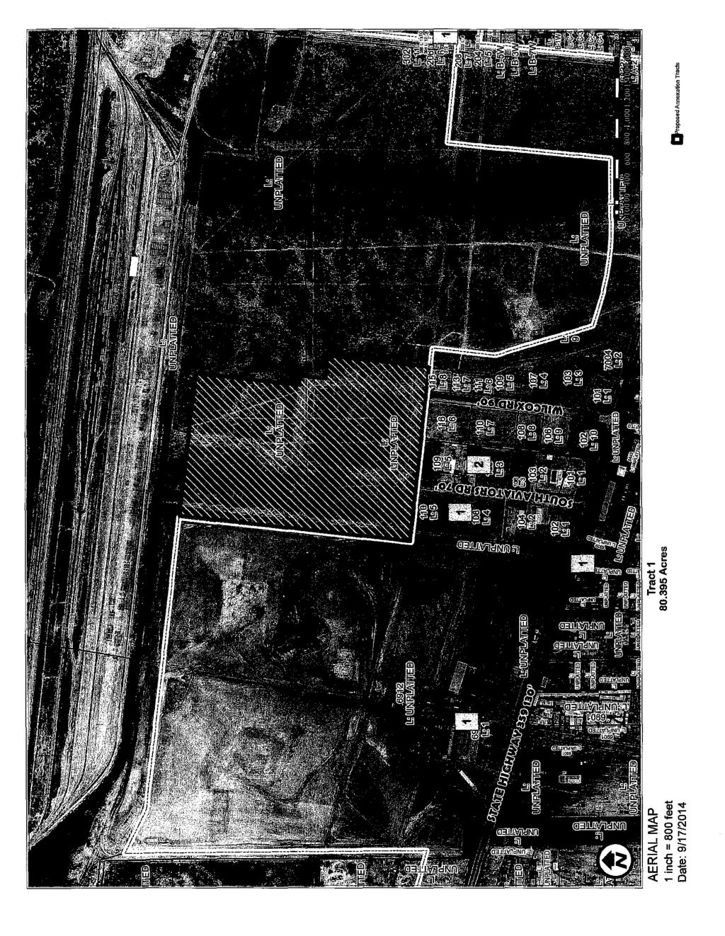
7 AERAL MAP o~nposed j\1'\wu~oj T!a'ZtS
8 L: UNPlATTED L: UNPlATTED L: UNPlATTED L: UNPlATTED!Mio~ L: UNPlATTED.:.; ZONNG MAP 1 inch = 800 feet Date: 9/17/2014 Tract Acres l2]s.u.p. (SPECAL USE PERMTS) [lc.u.p. (CONDTONAL USE PERMTS) r:;as.u.p. & C.U.P.

9 :b l/ni>latt~~ Ught Medium ndustrial Density Resi..ao~H j(jg ""5 116 tdi Light.ndustrial b UNPLAfmE:o FUTURE LANDUSE MAP 1 inch = BOO feet Date: 9/17/2014 Tract Acres

10 ---J ' ' i! i! i
11 LEGAL DESCRPTON ACRE TRACT A TRACT OF LAND CONTANNG ACRES, MORE OR LESS, STUATED N PORCON 31 AND 32, WEBB COUNTY. TEXAS AND BENG OUT OF A ACRE TRACT CONVEYED TO HURD URBAN DEVELOPMENT, LTD., AS RECORDED N VOLUME 2489, PAGES , WEBB COUNTY OFFCAL PUBLC RECORDS, WEBB COUNTY, TEXAS. SAD ACRES BENG MORE PARTCULARLY DESCRBED BY METES AND BOUNDS AS FOLLOWS: BEGNNNG AT A%" RON ROD FOUND BENG THE NORTHEAST CORNER OF THE CTY OF LAREDO LANDFLL TRACT RECORDED N VOLUME 227, PAGES , WEBB COUNTY DEED RECORDS, SAME BENG THE NORTHWEST CORNER OF SAD ACRE TRACT FOR THE NORTHWEST CORNER OF THS TRACT; THENCE, S 83'41'50" E, ALONG THE.NORTH LNE OF SAD ACRE TRACT A DSTANCE OF FEET TO A Y," RON SET FOR THE NORTHEAST CORNER OF THlS TRACT; THENCE, S 0617'20" W, A DSTANCE OF FEETTOA Y," RON ROD SET FORAN NTEROR CORNER OF THS TRACT; THENCE, S 83'42'40" E, A DSTANCE OF 90.0 FEET TO A W' RON ROD SET FOR AN EXTEROR CORNER OF THS TRACT; THENCE, S 0617'20" W, A DSTANCE OF FEET TO A Y," RON ROD SET FOR AN NTEROR CORNER OF THlS TRACT; THENCE, S 83'42'40" E, A DSTANCE OF FEET TO A Y," RON ROD SET FOR AN EXTEROR CORNER OF THS TRACT; THENCE, S 0617'20" W, A DSTANCE OF 1,000.0 FEET TO A Y," RON ROD FOUND BENG THE NORTHEAST CORNER OF LOT 8, BLOCK 4, LAS LOMAS NDUSTRAL PARK PHASE, RECORDED N VOLUME 31, PAGES 4-5, WEBB COUNTY PLAT RECORDS, WEBB COUNTY, TEXAS FOR THE SOUTHEAST CORNER OF THS TRACT; THENCE, N 83'42'40" W, ALONG THE SAD NORTH LNE OF SAD LAS LOMAS NDUSTRAL PARK PHASE, SAME BENG THE CTY LMTS LNE AS PER ORDNANCE , A DSTANCE OF FEET TO CONCRETE MONUMENT FOUND BENG THE NORTHWEST CORNER OF SAD LAS LOMAS NDUSTRAL PARK PHASE AND THE NORTHEAST CORNER OF LAS LOMAS NDUSTRAL PARK PHASE, AS RECORDED N VOLUME 30, PAGES 16-17, WEBB COUNTY PLAT RECORDS, WEBB COUNTY, TEXAS, CONTNUNG ALONG NORTH LNE OF SAD LAS LOMAS NDUSTRAL PARK PHASE AND SAD CTY LMTS LNEA DSTANCE OF FEET TO A CONCRETE MONUMENT FOUND BENG THE NORTHWEST CORNER OF SAD LAS LOMAS NDUSTRAL PARK PHASE, CONTNUNG SAME COURSE ACROSS A DRANAGE EASEMENT AGREEMENT BETWEEN THE CTY OF LAREDO AND HURD RANCH COMPANY LTD. RECORDED N VOLUME 1376, PAGES , WEBB COUNTY OFFCAL PUBLC RECORD A DSTANCE OF FEET FOR A TOTAL DSTANCE OF 1, FEET FOR THE SOUTHWEST CORNER OF THS TRACT; THENCE, N 0617'20" E, ALONG THE EAST LNE OF SAD CTY OF LAREDO LANDFLL AND WEST LNE OF SAD DRANAGE EASEMENT AGREEMENT, A DSTANCE OF 2, FEET TO RETURN TO AND CLOSE AT THE PONT OF BEGNNNG OF THS , MORE OR LESS, ACRE TRACT. BASS OF BEARNGS FOR THlS LEGAL DESCRPTON: STATE PLANE NAD 83, 4205 TEXAS SOUTH STATE OF TEXAS COUNTY OF WEBB, GLBERT L. CADE, REGSTERED PROFESSONAL LAND SURVEYOR DO HEREBY STATE THAT THlS LEGAL DESCRPTON REPRESENTS A SURVEY MADE ON THE GROUND UNDER MY SUPERVSON. ~ ;; ~~ 1#- -P'""'/1 103/~14- GLBERT L. CADE ll, R.P.L.S. NO DATE Exhibit A (z. f~j
12 Ac Las Lomas Ph3.txt Parcel name: Ac Las Lomas Ph3 North: East : Line course: s E Length: North: East : Line course: s w Length: North: East : Line course: s E Length: North: East : Line course: s w Length: North: East : Line course: s E Length: North: East : Line course: s w Length: North: East : Line course: N w Length: North: East : Line course: N E Length: North: East : Perimeter: Mapcheck closure - (Uses listed Error Closure: Error North: ~ Precision 1: 19,875, Area: 3,502, Sq Ft Ac. courses, radii, and deltas) course: N w East : Page 1 Exhibit A (lob)
13 Tract 1 (Hurd Tract) 1 CTY OF LAREDO ANNEXATON AGREEMENT AND SERVCE PLAN TRACTl HURD TRACT WHEREAS, the City of Laredo is a home rule municipality and a political subdivision of the State of Texas; and WHEREAS, Chapter of the Texas out the legal requirements for the annexation of municipality, such as the City of Laredo, Texas; WHEREAS, John R. Hurd, Jr., on filed a petition with the City of Laredo fur tract ofland being more particularly rj.,,,criih"' and of an annexation agreement betweer being annexed; and Code specifically sets city limits of a home-rule yek>pm.ent, Ltd. has tract o fland, said requires the execution landowner of the territory acknowledge, annexation by the Urban Development, S)EJU'T<)N of the sum of Sevenother good and valuable consideration, the acknowledged, the CTY OF LAREDO, a home,@prne~lt, Ltd. being the parties to this AND SERVCE PLAN, do hereby mutually to the following terms, conditions and service plan for of acres ofland, more or less, belonging to Hurd SERVCE PLAN A petition fur annexation from John R. Hurd, Jr., on behalf of Hurd Urban Development, Ltd., was received for property designated as "Tract (Hurd Tract)" described by metes and bounds in Attachment "A" of this Ordinance and made a part hereoffor all purposes. This Service Plan was prepared in accordance with the requirements of Section of the Texas Local Government Code and was available for review by the public at hearings duly held on October 20 and October 27,2014. Public notice ofthe hearings was provided on October 5 and October 12, 2014, not more than twenty or less than ten days before the hearing as provided in Section of the Texas Local Government Code. Attachment "B"
14 Tract (Hurd Tract) 2 Section 1. Services to be provided on the effective date of annexation 1. Police Protection: Police protection shall be provided to the tract immediately upon the effective date of annexation. Police protection shall include traffic control enforcement, crime prevention activities, police patrol, crime investigation, and emergency response. 2. Fire protection and Emergency Medical Services: First response fire and EMS services will be provided to the area from Fire Station No. 11, which is located approximately 2.5 miles from the proposed site. Fire services include protection, prevention, and emergency medical response. 3. Solid Waste Collection: The collection and to the area within thirty days from the effective residential and institutional customers. of solid waste may use city services or waste will be at the municipal sanitary be the same as all similarly classified custorr on the same basis as other industrial generators :J!isposalofall solid platting of to pay, for water treatment $ per residential lot bet we<m 8,000 and 9,999. For industrial or per acre. This fee is in by the adoption and and city ordinances require that all line to conform to city standards. Water ' charged like customers within the 'provided to the tract on the same basis lev,elo;pment within the city limits. 4b. At the time of the platting successors and assigns agree to pay, for wastewater per residential lot less than 6,000 square feet; $ per 6,000 and 7,999 square feet; $ per residential lot between 8,000 and feet; and $ per residential lot 10,000 square feet or over. For industrial or development the wastewater treatment capacity fee is $ per acre. This fee in addition to water availability or other fees but will be superseded by the adoption and implementation of impact fees. The City Charter and city ordinances require that all line extensions be made at the expense of the petitioner to conform to city standards. Wastewater service will be provided to the customer at the same rates charged like customers within the city limits. 5. Maintenance of roads and streets: Public roads and streets will be maintained on the effective date of the annexation in the same manner as all roads and streets within the city limits. All thoroughfare rights-of-way shall be dedicated to comply with the Long Range Thoroughfare requirements of the City of Laredo's Comprehensive Plan. Road maintenance Attachment "B"
15 Tract 1 (Hurd Tract) 3 consists of repair of paving, maintenance of traffic lights, controls and signals, and will be provided innnediately upon annexation. Street lighting is required of all new development and will be provided at petitioner's expense. 6. Operation and Maintenance of parks, playgrounds and swimming pools: No public parks, playgrounds, or swinnning pools are presently located within the tract. 7. Operation and Maintenance of other public facilities: No public facilities, public buildings, or other service facilities are presently located tract. All facilities required by the development shall be provided at the petitioner, its successors and assigns, or jointly in cooperation with the city at as warranted by the development. The Service Plan does not contemplate the it require the funding of capital im1nrovetneri agreed prior to the institution inconsistent with Chapter 395 of the Texas not propose services in the area than a negligible amount the services provided within the co:rpc1r, subdivision, nor will,petitioner has not maintenance than provided within plan must provide maintenance that is annexation, a service services, infrastructure, and infrastructure infrastructure, and infrastructure with topography, land use, and up'"""" or projected in the area. or acquisition of capital improvements by the ro!ta\lra~s. drainage, and all public improvements at When the annexation the abutment of residential uses with M-1 (Light Manufacturing District) as defuted in the Laredo Land Development Code, a 100 ft. buffer yard between the different land uses shall be required, and the buffer yard shall be maintained by the property owner. The Service Plan is valid for a period of ten years, and all services within the area shall be provided in accordance with the Plan. Should an ordinance pertaining to reserve areas or impact fees be adopted by the City Council, the ordinance shall supersede any provisions established herein. Attachment "B"
16 Tract (Hurd Tract) 4 THS ANNEXATON AGREEMENT AND SERVCE PLAN WAS ENTERED NTO AND EXECUTED ON THS DAY OF CTY OF LAREDO, a Texas Municipal Corporation HURD URBAN DEVELOPMENT, LTD. By: Carlos Villarreal City Manager R. Hurd, Jr. 10rize:d Representative State of Texas * County of Webb * This instrument was 2014 by Carlos Villarreal, as City State oftexas before me on this Development, Ltd. day of Notary Public, State oftexas Attachment "B"
17 PLANNNG AND ZONNG COMMUNCATON DATE: SUBJECT: PUBLC HEARNG AND RECOMMENDATON OF AN ORDNANCE For the voluntary annexation of one (1) tract ofland totaling 1.07 acres, more or less, as described by metes and bounds in the attached Exhibit "A", and known as annexation Tract 2 tem Vli.B. (J. M. Aguilar Tract), located south of US Highway 359 and east of Old Milwaukee Road, as required by Section of the Texas Local Government Code. NTATED BY: STAFF SOURCE: J. M. Aguilar Cynthia Collazo, Deputy City Manager Nathan R. Bratton, Director of Planning PREVOUS ACTON: None. BACKGROUND: The Planning and Zoning Department has received two (2) petitions for voluntary annexation. Texas Local Government Code, Section requires two public hearings before City Council. The first of said public hearings occurred on October 20, 2014; the second occurred on October 27,2014. The petition for annexation will subsequently go before City Council for introduction of the ordinance on November 17, Tract 2 is as follows: Voluntary Annexation: Tract 2: J. M. Aguilar Tract acres, more or less, located south of US Highway 359 and east of Old Milwaukee Road. Petitioner: J. M. Aguilar FNANCAL MPACT: The financial implication will be outlined in the Annexation Feasibility Analysis. COMMTTEE RECOMMENDATON: Not applicable. STAFF RECOMMENDATON: To conduct a public hearing for each individual tract and give a recommendation on the ordinances for annexation. Page of!
18 (> Proposed 2014 Annexation Tracts Tract Acres Tract Acres o':-.c:o:i. 5 3 Miles ,;1. 11 CTY OF LAREDO Building Development Services Department
19

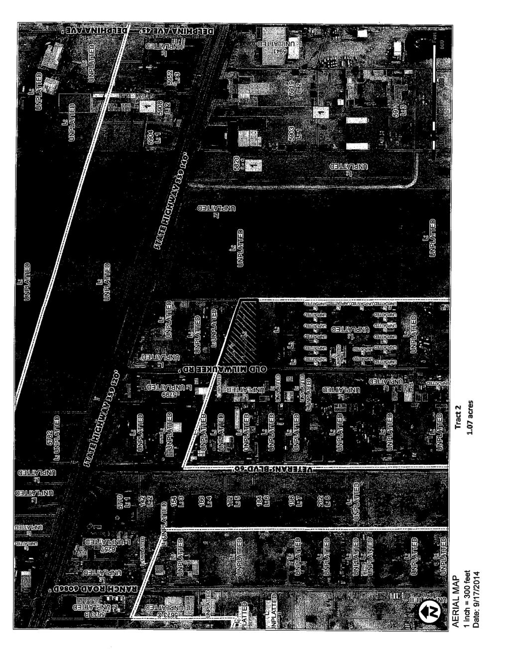
20 UNPlATTED L: UNPlATTED 5782 L: UNPlATTED L: UNPLATTED fil ~ a. z ::> " ~ 10~ ~a. 3 ~ L: UNPlATTED " w ~ ;; a. z ::> ~ fil ~ a. z ::> L: UNPLATTED 5904 L: 1 ~ 5908 L::l L: UNPlATTED 5952 L:3 L:4 L: UNPLATTED L: UNPLATTED UNPlATTED 172 L:5 0 L: UNPLATTED :> ~.. b iii L:. 6 UNPLATTED 196 L:7 202 L:8 ll -~ UNPLATTED t;..,...,...l"', '~"rj : L w UNPLATTED ~ a. z ::> L: UNPLATTED L: L: L: L: " LU ~ a. z ::> El!i82o L:3 ~-~-,~...i ~--~_:,... -M-~ -~ ;::i ll a. z :;:) -.:..i ~~ ZONNG MAP 1 inch = 300 feet Date: 9/17/2014 L: UNPlATTED Tract Z 1.07 acres L: UNPLATTED \!l D :!!D - m 1.21S.U.P. (SPECAL USE PERMTS) Oc.u.P. (CONDTONAL use PERMTS) t;,as.u.p. & C.U.P.

21 Low Density 5762 R 'd. L: UNPLATTED 851 enbaf l' w~~j?!-a.tis..~- L: UNPLATTED.. ~r~e~t1l~q; "' L: UNPLATTED UNPLATTED 0 w ~ loa. z ::J.:..; ~ '"'';; 5952 i#~ a. w. l!ii z '" ~; ~,so~ kl 5.!JJ9. L<? '$"9j1_i ~,;,~ FUTURE LANDUSE MAP 1 inch = 300 feet Date: 9/17/2014 Tract Z 1.07 acres m
22 -- TRACT A Acres _(,- 1 ;. " r---,- -/ii C!l!11 {{,.J "J 1~. 5' ~-'t g.s i/2 oj. -- 1" 0.._ 1'< TRACT C Acre Juan Monwel Molino, Jr. and Wife Leonor Molino Volume 357, Page 163 O.P.R.W.C.T. TRACT C-4 Maria Gulllermino Sanche<: de Aguilar Volume 175, Page 570 O.P.R.W.C.T Acres --~ SOA.E: t "" 40' TRACT 4-4-R1 ROADWAY RGHT-OF-WAY AND PUBLC UTLTY EASEMENT VOL 2536, PAGES D.R.W.C.T. l"'l ~ <:r - ~ > :::: ; "" TRACT A-2 3,00 Acres z 0 0. ~ "' ~ "l. Found Jin ron Rod TRACT C Acres s 89"29'16" w ' TRACT D Acres Martin Murillo Volume 169, Page 420 O.P.R.W.C.T, , 50' UTUTY AND ACCESS EASEMENT Found 32" ron Rod Point of Beginning 1/) --...!ll :; a' ~ ~ :;: -- STAT OF 'lex\s: COUNTY OF WEBB: t 1HE UNDERSGNED A R GSJ' REO PROfESSONAL LAND SU~ N THE STATE Of 'EX'S, HEREBY STAlE lhat THS SURV '1' S TWE MilD Wt>S PR:F'AREO from AN ACTUAl. SUR'JE'r OF THE PROPERlY UADE UNDER MY SUPEFMSDN, ON 1HE GROUHO, that THE CORNOR MDNUJEHTS SHOWN WEflE PROPERLY P..ACED OR LOCATED UNDER M1 SUPeRSON. u~ "1-9-/</ Eiiri(jiie A. MEiji11 ll, R.P.L.S. No DATE BASS OF' BEARNG~ G.PS., TelCO. Caardinab! SJ~t&rn,. ToX! SD!ltl ZanD, (NAil 1SB3) Swvey of o 1.07 acre tract of land out of Tract C-4, a tract of Joncl conveyed by cleed to MARA GUU.ERMJNA SANCHEZ DE AGU.AR recorded in Volume 175, Page 570, O.P.R.W.C.T., Situated in Porcion 32, Antonio Trevino, Abstract 296, Webb County, Texas REVSED: Blue Top DRAWN, A.T. Land Sutveying "" checked ev, E.A.M. 101WestHnlslde,SUe10.,~, DATe Lareclo, Texas Phone: (!156} JOB NO ~~(9=1~~~g SHEET: 1 OF' 2 F'.B. 00 _lpg.oo 'ADL 0 :-;:140in',~28.-;T~rn~cl'1'1C~-4:Anol~d-;M~,~.;,;;"';;'~'-~df.:w,
23 1/tM ~ Blue Top Land Surveying 101 W. Hillside, Suite 1 0 Laredo, Texas fax Field Notes For a 1.07 Acre tract of land, more or less, out of Tract C-4, a tract of land conveyed by deed to Maria Guillermina Sanchez de Aguilar, situated in Porcion 32, Antonio Trevino, Abstract 296, Webb County, Texas Being a tract of land containing 1.07 Acres, more or less, out of Tract C-4, a tract of land conveyed by deed to Maria GuiJiermina Sanchez de Aguilar, recorded in Volume 175, Page 570, Official Property Records, Webb County, Texas, situated in Porcion 32, Antonio Trevino, Abstract 296, and being more particularly described by metes and bounds as follows: BEGNNNG at a W' iron rod found on the west line of Tract No. 14, the southeast comer of said Tract C-4, the northeast comer of Tract D~l, a 2.00 acre tract of land conveyed by deed to Martin Murillo, recorded in Volume 189, Page 420, Official Public Records, Webb County, Texas, for the southeast comer of the herein described tract; Thence, along the south line of Tract C-4 and the north line of said Tract D~l, Soutll89o 29' 16'' West, a distance of feet to a Vi' iron rod found on the southeast corder of Tract 4-4-Rl, n tract of land recorded in Volume 2536, Pages , Deed Records, Webb County, Texas, the southwest comer of Tract C-4, the northwest corner of Tract D-1, for the southwest corner of the herein described tract; Thence, along the west line of Tract C~4 and the east line of said Tract 4-4-Rl, North 00 30' 44" West, a distance of feet to a point on the edge of the City Limit Line, for the northwest corner of the herein described tract; Thence, along the City Limit Line, South 72 46' 56" East, a distance of feet to a point on the west line of said Tract 14, the east line of Tract C-4, for the northeast corner of the herein described tract; Thence, along the west line of Tract 14, the east line of Tract C-4, Soutlz 00 30' 44'' East, a distance of feet to return and close at the PONT OF BEGNNNG of this 1.07 Acre tract of land, more or less. Basis of Bearings: G.P.S., Texas Coordinate System, Texas South Zone, (NAD 1983) State of Texas: County of Webb: J, Enrique A. Mejia, a Registered Professional Land Surveyor, do hereby-state that the above captioned "Field Notes" and attached ''Plat of Survey" is true and was prepared from an actual survey of the property made under my supervision on the ground and that the comer monument.;; shown were properly placed or located under my supervision. U??fi!! R.P.LS. No Texas '7 -s--/</ Current Date (Sheet 2 of 2) Exhibit A ( '2. H)
24 Blue Top Land Surveying 101 W. Hillside, Suite 10 Laredo, Texas fax Closure Sheet of A 1.07 Acre tract of land, more or less, out of Tract C-4, a tract of land conveyed by deed to Maria Guillermina Sanchez de Aguilar, recorded in Volume 175, Page 570, Official Property Records, Webb County, Texas, situated in Porcion 32, Antonio Trevino, Abstract 296, Course: S W Course: N W Course: S E Course: S E Distance: Distance: Distance: Distance: Perimeter: Area: acres Mapcheck Closure- (Uses listed courses & COGO Units) Error of Closure: Coruse: S E Precision 1: u~ 1-~-1 Enrique A~ ill, R.P.L.S. No Exhibit A (~.,p ~)
25 Tract 2 (J.M. Aguilar Tract) 1 CTY OF LAREDO ANNEXATON AGREEMENT AND SERVCE PLAN TRACT2 J. M. AGULAR TRACT WHEREAS, the City of Laredo is a home rule municipality and a political subdivision of the State of Texas; and WHEREAS, Chapter of the Texas out the legal requirements for the annexation municipality, such as the City of Laredo, Texas; Code specifically sets city limits of a home-rule WHEREAS, J. M. Aguilar has filed annexation of a 1.07 acre tract ofland, by metes and bounds on Attachment "A"; WHEREAS, Section of an annexation agreement being annexed; and preparation of a being annexed, hearings. execution e landowner of the territory Code, requires the services to the territory and related public ""'"'LV>-TON, ofthe sum of Sevengood and valuable consideration, the "''"'~!;;"'"''the CTY OF LAREDO, a homethe parties to this ANNEXATON do hereby mutually acknowledge, consent, and iditiorts and service plan for annexation by the City of or less, belonging to J. M. Aguilar. SERVCE PLAN A petition for annexation from J. M. Aguilar was received for property designated as "Tract 2 (J. M. Aguilar Tract)" described by metes and bounds in Attachment "A" of this Ordinance and made a part hereof for all purposes. This Service Plan was prepared in accordance with the requirements of Section of the Texas Local Government Code and was available for review by the public at hearings duly held on October 20 and October 27, Public notice of the hearings was provided on October 5 and October 12, 2014, not more than twenty or less than ten days before the hearing as provided in Section of the Texas Local Government Code. Attachment "B"
26 Tract 2 (J.M. Aguilar Tract) 2 Section 1. Services to be provided on the effective date of annexation. Police Protection: Police protection shall be provided to the tract immediately upon the effective date of annexation. Police protection shall include traffic control enforcement, crime prevention activities, police patrol, crime investigation, and emergency response. 2. Fire protection and Emergency Medical Services: First response fire and EMS services will be provided to the area from Fire Station No., which is located approximately mile from the proposed site. Fire services include protection, prevention, and emergency medical response. 3. Solid Waste Collection: The collection and waste will be extended to the area within thirty days from the effective residential and institutional customers. of solid waste may use city services or waste will be at the municipal sanitary on the same basis as other industrial generators c>is]posal of all solid within the tract will be the same as all similarly classified custorr platting of to pay, for water treatment $ per residential lot betvveen 8,000 and 9,999 For industrial or per acre. This fee is in by the adoption and city ordinances require that all line to conform to city standards. Water charged like customers within the provided to the tract on the same basis eve:lopme111t within the city limits. 4b. successors and assigns agree to pay, for wastewater per residential lot less than 6,000 square feet; $ per 6,000 and 7,999 square feet; $ per residential lot between 8,000 and feet; and $ per residential lot 10,000 square feet or over. For industrial or development the wastewater treatment capacity fee is $ per acre. This fee in addition to water availability or other fees but will be superseded by the adoption and implementation of impact fees. The City Charter and city ordinances require that all line extensions be made at the expense of the petitioner to conform to city standards. Wastewater service will be provided to the customer at the same rates charged like customers within the city limits. 5. Maintenance of roads and streets: Public roads and streets will be maintained on the effective date of the annexation in the same manner as all roads and streets within the city limits. All thoroughfare rights-of-way shall be dedicated to comply with the Long Range Thoroughfare requirements of the City of Laredo's Comprehensive Plan. Road maintenance Attachment "B"
27 Tract 2 (J.M. Aguilar Tract) 3 consists of repair of paving, maintenance of traffic lights, controls and signals, and will be provided immediately upon annexation. Street lighting is required of all new development and will be provided at petitioner's expense. 6. Operation and Maintenance of parks, playgrounds and swimming pools: No public parks, playgrounds, or swimming pools are presently located within the tract. 7. Operation and Maintenance of other public facilities: No public facilities, public buildings, or other service facilities are presently located tract. All facilities required by the development shall be provided at the petitioner, its successors and assigns, or jointly in cooperation with the city at s warranted by the development. The Service Plan does not contemplate the it require the funding of capital imonrnv<>tn<>< agreed prior to the institution ofpro cet:di.j~gs inconsistent with Chapter 395 of the Texas not propose services in the area than a negligible amount the services provided within the corpor: f the annexed area maintenance than provided within plan must provide maintenance that is subdivision, nor will petitioner has not marmer Plan does by more and emergency medical cipali1ty before annexation. annexation, a service services, infrastructure, and infrastructure infrastructure, and infrastructure with topography, land use, and npllate:d or projected in the area. or acquisition of capital improvements by the drainage, and all public improvements at When the annexation the abutment of residential uses with M-1 (Light Manufacturing District) as defined in the Laredo Land Development Code, a 100 ft. buffer yard between the different land uses shall be required, and the buffer yard shall be maintained by the property owner. The Service Plan is valid for a period of ten years, and all services within the area shall be provided in accordance with the Plan. Should an ordinance pertaining to reserve areas or impact fees be adopted by the City Council, the ordinance shall supersede any provisions established herein. Attachment "B"
28 Tract 2 (J.M. Aguilar Tract) 4 TDS ANNEXATON AGREEMENT AND SERVCE PLAN WAS ENTERED NTO ANDEXECUTEDONTDS DAYOF,2014. CTY OF LAREDO, a Texas Municipal Corporation J. M. AGULAR By: -:::--:--=:----:--- Carlos Villarreal City Manager Aguilar nri:7.ed Representative State of Texas County of Webb * * This instrument was 2014 by Carlos Villarreal, as City State of Texas me on this day of, Notary Public, State of Texas Attachment "B"
29 2014 CTY OF LAREDO PROPOSED ANNEXATON PROPOSED SERVCE PLAN City of Laredo Planning Department October 20, 2014
30 TABLE OF CONTENTS. Authority and Compliance -1. Tract Summary and Recommendations -. Tract Details and Service Plans Tract Tract 2 Hurd Tract J. M. Aguilar Tract V. Methodology V- v. Appendix V-1
31 Authoritv and Compliance SECTON/
32 SECTON AUTHORTY AND COMPLANCE Municipal annexation is governed by Chapter 43 Subchapter C of the Texas Local Government Code. The requirements of annexation are summarized briefly as follows: a. The area to be annexed must be within the extraterritorial jurisdiction of the City. (Section TEX. LOC. GOVT. CODE). b. The area to be annexed must be contiguous with the corporate limits (Section TEX. LOC. GOVT. CODE). c. Annexation must be in conformance with the City Charter (Section TEX. LOC. GOVT. CODE). d. Procedural requirements: 1. Before the issuance of the notices of public hearing, the City Council must direct the Planning Department to prepare a Service Plan for the area to be annexed. The service plan must detail the services to be provided within the area to be annexed. The city proposed a schedule to extend the period for providing certain services no later than 4 Yz years after the effective date of the annexation, except that the following services must be provided on the effective date of annexation of the area. () Police protection (2) Fire protection (3) Emergency medical services ( 4) Solid waste collection (5) Operation & maintenance of public water and wastewater services (6) Operation & maintenance of streets and roads, including street lighting (7) Operation & maintenance of parks, playgrounds, and swimming pools (8) Operation & maintenance of other public facilities ii. Two hearings must be held not more than forty ( 40) or less than twenty (20) days before the institution of proceedings. f more than twenty (20) adult residents of the area file a written protest after the required notice (not less than 0 or more than 20 days), then at least one of the hearings must be conducted within the area proposed for annexation. The Service Plan must be available for inspection and explained during the public hearings. Once adopted, the Plan becomes a contractual obligation of the city and the requirements are binding upon the city Annexation must be completed within ninety (90) days of the time that proceedings are instituted, i.e. following the adoption of the service plan and introduction of the ordinance. e. The property to be annexed must be not less than,000 feet wide at its narrowest point, unless contiguous on two sides with the corporate boundaries, annexed at the petition or request of the property owners, or abutting the boundaries of another jurisdiction. -
33 f. f the annexation is not undertaken pursuant to a petition or request of the property owner, then the maximum amount of area annexed may not exceed ten percent of the incorporated area of the preceding year, with a thirty percent carry over provision. This limitation does not apply to property owned by the municipality, the county, state or federal government. g. Construction of capital improvements necessary to provide service shall be substantially completed within 4Yz years. This requirement does not apply if the property is annexed upon the petition or request of the landowners, and the city and the petitioners may agree upon the services and facilities to be provided. The petitioners are ordinarily required to provide or pay for the facilities and service extensions required. The Service Plan may not require a landowner to fund capital improvements necessary to provide municipal services in a manner inconsistent with Chapter 395 TEXAS LOCAL GOVERNMENT CODE unless agreed to by the propertv owners (Section (e)(f)(2) TEXAS LOCAL GOVERNMENT CODE). h. Any amendments may not provide a level of service lower than those of the original plan. f the municipality owns a water or wastewater utility, the city shall extend service to the annexed area within the prescribed period. (The provision requiring the extension of water and wastewater service was adopted by the Legislature in 1989, and does not apply to annexations prior to that time). Real property is placed on tax rolls of the municipality on January 1st of each year. Completion of the proceedings is scheduled for late July to assure that tax revenues will be available to cover the cost of providing services to the annexed area. However, actual collection of taxes does not occur until the following year. The service requirements of undeveloped land usually place little strain on city services during the first year. The cost of providing services to development in subsequent years should be considered both at the time of annexation and during the budget process. A hearing and recommendation by the Planning & Zoning Commission is not required as a matter of state law, but ordinarily has been incorporated into the review process. uitial zoning has been incorporated into the annexation proceedings. Council has directed that notice of the proposed zoning be afforded property owners within 200 feet of the property, even though the property is not located within the city limits. - 2
34 Tract Summary & Recommendations SECTON
35 SECTON T TRACT SUMMARY AND RECOMMENDATONS The Department of Planning performed an analysis of those two (2) properties for which petitions for voluntary annexation have been received since September Both tracts are along US Highway 359 on the east side of the city. Tract (Hurd Tract) is north of the highway, abutting the north side of Las Lomas ndustrial Park, east of the City of Laredo Landfill and approximately 3 miles east of Loop 20. Tract 2 (J.M. Aguilar Tract) is on the south side of Highway 359, just over.5 miles east of Loop 20 and on the east side of fronting Old Milwaukee Road. The total acreage of the two (2) tracts is acres, more or less. All properties are identified by tract number on Map 1. Detailed information concerning each of the proposed tracts is found in Section of this report. There are standardized recommendations by staff that are pertinent to the majority of the tracts. General recommendations are as follows: ) All tracts with residential development are usually required to dedicate parkland and school sites. n the case of Tract 2 (J. M. Aguilar Tract), the northern portion of the single-lot tract was part of a unilateral annexation (Ord ) incorporating the highway, as well as the tract for the City Landfill. The proposed annexation is to bring the remainder of the property within city limits, as a single-family residence is currently located on the tract. No additional development is proposed. ) School sites should be required based on the number of school-age children generated by the development and the school district analysis. The following table shows the estimated number of school-age children and acreage required for school sites. Neither of the proposed annexation tracts requires a school. TABLE STANDARDZED RECOMMENDATONS Tract tract EsH uatoo E~imated Snideilts{ler - Pr<l'-rata Ntrmbet Name L~ No: <lf - -A r n>f Ttact -- _-School -~ ~-----~-~~ - ~~g----i~:r c-~;--, --~~- 1 Hurd 0 0 N/A N!A 2 J. M. Aguilar 1 0 N!A N/A Totals: 0 N/A N/A ) According to the Charter for the City of Laredo, water and wastewater lines are to be extended by the parties requesting this service. Tracts annexed voluntarily will be subject to a charge per lot on a sliding scale according to lot size and as provided for in the latest annexation. -
36 These properties may be subject to site-specific line sizing in accordance with departmental plans for the area. All properties must prepare an engineering plan for the whole tract that considers area-wide solutions regardless of the future platting strategy. The intent of the City is to minimize future conflicts that designing the system on a plat-by-plat basis may cause. The Water Utilities Department recommends that the petitioners, their successors and assigns pay for water treatroent capacity, $ per residential lot less than 6,000 square feet; $ per residential lot between 6,000 and 7,999 square feet; $ per residential lot between 8,000 and 9,999 square feet; and $1, per residential lot 10,000 or over. For commercial or industrial development the water treatroent capacity fee is $ per acre. This is in addition to water availability or other fees but will be omitted with the adoption and implementation of impact fees. Water service will be provided to the customer at the same rates charged to like customers within the city limits. For wastewater treatroent capacity, the Water Utilities Department recommends that the petitioners, their successors and assigns pay $ per residential lot less than 6,000 square feet; $ per residential lot between 6,000 and 7,999 square feet; $ per residential lot between 8,000 and 9,999 square feet; and $ per residential lot 10,000 or over. For commercial or industrial development the wastewater treatroent capacity fee is $ per acre. This is in addition to water availability or other fees but will be omitted with the adoption and implementation of impact fees. The City Charter and City Ordinances require that all line extensions be made at the expense of the petitioner to conform to City Standards. Recommendations for each tract are described in the individual tract details. - 2
37 D Proposed 2014 Annexation Tracts Tract Acres Tract Acres 0-;..::0:;.7 5-= Miles CTY OF LAREDo' Building Development Services Department Map 1
38 TRACT SUMMARY Hurd J.M. Aguilar $4,127,402 $336, Build-out 4 $56,612 $74,501 $74,573 $74,573 $74,573 $74,573 $74,573 $1,487 $1,487 $1,487 $1,487 $1,487 $1,487 $1,487 System Revenue Water System Wastewater System $40,704 $29,710 $55,131 $56,233 $57,357 $58,504 $59,674 $40,241 $41,045 $41,866 $42,702 $43,556 $59,674 $43,556 i System Expenditure Water System Wastewater System $40,311 $29,411 $54,599 $55,691 $56,805 $57,941 $59,100 $39,836 $40,633 $41,446 $42,274 $43,120 $59,100 $43,120 $937 The primary operational cost for police and fire services is off~set by tax revenues in the early lvo.o nfthoresidential subdivision's development. However as the population increases, the demand for services increases the operational costs cannot be met through property taxes alone. tract considered for unilateral annexation must be under the maximum allowable acreage for annexation, which equals 10% of the total acreage of the city plus any carryover from the previous year. 11-3
39 Tract Details and Service Plan SECTON/
40 Tract 1 SECTON/
41 Hurd Tract (Tract ) This acre tract is located north of US Highway 359 and east of the City of Laredo Landfill. The petitioner proposes M-1 zoning (Light Manufacturing District). Police protection shall be provided to the tract immediately upon annexation. First response fire and EMS service will be provided to the area from Fire Station No., which is located approximately 2.5 miles from the proposed site. As the proposed M-1 zoning precludes residential development, no dedications are required for parkland or schools. The Water Utilities Department recommends that the petitioners, their successors and assigns pay for water treatment capacity, at $ per acre for commercial or industrial development. This is in addition to water availability or other fees. Water service will be provided to the customer at the same rates charged like customers within city limits. Water for fire protection services will be provided to the tract on the same basis and subject to the same requirements as all new development within the city limits. For wastewater treatment capacity, the Water Utilities Department recommends that the petitioners, their successors and assigns pay a wastewater treatment capacity fee of $ per acre. This is in addition to water availability or other fees. Wastewater service will be provided to the customer at the same rates charged like customers within city limits. The City Charter and City Ordinance require that all line extensions be made at the expense of the petitioner to conform to City standards. When the annexation results in the abutment of residential uses with M-1 (Light Manufacturing District) as defined in the Laredo Land Development Code, a 00 ft. buffer yard between the different land uses shall be required, and the buffer yard shall be maintained by the property owner. -
42 HURD TRACT TRACT1 TRACT 1: Hurd Tract Acres: APPLCANT: Hurd Urban Development, Ltd. LOCATON: North of US Highway 359 and east of the City of Laredo Landfill. PROPOSED DEVELOPMENT: New phase of Las Lomas ndustrial Park. Proposed take down: 16 5-acre lots over 18 months Build-out Estimated population per development year Total acreage Single family dwelling units nstitutional ndustrial/ commercial acreage Park/Open Space (acres) Taxable Value (cumulative) 3,095,536 4,127,399 4,127,399 4,127,399 4,127,399 4,127,399 4,127,399 GENERAL FUND (cumulative; rates shown are static, in all likelihood some increase will occur) Taxes: Property 19,719 26,292 26,292 26,292 26,292 26,292 26,292 Garbage Fees 16,452 21,936 21,936 21,936 21,936 21,936 21,936 Stormwater Fees 17,280 23,040 23,040 23,040 23,040 23,040 23,040 TOTAL 53,451 71,268 71,268 71,268 71,268 71,268 71,268 GENERAL FUND EXPENDTURES -data based on per capita cost; cost data not available for commercial/industrial properties. Police Fire & EMS Sanitation/Street Maintenance TOTAL REVENUES LESS EXPENDTURE! $53,451 $71,268 $71,268 $71,268 $71,268 $71,268 $71,268 ENTERPRSE SYSTEM REVENUES (cumulative) Water System 40,040 54,454 55,542 56,653 57,786 58,941 58,941 Wastewater System 29,225 39,746 40,541 41,351 42,178 43,021 43,021 ENTERPRSE SYSTEM EXPENDTURES (cumulative) Water System 39,653 53,928 55,007 56,107 57,229 58,374 58,374 Wastewater System 28,931 39,347 40,134 40,936 41,755 42,590 42,590 SYSTEM PROFT/ (loss) $681 $925 $942 $961 $979 $998 $998 SPECAL CONSDERATONS: The proposed initial zoning is M-1 (Light Manufacturing District). Additional revenues (at proposed rates): $40,198 for water treatment capacity $52,257 for wastewater treatment capacity RECOMMENDATON: Approval ll - 2
43 Qi ~ J!1 N N..,._ 0 ~ ~.<= ".E
44
45 Tract (Hurd Tract) CTY OF LAREDO ANNEXATON AGREEMENT AND SERVCE PLAN TRACT! HURD TRACT WHEREAS, the City of Laredo is a home rule municipality and a political subdivision of the State of Texas; and WHEREAS, Chapter of the Texas Local Government Code specifically sets out the legal requirements' for the annexation of land adjoining the city limits of a home-rule municipality, such as the City of Laredo, Texas; and WHEREAS, John R. Hurd, Jr., on behalf of the Hurd Urban Development, Ltd. has filed a petition with the City of Laredo for the annexation of a acre tract of land, said tract of land being more particularly described by metes and bounds on Attachment "A"; and WHEREAS, Section 1.04 of the Charter of the City of Laredo requires the execution of an annexation agreement between the City of Laredo and the landowner of the territory being annexed; and WHEREAS, Section of the Texas Local Government Code, requires the preparation of a service plan describing the provision of municipal services to the territory being annexed, prior to implementation of annexation proceedings and related public hearings. NOW, THEREFORE, FORAND N CONSDERATON, ofthe sum of Seven Hundred Fifty and No/100 Dollars ($750.00) and other good and valuable consideration, the receipt and sufficiency of which is hereby acknowledged, the CTY OF LAREDO, a homerule municipality, and Hurd Urban Development, Ltd. being the parties to this ANNEXATON AGREEMENT AND SERVCE PLAN, do hereby mutually acknowledge, consent, and agree to the following terms, conditions and service plan for annexation by the eity of Laredo of acres of land, more or less, belonging to Hurd Urban Development, Ltd. SERVCE PLAN A petition for annexation from John R. Hurd, Jr., on behalf of Hurd Urban Development, Ltd., was received for property designated as "Tract (Hurd Tract)" described by metes and bounds in Attachment "A" of this Ordinance and made a part hereof for all purposes. This Service Plan was prepared in accordance with the requirements of Section of the Texas Local Government Code and was available for review by the public at hearings duly held on October 20 and October 27, Public notice of the hearings was provided on October 5 and October 12, 2014, not more than twenty or less than ten days before the hearing as provided in Section of the Texas Local Government Code. Attachment "B"

46 Tract (Hurd Tract) 2 Section. Services to be provided on the effective date of annexation. Police Protection: Police protection shall be provided to the tract immediately upon the effective date of annexation. Police protection shall include traffic control enforcement, crime prevention activities, police patrol, crime investigation, and emergency response. 2. Fire protection and Emergency Medical Services: First response frre and EMS services will be provided to the area from Fire Station No., which is located approximately 2.5 miles from the proposed site. Fire services include protection, prevention, and emergency medical response. 3. Solid Waste Collection: The collection and disposal of solid waste will be extended to the area within thirty days from the effective date of annexation on the same basis as other residential and institutional customers. nstitutional, commercial, and industrial generators of solid waste may use city services or contract with private haulers. Disposal of all solid waste will be at the municipal sanitary landfill. Fees charged customers within the tract will be the same as all similarly classified customers. 4a. Operation and Maintenance of Public Water Services: At the time of the platting of this property, the petitioner, its successors and assigns agree to pay, for water treatment capacity, $ per residential lot less than 6,000 square feet; $ per residential lot between 6,000 and 7,999 square feet; $ per residential lot between 8,000 and 9,999 square feet; and $1, per residential lot 10,000 square feet or over. For industrial or commercial development the water treatment capacity fee is $ per acre. This fee is in addition to water availability or other fees but will be superseded by the adoption and implementation of impact fees. The City Charter and city ordinances require that all line extensions be made at the expense of the petitioner to conform to city standards. Water service will be provided to the customer at the same rates charged like customers within the city limits. Water for frre protection services will be provided to the tract on the same basis and subject to the same requirements as all new development within the city limits. 4b. Operation and Maintenance of Public Wastewater Services: At the time of the platting of this property the petitioner, its successors and assigns agree to pay, for wastewater treatment capacity, $ per residential lot less than 6,000 square feet; $ per residential lot between 6,000 and 7,999 square feet; $ per residential lot between 8,000 and 9,999 square feet; and $ per residential lot 0,000 square feet or over. For industrial or commercial development the wastewater treatment capacity fee is $ per acre. This fee is in addition to water availability or other fees but will be superseded by the adoption and implementation of impact fees. The City Charter and city ordinances require that all line extensions be made at the expense of the petitioner to conform to city standards. Wastewater service will be provided to the customer at the same rates charged like customers within the city limits. 5. Maintenance of roads and streets: Public roads and streets will be maintained on the effective date of the annexation in the same manner as all roads and streets within the city limits. All thoroughfare rights-of-way shall be dedicated to comply with the Long Range Thoroughfare requirements of the City of Laredo's Comprehensive Plan. Road maintenance Attachment "B"
47 Tract 1 (Hurd Tract) 3 consists of repair of paving, maintenance of traffic lights, controls and signals, and will be provided immediately upon annexation. Street lighting is required of all new development and will be provided at petitioner's expense. 6. Operation and Maintenance of parks. playgrounds and swimming pools: No public parks, playgrounds, or swimming pools are presently located within the tract. 7. Operation and Maintenance of other public facilities: No public facilities, public buildings, or other service facilities are presently located within the tract. All facilities required by the development shall be provided at the expense of the petitioner, its successors and assigns, or jointly in cooperation with the city at such time as warranted by the development. The Service Plan does not contemplate the creation of another political subdivision, nor will it require the funding of capital improvements by the petitioner to which petitioner has not agreed prior to the institution of proceedings, or which will be charged in any manner inconsistent with Chapter 395 of the Texas Local Government Code. The Service Plan does not propose services in the area in a manner that would have the effect of reducing by more than a negligible amount the level of fire and police protection and emergency medical services provided within the corporate boundaries of the municipality before annexation. f the annexed area had a lower level of services, infrastructure, and infrastructure maintenance than the level of services, infrastructure, and infrastructure maintenance provided within the corporate boundaries of the municipality before annexation, a service plan must provide the annexed area with a level of services, infrastructure, and infrastructure maintenance that is comparable to the level of services, infrastructure, and infrastructure maintenance available in other parts of the municipality with topography, land use, and population density similar to those reasonably contemplated or projected in the area. Section 2. Capital mprovements The tract does not require the construction or acquisition of capital improvements by the City. Petitioner agrees to provide all roadways, drainage, and all public improvements at such time as the property is platted. Section 3. Land Use When the annexation results in the abutment of residential uses with M-1 (Light Manufacturing District) as defmed in the Laredo Land Development Code, a 00 ft. buffer yard between the different land uses shall be required, and the buffer yard shall be maintained by the property owner. The Service Plan is valid for a period of ten years, and all services within the area shall be provided in accordance with the Plan. Should an ordinance pertaining to reserve areas or impact fees be adopted by the City Council, the ordinance shall supersede any provisions established herein. Attachment ''B"
48 Tract (Hurd Tract) 4 THS ANNEXATON AGREEMENT AND SERVCE PLAN WAS ENTERED NTO AND EXECUTED ON THS DAY OF, CTY OF LAREDO, a Texas Municipal Corporation HURD URBAN DEVELOPMENT, LTD. By: Carlos Villarreal City Manager --~~~~--~ By: -:-,.--,::--::::---:-:---- John R. Hurd, Jr. Authorized Representative State of Texas County of Webb * * ACKNOWLEDGMENT This instrument was acknowledged before me on this day of-=---=----' 2014 by Carlos Villarreal, as City Manager, for and on behalf of the City of Laredo. Notary Public, State of Texas State of Texas County of Webb * * ACKNOWLEDGMENT This instrument was acknowledged before me on this day of, 2014 by John R. Hurd, Jr. for Hurd Urban Development, Ltd. Notary Public, State of Texas Attachment "B"

49 ' r----- <. ij
50 LEGAL DESCRPTON ACRE TRACT A TRACT OF LAND CONTANNG ACRES, MORE OR LESS, STUATED N PORCON 31 AND 32, WEBB COUNTY, TEXAS AND BENO OUT OF A ACRE TRACT CONVEYED TO HURD URBAN DEVELOPMENT, LTD., AS RECORDED N VOLUME2489, PAGES , WEBB COUNTY OFFCAL PUBLC RECORDS, WEBB COUNTY, TEXAS. SAD ACRES BENG MORE PARTCULARLY DESCRBED BY METES AND BOUNDS AS FOLLOWS: BEGNNNG AT A Y." Dl.ON ROD FOUND BENG THE NORTHEAST CORNER OF THE CTY OF LAREDO LANDFLL TRACT RECORDED N VOLUME 227, PAGES , WEBB COUNTY DEED RECORDS, SAME BENG THE NORTHWEST CORNER OF SAD ACRE TRACT FOR THE NORTHWEST CORNER OF THS TRACT; THENCE, S 8!41'50" E, ALONG THE.NORTH LNE OF SAD ACRE TRACT A DSTANCE OF FEET TO A V," RON SET FOR THE NORTHEAST CORNER OF THS TRACT; THENCE, S 0617'20" W, A DSTANCE OF FEET TO A V," RON ROD SET FOR AN NTEROR CORNER OF THS TRACT; THENCE, S 8!42'40" E, A DSTANCE OF 90.0 FEET TO A V," RON ROD SET FORAN EXTEROR CORNER OF THS TRACT; THENCE, S 0617'20" W, A DSTANCE OF FEET TO A V," RON ROD SET FORAN NTEROR CORNER OF THS TRACT; THENCE, S 8!42'40" E, A DSTANCE OF FEET TO A v,'' RON ROD SET FOR AN EXTEROR CORNER OF THS TRACT; THENCE, S 0617'20" W, A DSTANCE OF 1,000.0FEET TO A V," RON ROD FOUND BENG THE NORTHEAST CORNER OF LOT 8, BLOCK 4, LAS LOMAS NDUSTRAL PARK PHASE, RECORDED N VOLUME 31, PAGES 4-5, WEBB COUNTY PLAT RECORDS, WEBB COUNTY, TEXAS FOR THE SOUTHEAST CORNER OF THS TRACT; THENCE, N 8!42'40" W, ALONG THE SAD NORTH LNE OF SAD LAS LOMAS NDUSTRAL PARK PHASE, SAME BENG THE CTY LMTS LNE AS PER ORDNANCE , A DSTANCE OF 706.o7 FEET TO CONCRETE MONUMENT FOUND BENG THE NORTHWEST CORNER OF SAD LAS LOMAS NDUSTRAL PARK PHASE AND THE NORTHEAST CORNER OF LAS LOMAS NDUSTRAL PARK PHASE, AS RECORDED N VOLUME 30, PAGES 16-17, WEBB COUNTY PLAT RECORDS, WEBB COUNTY, TEXAS, CONTNUNG ALONG NORTH LNE OF SAD LAS LOMAS NDUSTRAL PARK PHASE AND SAD CTY LMTS LNE A DSTANCE OF FEET TO A CONCRETE MONUMENT FOUND BENG THE NORTHWEST CORNER OF SAD LAS LOMAS NDUSTRAL PARK PHASE, CONTNUNG SAME COURSE ACROSS A DRANAGE EASEMENT AGREEMENT BETWEEN THE CTY OF LAREDO AND HURD RANCH COMPANY LTD. RECORDED N VOLUME 1376, PAGES , WEBB COUNTY OFFCAL PUBLC RECORD A DSTANCE OF FEET FORA TOTAL DSTANCE OF 1, FEET FOR THE SOUTHWEST CORNER OF THS TRACT; THENCE, N 0617'20" E, ALONG THE EAST LNE OF SAD CTY OF LAREDO LANDFLL AND WEST LNE OF SAD DRANAGE EASEMENT AGREEMENT, A DSTANCE OF 2, FEET TO RETURN TO AND CLOSE AT THE PONT OF BEGNNNG OF TillS , MORE OR LESS, ACRE TRACT. BASS OF BEARNGS FOR THS LEGAL DESCRPTON: STATE PLANE NAD 83, 4205 TEXAS SOUTH STATE OF TEXAS COUNTY OF WEBB, GLBERT L. CADE lll, REGSTERED PROFESSONAL LAND SURVEYOR DO HEREBY STATE THAT TillS LEGAL DESCRPTON REPRESENTS A SURVEY MADE ON THE GROUND UNDER MY SUPERVSON. ~c;t ~ tt:t- GLBERT L. CADE ll, R.P.L.S. NO P'""'/1 ~/~*- DATE
51 Ac Las Lomas Ph3.txt Parcel name: Ac Las Lomas Ph3 North: East : Line course: E Length: North: East : Line course: w Length: North: East : Line course: E Length: North: East : Line course: w Length: North: East : Line course: E Length: North: East : Line course: w Length: North: East : Line course: N w Length: North: East : Line course: N E Length: North: East : Perimeter: Mapcheck closure - (Uses listed Error closure: Error North: , Precision 1: 19,875, Area: 3,502, Sq Ft Ac. courses, radii, and deltas) course: N w East : Page 1
52 Tract 2 SECTON
53 J. M. Aguilar Tract (Tract 2) This!.07 acre tract is located south of US Highway 359 and east of Old Milwaukee Road. The petitioner proposes R-1 zoning (Single Family Residential District). Police protection shall be provided to the tract immediately upon annexation. First response frre and EMS service will be provided to the area from Fire Station No., which is located approximately mile from the proposed site. The 1.07 acre tract proposed for annexation is the southern portion of a 1.86 acre tract, of which the northernmost portion ( appx acres) was part of a acre unilateral annexation, ordinance (Hwy 359/Landfill Tract). The serv'ice plan for Ord was valid for 10 years and has expired. A residential structure currently exists on the site; no additional development is planned
54 TRACT 2: J. M. Aguilar Tract APPLCANT: J. M. Aguilar J. M. AGULAR TRACT TRACT2 Acres: 1.07 LOCATON: Located south of US Highway 359 and east of Old Milwaukee Road. PROPOSED DEVELOPMENT: Residential Estimated population per development year (not cumulative) Total acreage 1.07 Single family dwelling units/per year nstitutional/government acreage Park/Open Space acreage Agricultural acreage Taxable Value (cumulative) $338,930 $338,930 $338,930 $338, Build-out $338,930 $338,930 $338,930 GENERAL FUND REVENUES -(rates shown are static; in all likelihood some increase will occur) Taxes: Property 2,159 2,159 2,159 2,159 2,159 2,159 2,159 Garbage Fees ,068 1,068 1,068 1,068 1,068 Stonnwater Fees TOTAL $3,161 $3,233 $3,305 $3,305 $3,305 $3,305 $3,305 GENERAL FUND EXPENDTURES- Police Fire & EMS Sanitation/Street Maintenance TOTAL 1,486 1,486 1,486 1,486 1,486 1,486 1,486 REVENUES LESS EXPENDTURES $1,675 $1,747 $1,819 $1,819 $1,819 $1,819 $1,819 ENTERPRSE SYSTEM REVENUES (cumulative) - Water System Wastewater System ENTERPRSE SYSTEM EXPENDTURES (cumulative) Water System Wastewater System SYSTEM PROFT/ (loss) $11 $12 $12 $12 $12 $12 $12 SPECAL CONSDERATONS: The proposed initial zoning is R-1 (Single-Family Residential District). The northern section of the tract, being 0.79 acres (i.e., 43% of the tota/1.86 acre tract}, is currently inside city limits and zoned R-1. The remainder of the tract, being the south 1.07 acres, is being annexed to bring the remainder of the tract into the incorporated area. The land to which Tract 2 is being added was annexed by ordinance A residential structure curently exists on the site; no additional development is planned. No water/wastewater treatment capacity revenues anticipated. RECOMMENDATON: Approval Additional revenues (at proposed rates): $0 for water treatment capacity $0 for wastewater treatment capacity ll -13
55 11'Proposed Annexation Tracts ~ 1.07Acres ~ ~... -u, LJ ~ m~ ':F.---'~~--:t, ~lilft~~ l_ ~r-.., j, i...,!.,_ii. '1,.1 r -... \ \ i ' '.! '...!'l>... i..:...,, ',. -- CTY OF LAREDO Building Development Services- GS Division DSCLAMER Tho OJionnatlon pro l~ed lnlhlo mop wo oubmiltod to, gatho"'d by ""dlar clo.,.,lopod by lho Cl~ of Lamdo fn>m votiouo """'""" Geogr.phl<: lnlorm8llon tl>< a high p!'gtlabllty of becoming ou!gated '"""tho ~ ll> couoolod and tllor&lo"', O!i>t<'Oer(Qtound condlliono mould be e.. ed 1o d<llermlne 11>e oocuracv ofptollk!ed inll>mlolion. Tho Qly of Laredo oooumeono bbl~ lor ""''deoi&ion< ma<fo or acllons taken ornolt ken by the """' ollhls data n reliance upon any data llomlshed h..,.wiu.. The uoe of llols 4otaln<lloat"" your uncor>diljonalocooptanoe ol all rl&ks,.,oclalod Mlhlhelllleollhlodala. ~".:':l'ii'c:"i' - ' "='===' i"iii'..;'ll' 480 ~ Feet'U 1 inch = 1,422 feet Print Date: 9/9/2014
56
57 CTY OF LAREDO ANNEXATON AGREEMENT AND SERVCE PLAN TRACT2 J. M. AGULAR TRACT WHEREAS. the City of Laredo is a home rule municipality and a political subdivision of the State of Texas; and WHEREAS, Chapter of the Texas out the legal requirements for the annexation of municipality, such as the City of Laredo, Texas; Code specifically sets he city limits of a home-rule WHEREAS, J. M. Aguilar has filed annexation of a!.07 acre tract ofland, by metes and bounds on Attachment "A"; WHEREAS, Section of an annexation agreement ' being annexed; and WHEREAS, preparation of a being annexed, hearings. Code, requires the services to the territory and related public,~~ ~TON, of the sum of Sevengood and valuable consideration, the m.- cuu.vlt:c!gt:c, the CTY OF LAREDO, a homethe parties to this ANNEXATON do hereby mutually acknowledge, consent, and td11iorts and service plan for annexation by the City of or less, belonging to J. M. Aguilar. SERVCE PLAN A petition for annexation from J. M. Aguilar was received for property designated as "Tract 2 (J. M. Aguilar Tract)" described by metes and bounds in Attachment "A" of this Ordinance and made a part hereof for all purposes. This Service Plan was prepared in accordance with the requirements of Section of the Texas Local Government Code and was available for review by the public at hearings duly held on October 20 and October 27,2014. Public notice of the hearings was provided on October 5 and October 12,2014, not more than twenty or less than ten days before the hearing as provided in Section ofthe Texas Local Government Code. Attachment "B"
58 2 Section 1. Services to be provided on the effective date of annexation 1. Police Protection: Police protection shall be provided to the tract immediately upon the effective date of annexation. Police protection shall include traffic control enforcement, crime prevention activities, police patrol, crime investigation, and emergency response. 2. Fire protection and Emergency Medical Services: First response fire and EMS services will be provided to the area from Fire Station No. 11, which is located approximately mile from the proposed site. Fire services include protection, prevention, and emergency medical response. 3. Solid Waste Collection: The collection and to the area within thirty days from the effective residential and institutional customers. of solid waste may use city services or waste will be at the municipal sanitary be the same as all similarly classified custorr industrial generators JS]JOsal of all solid mifhin the tract will 4a.,_,vv.v'v per acre. This fee is in by the adoption and d city require that all line to conform to city standards. Water charged like customers within the provided to the tract on the same basis 'evl~lo]pment within the city limits. 4b. ~~J!g!lli'!ill<!~m~: At the time of the successors and assigns agree to pay, for wastewater per residential lot less than 6,000 square feet; $ per 6,000 and 7,999 square feet; $ per residential lot between 8,000 and feet; and $ per residential lot 10,000 square feet or over. For industrial or development the wastewater treatment capacity fee is $ per acre. This fee in addition to water availability or other fees but will be superseded by the adoption and implementation of impact fees. The City Charter and city ordinances require that all line extensions be made at the expense of the petitioner to conform to city standards. Wastewater service will be provided to the customer at the same rates charged like customers within the city limits. 5. Maintenance of roads and streets: Public roads and streets will be maintained on the effective date of the annexation in the same manner as all roads and streets within the city limits. All thoroughfare rights-of-way shall be dedicated to comply with the Long Range Thoroughfare requirements of the City of Laredo's Comprehensive Plan. Road maintenance Attachment "B"
59 3 consists of repair of paving, maintenance of traffic lights, controls and signals, and will be provided immediately upon annexation. Street lighting is required of all new development and will be provided at petitioner's expense. 6. Operation and Maintenance of parks, playgrounds and swimming pools: No public parks, playgrounds, or swimming pools are presently located within the tract. 7. Operation and Maintenance of other public facilities: buildings, or other service facilities are presently located required by the development shall be provided at the and assigns, or jointly in cooperation with the city at development. The Service Plan does not contemplate the it require the funding of capital im1nrovetnet agreed prior to the institution ofprc)cf:edin!ls; inconsistent with Chapter 395 of the Texas not propose services in the area than a negligible amount the services provided within the corpor No public facilities, public tract. All facilities subdivision, nor will Jetitioner has not maintenance than provided within plan must provide maintenance that is or acquisition of capital improvements by the ~wav:s, drainage, and all public improvements at When the annexation the abutment of residential uses with M-1 (Light Manufacturing District) as defined in the Laredo Land Development Code, a 100 ft. buffer yard between the different land uses shall be required, and the buffer yard shall be maintained by the property owner. The Service Plan is valid for a period of ten years, and all services within the area shall be provided in accordance with the Plan. Should an ordinance pertaining to reserve areas or impact fees be adopted by the City Council, the ordinance shall supersede any provisions established herein. Attachment "B"
60 4 TDS ANNEXATON AGREEMENT AND SERVCE PLAN WAS ENTERED NTO AND EXECUTED ON THS DAY OF, CTY OF LAREDO, a Texas Municipal Corporation J. M. AGULAR By: ~~~~--~---- Carlos Villarreal City Manager Aguilar 1ori'~ed Representative State of Texas County of Webb * * This instrument was 2014 by Carlos Villarreal, as City State of Texas me on this day of Notary Public, State of Texas Attachment "B"
61 -- TRACT A Acres _(,- 1!8 -t..g.j; /tqtij//1,1,41 :['1 "'1-.3 5> :.og~ /:! 0 ~ /A. 0~ -- '"' TRACT C Acre Juan Manuel Molino, Jr. and Wife Leonor Molino Volume 357, Page 163 O.P.R.W.C.T. TRACT C-4 Mario Guillermino Sanche<: de Aguilar Volume 175, Page 570 O.P.R.W.C.T Acres ~ SCALE; ' TRACT 4-4-R1 ROADWAY RGHT-OF-WAY AND PUBUC UT LilY EASEMENT VOL 2536, PAGES D.R.W.C.T. TRACT A Acres z.. ~ "i. Found Ji ron Rod ' TRACT C Acres s 89"29'16" w ' TRACT D Acres Martin Murillo Volume 189, Page 420 O.P.R.W.C.T. UTUTY AND ACCESS EASEMENT Found.J2 ron Rod Point of Beginning 1., -- ~ "' ~ "'! ;1!l. ~ STATE OF 'EXAS: COUim' Of WEEB:, th UNDERSGNED A REGSTERED PROFESSONAL LAND SUREYOR JN lhe STATE OF mras. HEREBY STATE THAT lhs SURY Y S TRUE ANO WAS PREPARED FO AH ACTUAL SURVEY OF THE PROPERTY!lADE UNDER ff SUPEFMSKm, ON lhe GROUND, THAT THO: CORNER MONUMENTS SHOWN WERE PROPEM.T PJ.ACfD OR LOCA'!ED t.t;qer W't SUPERVSON. BASS OF BEARNGS: G.PS~ Tm<as Caonlinat.. -System~ TDlCas Saulh ZollO. (NAD 1983) Survey of o 1.07 acre tract of land out of Tract C-4, a tract of land conveyed by deed to MARA GULLERMNA- SANCHEZ DE AGULAR recorded in Volume 175, Page 570, Q.P.R.W.C.T., Situated in Porcion 32, Antonio Trevino, Abstract 296, Webb County, Teltlls REVSED: Blue Top DRAWN BYo A.T. Land Surveying CHECKED sv, E.A.M. 101WestHUslde,Sulte10 DATE! Laredo, Texas Phone:{956) JOB NO Fax: (956} SHEET: 1 OF 2 FRM No: , F.B. 00 FJL : Tract C-4 Old Milwaukee.d 1 1 r"""'"'
62 Blue Top Land Surveying 101 W. Hillside, Suite 10 Laredo, Texas fax Field Notes For a 1.07 Acre tract of land, more or less, out of Tract C-4, a tract of land conveyed by deed to Maria Guillermlna Sanchez de Aguilar, situated in Porcion 32, Antonio Trevino, Abstract 296, Webb County, Texas Being a tract of land containing 1.07 A~s. more or less, out of Tract C-4, a tract of land conveyed by deed to Maria Guillermina Sanchez de Aguilar, recorded in Volume 175, Page 570, Official Property Records, Webb County, Texas, situated in Porcion 32, Antonio Trevino, Abstract 296, and being more particularly described by metes and bounds as follows: BEGNNNG at a W' iron rod found on the west line of Tract No. 14, the southeast corner of said Tract C-4, the northeast comer of Tract D-1, a 2.00 acre tract of land conveyed by deed to Martin Murillo, recorded in Volume 189, Page 420, Officia1 Public Records, Webb County, Texas, for the southeast comer of the herein described tract; Thence, along the south line of Tract C-4 and the north line of said Tmct D-1, Sout!J 89 29' 16" West, a distance of /eet to a W' iron rod found on the southeast coriter oftract4-4-r1, a tract of land recorded in Volume 2536, Pages , Deed Records, Webb County, Texas, the southwest corner of Tract C-4, the northwest corner of Tract D-1, for the southwest corner of the herein described tract; Thence, along the west line of Tract C-4 and the east line of said Tract4-4-Rl, North 00 30' 44" West, a distance of feet to a point on the edge of the City Limit Lirie, for the northwest corner of the herein described tract; Thence, along the City Limit Line, Sollt!J 72 46' 56, East, a distance of feet to a point on the west line of said Tract 14, the east line of Tract C-4, for the northeast comer of the herein described tract; Thence, along the west line of Tract 14, the east line of Tract C-4, South 00 30' 44" East, a distance of feet to return and close at the PONT OF BEGNNNG of this 1.07 Acre tract of land, more or less, Basis of Bearings: G.P.S., Texas Coordinate System, Texas South Zone, (NAD 1 983) State of Texas: County of Webb:, Enrique A. Mejia m, a Registered Professional Land Surveyor, do hereby state that the above captioned "Field Notes" and attached "Plat of Survey" is true and was prepared from an actual survey of the property made under my supervision on the ground and that the comer monument.;; shown were properly placed or located under my supervision, U?!9ff R-P.L.S- No Texas '1-5-st' Current Date (Sheet 2 of 2)
63 * Blue Top Land Surveying 101 W. Hillside, Suite 10 Laredo, Texas fax Closure Sheet of A 1.07 Acre tract of land, more or less, out of Tract C-4, a tract of land conveyed by deed to Maria Guillermina Sanchez de Aguilar, recorded in Volume 175, Page 570, Official Property Records, Webb County, Texas, situated in Porcion 32, Antonio Trevino, Abstract 296, Course: S W Course: N W Course: S E Course: S E Distance: Distance: Distance: Distance: Perimeter: Area: acres Mapcheck Closure- (Uses listed courses & COGO Units) Error of Closure: Course: S E Precision 1:
64 Methodology SECTON V
65 2014B SECTON V METHODOLOGY This is a summary of the methods used to estimate the following revenues and expenditures for the annexation feasibility report. ESTMATED POPULATON The estimated population was based on the number of single-family and multi-family dwelling units projected to be built each year in that specific tract. Each year's population count shows the accumulative growth as the tract reaches final build-out. The population count of3.75 persons per household was taken from the 2013 American Community Survey of the U.S. Census (as released September 2014). Tract 2 (J. M. Aguilar Tract) currently has one single-family residence on it and no plans exist to develop the tract further; thus, the household figure was rounded up to 4 persons. TAXABLE VALUE The taxable value was estimated for each tract by comparing it to a similar development within the city. PROPERTY TAX This amount was based on the assessed value of each tract, which was then multiplied by the current property tax rate of per $100. Example: $11,250,000 (current taxable value) x = $71, property tax owed. GARBAGE FEES The figures for garbage fees were based on the current charges for residential and commercial units. Each residential unit is charged $19.25/ month for garbage pick-up service ($15.00 base rate+ $4.25 federal/state mandates). The number of expected residential units was multiplied by $19.25 and that number was then multiplied by 12 to obtain the expected annual revenue from the additional households. This dollar amount increases each year to reflect the increase in the number of households until final build-out is reached. Example: 70 SF lots and 30 multi-family units were projected to be taken down in residential units x $19.25 = $1,925 x 12 = $23,100 Ordinance provides annual increases in the residential monthly fee to $16.50 in 2015 and $18.00 in The monthly mandate fee of$4.25 remains the same. Commercial charges are based on the square footage of the commercial building at $39.25 ($35.00 base rate +$4.25 federal/state mandate fees) for up to 1,000 square feet; $49.25 ($45.00 base rate+ $4.25 mandate fees) for 1,001 to 3,000 square feet; $84.25 ($80.00 base fee+ $4.25 mandate fees) for 3,001 to 10,000 square feet; $ ($ base fee mandate fees) for anything over 10,000 square feet; no annual increases proposed for the commercial base rates). The product of the square footage of the businesses multiplied by the monthly fees would be multiplied by 12 to obtain the expected annual revenue. The assumption for this study is one business per 5-acre industrial lot. Example: 1 business (10,000+ square feet) x 12 5-acre lots projected to be taken down in businesses x $ = $1,371 x 12 = $16,452. V-
66 2014B ndustrial centers receive garbage pick-up services from the Department of Public Works if the industrial center requests this service and the garbage is left at the curb. The sanitation fee is the same as for commercial businesses. POLCE EXPENDTURES The Police Department provided the initial information regarding the cost per police officer. There are twenty police districts within the city with an average of officers assigned to a district over 24 hours. There are 1.8 officers per thousand ( 000) population. The cost of one officer (median= $73,549) was multiplied by 1.8, and then divided by one thousand (1000) to reach a per capita cost of$ The estimated population was then multiplied by $ Example: 00 (one hundred) population x $ per capita expense = $13,239 in expenditure. FRE & EMS EXPENDTURES This is based on the approved expenditure budget for FY14-15 for the Fire Department ($44,398,81 0) divided by the estimated population count (249,085; estimate based upon data from the 2013 American Community). The per capita dollar amount was then multiplied by the estimated population in the tract for each year. Example: $44,398,810/249,085 = $ per capita expense. $ x 500 = $89,125 expenditure for 1st year SANTATON EXPENDTURES This is based on the approved proposed expenditures for street cleaning, street maintenance and garbage refuse sanitation/recycling for FY ($14,397,899) divided by the number of accounts (59,118; as per FY14-15 Sanitation budget) charged for garbage pick-up. The dollar per household amount was then multiplied by the number of residential units expected to be taken down for each year to obtain the estimated expenditure. Example: $14,397,899 = $ per household expenditure $ x 100 = $24,355 expenditure for 1st year This does not take commercial property into account. BULDNG SERVCES Under the Building Services Department, the City anticipates twice as much revenue to be generated from annexation through building permit fees over the cost of providing Building Department services. ENTERPRSE WATER/WASTEWATER SYSTEMS Water and wastewater enterprise revenues were calculated by taking the FY proposed total for the waterworks/sewer system operating funds and dividing the totals by the number of accounts ( 68,213 water accounts and 63,410 sewer accounts as per September 30, 2014) for an annual rate, using the minimum base rate. Expenditures were figured in a similar manner, with the annual percent increase mirroring those of water/wastewater revenues. The tables below do not show increase in number of accounts; increase is only in revenue collected per account. V- 2
67 2014B Enterprise System Revenue - Water Revenues (Ord ) ANNUAL RATE Percent ncrease ncrease in YEAR (per account) over prior year Dollars % % % % % Enterprise System Revenue - Wastewater Revenues (Ord ) ANNUAL RATE Percent ncrease ncrease in YEAR (per account) over prior year Dollars % % % % % V- 3
68 Appendix SECTONV
69 SECTONV APPENDX ANNEXATON HSTORY TO 2014 DATE NUMBER OF TRACTS. TOTAL ACREAGE ANNEXED 10 8, , , , , , , , , , , , , , V-
Uiil:tED itc~ciiease. 1960 8,396.35 13.12 839.64 0 839.64 NORTH LAREDO TRACT 4,559.34 0 12/611960 NA 4,559.34 4,559.")
70 LA'.:.UU ANN:.AA UN Mil:> Ul'l. T ; U'.\:NAL LANU \: ~'~.AN Ul"' O,.,~O.)lJ Avl'l.l:.l:l.UL T 1 O, ~AN.1.SZE. 10% CARRY. ~AX-) '.,N~. >. UNLATERAL vo~~ntary. A~NEX. O!tDNANCl: TOTAL CTY AC; SQ. M. AREA OiiER ANEX.ii. A!illiiEXATONS. ANNEX 'ANNEX DATE NUMBSR NCREASE : C:()Uiil:tED itc~ciiease , NORTH LAREDO TRACT 4, / NA 4, , , , , VLLA DEL SOL & LOMAALTA NA , , , , AREA & TRACTS , , , EAST & WEST PORCON , , , DEL MAR WATER CONS. 2, EAST LAREDO TRACT MCPHERSON RD TOTALS: 2, , , , , , EAST LAREDO TRACT SO. LAREDO TRACT SO. LAREDO TRACT ll SO. LAREDO TRACT V TOTALS: , , , , SHLOH MCPHERSON RD WEST OF MNES RD EAST OF MNES RD LOS PRESDENTES ST FEDERAL HAYNES TOTALS: 1, , , , , , MNES RD TRACT / NO. FREEWAY TRACT / TOWNE EAST TRACT COLONA LOS PRES D KLLAM FOREGN TRADE TEJASNDUS.PARK TOTALS: 1, , , , , , SO. LAREDO (HWY.83) MULLER TRACT / HOFFMAN TRACT TOTALS: Acres allowed for annex. = 10% of total acreage of city + any carry over, but no more than 30% of incorporated area.

71 JAN.1 SZE. 10% CAR'Y CTY AC. SQ.M.., AREA JVER , TOTALS: , TOTALS: , , MAX.! ' NEW'.a.NN.-x_!,;. UNLA ""l'l 3, TOWNE EAST TRACT 1.07 AKT ANNEX.. PATE VTRACT /19/1990 LOS PRESDENTES TRACT /15/ HLL TOP FARMS TRACT /15/ TRACT /15/ L._D TRACT /15/1990 nract /15/ PAN AMERCAN TRACT /15/ LA BOTA BUS. TRACT /15/ TRACT /15/1990 KLLAM ND PK TRACT /15/ ANZON TRACT /15/ J NORTHVEW TRACT /15/ J ~SHLOH MCPHERSON RD /15/ FREDMAN TRACT 20 "ntello TRACT 70 10/15/ ! TRACT /15/1990 u-lj-2 KLLAM OL TRACT /15/ UNON PACFC TRACT /15/ t~t~l MNES RD. TRACT / , , , PAN AMERCAN TRACT /4/ NTERAMERCA TRACT /4/ COL LOS ANGELES TRACT /4/ GARCA TRACT /4/ MNES RD. TRACT /4/ MNES RD TRACT /1/ KLLAM ND. PK TRACT /21/ COL. LOS ANGELES TRACT /21/ TOWNE EAST TRACT /21/ i:Y-22"'1 NO. WATER TANK TRACT / r NORTH TRACT 1, / , fi::\o.nn 2, TOTALS: DE LLANO PAN AMER #3, ADDTON JAVER GARZA /11/ Acres allowed for annex. = 1 0% of total acreage of city + any carry over, but no more than 30% of incorporated area.

72 J\N.1 (\jew 1 u~ ~~~~L ----_,,_,.,.1 A~r-r\* c1tv S:iZEAc_. -AiJ~i:'vA,;.nua.t..lt.n:V." n:.a:-n:: , TOTALS: 1994 TOTALS: , , , J.B. ALEXANDER H.S /30/ , , LAREDO STATE UN V. 1, PNTO VALLE-DOLORES /30/ BUSTAMANTE FARM TRACT /30/ LA BOTA TRACT /30/1993 _j MLO BUSNESS CENTER 191: DE LLANO j 4/30/1993 j RAMOS TRACT RAMOS TRACT RUHLMAN TRACT VLLARREAL TRACT DE LLANO ll TRACT l TRACT BRUN TRACT MULLER TRACT GARZA TRACT YOUNG TRACT /1/ /1/ /1/1993 ~.3-V-L 11/1/ /1/ /1/ H. 35 KLLAM TRACT /31/ KLLAM ND. PARK# /31/ TRACT 1, , ltc TRACT /31/ GARCA TRACT /31/ MULLER TRACT /31/ KLLAM ND. PARK /31/ HURD TRACT /31/ DE LLANO TRACT /31/ SALNAS TRACT / TRACT la TRACT SALNAS TRACT DCKENSON TRACT 74. BRUN TRACT ATRACT ~KER TRACT LEYENDECKER TRACT ,LES TRACT TRACT l TRACT , /31/ /31/1994 1: 12/31/ TOTAL COU,NJ'~P ---- Jli~D.:Aai:: -, 4 ::lfifi.67 1 a 2, Acres allowed for annex. = 10% of total acreage of city + any carry over, but no more than 30% of incorporated area.
TAL_ -1 VUUNit:U ANNEX' ANNEX DATE.")
73 JAN; SZE 10~ ' CARRY MAlt i' city SZEAC, SQ. M. AREA OVER.. anoii:>ri' , , , TOTALS: ""'i9'96 36, , , , HURD TRACT KLLAM TRAC SANTOS TRACT ERREZTRACT K.Q.C. TRACT U..S.D. TRACT RAMOS TRACT itract 3Ul TRAC HALL SUMMERS f BRUN <NEW.. -:-:_. :YULU111A'(~.A.N'EX - _QRD~~'~9~1:'"' TC)TAL_ -1 VUUNit:U ANNEX' ANNEX DATE.. uuaca ---- U,..DCAac... u u~ll!i. LNK TRACT DEUTSCH RAMOS TRACT TRACT - ~X TRACT )TRAC SOUTHERN DEV. TRACT VELA TRACT MNNETRACT LNK TRACT ~ J ?01 12/31/ o9 12/31/ i 12/ i TOTALS: , , , GARCA TRACT /31/1997 ( 359 TRACT / 'df-u- HWY 359/LF TRACT 12/ HAYNES TRACT SO. DEV. NDUST. TRACT TRACT RAMOS TRACT KLLAM/LOOP 20 TRAC TOTALS: UNTEC TRACT SALNAS TRACT ZAGURRE TRACT H " BRDGE V '"'" 1 AU,..,...,,,._ r-r-un-r J 12/~1/ Q-3 HURD TRACT 1, , , Acres allowed for annex. = 10% of total acreage of city + any carry over, but no more than 30% of incorporated area.
74 1\: JAN_.l''''l' Sl~E 10% CARRY _fvlax NEW - ~- - ~---- SQ; Nil. AREA OVER_ - ANNEX.':. aiiui:v&,.,~ , , , , UNTEC TRACT /1/ UNTEC TRACT /31/ UNTEC TRACT /31/ UNTEC ll TRACT /31/ HACHAR H 35 TRACT 1, /31/ HACHAR MNES RD TRACT 1, /31/ PlCO RANCH TRACT ?/~1/1QQR!lSU1-' 2'!1NES ROAD TRACT KLLAM NDUSTRAL MNES ROAD TRACT H 35/MNES RD TRACT BOB BULLOCK LP TRACT f1~yh 12/31/ ,1998 BOB BULLOCK LP TRACT NORTH LAREDO TRACT /31/1998 NORTH LAREDO TRACT <o o<moon NORTH LAREDO ll TRACT ~ _. <ANDER TRACT /31/1998 CASA VERDE TRACT /31/1998 CASABLANCA TRACT /31/1998 EAST LAREDO TRACT /31/1998 HGHWAY 359 TRACT /31/1998 SOUTH LAREDO TRACT /31/1998 SOUTH LAREDO TRACT ) TQTAL:...,,.,.,.,..,.....,.,.:;. "- NCR!)(s 1 SOUTH LAREDO ll TRACT PALACOS/LNK TRACT HURD TRACT TOTALS: ~ OA..., ""'on 3, ?1;,.J..7 -=~; R.d??~ , , TOTALS: , FASKEN TRACT SAN SDRO TRAC WORMSER RANCH TRAC { RANCH TRACT o V TRACT NS FACLTY TRACT SOUTH LAREDO TRAC KLLAM RANCH TRACT KLLAM RANCH TRACT KLLAM NDUSTRAL BLVD 2, , /31/ /31/ /31/ /31/ /31/ /31/ /31/ , , Acres allowed for annex. = 10% of total acreage of city + any carry over, but no more than 30% of incorporated area.

75 JAN.1 l!ze 10% CARRY MAlt-.. NEW UNLATERAL VOLUNTARY ANNEX ORDNANCE TO TALc. CO.!N.TE.D CTY SZEAC. SQ.Mt. AREA.. OVER ANNEX! ANNEXAtiONS ANNEX ANNEX ~DATE NUMBER. NCREASE NCREASE , , , , DOLORES RANCH TRACT / KLLAM NDUSTRAL TRACT / KLLAM PONDEROSA TRACT / HURD TRACT /31/ TREVNO TRACT / MNES ROAD TRACT /31/ WORMSER ROAD TRACT /31/ TOTALS: , , , , USD TRACT /31/ MEJA TRACT /31/ HERLOOM TRACT /31/ FESCO TRACT /31/ FLORES TRACT /31/ LAKE/LFE DOWNS TRACT / LARGA VSTA TRACT /31/ COLOMBA BRDGE TRACT /31/ TOTALS: , , , , E.G. RANCH TRACT /31/ TREVNO TRACT /31/ TOTALS: , , , , LAS BLANCAS TRACT /31/ LAS MSONES TRACT /31/ McNARY and CALK TRACT / ZACHRY TRACT /31/ HGHWAY 359 TRACT /31/ TOTALS: , , , , , E.G. RANCH TRACT /31/ E.G. RANCH TRACT /31/ HURD TRACT /31/ HURD TRACT /31/ TRANSBORDER TRACT /31/ TREVNO TRACT /31/ TOTALS: Acres allowed for annex. = 10% of total acreage of city + any carry over, but no more than 30% of incorporated area.

76 JAN.1 SZE 10% C~RY:.111!1\l(.{ ~ew UNLATER.\1.; VOLUNTARY. ~~ex PRDNJ\~CE total; CQiJN:TED.,",'-' '"';._,,.. ' e1ty sl:l:i:!ac. SQ:.M: AREA. ow~. ~~~NEX:i , , , , SAN SDRO NORTHEAST / KLLAM RANCH TRACT 13 12/31/ HURD RANCH TRACT / HURD RANCH TRACT / HECTOR GAONA TRACT / ROLANDO GAONA TRACT / LAS MS lones TRACT /31/ CARRASCO TRACT / E.G. RANCH TRACT / TANQUECTOS TRACT /31/ TOTALS: , , , , U.LS.D. TRACT /11/ TANQUECTOS TRACT /11/ ALARCON TRACT /11/ HURD TRACT /11/ V HOLDNG TRACT /11/ KEY ENERGY TRACT /11/ GUTERREZ /ZAGURRE /11/ TOTALS: ANNEXAtioNs...!~Hi-lEx'.. ANNEx. DAtE'.. tluliililii(_ NCR~ASE NCREASE' , , , , ED-SAL TRACT /11/ KLLAM CHARCO TRACT KLLAM QUOTE TRACT H-5 TRACT /17/ A.R & ALCA SANCHEZ TRACT /17/ V HOLDNGS TRACT /17/ SOUTH WEBB COUNTY TRACT 1, /17/ DAUGHTERS OF MARY HELP /17/ TOTALS: 0 1, , , , , , EL PORTAL NDUS. TRACT / LAS VENTANAS TRACT / N.D. HACHAR TRACT /31/ KLLAM QUOTE TRACT /31/ TOTALS: , THERE WERE NO ANNEXATONS N Acres allowed for annex. = 10% of total acreage of city + any carry over, but no more than 30% of incorporated area.
77 JAN.1 SZE 10% CARRY. MAX; :r NEW UNLATERAL VOLUNTARY ANNEX. ORDNANCE TOTAL COUNTED CTY SZE/AC. SQ.M' AREA OVER ANNEX. ANNEXATONS ANNEX ANNEX 'DATE NUMBER NCRE)\SE NCRJ:ASE , , , , HWY 359 SOUTH TRACT HWY 359 EAST TRACT SOUTH LAREDO TRACT / LAREDO GOLF COURSE TRACT /31/ TOTALS: , , , , CUATRO VENTOS ROAD TRACT / CUATRO VENTOS ROAD TRACT CUATRO V ENTOS ROAD TRACT CUATRO VENTOS ROAD TRACT /31/ TOTALS: 1, , , , , , , COMMERCE CENTER TRACT /31/ SAN JOSE TRACT /31/ SAN SDRO RODRGUEZ RANCH TRACT TOTALS: , , , , SOMBRERETLLO WASTE WATER TREATMENT PLANT TRACT RANCHO SAN JOSE TRACT / TOTALS: , , , , N.D. HACHAR TRACT 3, /31/ TOTALS: 0 3, , Acres allowed for annex. = 10% of total acreage of city + any carry over, but no more than 30% of incorporated area.
78 PLANNNG & ZONNG COMMUNCATON DATE: SUBJECT: PUBLC HEARNG AND RECOMMENDATON OF AN ORDNANCE Amending the Zoning Ordinance (Map) of the City of Laredo by establishing the initial 11/6/2014 zoning of acres, more or less, as described by metes and bounds in Exhibit "A" tem V.A. and known as annexation Tract (Hurd Tract), located north of US Highway 359 and east of the City of Laredo Landfill, for the initial zoning of M-1 (Light Manufacturing District)~ District NTATED BY: Hurd Urban Development, Ltd. PREVOUS ACTON: None. STAFF SOURCE: Cynthia Collazo, Deputy City Manager Nathan R. Bratton, Director of Planning BACKGROUND: Texas Local Government Code, Section requires two public hearings before City Council. The first public hearing occurred on October 20, 2014, and the second occurred on October 27, The petition for annexation will go before City Council on November 17, 2014 for introduction of the ordinance. Council District: - The Honorable Esteban Rangel Proposed use: The area is contained within the Las Lomas ndustrial Park Master Plan (rev. 2009) and will be used for heavy commercial/light manufacturing businesses. Site: Unplatted and undeveloped. Surrounding land uses: North of the tract is the Kansas City Southern Railroad Serrano switching yard. Land east of the tract is vacant and undeveloped. The City of Laredo Landfill abuts the property on the west. South of the property are Blue Bell Creameries, Greene's Energy Group, HOLT CAT Laredo, Cornell Solutions LLC, Pioneer Wireline Service and a number of vacant tracts ready for development. Comprehensive Plan: The Future Land Use Plan recognizes this area as Light ndustrial. Transportation Plan: The Long Range Thoroughfare Plan identifies US Highway 359 as an Expressway. South Aviators Road and Wilcox Road are not identified on the Plan. Letters sent to surrounding property owners: 3 n favor: - Opposed:_ STAFF COMMENTS: Property owners have 180 days following the effective date of annexation to request a zone change without a fee charged. P&Z COMMSSON RECOMMENDATON: STAFF RECOMMENDATON: The P&Z Commission, in a_ to_ vote, recommended of the proposed initial Staff supports the proposed initial zoning. zomng. - of2-
79 PLANNNG & ZONNG COMMUNCATON MPACT ANALYSS: M-1 (Light Manufacturing District): The purpose of the M-1 Light Manufacturing District is to encourage the development of manufacturing and wholesale business establishments which are clean, quiet, and free of hazardous or objectionable elements such as noise, odor, dust, smoke or glare. Research activities are encouraged. This district is further designed to act as a transitional use between heavy industrial uses and other less intense and residential uses. s this initial zoning contrary to the established land use pattern? No. The land immediately to the south of the tract is occupied by heavy commercial and light industrial uses; to the west is the City of Laredo Landfill. Land to the north and east is vacant and undeveloped. Would this initial zoning create an isolated zoning district unrelated to surrounding districts? No. The tract to the south is zoned M-1 and the Landfill to the west is zoned M-2. Will this initial zoning adversely influence living conditions in the neighborhood? No. There are no residential neighborhoods in the area. - 2 of2-

80 AERAL MAP 1 inch = 800 feet Date: 9/17/2014 Q>roposed Annexation Tracts

81 L: UNPLATTED L: UNPLATTED L: UNPLATTED L: UNPLATTED 109 Lo5 116 L:B MP~ L: UNPLATTED ZONNG MAP 1 inch = BOO feet Date: 9/17/2014 Tract Acres D!2l S.U.P. (SPECAL USE PERMTS) Qc.U.P. (CONDTONAL USE PERMTS) Q S.U.P. & C.U.P.

82 ... if N'J}=!~fl;gp Light L i!jnf!!ana:j:> L;.liJ:-JPLAf!#> light Medium ndustrial Density Residenti Light ndustria! L; t:jnrlatted Low DensifN.;,,,~;~~ FUTURE LANDUSE MAP 1 inch = 800 feet Date: 9/17/2014 Tract Acres

83 ,, il f) ;;; ~! ;, -_:~.1 ~;:: 8 ; ~- ;;~:-~ ~~;~,! ' ::~ :t1 'J -~~~ i~ii ~~,, 1 'J ~ \' ' ~"~ ::::1~ ii~~,i! ~ : : : : : : : :, : : :! :!!,,i : ' fj)
84 LEGAL DESCRPTON ACRE TRACT A TRACT OF LAND CONTANNG ACRES, MORE OR LESS, STUATED N PORCON 3 AND 32, WEBB COUNTY, TEXAS AND BENG OUT OF A ACRE TRACT CONVEYED TO HURD URBAN DEVELOPMENT, LTD., AS RECORDED N VOLUME 2489, PAGES , WEBB COUNTY OFFCAL PUBLC RECORDS, WEBB COUNTY, TEXAS. SAD ACRES BENG MORE PARTCULARLY DESCRBED BY METES AND BOUNDS AS FOLLOWS: BEGNNNG AT A W' RON ROD FOUND BENG THE NORTHEAST CORNER OF THE CTY OF LAREDO LANDFLL TRACT RECORDED N VOLUME 227, PAGES , WEBB COUNTY DEED RECORDS, SAME BENG THE NORTHWEST CORNER OF SAD ACRE TRACT FOR THE NORTHWEST CORNER OF THS TRACT; THENCE, S 8341'50" E, ALONG THE.NORTH LNE OF SAD ACRE TRACT A DSTANCE OF FEET TO A W' RON SET FOR THE NORTHEAST CORNER OF THS TRACT; THENCE, S 0617'20" W, A DSTANCE OF FEET TO A Y," RON ROD SET FORAN NTEROR CORNER OF THS TRACT; THENCE, S 8342'40" E, A DSTANCE OF 90.0 FEET TO A Y," RON ROD SET FOR AN EXTEROR CORNER OF THS TRACT; THENCE, S 0617'20" W, A DSTANCE OF FEET TO A W' RON ROD SET FOR AN NTEROR CORNER OF THS TRACT; THENCE, S 8342'40" E, A DSTANCE OF FEET TO A W' RON ROD SET FOR AN EXTEROR CORNER OF THS TRACT; THENCE, S 0617'20" W, A DSTANCE OF 1,000.0 FEET TO A W'!RON ROD FOUND BENG THE NORTHEAST CORNER OF LOT 8, BLOCK 4, LAS LOMAS NDUSTRAL PARK PHASE, RECORDED N VOLUME 31, PAGES 4-5, WEBB COUNTY PLAT RECORDS, WEBB COUNTY, TEXAS FOR THE SOUTHEAST CORNER OF THS TRACT; THENCE, N 8342'40" W, ALONG THE SAD NORTH LNE OF SAD LAS LOMAS NDUSTRAL PARK PHASE, SAME BENG THE CTY LMTS LNE AS PER ORDNANCE , A DSTANCE OF FEET TO CONCRETE MONUMENT FOUND BENG THE NORTHWEST CORNER OF SAD LAS LOMAS NDUSTRAL PARK PHASE AND THE NORTHEAST CORNER OF LAS LOMAS NDUSTRAL PARK PHASE, AS RECORDED N VOLUME 30, PAGES 16-17, WEBB COUNTY PLAT RECORDS, WEBB COUNTY, TEXAS, CONTNUNG ALONG NORTH LNE OF SAD LAS LOMAS NDUSTRAL PARK PHASE AND SAD CTY LMTS LNE A DSTANCE OF FEET TO A CONCRETE MONUMENT FOUND BENG THE NORTHWEST CORNER OF SAD LAS LOMAS NDUSTRAL PARK PHASE, CONTNUNG SAME COURSE ACROSS A DRANAGE EASEMENT AGREEMENT BETWEEN THE CTY OF LAREDO AND HURD RANCH COMPANY LTD. RECORDED N VOLUME 1376, PAGES , WEBB COUNTY OFFCAL PUBLC RECORD A DSTANCE OF FEET FORA TOTAL DSTANCE OF 1, FEET FOR THE SOUTHWEST CORNER OF THS TRACT; THENCE, N 0617'20" E, ALONG THE EAST LNE OF SAD CTY OF LAREDO LANDFLL AND WEST LNE OF SAD DRANAGE EASEMENT AGREEMENT, A DSTANCE OF 2, FEET TO RETURN TO AND CLOSE AT THE PONT OF BEGNNNG OF THS , MORE OR LESS, ACRE TRACT. BASS OF BEARNGS FOR THS LEGAL DESCRPTON: STATE PLANE NAD 83, 4205 TEXAS SOUTH STATE OF TEXAS COUNTY OF WEBB, GLBERT L. CADE, REGSTERED PROFESSONAL LAND SURVEYOR DO HEREBY STATE THAT THS LEGAL DESCRPTON REPRESENTS A SURVEY MADE ON THE GROUND UNDER MY SUPERVSON. A;; ~~#:!: C'q/( g_h,4- GLBERT L. CADE, R.P.L.S. NO DATE Exhibit A (z. f 3)
85 Ac Las Lomas Ph3.txt Parcel name: Ac Las Lomas Ph3 North: East : Line course: s E Length: North: East : Line course: s w Length: North: East : Line course: s E Length: North: East : Line course: s w Length: North: East : Line course: s E Length: North: East : Line course: s w Length: North: East : Line course: N w Length: North: East : Line course: N E Length: North: East : Perimeter: Mapcheck closure - (Uses listed Error closure: Error North: ~ Precision 1: 19,875, Area: 3,502, Sq Ft Ac. courses, radii, and deltas) course: N w East : Page 1 Exhibit A (hb)
86 Tract (Hurd Tract) CTY OF LAREDO ANNEXATON AGREEMENT AND SERVCE PLAN TRACT HURD TRACT WHEREAS, the City of Laredo is a home rule municipality and a political subdivision of the State of Texas; and WHEREAS, Chapter of the Texas out the legal requirements for the annexation of municipality, such as the City of Laredo, Texas; WHEREAS, John R. Hurd, Jr., on filed a petition with the City of Laredo for tract ofland being more particularly des:criljed and WHEREAS, Section 1.04 of an annexation agreement betweer being annexed; and Code specifically sets city limits of a home-rule yelc pment, Ltd. has o fland, said '-'"'"uv requires the execution landowner of the territory acknowledge, annexation by the Urban Development, Sli>El~T:::>N. of the sum of Sevenother good and valuable consideration, the acknowledged, the CTY OF LAREDO, a homel:lprnentt, Ltd. being the parties to this AND SERVCE PLAN, do hereby mutually to the following temrs, conditions and service plan for of acres ofland, more or less, belonging to Hurd SERVCE PLAN A petition for annexation from John R. Hurd, Jr., on behalf of Hurd Urban Development, Ltd., was received fur property designated as "Tract 1 (Hurd Tract)" described by metes and bounds in Attachment "A" of this Ordinance and made a part hereof for all purposes. This Service Plan was prepared in accordance with the requirements of Section of the Texas Local Government Code and was available for review by the public at hearings duly held on October 20 and October 27,2014. Public notice of the hearings was provided on October 5 and October 12, 2014, not more than twenty or less than ten days before the hearing as provided in Section of the Texas Local Government Code. Attachment "B"
87 Tract 1 (Hurd Tract) 2 Section 1. Services to be provided on the effective date of annexation 1. Police Protection: Police protection shall be provided to the tract immediately upon the effective date of annexation. Police protection shall include traffic control enforcement, crime prevention activities, police patrol, crime investigation, and emergency response. 2. Fire protection and Emergency Medical Services: First response fire and EMS services will be provided to the area from Fire Station No. 11, which is located approximately 2.5 miles from the proposed site. Fire services include protection, prevention, and emergency medical response. 3. Solid Waste Collection: The collection and to the area within thirty days from the effective residential and institutional customers. of solid waste may use city services or waste will be at the municipal sanitary be the same as all similarly classified cus torr 4a. to pay, for water treatment $ per residential lot between 8,000 and 9,999. For industrial or >Jvv.v v per acre. This fee is in by the adoption and d city require that all line to conform to city standards. Water charged like customers within the provided to the tract on the same basis 'evt:lo]jment within the city limits. 4b. ~~~SliYi@!:.fu::rvi~: At the time of the platting successors and assigns agree to pay, for wastewater per residential lot less than 6,000 square feet; $ per 6,000 and 7,999 square feet; $ per residential lot between 8,000 and feet; and $ per residential lot 10,000 square feet or over. For industrial or development the wastewater treatment capacity fee is $ per acre. This fee in addition to water availability or other fees but will be superseded by the adoption and implementation of impact fees. The City Charter and city ordinances require that all line extensions be made at the expense of the petitioner to conform to city standards. Wastewater service will be provided to the customer at the same rates charged like customers within the city limits. 5. Maintenance of roads and streets: Public roads and streets will be maintained on the effective date of the annexation in the same manner as all roads and streets within the city limits. All thoroughfare rights-of-way shall be dedicated to comply with the Long Range Thoroughfure requirements of the City of Laredo's Comprehensive Plan. Road maintenance Attachment "B"

88 Tract 1 (Hurd Tract) 3 consists of repair of paving, maintenance of traffic lights, controls and signals, and will be provided immediately upon annexation. Street lighting is required of all new development and will be provided at petitioner's expense. 6. Operation and Maintenance of parks, playgrounds and swimming pools: No public parks, playgrounds, or swimming pools are presently located within the tract. 7. Operation and Maintenance of other public facilities: buildings, or other service facilities are presently located required by the development shall be provided at the and assigns, or jointly in cooperation with the city at development. The Service Plan does not contemplate the it require the funding of capital im1nrovetneri agreed prior to the institution inconsistent with Chapter 395 of the Texas not propose services in the area than a negligible amount the services provided within the co:rpc1r No public facilities, public tract. All facilities petitioner, its successors as warranted by the subdivision, nor will petitioner has not by more and emergency medical jcipallity before annexation. fthe annexed area maintenance than provided within plan must provide maintenance that is annexation, a service services, infrastructure, and infrastructure infrastructure, and infrastructure with topography, land use, and up1"""u or projected in the area. or acquisition of capital improvements by the rolldvvm, s, drainage, and all public improvements at When the annexation the abutment of residential uses with M-1 (Light Manufacturing District) as defined in the Laredo Land Development Code, a 100ft. buffer yard between the different land uses shall be required, and the buffer yard shall be maintained by the property owner. The Service Plan is valid for a period often years, and all services within the area shall be provided in accordance with the Plan. Should an ordinance pertaining to reserve areas or impact fees be adopted by the City Council, the ordinance shall supersede any provisions established herein. Attachment "B"
89 Tract (Hurd Tract) 4 THS ANNEXATON AGREEMENT AND SERVCE PLAN WAS ENTERED NTO AND EXECUTED ON THS DAY OF, CTY OF LAREDO, a Texas Municipal Corporation HURD URBAN DEVELOPMENT, LTD. By: --:::--:--=:::::----:---- Carlos Villarreal City Manager R. Hurd, Jr. oori>:<>rf Representative State of Texas County of Webb * * This instrument was 2014 by Carlos Villarreal, as City before me on this day of Development, Ltd. Notary Public, State of Texas Attachment "B"
90 PLANNNG & ZONNG COMMUNCATON DATE: SUBJECT: PUBLC HEARNG AND RECOMMENDATON OF AN ORDNANCE Amending the Zoning Ordinance (Map) of the City of Laredo by establishing the initial 11/6/2014 zoning of 1.07 acres, more or less, as described by metes and bounds in Exhibit "A", and tem V.B. known as Tract 2 (J. M. Aguilar Tract), located south of US Highway 359 and east of Old Milwaukee Road, for the initial zoning ofr-1 (Single Family Residential District). District NTATED BY: STAFF SOURCE: J. M. Aguilar Cynthia Collazo, Deputy City Manager Nathan R. Bratton, Director of Planning PREVOUS ACTON: None. BACKGROUND: Texas Local Government Code, Section requires two public hearings before City Council. The first public hearing occurred on October 20,2014, and the second occurred on October 27,2014. The petition for annexation will go before City Council on November 17, 2014 for introduction of the ordinance. Council District: - The Honorable Esteban Rangel Proposed use: Continuation of current residential use. The tract is contained within the Old Milwaukee Colonia; specifically, Old Milwaukee East. Site: Unplatted tract with a single family residence and multiple outbuildings/storage sheds. Surrounding land uses: To the east is vacant and undeveloped land. North of the site is a building materials/supplies business. West of the site are Joe's Electric, A Plus Plumbing Contractor, La Flecha Materials, Morales Machine Shop and single family residences (including manufactured homes); to the northwest is the Country Store [convenience store] with Chevron gas. To the northeast, on the north side of Highway 359, is Chiefs Food restaurant and Exxon gas. Single family residences, manufactured homes, and a warehouse are south of the site. Comprehensive Plan: The Future Land Use Plan recognizes the tract as Low Density Residential, with the exception of the southwestern quarter of the tract which is identified as Medium Density Residential. Transportation Plan: The Long Range Thoroughfare Plan identifies US Highway 359 as an Expressway; Old Milwaukee Road are a private road and not identified on the Plan. Letters sent to surrounding property owners: 12 n favor: Opposed: STAFF COMMENTS: Property owners have 180 days following the effective date of annexation to request a zone change without a fee charged. P&Z COMMSSON RECOMMENDATON: STAFF RECOMMENDATON: The P&Z Commission, in a_ to_ vote, recommended of the proposed initial Staff supports the proposed initial zoning. zonmg. - of2 -
91 PLANNNG & ZONNG COMMUNCATON MPACT ANALYSS: R-1 (Single Family Residential District): The purpose of the R-1 (Single Family Residential District) is to provide an area for residential uses and those public and semi-public uses normally considered and integral part of the residential neighborhood they serve. s this initial zoning contrary to the established land use pattern? No. There are many residences along both Old Milwaukee Road and Veterans Boulevard. Would this initial zoning create an isolated zoning district unrelated to surrounding districts? No. The tracts along both sides of US Highway 359 are zoned R-1. The tracts to the east are zoned R-3 (Mixed Residential District), which allows for residential uses. Will this initial zoning adversely influence living conditions in the neighborhood? No. The Old Milwaukee colonia has contained a mixture of single family residences and a variety of commercial/industrial uses for many years. -2 of2 -
92

93 r. "' c c c z z "' ""0 "1l "1l... " " " s i m 0 m 0 m 0.. "' ~ "' ' c c c., z, z z ""0 m m m 0 0 "' 5799 L: UNPLATED c, z " rn 0 L: UNPLATED r. r. r. c z ""0 r. m "' c, z m 0.-, r-"' co C.,,~ c z ""0 " m "' L: UNPLATED
]TEQ L: LJNPtA]T!::r:J 59H' k~ FUTURE LANDUSE MAP 1 inch = 300 feel Date: 9/17/2014 L;!,J]'!")
94 low Density 5782 R.d. L: UNPLATTED es enftal L: UNPLATTED L~ L: UNPLATTED ill J;;a. z ::>! 1. i 1!1 ~~ ~Tif 8: UJ 4i ~ ~' ~i 5003 ~~1 ~~19 k'~ L' UNpi)]TEQ L: LJNPtA]T!::r:J 59H' k~ FUTURE LANDUSE MAP 1 inch = 300 feel Date: 9/17/2014 L;!,J]'!f'Jd\JT 1). 1'1'11 1: :l! UJ11lm~ D $il
95 TRACT C Acre Juan Manuel Molina. Jr. and Wife Leonar Molina Volume 357, Page 163 O.P.R.W.C.T. -- TRACT A Acres " "-..i-&~ l TRACT C-4 Maria Guillermino S1:mchez de Aguilor Volume 175, Page 570 O.P.R.W.C.T, 0.79 Acres SOALE: 1" "" 40' :;!l. ii >: TRACT C-4 1.1l7 1\ores "- -..._ Sl'ATE OF 'El!r\5: COUNT'f OF WEBB: TRACT A-2 :3.00 Acres! "'!!: :::;, BASS OF BEARNGS: G.P.s., rexao CDD!'dinatc ~am~ TWQS Sauth Zcmo, (ND Survey of o 1.07 :!C'e tract of ktnd out of Tract C-4, a tract of land conveyed by deed to MARA GULLERMNA SANCHEZ DE AGUU.AR reccn'ded in \Qiume 176, Page 570, O.P..R.W.C.T., Situated in Porcion :32, Antonio Trevino, Abstract 296, Webb County, TelCCS TRACT D Acres Mortln Murillo Volume 189, Poge O.P.R.W.C.T ,-----, UT!UlY AND ACCESS EASEMENT ~ ~. 0" 1:4 >..., J ""' ::'::' ~
96 ~ Blue Top land Surveying i 01 W. Hillside, Suite 10 Laredo, Telcas lax Field Noles Fer a 1Jll7 Acre ilract of land~ Ulre 01r less~ Oll.!l.t of Tract C 4, aliract ol'land conveyed by dee<lllo Maria Guillermina Sanchez de AgW!arrg situated b:!llporcion 32J Antonio Trevino~ AlbstnC: 296, Weil»b Collllllty~ Texas Being a tract of land containing J.07 Acres, more or less, out of Tract C-4, a tract of land conveyed by deed to Maria Gumermina Sanchez de Aguilar, recorded in Volume 175, Page 570, Official Property Records, Webb County, Texas, situated in Porcion 32, Antonio Trevino, Abstract 296, and being more particularly described by metes and bounds as follows: BEGNNNG at a W' iron rod found on the west line of Tract No. 14, the southeast comer of said Tract C~4. the northeast comer of Tract D-1, a 2.00 acre tract of land CO!Veyed by deed to Martin MuriUo, recorded in Volume!89, Page 420. Official Public Records, Webb County. TeJtas, for the southeast comer of the herein described tract; Thence, ajong the south line of Tract C-4 and the north line of said Tmct D-l,SolEth 89 29~ 16'' West, a distance of feet ron W' iron rod found on the southeast corner oftract4-4-r, a tract of land recorded in Voinme 2536, Pages , Deed Records, Webb County, Texas, the southwest corner of Tract G4, the northwest corner of Tract D-1, for the southwest corner of the herein described tract; Thence, along the west line of Tract C-4 and the east Hne of said 'fract 4-4-Rl,North 00[], 30J 44" West, a distance of feet to a point on the edge of the City Limit Line, for the northwest comer of the herein described tract; 'fhence. alodg the City Limit Line, So1111tle 72 46' son East~ a distance of feet to a point on the west iine of said Tract 14, the emst line of Tract C-4, for the northeast corner of the herein described tract; Thence, along the west line of Tract 14, the east line of Tract C-4, South 00 3f.P 44" East, a distance of feet to return and close at the JPO.J[N'][' OF EEGlrNN'NG of this 1.@7 Acre tract of land, more or less. O.P.S., Texas Coordinate System, 'fexas South Zone, (NAD 1983} Stale of Texas County of Webb:, Enrique Ao Mejia ill. a Reg!stered Professional Land Surveyor, do hereby state that the above captioned "Field Notes" and attached "Piat of Survey" is true and was prepared from an actual survey of the property made under my supervision on the ground and that the comer monumentc;; shown were properly placed or located under my supervision. U??fit! R.P.L.R No Texas <J --s-/< Cm rent Date (Sheet 2 of 2) Exhibit A ( 1. B)
97 &M "!Blue Top land Surveying 101 W. Hillside, Suite 10 Laredo, Texas lax Closure Sheet of A 1.07 Acre tract of land, more or less, out of Tract C-4, a trad of land conveyed by lleed to Maria Gulllermina Sanchez de Aguilar, recorded in Volume 175, Page 570, Official Property Records, Webb County, Texas, situated n Pordon 3l, Antoruio Tl:'evmo, Abstract 296, Course: S W Course: N W Course: S E Course: S E Distance: Distance: !Distance: Distance: Perimeter: Area: acres Mapcheck Closure -(Uses listed courses & COGO Units) Error of Closure: Course: S E Precisioll 1: u~ 1~5-1 Enriq11e A~ ill, R.P.L.S. No. 5653

98 Tract 2 (J.M. Aguilar Tract) CTY OF LAREDO ANNEXATON AGREEMENT AND SERVCE PLAN TRACT2 J. M. AGULAR TRACT WHEREAS, the City of Laredo is a home rule municipality and a political subdivision of the State of Texas; and WHEREAS, Chapter of the Texas out the legal requirements for the annexation municipality, such as the City of Laredo, Texas; Code specifically sets city limits of a home-rule WHEREAS, J. M. Aguilar has filed annexation of a 1.07 acre tract of land, by metes and bounds on Attachment "A"; WHEREAS, Section 1 of an annexation agreement being annexed; and preparation of a being annexed, hearings. Code, requires the services to the territory and related public DE:RP~TO'J. of the sum of Sevengood and valuable consideration, the wle,dged, the CTY OF LAREDO, a homethe parties to this ANNEXATON do hereby mutually acknowledge, consent, and ditions and service plan for annexation by the City of or less, belonging to J. M. Aguilar. SERVCE PLAN A petition for annexation from J. M. Aguilar was received for property designated as "Tract 2 (J. M. Aguilar Tract)" described by metes and bounds in Attachment "A" of this Ordinance and made a part hereof for all purposes. This Service Plan was prepared in accordance with the requirements of Section of the Texas Local Gove=ent Code and was available for review by the public at hearings duly held on October 20 and October 27,2014. Public notice of the hearings was provided on October 5 and October 12, 2014, not more than twenty or less than ten days before the hearing as provided in Section of the Texas Local Gove=ent Code. Attachment "B"
99 Tract 2 (J.M. Aguilar Tract) 2 Section 1. Services to be provided on the effective date of annexation 1. Police Protection: Police protection shall be provided to the tract immediately upon the effective date of annexation. Police protection shall include traffic control enforcement, crime prevention activities, police patrol, crime investigation, and emergency response. 2. Fire protection and Emergency Medical Services: First response fire and EMS services will be provided to the area from Fire Station No. 11, which is located approximately 1 mile from the proposed site. Fire services include protection, prevention, and emergency medical response. 3. Solid Waste Collection: The collection and to the area within thirty days from the effective residential and institutional customers. of solid waste may use city services or waste will be at the municipal sanitary be the same as all similarly classified cus1toni on the same basis as other industrial generators il)is:posal of all solid addition to water implementation of extensions be made per acre. This fee is in by the adoption and d city ordlimmct:s require that all line to conform to city standards. Water charged like customers within the oro'v'ed to the tract on the same basis evelop:ment within the city limits. ~jm~m@~~~~:atthetimeofthe successors and assigns agree to pay, for wastewater per residential lot less than 6,000 square feet; $ per 6,000 and 7,999 square feet; $ per residential lot between 8,000 and feet; and $ per residential lot 10,000 square feet or over. For industrial or development the wastewater treatment capacity fee is $ per acre. This fee in addition to water availability or other fees but will be superseded by the adoption and implementation of impact fees. The City Charier and city ordinances require that all line extensions be made at the expense of the petitioner to conform to city standards. Wastewater service will be provided to the customer at the same rates charged like customers within the city limits. 5. Maintenance of roads and streets: Public roads and streets will be maintained on the effective date of the annexation in the same manner as all roads and streets within the city limits. All thoroughfare rights-of-way shall be dedicated to comply with the Long Range Thoroughfare requirements of the City of Laredo's Comprehensive Plan. Road maintenance Attachment "B"

100 Tract 2 (J.M. Aguilar Tract) 3 consists of repair of paving, maintenance of traffic lights, controls and signals, and will be provided immediately upon annexation. Street lighting is required of all new development and will be provided at petitioner's expense. 6. Operation and Maintenance of parks, playgrounds and swimming pools: No public parks, playgrounds, or swimming pools are presently located within the tract. 7. Operation and Maintenance of other public facilities: No public facilities, public buildings, or other service facilities are presently located tract. All facilities required by the development shall be provided at the and assigns, or jointly in cooperation with the city at development. The Service Plan does not contemplate the it require the funding of capital im1~rove1nei agreed prior to the institution of Jproce<ldiJlgs; inconsistent with Chapter 395 of the Texas not propose services in the area than a negligible amount the services provided within the corpor subdivision, nor will?eti1tioner has not f the annexed area maintenance than provided within plan must provide maintenance that is or acquisition of capital ijnprovements by the >w< y~, drainage, and all public ijnprovements at When the annexation the abutment of residential uses with M-1 (Light Manufacturing District) as defined in the Laredo Land Development Code, a 100 ft. buffer yard between the different land uses shall be required, and the buffer yard shall be maintained by the property owner. The Service Plan is valid for a period often years, and all services within the area shall be provided ill accordance with the Plan. Should an ordinance pertaining to reserve areas or ijnpact fees be adopted by the City Council, the ordinance shall supersede any provisions established herein. Attachment "B"
101 Tract 2 (J.M. Aguilar Tract) 4 TDS ANNEXATON AGREEMENT AND SERVCE PLAN WAS ENTERED NTO AND EXECUTED ON TmS DAY OF, CTY OF LAREDO, a Texas Municipal Corporation J. M. AGULAR By:-~-=---::--- Carlos Villarreal City Manager Aguilar torized Representative State of Texas County of Webb * * This instrument was 2014 by Carlos Villarreal, as City State of Texas me on this day of, Notary Public, State of Texas Attachment "B"
102 Planning & Zoning Commission Communication AGENDA TEM: X-A DATE: 11/06/14 APPLCANT: Tony Arce Jr. ENGNEER: Premier Engineering & Surveying Co. REQUEST: Public hearing and preliminary consideration of the Replat of Lot la and lb, Block 5, J.S.J. Estates Subdivision Unit 2- Garden Villas. The intent is residential. The purpose of the replat is to subdivide one lot into 2lots. STE: This 0.38 acre tract is located along the northeast comer of Jordan Dr. and Springfield Ave. The zoning for this 2 lot replat is R -1. This is located in District V- Cm. Roque Vela Jr. PROPOSED ACTON: APPROVE SUBJECT TO THE FOLLOWNG COMMENT: 1. Revise the legal description to avoid any confusion as this currently platted lot is already Lot la. Also revise plat not# 2 to reflect any correction. 2. Revise the owner's signature block to reflect no new dedication of streets, drains and easements. 3. Confirm if the proposed Lot lb is a pedestrian walkway. 4. Provide any pertinent plat notes from the previously recorded replat. Also provide a plat note to prohibit access from Springfield Ave to the proposed unbuildable lot. Notice to the Developer: Only the utility easements within the plat boundaries are subject to change prior to plat recordation, due to revisions by the utility companies.

103 51'00 ll! ALL o L N'ORTE ~ CLARK MDDLE EL~M... SCHOOL \ \ HLLS/OF g
104 \ ;\ \\ \;\\ J:.\ \\ i. \ ' \, i ~ \ : \, \\ \ 0 -- DETENTON POND No. J.SJ. HOMEOWNER ASSOCATON "'" ; RE: CTY ORDNANCE #94-().()27 \\ \ \' B L 0 C K 5.\ PART OF J.S.J. ESTATES SUBDVSON UNT 1 \\ ',\ Recorded in VOL. 13, PG. 81 W.C.P.R. s E "'1* M W GRAPHC SCALE N FEET POCBUJ 26 AMGUSTUl SUCHES \VEBB COUVTY ~. J.S.J. ESTATES SUBDVSON UNT 3 LEGACY HEGHTS Recorded in VOL. 19, PG. 85 W.C.P.R. AS PLATTED SCALE: 1"=100' ~~~ LOT 1A, LOT 2A, LOT 28, AND 3A- BLOCK 5 J.S.J. ESTATES SUBDVSON, UNT 2 GARDEN VLLAS CTY OF LAREDO, WEBB COUNTY, TEXAS
105 DETENTON POND No.1 J.S.J. HOMEOWNER ASSOCATON RE: CTY ORDNANCE # PART OF J.S.J. ESTATES SUBDVSON UNT 1 Recorded in VOL. 13, PG. 81 W.C.P.R..... \ \, \\ N '<;\ ---- \ \ \ \, \\ \ \\ \ 5 -- E GRAPHC SCALE N FEET - WU COBMTY J.S.J. ESTATES SUBDVSON UNT 3 LEGACY HEGHTS Recorded in VOL. 19, PG. 85 W.C.P.R. RE-PLAT LOT 1A, AND LOT 1B- BLOCK 5 J.S.J. ESTATES SUBDVSON, UNT 2-GARDEN VLLAS CTY OF LAREDO, WEBB COUNTY, TEXAS SCALE: 1'=100'
106 Y OF laredo, WEBB COUNTY, TEXAS "' "... o... 1::0 t\ 1:~ \JUDUV\:liU\1, UN '1. -13AKUt::.N VLLAS CTY OF laredo, WEBB COUNTY, TEXAS QSR efr B.S. U.E. P.O.B!ZZZa LEGEND SET J.l" RON ROD FOUND W' RON ROD BULDNG SETBACK UTLTY EASEMENT PONT OF BEGNNNG 100 YR FLOOD PlAN PlAT BOUNDARY LNE ---- LOTLNE SETBACK LNE EASEMENT LNE ---- CENTER LNE RGHT-OF-WAY LNE PLAT NOTES: 1. THE PURPOSE OF THS RE-PLAT S TO SUBDVDE la NTO TWO lots. 2. lot laa SHAll BE AN UN-BULDABLE lot. 3. THS RE-PLAT DOES NOT ATTEMPT TO AlTER, AMENDED, OR REMOVE ANY CONVENENCE OR RESTRCTONS, NO PORTON OF THE PRECEDNG PLAT WAS limted BY DEED RESTRCTONS TO RESDENTAl USE FOR NOT MORE THAN 2 RESDENT All UNTS PER lot. 4. MANTENANCE OF ANY LANDSCAPE AREA WTHN THE PUBLC RGHT-OF-WAY SHAll BE THE RESPONSBLTY OF THE J.SJ. HOMEOWNER'S ASSOCATON. 5. NO MORE THAN ONE SNGLE FAMLY DETACHED DWELLNG SHAll BE located ON AN NDVDUAl lot. Ll N E TABlE line# Course length ll S38" 12' 40"W ' l2 s85" 23' 48"W 40.78' l3 N47"25'04"W ' l4 N38" 12' 40"E ' l5 S76" 30' 20"E ' lg S8S" 39' 28"W 40.78' l7 N47" 09' 24"W ' ~ -- l8 N85" 39' 28"E 29.53' l9 S51" 31' 40"E 21.75'
107 Planning & Zoning Commission Communication AGENDA TEM: X-A DATE: 11106/14 APPLCANT: Killam Ranch Properties, Ltd. ENGNEER: Howland Surveying & Engineering Co. REQUEST: Revision and consideration of the Killam ndustrial Park Master Plan and preliminary consideration of Killam ndustrial Park Unit 16. The intent is industrial. STE: The master plan consists of approximately 100 lots on acres. Killam ndustrial Park Unit 16 consists of acres and is located south of Killam ndustrial Blvd. and east of General Milton Dr. The zoning for this one lot development is M-1. This tract is located in District V -Cm. Jorge A. Vera PREVOUS COMMSSON ACTON: This item was initially granted preliminary plat approval by the Planning & Zoning Commission on 02/06/03. PROPOSED ACTON: APPROVE SUBJECT TO THE FOLLOWNG COMMENTS: Master Plan: 1. Differentiate with bold lines all phases and provide the volume and page of any recorded phases. Also incorporate all of the boundaries of the ownership into the master plan. Also provide the adjacent property owner with volume and page number. 2. Provide a phase summary table to show the acreage and lot count. 3. Confirm TXDOT approval for any lots fronting H 35 and FM Preliminarv: 1. Provide a plat note stating "The setback lines indicated on the plat shall be for reference only. The official setback line shall be determined based on the current zoning district in accordance to Section ofthe Laredo Land Development Code." 2. Place signature blocks on the face of the plat in the following order: Owner w/ notary, Lien holder w/ notary (f applicable), Engineer of record and/or Surveyor, City Engineer, the Planning & Zoning Commission Chairman, Planning Director and the Webb County Clerk as the last three. 3. All improvements as Per Subdivision Ordinance. Notice to the Developer: 1. Only the utility easements within the plat boundaries are subject to change prior to plat recordation, due to revisions by the utility companies.
108 ~! " --L \ L ( \ ~. \ -,.---~",, J / ~. )... :' (. ~... :,

109 --~~~"W,All~ ---~~~~-- ;,,~:~1 "':'"' ~ ",~,~,,. -j n"7ii" j- -. ~~ ' ~~ " i- '' ",;_--
ltl'<fd,'<flt!j.sncn W'<f,,l)l ' -\"-.. -;; ' ' ' ~.")
110 'U 00~ "0\J ~ :(9 1'0~) cu oo~ - "0\J' ~ :(u 1 ~l (.L:33.J Nl) --~ ~ on;r- 001 :!l'lv!>s :JtHdVH'J -u.'~'-"""'-.r.l'l1"'"""'""''~'""'""mli J "' ""!'q..., ""'0~«~~''""'.1.'-'>""""q'f'M''P""'J"-'>J~'6;_...""'!l!'Oiil'O "'"""'~"~~''l'llt"""' ""''t""'"'v""""'"'!s~~-.. aoa "r'llt "'!"'~"!"'''M'!'tfOJ"'""'"'' ~Yt'fSf>DUNo:>N\"1~D;JJYJ.V '" n )ltl'<fd,'<flt!j.sncn W'<f,,l)l ' -"-.. -;; ' ' ' ~.. (/)~ Ul() o::o«> U...J;= <tal_ a_ -z N.,-:J 'ffrio -' _.._.._ , i.. ' ' ~ ' ' ' ' ' ' ' ' ' ' ' -, ''\ : ' ' ' '!, ' f~ : ~~i"! : ~~~! i: : ~ ' ' ' ' ' ' ' ' ' ' ' '$,~~ (~ ~ ~!''!ill!!ii "i'!!!; lj ' '!''! l i ~~~ 1~ Ul~ '' 1::! '!!,q, 1!.1 ~ " Rl~~~ a!f~ i! l!ilj!1 jill i '! ;1:1! i "" 11 il ~lh 1! '1 'll Pin!l' 'll li:lll!lq h:l i i11j Jr&!ii ;!' i1ll'1 '!!! 1, A i 1!' 11; ~ ~' i' ' il!j!!.,~..!! i ~ llil --
111 / / / / r' -5o<F~~--~RJ>OP'D = / / ( / / / / / _./ / 1/ ff ~,,' SANTARY f/f{j/ se"iw'ce c NEcnoN WTH ~' / - NTARY 20'x20' UTL EASEMENT =-""'.,.,_. - ~ ~ j;'t O'UTUN&:AccESS-EASEMENT j'.--/ SS EX-t ( 8-SS ~/// / S/67"13'11" w -1,-n. ' KLLAM RANCH PROPERliiES, lftd. (OWNER) (VOL. 540, PG. qt. O.P.f.W.C.T.) AUG. J.B 19'J,7'' (U.)PLAT~D~ "'-. /495-,..P"" ~... ~ - ' NOTES: ~E LAND PARK, OSE NAME JC ~EON -1--~ E THE AND 'OSES AND :E THS s 1. Set iron rods shown hereon are capped with yellow plastic cops marked "Howland". 2. Trees shall be installed at the time of issuance of building permits in accordance with the Laredo Land Development Code. 3. All curb cuts shall comply with the Transportation Element of the City of Laredo Comprehensive Plan. 4. All setbacks shall comply with Sec Dimensional Standards of the Loredo Land Development Code. 5. Finished Floor elevations or lowest structural member for lots within a flood zone shall be 18" above the bose flood elevation. 6. This acre tract is presently partially situated within a 1 00 year frequency flood zon"e, Zone "AE" as per Flood nsurance Rate Mop, Community Panel NumberS 48479C 1020, 48479C 1040, 48479C 1185 and 48479C 1205 with on effective date of April 2, STATE OF TEXAS: COUNTY OF WEBB:, MARGE R. BARRA, CLERK OF THE COUNTY COURT N AND FOR THE WEBB COUNTY, DO HEREBY CERTFY THAT THE FORGONG NSTRUMENT DATED THE DAY OF ~--- 20_~, WTH TS CERTFCATE OF AUTHENTCATON WAS FLED FOR RECORD N MY OFFCE ON THE DAY OF -~~-- 20_, AT_O'CLOCK _.M. N VOLUME, PAGE(S} OF THE MAP RECORDS OF SAD COUNTY ~- ~-1-~1~- DEPUTY COUNTY CLERK DATE WEBB COUNTY, TEXAS CERTFCATON OF COUNTY CLERK FLED OF RECORD AT O'CLOCK_.M. ON THE DAY OF, 20 DEPUlY: ~~--~~-~ ~-~~-~----~~ COUNTY CLERK WEBB COUNTY, TEXAS PLANNNG C THS PLAT OF KLLAM NDUSTRAL BEEN SUBMTTED TO AND CONSDE' CllY OF laredo, TEXAS, AND S H THE DAY OF --~-~~- EDUARDO A. CASTLLe ATTESTMENT OF PLA THE CTY OF LAREDO PLANNNG CC OF THS PLAT AT A PUBLC MEETN ~~-~-~ 20_. THE Ml APPROVAL. NATHAN R. BRA DRECTOR OF P CTY OF laredc PLAT-APPROVAL CTY ENGN, HAVE REVEWED THS PLAT OF K LAREDO, TEXAS, PREPARED BY "H AND DATED THE _ DAY OF - DATE ON -~~--~~~ WTH THE SUBDVSON ORDNANCE ROGELO RVEF CTY ENGit
112 Planning & Zoning Commission Communication AGENDA TEM: X-B DATE: APPLCANT: D & J Alexander ENGNEER: Premier Civil Engineering, LLC Management, L.P. REQUEST: Review and consideration of the Alexander Ranch Master Plan and preliminary consideration of Alexander Commercial, Phase 8. The intent is commercial. STE: This master plan consists of approximately 1471lots on acres. Alexander Commercial, Phase 8 consists of 1.50 acres and is located east of Rocio Dr. and south of Tournament Trail. The zoning for one lot development is B-3. This tract is located in District V- Cm. Roque Vela Jr. PREVOUS COMMSSON ACTON: This master plan was previously granted approval by the Planning & Zoning Commission on 10/16/14. PROPOSED ACTON: APPROVE SUBJECT TO THE FOLLOWNG COMMENTS: Master Plan: 1. Provide a revised approved master plan with a revision date of 11/06/14 to include any previously recorded plats prior to any subsequent plat submittal in accordance to Section 2-3.2(a) 4 of the Subdivision Ordinance Handbook. 2. Confirm the correct ROW width for Bartlett Ave. south of Del Mar Blvd. 3. Conform to Section of the Laredo Land Development Code regarding Flood Plain Management Standards. 4. Provide access between Phase 16 and Unit XXX or remove cul de sacs within Unit XXX in order to provide access to the tract south of Detention Pond #. 5. Extend the easternmost north- south local street in Unit XXX to the southernmost boundary of the master plan. 6. Change the street name of that section of University Blvd. east of McPherson Rd. up to the intersection of Bartlett Ave. Also increase the east- west street north of the proposed Phase 18 to a local collector or remove it. Preliminary: 1. Conform to Section of the Laredo Land Development Code regarding Flood Plain Management Standards. Confirm the flood zone designation. 2. Revise plat number from roman numeral to an 8 as this is a commercial tract, in order to be consistent with approved master plan layout. 3. Confirm lot width. 4. All improvements as Per Subdivision Ordinance. Notice to the Developer:. Only the utility easements within the plat boundaries are subject to change prior to plat recordation, due to revisions by the utility companies. 2. Confmn street name appropriateness with the Planning & Zoning Department prior to purchase of signs.
113

114 t N A<;S. 60 Decibel Day- Night Average sound level 65 Decibel Day- Night Average sound level 70 Decibel Day- Night Average sound level 100 Year Rood Plain 1
115 0 BLOCK 2 Lot 2 Alexander Commercial Subdivision Phase Vol. 29, Pg. 32 W.C.M.R. N PRELMNARY P LA T ALEXANDER COMMERCAL SUBDVSON, PHASE V 1.5 ACRES ( lots) OCTOBER 22, 2014 Office: 1302 Calle Del Norte, Ste. 2 Laredo, Texas Phone (956) Fax (956) premier@premier-ce.com FRM# F-8019
116 ATFSTMFNT OF PLANNNG COMM ~ BEFORE ME, THE UNDERSGNED AUTHORTY, ON THS JAY PERSONALLY APPEARED DAVD H. ARREDONDO. DEVELOPMENT MANAGER FOR D 8c J ALEXANDER MANAGEMENT. L.P., KNOWN TO ME TO BE THE PERSON WHOSE NAME S SUBSCRBED TO THE FOREGONG NSTRUMENT AND ACKNOWLEDGED TO ME THAT HE EXECUTED THE SAME FOR THE PURPOSES AND CONSDERATON THEREN STATED. GVEN MY HAND AND SEAL OF OFFCE THS DAY OF,2014 NOTARY PUBLC N AND FOR THE WEBB COUNTY, TEXAS MY COMMSSON EXPRES: -..Jln\1- V ''-'"''-' COUNTY OF WEBB:, EDUARDO J. GUTERREZ, REGSTERf SURVEYOR DO HEREBY STATE THAT 1 REPRESENTS THE RESULTS OF A SU GROUND UNDER MY SUPERVSON AN EDUARDO J. GUTERREZ, R.P.L.S. NO PLAT NOTES: 1.) SDEW/)LKS, DRVEWAYS AND TREES WLL BE NSTALLED AT THE TME OF SSUANCE OF BULDNG PERMT N ACCORDANCE TO THE LAREDO LAND DEVELOPMENT CODE. 2.) THE FNSHED FLOOR ELEVATON SHALL BE CONSTRUCTED A MNMUM OF 18 NCHES ABOVE THE ESTABLSHED BASE FLOOD ELEVATON. (F APPLCABLE) 3.) SET RON RODS SHOWN HEREON ARE CAPPED WTH BLUE PLASTC SURVEYS CAPS MARKED "PREMER CVL ENGNEERNG". PLAT -APPROVAL CTY El\ HAVE REVEWED THS PLAT AND ACC< CONSTRUCTON DRAWNGS DENTFED f. COMMERCAL SUBDVSON PHASE V. J. GUTERREZ LCENSED PROFESSON/ 82657, AND DATED THE DAY C THE LAST REVSED DATE ON THEM N COMPLANCE WTH ':::T 77 HE;:::--::S,.,-U""B""'D THE CTY OF LAREDO, TEXAS. ROGELO RVERA, P.E. CTY ENGNEER PLANNNG COMMSSON THS PLAT ALEXANDER COMMERCAL SUB SUBMTTED TO AND CONSDERED BY THE CTY OF LAREDO, TEXAS, AND S HEREB' ON DAY OF EDUARDO A. CASTLLO-NTERM CHARMA~
117 Planning & Zoning Commission Communication AGENDA TEM: X-A DATE: 11/06/14 APPLCANT: K Com Managers, LLC ENGNEER: PEUA Consulting, LLC. REQUEST: Preliminary consideration of the Khaledi Garden Homes Subdivision. The intent is residential. STE: This 5.78 acre tract is located east of Winfield Parway and north of Gracie Lane. The zoning for this 3 lot development is R-2 with and SUP. This tract is located in District V- Cm. Charlie San Miguel PROPOSED ACTON: APPROVE SUBJECT TO THE FOLLOWNG COMMENTS:. Show adjacent platted lots with volume and page number. 2. Conform to the approved exhibit from the S.U.P. 3. Provide a lot and block number for the private street. Also show acreage of private street in lot summary table. 4. Provide and show widths of all utility easements. 5. All improvements as Per Subdivision Ordinance. Notice to the Developer: 1. Only the utility easements within the plat boundaries are subject to change prior to plat recordation, due to revisions by the utility companies.

118 J. USD. R JOHN B AkEXANDE. HGH SCHOOL
119 L,--- fl-:._::::::-;. ~J~ / / / / 'i / \~-/4~,;'j~, ~~~.~~~: ~~ ~ ~ / - ~Biocl_l: 1 Gra.ciela. Botello Volume 5, Pa.n_es R.P.R. W.C. T. ~--~~(,:~~\::~~=~--~-~ -- =-1~--- '-o~ Jfi _i C{ -~-~:_. ~i:!{ JG PLAT SCALE: 1" = 100' East Lot.fA BloCk,1A 'V'u.ntry SubdiviSio~ Ph olu:rn.ep.~~w-~f!~s 2
120 1213 Grant Laredo, TX '' i... -' VCNTY MAP SCALE: 1" = 2000' NOTES: 1. SDEWALKS, DRVEWAYS, AND TREES WLL BE NSTALLED AT THE TME OF SSUANCE OF BULDNG PERMTS N ACCORDANCE WTH THE LAREDO LAND DEVELOPMENT CODE. 2. ALL CURB CUTS SHALL COMPLY WTH THE TRANSPORTATON ELEMENT OF THE CTY OF LAREDO COMPREHENSVE PLAN 0 LU ::::> (/) (/) 1- <(...1 a. z >- 0 0:: F <( 0.. ~ ~ :2 (.) :::i rj) w w 0:: 0 0..,.. w ~ 0 ~ ~ 0 N ~ 0 ~ '* ~ --- Vi G--- LEGEND FOUND RON RDD SET RON ROD EXSTNG PROPERTY BOUNDARY EXSTNG SANNTARY SEWER EXSTNG WATER LNE EXSTNG GAS LNE EXSTNG ROW LNE EXSTNG FRE HYDRANT EXSTNG MANHOLE EXSTNG WATER VALVE EXSTNG LGHT POLE PROPOSED BULDNG LOT LNE PROPOSED BOUNDARY LNE
121 Planning & Zoning Commission Communication AGENDA TEM: X-B DATE: 11/06/14 APPLCANT: EG Ranch, Ltd ENGNEER: Crane Engineering Corp. REQUEST: Preliminary reconsideration of the E.G. Ranch Subdivision. The intent is commercial. The purpose of the reconsideration is the relocation of the off-site access easement. STE: This 2.24 acre tract is located south ofhwy. 359 and east of Concord Hills Blvd. The zoning for this one lot development is R-1. This tract is located in District - Cm. Esteban Rangel. PREVOUS COMMSSON ACTON: This item was granted final plat approval by the Planning & Zoning Commission on 07/03/14. PROPOSED ACTON: APPROVE SUBJECT TO THE FOLLOWNG COMMENTS: 1. Provide a plat note stating "The setback lines indicated on the plat shall be for reference only. The official setback line shall be determined based on the current zoning district in accordance to Section of the Laredo Land Development Code." 2. Provide an Engineers signature block to state, "Pursuant to Section of the Texas Water Code, water and sanitary sewer improvements are not required. The land shown on the forgoing plat identified herein as EG Ranch Subdivision, is to be used only for the purpose of an existing saltwater injection well. No personnel will be on site except for maintenance work." 3. All improvements as Per Subdivision Ordinance. Notice to the Developer: 1. Only the utility easements within the plat boundaries are subject to change prior to plat recordation, due to revisions by the utility companies.
122 BUMKB i ~.!, //.,._. ).;.....,z: ~~KTS- - " t. \\ \ ~~ ', ~---! ' ~ll /.. (. : ~ ~.... / / \ / \ \ \ \ \ \ ~--,
123 ~. "' ~n! "'... ' "'[R Bl ~ 1; ii " ' ' ~ r. [g t<!'i!:l Ol!i;j ~. a i. 1i ' l:i. d! n ' ~ ~ ~ 8 B ~ ~ ii!. {il ~ 1; t! B il J
124 Planning & Zoning Commission Communication AGENDA TEM: X-C DATE: 11106/14 APPLCANT: San sidro Southwest, Ltd. ENGNEER: Howland Surveying & Engineering Co. REQUEST: Preliminary reconsideration of San sidro Southwest Subdivision, Phase V. The intent is commercial. The purpose of the reconsideration is to increase the acreage from 3.5 acres to acres. STE: This acre tract is located north of San sidro Parkway and west of Sandia Dr. The zoning for this 4 lot development is B-3. This tract is located in District V- Cm. Charlie San Miguel. PREVOUS COMMSSON ACTON: This item was granted final plat approval by the Plarming & Zoning Commission on 08/15/13. PROPOSED ACTON: APPROVE SUBJECT TO THE FOLLOWNG COMMENTS:. Revise the San sidro Ranch Southwest Quadrant Master Plan prior to final to update the phases according! y. 2. The setback lines indicated on the plat shall be for reference only. The official setback line shall be determined based on the current zoning district in accordance to Section of the Laredo Land Development Code. Provide a plat note stating, "The setback shall be determined based on the current zoning in accordance to Section of the Laredo Land Development Code." 3. Revise that section identified as Springfield Ave. to San sidro Parkway on the face of the plat. Also identify Hospitality Dr. 4. All improvements as Per Subdivision Ordinance. Notice to the Developer: Only the utility easements within the plat boundaries are subject to change prior to plat recordation, due to revisions by the utility companies.
125 . r..., 1 0 ~.. '.,_/ J

126 1!1!: <~!lj! " lj ffi" iii ''!!!.-.,,, ' "!l!!hl,; <!''i ~2~~! ;;t ~!:: L8,. jii:o~ _B~t;: ~ iiffil~ ' ' l! ~~~ -~n jl!i :!!;i!',: ~~~~ l ~'! i' iil'!ih:!i "'' ~:~ ~;~;~ tli.' ~ ~~ ~ iln ' "!' i! ii n ii.! 1 ~~~~ ; >1!, '' ~ ~~! ' ~~ f!t;h!''! li ; l! :!! " i i'" pi i r..! ' ~~ ~~ \';1!2! z 1'1~ ~ ~~ '''" i ''.. r ' l '! il'''. "! ~ ll:i'(ii'i n~.!!! li '1!1 :~.. 1'1"., "'! l'i>'il: n ii,,... ~~:..:e~g!i ~!i~~t ii!!:,.j., """" ~t;il'ii\i!'a ~ - ~.! B!! ~~~ ii~ b~i!j ~~". ~~~!~ 1>'"~:: ~! q: i'i,: ~ wr= r ~~~~ ii,.j 8 le,,, ~ l!l -il ~~~~ f$~1!1;~~} ~~., b \~~ <l~i u~.. ~~~~ '' i ~;:~JLP! 11!.! l'n i '!!ilfl '"! ' li~~~.,, 1;1, ~~'t" l' "! ' i iii,! " h~i!., i d -~ ~ i p '' i' g li'll ~ ~i!iii ;!~:-.~ ~ ~!h! i p!l! iii! ~ ; o~!lwl! ~~ h'il '!.) ~~~=~ ' '! 1!. ' i l!l~!l~!. '!' - ~ ~ ~ 1: ~~,1 11! ~ ' ''.. " ' g '!i' l " t~~~~: ' f!8! ~ j!i ~~ ~! 1 ~~ '!l ~~ " :1 1 ~~ ~1111 ~ :!! ' i i-.. ' ~ :1!1!
127 Planning & Zoning Commission Communication AGENDA TEM: X-D DATE: 11106/14 APPLCANT: Ramiro Macias, Alexis ENGNEER: TEC Engineers & Consultants, Aguirre & Juan Macias nc. REQUEST: Preliminary consideration of the Replat of Lot 7 A & 7B, Block 1, Los Altos Subdivision. The intent is residential. The purpose of the replat is to legally subdivide one lot into two lots. STE: This 0.44 acre tract is located east of Los Altos Dr. and north of Enlace Rd. This property is located outside the city limits but inside the city of Laredo's ETJ (Extra Territorial Jurisdiction). PROPOSED ACTON: APPROVE SUBJECT TO THE FOLLOWNG COMMENTS: 1. Place signature blocks on the face of the plat in the following order: Owner w/ notary, Lien holder w/ notary (f applicable), Engineer of record and/or Surveyor, Webb County Conunissioner's Court, City Engineer, the Planning & Zoning Commission Chairman, Planning Director and the Webb County Clerk as the last three. 2. Show and label the building setbacks. 3. Show and label the size of the utility easements. 4. Shall require Webb County Commissioner's Court approval. 5. Update the location map to reflect the current city limits. 6. All improvements as Per Subdivision Ordinance. Notice to the Developer: Only the utility easements within the plat boundaries are subject to change prior to plat recordation, due to revisions by the utility companies.
128 ' <,;--. ' t ' L~ 0 ll _T!!Y... ~
129 LOT 27 LOT 28 LOT 29 0 NORTH SCALE: 1~= 100' LOT 27 LOT 28 LOT 2t LDT 6 BLJJC ~7-0 UJT 8 LOT ls LOT 29 AS PLATTED LOT 7, BLOCK 1, LOS ALTOS SUBDVSON, AS PER DEED RECORDED N VOL 3194, PAGES (WEBB COUNTY DEED RECORDS) R.EPLATC>F REPLAT lot 7, BlOCK 1, LOS AlTOS SUBDJVlSON, NTO LOTS 7-A & 7-B BLOCK 1, LOS ALTOS SUBDVSON CTY OF LAREDO. WEBB COUNTY. TEXAS. REPLATC>F LOT 7, BLOCK 1, LOS AlTOS SUBDVSON, NTO LOTS 7-A & 7-B, BLOCK 1, LOS ALTOS SUBDVSON CTY OF LAREDO, WEBB COUNTY, TEXAS. PRELMNARY PLAT TEO.E!Nei.N.iERS a CONSULTANTS JNC. TEXAS REGSTERED ENGNEE<:NG FRM F-oDS GUADALUPE ST. SUTE 101 ~00, TX PH. (9SB} C FAX (956}
130 Planning & Zoning Commission Communication AGENDA TEM: X-E DATE: 11106/14 APPLCANT: David Martinez ENGNEER: Guerra Engineering & Surveying Co. REQUEST: Preliminary consideration of the David Martinez Subdivision. The intent is commercial and multi-family residential. STE: This 2.0 acre tract is located north ofhwy. 359 and east of Serrano Rd. This property is located outside the city limits but inside the city of Laredo's ETJ (Extra Territorial Jurisdiction). PROPOSED ACTON: APPROVE SUBJECT TO THE FOLOWNG COMMENTS: 1. Place signature blocks on the face of the plat in the following order: Owner w/ notary, Lien holder w/ notary (f applicable), Engineer of record and/or Surveyor, Webb County Commissioner's Court, City Engineer, the Planning & Zoning Commission Chairman, Planning Director and the Webb County Clerk as the last three. 2. Show and label the building setbacks. 3. Show and label the size of the utility easements. 4. Provide an improvement survey. 5. Shall require Webb County Commissioner's Court approval. 6. Update the location map to show the current city limits. Also show it to scale. 7. Revise the designation ofsh Hwy. 359 on the face of the plat. Also Access onto SH Hwy. 359 is subject to review and approval by the Texas Department of Transportation. 8. All improvements as Per Subdivision Ordinance. Notice to the Developer: 1. Only the utility easements within the plat boundaries are subject to change prior to plat recordation, due to revisions by the utility companies.
131 ---- J --+-, ' \. ) ~ ) \ y., Gk. )-:' "'.. ) c::.1-ry
132 UNPLATTED LOT C - 1 UNPLATTED LOT C - SA FD R S89'57'21"E ' FD R rt~.-~~~----lt~~~e~--- v. 2030, P , O.P.R.W.C.T. v. 2030, P , O.P.R.W.C.T. WE 8 8 COUNTY, P 0 R C 0 N 32 A 8 S T A C T 296 '<' t) ~ c:i c» t) ~ '<1- <,..,.; "'... 5 ~ "' LOT 2 BLOCK 1.., g ACS. ~! ' C\1 "' ~ w :;;:: 8 ' a.. )... (o z!'> p '<1- w ') 0 :i 0 z (/) NB9'57'21 "w '? 82.00' J.-l LOT 1 fg BLOCK 1 w 0),.,. 0 "o fgd AC.!'1('-j (!;co FD R ' 82.00' z ' FD R N89'57'21"W ' "' N89'57'21"W TX..., "' - = 0.. :SS:,_: OJ:Qu co"~~ 5 lli;o: ~,_a. <'!t:a.: fa gu)r-: o<o a.. z "' a.:.:s::jo a..~"' '-'> TX. HWY. 359 (R.O.W. VARES) P.O.B. P.O.R.
133 Planning & Zoning Commission Communication AGENDA TEM: X-F DATE: 11/06/14 APPLCANT: Mage 4 Group, Ltd. ENGNEER: CEC Civil Engineering Co. REQUEST: Preliminary consideration of the Lope De Vega Subdivision. The intent is residential. STE: This 3.04 acre tract is located south of Lope De Vega Dr. and west of Cuenca Dr. The zoning for this 3 lot development is R-2. This tract is located in District -Cm. Alejandro "Alex Perez PROPOSED ACTON: APPROVE SUBJECT TO THE FOLLOWNG COMMENTS 1. Provide a lot and block number for the proposed lots. 2. Conform to Section of the Laredo Land Development Code regarding Flood Plain Management Standards. Also show the boundaries of the 100 year flood plain. 3. Show and label the width of the utility easements. 4. Show and label the setback lines. The setback lines indicated on the plat shall be for reference only. The official setback line shall be determined based on the current zoning district in accordance to Section of the Laredo Land Development Code. Provide a plat note stating, "The setback shall be determined based on the current zoning in accordance to Section of the Laredo Land Development Code." 5. All improvements as per Subdivision Ordinance. Notice to the Developer:. Only the utility easements within the plat boundaries are subject to change prior to plat recordation, due to revisions by the utility companies.

134 ll '. i '. 'N 0 R T H!.JJ.. ( &700' p l..j SBOO :
135 ... NOSAGBRB YD.A!iiG-!dO' ""'-"'"" lg!i:!!ll ~ ~~ ''' jill i! lj! 1 'll... f ~~ ill! 1111,!:1 '' 111,!!,, u, 'lh iii. li l '1'1 hj,!1'1 ~~~~.ih. 'll i ~ ;t ~ ;t ~ ;; ;t ~ ~~ :11!11 i. ilii! ; 11!!!i!h!l!ih!!l!h!. ll! lilillllilllliii! 11~. jlu! jll jl 1.!i 11!! djilllll i! lljlf li!ll 1111 ' 1 " t '! " ' i '' l!h P.ll~ 11ll!!i ll it 11!1 li: h:!! li:!!i!! j!, lih i11i!1 lihl! h,!!!.1 '~ jii ' ' 11 pi " '! ' '!.' '! i! < ' i i ' ~t:i.., id' ~ '..! ' '.f< ll,fi
136 Planning & Zoning Commission Communication AGENDA TEM: X-G DATE: 1106/14 APPLCANT: CFT Developments, LLC ENGNEER: Bannister Engineering REQUEST: Preliminary consideration of the Replat of Lot 3Al and 3C, Block 1, Ponderosa Commercial Subdivision, Unit 1. The intent is commercial. The purpose of the replat is to subdivide one lot into 2 lots. STE: This acre tract is located north of Clark Blvd. and west of Bob Bullock Loop. The zoning for this 2 lot replat is B-3. This tract is located in District V- Cm. Juan Narvaez PROPOSED ACTON: APPROVE SUBJECT TO THE FOLLOWNG COMMENTS: 1. Delete plat notes 6 and 7 to avoid any confusion. 2. Show the "As Platted" section of the Replat as depicted in the currently recorded replat to avoid any confusion. Remove any unrecorded easement agreements. 3. Provide a plat note stating how the proposed Lot 3C will receive access from either Bob Bullock Loop and/or Clark Blvd. 4. The setback lines indicated on the plat shall be for reference only. The official setback line shall be determined based on the current zoning district in accordance to Section of the Laredo Land Development Code. Provide a plat note stating, "The setback shall be determined based on the current zoning in accordance to Section of the Laredo Land Development Code." 5. All improvements as Per Subdivision Ordinance. Notice to the Developer: 1. Only the utility easements within the plat boundaries are subject to change prior to plat recordation, due to revisions by the utility companies.
 Jl!5600..- \"'. ~ ROCKCR ~J..Cl,.~.:-..v- ~")
137 ~ \ ""\ 0 0 /. /f~ ;.,, 0 0 N 0 0 ' 'w~ ,, E E ~ CLAR~ Cft?,SS!N 17 ~- ~r fa: lil!1100 Jc-=\ * c- ~.~ ---- ~..../..._~ \ '""':::>---, ~. ~...,...,-...-?-..._,,.. ~ r:\ 't--,.\.-p- --:-.. ob< ~ rr;,. r ~ ' ( ') Jl! "'. ~ ROCKCR ~J..Cl,.~.:-..v- ~
138 :j.-: ::.::: ' ;'j ~~ ~i ~i s 0.. LW 0::: ' L;-;: "-"'~ <- /./
139 :.M.R. UKE ENERGY FELD CORP. NEEASEMENTAUGNMENT L=170.57' CB=N87 21'42"W ME 21, PAGE 99, W.C.M.R. CL=, ' ' ~=4 57'40" R= ' 40' BULDNG SETBACK H---~ >LUME 21, PAGE 99, W.C.M.R.- -~~ N89 50' 32"W ' ~ i:o~ ~ '\t"o,...._l.'uif "' m~!ljv o ~ LOT 2, BL *~"' ~ "' PONDER en "' COMMEF ;' ~ SUBDVSO /':;>( ttj ~ VOLUME 21, 2!2. 0 W.C.M 2: RS RS --- SPUR 400 S07 09' 46"W 59.58' RS CLARK BOULEVARD EXTENSON _OCK 1 OMMERCAL -4 E 48, W.C.M.R. UO' RGHT-OF-WAY VOLUME 323, PAGE 864, W.C.D.R. ~=1 31'52" R= ' L=54.23' CB=S85 35'12"E CL=54.23' AS 1PLATTED ~=0 42'53" ----J.._ R= ' L=24.57' CB=N83 11'09"W \ CL=24.57' LOT 1, BLOCK 1 PONDEROSA COMMERCAL UNT 4 VOLUME 25, PAGE 48, W.C.M.R. GENERAL NOTES: 1. All coordinates and bearings shown herein are Texas State Plane Coordinate System, NAD83 (CORS), Texas South Zone (42p5). All distances shown herein are surface distances. i 2. According to surveyor's interpretation of information shown on the National Flood nsurance Program (NFP) "Flood nsurance Rate Map" (FRM), Community Panel No C1215C, dated April 2, The property appears to lie within Zone "X" and the entire property lies within a "Areas determined to be outsi(e the 0.2% annual chance floodplain" zone as defined by the U.S. Department of Housing and Ur!Jan Development, Federal nsurance Administration, or the Federal Emergency Management Agenty. 3. The above referenced "FRN" map is for use in administering the "NFP"; it does not necessarily show all areas subject to floobing, particularly from local sources of small size, which could be flooded by severe, concentratkd rainfall coupled with inadequate local drainage systems. There may be other streams, creels, low areas, drainage systems or other surface or subsurface conditions existing on or near the subject property which are not studied or addressed as a part of the "NFP". 4. All iron rods set (RS) are 5)8-inch with a plastic cap stamped "RPLS 4838". 5. This replat does not atte~pt to alter, amend, or remove any convenants or restrictions. No portion of the preceding plat \lfas limited by deed restriction to residential use for not more than two (2) residential units per lo~ 6. Access to Lot 1 and Lot 2 1 Block 1 shall be thru Lot 3A, Block 1 as per agreement between Wai-Mart Real Estate Business: Trust and Killam Oil Co., Ltd. related to Access Easements as per instrument titled "Easements,With Covenants and Restrictions Affecting Land", dated June 25, 2001 and recorded in Volume 1069, ' Page 417, Official Public Records, Webb County, Texas. 7. Lot 3A shall allow Lot 3B tolutilize the Access Easement as per instrument titled "Easements with Covenants and~estrictio$ Affecting Land", dated June 25, 2001 and recorded in Volume 1069, Page 417, Offtctal Public~ecords, Webb County, Texas.
140 Planning & Zoning Commission Communication AGENDA TEM: X-H DATE: 11106/14 APPLCANT: Bruce Werstak ENGNEER: Howland Surveying & Engineering Co. REQUEST: Preliminary consideration of the Replat of Lot la thru 4A, Block 2, Monaco Subdivision. The intent is commercial. The purpose of the replat is to remove an existing access easement and incorporate a new aces easement. STE: This 7.15 acre tract is located south of Monaco Dr. and west of McPherson Rd. The zoning for this 4 lot replat is B-3. This tract is located in District V- Cm. Charlie San Miguel PROPOSED ACTON: APPROVE SUBJECT TO THE FOLLOWNG COMMENTS:. Revise plat note# 3 to reference the case number of the approved L.O.M. R. 2. Revise the Lot numbers within the Replat section to properly read as Lot la, 2A, 3A and4a. 3. ncorporate Lot 5, Block 2 into the replat boundaries as the access easement being removed and integrated is also within Lot Revise the owner's signature block to remove any public improvements not being dedicated. 5. Confirm storm sewer line is within 15' drainage easement in Lot All improvements as Per Subdivision Ordinance. Notice to the Developer: Only the utility easements within the plat boundaries are subject to change prior to plat recordation, due to revisions by the utility companies.
 / c,.")
141 - ~ \ \ -. ) / c,.

142 'Z >10018 'Vt!01 ~ V 101 QJ.N NOSVOBnS OOVNOW 'Z" >1:>018 't-~ 101! i! ~ lji '.*-'«,_ g ~ ~~ i ' " 1 1 il ' ' i! ; '.! ' '. ~ ' ~ ; '
143 Planning & Zoning Commission Communication AGENDA TEM: X-A DATE: 11106/14 APPLCANT: Robert David Hachar ENGNEER: Howland Surveying & Engineering Co. REQUEST: Final consideration of the R.H. Billboard Plat# 3. The intent is commercial. STE: This.08 acre tract is located south of Hwy. 359 and west of Cuatro Vientos Rd. The zoning for this one lot development is B-3. This tract is located in District - Cm. Mike Garza PREVOUS COMMSSON ACTON: This item was granted preliminary plat approval by the Planning & Zoning Commission on 10/ PROPOSED ACTON: APPROVAL
CR. --.")
144 :':) 'A~ N 400 ' ~ - ~;~!: { 1.. ~... \ \ \ -'. ~\~~fr{ln \!'l:ementary \, 0!i... '!". )CR. --. ji/,..
145 j~ "8~...,! ~~ :! B ' ; ~f!s =~ ~~!' " i~i! ~.,! t~~ ~~!" gll ' o,s;~!: ii!~! li ii ~~: :::;! ~~.!! i!' ' :!! ll ; ;. :; ~~ ~s >.l!...g _g ;..;.'0 ' ~ 2 2 ~ m ~~ ~ 0 j ~ i h~~ f~; of '~:\ j ;1'*''\ \~''ell.,, r~.;...!jw,,,,, ' '~ '! d!:. i1 ~~ 'l'~ r :!'; '! ~~.!;.. ' 8 1: ;;! ~~ ii~! 'i'' '. ',,!.,! ' l' i.. <,!1 ~~!. t < '.. :: i ~r).. i'ji!'!i i!i!hl li'l! ' ;,. l l!~ r! i~: ~ uj ii!~ ~ \!!"- "- b. ' ; ~~ i -~; i' h 1'1 ;o ~" i"l!l n i ~ ll.. '..!:1!' l.~, 1il 1 l!i ~~ r!' ' G. : li ' i!j "!j,,.,!!!! ~~i 8!jli! 'lj' 1i:l l ' j i' i ' ' 'gili' ' ii:' ~ i!! ~ 1!1 "'i'" ' ;!';! ;'!!;. ~ ~~r i ~- i:i!! '' i!"l ill! '!!il!i o!fi! ~ ', l.,, ll ~!!!!!:~~ ~~.. d!ill i i!!!ji ~~ ml ~ Tf<O V'NTDS RD. cu;.o.w.-~ ' ' \ \ ' i f b \ f \!' -~ ~' ~:f~ " ' ' ~ 'ill! ' ~ \ p ' l='! f ~~~" --;;;~w- -- ' d ''" i!.. l!~;! f / i' ~ b:il ' i' ti '!il! ~ q ~!!~ P' ' ',, i 1:.! R.Q.W,- V.wE ' ' ' i ~~~! i ~ " '. 1:, '1 ill :li ' CVATFOOVONTOS FD. f,, --;;..t :11~~ b 1;11 i!~l!l!s ~~~ ~ ~~ 1!'1 ~~i li.,m ~W!i!i!' :'! il!lli 1;11 1''! ~~!',,!i!l -~ ti ~g<"~... ~1!1~ / <~;&#~ i ' ' ' g '! '! i!ll!,..! "'i "~"'.. ' "'i ' ' ; li' i ~ ii! " ~~ i :~ ' lij ;i!li! ill :li
146 Planning & Zoning Commission Communication AGENDA TEM: X-B DATE: 11106/14 APPLCANT: D & J Alexander ENGNEER: Premier Civil Engineering Management, L.P. LLC REQUEST: Final consideration of the Replat of Lots 9-18, Block la and Lots 13-16, Block 2A, D & J Alexander Subdivision, Unit XX. The intent is residential. STE: This 3.04 acre tract is located south of Del Mar Blvd. and west of John B. Alexander Pkwy. The zoning for this 15 lot Replat is R-1. This tract is located in District V -Cm Roque Vela Jr. PREVOUS COMMSSON ACTON: This item was previously granted preliminary plat approval by the Planning & Zoning Commission on 09/04/14. PROPOSED ACTON: APPROVAL

147 - ~ USD At.EXA ~: schdo JOH H 1, ) l ~ -. l.v tf?v / /.,~' u p----j. r \ \ L.. ' ~ -"
 RESDENTAL Hm BLOCK 1 AND L SHALL BE CONS FNSH FLOOR El 5.) EXSTNG TEMPO! RECORDED N V WTHN PLAT BO BY THS PLAT. 6.) EXSTNG OFFSTE RECORDED N V WTHN RGHT -01 THS PLAT. Zone A.; case No.")
148 \ ( \ \ \ b c; co ~ 6 s --- \ --- \ ~ \ Qv(j) \ ~~ \ ~--;;, \ ~l ~'?c i,lli o., " v~ SDEWALKS, DR NSTALLED AT l BULDNG PERM LAND DEVELOP! \ ~ \ \ \ \ NO ACCESS AU BLOCK 4 AND BLVD. 4.) RESDENTAL Hm BLOCK 1 AND L SHALL BE CONS FNSH FLOOR El 5.) EXSTNG TEMPO! RECORDED N V WTHN PLAT BO BY THS PLAT. 6.) EXSTNG OFFSTE RECORDED N V WTHN RGHT -01 THS PLAT. Zone A.; case No p Effective Dale January 28, ) EXSTNG OFFST RECORDED N V WTHN RGHT -01 BY THS PLAT. 8.) EXSTNG OFFST RECORDED N V WTHN RGHT -01 BY THS PLAT.

149 \ \ 0 \ \ C- :,."' ~ case No. 14-o6-3043A Effective Dale July 17, 2014 FNAL 1 \ \ \ \ "'ce\ \ \ \ ~ \ \1: ~ls' ( \ D & J ALEXANDER SUBDVSON REPLAT OF LOTS 9-18, BLOCK 1A & LOTS 12-16, BLOCK 2A, UNT XX OCTOBER 22, 2014 Office: 1302 Calle Del Norte, Ste. 2 Laredo, Texas Phone (956) Fax (956) E~mail: premier@premier-ce.com
150 - 6 \ \ \ \ \ s \ \.- A \ \ \.D\ (\)\ -~\ \ \ \ \ ' ~ \ SCALE: 1"=100' \ \ \ REPLAT NOTES: 1.) NO GARAGE OR CARPORT WHCH RECEVES ACCESS FROM THE SDE YARD ON ANY CORNER LOT SHALL BE LOCATED LESS THAN 2D FEET FROM THE PROPERTY LNE. 2.) SDEWALKS, DRVEWAYS AND TREES WLL BE NSTALLED AT THE TME OF SSUANCE OF BULDNG PERMT N ACCORDANCE TO THE LAREDO LAND DEVELOPMENT CODE. ~ l F l l ( l F 3.) NO MORE THAN ONE SNGLE FAMLY DETACHED DWELLNG SHALL BE LOCATED ON AN NDVDUAL LOT. 4.} THE SETBACK SHALL BE DETERMNED BASED ON THE CURRENT ZONNG N ACCORDANCE TO SECTON OF THE LAREDO LAND DEVELOPMENT CODE, UNLESS THE DEVELOPERS RESTRCTONS ARE RRESPECTVE OF THE ZONNG. 5.} FLOOD PLAN SHOWN S BASED ON THE LETTER OF MAP REVSON BASED ON FLL (LOMR-F) CASE NO A PLATTED NTO 18 OF BLOCK 1A & LOTS OF BLOCK 2A, ' & J ALEXANDER SUBDVSON UNT XX
151 Planning & Zoning Commission Communication AGENDA TEM: X-C DATE: 11/06114 APPLCANT: D & J Alexander ENGNEER: Premier Civil Engineering LLC Management, L.P. REQUEST: Final reconsideration of D & J Alexander Subdivision, Unit XX. The intent is residential. The purpose of the reconsideration is to comply with the Model Subdivision Rules. STE: This acre tract is located south ofo'henry Dr. and west of Melville Lp. The zoning for this 49 lot development is R-1. This tract is located in District V -Cm Roque Vela Jr. PREVOUS COMMSSON ACTON: This item was previously granted final plat approval by the Planning & Zoning Commission on 09/25/13. PROPOSED ACTON: THS PLAT S N FULL COMPLANCE WTH THE HOME MODEL RULES AND STAFF RECOMMENDS APPROVAL.
152 . r - / w rf.?:../. ~ \ ~. \~l-p-.. ' \ l,..., " looo "\

153 ~V1d '1V.Nid
154 J.V'ld "'VNB
155 WATER SERVCE AGREEMENT AGREEMENT REGARDNG WATER SERVCE FOR THE PROPOSED D & J ALEXANDER SUBDVSON UNT XX PARTES: This Agreement is by and between the Utility and the Subdivider, to wit: The Utility is the governing board or owner of a retail public utility which supplies of drinking water known as City of Laredo Water Utilities Department. The Subdivider is D & J Alexander Management. LP, David H. Arredondo, Development Manager. Who is the owner, or the authorized agent of the owner, of a tract of land in Webb County, Texas, that has been proposed to be divided into a subdivision (the Subdivision) known as D & J ALEXANDER SUBDVSON UNT XX. TERMS: This Agreement is entered into in partial satisfaction of requirements under the Texas Water Development Board's Economically Distressed Areas Program Model Subdivision Rules. The Subdivider has prepared a plat of the Subdivision for submission to the City of Laredo for its approval. The Subdivider plans to construct for the Subdivision a drinking water distribution system to be connected to the Utility's public water system. The Utility has reviewed the plans for the Subdivision (the Plans) and has estimated the drinking water flow anticipated to be needed by the Subdivision under fully built-out conditions (the anticipated water flow) to be approximately 10,582 gallons daily. The Utility covenants that it has or will have the ability to provide the anticipated water flow for at least thirty years, and that will provide that water flow. These covenants will be in effect until thirty years after the plat of the Subdivision has been recorded and the Subdivision's water distribution system has been connected to the Utility's water supply system.
156 The Subdivider covenants that the water distribution system will be constructed as shown in the Plans and as provided for through the plat-approval process so that the residents of the lots of the Subdivision may receive drinking water service from the Utility. Upon completion of the water distribution system and upon its approval and acceptance by the Utility, the Subdivider will convey to the Utility all right and title to the water distribution system. The Subdivider has paid the Utility the sum of$ 42, which sum represents the total cost of water availability and water meters. The above provisions notwithstanding, this Agreement shall no longer be in effect if the plat of the Subdivision is not approved by the City of Laredo or by municipality whose approval is required. By affixing his or her signature to this Agreement, the person signing for the Utility warrants that he or she is authorized to sign this Agreement on behalf of the Utility. By affixing his or her signature to this Agreement, the person signing for the Subdivider warrants that he or she is authorized to sign this Agreement on behalf ofthe Subdivider. This Agreement is effective on -Lj,a::... -/-/_,_j~..c:lt, The Utility By: 2_, ~ Printed Name: Tomas M. Rodriguez, Jr., P.E. Office or Position: Director Utilities Department Date: The Subdivider ;:J /,!-<6/1,;_ / ~~~GQe:~~v1d H~:;-:ondo Office or P'sition: feveiopment Manager Date: Cf '2 t; _ 'f r 1
157 WASTEWATER SERVCE AGREEMENT AGREEMENT REGARDNG WASTEWATER SERVCE FOR THE PROPOSED D & J ALEXANDER SUBDVSON UNT XX PARTES: This Agreement is by and between the Utility and the Subdivider, to wit: The Utility is the governing board or owner of a retail public utility which provides wastewater treatment and is known as City of Laredo Water Utilities Department. The Subdivider is D & J Alexander Management, LP, David H. Arredondo, Development Manager. Who is the owner, or the authorized agent of the owner, of a tract ofland in Webb County, Texas, that has been proposed to be divided into a subdivision (the Subdivision) known as D & J ALEXANDER SUBDVSON UNT XX TERMS: This Agreement is entered into in partial satisfaction of requirements under the Texas Water Development Board's Economically Distressed Areas Program Model Subdivision Rules. The Subdivider has prepared a plat of the Subdivision for submission to the City of Laredo for its approval. The Subdivider plans to construct for the Subdivision a wastewater collection system to be connected to the Utility's wastewater collection and treatment system. Such wastewater will consist of domestic sewage, i.e., waterborne human waste and waste from domestic activities such as bathing, washing and food preparation. The Utility has reviewed the plans for the Subdivision (the Plans) and has estimated the wastewater flow projected from the Subdivision under fully builtout conditions (the projected wastewater flow) to be approximately 8,140 gallons daily. The Utility covenants that it has or will have the capacity to treat the projected wastewater flow and that it will treat that wastewater flow for at least thirty years. These covenants will be in effect until thirty years after the plat of the Subdivision has been recorded and the Subdivision's wastewater collection system has been connected to the Utility's wastewater treatment plant.
158 The Subdivider covenants that the wastewater collection system will be constructed as shown in the Plans and as provided for through the plat -approval process so that the residents of the lots of the Subdivision may receive wastewater treatment service from the Utility. Upon completion of the wastewater collection system and upon its approval and acceptance by the Utility, the Subdivider will convey to the Utility all right and title to the wastewater collection system. The above provisions notwithstanding, this Agreement shall no longer be in effect if the plat of the Subdivision is not approved by the City of Laredo or by municipality whose approval is required. By affixing his or her signature to this Agreement, the person signing for the Utility warrants that he or she is authorized to sign this Agreement on behalf of the Utility. By affixing his or her signature to this Agreement, the person signing for the Subdivider warrants that he or she is authorized to sign this Agreement on behalf of the Subdivider. This Agreement is effective on ---/-./.--'9'7:;/<----;)c::47: ' The Utility By: ~?- {) Printed Name: Tomas M. Ro nguez, Jr., P.E. Office or Position: Director Utilities Department Date:,1~7/~/;4 The Subdivider. /) ~ By:f;;ot! ~~ Printed Name: David H. Arredondo mentmana er
 f*\" St.")
159 D & J Alexander Subdivision Phase 22 October 14, 2014 ' ~ / 17 Check List Acceptance letter from the Utilities Department Acceptance letter from the Traffic Department \o\t' \H '0\'u~\v \ Pending Pending Acceptance letter from the Environmental Services Deptl\ 1nl e--'.<"1 t?", Punch-list items addressed i N/A Pending v * *Trees (see note below) f*" St. Lights (see note below) *Street Name Signs (see note below) *Sidewalks (see note below) Depending on platting requirements, these improvements may or may not be required at this time. Provided for nformational purposes. Project has been completed as per plans and specs, however we lack the Environmental Services Dept., Utilities Dept., and Traffic Dept. "acceptance letters". We recommend non-acceptance of the D & J Alexander Subd. Unit 22 project, until the required acceptance letters from the Environmental Srvs. Department, Utilities Department, and Traffic Departmant are obtained. Please note that the "recommendation" made by the inspection division is limited to items which fall under the purview of the inspection division and does not include other items or documentation which may be required (i.e. warranty documentation,as-built plans, etc.) for subdivision acceptance by the city engineer.. 1 Rogelio F. Maldonado
160 / Mr. Rogelio Rivera, P.E., R.P.L.S. City Engineering City of Laredo Engineering Department ll 0 Houston Street Laredo, TX ATTN: Ms. Pilar Pinto RE: D & J Alexander Subdivision Phase XX Dear Mr. Rivera: n accordance with the contract between D & J Alexander Management, LP and D & J Alexander Construction and pursuant to the specifications in the contract documents, we hereby submit the Engineer's Completion Report ford & J Alexander Subdivision Phase XX. STATE OF TEXAS STATE OF WEBB This is to certify that, Armando Guerra, PE the project Engineer have reviewed the work completed by D & J Alexander Construction under construction with D & J Alexander Management, LP and found the work to be in general compliance and in general accordance with the plans and specifications for D & J Alexander Subdivision Phase XX. q \-l, 0 ( SGNEDONTHSTHE _J. DAYOF (+uber 2014.
161 CERTFCATE OF WARRANTY City of Laredo Attention: Mr. Rogelio Rivera, P.E. City Engineer City of Laredo Engineering Department ll 0 Houston/2nd. Floor Laredo, TX Re: D & J Alexander Subdivision Phase XX Dear Mr. Rivera, D & J Alexander Management, LP (Owner) guarantees to the city of Laredo ("City") all workmanship and materials on the above-referenced project to be free of defects for a period of one () year from the date of acceptance by the City of Laredo. Upon written notice, from the City of Laredo advising Owner, any defective material or faulty workmanship developing within this period will be replaced at no cost to the City of Laredo. Sincerely, By: D & J Alexander Management., LP By: David H. Arredondo Development Manager STATE OF TEXAS COUNTY OF WEBB Before me, a Notary Public in hand and for Webb County State of Texas, on this day personally appeared David H. Arredondo known to me to be the person (s) whose name (s) subscribed to the foregoing affidavit and acknowledged to me that he executed the same for the purpose and consideration therein expressed. GVEN UNDER MY HAND AND SEAL OF OFFCE NOTARY PUBLC A D WEBB COUNTY, STATE OF TEXAS My commission Expires: ({2 7- '31- Z!J(':)
162 AFFDAVT This to certify that all persons who furnished labor, and bids for materials and equipment furnished in connection with the contractor for the construction of D & J Alexander Subdivision Phase XX have been paid in full and there are no outstanding claims for payments of labor or materials that have been supplied and there are no claims of any kind outstanding. THE CTY OF LAREDO is hereby held harmless for ant outstanding claims which may arise from D & J Alexander Subdivision Phase XX for unpaid materials or labor or any claims which may arise this project. STATE OF TEXAS COUNTY OF WEBB Sincerely, By: D & J Alexander Management, LP VJQhU0:2 By: David H. Arredondo Development Manager Before me, a Notary Public in hand and for Webb County State of Texas, on this day personally appeared David H. Arredondo known to me to be the person (s) whose name (s) subscribed to the foregoing affidavit and acknowledged to me that he executed the same for the purpose and consideration therein expressed. GVEN UNDER MY HAND AND SEAL OF OFFC NOTARYPUBL N WEBB COUNTY, STATE OF TEXAS My commission Expires: {} ,.. '2otr-
163 CTY OF LAREDO Water Uti/hillS Depallfflflnt TO: FROM: SUBJECT: NSPECTON REPORT Attached please f.ind copies of the inspection reports for the following listed project. The water and wastewater service lines have been inspected as per plans and specifications. We recommend acceptance for the following project: D&J Alexander Subdivision Unit XX Martinez Paving xc: Teresa Esparza, City Engineering Premier Civil Engineering Nathan R. Bratton, Planning Director Billing Department (49-1" domestic services) File
164 CTY OF LAREDO TRANSPORTATON DEPARTMENT TRAFFC SAFETY DMSON ACCEPTANCE REQUEST To: Rogelio Rivera, PE - City Engineer Atta: Teresa Esparza, BT-Engineering Associate B From: Roberto Murillo, PE, PTOE - Traffic Safety Manager Tbru: Sinai Castro, BT Engineering Associate ll Subject: D & J Alexander Subdivision Unit XXll Company: Premier Civil Engineering, LLC Date: October23, 2014 ~1 1 1 / ).. V'-' \.../ d, A (j} The Traffic Safety Department bas conducted an inspection at tbe subject location. Tbe following comments are provided: A letter of acceptance is recommended. Should you have any questions, please call me at (956) SO.
165 Maria Del Pilar Pinto From: Sent: To: Cc: Subject: [mportance: Victor J. Linares Thursday, October 23, :41 AM Maria Del Pilar Pinto 'Armando Guerra'; Luis F. De Leon D & J Alexander Subdivision Phase XXll ~Environmental Completion for Letter of Credit High Pilar, All the Environmental Letter of Credit tems have been addressed for the above referenced project. Please feel free to contact me should you have any questions. Thank you, Vctor J. Linares, P.E., CFM City of Laredo Building Development Services 1120 San Bernardo Ave. Laredo, Texas Phone: (956) vlinares@ci.laredo.tx.us 1
166 CTY OF LAREDO ENGNEERNG DEPARTMENT l.41!roo, rex"~ 1755 X Normal Private Street Detention Pond Other( ) X Acceptance Release Subdivision Acceptance Requirements Below there's a list of items required by The City of Laredo Engineering Department for Acceptance Subdivision. Please be advised that the only pending items need to be submitted in order for us to accept the Subdivision. Subdivision Name Developer Engineering Date D & J Alexander Subdivision, Phase 22 O&J Alexande.-Management. L.P. Premier &1glneering and s~rvey!ng REQURED TEMS SUBMTTED RESUMT Engineering CoJ:lli!letion Report Affidavit from the owner to the City of X Laredo Warranty Letter from the owner to the CitY of Laredo X Letter of Acceptance from Laredo Water ~ Utilities Letter of A(ceptance from Environmental Letter of Acceptance from Traffic./ Deoartment AEP Street Ligbt Layout X Conduit Crossin!! Plan X Concrete Monuments Address Plan X As~Built Plan X Trees Verification of the Detention Pond Pendina Punch Ust Comments: "' PENDNG X N/A NJA COMMENTS 1110 HOUSTON ST. P.O. DOX579 LAREDO, TEXAS (956) FAX (956)7n-7496
 ~St.")
167 y ~ Acceptance letter from the Utilities Department / T D & J Alexander Subdivision Phase 22 October 14, 2014 Check List Acceptance letter from the Traffic Department,ov~, \~"\ VJ\-P\~4._ Pending Pending N/A Pending J v * Acceptance letter from the Environmental Services Deptl\. ce-'-"'"' \ Punch-list items addressed *Trees (see note below) ~St. Lights (see note below) *Street Name Signs (see note below) *Sidewalks (see note below) Depending on platting requirements, these improvements may or may not be required at this time. Provided for informational purposes. lni?.sl. '1 Project has been completed as per plans and specs, however we lack the Environmental Services Dept., Utilities Dept., and Traffic Dept. "acceptance letters". We recommend non-acceptance of the D & J Alexander Subd. Unit 22 project, until the required acceptance letters from the Environmental Srvs. Department, Utilities Department, and Traffic Departmant are obtained. Please note that the "recommendation" made by the inspection division is limited to items which fall under the purview of the inspection division and does not include other items or documentation which may be required (i.e. warranty documentation,as-built plans, etc.) for subdivision acceptance by the city engineer.. ~ h.. Rogeho F. Maldonado
168 Mr. Rogelio Rivera, P.E., R.P.L.S. City Engineering City of Laredo Engineering Department ll 0 Houston Street Laredo, TX ATTN: Ms. Pilar Pinto RE: D & J Alexander Subdivision Phase XX Dear Mr. Rivera: n accordance with the contract between D & J Alexander Management, LP and D & J Alexander Construction and pursuant to the specifications in the contract documents, we hereby submit the Engineer's Completion Report ford & J Alexander Subdivision Phase XX. STATE OF TEXAS STATE OF WEBB This is to certify that, Armando Guerra, PE the project Engineer have reviewed the work completed by D & J Alexander Construction under construction with D & J Alexander Management, LP and found the work to be in general compliance and in general accordance with the plans and specifications for D & J Alexander Subdivision Phase XX. 'H~ 0 r SGNEDONTHSTHE..). DAYOF (+O'<ler 2014.
169 CERTFCATE OF WARRANTY City of Laredo Attention: Mr. Rogelio Rivera, P.E. City Engineer City of Laredo Engineering Department 1110 Houston/2nd. Floor Laredo, TX Re: D & J Alexander Subdivision Phase XX Dear Mr. Rivera, D & J Alexander Management, LP (Owner) guarantees to the city of Laredo ("City") all workmanship and materials on the above-referenced project to be free of defects for a period of one () year from the date of acceptance by the City of Laredo. Upon written notice, from the City of Laredo advising Owner, any defective material or faulty workmanship developing within this period will be replaced at no cost to the City of Laredo. Sincerely, By: D & J Alexander Management., LP By: David H. Arredondo Development Manager STATE OF TEXAS COUNTY OF WEBB Before me, a Notary Public in hand and for Webb County State of Texas, on this day personally appeared David H. Arredondo known to me to be the person (s) whose name (s) subscribed to the foregoing affidavit and acknowledged to me that he executed the same for the purpose and consideration therein expressed. GVENUNDER-===~LOFOFF~::~0\4, vm. >1~~-Roberto Gonzalez, Jrl ~Jo:k.i{l'., Nota.-yPubuc. l NOTARYPUBLC A D "'X~ Sta1:e of Texas ~ :!~ ~~~~~!e~~z~!~~~~j WEBB COUNTY, STATE OF TEXAS My commission Expires: i2 7- '31-2()f2)
170 AFFDAVT This to certify that all persons who furnished labor, and bids for materials and equipment furnished in connection with the contractor for the construction of D & J Alexander Subdivision Phase XX have been paid in full and there are no outstanding claims for payments of labor or materials that have been supplied and there are no claims of any kind outstanding. THE CTY OF LAREDO is hereby held harmless for ant outstanding claims which may arise from D & J Alexander Subdivision Phase XX for unpaid materials or labor or any claims which may arise this project. Sincerely, By: D & J Alexander Management, LP VJQh (lc};z By: David H. Arredondo Development Manager STATE OF TEXAS COUNTY OF WEBB Before me, a Notary Public in hand and for Webb County State of Texas, on this day personally appeared David H. Arredondo known to me to be the person (s) whose name (s) subscribed to the foregoing affidavit and acknowledged to me that he executed the same for the purpose and consideration therein expressed.. '", Wdo ~ Roberto Gonzalez. Jr.! ~~ Nota.-yPubltc, j N TARYPUBUN... ~~~~~r:~~j WEBB COUNTY, STATE OF TEXAS GVEN UNDER MY HAND AND seal of o~::a Y OF rfjd F My commission Expires: {} '2.01)
171 CTY OF LAREDO Water Utilities Dtpsrtm6nl SUBJECT: NSPECTON REPORT Attached please find copies of the inspection reports for the following listed project. The water and wastewater service lines have been nspected as per plans and specifications. We recommend acceptance for the following project: D&J Alexander Subdivision Unit XX Martinez Paving xc: Teresa Esparza, City Engineering Premier Civil Engineering Nathan R. Bratton, Planning Director Billing Department (49-1" domestic services) File
172 CTY OF LAREDO TRANSPORTATON DEPARTMENT TRAFFC SAFETY DMSON ACCEPTANCE REQUEST To: Rogelio Rivera, PE City Engineer Attn: Teresa Esparza, ET-Engineering Associate ll From: RobertD Murillo, PE, P10E-Traffic Safety Manager Thru: Sinai Castro, BT - Engineering Associate Subject: D & J AleXBilder Subdivision Unit XXll Company; Premier Civil Engineering. LLC Date: October 23, 2014 ~1 1 J /).. A (/)V'-' \.../d. The Traffic Safety Department has conducted an inspection at the subject location. Tbe following comments are provided: A letter of acceptance is recommended. Should you have any questions, please call me at (956)
173 Maria Del Pilar Pinto From: Sent: To: Cc: Subject: Victor J. Linares Thursday, October 23, :41 AM Maria Del Pilar Pinto 'Armando Guerra'; Luis F. De Leon D & J Alexander Subdivision Phase XX- Environmental Completion for Letter of Credit mportance: High Pilar, All the Environmental Letter of Credit tems have been addressed for the above referenced project. Please feel free to contact me should you have any questions. Thank you, Victor J. Linares, P.E., CFM City of Laredo - Building Development Services 1120 San Bernardo Ave. Laredo, Texas Phone: (956) vlinares@cl.laredo.tx.us 1
174 CTY OF LAREDO ENGNEERNG DEPARTMENT t411f.no, TP,.s 1755 X Normal Private Street Detention Pond Other L ) X Acceptance Release Subdivision Acceptance Requirements Below there's a list of items required by The City of Laredo Engineering Department for Acceptance Subdivision. Please be advised that the only pending items need to be submitted in order for us to accept the Subdivision. Subdivision Name Developer Engineering Date 09-1)4-13 D & J Alexander Subdivision, Phase 22 D & J Alexandef Management. L.P. Premier Engineering and Surveying REQURED TEMS SUBMTTED RESUMT PENDNG COMMENTS Engineering Comnletion Reoort X Affidavit from the owner to the City of X Laredo Warranty Letter from the owner to the Citv of Laredo _.x Letter of Acceptance from Laredo Water Utilities Letter of Acceptance from Environmental Letter of Acceptance from Traffic./ Deoartment AEP Street Ught Layout X Conduit Crossina: Plan X Concrete Monuments Address Plan X As~Built Plan X Trees Verification of the Detention Pond Pendina Punch List Comments: X N/A N/A 1110 HOUSTON ST. P.O. BOX579 LAREDO, TEXAS (956) FAX (956)
175 Planning & Zoning Commission Communication AGENDA TEM: X-D DATE: 11/06/14 APPLCANT: Fasken, Ltd ENGNEER: Camacho-Hernandez & Associates REQUEST: Final reconsideration of Villas San Agustin-Unit 8. The intent is residential. The purpose of the reconsideration is to comply with the Model Subdivision Rules. STE: This 7.64 acre tract is located south of Bob Bullock Loop and west of Atlanta Dr. The zoning for this 42 lot development is R-2. This is located in District V-Cm. Jorge A Vera PREVOUS COMMSSON ACTON: This item was granted final plat approval by the Planning & Zoning Commission on 08/ PROPOSED ACTON: THS PLAT S N FULL COMPLANCE WTH THE HOME MODEL RULES AND STAFF RECOMMENDS APPROVAL.
 ''.t.")
176 ...: ''. ' e"" \) ''.t. '. \ \ \
177 . --~~~... ;;ive~'i:i~ ~ ~~ ~~ j! ~ ~ ~: ~ ~i. ;;!,, $\JG.. '003lNl J.Vld NOS\OSnS S.LNn - N.LSnEYii'N'VS S'VlliA l\fld lvn~

178 s\x3.l oa3~yl.l\fld NOSOBnS B.LNn - N.LSnE>V NVS S\fl1111 -!! '! ij'!i ~~~~ i " ! ' lill ~i \\ ~'~" ~il \ i~ 0 ~ z ~ ~ CARRZO -~ P' ORlVE ~-~ zz ~_ d001 S\:11'1101 NOO '" ~"": H ~: "0 '". 0 ' 0 (TO"M'l:fd 'zt:' -~d 'SZ '101\J Z ljnrt 'N.LS"'El'V' N'v'S S\fll/11 dool O.LN:\ir 30,0S'Vd! ~!"!"' ~ t!m - ;t ~~~ g, ~ ii ~~ ~~~! 111 li ~ ~ i!! ~ b ir i ~ ~ ~ ~~i! ; '. 2! ~,!;J ll ~~!~! ~~~.,;!!l' '' '!il i ffi &:~ :l1 ',!!ii i:' ; ' :1! r ~ ~. -~~i!~' ~ 1 '!,iii! =~Ji!~ ' ' h ~~~3 ~ J! iji! 'i /''i! ~8 ~~~ ' li ~
179 ,. LVld NOSAOSOS 8 :LNn - Nl.lSnE>'f N'VS S\flliA LYld lvn~ ::=~ ' \ \ \ ~ ' E \ \ l \\ ~ t;ff ~~ ~~ ~,.: _.. o..j. bs <~ "' ~ - ~~ >~ ~~,, ~~- i~ i! ~~ ~~.\ 0 '. i,\ ~~ ~\ ~ \ \ 1 ;::~ ~~ Zri,. t;a.:_ o< ~oi (lj~ 5: =o >~ ~ ' ~! ill!j. i.. l ~!~ - ~~~~i _,, ~!.. ~~; ~;~ il' '! ~~ -,1 i!lll!1!: '' ~,-. o,!g l!i:bal T::'M'lf~'O DVd '?!ll 'lon.l:ww. 3lJO\f U'Z9 >0 NO.lliOd 0Nitj.V.~3ll (T:YM'l:fd 'Z$~ 'Del '!l~ '101\) t!jnn 'N.lSnEV N\!'S SVTA c---coojolnfow.. :--;---::lq,%y-:j-).- -;-;-_
180 WATER SERVCE AGREEMENT AGREEMENT REGARDNG WATER SERVCE FOR THE PROPOSED VLLAS SAN AGUSTN- UNT 8 SUBDVSON PARTES: This Agreement is by and between the Utility and the Subdivider, to wit: The Utility is the governing board or owner of a retail public utility which supplies of drinking water known as City of Laredo Water Utilities Department. The Subdivider is Mines Road Development, Ltd., a Texas Limited Partnership, who is the owner of a tract of land in Webb County, Texas, that has been proposed to be divided into a subdivision known as Villas San Agustin- Unit 8 (the "Subdivision"). TERMS: This Agreement is entered into in partial satisfaction of requirements under the Texas Water Development Board's Economically Distressed Areas Program Model Subdivision Rules. The Subdivider has prepared a plat of the Subdivision for submission to the Citv of Laredo for its approval. The Subdivider plans to construct for the Subdivision a drinking water distribution system to be connected to the utility's public water system. The Utility has reviewed the plans for the subdivision (the Plans) and has estimated the drinking water flow anticipated to be needed by the subdivision under fully built-out conditions (the anticipated water flow) to be approximately 23,478 gallons daily. The Utility covenants that it has or will have the ability to provide the anticipated water flow for at least thirty years, and that will provide that water flow. These covenants will be in effect until thirty years after the plat of the Subdivision has been recorded and the Subdivision's water distribution system has been connected to the Utility's water supply system. The Subdivider covenants that the water distribution system will be constructed as shown in the Plans and as provided for through the plat-approval process so that the residents of the lots of the Subdivision may receive drinking water service from the Utility. Upon completion of the water distribution system and upon its approval and acceptance by the Utility, the Subdivider will convey to the Utility all right and title to the water distribution system. The Subdivider has paid the Utility the sum of$ which sum represents the total costs of water availability, annexation fees, water meters, and all membership or other fees associated with connecting the individual lots in the Subdivision to the Utility's water supply system.
181 .\ The above provisions notwithstanding, this Agreement shall no longer be in effect if the plat of the Subdivision is not approved by the City of Laredo or by municipality whose approval is required. By affixing his or her signature to this Agreement, the person signing for the Utility warrants that he or she is authorized to sign this Agreement on behalf of the Utility. By affixing his or her signature to this Agreement, the person signing for the Subdivider warrants that he or she is authorized to sign this Agreement on behalf of the Subdivider. This Agreement is effective on ---~/'--'-C-' 7 /"-1-"y<-._',, The Utility. --- c ~ By:.df'~ /;!;! /t Printed Name: Tomas Rodrigu z, Jr., P.E. Office or Position: Utilities Department Director Date: ;e; /~/ 7 1 The Subdivider Mines Road Development, Ltd. A Texas Limited Partnership By: ts General Partner, Fasken Management, LLC A Texas Limited Liability Company Dy~"~~J:ko/ Senior Vice President Date: ({) {ljo }(U}u 4 (}o / V
182 j ' WASTEWATER SERVCE AGREEMENT AGREEMENT REGARDNG WASTEWATER SERVCE FOR THE PROPOSED VLLAS SAN AGUSTN- UNT 8 SUBDVSON PARTES: This Agreement is by and between the Utility and the Subdivider, to wit: The Utility is the governing board or owner of a retail public utility which provides wastewater treatment and is known as City of Laredo Water Utilities Department. The Subdivider is Mines Road Development, Ltd., a Texas Limited Partnership, who is the owner of a tract of land in Webb County, Texas, that has been proposed to be divided into a subdivision known as Villas San Agustin- Unit 8 (the "Subdivision"). TERMS: This Agreement is entered into in partial satisfaction of requirements under the Texas Water Development Board's Economically Distressed Areas Program Model Subdivision Rules. The Subdivider has prepared a plat of the Subdivision for submission to the City of Laredo for its approval. The Subdivider plans to construct for the Subdivision a wastewater collection system to be connected to the Utility's wastewater collection and treatment system. Such wastewater will consist of domestic sewage, i.e., waterborne human waste and waste from domestic activities such as bathing, washing, and food preparation. The Utility has reviewed the plans for the Subdivision (the Plans) and has estimated the wastewater flow projected from the Subdivision under fully builtout conditions (the projected wastewater flow) to be approximately 18,060 gallons daily. The Utility covenants that it has or will have the capacity to treat the projected wastewater flow, and that it will treat that wastewater flow for at least thirty years. These covenants will be in effect until thirty years after the plat of the Subdivision has been recorded and the Subdivision's wastewater collection system has been connected to the Utility's wastewater treatment plant. The Subdivider covenants that the wastewater collection system will be constructed as shown in the Plans and as provided for through the plat -approval process so that the residents of the lots of the Subdivision may receive wastewater treatment service from the Utility. Upon completion of the wastewater collection system and upon its approval and acceptance by the Utility, the Subdivider will convey to the Utility all right and title to the wastewater collection system. The Subdivider has paid the Utility the sum of$ which sum represents the total costs of annexation and other fees associated with connecting the individual lots in the Subdivision to the Utility's wastewater collection and treatment system. The above provisions notwithstanding, this Agreement shall no longer be in effect if the plat of the Subdivision is not approved by the City of Laredo or by municipality whose approval is required.
183 By affixing his or her signature to this Agreement, the person signing for the Utility warrants that he or she is authorized to sign this Agreement on behalf of the Utility. By affixing his or her signature to this Agreement, the person signing for the Subdivider warrants that he or she is authorized to sign this Agreement on behalf of the Subdivider.. )c/o This Agreement is effective on ,1-Ll--'iJ"------' / The Utility ' r 0/ By:.fon..,, ht-~ - 7"';;''"' Printed~Name: Tomas Rodilguez, Jr., P.E. Office or Position: Utilities Departinent Director Date: /C' 4<1. - / The Subdivider Mines Road Development, Ltd. A Texas Limited Partnership By: ts General Partner, Fasken Management, LLC A Texas Limited Liability Company By: ---=(_;t_,._' _-Lj_z.-,----'---'?----'--.?k..: -=:...::/{ L::JL b -{) /: Charles F. Hedges, Jr. 0 Senior Vice President Date: ~D~(jf!J~ Wc"--LLJ '.,f./_j~j'---""j,--""-'q J_J_tf
 Sidewalks (see note below) Depending on platting requirements, these improvements may or may not be required at this time. Provided for nformational purposes.")
184 Villas San Agustin unit 8 Replat October 13, 2014 Ac;ceptance letter from the Utilities Department 1Ac:ce1)tar1ce letter from the Traffic Department Trees (see note below) St. Lights (see note below) Sidewalks (see note below) Depending on platting requirements, these improvements may or may not be required at this time. Provided for nformational purposes. Project has been completed as per plans and specs, however we lack the Environmental Services Dept. Accepatnce letter. Additionally construction of valley gutters on Sierra Gorda Drive and Basque Drive have not been done. We have the "acceptance' letters from the Traffic and Utilities Departments. We recommend 1lflll.-acceptance of the Villas San Agustin unit 8 Replat project, ~:~ntil tne requireel aeeeptaflee letter ff6fr-tne EnviroAmefltai-Sei'Viees. Department is obtaified-afle-oorstt:ygtioo..ot.tbap.el:1.ding..alley Qt4tter-s-.... Please note that the "recommendation" made by the inspection division is limited to items which fall under the purview of the inspection division and does not include other items or documentation which may be required (i.e. warranty documentation,as-built plans, etc.) for subdivision acceptance by the city engineer. Rogelio F. Maldonado
CITY OF LAREDO SPECIAL CITY COUNCIL MEETING
 CITY OF LAREDO SPECIAL CITY COUNCIL MEETING A-2014-SC-01 CITY COUNCIL CHAMBERS 1110 HOUSTON STREET LAREDO, TEXAS 78040 MAY 27, 2014 12:00 NOON DISABILITY ACCESS STATEMENT Persons with disabilities who
ORDINANCE N0.18-ll6. WHEREAS, City has prepared a Service Plan for said tract which is attached as Exhibit "A" to this ordinance; &
 c: 0 ORDINANCE N0.18-ll6 AN ORDINANCE ANNEXING THE HEREINAFTER DESCRIBED TERRITORY TO THE CITY OF FORT STOCKTON, PECOS COUNTY, TEXAS, AND EXTENDING THE BOUNDARY LIMITS OF SAID CITY SO AS TO INCLUDE SAID
I.2ESOTO CITY COUNCIL AGENDA
 0-2- 4 PUBLC HEARNGS E..2ESOTO CTY COUNCL AGENDA MANAGEMENT REPORT AGENDA TEM: CONDUCT THE FRST ANNEXATON PUBLC HEARNG TO CONSDER A PETTON FROM US REAL ESTATE LP ASKNG THE CTY OF DESOTO TO ANNEX A 3. ACRE
CITY OF LAREDO PLANNING AND ZONING COMMISSION
 CITY OF LAREDO PLANNING AND ZONING COMMISSION MINUTES OF THE PLANNING AND ZONING MEETING OF FEBRUARY 15, 2017 The City of Laredo Planning and Zoning Commission convened in special session open to the public
College Station, TX. Legislation Details (With Text) 3/23/2015 In control: City Council Regular 4/9/2015
 3/23/2015 In control: City Council Regular 4/9/2015") College Station, TX City Hall 1101 Texas Ave College Station, TX 77840 Legislation Details (With Text) File #: 15-0165 Version: 1 Name: Annexation Ordinance 233 Acres Type: Annexation Status: Agenda Ready
College Station, TX City Hall 1101 Texas Ave College Station, TX 77840 Legislation Details (With Text) File #: 15-0165 Version: 1 Name: Annexation Ordinance 233 Acres Type: Annexation Status: Agenda Ready
AGENDA ITEM: VIII-A DATE: 04/06/17 APPLICANT: AR Sanchez, Jr. ENGINEER: Crane Engineering REQUEST: Review and consideration of the Southern Developmen
 AGENDA ITEM: VIII-A DATE: 04/06/17 APPLICANT: AR Sanchez, Jr. ENGINEER: Crane Engineering REQUEST: Review and consideration of the Southern Development Subdivision Master Plan. The intent is residential
EXHIBIT A. City of Corpus Christi Annexation Guidelines
 City of Corpus Christi Annexation Guidelines Purpose: The purpose of this document is to describe the City of Corpus Christi s Annexation Guidelines. The Annexation Guidelines provide the guidance and
Synergy Park Addition (Companion to item 3)
") Synergy Park Addition (Companion to item 3) Attachments: 1. Locator 2. Replat staff report 3. Replat W P G r es rg eo e s Bu hh wy Lot 6A 4.02-acres Lot 4C 13.02-acres Fran k Lots 4C and 6A, Block A Synergy
Synergy Park Addition (Companion to item 3) Attachments: 1. Locator 2. Replat staff report 3. Replat W P G r es rg eo e s Bu hh wy Lot 6A 4.02-acres Lot 4C 13.02-acres Fran k Lots 4C and 6A, Block A Synergy
SUBDIVISION APPLICATION
 SUBDIVISION APPLICATION Preliminary Plat Minor Plat Final Plat Amended Plat Applicant Name: Owner (if different from applicant) Name: Company: Company: Address: Address: City, State, Zip City, State, Zip
CITY OF COLLEGE STATION SERVICE PLAN FOR THE AREA TO BE ANNEXED EFFECTIVE 14 APRIL 2011
 CITY OF COLLEGE STATION SERVICE PLAN FOR THE AREA TO BE ANNEXED EFFECTIVE 14 APRIL 2011 I. ANNEXATION AREA The annexation area is located on the southwest side of the City of College Station, in the City
ORDINANCE NO
 130? ORDNANCE NO.2 9.02.5. An ordinance providing for the abandonment and relinquishment of a portion of a sanitary sewer easement, located in City Block 711616 in the City of Dallas and County of Dallas,
ORDINANCE NO. 12, 782
 ORDNANCE NO. 12, 782 AN ORDNANCE OF THE CTY COUNCL OF THE CTY OF BAYTOWN, TEXAS, MAKNG CERTAN FNDNGS; PROVDNG FOR THE EXTENSON OF CERTAN BOUNDARY LMTS OF THE CTY OF BAYTOWN, TEXAS, AND THE ANNEXATON OF
Rockwall, Texas, on the 4`h day of June, 2012, at 6: 00 p. m. and on the 4th day of June, 2012, at
 CITY OF ROCKWALL, TEXAS ORDINANCE NO. 12-17 AN ORDINANCE OF THE CITY COUNCIL OF THE CITY OF ROCKWALL, TEXAS, PROVIDING FOR THE EXTENSION OF CERTAIN BOUNDARY LIMITS OF THE CITY OF ROCKWALL, TEXAS AND THE
RESOLUTION NO. R
 RESOLUTON NO. R-98-119 RESOLUTON APPROVNG ZONNG PETTON TDR97-72 TRANSFER OF DEVELOPMENT RGHTS (TDR) PETTON OF THOROUGHBRED LAKE ESTATES, LTD. BY KERAN KLDAY, AGENT THOROUGHBRED LAKES ESTATES WHEREAS, the
PLANNING AND ZONING COMMISSION
 PLANNNG AND ZONNG COMMSSON NOTCE OF PUBLC MEETNG City of Laredo City Hall City Council Chambers 1ll0 Houston Street Laredo, Texas September 1, 2016 6:00p.m. AMENDED MEETNG AGENDA. CALL TO ORDER.. V. ROLL
PLANNING & ZONING COMMISSION AGENDA: MAY 7, 2015
 PLANNNG & ZONNG COMMSSON AGENDA: MAY 7, 2015 CTY OF LAREDO PLANNNG AND ZONNG COMMSSON NOTCE OF MEETNG The City of Laredo Planning and Zoning Commission will convene in regular session open to the public
TEXAS TRANSPORTATION COMMISSION
 TEXAS TRANSPORTATON COMMSSON TRAVS County MNUTE ORDER Page 1 of 1 AUSTN District n TRAVS COUNTY, on STATE HGHWAY LOOP 1 from 0.61 miles south ofbraker Lane to 0.8] miles south ofbraker Lane, the Texas
CITY OF ROCKWALL, TEXAS ORDINANCE NO
 CITY OF ROCKWALL, TEXAS ORDINANCE NO. 08-65 AN ORDINANCE OF THE CITY COUNCIL OF THE CITY OF ROCKWALL, TEXAS, PROVIDING FOR THE EXTENSION OF CERTAIN BOUNDARY LIMITS OF THE CITY OF ROCKWALL, TEXAS AND THE
Preliminary Plat/Final Plat Application
 Melissa Municipal Center 3411 Barker Avenue Melissa, Texas 75454 Phone: (972) 838-2036 Applicant: Date: Address: Phone: Contact: Fax: E-mail: Propose Addition Name: Acres: Existing Zoning: Propose Zoning:
Subchapter 16 Subdivisions.
 Subchapter 16 Subdivisions. Sections: 35.16.1 Authority. 35.16.2 Purpose. 35.16.3 Jurisdiction. 35.16.4 Application. 35.16.5 Compliance and Enforcement. 35.16.6 Approval of Plat Required. 35.16.7 Lots,
BE IT ORDAINED BY THE CITY COUNCIL OF THE CITY OF DALLAS:
 103073 An ordinance providing for the abandonment, closure, and vacation of a portion of an alley located adjacent to City Blocks A17097 and C/7100 in the and County of Dallas, Texas; providing for the
AGENDA ITEM #4.G. TOWN OF LOS ALTOS HILLS Staff Report to the City Council. February 15, 2018
 :, j - ~ ' \ ' AGENDA TEM #4.G TOWN OF LOS ALTOS HLLS Staff Report to the City Council February 15, 2018 SUBJECT: ADOPT A RESOLUTON MAKNG DETERMNATONS AND APPROVNG THE REORGANZATON OF AN UNNHABTED TERRTORY
QUITCLAIM DEED CR 202 THE STATE OF TEXAS KNOW ALL MEN BY THESE PRESENTS: COUNTY OF WILLIAMSON
 QUITCLAIM DEED CR 202 THE STATE OF TEXAS KNOW ALL MEN BY THESE PRESENTS: COUNTY OF WILLIAMSON That WILLIAMSON COUNTY, TEXAS, hereinafter referred to as Grantor, whether one or more, for and in consideration
City of Shenandoah Development Package
 Upon completion return application to Development@shenandoahtx.us City of Shenandoah Development Package Documentation includes the following: Fee Schedule Platting Development Check List & Outline Development
COMPREHENSIVE ZONING ORDINANCE OF THE CITY OF ROCKWALL AS HERE-
 ORDNANCE NO. 82-22 AN ORDNANCE OF THE CTY OF ROCKt'JALL TEXAS, AMENDNG THE COMPREHENSVE ZONNG ORDNANCE OF THE CTY OF ROCKWALL AS HERE- TOFORE AMENDED SO AS TO CHF.NGE TRACTS AND TO PD PLANNED DEVELOPMENT
FINAL PLAT APPLICATION
 FINAL PLAT APPLICATION (Page 1 of 3) LEGAL OWNER(s): NAME: STREET ADDRESS OWNER(s): CITY, STATE, ZIP CODE: PHONE NUMBER: BILLING ADDRESS: NAME OF ENGINEER/SURVEYOR: Engineer/Surveyor Address, Phone: PROPERTY
CITY COUNCIL SPECIAL MEETING THURSDAY, SEPTEMBER 1, :00 P.M. CITY COUNCIL CHAMBER, CITY HALL 2401 MARKET STREET BAYTOWN, TEXAS AGENDA
 CITY OF BAYTOWN NOTICE OF MEETING CITY COUNCIL SPECIAL MEETING THURSDAY, SEPTEMBER 1, 2016 5:00 P.M. CITY COUNCIL CHAMBER, CITY HALL 2401 MARKET STREET BAYTOWN, TEXAS 77520 AGENDA CALL TO ORDER AND ANNOUNCEMENT
Honorable Mayor Bill Agan and members of the Richland Hills City Council. Final Plat Richland Hills, Lots 1 & 2, Block 1 Brumlow Addition
 2B - 1 Memorandum To: From: Date: Subject: Honorable Mayor Bill Agan and members of the Richland Hills City Council Jason Moore, Assistant City Manager January 17, 2017 Final Plat Richland Hills, Lots
Oakland County Michigan Register of Deeds Plat Engineering, GIS, & Remonumentation Dept. Ph: (248) Fax (248)
 Fax (248)") Oakland County Michigan Register of Deeds Plat Engineering, GIS, & Remonumentation Dept. Ph: (248)-858-1447 Fax (248)-858-7466 Requirements Needed for Final Plat Approval No. General Requirements. 1 Routing
Oakland County Michigan Register of Deeds Plat Engineering, GIS, & Remonumentation Dept. Ph: (248)-858-1447 Fax (248)-858-7466 Requirements Needed for Final Plat Approval No. General Requirements. 1 Routing
ARTICLE SINGLE FAMILY SITE CONDOMINIUM DEVELOPMENT STANDARDS
 ARTICLE 28.00 SINGLE FAMILY SITE CONDOMINIUM DEVELOPMENT STANDARDS Section 28.01 PURPOSE The purpose of this Article is to recognize that conventional single family developments, traditionally developed
Resolution adopting City of Corpus Christi Annexation Guidelines
 Resolution adopting City of Corpus Christi Annexation Guidelines WHEREAS, stakeholder meetings were held on May 12, 2017; June 1, November 10, 2017 to discuss the guidelines; 2017; and WHEREAS, a public
ARTICLE III GENERAL PROCEDURES, MINOR PLANS AND FEE SCHEDULES
 ARTICLE III GENERAL PROCEDURES, MINOR PLANS AND FEE SCHEDULES 301. Prior to Submission a. Copies of this Ordinance shall be available on request, at cost, for the use of any person who desires information
ANNEXATION PACKET. Annexation Process. Other Considerations
 ANNEXATION PACKET Annexation Process The following items need to be turned in no later than the 1 ST of the month, to have annexation presented at the next AMUD Board Meeting. 1. Applicant shall prepare
$5,462 ($3,762, plus closing costs not to exceed
 4: Q i Jtwié9,21O A RESOLUTION DETERMINING UPON THE NECESSITY OF ACQUIRING REAL PROPERTY AND AUTHORIZING ITS APPROPRIATION AND/OR CONDEMNATION FOR A MUNICIPAL PURPOSE AND PUBLIC USE. DEFINITIONS: shall
Memorandum September 13, 2018
 Memorandum September 13, 2018 TO: FROM: Planning and Zoning Commission Julie Couch, Town Manager Israel Roberts, AICP Planning Manager SUBJECT: FINAL PLAT FOR THE EBERSOHL ADDITION BACKGROUND: This is
City of Colleyville Community Development Department. Subdivision Application Packet
 Community Development Department Subdivision Application Packet 1 Development Application Fees 100 Main Street Colleyville TX 76034 817.503.1050 Zoning Zoning Change $ 500 + $5 per acre Planned Unit Development
S U B D I V I S I O N AGREEMENT
 S U B D I V I S I O N AGREEMENT THIS AGREEMENT made this 17th day of January, 2006, by and between Peachtree Properties, L.L.C., (hereinafter referred to as "Developer"); SANITARY AND IMPROVEMENT DISTRICT
Charter Township of Plymouth Zoning Ordinance No. 99 Page 208 Article 21: Residential Unit Developments Amendments: ARTICLE XXI
 Charter Township of Plymouth Zoning Ordinance No. 99 Page 208 ARTICLE XXI RESIDENTIAL UNIT DEVELOPMENTS PURPOSE The purpose of the Residential Unit Development (RUD) is to permit two (2) optional methods
Auqust 27, For the purposes of this resolution, the following definitions of terms. shall apply: CITY : The City of Dallas
 COUNCIL CHAMBER Auqust 27, 2014 A RESOLUTION DETERMINING UPON THE NECESSITY OF ACQUIRING REAL PROPERTY AND AUTHORIZING ITS APPROPRIATION ANDOR CONDEMNATION FOR PUBLIC USE. DEFINITIONS: shall apply: For
Article 12 PLATTING. ADOPTED: September 20, 2016 CASE NUMBER: TA ORDINANCE NO
 Article 12 PLATTING ADOPTED: September 20, 2016 CASE NUMBER: TA160701 ORDINANCE NO. 10130 2016 Unified Development Code Grand Prairie, Texas Planning Department Table of Contents Page No. Section 1 Purpose
ORDINANCE NO
 ORDINANCE NO. 3 0 3 1 1 170133 An ordinance providing for the abandonment and relinquishment of portion of a sanitary sewer easement, located in City Block 245 in the City of Dallas and County of Dallas,
FINAL PLAT GUIDE TO SUBDIVIDING PROPERTY. Background
 FINAL PLAT GUIDE TO SUBDIVIDING PROPERTY Background A final plat is the second step in the process of subdividing land into separate parcels for future sale or lease. Once a preliminary plat has been approved
Chapter 100 Planned Unit Development in Corvallis Urban Fringe
 100.100 Scope and Purpose. Chapter 100 Planned Unit Development in Corvallis Urban Fringe (1) All applications for land divisions in the Urban Residential (UR) and Flood Plain Agriculture (FPA) zones within
ST. TAMMANY PARISH COUNCIL ORDINANCE
 ST. TAMMANY PARSH COUNCL ORDNANCE ORDNANCE CALENDAR NO: 4691 COUNCL SPONSOR: GOULDDAVS NTRODUCED BY: BURKHALTER ORDNANCE COUNCL SERES NO: PROVDED BY: PLANNNG SECONDED BY: STEFANCK ON THE 1 DAY OF DECEMBER,
Planning Commission Staff Report. February 13, 2017
 Current Planning Division 410 E. 5th Street Loveland, CO 80537 (970) 962-2523 eplanplanning@cityofloveland.org Planning Commission Staff Report February 13, 2017 Agenda #: Consent Agenda - 1 Title: Applicant:
WASTEWATER BACKFLOW RELEASE PROCEDURES
 WASTEWATER BACKFLOW RELEASE PROCEDURES PROCEDURE FOR OBTAINING A WASTEWATER RELEASE FOR PRIVATE DEVELOPMENT PROJECTS: PLEASE NOTE THAT THE WASTEWATER BACKFLOW RELEASE DOCUMENT MUST FOLLOW THE CITY S PROCEDURES.
Reading Plats and the Complexities of Antiquated Subdivisions Presented by: David W. Depew, PhD, AICP, LEED AP Morris-Depew Associates, Inc.
 Presented by: David W. Depew, PhD, AICP, LEED AP Morris-Depew Associates, Inc. Introduction Plat is a term for a survey of a piece of land to identify boundaries, easements, flood zones, roadway, and access
APPROVAL REQUIREMENTS
 APPROVAL REQUIREMENTS FOR INSTRUMENTS OF CONVEYANCE IN ERIE COUNTY, OHIO DRAFT Requirements for all instruments of Conveyance in Erie County, revised and effective, 2014. An Erie County policy governing
RESOLUTION NO. RESOLUTION APPROVING ZONING PETITION 84-71, Special Exception. WHEREAS, the Board of County Commissioners, as the governing
 /. ;C- C, i RESOLUTION NO. R-@+-l2?8 RESOLUTION APPROVING ZONING PETITION 84-71, Special Exception WHEREAS, the Board of County Commissioners, as the governing body, pursuant to the authority vested in
CITY OF DEL RIO PLANNING & ZONING COMMISSION COUNCIL CHAMBERS - CITY HALL 109 WEST BROADWAY ST. WEDNESDAY, MAY 20, :30 P.M.
 CITY OF DEL RIO PLANNING & ZONING COMMISSION COUNCIL CHAMBERS - CITY HALL 109 WEST BROADWAY ST. WEDNESDAY, MAY 20, 2015 5:30 P.M. AGENDA 1. CALL TO ORDER 2. ROLL CALL 3. APPROVAL OF MINUTES a. Approve
SUBDIVISION APPLICATION: RECOMBINATION PLAT or EXEMPT PLAT
 SUBDIVISION APPLICATION: RECOMBINATION PLAT or EXEMPT PLAT Pursuant to Article 7, Section 155.706 of the Unified Development Code, an owner of land within the jurisdiction of the Town (or a duly authorized
CITY OF SOUTHLAKE ORDINANCE NO. 1177
 CTY OF SOUTHLAKE ORDNANCE NO. 1177 AN ORDNANCE VACATNG AND ABANDONNG A CERTAN DESCRBED 322 SQUARE FOOT LFT STATON PARCEL PREVOUSLY DEDCATED TO THE CTY BY RCHARD PAUL DAVS AND DAWN LAWRENCE DAVS THROUGH
ORDINANCE NO AN ORDINANCE AMENDING THE CODE OF ORDINANCES OF THE CITY OF PORT ARANSAS, TEXAS, BY ADOPTING A NEW CHAPTER
 ORDINANCE NO. 2008-09 AN ORDINANCE AMENDING THE CODE OF ORDINANCES OF THE CITY OF PORT ARANSAS, TEXAS, BY ADOPTING A NEW CHAPTER TWENTY-SIX CONCERNING IMPACT FEES FOR ROADWAY FACILITIES; INCORPORATING
EDGERTON CITY HALL PLANNING COMMISSION MEETING REGULAR SESSION March 12, 2019
 EDGERTON CITY HALL PLANNING COMMISSION MEETING REGULAR SESSION The met in regular session with Chair John Daley calling the meeting to order at 7:00 p.m. All present participated in the Pledge of Allegiance.
PLANNING COMMISSION. Agenda Item # 8.
 PLANNING COMMISSION Agenda Item # 8. CASE SUMMARY Street Closure Planning Commission February 1, 2016 SC-1-217 Jeff Walton, 341-3260, jeff.walton@wilmingtonnc.gov Staff recommendation APPROVAL Planning
==============================================================
 Agenda tem: f'2 PALM BEACH COUNTY BOARD OF COUNTY COMMSSONERS AGENDA TEM SUMMARY ===--================================================================= Meeting Date: August 13, 2013 Department: Submitted
AMENDING PLAT REQUIREMENTS Revised
 City of University Park AMENDING PLAT REQUIREMENTS Revised 10-2016 1. The amending plat is prepared with the appropriate certificates printed on the document and three (3) 24 x 36 paper copies are submitted
ARTICLE 5 GENERAL REQUIREMENTS
 5.1 SUITABILITY OF THE LAND ARTICLE 5 GENERAL REQUIREMENTS 5.1.1 Land subject to flooding, improper drainage or erosion, and land deemed to be unsuitable for development due to steep slope, unsuitable
DALLAS WATER UTILITIES WATER/WASTEWATER COVENANT
 DALLAS WATER UTILITIES WATER/WASTEWATER COVENANT Procedure for obtaining a water and wastewater covenant, water covenant, or wastewater covenant; Required for initial submittal: 1. One letter from the
CITY OF DECATUR, TEXAS
 Final Plat or Amending Plat / Replat Checklist A submittal of a complete application will facilitate a timely review. Failure of the applicant to provide required information or obtain a waiver from the
Sketch & Legal Description of Mitigation Bank and Ingress/Egress Access Easements
 Appendix H: Sketch & Legal Description of Mitigation Bank and Ingress/Egress Access Easements Tippen Bay Wetland Mitigation Bank DeSoto County, Florida Prepared by: September, 2017 Original file
The City Council of the City of Sulphur, Louisiana, met in special session at its
 July 12, 2018 The City Council of the City of Sulphur, Louisiana, met in special session at its regular meeting place in the Council Chambers, Sulphur, Louisiana, on July 12, 2018 at 5:00 p.m., after full
CIMARRON HILLS PUBLIC IMPROVEMENT DISTRICT SERVICE AND ASSESSMENT PLAN 2012 UPDATE
 CIMARRON HILLS PUBLIC IMPROVEMENT DISTRICT SERVICE AND ASSESSMENT PLAN 2012 UPDATE Introduction Sections 372.013 372.014 of Chapter 372 of the Local Government Code known as the Public Improvement District
REAL ESTATE PURCHASE AGREEMENT
 REAL ESTATE PURCHASE AGREEMENT This Real Estate Purchase Agreement ( Agreement ) is made this day of, 2016 by and between the City of Arapahoe, Nebraska, a municipal corporation ( Seller ), and and, husband
PLANNED DEVELOPMENT DISTRICT A ACRE TRACT KNOWN AS GEAN ESTATES CITY OF KELLER, TARRANT COUNTY TEXAS
 PLANNED DEVELOPMENT DISTRICT A 123.359 ACRE TRACT KNOWN AS GEAN ESTATES CITY OF KELLER, TARRANT COUNTY TEXAS A. Exhibit A Development Regulations B. Exhibit B Legal Description C. Exhibit C Conceptual
Planning. the propertyy. Texas Local. Government. Code. size of 2,0000 RSF-2-PUD. Road within the Wharf at a. Citizen. 0 Letter of. 1.
 Planning & Zoning Commissionn Replat Phase I of the Wharf at Clear Lake, Dock 18, Slips 1 and 2 Planning & Development Department February 15, 20166 Request Replat approximately 0.0209 acres of a previouslyy
ORDINANCE NO. 463 NOW, THEREFORE, THE CITY COUNCIL OF THE CITY OF WOODINVILLE, WASHINGTON, DOES ORDAIN AS FOLLOWS:
 ORDNANCE NO. 463 AN ORDNANCE OF THE CTY OF WOODNVLLE, WASHNGTON, CORRECTNG ORDNANCE NO. 272 AND N PARTCULAR, THE LEGAL DESCRPTON OF THE PORTON OF 143RD PLACE N.E. BENG VACATED; PROVDNG FOR SEVERABLTY,
TOWN OF LOS ALTOS HILLS StaffReport to the City Council
 AGENDA ITEM #5.A TOWN OF LOS ALTOS HILLS StaffReport to the City Council July 31,2012 SUBJECT: APPROVAL OF A RESOLUTION TO UNINCORPORATED OLIVE TREE HILL AREA, TWENTY FIVE PARCELS (31.7 ACRES) OF DEVELOPED
PLANNED DEVELOPMENT DISTRICT A ACRE TRACT KNOWN AS GEAN ESTATES CITY OF KELLER, TARRANT COUNTY TEXAS
 PLANNED DEVELOPMENT DISTRICT A 105.026 ACRE TRACT KNOWN AS GEAN ESTATES CITY OF KELLER, TARRANT COUNTY TEXAS A. Exhibit A Development Regulations B. Exhibit B Legal Description C. Exhibit C Conceptual
CONCEPT PLAN SUBMISSION REQUIREMENTS:
 STAFF STRONGLY RECOMMENDS A PRE-DEVELOPMENT MEETING BEFORE THE SUBMITTAL OF ANY APPLICATION FOR ZONING, REZONING, CONDITIONAL USE PERMIT (CUP), OR FOR A TEXT AMENDMENT TO A PROVISION(S) OF THE ZONING ORDINANCE.
Amelia Walk Community Development District. September 27, 2018
 Amelia Walk Community Development District September 27, 2018 AGENDA Amelia Walk Community Development District Continued Meeting Agenda Thursday Amelia Walk Amenity Center September 27, 2018 85287 Majestic
For the purposes of this resolution, the following definitions of terms
 COUNCIL CHAMBER February 23, 2011 A RESOLUTION DETERMINING UPON THE NECESSITY OF ACQUIRING REAL PROPERTY AND AUTHORIZING ITS APPROPRIATION ANDIOR CONDEMNATION FOR A MUNICIPAL PURPOSE AND PUBLIC USE. DEFINITIONS:
AGENDA COLLETON COUNTY COUNCIL REGULAR MEETING TUESDAY, FEBRUARY 5, :00 P.M. COUNTY COUNCIL CHAMBERS, OLD JAIL BUILDING
 AGENDA COLLETON COUNTY COUNCIL REGULAR MEETING TUESDAY, FEBRUARY 5, 2013 6:00 P.M. COUNTY COUNCIL CHAMBERS, OLD JAIL BUILDING 1. Call to Order 2. Invocation 3. Present Colors and Lead Pledge of Allegiance-
WESTON COUNTY FINAL PLAT APPLICATION
 WESTON COUNTY FINAL PLAT APPLICATION Property Owner: Mailing Address of owner: Telephone Number(s) of owner: Property Owner: Mailing Address of owner: Telephone Number(s) of owner: (If subdivider/applicant
A Preliminary Plat is required in addition to a Final Plat or Replat if any of the following apply:
 DO YOU NEED A PLAT? City of Grapevine, Texas PLATTING INFORMATION Updated July 22, 2014 Public Works Department Engineering Division 200 South Main Street Grapevine, Texas 76051 Tele: 817.410.3136 Fax:
CITY COUNCIL SPECIAL MEETING
 City Council Special Meeting January 16, 2018 A G E N D A CITY COUNCIL SPECIAL MEETING TUESDAY, JANUARY 16, 2018, AT 5:30 P.M. CST COUNCIL CHAMBERS, CITY HALL BUILDING, 100 SOUTH MONROE STREET, EAGLE PASS,
ORDINANCE NO. An ordinance ratifying and adopting an agreement between the cities of Dallas and Rowlett
 150504 03-12-15 ORDINANCE NO. 29673 An ordinance ratifying and adopting an agreement between the cities of Dallas and Rowlett adjusting their common boundary line; releasing a certain area of land to the
STATE OF OKLAHOMA, TULSA COUNTY. "!" A qv 23 11' II 30. l.:; U 1h J r. l ' ~d/,~ Agreement- Engineering- Underground Right-of-Way Easement
 PURCHASNG DEPARTMENT DATE: May 23, 2018 STATE OF OKLAHOMA, "!" A qv 23 11' 30 l.:; U 1h J r. l ' MEMO APPROVED MAY 2 9 2018 FROM: TO: SUBJECT: ~d/,~ MatneyM. Ellis Purchasing Director...-/ M ~ Board of
I. Requirements for All Applications. C D W
 108-16.1. Application checklists. Checklist for Required Submissions to the Planning Board or Zoning Board of Adjustment of Monroe Township All required submissions are to be made to the Administrative
ORDINANCE WHEREAS, the adoption of this Ordinance shall not be construed as an admission that the aforesaid claim has merit or is correct; and
 ORDINANCE 12-24 AN ORDINANCE OF THE CITY OF WINTER GARDEN, FLORIDA, REPEALING ORDINANCE 12-02 AND REPLACING IT WITH THE AMENDMENTS TO ARTICLE V OF CHAPTER 118 OF THE WINTER GARDEN CODE OF ORDINANCES CONTAINED
PREDEVELOPMENT PLAN REVIEW OF A 90-UNIT RESIDENTIAL CARE FACILITY AT 995 SOUTH FAIR OAKS AVENUE (ARLINGTON REGENCY PARK SENIOR LIVING)
") Agenda Report TO: FROM: SUBJECT: Honorable Mayor and Cty Councl Plannng & Communty Development Department PREDEVELOPMENT PLAN REVEW OF A 90-UNT RESDENTAL CARE FACLTY AT 995 SOUTH FAR OAKS AVENUE (ARLNGTON
Agenda Report TO: FROM: SUBJECT: Honorable Mayor and Cty Councl Plannng & Communty Development Department PREDEVELOPMENT PLAN REVEW OF A 90-UNT RESDENTAL CARE FACLTY AT 995 SOUTH FAR OAKS AVENUE (ARLNGTON
ACTION FORM BRYAN CITY COUNCIL
 ACTION FORM BRYAN CITY COUNCIL DATE OF COUNCIL MEETING: July 8, 2014 DATE SUBMITTED: June 17, 2014 DEPARTMENT OF ORIGIN: Development Services SUBMITTED BY: Maggie Dalton MEETING TYPE: CLASSIFICATION: ORDINANCE:
SECTION 6 - APPROVAL OF PLATS. Whenever any subdivision of land is proposed, and before any permit for the
 SECTION 6 - APPROVAL OF PLATS 6-1 APPROVAL REQUIRED BEFORE SALE Whenever any subdivision of land is proposed, and before any permit for the erection of a structure shall be granted, the subdivider or his
CITY OF SPRINGDALE, OHIO SPRINGDALE BUILDING DEPARTMENT SPRINGFIELD PIKE SPRINGDALE, OHIO TELEPHONE: (513)
") CITY OF SPRINGDALE, OHIO SPRINGDALE BUILDING DEPARTMENT 11700 SPRINGFIELD PIKE SPRINGDALE, OHIO 45246 TELEPHONE: (513) 346-5730 SUBMISSION REQUIREMENTS AND INSTRUCTIONS FOR MAJOR CHANGE TO A PRELIMINARY
CITY OF SPRINGDALE, OHIO SPRINGDALE BUILDING DEPARTMENT 11700 SPRINGFIELD PIKE SPRINGDALE, OHIO 45246 TELEPHONE: (513) 346-5730 SUBMISSION REQUIREMENTS AND INSTRUCTIONS FOR MAJOR CHANGE TO A PRELIMINARY
Department of Development Services Engineering; Survey Plat Review Group SPRG
 Department of Development Services Engineering; Survey Plat Review Group SPRG CITY OF DALLAS LEGAL DESCRIPTION PREPARATION GUIDELINE AND CHECKLIST The following guideline and checklist are provided to
As Introduced. 131st General Assembly Regular Session H. B. No
 131st General Assembly Regular Session H. B. No. 239 2015-2016 Representative Sears A B I L L To amend section 5120.092 and to enact section 5120.80 of the Revised Code to allow the Director of Budget
A. Appropriate agency responsible for transportation review for the subject property.
 7.8.10 Procedure Any person desiring to create a minor subdivision shall submit to the Commission for approval an application on forms provided by the Division, and a record plat in conformance with the
REPLAT REQUIREMENTS Revised
 City of University Park REPLAT REQUIREMENTS Revised 02-2016 1. The replat is prepared with the appropriate certificates printed on the document and three (3) 24 x 36 paper copies are submitted with a completed
PLANNING AND ZONING COMMISSION
 PLANNING AND ZONING COMMISSION NOTICE OF PUBLIC MEETING City of Laredo City Hall City Council Chambers 1110 Houston Street Laredo, Texas September 20, 2018 6:00 p.m. MEETING AGENDA 1. CALL TO ORDER - :.
FINAL SUBDIVISION AND LAND DEVELOPMENT PLAN CHECKLIST. Plan Name. Applicant's Name:
 TOWNSHIP OF UPPER ST. CLAIR FINAL SUBDIVISION AND LAND DEVELOPMENT PLAN CHECKLIST Date Filed Plan Name PLC Applicant's Name: Phone Filing Date for Final Application Final Plat 114.22. FINAL APPLICATION
ORDINANCE NO
 ORDINANCE NO. 2014-160 AN ORDINANCE OF THE CITY COUNCIL OF THE CITY OF MENIFEE, CALIFORNIA, REPEALING SECTION 10.35 OF RIVERSIDE COUNTY LAND USE ORDINANCE NO. 460.152 AS ADOPTED BY THE CITY OF MENIFEE
PLANNING & ZONING COMMISSION AGENDA: SEPTEMBER 25, 2013
 PLANNNG & ZONNG COMMSSON AGENDA: SEPTEMBER 25, 2013 CTY OF LAREDO PLANNNG AND ZONNG COMMSSON NOTCE OF MEETNG The City of Laredo Planning and Zoning Commission will convene in special session open to the
TITLE 14 ZONING AND LAND USE CONTROL CHAPTER 1 MUNICIPAL PLANNING COMMISSION
 14-1 TITLE 14 ZONING AND LAND USE CONTROL CHAPTER 1. MUNICIPAL PLANNING COMMISSION. 2. ZONING ORDINANCE. 3. MOBILE HOMES (TRAILERS). CHAPTER 1 MUNICIPAL PLANNING COMMISSION SECTION 14-101. Creation and
1. an RSF-R, RSF-1, RSF-2, RSF-4, RMF-5, or RMF-8 zoning district; or
 Chapter 9 INCENTIVES 9.1 General 9.1.1 Review and Approval Procedure Projects requesting bonuses under this chapter for land that has not been platted, or for land that is being voluntarily replatted,
PLANNING AND DEVELOPMENT DEPARTMENT PRELIMINARY PLAT APPLICATION
 PLANNING AND DEVELOPMENT DEPARTMENT PRELIMINARY PLAT APPLICATION IT IS INCUMBENT UPON THE APPLICANT TO SUBMIT COMPLETE AND CORRECT INFORMATION. ANY MISLEADING, DECEPTIVE, INCOMPLETE OR INCORRECT INFORMATION
Condominium Unit Requirements.
 ARTICLE 19 CONDOMINIUM REGULATIONS Section 19.01 Purpose. The purpose of this Article is to regulate projects that divide real property under a contractual arrangement known as a condominium. New and conversion
SUBDIVISION REGULATIONS*
 City of Cedar Hill, Texas SUBDIVISION REGULATIONS Page 1 of 46 Chapter 20 SUBDIVISION REGULATIONS* Art. I. In General, 20-1 - 20-40 Art. II. Park Land Dedication, 20-41 - 20-65 Art. III. Escarpment Development
SECTION 10.7 R-PUD (RESIDENTIAL PLANNED UNIT DEVELOPMENT) ZONE
 ZONE") Article X Zones 10-20 SECTION 10.7 R-PUD (RESIDENTIAL PLANNED UNIT DEVELOPMENT) ZONE A. PURPOSE AND INTENT: The R-PUD Residential PUD Zone is intended to provide alternative, voluntary zoning procedures
Article X Zones 10-20 SECTION 10.7 R-PUD (RESIDENTIAL PLANNED UNIT DEVELOPMENT) ZONE A. PURPOSE AND INTENT: The R-PUD Residential PUD Zone is intended to provide alternative, voluntary zoning procedures
INTERLOCAL AGREEMENT FOR LEESVILLE BRANCH LIBRARY BETWEEN CITY OF RALEIGH, NORTH CAROLINA AND WAKE COUNTY, NORTH CAROLINA
 DRAFT 01-23-08 INTERLOCAL AGREEMENT FOR LEESVILLE BRANCH LIBRARY BETWEEN CITY OF RALEIGH, NORTH CAROLINA AND WAKE COUNTY, NORTH CAROLINA Dated as of, 2008 INTERLOCAL AGREEMENT THIS INTERLOCAL AGREEMENT
CITY OF MADISON, WISCONSIN
 CITY OF MADISON, WISCONSIN A SUBSTITUTE ORDINANCE Amending Secs. 4.09(13), 16.23(8)(f), 16.23(9)(e), 20.04(18)(a), 20.06, and 20.09 relating to the imposition and collection of subdivision service costs