- A G E N D A - PLEASE TURN ALL CELL PHONES AND PAGERS OFF BEFORE ENTERING CHAMBERS PUBLIC HEARING APPLICATION
|
|
|
- Clement Mervin Wilkins
- 6 years ago
- Views:
Transcription
1 - A G E N D A - H E A R I N G O F F I C E R Manatee County Government Administrative Center 1112 Manatee Avenue West 1 st Floor Chambers Bradenton, Florida July 18, :00 pm PLEDGE OF ALLEGIANCE SWEARING IN BY CLERK'S OFFICE: All Staff/Public Wishing to Speak PLEASE TURN ALL CELL PHONES AND PAGERS OFF BEFORE ENTERING CHAMBERS PUBLIC HEARING APPLICATION 1. SP MEPS560 DTS Community Church of God/Visible Men Academy Middle School Stephanie Moreland, Principal Planner Request: Approval of a Special Permit to allow a Middle School in the RDD-6 (Residential Duplex Dwelling six dwelling units per acre) zoning district. The site is on the north side of 63 rd Avenue East approximately 320 feet east of the intersection of 9 th Street East and 63 rd Avenue East at rd Avenue East, Bradenton (4.8± acres). 2. VA Mendoza Variance - Branden Roe, Planner Request: Approval of a variance to the setback requirements established in the PDR (Planned Development Residential) zoning district by Zoning Ordinance PDR-96-09, to reduce the minimum waterfront setback for Lot 45 of the Harbour Landings Estates Subdivision from 30 feet to 15 feet. The site is located on the east side of Baypointe Terrace, commonly known as Baypointe Terrace, Cortez (Manatee County) (±0.37 acres).
2 Page 2-07/18/2016 Hearing Officer PUBLIC NOTICE Within 21 calendar days of today's public hearing, the Hearing Officer shall issue a written report detailing the findings of fact, conclusions of law and recommendations regarding approval or denial of an application for development approval (LDC Section B.6). If you wish to receive notice of the final decision or recommendation of the Hearing Officer, you must supply the Planning Department with two stamped, self-addressed envelopes for that purpose (LDC Section B.7). Rules of Procedure for this public hearing are in effect pursuant to Sections 312.8B and 316 of the Manatee County Land Development Code. Copies of these sections of the Code are available for review, or purchase at cost, at the Building and Development Services Department, 4 th Floor, Manatee County Administrative Center, 1112 Manatee Avenue West, Bradenton, Florida. According to Florida Statutes, Section , any person desiring to appeal any decision made by a Hearing Officer with respect to any matter considered at this Public Hearing will need a record of the proceedings, and for such purposes he may need to ensure that a verbatim record of the proceedings is made, which includes the testimony and evidence upon which the appeal is to be based. Hearing Officers of Manatee County, Florida, do not discriminate upon the basis of any individual's disability status. This non-discrimination policy involves every aspect of the Hearing Officer's functions including one's access to, participation, employment, or treatment in its programs or activities. Anyone requiring reasonable accommodation for this meeting as provided for in the Americans with Disabilities Act, should contact Kaycee Ellis at ; TDD ONLY and wait 60 seconds; FAX
3 H.O. 07/18/16 SP (MEPS #560, DTS# ) COMMUNITY CHURCH OF GOD/VISIBLE MEN ACADEMY MIDDLE SCHOOL Request: Approval of a Special Permit to allow a Middle School in the RDD-6 (Residential Duplex Dwelling six dwelling units per acre) zoning district. The site is on the north side of 63 rd Avenue East approximately 320 feet east of the intersection of 9 th Street East and 63 rd Avenue East at rd Avenue East, Bradenton (4.8± acres). Hearing Officer: 07/18/16
4 Page 2 of 10 SP Community Church of God/Visible Men Academy Middle School, MEPS 560, DTS # PROJECT SUMMARY CASE#: PROJECT NAME: APPLICANT(S): SP-16-05, MEPS 560, DTS # RAPID RESPONSE Community Church of God/Visible Men Academy Middle School Community Church of God/Visible Men Academy REQUEST: Special Permit for Middle School CASE PLANNER: STAFF RECOMMENDATION: Stephanie Moreland APPROVAL SITE CHARACTERISTICS AND SURROUNDING AREA ADDRESS: GENERAL LOCATION: SIZE: rd Avenue East, Bradenton North side of 63 rd Avenue East approximately 320 feet east of the intersection of 9 th Street East and 63 rd Avenue East. 4.8± acres EXISTING USE(S): PREVIOUS APPROVAL(S): ZONING: FLOOR AREA RATIO (FAR): FUTURE LAND USE CATEGORY (FLUC): Church & Elementary School 1. AP (approved 8/2/13) for elementary school (approximately 176 students) 2. AP (approved 7/15/2015) to add 3 additional modular buildings for elementary school RDD-6 (Residential Duplex Dwelling-six dwelling units per acre) Maximum 0.15 per RDD zoning district; Proposed 0.08 RES-9 (Residential -9 dwelling units per acre) OVERLAY DISTRICT(S): N/A STAFF SUMMARY The 4.80± acre site is on the north side of 63 rd Avenue East, approximately 320 feet east of the intersection of 9 th Street East and 63 rd Avenue East in Pride Park. The site is occupied by a Church (Community Church of God) and leased by an all-boys chartered elementary school known as Visible Men Academy. History: On August 2, 2013, Administrative Permit [AP-13-08(OSR)] was approved for a charter school with up to 176 elementary school students (K-5 th grade). On July 15, 2015, Administrative Permit [AP (OSR)] was approved to allow three (3) modular buildings for
5 Page 3 of 10 SP Community Church of God/Visible Men Academy Middle School, MEPS 560, DTS # the elementary school. The Charter School was approved by the School Board on 3/28/2013. Request: The current request seeks approval of a Special Permit to add a middle school (grades 6, 7, & 8), limited to a maximum of 45 students. According to the applicant, the middle school will be developed as follows: Middle School School Year Grade Number of Students Total middle school students 45 Approved number of elementary school students 176 Total maximum number of students 221 The site plan shows two additional modular buildings (864 sq. ft. each) will be temporarily added to the site to accommodate the needs of the elementary and middle school. The applicant has indicated that within the next five years the school facility anticipates a relocation to their recently acquired vacant site immediately to the west. The subject property is in the RES-9 Future Land Use Category (FLUC). Manatee County Comprehensive Plan, Policy , lists schools in the Range of Potential Uses for the RES-9 FLUC. The site is in the RDD-6 (Residential Duplex Dwelling- six dwelling units per acre) zoning district. According to Manatee County Land Development Code (LDC) Section 401, Table 4-1(Uses in Agriculture and Residential Districts), middle schools may be permitted in the RDD zoning district with Special Permit approval. The site is in Flood Zone X Category. There are no known wetlands on the site. All applicable state permits shall be obtained before commencement of the development. The preliminary site plan indicates there are no known existing wells on-site. However, staff has provided a stipulation in the event wells are discovered during construction of the project. The applicant hosted a neighborhood meeting on June 21, The applicant submitted a summary of the meeting which indicate parents and residents support. Staff recommends approval.
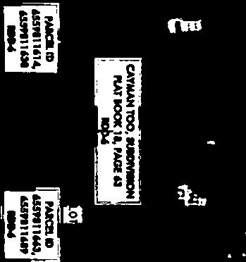
6 Page 4 of 10 SP Community Church of God/Visible Men Academy Middle School, MEPS 560, DTS # STAFF RECOMMENDED STIPULATIONS 1. This Special Permit shall not be effective until it has been recorded in the Public Records of Manatee County, Florida, by the applicant and a copy of the recorded Order is received by the Building and Development Services Department. 2. The site plan submitted with this application shall be part of this approval. 3. All applicable state permits shall be obtained before commencement of the development. 4. A Well Management Plan for the proper protection and abandonment of existing wells shall be submitted to the County for review and approval if wells are discovered during construction. The Well Management Plan shall include the following information: Digital photographs of the well along with nearby reference structures (if existing). GPS coordinates (latitude/longitude) of the well. The methodology used to secure the well during construction (e.g. fence, tape). The final disposition of the well; used, capped, or plugged. 5. Irrigation for landscaping shall use the lowest water quality source available, which shall be identified on the Final Site Plan. Use of Manatee County public potable water supply shall be prohibited. 6. If right-of-way is required to be dedicated for the project in the future, the existing roadway buffer shall be relocated to be inside the new property line. If the County widens the roadway, the developer/owner will be responsible for replacing all landscaping that is removed to accommodate the widened road. SURROUNDING USES & ZONING NORTH SOUTH EAST WEST MINIMUM SETBACKS: OPEN SPACE: BUFFERS: ACCESS: Duplex residences in Cayman Too Subdivision zoned RDD-6 Across 63 rd Avenue West are Single-family residences and a church zoned RSF-2 (Residential Single-Family - two dwelling units per acre) and RSF-3 (Residential Single Family three dwelling units per acre). Further south is Harlee Middle School zoned RSF-2. Duplex residences in Thunder Bay Subdivision zoned RDD-6 Vacant land owned by Visible Men Academy zoned RDD-6. Across 9 th Street E is an elementary school, (Daugthrey Elementary School zoned PDPI (Planned Development Public Interest) and RDD-6. SITE DESIGN DETAILS Front: 25 Sides: 15 Rear: 20 Required: 20% or 0.96± acres Provided: 78% or 3.74± acres Existing - 10-foot wide roadway buffers along 63 rd Avenue East 10-foot wide perimeter buffers adjacent to residential uses. One entrance connecting 63 rd Avenue East
7 Page 5 of 10 SP Community Church of God/Visible Men Academy Middle School, MEPS 560, DTS # WETLAND ACREAGE & IMPACTS: No wetlands FLOOD ZONE(S): X, FIRM Panel 12081C 0316 E dated 3/17/14 AREA OF KNOWN FLOODING: Yes, Rainfall UTILITY CONNECTIONS: County water and sewer POSITIVE ASPECTS The nearby area has a mix of residential and residential support uses. The site is currently being used for an elementary school. The establishment of a middle school provides current 5 th Grade students an opportunity to remain in the school s student population and advance to Grade 6.
8 Page 6 of 10 SP Community Church of God/Visible Men Academy Middle School, MEPS 560, DTS # SPECIAL PERMIT CRITERIA PURSUANT TO LDC SECTION A. The proposed use shall be consistent with the Comprehensive Plan and the requirements of this Code; The site is in the RDD-6 (Residential Duplex Dwelling Six dwelling units per acre) zoning district. Middle schools are Special Permit uses in the RDD zoning district. Additionally, the use is subject to requirements in LDC Section (Schools). This proposal was reviewed for consistency with Policy of the Comprehensive Plan which requires review of all proposed development for compatibility and appropriate timing. Staff finds that this proposal meets the requirements of the Comprehensive Plan with the recommended stipulations. B. The establishment, maintenance or operation of the proposed use shall not be detrimental to or endanger the public health, safety or general welfare; The school is classified as a residential support use. The small expansion to add a middle school on this site should not be detrimental to or endanger the public health, safety, or general welfare. C. The establishment of the use shall not impede the normal and orderly development and improvement of surrounding properties for uses permitted in the zoning district; Except for a vacant parcel (owned by the school) to the west, the site is surrounded by residential developments to the north, east and south. The school is relatively small and its structures and playground are adequately separated from surrounding properties and uses. The site plan shows an existing fence separates adjacent residential structures to the east from the school site. Also, there is significant vegetation on the site which separates the adjacent residential uses to the north from the playground area. This area of vegetation is not planned to be disturbed with this request. Additionally, the nearest structure on the school site is approximately 72 feet from the boundary of adjacent residential uses to the east and 309± feet to the northern property line. The existing playground area is north of the church building, away from residential uses to the north and east. The addition of a middle school should not impede the normal and orderly development and improvement of surrounding properties. D. Adequate measures shall already exist, or shall be taken, to provide ingress and egress to the proposed use in a manner that minimizes traffic congestion in the public streets; Major Transportation Facilities The site is located on 63rd Avenue East, which is designated as a four lane arterial roadway in the Comprehensive Plan s Future Traffic Circulation Plan and has a planned right of way width of 120 feet. Transportation Concurrency Transportation concurrency was evaluated for the project. The Applicant prepared a Traffic Impact Statement (TIS), and the conclusion of the approved TIS is that there are no off-site concurrencyrelated improvements required for the project (see Certificate of Level of Service (CLOS) Compliance table below). Access Access to the site will be provided by two existing full-access driveways along 63 rd Avenue East.
9 Page 7 of 10 SP Community Church of God/Visible Men Academy Middle School, MEPS 560, DTS # CERTIFICATE OF LEVEL OF SERVICE (CLOS) COMPLIANCE TRANSPORTATION CONCURRENCY CLOS APPLIED FOR: Yes TRAFFIC STUDY REQ D: Yes NEAREST THOROUGHFARE LINK ADOPTED LOS FUTURE LOS WITH PROJECT 63 rd Avenue East 1940 D D Solid waste landfill capacity and preliminary drainage intent have been reviewed with this Preliminary Site Plan. Potable water and waste water will be reviewed at the time of Final Site Plan/Construction Drawings. LDC , Table 10-2 (Parking Ratios) requires the preparation of an independent parking study to analyze the parking requirements for schools. The site has 63 parking spaces. Based on a parking study submitted by the applicant, the existing 63 parking spaces provide sufficient accommodation for the 12 teachers, 15 administrative staff and four potential visitors. There appears to be no conflict with parking for the Church and school. According to the applicant, the church services occur on Sundays and Wednesday night. School hours are 8:00 a.m. to 4:15 p.m. Parent drop off and before school child care begin at 7:15 a.m. After school child care and enrichment programs end at 5:15 p.m., Monday through Friday. E. The use, as proposed, is compatible with the surrounding uses and the general desired character of the area (height, bulk, scale, intensity, traffic, noise, drainage, lighting, and appearance); There is an elementary school (K-5 th grades) already existing on the site. According to the applicant, the expansion of the middle school will occur in increments of 15 students over the next three years, beginning with Grade 6 for the school year As mentioned previously, the site is surrounded by residential developments to the north, east and south, across 63 rd Avenue East. The school is relatively small. Its structures and playground are adequately separated (fence to the east and trees to the north) from surrounding residential properties and uses. The separation and existing buffers, tree vegetation and fences should help to alleviate any potential noise impacts. The LDC classifies schools as a residential support use. There are other residential support uses, such as churches and schools in the immediate vicinity of the school. These types of uses normally co-exist well with residential uses. Therefore, the school as proposed, is considered compatible with the surrounding residential uses and the general desired character of the area. Two additional modular buildings totaling 1,728 square feet will be placed on-site to accommodate the middle school use. The maximum building height proposed is 35 feet. This height should not create any external impacts that would adversely affect surrounding developments. The site meets the intensity requirements. The proposed Floor Area Ratio (FAR) of 0.08 is below the maximum FAR threshold of 0.15 (listed in LDC Table 4-4, Schedule of Bulk and Dimensional Standards for Agricultural and Residential Districts) for the RDD zoning district. The Applicant prepared a Traffic Impact Statement (TIS). The conclusion of the approved TIS is that there are no off-site concurrency-related improvements required for the project (see Certificate of Level of Service (CLOS) Compliance table below). There are no drainage concerns relative to the expansion of the existing school.
10 Page 8 of 10 SP Community Church of God/Visible Men Academy Middle School, MEPS 560, DTS # Lighting will be addressed with the Final Site Plan. F. Development of the proposed use shall not have a substantial adverse effect on a known archaeological, historical or cultural resource located on or off the parcel proposed for development; There are no known historic or archaeological resources on the site. 78% open space is proposed. G. Screening and buffers are proposed of such type, dimension and character to improve compatibility and harmony of the proposed use and structure with the uses and structures of adjacent and nearby properties. No change is anticipated to the existing site conditions relative to roadway and perimeter buffers. There is a fence within the required ten-foot wide perimeter landscaped buffer along the east boundary to alleviate any potential impacts on adjacent and nearby residents. REMAINING ISSUES OF CONCERN NOT RESOLVED OR STIPULATED There are no remaining issues of concern. LDC SECTION STANDARDS FOR ACESSORY, SPECIFIC USES, STRUCTURES Schools All accessory parking lots and playing fields shall be oriented in such a manner so as not be located adjacent to residentially zoned property. If this cannot be met, then those areas shall be screened with either a solid fence or landscaping reaching eighty (80) percent opacity within two (2) years. MANATEE COUNTY COMPREHENSIVE PLAN Policy: Review all proposed development for compatibility and appropriate timing. This analysis shall include: - consideration of existing development patterns, - types of land uses, - transition between land uses, - density and intensity of land uses, - natural features, - approved development in the area, - availability of adequate roadways, - adequate centralized water and sewer facilities, - other necessary infrastructure and services. - limiting urban sprawl
11 Page 9 of 10 SP Community Church of God/Visible Men Academy Middle School, MEPS 560, DTS # applicable specific area plans - (See also policies under Objs ) Policy: RES-9: Establish the Residential-9 Dwelling Units/Gross Acre future land use category as follows: Policy: Policy: Policy: Intent: To identify, textually in the Comprehensive Plan's goals, objectives, and policies, or graphically on the Future Land Use Map, areas which are established for a low-moderate urban, or clustered moderate density urban residential environment. Also to provide for a complement of residential support uses normally utilized during the daily activities of residents of these urban areas. Range of Potential Uses (see Policies , ): Suburban or urban residential uses, neighborhood retail uses, dormitories, short-term agricultural uses other than special agricultural uses, agriculturallycompatible residential uses, public or semi-public uses, schools, low intensity recreational uses, and appropriate water-dependent/waterrelated/water-enhanced uses (see also Objectives and ). Range of Potential Density/Intensity: Maximum gross residential density: 9 dwelling units per acre Minimum Gross Residential Density: 7.0 only in UIRA for residential projects that designate a minimum of 25% of the dwelling units as affordable housing. Maximum net residential density: 16 dwelling units per acre 20 dwelling units per acre within the UIRA for residential projects that designate a minimum of 25% of the dwelling units as Affordable Housing. (except within the WO or CHHA Overlay Districts pursuant to Policies and ) Maximum Floor Area Ratio: 0.23 (0.35 for mini-warehouse uses) 1.00 inside the UIRA [Supplement 22] Policy: Maximum Square Footage for Neighborhood Retail Uses: Medium (150,000sf) Other Information: a) All mixed and multiple-use projects shall require special approval, as defined herein, and as further defined in any land development regulations developed pursuant to , F.S. b) All projects for which gross residential density exceeds 6
12 Page 10 of 10 SP Community Church of God/Visible Men Academy Middle School, MEPS 560, DTS # ATTACHMENTS 1. Copy of Newspaper Advertising 2. Preliminary Site Plan dwelling units per acre, or in which any net residential density exceeds 9 dwelling units per acre shall require special approval. c) Any nonresidential project exceeding 30,000 square feet of gross building area shall require special approval. d) Professional office uses not exceeding 3,000 square feet in gross floor area within this category may be exempted from compliance with any locational criteria specified under Policies and , provided such office is located on a roadway classified as a minor or principal arterial, however, not including interstates, and shall still be consistent with other commercial development standards and with other goals, objectives, and policies in this Comprehensive Plan (see also ).


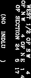
13 9 ST E AERIAL NEW VISION BAPTIST CHURCH LEE'S WAREHOUSE 9 ST E INSURANCE AUTO AUCTION 15 ST E MISSION PENTECOSTAL CHURCH PRIDE PARK EXPANSION PRIDE PARK EXPANSION INSURANCE AUTO AUCTION 63 AVE E CIRCLE K STATION NO STERLING LAKE 9 ST E ANNE'S MINI STORAGE OAKWOOD APTS BEDWELL COMMERCIAL Parcel ID #(s) Project Name: Project #: DTS#: Proposed Use: Visible Men Academy Middle School SP S/T/R: Acreage: Existing Zoning: Existing FLU: Overlays: Special Areas: Sec 24 Twn 35 Rng RDD-6 RES-9 NONE CRA CHH: Watershed: Drainage Basin: Commissioner: NONE NONE BOWLEES CREEK Robin DiSabatino ¹ Manatee County Staff Report Map Map Prepared 6/17/ inch = 744 feet


14 9 ST E FUTURE LAND USE NEW VISION BAPTIST CHURCH 9 ST E ROR RES-9 INSURANCE AUTO AUCTION 15 ST E MISSION PENTECOSTAL CHURCH RES-16 PRIDE PARK EXPANSION PRIDE PARK EXPANSION INSURANCE AUTO AUCTION IL ROR 63 AVE E CIRCLE K STATION NO IH RES-16 STERLING LAKE RES-6 RES-3 ROR RES-6 9 ST E ANNE'S MINI STORAGE IL Parcel ID #(s) Project Name: Project #: DTS#: Proposed Use: Visible Men Academy Middle School SP S/T/R: Acreage: Existing Zoning: Existing FLU: Overlays: Special Areas: Sec 24 Twn 35 Rng RDD-6 RES-9 NONE CRA CHH: Watershed: Drainage Basin: Commissioner: NONE NONE BOWLEES CREEK Robin DiSabatino ¹ Manatee County Staff Report Map Map Prepared 6/17/ inch = 686 feet

 6560010057 Project Name: Project #: DTS#: Proposed Use: Visible Men Academy")

15 9 ST E PD-R NEW VISION BAPTIST CHURCH 9 ST E ZONING RDD-6 GC LM RDD-6 RDD-6 MISSION PENTECOSTAL CHURCH RMF-9 RDD-6 PRIDE PARK EXPANSION PRIDE PARK EXPANSION RSF-6 RSF-6 INSURANCE AUTO AUCTION INSURANCE AUTO AUCTION LM 15 ST E HC GC RDD-6 HC LM RSF-4.5 RSMH-6 PD-PI 63 AVE E LM RSF-4.5 RSF-3 RMF-9 NC-S HC PD-R NC-S CIRCLE K STATION NO PD-C GC RSMH-6 LM HM STERLING LAKE RSF-2 HC RSF-6 RSF-3 RSF-4.5 GC RSMH-6 9 ST E ANNE'S MINI STORAGE LM RSF-6 Parcel ID #(s) Project Name: Project #: DTS#: Proposed Use: Visible Men Academy Middle School SP S/T/R: Acreage: Existing Zoning: Existing FLU: Overlays: Special Areas: Sec 24 Twn 35 Rng RDD-6 RES-9 NONE CRA CHH: Watershed: Drainage Basin: Commissioner: NONE NONE BOWLEES CREEK Robin DiSabatino ¹ Manatee County Staff Report Map Map Prepared 6/17/ inch = 686 feet


16
17


18


19
20
21 NOTICE OF ESTABLISHMENT OR CHANGE OF A REGULATION AFFECTING THE USE OF LAND IN UNINCORPORATED MANATEE COUNTY Bradenton Herald June 29, 2016 Miscellaneous Notices NOTICE IS HEREBY GIVEN, that the Hearing Officer for Manatee County, will conduct a Public Hearing on Monday, July 18, 2016 at 3:00 p.m. at the Manatee County Government Administrative Center, 1st Floor Chambers, 1112 Manatee Avenue West, Bradenton Florida to consider and act upon the following matters: VA MENDOZA VARIANCE - DTS Request: Approval of a variance to the setback requirements established in the PDR (Planned Development Residential) zoning district by Zoning Ordinance PDR-96-09, to reduce the minimum waterfront setback for Lot 45 of the Harbour Landings Estates Subdivision from 30 feet to 15 feet. The site is located on the east side of Baypointe Terrace, commonly known as Baypointe Terrace, Cortez (Manatee County) (ñ0.37 acres). SP (MEPS #560, DTS# ) - COMMUNITY CHURCH OF GOD/VISIBLE MEN ACADEMY MIDDLE SCHOOL Request: Approval of a Special Permit to allow a Middle School in the RDD-6 (Residential Duplex Dwelling - six dwelling units per acre) zoning district. The site is on the north side of 63rd Avenue East approximately 320 feet east of the intersection of 9th Street East and 63rd Avenue East at rd Avenue East, Bradenton (4.8ñ acres). Rules of Procedure for this public hearing are in effect pursuant to Section of the Manatee County Land Development Code. Copies of this section of the Code are available for review at the Building and Development Services Department. All interested parties are invited to appear at this Hearing and be heard, subject to proper rules of conduct. Additionally, any written comments filed with the Director of the Building and Development Services Department will be heard and considered by the Hearing Officer and entered into the record. Interested parties may examine the Official Zoning Atlas, the application, related documents, and may obtain assistance regarding this matter from the Manatee County Building and Development Services Department, 1112 Manatee Avenue West, 4th Floor, Bradenton, Florida, telephone number (941) ext or at: planning.agenda@mymanatee.org. According to Florida Statutes, Section , any person desiring to appeal any decision made by the Hearing Officer with respect to any matter considered at the Public Hearing will need a record of the proceedings, and for such purposes they may need to ensure that a verbatim record of the proceedings is made, which includes the testimony and evidence upon which the appeal is to be based. Americans With Disabilities: The Hearing Officer of Manatee County does not discriminate upon the basis of any individual's disability status. This non-discrimination policy involves every aspect of the Hearing Officer's functions including one's access to and participation in public hearings. Anyone requiring reasonable accommodation for this meeting as provided for in the ADA, should contact Kaycee Ellis at ; TDD ONLY and wait 60 seconds, or FAX THE PUBLIC HEARING MAY BE CONTINUED FROM TIME TO TIME PENDING ADJOURNMENTS.
22 MANATEE COUNTY HEARING OFFICER Manatee County Building and Development Services Department Manatee County, Florida 06/29/2016
23 Sarasota Herald-Tribune June 29, 2016 Miscellaneous Notices NOTICE OF ESTABLISHMENT OR CHANGE OF A REGULATION AFFECTING THE USE OF LAND IN UNINCORPORATED MANATEE COUNTY NOTICE IS HEREBY GIVEN, that the Hearing Officer for Manatee County, will conduct a Public Hearing on Monday, July 18, 2016 at 3:00 p.m. at the Manatee County Government Administrative Center, 1st Floor Chambers, 1112 Manatee Avenue West, Bradenton Florida to consider and act upon the following matters: VA MENDOZA VARIANCE - DTS Request: Approval of a variance to the setback requirements established in the PDR (Planned Development Residential) zoning district by Zoning Ordinance PDR-96-09, to reduce the minimum waterfront setback for Lot 45 of the Harbour Landings Estates Subdivision from 30 feet to 15 feet. The site is located on the east side of Baypointe Terrace, commonly known as Baypointe Terrace, Cortez (Manatee County) (±0.37 acres). SP (MEPS #560, DTS# ) - COMMUNITY CHURCH OF GOD/VISIBLE MEN ACADEMY MIDDLE SCHOOL Request: Approval of a Special Permit to allow a Middle School in the RDD-6 (Residential Duplex Dwelling - six dwelling units per acre) zoning district. The site is on the north side of 63rd Avenue East approximately 320 feet east of the intersection of 9th Street East and 63rd Avenue East at rd Avenue East, Bradenton (4.8± acres). Rules of Procedure for this public hearing are in effect pursuant to Section of the Manatee County Land Development Code. Copies of this section of the Code are available for review at the Building and Development Services Department. All interested parties are invited to appear at this Hearing and be heard, subject to proper rules of conduct. Additionally, any written comments filed with the Director of the Building and Development Services Department will be heard and considered by the Hearing Officer and entered into the record. Interested parties may examine the Official Zoning Atlas, the application, related documents, and may obtain assistance regarding this matter from the Manatee County Building and Development Services Department, 1112 Manatee Avenue West, 4th Floor, Bradenton, Florida, telephone number (941) ext or at: planning.agenda@mymanatee.org. According to Florida Statutes, Section , any person desiring to appeal any decision made by the Hearing Officer with respect to any matter considered at the Public Hearing will need a record of the proceedings, and for such purposes they may need to ensure that a verbatim record of the proceedings is made, which includes the testimony and evidence upon which the appeal is to be based. Americans With Disabilities: The Hearing Officer of Manatee County does not discriminate upon the basis of any individual's disability status. This non-discrimination policy involves every aspect of the Hearing Officer's functions including one's access to and participation in public hearings. Anyone requiring reasonable accommodation for this meeting as provided for in the ADA, should contact Kaycee Ellis at ; TDD ONLY and wait 60 seconds, or FAX THE PUBLIC HEARING MAY BE CONTINUED FROM TIME TO TIME PENDING ADJOURNMENTS.
24 MANATEE COUNTY HEARING OFFICER Manatee County Building and Development Services Department Manatee County, Florida Date of pub: June 29, 2016
25 H.O. 07/18/2016 VA Mendoza Variance Request: Approval of a variance to the setback requirements established in the PDR (Planned Development Residential) zoning district by Zoning Ordinance PDR-96-09, to reduce the minimum waterfront setback for Lot 45 of the Harbour Landings Estates Subdivision from 30 feet to 15 feet. The site is located on the east side of Baypointe Terrace, commonly known as Baypointe Terrace, Cortez (Manatee County) (±0.37 acres). Hearing Officer: 07/18/2016
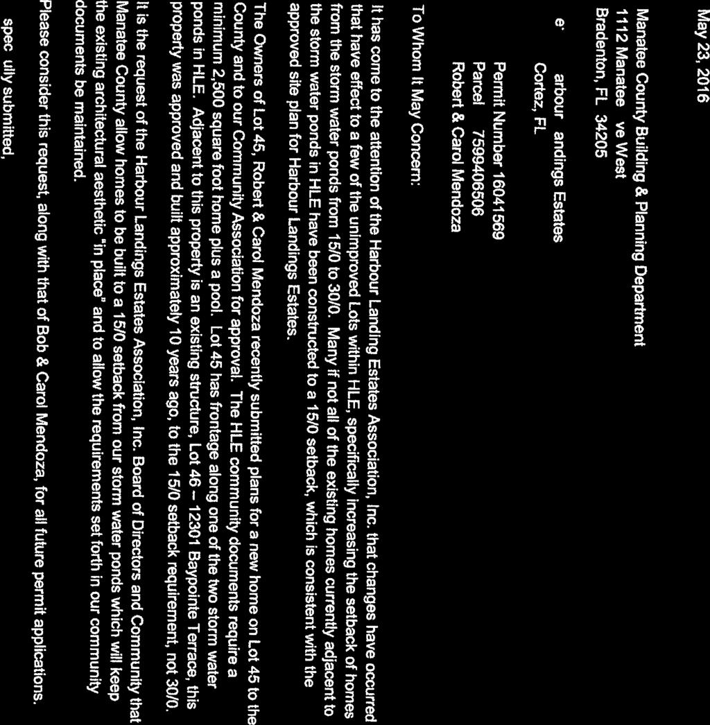
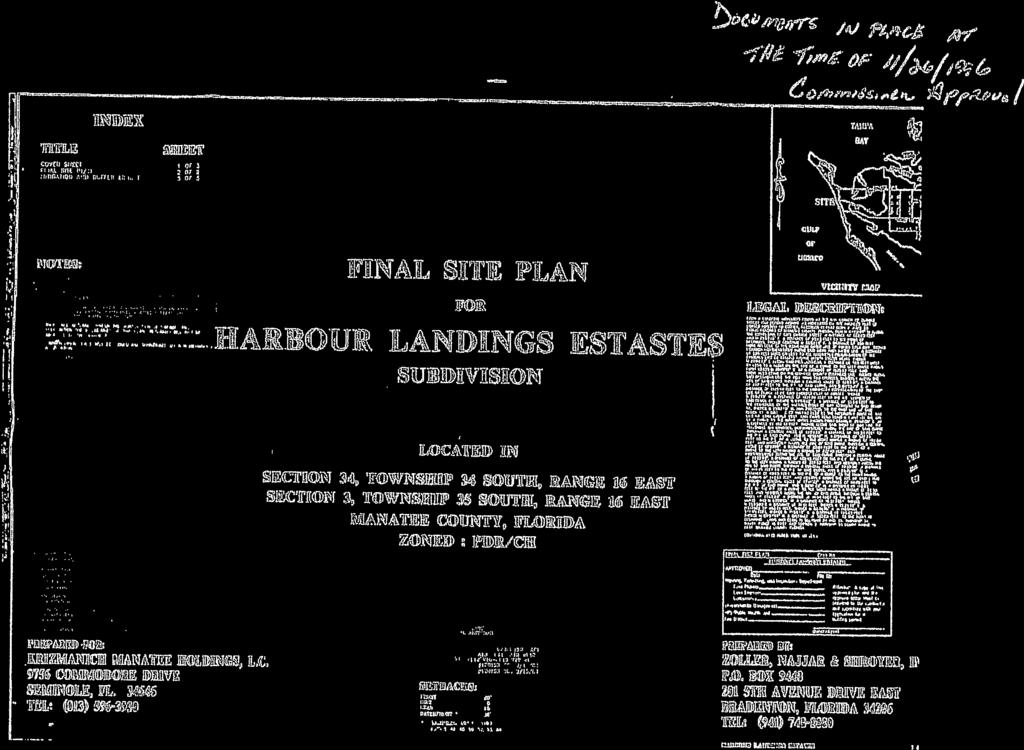
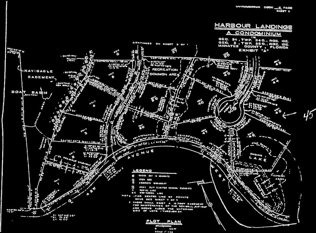
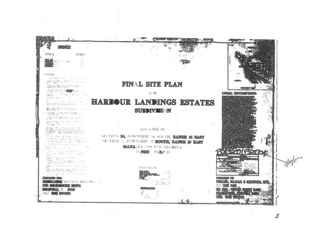
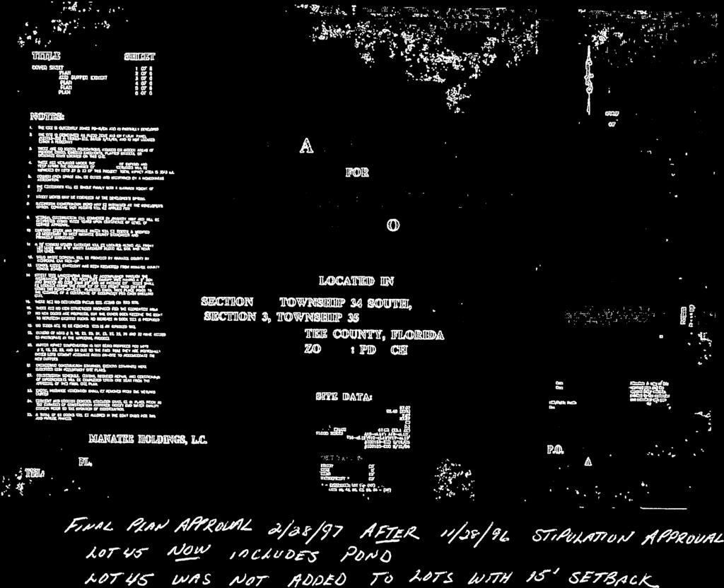
26 Page 2 of 8 VA Mendoza Variance PROJECT SUMMARY CASE#: VA (DTS # ) PROJECT NAME: APPLICANT(S): REQUEST: CASE PLANNER: STAFF RECOMMENDATION: Mendoza Variance Robert E. Mendoza Variance to the setback requirements established in the Planned Development Residential (PDR) Zoning District by Zoning Ordinance PDR-96-09, to reduce the minimum waterfront setback for Lot 45 of the Harbour Landings Estates Subdivision from 30 feet to 15 feet. Branden Roe APPROVAL SITE CHARACTERISTICS ADDRESS: GENERAL LOCATION: SIZE: EXISTING USE(S): PREVIOUS APPROVAL(S): ZONING: FUTURE LAND USE CATEGORY: OVERLAY DISTRICT(S): Baypointe Terrace, Cortez Harbour Landings Estates Subdivision, north of Cortez Avenue. ±16,271 square feet (±0.37 acres) Vacant Residential PDR-96-09, FSP PD-R RES-9/CHHA (Residential, 9 dwelling units per acre / Coastal High Hazard Overlay) CHHA (Coastal High Hazard Overlay) STAFF SUMMARY The request at hand is for a variance from the required 30 foot waterfront setback as established by the Manatee County Land Development Code, and as reiterated and referenced in PDR-96-09(P). The subject property is Parcel ID , commonly known as Lot 45 of the Harbour Landings Estates Subdivision. The lot is located at the common address of Baypointe Terrace. The Harbour Landings Estates Subdivision Preliminary Site Plan for the project was approved in 1996, the Final Site Plan was approved in 1997, and the Subdivision was platted in Setbacks for the project were established when the Preliminary Site Plan was brought before the Board of County Commissioners in 1996, included among these established setbacks was a minimum 30 foot waterfront setback. This 30 foot minimum setback was, and still is, the typical minimum waterfront setback established by the LDC for all standard Euclidian Zoning Districts. The regulations pertaining to the PDR Zoning District do not speak to any requirement to establish a minimum waterfront setback; rather, the minimum requirements are to


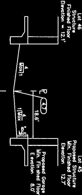
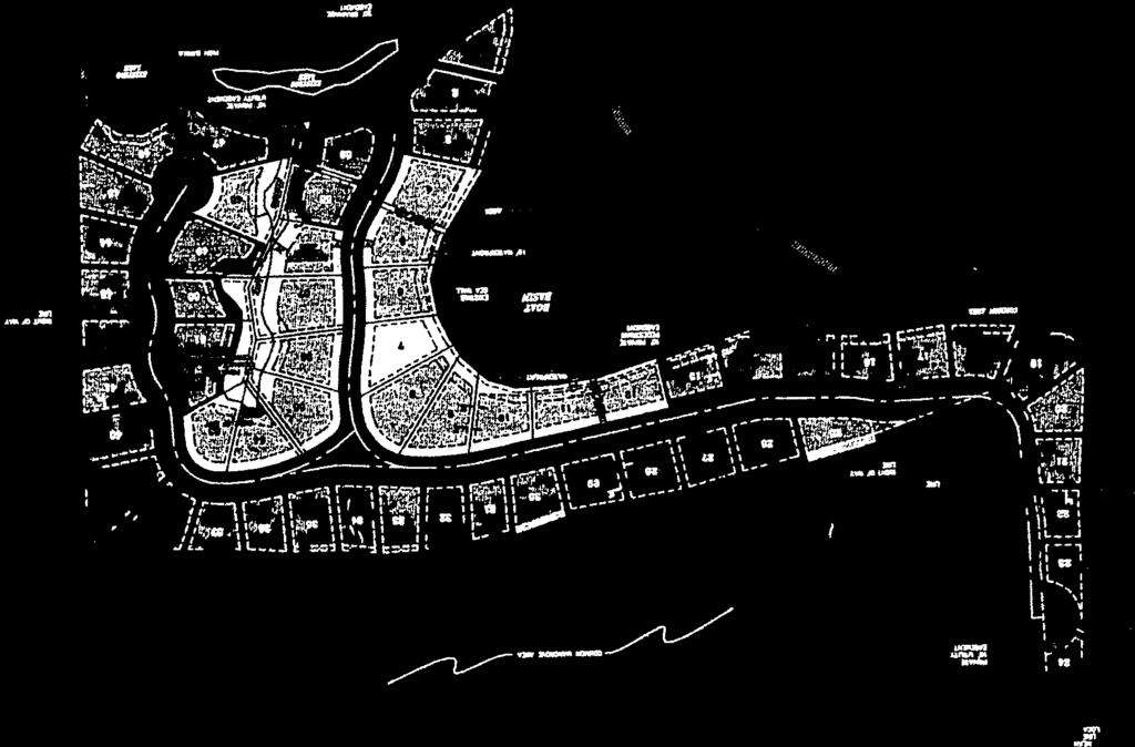
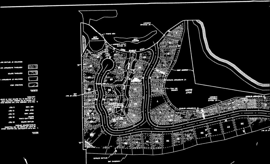
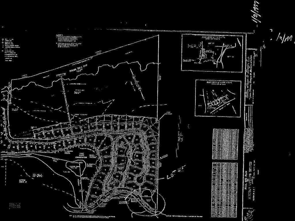
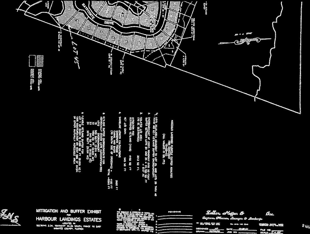
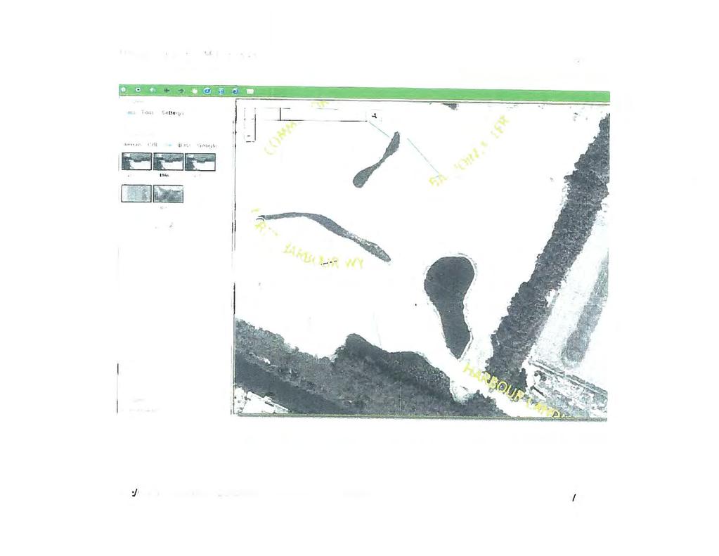
27 Page 3 of 8 VA Mendoza Variance establish only front, side and rear yard setbacks. As such, the original PDR request did not establish a project specific minimum waterfront setback, but instead referenced and referred back to the Code based requirements for comparable standard zoning districts. While the 30 foot waterfront setback was established as the minimum, a number of parcels abutting stormwater facilities in the project were granted reduced waterfront setbacks to establish lot specific minimums ranging from feet by means of a stipulation in order to allow for reasonable use of lots with stormwater facilities within their boundaries (see Stipulation 6 in the attached copy of Zoning Ordinance PDR-96-09(P)). The fundamental basis for the language of Stipulation 6 was on the design as shown on PDR s associated Preliminary Site Plan. In a comparative review of the design of the project, specifically the design of the stormwater facilities from the approved preliminary site plan and approved subdivision plat, it is apparent that the shape of the proposed stormwater facility impacting Lots 45 and 46 changed. Refer to the bottom right quadrants of both figures for the subject areas. Figure 1 illustrates the design of the stormwater facility on the preliminary site plan which was the basis for the drafting of Stipulation 6 for PDR-96-09(P). Stipulation 6 granted Lot 46 a reduced waterfront setback of 15 feet, at that time the proposed stormwater facility impacts were restricted solely to Lot 46, and Lot 45 was not to be impacted by the facility as shown in the PSP design. Figure 2 shows a revised design of the stormwater facility on the approved Plat, which is consistent with the actual layout of the stormwater facility today. With the new design that appeared on the Plat, impacts from the stormwater facility were no longer restricted to Lot 46, but were extended onto Lot 45. Figure 1: PSP Figure 2: Plat As demonstrated in Figures 1 and 2 above, the design of the stormwater facility clearly limited impacts to Lot 46 in the original design. The language for Stipulation 6 of PDR-96-09(P), which stipulated Code (a practice that has since been discontinued), and granting reduced setbacks was specifically crafted to include only lots which were impacted by such facilities based upon this PSP design. The design was t significantly altered between board approval of PSP, and approval of the subdivision plat. Prior to approval of the subdivision plat, Staff failed to recognize that Stipulation 6 had not been revised in response to the design change to mitigate for the new impacts on Lot 45. As a result, Lot 45 was not privy to the reduced waterfront setback that other lots located along the stormwater facilities within the subdivision were, most notably Lot 46.

 and its surrounding topographical and physical landscape in 1994.")
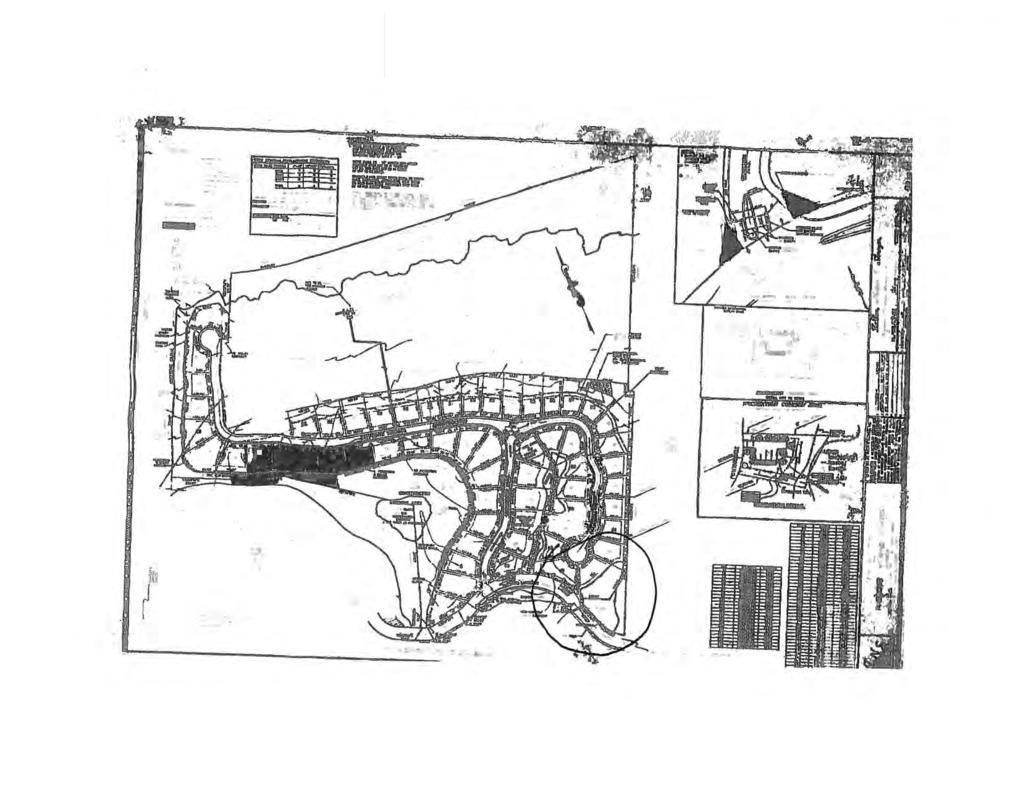
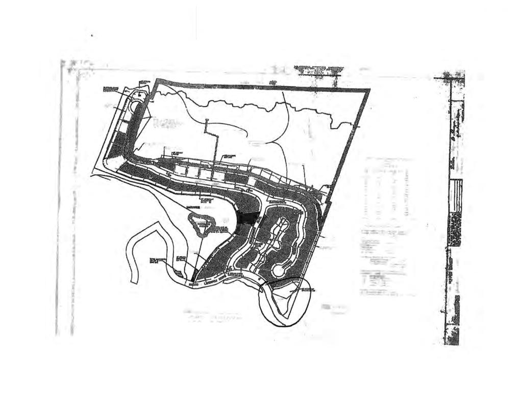
28 Page 4 of 8 VA Mendoza Variance In a review of the historical documents and information available, Staff has identified an apparent discrepancy between actual topographical and physical landscape of the subject property and the topography and physical landscape as shown in the approved design of the PSP. Figure 3 below shows an aerial focused of the subject property (denoted with a red square) and its surrounding topographical and physical landscape in Figure 4 below shows an aerial of the subject property (denoted with a red square) and its surrounding topographical and physical landscape in It is apparent that the shape of the stormwater facility, which is now contained within Lots 45 and 46 of the Harbour Landings Estates Subdivision, changed between 1984 and It is also apparent upon a cross referencing with Figure 1 that the design of the PSP which was approved in 1996 was based upon the 1984 aerial rather than the newer 1994 aerial. The review of the available archived information brings forward a concern that Staff in 1996, 1997 and 1998 at the time of preliminary site plan, final site plan and subdivision platting (respectively) failed to verify the consistency of actual topographical and physical conditions with those shown by the original applicant of PDR (P). This ultimately led to the approval of a PSP which was clearly inconsistent with the actual topographical and physical conditions. As a result, the language used to craft Stipulation 6 failed to account for the true physical layout of the stormwater facility and ultimately failed to provide equal relief to all properties which were impacted by the stormwater facility. Figure 3 Historical Aerial 1984 Figure 4 Historical Aerial 1994 In addition to the minimum 30 foot waterfront setback for the subject lot, there are also a number of easements on the property which may limit the developable area of the lot. These include a 10 foot Drainage, Utility & Sidewalk Easement in the front yard, 5 foot Drainage & Utility Easements on both side yards, a 5 foot Drainage & Utility Easement as well as an additional 10 foot Private Drainage Easement in the rear yard. These easements may contribute to the applicant having difficulty carrying out reasonable development of the property; however, the redesign of the stormwater pond and the lack of relief from the 30 foot setback requirements that other lots were granted by means of Stipulation is the largest impediment to reasonable
29 Page 5 of 8 VA Mendoza Variance development occurring, and the basis of the hardship to the property owner. Based upon a review of the prior approvals, a review historical and archival materials, as well as a review of the current conditions, and an analysis demonstrating the request at hand meets the review criteria established in Section of the LDC, Staff recommends approval of this Variance request. COMPLIANCE WITH THE LAND DEVELOPMENT CODE Limitations on Granting of Variances (LDC Section 367.2) Prohibitions (LDC Section 367.3) Review Criteria (LDC Section 367.6) Section Limitations on Granting of Variances. Variances may be granted for no other purpose than to allow a single lot or parcel to depart from dimensional regulations of this Code that restrict the following matters: A. Minimum floor area per dwelling units; B. Required yards, buffers, or setbacks; C. Maximum lot coverage; D. Maximum heights; and E. Errors of encroachments. The requested variance seeks to depart from the required waterfront setback for a single lot or parcel of property which is consistent with limitation B of Section of the LDC. The requested variance does not propose any departures from minimum floor areas (367.2.A.), maximum lot coverages (367.2.C.), maximum heights (367.2.D.), or any errors of encroachments (367.2.E.). As such, the requested variance is consistent with the limitations on granting variances as laid out by Section Section Prohibitions. Even if a requested variance complies with the requirements of this Section, such variance shall not be granted if such variance: A. Allows the expansion or establishment of a use in a zone or district in which such use is not permitted by this Code; The variance being requested pertains solely to the departure from the dimension regulation of a waterfront setback for a single lot, and as such, does not propose any expansion or establishment of a use not currently permitted in the PD-R zoning district as established by the Manatee County LDC. B. Permits the establishment or expansion of a Special Permit or Administrative Permit use without the required approvals; The variance being requested pertains solely to the departure from a dimension regulation and as such. does not propose any establishment or expansion of a Special Permit or Administrative Permit. C. Relates in any way to a nonconforming use, except to the extent such a use has been approved pursuant to this Code; The variance being requested pertains solely to the departure from the dimension regulation of a waterfront setback for a single lot, and will have no relationship to any nonconforming uses. D. Purports to modify any definitions set forth in Chapter 2, Definitions; The variance being requested pertains solely to the departure from a dimension regulation and as such, proposes no modifications to any definitions which have been set forth in Chapter 2 of the LDC.
30 Page 6 of 8 VA Mendoza Variance E. Results in an increase in density above that permitted in the applicable zoning district regulations; The variance being requested pertains solely to the departure from the dimension regulation of a waterfront setback for a single lot. The variance is not proposing any increase in density let alone any density increase which would exceed the permitted densities of the PD-R zoning district. F. Will be inconsistent with the Manatee County Comprehensive Plan; The variance being requested is seeking a departure from the dimension regulation of a waterfront setback for a single lot, and is consistent with the Manatee County Comprehensive Plan. This consistency is confirmed by Manatee County Comprehensive Plan Section C Consistency with the Comprehensive Plan, which states that land development regulations may provide for appropriate variance procedures to permit exceptions from certain minimum dimensional standards (such as setbacks, buffers, minimum lot sizes, and minimum open space requirements), to avoid unique hardships running with the land that are not self-imposed, and to avoid the taking of private property without due process of law and just compensation pursuant to (4)(a) and (b), Florida Statutes. Such variances shall be the minimum variance necessary that will allow a reasonable use of the property and shall not allow the establishment or expansion of a use, density or intensity which is not allowed for the Future Land Use Element category for the subject property. Such variance procedures shall require public hearings and ensure that minimum due process requirements are met, (emphasis added). The proposed variance is the minimum necessary to allow for reasonable use of the property, and does not propose to establish or expand any use, density, or intensity not allowed for in the Future Land Use Element. The variance request, proposes an exception from a dimensional standard in the form of a waterfront setback, to avoid a unique hardship which has not been self-imposed. G. Results in approval of any action which would violate any floodplain management provision of Manatee County; any floodplain management provision of the National Flood Insurance Program; and/or any floodplain management provision of the Community Rating System Program. The variance being requested pertains solely to the departure from the dimension regulation and will not result in any violation of any floodplain management provisions of Manatee County, the National Flood Insurance Program, or the Community Rating System Program. Section Review Criteria. All variances shall comply with the following criteria: A. The particular physical surroundings, shape, topographical condition, or other physical or environmental condition of the specific property involved would result in a particular hardship upon the owner, as distinguished from a mere inconvenience, if the strict letter of the regulations were carried out. Lot 45 of the Harbour Landings Estates Subdivision, located at the common address of Baypointe Terrace, has been subjected to a hardship to reasonable development as a result of the lot shape as well as the physical/environmental conditions of the property. In a comparative review of the design of the project, specifically the design of the stormwater facilities from the approved preliminary site plan, approved final site plan and approved subdivision plats, it is apparent that the shape of the proposed stormwater facility impacting Lots 45 and 46 changed. Stipulation 6 granted Lot 46 a reduced waterfront setback of 15 feet, Lot 45 did not have any anticipated impacts from the stormwater facility at the time of
31 Page 7 of 8 VA Mendoza Variance PSP approval, and Stipulation drafting. Between the approval of the PSP in 1996 and the 1998 approval of the Subdivision Plat a new design for the stormwater facility appeared, which expanded its impacts from being solely within the lot boundaries for Lot 46, to also include impacts on Lot 45. The original design of the subject stormwater facility clearly limited impacts to Lot 46, the language for the Stipulation granting reduced setbacks was specifically crafted to include only lots which were impacted by such facilities based upon this design. The design was not significantly altered until the process of approving the subdivision plat, at which point the stipulation was not revised. As a result, Lot 45 was not privy to the reduced waterfront setback that other lots located along the stormwater facilities were, most notably Lot 46, which places a hardship on the owner to be able to carry out reasonable development of the lot.w B. The conditions upon which the request for a variance is based are unique to the parcel and would not be applicable, generally to other property within the vicinity. The request for a variance of the required waterfront setback is unique to the parcel as the adjacent and surrounding lots which are situated along the same storm water facility and others within the subdivision were granted reduced minimum setbacks by means of Stipulation 6 in PDR-96-09(P). C. The variance are not based on any conditions, including financial, occupational, or ability, which are personal to the applicant as applied to the property involved in the application. The application and request for this variance to the waterfront setback requirements is not based upon any conditions, including financial, occupational, or ability, which are personal to the applicant / owner of the property. D. The alleged hardship has not been created by any person presently having an interest in the property or was created as a result of a bona fide error. The hardship created on this property is not the result of actions by any person presently having an interest in the property. Likewise, there is no definitive evidence that this hardship was the result of a bona fide error. E. The granting of the variance will not be detrimental to the public welfare or injurious to other property of improvements in the vicinity. The variance request is not proposing any true detriment to the public welfare, and is not proposing any conditions that would prove injurious to any surrounding properties. F. The proposed variance will not substantially increase the congestion in the public streets, or increase the danger of fire, or endanger the public safety. The variance request as proposed will not contribute to any substantial increase in congestion on the public streets. Likewise the requested reduction in the waterfront setback will have no bearing or influence on the risk of fire or public safety. G. The variance granted is the minimum variance that will make possible the reasonable use of the property. The requested variance to reduce the waterfront setback from 30 foot to 15 foot will enable the owner of the subject property to construct a residential dwelling unit that is of a bulk and scale that is consistent with the existing development pattern of the subdivision, including adjacent developed lots. Likewise, the other lot (Lot 46) which abuts the same stormwater lake received a reduced waterfront setback of 15
32 Page 8 of 8 VA Mendoza Variance feet to allow for reasonable use of the site, and other lots abutting stormwater facilities were granted relief from the 30 foot waterfront setback by means of Stipulation 6 in the original Zoning Ordinance. A variance to grant a reduction by 15 feet is the minimum that would allow for reasonable use of the property while ensuring that there is no risk of human error establishing a nonconformity subsequent to the required public hearing. H. The property cannot be put to a reasonable use which complies fully with the requirements of the Code unless the variance is granted. In addition to the minimum 30 foot waterfront setback for the subject lot, there are also a number of easements on the property which limit the developable area of the lot. These include a 10 foot Drainage, Utility & Sidewalk Easement in the front yard, 5 foot Drainage & Utility Easements on both side yards, a 5 foot Drainage & Utility Easement as well as an additional 10 foot Private Drainage Easement in the rear yard. These easements in conjunction with the 30 foot waterfront setback makes it impossible to put the property to a reasonable use while maintaining consistency with the surrounding development pattern as well as the requirements of the Code. The requested variance would provide relief from the waterfront setback that is consistent with Lot 46 (immediately adjacent), as well as other lots abutting the storm water facilities. I. Alternatively, a variance may be issued to correct a bona fide staff error that has been made and has led to construction that does not comply with the Code. There is a clear discrepancy between the historical aerials and the approved preliminary site plan which leads Staff to find that previous Staff in 1996, 1997 and 1998 failed to verify the consistency of actual topographical and physical conditions with those shown by the original applicant of PDR-96-09(P). Bona fide is defined as genuine; real; sincere; or without intention to deceive. Staff s review of available information leads to the conclusion that previous staff made an error in not verifying accuracy between the submittal and the actual conditions, without any intent to deceive or place any intention undue hardship on any particular property owner; This failure to verify the shown conditions led to the approval of a PSP which was clearly inconsistent with the actual topographical and physical conditions.. As a result, the language used to craft Stipulation 6 failed to account for the true physical layout of the stormwater facility and ultimately failed to provide equal relief to all properties which were impacted by the stormwater facility. Therefore, current Staff s analysis leads to the conclusion that there was a failure by the Staff responsible for reviewing the PSP, FSP and Plats in 1996, 1997 and 1998, and while the failure likely had no intention to deceive, there is no competent and substantial evidence that there was a true bona fide staff error that has led to a construction of terms that does not comply with the code. ATTACHMENTS 1. Drainage Plan (Current Site Plan for Mendoza Property) 2. Marked Up Drainage Plan (highlighted setbacks and infringement) 3. Copy of PDR (P) Zoning Ordinance 4. Copy of PDR-96-09(P)(R) Zoning Ordinance 5. PDR-96-09(P) PSP Sheet 6. Zoomed in Copy of PDR-96-09(P) PSP Sheet 7. Sheet from Recorded Plat (PB 32, PG 124) 8. Applicant s Request Letter & Support Materials 9. Copy of Newspaper Advertising


 ST CT W 7599406506 W ST W ST CT W CORTEZ HISTORICAL")


33 AERIAL WALK NERS BAYPOINTE TER 128 ST W OSPREY HARBOUR LOOP SAFE HARBOUR DR HARBO UR LANDI N GS DR COMMO D O RE BLVD TER BAYPOINTE E G RE T HARBOUR WY MANATEE FRUIT / CROSSROADS & PENINSULA BAY 126 ST W 42 AVE DR W HARBOUR LANDINGS DR ST CT W HUNTERS HILL INC 124 KEY WAY RV PARK EXPANSION 123 ST W BRADENTON BOAT CLUB MANATEE FRUIT / CROSSROADS & PENINSULA BAY AVE A AVE B FIT BY GRIND BOAT WORKS QR 684 CORTEZ RD W 119 ST W AVE C AVE D RAL AVE Parcel ID #(s) ST CT W W ST W ST CT W CORTEZ HISTORICAL SCHOOL PARK Project Name: Project #: DTS#: Proposed Use: Mendoza Variance VA S/T/R: Acreage: Existing Zoning: Existing FLU: Overlays: Special Areas: Sec 3 Twn 35 Rng PD-R RES-9 NONE CEA CHH: Watershed: Drainage Basin: Commissioner: Y NONE DIRECT RUNOFF TO BAY John Chappie ¹ Manatee County Staff Report Map Map Prepared 6/22/ inch = 451 feet
 7599406506")


34 AERIAL MANATEE FRUIT / CROSSROADS & PENINSULA BAY Parcel ID #(s) Project Name: Project #: DTS#: Proposed Use: Mendoza Variance VA S/T/R: Acreage: Existing Zoning: Existing FLU: Overlays: Special Areas: Sec 3 Twn 35 Rng PD-R RES-9 NONE CEA CHH: Watershed: Drainage Basin: Commissioner: Y NONE DIRECT RUNOFF TO BAY John Chappie ¹ Manatee County Staff Report Map Map Prepared 6/22/ inch = 54 feet


 7599406506 W ST W RES-6 ST CT W CORTEZ HISTORICAL SCHOOL")


35 FUTURE LAND USE WALK NERS BAYPOINTE TER 128 ST W OSPREY HARBOUR LOOP SAFE HARBOUR DR HARBO UR LANDI N GS DR COMMO D O RE BLVD TER BAYPOINTE RES-9 E G RE T HARBOUR WY MANATEE FRUIT / CROSSROADS & PENINSULA BAY 126 ST W 42 AVE DR W ST CT W HUNTERS HILL INC HARBOUR LANDINGS DR AVE A AVE B 124 IL KEY WAY RV PARK EXPANSION 123 ST W FIT BY GRIND BOAT WORKS QR 684 BRADENTON BOAT CLUB ROR MANATEE FRUIT / CROSSROADS & PENINSULA BAY CORTEZ RD W 119 ST W AVE C AVE D RAL AVE ST CT W Parcel ID #(s) W ST W RES-6 ST CT W CORTEZ HISTORICAL SCHOOL PARK Project Name: Project #: DTS#: Proposed Use: Mendoza Variance VA CHHA Coastal Evacuation Area S/T/R: Acreage: Existing Zoning: Existing FLU: Overlays: Special Areas: Sec 3 Twn 35 Rng PD-R RES-9 NONE CEA CHH: Watershed: Drainage Basin: Commissioner: Y NONE DIRECT RUNOFF TO BAY John Chappie ¹ Manatee County Staff Report Map Map Prepared 6/22/ inch = 451 feet

 7599406506")


36 ZONING WALK NERS BAYPOINTE TER 128 ST W OSPREY HARBOUR LOOP SAFE HARBOUR DR HARBO UR LANDI N GS DR COMMO D O RE BLVD TER BAYPOINTE PD-R RSF-4.5 E G RE T HARBOUR WY MANATEE FRUIT / CROSSROADS & PENINSULA BAY LM 126 ST W PD-W AVE A AVE B AVE C AVE D 124 RAL AVE ST CT W LM HUNTERS HILL INC PD-MU PD-C ST CT W Parcel ID #(s) GC RDD-6 42 AVE DR W KEY WAY RV PARK EXPANSION CRV W ST W 123 ST W FIT BY GRIND BOAT WORKS PD-W QR 684 RSF-6 HARBOUR LANDINGS DR PD-W BRADENTON BOAT CLUB ST CT W CRV MANATEE FRUIT / CROSSROADS & PENINSULA BAY CORTEZ RD W RDD ST W CORTEZ HISTORICAL SCHOOL PARK RDD-4.5 Project Name: Project #: DTS#: Proposed Use: Mendoza Variance VA S/T/R: Acreage: Existing Zoning: Existing FLU: Overlays: Special Areas: Sec 3 Twn 35 Rng PD-R RES-9 NONE CEA CHH: Watershed: Drainage Basin: Commissioner: Y NONE DIRECT RUNOFF TO BAY John Chappie ¹ Manatee County Staff Report Map Map Prepared 6/22/ inch = 451 feet
37


38
39
40
41

42

43
44
45
46
47

48
49
50
51


52

53
54

55
56

57

58

59

60


61
- A G E N D A - PLEASE TURN ALL CELL PHONES AND PAGERS OFF BEFORE ENTERING CHAMBERS PUBLIC HEARING APPLICATIONS (INDIVIDUAL CONSIDERATION)
") - A G E N D A - H E A R I N G O F F I C E R Manatee County Government Administrative Center 1112 Manatee Avenue West 1 st Floor Chambers Bradenton, Florida 34205 July 21, 2014 3:00 pm PLEDGE OF ALLEGIANCE
- A G E N D A - H E A R I N G O F F I C E R Manatee County Government Administrative Center 1112 Manatee Avenue West 1 st Floor Chambers Bradenton, Florida 34205 July 21, 2014 3:00 pm PLEDGE OF ALLEGIANCE
VARIANCE PUBLIC HEARING SUBMISSION REQUIREMENTS FOR COMPLETENESS REVIEW
 Building and Development Services Department 1112 Manatee Ave West, Suite 408 Bradenton, FL 34205 Phone: (941) 749 3070 www.mymanatee.org A 10 VARIANCE PUBLIC HEARING SUBMISSION REQUIREMENTS FOR COMPLETENESS
Manatee County Government Administrative Building First Floor, Chambers August 3, :00 am
 Manatee County Government Administrative Building First Floor, Chambers August 3, 2017-9:00 am August 3, 2017 - Land Use Meeting Agenda Item #16 Subject Resolution 17-089 (Related to AP-17-01) - SA-17-01
FUTURE LAND USE ELEMENT
 FUTURE LAND USE ELEMENT GOAL: 2.1 A distribution of land uses throughout unincorporated Manatee County which limit urban sprawl, providing a predictable and functional urban form, encouraging development
Division Development Impact Review.
 Division 51-4.800. Development Impact Review. SEC. 51-4.801. PURPOSE. The general objectives of this division are to promote and protect the health, safety, and general welfare of the public through the
FUTURE LAND USE ELEMENT
 FUTURE LAND USE ELEMENT GOAL: 2.1 A distribution of land uses throughout unincorporated Manatee County which limit urban sprawl, providing a predictable and functional urban form, encouraging development
Charter Township of Plymouth Zoning Ordinance No. 99 Page 208 Article 21: Residential Unit Developments Amendments: ARTICLE XXI
 Charter Township of Plymouth Zoning Ordinance No. 99 Page 208 ARTICLE XXI RESIDENTIAL UNIT DEVELOPMENTS PURPOSE The purpose of the Residential Unit Development (RUD) is to permit two (2) optional methods
AMENDMENTS TO OFFICIAL ZONING ATLAS (REZONE-STANDARD) SUBMISSION REQUIREMENTS FOR COMPLETENESS REVIEW
 SUBMISSION REQUIREMENTS FOR COMPLETENESS REVIEW") Building and Development Services Department 1112 Manatee Ave West, Suite 408 Bradenton, FL 34205 Phone: (941) 749 3070 www.mymanatee.org A 2 AMENDMENTS TO OFFICIAL ZONING ATLAS (REZONE-STANDARD) SUBMISSION
Building and Development Services Department 1112 Manatee Ave West, Suite 408 Bradenton, FL 34205 Phone: (941) 749 3070 www.mymanatee.org A 2 AMENDMENTS TO OFFICIAL ZONING ATLAS (REZONE-STANDARD) SUBMISSION
COMMUNITY DEVELOPMENT. Staff Report. Site Plan Review. SP June 19, 2018
 COMMUNITY DEVELOPMENT 333 Broadalbin Street SW, PO Box 490, Albany, Oregon 97321-0144 BUILDING 541-917-7553 PLANNING 541-917-7550 Staff Report Site Plan Review SP-18-18 June 19, 2018 Summary On May 1,
PALM BEACH COUNTY PLANNING, ZONING AND BUILDING DEPARTMENT ZONING DIVISION
 PALM BEACH COUNTY PLANNING, ZONING AND BUILDING DEPARTMENT ZONING DIVISION Application No.: DOA-2014-01111 Application Name: World Class Academy Control No.: 1998-00052 Applicant: World Class Academy Inc
PALM BEACH COUNTY PLANNING, ZONING AND BUILDING DEPARTMENT ZONING DIVISION
 PALM BEACH COUNTY PLANNING, ZONING AND BUILDING DEPARTMENT ZONING DIVISION Application No.: Z-2016-00663 Application Name: Autism School Control No.: 2014-00133 Applicant: Dayna2, LLC Owners: Dayna2, LLC
Medical Marijuana Special Exception Use Information
 Medical Marijuana Special Exception Use Information The Special Exception Use information below is a modified version of the Unified Development Code. It clarifies the current section 5:104 Special Exceptions
PROPOSED AMENDMENTS TO THE DERBY ZONING REGULATIONS AUGUST 12, 2008
 ARTICLE II Definitions and word usage 195-7. Definitions and word usage. Modify the following: HOUSING FOR THE ELDERLY OLDER PERSONS Housing in accordance with and as defined in the United States Fair
BOARD OF ADJUSTMENT MEETING CITY OF ST. PETE BEACH
 BOARD OF ADJUSTMENT MEETING CITY OF ST. PETE BEACH 155 Corey Avenue St. Pete Beach, Florida Wednesday, 11/15/2017 2:00 p.m. Call to Order Pledge of Allegiance Roll Call 1. Changes to the Agenda Agenda
Marion County Board of County Commissioners
 Marion County Board of County Commissioners Date: 6/4/217 P&Z: 9/25/217 BCC Transmittal: 1/17/217 BCC Adopt: TBD Amendment No: 217-L6 Type of Application Large-Scale Comp Plan Amendment Request: Change
INDIAN RIVER COUNTY, FLORIDA. The Honorable Members of the Planning and Zoning Commission DEPARTMENT HEAD CONCURRENCE
 Public Hearing Legislative INDIAN RIVER COUNTY, FLORIDA M E M O R A N D U M TO: The Honorable Members of the Planning and Zoning Commission DEPARTMENT HEAD CONCURRENCE Robert M. Keating, AICP; Community
CITY OF WEST PALM BEACH ZONING BOARD OF APPEALS
 CITY OF WEST PALM BEACH ZONING BOARD OF APPEALS Meeting Date: November 2, 2017 Zoning Board of Appeals Case No. 3356 Dr. Alice Moore Apartments Variances Location Aerial I. REQUEST Site is outlined in
COMPREHENSIVE PLAN FUTURE LAND USE MAP AMENDMENT APPLICATION
 COUNTY STAFF DATA ONLY Date Received: Project No. CPA-20 - GADSDEN COUNTY DEPARTMENT OF PLANNING & COMMUNITY DEVELOPMENT 1-B East Jefferson Street, Post Office Box 1799, Quincy, FL 32353-1799 PLANNING
ARTICLE 24 SITE PLAN REVIEW
 ARTICLE 24 SITE PLAN REVIEW 24.1 PURPOSE: The intent of these Ordinance provisions is to provide for consultation and cooperation between the land developer and the Township Planning Commission in order
Village of Glenview Zoning Board of Appeals
 Village of Glenview Zoning Board of Appeals STAFF REPORT December 7, 2015 TO: Chairman and Zoning Board of Appeals Commissioners FROM: Community Development Department CASE #: Z2015-049 LOCATION: PROJECT
ORDINANCE NO URBAN CORRIDOR AMENDMENTS
 ORDINANCE NO. 16-07 URBAN CORRIDOR AMENDMENTS AN ORDINANCE OF THE BOARD OF COUNTY COMMISSIONERS OF MANATEE COUNTY, FLORIDA, REGARDING COMPREHENSIVE PLANNING, AMENDING MANATEE COUNTY ORDINANCE NO. 89-01,
PALM BEACH COUNTY PLANNING, ZONING AND BUILDING DEPARTMENT ZONING DIVISION
 PALM BEACH COUNTY PLANNING, ZONING AND BUILDING DEPARTMENT ZONING DIVISION Application No.: Z/CA-2013-00493 Application Name: Trails Charter School Control No.: 2013-00085 Applicant: MG3 ALF Military LLC
Plans shall be drawn at a readable scale, signed, and sealed by a Florida Registered Engineer. The application package shall include:
 CHAPTER 400. SECTION 403. PERMIT TYPES AND APPLICATIONS SITE DEVELOPMENT 403.3. Preliminary Site Plans (PSP) A. Intent and Purpose PSPs are used to identify existing site conditions and demonstrate general
ARTICLE 14 PLANNED UNIT DEVELOPMENT (PUD) DISTRICT
 DISTRICT") ARTICLE 14 PLANNED UNIT DEVELOPMENT (PUD) DISTRICT Section 14.01 Intent. It is the intent of this Article to allow the use of the planned unit development (PUD) process, as authorized by the Michigan Zoning
ARTICLE 14 PLANNED UNIT DEVELOPMENT (PUD) DISTRICT Section 14.01 Intent. It is the intent of this Article to allow the use of the planned unit development (PUD) process, as authorized by the Michigan Zoning
PALM BEACH COUNTY PLANNING, ZONING AND BUILDING DEPARTMENT ZONING DIVISION ZONING COMMISSION VARIANCE STAFF REPORT 06/05/2014
 PALM BEACH COUNTY PLANNING, ZONING AND BUILDING DEPARTMENT ZONING DIVISION ZONING COMMISSION VARIANCE STAFF REPORT 06/05/2014 APPLICATION NO. ZV-2013-03120 CODE SECTION REQUIRED PROPOSED VARIANCE (V1)
May 23, 2017 Staff Report to the Board of Zoning Ad justment. C AS E # VAR I t e m #1. Location Map. Subject
 May 23, 2017 Staff Report to the Board of Zoning Ad justment C AS E # VAR 2 0 1 7-00031 I t e m #1 U N I T E D R E N TA L S O R L A N D O Location Map S U M M A R Y Owner Herbert R. Matthews, Jr. Applicant
VILLAGE OF DOWNERS GROVE PLAN COMMISSION VILLAGE HALL COUNCIL CHAMBERS 801 BURLINGTON AVENUE. June 2, :00 p.m. AGENDA
 VILLAGE OF DOWNERS GROVE PLAN COMMISSION VILLAGE HALL COUNCIL CHAMBERS 801 BURLINGTON AVENUE June 2, 2014 7:00 p.m. AGENDA 1. Call to Order 2. Roll Call a. Pledge of Allegiance 3. Approval of Minutes April
Village of Glenview Zoning Board of Appeals
 Village of Glenview Zoning Board of Appeals STAFF REPORT January 16, 2017 TO: Chairman and Zoning Board of Appeals Commissioners FROM: Community Development Department CASE #: Z2017-001 LOCATION: PROJECT
O-I (Office-Institutional) and AG-1(Agricultural)
 and AG-1(Agricultural)") PROPERTY INFORMATION ADDRESS 3503 and 3505 Bethany Bend DISTRICT, LAND LOTS 2/1 973 and 974 OVERLAY DISTRICT State Route 9 PETITION NUMBERS EXISTING ZONING O-I (Office-Institutional) and AG-1(Agricultural)
PROPERTY INFORMATION ADDRESS 3503 and 3505 Bethany Bend DISTRICT, LAND LOTS 2/1 973 and 974 OVERLAY DISTRICT State Route 9 PETITION NUMBERS EXISTING ZONING O-I (Office-Institutional) and AG-1(Agricultural)
PALM BEACH COUNTY PLANNING, ZONING AND BUILDING DEPARTMENT ZONING DIVISION ZONING COMMISSION VARIANCE STAFF REPORT 07/05/2012
 PALM BEACH COUNTY PLANNING, ZONING AND BUILDING DEPARTMENT ZONING DIVISION ZONING COMMISSION VARIANCE STAFF REPORT 07/05/2012 APPLICATION NO. CODE SECTION REQUIRED PROPOSED VARIANCE ZV-2012-00690 3.D.1.A
13 NONCONFORMITIES [Revises Z-4]
![13 NONCONFORMITIES [Revises Z-4]](/thumbs/87/97238669.jpg "13 NONCONFORMITIES [Revises Z-4]") Dimensional Standards Building Design Standards Sidewalks Tree Protection & Landscaping Buffers & Screening Street Tree Planting Parking Lot Landscaping Outdoor Lighting Signs 13.1 PURPOSE AND APPLICABILITY
Dimensional Standards Building Design Standards Sidewalks Tree Protection & Landscaping Buffers & Screening Street Tree Planting Parking Lot Landscaping Outdoor Lighting Signs 13.1 PURPOSE AND APPLICABILITY
CITY OF GRAND JUNCTION, COLORADO
 CITY OF GRAND JUNCTION, COLORADO ORDINANCE NO. 4778 AN ORDINANCE AMENDING VARIOUS SECTIONS OF THE ZONING AND DEVELOPMENT CODE (TITLE 21 OF THE GRAND JUNCTION MUNICIPAL CODE) REGARDING ADMINISTRATION AND
CHAPTER 14 PLANNED UNIT DEVELOPMENTS
 9-14-1 9-14-1 CHAPTER 14 PLANNED UNIT DEVELOPMENTS SECTION: 9-14-1: Purpose 9-14-2: Governing Provisions 9-14-3: Minimum Area 9-14-4: Uses Permitted 9-14-5: Common Open Space 9-14-6: Utility Requirements
Village of Glenview Zoning Board of Appeals
 Village of Glenview Zoning Board of Appeals STAFF REPORT December 9, 2013 TO: Chairman and Zoning Board of Appeals Commissioners FROM: Community Development Department CASE #: Z2013-055 LOCATION: PROJECT
Midwest City, Oklahoma Zoning Ordinance
 2010 Midwest City, Oklahoma Zoning Ordinance 9/2/2010 Table of Contents Section 1. General Provisions... 5 1.1. Citation... 5 1.2. Authority... 5 1.3. Purpose... 5 1.4. Nature and Application... 5 1.5.
Glades County Staff Report and Recommendation Unified Staff Report for Small Scale Plan Amendment and Rezoning
 Glades County Staff Report and Recommendation Unified Staff Report for Small Scale Plan Amendment and Rezoning CASE NUMBERS: COMP17-02 and RZ17-02 DATE of STAFF REPORT: May 1, 2017 CASE TYPE: Application
PALM BEACH COUNTY PLANNING, ZONING AND BUILDING DEPARTMENT ZONING DIVISION
 PALM BEACH COUNTY PLANNING, ZONING AND BUILDING DEPARTMENT ZONING DIVISION Application No.: Z-2014-01627 Application Name: Dazco Center Control No.: 2003-00040 Applicant: 4730 Hypoluxo LLC Owners: 4730
Cover Letter with Narrative Statement
 Cover Letter with Narrative Statement March 31, 2017 rev July 27, 2017 RE: Rushton Pointe Residential Planned Unit Development Application for Public Hearing for RPUD Rezone PL2015 000 0306 Mr. Eric Johnson,
PLANNED UNIT DEVELOPMENT & SUBDIVISION STAFF REPORT Date: April 18, 2019
 PLANNED UNIT DEVELOPMENT & SUBDIVISION STAFF REPORT Date: April 18, 2019 DEVELOPMENT NAME SUBDIVISION NAME Springhill Village Subdivision Springhill Village Subdivision LOCATION 4350, 4354, 4356, 4358,
ARTICLE VII. NONCONFORMITIES. Section 700. Purpose.
 ARTICLE VII. NONCONFORMITIES. Section 700. Purpose. The purpose of this chapter is to regulate and limit the development and continued existence of legal uses, structures, lots, and signs established either
PETITION FOR VARIANCE. Village Hall Glen Carbon, IL (Do not write in this space-for Office Use Only) Notice Published On: Parcel I.D. No.
 Notice Published On: Parcel I.D. No.") (Execute in Duplicate) PETITION FOR VARIANCE Zoning Board of Appeals Village Hall Glen Carbon, IL 62034 Variance Request No. Date:, 20 (Do not write in this space-for Office Use Only) Date Set for Hearing:
(Execute in Duplicate) PETITION FOR VARIANCE Zoning Board of Appeals Village Hall Glen Carbon, IL 62034 Variance Request No. Date:, 20 (Do not write in this space-for Office Use Only) Date Set for Hearing:
9. REZONING NO Vicinity of the northwest corner of 143 rd Street and Metcalf Avenue
 9. REZONING NO. 2002-15 Vicinity of the northwest corner of 143 rd Street and Metcalf Avenue 1. APPLICANT: Andrew Schlagel is the applicant for this request. 2. REQUESTED ACTION: The applicant is requesting
Residential Project Convenience Facilities
 Standards for Specific Land Uses 35.42.220 E. Findings. The review authority shall approve a Land Use Permit in compliance with Subsection 35.82.110.E (Findings required for approval) or a Conditional
Add on item to regular section of agenda: FDOT Draft Tentative Work Program
 MEMORANDUM To: Robin Meyer, AICP, Planning Section Manager From: Bobbi Roy, Planning Coordinator Date: December 3, 2014 Subject: Agenda Update for the December 4, 2014 Board of County Commissioners Land
DEPARTMENT OF PLANNING JEFFERSON PARISH, LOUISIANA
 DEPARTMENT OF PLANNING JEFFERSON PARISH, LOUISIANA SUBDIVISION REPORT DOCKET NO: ES-89-15-PF SUMMARY NO: COUNCIL DISTRICT 2 Paul D. Johnston COUNCIL AT LARGE: A Chris Roberts B Elton M. Lagasse ADVERTISING
SANTA BARBARA COUNTY ZONING ADMINISTRATOR STAFF REPORT January 11, 2008
 SANTA BARBARA COUNTY ZONING ADMINISTRATOR STAFF REPORT January 11, 2008 PROJECT: Gerrity Parking in Side Setback and Gerrity Student Housing Addition HEARINGDATE: January 28, 2008 STAFF/PHONE: J. Ritterbeck,
Planned Residential Development ( PRD ) Application
 Application") FOR PLANNING USE ONLY Application # PRD Application Fee $ Receipt No. Filing Date Completeness Date Planned Residential Development ( PRD ) Application A. PROJECT INFORMATION 1. Project Name: 2. Address
FOR PLANNING USE ONLY Application # PRD Application Fee $ Receipt No. Filing Date Completeness Date Planned Residential Development ( PRD ) Application A. PROJECT INFORMATION 1. Project Name: 2. Address
Please be advised that the Town does not enforce private covenants or deed restrictions. I. SUBJECT ADDRESS: Zoning District. Palm Beach County:
 ZONING APPLICATION TOWN OF PALM BEACH () This application includes requests for: Site Plan Review Special Exception Variance TO BE HEARD BY THE TOWN COUNCIL ON AFTER 9:30 A.M., IN THE TOWN OF PALM BEACH
File Name: Conditional Use Application_2017
 Office Use Only Recv d: By: App #: #: Meeting Date: Conditional Use Application 2017 FEE: $2,500.00. The fee is payable upon application submittal. *Any additional meeting with mailed & published notice
UPPER MOUNT BETHEL TOWNSHIP NORTHAMPTON COUNTY, PENNSYLVANIA
 UPPER MOUNT BETHEL TOWNSHIP NORTHAMPTON COUNTY, PENNSYLVANIA JOINDER DEED / LOT CONSOLIDATION TOWNSHIP REVIEW PROCESS When accepting proposed Joinder Deeds / Lot Consolidations, review the Joinder Deed
Variance Application To The Zoning Board of Appeals
 MUST BE FILED WITH ZONING OFFICE BY 4:30pm ON HEARING DATE: :00pm Variance Application To The Zoning Board of Appeals Part 1. General Information 1. Application Form. Be sure to thoroughly complete and
PALM BEACH COUNTY PLANNING, ZONING AND BUILDING DEPARTMENT ZONING DIVISION
 PALM BEACH COUNTY PLANNING, ZONING AND BUILDING DEPARTMENT ZONING DIVISION Application No.: CA-2012-00688 Control No.: 2011-00552 Applicant: Garry Bernardo Owners: Garry Bernardo Agent: Frogner Consulting,
STAFF REPORT VARIANCE FROM LDC CHAPTER 17, SECTION 15(d)(1)(a) CASE NO
(1)(a) CASE NO") STAFF REPORT VARIANCE FROM LDC CHAPTER 17, SECTION 15(d)(1)(a) CASE NO. 16-90000010 REQUEST: OWNER: APPLICANT: LOCATION: RECOMMENDATION: Variance from the Land Development Code (LDC) to allow a minimum
STAFF REPORT VARIANCE FROM LDC CHAPTER 17, SECTION 15(d)(1)(a) CASE NO. 16-90000010 REQUEST: OWNER: APPLICANT: LOCATION: RECOMMENDATION: Variance from the Land Development Code (LDC) to allow a minimum
TOWN OF ORO VALLEY PLANNING & ZONING COMMISSION MEETING DATE: December 6, 2011
 PLANNING & ZONING COMMISSION MEETING DATE: December 6, 2011 TO: FROM: SUBJECT: PLANNING & ZONING COMMISSION Matt Michels, Senior Planner mmichels@orovalleyaz.gov; tel. 229-4822 Public Hearing: Rancho de
ARTICLE 9: VESTING DETERMINATION, NONCONFORMITIES AND VARIANCES. Article History 2 SECTION 9.01 PURPOSE 3
 ARTICLE 9 VESTING DETERMINATIONS, NONCONFORMITIES, AND VARIANCES Table of Contents Article History 2 SECTION 9.01 PURPOSE 3 SECTION 9.02 LOT OF RECORD AND VESTING DETERMINATIONS FOR NONCONFORMING DEVELOPMENTS
City of Harrisburg Variance and Special Exception Application
 City of Harrisburg Variance and Special Exception Application Note: The Planning Bureau will review all applications for completeness; incomplete applications may cause a delay in processing. Contact Ben
Staff Report: Date: Applicant: Property Identification: Acreage of Request: Current Zoning of Requested Area: Requested Action: Attached:
 Staff Report: Completed by Jeff Palmer Director of Planning & Zoning Date: November 7, 2018, Updated November 20, 2018 Applicant: Greg Smith, Oberer Land Developer agent for Ronald Montgomery ET AL Property
Town of Scarborough, Maine
 Town of Scarborough, Maine Miscellaneous Appeal INFORMATION REQUIRED FOR ALL APPEALS Before any appeal can be processed, the following material must be submitted to the Code Enforcement Office: 1. A fee
1 st Hearing: 2 nd Hearing: Publication Dates: Notices Mailed: Rezone, Special Exception and Variance APPLICANT INFORMATION PROPERTY INFORMATION
 City of Okeechobee General Services Department 55 S.E. 3 rd Avenue, Room 101 Okeechobee, Florida 34974-2903 Phone: (863) 763-3372, ext. 218 Fax: (863) 763-1686 1 Name of property owner(s): 2 Owner mailing
Guide to Preliminary Plans
 Guide to Preliminary Plans Introduction The Douglas County is committed to providing open, transparent application processes to the public. This Guide is provided to assist anyone interested in the procedures
Chapter SPECIAL USE ZONING DISTRICTS
 Chapter 20.20 Sections: 20.20.010 Urban Transition (U-T) Zoning District 20.20.020 Planned Development (P-D) Zoning Districts 20.20.010 Urban Transition (U-T) Zoning District A. Purpose. The purpose of
ARTICLE 15 - PLANNED UNIT DEVELOPMENT
 Section 15.1 - Intent. ARTICLE 15 - PLANNED UNIT DEVELOPMENT A PUD, or Planned Unit Development, is not a District per se, but rather a set of standards that may be applied to a development type. The Planned
TOOELE COUNTY LAND USE ORDINANCE CHAPTER 31 Page 1
 CHAPTER 31 PLANNED COMMUNITY ZONE (P-C) Section 31-1 Definitions. 31-2 Purpose. 31-3 Land use districts. 31-4 P-C zone area minimum requirements. 31-5 Permitted uses. 31-6 Conditional uses. 31-7 Planning
PLANNING AND ZONING COMMISSION AGENDA MEMORANDUM
 City and County of Broomfield, Colorado PLANNING AND ZONING COMMISSION AGENDA MEMORANDUM To: Planning and Zoning Commission From: John Hilgers, Planning Director Anna Bertanzetti, Principal Planner Meeting
Condominium Unit Requirements.
 ARTICLE 19 CONDOMINIUM REGULATIONS Section 19.01 Purpose. The purpose of this Article is to regulate projects that divide real property under a contractual arrangement known as a condominium. New and conversion
31, Township 29 South, Range 25 East, Polk County, Florida, as depicted by the Land Use Plan attached
 ORDINANCE NO. 2013-04 AN ORDINANCE AMENDING THE ZONING MAP OF THE CITY OF BARTOW, FLORIDA, REZONING APPROXIMATELY 2. 2 ACRES OF LAND OWNED BY BALA3I OF POLK COUNTY, LLC AND LOCATED IN SECTION 31, TOWNSHIP
PALM BEACH COUNTY PLANNING, ZONING AND BUILDING DEPARTMENT ZONING DIVISION ZONING COMMISSION VARIANCE STAFF REPORT 06/07/2012
 PALM BEACH COUNTY PLANNING, ZONING AND BUILDING DEPARTMENT ZONING DIVISION ZONING COMMISSION VARIANCE STAFF REPORT 06/07/2012 APPLICATION NO. CODE SECTION REQUIRED PROPOSED VARIANCE ZV-2009-03300 Variance
ZONING HEARING BOARD APPEAL APPLICATON REQUIREMENTS
 ZONING HEARING BOARD APPEAL APPLICATON REQUIREMENTS The following items together must be submitted to the Bureau of Permits, Planning and Zoning to make up a complete application to the Zoning Hearing
PLANNING COMMISSION STAFF REPORT. Merrimac PLNSUB Planned Development 38 West Merrimac November 9, Request. Staff Recommendation
 PLANNING COMMISSION STAFF REPORT Merrimac PLNSUB2011-00374 Planned Development 38 West Merrimac November 9, 2011 Planning and Zoning Division Department of Community and Economic Development Applicant:
TOWN OF MELBOURNE BEACH 2016 DEVELOPMENT APPLICATION
 TOWN OF MELBOURNE BEACH 2016 DEVELOPMENT APPLICATION I. SUBMITTAL REQUIREMENTS: 1. Fees per current schedule. 2. Deed to property. 3. Pre-Application meeting is mandatory. Contact the Building Official
REPORT TO PLANNING AND DESIGN COMMISSION City of Sacramento
 REPORT TO PLANNING AND DESIGN COMMISSION City of Sacramento 915 I Street, Sacramento, CA 95814-2671 www.cityofsacramento.org 9 PUBLIC HEARING December 10, 2015 To: Members of the Planning and Design Commission
Special Land Use. SLU Application & Review Standards
 review and approval is needed for certain uses of property that have the potential to impact adjacent properties and the neighborhood. The application and review procedure is intended to ensure that the
Site Plan Application
 Site Plan Application City of St. Pete Beach Community Development Department 155 Corey Avenue St. Pete Beach, Florida 33706 (727) 367-2735 www.stpetebeach.org Case Number: PROPERTY OWNER: Name: Address:
Variation Application
 Village of Gurnee Community development department NOTICE TO APPLICANTS A Variation is a device which grants a property owner relief from certain provisions of the Zoning Ordinance when, because of the
5.03 Type III (Quasi-Judicial) Decisions
 Decisions") 5.03 Type III (Quasi-Judicial) Decisions 5.03 General Requirements A. The purpose of this Section is to identify what types of actions are considered Type III decisions. Type III decisions involve significant
5.03 Type III (Quasi-Judicial) Decisions 5.03 General Requirements A. The purpose of this Section is to identify what types of actions are considered Type III decisions. Type III decisions involve significant
REZONING APPLICATION INSTRUCTIONS
 REZONING APPLICATION INSTRUCTIONS All required information, as stated on the Rezoning Application Checklist, must be included to qualify as a complete application. Upon receipt, staff will review the application
MINUTES ADJUSTMENTS AND APPEALS BOARD. April 3, 2013
 MINUTES ADJUSTMENTS AND APPEALS BOARD April 3, 2013 A Public Hearing of the City of South Daytona s Adjustments and Appeals Board was called to order in the South Daytona City Council Chambers, 1672 South
PROVIDING FOR THE REZONING OF CERTAIN LAND FROM A-1 (SUBURBAN
 MANATEE COUNTY ZONING ORDINANCE PDR-01-12(Z)(P) - TOROBE CITRUS, INC./SUGAR MILL LAKES AN ORDINANCE OF THE COUNTY OF MANATEE, FLORIDA, AMENDING THE OFFICIAL ZONING ATLAS OF MANATEE COUNTY, ORDINANCE NO.
CHAPTER 10 Planned Unit Development Zoning Districts
 CHAPTER 10 Planned Unit Development Zoning Districts Section 10.1 Intent and Purpose The Planned Unit Development (PUD) districts are intended to offer design flexibility for projects that further the
FREQUENTLY USED PLANNING & ZONING TERMS
 City Of Mustang FREQUENTLY USED PLANNING & ZONING TERMS Abut: Having property lines, street lines, or zoning district lines in common. Accessory Structure: A structure of secondary importance or function
MINUTES OF THE TOWN OF LADY LAKE REGULAR PLANNING AND ZONING BOARD MEETING LADY LAKE, FLORIDA. May 8, :30 p.m.
 MINUTES OF THE TOWN OF LADY LAKE REGULAR PLANNING AND ZONING BOARD MEETING LADY LAKE, FLORIDA May 8, 2017 5:30 p.m. The Planning and Zoning Board Meeting was held in the Town Hall Commission Chambers at
AGENDA FOR THE HEARING EXAMINER
 AGENDA FOR THE HEARING EXAMINER Tuesday, September 4, 2018 9:00 AM Council Chambers 1. HEARINGS CALLED TO ORDER 2. HEARINGS A. Case # VA18-0016; Address: 5205 Sea Gull Court; Applicant: Robert W Schmid
ZONING HEARING BOARD APPLICANTS
 ZONING HEARING BOARD APPLICANTS All applications to the Manheim Township Zoning Hearing Board shall include all of the following information. 1. One (1) application form (no copies needed), signed by the
Guide to Replats. Step 1. Step 2. Step 3. Step 4. Step 5. Step 6. Step 7. Step 8. Step 9. Step 10
 Guide to Replats Introduction Douglas County is committed to providing open, transparent application processes to the public. This Guide is provided to assist anyone interested in the procedures and expectations
Memorandum #8. Florida International Gateway (FIG) Whitfield Residential Manufacturing Development (MDO) [11/17, DRAFT #3] Page 1. Objective 2.2.
![Memorandum #8. Florida International Gateway (FIG) Whitfield Residential Manufacturing Development (MDO) [11/17, DRAFT #3] Page 1. Objective 2.2.](/thumbs/79/79099965.jpg "Memorandum #8. Florida International Gateway (FIG) Whitfield Residential Manufacturing Development (MDO) [11/17, DRAFT #3] Page 1. Objective 2.2.") Memorandum #8 DATE: March 7, 2017, Revised 11/15/17 PROJECT NO.: 527116089 TO: FROM: SUBJECT: Lisa Barrett, Planning Manager Patricia Tyjeski, AICP, Project Manager LDC/Plan Consistency Future Land Use
Memorandum #8 DATE: March 7, 2017, Revised 11/15/17 PROJECT NO.: 527116089 TO: FROM: SUBJECT: Lisa Barrett, Planning Manager Patricia Tyjeski, AICP, Project Manager LDC/Plan Consistency Future Land Use
Guide to Minor Developments
 Guide to Minor Developments Introduction The Douglas County (DCD) is committed to providing open, transparent application processes to the public. This Guide is provided to assist anyone interested in
JOINT PLANNING BOARD APPLICATION FORM
 JOINT PLANNING BOARD APPLICATION FORM TOWNSHIP OF RIVER VALE 406 RIVERVALE ROAD RIVER VALE, NJ 07675 The application, with supporting documentation, must be filed with the Administrative Officer to the
Nassau County Single Land Split Application
 NASSAU COUNTY DEPARTMENT OF PLANNING AND ECONOMIC OPPORTUNITY FLORIDA Nassau County Single Land Split Application Taco E. Pope, AICP, Director 96161 Nassau Place Yulee, Florida 32097 (904) 530-6300 APPLICATION
2 April 9, 2014 Public Hearing
 2 April 9, 2014 Public Hearing APPLICANT (Street Closure): EBENEZER BAPTIST CHURCH APPLICANT & PROPERTY OWNER (Use Permit Modification): EBENEZER BAPTIST CHURCH STAFF PLANNER: Kevin Kemp REQUESTS: A. Street
NONCONFORMITIES ARTICLE 39. Charter Township of Commerce Page 39-1 Zoning Ordinance. Article 39 Nonconformities
 ARTICLE 39 NONCONFORMITIES SECTION 39.01. Intent and Purpose It is recognized that there exists within the districts established by this Ordinance lots, structures, sites and uses which were lawful prior
Glades County Staff Report and Recommendation REZONING
 Glades County Staff Report and Recommendation REZONING CASE NUMBER: RZ15-01 DATE: October 2, 2015 CASE TYPE: Application for Rezoning REQUEST: J.J. Wiggins Memorial Trust is requesting a rezoning of 22.1±
Operating Standards Attachment to Development Application
 Planning & Development Services 2255 W Berry Ave. Littleton, CO 80120 Phone: 303-795-3748 Mon-Fri: 8am-5pm www.littletongov.org Operating Standards Attachment to Development Application 1 PLANNED DEVELOPMENT
Staff Report: Date: Applicant: Property Identification: Acreage of Request: Current Zoning of Requested Area: Requested Action: Attached:
 Staff Report: Completed by Jeff Palmer Director of Planning & Zoning Date: November 7, 2018 Applicant: Greg Smith, Oberer Land Developer agent for Ronald Montgomery ET AL Property Identification: Frontage
610 LAND DIVISIONS AND PROPERTY LINE ADJUSTMENTS OUTSIDE A UGB
 ARTICLE VI: LAND DIVISIONS AND PROPERTY LINE ADJUSTMENTS VI-21 610 LAND DIVISIONS AND PROPERTY LINE ADJUSTMENTS OUTSIDE A UGB 610-1 Property Line Adjustments (Property Line Relocation) A property line
PALM BEACH COUNTY PLANNING, ZONING AND BUILDING DEPARTMENT ZONING DIVISION
 PALM BEACH COUNTY PLANNING, ZONING AND BUILDING DEPARTMENT ZONING DIVISION Application No.: SV/ZV-2010-01435 Control No.: 1984-00139 Applicant: Jewish Community Facilities Corp Owners: Jewish Community
LAND USE AND ZONING OVERVIEW
 OVERVIEW OF PLANNING POLICIES LAND USE AND ZONING OVERVIEW The Minneapolis Plan for Sustainable Growth and Other Adopted Plans Community Planning and Economic Development Development Services Division
CITY AND BOROUGH OF SITKA PLANNING AND COMMUNITY DEVELOPMENT DEPARTMENT VARIANCES
 CITY AND BOROUGH OF SITKA PLANNING AND COMMUNITY DEVELOPMENT DEPARTMENT VARIANCES VARIANCES WHAT? A variance is a waiver of development standards as outlined by municipal code. Variances may be sought
1017 S. MILLS AVE. DRIVEWAY
 Staff Report to the Board of Zoning Adjustment January 27, 2015 VAR2014-00119 I TEM #2 1017 S. MILLS AVE. DRIVEWAY S. MILLS AVE. Location Map S UMMARY Applicant/Owner Jack Elkins Project Planner Jim Burnett,
Understanding the Conditional Use Process
 Understanding the Conditional Use Process The purpose of this document is to explain the process of applying for and obtaining a conditional use permit in the rural unincorporated towns of Dane County.
DEVELOPMENT DEPARTMENT STAFF REPORT DRESDEN HEIGHTS PHASE II DCI
 DEVELOPMENT DEPARTMENT Meeting Date: January 10, 2019 Item #: PZ2019-393 Project Name: Applicant and Owner: Proposed Development: Requests: STAFF REPORT DRESDEN HEIGHTS PHASE II DCI Dresden Heights Phase