Information for File # DWW
|
|
|
- Amelia Lindsey
- 5 years ago
- Views:
Transcription
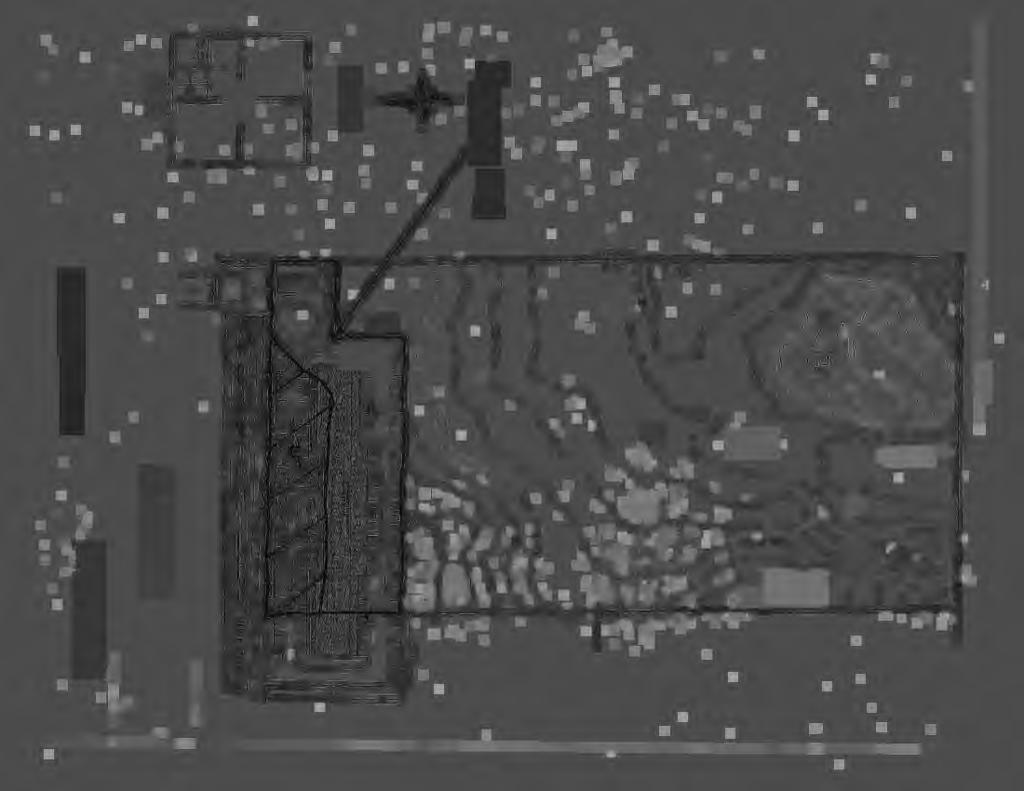
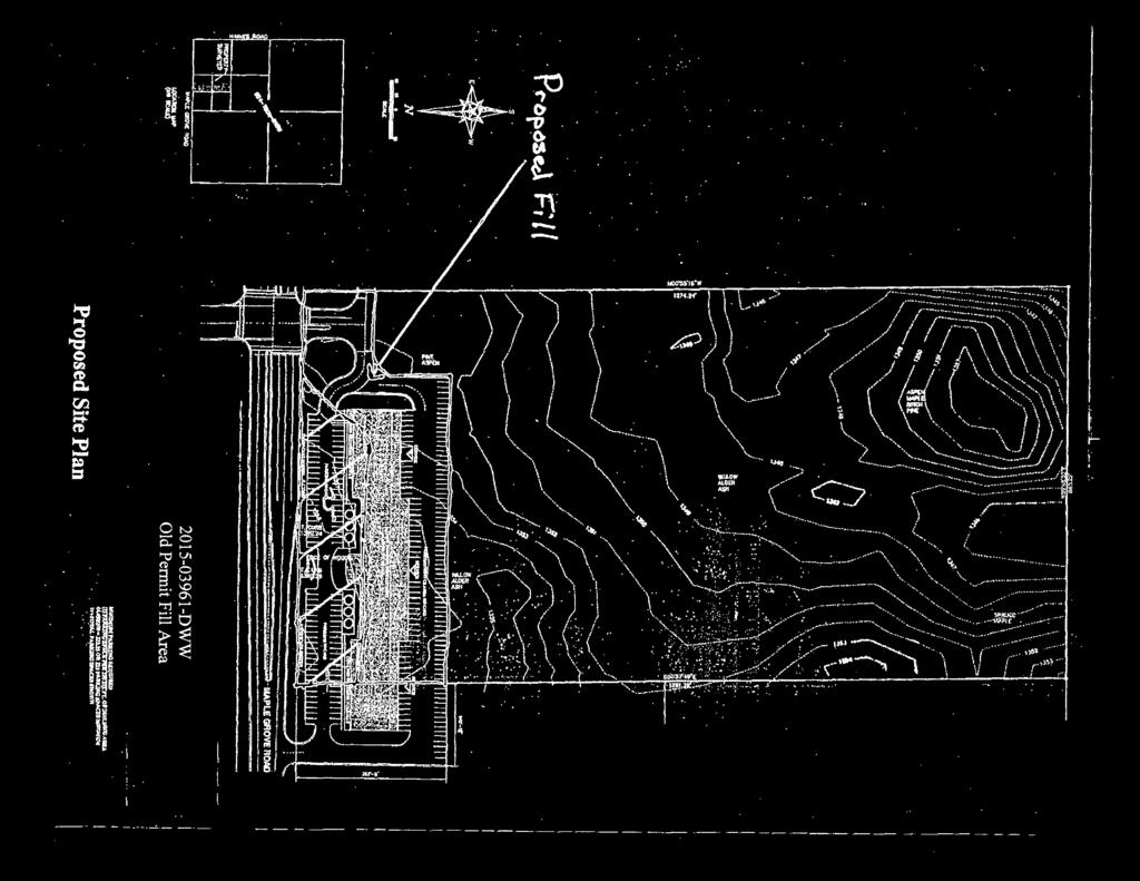
1 Information for File # DWW Applicant Corps Contact Stauber Properties, LLC Daryl W. Wierzbinski Address 600 South Lake Avenue, Suite 211 Duluth, Minnesota daryl.w.wierzbinski@usace.army.mil Phone Primary County St. Louis Section 24 Township Range 50N 15W Information Complete On May 5, 2016 Posting Expires On July 10, 2016 Authorization Type LOP-05-MN This application is being reviewed in accordance with current practices for documenting Corps jurisdiction under Section 404 of the Clean Water Act. We have made a preliminary determination that the aquatic resources that would be impacted by the proposed project are subject to Corps of Engineers jurisdiction under Section 404 of the Clean Water Act. If an approved jurisdictional determination is completed as part of the review process for this application, a copy will be posted on the St. Paul District web page at the following link: Project Purpose Stauber Properties LLC is proposing to develop a portion of a 20-acre property for a retail, commercial development next to Maple Grove Road in the City of Hermantown, Minnesota. The applicant would construct a 34,184 square-foot retail, commercial building, approximately 200 parking stalls within three parking lot areas, two access points, and a 10,454 square-foot retention pond. The proposed work would be within the property limits. Project Description The proposed retail, commercial development would result in the discharge of dredged and fill materials into 1.82 acres of forested and scrub-shrub wetlands adjacent to Keene Creek. The project site is located in the NW ¼, NE ¼, Section 24, Township 50N., Range 15W., St. Louis County, Minnesota. 1
2 BACKROUND The applicant received an authorization from the Corps of Engineers (Corps) under Department of the Army (DA) Permit KRZ at this location to discharge dredged and fill materials into 2.86 acres of wetlands for a retail, commercial site. The DA permit was issued in 2004 with an expiration date of May 31, The DA permit had expired because the applicant did not request a DA permit time extension for the work in wetlands. The applicant did not begin the work in wetlands; the applicant did not discharge dredge and fill materials into wetlands for the proposed activity since the issuance of the permit. However, the administrative record shows that the applicant purchased 2.86 acres of shallow marsh wetland mitigation credits from the Terry Banick wetland mitigation bank in Morrison County, Minnesota; and created a covenants recorded for the 20-acre property to protect approximately acres of remaining wetlands and 0.55 acre of uplands. Please note that DA Permit KRZ required scrub-shrub wetland mitigation credits to be purchased for the project. The applicant voluntarily reduced the size of the footprint for the current project to avoid and minimize wetland impacts. The applicant voluntarily reduced the proposed wetland fill by 1.04 acres in good faith to avoid further project delays and other mitigation measures. The applicant has received all other necessary permit approvals from the City of Hermantown. The applicant did harvest trees in the project footprint spring of 2016 to avoid tree clearing restrictions as a result of the Northern Long Eared Bat. Name, Area and Types of Waters (including wetlands) Subject to Loss The proposed wetland impact types would consist of approximately 1.82 acres of forested and scrub-shrub wetlands adjacent to Keene Creek. Alternatives Considered A no build alternative was considered but rejected because the applicant determined that the no-build would not fulfill the purpose and need of the project. The preferred alternative would utilize and existing entrance-way constructed by the Minnesota Department of Transportation District 1. The remaining acreage of the site has been placed into a restricted covenants. Compensatory Mitigation The applicant purchased 2.86 acres of shallow marsh wetland mitigation credits from the Terry Banick wetland mitigation bank in Morrison County, Minnesota in 2004; and created a covenants recorded for the 20-acre property to protect approximately acres of remaining wetlands and 0.55 acre of uplands. According the District wetland mitigation ratio with out-of-kind and out-of-place (1.5:1) for the proposed 1.82 acres of wetland impacts, the compensatory wetland mitigation should be 2.73 credits. The applicant purchased 0.13 acre more wetland credits and created a covenants to protect acres of remaining wetlands at the site. The Corps believes this is adequate compensatory mitigation for the proposed project. Drawings See attached. 2
3
oo<o f\"'t- (0 -= = tv 0 Vi ()' 0 0 < \>) (1) \0 :::3 O'I ';\"\"\"'.")

4 l I! l '\ 'J--JC ', \ " '"'t e e fll (0 c.. 00 )oo<o f"'t- (0 -= = tv 0 Vi ()' 0 0 < \>) (1) \0 :::3 O'I ';"""'... v 11 I...e i..... h "ll ft.( Ii ' le i I I I I I I :c :.:_ - -0 ". p " '


5 Legend Parking Retention Pond Structures 0 Property Boundary Wetland Source: St. Louis County Aerial Imagery, circa Spring Drawing Scale in Feet DWW New Proposed Area
engineering planning environmental construction
 engineering planning environmental construction 1648 Third Avenue SE Rochester, MN 55904 Tel: 507-289-3919 Fax: 507-289-7333 June 3, 2015 Mr. John Harford Rochester / Olmsted Planning Department 2122 Campus
ALACHUA COUNTY FARM 115 ± ACRES TOTAL HAWTHORNE, FL ALACHUA COUNTY. SREland.com/Alachua. Jeff Cusson, CCIM
 COLDWELL BANKER COMMERCIAL SAUNDERS REAL ESTATE ALACHUA COUNTY FARM HAWTHORNE, FL ALACHUA COUNTY 115 ± ACRES TOTAL SREland.com/Alachua Jeff Cusson, CCIM 772.332.9070 COLDWELL BANKER COMMERCIAL SAUNDERS
Public Notice ISSUED: October 26, 2018 EXPIRES: November 25, 2018
 SPONSOR: Don Redman Public Notice ISSUED: October 26, 2018 EXPIRES: November 25, 2018 REFER TO: MVP-2015-04063-DAS SECTION:404 - Clean Water Act 1. WETLAND COMPENSATORY MITIGATION BANK PROPOSAL 2. SPECIFIC
Joint Public Notice. US Army Corps of Engineers Louisville District
 Joint Public Notice US Army Corps of Engineers Louisville District Public Notice No. LRL-2016-00110-gjd Open Date: 13 Feb 2017 Close Date: 15 Mar 2017 Please address all comments and inquiries to: U.S.
JOINT PUBLIC NOTICE CORPS OF ENGINEERS STATE OF ARKANSAS Application Number: Date: December 9, 2016 Comments Due: January 3, 2017
 US Army Corps of Engineers Little Rock District JOINT PUBLIC NOTICE CORPS OF ENGINEERS STATE OF ARKANSAS Application Number: 2016-00183-1 Date: December 9, 2016 Comments Due: January 3, 2017 TO WHOM IT
ZONING & LAND USE APPLICATION
 City of Maple Plain 5050 Independence St P.O. Box 97 Maple Plain, MN 55359 Office: (763) 479-0515 Fax: (763) 479-0519 ZONING & LAND USE APPLICATION APPLICANT INFORMATION Applicant Name Company, if applicable
Honolulu District U.S. Army Corps of Engineers
 Honolulu District U.S. Army Corps of Engineers Nationwide Permit Pre-Construction Notification (PCN) This PCN template integrates requirements of the U.S. Army Corps of Engineers (Corps) Nationwide Permit
Jurisdictional Determination Request
 This form is intended for use by anyone requesting a jurisdictional determination (JD) from the U.S. Army Corps of Engineers, Wilmington District (Corps). Please include all supporting information, as
Public Notice U.S. ARMY CORPS OF ENGINEERS, GALVESTON DISTRICT AND TEXAS COMMISSION ON ENVIRONMENTAL QUALITY
 Public Notice U.S. Army Corps Permit Application No: SWG-2016-00384 Of Engineers Date Issued: 27 December 2018 Galveston District Comments Due: 29 January 2019 U.S. ARMY CORPS OF ENGINEERS, GALVESTON DISTRICT
PUBLIC NOTICE. Attn: David Syster 5315 South College Road., Suite E Wilmington, North Carolina 28412
 US Army Corps Of Engineers Wilmington District PUBLIC NOTICE Issue Date: April 23, 2013 Comment Deadline: May 23, 2013 Corps Action ID #: SAW-2003-00214 The Wilmington District, Corps of Engineers (Corps)
BRICK ROAD MITIGATION BANK
 COLDWELL BANKER COMMERCIAL SAUNDERS REAL ESTATE BRICK ROAD MITIGATION BANK BUNNELL, FL FLAGLER COUNTY 2,945 +/- ACRES SREland.com/BrickRoad Jack Vogel 352.364.0070 or Dean Saunders, ALC, CCIM 863.648.1528
Savannah District. Regulatory Program. reg199.ppt 1
 Regulatory Program reg199.ppt 1 U.S. U.S. ARMY ARMY CORPS CORPS OF OF ENGINEERS ENGINEERS SAVANNAH SAVANNAH DISTRICT DISTRICT IN-LIEU FEE MITIGATION PROGRAM reg199.ppt 2 2008 2008 MITIGATION MITIGATION
DECLARATION OF RESTRICTIVE COVENANTS
 STATE OF MARYLAND COUNTY OF DECLARATION OF RESTRICTIVE COVENANTS THIS DECLARATION OF RESTRICTIVE COVENANTS is made this day of, 20, by ( Declarant(s) ). RECITALS WHEREAS, Declarant(s) is/are the owner(s)
Environmental Credit Offsets: Not Just for Wetlands Transportation Engineers Association of Missouri
 Environmental Credit Offsets: Not Just for Wetlands Transportation Engineers Association of Missouri March 8, 2018 WHAT IS MITIGATION? Mitigation is the third step in an environmental sequence First step:
Construction & Earthwork Request Form (CERF)
") ShoreLand Traditions Construction & Earthwork Request Form (CERF) SECTION 1 SECTION 2 SECTION 3 Definitions and Points to Remember Requirements and Process Site Sketch Requirements and Sample If you have
ShoreLand Traditions Construction & Earthwork Request Form (CERF) SECTION 1 SECTION 2 SECTION 3 Definitions and Points to Remember Requirements and Process Site Sketch Requirements and Sample If you have
Attachment B - ADL MITIGATION PLAN JUNEAU INTERNATIONAL AIRPORT LARGE PROJECT
 MITIGATION PLAN JUNEAU INTERNATIONAL AIRPORT LARGE PROJECT Introduction The group of projects represented in the permit application package is hereinafter referred to as the Juneau Airport Large Project
APPLICATION. Telephone Fax Address. Telephone Fax Address FOR MARTIN COUNTY USE ONLY
 APPLICATION PRESERVE AREA MANAGEMENT PLAN/ ABBREVIATED PRESERVE AREA MANAGEMENT PLAN Growth Management Department Environmental Division PART 1: Applicant Information A. Land Owner(s) Name Title and Company
{{t:t;r:n;o:"signer 2";l:"Date";}}
 Application/File # Date Application Rec'd: Oct 13 2017 Fee Collected $ (for office use only) CONDITIONAL USE APPLICATION MOTLEY MN Site Address (E-911#): 164 MORRISON STREET WEST 410095000 Lake/River Name:
Instructions to the Applicant
 CONDITIONAL USE PERMIT APPLICATION Lake of the Woods County Land and Water Planning Office 206 8 th Avenue Southeast, Suite #290 Baudette MN 56623-2867 www.co.lake-of-the-woods.mn.us Phone: (218) 634-1945
Interim Use Permit Application
 BENTON COUNTY DEPARTMENT OF DEVELOPMENT 531 DEWEY STREET, PO BOX 129 FOLEY, MN 56329-0129 PHONE: (320) 968-5065 FAX: (320) 968-5351 Interim Use Permit Application Application Fee: $400 ($754 if it is an
AMENDED DEED OF CONSERVATION EASEMENT
 Prepared by: Wayne E. Flowers Lewis, Longman & Walker, P.A. 245 Riverside Ave. Suite 150 Jacksonville, FL 32202 Return recorded original to: Mitigation Marketing 1091 W. Morse Blvd. Suite 101 Winter Park,
YMCA Property Discussion. City Council Study Session April 10,
 YMCA Property Discussion City Council Study Session April 10, 2018 1 Council Discussion Items Questions for City Council: 1. Shall the City Council authorize staff to re-negotiate the terms of the Recreational
METROPOLITAN COUNCIL 390 North Robert Street, St. Paul, MN Phone (651) TDD (651)
 TDD (651)") METROPOLITAN COUNCIL 390 North Robert Street, St. Paul, MN 55101 Phone (651) 602-1000 TDD (651) 291-0904 DATE: November 23, 2009 TO: Metropolitan Parks and Open Space Commission FROM: Jan Youngquist, Senior
METROPOLITAN COUNCIL 390 North Robert Street, St. Paul, MN 55101 Phone (651) 602-1000 TDD (651) 291-0904 DATE: November 23, 2009 TO: Metropolitan Parks and Open Space Commission FROM: Jan Youngquist, Senior
Easements: Ditch and flowage easements will be terminated upon sale.
 Property #156084: Otter Tail County Parcel Removed from Sale Containing 58.20 acres, more or less. Property Data Sheet 156084 Parts of the Southeast Quarter of the Northeast Quarter (SE1/4, NE1/4), Government
2015 WETLAND CONSERVATION ACT STATUTE CHANGES
 2015 WETLAND CONSERVATION ACT STATUTE CHANGES Summary of Key Statute Changes and Related Legislation with Explanations This summary includes excerpts from Laws of MN 2015, Chapter 4, Article 4. It includes
LAMPADOSHIA DEVELOPMENT
 COLDWELL BANKER COMMERCIAL SAUNDERS REAL ESTATE LAMPADOSHIA DEVELOPMENT WAVERLY, GA CAMDEN COUNTY 10,779 +/- ACRES SREland.com/Lampadoshia David Hitchcock ALC, CCIM 863.727.7155 Dean Saunders, ALC, CCIM
(Continued on back of page)
") Definitions Certificate of Survey is the subdivision of land into three or fewer tracts of land. The remnant tract counts as one tract. Plat is the subdivision of land into more than three tracts of land.
Definitions Certificate of Survey is the subdivision of land into three or fewer tracts of land. The remnant tract counts as one tract. Plat is the subdivision of land into more than three tracts of land.
Community Development Committee
 C Date Prepared: Subject: Community Development Committee For the Metropolitan Council meeting of December 9, 2009 December 8, 2009 Committee Report SW Item: 2009-444 ADVISORY INFORMATION Rice Creek Chain
How Mitigation Banks and ILF Programs Can Help Conservation
 How Mitigation Banks and ILF Programs Can Help Conservation Devin Schenk, Mitigation Program Manager Anthony Sasson The Nature Conservancy Mission: To conserve the lands and waters for which all life depends
BEAR HAMMOCK GAME HAVEN
 COLDWELL BANKER COMMERCIAL SAUNDERS REAL ESTATE BEAR HAMMOCK GAME HAVEN EUSTIS, FL LAKE COUNTY 45 ± ACRES TOTAL 3 PURCHASING OPTIONS AVAILABLE SREland.com/BearHammock Carson Futch 863.216.5913 COLDWELL
Easement Grant of Easement for Habitat Protection
 Date: Grantor(s): XXXXXXXXXX Grantee: Tri-Basin Natural Resources District, (hereinafter referred to as Tri-Basin NRD)1308 2 nd St., Holdrege NE 68949 Protected Property: See Exhibit A attached for legal
Public Hearing. Green Township Petition for Plan Conformance
 Public Hearing Green Township Petition for Plan Conformance Introduction to Green Township Green Township Green Township Background Statistics Incorporated: 1824 Population (2000): 3,220 Land Area: 10,429
Appendix H: Real Estate Plan
 APPENDIX H Spring Creek North Ecosystem Restoration Feasibility Study Appendix H: Real Estate Plan New York District U.S. Army Corps of Engineers October 2016 Revised: 13 April 2017 Spring Creek North
JOINT PUBLIC NOTICE PUBLIC NOTICE
 Albuquerque District JOINT PUBLIC NOTICE PUBLIC NOTICE Application Number: SPA-2012-00299-ABQ Date: October 20, 2014 Comments Due: November 20, 2014 SUBJECT: The U.S. Army Corps of Engineers, Albuquerque
THIS DECLARATION OF RESTRICTIVE COVENANTS is made this day of, 20, by ("Covenantor"). RECITALS
. RECITALS") Model for Use with Permits Without Mitigation Plans STATE OF COUNTY OF DECLARATION OF RESTRICTIVE COVENANTS THIS DECLARATION OF RESTRICTIVE COVENANTS is made this day of, 20, by ("Covenantor"). RECITALS
Model for Use with Permits Without Mitigation Plans STATE OF COUNTY OF DECLARATION OF RESTRICTIVE COVENANTS THIS DECLARATION OF RESTRICTIVE COVENANTS is made this day of, 20, by ("Covenantor"). RECITALS
JOINT APPLICATION FOR INDIVIDUAL ENVIRONMENTAL RESOURCE PERMIT/ AUTHORIZATION TO USE STATE-OWNED SUBMERGED LANDS/ FEDERAL DREDGE AND FILL PERMIT
 Form 62-330.060(1) JOINT APPLICATION FOR INDIVIDUAL ENVIRONMENTAL RESOURCE PERMIT/ AUTHORIZATION TO USE STATE-OWNED SUBMERGED LANDS/ FEDERAL DREDGE AND FILL PERMIT FLORIDA DEPARTMENT OF ENVIRONMENTAL PROTECTION/
DECLARATION OF RESTRICTIVE COVENANTS. THIS DECLARATION OF RESTRICTIVE COVENANTS made this day of, 200_, by ( Declarant ). RECITALS
. RECITALS") DECLARATION OF RESTRICTIVE COVENANTS THIS DECLARATION OF RESTRICTIVE COVENANTS made this day of, 200_, by ( Declarant ). RECITALS WHEREAS, Declarant is the owner of the surface of certain real property
DECLARATION OF RESTRICTIVE COVENANTS THIS DECLARATION OF RESTRICTIVE COVENANTS made this day of, 200_, by ( Declarant ). RECITALS WHEREAS, Declarant is the owner of the surface of certain real property
MALBONE WETLAND MITIGATION SITE VDOT RESPONSES TO QUESTIONS
 C00091334DB17: Questions and Answers MALBONE WETLAND MITIGATION SITE VDOT RESPONSES TO QUESTIONS Date: June 2, 2009 Project: Subject: Malbone Wetland Mitigation Site C00091334DB17 - VDOT Responses to Questions
R e z o n i n g A p p l i c a t i o n S u b m i s s i o n R e q u i r e m e n t s
 H O R R Y C O U N T Y P L A N N I N G & Z O N I N G 1 3 0 1 2 N D A V E., S U I T E 1 D - 0 9 C O N W A Y, S. C. 2 9 5 2 6 P H O N E : 8 4 3. 9 1 5. 5 3 4 0 F A X : 8 4 3. 9 1 5. 6 3 4 1 R e z o n i n
APPENDIX B. SUBMISSION REQUIREMENTS
 Master Major Site Minor Site Landscape Section B.1 Table of /Plat Requirements Proposed or approved name of development, project, subdivision, and/or phase. Location, including township, county, and state.
EXHIBIT D. Planned Unit Development Written Description April 13, 2016 Rouen Cove Phase II PUD
 1 EXHIBIT D Planned Unit Development Written Description April 13, 2016 Rouen Cove Phase II PUD Development # 8986.001 Developer: Curtis L. Hart Hart Resources LLC 8051 Tara Lane Jacksonville, Florida
Rarity Pointe Commercial Recreation and Residential Development on Tellico Reservoir, Loudon and Monroe Counties, TN
 ======================================================================= Federal Register: September 10, 2003 (Volume 68, Number 175) =======================================================================
(b) (c) (d) Address City, Zip Phone. (b) (c) (d) Address City, Zip Phone 6. LIST THE NUMBER AND USE OF ALL EXISTING STRUCTURES ON PROPERTY:
 (c) (d) Address City, Zip Phone. (b) (c) (d) Address City, Zip Phone 6. LIST THE NUMBER AND USE OF ALL EXISTING STRUCTURES ON PROPERTY:") DEPARTMENT OF PLANNING AND COMMUNITY DEVELOPMENT 1010 10 TH Street, Suite 3400, Modesto, CA 95354 Planning Phone: (209) 525-6330 Fax: (209) 525-5911 Building Phone: (209) 525-6557 Fax: (209) 525-7759 Form
DEPARTMENT OF PLANNING AND COMMUNITY DEVELOPMENT 1010 10 TH Street, Suite 3400, Modesto, CA 95354 Planning Phone: (209) 525-6330 Fax: (209) 525-5911 Building Phone: (209) 525-6557 Fax: (209) 525-7759 Form
PUBLIC NOTICE. Attn: Corey Lamarche 10 Presidential Way Woburn, Massachusetts 01801
 US Army Corps Of Engineers Wilmington District PUBLIC NOTICE Issue Date: April 9, 2014 Comment Deadline: May 8, 2014 Corps Action ID #: SAW-2010-01235 The Wilmington District, Corps of Engineers (Corps)
Chapter HABITAT CONSERVATION PLAN / NATURAL COMMUNITY CONSERVATION PLAN IMPLEMENTATION ORDINANCE
 Chapter 15.108 HABITAT CONSERVATION PLAN / NATURAL COMMUNITY CONSERVATION PLAN IMPLEMENTATION ORDINANCE Sections: 15.108.010 Purpose. 15.108.020 Definitions. 15.108.030 Applicability 15.108.040 Responsibility
CONSERVATION EASEMENT INCLUDING MITIGATION
 After recording return to: GRANTOR: GRANTEE: GRANTEE (Trustee): LEGAL DESCRIPTION: TAX PARCEL I.D. #: REFERENCE # s: WHATCOM COUNTY N/A CONSERVATION EASEMENT INCLUDING MITIGATION This grant of a conservation
NOTICE DATE: August 19, Joint Public Notice. U.S. Army Corps of Engineers and State of Arkansas
 US Army Corps of Engineers Memphis District Public Notice FILE NUMBER: MVM-2013-182 (RCW) NOTICE DATE: August 19, 2013 Attn: Postmaster, Please Post Until EXPIRATION DATE: September 18, 2013 Joint Public
City Council Agenda Item #10A Meeting of January 23, Adopt the resolution approving the preliminary and final plat
 City Council Agenda Item #10A Meeting of January 23, 2017 Brief Description Recommendation Resolution approving preliminary and final plat of TONY S ADDITION at 9597 Sandra Lane Adopt the resolution approving
BEFORE THE HEARING EXAMINER FOR THURSTON COUNTY
 COUNTY COMMISSIONERS Cathy Wolfe District One Diane Oberquell District Two Robert N. Macleod District Three HEARING EXAMINER BEFORE THE HEARING EXAMINER FOR THURSTON COUNTY In the Matter of the Application
OKALOACOOCHEE RANCH 662 ± ACRES TOTAL IMMOKALEE, FL COLLIER COUNTY. SREland.com/Okaloacoochee
 COLDWELL BANKER COMMERCIAL SAUNDERS REAL ESTATE OKALOACOOCHEE RANCH IMMOKALEE, FL COLLIER COUNTY 662 ± ACRES TOTAL SREland.com/Okaloacoochee Paul J. Meador, Associate Broker 863.692.3425 and Sara E. Catlett,
MUNICIPALITY OF ANCHORAGE PLANNING AND ZONING COMMISSION RESOLUTION NO
 MUNICIPALITY OF ANCHORAGE PLANNING AND ZONING COMMISSION RESOLUTION NO. 0-07 A RESOLUTION SUPPORTING THE APPROVAL AND ADOPTION OF THE ANCHORAGE WETLANDS MANAGEMENT PLAN. (Case 0-09) WHEREAS, the Anchorage
PERMIT FEES Within the shore impact zone (Includes Rip-Rap and Sand Blankets) $ Over 51 cubic yards $100.00
 $ Over 51 cubic yards $100.00") WHAT IS A LAND ALTERATION PERMIT? A land alteration permit is a permit to move or excavate dirt, gravel, sand, etc, on property, which is not incidental to an approved building permit or a septic system
WHAT IS A LAND ALTERATION PERMIT? A land alteration permit is a permit to move or excavate dirt, gravel, sand, etc, on property, which is not incidental to an approved building permit or a septic system
FINDING OF NO SIGNIFICANT IMPACT TENNESSEE VALLEY AUTHORITY DISPOSAL FEE OWNERSHIP OF YELLOW CREEK INDUSTRIAL PARK PROPERTIES
 FINDING OF NO SIGNIFICANT IMPACT TENNESSEE VALLEY AUTHORITY DISPOSAL FEE OWNERSHIP OF YELLOW CREEK INDUSTRIAL PARK PROPERTIES In 1971, the Tennessee Valley Authority (TVA) partnered with the Mississippi
NATIONAL WETLAND MITIGATION BANKING STUDY Commercial Wetland Mitigation Credit Ventures: 1995 National Survey
 NATIONAL WETLAND MITIGATION BANKING STUDY Commercial Wetland Mitigation Credit Ventures: 1995 National Survey Institute for Water Resources Water Resources Support Center U.S. Army Corps of Engineers Alexandria,
SPECIAL PUBLIC NOTICE
 SPECIAL PUBLIC NOTICE U.S. ARMY CORPS OF ENGINEERS BUILDING STRONG LOS ANGELES DISTRICT APPLICATION FOR PERMIT Coachella Valley In-Lieu Fee Program Public Notice/Application No.: SPL-2013-00324-TOB Project:
DECLARATION OF RESTRICTIVE COVENANTS
 DECLARATION OF RESTRICTIVE COVENANTS The Declarant,, is the fee simple owner of the certain real property located in County, Kansas, as described on Exhibit A, which is attached hereto and incorporated
MEMORANDUM. DATE: August 31, Honorable Mayor and City Councilmembers Patrick Klaers, City Administrator. Matthew Bachler, Associate Planner
 NEW BUSINESS 8B MEMORANDUM DATE: August 31, 2015 TO: FROM: Honorable Mayor and City Councilmembers Patrick Klaers, City Administrator Matthew Bachler, Associate Planner SUBJECT: Planning Case #15-016 Applicant:
Public Notice. Applicant: Avere Real Estate Project No.: SWF Date: May 30, Phone Number:
 Public Notice Applicant: Avere Real Estate Project No.: SWF-2017-00150 Date: May 30, 2017 Purpose The purpose of this public notice is to inform you of a proposal for work in which you might be interested.
SEQRA (For Land Surveyors) Purpose of this Presentation
 Purpose of this Presentation") SEQRA (For Land Surveyors) Purpose of this Presentation Understand the basics and legal requirements of SEQRA Recognize the role that Land Surveyors play in the SEQRA Identify the problems posed by SEQRA
SEQRA (For Land Surveyors) Purpose of this Presentation Understand the basics and legal requirements of SEQRA Recognize the role that Land Surveyors play in the SEQRA Identify the problems posed by SEQRA
National Wetland Mitigation Banking Study
 National Wetland Mitigation Banking Study This report is part of a series of reports that are being published during the National Wetland Mitigation Banking Study. Among the reports already published,
DRAFT FOR PUBLIC HEARING (rev. March, 2016)
") Chapter 200. ZONING Article VI. Conservation/Cluster Subdivisions 200-45. Intent and Purpose These provisions are intended to: A. Guide the future growth and development of the community consistent with
Chapter 200. ZONING Article VI. Conservation/Cluster Subdivisions 200-45. Intent and Purpose These provisions are intended to: A. Guide the future growth and development of the community consistent with
DEVIL S CANYON TRACT
 P.O. Box 65 No. 4 Executive Circle Arkadelphia, AR 71923 (870)246-5757 FAX 1-870-246-3341 E-mail: arkadelphia@kingwoodforestry.com Other Kingwood Locations: P.O. Box 1290 145 Greenfield Drive Monticello,
CITY OF INVER GROVE HEIGHTS 8150 Barbara Avenue Inver Grove Heights, MN (651)
") 8150 Barbara Avenue Inver Grove Heights, MN 55077 (651) 450-2545 www.invergroveheights.org FINAL PLANNED UNIT DEVELOPMENT (City Code Section 10-13A) The following must be submitted prior to review and
8150 Barbara Avenue Inver Grove Heights, MN 55077 (651) 450-2545 www.invergroveheights.org FINAL PLANNED UNIT DEVELOPMENT (City Code Section 10-13A) The following must be submitted prior to review and
Natural Resource Assessment Submittal Checklist
 WHATCOM COUNTY Planning & Development Services 5280 Northwest Drive Bellingham, WA 98226-9097 360-778-5900, TTY 800-833-6384 360-778-5901 Fax Mark Personius, AICP Director Natural Resource Assessment Submittal
Door County Shoreland Zoning. Door County Land Use Services Department June 26, 2018
 Door County Shoreland Zoning Door County Land Use Services Department June 26, 2018 Wisconsin ShorelandZoning: Background June 12, 1968: State-mandated date for counties to begin administering shoreland
MEMORANDUM. DATE: November 9, 2016 PC Agenda Item 3.C
 MEMORANDUM DATE: November 9, 2016 PC Agenda Item 3.C TO: FROM: SUBJECT: Planning Commission Eric Zweber, AICP, Interim City Planner Planning Case #16-029 Public Hearing Required Applicant: Bremer Bank,
Record of Decision and Statement of Findings for Department of the Army (DA) Permit Application SAJ Attachment C
 Permit Application SAJ Attachment C") Record of Decision and Statement of Findings for Department of the Army (DA) Permit Application SAJ-1993-01395 Attachment C Attachment C Figure 1 - No Action Uplands Only Figure 2 - Upland mining with
Record of Decision and Statement of Findings for Department of the Army (DA) Permit Application SAJ-1993-01395 Attachment C Attachment C Figure 1 - No Action Uplands Only Figure 2 - Upland mining with
September 6, 2017 ATTACHMENT E.2.
 DEPARTMENT OF THE ARMY JACKSONVILLE DISTRICT CORPS OF ENGINEERS 10117 PRINCESS PALM AVENUE, SUITE 120 TAMPA, FLORIDA 33610 REPLY TO ATTENTION OF Regulatory Division West Permits Branch Tampa Permits Section
EVALUATIVE CRITERIA FOR COMPLIANCE: UNFUNDED MANDATES CONTROL ACT. Appendix B:
 EVALUATIVE CRITERIA FOR COMPLIANCE: UNFUNDED MANDATES CONTROL ACT Appendix B: Evaluative Criteria for Compliance: Regulatory Flexibility Act of 1980, as Amended by the Small Business Regulatory Enforcement,
Planning Commission Replat Falcon Pointe at Lake Medina Reserve, Ph. 3 Medina Township
 Planning Commission Replat Falcon Pointe at Lake Medina Reserve, Ph. 3 Medina Township Meeting: December 7, 2016 App. No.: 115-2016-R Applicant: W.J. Bailey Homes Owner: Crossbow Development Inc. Engineer:
Part 72. Sec. 1. This ordinance shall be known and may be cited as the Clyde Township Wetlands Ordinance.
 Part 72 72.000 WETLANDS ORDINANCE Ord. No. 1 Adopted: June 12, 1991 Amended: April 13, 1994 72.001 SHORT TITLE. 72.002 PURPOSE. 72.003 DEFINITIONS. CLYDE TOWNSHIP ORDAINS: Sec. 1. This ordinance shall
PASCO COUNTY, FLORIDA INTEROFFICE MEMORANDUM. REFERENCES: Land Development Code, Development Director
 PASCO COUNTY, FLORIDA INTEROFFICE MEMORANDUM TO: Development Review Committee DATE: 11/12/08 FILE: DR09-100 SUBJECT: Class II, Commercial Development Review - Ashley Furniture Preliminary/Construction
Village of Glenview Zoning Board of Appeals
 Village of Glenview Zoning Board of Appeals STAFF REPORT January 16, 2017 TO: Chairman and Zoning Board of Appeals Commissioners FROM: Community Development Department CASE #: Z2017-001 LOCATION: PROJECT
Rules for Use of Submerged Lands-Permitting, Dredging, Construction
 Rules for Use of Submerged Lands-Permitting, Dredging, Construction http://www.mrc.virginia.gov/regulations/subaqueous_guidelines.shtm Section I Subaqueous Guidelines VA Constitution Article XI C. General
CANNABIS APPLICATION CHECKLIST
 COUNTY OF MENDOCINO DEPARTMENT OF PLANNING AND BUILDING SERVICES 860 NORTH BUSH STREET UKIAH CALIFORNIA 95482 120 WEST FIR STREET FORT BRAGG CALIFORNIA 95437 IGNACIO GONZALEZ, INTERIM DIRECTOR PHONE: 707-234-6650
The Woods of Ormond Beach
 Ormond Beach, Florida Volusia County 7,086 +/- Acres Approved PUD Merchantable Timber Potential Commercial or Residential Use 2 Ormond Beach, Florida Volusia County One of the largest landowners in the
NOTICE DATE: August 8, Public Notice U.S. Army Corps of Engineers
 m US Army Corps of Engineers Memphis District FILE NUMBER: MVM 1991-432 (JME) Public Notice NOTICE DATE: August 8, 2017 Attn: Postmaste.r, EXPIRATION DATE: Please Post Unlllc::::;> August 22, 2017 Public
Lessard Sams Outdoor Heritage Council
 Lessard Sams Outdoor Heritage Council MEMO: Agenda Item # 10 DATE: December 11, 2014 SUBJECT: PRESENTER: 2015 Legislative Appropriation Recommendation Bill Heather Koop, LSOHC staff Background: On October
BEFORE THE HEARING EXAMINER FOR THURSTON COUNTY
 COUNTY COMMISSIONERS Cathy Wolfe District One Diane Oberquell District Two Robert N. Macleod District Three HEARING EXAMINER BEFORE THE HEARING EXAMINER FOR THURSTON COUNTY In the Matter of the Application
 Conservation and Development Plan Muddy Acres Subdivision March 21, 2018 General This narrative will detail the Conservation and Development Plan for Muddy Acres Subdivision located on Tulls Creek Road
STAFF REPORT. Permit Number: Unlimited. Kitsap County Board of Commissioners; Kitsap County Planning Commission
 STAFF REPORT Permit Number: 15 00550 Unlimited DATE: March 2, 2016 TO: FROM: Kitsap County Board of Commissioners; Kitsap County Planning Commission Katrina Knutson, AICP, Senior Planner, DCD and Jeff
CITY OF OCOEE LAND DEVELOPMENT CODE SUFFICIENCY TABLE WITH NOTES
 CITY OF OCOEE LAND DEVELOPMENT CODE SUFFICIENCY TABLE WITH NOTES The Sufficiency Table is a checklist to help identify the types of information and documentation needed for various types of projects. The
Fordham Environmental Law Review
 Fordham Environmental Law Review Volume 6, Number 3 2011 Article 8 Avoid, Minimize, Mitigate: The Continuing Constitutionality of Wetlands Mitigation After Dolan v. City of Tigard Stephen M. Johnson Copyright
Public Notice. Notice No Closing Date: August 16, 2018
 Public Notice U.S. Army Corps of Engineers Pittsburgh District In Reply Refer to Notice No. below US Army Corps of Engineers, Pittsburgh District 1000 Liberty Avenue Pittsburgh, PA 15222-4186 Application
City of Owasso Public Work Department STATUS REPORT January 2, 2018
 City of Owasso Public Work Department STATUS REPORT January 2, 2018 E 76 St N Widening (from U.S. Hwy169 to N 129 E Avenue) HDH - In 2010, federal funding was awarded for the engineering, right-ofway and
Columbia County Properties 6 Acreage Sites and 1 Commercial Site Lake City, FL
 6 Acreage Sites and 1 Commercial Site Location Maps of 7 Parcels Proximity of 7 Parcel Locations Locations of 7 Parcels Within 500-Mile Driving Radius Parcel 1 Property Type: Vacant Residential Total Acres:
HERON LANDING SUBDIVISION
 HERON LANDING SUBDIVISION Engineering Comments: Per FEMA guidelines, any development greater than 5 acres in size or subdivision 50 lots in size, requires a flood study. Width of drainage easement to be
Issues in Wetland Protection
 This document is made available electronically by the Minnesota Legislative Reference Library as part of an ongoing digital archiving project. http://www.leg.state.mn.us/lrl/lrl.asp John Helland, Legislative
STATE OF SOUTH CAROLINA ) AGREEMENT ) OF COUNTY OF RICHLAND ) PURCHASE AND SALE
 AGREEMENT ) OF COUNTY OF RICHLAND ) PURCHASE AND SALE") STATE OF SOUTH CAROLINA ) AGREEMENT ) OF COUNTY OF RICHLAND ) PURCHASE AND SALE THIS AGREEMENT (the Agreement ) executed the day of, 2010 (the Effective Date ), by and between COLUMBIA VENTURE, LLC, a
STATE OF SOUTH CAROLINA ) AGREEMENT ) OF COUNTY OF RICHLAND ) PURCHASE AND SALE THIS AGREEMENT (the Agreement ) executed the day of, 2010 (the Effective Date ), by and between COLUMBIA VENTURE, LLC, a
19.12 CLUSTER RESIDENTIAL DISTRICT
 Chapter 19.12 CLUSTER RESIDENTIAL DISTRICT (Adopted 12/22/2003; Ordinance #0061970). Amended 7/3/17, Ordinance #079100. Section 19.12.010 - Declaration of Intent. The Cluster Residential District provides
BY BOARD OF COUNTY COMMISSIONERS AN ACT TO BE ENTITLED
 BY BOARD OF COUNTY COMMISSIONERS ORDINANCE NO. AN ACT TO BE ENTITLED AN ORDINANCE AMENDING THE PASCO COUNTY LAND DEVELOPMENT CODE, ARTICLE 700, BY REPEALING EXISTING SECTION 702, ENVIRONMENTALLY SENSITIVE
East Contra Costa County Habitat Conservation Plan / Natural Community Conservation Plan (HCP/NCCP) HCP/NCCP Application Process.
 HCP/NCCP Application Process.") East Contra Costa County Habitat Conservation Plan / Natural Community Conservation Plan (HCP/NCCP) HCP/NCCP Application Process January 9, 2008 John Kopchik (Contra Costa County) and David Zippin (Jones
East Contra Costa County Habitat Conservation Plan / Natural Community Conservation Plan (HCP/NCCP) HCP/NCCP Application Process January 9, 2008 John Kopchik (Contra Costa County) and David Zippin (Jones
MULTI-PARCEL PRIME FARMLAND AUCTION
 MULTI-PARCEL PRIME FARMLAND AUCTION Abbas Farm Land Sec.13, Ericson Twp Renville County, Minnesota Being offered in two parcels: Parcel 1: 96.02 deeded acres, 89.15 tillable acres Parcel 2: 59.29 deeded
Chapter XVIII LAND USE REGULATION A. ZONING. The most significant scheme for controlling land use in America is zoning, by which
 Chapter XVIII LAND USE REGULATION A. ZONING The most significant scheme for controlling land use in America is zoning, by which local authorities divide a municipality into various zoning districts for
February 6, Operations Division Regulatory Branch (North) ID No. LRL dlz
 ID No. LRL dlz") DEPARTMENT OF THE ARMY U.S. ARMY ENGINEER DISTRICT, LOUISVILLE CORPS OF ENGINEERS INDIANAPOLIS REGULATORY OFFICE 8902 OTIS AVENUE, SUITE S106B INDIANAPOLIS, INDIANA 46216 February 6, 2013 Operations Division
DEPARTMENT OF THE ARMY U.S. ARMY ENGINEER DISTRICT, LOUISVILLE CORPS OF ENGINEERS INDIANAPOLIS REGULATORY OFFICE 8902 OTIS AVENUE, SUITE S106B INDIANAPOLIS, INDIANA 46216 February 6, 2013 Operations Division
OPEN-SPACE CONVERSION REQUEST
 OPEN-SPACE CONVERSION REQUEST Applicant: Board Meeting: February 9, 2017 Landowner: Normandy Capital, LLC VOF Easement: BAT-03678 Table of Contents: Cover Page 1 Table of Contents 2 Application Overview
LAND AUCTION. Productive Irrigated and Dry Cropland Farms Offered in Five Tracts!
 LAND AUCTION 1,237+/- Acres Sedgwick County, Colorado and Deuel County, Nebraska Thursday, February 16, 2017 10:00 AM at the Julesburg Fire Hall Meeting Room 510 East First Street, Julesburg, Colorado
Please visit our website to view maps and photographs of this tract and all of our active listings
 K INGWOOD FORESTRY SERVICES, INC. LAND FOR SALE Native Hardwood on Paved Road LISTING #4577 Deltic 40 Tract L Aigle Creek Excellent Hunting $73,500.00 See this and other listings at www.kingwoodforestry.com
LINCOLN COUNTY PLANNING & INSPECTIONS DEPARTMENT
 LINCOLN COUNTY PLANNING & INSPECTIONS DEPARTMENT 30 NORTH ACADEMY STREET, SUITE A, LINCOLNTON, NORTH CAROLINA 809 704-736-8440 OFFICE 704-736-8434 INSPECTION REQUEST LINE 704-73-900 FAX To: Board of Commissioners
LISA ANDERSON-OGILVIE, AICP DEPUTY COMMUNITY DEVELOPMENT DIRECTOR AND PLANNING ADMINISTRATOR
 FOR MEETING OF: October 24, 2018 CASE NO.: CU-18-09 TO: FROM: HEARINGS OFFICER LISA ANDERSON-OGILVIE, AICP DEPUTY COMMUNITY DEVELOPMENT DIRECTOR AND PLANNING ADMINISTRATOR SUBJECT: CONDITIONAL USE NO.