Development Guidebook 2016 TEXAS
|
|
|
- Phyllis Shepherd
- 5 years ago
- Views:
Transcription
1 TEXAS Development Guidebook 2016 DISCLAIMER: This Development Guidebook is not law. For the full and complete requirements necessary for submitting development applications, please see the City of Magnolia s Unified Development Code (UDC). If there are any discrepancies that exist between the Development Guidebook and the UDC, the UDC is the legally controlling document.
2 This page was intentionally left blank.
3 TEXAS Development Guidebook Dear Property Owners and Citizens, It is with great excitement that I write you. Our City is at a point in time where we know that we will be experiencing unprecedented growth. I am proud that we have decided to be proactive instead of reactive in our decision to manage how our great city will grow. In October of 2015, the City Council made the decision to enact the Unified Development Code (UDC). Probably the most significant part of this adoption was the creation of a zoning structure for the City. However, the new UDC regulates much more than just zoning. All development related regulations have been merged into this UDC in order to have everything one needs to know about development in Magnolia in a central location. This includes, but is not limited to, development standards, site design, signs, lighting, parking, landscaping, permits, procedures, and enforcement. The City Council and I are dedicated to maintaining our City as a great place to work and live. In order for us to do this we must set certain standards that our new and existing neighborhoods will either meet or exceed. We also want to be respectful and understanding of the role that businessmen and developers have taken to make Magnolia what it is today. For this reason, we decided to create this Development Guidebook to serve as a reference for developers and citizens of Magnolia who are interested in adding new infrastructure to our community. The Development Guidebook is not law; it summarizes the UDC and will serve as a guide for anyone who will be going through the development process. If you are reading this letter then let me say thank you, because you are probably considering making an investment in our community. We along with you want your investment to grow and prosper. In order to cover the City s administrative and technical review costs, we have enacted an escrow fee formula. We have enacted this fee structure in order to reward applicants who are able to work with us in a cost effective manner in order to create a quality product. Our goal is to refund a sizeable amount of the escrow fee that you submit. In order for us to this, we will need your help. We ask that you submit plans that are in conformance with both the UDC regulations and our conversations with you during any pre-application conferences. Thank you for your interest in continuing to make Magnolia a great place to live and work. Sincerely, Mayor Todd Kana
4 This page was intentionally left blank.
5 TEXAS Development Guidebook PART 1: INTRODUCTION TO THE DEVELOPMENT REVIEW PROCESS Pre-Application Process...1 Development Review Process...2 Application Deadlines, Public Hearing, and Process...2 Review for Completeness...2 Table 1.1 Submittal Deadlines...3 Table 1.2 Required Notice...5 PART 2: DEVELOPMENT REVIEW BODIES City Council...7 Planning and Zoning Commission...7 Board of Adjustment...8 Administrator...8 Development Review Committee...8 Table 2.1 Magnolia Development Review Bodies PART 3: SUBDIVISIONS AND PLATTING Preliminary Plat Final Plat Major Modification of Plat Subdivision Change Administrative Plat/Minor Plat PART 4: ZONING, CONDITIONAL USE, AND SITE PLANS Site Plans Rezoning Conditional Use Permit PART 5: ADMINISTRATIVE PERMITS Site Permit Certificate of Occupancy Land Clearing Permit Tree Removal Permit Zoning Clearance Permit Temporary Use Permit Floodplain Development Permit Floodplain Development Permit Waiver Drainage Plan Building Permit Right-of-Way Encroachment Permit Sign Permit... 26
6 TEXAS Development Guidebook PART 6: ADMINISTRATIVE APPEALS Variance Administrative Appeal Appeal to Council Request for Interpretation PART 7: ANNEXATION AND DEVELOPMENT AGREEMENTS Annexation Agreement Development Agreement PART 8: DEVELOPMENT CALENDAR Table 8.1 Platting Submittal Dates Table 8.2 Zoning Submittal Dates PART 9: FEE SCHEDULE Development Fee Cost Escrow Account Table 9.1 Development Fee Table PART 10: APPLICATION FORMS AND CHECKLISTS Administrative Plat Application Building Permit Certificate of Occupancy Change of Subdivision Application Conditional Use Permit Application Drainage Plan Checklist Final Plat Application Floodplain Development Permit Checklist Floodplain Development Permit Waiver Checklist Land Clearing Permit Major Modification of Plat Application Preliminary Plat Application Rezoning Application Right-of-Way Encroachment Permit Application Sign Permit Application Site Permit Application Temporary Use Permit Checklist Tree Removal Permit Application Variance Application Zoning Clearance Permit Application
7 TEXAS INTRODUCTION TO THE DEVELOPMENT REVIEW PROCESS Development Guidebook 1 Part 1 The City of Magnolia has adopted regulations regarding the use and development of land, including the subdivision of property. Those regulations reside in the City of Magnolia s Unified Development Code (UDC). The provisions of the UDC are enacted to protect the public health, safety, and general welfare in accordance with the goals of the City s Comprehensive Plan. The adoption and enforcement of the UDC are pursuant to the authority granted by the Constitution of the State of Texas under Article XI, Section 5. The purpose of a UDC is to improve the accessibility of a City s regulatory environment associated with land development. The UDC, and corresponding Development Guidebook, is intended to orient a wide array of users to the City s development processes. Users may include local residents looking to construct a backyard shed, developers wanting to plat a new subdivision, business owners needing new signage, and public officials assisting other users with questions. Additionally, this guidebook will provide value in helping people adjust to several approaches to regulation in the UDC that are different than the City has historically used. Pre Application Process The City offers Pre-Application Conferences to all residents, developers, and builders who are contemplating submitting an application for development approval. During a Pre-Application Conference, a member of the City s Development Review committee explains the steps in the application process and gives initial feedback about the applicant s proposal. The two-way communication of information is vital to an efficient process and the City encourages applicants to attend these meetings well before any application is filed. Early City input has the potential to help applicants avoid costly design changes. Specific dates for the Pre-Application Conferences are listed in Table 8.1, Platting Submittal Dates and Table 8.2, Zoning Submittal Dates on page 35. Meeting times are set in coordination with the applicant. 1
8 FEBRUARY 9, Part 1 Development Review Process There are different types of cases that go through the development review process. Some cases require public hearings and are decided by a commission or the City Council. Administrative, or staff level, approvals do not require any type of public hearing notice and are typically quick or small-scale developments including sign permits, land clearing permits, and temporary use permits. Development begins with land use decisions made by the applicant and direction is determined by the current zoning and platting status of the property. Ideally the proposed development meets the requirements set out in the existing zoning district and the property is platted leading to a fairly short development process. Commonly, however, there is some type of approval required, whether it is a use permit, a platting requirement, or both. The development process for each permit type or development action is outlined in its respective chapter of this Guide. Application Deadlines, Public Hearings, and Process The Planning and Zoning Commission meets on the last Thursday of each month at 4:30 PM. City Council meets on the second Tuesday of the month at 7:00 PM. Both meetings are held in the City Hall Council Chambers, unless otherwise specified. The timing of the development process is partially dependent on state statutes regarding requirements for legal notification. Table 1.1, Submittal Process and Table 1.2, Required Notice identify each applications type manner and requirements for notification and the process necessary to obtain approval. Review for Completeness City staff will review all applications and will give the applicant a response regarding the completeness of the application in no more than five business days from the date of the submittal. If the application is complete, staff will process the application. If it is determined that the application is incomplete, staff will return the submitted application and fee with a written explanation of what must be submitted in order to complete the application. No application can be filed for further processing until it is determined that the submittal is complete. See Section , Application Review. 2
9 FEBRUARY 9, 2016 INTRODUCTION TO THE DEVELOPMENT REVIEW PROCESS Type of Public Hearing Permit Site Plan Administrative/ Minor Plats Timing Prior to building permit or site permit. Table 1.1 Submittal Process Prior to issuance of permits that allow for site clearing, grading, or construction. Preliminary Plat Prior to the commencement of land disturbance activity, final plat approval, installation of public improvements, and issuance of applicable permits. Final Plat Major Modifications of Plats; Change of Subdivision. Within two years from the date of preliminary plat approval, unless an extension of time is applied for and granted by the Planning and Zoning Commission. Prior to the construction or development that is within the area proposed to be modified. Process Administrator reviews for compliance with UDC requirements; forwards to Planning and Zoning Commission for a public hearing and final determination at a Planning and Zoning Commission meeting. Administrator reviews, makes decision for approval/ disapproval; or submits to the Planning and Zoning Commission to determine approval or disapproval. 1. Applicant attends Pre-Application Conference. 2. Administrator reviews, forwards with recommendation/comments to the Planning and Zoning Commission. 3. Planning and Zoning Commission reviews and approves/disapproves the submittal. 4. Commission Chairperson has 14 days to sign an approved Preliminary Plat. Applicant may begin submitting construction drawings for review by the City Engineer for compliance with UDC requirements. Applicant begins construction, or obtains performance bond for improvement completion. Approval expires within two years, unless Commission grants extension. 1. Upon approval of construction documents and approved construction or bonding of improvements, an applicant shall submit a Final Plat application to the Administrator. 2. Within 30 days, the Planning and Zoning Commission will take action. 3. After approval of Final Plat, applicant submits plat sheets, required certifications, and associated fees. The plat is submitted to Montgomery County Clerk to be recorded. 1. The applicant submits a copy of the original plat, a sketch showing the subdivision with abutting properties, a proposed plat, and updated drainage plan, if applicable, to the Administrator. 2. Within 30 days, the Planning and Zoning Commission will take action on the Final Plat. If approved, the plat will be submitted to Montgomery County for recordation. 1 3
10 FEBRUARY 9, Part 1 Rezoning Variances Table 1.1 Submittal Process Prior to any change in land use other than those that are permitted in the respective zoning district. Prior to building permit for improvements for which a variance is required; concurrently with other applications for development approval that includes variances. 1. Applicant attends Pre-Application Conference. 2. Applicant submits Zoning Change request to Administrator. 3. Applicant has 30 days to submit any additional requested information to Administrator. 4. Administrator reviews, forwards request to the Planning and Zoning Commission. 5. Within 120 days, the Commission reports recommendation to the City Council. 6. The City Council makes the final decision of approval/disapproval for the Zoning Change request. 1. The applicant submits the variance request to the Administrator. 2. Administrator reviews, forwards to the City Council. 3. Board of Adjustment makes the final decision of approval/disapproval for the Zoning Change request. 4
11 FEBRUARY 9, 2016 Table 1.2 Required Notice 1 Type of Public Hearing Permit Comprehensive Plan Amendments Publication Notice Published at least 15 days prior to the public hearing dates of the Planning and Zoning Commission and City Council meetings. Rezoning Published at least 15 days prior to the public hearing dates of the Planning Commission and the City Council meetings. Conditional Use Permits Published at least 15 days prior to the public hearing date of the Planning and Zoning Commission and City Council meetings. Variances Published at least 10 days prior to the public hearing date of the Zoning Board of Adjustment meeting. Replats Published at least 15 days prior to the public hearing dates of the Planning Commission meetings. Written Notice No written notification required. At least 15 days prior to the public hearing, notice to all parties of interest, each owners of record for properties under consideration. At least 15 days prior to the public hearing, notice to all parties of interest, each owners of record for properties under consideration, and the Planning Commission. At least 10 days prior to the public hearing date of the Zoning Board of Adjustment Meeting, notice to all parties of interest, each owners of record for properties under consideration. No written notification required, except as required by Texas Local Government Code Chapter Table Notes: 1 Any application that requires a public hearing that is not included in this table shall be required to meet the minimum public notice requirements set out by the state for said application or approval. 1 5
12 This page was intentionally left blank.
13 TEXAS Development Guidebook DEVELOPMENT REVIEW BODIES Part 2 2 Each development review body that is responsible for the administration of any of the regulations outlined in the code, their role, and whether they recommend or have the final decision regarding development applications is described below. Details about these Boards and Commissions are further explained in the City of Magnolia UDC, Division , Bodies of the UDC. Development applications and the review body responsible for each application is listed in Table 2.1, City of Magnolia Development Review Bodies. City Council The City Council is made up of a mayor and five council members elected every two years. The Council has the power to: Adopt plans, policies, and ordinances to implement the municipal function of planning; Approve plans and programs for its jurisdiction with respect to the City s Comprehensive Plan; Render a decision regarding text amendments and zoning map changes; and To hear appeals from decisions of the Planning and Zoning Commission. For further information see, Section , City Council, of the City of Magnolia UDC. Planning and Zoning Commission The Planning and Zoning Commission is authorized by state statute to serve in the role to review and make recommendations to the City Council, and render decisions regarding development activities (see Texas Local Government Code, Chapter , for more information). The Commission consists of seven members appointed by the Mayor with the consent of the City Council. Section , Planning and Zoning Commission, of the City of Magnolia UDC details the jurisdiction of the Commission, their powers and duties, membership, and the rules of procedure. The Commission shall undertake a continuing planning program for the physical, social, economic growth, development, and redevelopment of the area within its jurisdiction. 7
14 FEBRUARY 9, Part 1 The following is a list of items the Planning and Zoning Commission typically reviews, recommends, and/or approves: Site plans; Subdivisions/platting; Conditional Use Permits; and Text Amendments Board of Adjustment The Board of Adjustment (BOA) role and authorization is defined by state statute to serve as a deciding body on appeals, interpretation, and variances (see Texas Local Government Code, Chapter , for more information). The BOA has the power to hear appeals regarding the following: Regulation requirements; and Decision or determination by the Administrator, or other administrative official, who enforces the regulations. The BOA may authorize variances from specific terms of UDC regulations, if they meet the criteria for a variance and do not conflict with permitted land uses. The Board is composed of five members appointed by the Mayor with the consent of the City Council. As of January 2016, the City of Magnolia does not have a BOA. The City Council acts as the BOA per Texas Local Government Code Chapter Administrator The Administrator is a member of City staff who is responsible for many of the tasks related to implementating the UDC and development processes. The Administrator is tasked with following: Maintenance of the Official Zoning Map; Processing permits and applications; Recommendations to the different review bodies; Approval of many of the Administrative Permits; Record keeping of applications; Inspections for certain site improvements and landscaping compliance; and Chairing the Development Review Committee. For more information on the Administrator position see Section , Administrator, of the City of Magnolia UDC. 8
15 FEBRUARY 9, 2016 Development Review Committee The Development Review Committee (DRC) provides technical review of the following items: Development plans; Site plans; and Plats to verify compliance with adopted state and local regulations and principles of good design. Additionally, the DRC can make recommendations to the Planning Commission regarding submitted applications. The Committee is composed of officials from several departments to ensure a thorough review, including the Director of Public Works, the Chief Building Official, the Fire Chief, the Director of Parks, the Administrator, the City Engineer, the Floodplain Administrator, or any of their designated representatives. The Administrator serves as the Chairperson for the Committee and formally submits the recommendations of the Committee to other boards, commissions, and committees as necessary. 2 Specific Final Review Roles The City Engineer has the responsibility for final decision on review of Drainage Plans and shares responsibility for the final decision on Floodplain Development Permits with the Administrator. The Chief Building Official has the responsibility of making the final decision on Building Permits. 9
16 This page was intentionally left blank.
17 FEBRUARY 9, 2016 Table 2.1 City of Magnolia Development Review Bodies Procedure City Commission Planning and Zoning Commission Board of Adjustments Public Hearings Development Review Committee Administrator (Planning/ Floodplain/ Zoning) City Engineer Building Official Site Plan Final Decision Review Preliminary Plat Final Plat Acceptance of dedications* Acceptance of dedications* Final Decision Recommendation Review Review Review Final Decision Recommendation Review Review Review Conditional Use Permit Final Decision Recommends Review Recommendation Major Modifications of Plats; Subdivision Change Acceptance of dedications* Final Decision Recommendation Review Review Review Text Amendment Final Decision Recommendation Review Recommendation Rezoning Final Decision Recommendation Review Recommendation Variances Final Decision Review Recommendation Review Administrative Appeal Final Decision Review Appeals to City Council Final Decision Review Review Annexation Final Decision Recommendation Administrative Approvals Site Permit Appeal/Referral Appeal/Referral Final Decision Certificate of Occupancy Permit Land Clearing Permit Tree Removal Permit Final Decision Final Decision Final Decision Administrative Plat Final Decision Review Review Zoning Clearance Permit Temporary Use Permit Final Decision Final Decision Floodplain Development Permit Review Final Decision Final Decision Floodplain Development Waiver Permit Joint Approval Joint Approval Joint Approval Joint Approval Drainage Plan Review Review Final Decision Building Permit Review Review Review Final Decision Right-of-Way Encroachment Permit Review Final Decision Review Review Sign Permit Review Final Decision Review Review 2 *Dedications include the land, easements, utilities, etc., that become apart of the public domain as a result of the property subdivision. 11
18 12 This page was intentionally left blank.
19 TEXAS Development Guidebook SUBDIVISIONS AND PLATTING Part 3 The City of Magnolia regulates the subdivision of property to ensure that lot sizes and open space requirements are in conformance with the City s subdivision regulations. The City also ensures that utility, street, and other required public infrastructure are installed efficiently, effectively, and responsibly. The City s platting regulations are written to achieve the following objectives: 3 1. To protect people who purchase lots by ensuring that each lot has access to public streets and utilities, and that the lots are buildable; 2. To ensure that the growth of the City occurs in a harmonious and organized manner according to the City s Comprehensive Plan and Unified Development Code; and 3. To require that the streets and utilities that are installed by private developers meet the City s engineering requirements. The process of converting raw land to a legally platted subdivision is complex, both for the developer and for the City. There are two significant steps in the platting process the Preliminary Plat and the Final Plat. Preliminary Plat Required for preliminary subdivision platting. Preliminary platting is the first step in the subdivision of property. It allows for the submittal and review of initial plans that identify location, layout, and capacity of infrastructure that will adequately support any new development. For further information and requirements see Section Preliminary Plat and Article 5-1 Subdivision Design and Land Development of the City of Magnolia UDC. Procedure. The subdivider shall have a Preliminary Plat prepared by a registered surveyor. Improvements, plans, and other materials may be required by the City with the application. The procedure for review and approval of a Preliminary Plat consists of the following: 1. After a Pre-Application Conference, the applicant prepares and submits a Preliminary Plat of the proposed subdivision to the Administrator for the review, consideration, 13
20 FEBRUARY 9, 2016 Part 1 3 and tentative approval of the Zoning Commission. 2. The Administrator will provide the tentatively approved Preliminary Plat to the Commission Chairperson, who has 14 days after receiving the decision of the Commission to sign the plat. 3. Next, the applicant submits detailed construction drawings for the review, consideration, and approval of the City Engineer that are in accordance with the UDC and all other standards and requirements of the City. 4. Then the applicant constructs the improvements for the inspection and approval of the City Engineer (or an appointee), OR the applicant posts a performance bond that assures that all improvements on the approved detailed construction drawings will be completed; 5. After tentative approval by the City Engineer, the Preliminary Plat is approved. Approval of the Preliminary Plat does not constitute acceptance or approval of the Final Plat. NOTE: A Preliminary Plat and Final Plat may be submitted concurrently for review at the applicant s discretion. Figure 3.1 Preliminary Plat Approval Pre-Application Conference Plat Submittal Review for Completeness Development Review Committee Review and Recommendation Planning and Zoning Commission Public Hearing and Final Decision Final Plat Required for dedication of infrastructure to city and development buildout of subdivided lots. Final Platting is the formal process in which the city will accept the dedication of constructed infrastructure (i.e. roads, certain utilities, etc.) and submit the approval of the subdivision of property into lots for recordation with the county clerk. Information is reviewed for consistency with the Preliminary Plat, when applicable, and the adherence to subdivision design regulation in the City of Magnolia UDC. For further information and requirements see Section Preliminary Plat and Article 5-1 Subdivision Design and Land Development of the City of Magnolia UDC. 14
21 FEBRUARY 9, 2016 Procedure. The subdivider shall have a Final Plat prepared by a registered engineer within two years from the date of Preliminary Plat approval, or request an extension of time from the Commission. The procedure for review and approval of a Final Plat consists of the following: 1. After approval of the detailed construction drawings by the City Engineer, the applicant submits a Final Plat application. The Final Plat shall conform substantially to the approved Preliminary Plat. The Final Plat may constitute only a portion of the approved Preliminary Plat, as long as that portion conforms substantially to all requirements of the UDC and other standards and requirements of the City. 2. After the applicant submits a Final Plat application and the City concludes its Completeness Review, the Commission shall take action on the Final Plat within 30 days. If the Final Plat is approved by the Commission, the Chairperson signs the plat within 14 days or the Final Plat is automatically approved. If the plat is disapproved by the Commission, the grounds for disapproval are stated in writing. Failure by the Commission to act on the Final Plat within 60 days results in automatic approval of it. 3. After approval of the Final Plat, the applicant submits the following certificates on each sheet that is filed with the Montgomery County Clerk of Court: a. Certification showing the applicant is the landowner and dedicates street and other rights-of-way and any sites for public use; b. Certification by a registered land surveyor as to the accuracy of the survey and plat and the placement of monuments; c. Certification of the sewage disposal and water systems by the City Engineer; Certification by the City Engineer, or any other official or body authorized by law to act prior to the approval of the plat, that the subdivider has complied with one of the following alternatives:»» Installation and an acceptable inspection by the City Engineer (or an appointee) of all improvements in accordance with the requirements of the UDC and the detailed construction drawings; OR,»» Posting of a performance bond in sufficient amount as to assure the completion of all required improvements and detailed construction drawings as approved by the City Engineer. A certificate of the City Attorney as to the sufficiency of the bond offer (being no less and may be more than 100 percent of the estimated contract amount) must be submitted with the plat. 4. After submission of the required certifications, the applicant must submit a film positive of the approved Final Plat to the Administrator, with any corrections and/or changes required by the Commission, with the applicable fee. Then the Administrator makes blue-line prints of the Final Plat and obtains the signatures of the City Engineer, Commission Chairperson, City Council President, and Mayor on the film positive and prints. Next, within 10 working days, the Administrator has the plat recorded in the office of the Clerk of Court of Montgomery County. 5. After the recording of the Final Plat, the Administrator distributes the blue-line prints of the plat with all signatures and the file number of the Clerk of Court. If the applicant fails to pay the fee within 30 days after approval and approval notification of the Final Plat, the Final Plat is rendered null and void and the Administrator will notify the applicant by U.S. Certified Mail, and note that action on the permanent 3 15
22 FEBRUARY 9, 2016 record of the subdivision request. 6. If approval of the Final Plat is contingent upon an agreement drawn after discussion between the applicant and any City department, and the agreement is not successfully reached within the required 30-day period, the Commission may elect to extend the date on which the applicant must pay the fee to avoid the final plat becoming null and void. This extension may occur only once and up to 30 days. Part 1 3 Figure 3.2 Final Plat Approval Pre-Application Conference Plat Submittal Review for Completeness Development Review Committee Review and Recommendation Planning and Zoning Commission Public Hearing and Final Decision Sent to County Clerk for Recordation Major Modification of a Plat Required for any modification to a plat that does not meet the standards for an administrative plat. In the instance where a change is needed to a plat that has gone through the recordation process, the applicant will follow the same process for a Final Plat and if needed, a Preliminary Plat. Additional information will need to be submitted as part of the plat application. For further information and requirements see Section Major Modification of Plats; Changes in Subdivision and Article 5-1 Subdivision Design and Land Development of the City of Magnolia UDC. Applications for a major modification require, at a minimum, the following information: 1. A copy of the plat proposed to be modified; 2. A sketch drawing that includes enough detail to show the context of the subdivision with respect to abutting property within 300 feet of any lot line; 3. A proposed plat containing the proposed parcel or lot lines, which demonstrates compliance with the UDC; and 4. A drainage plan, if site drainage is affected by the modification. 16
23 FEBRUARY 9, 2016 Figure 3.3 Major Modifications Pre-Application Conference Plat Submittal Review for Completeness Development Review Committee Review and Recommendation Planning and Zoning Commission Public Hearing and Final Decision Sent to County Clerk for Recordation 3 Subdivision Change Required for the changing of a subdivision name for a plat that has gone through recordation. If there is a desire to change the name of a subdivision, the following information, at minimum, must be provided on the application: 1. A petition by all owners of lots in the subdivision; 2. A copy of the revised plat, which shall be the same as the existing plat, but with the following additional text appearing on its face: a. This is an existing approved subdivision that is filing for a name change only. Approved by the Planning and Zoning Commission on (date) ; and b. A signature line for the Planning and Zoning Commission Chairperson. Figure 3.4 Subdivision Change Submitted Petition and Copy of Revised Plat Review for Completeness City Council Public Hearing and Final Decision Sent to County Clerk for Recordation 17
24 FEBRUARY 9, 2016 Administrative Plat/Minor Plats An Administrative Plat is applicable to minor modifications of an existing parcel of land. Part 1 3 An Administrative Plat can only be used in instances in which the subdivision process does not pertain to: new streets or public improvements, developments of more than one acre or five lots, lot size reductions below the minimum standard, or property not zoned for residential use; and does not change the number of lots. For further information and requirements see Section Administrative Plat and Section Administrative Plats of the City of Magnolia UDC. In order to qualify for consideration for an Administrative Plat the following requirements have to be met: 1. There will be no more than five lots in the subdivision; 2. The number of lots of record does not increase; 3. All lots will front on an existing public street; 4. The plat does not reduce a lot size below the minimum area or dimension requirements set out in Section , New Neighborhoods, and Section , Established Neighborhoods; 5. The plat does not involve more than one acre; 6. The property must be zoned SR, SU, or NC; 7. The subdivision does not require the creation of any new streets; 8. All lots will be served by existing municipal facilities (water, sewer, drainage, etc.); 9. The plat meets all the applicable requirements of this UDC. The Administrator approves the Administrative Plat application if it does not contradict the principles and objectives of the implementation of the City s Comprehensive Plan (e.g., by encouraging sprawling development patterns or blocking access to a planned thoroughfare); and if it complies with all applicable requirements of the UDC. Figure 3.5 Administrative Plat Pre-Application Conference Plat Submittal Review for Completeness Development Review Committee City Administrator Decision Sent to County Clerk for Recordation 18
25 TEXAS Development Guidebook ZONING, CONDITIONAL USE, AND SITE PLANS Part 4 Zoning assists in the development of the City by guiding each land use to areas zoned specifically for that use, creating a harmonious and functional built environment, while separating uses that are incompatible. As an example, a proposed concrete batching plant would bring many nuisances if permitted to abut existing single-family residences. Zoning establishes districts in which different uses are subject to specific development requirements. These requirements include lot size, landscaping, buffers, and building height. Some uses, known as Conditional Uses, can be allowed across multiple zoning districts, if they meet the stricter regulations set forth by the code. 4 Site Plans Required for new development and redevelopment that involves the removal of existing buildings, including significant expansions of existing buildings. The approval of a site plan begins with a complete submittal package to the Administrator who will begin the process for review by the Planning and Zoning Commission, to be heard at the next available Planning and Zoning Commission meeting (see Table 8.2, Zoning Submittal Dates, page 37). The Planning and Zoning Commission is the approving entity and may impose conditions of approval to ensure compliance with the UDC. Decision Criteria: 1. The proposed development or structure meets all of the requirements of this UDC. 2. The proposed project, building or development does not place an undue burden upon public facilities or infrastructure, including but not limited to: a. Inefficient street networks causing undue congestion of streets and traffic access; b. Building and parking arrangements that would overcrowd land or overburden public facilities and services such as transportation, sewage, drainage, schools, parks, fire or police protection, and other public facilities and services; or c. Inadequate pedestrian ways. 19
26 FEBRUARY 9, 2016 Figure 4.1 Site Plan Approval Process Pre-Application Conference Application Submittal Review for Completeness Development Review Committee Part 1 Review and Recommendation Planning and Zoning Commission Public Hearing and Final Decision Rezoning Required to change zoning classification to allow different uses. 4 The City s Official Zoning Map identifies the zoning classification for each parcel inside the city limits. The zoning map may be amended periodically by the City Council to implement goals of the City or by a landowner s request that has been approved by the City Council. The review of zoning change requests will include many considerations such as the Future Land Use Plan, existing infrastructure, and comprehensive planning efforts. An applicant should work with City staff to better understand the context of the zoning change request. For further information see Section , Zone Change, of the City of Magnolia UDC. 20 Decision Criteria: 1. The proposed zoning is preferable to the existing zoning in terms of its likelihood of advancing the goals, objectives, and policies of the Comprehensive Plan or another adopted land use or area plan, including but not limited to redevelopment plans; 2. The proposed zoning is consistent with the future land use plan of the Comprehensive Plan (a future land use plan amendment may be processed concurrently with the zone change); 3. The proposed change is consistent with the implementation of existing or pending plans for providing streets, water and wastewater, other utilities, and the delivery of public services to the area in which the parcel proposed for a zone change is located; 4. The range of uses and the character of development that is allowed by the proposed zone will be compatible with the properties in the immediate vicinity of the parcel proposed for a zone change, and the parcel proposed for a zone change has sufficient dimensions to accommodate reasonable development that complies with the requirements of this UDC, including parking and buffering requirements; and 5. The pace of development and/or the amount of vacant land currently zoned for comparable development in the vicinity suggests a need for the proposed rezoning in order to ensure an appropriate inventory of land to maintain a competitive land market that promotes economic development.
27 FEBRUARY 9, Once the Planning and Zoning Commission has made its formal recommendation on the rezoning, the City Council will make the final decision whether to rezone the property by ordinance. Figure 4.2 Rezoning Pre-Application Conference Application Submittal Review for Completeness Conditional Use Permit Administrative Review and Recommendation Planning and Zoning Commission Public Hearing City Council Public Hearing and Final Decision Required for uses potentially allowed in multiple zoning districts subject to specific standards 4 A Conditional Use is a use that is only permitted within a zoning district when specific standards are met. These uses commonly have the potential for various adverse impacts such as traffic congestion, noise, visual and aesthetic impacts, which if unmitigated, could undermine the integrity of the zoning district. A public hearing process is required. The conditions applicable to each conditional use are set out in Section , Conditional Uses, Subsection C., of the City of Magnolia UDC. For further information see Section , Conditional Use Permit, of the City of Magnolia UDC. Decision Criteria: 1. The conditional use shall not be of a type that would tend to undermine the implementation of an adopted plan that includes the parcel proposed for development. 2. The conditional use shall be compatible with surrounding land uses and the natural environment, and will not materially detract from the character of the immediate area or negatively affect the planned or anticipated development or redevelopment trajectory. 3. There is no practicable alternative location where the use is permitted as-of-right within 1,000 feet of the parcel proposed for development, or, if such a location exists, the proposed location is more favorable in terms of: a. Providing a needed community service; b. Providing a critical mass of jobs that are likely to pay more than the median wages for the region; c. Providing a balance of land uses, ensuring that appropriate supporting activities, 21
28 FEBRUARY 9, 2016 Part 1 4 such as employment, housing, leisure-time, and retail centers are in close proximity to one another; or d. Making more efficient use of public infrastructure, such as off-peak street capacity. 4. The approval of the conditional use will not create a critical mass of similar conditional uses that is likely to discourage permitted uses by making the vicinity less desirable for them. 5. The conditional use and any conditions of development shall adequately protect public health and safety against natural and man-made hazards which include, but are not limited to, traffic noise, water pollution, airport hazards, and flooding. 6. The conditional use will not use an unfairly disproportionate share of public services that would compromise the delivery of those services to other uses in the vicinity. Applicable public services include, but are not limited to, utilities, police protection, fire protection, schools, parks, and libraries. Once the Planning and Zoning Commission has made its formal recommendation, the City Council will make the final decision whether to grant conditional use for the property by ordinance. Figure 4.3 Conditional Use Permit Pre-Application Conference Application Submittal Review for Completeness Administrative Review and Recommendation Planning and Zoning Commission Public Hearing and Final Decision City Council Public Hearing and Final Decision 22
29 TEXAS Development Guidebook ADMINISTRATIVE PERMITS Part 5 Administrative Permits are development permits that are issued by designated City staff upon finding that the application meets all applicable rules and regulations of the code. The following is a list of the Administrative Permits for development projects within the City of Magnolia: Site Permit Certificate of Occupancy Permit Land Clearing Permit Tree Removal Permit Zoning Clearance Permit Temporary Use Permit Floodplain Development Permit Floodplain Development Permit Waiver Drainage Plan Building Permit Right-of-Way Encroachment Permit Sign Permit The above list of Administrative Permits is taken from Table , Administrative Permits, in the City of Magnolia UDC. The following explanations and overviews of each type of the administrative permit is also derived from that table. 5 Site Permit A Site Permit is required for clearing, grading, excavation, or construction of any site improvements. A Site Permit should be obtained prior to any activity for which a permit is required with rare exceptions. Examples of exception projects include construction of a single-family home on a single-family lot in an improved subdivision; agriculture related practices; and forestry related practices. For further information on the site permit see Section , Site Permit Requirements, of the City of Magnolia UDC. Decision Criteria: 1. All applicable requirements of this UDC have been met; and 2. If any State or Federal approvals are required, said approvals have been granted. 23
30 FEBRUARY 9, 2016 Certificate of Occupancy A Certificate of Occupancy is required for occupancy of a newly constructed building or structure upon completion, or before change of occupancy to an existing building or structure. Once construction has been completed and the building inspectors have issued the applicable the building permit approvals, the City Administrator can issue a Certificate of Occupancy, indicating the structure was built in conformance with all building codes and applicable provisions of the code. For further information and requirements see Section , Certificate of Occupancy Permit Requirements, of the City of Magnolia UDC. Decision Criteria: Certificate of occupancy permits shall be issued only upon a finding that all requirements of this UDC, conditions of approval, and applicable building code requirements are met. 5 Land Clearing Permit A Land Clearing Permit is required for clearing, grading, excavation, or construction of any site improvements. The Land Clearing Permit shall be accompanied by an official tree survey prepared by a licensed arborist, landscape architect, or landscape contractor, prior to the development, redevelopment or substantial improvement of an existing property. For further information and requirements see Section , Land Clearing Permit Requirements, of the City of Magnolia UDC. Decision Criteria: An administrative land clearing permit shall be approved if it is demonstrated that the activities carried out are in accordance with the Texas Forestry Best Management Practices. Tree Removal Permit A Tree Removal Permit is required for clearing, grading, excavation, or construction of any site improvements. A Tree Removal Permit is necessary if there is to be any removal of protected trees, up to and including a maximum of 10 protected trees. An application to the Administrator should include a site plan. For further information and requirements see Section , Tree Removal Permit, of the City of Magnolia UDC. 24
31 FEBRUARY 9, 2016 Decision Criteria: 1. Removal of the tree is reasonably required in order to conduct anticipated activities; or 2. A reasonable accommodation cannot be made to preserve the tree. Zoning Clearance Permit A Zoning Clearance Permit is necessary with new land uses and changes in land uses. A Zoning Clearance Permit is an administrative procedure in which the Administrator verifies that an application for development approval of a permitted use, or a building or structure that is permitted without site plan approval, complies with the requirements of the UDC. Zoning clearance permits may be issued simultaneously with building permits or other required permits. Temporary Use Permit Required for establishing a temporary use such as public, commercial, neighborhood, or other special events. A Temporary Use Permit can be issued for uses which are short-term in nature, if they are in compliance with the code. The Administrator can approve a permit with a specified maximum duration time after which the use shall cease. A Temporary Use Permit is required before the installation of any temporary structure. For further information and requirements see Section , Temporary Use Permit, of the City of Magnolia UDC. 5 Floodplain Development Permit Required for proposed development occurring in areas identified on FEMA maps as flood areas. The Floodplain Administrator may approve or deny a permit based on applicable provisions outlined in Article 5-3 Floodplain Management and Flood Damage Prevention of the City of Magnolia UDC. The permit ensures that the proposed development will not contribute to possible flooding downstream, causing neighboring properties to be inundated due to too much impervious cover and improper drainage techniques. For further information and requirements see Section , Floodplain Development Permit, of the City of Magnolia UDC. Floodplain Development Permit Waiver Required for proposed development occurring in areas identified on FEMA maps as flood areas. The Floodplain Administrator may approve or deny a permit based on applicable provisions outlined in Article 5-3 Floodplain Management and Flood Damage Prevention of the City of Magnolia UDC. For further information and requirements see Section , Floodplain Development Permit Waiver, of the City of Magnolia UDC. 25
32 FEBRUARY 9, 2016 Drainage Plan A Drainage Plan should be created prior to the installation of a drainage system. Every proposed development must have a drainage system that shall be designed by a registered engineer and constructed by the subdivider, as set out in Article 5-4, Storm Water Management of the City of Magnolia UDC. The subdivider shall be responsible to design and construct drainage facilities to retain/detain storm water to provide a 10 percent reduction in runoff from pre-construction conditions. The design considerations for the drainage system are set out in Section , Drainage System of the City of Magnolia UDC. For further information and requirements see Section , Drainage Plan, of the City of Magnolia UDC. Building Permit Required for new construction and any structural modification. 5 When new construction, repairs, or remodeling occur on a commercial or residential structure, a building permit is required. Obtaining a building permit allows the City inspectors to verify the work being completed is to approved building standards and that the structure is safe for occupancy. Several inspections occur throughout the construction process and work may be required to be redone to be in compliance with the adopted building code. For further information and requirements see Section , Building Permit, of the City of Magnolia UDC. Right-of-Way Encroachment Permit Required for encroachments within the Unity Plaza (UP) District. In the Unity Plaza District of the City of Magnolia, there are instances where structures or awnings were built in the past that are not in compliance with existing regulations. In such cases, encroachment permits may be issued by the City Administrator, if the encroachment meets the substantive requirements of the code found in Section Unity Plaza UP District, Subsection C, of the City of Magnolia UDC. If the encroachment does not meet the requirements of the code, they may be allowed a variance. For further information and requirements see Section , Right of Way Encroachment, of the City of Magnolia UDC. Sign Permit Required for construction, repair, removal, alteration, relocation, and installation of a sign Any changes to the signage of a business, home occupation, or advertising billboard, a Sign Permit must be obtained from the City Administrator. Chapter 6, Signs and Lighting, of the City of Magnolia UDC outlines the requirements for all allowed signage. The permit is in place to ensure safety of pedestrians and to return sign pollution. 26
33 TEXAS Development Guidebook ADMINISTRATIVE APPEALS Part 6 The City of Magnolia UDC contains provisions that allow for the applicant to request relief from strict application of the code. City staff is required to make strict interpretations and uphold the integrity of the code, and does not have the authority to grant waivers from the code requirements. If the applicant believes they cannot conform to the strict interpretation of the code, designated City staff members may assist the applicant through the variance process. Because these are requests to vary from what is required by the code, approval of these applications is not guaranteed. Variance A variance is a method to provide limited relief from the strict requirements of the code. Typically, variances involve regulations such as building height, building setbacks, parking spaces, etc. Variances may be granted in instances where the strict application of code requirements will cause an undue hardship by preventing the use and development of the property in a reasonable manner. Variances are authorized on a case by case basis. The approval of variances must adhere to strict approval criteria from which no deviation is allowed. The Board of Adjustment will hear the variance request and make the final decision of approval or disapproval. For further information see Section , Variances, of the City of Magnolia UDC. 6 Decision Criteria: 1. The request for the variance is rooted in special conditions of the applicant s property (e.g., physical surroundings, shape, or topographical conditions) that do not generally exist on other properties in the same zoning district; 2. Due to such special conditions, the literal enforcement of the strict terms of this UDC would cause an unnecessary hardship, as distinguished from a mere inconvenience, on the applicant; 3. The alleged difficulty or hardship is caused by the UDC and has not been created by any person presently having an interest in the property; 4. The variation will not serve as a precedent which, in effect, will rewrite a provision of this UDC; 27
34 FEBRUARY 9, The variance is not contrary to the public interest or injurious to other property or improvements in the neighborhood in which the property is located, in that: a. It will not impair an adequate supply of light and air to adjacent property, or substantially increase the congestion in the public streets, or increase the danger of fire, or endanger the public safety, or substantially diminish or impair property value within the neighborhood. b. It does not allow applicants to frustrate the application of the UDC for: 1. Self-imposed hardships; 2. Hardships based solely on financial considerations, convenience, or inconvenience; or 3. Conditions that are alleged to be special, but that are actually common to many properties within the same zoning district. c. The variance will not have a detrimental impact upon: 1. The current or future use of adjacent properties for purposes for which they are zoned; 2. The economic welfare of the area in which the subject property is located; 3. Public infrastructure or services; and 4. Public health, safety, or welfare. d. The degree of variance from this UDC is the least that is necessary to grant relief from the identified unnecessary hardship. e. The variance is not used to circumvent other procedures and standards of this UDC that could be used for the same or comparable effect (e.g., if alternative development standards, alternative development patterns, or other flexible measures in this UDC are available that would avoid or mitigate hardship without using a variance, then they must be used). f. By granting the variance, the spirit of the UDC is observed and substantial justice is done. Figure 6.1 Variance Pre-Application Conference Application Submittal Review for Completeness Review and Report Board of Adjustment Public Hearing and Final Decision 28
35 FEBRUARY 9, 2016 Administrative Appeal An administrative appeal is a method to request a review body to reverse a ruling made by another commission or board. The appeal of an administrative decision typically occurs when there is a disagreement about the interpretation and the enforcement of a certain definition or development criteria. The Board Adjustment (BOA) is the designated review body which hears appeals of administrative decisions. Appeals to the BOA may be brought by any aggrieved person or by any officer, department, board, or bureau of the City affected by any decision of the Administrator or other staff person set out in Chapter 10, Administrative Bodies, of the City of Magnolia UDC. The officer who brings the appeal must give all records related to the action under appeal to the BOA. For further information see Section , Administrative Appeals, of the City of Magnolia UDC. Figure 6.2 Administrative Appeal Denial of Permit Appeal Submitted to Respective City Officer, Within Reasonable Time Frame Board of Adjustment Public Hearing and Final Decision Appeal to Council An appeal to council is a method to appeal a decision made by the Planning and Zoning Commission. 6 An appeal may be brought by any person or entity that is aggrieved by a decision from the Planning and Zoning Commission. An appeal to the decision of the Planning and Zoning Commission is heard by the City Council. The petition to appeal must occur within 10 days of the decision; otherwise the decision stands. The Council will adhere to the same decision criteria that the Commission used in reaching its decision. For further information see Section , Appeal to Council, of the City of Magnolia UDC. Figure 6.3 Appeal to Council Aggrieved Decision Rendered Petition Submitted, Within 10 Days of Decision City Council Public Hearing and Final Decision 29
36 FEBRUARY 9, 2016 Request for Interpretation A request for interpretation is a method to deliver clarity to items that may fall under uncertainty in the application of the UDC. Any person may request an administrative interpretation of the terms, provisions, or requirements of the UDC if the application of the terms, provisions, or requirements is not obvious. The interpretation is made by the official charged with administering the provision for which an interpretation is requested. This interpretation is not subject to appeal. Within 30 days of the application for interpretation the responsible official shall respond to the applicant in writing. For further information see Section , Request of Interpretation, of the City of Magnolia UDC. Figure 6.4 Request for Interpretation Application Submitted City Official Written Response, Within 30 Days of Application 6 30
37 TEXAS Development Guidebook ANNEXATION AND DEVELOPMENT AGREEMENTS Part 7 The City is allowed under Texas Local Government Code Section , Development Agreements to enter into agreements for: Development plans; Authorization of municipal enforcement of regulations; Land use and development regulations; Provision of infrastructure; Enforcement of environment regulations, and Annexation. Annexation and development agreements should be reviewed by the City s legal staff, but ultimate approval resides with the City Council. Annexation Agreement An annexation agreement is a contract between the City and a property owner, or a group of property owners, who consent to the future annexation of their land into the City. Annexation agreements are required to include the following components: 1. An irrevocable consent of annexation into the City by the owner of the property; 2. The timing or conditions upon which the annexation will take place; and 3. The timing or phasing of extension of utilities and services to the annexed property, including how the costs of the extension will be allocated between the City and the property owner. 7 Development Agreement A Development Agreement is appropriate to set the timing of the installation of public infrastructure, and to determine the appropriate percentages of public infrastructure cost that will be borne by the developer and the City. For this reason, development agreements are usually associated with larger, multi-phased development. However, in certain instances, the city may decide to enter into a development agreement on a smaller development. 31
38 FEBRUARY 9, 2016 As stated in the UDC a development agreement shall include, at a minimum, the following components: 1. Design Standards; 2. Subdivision Standards; 3. Duration of the agreement; 4. Permitted uses; 5. Terms and conditions relating to financing of necessary public facilities by the applicant; and, 6. If such improvements serve more than the applicant s subdivision, subsequent reimbursement of the applicant over time. Development agreements shall be reviewed every 12 months for compliance. If a good faith effort to achieve compliance has not been met, the City Council may terminate the agreement, on the basis of substantial evidence. 7 32
39 TEXAS Development Guidebook DEVELOPMENT CALENDER Part 8 The following pages contain a list of dates for submittal of develop applications for the City of Magnolia. 8 33
40 This page was intentionally left blank.
41 FEBRUARY 9, 2016 Pre-Submittal Conference (Recommended) Table 8.1 Platting Submittal Dates Submittal Deadline Staff Comments Re-submittal Deadline to Address All of Staff Comments Planning and Zoning Commission Meeting 12/14/ /28/2015 1/8/2016 1/15/2016 1/28/2016 2/9/2016 1/11/2015 1/25/2016 2/5/2016 2/12/2016 2/25/2016 3/8/2016 2/15/2015 2/29/2016 3/11/2016 3/18/2016 3/31/2016 4/12/2016 3/7/2016 3/21/2016 4/8/2016 4/15/2016 4/28/2016 5/10/2016 4/11/2016 4/25/2016 5/6/2016 5/13/2016 5/26/2016 6/14/2016 5/16/2016 5/30/2016 6/10/2016 6/17/2016 6/30/2016 7/12/2016 6/13/2016 6/27/2016 7/8/2016 7/15/2016 7/28/2016 8/9/2016 7/11/2016 7/25/2016 8/5/2016 8/12/2016 8/25/2016 9/13/2016 8/15/2016 8/29/2016 9/9/2016 9/16/2016 9/29/ /11/2016 9/12/2016 9/26/ /7/ /14/216 10/27/ /8/ /3/ /17/ /28/ /4/ /17/ /13/ /31/ /14/ /23/ /2/ /15/2016 1/10/2017 City Council Meeting Pre-Submittal Conference (Recommended) Submittal Deadline Table 8.2 Zoning Submittal Dates Planning and Zoning Commission Notifications (Public and Mailed) Planning and Zoning Commission Meeting City Council Notifications (Public and Mailed) 12/14/ /28/2015 1/13/2016 1/28/2016 2/22/2016 3/8/2016 1/11/2016 1/25/2016 2/10/2016 2/25/2016 3/28/2016 4/12/2016 2/8/2016 2/22/2016 3/16/2016 3/31/2016 4/25/2016 5/10/2016 City Council Meeting 3/14/2016 3/28/2016 4/13/2016 4/28/2016 5/30/2016 6/14/2016 4/11/2016 4/25/2016 5/11/2016 5/26/2016 5/30/2016 6/14/2006 5/16/2016 5/30/2016 6/15/2016 6/30/2016 7/25/2016 8/9/2016 6/13/2016 6/27/2016 7/13/2016 7/28/2016 8/29/2016 9/13/2016 7/11/2016 7/25/2016 8/10/2016 8/25/2016 9/26/ /11/2016 9/15/2016 9/29/2016 9/14/2016 9/29/ /24/ /8/2016 9/12/2016 9/26/ /12/ /27/ /28/ /13/ /3/ /17/ /2/ /17/ /26/2016 1/10/
42 36 This page was intentionally left blank.
43 TEXAS Development Guidebook FEE SCHEDULE Part 9 The City of Magnolia is expected to experience increased administrative costs due to the increase in the volume of development applications. In order to offset costs the City will incur a fee associated with the cost of processing and reviewing each type of application has been established. The fee schedule is shown in Table 9.1, Development Fee Schedule, on the next page. Development Review Cost Escrow Account The City has elected to use an escrow account to handle the billing cost incurred by retaining professional services to perform technical review. The City will draw upon the escrow account to pay the monthly billing of the cost of review for the application. The Administrator may require an additional escrow fund to account for additional services related to the application on an as-needed basis. When the application process has concluded, the balance of the escrow (if positive) will be returned to the applicant. If an additional balance is due, it shall be paid by the applicant to the City as a condition of approval. 9 37
44 FEBRUARY 9, 2016 Procedure Final Plat: Major Modifications of Plats Preliminary Plat: Rezoning: Planned Development (PD) Site Plan: 20 or more acres Site Plan: > acres Preliminary Plat: With no Transportation Improvement Analysis or Public Improvements Rezoning: All Designations Except PD Site Permit Site Plan: < 9.99 acres Conditional Use Permit Drainage Plan Final Plat: Minor Amending Final Plat Final Vacation Plat Land Clearing Permit Table 9.1 Development Fee Schedule Notes Escrow $5,000 Fee does not include Montgomery County recordation. Fee does not include Montgomery County recordation. Fee does not include civil consturction application materials. Fee includes publication Escrow $4,000 Escrow $3,000 Fee does not include Civil Construction Permits. Fee includes publication Site preparation to shape the site for development Escrow $2,000 Fee applicable only when Drainage Plan submitted seperately without any civil construction application materials. Fee does not include Montgomery County recordation. Tree Inventory, Removal, Mitigation, and Erosion Control 9 Text Amendment (Land Code) Variance Administrative Appeal Appeals to City Council Annexation Building Permit Certificate of Occupancy Permit $100 Right-of-Way Encroachment Permit $100 Sign Permit Tree Removal Permit Applies to any variance Escrow $1,000 Miscellaneous No Charge In accordance with currently adopted IBC and ICC Building Valuation Data Price depends upon sign type. See Part 10: Sign Permit Application $50 + $10/protected tree 38
45 TEXAS Development Guidebook APPLICATION FORMS AND CHECKLISTS Part 10 The following pages contain the applications for each respective development process required in the UDC
46 This page was intentionally left blank.
47 1 Administrative Plat Application Form This form shall be submitted with each application for an administrative plat. CONTACT INFORMATION Applicant _ Architect (if different) _ Property Owner (if different) Engineer/Land Surveyor (if different)
48 2 PROPERTY PROFILE Property ID # Legal Description (Subdivision) (Lot) (Block) Current Zoning Present Use of Property Proposed Use of the Property Total Area of Site
49 1. Description of existing property. If the property has been previously subdivided, provided the lot(s), block(s), and subdivision name. If the property has been subdivided, provide the metes and bounds description: 2. Description of proposed property change, including lot numbers, name, etc. 3
50 4 Required Information Three (3) copies of the minor plat; minimum 11 in. x 17 in. size Mylar originals sealed by a state of Texas registered surveyor One (1) copy in blue or black line of all originals in 11 in. x 17 in. size All fees One (1) Adobe Acrobat PDF of each page presented to the City for review Vicinity map North arrow Revision date Legal description Scale Tabulations that include: The area and lot width of each lot involved in the combination before the proposed subdivision The area and lot width of each lot involved in the combination after the proposed subdivision Use and ownership of abutting parcels or lots Location and dimensions (including all curve data, the lengths of all arcs, radii, internal angles, points of curvature, lengths and bearings of tangents) of abutting right-of-way, lots, open space, and buffers Proposed generalized use of lots (e.g., mixed-use, single-family attached, multi-family, industrial, commercial or office, or institutional), provided on a separate attached description Proposed location and width of utility easements, if changed Proposed location of fire hydrants, if changed, provided on utility and street construction plans The outer boundary lines with accurate distances, angles, or true bearings if available, the exact location width of all recorded streets and ways intersecting the boundaries of the tract being divided All required notes, certifications, and signatures I, (print or type name), certify with my signature below that the information included in my submittal packet is complete, true, and correct, to the best of my knowledge. Signature of Applicant Date
51
52
53 1 Certificate of Occupancy Application Form This form shall be submitted with each application for a certi icate of occupancy. CONTACT INFORMATION Applicant _ Architect (if different) _ Property Owner (if different) Engineer/Land Surveyor (if different)
54 2 PROPERTY PROFILE Property ID # Site Address Legal Description (Subdivision) (Lot) (Block) Current Zoning Present Use of Property Proposed Use of the Property Total Area of Site Square Footage of the Space you will be Occupying Will there be any structural, electrical, plumbing, or HVAC changes to accommodate the new occupancy? If yes, explain: I, (print or type name), certify with my signature below that the information included in my submittal packet is complete, true, and correct, to the best of my knowledge. Signature of Applicant Date
55 1 Change of Subdivision Application Form This form shall be submitted with each application for a subdivision name change. CONTACT INFORMATION Applicant _ Architect (if different) _ Property Owner (if different) Engineer/Land Surveyor (if different)
56 2 PROPERTY PROFILE Property ID # Legal Description (Subdivision) (Lot) (Block) Current Zoning Present Use of Property Proposed Use of the Property Total Area of Site
57 3 Required Information Seven (7) copies of the proposed final plat All fees A petition by all owners of lots in the subdivision A copy of the revised plat, which shall be the same as the existing approved final plat, but with the revised name and following additional text appearing on its face: This is an existing approved subdivision that is filing for a name change only. Approved by the Planning and Zoning Commission on (date). A name and signature line for the Mayor and signature line for recommendation for approval by the Public Works Coordinator Signature line for the Chair of the Planning and Zoning Commission I, (print or type name), certify with my signature below that the information included in my submittal packet is complete, true, and correct, to the best of my knowledge. Signature of Applicant Date
58 1 Conditional Use Permit Application Form This form shall be submitted with each application for a conditional use permit. CONTACT INFORMATION Applicant _ Architect (if different) _ Property Owner (if different) Engineer/Land Surveyor (if different)
59 2 PROPERTY PROFILE Property ID # Legal Description (Subdivision) (Lot) (Block) Current Zoning Present Use of Property Proposed Use of the Property (for conditional use) Total Area of Site
60 3 1. List all vacant properties within a quarter mile of the property that would permit the use by right, if any, along with a brief description of why the subject property is a better location that each of the other vacant parcels: 2. A list of similar existing uses in the vicinity of the parcel proposed for development: 3. If the use is required to be separated from the same use, or from a different use, a brief description of the nearest such use with an indication of the linear distance to it: 4. A description of any proposed mitigation strategies that will be employed to lessen the potential negative impact to surrounding land uses and public streets: 5. A description of any proposed limitation on operations: 6. A narrative regarding how the proposed use complies with the standards of Section , Conditional Uses: 7. Any other supporting documentation required for the use by Section , Conditional Uses:
61 4 Map Sheet General Requirements No larger than 24 in. x 36 in. sheet size; no smaller than 11 in. x 17 in. sheet size Largest engineering scale possible Key map with scale North arrow Title block with name of applicant and date of submittal Number of parking spaces allocated to the proposed use Information Requirements One (1) complete application All fees The zoning of the subject property as well as surrounding properties Existing or future uses of all abutting properties Lot area of the parcel proposed for development Proposed floor area of the conditional use Location of all freestanding and wall signage Dimensions and height of all freestanding and wall signage Door access to each individual use internal and external Location, type, and screening details of all proposed outdoor storage Location of all parking areas and circulation aisles Location of all access drives Location of all buffer areas with an indication of whether each is a required buffer or an additional buffer Elevation drawings of al structures Traffic study (if necessary) Approved site plan (if new construction) I, (print or type name), certify with my signature below that the information included in my submittal packet is complete, true, and correct, to the best of my knowledge. Signature of Applicant Date
62 1 Drainage Plan Application Form This form shall be submitted with each application for a site plan. CONTACT INFORMATION Applicant _ Property Owner (if different) Engineer _
63 2 PROPERTY PROFILE Property ID # Site Address Legal Description (Subdivision) (Lot) (Block) Current Zoning Present Use of Property Proposed Use of the Property Total Area of Site
64 3 Required Information A cover sheet with the name of the subdivision and the contact information for the engineering firm that prepared the drainage report. A summary sheet that shows: Project location Existing/proposed conditions Location with respect to areas of special flood hazard Existing and proposed runoff estimations Storm drainage detention estimations Soil data information Direction of flow A drainage area map that shows: Delineation of all contributing areas Contours Spot elevations Direction of flow Right-of-way/property lines and dimensions Existing and proposed storm sewer system, including outfall A calculations, sheet that shows: Time concentration estimates Runoff coefficient assumptions Storage volume calculations Copy of recorded plat or most recent preliminary plat. Copy of concept plan (if site is part of a larger development) I, (print or type name), certify with my signature below that the information included in my submittal packet is complete, true, and correct, to the best of my knowledge. Signature of Applicant Date
65 1 Final Plat Application Form This form shall be submitted with each application for a final plat. CONTACT INFORMATION Applicant _ Architect (if different) _ Property Owner (if different) Engineer/Land Surveyor (if different)
66 2 PROPERTY PROFILE Property ID # Legal Description (Subdivision) (Lot) (Block) Current Zoning Present Use of Property Proposed Use of the Property Total Area of Site
67 3 1. Description of existing property. If the property has been previously subdivided, provided the lot(s), block(s), and subdivision name. If the property has been subdivided, provide the metes and bounds description: 2. Description of proposed property change, including lot numbers, name, etc. Required Information Three (3) copies of the final plat; minimum 20 in. x 24 in. size Mylar originals sealed by a state of Texas registered surveyor Twelve (12) copies in black or blue line copies of the original Mylar final plat Twelve (12) copies of a letter of explanation explaining the details of the final plat One (1) copy in blue or black line of all originals in 11 in. x 17 in. size All fees One (1) Adobe Acrobat PDF of each page presented to the City for review Owner affidavit of no conveyance of any interest and that no additional liens exist on the land within the plat since the date of the original title opinion (title search) Tax certificates; City, County, and School Final plans and specifications for all required improvements Vicinity map North arrow Revision date Legal description Scale Contour lines (at one-foot intervals) Tabulations that include: The number of lots in the subdivision The size of the parcel The number of dwelling units proposed (provided on a separated attached description) The number of square feet of nonresidential floor area proposed, by generalized use (provided on a separate attached description) Water available for fire protection Use and ownership of abutting parcels or lots Location and dimensions (including all curve data, the lengths of all arcs, radii, internal angles, points of curvature, lengths and bearings of tangents) of: Right-of-way, streets, alleys, railroads, lots, open space, parks, protected natural resources, and buffers Utility and access easements Private access easements
68 4 The outer boundary lines of the parcel proposed for subdivision, with accurate distances, angles, and true bearings if available, and the exact location width of all recorded streets and ways intersecting the boundaries of the parcel being platted Distances and angles, or true bearings if available, to the established street lines or official monuments, which shall be accurately described on the plat Proposed names of streets Linear footage of proposed new right-of-way All block indications, if any; lot numbers; all individual areas designated by number or letter, and lots in new subdivision, numbered consecutively The accurate location, material, type and description of all permanent control monuments. Where no established bench mark exists, show permanent bench marks that have been established on the property based on mean sea level datum and shown on the plat Delineation and area of special use areas, including the location and size of proposed parks, playgrounds, protected resources and open spaces, sites for places of public assembly (including schools) or other special uses of land to be considered for dedication to public use, and of all property that may be granted by deed and covenants for the common use of the property owners in the subdivision, along with statements for responsibility for maintenance. Actual use descriptions must be provided on a separate attached description Proposed generalized use of lots (e.g., mixed-use, single-family attached, multi-family, industrial, commercial or office, or institutional), provided on a separate attached description Proposed location, size, and linear footage of proposed potable water lines, provided on a separate utility sheet Proposed location, size, and linear footage of natural gas lines, provided on a separate utility sheet Proposed location, size, and linear footage of sanitary sewer lines and sewerage facilities, except individual treatment systems provided on utility and street construction plans Proposed location of fire hydrants, provided on utility and street construction plans If the proposed subdivision is to be constructed in several phases, a staging plan that shows how the subdivision improvements will be phased. Anticipated time lines for construction of the improvements shall be provided on a separate attached description If the proposed subdivision is one of several phases, conceptual plans for the other phases Traffic study (if necessary) All required notes, certifications, and signatures I, (print or type name), certify with my signature below that the information included in my submittal packet is complete, true, and correct, to the best of my knowledge. Signature of Applicant Date
69 1 Floodplain Development Application Form This form shall be submitted with each application for a site plan. CONTACT INFORMATION Applicant _ Property Owner (if different) Engineer/Land Surveyor _
70 2 PROPERTY PROFILE Property ID # Site Address Legal Description (Subdivision) (Lot) (Block) Current Zoning Present Use of Property Proposed Use of the Property Total Area of Site
71 3 Required Information A cover sheet with the name of the subdivision and the contact information for the engineering/surveying firm that prepared the elevation A site plan that identifies existing and proposed structures (with finished floor elevations), property lines, contours, and flood zones with a seal from an Registered Professional Land Surveyor (RPLS) or Professional Engineer (PE) A fill plan for any grading that is to occur. I, (print or type name), certify with my signature below that the information included in my submittal packet is complete, true, and correct, to the best of my knowledge. Signature of Applicant Date
72 1 Land Clearing Permit Application Form This form shall be submitted with each application for a land clearing permit. CONTACT INFORMATION Applicant _ Architect (if different) _ Property Owner (if different) Engineer/Land Surveyor (if different)
73 2 PROPERTY PROFILE Property ID # Site Address Legal Description (Subdivision) (Lot) (Block) Current Zoning Present Use of Property Proposed Use of the Property Total Area of Site
74 3 Narrative Work description Map Sheet General Requirements 24 in. x 36 in. sheet size Largest engineering scale possible Key map North arrow Title block with name of applicant and date of submittal Required Information One (1) complete application All fees Official tree survey prepared by a licensed state arborist, landscape architect, or landscape contractor Demarcation of property lines with dimensions Dimensions of the property to be cleared Access points to public roads I, (print or type name), certify with my signature below that the information included in my submittal packet is complete, true, and correct, to the best of my knowledge. Signature of Applicant Date
75 1 Major Modification of Plat Application Form This form shall be submitted with each application for a major modification to a plat. CONTACT INFORMATION Applicant _ Architect (if different) _ Property Owner (if different) Engineer/Land Surveyor (if different)
76 2 PROPERTY PROFILE Property ID # Legal Description (Subdivision) (Lot) (Block) Current Zoning Present Use of Property Proposed Use of the Property Total Area of Site
77 3 1. Description of existing property. If the property has been previously subdivided, provided the lot(s), block(s), and subdivision name. If the property has been subdivided, provide the metes and bounds description: 2. Description of proposed property change, including lot numbers, name, etc. Required Information Three (3) copies of the final plat; minimum 20 in. x 24 in. size Mylar originals sealed by a state of Texas registered surveyor Twelve (12) copies in black or blue line copies of the original Mylar final plat Twelve (12) copies of a letter of explanation explaining the details of the final plat One (1) copy in blue or black line of all originals in 11 in. x 17 in. size All fees One (1) Adobe Acrobat PDF of each page presented to the City for review Owner affidavit of no conveyance of any interest and that no additional liens exist on the land within the plat since the date of the original title opinion (title search) Tax certificates; City, County, and School Final plans and specifications for all required improvements Vicinity map North arrow Revision date Legal description Scale Contour lines (at one-foot intervals) Tabulations that include: The number of lots in the subdivision The size of the parcel The number of dwelling units proposed (provided on a separated attached description) The number of square feet of nonresidential floor area proposed, by generalized use (provided on a separate attached description) Water available for fire protection Use and ownership of abutting parcels or lots Location and dimensions (including all curve data, the lengths of all arcs, radii, internal angles, points of curvature, lengths and bearings of tangents) of: Right-of-way, streets, alleys, railroads, lots, open space, parks, protected natural resources, and buffers Utility and access easements Private access easements
78 4 The outer boundary lines of the parcel proposed for subdivision, with accurate distances, angles, and true bearings if available, and the exact location width of all recorded streets and ways intersecting the boundaries of the parcel being platted Distances and angles, or true bearings if available, to the established street lines or official monuments, which shall be accurately described on the plat Proposed names of streets Linear footage of proposed new right-of-way All block indications, if any; lot numbers; all individual areas designated by number or letter, and lots in new subdivision, numbered consecutively The accurate location, material, type and description of all permanent control monuments. Where no established bench mark exists, show permanent bench marks that have been established on the property based on mean sea level datum and shown on the plat Delineation and area of special use areas, including the location and size of proposed parks, playgrounds, protected resources and open spaces, sites for places of public assembly (including schools) or other special uses of land to be considered for dedication to public use, and of all property that may be granted by deed and covenants for the common use of the property owners in the subdivision, along with statements for responsibility for maintenance. Actual use descriptions must be provided on a separate attached description Proposed generalized use of lots (e.g., mixed-use, single-family attached, multi-family, industrial, commercial or office, or institutional), provided on a separate attached description Proposed location, size, and linear footage of proposed potable water lines, provided on a separate utility sheet Proposed location, size, and linear footage of natural gas lines, provided on a separate utility sheet Proposed location, size, and linear footage of sanitary sewer lines and sewerage facilities, except individual treatment systems provided on utility and street construction plans Proposed location of fire hydrants, provided on utility and street construction plans If the proposed subdivision is to be constructed in several phases, a staging plan that shows how the subdivision improvements will be phased. Anticipated time lines for construction of the improvements shall be provided on a separate attached description If the proposed subdivision is one of several phases, conceptual plans for the other phases Traffic study (if necessary) All required Master Notes All required City certifications and signatures I, (print or type name), certify with my signature below that the information included in my submittal packet is complete, true, and correct, to the best of my knowledge. Signature of Applicant Date
79 1 Preliminary Plat Application Form This form shall be submitted with each application for a preliminary plat. CONTACT INFORMATION Applicant _ Architect (if different) _ Property Owner (if different) Engineer/Land Surveyor (if different)
80 2 PROPERTY PROFILE Property ID # Legal Description (Subdivision) (Lot) (Block) Current Zoning Present Use of Property Proposed Use of the Property Total Area of Site
81 3 1. Description of existing property. If the property has been previously subdivided, provided the lot(s), block(s), and subdivision name. If the property has been subdivided, provide the metes and bounds description: 2. Description of proposed property change, including lot numbers, name, etc. Required Information Three (3) copies of the preliminary plat; minimum 20 in. x 24 in. size in blue or black line All fees One (1) Adobe Acrobat PDF of each page presented to the City for review Title opinion (title search) from a title guaranty company not more than 30 days old Three (3) original copies of a letter of transmittal Vicinity map North arrow Revision date Legal description of the parcel proposed for subdivision Scale Contour lines (at one-foot intervals) Tabulations that include: The number of lots in the subdivision The size of the parcel Water available for fire protection Use and ownership of abutting parcels or lots Location and dimensions of right-of-ways, lots, utility easements, open spaces, and buffers Required justifications for cul-de-sacs, if cul-de-sacs are proposed Three (3) copies of blue or black line prints of the preliminary plans for the furnishings of water, sanitary sewer facilities, and provisions for storm sewers and general drainage facilities Proposed generalized use of lots (e.g., mixed-use, single-family attached, multi-family, industrial, commercial or office, or institutional), provided on a separate attached description Location and size of proposed parks, playgrounds, civic (including church) or school sites or other special uses of land to be considered for dedication to public use, provided on a separate attached description If the proposed subdivision is to be constructed in several phases, a staging plan that shows how the subdivision improvements will be phased. Anticipated time lines for construction of the improvements shall be provided on a separate attached description Statement of proposed plans for drainage and sewage disposal/outfall, including location of proposed culverts and bridge, provided on a separate utility sheet If the proposed subdivision is one of several phases, conceptual plans for the other phases Traffic study (if necessary)
82 4 I, (print or type name), certify with my signature below that the information included in my submittal packet is complete, true, and correct, to the best of my knowledge. Signature of Applicant Date
83 1 Rezoning Application Form This form shall be submitted with each application for a rezoning. CONTACT INFORMATION Applicant _ Architect (if different) _ Property Owner (if different) Engineer/Land Surveyor (if different)
84 2 PROPERTY PROFILE Property ID # Legal Description (Subdivision) (Lot) (Block) Current Zoning Proposed Zoning Present Use of Property Proposed Use of the Property Total Area of Site The rezoning is requested due to the following reason(s) Fees YES NO I, (print or type name), certify with my signature below that the information included in my submittal packet is complete, true, and correct, to the best of my knowledge. Signature of Applicant Date
85 1 Right-of-Way Encroachment Application Form This form shall be submitted with each application for a right-of-way encroachment. CONTACT INFORMATION Applicant _ Architect (if different) _ Property Owner (if different) Engineer/Land Surveyor (if different)
86 2 PROPERTY PROFILE Property ID # Site Address Legal Description (Subdivision) (Lot) (Block) Current Zoning Present Use of Property Proposed Use of the Property Total Area of Site Total Area of Building Encroachment into Right-of-Way I, (print or type name), certify with my signature below that the information included in my submittal packet is complete, true, and correct, to the best of my knowledge. Signature of Applicant Date
87 1 Sign Permit Application Form This form shall be submitted with each application for a sign permit. CONTACT INFORMATION Applicant _ Architect (if different) _ Property Owner (if different) Sign Contractor (if different)
88 2 PROPERTY PROFILE Property ID # Site Address Legal Description (Subdivision) (Lot) (Block) Current Zoning Present Use of Property Proposed Use of the Property Total Area of Site
89 3 Plan Sheet General Requirements Largest engineering scale possible Key map North arrow Title block with name of applicant and date of submittal Demarcation of property lines with dimensions Required Information One (1) complete application All fees Photos of the part of the parcel proposed for development where the sign is proposed, as viewed from the street Existing or proposed/approved buildings Location of all existing and proposed/approved street access points, private drives, and street rightof-way, and all sight distance triangles Location of nearest pavement edge of a public street Location and size of existing and proposed trees within 40 feet of the proposed signage Location of all existing easements Location of all existing and proposed freestanding signage on the site Location of all existing and proposed attached signage on the buildings, facades, fascia, parapet, walls, windows, canopies, and/or awnings that will have signage Dimensions and height of all existing, approved, and proposed freestanding signs Dimensions and height of all existing, approved, and proposed attached signs, and calculations regarding the signable area ratio, where a signable area ratio is established Location of the nearest: Parcel that contains or could contain a public park, public building, or public/private school Historical site, landmark, or district Point of entrance into any area zoned or used for residential purposes Design elevations, or a design theme with illustrative examples of each sign type and the proposed general locations of each sign type, to include: Materials and colors For freestanding signs, proposed landscaping around the base of the sign Proposed illumination, including location of fixtures (or annotation regarding internal lighting), and proposed illumination levels Maximum numbers of items of information per sign face
90 4 I, (print or type name), certify with my signature below that the information included in my submittal packet is complete, true, and correct, to the best of my knowledge. Signature of Applicant Date Sign permits are valid for six months and may be renewed for ½ permit fee. This form is for new sign please fill out Signage Operating Application to renew your permit.
91
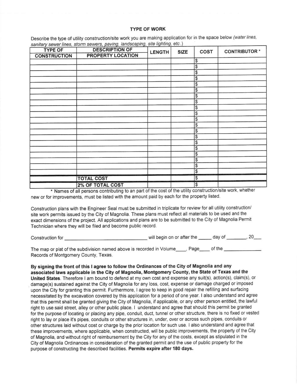
92
93 1 CONTACT INFORMATION Temporary Use Permit Checklist Map sheets and attached documents containing the following information shall be submitted with each application for a temporary use. Applicant _ Architect (if different) _ Property Owner (if different) Engineer/Land Surveyor (if different)
94 2 PROPERTY PROFILE Property ID # Site Address Legal Description (Subdivision) (Lot) (Block) Current Zoning Present Use of Property Proposed Use of the Property Total Area of Site
95 3 Narrative 1. Category and narrative description of the proposed temporary use, including its start and end dates, anticipated attendance (for public interest or special events), hours of operation: 2. Description of proposed traffic controls; or, if the use is construction related, trucking route: 3. Description of surrounding street traffic capacity to absorb the proposed temporary use, if the use is anticipated to generate material amounts of traffic: 4. Description of restroom facilities and garbage collection facilities: 5. Description of any proposed mitigation strategies that will be employed to lessen the potential negative impact to surrounding land uses and public streets, including an estimate of the noise that will be generated by the use: 6. A description of the limitations on operations: 7. A description of food services: 8. A list of similar existing uses in the vicinity of the site:
96 4 Map Sheet General Requirements No larger than 24 in. x 36 in. sheet size; no smaller than 11 in. x 17 in. sheet size Largest engineering scale possible Key map North arrow Title block with name of applicant and date of submittal Information Requirements One (1) completed application All fees Area proposed for primary use by the temporary use (including, for commercial outdoor sales events, the location and types of merchandise to be sold) The zoning of the subject property as well as surrounding properties Required sight distance triangles Number, type, location, height, and area of all signs and attention drawing devices to be used for the proposed temporary use Location, number, and details of special lighting to be used for the proposed temporary use (including hours of operation and brightness of the lighting) Location and details of amplification equipment to be used at the proposed temporary used (including the proposed hours of operation of the equipment) A separate map showing projected routes to and from the event) If the temporary use is located in a parking lot, the location and calculation of the percent of parking areas allocated to stage the temporary use Location of all fire lanes existing on site Location of all proposed temporary structures I, (print or type name), certify with my signature below that the information included in my submittal packet is complete, true, and correct, to the best of my knowledge. Signature of Applicant Date
97 1 Tree Removal Permit Application Form This form shall be submitted with each application for a tree removal permit. CONTACT INFORMATION Applicant _ Architect (if different) _ Property Owner (if different) Land Surveyor (if different)
98 2 PROPERTY PROFILE Property ID # Site Address Legal Description (Subdivision) (Lot) (Block) Current Zoning Present Use of Property Proposed Use of the Property Total Area of Site Number of Protected Trees on Site Site Permit Approval: YES NO Date Building Permit Approval: YES NO Date
99 3 Narrative Work description Map Sheet General Requirements 24 in. x 36 in. sheet size Largest engineering scale possible Key map North arrow Title block with name of applicant and date of submittal Required Information One (1) completed application All fees Tree location map and site plan, showing: Location of all buildings, structures, and other improvements proposed Limits of the construction lines Location of trees to be removed, located by measurements from the two nearest property lines and assigned a reference number Caliper and common name of all protected trees Any required replacement trees, shown with caliper size and common name and scientific name of the tree (Genus and species) I, (print or type name), certify with my signature below that the information included in my submittal packet is complete, true, and correct, to the best of my knowledge. Signature of Applicant Date
100 1 Variance Application Form This form shall be submitted with each application for a variance. CONTACT INFORMATION Applicant _ Architect (if different) _ Property Owner (if different) Engineer/Land Surveyor (if different)
101 2 PROPERTY PROFILE Property ID # Site Address Legal Description (Subdivision) (Lot) (Block) Current Zoning Present Use of Property Proposed Use of the Property Total Area of Site
102 3 1. The applicant is seeking relief from the following specific Section(s) of the UDC (also list the UDC requirement and the proposed alternative requirement): 2. the applicant seeks this variance in order to: 3. the zoning of the lot and adjacent lots is: 4. this variance will not disrupt adjacent lot owners due to the following mitigating factors: 5. items will be delivered to the site in the following manner and along the following routes: Variance Application Checklist: One (1) completed application All fees One (1) copy of the recorded plat of the property One (1) copy of the recorded covenants and restrictions for the property (if applicable) One (1) legible copy of a site plan/plot plan (scaled/dimensioned drawing showing location of proposed construction) on 24 in. x 36 in., 11 in. x 17 in., or 8 ½ in. x 11 in. Building elevations for the proposed construction
103 4 I, (print or type name), certify with my signature below that the information included in my submittal packet is complete, true, and correct, to the best of my knowledge. Signature of Applicant Date

104 1 CONTACT INFORMATION Zoning Clearance Permit Application Form This form shall be submitted with each application to establish a new use or to request a change in use. Depending on the nature of the work, additional permits may be required. Applicant _ Architect (if different) _ Property Owner (if different) Engineer/Land Surveyor (if different)
HOW TO APPLY FOR A USE PERMIT
 HOW TO APPLY FOR A USE PERMIT MENDOCINO COUNTY PLANNING AND BUILDING SERVICES What is the purpose of a use permit? Throughout the County, people use their properties in many different ways. They build
Article 6: Planned Unit Developments
 LUDC 2013 GARFIELD COUNTY, COLORADO Article 6: Planned Unit Developments ARTICLE 6 PLANNED UNIT DEVELOPMENTS TABLE OF CONTENTS DIVISION 1. GENERAL.... 1 6-101. GENERAL PROVISIONS.... 1 A. Purpose....
BARROW COUNTY, GEORGIA
 BARROW COUNTY, GEORGIA Application For Rezoning, Special Use, and Change in Conditions BARROW COUNTY DEPARTMENT OF PLANNING AND DEVELOPMENT 30 North Broad Street Winder, Georgia 30680 770-307-3034 APPLICATION
201 General Provisions
 201 General Provisions 201.01 Title 201.09 Amendments 201.02 Purpose and Intent 201.10 Public Purpose 201.03 Authority 201.11 Variances and Appeals 201.04 Jurisdiction 201.12 Nonconformances 201.05 Enactment
DEVELOPMENT PLAN ORDINANCE
 DEVELOPMENT PLAN ORDINANCE CITY OF GLASGOW Ordinance No. 2026 SECTION A. Section 1. INTENT AND PURPOSE The purpose of this Ordinance is to establish and define development plans, which may be utilized
Town of Norwich, Vermont SUBDIVISION REGULATIONS
 Town of Norwich, Vermont SUBDIVISION REGULATIONS Adopted: August 6, 2002 Amended: February 8, 2006 Prepared by Norwich Planning Commission with the assistance of: Burnt Rock Inc. A ssociates in Community
ARTICLE 1 GENERAL PROVISIONS
 ARTICLE 1 GENERAL PROVISIONS SECTION 100 TITLE This Ordinance shall be known and cited as the "Rice Township Subdivision and Land Development Ordinance." SECTION 101 AUTHORITY Rice Township is empowered
Subchapter 16 Subdivisions.
 Subchapter 16 Subdivisions. Sections: 35.16.1 Authority. 35.16.2 Purpose. 35.16.3 Jurisdiction. 35.16.4 Application. 35.16.5 Compliance and Enforcement. 35.16.6 Approval of Plat Required. 35.16.7 Lots,
CHAPTER 3 PERMITS, PLANS AND ANNEXATION
 CHAPTER 3 PERMITS, PLANS AND ANNEXATION SECTION: 10-3-1: General Regulations 10-3-2: Building Permit 10-3-3: Plans 10-3-4: Certificate of Compliance and Occupancy 10-3-5: Conditional Use Permits 10-3-6:
LAND USE AND ZONING OVERVIEW
 OVERVIEW OF PLANNING POLICIES LAND USE AND ZONING OVERVIEW The Minneapolis Plan for Sustainable Growth and Other Adopted Plans Community Planning and Economic Development Development Services Division
A. Be consistent with the local growth management program;
 6.1. Authority 6.2. Purpose Subject to the conditions and/or restrictions and in accordance with the state of Maine Planning and Land Use Laws, 30-A M.R.S.A., Section 4352, Sub-Section 8, property in the
Application for Sketch Plan Review
 Town of Standish 175 Northeast Road Standish, ME - 04084 Phone: (207)642-3461 Fax: (207) 642-5181 Application for Sketch Plan Review Applicant & Owner Information 1) Name of Applicant: Address: Phone:
Salem Township Zoning Ordinance Page 50-1 ARTICLE 50.0: PUD PLANNED UNIT DEVELOPMENT
 Salem Township Zoning Ordinance Page 50-1 ARTICLE 50.0 PLANNED UNIT DEVELOPMENT Section 50.01 Purpose The provisions of this Article provide enabling authority and standards for the submission, review,
ZONING & LAND USE APPLICATION
 City of Maple Plain 5050 Independence St P.O. Box 97 Maple Plain, MN 55359 Office: (763) 479-0515 Fax: (763) 479-0519 ZONING & LAND USE APPLICATION APPLICANT INFORMATION Applicant Name Company, if applicable
CITY OF VALDEZ APPLICATION FOR SUBDIVISION
 CITY OF VALDEZ APPLICATION FOR SUBDIVISION The subdivision of any land within the city limits of the City of Valdez is regulated by Title 16 of the Valdez Municipal Code. 16.04.020 Definitions. Subdivision
Title 6 - Local Government Provisions Applicable to Special Purpose Districts and Other Political Subdivisions
 Title 6 - Local Government Provisions Applicable to Special Purpose Districts and Other Political Subdivisions CHAPTER 29. SOUTH CAROLINA LOCAL GOVERNMENT COMPREHENSIVE PLANNING ENABLING ACT OF 1994 1994
ZONING HEARING BOARD APPEAL APPLICATON REQUIREMENTS
 ZONING HEARING BOARD APPEAL APPLICATON REQUIREMENTS The following items together must be submitted to the Bureau of Permits, Planning and Zoning to make up a complete application to the Zoning Hearing
Burnett County, WI LAND USE VARIANCE APPLICATION, EXPLANATION, & REQUIREMENTS
 Burnett County, WI LAND USE VARIANCE APPLICATION, EXPLANATION, & REQUIREMENTS A variance is a relaxation of a standard in a land use ordinance. Variances are decided by the Board of Adjustment/Appeals
PLANNED UNIT DEVELOPMENT (PUD)
") SECTION 38.01. ARTICLE 38 PLANNED UNIT DEVELOPMENT (PUD) Purpose The purpose of this Article is to implement the provisions of the Michigan Zoning Enabling Act, Public Act 110 of 2006, as amended, authorizing
SECTION 38.01. ARTICLE 38 PLANNED UNIT DEVELOPMENT (PUD) Purpose The purpose of this Article is to implement the provisions of the Michigan Zoning Enabling Act, Public Act 110 of 2006, as amended, authorizing
SPECIAL USE FOR A PLANNED UNIT DEVELOPMENT (P.U.D.), REZONING, and COMPREHENSIVE PLAN AMENDMENT APPLICATION PACKET
, REZONING, and COMPREHENSIVE PLAN AMENDMENT APPLICATION PACKET") SPECIAL USE FOR A PLANNED UNIT DEVELOPMENT (P.U.D.), REZONING, and COMPREHENSIVE PLAN AMENDMENT APPLICATION PACKET VILLAGE OF HANOVER PARK DEVELOPMENT COMMISSION Village of Hanover Park Department of Community
SPECIAL USE FOR A PLANNED UNIT DEVELOPMENT (P.U.D.), REZONING, and COMPREHENSIVE PLAN AMENDMENT APPLICATION PACKET VILLAGE OF HANOVER PARK DEVELOPMENT COMMISSION Village of Hanover Park Department of Community
Guide to Minor Developments
 Guide to Minor Developments Introduction The Douglas County (DCD) is committed to providing open, transparent application processes to the public. This Guide is provided to assist anyone interested in
APPLICANT NAME SUBDIVISION NAME DEVELOPMENT NAME LOCATION. CITY COUNCIL DISTRICT Council District 4 PRESENT ZONING PROPOSED ZONING
 SUBDIVISION, PLANNED UNIT DEVELOPMENT, PLANNING APPROVAL, ZONING AMENDMENT, & SIDEWALK WAIVER REQUEST STAFF REPORT Date: February 17, 2010 APPLICANT NAME SUBDIVISION NAME DEVELOPMENT NAME LOCATION David
(if more than one, give square footage for each) ANNEXATION LOT LINE Adjustments PRE/FINAL PLAT SPECIAL USE PERMIT
 ANNEXATION LOT LINE Adjustments PRE/FINAL PLAT SPECIAL USE PERMIT") Planning Commission Application Building & development office 915 Third ST. Rawlins WY ph. 307-328-4599 fax. 307-328-4590 PROJECT REVIEW: GENERAL INFORMATION Project name: OFFICE USE ONLY Site address
Planning Commission Application Building & development office 915 Third ST. Rawlins WY ph. 307-328-4599 fax. 307-328-4590 PROJECT REVIEW: GENERAL INFORMATION Project name: OFFICE USE ONLY Site address
Residential Subdivision Preliminary Plat Application
 WATER MODELING FEES Major : $650 or Minor : $550 # of lots x $35 per lot Residential Preliminary Plat Application Lots: 1-9 10-19 20-49 50-99 100-199 $300 $400 $475 $625 $825 200-349 350-499 500-499 700-999
CHAPTER 10 Planned Unit Development Zoning Districts
 CHAPTER 10 Planned Unit Development Zoning Districts Section 10.1 Intent and Purpose The Planned Unit Development (PUD) districts are intended to offer design flexibility for projects that further the
Administrative Plat Application Form
 1 Administrative Plat Application Form This form shall be submitted with each application for an administrative plat. CONTACT INFORMATION Applicant Architect (if different) Property Owner (if different)
MINOR SUBDIVISION FINAL PLAT APPLICATION Town of Apex, North Carolina
 MINOR SUBDIVISION FINAL PLAT APPLICATION Town of Apex, North Carolina This document is a public record under the North Carolina Public Records Act and may be published on the Town s website or disclosed
Town of Bristol Rhode Island
 Town of Bristol Rhode Island Subdivision & Development Review Regulations Adopted by the Planning Board September 27, 1995 (March 2017) Formatted: Highlight Formatted: Font: 12 pt Table of Contents TABLE
ARTICLE III GENERAL PROCEDURES, MINOR PLANS AND FEE SCHEDULES
 ARTICLE III GENERAL PROCEDURES, MINOR PLANS AND FEE SCHEDULES 301. Prior to Submission a. Copies of this Ordinance shall be available on request, at cost, for the use of any person who desires information
DENTON Developer's Handbook
 DENTON Developer's Handbook A guide for land development in the City of Denton Department of Development Services 2017 2 Table of Contents 1. City of Denton Development Process...5 Role of the Development
ARTICLE 15 - PLANNED UNIT DEVELOPMENT
 Section 15.1 - Intent. ARTICLE 15 - PLANNED UNIT DEVELOPMENT A PUD, or Planned Unit Development, is not a District per se, but rather a set of standards that may be applied to a development type. The Planned
PLANNED UNIT DEVELOPMENT & SUBDIVISION STAFF REPORT Date: April 18, 2019
 PLANNED UNIT DEVELOPMENT & SUBDIVISION STAFF REPORT Date: April 18, 2019 DEVELOPMENT NAME SUBDIVISION NAME Springhill Village Subdivision Springhill Village Subdivision LOCATION 4350, 4354, 4356, 4358,
Burnett County, WI SUBDIVISION VARIANCE APPLICATION, EXPLANATION, & REQUIREMENTS PROCESS (NOTE: PLEASE READ ENTIRE APPLICATION BEFORE PROCEEDING)
") Burnett County, WI SUBDIVISION VARIANCE APPLICATION, EXPLANATION, & REQUIREMENTS A variance is a relaxation of a standard in a land use ordinance. Subdivision variances are decided by the Land Use and
Burnett County, WI SUBDIVISION VARIANCE APPLICATION, EXPLANATION, & REQUIREMENTS A variance is a relaxation of a standard in a land use ordinance. Subdivision variances are decided by the Land Use and
MAJOR RESIDENTIAL AND NONRESIDENTIAL SUBDIVISIONS
 Lawrence-Douglas County MAJOR RESIDENTIAL AND NONRESIDENTIAL SUBDIVISIONS Preliminary Plats The applicant shall schedule a Pre-Application meeting with Planning Staff at least seven (7) working days prior
Midwest City, Oklahoma Code of Ordinances Chapter 38: Subdivision Regulations
 2012 Midwest City, Oklahoma Code of Ordinances Chapter 38: Subdivision Regulations Adoption Date: 8/14/2012 Table of Contents Article I. General Provisions... 5 Section 38-1. Preamble... 5 Section 38-2.
CHAPTER SHORT SUBDIVISIONS
 CITY OF MOSES LAKE MUNICIPAL CODE CHAPTER 17.09 SHORT SUBDIVISIONS Sections: 17.09.010 Purpose 17.09.020 Scope 17.09.030 Preliminary Short Subdivision Conditions and Requirements 17.09.040 Referral to
PLANNED DEVELOPMENT REVIEW Last Revised 8/15/17
 Community Development Department City Hall 222 E. 9 th Street, 2 nd Floor Lockport, IL 60441 (815) 838-0549, Option 4 www.lockport.org PLANNED DEVELOPMENT REVIEW Last Revised 8/15/17 Community Development
Conditional Use Application
 Conditional Use Application City of St. Pete Beach Community Development Department 155 Corey Avenue St. Pete Beach, Florida 33706 (727) 367-2735 www.stpetebeach.org Case Number: PROPERTY OWNER: Name:
ARTICLE 24 SITE PLAN REVIEW
 ARTICLE 24 SITE PLAN REVIEW 24.1 PURPOSE: The intent of these Ordinance provisions is to provide for consultation and cooperation between the land developer and the Township Planning Commission in order
Planning and Zoning Code
 2014 Planning and Zoning Code City of Defiance, Ohio December 2014 Planning and Zoning Code City of Defiance, Ohio CHAPTER 1161. General Provisions... 7 1161. 01. Title... 7 1161. 02. Purpose... 7 1161.
BY THE CITY COMMISSION ORDINANCE NO.:
 BY THE CITY COMMISSION ORDINANCE NO.: 2005-0868 AN ORDINANCE BY THE CITY COMMISSION OF THE CITY OF DADE CITY, FLORIDA CREATING A DEVELOPMENT REVIEW PROCEDURES ORDINANCE; PROVIDING FOR INTENT, PURPOSE,
2015 Planning and Zoning School Town of Hyde Park July 15, Site Plan Review and Special Use Permits
 2015 Planning and Zoning School Town of Hyde Park July 15, 2015 Site Plan Review and Special Use Permits Matthew G. Rogers, AICP New York Planning Federation Introduction Site Plan and Special Use Permits
MASTER SUBDIVISION FINAL PLAT APPLICATION Town of Apex, North Carolina
 MASTER SUBDIVISION FINAL PLAT APPLICATION Town of Apex, North Carolina This document is a public record under the North Carolina Public Records Act and may be published to the Town s website or disclosed
PLANNED UNIT DEVELOPMENT (PUD) AREA PLAN/REZONING REVIEW PROCEDURE
 AREA PLAN/REZONING REVIEW PROCEDURE") PLANNED UNIT DEVELOPMENT (PUD) AREA PLAN/REZONING REVIEW PROCEDURE Professional inquiries will be made to our Township Planning Consultant, Township Engineer, and Township Attorney to get their opinions
PLANNED UNIT DEVELOPMENT (PUD) AREA PLAN/REZONING REVIEW PROCEDURE Professional inquiries will be made to our Township Planning Consultant, Township Engineer, and Township Attorney to get their opinions
TOWN OF LERAY PLANNING BOARD Minor Subdivision Application Packet
 This Packet is designed to assist applicants in providing the forms needed for submission of a 1 to 4 lot subdivision to the Planning Board for approval. The following should be filled out to ensure the
IV. REVIEW PROCEDURES FOR MINOR SUBDIVISIONS
 IV. REVIEW PROCEDURES FOR MINOR SUBDIVISIONS IV-A. General Minor subdivisions create five or fewer lots from a tract of record, each lot of which has legal and physical access. If the tract of record proposed
Guide to Combined Preliminary and Final Plats
 Guide to Combined Preliminary and Final Plats Introduction The Douglas County is committed to providing open, transparent application processes to the public. This Guide is provided to assist anyone interested
ARTICLE VII. NONCONFORMITIES. Section 700. Purpose.
 ARTICLE VII. NONCONFORMITIES. Section 700. Purpose. The purpose of this chapter is to regulate and limit the development and continued existence of legal uses, structures, lots, and signs established either
ARTICLE 5 GENERAL REQUIREMENTS
 5.1 SUITABILITY OF THE LAND ARTICLE 5 GENERAL REQUIREMENTS 5.1.1 Land subject to flooding, improper drainage or erosion, and land deemed to be unsuitable for development due to steep slope, unsuitable
PLANNING COMMISSION STAFF REPORT
 PLANNING COMMISSION STAFF REPORT West Capitol Hill Zoning Map Amendment Petition No. PLNPCM2011-00665 Located approximately at 548 W 300 North Street, 543 W 400 North Street, and 375 N 500 West Street
The following regulations shall apply in the R-E District:
 "R-E" RESIDENTIAL ESTATE DISTRICT (8/06) The following regulations shall apply in the R-E District: 1. Uses Permitted: The following uses are permitted. A Zoning Certificate may be required as provided
ADUs and You! Common types of ADUs include mother-in-law suite, garage apartments and finished basements.
 ADUs and You! Accessory Dwelling Units Town of Lyons Accessory Dwelling Units (ADUs) are a form of housing that can be an important tool for diversifying and increasing the local housing stock. Lyons lost
City of Altamonte Springs Developer s Guide
 Section 6 SUBDIVISION PLAN & PLAT REVIEW PROCESS This section contains information, applications, and checklists related to the subdivision development plan and plat review process in Altamonte Springs.
MIDWAY CITY Municipal Code
 MIDWAY CITY Municipal Code TITLE 9 ANNEXATION CHAPTER 9.01 PURPOSE CHAPTER 9.02 GENERAL REQUIREMENTS CHAPTER 9.03 PROPERTY OWNER INITIATION OF ANNEXATION CHAPTER 9.04 PROCEDURES FOR CONSIDERATION OF PETITION
City of Shenandoah Development Package
 Upon completion return application to Development@shenandoahtx.us City of Shenandoah Development Package Documentation includes the following: Fee Schedule Platting Development Check List & Outline Development
PLANNED UNIT DEVELOPMENT & SUBDIVISION STAFF REPORT Date: July 20, 2017
 PLANNED UNIT DEVELOPMENT & SUBDIVISION STAFF REPORT Date: July 20, 2017 DEVELOPMENT NAME SUBDIVISION NAME LOCATION Rangeline Crossing III Subdivision Rangeline Crossing III Subdivision 5289 Halls Mill
Understanding the Conditional Use Process
 Understanding the Conditional Use Process The purpose of this document is to explain the process of applying for and obtaining a conditional use permit in the rural unincorporated towns of Dane County.
Town of Scarborough, Maine
 Town of Scarborough, Maine Miscellaneous Appeal INFORMATION REQUIRED FOR ALL APPEALS Before any appeal can be processed, the following material must be submitted to the Code Enforcement Office: 1. A fee
CHAPTER 3. APPLICATION REVIEW AND DECISION
 CHAPTER 3. APPLICATION REVIEW AND DECISION 3.1 LAND USE PERMITS/DECISIONS... 1 3.1.1 General Provisions... 1 A) Land Use Permits Required... 1 B) Effect of Approval... 1 C) Zoning Information Sheet...
CONDITIONAL USE PERMIT (CUP)
") CONDITIONAL USE PERMIT (CUP) LAND DEVELOPMENT APPLICATION FORM DEPARTMENT OF PLANNING 300 East Main Street, Sun Prairie, WI 53590-2227 (608)825-1107 FAX (608)825-1194 Applications will not be processed
CONDITIONAL USE PERMIT (CUP) LAND DEVELOPMENT APPLICATION FORM DEPARTMENT OF PLANNING 300 East Main Street, Sun Prairie, WI 53590-2227 (608)825-1107 FAX (608)825-1194 Applications will not be processed
Article 2 Application Type and Standards Requirements
 Article 1 Article 2 Division 1 Application Type and Standards Requirements General Provisions Sec. 2.1.1 Division 2 Division 3 Division 4 Division 5 Division 6 Division 7 Division 8 Division 9 Sec. 2.9.1
A GUIDE TO PROCEDURES FOR: SUBDIVISIONS & CONDOMINIUM CONVERSION
 A GUIDE TO PROCEDURES FOR: SUBDIVISIONS & CONDOMINIUM CONVERSION A GUIDE TO PROCEDURES FOR: SUBDIVISIONS (TENTATIVE MAPS) PURPOSE Definition: A subdivision is defined as the division of any improved or
A. Appropriate agency responsible for transportation review for the subject property.
 7.8.10 Procedure Any person desiring to create a minor subdivision shall submit to the Commission for approval an application on forms provided by the Division, and a record plat in conformance with the
II. What Type of Development Requires Site Plan Review? There are five situations where a site plan review is required:
 I. What is a Site Plan Review? Site Plan Review is a process where the construction of new buildings, new additions, and certain types of canopies and/or tax-exempt institutions are reviewed by the City
FINAL SITE PLAN PLAT APPLICATION Town of Apex, North Carolina
 FINAL SITE PLAN PLAT APPLICATION Town of Apex, North Carolina This document is a public record under the North Carolina Public Records Act and may be published on the Town s website or disclosed to third
CHAPTER 3 PRELIMINARY PLAT
 10-3-1 10-3-3 SECTION: CHAPTER 3 PRELIMINARY PLAT 10-3-1: Consultation 10-3-2: Filing 10-3-3: Requirements 10-3-4: Approval 10-3-5: Time Limitation 10-3-6: Grading Limitation 10-3-1: CONSULTATION: Each
Chapter 100 Planned Unit Development in Corvallis Urban Fringe
 100.100 Scope and Purpose. Chapter 100 Planned Unit Development in Corvallis Urban Fringe (1) All applications for land divisions in the Urban Residential (UR) and Flood Plain Agriculture (FPA) zones within
LYON COUNTY TITLE 15 LAND USE AND DEVELOPMENT CODE LAND DIVISION REGULATIONS CHAPTERS October 19, 2017 Ordinance Draft DRAFT
 DRAFT LYON COUNTY TITLE 15 LAND USE AND DEVELOPMENT CODE LAND DIVISION REGULATIONS CHAPTERS 15.600 15.607 October 19, 2017 Ordinance Draft This page left blank intentionally DRAFT DRAFT Lyon County Contents
Larimer County Planning Dept. Procedural Guide for 1041 PERMITS
 - Larimer County Planning Dept. Procedural Guide for 1041 PERMITS PLEASE NOTE: A PRE-APPLICATION CONFERENCE IS REQUIRED PRIOR TO SUBMITTING THIS APPLICATION. PURPOSE: State Statutes allow local governments
Applicant: Address: Fee Owner: Address: Property Location (Address and Complete (long) Legal Description: Detailed Reason for Request:
 Legal Description: Detailed Reason for Request:") Date Received: Received By: Permit #: LAND USE APPLICATION Comprehensive Plan Zoning District Amend Zoning Text Amend Variance*(see below) Zoning Appeal Conditional Use Permit (C.U.P.) Flood Plain C.U.P.
Date Received: Received By: Permit #: LAND USE APPLICATION Comprehensive Plan Zoning District Amend Zoning Text Amend Variance*(see below) Zoning Appeal Conditional Use Permit (C.U.P.) Flood Plain C.U.P.
ADMINISTRATIVE HEARING STAFF REPORT
 ADMINISTRATIVE HEARING STAFF REPORT Providence Place Apartments Utility Box No. 2 Conditional Use Petition PLNPCM2011-00426 309 East 100 South September 22, 2011 Planning and Zoning Division Department
ARTICLE SINGLE FAMILY SITE CONDOMINIUM DEVELOPMENT STANDARDS
 ARTICLE 28.00 SINGLE FAMILY SITE CONDOMINIUM DEVELOPMENT STANDARDS Section 28.01 PURPOSE The purpose of this Article is to recognize that conventional single family developments, traditionally developed
Medical Marijuana Special Exception Use Information
 Medical Marijuana Special Exception Use Information The Special Exception Use information below is a modified version of the Unified Development Code. It clarifies the current section 5:104 Special Exceptions
Guide to Replats. Step 1. Step 2. Step 3. Step 4. Step 5. Step 6. Step 7. Step 8. Step 9. Step 10
 Guide to Replats Introduction Douglas County is committed to providing open, transparent application processes to the public. This Guide is provided to assist anyone interested in the procedures and expectations
REZONING APPLICATION INSTRUCTIONS
 REZONING APPLICATION INSTRUCTIONS All required information, as stated on the Rezoning Application Checklist, must be included to qualify as a complete application. Upon receipt, staff will review the application
MINOR SUBDIVISION INFORMATION
 A. POINTS OF CONTACT: MINOR SUBDIVISION INFORMATION Surveyor: Address: Phone #: Fax # E-Mail Address: Representative (If different from applicant): Address: Phone #: Fax # E-Mail Address: B. GENERAL INFORMATION:
TENTATIVE PARCEL MAP APPLICATION GUIDE TENTATIVE PARCEL MAP APPLICATION REQUIREMENTS
 TENTATIVE PARCEL MAP APPLICATION GUIDE SISKIYOU COUNTY PLANNING DIVISION 806 South Main Street, Yreka CA 96097 Phone: (530) 841-2100 / Fax: (530) 841-4076 TENTATIVE PARCEL MAP APPLICATION REQUIREMENTS
SUBDIVISION, PLANNED UNIT DEVELOPMENT, ZONING AMENDMENT, & SIDEWALK WAIVER STAFF REPORT Date: July 19, 2018
 SUBDIVISION, PLANNED UNIT DEVELOPMENT, ZONING AMENDMENT, & SIDEWALK WAIVER STAFF REPORT Date: July 19, 2018 NAME SUBDIVISION NAME LOCATION West Mobile Properties, LLC U.S. Machine Subdivision 556, 566,
BY AUTHORITY A BILL FOR AN ORDINANCE MAKING REVISIONS TO CHAPTERS 2 THROUGH 5 OF TITLE XI OF THE WESTMINSTER MUNICIPAL CODE
 BY AUTHORITY ORDINANCE NO. 3919 COUNCILLOR' S BILL NO. 6 SERIES OF 2018 INTRODUCED BY COUNCILLORS Seitz, De Cambra A BILL FOR AN ORDINANCE MAKING REVISIONS TO CHAPTERS 2 THROUGH 5 OF TITLE XI OF THE WESTMINSTER
FINAL PLAT APPLICATION
 FINAL PLAT APPLICATION (Page 1 of 3) LEGAL OWNER(s): NAME: STREET ADDRESS OWNER(s): CITY, STATE, ZIP CODE: PHONE NUMBER: BILLING ADDRESS: NAME OF ENGINEER/SURVEYOR: Engineer/Surveyor Address, Phone: PROPERTY
TABLE OF CONTENTS. Page TITLE, SHORT TITLE, AND PURPOSE SUBMISSION AND REVIEW PROCEDURES
 ARTICLE I TABLE OF CONTENTS TITLE, SHORT TITLE, AND PURPOSE Page 101 Title 3 102 Short Title 3 103 Purpose 3 104 Application of the Ordinance 3 105 Interpretation 4 106 Revision and Resubdivisions 4 ARTICLE
ZONING ORDINANCE Ordinance No January 2011
 ZONING ORDINANCE Ordinance No. 121410 January 2011 McCordsville, Indiana Table of Contents Article I. General Provisions... 7 Section 1.01 Title... 7 Section 1.02 Purpose & Authority... 7 Section 1.03
COMPREHENSIVE PLAN FUTURE LAND USE MAP AMENDMENT APPLICATION
 COUNTY STAFF DATA ONLY Date Received: Project No. CPA-20 - GADSDEN COUNTY DEPARTMENT OF PLANNING & COMMUNITY DEVELOPMENT 1-B East Jefferson Street, Post Office Box 1799, Quincy, FL 32353-1799 PLANNING
AN ORDINANCE TO AMEND SECTION OF THE RAPID CITY MUNICIPAL CODE TO ALLOW FOR ADMINISTRATIVE DISSOLUTION OF PLANNED DEVELOPMENTS
 Ordinance No. 6231 AN ORDINANCE TO AMEND SECTION 17.50.050 OF THE RAPID CITY MUNICIPAL CODE TO ALLOW FOR ADMINISTRATIVE DISSOLUTION OF PLANNED DEVELOPMENTS WHEREAS, the City of Rapid City has adopted a
APPLICATION FOR MAJOR SUBDIVISION APPROVAL (PRELIMINARY PLAT)
") 209 S. Main Street Marysville, Ohio 43040 Phone: (937) 645-7350 Fax: (937) 645-7351 www.marysvilleohio.org APPLICATION FOR MAJOR SUBDIVISION APPROVAL (PRELIMINARY PLAT) *** IMPORTANT INFORMATION ~ Please
209 S. Main Street Marysville, Ohio 43040 Phone: (937) 645-7350 Fax: (937) 645-7351 www.marysvilleohio.org APPLICATION FOR MAJOR SUBDIVISION APPROVAL (PRELIMINARY PLAT) *** IMPORTANT INFORMATION ~ Please
BRIDGETON SUBDIVISION APPLICATION CHECKLIST
 APPLICATION NAME AND # CHECKLIST COMPLETED BY: DATE: Signature and printed name BRIDGETON SUBDIVISION APPLICATION CHECKLIST TO SUBDIVISION APPLICANTS: The attached checklist is to assist you in the submission
PLANNING & ZONING DEPARTMENT 401 South Rogers Street Waxahachie, Texas (469)
") ZONING APPLICATION Select Application Type: Zoning Change Specific Use Permit (SUP) PD Concept Plan PD Detailed Plan PD Amendment Site Plan The following items shall be included in the application submittal:
ZONING APPLICATION Select Application Type: Zoning Change Specific Use Permit (SUP) PD Concept Plan PD Detailed Plan PD Amendment Site Plan The following items shall be included in the application submittal:
CHAPTER 22 SUBDIVISION AND LAND DEVELOPMENT. Part 1 General Provisions. Part 2 Application Procedure and Approval Process
 CHAPTER 22 SUBDIVISION AND LAND DEVELOPMENT Part 1 General Provisions 101. Title 102. Policy 103. Purposes 104. Authority 105. Jurisdiction 106. Interpretation, Conflict and Separability 107. Municipal
1 st Hearing: 2 nd Hearing: Publication Dates: Notices Mailed: Rezone, Special Exception and Variance APPLICANT INFORMATION PROPERTY INFORMATION
 City of Okeechobee General Services Department 55 S.E. 3 rd Avenue, Room 101 Okeechobee, Florida 34974-2903 Phone: (863) 763-3372, ext. 218 Fax: (863) 763-1686 1 Name of property owner(s): 2 Owner mailing
PRELIMINARY SUBDIVISION PLAN APPLICATION INSTRUCTIONS
 City of Chesapeake Department of Planning Post Office Box 15225 Chesapeake, Virginia 23328-5225 (757) 382-6176 FAX (757) 382-6406 PRELIMINARY SUBDIVISION PLAN APPLICATION INSTRUCTIONS PURPOSE A preliminary
INFORMATION & PROCEDURES FOR CHANGE OF ZONING REQUESTS AND CONDITIONAL USE PERMITS
 INFORMATION & PROCEDURES FOR CHANGE OF ZONING REQUESTS AND CONDITIONAL USE PERMITS The applicant is strongly encouraged to attend a pre-application meeting for the project prior to submittal of a zoning
Elkhart County ZONING ORDINANCE
 Elkhart County ZONING ORDINANCE ADOPTED: December 15, 2014 EFFECTIVE: February 2, 2015 LAST AMENDED: N/A If you are viewing a digital version of this Zoning Ordinance, you may click on any cross-reference
Chair Mark Seifert Presiding. 1. Roll Call. 2. Approval of Agenda. 3. Recognition by Planning Commission of Interested Citizens.
 If Commissioners have any comments, concerns or questions, they should contact the staff Project Manager prior to the scheduled meeting date. Also, if you are for any reason unable to attend the meeting,
City of East Orange. Department of Policy, Planning and Development LAND USE APPLICATION & SITE PLAN REVIEW CHECKLIST
 Department of Policy, Planning and Development LAND USE APPLICATION & SITE PLAN REVIEW CHECKLIST COMPLETE: Applicant Information: Type of Proposal: OFFICE USE ONLY: New Residential Case #: Date: New Accessory
SUBDIVISION APPLICATION CHECKLIST SKETCH PLAN PRELIMINARY PLAT FINAL PLAT
 RECEIVED STAMP SUBDIVISION APPLICATION CHECKLIST SKETCH PLAN PRELIMINARY PLAT FINAL PLAT A checklist of background information and submission requirements for processing of a sketch plan, preliminary plat
THE SUBDIVISION AND LAND DEVELOPMENT REVIEW PROCESS
 THE SUBDIVISION AND LAND DEVELOPMENT REVIEW PROCESS INTRODUCTION: Howard County Subdivision and Land Development Regulations are intended to promote the health, safety and general welfare of County residents.
CHAPTER XVIII SITE PLAN REVIEW
 CHAPTER XVIII SITE PLAN REVIEW Section 18.1 Section 18.2 Description and Purpose. The purpose of this chapter is to provide standards and procedures under which applicants would submit, and the Township
13-2 SUBDIVISION PLANS AND PLATS REQUIRED EXCEPTIONS Subdivision Plats Required To be Recorded
 ARTICLE XIII SUBDIVISIONS 13-1 INTENT AND PURPOSE 13-1-1 Intent: It is the intent of the County Commission through the adoption of this Article to more fully avail itself of the power granted under 17-27-601
610 LAND DIVISIONS AND PROPERTY LINE ADJUSTMENTS OUTSIDE A UGB
 ARTICLE VI: LAND DIVISIONS AND PROPERTY LINE ADJUSTMENTS VI-21 610 LAND DIVISIONS AND PROPERTY LINE ADJUSTMENTS OUTSIDE A UGB 610-1 Property Line Adjustments (Property Line Relocation) A property line
TOWN OF LEWISTON PLANNING BOARD APPLICATION
 TOWN OF LEWISTON PLANNING BOARD APPLICATION DESCRIPTION OF PROPOSED REQUEST: Name of Property Owner: Phone #: Name of Applicant:Phone #: Address or Location of Proposal:_SBL# Size of Parcel or Structure:Existing