Commissioners present: Matheson; Nichols; Denton; Robinson; Sossaman; and Ingram (Commissioner Arrington was absent).
|
|
|
- Melvyn Ward
- 5 years ago
- Views:
Transcription
1
2
3
4 f 1. Call to Order MINUTES WORK STUDY SESSION QUEEN CREEK PLANNING & ZONING COMMISSION QUEEN CREEK TOWN HALL, S. ELLSWORTH ROAD COUNCIL CHAMBERS August 12, :00 PM The meeting was called to order at 6:07 PM 2. Roll Call (one or more members of the Commission may participate by telephone) Commissioners present: Matheson; Nichols; Denton; Robinson; Sossaman; and Ingram (Commissioner Arrington was absent). ITEMS FOR DISCUSSION These items are for Commission discussion only and no action will be taken. In general, no public comment will be taken. 3. Discussion on the North Specific Area Plan (Chris Anaradian) Chris Anaradian, Development Services Director, summarized the purpose of the presentation, which is to provide the Commission with a brief overview of the North Specific Area Plan. Mr. Anaradian noted that he expects the South Area Plan to be presented at another Work Session in the upcoming months. Mr. Anaradian also stated that the North Specific Area Plan will be presented at the September 9, 2015 Planning and Zoning Commission Regular Session for approval and Council will vote to approve the plan at the September 16, 2015 meeting. Mr. Anaradian noted that Town staff, property owners, consultants, and other agencies have been working on the North Specific Area Plan for nearly a year and a half. Mr. Anaradian provided a summary of a few salient points of the plan by chapter: Chapter 1 Background Chapter. Mr. Anaradian stated that the Background Chapter summarizes the impetus behind the plan, where five property owners in the North Area had land identified as industrial in the General Plan who wanted to apply for a General Plan Amendment to residential. Chapter 2 Character and Vision Mr. Anaradian stated that the Town Council petitioned owners to suspend their request to amend the General Plan in favor of a specific area plan in order to create a more cohesive vision for the area. Mr. Anaradian stated that Town Staff began working with property owners to define the character and vision for the North Specific Area Plan. Chapter 3 Economic Development Analysis Mr. Anaradian stated that the property owners came to Town Staff with their own development feasibility studies that they conducted prior to the recession to make the case that the land use designations included in the General Plan may not be attainable. In 2013, the Town conducted its own study to better understand why the property owners wanted to build residential rather than industrial development. Mr. Anaradian stated that the results of the study were
5 Planning & Zoning Work Study Minutes March 12, 2014 Page 2 of 4 contradictory to what was understood in 2008 (the year the General Plan was adopted) that the Town paid for a second study. Mr. Anaradian presented a table that compares the total acres of retail, industrial, office, and agritainment for the Town proposed in the General Plan and the North and South Specific Area Plans. The table also included the total acreage that could be reasonably absorbed by 2053 per the two independent studies conducted by the Town. The absorption of acres determined by the two studies considers the Town s anticipated full build out of 90,000 residents, commute shed, land use, and how neighboring communities are growing. Mr. Anaradian presented a table that compared the jobs to housing ratios of valley communities. Mr. Anaradian noted that at full build out of the current General Plan, the Town will have a jobs-to-housing ratio at 1.64 jobs to homes. Mr. Anaradian noted that if the North Specific Area Plan is approved, the ratio would be reduced to Mr. Anaradian referenced the current jobs to housing ratios of neighboring municipalities: Maricopa 0.16 Queen Creek 0.48 Gilbert 0.60 Mesa 0.62 Chandler 0.97 Scottsdale 1.14 Phoenix 1.29 Tempe 2.34 Mr. Anaradian stated that Scottsdale, Phoenix, and Tempe are the three net importers of jobs as a result of the available transportation systems and as a result, those cities have more people coming into the community to work than leaving. Mr. Anaradian noted that in the next 40 years, no new freeways are planned. Mr. Anaradian presented a map that identifies the proposed commercial and industrial development in the Maricopa County region. Mr. Anaradian explained that there is a lot of land proposed for commercial and industrial development in favorable locations near freeways that have not yet been developed. Mr. Anaradian stated Staff analyzed eight operating job and commerce centers in the east valley, noting that these sites are considered the Town s competition. Mr. Anaradian stated that the results of the economic development analysis show that property owners applications for an amendment from industrial and commercial to residential are not unreasonable. Mr. Anaradian presented a map of the current General Plan designations for the North Specific Area. Mr. Anaradian then presented a map showing that all of the eight operating and commerce centers could fit in the North Specific Area. Mr. Anaradian stated that the current General Plan may be unreasonable to expect this level of industrial development by the next 40 years. Mr. Anaradian then presented the proposed land use plan for the North Specific Area, which still would include enough commercial and industrial land to fit six operating job and commerce centers. Chapter 4 Land Use Mr. Anaradian stated that the Land Use Chapter gets into more detail of the proposed land use and also discussed the Phoenix-Mesa Gateway Airport. Mr. Anaradian presented a map of the airport s overflight areas. Mr. Anaradian pointed out that no homes can be built in the 65 DNL contour (a.k.a. Area 1), where homes are built outside of the 65 DNL contour. Mr. Anaradian stated that in 1996, the Town, Gilbert, and Mesa determined that municipalities would respect the 60 DNL contour (a.k.a. Area 2) and not build homes within the 60 DNL contour. Mr. Anaradian noted that the proposed plan does not propose homes within the 60 DNL contour, but does propose 1,392 homes outside the 60 DNL contour but are still considered a part of Area 2. Mr. Anaradian stated that only heavy and light industrial and a park are proposed to be developed in the 60 DNL contour and the 65 DNL contour.
6 Planning & Zoning Work Study Minutes March 12, 2014 Page 3 of 4 Chapter 5 Transportation Mr. Anaradian presented a map of the Town s existing street network that highlights the traffic flows of Queen Creek residents and non Queen Creek residents. Mr. Anaradian noted that it is in the Town s interest to drive non Queen Creek resident traffic around the Town rather than through the Town. Mr. Anaradian summarized the roads that are going to be built withouttown funding, which would help divert non-resident traffic to SR-24. Chapter 6 Infrastructure Mr. Anaradian stated that another reason for proposing residential development on both sides of the North Specific Area with industrial in the center is that the construction of homes will spur the construction of water, sewer, streets, and fiber optic lines which will advance our competitiveness for industrial and commercial development. Chapter 7 Open Space Mr. Anaradian noted that the North Specific Area Plan includes a park that will help with drainage consideration. Mr. Anaradian stated that the homes will be built to 2007 drainage standards. Chapter 8 Design Standards Mr. Anaradian stated that this chapter articulates the goal to create a good quality neighborhood that holds its values. Chapter 9 Financial Analysis Mr. Anaradian noted that Chapter 9 is still in development however it consists of a model that generates the net projected financial results if the North Specific Area Plan is adopted and if it is not adopted. Commissioner Robinson inquired if the plan includes anything on recycled or reclaimed water. Mr. Anaradian responded, stating that there was a proposal to build a pipeline from the Greenfield Reclamation Plant to the East Park site, but since then, there is a new proposal that prevents the pipeline from being constructed. Commissioner also Robinson inquired if the Town has the property owners support on the plan. Mr. Anaradian responded, stating yes. Commissioner Matheson inquired if the potential benefit that might be lost by not having people drive through the Town was taken into consideration. Mr. Anaradian responded, stating that it was determined that the philosophy of choice wins in the long-run, where the choice to shop in a place is based on the quality of the retail. Forcing people to dive through our downtown to shop would make it a less desirable shopping choice. Mr. Anaradian noted that it is important to focus on the desirability of our downtown to make it a destination by choice. Commissioner Robinson inquired if there were any other transportation options included in the plan. Mr. Anaradian stated that Mohammed Youssef, the Town s Traffic Engineer, is starting a Town wide transportation master plan, which would include alternate modes of transit. 4. Administrative Items (Chris Anaradian) Mr. Anaradian stated that with the adoption of the new Zoning Ordinance, the Planning Commission has new powers and responsibilities. As such, Mr. Anaradian explained that the Town Council would like to speak with each Commissioner to discuss each Commissioner s opinions on their new duties. Mr. Anaradian noted that the Town Council would like to begin to stagger the Commissioners appointments so that 2 to 3 seats can come up every few years. Mr. Anaradian noted that there is not a term limit on reappointments. 5. On camera training (Chris Tinard) Chris Tinard of Orange Screen, provided an on-camera training session for the Commissioners. In summary, Mr. Tinard: Identified the three cameras and camera shots that are used. Told the Commissioners to assume cameras and microphones are always on and the camera feed is live. Noted that all Commissioners, presenters, and members of the public will need to speak into a microphone in order for the audio to record. Summarized the types of clothing patterns and colors that do not translate well to camera.
7 Planning & Zoning Work Study Minutes March 12, 2014 Page 4 of 4 Noted that the viewer cannot see laser pointers, the back of the room, or the document viewer so he stressed that commissioners should remember to bring people to the podium and to describe the document that is being referenced Provided a few final on-camera tips including reducing unnecessary noise, using the mute button when necessary, and to keep good posture. ADMINISTRATIVE ITEMS 6. Recent activity update. 7. Summary of Events from members of the Commission and staff. The Commission may not deliberate or take action on any matter in the summary unless the specific matter is properly noticed on the Regular Session agenda. 8. Adjournment Motion to adjourn at: 7:02 PM 1st: Sossaman 2nd: Matheson Vote: Unanimous Town of Queen Creek Planning & Zoning Commission Steve Ingram, Chairman ATTEST: Sarah Mertins, Planning Assistant I, Sarah Mertins, do hereby certify that, to the best of my knowledge and belief, the forgoing Minutes are a true and correct copy of the Minutes of the August 12, 2015 Work Session Minutes of the Queen Creek Planning and Zoning Commission. I further certify that the meeting was duly called and that a quorum was present. Passed and approved on September 9, Sarah Mertins, Planning Assistant

8 1. Call to Order The meeting was called to order at 7:08 PM 2. Roll Call: One or more members of the Commission may participate by telephone. Commissioners in Attendance: Ingram, Arrington, Denton, Nichols, Matheson, Robinson, & Sossaman 3. Public Comment: Members of the public may address the Commission on items not on the printed agenda. Please observe the time limit of (3) three minutes. Request to Speak Cards are available at the door, and may be delivered to staff prior to the commencement of the meeting. Members of the Commission may not discuss, consider, or act on any matter raised during public comment. None. 4. Consent Agenda: Matters listed under the Consent Agenda are considered to be routine and will be enacted by one motion and one vote. A. Discussion and Possible Action on the July 8, 2015 Planning Commission Meeting Minutes. Motion to approve the July 8, 2015 Planning Commission Meeting Minutes with the edit of a typo: 1 st : Denton 2 nd : Robinson Vote: 7-0 MINUTES REGULAR MEETING QUEEN CREEK PLANNING & ZONING COMMISSION QUEEN CREEK TOWN HALL, S. ELLSWORTH RD. COUNCIL CHAMBERS August 12, :00 PM ITEM FOR DISCUSSION: 5. REVIEW AND POSSIBLE APPROVAL OF SP15-025, CENTRAL CHRISTIAN CHURCH SITE PLAN, a request from Greg Davis (Iplan Consulting) for a Site Plan approval with landscape plans and building elevations for a 60,000 square foot church building. This project is located on the southeast corner of Ocotillo Road and Signal Butte Road. Planner, Sidney Urias, provided a general summary of the project s location and stated the applicant is requesting approval for a site plan with landscape plans and building elevations for a church. Mr. Urias noted that while the site is designated as Commercial in the General Plan, a church is a permitted use in this zoning designation. Mr. Urias identified the three points of access to the property, one at Signal Butte Road, one at 226 th Street, and another on Ocotillo Road. Mr. Urias also noted that the church is split between two parcels, where the eastern portion of the site acts as an overflow area for events and could be used for expansion in the future. Mr. Urias presented the project s building elevations, which include a variety different materials, height variations, and roof types. Mr. Urias stated that on April 22, 2015 a Neighborhood Meeting was held where two members of the public, one a Queen Creek resident and one Maricopa County resident, attended; both of whom were supportive of the project.
9 Planning & Zoning Regular Meeting Minutes August 12, 2015 Page 2 of 10 Staff recommended approval of the request, subject to the conditions of approval listed in the staff report. Greg Davis, of Iplan Consulting, spoke on behalf of the applicant. Mr. Davis summarized the two phases of the project, which included: Phase 1: the development of the western parcel which consists of the proposed church and church surface parking lot Phase 2: the development of the eastern parcel which would consist of overflow parking, which may in the future be built as another church facility or sold to another development Mr. Davis stated that because Ocotillo Road scallops into a single lane, turning movements from Ocotillo Road are limited. As such, access into and out of the site will primarily be Signal Butte Road and 226 th Street, both of which are signalized. The Ocotillo Road access point will be right in and right out only, in the interim. Mr. Davis pointed out the several pedestrian access points to and throughout the site, including the standard pedestrian connections along Ocotillo and side streets but also pedestrian connections from the Church Farms neighborhood to the church. Mr. Davis summarized the architectural design of the site which includes various types of materials, such as stone, polished metal, and stucco, a diversity of building massing, colors, and roofline articulation. Mr. Davis noted that while the building is large, the design of the structure incorporates a lot of fenestration to bring back the scale of the building to the pedestrian level to ensure pedestrians know where to go and how to access the building. Chairman Ingram inquired if all perimeter landscaping will be completed with Phase 1 of the project. Mr. Davis responded, stating that yes, all landscaping will be completed with the first Phase of the project. Commissioner Nichols inquired if there is any intent to allow two-way access on Signal Butte Road, as it appears on the site plan that there is only a right out only access. Mr. Davis noted that the access point on Signal Butte is designed a full motion access point. Commissioner Sossaman inquired if there is a planned signal at Ocotillo Road. Mr. Davis stated that no signal is planned for the access point at Ocotillo Road, noting the existing signals at Signal Butte Road and 226 th Street. Commissioner Robinson inquired if there are any other sidewalks or trails along the western and eastern edge of the property, aside from the sidewalk and the 8 foot multi-use trail along Ocotillo Road. Mr. Davis responded, stating that there are a sidewalk connections that run along Signal Butte Road and 226 th Street and sidewalk connections through the property. Commissioner Nichols inquired: is the parking sufficient for a typical Sunday service (excluding the overflow lot)? Mr. Davis responded, stating that the proposed parking exceeds the Town s requirements, asit reflects the parking demand observed at other Central Christian Churches in the valley. Mr. Davis noted that there are only a few events during the year that may require the use of the overflow lot. Public Comments: None Motion to approve SP15-025, Central Christian Church Site Plan, a request from Greg Davis (Iplan Consulting) for a Site Plan approval with landscape plans and building elevations for a 60,000 square foot church building. This project is located on the southeast corner of Ocotillo Road and Signal Butte Road. 1 st : Sossaman 2 nd : Matheson Vote: 7-0
10 Planning & Zoning Regular Meeting Minutes August 12, 2015 Page 3 of PUBLIC HEARING AND POSSIBLE APPROVAL OF GP15-028; RZ15-019; AND SP AVILLA AT QUEEN CREEK, a request from Brennan Ray (Burch & Cracchiolo, P.A.) for a Minor General Plan Amendment for ten acres from Public/Quasi Public (PQP) to Town Center Mixed-Use (TC); Planned Area Development (PAD) rezone from R-2 (Urban Development Type B District) to PAD/R-2 (Urban Development Type B District); Site Plan with landscape plans and building elevations for a 225 unit leased home complex. Sidney Urias, Planner, summarized the project location and described the applicant s request for approval for a Minor General Plan Amendment, a PAD Rezone, and Site Plan with landscape plans and building elevations for a 225 unit leased home complex. Mr. Urias noted that the majority of the General Plan Amendment lies outside of the project area. Mr. Urias identified the two access points into the property, one at Victoria Lane and one at Ocotillo Road. Mr. Urias summarized the applicant s requests for deviations from the zoning ordinance for R-2 zoning districts: To reduce the minimum lot area from 4,000 square feet to 3,560 square feet To increase the maximum density from 10.0 du/acre to 11.3 du/acre To utilize the private back yard space as the required buffer setback along the east side of the property Mr. Urias presented the landscape plan for the site, which includes two amenity areas which consist of bocce ball courts, a pool, a putting green, and ramadas. Mr. Urias presented the proposed elevations for the units: Plan 1 (approximately 635 square feet): a duplex concept Plan 2 (approximately 965 square feet): a detached structure Plan 3 (approximately 1,244 square feet): a detached structure. Mr. Urias summarized the neighborhood meetings held for this case. The first was held on June 23, 2015 with seven members of the public in attendance and the second was held on July 9, 2015 with six members of the public in attendance. Mr. Urias noted that, members of the public were originally weary of the proposed project, but after speaking with the applicant and Town staff, they were supportive. Staff is recommending approval, subject to the conditions found in the staff report. Commissioner Arrington inquired if the project is a gated community and if the streets were privatae. Mr. Urias responded, stating, yes the project is gated and that the streets are private. Commissioner Nichols inquired: what is the open space requirement for R-2 zoning districts, what percentage of open space does this project provide, and how was the open space percentage calculated? Mr. Urias responded, stating that the ordinance requires 20 percent open space for R-2 zoning districts and this project provides 49 percent open space. Mr. Urias deferred to the applicant to answer how the open space percentage was calculated. Brennan Ray, of Burch & Cracchiolo spoke on behalf of the applicant. Mr. Ray summarized the Avilla product which includes one story, predominately detached homes with single family layouts that have private rear yards, and all homes are owned by one entity with a private property management company. Mr. Ray noted that the land not included in the Site Plan (referencing the land included in the Minor General Plan Amendment request just east of the Avilla site) would continue to be owned by Victoria Lund and may in the future be reincorporated into the project. Mr. Ray stated that the overall site has 49 percent or roughly 9 acres of open space, which is made up of a combination of public and private open space. Mr. Ray noted that the public aspect amounts to about 6 acres, and when compared to the Town s 20 percent requirement, the proposed public open space is approximately 3 acres more than what is required. Mr. Ray also noted that all 225 residents have their own private rear yard, which amounts to a total of approximately 2.2 acres.
11 Planning & Zoning Regular Meeting Minutes August 12, 2015 Page 4 of 10 Mr. Ray stated that the project includes a 30 foot landscape buffer along Ocotillo Road and Victoria Lane. Mr. Ray summarized the quad style layout of the grouping of homes, where each quad shares a common sidewalk. Mr. Ray presented the architectural design of the project, which consist of a desert contemporary theme. Mr. Ray noted that the interior of the unit includes 10 foot ceiling heights, upgraded finishes, and stainless steel appliances. Mr. Ray summarized the anticipated the demographics of the project: 45% of residents over 40 75% of residents are women Average household income of $75,00 and 80,000 Few children: 2 per 10 households month lease agreements available Participation in the Crime Free Multi-Housing Neighborhood Program Commissioner Nichols inquired if the retention on site is primarily underground? Mr. Ray responded, stating that there is some above ground retention taking place, though the majority of the retention is underground. Commissioner Nichols inquired if the refuse collection is a joint style trash pick-up? Mr. Ray responded, stating that yes, the project consists of a dumpster style pick-up. Commissioner Nichols asked Mr. Ray if the mailboxes were shown on the site plan. Mr. Ray identified the location of the gang-style mailboxes at the south end of the property near the leasing office. Commissioner Nichols inquired, that with a more mature demographic, are more ADA parking spaces required? Mr. Ray responded, stating that the project provides the amount of ADA parking spaces required by law. Commissioner Robinson inquired if the individual parking garages were optional. Mr. Ray responded, stating that residents may have a garage for an additional fee, though it is required that you have an ability to pull in a vehicle into the garage to prevent the garages from turning into a storage unit. Commissioner Robinson inquired if any walking or biking paths were provided, noting that there may be a need for access to the commercial development to the north of the site. Mr. Ray stated that there are paths that draw residents to the amenity areas on site and there are sidewalks that will allow residents to get into and out of the development. Commissioner Robinson followed, asking if there will be a traffic light at the Victoria entrance. Mr. Ray noted that a Traffic Impact Analysis is currently underway and if the TIA concludes that a traffic light is required the applicant will respond accordingly. Commissioner Robinson stated that the pedestrian traffic across Victoria Lane will likely be significant and some sort of controlled cross walk would be beneficial. Commissioner Matheson asked the applicant to discuss the other Avilla developments and the typical occupancy rates of those communities. Mr. Ray stated that the Chandler Avilla site is the only development that is complete, while another project is under construction in Goodyear and two others are in the planning process in Chandler. Mr. Ray explained that the existing occupancy rates are approximately in the mid to high 90 percent range. Commissioner Sossaman inquired if the project will be developed in phases or if the project will be built in full. Mr. Ray noted that the intent is to construct the development similar to a single-family development, which would include initially construction all improvements along Ocotillo Road and Victoria Lane. Commissioner Sossaman stated that because the Town requires a 10 foot buffer at the eastern edge of the project and the request is to utilize private back yard space as that buffer, Josh Hartman, of NexMetro Development, LLC, responded, stating that the intent is to build the southern portion of the site first and then move to the northern half, but there is no intention of stopping the construction
12 Planning & Zoning Regular Meeting Minutes August 12, 2015 Page 5 of 10 of the project by phase. Mr. Hartman noted that the perimeter wall of the project will be built prior to the homes being built. Commissioner Robinson inquired if the Traffic Impact Analysis will include pedestrian traffic. Mr. Urias responded, stating that he believes only vehicular traffic counts are included in the analysis. Commissioner Sossaman asked if a signalized pedestrian crosswalk, similar to the one in front of Town Hall, should be provided to help maintain pedestrian safety. Commissioner Robinson agreed. Mr. Urias stated that staff is willing to work with the applicant regarding the crossing at Victoria Lane and more information will be provided once the TIA is completed. Mr. Ray stated that the applicant is willing to work with staff to see if a pedestrian crossing is needed at Victoria Lane. Mr. Urias stated that staff can update the Commission regarding the conclusions of the TIA prior to Town Council. Public Comment: None. Commissioner Nichols expressed his dislike for the lack of pedestrian access from the north end of the site to the south. Commissioner Nichols also stated that he thinks another gang of mailboxes should be provided at the northern portion of the site. Lastly, Commissioner Nichols also stated that he did not agree with calling the landscaped areas in-between units as being counted towards open space because these areas are not useful open space. Commissioner Sossaman agreed with Commissioner Nichols comments. Commissioner Robinson asked if the applicant would consider adding another set of mailboxes. Mr. Urias stated that the applicant is open to adding another gang of mailboxes at the northern end of the property. Commissioner Robinson also expressed concern with the lack of sidewalks running north and south on the site. Mr. Ray stated that they will look into providing additional sidewalks on site. Motion to approve GP Avilla at Queen Creek, a request from Brennan Ray (Burch & Cracchiolo, P.A.) for a Minor General Plan Amendment for ten acres from Public/Quasi Public (PQP) to Town Center Mixed-Use (TC). 1 st : Robinson 2 nd : Nichols Vote: 7-0 Motion to approve RZ Avilla at Queen Creek, a request from Brennan Ray (Burch & Cracchiolo, P.A.) for a Planned Area Development (PAD) rezone from R-2 (Urban Development Type B District) to PAD/R-2 (Urban Development Type B District). 1 st : Sossaman 2 nd : Arrington Vote: 7-0 Motion to approve SP Avilla at Queen Creek, a request from Brennan Ray (Burch & Cracchiolo, P.A.), a request from Brennan Ray (Burch & Cracchiolo, P.A.) for a Site Plan with landscape plans and building elevations for a 225 unit leased home complex with the addition that a the Traffic Impact Analysis evaluate the feasibility of placing a pedestrian crossing at the Victoria Lane access point. 1 st : Sossaman 2 nd :Denton Vote: PUBLIC HEARING AND POSSIBLE APPROVAL ON RZ Pecan Plaza, a request by Sam Sprague, Aurbis Development, LLC for a Planned Area Development (PAD) rezone from R1-43 and PAD/R1-18 to PAD/C-2 on approximately 19 acres located at the northwest corner of Ellsworth Road and Riggs Road.
13 Planning & Zoning Regular Meeting Minutes August 12, 2015 Page 6 of 10 Planner, Keith Newman, summarized the location of the site. Mr. Newman explained the applicant s request to rezone the property from R1-43 and PAD/R1-18 to PAD/C-2 for 19 acres. Mr. Newman noted that the proposed Tractor Supply Company development is located just to the north of the Pecan Plaza site. Mr. Newman noted that the Uptain residence property was included in this case to provide access to the homeowner s property through the shopping center. Mr. Newman stated that the project will generally consist of eight buildings and five pad sites with approximately 123,000 square feet of retail and commercial space. Mr. Newman identified the five access points to the site, with two located along Ellsworth Road and three located along Riggs Road. Mr. Newman stated that the 3.1 acre Uptain residence located at the northern portion of the site will remain zoned residential. Mr. Newman stated that an access easement through the shopping center will be provided by the Tractor Supply Company and Pecan Plaza development in order for the homeowner to maintain legal access from their property to Ellsworth Road. Mr. Newman noted that the site will consist of 15 percent landscaping, which is the minimum requirement per the Town s Zoning Ordinance. Mr. Newman identified the 25 foot landscape buffer that will be provided at the north and west boundaries of the site and the 30 foot landscape buffer that will be provided along Ellsworth and Riggs roads. Mr. Newman presented that the proposed building elevations for the site, which include a variety of different architectural details and materials. Mr. Newman noted that the applicant is requesting two deviations from the Zoning Ordinance. Mr. Newman stated that a neighborhood meeting was held on March 26, 2015 as part of the public participation requirement as well as two other public meetings with the Pecans and Orchard Ranch Home Owners Associations. Staff recommends approval subject to the conditions listed in the staff report. Mr. Newman specifically called attention to Condition of Approval item number two, which states that upon the development of the property to the west of the Uptain residence an alternate direct access to Riggs Road shall be provided, and the proposed access to Ellsworth Road properly abandoned. Chairman Ingram asked who owned the property to the west. Mr. Newman deferred to the applicant. Chairman Ingram requested that Keith review the requested deviations from the Zoning Ordinance. Mr. Newman responded stating that the applicant is requesting: An increase in the parking light pole fixture height from 15 feet to 25 feet The elimination of the required frontage for the Uptain residence Commissioner Arrington inquired if the Town has approved 25 foot light fixtures in the past. Mr. Newman responded, stating yes the Town has previously approved 25 foot parking lot light fixutres, referencing the Cornerstone at Queen Creek. Susan Demmitt, of Gammage and Burnham, spoke on behalf of the applicant. Ms. Demmitt summarized the rezoning request and noted that a later Site Plan and comprehensive sign plan will be submitted at a future date. Ms. Demmitt presented the potential building elevations envisioned for the site. Ms. Demmitt highlighted example commercial developments built by Aubris Development and presented photos of possible materials including a combination of stone, metal, and wood. Ms. Demmit stated that more specific detail will be presented when the site plan application is submitted. Ms. Demmitt stated that this site is proposed to be a shopping center anchored by a major tenant such as a grocery store and will include pad buildings for banks, gas stations, and/or drive-thru restaurants. Ms. Demmitt pointed out the three access points along Riggs Road and two access points on Ellsworth Road. Ms. Demmitt identified the primary access to the site which is the northern most entrance on Ellsworth Road which will eventually be signalized. Ms. Demmitt noted that this primary entrance on Ellsworth is where access to the Uptain residence will be maintained. Ms. Demmitt noted that staff has agreed to work with the
14 Planning & Zoning Regular Meeting Minutes August 12, 2015 Page 7 of 10 applicant to phase the Riggs Road improvements in order to coordinate with MCDOT s construction for Riggs Road improvements. Ms. Demmitt stated that the current access and frontage along Ellsworth for the Uptain Residence will be eliminated with the construction of the Pecan Plaza site and the Tractor Supply Company site, but access to the residential property will still be provided through the shopping center to the signalized intersection at Ellsworth Road. Ms. Demmitt stated that ultimately, once the property to the west is developed, access to the Uptain residence will be relocated in some form or fashion towards Riggs Road or out to the west. Ms. Demmitt summarized the request for deviations from the Zoning Ordinance. Public comment: None. Commissioner Sossaman inquired if it was more appropriate to place a permanent easement towards Riggs Road to provide access to the Uptain residence rather than a temporary easement, especially if the property to the west is owned by the same property owner. Mr. Newman noted that a permanent easement could be noted on the preliminary plat for the development of the west to provide access. Commissioner Sossaman expressed the need to have a permanent easement noted on this plan, rather than simply including the temporary easement as a Condition of Approval. Ms. Demmit noted that Pecan Plaza, the Uptain s, and the property owner to the west are currently in the process of negotiating a tri-party cross access agreement that will ultimately be recorded against the property. Commissioner Sossaman expressed the desire to ensure that the future property owner to the west is fully aware of the easement that would need to be provided to grant access to the Uptain property per the conditions of approval. Ms. Demmitt noted that the property owner to the west, Lonnie McCleve, is involved in discussions to work out access solutions. Ms. Demmitt stated that the existing access out to Ellsworth Road will also be documented by a separate cross access easement and agreement that will be permanent until it is abandoned. Commissioner Nichols stated that the only way to ensure that the property to the west provides access to the Uptain residence is to have an easement on that property today. Commissioner Nichols also stated that the determination needs to be made whether or not the stipulation to provide access to the Uptain residence to Ellsworth Road is essential to this case. Commissioner Nichols noted that if it is needed, there needs to be an easement placed on the western property and if it is not, then the stipulation can be removed. Commissioner Sossaman agreed with Commissioner Nichols. Ms. Demmitt stated that they would agree with removing Condition of Approval item number two. Commissioner Nichols noted that the applicant is requesting 0 foot lot frontage, which does not allow for typical access. Commissioner Nichols noted that requesting a permanent access would be a reasonable stipulation to grant a 0 foot lot frontage request. Commissioner Sossaman requested staff to explain the reason behind the Condition of Approval item number two. Mr. Newman stated that staff is open to modifying the item per the Commission s recommendation. Chairman Ingram inquired: what is the frontage along Ellsworth currently for the Uptain property? Mr. Newman responded, stating it is roughly 300 feet. Commissioner Nichols stated that he supports removing Condition of Approval item number two. Motion to approve RZ Pecan Plaza, a request by Sam Sprague, Aurbis Development, LLC for a Planned Area Development (PAD) rezone from R1-43 and PAD/R1-18 to PAD/C-2 on approximately 19
15 Planning & Zoning Regular Meeting Minutes August 12, 2015 Page 8 of 10 acres located at the northwest corner of Ellsworth Road and Riggs Road with the elimination of stipulation number two. 1 st : Sossaman 2 nd : Nichols Vote: PUBLIC HEARING AND POSSIBLE APPROVAL ON GPA14-065, RZ14-066, SP TRACTOR SUPPLY COMPANY RETAIL STORE, a request by Nicholas Brown, CEG Engineering, for a Minor General Plan Amendment for 2.61 acres from Low Density Residential to Commercial/Services, Rezone from R1-43 to PAD/C-2, and a Site Plan approval for a new 21,702 square foot retail store on a 3.99 acre property located north of the northwest corner of Ellsworth Road and Riggs Road. Planner, Keith Newman summarized the location of the site and stated the applicant is requesting approval for a PAD rezone, a minor General Plan Amendment, and Site Plan for a Tractor Supply Company Retail Store. Mr. Newman stated that the 4 acre site will contain an approximately 21,702 square foot building and three outdoor display areas. Mr. Newman identified the main entrance to the site, which is proposed along Ellsworth Road at the north east corner of the site. Mr. Newman summarized the landscape plan for the site, which will provide 26 percent landscaping, where 15 percent is required by the Town s Zoning Ordinance. Mr. Newman noted that the project will also include a 30 foot landscape buffer along the perimeter. Mr. Newman presented the proposed elevations for the project, which contain a variety of materials and architectural features. Mr. Newman noted that the applicant is requesting: Outdoor storage to be allowed in the north side yard within an open-air, 4 high split-faced CMU block wall topped with a 4 high faux wrought-iron fence. To permanently allow display immediately in front of the building and in outdoor storage display areas noted on the site plan, as well as adjacent to the south side of the building. To reduce parking requirements from 115 spaces to 87 spaces. Mr. Newman noted that no outdoor storage will be placed along Ellsworth Road. Mr. Newman stated that on March 26, 2015 a joint-neighborhood meeting was held concurrent with the Pecan Plaza development. Two additional neighborhood meetings were held with the Pecans and the Orchard Ranch subdivisions. Staff recommends approval subject to the conditions in the report. Commissioner Sossaman inquired if there is cross access to the Pecan Plaza? Mr. Newman responded, stating yes there will be a cross access easement to Pecan Plaza. Commissioner Arrington inquired: what is the applicant s reason for leaving the equipment outside? Mr. Newman deferred to the applicant. Commissioner Nichols referenced the south eastern most parking island on the site plan, and asked why is the island a half island. Mr. Newman deferred to the applicant. Mr. Pew, of Pew and Lake P.L.C. spoke on behalf of Tractor Supply. Mr. Pew responded to Commissioners questions: Mr. Pew noted that Condition of Approval item number eight in the staff report provides a cross access because the southern access point to this site comes through Pecan Plaza, and in order to make sure this occurs, that easement should be established with the current owner of the property. So that if the projects develop at different times there will always be an access point south of this site. In reference to the half parking island identified by Commissioner Nichols, the half parking island is an aisle that is designed to accommodate predominately delivery vehicles.
16 Planning & Zoning Regular Meeting Minutes August 12, 2015 Page 9 of 10 Mr. Pew summarized the types of products that are displayed outdoors which include fencing materials, posts, and gates, trailers, livestock equipment, pens, feeding equipment, etc. Mr. Pew presented the site plan, noting that the building is setback 335 feet from Ellsworth Road and the northern and western boundaries are bound by a 6 foot CMU wall and a 25 landscape buffer. Mr. Pew noted that the request for reduced parking spaces is based on the parking characteristics of existing Tractor Supply Company retail stores. Further, Mr. Pew stated that the Town s parking requirements are not directly compatible to this type of retail store. Mr. Pew identified the locations that outdoor storage will occur on site. Mr. Pew noted that permanent storage of products will occur at the northern side of the building, which is screened by a 4 CMU block wall with 4 of wrought iron. Mr. Pew stated that the products held in this area do not need to be covered by a building and may be kept outdoors. Mr. Pew noted that no overnight outdoor storage will occur on the east and south side of the facility. Mr. Pew presented the proposed building elevations which contain much more architectural details and design elements than in the standard Tractor Supply Company store design. Commissioner Nichols inquired if many walk-up customers are expected. Mr. Pew responded, stating no. Commissioner Nichols referenced the side walk on the Site Plan, which is placed at the center of the site, and stated he feels it may be unnecessary or ill-placed. Mr. Newman responded, stating the sidewalk is needed to meet building codes and ADA requirements. Commissioner Nichols asked staff if the sidewalk is placed in the ideal location. Mr. Newman responded, stating staff has no issue with the location of the sidewalk. Commissioner Arrington and Commissioner Nichols suggested shifting the sidewalk to the southern edge of the parking lot in order to allow pedestrians to cross one drive aisle rather than cross the parking lot to access the building. Mr. Pew noted that a reference could be included in a motion to work with staff to relocate the sidewalk. Commissioner Nichols inquired if there will be a cross access and cross parking agreement with the development to the south. Mr. Pew noted that only a cross access easement is needed. Commissioner Nichols inquired if a cross parking easement would be a detriment to this project. Mr. Pew responded, stating that yes a cross parking agreement would be detrimental as the uses are not consistent and Tractor Supply Company would have to redo its insurance and liability coverage. Commissioner Sossaman inquired that rather than putting a stipulation requiring the sidewalk be moved south, if staff can work with the applicant to identify a more efficient location for the sidewalk. Mr. Newman responded, stating that staff would be willing to work with the applicant to consider moving the sidewalk to a more appropriate location. Public Comment: None. Commissioner Sossaman expressed his approval of the outdoor storage at Tractor Supply Company stores as it allows for customers to easily see the types of equipment the store is carrying. Motion to approve GPA14-065, RZ14-066, SP Tractor Supply Company Retail Store, a request by Nicholas Brown, CEG Engineering, for a Minor General Plan Amendment for 2.61 acres from Low Density Residential to Commercial/Services, Rezone from R1-43 to PAD/C-2, and a Site Plan approval for a new 21,702 square foot retail store on a 3.99 acre property located north of the northwest corner of Ellsworth Road and Riggs Road. 1 st : Nichols 2 nd : Arrington Vote: 7-0 ADMINISTRATIVE ITEMS
17 Planning & Zoning Regular Meeting Minutes August 12, 2015 Page 10 of Summary of Events from members of the Commission and staff. The Commission may not deliberate or take action on any matter in the summary unless the specific matter is properly noticed on the Regular Session agenda. Brett Burningham, Planning Administrator summarized the cases that will be presented at the next Planning and Zoning Commission Meeting, including the North Specific Area Plan, a rezone for a mini-storage development, and another church site plan. Mr. Burningham noted that, at the Work Session next month, the Utilities Department will be giving a presentation on reclaimed water and the master planning of water and sewer divisions of the Town. Additionally, there will be a presentation on the mid-decade special census. 10. Adjournment Motion to adjourn: 9:16 PM 1 st : Sossaman 2 nd : Arrington Vote: 7-0 Town of Queen Creek Planning & Zoning Commission Steve Ingram, Chairman ATTEST: Sarah Mertins, Planning Assistant I, Sarah Mertins, do hereby certify that, to the best of my knowledge and belief, the forgoing Minutes are a true and correct copy of the Minutes of the August, 2015 Regular Session Minutes of the Queen Creek Planning and Zoning Commission. I further certify that the meeting was duly called and that a quorum was present. Passed and approved on September 9, Sarah Mertins, Planning Assistant
18 Requesting Department: Development Services TO: THROUGH: FROM: RE: PLANNING AND ZONING COMMISSION CHRIS ANARADIAN, DEVELOPMENT SERVICES DIRECTOR, BRETT BURNINGHAM, PLANNING ADMINISTRATOR AMY SHACKELFORD, SPECIAL PROJECTS MANAGER PUBLIC HEARING AND POSSIBLE ACTION ON THE NORTH SPECIFIC AREA PLAN (RESOLUTION ) DATE: SEPTEMBER 9, 2015 STAFF RECOMMENDATION Staff recommends approval of the North Specific Area Plan (Resolution ) PROPOSED MOTION Move to approve the North Specific Area Plan (Resolution ) RELEVANT COUNCIL GOALS Secure future: KRA Environment; Land Use & Economic Development Superior Infrastructure: KRA Capital Improvement Program Quality Lifestyle: KRA SUMMARY The Specific Area Plan, or specific plan, is authorized under Title 9 of Arizona Revised Statutes (ARS ) which establishes the authority and scope of specific plans for the systematic execution of the general plan. It also establishes the public notification and adoption process including a recommendation from the Planning Commission followed by consideration and adoption by Town Council. Page 1 of 7
19 A Specific Area Plan further defines elements of the Town s adopted General Plan such as land use, transportation, open space, economic development and infrastructure. It also provides more detailed guidelines such as design guidelines or character and vision which are more specific to the area that is the subject of the plan. On February 19, 2014, Council authorized a project to create two Specific Area Plans: one North plan for the three square miles bounded by Ellsworth, Germann, Meridian, and Queen Creak Roads; and one South plan for the segment of Town that generally is the 1-2 mile radius centered on Riggs and Meridian Roads. This staff report and the public hearing is related only to the North Specific Area Plan. The process to create the North Specific Area Plan included a collaborative effort to draft a document that embodies the goals and vision of the Town s adopted General Plan yet also acknowledges the recent changes in the economy and shifting development trends in this region of the valley. During the course of the project, a series of meetings that included property owners, key stakeholders and an inter-department staff team to discuss the main issues facing this area of town, and to outline the various elements that would comprise the document. The attached draft is the culmination of those meetings. The document provides the proposed future land use map and related elements that will shape the future growth and development of the North Specific Area. HISTORY September, 2008: June, 2008: April, 2009 April, 2010 December, 2012 February, 2013 Queen Creek General Plan approved by voters. GP for Barney Farms: Major Amendment from Employment Type B to Employment Type B, Medium High Density Residential, Community Commercial. Withdrawn for further analysis. GP09-015, Res for Town-initiated Minor Amendment to modify Transportation and Circulation Element related to Signal Butte and Meridian Rd. corridor. Approved. GP09-058, Res for Barney Farms: Major Amendment from Employment Type B to Employment Type A, Community Commercial and Medium High Density Residential. Approved. GP12-51, Res for Town-initiated Major Amendment to Transportation and Circulation Element to add Goal 8 to propose realignment of Signal Butte Rd. Approved. GP12-49, Res for Queen Creek Station: Major Amendment from Mixed Use, Employment Type A and B, Medium High Density Residential A and B, Very Low Density Residential, Neighborhood Commercial, Commercial Services to Employment Type A and B, Medium High Density Residential, Mixed Use and Neighborhood Commercial. Approved. Page 2 of 7
20 February, 2014 February, 2014 February 19, 2014 August 11, 2015 August 18, 2015 August 26, 2015 GP for Estates at Queen Creek Station: Major Amendment from Employment Type A to Low Density Residential. Withdrawn for Specific Area Plan process. GP for Barney Farms: Major Amendment from Recreation/Conservation and Employment Type B to Mixed Use and Medium High Density Residential Type B. Withdrawn for Specific Area Plan process. Town Council authorizes staff to create the North and South Specific Area Plans. (Attachment 5) Neighborhood meeting for the North Specific Area Plan. Presentation to Parks and Recreation Advisory Committee. Presentation to Economic Development Committee. Committee voted to recommend approval of NSAP. DISCUSSION Background Over the course of the last 25 years, the Town has attempted to predict the need for, and scale of, long-term employment opportunities to balance the rural and residential character that has been the foundation of Queen Creek. Those attempts are depicted in the previously adopted General Plans in 1996, 2002 and As evidence of those efforts, a large segment of land at the Town s northeast quadrant is designated for employment use, typically represented by light or heavy industrial uses, mainly due to similar existing uses in City of Mesa just across the Town s northern border and the proximity of Phoenix-Mesa Gateway Airport (PMGA). In the last three to four years, an increasing number for requests to amend the general plan land use designations in this area of town have been submitted. The requests fell into two general categories: change the land use from industrial to residential; or, increase the density of residential land uses. There was significant concern about the potential risks to the Town if these requests were approved. Late in 2013, staff took a broader look at this trend and sought to find an alternative process that would achieve the right balance between the general plan and property owner s desires to develop land. Process The alternative process that best fit the needs and issues came in the form of a specific area plan. Beginning in December, 2013 and January, 2014, the process was initiated with interdepartment meetings to determine the applicability of the state statute to this project, to determine the best course of action, and to assess the feasibility of the project. Discussions were also held with affected applicants for the general plan amendments to ensure they were in agreement with the specific area plan process and would participate and support the effort. Additionally, consultants were contracted to assist Development Services and Economic Development staff with portions of the project. Page 3 of 7
21 A series of stakeholder meetings were held over the next year to begin the effort to develop the format of the area plan, analyze the history of the area, form a vision for the future of the area, and begin to develop the content. A visioning session was facilitated by Swaback Partners to provide a focused discussion about the potential character and theme for future developments in the North Specific Area Plan. Throughout the process, Town staff regularly met with representatives from Phoenix-Mesa Gateway Airport as well as provided briefings at regularly scheduled PMGA board and management team meetings. The main topic of discussion was the Airport Overflight Areas (AOAs) in relation to the noise contours and the impact these designations have on existing zoning entitlements and future developments. More information is provided about this later in this staff report. In addition, Town staff met with representatives from City of Mesa, Maricopa County, and Pinal County to discuss transportation, land use, and the other elements of the area plan. At regular intervals, staff provided briefings to the Town s commissions and committees about the project and to receive input or feedback. About the document The plan is comprised of nine chapters. Each chapter provides a purpose statement to define the intent of the guidelines and goals included as a means to provide developers, existing land owners, and Town departments with a framework to analyze development projects within this area of town. It incorporates elements of the general plan including: land use; economic development, infrastructure, transportation and open space. Each chapter includes maps, images, exhibits, or graphs that support the purpose and intent of the plan. At the conclusion of each chapter, a series of goals are provided to further outline the intent of the element, and guide future investment in this region of town. (Attachment 1) North Specific Area Plan highlights Regional economic analysis: A main consideration undertaken was the determination of the right size for employment lands that could be feasibly developed and absorbed in the long-term planning of the Town. An analysis of previous economic studies that were solicited by both public sector and private sector agencies continuously highlights the fact that Queen Creek would need to address the imbalance of employment land uses in light of its regional context and continuing development trends in the community. In comparison, other industrial corridors in the southeast valley that offer advantages like major freeway access, existing infrastructure, or nearby retail amenities still see measured development activity even as the region as a whole continues to see economic recovery. Queen Creek should consider how industrial growth is absorbed by those communities as a wave of investment in new industry approaches our borders. The goal of the economic development analysis chapter is to identify Queen Creek s potential for future industrial development. To do this, the NSAP centralizes the industrial corridor for future development within the airport noise contours, provides for transitional uses surrounding industrial, and provides for buffers and open space areas as further means to separate uses. It also demonstrates the Town s desire for industrial uses by outlining methods of bringing utilities and street networks to the corridor to provide shovel-ready sites to attract development. Impact of Phoenix-Mesa Gateway Airport (PMGA): During the course of this project, Town staff met regularly with staff from the airport. The focus of the discussions was on the historical noise contours and overflight designations surrounding the contours. Queen Creek is an original Page 4 of 7
22 signatory of the Williams Intergovernmental Agreement and has supported the efforts to protect the economic development potential of the airport since that time. The Town also supports the property rights of land owners in accordance with adopted land use plans. Today, the Town and property owners at the north end of town are faced with the challenge that previous designations for overflight areas were based on land use plans adopted prior to 1996, and even more inconsistent with the currently adopted 2008 General Plan. The planning study that drafted the overflight areas designated boundaries that followed section lines rather than the noise contours. Additionally, existing zoning entitlements allow residential development in all of the noise contours and overflight areas. This means that if a developer proposes a project that complies with the minimum development standards, council action is not required to authorize the development after necessary permits are obtained. The Town respects the need to limit residential development in areas most negatively affected by aircraft flight paths. One outcome of the NSAP and the proposed land use designations is to guide development to be more harmonious with airport operations. Land use: The land use element along with the economic devevelopment analysis element of the specific area plan was the focus of most of the early stakeholder meetings. Major considerations during discussion of the land use mix include: the designated uses for land, compatibility between land uses, impacts of PMGA operations on development, and incongruity of existing entitlements. As identified in the economic development analysis, changes in development patterns occurred as a result of the Great Recession. Additionally, changes and advancements in the regional transportation network also offer challenges and opportunities for development in the North Specific Area. These realities are the premise for consolidating the industrial land uses (Employment Type B) toward the core of the North Specific Area under the aircraft flight paths. The proposed map proposes transitional land use designations (Employment Type A) and open space or buffer areas between residential uses and potential heavy industrial uses or existing heavy industrial north of the Town s border along Germann Road. Medium High Density Residential Type A (0-5 DU/AC) is shown on the east and west ends of the area, outside of the noise contour lines, and Medium Density Residential (0-3 DU/AC) is retained along Queen Creek Rd. The proposed North Specific Area Plan land use element shows the East Park site. It provides for future Multi-Family, Neighborhood Commercial and Commercial land uses in appropriate locations based on the Town s street network and while respecting development patterns and existing developments in the area. Roadway corridors: In 2009, a Town-initiated minor amendment to the transportation element of the general plan was approved to modify the street network related to Signal Butte Road and Meridian Road. The purpose of the modification was to provide for a revised route that did not follow the traditional pattern aligning arterial and collector roads with section lines. At the time, this modification was attempting to address the issues such as the cost of an additional railroad crossing, multi-jurisdictional coordination, and lack of dedicated funding source for these roads. The selected option that was approved provided for a curved alignment to the roads south of Queen Creek Rd. Later development proposals including subsequent major general plan amendments modified this element yet again and provided for a similar curved road alignment north of Queen Creek Rd. As part of the NSAP project, this issue was brought back into the forefront for analysis. Town staff including the traffic and public works departments looked at current development trends in Page 5 of 7
23 the southeast region, traffic patterns, and most importantly the Town s current and near-term future. The determination was made the previous assumptions that created the curved roads no longer applied today. After a series of inter-agency meetings with neighboring communities and county agencies, a mutually beneficial solution was agreed upon that would maintain the traditional arterial road network on the one-mile section lines for Signal Butte and Meridian Roads. This decision was based on the current improvement plans for roads coming to or along the Town s borders. Since these projects are already funded by other agencies, there is little or no cost to the town at this time. Infrastructure: This element of the plan discusses the challenges faced with attracting industrial or employment-based developments to this area because of the lack of infrastructure, or shovel ready sites. The proposed residential land use designations on the east and west end of the area and their near-term development expedite the installation of infrastructure that make the area more marketable and attractive to employment- or industrial-based investors. Open Spaces and Trails: One of the Town s five major park sites identified by the 2007 Five Park Master Plan is situated in the center of the North Specific Area Plan although it is shown differently today than when the master plan was adopted. As a result of a council approved real estate transaction in 2012, the previous 102-acre park site was reverted to the original owner in trade for the 127-acre park site as depicted in the North Specific Area Plan maps. Since the time of the transaction, the general plan has not been amended to reflect this land trade or the resulting change to the land use designations of the effected properties. The North Specific Area Plan will be the first town document to depict the new configuration and location of the East Park. In addition to the park, this element of the plan also identifies the future east west paved and unpaved trail that will be co-located with the future Salt River Project transmission lines that will be located along the Ryan Road alignment. This future trail system will provide a link from the future residential developments to the East Park site. Public Notification/Participation: A Neighborhood Meeting was conducted by Town staff at Town Hall on August 11, 2015 to provide an overview and explanation of the North Specific Area Plan project and draft document, to hear comments and answer questions. Notification of the meeting was sent to property owners within 1,200 feet surrounding the three square miles of the North Specific Area Plan and six (6) signs were posted around the plan area. Notification was also sent to City of Mesa, Maricopa County, Phoenix-Mesa Gateway Airport, Pinal County, Queen Creek Unified School District, and Salt River Project. 13 members of the public were in attendance and had general questions about the potential impact of future development on existing residents and the Town s resources. (Attachment 4) Notification of the required Public Hearings was sent to the newspaper, six (6) public notice signs were posted around the plan area, and notification letters mailed to property owners within 1,200 feet surrounding the three square miles of the North Specific Area Plan and six (6) signs were posted around the plan area. Notification was also sent to City of Mesa, Maricopa County, Phoenix-Mesa Gateway Airport, Pinal County, Queen Creek Unified School District, and Salt River Project. A presentation and overview of the plan was provided at the August 12 th Planning Commission work session, at the August 18 th Parks and Recreation Advisory Board, and at the August 26 th Economic Development Committee. At the Economic Development Committee meeting, the Page 6 of 7
24 presentation focused more on the economic development analysis and land use element. After brief discussion and comments, the committee took action and voted to recommend the North Specific Area Plan for approval. The Transportation Advisory Committee heard a presentation about the transportation element of the plan with an overview of the project at the May 14 th meeting. Public Comments/Inquiries: To date, staff has not received any comments or inquires from residents about the plan. Copies of letters received from Phoenix-Mesa Gateway Airport and Maricopa County Department of Transportation are included as attachments. (Attachment 2 and 3) ATTACHMENTS 1. Draft North Specific Area Plan document 2. Letter from Phoenix-Mesa Gateway Airport 3. Letter from Maricopa County Department of Transportation 4. August 11, 2015 Neighborhood meeting minutes 5. February 19, 2014 Town Council staff report 6. August 12, 2015 Planning Commission meeting minutes Page 7 of 7

25


26

27


28


29
30 North Specific Area Plan Neighborhood Meeting August 11, pm 8pm Town Council Chambers S. Ellsworth Rd, Queen Creek, attendees Town staff in attendance: Chris Anaradian, Development Services Director Troy White, Public Works Director Mohamed Youssef, Traffic Engineer Tom Narva, Senior Project Manager-CIP Amy Shackelford, Special Projects Manager Paul Gardner, Utilities Director Doreen Cott, Economic Development Director Brett Burningham, Planning Administrator Bruce Gardner, Assistant Town Manager Chris Anaradian, Development Services Director, welcomed the attendees and opened the neighborhood meeting. Town staff introduced themselves and identified their role on the North Specific Area Plan project. Mr. Anaradian asked the audience if there were any specific questions, concerns or goals that he could address during the meeting. Several attendees offered general topics of concern: Amount of housing projects shown in the new land use plan Potential light/glare emitted from all the new houses and development in this area of town Airplane overflight currently; concern about changes to flight paths Impact of new housing on the school system Amount of new traffic, current and future road conditions/improvements; commercial traffic and residential traffic Specific concern about cross-walk conditions at Queen Creek and Crismon Rd intersection. (Troy White spoke directly to this resident after the meeting to address concerns questions.) Mr. Anaradian indicated that the presentation would address each of these topics and that there would be opportunity for follow-up questions and comments after the presentation. Mr. Anaradian provided an overview of the draft plan by going through each chapter and highlighting the content; the background of the project, general plan, and town in general; and the purpose of the North Specific Area Plan. The overview provided a more detailed explanation of the recent years requests for General Plan amendments, current land use designations, and regional impact on the Town s development potential for employment or industrial uses, and changes in the housing market in town which all form the premise for the North Specific Area Plan project.
31 Mr. Anaradian explained the economic analysis that is detailed in the document and uses multiple research studies to examine and support the proposed changes to land use designations in the north area of town. He also offered background information about the current noise contours for airplane traffic at Phoenix-Mesa Gateway Airport which provide guidelines for development on the lands that surround the airport. Conflict still exists between the Airport and the Town regarding housing within the Overflight Area 2 (staggered lines) and the 60 DNL contour lines. Under this plan, no new housing would be constructed within the 60 DNL contour line. Further explanation was provided about the existing General Plan land use designations and the proposed changes. Mr. Anaradian explained why staff proposes to concentrate the industrial uses under the airport flight paths and to have the land use for residential more reflective of existing zoning entitlements in the area. The transportation element also underwent significant analysis by staff, particularly the design for Signal Butte and Meridian Roads. Factors for reverting to a traditional arterial road network following section lines include changes to traffic patterns in and around town and changes to transportation plans by adjacent municipal and county jurisdictions. Also, the transportation element is a philosophical shift for dealing with cut-through traffic from south of town. Previously, the town attempted to develop a street network that accommodated this large volume of traffic. Today and in the future, the town s goal will be to provide a road network that focuses on the town s needs, while also reflects the responsibilities of our neighboring communities or agencies and their resources. Mr. Anaradian summarized the remaining chapters about Infrastructure, Open Space, and Design Standards. The final chapter, which is still being completed, offers a Financial Analysis that is often left out of these types of plans. It offers an analysis of the long-term financial impact on the Town for the various types of development that may occur in the plan area. Following the presentation, Mr. Anaradian and town staff answered questions related to the impact on the school system, outlining how developer s work with the school district(s) to provide land and/or funding related to the additional population. Concerns about future traffic, specifically along Queen Creek Rd. were addressed by explaining that the road will be widened as the adjacent parcels are developed and Capital Improvement Projects by the Town. The meeting was then concluded.
32 Requesting Department: Development Services Department TO: HONORABLE MAYOR AND TOWN COUNCIL THROUGH: JOHN KROSS, TOWN MANAGER FROM: RE: CHRIS ANARADIAN, DEVELOPMENT SERVICES DIRECTOR; CONSIDERATION AND POSSIBLE APPROVAL OF DIRECTING STAFF TO CREATE TWO AREA PLANS (NORTHERN EMPLOYMENT CORRIDOR TIER BOUNDED BY ELLSWORTH, MERIDIAN, QUEEN CREEK AND GERMANN ROADS); AND THE MILE RADIUS AROUND RITTENHOUSE AND RIGGS ROADS. DATE: FEBRUARY 19, 2014 Staff Recommendation: Authorize staff to begin to reach out to property owners and begin efforts to establish and execute two Specific Area Plans: one North plan that will largely address future undeveloped properties north of Queen Creek Road; and, one South plan that will largely address existing agritainment and undeveloped properties in the 1-2 mile radius centered on Riggs and Meridian Roads. Proposed Motion: Move to approve directing staff to begin the Specific Area Plan process as allowed by Arizona State Statute to create two area plans: Northern Employment Corridor Tier bounded by Ellsworth Rd, Meridian Rd, Queen Creek Rd, and Germann Rd; and the mile radius around Rittenhouse and Riggs Roads. Page 1 of 7


33 Discussion: Background: Following feedback received following my briefing on February 5th, this report provides additional detail regarding the likely process and timeline for developing two Specific Area Plans for the Town, and requests Council authorization to proceed with these efforts. Exhibit 1 below generally outlines the two areas under consideration, one in the North and the other the South areas of our Town. The exact extents of the study areas will be determined as part the project, which initially includes outreach to property owners. Page 2 of 7
34 Current Situation: As described in the February 5 th presentation, the Specific Area Plan process is authorized under Arizona State Statute, which provides direction on content of such a plan, and the process to approve it. The content can and will likely contain elements similar to that of the Town s General Plan. The process provides for a recommendation from your Planning and Zoning Commission based on a noticing and public hearing regime, followed by Town Council consideration and Approval: Procedure for adoption of specific plans and regulations A. If a municipality has a planning commission, the planning commission shall hold at least one public hearing on a specific plan or regulation prior to any hearing by the legislative body. Notice of the time and place of such hearing shall be given at least fifteen and not more than thirty calendar days before the hearing by: 1. Publication at least once in a newspaper of general circulation published or circulated in the municipality, or if there is none, by posting in at least ten public places in the municipality. 2. Such other manner in addition to publication as the municipality may deem necessary or desirable. B. A copy of any specific plan, regulation or amendment together with the recommendation of the planning commission shall be submitted to the legislative body accompanied by a statement of the planning commission's reasons for such recommendation. C. Upon receipt of a copy of any proposed specific plan, regulation or amendment of such plan or regulation, the legislative body may by ordinance or resolution adopt the plan or regulation. Before adopting the proposed specific plan or regulation, the legislative body shall hold at least one public hearing. Notice of the time and place of such hearing shall be given in the time and manner provided for the giving of notice of the hearing by the planning commission as provided in subsection A. The specific plan or regulation, as adopted, shall be designated as a specific plan or regulation. D. If the municipality does not have a planning commission, the only procedural steps required for the adoption of a specific plan, regulation or any amendment to a specific plan or regulation are those provided in this article for action by the legislative body. Per Town standards, if authorized to proceed with this Project, Town staff would exceed the State requirements for informing our residents regarding the consideration of land use changes through the use of enhanced notifications; involvement of our board and commission systems; additional public hearings with the Planning and Zoning Commission and Town Council; and appropriate use of our social media tools. Page 3 of 7


35 The following graphic was used in the February 5 th presentation to communicate the incorporation of multiple elements that will comprise both North and South Specific Area Plans. The two main benefits of incorporating the elements shown here for the Town s South and North Specific Area plans are: 1. A cross-departmental approach is required to ensure work plans within Development Services, Utilities, Economic Development, and Finance are brought to the table during the development of these plans. There will be a higher level of coordination and less conflict with regards to planning and executing development for these areas of the Town in the future. Page 4 of 7
36 2. Much of the work that is already happening across Town Department lines will receive more concentrated focus, improved documentation, and an accelerated approach to completion. Examples include, but are not limited to: Collector Streets and bike path planning; Trials and open space gap analysis, planning, and funding; Utility extension planning and funding; better coordination of the 5-year Town CIP (Capital Improvement Plan) in these future development areas. Building on this overview, and following the direction received from our February 5th briefing, the following timeline and sequence of events has been established (also attached and depicted in graphic form for your consideration): FEBRUARY: MARCH: APRIL: MAY: JUNE: JULY: AUGUST: SEPTEMBER: Council Authorization to Proceed Establish Staff Task Force Establish regular meetings with Property Owners Establish Boundaries of Study Areas Verify Study Findings Contract needed consultant services Verify Study Findings Publish Ownership Maps Begin to Map Proposed Land Uses; Calculations Verify Study Findings Continue Land Use Options Begin Transportation Planning Check in with Town Committees: Economic Development Parks and Recreation, Transportation Incorporate proposed 5-year CIP into Planning Efforts Begin Infrastructure Planning Check in with Planning and Zoning Commission Begin Open Space Planning Complete Study Findings Check in with Phoenix-Mesa Gateway Airport Authority Return to Planning and Zoning Commission with update Return to Town Council with Check-In Take Project to surrounding properties Begin Development Standards Expand use of social media Take Project to surrounding Communities Take Project to Town Committees (Parks and Recreation, Transportation) for final input Page 5 of 7
37 Compete Park and Open Space Planning Return to Town Council with Update/Approval to Proceed OCTOBER: NOVEMBER: DECEMBER: JANUARY 2015: FEBRUARY 2015: Compete Infrastructure and Transportation Planning Begin Finance Plan Final check in with Neighboring Properties and Surrounding Communities Check in with Planning and Zoning Commission with Development Standards 90% complete; mapping complete. Complete Project Elements. Final Planning and Zoning Commission hearing for formal recommendation Step up use of social media and communication efforts. Town Council consideration of completed Specific Area Plans and direction on any additional Finance Planning considerations. Communicate Project Results to our Community. The pace of project progress identified here can be characterized as moderately aggressive, and assumes that there are no major objections or setbacks during the course of project development. Our team will endeavor to achieve progress on a number of important fronts with the participating property owners along the way. These include: Informing and working well with our neighboring communities and the Phoenix-Mesa Gateway Airport Establishing a plan for funded infrastructure in the study areas Land use planning that makes sense for the Town, and allows responsible development to occur in the short, mid, and long-term Identified parks and pathways that increase the quality of life in our Town Design standards that create a desired quality level and establishes themes across property lines; But most important: Having a financial plan that supports these desires and also leaves the Town in a positive financial operating posture. Page 6 of 7
38 The bulk of the work effort described above will be directed by internal staff, with assistance in: research, coordination, project documentation, graphics, economic analysis, and development standard production, augmented with professional consultant assistance. Should council give authorization to proceed at this time, our staff will prepare a more detailed authorization for consultant services contracting to be reviewed and approved by the Town Council at your next meeting. Reference Exhibit 1 for graphic depiction of the timeline, process requirements, decision points, and stakeholders. Fiscal Impact: If approved, funds required for this project will be redirected from funds previously allocated for the General Plan update process which were approved in the Fiscal Year 2014 and Fiscal Year 2015 budgets. The General Plan update process was authorized for a total of $200,000 divided equally over the two fiscal years. ($100,000 in FY2014 and $100,000 in FY15.) Staff anticipates the cost for the Specific Area Plan process to not exceed $60,000. Attachments: 1. Exhibit 1 Graphic Specific Area Plan process Page 7 of 7
39 Surrounding Neighborhoods Surrounding Communities P/Z Commission Airport Coordination Parks Commission f f Council Update Council Update Surrounding Neighborhoods Surrounding Communities INFRASTRUCTURE DEVELO TRANSPO P/Z Commission PMENT RTATION PLAN f STANDARDS OPEN SPACE Council Authorization FINANCE AUG SEPT JULY PLAN MAY JUNE DEC OCT NOV JAN f FEB Airport Coordination CIP P/Z Commission LAND USE VERIFY FINDINGS APRIL MAR ED Commission FEB OWNERSHIP Council Authorization
40 f 1. Call to Order MINUTES WORK STUDY SESSION QUEEN CREEK PLANNING & ZONING COMMISSION QUEEN CREEK TOWN HALL, S. ELLSWORTH ROAD COUNCIL CHAMBERS August 12, :00 PM The meeting was called to order at 6:07 PM 2. Roll Call (one or more members of the Commission may participate by telephone) Commissioners present: Matheson; Nichols; Denton; Robinson; Sossaman; and Ingram (Commissioner Arrington was absent). ITEMS FOR DISCUSSION These items are for Commission discussion only and no action will be taken. In general, no public comment will be taken. 3. Discussion on the North Specific Area Plan (Chris Anaradian) Chris Anaradian, Development Services Director, summarized the purpose of the presentation, which is to provide the Commission with a brief overview of the North Specific Area Plan. Mr. Anaradian noted that he expects the South Area Plan to be presented at another Work Session in the upcoming months. Mr. Anaradian also stated that the North Specific Area Plan will be presented at the September 9, 2015 Planning and Zoning Commission Regular Session for approval and Council will vote to approve the plan at the September 16, 2015 meeting. Mr. Anaradian noted that Town staff, property owners, consultants, and other agencies have been working on the North Specific Area Plan for nearly a year and a half. Mr. Anaradian provided a summary of a few salient points of the plan by chapter: Chapter 1 Background Chapter. Mr. Anaradian stated that the Background Chapter summarizes the impetus behind the plan, where five property owners in the North Area had land identified as industrial in the General Plan who wanted to apply for a General Plan Amendment to residential. Chapter 2 Character and Vision Mr. Anaradian stated that the Town Council petitioned owners to suspend their request to amend the General Plan in favor of a specific area plan in order to create a more cohesive vision for the area. Mr. Anaradian stated that Town Staff began working with property owners to define the character and vision for the North Specific Area Plan. Chapter 3 Economic Development Analysis Mr. Anaradian stated that the property owners came to Town Staff with their own development feasibility studies that they conducted prior to the recession to make the case that the land use designations included in the General Plan may not be attainable. In 2013, the Town conducted its own study to better understand why the property owners wanted to build residential rather than industrial development. Mr. Anaradian stated that the results of the study were
41 Planning & Zoning Work Study Minutes March 12, 2014 Page 2 of 4 contradictory to what was understood in 2008 (the year the General Plan was adopted) that the Town paid for a second study. Mr. Anaradian presented a table that compares the total acres of retail, industrial, office, and agritainment for the Town proposed in the General Plan and the North and South Specific Area Plans. The table also included the total acreage that could be reasonably absorbed by 2053 per the two independent studies conducted by the Town. The absorption of acres determined by the two studies considers the Town s anticipated full build out of 90,000 residents, commute shed, land use, and how neighboring communities are growing. Mr. Anaradian presented a table that compared the jobs to housing ratios of valley communities. Mr. Anaradian noted that at full build out of the current General Plan, the Town will have a jobs-to-housing ratio at 1.64 jobs to homes. Mr. Anaradian noted that if the North Specific Area Plan is approved, the ratio would be reduced to Mr. Anaradian referenced the current jobs to housing ratios of neighboring municipalities: Maricopa 0.16 Queen Creek 0.48 Gilbert 0.60 Mesa 0.62 Chandler 0.97 Scottsdale 1.14 Phoenix 1.29 Tempe 2.34 Mr. Anaradian stated that Scottsdale, Phoenix, and Tempe are the three net importers of jobs as a result of the available transportation systems and as a result, those cities have more people coming into the community to work than leaving. Mr. Anaradian noted that in the next 40 years, no new freeways are planned. Mr. Anaradian presented a map that identifies the proposed commercial and industrial development in the Maricopa County region. Mr. Anaradian explained that there is a lot of land proposed for commercial and industrial development in favorable locations near freeways that have not yet been developed. Mr. Anaradian stated Staff analyzed eight operating job and commerce centers in the east valley, noting that these sites are considered the Town s competition. Mr. Anaradian stated that the results of the economic development analysis show that property owners applications for an amendment from industrial and commercial to residential are not unreasonable. Mr. Anaradian presented a map of the current General Plan designations for the North Specific Area. Mr. Anaradian then presented a map showing that all of the eight operating and commerce centers could fit in the North Specific Area. Mr. Anaradian stated that the current General Plan may be unreasonable to expect this level of industrial development by the next 40 years. Mr. Anaradian then presented the proposed land use plan for the North Specific Area, which still would include enough commercial and industrial land to fit six operating job and commerce centers. Chapter 4 Land Use Mr. Anaradian stated that the Land Use Chapter gets into more detail of the proposed land use and also discussed the Phoenix-Mesa Gateway Airport. Mr. Anaradian presented a map of the airport s overflight areas. Mr. Anaradian pointed out that no homes can be built in the 65 DNL contour (a.k.a. Area 1), where homes are built outside of the 65 DNL contour. Mr. Anaradian stated that in 1996, the Town, Gilbert, and Mesa determined that municipalities would respect the 60 DNL contour (a.k.a. Area 2) and not build homes within the 60 DNL contour. Mr. Anaradian noted that the proposed plan does not propose homes within the 60 DNL contour, but does propose 1,392 homes outside the 60 DNL contour but are still considered a part of Area 2. Mr. Anaradian stated that only heavy and light industrial and a park are proposed to be developed in the 60 DNL contour and the 65 DNL contour.
42 Planning & Zoning Work Study Minutes March 12, 2014 Page 3 of 4 Chapter 5 Transportation Mr. Anaradian presented a map of the Town s existing street network that highlights the traffic flows of Queen Creek residents and non Queen Creek residents. Mr. Anaradian noted that it is in the Town s interest to drive non Queen Creek resident traffic around the Town rather than through the Town. Mr. Anaradian summarized the roads that are going to be built withouttown funding, which would help divert non-resident traffic to SR-24. Chapter 6 Infrastructure Mr. Anaradian stated that another reason for proposing residential development on both sides of the North Specific Area with industrial in the center is that the construction of homes will spur the construction of water, sewer, streets, and fiber optic lines which will advance our competitiveness for industrial and commercial development. Chapter 7 Open Space Mr. Anaradian noted that the North Specific Area Plan includes a park that will help with drainage consideration. Mr. Anaradian stated that the homes will be built to 2007 drainage standards. Chapter 8 Design Standards Mr. Anaradian stated that this chapter articulates the goal to create a good quality neighborhood that holds its values. Chapter 9 Financial Analysis Mr. Anaradian noted that Chapter 9 is still in development however it consists of a model that generates the net projected financial results if the North Specific Area Plan is adopted and if it is not adopted. Commissioner Robinson inquired if the plan includes anything on recycled or reclaimed water. Mr. Anaradian responded, stating that there was a proposal to build a pipeline from the Greenfield Reclamation Plant to the East Park site, but since then, there is a new proposal that prevents the pipeline from being constructed. Commissioner also Robinson inquired if the Town has the property owners support on the plan. Mr. Anaradian responded, stating yes. Commissioner Matheson inquired if the potential benefit that might be lost by not having people drive through the Town was taken into consideration. Mr. Anaradian responded, stating that it was determined that the philosophy of choice wins in the long-run, where the choice to shop in a place is based on the quality of the retail. Forcing people to dive through our downtown to shop would make it a less desirable shopping choice. Mr. Anaradian noted that it is important to focus on the desirability of our downtown to make it a destination by choice. Commissioner Robinson inquired if there were any other transportation options included in the plan. Mr. Anaradian stated that Mohammed Youssef, the Town s Traffic Engineer, is starting a Town wide transportation master plan, which would include alternate modes of transit. 4. Administrative Items (Chris Anaradian) Mr. Anaradian stated that with the adoption of the new Zoning Ordinance, the Planning Commission has new powers and responsibilities. As such, Mr. Anaradian explained that the Town Council would like to speak with each Commissioner to discuss each Commissioner s opinions on their new duties. Mr. Anaradian noted that the Town Council would like to begin to stagger the Commissioners appointments so that 2 to 3 seats can come up every few years. Mr. Anaradian noted that there is not a term limit on reappointments. 5. On camera training (Chris Tinard) Chris Tinard of Orange Screen, provided an on-camera training session for the Commissioners. In summary, Mr. Tinard: Identified the three cameras and camera shots that are used. Told the Commissioners to assume cameras and microphones are always on and the camera feed is live. Noted that all Commissioners, presenters, and members of the public will need to speak into a microphone in order for the audio to record. Summarized the types of clothing patterns and colors that do not translate well to camera.
43 Planning & Zoning Work Study Minutes March 12, 2014 Page 4 of 4 Noted that the viewer cannot see laser pointers, the back of the room, or the document viewer so he stressed that commissioners should remember to bring people to the podium and to describe the document that is being referenced Provided a few final on-camera tips including reducing unnecessary noise, using the mute button when necessary, and to keep good posture. ADMINISTRATIVE ITEMS 6. Recent activity update. 7. Summary of Events from members of the Commission and staff. The Commission may not deliberate or take action on any matter in the summary unless the specific matter is properly noticed on the Regular Session agenda. 8. Adjournment Motion to adjourn at: 7:02 PM 1st: Sossaman 2nd: Matheson Vote: Unanimous Town of Queen Creek Planning & Zoning Commission Steve Ingram, Chairman ATTEST: Sarah Mertins, Planning Assistant I, Sarah Mertins, do hereby certify that, to the best of my knowledge and belief, the forgoing Minutes are a true and correct copy of the Minutes of the August 12, 2015 Work Session Minutes of the Queen Creek Planning and Zoning Commission. I further certify that the meeting was duly called and that a quorum was present. Passed and approved on September 9, Sarah Mertins, Planning Assistant
 for an approval of a Site Plan with landscape plans and building")
44 Requesting Department: Development Services TO: PLANNING AND ZONING COMMISSION THROUGH: CHRIS ANARADIAN, DEVELOPMENT SERVICES DIRECTOR, BRETT BURNINGHAM, PLANNING ADMINISTRATOR FROM: RE: SIDNEY URIAS, PLANNER REVIEW AND POSSIBLE APPROVAL OF SP and RZ15-023, OCOTILLO STORAGE, a request from Greg Davis (Iplan Consulting) for an approval of a Site Plan with landscape plans and building elevations and a Rezone of approximately 5 acres from R1-43 (Rural Estate District) to C-2 (General Commercial District) for a self-storage facility. This project is located east of the southeast corner of Ocotillo Road and 226 th Street. DATE: SEPTEMBER 9, 2015 STAFF RECOMMENDATION Staff recommends approval of SP and RZ15-023, Ocotillo Storage, subject to the Conditions of Approval outlined in this report. PROPOSED MOTION Move to recommend approval of SP and RZ15-023, Ocotillo Storage, subject to the Conditions of Approval outlined in this report. RELEVANT COUNCIL GOAL KRA 8, Objective 1: Maintain a balanced community and economically diverse employment base by evaluating new economic development models focusing on fostering economic development within the community through regular monitoring of national trends. KRA 8, Objective 8: Enhance the opportunities for Queen Creek businesses to succeed.
45 General Plan Growth Areas Element, Goal 5, Policy 5b: Encourage the use of available infrastructure capacity to accommodate new development consistent with the land use goals and provisions of the General Plan. General Plan, Goal 6: Provide for the daily needs and services of the community s residents and develop the regional market by encouraging the attraction of new and the expansion of existing commercial enterprises. SUMMARY The applicant is requesting approval of a Site Plan with landscape plans and building elevations and a Rezone of 5 acres from R1-43 (Rural Estate District) to C-2 (General Commercial District) for a self-storage facility, located east of the southeast corner of Ocotillo Road and 226 th Street. The applicant is proposing a 75,000 square foot selfstorage facility on approximately 5 acres. The applicant foresees a necessity for a selfstorage facility due to residential developments under construction such as Church Farm and others found within a close proximity. A sales office is proposed to be located facing Ocotillo Road and designed to be 22 feet in height with a surrounding building/wall height of 16 feet. Due to the design of the site and industry standards, the backside of the buildings will also serve as the perimeter wall for the facility (please see site plan and elevation attachments). A total of ten buildings are located on site which will exist as the exterior wall of the development. Furthermore, the applicant is proposing an outdoor storage yard for RV s and boats. The Storage yard is proposed to be centered on the southern portion of the site providing 56 spaces. HISTORY October 1, 2008 June 16, 2010 March 14, 2012 April 18, 2012 Town Council approves annexation of Church Farm and subject property via annexation Town Council approved GP10-014, Minor General Plan Amendment reducing the size of Community Commercial from 45 acres to 25 acres. Planning Commission recommended approval of RZ and SD Town Council approved the 879 acre Planned Area Development (PAD) (RZ11-038) and Preliminary Plat (SD11-039) for Church Farm. SP and RZ Ocotillo Storage September 9, 2015, Planning Commission Staff Report Page 2 of 6
46 DISCUSSION The applicant is requesting approval of a Site Plan with landscape plans and building elevations and Rezone of a 5 acre self-storage facility, located east of the southeast corner of Ocotillo Road and 226 th Street. The proposed development is directory north of Church Farm Parcel A1 and Parcel B. The proposed project will have direct access from Ocotillo Road. The current zoning designation for the site is R1-43 (Rural Estate District); the applicant is proposing to rezone the property to C-2 (General Commercial District). Self-storage facilities are permitted uses in the C-2 zoning district with the following conditions: 1. The facility shall provide an on-site a manager to maintain the establishment. 2. The repair, construction, or reconstruction of any boat, engine, motor vehicle, furniture, and the storage of any propane, gasoline engine, or storage tank is prohibited. No business activity other than rental of storage units shall be conducted on the premises. 3. Driving lanes shall be at least twenty-c.six feet (26') wide when cubicles open onto one (1) side of the lane only and at least thirty feet (30') wide when cubicles open onto both sides of the lane. 4. Parking requirements shall adhere to the standards set in Table of the Zoning Ordinance. Project Name Site Location Current Zoning Proposed Zoning General Plan Designation Surrounding Zoning Designations: North South East West Gross Acreage Parking Spaces Proposed Ocotillo Storage Project Information Ocotillo Storage East of Southeast corner of Ocotillo Road and 226 th Street R1-43 (Rural Estate District) C-2 (General Commercial District) Commercial/Services Undeveloped Vacant Land (Zoned R1-43) Church Farm Residential Development (Zoned R1-4, R1-5, R1-7 and R1-9) County Land (Zoned RU-43) Central Christian Church (Zoned C-2) 5 Acres 11 (5 Required) SP and RZ Ocotillo Storage September 9, 2015, Planning Commission Staff Report Page 3 of 6
47 ANALYSIS General Plan Review: The General Plan Land Use Designation for this project is the Commercial/Services (CS). The proposed project is in compliance with the General Plan. Zoning Review: The current zoning designation of the property is R1-43 (Rural Estate District). The applicant is proposing a Rezone to C-2 (General Commercial District) which allows self-storage facilities as a permitted use within the zoning classification. Staff has reviewed this proposal and believes that the overall quality of the request fulfills the criteria outlined in the Zoning Ordinance. Additionally, the applicant has not received any opposition from neighboring property owners. Only one resident attended the Neighborhood Meeting expressing his general support of the proposed use. Furthermore, the applicant is also required to meet conditions of approval such as requiring an on-site manager, the repairing of any vehicles or storage of fuel tanks are prohibited, minimum drive lanes widths and adhering to minimum parking requirements as outlined in the Zoning Ordinance. These conditions have been added to the conditions of approval section. Engineering Review: The Site Plan provides adequate parking and driveways for points of ingress and egress. Patrons will able to directly access the site via one driveway from Ocotillo Road. The project has been reviewed by the Engineering and Traffic divisions. Conditions of approval have been added to address both Engineering and Traffic requirements for this project. Site Plan Review: The applicant is proposing a general office building height of 22 feet with a surrounding building/wall height of 16 feet. Due to the design of the site and industry standards, the backside of the buildings will also serve as a perimeter wall for the facility (please see site plan and elevation attachments). A total of ten buildings are located on site which will exist as the exterior of the development. The site plan appears to meet the Zoning Ordinance requirements for site planning and design. Furthermore, the applicant is proposing an outdoor storage yard for RV s and boats. The Storage yard will be centered in the southern portion of the site providing 56 spaces for patrons. The applicant has also included an eight foot multi-use trail along Ocotillo Road to be in compliance with the Parks, Trails and Open Space Master Plan. The applicant has also proposed a continuous row of 24 inch box trees surrounding the site in a 25 foot landscape buffer adjacent to Central Christian Church site and the lots at Church Farm. Building Elevation Review: The applicant has provided a variety of materials and a color scheme which will complement existing development. The applicant is proposing a combination of glass, block and stucco along its north/front façade. The remainder of SP and RZ Ocotillo Storage September 9, 2015, Planning Commission Staff Report Page 4 of 6
48 the sides will include stucco sides with block accent towers. The proposed building elevations appear to be in compliance with the Zoning Ordinance. Landscape / Open Space / Fence Plan Review: The applicant is proposing 22 percent open space, exceeding the 15 percent open space required by the Zoning Ordinance. The applicant has provided towers along the perimeter walls as well as 24 inch box trees surrounding the perimeter of the development in order to alleviate the long expanse of walls. The overall landscaping and open space appears to meet the standards set forth in the Zoning Ordinance. PUBLIC COMMENTS A Neighborhood Meeting was held on June 29, 2015 at the Town Council Chambers. During the meeting the applicant gave an overview of the proposed site, building elevations and landscape plans. Only one resident attended the meeting with questions regarding the proposed use within a residential area and traffic concerns on Ocotillo Road. The applicant addressed the resident s questions throughout his presentation. No other comments or questions were expressed at the meeting. Subsequent to the presentation the resident was generally supportive of the proposed plans. CONDITIONS OF APPROVAL 1. This project shall be developed in accordance with the plans attached to this case and all the provisions of the Zoning Ordinance applicable to this case. 2. The facility shall provide an on-site a manager to maintain the establishment. 3. The repair, construction, or reconstruction of any boat, engine, motor vehicle, furniture, and the storage of any propane, gasoline engine, or storage tank is prohibited. No business activity other than rental of storage units shall be conducted on the premises. 4. Driving lanes shall be at least twenty six feet (26') wide when cubicles open onto one (1) side of the lane only and at least thirty feet (30') wide when cubicles open onto both sides of the lane. 5. Parking requirements shall adhere to the standards set in Table of the Zoning Ordinance of right-of-way on Ocotillo Road shall be required to be dedicated by a Map of Dedication prior to any permits being issued on the property. 7. Full half street improvements per the Town s Detail No. R-102 shall be required to be designed and constructed for Ocotillo Road for all portions of the right-ofway adjacent to the project. The half street improvements shall include all SP and RZ Ocotillo Storage September 9, 2015, Planning Commission Staff Report Page 5 of 6
49 appropriate roadway tapers (if any) as required by the Town s Traffic Department. 8. Construction assurance shall be required for all offsite public improvements in the form of a bond, irrevocable letter of credit, or cash. The construction assurance is required to be approved by the Town Attorney. Construction assurances shall be provided in accordance with the form and timing as described in Section 7 of the Town s Subdivision Ordinance. 9. The developer shall submit an Engineers Cost Estimate for the offsite public improvements. The Engineers Cost Estimate is required to be submitted to the Town during the construction document review phase of the project. 10. A lot tie application to combine all lots together shall to be recorded prior to any permits being issued for the property. 1. Aerial Photo Exhibit 2. General Plan Exhibit 3. Zoning Map Exhibit 4. Site Plan Exhibit 5. Landscape Plan Exhibit 6. Building Elevations Exhibit ATTACHMENTS SP and RZ Ocotillo Storage September 9, 2015, Planning Commission Staff Report Page 6 of 6
50 223RD PL 224TH PL 225TH WAY 224TH PL 225TH WAY SIGNAL BUTTE RD 224TH PL 228TH ST 228TH PL Project Name: Ocotillo Storage Case Number: SP and RZ Planning Commission Hearing Date: September 9, 2015 MAYA RD Charleston Estates ROSA RD DOMINGO RD OCOTILLO RD Proposed Ocotillo Storage Site PICKETT CT Ocotillo Heights Central Christian Church Site County Island 223RD ST DUNCAN RD MUNOZ CT 224TH PL 224TH PL DUNCAN ST MUNOZ ST Church Farm TIERRA GRANDE AVENIDA DEL VALLE STONECREST DR SILVER CREEK LN 225TH WAY 226TH ST 226TH PL 226TH PL 226TH WAY 226TH WAY STONECREST DR MUNOZ ST TIERRA GRANDE SILVER CREEK LN 227TH PL 227TH WAY 227TH WAY MUNOZ ST 223RD PL SONOQUI BLVD DESERT HILLS DR
51 223RD PL 224TH PL 225TH WAY SIGNAL BUTTE RD 228TH ST Project Name: Ocotillo Storage Case Number: SP and RZ Hearing Date: September 9, 2015 ESCALANTE RD Charleston Estates MDR EMP A DOMINGO RD NC Proposed Ocotillo Storage Site OCOTILLO RD PICKETT CT Central Christian Church Site CS County Island DUNCAN RD Ocotillo Heights MDR 224TH PL 224TH PL DUNCAN ST 226TH ST DUNCAN ST MUNOZ ST Church Farm MDR TIERRA GRANDE 226TH PL 226TH WAY MUNOZ ST TIERRA GRANDE 227TH WAY VLDR AVENIDA DEL VALLE AVENIDA DEL VALLE General Plan Land Use Very Low Density Residential (0-1 DU/AC) Low Density Residential (0-2 DU/AC) Meduim Density Residential (0-3 DU/AC) Meduim High Density Residential Type A (0-5 DU/AC) Multi-Family Master Plan Community (0-1.8 DU/AC) Mixed Use Neighborhood Commercial Community Commercial Office/Services Commercial Regional Commercial Center Employment Type A Employment Type B Public/Quasi-Public Open Space
52 223RD PL 224TH PL 225TH WAY SIGNAL BUTTE RD 228TH ST Project Name: Ocotillo Storage Case Number: SD and RZ Hearing Date: September 9, 2015 R1-7 R1-9 Charleston Estates R1-43 DOMINGO RD C-1 Proposed Ocotillo Storage Site OCOTILLO RD Central Christian C-2 Church Site County Island DUNCAN RD RC 224TH PL DUNCAN ST MUNOZ ST MUNOZ CT MUNOZ ST Ocotillo Heights CHURCH FARM PARCEL A1 R1-4 TIERRA GRANDE TIERRA GRANDE Church Farm AVENIDA DEL VALLE 225TH WAY 226TH ST 226TH PL 226TH WAY R1-5 CHURCH FARM PARCEL B 226TH WAY TIERRA GRANDE AVENIDA DEL VALLE 227TH WAY Zoning Districts C-1, Commercial PQP, Public/Quasi-Public R1-4, Residential R1-9, Residential R1-35, Residential C-2, Commercial RC, Recreation/Conservation R1-5, Residential R1-10, Residential R1-43, Residential TC, Commercial R-2, Residential R1-6, Residential R1-12, Residential R1-54, Residential I-1, Industrial R-3, Residential R1-7, Residential R1-15, Residential R1-190, Residential I-2, Industrial R-4, Residential R1-8, Residential R1-18, Residential
53 38' 17'

54

55

56
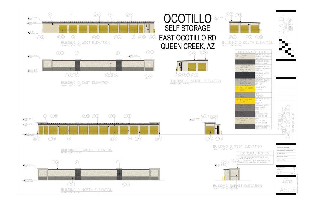
57

58

59
60
61

62
MINUTES OF THE WORK STUDY MEETING OF THE QUEEN CREEK PLANNING AND ZONING COMMISSION AGENDA
 November 14, 2012, Page 1 of 5 MINUTES OF THE WORK STUDY MEETING OF THE QUEEN CREEK PLANNING AND ZONING COMMISSION WHEN: WEDNESDAY, NOVEMBER 14, 2012 WHERE: TOWN HALL COUNCIL CHAMBERS TIME: 6:00 p.m. Pursuant
CHRIS ANARADIAN, DEVELOPMENT SERVICES DIRECTOR BRETT BURNINGHAM, PRINCIPAL PLANNER
 Requesting Department: Development Services TO: THROUGH: PLANNING AND ZONING COMMISSION CHRIS ANARADIAN, DEVELOPMENT SERVICES DIRECTOR BRETT BURNINGHAM, PRINCIPAL PLANNER FROM: RE: KEITH NEWMAN, PLANNER
MINUTES REGULAR MEETING QUEEN CREEK PLANNING & ZONING COMMISSION QUEEN CREEK COMMUNITY CHAMBERS E. CIVIC PARKWAY APRIL 11, :00 PM
 1. Call to Order This meeting was called to order at 7:00PM. 2. Roll Call: One or more members of the Commission may participate by telephone. Commissioners in attendance: Chairman Arrington, Vice-Chairman
CHRIS ANARADIAN, DEVELOPMENT SERVICES DIRECTOR BRETT BURNINGHAM, PLANNING ADMINISTRATOR; CHRISTINE SHEEHY, PRINCIPAL PLANNER
 Requesting Department: Development Services TO: THROUGH: FROM: RE: PLANNING AND ZONING COMMISSION CHRIS ANARADIAN, DEVELOPMENT SERVICES DIRECTOR BRETT BURNINGHAM, PLANNING ADMINISTRATOR; CHRISTINE SHEEHY,
WALNUT CREEK DESIGN REVIEW COMMISSION STAFF REPORT. AGENDA: July 6, 2016 ITEM 4b.
 WALNUT CREEK DESIGN REVIEW COMMISSION STAFF REPORT Attachment 3 AGENDA: July 6, 2016 ITEM 4b. ORIGINATED BY: COMMUNITY AND ECONOMIC DEVELOPMENT DEPARTMENT PLANNING PROJECT NAME APPLICATION TYPE APPLICATION
A favorable recommendation to the City Council is requested.
 To: Sycamore Plan Commission From: Brian Gregory, City Manager Date: November 9, 2017 Re: November 13, 2017 Plan Commission Meeting The Plan Commission has one action item and three workshop items. I.
CHRIS ANARADIAN, DEVELOPMENT SERVICES DIRECTOR BRETT BURNINGHAM, PRINCIPAL PLANNER; SIDNEY URIAS, PLANNER
 Requesting Department: Development Services TO: THROUGH: FROM: RE: PLANNING AND ZONING COMMISSION CHRIS ANARADIAN, DEVELOPMENT SERVICES DIRECTOR BRETT BURNINGHAM, PRINCIPAL PLANNER; SIDNEY URIAS, PLANNER
4 June 11, 2014 Public Hearing
 4 June 11, 2014 Public Hearing APPLICANT: FRANKLIN JOHNSTON MANAGEMENT DEVELOPMENT, L.L.C. PROPERTY OWNER: TRUSTEES OF FIRST LYNNHAVEN BAPTIST CHURCH STAFF PLANNER: Stephen J. White REQUEST: Change of
PLAINFIELD CHARTER TOWNSHIP COMMUNITY DEVELOPMENT DEPARTMENT PLANNING, ZONING & BUILDING SERVICES MEMORANDUM
 PLAINFIELD CHARTER TOWNSHIP COMMUNITY DEVELOPMENT DEPARTMENT PLANNING, ZONING & BUILDING SERVICES 6161 BELMONT AVENUE N.E. BELMONT, MI 49306 PHONE 616-364-1190 FAX: 616-364-1170 www.plainfieldchartertwp.org
LAND USE ASSUMPTIONS REPORT POTENTIAL FUTURE DEVELOPMENT WEST WHITELAND TOWNSHIP, CHESTER COUNTY, PA
 LAND USE ASSUMPTIONS REPORT POTENTIAL FUTURE DEVELOPMENT WEST WHITELAND TOWNSHIP, CHESTER COUNTY, PA Adopted June 17, 2015 by Township Resolution No. 2015-30 Prepared by Theurkauf Design & Planning, LLC
SUBJECT: Application for Planned Unit Development and Rezoning 1725 Winnetka Road
 TO: FROM: CHAIRMAN BILL VASELOPULOS AND MEMBERS OF THE PLAN & ZONING COMMISSION STEVE GUTIERREZ DIRECTOR OF COMMUNITY DEVELOPMENT MEETING DATE: September 5, 2017 SUBJECT: Application for Planned Unit Development
2. The AT&T WCF shall consist of a stealth design (faux saguaro cactus) with a maximum height of 30 feet above adjacent grade;
 with a maximum height of 30 feet above adjacent grade;") AGENDA ITEM # DATE: October 24, 2011 COAC NUMBER: 11-4698 CITY OF GOODYEAR CITY COUNCIL ACTION FORM SUBJECT: Special Use to allow the installation of a proposed AT&T Wireless Communication Facility to
AGENDA ITEM # DATE: October 24, 2011 COAC NUMBER: 11-4698 CITY OF GOODYEAR CITY COUNCIL ACTION FORM SUBJECT: Special Use to allow the installation of a proposed AT&T Wireless Communication Facility to
City of Brooklyn Park Planning Commission Staff Report
 City of Brooklyn Park Planning Commission Staff Report Agenda Item: 6D Meeting Date: August 9, 2017 Originating Agenda Section: Public Hearing Department: Community Development Resolution: X Ordinance:
Planned Residence District (PR) To review a plan to construct 11 single family homes on approximately 4.01 acres.
 To review a plan to construct 11 single family homes on approximately 4.01 acres.") STAFF REPORT PLANNING & ZONING COMMISSION Village Green Municipal Building, Council Chambers 47 Hall Street Wednesday, March 13, 2019 7:00 P.M. 1. FINAL DEVELOPMENT PLAN REVIEW Applicant: Romanelli and
STAFF REPORT PLANNING & ZONING COMMISSION Village Green Municipal Building, Council Chambers 47 Hall Street Wednesday, March 13, 2019 7:00 P.M. 1. FINAL DEVELOPMENT PLAN REVIEW Applicant: Romanelli and
CITY OF ALBERT LEA PLANNING COMMISSION ADVISORY BOARD
 CITY OF ALBERT LEA PLANNING COMMISSION ADVISORY BOARD 9/1/2015, 5:30 p.m. City Council Chambers AGENDA A. CALL TO ORDER AND ROLL CALL B. APPROVAL OF THE AGENDA C. APPROVAL OF MINUTES 1. PC Minutes from
CITY OF SIGNAL HILL SUBJECT: PUBLIC HEARING THE COURTYARD RESIDENTIAL DEVELOPMENT OF 10 CONDOMINIUMS AND A NEW SPECIFIC PLAN
 CITY OF SIGNAL HILL 2175 Cherry Avenue Signal Hill, CA 90755-3799 AGENDA ITEM TO: FROM: HONORABLE CHAIR AND MEMBERS OF THE PLANNING COMMISSION SELENA ALANIS ASSOCIATE PLANNER SUBJECT: PUBLIC HEARING THE
A. Land Use Relationships
 Chapter 9 Land Use Plan A. Land Use Relationships Development patterns in Colleyville have evolved from basic agricultural and residential land uses, predominate during the early stages of Colleyville
Rezoning Petition Zoning Committee Recommendation June 29, 2017
 Rezoning Petition 2017-076 Zoning Committee Recommendation June 29, 2017 REQUEST Current Zoning: MUDD-O (mixed use development, optional) and R-4 (single family residential) Proposed Zoning: UR-2(CD) (urban
PLANNING & ZONING COMMISSION CITY OF PALMER, ALASKA REGULAR MEETING THURSDAY, JULY 17, :00 P.M. - COUNCIL CHAMBERS
 PLANNING & ZONING COMMISSION CITY OF PALMER, ALASKA REGULAR MEETING THURSDAY, JULY 17, 2014 7:00 P.M. - COUNCIL CHAMBERS A. CALL TO ORDER: The regular meeting of the Planning and Zoning Commission was
SAGINAW CHARTER TOWNSHIP PLANNING COMMISSION SAGINAW CHARTER TOWNSHIP HALL DECEMBER 2, Members Present Members Absent Others Present
 SAGINAW CHARTER TOWNSHIP PLANNING COMMISSION SAGINAW CHARTER TOWNSHIP HALL DECEMBER 2, 2015 Members Present Members Absent Others Present S. McGraw J. (excused) B. Smith, Planner B. Gombar C. Edlinger,
MINUTES - ZONING BOARD. The workshop portion of the meeting was called to order at 8:02 P.M. by Mr. Marotta, Chairman.
 MINUTES - ZONING BOARD The workshop portion of the meeting was called to order at 8:02 P.M. by Mr. Marotta, Chairman. ROLL CALL: Members Present: Mr. Marotta Mr. Pistol Mr. Bovasso Ms. Drake Ms. Hay Ms.
Hamilton County Regional Planning Commission
 Hamilton County Regional Planning Commission March 1, 2012 Colerain Township Staff Report Zone Map Amendment: Case No.: ZA2012-01 Joseph Toyota Prepared By: Amy Bancroft, Land Use Planner ACTION REQUESTED:
May 23, 2017 Staff Report to the Board of Zoning Ad justment. C AS E # VAR I t e m #1. Location Map. Subject
 May 23, 2017 Staff Report to the Board of Zoning Ad justment C AS E # VAR 2 0 1 7-00031 I t e m #1 U N I T E D R E N TA L S O R L A N D O Location Map S U M M A R Y Owner Herbert R. Matthews, Jr. Applicant
GENERAL PLAN UPDATE SPECIFIC AREAS OF THE CITY
 GENERAL PLAN UPDATE SPECIFIC AREAS OF THE CITY Background There are a total of 14 specific areas that are being reviewed as part of the update of the General Plan. Requests to review these areas came from
MEETING MINUTES PLAN COMMISSION Wednesday, December 12, :00 P.M. Evanston Civic Center, 2100 Ridge Avenue, James C. Lytle Council Chambers
 MEETING MINUTES PLAN COMMISSION Wednesday, December 12, 2018 7:00 P.M. Evanston Civic Center, 2100 Ridge Avenue, James C. Lytle Council Chambers Members Present: Colby Lewis (Chair), Jennifer Draper, Carol
LIN AVE The applicant is proposing to construct a four-unit Lot A R.P
 Public Notice June 21, 2018 Subject Property: 125 Calgary Avenue Lot 4, District Lot 250, Similkameen Division Yale District, Plan 1164, Except Plan B5473 Application: Rezone PL2018-8261 The applicant
City of Lake Elmo Planning Commission Meeting Minutes of January 14, 2013
 City of Lake Elmo Planning Commission Meeting Minutes of January 14, 2013 Chairman Williams called to order the workshop of the Lake Elmo Planning Commission at 7:00pm COMMISSIONERS PRESENT: Fliflet, Obermueller,
NOTICE OF MEETING AND AGENDA FOR THE PLANNING COMMISSION OF SPRINGVILLE, UTAH... JANUARY 23, 2018
 NOTICE OF MEETING AND AGENDA FOR THE PLANNING COMMISSION OF SPRINGVILLE, UTAH............................ JANUARY 23, 2018 Notice is hereby given that the Planning Commission will hold a public meeting
Staff Report PLANNING DIVISION COMMUNITY & ECONOMIC DEVELOPMENT. Alley Closure
 Staff Report PLANNING DIVISION COMMUNITY & ECONOMIC DEVELOPMENT To: From: Salt Lake City Planning Commission Doug Dansie, 801-535-6182, doug.dansie@slcgov.com Date: March 23, 2016 Re: PLNPCM2015-00941
ARTICLE 143. PD 143.
 ARTICLE 143. PD 143. SEC. 51P-143.101. LEGISLATIVE HISTORY. PD 143 was established by Ordinance No. 17685, passed by the Dallas City Council on February 2, 1983. Ordinance No. 17685 amended Ordinance No.
Major General Plan Amendment. Project Narrative
 Major General Plan Amendment MERIDIAN CROSSING Project Narrative SEC SWC of Riggs/Combs and Meridian Roads Prepared: Submitted to: TOWN OF QUEEN CREEK PLANNING DEPARTMENT 22350 South Ellsworth Road Queen
CITY OF BELLEVIEW PLANNING & ZONING BOARD AGENDA
 CITY OF BELLEVIEW PLANNING & ZONING BOARD AGENDA BELLEVIEW CITY HALL COMMISSION ROOM 5:30 PM IF A PERSON SHOULD DESIRE TO APPEAL ANY DECISION MADE BY THE BOARD, A VERBATIM RECORD OF THE PROCEEDINGS WHICH
ORDINANCE NO
 ORDINANCE NO. 07-1094 AN ORDINANCE OF THE MAYOR AND COUNCIL OF THE CITY OF GOODYEAR, MARICOPA COUNTY, ARIZONA PROVIDING FOR CONDITIONAL REZONING OF 41 ACRES OF LAND FROM THE AGRICULTURAL (AG) DISTRICT
HISTORIC PRESERVATION BOARD BOARD AGENDA
 HISTORIC PRESERVATION BOARD BOARD AGENDA Historic Preservation Board Regular Meeting - Monday, November 24, 2014-6:00 p.m. City Hall - City Commission Chambers, 100 North U.S. #1, Fort Pierce, Florida
The Zoning Committee voted 4-2 to APPROVE this petition.
 Rezoning Petition 2016-T001 Zoning Committee Recommendation August 9, 2016 REQUEST SUMMARY OF PETITION PETITIONER AGENT/REPRESENTATIVE COMMUNITY MEETING STATEMENT OF CONSISTENCY Text amendment to Sections
Town of Waxhaw Board of Commissioners. Waxhaw Police Department Community Meeting Room Tuesday January 12, 2016
 Town of Waxhaw Board of Commissioners Waxhaw Police Department Community Meeting Room Tuesday January 12, 2016 Petition RZ-003994-2015 A request by the Town of Waxhaw Planning & Community Development Department,
TOWN OF ORO VALLEY PLANNING & ZONING COMMISSION MEETING DATE: December 6, 2011
 PLANNING & ZONING COMMISSION MEETING DATE: December 6, 2011 TO: FROM: SUBJECT: PLANNING & ZONING COMMISSION Matt Michels, Senior Planner mmichels@orovalleyaz.gov; tel. 229-4822 Public Hearing: Rancho de
Exhibit D. Tallow Ridge PUD. Written Description. Date: January 5, E. City Development Number:
 Exhibit D Tallow Ridge PUD Written Description Date: January 5, 2016 I. SUMMARY DESCRIPTION OF THE PROPERTY A. Current Land Use Designation: RR B. Current Zoning District: PUD C. Requested Zoning District:
9. REZONING NO Vicinity of the northwest corner of 143 rd Street and Metcalf Avenue
 9. REZONING NO. 2002-15 Vicinity of the northwest corner of 143 rd Street and Metcalf Avenue 1. APPLICANT: Andrew Schlagel is the applicant for this request. 2. REQUESTED ACTION: The applicant is requesting
Town of Cary, North Carolina Rezoning Staff Report 14-REZ-31 Cary Park PDD Amendment (Waterford II) Town Council Meeting January 15, 2015
 Town Council Meeting January 15, 2015") Town of Cary, North Carolina Rezoning Staff Report 14-REZ-31 Cary Park PDD Amendment (Waterford II) Town Council Meeting January 15, 2015 REQUEST To amend the Town of Cary Official Zoning Map by amending
Town of Cary, North Carolina Rezoning Staff Report 14-REZ-31 Cary Park PDD Amendment (Waterford II) Town Council Meeting January 15, 2015 REQUEST To amend the Town of Cary Official Zoning Map by amending
DEPARTMENT OF COMMUNITY DEVELOPMENT SERVICES. Planning Division. m e m o r a n d u m
 DEPARTMENT OF UNITY DEVELOPMENT SERVICES Planning Division m e m o r a n d u m TO: FROM: The Urbana Zoning Board of Appeals Marcus Ricci, Planner II DATE: August 11, 2017 SUBJECT: ZBA Case 2017-C-01: a
Attachment 4. Planning Commission Staff Report. June 26, 2017
 Planning Commission Staff Report June 26, 2017 Agenda #: Regular Agenda - 2 Title: Applicant: Request: Location: Existing Zoning: Proposed Use: Staff Planner: The Brands and The Brands West Eagle Crossing
STATE OF ALABAMA SHELBY COUNTY
 STATE OF ALABAMA SHELBY COUNTY Members Present: Members Absent: Staff Present: SHELBY COUNTY PLANNING COMMISSION MINUTES Regular Meeting March 6, 2017 6:00 PM Michael O Kelley, Chairman; Jim Davis, Vice
City and County of Broomfield, Colorado
 City and County of Broomfield, Colorado CITY COUNCIL AGENDA MEMORANDUM To: From: Mayor and City Council George Di Ciero, City and County Manager Teri Malies, Principal Planner Terrance Ware, Planning Director
Village of Glenview Plan Commission
 Village of Glenview Plan Commission STAFF REPORT March 24, 2015 TO: Chairman and Plan Commissioners CASE #: P2015-012 FROM: Community Development Department CASE MANAGER: Michelle House, Planner SUBJECT:
1999 Town Center West Proposal
 Crescent Square June 10, 2014 Page 2 1999 Town Center West Proposal Food-4- Less Retail Not a Part On June 10, 2004, the City Council and Planning Commission conducted a joint workshop to review conceptual
CITY OF APPLE VALLEY PLANNING COMMISSION MINUTES DECEMBER 7, 2016
 PLANNING COMMISSION MINUTES DECEMBER 7, 2016 1. CALL TO ORDER The City of Apple Valley Planning Commission meeting was called to order by Chair Melander at 7:01 p.m. Members Present: Tom Melander, Ken
New Millennium Senior Living Communities, LLC
 Applicant Property Owners Baylake Limited Partnership, W. Heywood Fralin 2012 Revocable Trust, W. Heywood Fralin Irrevocable Children s Trust, & Karen Holly Waldron Trust Public Hearing August 9, 2017
STAFF REPORT PLN September 11, 2017
 Page: 1 TO: SUBJECT: GENERAL COMMITTEE APPLICATIONS FOR OFFICIAL PLAN AMENDMENT AND ZONING BY-LAW AMENDMENT 37 JOHNSON STREET WARD: WARD 1 PREPARED BY AND KEY CONTACT: SUBMITTED BY: GENERAL MANAGER APPROVAL:
PLANNING COMMISSION STAFF REPORT
 PLANNING COMMISSION STAFF REPORT REZONING CASE: RZ-15-002 REPORT DATE: January 26, 2016 CASE NAME: Thursday Lunch Club Rezoning PLANNING COMMISSION DATE: February 17, 2016 ADDRESS OF REZONING PROPOSAL:
ANOKA PLANNING COMMISSION REGULAR MEETING ANOKA CITY HALL TUESDAY, MAY 16, :00 P.M.
 ANOKA PLANNING COMMISSION REGULAR MEETING ANOKA CITY HALL TUESDAY, MAY 16, 2017 7:00 P.M. CALL TO ORDER: The regular meeting of the Anoka Planning Commission was called to order at 7:00 p.m. ROLL CALL:
SPECIAL ZONING DISTRICTS
 SPECIAL ZONING DISTRICTS 5.01 5.99 RESERVED 5.100 PLANNED DEVELOPMENTS: Purpose: This district is intended to accommodate unified design of residential, commercial, office, professional services, retail
EDMOND PLANNING COMMISSION 20 S. Littler, Edmond, Oklahoma Tuesday, May 6, :30 p.m.
 City of Edmond NOTICE OF PUBLIC MEETING The City of Edmond encourages participation from all its citizens. If participation at any Public meeting is not possible due to a disability, notification to the
PLANNING COMMISSION Minutes
 MEETING DATE: Monday January 22, 2018 MEETING TIME: 6:00 PM MEETING LOCATION: City Council Chambers, 448 E. First Street, Suite 190, Salida, CO Present: Mandelkorn, Follet, Denning, Thomas, Farrell, Bomer,
ZONING AMENDMENT & SUBDIVISION STAFF REPORT Date: November 3, 2016
 ZONING AMENDMENT & SUBDIVISION STAFF REPORT Date: November 3, 2016 APPLICANT NAME SUBDIVISION NAME David Shumer 5955 Airport Subdivision CITY COUNCIL DISTRICT District 6 5955 Airport Boulevard, 754 Linlen
CITY PLAN COMMISSION STAFF REPORT
 CITY PLAN COMMISSION STAFF REPORT SUBJECT: Request for a Change of Zoning and Preliminary Development Plan FROM: Mara Perry, Director of Planning & Development MEETING DATE: November 6, 2017 PETITION:
BOARD OF ZONING ADJUSTMENT MINUTES MEETING OF DECEMBER 1, :00 P.M. MOBILE GOVERNMENT PLAZA, MULTI-PURPOSE ROOM
 BOARD OF ZONING ADJUSTMENT MINUTES MEETING OF DECEMBER 1, 2008-2:00 P.M. MOBILE GOVERNMENT PLAZA, MULTI-PURPOSE ROOM MEMBERS PRESENT William Guess, Vice Chairman Vernon Coleman Sanford Davis Mack Graham
PLANNING COMMISSION STAFF REPORT
 PLANNING COMMISSION STAFF REPORT REZONING CASE: RZ-16-001 REPORT DATE: March 8, 2016 CASE NAME: Trailbreak Partners Rezoning PLANNING COMMISSION DATE: March 16, 2016 ADDRESSES OF REZONING PROPOSAL: 5501
A REGULAR MEETING MINUTES PLANNING AND ZONING BOARD JANUARY 05, 2009
 A REGULAR MEETING MINUTES PLANNING AND ZONING BOARD JANUARY 05, 2009 CALL TO ORDER Vice-Chairman Jerry Carris called the meeting of the City of Winter Garden Planning and Zoning Board to order at 6:38
MINUTES JOINT MEETING LINCOLN COUNTY and SIOUX FALLS PLANNING COMMISSIONS 7:00 pm August 10, 2011
 MINUTES JOINT MEETING LINCOLN COUNTY and SIOUX FALLS PLANNING COMMISSIONS 7:00 pm August 10, 2011 Commissioners Room - Lincoln County Court House A joint meeting of the Lincoln County and Sioux Falls Planning
ADA TOWNSHIP PLANNING COMMISSION MINUTES OF THE JANUARY 17, 2019 MEETING
 ADA TOWNSHIP PLANNING COMMISSION MINUTES OF THE JANUARY 17, 2019 MEETING A meeting of the was held on Thursday, January 17, 2019, at 7:00 p.m. at the Ada Township Offices, 7330 Thornapple River Dr., Ada,
# Grant St. Apartments Preliminary/Final PUD Project Review for Planning and Zoning Commission
 #2014-48 95 Grant St. Apartments Preliminary/Final PUD Project Review for Planning and Zoning Commission Meeting Date: March 4, 2015 and May 6, 2015 Requests: Location: Acreage: Existing Zoning: Preliminary
CITY OF WEST PALM BEACH PLANNING BOARD Meeting Date: July 17, 2018 Planning Board Case No. 1670I
 CITY OF WEST PALM BEACH PLANNING BOARD Meeting Date: July 17, 2018 Planning Board Case No. 1670I Palms Gateway Commercial Planned Development (CPD) Southeast Corner of Belvedere Road and Australian Avenue
Watkinsville First Baptist Church Building and Parking Masterplan Norton Road & Simonton Bridge Road Oconee County Georgia
 Watkinsville First Baptist Church Building and Parking Masterplan Norton Road & Simonton Bridge Road Oconee County Georgia Special Use Approval A-1 CUP to A-1 with Special Use Approval Total Site Area
Planning and Zoning Commission STAFF REPORT REQUEST. DSA : Zone Change from R-3 (Multi-Family Residential) to B-4 (Community Services).
 to B-4 (Community Services).") Planning and Zoning Commission STAFF REPORT AGENDA # TO: FROM: PLANNING AND ZONING COMMISSION Joseph Horn, City Planner MEETING DATES: August 4, 2016 SUBJECT: Gino Tarantini zone change requests REQUEST
Planning and Zoning Commission STAFF REPORT AGENDA # TO: FROM: PLANNING AND ZONING COMMISSION Joseph Horn, City Planner MEETING DATES: August 4, 2016 SUBJECT: Gino Tarantini zone change requests REQUEST
Financial Impact Statement There are no immediate financial impacts associated with the adoption of this report.
 STAFF REPORT Planning and Development Department Subject: Application by RYC Property to rezone a portion of lands on John Murray Dr. and Megan Lynn Dr. from R2 to R3 and to enter into a Development Agreement
TOWNSHIP ZONING ORDINANCE PETERS TOWNSHIP PLANNING DEPARTMENT JUNE, E. McMURRAY ROAD McMURRAY, PA 1531 (724)
") EXECUTIVE PROPOSED SUMMARY PETERS Summary: Peters Township Zoning Ordinance TOWNSHIP ZONING ORDINANCE JUNE, 2017 PETERS TOWNSHIP PLANNING DEPARTMENT 610 E. McMURRAY ROAD McMURRAY, PA 1531 (724) 942-5005
EXECUTIVE PROPOSED SUMMARY PETERS Summary: Peters Township Zoning Ordinance TOWNSHIP ZONING ORDINANCE JUNE, 2017 PETERS TOWNSHIP PLANNING DEPARTMENT 610 E. McMURRAY ROAD McMURRAY, PA 1531 (724) 942-5005
Community Dev. Coord./Deputy City Recorder
 1 2 3 4 5 6 7 8 9 10 11 12 13 14 15 16 17 18 19 20 21 22 23 24 25 26 27 28 29 30 31 32 33 34 35 36 37 38 39 40 41 42 43 44 45 46 NORTH OGDEN PLANNING COMMISSION MEETING MINUTES December 18, 2013 The North
THE REDEVELOPMENT PLAN
 PAGE 37 THE REDEVELOPMENT PLAN FUTURE LAND USE The Silver Terrace Redevelopment Area is currently designated as Redevelopment Area #4 on the City of Delray Beach Future Land Use Map (FLUM). This designation
Lot 1 KAP Lot 1. Lot 1. Lot 4. ot 5
 Public Notice January 11, 2018 Subject Property: 237 Phoenix Avenue Lot 4, District Lot 5, Group 7 Similkameen Division Yale (Formerly Yale-Lytton) District, Plan 10974 Application: The applicant is proposing
COUNTY OF ALBEMARLE PLANNING STAFF REPORT SUMMARY
 COUNTY OF ALBEMARLE PLANNING STAFF REPORT SUMMARY Project Name: ZMA 2010-00015, Cedar Hill Planning Commission Worksession: February 15, 2011 Public Hearing: Not scheduled Staff: Judith C. Wiegand, AICP
Staff Report: Date: Applicant: Property Identification: Acreage of Request: Current Zoning of Requested Area: Requested Action: Attached:
 Staff Report: Completed by Jeff Palmer Director of Planning & Zoning Date: November 7, 2018, Updated November 20, 2018 Applicant: Greg Smith, Oberer Land Developer agent for Ronald Montgomery ET AL Property
MAPLE GROVE PLANNING COMMISSION May 26, 2015
 MAPLE GROVE PLANNING COMMISSION CALL TO ORDER A meeting of the Maple Grove Planning Commission was held at 7:00 p.m. on at the Maple Grove City Hall, Hennepin County, Minnesota. Chair Colson called the
MANATEE COUNTY PLANNING COMMISSION REGULAR MEETING COUNTY ADMINISTRATIVE CENTER 1112 Manatee Avenue West Bradenton, Florida February 11, 2016
 MANATEE COUNTY PLANNING COMMISSION REGULAR MEETING COUNTY ADMINISTRATIVE CENTER 1112 Manatee Avenue West Bradenton, Florida February 11, 2016 Present were Members: William Conerly, Chairman Tim Rhoades,
Request Conditional Rezoning (R-5D Residential Duplex District and I-1 Light Industrial District to Conditional A-36 Apartment District)
") Request Conditional Rezoning (R-5D Residential Duplex District and I-1 Light Industrial District to Conditional A-36 Apartment District) Staff Planner Ashby Moss Location 5833 Sandpit Road & Nearby Parcels
Request Conditional Rezoning (R-5D Residential Duplex District and I-1 Light Industrial District to Conditional A-36 Apartment District) Staff Planner Ashby Moss Location 5833 Sandpit Road & Nearby Parcels
WOODS CROSS CITY PLANNING COMMISSION MEETING MARCH 27, 2018
 WOODS CROSS CITY PLANNING COMMISSION MEETING The minutes of the Woods Cross City Planning Commission meeting held March 27, 2018 at 6:30 P.M. in the Woods Cross City Hall located at 1555 South 800 West,
TASK 2 INITIAL REVIEW AND ANALYSIS U.S. 301/GALL BOULEVARD CORRIDOR FORM-BASED CODE
 TASK 2 INITIAL REVIEW AND ANALYSIS U.S. 301/GALL BOULEVARD CORRIDOR FORM-BASED CODE INTRODUCTION Using the framework established by the U.S. 301/Gall Boulevard Corridor Regulating Plan (Regulating Plan),
Village of Glenview Plan Commission
 Village of Glenview Plan Commission STAFF REPORT June 24, 2014 TO: Chairman and Plan Commissioners CASE #: P2014-026 FROM: Community Development Department CASE MANAGER: Tony Repp, Planner SUBJECT: Final
Bylaw No , being "Official Community Plan Bylaw, 2016" Schedule "A" DRAFT
 Bylaw No. 2600-2016, being "Official Community Plan Bylaw, 2016" Schedule "A" Urban Structure + Growth Plan Urban Structure Land use and growth management are among the most powerful policy tools at the
PLANNING COMMISSION STAFF REPORT
 PLANNING COMMISSION STAFF REPORT West Capitol Hill Zoning Map Amendment Petition No. PLNPCM2011-00665 Located approximately at 548 W 300 North Street, 543 W 400 North Street, and 375 N 500 West Street
CITY OF FARMERSVILLE CITIZEN ADVISORY COMMITTEE AGENDA November 17, :30 P.M. 1, COUNCIL CHAMBERS, CITY HALL
 I. PRELIMINARY MATTERS CITY OF FARMERSVILLE CITIZEN ADVISORY COMMITTEE AGENDA November 17, 2014 6:30 P.M. 1, COUNCIL CHAMBERS, CITY HALL Call to Order, Roll Call, Prayer and Pledge of Allegiance Welcome
URBANDALE PLANNING AND ZONING COMMISSION MINUTES. July 9, 2018
 URBANDALE PLANNING AND ZONING COMMISSION MINUTES The Urbandale Planning and Zoning Commission met in regular session on Monday,, at the Urbandale City Hall, 3600 86th Street. Chairperson Jeff Hatfield
Request Conditional Rezoning (R-7.5 Residential to Conditional A-18 Apartment) Staff Recommendation Approval. Staff Planner Jimmy McNamara
 Staff Recommendation Approval. Staff Planner Jimmy McNamara") Applicants Property Owners Baker Villas, LLC; Ocean Rental Properties, LLC; James Edward Sollner; & Linda Susan Sollner Public Hearing November 8, 2017 City Council Election District Kempsville Agenda
Applicants Property Owners Baker Villas, LLC; Ocean Rental Properties, LLC; James Edward Sollner; & Linda Susan Sollner Public Hearing November 8, 2017 City Council Election District Kempsville Agenda
CITY OF MERCED Planning Commission MINUTES
 CITY OF MERCED Planning Commission MINUTES Merced City Council Chambers Wednesday, December 4, 2013 Vice-Chairperson MACKIN called the meeting to order at 7:00 p.m., followed by a moment of silence and
City of Colleyville City Council Agenda Briefing
 City of Colleyville City Council Agenda Briefing City Hall 100 Main Street Colleyville, Texas 76034 www.colleyville.com Agenda Number 5a Agenda Date 01/06/2015 Number Ordinance O-14-1942 Type Ordinance
Bowie Marketplace Residential Detailed Site Plan Statement of Justification January 13, 2017 Revised February 2, 1017
 Bowie Marketplace Residential Detailed Site Plan Statement of Justification January 13, 2017 Revised February 2, 1017 Submitted on behalf of: BE Bowie LLC 5410 Edson Lane, Suite 220 Rockville, MD 20852
Section 4 Master Plan Framework
 Section 4 Master Plan Framework 4.1 PURPOSE The Master Plan, as an implementation tool of the SPC District, establishes the primary framework for the overall development of the Property. Detailed site
REPORT TO PLANNING AND DESIGN COMMISSION City of Sacramento
 REPORT TO PLANNING AND DESIGN COMMISSION City of Sacramento 915 I Street, Sacramento, CA 95814-2671 www.cityofsacramento.org 9 PUBLIC HEARING December 10, 2015 To: Members of the Planning and Design Commission
EDGERTON CITY HALL PLANNING COMMISSION MEETING REGULAR SESSION March 12, 2019
 EDGERTON CITY HALL PLANNING COMMISSION MEETING REGULAR SESSION The met in regular session with Chair John Daley calling the meeting to order at 7:00 p.m. All present participated in the Pledge of Allegiance.
Village of Cazenovia Zoning Board of Appeals August 12, 2014
 Village of Cazenovia Zoning Board of Appeals August 12, 2014 FINAL - 1 - Village of Cazenovia Zoning Board of Appeals August 12, 2014 5 10 Members Present: Phil Byrnes, Chair; Sally Ryan; William Keiser;
Initial Project Review
 Pierce County Department of Planning and Land Services, 2401 South 35th Street, Tacoma, WA (253) 798-7037 Initial Project Review Major Amendment to Preliminary Plat: Hawks Ridge Division 1 Application
ARLINGTON COUNTY, VIRGINIA
 ARLINGTON COUNTY, VIRGINIA County Board Agenda Item Meeting of June 16, 2012 DATE: June 7, 2012 SUBJECT: SP #397 SITE PLAN AMENDMENT to revise condition #31 to modify the retail transparency requirement
EXHIBIT 1 PROJECT DESCRIPTION AND DESCRIPTION OF REQUESTED AREA VARIANCES REDEVELOPMENT OF 201 ELLICOTT STREET
 EXHIBIT 1 PROJECT DESCRIPTION AND DESCRIPTION OF REQUESTED AREA VARIANCES REDEVELOPMENT OF 201 ELLICOTT STREET I. PROJECT DESCRIPTION: Ciminelli Real Estate Corporation (the Applicant ) is seeking area
CITY OF RIO VISTA PLANNING COMMISSION STAFF REPORT
 MEETING DATE: January10, 2018 CITY OF RIO VISTA PLANNING COMMISSION STAFF REPORT AGENDA ITEM #4.2 PREPARED BY: Lamont Thompson, Planning Manager SUBJECT: Vesting Tentative Tract No. 2017-001: To consider
THE AREA PLAN COMMISSION OF ST. JOSEPH COUNTY, IN AGENDA
 THE AREA PLAN COMMISSION OF ST. JOSEPH COUNTY, IN AGENDA Tuesday, January 17, 2017 Fourth-Floor Council Chambers 3:30 p.m. County-City Building, South Bend, IN EXECUTIVE SESSION: A. Election of Officers
Evolution of the Vision for NE 181st Street Study Area
 City Council Action on NE 181 St Street Study Area Evolution of the Vision for NE 181st Street Study Area such uses to ensure neighborhood compatibility. More intense uses may be allowed through a conditional
ORDINANCE NO. 208 BE IT ORDAINED BY THE CITY COUNCIL OF THE CITY OF UNIVERSITY HEIGHTS, JOHNSON COUNTY, IOWA:
 ORDINANCE NO. 208 AN ORDINANCE AMENDING ORDINANCE NO. 79 (ZONING) TO CREATE A COMMERCIAL HOTEL ZONE AND PERMIT DEVELOPMENT PURSUANT TO A COMMERCIAL HOTEL PUD BE IT ORDAINED BY THE CITY COUNCIL OF THE CITY
2. Rezone a portion of the lot from R2 (Small Lot Residential) to RD2 (Duplex: Housing Lane).
 to RD2 (Duplex: Housing Lane).") Public Notice September 6, 2018 Subject Property Subject Property: 337 Hastings Ave Lot 24, District Lot 1, Group 7, Similkameen Division Yale (Formerly Yale-Lytton) District, Plan 932 Application: The
Public Notice September 6, 2018 Subject Property Subject Property: 337 Hastings Ave Lot 24, District Lot 1, Group 7, Similkameen Division Yale (Formerly Yale-Lytton) District, Plan 932 Application: The
REQUEST FOR COUNCIL ACTION
 REQUEST FOR COUNCIL ACTION To: From: Mayor & City Council Dan Boles, AICP, Senior Planner Date: November 18, 2014 Subject: Applicant Presentation: Staff Presentation: Hoggan Lane Plat Amendment Jarin Dana
O-I (Office-Institutional) and AG-1(Agricultural)
 and AG-1(Agricultural)") PROPERTY INFORMATION ADDRESS 3503 and 3505 Bethany Bend DISTRICT, LAND LOTS 2/1 973 and 974 OVERLAY DISTRICT State Route 9 PETITION NUMBERS EXISTING ZONING O-I (Office-Institutional) and AG-1(Agricultural)
PROPERTY INFORMATION ADDRESS 3503 and 3505 Bethany Bend DISTRICT, LAND LOTS 2/1 973 and 974 OVERLAY DISTRICT State Route 9 PETITION NUMBERS EXISTING ZONING O-I (Office-Institutional) and AG-1(Agricultural)