Present: Mayor Daune Gardner, Mayor Pro Tem Erin Kirkpatrick, Commissioners Joyce Blythe, Brett Diller and Sean Poccia
|
|
|
- Jemimah Robbins
- 5 years ago
- Views:
Transcription
1 November 12, 2013 Regular Meeting 6:30 p.m. Museum of the Waxhaws The Waxhaw Board of Commissioners met in the regular location the Museum of the Waxhaws on November 12, 2013 at 6:30 p.m. in public hearings and regular meeting. Present: Mayor Daune Gardner, Mayor Pro Tem Erin Kirkpatrick, Commissioners Joyce Blythe, Brett Diller and Sean Poccia Absent: Commissioner Michael Stewart Town Staff: Town Manager Michael McLaurin, Attorney Chaplin Spencer and Town Clerk Bonnie McManus Mayor Gardner called the meeting to order and requested everyone please stand for the Pledge of Allegiance and Invocation (moment of silence). Mayor Gardner thanked everyone for attending the meeting. Adoption of Agenda: (Adopt the agenda with amendments, additions and/or deletions) Mayor Gardner asked for any amendments, deletions or additions to the agenda and a motion to adopt. Amendments: Project Manager Report: -Moved to agenda after Town Manager s Weekly Council Report. Edifice; Remove the word modification Lennar Homes- Pace CUP The shaded area was corrected to have the following information included and when approved reference the official order as presented by Attorney Spencer. ( Changed -from 241 to 240 lots in Phase 3) Additions: Deletions: None Economic Development Committee- Requested removal by Mayor Pro Tem Kirkpatrick.
2 Board Action: Motion by Commissioner Diller and seconded by Commissioner Poccia to adopt the agenda with the changes as stated. Motion carried unanimously. Public Hearings: RZ A request by the Waxhaw Planning & Community Development Department on behalf of the Board of Commissioners for a rezoning / map amendment from CD-C4 (Conditional District Central Business District) to NMX (Neighborhood Mixed Use) and TC (Town Center) on approximately 14.9 acres (Tax Parcel ID number ). The property has frontage on N. Broome St., Bivens St., N. Broad St., Church St. and Price St. The Board cannot approve rezoning of this property unless it finalizes and approves the new form based downtown code (TA ). Mayor Gardner stated the first item on the agenda is the public hearings and at this time she would open the public hearings. The first public hearing is RZ A request by the Waxhaw Planning & Community Development Department on behalf of the Board of Commissioners for a rezoning / map amendment from CD-C4 (Conditional District Central Business District) to NMX (Neighborhood Mixed Use) and TC (Town Center) on approximately 14.9 acres (Tax Parcel ID number ). The property has frontage on N. Broome St., Bivens St., N. Broad St., Church St. and Price St. The Board cannot approve rezoning of this property unless it finalizes and approves the new form based downtown code (TA ). Mayor Gardner requested a motion to open the public hearing. Board Action: Motion by Commissioner Diller and seconded by Commissioner Poccia to open the public hearing for RZ A request by the Waxhaw Planning & Community Development Department on behalf of the Board of Commissioners for a rezoning / map amendment from CD-C4 (Conditional District Central Business District) to NMX (Neighborhood Mixed Use) and TC (Town Center) on approximately 14.9 acres (Tax Parcel ID number ). The property has frontage on N. Broome St., Bivens St., N. Broad St., Church St. and Price St. The Board cannot approve rezoning of this property unless it finalizes and approves the new form based downtown code (TA ). Motion carried unanimously.
3 Staff Presentation by Planner McCarter Note: All due legal notice as required by the UDO and NC General Statutes satisfied. Planner McCarter stated she would like to enter the staff report into the record. The approval of this rezoning is dependent on the adoption of the downtown code. Town of Waxhaw/Historic Ventures, LLC EXPLANATION OF THE REQUEST Petition RZ is a request by the Waxhaw Planning & Community Development Department on behalf of the Board of Commissioners for a rezoning / map amendment from CDC4 (Conditional District Central Business District) to NMX (Neighborhood Mixed Use) and TC (Town Center) on approximately 14.9 acres (Tax Parcel ID number ) located on portions of N. Broome St., Bivens St., N. Broad St., Church St. and Price St. The Town is initiating a rezoning of the property, with the owner s consent, to the new TC and NMX zoning districts found in the Downtown Code for compatibility with the re-zonings proposed for the surrounding downtown properties. LOCATION AND CURRENT LAND USE The property has frontage on N. Broome St., Bivens St., N. Broad St., Church St. and Price St. The portion of the property located to the east of N. Church St. is currently in use as ministorage, Ice Cream and Pizza Works restaurant, Stack s restaurant, Video Works and some vacant offices. The portion of the property located to the west of N. Church St. is vacant and partially wooded. Condition and land use of the surrounding properties. The adjoining properties are: To the north Waxhaw Animal Hospital zoned OIS (Office, Institutional and Specialty) and two vacant parcels zoned R-3 (Single-Family Residential). To the east Reining Cats & Dogs retail, Waxhaw Insurance Agency, former dentist office, vacant offices, and mixed-use building zoned OIS (Office, Institutional and Specialty); BB&T and vacant lot split zoned R-3 (Single-Family Residential) and OIS (Office Institutional and Specialty); and HMS Commercial HVAC, Town of Waxhaw Department of Planning and Community Development and a laundromat and gas station zoned C-2 (Highway Commercial). To the south Waxhaw United Methodist Church zoned OIS (Office, Institutional and Specialty) and R-3 (Single-Family Residential). To the west Single Family Dwellings and vacant parcels zoned R-3 (Single-Family Residential).
4 *The existing zoning classifications of the neighboring properties are subject to change per the adoption of the Downtown Code text amendment and rezonings. PROPERTY HISTORY The subject property is zoned CD-C4 (Conditional District Central Business District) and has an approved conditional district/rezoning development plan approved by the Board of Commissioners on March 23, The property is located in the Downtown Code boundary but was not originally included in the Downtown Code associated re-zonings because of the conditional district zoning on the property and associated vested property rights. At their September 10, 2013 meeting, the Board of Commissioners requested that staff contact the property owners of the three conditionally zoned properties in the Downtown Code rezoning boundary that were not included in the rezonings to see if they wanted to be included in a Town initiated rezoning to one of the Downtown Code zoning districts. This request is a result of staff reaching out to the property owner. The request is to change the zoning designation from CD-C4 to TC and NMX COMPREHENSIVE PLAN & FUTURE LAND USE MAP The Future Land Use Map from the 2030 Comprehensive Plan shows the property as Historic Downtown. Historic Downtown is described in the plan as follows; This area incorporates the historic structures, civic uses, commercial opportunities, and the active environment that is the downtown core of Waxhaw. The core commercial areas are to be preserved and enhanced over the long term and should provide mixeduse opportunities that include commercial, office, and institutional uses, and some residential uses. The future Downtown Small Area Plan will identify more specific designations of these land uses and detailed design standards. The TC and NMX zoning districts are consistent with the description of Historic Downtown. The TC zoning district description from the Downtown Code is as follows: Town Center (TC): The Town Center District consists of larger mixed use buildings that accommodate retail, offices, townhouses and apartments. It has a tight network of streets with wide sidewalks, steady street tree planting and buildings set close to the sidewalks. The NMX zoning district description from the Downtown Code is as follows: Neighborhood Mixed Use (NMX): The Neighborhood Mixed Use District consists of higher density, mixed use buildings that accommodate retail, offices, townhouses and apartments. It has a tight network of streets, with wide sidewalks, steady street tree planting and buildings set close to the sidewalks.
5 DOWNTOWN WAXHAW VISION PLAN The request is in keeping with the Downtown Waxhaw Vision Plan which shows the property as TC next to N. Broome Street and NMX to the west of the TC zoning in the Regulating Plan for Future Development. PLANNING STAFF ANALYSIS The rezoning request is in keeping with the 2030 Comprehensive Plan and Future Land Use Plan which shows the property as Historic Downtown. The request is also in keeping with the Downtown Waxhaw Vision Plan which shows the property as TC and NMX in the regulating plan. This rezoning is a Town initiated rezoning in order to make the property zoning compatible with the rezonings proposed for the surrounding downtown properties. Staff recommends approval of the proposed rezoning. PLANNING BOARD RECOMMENDATION At their October 21, 2013 meeting, the Planning Board recommended to send a favorable recommendation for RZ (unanimous) Power Point RZ Petition RZ is a request by the Waxhaw Planning & Community Development Department on behalf of the Board of Commissioners for a rezoning / map amendment from CD-C4 (Conditional District Central Business District) to NMX (Neighborhood Mixed Use) and TC (Town Center) on approximately 14.9 acres (Tax Parcel ID number ) located on portions of N. Broome St., Bivens St., N. Broad St., Church St. and Price St. The Town is initiating a rezoning of the property, with the owner s consent, to the new TC and NMX zoning districts found in the Downtown Code for compatibility with the re-zonings proposed for the surrounding downtown properties.


6 The property has frontage on N. Broome St., Bivens St., N. Broad St., Church St. and Price St. The portion of the property located to the east of N. Church St. is currently in use as ministorage, Ice Cream and Pizza Works restaurant, Stack s restaurant, Video Works and some vacant offices. The portion of the property located to the west of N. Church St. is vacant and partially wooded.
 and two vacant parcels zoned R-3 (Single-Family Residential).")
7 The subject property is zoned CD-C4 (Conditional District Central Business District) and has an approved conditional district/rezoning development plan approved by the Board of Commissioners on March 23, To the north Waxhaw Animal Hospital zoned OIS (Office, Institutional and Specialty) and two vacant parcels zoned R-3 (Single-Family Residential). To the east Reining Cats & Dogs retail, Waxhaw Insurance Agency, former dentist office, vacant offices, and mixed-use building zoned OIS; BB&T and vacant lot split zoned R-3 and OIS; and HMS Commercial HVAC, Town of Waxhaw Department of Planning and Community Development and a laundromat and gas station zoned C-2 (Highway Commercial). To the south Waxhaw United Methodist Church zoned OIS and R-3. To the west Single Family Dwellings and vacant parcels zoned R-3.

8 The property is located in the Downtown Code boundary but was not originally included in the Downtown Code associated re-zonings because of the conditional district zoning on the property and associated vested property rights.

9 The Future Land Use Map from the 2030 Comprehensive Plan shows the property as Historic Downtown. Historic Downtown is described in the plan as follows; This area incorporates the historic structures, civic uses, commercial opportunities, and the active environment that is the downtown core of Waxhaw. The core commercial areas are to be preserved and enhanced over the long-term and should provide mixeduse opportunities that include commercial, office, and institutional uses, and some residential uses. The future Downtown Small Area Plan will identify more specific designations of these land uses and detailed design standards. The TC and NMX zoning districts are consistent with the description of Historic Downtown. The TC zoning district description from the Downtown Code is as follows: Town Center (TC): The Town Center District consists of larger mixed-use buildings that accommodate retail, offices, townhouses and apartments. It has a tight network of streets with wide sidewalks, steady street tree planting and buildings set close to the sidewalks. The NMX zoning district description from the Downtown Code is as follows: Neighborhood Mixed Use (NMX): The Neighborhood Mixed Use District consists of higher density, mixed use buildings that accommodate retail, offices, townhouses and apartments. It has a tight network of streets, with wide sidewalks, steady street tree planting and buildings set close to the sidewalks.
10 Downtown Waxhaw Vision Plan The request is in keeping with the Downtown Waxhaw Vision Plan which shows the property as TC next to N. Broome Street and NMX to the west of the TC zoning in the Regulating Plan for Future Development. Staff Recommendation The request is in keeping with the 2030 Comprehensive Plan and Future Land Use Plan. The request is in keeping with the Downtown Waxhaw Vision Plan. Staff recommends approval of the proposed rezoning. Exhibits: Staff Report Plan Development Maps Comments: None were presented Mayor Gardner stated at this time she would ask for a motion to close the public hearing for RZ A request by the Waxhaw Planning & Community Development Department on behalf of the Board of Commissioners for a rezoning / map amendment from CD-C4 (Conditional District Central Business District) to NMX (Neighborhood Mixed Use) and TC (Town Center) on approximately 14.9 acres (Tax Parcel ID number ). The property has frontage on N. Broome St., Bivens St., N. Broad St., Church St. and Price St. The Board cannot approve rezoning of this property unless it finalizes and approves the new form based downtown code (TA ) and action would be taken at the November 25 th town meeting. Board Action: Motion by Commissioner Blythe and seconded by Commissioner Poccia to close the public hearing for RZ A request by the Waxhaw Planning & Community Development Department on behalf of the Board of Commissioners for a rezoning / map amendment from CD-C4 (Conditional District Central Business District) to NMX (Neighborhood Mixed Use) and TC (Town Center) on approximately 14.9 acres (Tax Parcel ID number ). The property has frontage on N. Broome St., Bivens St., N. Broad St., Church St. and Price St. The Board cannot approve rezoning of this property unless it finalizes and approves the new form based downtown code (TA ). Motion carried unanimously.
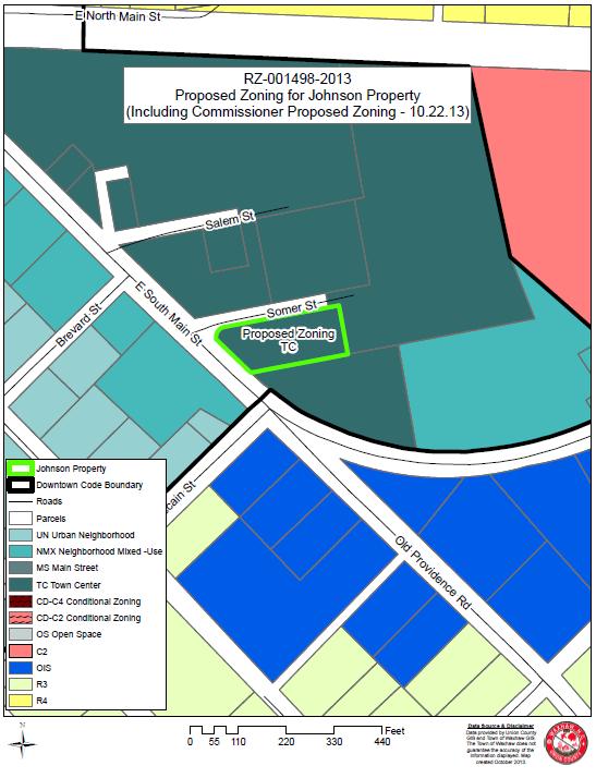
11 RZ A request by the Waxhaw Planning & Community Development Department on behalf of the Board of Commissioners for a rezoning/map amendment on parcel from CD-C2 (Conditional District Highway Commercial) to TC (Town Center) located at 112 Somer Street. The Board cannot approve rezoning of this property unless it finalizes and approves the new form based downtown code (TA ). Mayor Gardner stated the next item on the agenda is a public hearing for RZ A request by the Waxhaw Planning & Community Development Department on behalf of the Board of Commissioners for a rezoning/map amendment on parcel from CD-C2 (Conditional District Highway Commercial) to TC (Town Center) located at 112 Somer Street. The Board cannot approve rezoning of this property unless it finalizes and approves the new form based downtown code (TA ) and requested a motion to open the public hearing. Board Action: Motion by Commissioner Poccia and seconded by Commissioner Diller to open the public hearing for RZ A request by the Waxhaw Planning & Community Development Department on behalf of the Board of Commissioners for a rezoning/map amendment on parcel from CD-C2 (Conditional District Highway Commercial) to TC (Town Center) located at 112 Somer Street. The Board cannot approve rezoning of this property unless it finalizes and approves the new form based downtown code (TA ). Motion carried unanimously. Staff Report by Planner McCarter: Note: All due legal notice as required by the UDO and NC General Statutes has been satisfied. Planner McCarter stated she would like to enter the staff report into the record. The approval of this rezoning is dependent on the adoption of the downtown code. Rezoning Petition RZ Town of Waxhaw/Johnson Property EXPLANATION OF THE REQUEST Petition RZ is a request by the Waxhaw Planning & Community Development Department on behalf of the Board of Commissioners for a rezoning/map amendment on parcel from CD-C2 (Conditional District Highway Commercial) to TC (Town Center) located at 112 Somer Street. The Town is initiating a rezoning of the property, with the owner s consent, to the new TC zoning district found in the Downtown Code for compatibility with the re-zonings proposed for the surrounding downtown properties.
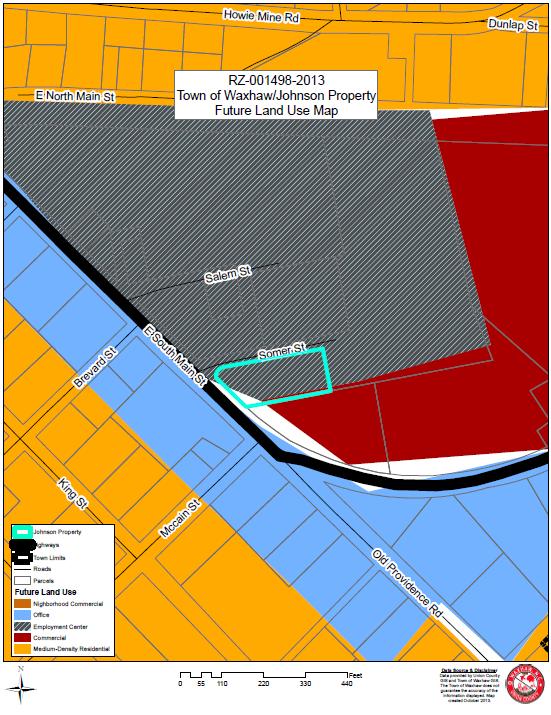
12 LOCATION AND CURRENT LAND USE The property is located at 112 Somer Street and has frontage on East South Main Street/NC-75 and Somer Street. The property is currently for lease and was previously in use as an office. Condition and land use of the surrounding properties. *The adjoining properties are: To the north A vacant parcel and automobile repair/auto body repair shop both zoned I-1 Light Industrial To the east A vacant wooded parcel zoned I-1 Light Industrial To the south A Marathon gas station zoned C-2 Highway Commercial To the west A single-family residence zoned OIS Office, Institutional and Specialty *The existing zoning classifications of the neighboring properties are subject to change per the adoption of the Downtown Code text amendment and re-zonings. PROPERTY HISTORY The subject property is zoned CD-C2 (Conditional District Highway Commercial) and has an approved conditional district/rezoning development plan approved by the Board of Commissioners on July 26, The property is located in the Downtown Code boundary but was not originally included in the Downtown Code associated rezonings because of the conditional district zoning on the property and associated vested property rights. At their September 10, 2013 meeting, the Board of Commissioners requested that staff contact the property owners of the three conditionally zoned properties in the Downtown Code rezoning boundary that were not included in the rezonings to see if they wanted to be included in a Town initiated rezoning to one of the Downtown Code zoning districts. This request is a result of staff reaching out to the property owner. The request is to change the zoning designation from CD-C2 to TC. The property is now for lease but was previously an office use, which is permitted by right in the TC zoning district COMPREHENSIVE PLAN & FUTURE LAND USE MAP The Future Land Use Map from the 2030 Comprehensive Plan shows the property as Employment Center. Employment Center is described in the plan as follows; These areas include a wide range of business, light industrial, office, research and development, and related ancillary uses, such as restaurants, small scale retail and
13 convenience shopping. They generally take on the appearance of an office development, yet with warehousing capabilities. Employment Centers should take the form of a campus in the integration and coordination of uses and quality and character of the development. Examples of desirable employment center development include the Ballantyne development and the Blakeney Heath Facility. These areas are prime locations with good access to major road networks. The use of this property as an office is in keeping with the Employment Center description in the 2030 Comprehensive Plan and Future Land Use Map. DOWNTOWN WAXHAW VISION PLAN The Downtown Waxhaw Vision Plan shows the property as NMX (Neighborhood Mixed Use) in the Regulating Plan for Future Development. The Downtown Code Proposed Rezoning Map has been modified from what was initially proposed (in the regulating plan), and currently the abutting properties are all shown as TC zoning. PLANNING STAFF ANALYSIS The rezoning request is in keeping with the 2030 Comprehensive Plan and Future Land Use Plan which shows the property as Employment Center. Although the Regulating Plan from the Downtown Waxhaw Vision Plan depicts the property as NMX, the most recent proposed Downtown Code Rezoning Map depicts the abutting properties as TC. Therefore, the request is in keeping with the proposed Downtown Code re-zonings. This rezoning is a Town initiated rezoning in order to make the property compatible with the re-zonings proposed for the surrounding downtown properties. Staff recommends approval of the proposed rezoning. PLANNING BOARD RECOMMENDATION At their October 21, 2013 meeting, the Planning Board voted to send a favorable recommendation for RZ (unanimous). Power Point RZ Petition RZ is a request by the Waxhaw Planning & Community Development Department on behalf of the Board of Commissioners for a rezoning/map amendment on parcel from CD-C2 (Conditional District Highway Commercial) to TC (Town Center) located at 112 Somer Street. The Town is initiating a rezoning of the property, with the owner s consent, to the new TC zoning district found in the Downtown Code for compatibility with the re-zonings proposed for the surrounding downtown properties.


14 The property is located at 112 Somer Street and has frontage on East South Main Street/NC-75 and Somer Street. The property is currently in use as an office.

15 The subject property is zoned CD-C2 (Conditional District Highway Commercial) and has an approved conditional district/rezoning development plan approved by the Board of Commissioners on July 26, The adjoining properties are: To the north A vacant parcel and automobile repair/auto body repair shop both zoned I-1 Light Industrial To the east A vacant wooded parcel zoned I-1 To the south A Marathon gas station zoned CU-C2 Conditional Use - Highway Commercial To the west A single-family residence zoned OIS
16
17 The future land use map shows the property as Employment Center. The use of the property as an office is consistent with the description of Employment Center. Staff Recommendation The regulating plan from the Downtown Waxhaw Vision Plan shows the property as NMX, but the proposed rezoning map has since been revised and the abutting properties are zoned TC. Staff recommends approval of the proposed rezoning Exhibits: Staff Report Survey Maps Comments: None Mayor Gardner stated at this time she would entertain a motion to close the public hearing and that action would be taken on this rezoning at the November 25 th meeting. Board Action: Motion by Commissioner Poccia and seconded by Commissioner Diller to close the public hearing for RZ A request by the Waxhaw Planning & Community Development Department on behalf of the Board of Commissioners for a rezoning/map amendment on parcel from CD-C2 (Conditional District Highway Commercial) to TC (Town Center) located at 112 Somer Street. The Board cannot approve rezoning of this property unless it finalizes and approves the new form based downtown code (TA ). Motion carried unanimously RZ A request by the Waxhaw Planning & Community Development Department on behalf of the Board of Commissioners for a rezoning/map amendment from CD-C4 (Conditional District Central Business District) to TC (Town Center) on approximately acres (Tax Parcel ID number ) located at 203 N. Broome Street. The Board cannot approve rezoning of this property unless it finalizes and approves the new form based downtown code (TA ). Mayor Gardner stated the next item on the agenda is a public hearing for RZ A request by the Waxhaw Planning & Community Development Department on behalf of the Board of Commissioners for a rezoning/map amendment from CD-C4 (Conditional District Central Business District) to TC (Town Center) on approximately acres (Tax Parcel ID number ) located at 203 N. Broome Street. The Board cannot approve rezoning of this property unless it finalizes and approves the new form based downtown code (TA ) and requested a motion to open the public hearing.
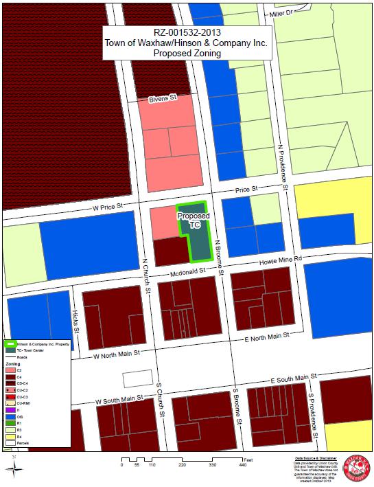
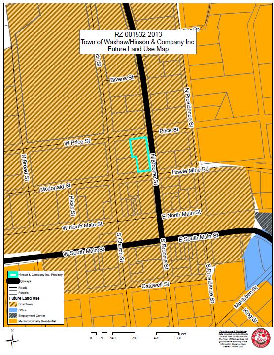
18 Board Action: Motion by Commissioner Diller and seconded by Commissioner Poccia to open the public hearing for RZ A request by the Waxhaw Planning & Community Development Department on behalf of the Board of Commissioners for a rezoning/map amendment from CD-C4 (Conditional District Central Business District) to TC (Town Center) on approximately acres (Tax Parcel ID number ) located at 203 N. Broome Street. The Board cannot approve rezoning of this property unless it finalizes and approves the new form based downtown code (TA ). Motion carried unanimously. Staff Presentation by Planner McCarter Note: All due legal notice as required by the UDO and NC General Statutes has been satisfied. Planner McCarter stated she would like to enter the staff report into the record. The approval of this rezoning is dependent on the adoption of the downtown code. Rezoning Petition RZ Town of Waxhaw/Hinson & Company, Inc. EXPLANATION OF THE REQUEST Petition RZ is a request by the Waxhaw Planning & Community Development Department on behalf of the Board of Commissioners for a rezoning/map amendment from CDC4 (Conditional District Central Business District) to TC (Town Center) on approximately acres (Tax Parcel ID number ) located at 203 N. Broome Street. The Town is initiating a rezoning of the property, with the owner s consent, to the new TC zoning district found in the Downtown Code for compatibility with the re-zonings proposed for the surrounding downtown properties. LOCATION AND CURRENT LAND USE The property is located at 203 N. Broome Street and has frontage on N. Broome Street, Price Street and McDonald Street. The property is currently in use as a Marathon Gas Station, Sonny s Sports Place Restaurant, State Farm Insurance office and a vacant office. Condition and land use of the surrounding properties. *The adjoining properties are: 1. To the north Shell Gas Station zoned C2 (Highway Commercial). 2. To the east A vacant parcel and The Antique Clock Shop zoned OIS (Office, Institutional and Specialty). 3. To the south A vacant parcel zoned C4 (Central Business District). 4. To the west Stewart s Art Gallery zoned C4 (Central Business District) and the Waxhaw Farmer s Market zoned C2 (Highway Commercial).
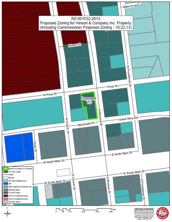
19 *The existing zoning classifications of the neighboring properties are subject to change per the adoption of the Downtown Code text amendment and rezonings. PROPERTY HISTORY The subject property is zoned CD-C4 (Conditional District Central Business District) and has an approved conditional district/rezoning development plan approved by the Board of Commissioners on June 28, The property is located in the Downtown Code boundary but was not originally included in the Downtown Code associated re-zonings because of the conditional district zoning on the property and associated vested property rights. At their September 10, 2013 meeting, the Board of Commissioners requested that staff contact the property owners of the three conditionally zoned properties in the Downtown Code rezoning boundary that were not included in the re-zonings to see if they wanted to be included in a Town initiated rezoning to one of the Downtown Code zoning districts. This request is a result of staff reaching out to the property owner. The request is to change the zoning designation from CD-C4 to TC. All of the uses currently on the site are allowed in the TC zoning district. Gas stations are permitted with a Conditional Use Permit, and restaurants and offices are permitted by right COMPREHENSIVE PLAN & FUTURE LAND USE MAP The Future Land Use Map from the 2030 Comprehensive Plan shows the property as Historic Downtown. Historic Downtown is described in the plan as follows; This area incorporates the historic structures, civic uses, commercial opportunities, and the active environment that is the downtown core of Waxhaw. The core commercial areas are to be preserved and enhanced over the long term and should provide mixeduse opportunities that include commercial, office, and institutional uses, and some residential uses. The future Downtown Small Area Plan will identify more specific designations of these land uses and detailed design standards. The commercial use of this property is consistent with the description of Historic Downtown. DOWNTOWN WAXHAW VISION PLAN The request is in keeping with the Downtown Waxhaw Vision Plan which shows the property as Town Center in the Regulating Plan for Future Development. PLANNING STAFF ANALYSIS The rezoning request is in keeping with the 2030 Comprehensive Plan and Future Land Use Plan which shows the property as Historic Downtown. The request is also in keeping with the Downtown Waxhaw Vision Plan which shows the property as TC in the regulating plan. This rezoning is a Town initiated rezoning in order to make the property zoning compatible with the re-zonings proposed for the surrounding downtown properties.
.")
20 Staff recommends approval of the proposed rezoning. PLANNING BOARD RECOMMENDATION At their October 21, 2013 meeting, the Planning Board voted to send a favorable recommendation for RZ (unanimous). Power Point RZ Petition RZ is a request by the Waxhaw Planning & Community Development Department on behalf of the Board of Commissioners for a rezoning/map amendment from CD-C4 (Conditional District Central Business District) to TC (Town Center) on approximately acres (Tax Parcel ID number ) located at 203 N. Broome Street. The Town is initiating a rezoning of the property, with the owner s consent, to the new TC zoning district found in the Downtown Code for compatibility with the rezonings proposed for the surrounding downtown properties.

21 The property is located at 203 N. Broome Street and has frontage on N. Broome Street, Price Street and McDonald Street. The property is currently in use as a Marathon Gas Station, Sonny s Sports Place Restaurant, State Farm Insurance office and a vacant office. The subject property is zoned CD-C4 (Conditional District Central Business District) and has an approved conditional district/rezoning development plan approved by the Board of Commissioners on June 28, To the north Shell Gas Station zoned C2 (Highway Commercial). To the east A vacant parcel and The Antique Clock Shop zoned OIS (Office, Institutional and Specialty). To the south A vacant parcel zoned C4 (Central Business District). To the west Stewart s Art Gallery zoned C4 and the Waxhaw Farmer s Market zoned C2.
22
23 Staff Recommendation
24 Exhibits: Consistent with the Downtown Waxhaw Vision Plan which shows the property as TC Staff recommends approval of the proposed rezoning Staff Report Maps Comments: None Mayor Gardner stated at this time no additional comments were being made therefore she would entertain a motion to close the public hearing and stated action would be taken at the November 25 th meeting. Board Action: Motion by Commissioner Poccia and seconded by Commissioner Diller to close the public hearing for RZ A request by the Waxhaw Planning & Community Development Department on behalf of the Board of Commissioners for a rezoning/map amendment from CD-C4 (Conditional District Central Business District) to TC (Town Center) on approximately acres (Tax Parcel ID number ) located at 203 N. Broome Street. The Board cannot approve rezoning of this property unless it finalizes and approves the new form based downtown code (TA ). Motion carried unanimously. TA A request by the Planning & Community Development Department to amend Section (Restaurant, Fast Food or Drive Through) of the Town of Waxhaw Unified Development Ordinance to eliminate the required 700 foot distance separation between a fast food or drive through restaurant located on the same side of a public street as another fast food or drive through restaurant. The proposed text amendment will also remove language limiting the number of fast food or drive through restaurants located at the intersection of two public streets to two. Mayor Gardner stated the next item on the agenda is a public hearing for TA A request by the Planning & Community Development Department to amend Section (Restaurant, Fast Food or Drive Through) of the Town of Waxhaw Unified Development Ordinance to eliminate the required 700 foot distance separation between a fast food or drive through restaurant located on the same side of a public street as another fast food or drive through restaurant. The proposed text amendment will also remove language limiting the number of fast food or drive through restaurants located at the intersection of two public streets to two and requested a motion to open the public hearing.
25 Board Action: Motion by Commissioner Diller and seconded by Commissioner Poccia to open the public hearing for TA A request by the Planning & Community Development Department to amend Section (Restaurant, Fast Food or Drive Through) of the Town of Waxhaw Unified Development Ordinance to eliminate the required 700 foot distance separation between a fast food or drive through restaurant located on the same side of a public street as another fast food or drive through restaurant. The proposed text amendment will also remove language limiting the number of fast food or drive through restaurants located at the intersection of two public streets to two. Motion carried unanimously. Staff Presentation by Planner Oliver Note: All due legal notice as required by UDO and the NC General Statutes has been satisfied. Text Amendment TA Fast Food EXPLANATION OF THE REQUEST Petition TA is a request by the Planning and Community Development Department staff to amend Section (Restaurant, Fast Food or Drive Through) of the Town of Waxhaw Unified Development Ordinance to eliminate the required 700 foot distance separation between a fast food or drive through restaurant located on the same side of a public street as another fast food or drive through restaurant. The proposed text amendment will also remove language limiting the number of fast food or drive through restaurants located at the intersection of two public streets to two. REQUESTED UDO CHANGES Section Restaurant, Fast Food or Drive Through (see attached language) Language was removed from this section that regulates the location of this use in relation to other facilities of the same use. PLANNING STAFF ANALYSIS Currently, the UDO requires a 700 foot separation between a fast food or drive through restaurant and another fast food or drive through restaurant on the same side of a public street and allows for only two fast food or drive through restaurants at the intersection of two public streets. Staff feels the proposed amendments to the UDO would enable the market to better meet the demands of the general public. The proposed text amendment strikes the language requiring a 700 foot separation between a fast food or drive through restaurant and another fast food or drive through restaurant located on the same side of a public street. It also removes the language limiting the number of fast food or drive through restaurants that can be located at the intersection of two public streets to two.
26 The Planning and Community Development Department has been contacted several times with inquiries into establishing such facilities and in most cases the requested use has not been able to meet the standards of the code as they currently read. This amendment will also help to make Waxhaw s regulations on fast food and drive through restaurants fall more in line with those of other similar sized jurisdictions in the area. PLANNING STAFF RECOMMENDATION Planning Staff recommends approval of TA The proposed text amendment will eliminate the required 700 foot separation between two fast food or drive through restaurants and will remove the text limiting an intersection of two publics streets to just two fast food or drive through restaurants. This text amendment will also bring Waxhaw s fast food and drive through restaurant regulations more in line with other jurisdictions of similar size in the area. Staff feels that the proposed changes to the text will allow for the market to better meet the demands of the general public. PLANNING BOARD MEETING The Planning Board, at their October 21, 2013 meeting, voted five to one (5-1) to send a favorable recommendation to the Board of Commissioners on TA Planning Board Member Michael Kreimer opposed the text amendment, citing that he was uncomfortable with the proposed text. 11- Schedule of District Regulations (Proposed Removal) C. There may be up to two fast food restaurants located at the intersection of any two public streets. Otherwise, no two fast food restaurants shall be located on the same side of the same public street within seven hundred (700) feet of each other. These spacing provisions shall not apply if the conditions in Subsection 1herein are met. Example: Fast Food/Drive Through Standards Research Distance Separation Requirements Between Other Fast Food Restaurants Distance Between Fast Food Restaurants and Residential Zoning Drive Through Window/Speaker Location Standards Limited to/conditional in some Commercial Districts Cornelius No No Yes Yes Harrisburg No No No Yes Huntersville No No Yes Yes Indian Trail No No No No Matthews No No No Yes Mint Hill No No No Yes Waxhaw Yes Yes Yes Yes

27 Power Point TA is a request by the Planning and Community Development Department staff to amend Section (Restaurant, Fast Food or Drive Through) of the Town of Waxhaw Unified Development Ordinance to eliminate the required 700 foot distance separation between a fast food or drive through restaurant located on the same side of a public street as another fast food or drive through restaurant. The proposed text amendment will also remove language limiting the number of fast food or drive through restaurants located at the intersection of two public streets to two. This text amendment was prompted after staff had several inquiries into fast food restaurants locating in Waxhaw. Staff then decided to research the regulations of other towns in the area to find what the standards they had on the subject of fast food and drive through restaurants. Section Supplemental Regulations

28 The proposed text amendment strikes section C that limits the number of fast food restaurants at an intersection of two public streets to 2 and requires a 700 foot separation between fast food or drive through restaurants on the same side of a public street. The proposed amendment preserves the required 350 foot separation between a free standing fast food restaurant and a residential zoning district. fast food restaurants that are located within a convenience store or located within a multi tenant development and do not have an outside call box are not required to meet these separation standards. (such as the Rock Store BBQ to McDonalds) Section Comparison with other Jurisdictions Out of all the jurisdictions researched for this text amendment, Waxhaw is the only one that has a requires a separation between other fast food or drive through restaurants. Waxhaw is again the only jurisdiction researched to require a separation distance between a fast food or drive through restaurant and residential zoning districts. As you can see, some jurisdictions have standards on drive through window and speaker locations such as what side of the building they can be on or how far they must be from adjoining property, Waxhaw does have conditions on this. All jurisdictions researched have standards that limit fast food or drive through restaurants to certain commercial districts or make them a conditional use in all or some commercial districts except for Indian Trail. Waxhaw limits fast food and drive through restaurants to C-2 and C-3 zoning districts and they are a conditional use with supplemental regulations in both districts.

29 The current map shows the potential locations of fast food restaurants under the current code. The only exception is one of the corners at Cuthbertson and Hwy 16 could be redeveloped into a fast food restaurant under current code, provided that they are 350 feet away from a residentially zoned property.


30 This map shows the potential locations of fast food or drive through restaurants if the proposed text amendment were adopted. An important thing to remember is the proposed text removes the 700 foot separation requirement which means fast food or drive through restaurants could be located directly next to each other and the town could potentially be home to more of these restaurants than under current code if the text amendment is adopted. This map shows the potential locations of fast food restaurants under current code in the Waxhaw Parkway Hwy 16 area. With the required 700 foot separation between fast food or drive through restaurants the potential number is limited.
31 This map showed the potential locations of fast food or drive through restaurants along Hwy 75, east of downtown under current code or with the proposed text change. This is because there are not currently any fast food restaurants in the area. The difference comes if a fast food or drive through restaurant is built. With the proposed text change more restaurants could potentially be built than under current code. Staff Recommendation Planning Staff recommends approval of TA The proposed text amendment will eliminate the required 700 foot separation between two fast food or drive through restaurants and will remove the text limiting an intersection of two publics streets to just two fast food or drive through restaurants. This text amendment will also bring Waxhaw s fast food and drive through restaurant regulations more in line with other jurisdictions of similar size in the area. Staff feels that the proposed changes to the text will allow for the market to better meet the demands of the general public. Planning Board Action On October 21, 2013, The Waxhaw Planning Board voted (5-1) to send a favorable recommendation to the Board of Commissioners on TA Statement of Consistency The approved statement must: Describe whether the action is consistent with the comprehensive plan, and Explain why the action is reasonable and in the public interest.
32

33 Comments Mayor Gardner: Why the negative vote by the Planning Member. Staff responded he didn t feel comfortable with the reduction of the distance from 700 to zero. Commissioner Diller: Commissioner Diller stated he had spoken to the planning board member and the concern was going from 700 feet to zero was his concerned. Staff stated they provided other options but the majority approved the proposed change. Mayor Pro Tem Kirkpatrick: Mayor Pro Tem Kirkpatrick asked if a study was done on stacking minimums. Was there one and if not then she would like to see one as part of the text change. Staff did not do one but would complete this request for the board.
34 Mayor Gardner: Mayor Gardner stated if the town invaded for fast food restaurants on Highway 16, then how many could be? Staff did not research this issue. She would like to know. She pointed another reason is Highway 16 is open for development of fast food restaurants and this could resemble other interstates. She mentioned the list provided and asked staff what community listed would the town want to follow. She asked staff to review what Waxhaw would like to be with this type of development. She does not want Highway 16 to look like Highway 74. Commissioner Diller: Commissioner Diller reviewed the list of towns and Waxhaw is not in the same category as these. Look at other towns similar to Waxhaw for a better comparison was suggested. Commissioner Blythe: Commissioner Blythe state most fast food restaurants empty on to an interstate. She would like to hear from other towns similar to Waxhaw and are main streets and not near an interstate. She asked if Form Base Code was every in every example and that was not the case. She asked for the difference between the zoning for fast food establishments. She scared about the Form Base Code. Mayor Gardner: Mayor Gardner would like to find the list Waxhaw wanted to be similar to that was discussed previously at a town meeting. She would like to see what this text change would be if this is the route to go with the additional research asked of staff. Town Manager- He proposed looking at the following towns that may be similar to Waxhaw with fast foot businesses. Belmont, Ft. Mill (Hardee s Main Street) Board Suggestion The suggestion was further researched on this proposed text amendment. Some town listed were picked as Form Base Code and this could be compared to Waxhaw if adopted. Staff to research and bring some additional information to study. Suggested public hearing be recessed until the meeting on November 25 th. Mayor Gardner stated at this time as there are no additional comments that she would entertain a motion to recess the public hearing and action would be taken at the meeting on November 25 th.
35 Comments: Board Action Motion by Commissioner Poccia and seconded by Commissioner Blythe to close the public hearing for TA A request by the Planning & Community Development Department to amend Section (Restaurant, Fast Food or Drive Through) of the Town of Waxhaw Unified Development Ordinance to eliminate the required 700 foot distance separation between a fast food or drive through restaurant located on the same side of a public street as another fast food or drive through restaurant. The proposed text amendment will also remove language limiting the number of fast food or drive through restaurants located at the intersection of two public streets to two. Motion carried Discussion Staff Issue on Motion Administrator Oakley stated that the board has closed the public hearing and in order to provide the additional information they are asking, then a new public hearing must be advertised. Attorney Spencer stated that this was a legislative decision so the rules are not as strict but the Board could do a motion to reconsider the motion and keep the public hearing open. Board Action Reconsider Motion Public Hearing Closing Motion by Commissioner Blythe and seconded by Commissioner Poccia to to reconsider motion of closing the public hearing for TA A request by the Planning & Community Development Department to amend Section (Restaurant, Fast Food or Drive Through) of the Town of Waxhaw Unified Development Ordinance to eliminate the required 700 foot distance separation between a fast food or drive through restaurant located on the same side of a public street as another fast food or drive through restaurant. The proposed text amendment will also remove language limiting the number of fast food or drive through restaurants located at the intersection of two public streets to two an. Motion carried unanimously.board Action Motion by Commissioner Poccia and seconded by Commissioner Blythe to recess the public hearing for TA A request by the Planning & Community Development Department to amend Section (Restaurant, Fast Food or Drive Through) of the Town of Waxhaw Unified Development Ordinance to eliminate the required 700 foot distance separation between a fast food or drive through restaurant located on the same side of a public street as another fast food or drive through restaurant. The proposed text amendment will also remove language limiting the number of fast food or drive through restaurants located at the intersection of two public
36 streets to two and place on the December 10, 2013 at the Museum of the Waxhaws beginning at 6.30 p.m. Motion carried unanimously. TA A request by the Waxhaw Planning & Community Development Department on behalf of the Board of Commissioners to revise and amend the Flood Prevention Damage Ordinance in Section 6.5 of the Waxhaw Unified Development Ordinance. Mayor Gardner stated the next public hearing ista A request by the Waxhaw Planning & Community Development Department on behalf of the Board of Commissioners to revise and amend the Flood Prevention Damage Ordinance in Section 6.5 of the Waxhaw Unified Development Ordinance and requested a motion to open the public hearing. Board Action: Motion by Mayor Pro Tem Kirkpatrick and seconded by Commissioner Blythe to open the public hearing for TA A request by the Waxhaw Planning & Community Development Department on behalf of the Board of Commissioners to revise and amend the Flood Prevention Damage Ordinance in Section 6.5 of the Waxhaw Unified Development Ordinance. Motion carried unanimously Staff Presentation by Director Mahar P&CD Note: All legal due notice as required by NC General Statutes has been done. Proposed Text Amendment Text Amendment TA Flood Damage Prevention Ordinance EXPLANATION OF THE REQUEST Petition TA is a request by staff on behalf of the Board of Commissioners to amend the Flood Prevention Damage Ordinance in Section 6.5 of the Waxhaw Unified Development Ordinance to change the requirements for the filling of a floodplain. STAFF REQUESTED UDO CHANGES Section 6.5 Flood Damage Prevention Ordinance Changed the requirements for filling a floodplain, floodway and changed the requirements for elevating structures in a flood zone. Please see attached draft ordinance.
37 ENGINEERING STAFF ANALYSIS The Flood Damage Prevention Ordinance in Section 6.5 of the Unified Development Ordinance is required by the Federal Emergency Management Association (FEMA) to allow the Town of Waxhaw to participate in the National Flood Insurance Program (NFIP) which regulates flood insurance policies and rates in our community and throughout the nation. The Waxhaw Board of Commissioners requested staff to analyze the current ordinance and examine neighboring jurisdictions Flood Damage Prevention Ordinances to determine if there were any improvements that could be made for areas in the ordinance or that should be enhanced. Particular focus was to be paid to the filling of the areas of floodplains and floodways. During analysis staff found the current ordinance to be the minimum ordinance required by the North Carolina Emergency Management Agency (NCEM) and FEMA. NCEM oversees the NFIP for FEMA and reviews the ordinances for all participating municipalities and counties in North Carolina. Staff also discovered Weddington and Wesley Chapel also have the state minimum ordinance in effect while Marvin and Mineral Springs have a somewhat more restrictive ordinance requiring various provisions that will better protect residents from impacts during a flood event. Staff felt the community would be better protected by suggesting enhancements to the current ordinance that requires residential structures to be elevated two (2) feet above the Base Flood Elevation (BFE) and commercial structures to be elevated one (1) foot above the BFE. Enhancements also require that any development in a floodway does not allow an increase in flood levels on adjoining properties. NCEM has reviewed the suggested changes and has provided some additional recommendations which are included in the text of the amendment. RECOMMENDATIONS Staff recommends approval of TA The Town of Waxhaw has a large amount of floodplain area throughout the town and development in these areas has the potential to adversely affect the other areas inside the town with negative impacts on property owners. Staff feels that this amendment will allow for more scrutiny and better control of the negative impacts flood waters have on property and life during flood events. Planning Board Recommendation At their October 21, 2013 meeting the Planning Board voted unanimously 6-0 to send a favorable recommendation to the Board of Commissioners. suggested changes and has provided some additional recommendations which are included in the text of the amendment.
38 RECOMMENDATIONS Staff recommends approval of TA The Town of Waxhaw has a large amount of floodplain area throughout the town and development in these areas has the potential to adversely affect the other areas inside the town with negative impacts on property owners. Staff feels that this amendment will allow for more scrutiny and better control of the negative impacts flood waters have on property and life during flood events. Planning Board Recommendation At their October 21, 2013 meeting the Planning Board voted unanimously 6-0 to send a favorable recommendation to the Board of Commissioners. SECTION 6.5 FLOOD DAMAGE PREVENTION ORDINANCE ARTICLE 1. STATUTORY AUTHORIZATION, FINDINGS OF FACT, PURPOSE AND OBJECTIVES. SECTION A. STATUTORY AUTHORIZATION. Municipal: The Legislature of the State of North Carolina has in Part 6, Article 21 of Chapter 143; Parts 3, 5, and 8 of Article 19 of Chapter 160A; and Article 8 of Chapter 160A of the North Carolina General Statutes, delegated to local governmental units the responsibility to adopt regulations designed to promote the public health, safety, and general welfare. Therefore, the Board of Commissioners for the Town of Waxhaw, North Carolina, does ordain as follows: SECTION B. FINDINGS OF FACT. (1) The flood prone areas within the jurisdiction of Waxhaw, North Carolina are subject to periodic inundation which results in loss of life, property, health and safety hazards, disruption of commerce and governmental services, extraordinary public expenditures of flood protection and relief, and impairment of the tax base, all of which adversely affect the public health, safety, and general welfare. (2) These flood losses are caused by the cumulative effect of obstructions in floodplains causing increases in flood heights and velocities and by the occupancy in flood prone areas of uses vulnerable to floods or other hazards. SECTION C. STATEMENT OF PURPOSE. It is the purpose of this ordinance to promote public health, safety, and general welfare and to minimize public and private losses due to flood conditions within flood prone areas by provisions designed to: (1) restrict Restrict or prohibit uses that are dangerous to health, safety, and property due to water or erosion hazards or that result in damaging increases in erosion, flood heights or velocities; (2) require Require that uses vulnerable to floods, including facilities that serve such uses, be protected against flood damage at the time of initial construction;
39 (3) control Control the alteration of natural floodplains, stream channels, and natural protective barriers, which are involved in the accommodation of floodwaters; (4) control Control filling, grading, dredging, and all other development that may increase erosion or flood damage; and (5) prevent Prevent or regulate the construction of flood barriers that will unnaturally divert flood waters or which may increase flood hazards to other lands. SECTION D. OBJECTIVES. The objectives of this ordinance are to: (1) protect Protect human life, safety, and health; (2) minimize Minimize expenditure of public money for costly flood control projects; (3) minimize Minimize the need for rescue and relief efforts associated with flooding and generally undertaken at the expense of the general public; (4) minimize Minimize prolonged business losses and interruptions; (5) minimize Minimize damage to public facilities and utilities (i.e. water and gas mains, electric, telephone, cable and sewer lines, streets, and bridges) that are located in flood prone areas; (6) help Help maintain a stable tax base by providing for the sound use and development of flood prone areas; and (7) ensure Ensure that potential buyers are aware that property is in a Special Flood Hazard Area. ARTICLE 2. DEFINITIONS. Unless specifically defined below, words or phrases used in this ordinance shall be interpreted so as to give them the meaning they have in common usage and to give this ordinance its most reasonable application. Accessory Structure (Appurtenant Structure) means a A structure located on the same parcel of property as the principal structure and the use of which is incidental to the use of the principal structure. Garages, carports and storage sheds are common urban accessory structures. Pole barns, hay sheds and the like qualify as accessory structures on farms, and may or may not be located on the same parcel as the farm dwelling or shop building. Addition (to an existing building) means a An extension or increase in the floor area or height of a building or structure. Appeal means a A request for a review of the Floodplain Administrator's interpretation of any provision of this ordinance.
40 Area of Shallow Flooding means a A designated Zone AO on a community's Flood Insurance Rate Map (FIRM) with base flood depths determined to be from one (1) to three (3) feet. These areas are located where a clearly defined channel does not exist, where the path of flooding is unpredictable and indeterminate, and where velocity flow may be evident. Area of Special Flood Hazard see Special Flood Hazard Area (SFHA). Base Flood means t The flood having a one (1) percent chance of being equaled or exceeded in any given year. Base Flood Elevation (BFE) means a A determination of the water surface elevations of the base flood as published in the Flood Insurance Study. When the BFE has not been provided in a Special Flood Hazard Area, it may be obtained from engineering studies available from a Federal, State, or other source using FEMA approved engineering methodologies. This elevation, when combined with the Freeboard, establishes the Regulatory Flood Protection Elevation. Basement means a Any area of the building having its floor subgrade (below ground level) on all sides. Building see Structure. Chemical Storage Facility means a A building, portion of a building, or exterior area adjacent to a building used for the storage of any chemical or chemically reactive products. Development means a Any man-made change to improved or unimproved real estate, including, but not limited to, buildings or other structures, mining, dredging, filling, grading, paving, excavation or drilling operations, or storage of equipment or materials. Disposal means, a As defined in NCGS 130A-290(a)(6), the discharge, deposit, injection, dumping, spilling, leaking, or placing of any solid waste into or on any land or water so that the solid waste or any constituent part of the solid waste may enter the environment or be emitted into the air or discharged into any waters, including groundwaters. Elevated Building means a A non-basement building which has its lowest elevated floor raised above ground level by foundation walls, shear walls, posts, piers, pilings, or columns. Encroachment means t The advance or infringement of uses, fill, excavation, buildings, structures or development into a floodplain, which may impede or alter the flow capacity of a floodplain. Existing Manufactured Home Park or Manufactured Home Subdivision means a A manufactured home park or subdivision for which the construction of facilities for servicing the lots on which the manufactured homes are to be affixed (including, at a
41 minimum, the installation of utilities, the construction of streets, and either final site grading or the pouring of concrete pads) was completed before the initial effective date of the floodplain management regulations adopted by the community. Flood or Flooding means a general and temporary condition of partial or complete inundation of normally dry land areas from: (1) the The overflow of inland or tidal waters; and/or (2) the The unusual and rapid accumulation or runoff of surface waters from any source. Flood Boundary and Floodway Map (FBFM) means a An official map of a community, issued by the Federal Emergency Management Agency, on which the Special Flood Hazard Areas and the floodways are delineated. This official map is a supplement to and shall be used in conjunction with the Flood Insurance Rate Map (FIRM). Flood Hazard Boundary Map (FHBM) means a An official map of a community, issued by the Federal Emergency Management Agency, where the boundaries of the Special Flood Hazard Areas have been defined as Zone A. Flood Insurance means t The insurance coverage provided under the National Flood Insurance Program. Flood Insurance Rate Map (FIRM) means a An official map of a community, issued by the Federal Emergency Management Agency, on which both the Special Flood Hazard Areas and the risk premium zones applicable to the community are delineated. Flood Insurance Study (FIS) means a An examination, evaluation, and determination of flood hazards, corresponding water surface elevations (if appropriate), flood hazard risk zones, and other flood data in a community issued by the Federal Emergency Management Agency. The Flood Insurance Study report includes Flood Insurance Rate Maps (FIRMs) and Flood Boundary and Floodway Maps (FBFMs), if published. Flood Prone Area see Floodplain Flood Zone means a A geographical area shown on a Flood Hazard Boundary Map or Flood Insurance Rate Map that reflects the severity or type of flooding in the area. Floodplain means a Any land area susceptible to being inundated by water from any source. Floodplain Administrator is t The Director of Engineering charged with the duty to administer and enforce the floodplain management regulations.
42 Floodplain Development Permit means a Any type of permit that is required in conformance with the provisions of this ordinance, prior to the commencement of any development activity. Floodplain Management means t The operation of an overall program of corrective and preventive measures for reducing flood damage and preserving and enhancing, where possible, natural resources in the floodplain, including, but not limited to, emergency preparedness plans, flood control works, floodplain management regulations, and open space plans. Floodplain Management Regulations means t This ordinance and other zoning ordinances, subdivision regulations, building codes, health regulations, special purpose ordinances, and other applications of police power. This term describes Federal, State or local regulations, in any combination thereof, which provide standards for preventing and reducing flood loss and damage. Floodproofing means a Any combination of structural and nonstructural additions, changes, or adjustments to structures which reduce or eliminate flood damage to real estate or improved real property, water and sanitation facilities, structures, and their contents. Floodway means t The channel of a river or other watercourse and the adjacent land areas that must be reserved in order to discharge the base flood without cumulatively increasing the water surface elevation more than one (1) foot. Freeboard means t The height added to the Base Flood Elevation (BFE) to account for the many unknown factors that could contribute to flood heights greater than the height calculated for a selected size flood and floodway conditions, such as wave action, blockage of bridge openings, and the hydrological effect of urbanization of the watershed. The Base Flood Elevation (BFE) plus the freeboard establishes the Regulatory Flood Protection Elevation. Functionally Dependent Facility means a A facility which cannot be used for its intended purpose unless it is located in close proximity to water, limited to a docking or port facility necessary for the loading and unloading of cargo or passengers, shipbuilding, or ship repair. The term does not include long-term storage, manufacture, sales, or service facilities. Hazardous Waste Management Facility means, a As defined in NCGS 130A, Article 9, a facility for the collection, storage, processing, treatment, recycling, recovery, or disposal of hazardous waste. Highest Adjacent Grade (HAG) means t The highest natural elevation of the ground surface, prior to construction, immediately next to the proposed walls of the structure.
43 Historic Structure means any structure that is: (a) listed Listed individually in the National Register of Historic Places (a listing maintained by the US Department of Interior) or preliminarily determined by the Secretary of Interior as meeting the requirements for individual listing on the National Register; (b) certified Certified or preliminarily determined by the Secretary of Interior as contributing to the historical significance of a registered historic district or a district preliminarily determined by the Secretary to qualify as a registered historic district; (c) individually Individually listed on a local inventory of historic landmarks in communities with a Certified Local Government (CLG) Program ; or (d) certified Certified as contributing to the historical significance of a historic district designated by a community with a Certified Local Government (CLG) Program. Certified Local Government (CLG) Programs are approved by the US Department of the Interior in cooperation with the North Carolina Department of Cultural Resources through the State Historic Preservation Officer as having met the requirements of the National Historic Preservation Act of 1966 as amended in Letter of Map Change (LOMC) mean an official determination issued by FEMA that amends or revises an effective Flood Insurance Rate Map or Flood Insurance Study. Letters of Map Change include: (a) Letter of Map Amendment (LOMA): An amendment based on technical data showing that a property was incorrectly included in a designated special flood hazard area. A LOMA amends the current effective Flood Insurance Rate Map and establishes that a specific property, portion of a property, or structure is not located in a special flood hazard area. (b) Letter of Map Revision (LOMR): A revision based on technical data that may show changes to flood zones, flood elevations, special flood hazard area boundaries and floodway delineations, and other planimetric features. (c) Letter of Map Revision Based on Fill (LOMR-F): A determination that a structure or parcel of land has been elevated by fill above the base flood elevation and is, therefore, no longer located within the special flood hazard area. In order to qualify for this determination, the fill must have been permitted and placed in accordance with the community s floodplain management regulations. (d) Conditional Letter of Map Revision (CLOMR): A formal review and comment as to whether a proposed flood protection project or other project complies with the minimum NFIP requirements for such projects with respect to delineation of special flood hazard areas. A CLOMR does not revise the effective Flood
44 Insurance Rate Map or Flood Insurance Study; upon submission and approval of certified as-built documentation, a Letter of Map Revision may be issued by FEMA to revise the effective FIRM. Lowest Adjacent Grade (LAG) means t The elevation of the ground, sidewalk or patio slab immediately next to the building, or deck support, after completion of the building. Lowest Floor means t The lowest floor of the lowest enclosed area (including basement). An unfinished or flood resistant enclosure, usable solely for parking of vehicles, building access, or limited storage in an area other than a basement area is not considered a building's lowest floor, provided that such an enclosure is not built so as to render the structure in violation of the applicable non-elevation design requirements of this ordinance. Manufactured Home means a A structure, transportable in one or more sections, which is built on a permanent chassis anddesigned to be used with or without a permanent foundation when connected to the required utilities. The term manufactured home does not include a recreational vehicle. Manufactured Home Park or Subdivision means a A parcel (or contiguous parcels) of land divided into two or more manufactured home lots for rent or sale. Market Value means t The building value, not including the land value and that of any accessory structures or other improvements on the lot. Market value may be established by independent certified appraisal; replacement cost depreciated for age of building and quality of construction (Actual Cash Value); or adjusted tax assessed values. Mean Sea Level means, f For purposes of this ordinance, the National Geodetic Vertical Datum (NGVD) as corrected in 1929, the North American Vertical Datum (NAVD) as corrected in 1988, or other vertical control datum used as a reference for establishing varying elevations within the floodplain, to which Base Flood Elevations (BFEs) shown on a FIRM are referenced. Refer to each FIRM panel to determine datum used. New Construction means s Structures for which the start of construction commenced on or after the effective date of the initial floodplain management regulations and includes any subsequent improvements to such structures. Non-Encroachment Area means t The channel of a river or other watercourse and the adjacent land areas that must be reserved in order to discharge the base flood without cumulatively increasing the water surface elevation more than one (1) foot as designated in the Flood Insurance Study report. Post-FIRM means c Construction or other development for which the start of construction occurred on or after the effective date of the initial Flood Insurance Rate Map.
45 Pre-FIRM means c Construction or other development for which the start of construction occurred before the effective date of the initial Flood Insurance Rate Map. Principally Above Ground means t That at least 51% of the actual cash value of the structure is above ground. Recreational Vehicle (RV) means a A vehicle, which is: (a) built Built on a single chassis; (b) 400 square feet or less when measured at the largest horizontal projection; (c) designed Designed to be self-propelled or permanently towable by a light duty truck; and (d) designed Designed primarily not for use as a permanent dwelling, but as temporary living quarters for recreational, camping, travel, or seasonal use. Reference Level is Is the bottom of the lowest horizontal structural member of the lowest floor for structures within all Special Flood Hazard Areas. Regulatory Flood Protection Elevation means t The Base Flood Elevation plus the Freeboard. In Special Flood Hazard Areas where Base Flood Elevations (BFEs) have been determined, this elevation shall be the BFE plus two (2) feet of freeboard. In Special Flood Hazard Areas where no BFE has been established, this elevation shall be at least two (2) feet above the highest adjacent grade. Remedy a Violation means t To bring the structure or other development into compliance with State and community floodplain management regulations, or, if this is not possible, to reduce the impacts of its noncompliance. Ways that impacts may be reduced include protecting the structure or other affected development from flood damages, implementing the enforcement provisions of the ordinance or otherwise deterring future similar violations, or reducing Federal financial exposure with regard to the structure or other development. Riverine means r Relating to, formed by, or resembling a river (including tributaries), stream, brook, etc. Salvage Yard means a Any non-residential property used for the storage, collection, and/or recycling of any type of equipment, and including but not limited to vehicles, appliances and related machinery. Solid Waste Disposal Facility means a Any facility involved in the disposal of solid waste, as defined in NCGS 130A-290(a)(35).
46 Solid Waste Disposal Site means, a As defined in NCGS 130A-290(a)(36), any place at which solid wastes are disposed of by incineration, sanitary landfill, or any other method. Special Flood Hazard Area (SFHA) means t The land in the floodplain subject to a one percent (1%) or greater chance of being flooded in any given year, as determined in Article 3, Section B of this ordinance. Start of Construction I Includes substantial improvement, and means the date the building permit was issued, provided the actual start of construction, repair, reconstruction, rehabilitation, addition placement, or other improvement was within 180 days of the permit date. The actual start means either the first placement of permanent construction of a structure on a site, such as the pouring of slab or footings, the installation of piles, the construction of columns, or any work beyond the stage of excavation; or the placement of a manufactured home on a foundation. Permanent construction does not include land preparation, such as clearing, grading, and filling; nor does it include the installation of streets and/or walkways; nor does it include excavation for a basement, footings, piers, or foundations or the erection of temporary forms; nor does it include the installation on the property of accessory buildings, such as garages or sheds not occupied as dwelling units or not part of the main structure. For a substantial improvement, the actual start of construction means the first alteration of any wall, ceiling, floor, or other structural part of the building, whether or not that alteration affects the external dimensions of the building. Structure means a A walled and roofed building, a manufactured home, or a gas, liquid, or liquefied gas storage tank that is principally above ground. Substantial Damage means d Damage of any origin sustained by a structure during any one-year period whereby the cost of restoring the structure to its before damaged condition would equal or exceed 50 percent of the market value of the structure before the damage occurred. See definition of substantial improvement. Substantial Improvement means a Any combination of repairs, reconstruction, rehabilitation, addition, or other improvement of a structure, taking place during any one-year period for which the cost equals or exceeds 50 percent of the market value of the structure before the start of construction of the improvement. This term includes structures which have incurred substantial damage, regardless of the actual repair work performed. The term does not, however, include either: (a) any Any correction of existing violations of State or community health, sanitary, or safety code specifications which have been identified by the community code enforcement official and which are the minimum necessary to assure safe living conditions; or (b) any Any alteration of a historic structure,structure provided that the alteration will not preclude the structure's continued designation as a historic structure.
47 Threat to Public Safety and/or Nuisance means a Anything which is injurious to the safety or health of an entire community or neighborhood, or any considerable number of persons, or unlawfully obstructs the free passage or use, in the customary manner, of any navigable lake, or river, bay, stream, canal, or basin. Variance is Is a grant of relief from the requirements of this ordinance. Violation means t The failure of a structure or other development to be fully compliant with the community's floodplain management regulations. A structure or other development without the elevation certificate, other certifications, or other evidence of compliance required in Articles 4 and 5 is presumed to be in violation until such time as that documentation is provided. Water Surface Elevation (WSE) means t The height, in relation to mean sea level, of floods of various magnitudes and frequencies in the floodplains of coastal or riverine areas. Watercourse means a A lake, river, creek, stream, wash, channel or other topographic feature on or over which waters flow at least periodically. Watercourse includes specifically designated areas in which substantial flood damage may occur. ARTICLE 3. GENERAL PROVISIONS. SECTION A. LANDS TO WHICH THIS ORDINANCE APPLIES. This ordinance shall apply to all Special Flood Hazard Areas within the jurisdiction of the Town of Waxhaw. SECTION B. BASIS FOR ESTABLISHING THE SPECIAL FLOOD HAZARD AREAS. The Special Flood Hazard Areas are those identified under the Cooperating Technical State (CTS) agreement between the State of North Carolina and FEMA in its FIS dated (Insert effective date shown on FIS)October 16, 2008 for (Insert County name)union County and associated DFIRM panels, including any digital data developed as part of the Flood Insurance Study, which are adopted by reference and declared a part of this ordinance. Future revisions to the FIS and DFIRM panels that do not change flood hazard data within the jurisdictional authority of (Insert community name)the Town of Waxhaw are also adopted by reference and declared a part of this ordinance The Special Flood Hazard Areas are those identified under the Cooperating Technical State (CTS) agreement between the State of North Carolina and FEMA in its Flood Insurance Study (FIS) and its accompanying Flood Insurance Rate Maps (FIRM), for Union County dated October 16, 2008, which are adopted by reference and declared to be a part of this ordinance.
48 SECTION C. ESTABLISHMENT OF FLOODPLAIN DEVELOPMENT PERMIT. A Floodplain Development Permit shall be required in conformance with the provisions of this ordinance prior to the commencement of any development activities within Special Flood Hazard Areas determined in accordance with the provisions of Article 3, Section B of this ordinance. SECTION D. COMPLIANCE. No structure or land shall hereafter be located, extended, converted, altered, or developed in any way without full compliance with the terms of this ordinance and other applicable regulations. SECTION E. ABROGATION AND GREATER RESTRICTIONS. This ordinance is not intended to repeal, abrogate, or impair any existing easements, covenants, or deed restrictions. However, where this ordinance and another conflict or overlap, whichever imposes the more stringent restrictions shall prevail. SECTION F. INTERPRETATION. In the interpretation and application of this ordinance, all provisions shall be: (a) considered as minimum requirements; (b) liberally construed in favor of the governing body; and (c) deemed neither to limit nor repeal any other powers granted under State statutes. SECTION G. WARNING AND DISCLAIMER OF LIABILITY. The degree of flood protection required by this ordinance is considered reasonable for regulatory purposes and is based on scientific and engineering consideration. Larger floods can and will occur. Actual flood heights may be increased by man-made or natural causes. This ordinance does not imply that land outside the Special Flood Hazard Areas or uses permitted within such areas will be free from flooding or flood damages. This ordinance shall not create liability on the part of the Town of Waxhaw or by any officer or employee thereof for any flood damages that result from reliance on this ordinance or any administrative decision lawfully made hereunder. SECTION H. PENALTIES FOR VIOLATION. Violation of the provisions of this ordinance or failure to comply with any of its requirements, including violation of conditions and safeguards established in connection with grants of variance or special exceptions, shall be enforced in accordance with Article 4 (D), hereof, and Section of the Waxhaw Unified Development Ordinance, as amended. ARTICLE 4. ADMINISTRATION. SECTION A. DESIGNATION OF FLOODPLAIN ADMINISTRATOR. The Director of Engineering, or designee, hereinafter referred to as the Floodplain Administrator, is hereby appointed to administer and implement the provisions of this ordinance.
49 SECTION B. FLOODPLAIN DEVELOPMENT APPLICATION, PERMIT AND CERTIFICATION REQUIREMENTS. (1) Application Requirements. Application for a Floodplain Development Permit shall be made to the Floodplain Administrator prior to any development activities located within Special Flood Hazard Areas. The following items shall be presented to the Floodplain Administrator to apply for a floodplain development permit: (a) A plot plan drawn to scale which shall include, but shall not be limited to, the following specific details of the proposed floodplain development: (i) the The nature, location, dimensions, and elevations of the area of development/disturbance; existing and proposed structures, utility systems, grading/pavement areas, fill materials, storage areas, drainage facilities, and other development; (ii) the The boundary of the Special Flood Hazard Area as delineated on the FIRM or other flood map as determined in Article 3, Section B, or a statement that the entire lot is within the Special Flood Hazard Area; (iii) flood Flood zone(s) designation of the proposed development area as determined on the FIRM or other flood map as determined in Article 3, Section B; (iv) the The boundary of the floodway(s) or non-encroachment area(s) as determined in Article 3, Section B; (v) the The Base Flood Elevation (BFE) where provided as set forth in Article 3, Section B; Article 4, Section C; or Article 5, Section D; (vi) the The old and new location of any watercourse that will be altered or relocated as a result of proposed development; and (vii) the The certification of the plot plan by a registered land surveyor or professional engineer. (b) Proposed elevation, and method thereof, of all development within a Special Flood Hazard Area including but not limited to: (i) Elevation in relation to mean sea level of the proposed reference level (including basement) of all structures; (ii) Elevation in relation to mean sea level to which any non-residential structure in Zone AE, A or AO will be floodproofed; and
50 (iii) Elevation in relation to mean sea level to which any proposed utility systems will be elevated or floodproofed. (c) If floodproofing, a Floodproofing Certificate (FEMA Form 81-65) with supporting data, an operational plan, and an inspection and maintenance plan that include, but are not limited to, installation, exercise, and maintenance of floodproofing measures. (d) A Foundation Plan, drawn to scale, which shall include details of the proposed foundation system to ensure all provisions of this ordinance are met. These details include but are not limited to: (i) The proposed method of elevation, if applicable (i.e., fill, solid foundation perimeter wall, solid backfilled foundation, open foundation on columns/posts/piers/piles/shear walls); a (ii) Openings to facilitate automatic equalization of hydrostatic flood forces on walls in accordance with Article 5, Section B(4)(c) when solid foundation perimeter walls are used in Zones A, AO, AE, and A1-30. (e) Usage details of any enclosed areas below the lowest floor. (f) Plans and/or details for the protection of public utilities and facilities such as sewer, gas, electrical, and water systems to be located and constructed to minimize flood damage. (g) Certification that all other Local, State and Federal permits required prior to floodplain development permit issuance have been received. (h) Documentation for placement of Recreational Vehicles and/or Temporary Structures, when applicable, to ensure that the provisions of Article 5, Section B, subsections (6) and (7) of this ordinance are met. (i) A description of proposed watercourse alteration or relocation, when applicable, including an engineering report on the effects of the proposed project on the flood-carrying capacity of the watercourse and the effects to properties located both upstream and downstream; and a map (if not shown on plot plan) showing the location of the proposed watercourse alteration or relocation. (2) Permit Requirements. The Floodplain Development Permit shall include, but not be limited to: (a) A description of the development to be permitted under the floodplain development permit. (b) The Special Flood Hazard Area determination for the proposed development in accordance with available data specified in Article 3, Section B.
51 (c) The Regulatory Flood Protection Elevation required for the reference level and all attendant utilities. (d) The Regulatory Flood Protection Elevation required for the protection of all public utilities. (e) All certification submittal requirements with timelines. (f) A statement that no fill material or other development shall encroach into the floodway or non-encroachment area of any watercourse, as applicable. (g) The flood openings requirements, if in Zone A, AO, AE or A1-30. (h) Limitations on use of enclosed areas below the lowest floor (if applicable), i.e., parking, building access and limited storage only. (3) Certification Requirements. (a) Elevation Certificates (i) An Elevation Certificate (FEMA Form 81-31) is required prior to the actual start of any new construction. It shall be the duty of the permit holder to submit to the Floodplain Administrator a certification of the elevation of the reference level, in relation to mean sea level. The Floodplain Administrator shall review the certificate data submitted. Deficiencies detected by such review shall be corrected by the permit holder prior to the beginning of construction. Failure to submit the certification or failure to make required corrections shall be cause to deny a floodplain development permit. (ii) An Elevation Certificate (FEMA Form 81-31) is required after the reference level is established. Within seven (7) calendar days of establishment of the reference level elevation, it shall be the duty of the permit holder to submit to the Floodplain Administrator a certification of the elevation of the reference level, in relation to mean sea level. Any work done within the seven (7) day calendar period and prior to submission of the certification shall be at the permit holder s risk. The Floodplain Administrator shall review the certificate data submitted. Deficiencies detected by such review shall be corrected by the permit holder immediately and prior to further work being permitted to proceed. Failure to submit the certification or failure to make required corrections shall be cause to issue a stop-work order for the project. (iii) A final as-built Elevation Certificate (FEMA Form 81-31) is required after construction is completed and prior to Certificate of Compliance/Occupancy issuance. It shall be the duty of the permit holder to submit to the Floodplain Administrator a certification of final as-built
52 Floodproofing Certificate construction of the elevation of the reference level and all attendant utilities. The Floodplain Administrator shall review the certificate data submitted. Deficiencies detected by such review shall be corrected by the permit holder immediately and prior to Certificate of Compliance/Occupancy issuance. In some instances, another certification may be required to certify corrected as-built construction. Failure to submit the certification or failure to make required corrections shall be cause to withhold the issuance of a Certificate of Compliance/Occupancy. If non-residential floodproofing is used to meet the Regulatory Flood Protection Elevation requirements, a Floodproofing Certificate (FEMA Form 81-65), with supporting data, an operational plan, and an inspection and maintenance plan are required prior to the actual start of any new construction. It shall be the duty of the permit holder to submit to the Floodplain Administrator a certification of the floodproofed design elevation of the reference level and all attendant utilities, in relation to mean sea level. Floodproofing certification shall be prepared by or under the direct supervision of a professional engineer or architect and certified by same. The Floodplain Administrator shall review the certificate data, the operational plan, and the inspection and maintenance plan. Deficiencies detected by such review shall be corrected by the applicant prior to permit approval. Failure to submit the certification or failure to make required corrections shall be cause to deny a floodplain development permit. Failure to construct in accordance with the certified design shall be cause to withhold the issuance of a Certificate of Compliance/Occupancy. (c) If a manufactured home is placed within Zone A, AO, AE, or A1-30 and the elevation of the chassis is more than 36 inches in height above grade, an engineered foundation certification is required in accordance with the provisions of Article 5, Section B(3)(b). (d) If a watercourse is to be altered or relocated, a description of the extent of watercourse alteration or relocation; a professional engineer s certified report on the effects of the proposed project on the flood-carrying capacity of the watercourse and the effects to properties located both upstream and downstream; and a map showing the location of the proposed watercourse alteration or relocation shall all be submitted by the permit applicant prior to issuance of a floodplain development permit. (e) Certification Exemptions. The following structures, if located within Zone A, AO, AE or A1-30, are exempt from the elevation/floodproofing certification requirements specified in items (a) and (b) of this subsection: (i) Recreational Vehicles meeting requirements of Article 5, Section B(6)(a); (ii) Temporary Structures meeting requirements of Article 5, Section B(7); and (iii) Accessory Structures less than 150 square feet meeting requirements of Article 5, Section B(8).
53 (4) Determinations for existing buildings and structures. For applications for building permits to improve buildings and structures, including alterations, movement, enlargement, replacement, repair, change of occupancy, additions, rehabilitations, renovations, substantial improvements, repairs of substantial damage, and any other improvement of or work on such buildings and structures, the Floodplain Administrator, in coordination with the Building Official, shall: (a) Estimate the market value, or require the applicant to obtain an appraisal of the market value prepared by a qualified independent appraiser, of the building or structure before the start of construction of the proposed work; in the case of repair, the market value of the building or structure shall be the market value before the damage occurred and before any repairs are made; (b)compare the cost to perform the improvement, the cost to repair a damaged building to its pre-damaged condition, or the combined costs of improvements and repairs, if applicable, to the market value of the building or structure; (c) Determine and document whether the proposed work constitutes substantial improvement or repair of substantial damage; and (d) Notify the applicant if it is determined that the work constitutes substantial improvement or repair of substantial damage and that compliance with the flood resistant construction requirements of the NC Building Code and this ordinance is required. SECTION C. DUTIES AND RESPONSIBILITIES OF THE FLOODPLAIN ADMINISTRATOR. The Floodplain Administrator shall perform, but not be limited to, the following duties: (1) Review all floodplain development applications and issue permits for all proposed development within Special Flood Hazard Areas to assure that the requirements of this ordinance have been satisfied. (2) Review all proposed development within Special Flood Hazard Areas to assure that all necessary Local, State and Federal permits have been received. (3) Notify adjacent communities and the North Carolina Department of Crime Control and Public Safety, Division of Emergency Management, State Coordinator for the National Flood Insurance Program prior to any alteration or relocation of a watercourse, and submit evidence of such notification to the Federal Emergency Management Agency (FEMA). (4) Assure that maintenance is provided within the altered or relocated portion of said watercourse so that the flood-carrying capacity is maintained.
54 (5) Prevent encroachments into floodways and non-encroachment areas unless the certification and flood hazard reduction provisions of Article 5, Section F are met. (6) Obtain actual elevation (in relation to mean sea level) of the reference level (including basement) and all attendant utilities of all new and substantially improved structures, in accordance with the provisions of Article 4, Section B(3). (7) Obtain actual elevation (in relation to mean sea level) to which all new and substantially improved structures and utilities have been floodproofed, in accordance with the provisions of Article 4, Section B(3). (8) Obtain actual elevation (in relation to mean sea level) of all public utilities in accordance with the provisions of Article 4, Section B(3). (9) When floodproofing is utilized for a particular structure, obtain certifications from a registered professional engineer or architect in accordance with the provisions of Article 4, Section B(3) and Article 5, Section B(2). (10) Where interpretation is needed as to the exact location of boundaries of the Special Flood Hazard Areas, floodways, or non-encroachment areas (for example, where there appears to be a conflict between a mapped boundary and actual field conditions), make the necessary interpretation. The person contesting the location of the boundary shall be given a reasonable opportunity to appeal the interpretation as provided in this article. (11) When Base Flood Elevation (BFE) data have not been provided in accordance with the provisions of Article 3, Section B, obtain, review, and reasonably utilize any BFE data, along with floodway data or non-encroachment area data available from a Federal, State, or other source, including data developed pursuant to Article 5, Section D(2)(b), in order to administer the provisions of this ordinance. (12) When Base Flood Elevation (BFE) data are provided but no floodway or nonencroachment area data have been provided in accordance with the provisions of Article 3, Section B, obtain, review, and reasonably utilize any floodway data or nonencroachment area data available from a Federal, State, or other source in order to administer the provisions of this ordinance. (13) When the lowest floor and the lowest adjacent grade of a structure or the lowest ground elevation of a parcel in a Special Flood Hazard Area are above the Base Flood Elevation (BFE), advise the property owner of the option to apply for a Letter of Map Amendment (LOMA) from FEMA. Maintain a copy of the LOMA issued by FEMA in the floodplain development permit file. (14) Permanently maintain all records that pertain to the administration of this ordinance and make these records available for public inspection, recognizing that such information may be subject to the Privacy Act of 1974, as amended.
55 (15) Make on-site inspections of work in progress. As the work pursuant to a floodplain development permit progresses, the Floodplain Administrator shall make as many inspections of the work as may be necessary to ensure that the work is being done according to the provisions of the local ordinance and the terms of the permit. In exercising this power, the Floodplain Administrator has a right, upon presentation of proper credentials, to enter on any premises within the jurisdiction of the community at any reasonable hour for the purposes of inspection or other enforcement action. (16) Issue stop-work orders as required. Whenever a building or part thereof is being constructed, reconstructed, altered, or repaired in violation of this ordinance, the Floodplain Administrator may order the work to be immediately stopped. The stop-work order shall be in writing and directed to the person doing or in charge of the work. The stop-work order shall state the specific work to be stopped, the specific reason(s) for the stoppage, and the condition(s) under which the work may be resumed. Violation of a stop-work order constitutes a misdemeanor. (17) Revoke floodplain development permits as required. The Floodplain Administrator may revoke and require the return of the floodplain development permit by notifying the permit holder in writing stating the reason(s) for the revocation. Permits shall be revoked for any substantial departure from the approved application, plans, and specifications; for refusal or failure to comply with the requirements of State or local laws; or for false statements or misrepresentations made in securing the permit. Any floodplain development permit mistakenly issued in violation of an applicable State or local law may also be revoked. (18) Make periodic inspections throughout the Special Flood Hazard Areas within the jurisdiction of the community. The Floodplain Administrator and each member of his or her inspections department shall have a right, upon presentation of proper credentials, to enter on any premises within the territorial jurisdiction of the department at any reasonable hour for the purposes of inspection or other enforcement action. (19) Follow through with corrective procedures of Article 4, Section D. (20) Review, provide input, and make recommendations for variance requests. (21) Maintain a current map repository to include, but not limited to, the FIS Report, FIRM and other official flood maps and studies adopted in accordance with the provisions of Article 3, Section B of this ordinance, including any revisions thereto including Letters of Map Change, issued by FEMA. Notify State and FEMA of mapping needs. (22) Coordinate revisions to FIS reports and FIRMs, including Letters of Map Revision Based on Fill (LOMR-Fs) and Letters of Map Revision (LOMRs). SECTION D. CORRECTIVE PROCEDURES.
56 (1) Violations to be Corrected: When the Floodplain Administrator finds violations of applicable State and local laws, it shall be his or her duty to notify the owner or occupant of the building of the violation. The owner or occupant shall immediately remedy each of the violations of law cited in such notification. (2) Actions in Event of Failure to Take Corrective Action: If the owner of a building or property shall fail to take prompt corrective action, the Floodplain Administrator shall give the owner written notice, by certified or registered mail to the owner s last known address or by personal service, stating: (a) that That the building or property is in violation of the floodplain management regulations; (b) that That a hearing will be held before the Floodplain Administrator at a designated place and time, not later than ten (10) days after the date of the notice, at which time the owner shall be entitled to be heard in person or by counsel and to present arguments and evidence pertaining to the matter; and (c) that That following the hearing, the Floodplain Administrator may issue an order to alter, vacate, or demolish the building; or to remove fill as applicable. (3) Order to Take Corrective Action: If, upon a hearing held pursuant to the notice prescribed above, the Floodplain Administrator shall find that the building or development is in violation of the Flood Damage Prevention Ordinance, he or she shall issue an order in writing to the owner, requiring the owner to remedy the violation within a specified time period, not less than sixty (60) calendar days, nor more than (120) calendar days. Where the Floodplain Administrator finds that there is imminent danger to life or other property, he or she may order that corrective action be taken in such lesser period as may be feasible. (4) Appeal: Any owner who has received an order to take corrective action may appeal the order to the Board of Adjustment in accordance with Section with Section 15 of the Waxhaw Unified Development Ordinance, as amended. In the absence of an appeal, the order of the Floodplain Administrator shall be final. (5) Failure to Comply with Order: If the owner of a building or property fails to comply with an order to take corrective action for which no appeal has been made or fails to comply with an order of the Board of Adjustment following an appeal, the owner shall be subject to the penalties set forth in Article 3, Section H hereof. SECTION E. VARIANCE PROCEDURES. (1) The Board of Adjustment as established by the Town of Waxhaw, shall hear and decide requests for variances from the requirements of this ordinance and Section 15 of the Waxhaw Unified Development Ordinance, as amended.
57 (2) Any person aggrieved by the decision of the appeal board may appeal such decision to the Court, as provided in Chapter 7A of the North Carolina General Statutes. (3) Variances may be issued for: (a) the The repair or rehabilitation of historic structures upon the determination that the proposed repair or rehabilitation will not preclude the structure's continued designation as a historic structure and that the variance is the minimum necessary to preserve the historic character and design of the structure; (b) functionally Functionally dependent facilities if determined to meet the definition as stated in Article 2 of this ordinance, provided provisions of Article 4, Section E(9)(b), (c), and (e) have been satisfied, and such facilities are protected by methods that minimize flood damages during the base flood and create no additional threats to public safety; or (c) any Any other type of development, development provided it meets the requirements of this Section. (4) In passing upon variances, the Board of Adjustment shall consider all technical evaluations, all relevant factors, all standards specified in other sections of this ordinance, Section 15 of the Waxhaw Unified Development Ordinance and: (a) the The danger that materials may be swept onto other lands to the injury of others; (b) the The danger to life and property due to flooding or erosion damage; (c) the The susceptibility of the proposed facility and its contents to flood damage and the effect of such damage on the individual owner; (d) the The importance of the services provided by the proposed facility to the community; (e) the The necessity to the facility of a waterfront location as defined under Article 2 of this ordinance as functionally dependent facility, where applicable; (f) the The availability of alternative locations, not subject to flooding or erosion damage, for the proposed use; (g) the The compatibility of the proposed use with existing and anticipated development; (h) the The relationship of the proposed use to the comprehensive plan and floodplain management program for that area; (i) the The safety of access to the property in times of flood for ordinary and emergency vehicles;
58 (j) the The expected heights, velocity, duration, rate of rise, and sediment transport of the floodwaters and the effects of wave action, if applicable, expected at the site; and (k) the The costs of providing governmental services during and after flood conditions including maintenance and repair of public utilities and facilities such as sewer, gas, electrical and water systems, and streets and bridges. (5) A written report addressing each of the above factors shall be submitted with the application for a variance. (6) Upon consideration of the factors listed above and the purposes of this ordinance, the Board of Adjustment may attach such conditions to the granting of variances as it deems necessary to further the purposes and objectives of this ordinance and the Waxhaw Unified Development Ordinance. (7) Any applicant to whom a variance is granted shall be given written notice specifying the difference between the Base Flood Elevation (BFE) and the elevation to which the structure is to be built and that such construction below the BFE increases risks to life and property, and that the issuance of a variance to construct a structure below the BFE will result in increased premium rates for flood insurance up to $25 per $100 of insurance coverage. Such notification shall be maintained with a record of all variance actions, including justification for their issuance. (8) The Floodplain Administrator shall maintain the records of all appeal actions and report any variances to the Federal Emergency Management Agency and the State of North Carolina upon request. (9) Conditions for Variances: (a) Variances shall not be issued when the variance will make the structure in violation of other Federal, State, or local laws, regulations, or ordinances. (b) Variances shall not be issued within any designated floodway or nonencroachment area if the variance would result in any increase in flood levels during the base flood discharge. (c) Variances shall only be issued upon a determination that the variance is the minimum necessary, considering the flood hazard, to afford relief. (d) Variances shall only be issued prior to development permit approval. (e) Variances shall only be issued upon: (i) a A showing of good and sufficient cause;
59 (ii) a A determination that failure to grant the variance would result in exceptional hardship; and (iii) a A determination that the granting of a variance will not result in increased flood heights, additional threats to public safety, or extraordinary public expense, create nuisance, cause fraud on or victimization of the public, or conflict with existing local laws or ordinances. (10) A variance may be issued for solid waste disposal facilities or sites, hazardous waste management facilities, salvage yards, and chemical storage facilities that are located in Special Flood Hazard Areas provided that all of the following conditions are met. (a) The use serves a critical need in the community. (b) No feasible location exists for the use outside the Special Flood Hazard Area. (c) The reference level of any structure is elevated or floodproofed to at least the Regulatory Flood Protection Elevation. (d) The use complies with all other applicable Federal, State and local laws. (e) The (community)town of Waxhaw has notified the Secretary of the North Carolina Department of Public Safety of its intention to grant a variance at least thirty (30) calendar days prior to granting the variance ARTICLE 5. PROVISIONS FOR FLOOD HAZARD REDUCTION. SECTION A. GENERAL STANDARDS. In all Special Flood Hazard Areas the following provisions are required: (1) All new construction and substantial improvements shall be designed (or modified) and adequately anchored to prevent flotation, collapse, and lateral movement of the structure. (2) All new construction and substantial improvements shall be constructed with materials and utility equipment resistant to flood damage. (3) All new construction and substantial improvements shall be constructed by methods and practices that minimize flood damages. (4) Electrical, heating, ventilation, plumbing, air conditioning equipment, and other service facilities shall be designed and/or located so as to prevent water from entering or accumulating within the components during conditions of flooding to the Regulatory Flood Protection Elevation. These include, but are not limited to, HVAC equipment,
60 water softener units, bath/kitchen fixtures, ductwork, electric/gas meter panels/boxes, utility/cble boxes, hot water heaters, and electric outlets/switches. (5) All new and replacement water supply systems shall be designed to minimize or eliminate infiltration of floodwaters into the system. (6) New and replacement sanitary sewage systems shall be designed to minimize or eliminate infiltration of floodwaters into the systems and discharges from the systems into floodwaters. (7) On-site waste disposal systems shall be located and constructed to avoid impairment to them or contamination from them during flooding. (8) Any alteration, repair, reconstruction, or improvements to a structure, which is in compliance with the provisions of this ordinance, shall meet the requirements of new construction as contained in this ordinance. (9) Nothing in this ordinance shall prevent the repair, reconstruction, or replacement of a building or structure existing on the effective date of this ordinance and located totally or partially within the floodway, non-encroachment area, or stream setback, provided there is no additional encroachment below the Regulatory Flood Protection Elevation in the floodway, non-encroachment area, or stream setback, and provided that such repair, reconstruction, or replacement meets all of the other requirements of this ordinance. (10) New solid waste disposal facilities and sites, hazardous waste management facilities, salvage yards, and chemical storage facilities shall not be permitted. A structure or tank for chemical or fuel storage incidental to an allowed use or to the operation of a water treatment plant or wastewater treatment facility may be located in a Special Flood Hazard Area only if the structure or tank is either elevated or floodproofed to at least the Regulatory Flood Protection Elevation and certified in accordance with the provisions of Article 4, Section B(3). (11) All subdivision proposals and other development proposals shall be consistent with the need to minimize flood damage. (12) All subdivision proposals and other development proposals shall have public utilities and facilities such as sewer, gas, electrical, and water systems located and constructed to minimize flood damage. (13) All subdivision proposals and other development proposals shall have adequate drainage provided to reduce exposure to flood hazards. (14) All subdivision proposals and other development proposals shall have received all necessary permits from those governmental agencies for which approval is required by Federal or State law, including Section 404 of the Federal Water Pollution Control Act Amendments of 1972, 33 U.S.C
61 (15) When a structure is partially located in a Special Flood Hazard Area, the entire structure shall meet the requirements for new construction and substantial improvements. (16) When a structure is located in multiple flood hazard zones or in a flood hazard risk zone with multiple Base Flood Elevations (BFEs), the provisions for the more restrictive flood hazard risk zone and the highest BFE shall apply. SECTION B. SPECIFIC STANDARDS. In all Special Flood Hazard Areas where Base Flood Elevation (BFE) data have been provided, as set forth in Article 3, Section B, or Article 5, Section D, the following provisions, in addition to the provisions of Article 5, Section A, are required: (1) Residential Construction. New construction and substantial improvement of any residential structure (including manufactured homes) shall have the reference level, including basement, elevated no lower than the two feet above the Regulatory Flood Protection Elevation, as defined in Article 2 of this ordinance. (2) Non-Residential Construction. New construction and substantial improvement of any commercial, industrial, or other non-residential structure shall have the reference level, including basement, elevated no lower than one foot above the Regulatory Flood Protection Elevation, as defined in Article 2 of this ordinance. Structures located in A, AE, AO, and A1-30 Zones may be floodproofed to the Regulatory Flood Protection Elevation in lieu of elevation provided that all areas of the structure, together with attendant utility and sanitary facilities, below the Regulatory Flood Protection Elevation are watertight with walls substantially impermeable to the passage of water, using structural components having the capability of resisting hydrostatic and hydrodynamic loads and the effect of buoyancy. For AO Zones, the floodproofing elevation shall be in accordance with Article 5, Section G(2). A registered professional engineer or architect shall certify that the floodproofing standards of this subsection are satisfied. Such certification shall be provided to the Floodplain Administrator as set forth in Article 4, Section B(3), along with the operational plan and the inspection and maintenance plan. (3) Manufactured Homes. (a) New and replacement manufactured homes shall be elevated so that the reference level of the manufactured home is no lower than two feet above the Regulatory Flood Protection Elevation, as defined in Article 2 of this ordinance. (b) Manufactured homes shall be securely anchored to an adequately anchored foundation to resist flotation, collapse, and lateral movement, either by certified engineered foundation system, or in accordance with the most current edition of the State of North Carolina Regulations for Manufactured Homes adopted by the Commissioner of Insurance pursuant to NCGS Additionally, when the elevation would be met by an elevation of the chassis thirty-six (36) inches or less above the grade at the site, the chassis shall be supported by reinforced
62 piers or engineered foundation. When the elevation of the chassis is above thirtysix (36) inches in height, an engineering certification is required. (c) All enclosures or skirting below the lowest floor shall meet the requirements of Article 5, Section B(4). (d) An evacuation plan must be developed for evacuation of all residents of all new, substantially improved or substantially damaged manufactured home parks or subdivisions located within flood prone areas. This plan shall be filed with and approved by the Floodplain Administrator and the local Emergency Management Coordinator. (4) Elevated Buildings. Fully enclosed area, of new construction and substantially improved structures, which is below the lowest floor: (a) shall Shall not be designed or used for human habitation, but shall only be used for parking of vehicles, building access, or limited storage of maintenance equipment used in connection with the premises. Access to the enclosed area shall be the minimum necessary to allow for parking of vehicles (garage door) or limited storage of maintenance equipment (standard exterior door), or entry to the living area (stairway or elevator). The interior portion of such enclosed area shall not be finished or partitioned into separate rooms, except to enclose storage areas; (b) shall Shall be constructed entirely of flood resistant materials at least to the Regulatory Flood Protection Elevation; and (c) shall Shall include, in Zones A, AO, AE, and A1-30, flood openings to automatically equalize hydrostatic flood forces on walls by allowing for the entry and exit of floodwaters. To meet this requirement, the openings must either be certified by a professional engineer or architect or meet or exceed the following minimum design criteria: (i) A minimum of two flood openings on different sides of each enclosed area subject to flooding; (ii) The total net area of all flood openings must be at least one (1) square inch for each square foot of enclosed area subject to flooding; (iii) If a building has more than one enclosed area, each enclosed area must have flood openings to allow floodwaters to automatically enter and exit; (iv) The bottom of all required flood openings shall be no higher than one (1) foot above the adjacent grade;
63 (v) Flood openings may be equipped with screens, louvers, or other coverings or devices, provided they permit the automatic flow of floodwaters in both directions; and (vi) Enclosures made of flexible skirting are not considered enclosures for regulatory purposes, and, therefore, do not require flood openings. Masonry or wood underpinning, regardless of structural status, is considered an enclosure and requires flood openings as outlined above. (5) Additions/Improvements. (a) Additions and/or improvements to pre-firm structures when the addition and/or improvements in combination with any interior modifications to the existing structure are: (i) not Not a substantial improvement, the addition and/or improvements must be designed to minimize flood damages and must not be any more non-conforming than the existing structure. (ii) a A substantial improvement, both the existing structure and the addition and/or improvements must comply with the standards for new construction. (b) Additions to post-firm structures with no modifications to the existing structure other than a standard door in the common wall shall require only the addition to comply with the standards for new construction. (c) Additions and/or improvements to post-firm structures when the 6) Recreational Vehicles. Recreational vehicles shall either: (a) be on site for fewer than 180 consecutive days; or (b) be fully licensed and ready for highway use (a recreational vehicle is ready for highway use if it is on its wheels or jacking system, is attached to the site only by quick disconnect type utilities, and has no permanently attached additions) (c) Permanent Placement. Recreational vehicles that do not meet the limitations of Temporary placement shall meet all the requirements for new construction. (a) be on site for fewer than 180 consecutive days and be fully licensed and ready for highway use (a recreational vehicle is ready for highway use if it is on its wheels or jacking system, is attached to the site only by quick disconnect type utilities, and has no permanently attached additions); or (b) meet all the requirements for new construction. (7) Temporary Non-Residential Structures. Prior to the issuance of a floodplain development permit for a temporary structure, the applicant must submit to the
64 Floodplain Administrator a plan for the removal of such structure(s) in the event of a hurricane, flash flood or other type of flood warning notification. The following information shall be submitted in writing to the Floodplain Administrator for review and written approval: (a) a A specified time period for which the temporary use will be permitted. Time specified may not exceed three (3) months, renewable up to one (1) year; (b) the The name, address, and phone number of the individual responsible for the removal of the temporary structure; (c) the The time frame prior to the event at which a structure will be removed (i.e., minimum of 72 hours before landfall of a hurricane or immediately upon flood warning notification); (d) a A copy of the contract or other suitable instrument with the entity responsible for physical removal of the structure; and (e) designation Designation, accompanied by documentation, of a location outside the Special Flood Hazard Area, to which the temporary structure will be moved. (8) Accessory Structures. When accessory structures (sheds, detached garages, etc.) are to be placed within a Special Flood Hazard Area, the following criteria shall be met: (a) Accessory structures shall not be used for human habitation (including working, sleeping, living, cooking or restroom areas); (b) Accessory structures shall not be temperature-controlled; (c) Accessory structures shall be designed to have low flood damage potential; (d) Accessory structures shall be constructed and placed on the building site so as to offer the minimum resistance to the flow of floodwaters; (e) Accessory structures shall be firmly anchored in accordance with the any interior modifications to the existing structure are: (f) All service facilities such as electrical shall be installed in accordance with the provisions of Article 5, Section A(4); and (g) Flood openings to facilitate automatic equalization of hydrostatic flood forces shall be provided below Regulatory Flood Protection Elevation in conformance with the provisions of Article 5, Section B(4)(c). An accessory structure with a footprint less than 150 square feet that satisfies the criteria outlined above does not require an elevation or floodproofing certificate.
65 Elevation or floodproofing certifications are required for all other accessory structures in accordance with Article 4, Section B(3). (9) Tanks. When gas and liquid storage tanks are to be placed within a Special Flood Hazard Area, the following criteria shall be met: (a) Underground tanks. Underground tanks in flood hazard areas shall be anchored to prevent flotation, collapse or lateral movement resulting from hydrodynamic and hydrostatic loads during conditions of the design flood, including the effects of buoyancy assuming the tank is empty; (b) Above-ground tanks, elevated. Above-ground tanks in flood hazard areas shall be attached to and elevated to or above the design flood elevation on a supporting structure that is designed to prevent flotation, collapse or lateral movement during conditions of the design flood. Tank-supporting structures shall meet the foundation requirements of the applicable flood hazard area; (c) Above-ground tanks, not elevated. Above-ground tanks that do not meet the elevation requirements of Section B (2) of this ordinance shall be permitted in flood hazard areas provided the tanks are anchored or otherwise designed and constructed to prevent flotation, collapse or lateral movement resulting from hydrodynamic and hydrostatic loads during conditions of the design flood, including the effects of buoyancy assuming the tank is empty and the effects of flood-borne debris. Tank inlets and vents. Tank inlets, fill openings, outlets and vents shall be: (i) at or above the design flood elevation or fitted with covers designed to prevent the inflow of floodwater or outflow of the contents of the tanks during conditions of the design flood; and (ii) anchored to prevent lateral movement resulting from hydrodynamic and hydrostatic loads, including the effects of buoyancy, during conditions of the design flood. (10) Other Development. Prior to the issuance of a floodplain development permit for a temporary structure, the applicant must submit to the Floodplain Administrator a plan for the removal of such structure(s) in the event of a hurricane, flash flood or other type of flood warning notification. The following information shall be submitted in writing to the Floodplain Administrator for review and written approval: (a) Fences in regulated floodways and NEAs that have the potential to block the passage of floodwaters, such as stockade fences and wire mesh fences, shall meet the limitations of Article 5, Section F of this ordinance. (b) Retaining walls, sidewalks and driveways in regulated floodways and NEAs. Retaining walls and sidewalks and driveways that involve the placement of fill in
66 regulated floodways shall meet the limitations of Article 5, Section F of this ordinance (c) Roads and watercourse crossings in regulated floodways and NEAs. Roads and watercourse crossings, including roads, bridges, culverts, low-water crossings and similar means for vehicles or pedestrians to travel from one side of a watercourse to the other side, that encroach into regulated floodways shall meet the limitations of Article 5, Section F of this ordinance. SECTION C. RESERVED. SECTION D. STANDARDS FOR FLOODPLAINS WITHOUT ESTABLISHED BASE FLOOD ELEVATIONS. Within the Special Flood Hazard Areas designated as Approximate Zone A and established in Article 3, Section B, where no Base Flood Elevation (BFE) data have been provided by FEMA, the following provisions, in addition to the provisions of Article 5, Section A, shall apply: (1) No encroachments, including fill, new construction, substantial improvements or new development shall be permitted within a distance of twenty fifty (2050) feet each side from top of bank or five ten (10) times the width of the stream, whichever is greater, unless certification with supporting technical data by a registered professional engineer is provided demonstrating that such encroachments shall not result in any increase in flood levels during the occurrence of the base flood discharge. (2) The BFE used in determining the Regulatory Flood Protection Elevation shall be determined based on the following criteria: (a) When Base Flood Elevation (BFE) data are available from other sources, all new construction and substantial improvements within such areas shall also comply with all applicable provisions of this ordinance and shall be elevated or floodproofed in accordance with standards in Article 5, Sections A and B. ( b) When floodway or non-encroachment data are available from a Federal, State, or other source, all new construction and substantial improvements within floodway and non-encroachment areas shall also comply with the requirements of Article 5, Sections B and F. (c) All subdivision, manufactured home park and other development proposals shall provide Base Flood Elevation (BFE) data if development is greater than five (5) acres or has more than fifty (50) lots/manufactured home sites. Such BFE data shall be adopted by reference in accordance with the provisions of Article 3, Section B and utilized in implementing this ordinance. (d) When Base Flood Elevation (BFE) data are not available from a Federal, State, or other source as outlined above, the reference level shall be elevated or floodproofed
67 (nonresidential) to or above the Regulatory Flood Protection Elevation, as defined in Article 2. All other applicable provisions of Article 5, Section B shall also apply. SECTION E. STANDARDS FOR RIVERINE FLOODPLAINS WITH BASE FLOOD ELEVATIONS BUT WITHOUT ESTABLISHED FLOODWAYS OR NON-ENCROACHMENT AREAS. Along rivers and streams where Base Flood Elevation (BFE) data is provided by FEMA or is available from another source but neither floodway nor non-encroachment areas are identified for a Special Flood Hazard Area on the FIRM or in the FIS report, the following requirements shall apply to all development within such areas: (1) Standards of Article 5, Sections A and B; and (2) Until a regulatory floodway or non-encroachment area is designated, no encroachments, including fill, new construction, substantial improvements, or other development, shall be permitted unless certification with supporting technical data by a registered professional engineer is provided demonstrating that the cumulative effect of the proposed development, when combined with all other existing and anticipated development, will not increase the water surface elevation of the base flood more than one (1) foot at any point within the community. SECTION F. FLOODWAYS AND NON-ENCROACHMENT AREAS. Areas designated as floodways or non-encroachment areas are located within the Special Flood Hazard Areas established in Article 3, Section B. The floodways and nonencroachment areas are extremely hazardous areas due to the velocity of floodwaters that have erosion potential and carry debris and potential projectiles. The following provisions, in addition to the standards outlined in Article 5, Sections A and B, shall apply to all development within such areas: (1) No encroachments, including fill, new construction, substantial improvements and other developments shall be permitted unless it has been demonstrated through hydrologic and hydraulic analyses performed and certified by a registered professional civil engineer, in accordance with standard engineering practice that the proposed encroachment would not result in any (0.00 feet) increase in the flood levels during the occurrence of the base flood and/or future base flood (if applicable). The certification and technical data shall be presented to the Floodplain Administrator for any change which would cause a rise in the base flood and/or future base flood elevation (if applicable) and will require notification of adjoining property owners and a Conditional Letter of Map Revision (CLOMR) from FEMA. If approved and constructed, as-built plans must be submitted by the property owner and approved by FEMA and a letter of map revision (LOMR) issued. A certificate of occupancy will not be issued without the above stated letter of map revision. (2) If Article 5, Section F (1) is satisfied, all development shall comply with all applicable flood hazard reduction provisions of this ordinance.
68 (3) Construction of any vehicular parking lot in association with an Active Park or Passive Park shall be allowed provided that a permit is obtained from the Floodplain Administrator demonstrating that (i) no fill is added to the floodway or non-encroachment area and (ii) there are no obstructions to the floodway or nonencroachment area. Any parking area authorized under this section does not have to be paved but must otherwise comply with other town regulations. (4) No manufactured homes shall be permitted, except replacement manufactured homes in an existing manufactured home park or subdivision, provided the following provisions are met: (a) The anchoring and the elevation standards of Article 5, Section B(3); and (b) The no encroachment standard of Article 5, Section F (1). (1) No encroachments, including fill, new construction, substantial improvements and other developments shall be permitted unless: (a) it is demonstrated that the proposed encroachment would not result in any increase in the flood levels during the occurrence of the base flood, based on hydrologic and hydraulic analyses performed in accordance with standard engineering practice and presented to the Floodplain Administrator prior to issuance of a floodplain development permit, or (b) a Conditional Letter of Map Revision (CLOMR) has been approved by FEMA. A Letter of Map Revision (LOMR) must also be obtained upon completion of the proposed encroachment. (2) If Article 5, Section F(1) is satisfied, all development shall comply with all applicable flood hazard reductionprovisions of this ordinance. (3) No manufactured homes shall be permitted, except replacement manufactured homes in an existing manufactured home park or subdivision, provided the following provisions are met: (a) the anchoring and the elevation standards of Article 5, Section B(3); and (b) the no encroachment standard of Article 5, Section F(1). SECTION G. STANDARDS FOR AREAS OF SHALLOW FLOODING (ZONE AO). Located within the Special Flood Hazard Areas established in Article 3, Section B, are areas designated as shallow flooding areas. These areas have special flood hazards associated with base flood depths of one (1) to three (3) feet where a clearly defined channel does not exist and where the path of flooding is unpredictable and
69 indeterminate. In addition to Article 5, Sections A and B, all new construction and substantial improvements shall meet the following requirements: (1) The reference level shall be elevated at least as high as the depth number specified on the Flood Insurance Rate Map (FIRM), in feet, plus a freeboard of _four (4) feet, above the highest adjacent grade; or at least four (4) feet above the highest adjacent grade if no depth number is specified. (2) Non-residential structures may, in lieu of elevation, be floodproofed to the same level as required in Article 5, Section G(1) so that the structure, together with attendant utility and sanitary facilities, below that level shall be watertight with walls substantially impermeable to the passage of water and with structural components having the capability of resisting hydrostatic and hydrodynamic loads and effects of buoyancy. Certification is required in accordance with Article 4, Section B(B (3) and Article 5, Section B(B (2). (3) Adequate drainage paths shall be provided around structures on slopes, to guide floodwaters around and away from proposed structures. ARTICLE 6. LEGAL STATUS PROVISIONS. SECTION A. EFFECT ON RIGHTS AND LIABILITIES UNDER THE EXISTING FLOOD DAMAGE PREVENTION ORDINANCE. This ordinance in part comes forward by re-enactment of some of the provisions of the flood damage prevention ordinance enacted December 28, 1998 as amended, and currently located in Section 6.5 of UDO, and it is not the intention to repeal but rather to re-enact and continue to enforce without interruption of such existing provisions, so that all rights and liabilities that have accrued thereunder are reserved and may be enforced. The enactment of this ordinance shall not affect any action, suit or proceeding instituted or pending. All provisions of the flood damage prevention ordinance of the Town of Waxhaw located in Section 6.5 which are not reenacted herein are repealed. SECTION B. EFFECT UPON OUTSTANDING FLOODPLAIN DEVELOPMENT PERMITS. Nothing herein contained shall require any change in the plans, construction, size, or designated use of any development or any part thereof for which a floodplain development permit has been granted by the Floodplain Administrator or his or her authorized agents before the time of passage of this ordinance; provided, however, that when construction is not begun under such outstanding permit within a period of six (6) months subsequent to the date of issuance of the outstanding permit, construction or use shall be in conformity with the provisions of this ordinance. SECTION C. SEVERABILITY.
70 If any section, clause, sentence, or phrase of the Ordinance is held to be invalid or unconstitutional by any court of competent jurisdiction, then said holding shall in no way effect the validity of the remaining portions of this Ordinance. SECTION D. EFFECTIVE DATE. This ordinance shall become effective October 14, 2008.upon adoption. SECTION D E. ADOPTION CERTIFICATION. I hereby certify that this is a true and correct copy of the flood damage prevention ordinance as adopted by the Board of Commissioners of Waxhaw, North Carolina, on the 14th xxth day of Octoberxxxxxxxx, WITNESS my hand and the official seal of, this the day of, 20 Mayor Town Clerk Mayor Comments: Mayor Gardner ; Mayor Gardner questioned the fill in that occurred at the Prescot Property on Highway 16. She asked if these changes are adopted would this be the same action taken in the floodplain. Director Mahar stated there is no firm answer. Mayor Gardner asked how much floodplain property in Waxhaw. Director Mahar stated he was not sure but could request Staff Member Oliver in GIS Planning to calculate this for the board. Commissioner Diller: Commissioner Diller 303 parcels in the special flood areas. (SFHA) Attorney Spencer: Attorney Spencer stated when first reviewed the proposed changes that he also reviewed the NC State laws on environmental laws. He stated under Section Law the board must vote unanimously to adopt the proposed Floodplain Ordinance Amendment as environmental laws must be unanimous through October Mayor Gardner stated at this time she would entertain a motion to close the public hearing as no additional comments were presented. Mayor Gardner stated this item will be on the November 25 th agenda for board action.
71 Board Action: Motion by Commissioner Blythe and seconded by Commissioner Diller to close the public hearing for TA A request by the Waxhaw Planning & Community Development Department on behalf of the Board of Commissioners to revise and amend the Flood Prevention Damage Ordinance in Section 6.5 of the Waxhaw Unified Development Ordinance. Motion carried unanimously. Informal Comments: (Residents may sign up to speak) Mayor Gardner opened the public comments session of the meeting and stated the board would listen to residents on any item. Comments: Mr. Zimmerman: Commissioner Blythe wanted Mr. Zimmerman to explain why he felt that approving Form Base would be against the historic district if zoned. His concern is if you look at the mix use at town center, urban neighborhood and then mixed use and the others there is basically no difference. Commissioner Blythe asked Director Mahar if he had viewed this chart created by Mr. Zimmerman. He stated he had not. Mr. Zimmerman stated in downtown you cannot have a garden, but in mixed use you could have a rental car business. He suggested looking at South Blvd and the area is a massive area of junk. He stated his listed his concern about definitions not be defined. He stated the maps are the same and need better defined. He feels this is heart surgery if adopted and you will kill the patient (Waxhaw downtown) Town Manager McLaurin: He asked for the handouts that Mr. Zimmerman had. These were given to the board members at the November 2 nd meeting. Ms. Holmes-- The handouts provided by staff was consolidated for better overviews. Commissioner Blythe: Commissioner Blythe asked if Form Base Code will protect historic structures. Ms. Holmes stated unless you have a historic district you cannot protect historic properties to be demolished if requirements are met. Bonnie Ruskino- Ms. Ruskino stated she signed the wrong sheet, she wished to speak at the end of the meeting.
72 Mayor Gardner closed the informal comments session the meeting and asked Town Manager McLaurin to provide his weekly report. Manager s Weekly Council Report: (Overview of weekly council report provided to board and town website) November 1, 2013 Administration Department Continued working on the Police Department structure including working to coordinate the issuance of an RFP for the A/V and Security System. The mini-storage warehouses have been cleared out and demolition is scheduled for November 11. Staff is working with Piedmont Natural Gas to install natural gas lines at the site and replace the existing propane tanks. This installation should not interfere with the creation of the parking lot. Began reviewing proposals received for the design of the wayfinding signs. Continuing working on a proposal per Mayor Protem Kirkpatrick s request for additional holiday decorations in the David G. Barnes Park as part of the 12 Days of Christmas Project Management Currently working on access rights finalization for boards and committees. Creating process improvements for all board and committees in progress. Currently working on the action opens items for Strategic BOC Goals and MS Project plan time lines. Milestone tracking in progress. Created and managing PD Administrative project plan updates and managing progress. Additional items Parking lot, MacDonald House(Retail Proposed) and Town Hall Infrastructure, will also be placed into timeline plans. Change request log created. Supporting MacDonald house updates for SharePoint, target plan provided for Dec Maintaining SharePoint site overall. Address critical path open issue for Town Hall, presentation planned- awaiting updates from Creech Associates after approval of Schematic design Oct 31 meeting. Planning and Community Development Zoning Completed text amendment application to allow for ball field sponsorship board and scoreboard signage. Discussed the property across from Prescot commercial with the architect working on a possible project for the property. Worked on non-conforming sign project. Downtown Code and Rezonings - Preparation for November 2 meeting. Began preparation of variance application for HC Nesbit lights. Worked on Section 18 Subdivision ordinance rewrite. Reviewed new house plans for the Millbridge subdivision.
73 Plan Review Completed preliminary review of Millbridge Conditional District. rezoning and Millbridge Subdivision. Final review and approval of Millbridge Phase 2D Map 1 final plat. Completed 2 reviews of Inverness on Providence construction plans. Other Held Downtown Neighborhoods Small Area Plans Advisory Committee Meetings. Submitted parcel, road, and address updated for ConnectGIS. Continued with Trimble work. Completed revision of Façade Improvement Grant Application. Meeting with Bonnie Rusinko concerns over downtown code. Compiled information for Joe Sancinella on Barrington subdivision. Police There were 512 calls for service. Crimes and/or arrest included: misdemeanor possession of marijuana, possession of drug paraphernalia, ABC violation, vandalism, financial card fraud. Arrest include: driving with license revoked, indecent liberties with a child, breaking & entering/theft of a motor vehicle, possession of drug paraphernalia, no operator s license. 75 citations were issued including: 6 driving with license revoked, 10 speeding, 18 registration violations, 8 stop sign violations, 19 seat belt, 2 change of address on driver s license, 5 no operator s license, 1 each of possession of a controlled substance, expired registration, driving left of center, graduated driver s license, possession of drug paraphernalia, child not in rear seat, no liability insurance. Waxhaw Police Department arrested a robbery suspect who robbed an AT&T store in Wesley Chapel. Public Service Twelve new residential solid waste households. Number of new residents: 43 Revised solid waste numbers for week of Oct. 24: 16 new households and 54 new residents. Made preparations to deliver wood from the PD tree to Boone for processing. Began annual leaf vacuuming program, will continue through Jan. 31, Preparations for driveway modifications and survey of new opened areas contained within the Southside Cemetery. Street and storm drain inspections conducted in the Prescott subdivision. Set up for special called BOC meeting to be held. Upcoming Events Board of Commissioners Meeting, Saturday November 8, 2013 Council Report Administration
74 Administration Attended the November 2 Meeting. Continued planning for the demolition of the mini-storage warehouses and concrete block building scheduled for November 11. Staff is working with Piedmont Natural Gas to install natural gas lines at the site and replace the existing propane tanks. This installation should not interfere with the creation of the parking lot. Received one proposal from the consultant on the site plan for the David G. Barnes Park and Horton Property. The proposal is currently under review. Met with two consultants being considered for the Wayfinding Project. Continued planning for the 12 Days of Christmas. Met with representatives from Time-Warner to discuss proposals for connectivity between the new police department and current Town Hall. Project Management Currently working on access rights finalization. Organize and create process improvements for all board and committees in progress. Currently working on the action opens items for Strategic BOC Goals and MS Project plan time lines. Milestone tracking in progress. Created and managing PD Administrative project plan updates and managing progress. Additional items Parking lot, MacDonald House(Retail Proposed) and Town Hall Infrastructure, will also be placed into timeline plans. Change request log created. Supporting MacDonald house updates for SharePoint. Target plan provided for Dec Maintaining SharePoint site overall. Address critical path open issue for Town Hall, presentation planned- awaiting updates from Creech Associates IT Infrastructure review / datacenter design pending review for PD. Awaiting SharePoint folder updates from BOC meetings for content. Planning and Community Development Development activity for the week include 14 new residential permits, 1 new residential renovation permits, 18 plumbing permits, 16 mechanical permits, 17 electrical permits, 1 sign permit and 30 zoning permits. 256 inspections were conducted during the week. Zoning Related: Continued work on non-conforming sign project Started work on reformatting UDO Processing variance application for HC Nesbit Park lighting Preparing the staff report and agenda package for the Millbridge CD rezoning Continued to work on the text amendment for sponsorship boards and scoreboard signs Downtown Code & Rezoning - Attended special called BOC meeting, worked on revisions to code including summary sheet
75 Researched conservation and cluster subdivisions for Section 18 (Subdivision ordinance) rewrite Researched connectivity issue related to connectivity between neighborhoods Plan Review: Performed second review of proposed town-owned temporary parking lot per Downtown Code regulations. Reviewed the subdivision plan associated with the Millbridge CD rezoning. Performed final review of Millbridge Amenity Center revision. Miscellaneous: Mailed postcards for upcoming Façade Improvement Grant special meeting and posted information on website Compiled WHPC packets including grant extension requests Police There were 463 calls for service. Crimes and/or arrest included: Possession of drug paraphernalia, possession of marijuana, vandalism, breaking & entering/theft of a motor vehicle, misdemeanor larceny, animal call, injury to property, communicating threats. Arrest include: Possession of drug paraphernalia, possession of marijuana Sgt. Feige attended an Early Stage Street Encounters class 26 citations were issued including: 3 possession of drug paraphernalia/marijuana, 5 fictitious/expired registrations, 2 no liability insurance, 3 stop sign violations, 4 no operator s license, 4 speeding, 2 expired inspections, 1 each of child under 16 not secured, violation of city/county ordinance, signal movement violation. Public Services 7 new residential solid waste households. Number of new residents for the week: 28 Assisted with repair and service of sound system at the Museum. Conducted storm drain inspections in the Anklin Forest subdivision. Met with Duke Energy officials concerning additional streetlight installations in the Wysacky Park subdivision. Staff completed an after hours inspection of all streetlights within the town; a total of 41 streetlight outages were reported to the appropriate service provider. All have been repaired as of this report. Upcoming Events Board of Commissioners Meeting, Saturday, November 12 6:30 p.m. Museum of the Waxhaws. Project Manager Branch: Project Manager Branch provided a handout with report showing updates. Each Thursday the Advisory Board has a conference call. Red items are the issues which are causing a caution and she stated some items that will remain yellow.
76 Five Stone Trailers- Moved Propane Changes Form Base Code- If not adopted cleared and roped off. Green- demolition of storage buildings and block buildings Police Department Green schedule daily contractor meeting December removing covenant will be handled IT Manager plan provided and approved for the new police facility NIck Security- and AV- Chief Eiss- Bids are going out and coming back to board. Schematic Design- Brent and Nickole- Current design in Form Base Code and not UDO, when decision is made design will be presented. McDonald House- RFQ reviewed by Attorney and out f or bids- contractors that restore historic sites- possible December or January Commissioner Blythe will met with Terry Settle and Town Manager on a proposal for the use of the McDonald House at 2:00 p.m. November 13, 2013 in the Town Manager s Office. Mr. William Whaley, Building Inspector will be in attendance. The proposal is to stabilize the building for winter months. The RFQ is to get it stable for weather. Project Manager Branch stated some items discussed tonight is part of the Advisory Board weekly discussions. Goals High Level.- 54% completion of goals. Town Financial Policies- Reviewed- last year and nothing started at this time. Commissioner Poccia would like to be the leader in February for budget processcompletion 2014 Board/Committee/Evaluation- Direction, Training- Mayor Pro Tem Kirkpatrick started but stopped and will not go forward by her. Mayor Gardner stated the process will begin again the first of next year. Strategic Plan- Actions are being taken and in process Comprehensive Town Organizations- This is slated for next year- will be defined by Project Manager and all these will be listed and assigned to one commissioner to handle. Action Plans- What is needed and make assignments for moving forward. Communications/Press Kit-/Welcome Packet: Preliminary discussions with Chris Parte Monroe/Union County per Mayor Pro Tem Kirkpatrick. Nothing substantial in the process at this time. Budget Format and Process: Not active at this time
77 Responsible Town Growth: Not going forward- No deliverable. Form Base Code- Moving Forward- on target for possible adoption later that night. Comprehensive Plan: Committee was updated and appointed. Staff sent out applications out to the appointees and only two responded. Mayor Pro Tem Kirkpatrick stated some do not want to serve and maybe new applications. Staff Member Oakley stated meetings are in progress and will take about eighteen months. Small Area Plans: Still working on the four plans. Do an update. Wayfinding Signage: July Looking at consultants and doing reviews. Sign Ordinance: Complete Neighborhood Commercial Regulations: In process Section 18; In process Kensington Road: Commissioner Poccia handling Community Garden: Completed Storm water Amendment: In process No Bill No Fill: In process Fence Ordinance: Completed Park & Recreation Master Plan- Implementation :Need direction on what committee is responsible for implementing Library Plan: Not in process Dog Park: Discussions but not in process Miniature Railroad: Discussions but not in process Nesbit Park: Lighting of park is current in process which require action approval by the Board of Adjustment Community Events Expansion : Discussed and some budget increased but more discussion and open item

78 Dog Events- Policy, Direction and Enforcement: Not started but discussed David G. Barnes Park Improvement: In process and only one response for the RFQ. May send back out as only received one proposal Town Manager to handle. Police Faculty: In process Town Hall Facility: In process Local Greenway System: Started, but needs revisiting. Comprehensive Capital Improvement Community Investment Plan: Needs to be submitted in spring. CDBG Project Manager: She will bring a detailed report back this meeting to the board. Thanks for hard work. Power Point
79 Parking Lot- (Adjacent Town Hall) Nov 29 th Tenants will receive notice today, less than 30days possible(storage units) 30 days Oct 31st Office tenant impact for parking notice - Mike Demolition Permit / Asbestos certification- Brent / William Oct 2nd Salvage of actual storage unit Aluminum requested Edifice Creech / LandDesign have 14 days to complete design- Oct 9 th - Lori Edifice requires design too finish for bid in 14 days Oct 22nd BOC(special meeting) Public Service will be moving all items belonging to Waxhaw- Oct 14th, All items out Nov 10th for all tenants Gas tank removal Nov 8 th- Nov 15 th, no permit/screening Mailboxes will be moved Screening brick, Required masonry martials lattice bond, opaque required Dumpster enclosed required to open parking lot, design / time impact Remove trailers (FiveStones) Nov 11th Tenant notification/ letters sent, hold until eviction action, Nov 11 th Final design in progress, propane changes and newest-plan Approved prior / submitted before- Nov 13 th If new code is not passed, Demo completes and lot will be roped/closed Permit items for temporary parking Lori Nov 13 th Construction / Demolition Nov 11 th, 8:30am until Nov 27th Complete parking lot prior to Nov 29th Review Progress on Town Hall Interior Floor Plan Options / Plaza rendering to be approved BOC meeting -Oct 22 nd Infrastructure update for Town Hall (Site costs pedestrian sidewalks, widening $99,401)- Marc M. / Nate Doolittle Nov 22nd(BOC approval) Schedule for confirmation of tasks Not yet available Approved Schematic Design based on Form based Downtown Codes, Risk UDO not in current design Edifice Contract Confirmation Nov 12 th BOC Review parcel for combination - Nov 2014
80 Review Progress on Police Department LGC Approved meeting Oct 1 st- Complete GMP approval BOC, Update on Closing(Oct 10 th ) Oct 8 th Complete Zoning permit(2 days)- Lori Oct 10 th - Complete Waxhaw Events / Ribbon Cutting Oct 25 th 8:30am Subcontractor require license Chris-Oct 25 th - completed Construction start date Oct 28 th - Completed Change request for scope change Town Hall parking lot- approved Subcontractor meeting daily meeting, OAC bi-monthly Parking lot amend parking code, restrictive covenant Dec 7th Chaplin/Mike(Town Manager IT, AV and Security vendor plan to complete Nov 19th Fuel Master (tank/equipment) Nick / Chris (Edifice) (Cat 6 line) McDonald House update RFQ in review- Chaplin / Whaley Oct 25th McDonald House(100K) Selection of Vendor 11/2013 Construction updates to house 12/2013
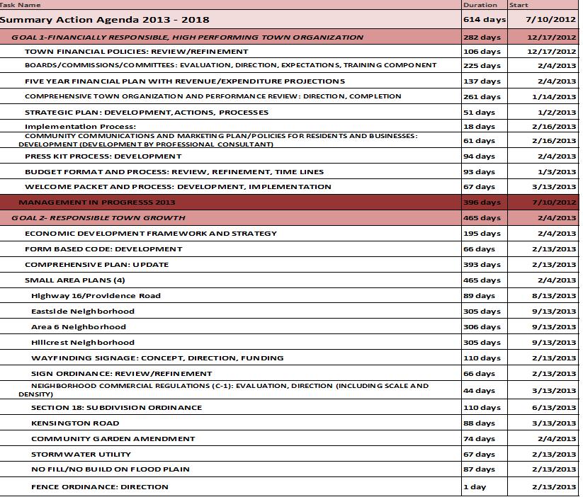
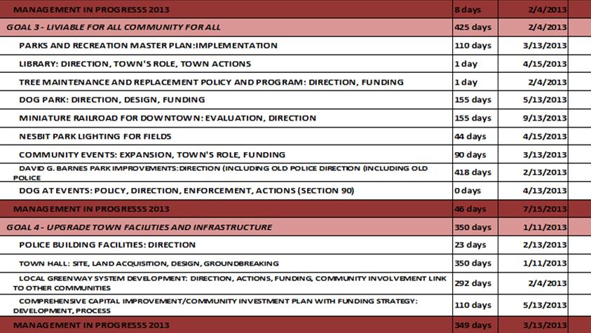
81
82 Mayor Gardner stated at this time she would hold a short recess 8:10 p.m. Break Reconvened: 8:27 p.m. Unfinished Business TA : (A request by staff on behalf of the Board of Commissioners to create a new form based downtown code by amending the Table of Contents, Sections 4 Primary Districts Established, Section 8.2 Definitions, Section 11.1 Table of Uses, Section 11.2 Lot Development Requirements, Section 16.2 Conditional Zoning and adding Section 21 Downtown Code of the Town of Waxhaw Unified Development Ordinance).- Public hearing held on September 10 th, 2013, discussion on September 24 th, October 8, 2013, October 22, 2013 and November 2, 2013). Mayor Gardner stated the next item on the agenda is TA : (A request by staff on behalf of the Board of Commissioners to create a new form based downtown code by amending the Table of Contents, Sections 4 Primary Districts Established, Section 8.2 Definitions, Section 11.1 Table of Uses, Section 11.2 Lot Development Requirements, Section 16.2 Conditional Zoning and adding Section 21 Downtown Code of the Town of Waxhaw Unified Development Ordinance).- Public hearing held on September 10 th, 2013, discussion on September 24 th, October 8, 2013, October 22, 2013 and November 2, 2013). She stated as noted this have been discussed at several meetings and Planner McCarter has an updated Power Point to present and possible action by the board after discussion. Staff McCarter- Presentation TA Downtown Code- Update Definitions & Associated Text Changes EXPLANATION OF THE REQUEST Petition TA is a request by the Waxhaw Planning and Community Development Department on behalf of the Board of Commissioners to create a new form based Downtown Code that will streamline processes for the downtown area of Waxhaw. This will be Section 21 of the Town of Waxhaw Unified Development Ordinance. Along with the concurrent rezoning request, it places new zoning on properties in the downtown area and creates a predictable public realm by controlling physical form primarily, with a lesser focus on land use. The request also includes adding terms found in the Downtown Code to Section 8 Definitions and small changes to reference the Downtown Code and the new zoning districts in Section 11.1
83 Zoning Table of Uses, the Table of Contents, Section 4 Primary Zoning Districts, Section 11.2 Schedule of District Regulations and Section 16 Amendment to the Unified Development Ordinance. REQUESTED UDO CHANGES UDO Table of Contents (see attached language) The Downtown Code section was added. Section 4 Primary Zoning Districts (see attached language) The Downtown Code zoning districts were added. Section 8.2 Definitions (see attached language) Definitions of verbiage found in the new Downtown Code were added. Section 11.1 Zoning Table of Uses (see attached language) This section was modified. Section 11.2 Lot Development Requirements (see attached language) This section was modified. Section 16 Amendment to the Unified Development Ordinance (see attached language) The Downtown Code zoning districts were added. Section 21 Downtown Code (see attached language) This section was added. PLANNING STAFF ANALYSIS In 2012, the Waxhaw Board of Commissioners hired The Lawrence Group to write a form based Downtown Code to be added to the Unified Development Ordinance. The Lawrence Group worked with staff to examine issues with the current regulations in the downtown area and also held several meetings to engage the public about what is working and what is not working in the current regulations. Close attention was paid to ways to streamline processes for the downtown area and focus on the form of development and infrastructure rather than the use. The new regulations were written with the goal of user friendliness through increased flexibility and clarity, better organization, making the standards more concise, and eliminating redundancy and subjectivity. Uses in the Downtown Code are broader in scope rather than an extensive list of uses found in the current Unified Development Ordinance. The increased flexibility is balanced with maintaining the character of the town. Along with the addition of Section 21 Downtown Code to the Unified Development Ordinance, Section 8 Definitions were amended for consistency with the new Downtown Code. Also, definitions of terms found in the new code were added. References to the
84 new Downtown Code were added to the Table of Contents and the Zoning Table of Uses and Schedule of District Regulations in Section 11. The new Downtown Code zoning districts were added to Section 4 Primary Zoning Districts Established and Section 16 Amendment to the Unified Development Ordinance. DOWNTOWN WAXHAW VISION PLAN In Section 9.2 of the Downtown Waxhaw Vision Plan, Regulating Plan & Coding Strategies, Action Items it calls for the creation of a new Downtown Code that: Permits a diversity of housing options. Allows mixed use development by right that meets the objectives of the plan. Expedites the permitting process for applications that meet the objectives of the plan. Uses regulations that are context sensitive. Implements a coding strategy focused on form, not on use. The proposed Downtown Code achieves these strategies and is therefore consistent with the action items in the Downtown Waxhaw Vision Plan. PLANNING STAFF RECOMMENDATION Planning Staff recommends approval of TA The Downtown Code will protect the character of the town and the existing neighborhoods while still allowing flexibility and more diverse uses. PLANNING BOARD RECOMMENDATION The Planning Board, at their August 19, 2013 regular meeting, voted unanimously to send a favorable recommendation on TA BOARD OF COMMISSIONERS PUBLIC HEARING The Board of Commissioners held a public hearing on the Downtown Code text amendment on September 10, The following is a list of discussion items and how staff is addressing them: The proposed NMX zoning has a maximum building height of 4 stories (Downtown Code Section ), with a maximum height of 20 per story (Downtown Code Section A). There was concern that would result in 4 story buildings with a height of 80 feet. The current OIS zoning is comparable to NMX and has a maximum height of 45 feet and is not regulated by stories (UDO Section 11.2). o Staff has added a maximum height in the NMX zoning district of 45 feet in keeping with the current OIS zoning height requirement. (This will be added to Downtown Code Section ). The proposed NMX zoning allows multi family dwellings (Downtown Code Section A). The current OIS zoning (comparable to NMX although OIS is more of a light commercial zoning) does not allow multi family dwellings (UDO Section 11.1). There
85 were objections raised regarding 4 story apartment buildings and allowing multi family in NMX. o Staff believes multi family use is appropriate for the NMX zoning district and does not recommend removing it. By limiting the building height in NMX to a maximum of 45 feet (see item above) it would eliminate the possibility of an 80 foot apartment building that was discussed at the public hearing. If the Board of Commissioners thinks it is appropriate one option provided by the consultant would be to limit multi family buildings to 20 units, so that there is still a diversity of housing types as recommended in the Waxhaw Downtown Vision Plan, but their size would be limited. The proposed NMX allows funeral homes (Downtown Code Section C). The existing OIS (comparable to NMX) does not allow funeral homes (UDO Section 11.1). There were objections raised that funeral homes would be permitted in NMX. Staff has removed this as an allowed use in NMX, as it is not currently a permitted use in OIS and removing it does not compromise the spirit of the proposed code. There was concern that a property would have to comply with the new regulations if there was substantial modification. o This requirement in the Downtown Code Section Applicability and Existing Conditions was taken directly from our current UDO Section 10 Non Conforming Situations in & 10.5 Reconstruction Prohibited. Staff recommends keeping this language to bring about gradual compliance with the new Downtown Code. There was concern about the 22 ft. minimum building height for commercial buildings in the MS and TC (Downtown Code Sections A & Section & Section ). o Staff has revised the minimum building height to 16 ft. for commercial buildings in the MS and TC, as staff and the consultant agree that this may not be appropriate for all commercial buildings. BOARD OF COMMISSIONERS SEPTEMBER 24, 2013 MEETING Infill lot height and setbacks: There was concern over consistency with adjacent existing development. Language was added to C that in the UN district, the Administrator shall require that a proposed building be within 5 feet of the adjacent Setbacks and 15 feet of the adjacent height. Language was also added to D.4 to add a minimum rear setback of 20 in NMX if it abuts UN. Tree protection: There was concern that there was not enough tree protection. Language was added to Section Site Landscaping to add additional tree protection including more protection for heritage and specimen trees.
86 Building height: There was concern that the building heights were too tall. The heights were changed in Section UN, NMX, MS and OS maximum building heights were lowered to 3 stories not to exceed 54 feet. TC was lowered to 4 stories not to exceed 72. The Lawrence Group has prepared a comparison report with examples of local form based code examples of height that is attached. Most local ordinances don t have a maximum height per story, so Waxhaw would be more stringent. Natural disasters of greater than 60% of the value of the structure require building design standards. There was discussion on removing this. Staff does not recommend removing this because the intent of the Ordinance is to bring about conformity with current standards when properties are redeveloped or significantly damaged. If this is removed then properties that are damaged by natural disasters will not be subject to any of the building design standards. Uses: Funeral homes: removed from all districts Veterinary: Removed from NMX and MS Cemetery: Removed from NMX and TC College/University: Added to NMX Artist Studio/Light Manufacturing: Separated; o Definitions added o Artist Studio: Permitted in UN (with supplemental regulations), NMX, MS and TC o Light Manufacturing: Permitted in NMX(with supplemental regulations), MS and TC Community Garden: Remove from MS and TC, add to OS Telecommunications tower: Allow in UN, NMX, MS and TC with conditional use permit Medical: Allow in NMX BOARD OF COMMISSIONERS OCTOBER 8, 2013 MEETING At the October 8, 2013 Board of Commissioners meeting, several changes were requested to the Downtown Code by the board. These changes were made and are in the final draft of the Downtown Code: Exempt TC from Renovation due to disaster in Section Applicability and Existing Conditions. In Section E.1 Change the NMX, TC & MS minimum streetscape standards to 8 foot sidewalk and 5 foot planting strip. (Applicable street sections will be changed in Street Regulating Plan In Section B Parking Design and Location, clarify language that parking must be accessed from the rear for any attached building. Front loading garaged are only permitted on a detached single family. In the MS and TC, commercial use on through lots that do not abut an alley, side street, or parking area of an adjacent property may locate their driveway in the first layer.
87 Height in UN: Attached, Single Family: 3 stories or 54 ft max.; All Other: 2 Stories or 45 ft. max. Handouts with the uses allowed for the different zoning districts separately, and a summary handout. In the NMX add regulations that there be no delivery or trash removal between 11PM and 6AM; and that hours of operation are only between 6AM and 11PM, with exceptions including hotels, bed and breakfasts, ATM, and civic/government use. BOARD OF COMMISSIONERS NOVEMBER 2, 2013 MEETING At the November 2, 2013 Board of Commissioners meeting, several changes were suggested for the Downtown Code by the board as well as the public. Changes have been made to the Downtown Code pursuant to these requests. Please refer to the Downtown Code Summary of Changes provided by the Lawrence Group that is included in your packets for a detailed description of the changes that have been made. Statement of Consistency and Reasonableness The proposed zoning of these parcels is consistent with the future planning goals of the Town of Waxhaw and the proposed zoning of this property appears to be reasonable at this time. The proposed zoning of the subject parcel does not preclude the future petition of a zoning map amendment. Summary of Changes Since November 2, 2013 This is a text amendment a request by the Waxhaw Planning & Community Development Staff on behalf of the Board of Commissioners to add a new Downtown Code to our Unified Development Ordinance Uses removed from NMX because of residents concerns expressed at November 2, 2013 BOC meeting: Hotel/Motel Bank Teller Machine Financial Institution Dry Cleaning & Laundry Services General Commercial over 10,000 sf Outside Sales (Accessory) Restaurants over 5,000 sf Indoor and Outdoor Recreation Facilities Stadiums Vehicle Rental/Leasing/Sales Nursery/Nurseries and Garden Centers Recommend 7,500 Restaurant
88 Indoor/Outdoor Do not remove. Historic homes destroyed by disaster are not required to meet building design standards. Allows historic homes to be rebuilt to standards of existing home UN & NMX reduce max height from 54 to 45 ; Max two story height for NMX facing UN This addresses height concerns expressed Add transparency requirement for Mixed-Use/Commercial of 60% This was lost previously in a corrupted file; maintains high design quality Clarify parking requirements, not to occur in front of building Restrict parking to the rear of the property UN & NMX flat roofs are not permitted Ensure appropriate roof pitch and aesthetics Attached housing must be accessed by an alley Restricts attached housing to corner lots and lots with alley access Add language to allow Zoning Administrator to assign street section Allow administrator to evaluate appropriate street section in larger development; ensures appropriate street sections are used Clarify that Additional Setbacks are Required for Congregate Care Facilities Adjacent to UN Referred to R Zoning District Only Previously Eliminate Residential Zoning Standards for Event Centers Event Centers are Not Allowed in Residential Zoning Districts Clarify Wording Regarding Screening of Mechanical Equipment Put in a Missing Word to Correct Grammatical Error Add definition for General Commercial 10,000 to 25,000 sf Needed a definition since this was added to the use table, and is not permitted in NMX Add definition for Medical Services In use table but did not previously have a definition Add Definition for Storage, Outdoor Storage Yard Clarify that it is not allowed as a principal or accessory use Modified Definition of General Office Clarify that counseling offices are included
89 4. Town Center TC A. BUILDING HEIGHT a. Principal Building 16 ft. min. 4 stories, 72 ft. max. b. Accessory Building 1 story max. B. LOT OCCUPATION 1. Lot Width 18 ft. min. 96 ft. max. 2. Lot Coverage 100% max. C. BUILDING DISPOSITION (See Sec ) a. Edgeyard not permitted b. Sideyard not permitted c. Rearyard permitted d. Courtyard permitted D. SETBACKS PRINCIPAL BUILDING*** 1. Front Setback - Principal 2. Front Setback - Secondary 0 ft. min. 6 ft. max. 0 ft. min. 3. Side Setback 0 ft. min.* 4. Rear Setback 0 ft. min.**, 20 ft. min. if abutting UN 5. Frontage Buildout 80% min at setback E. SETBACKS ACCESSORY BUILDING a. General Placement 3 rd layer only* F. PRIVATE FRONTAGES (See Sec ) a. Common Lawn not permitted b. Porch & Fence not permitted c. Terrace/Lightwell. permitted d. Forecourt permitted e. Stoop permitted f. Shopfront/Awning permitted g. Gallery permitted h. Arcade permitted G. PARKING PROVISIONS See Section *Additional setbacks in accordance with the Building Code may apply **or 15 ft. from center line of alley ***Special infill lot provisions in Section C These meetings were all open to the public Page 21-32, Section Town Center Add 20 buffer for TC abutting UN To provide additional privacy for UN Statement of Consistency and Reasonableness The zoning amendment is consistent with the future planning goals of the Town of Waxhaw and the Comprehensive Plan, and the proposed zoning amendment appears to be reasonable and in the public interest at this time because it fosters economic development in the downtown area.
90 Downtown Code Summary of Changes The following includes changes from the workshop on in preparation for the Board of Commissioners Meeting on November 12. Below are recommended code changes based on feedback from the public. Reasoning is included for each change. Uses that were changed in the tables are shown in red. This is meant to be a working document to further clarify the purpose of the ordinance. a. Section 21 Downtown Code Pg REASONING: Input from public requested allowing historic homes to be built to standards of existing home if it is destroyed due to disaster. - Compliance with all applicable standards required Compliance required of the expanded building area only and the landscaping requirements of Section 8 to the extent practical Building Standard Design Parking Driveways & Cross Access Connections Site Landscaping Utilities, Trash Containment & Loading Streetscape Improvements Sign Regulations Parking Area Expansion Minor : 1-24 Spaces + Major: 25 or more Spaces + Building Renovation or Expansion Renovation Due to Disaster (Fire, Flood, etc.) Renovation Due to Disaster with ownership and use prior to the effective date of the Downtown Code in the Town Center (TC) Renovation Due to Disaster with structures built prior to 1963, if built in accordance with the Waxhaw Historic Landmark Guidelines. + Reoccupation after Extended Vacancy (Greater than 180 days) Exterior Renovation without Expansion <60% of the Taxed Value of building Substantial Exterior Renovation without Expansion >60% of Taxed Value of building
91 Pg REASONING: Input from public requested removing Hotel/Motel from NMX. B. Lodging UN NMX MS TC OS Supplemental Regulations Hotel/Motel X X REASONING: Input from public requested removing Bank Teller Machine and Financial Institution. This does not greatly change the intent of the code. C. Office/Service UN NMX MS TC OS Supplemental Regulations Bank Teller Machine (i.e., ATM s) XS XS C.1 Financial Institution X X Pg REASONING: Current draft in Board packet was corrupted and therefore inaccurate in latest version. Below is the correct use table for Office/Service. Also included since prior drafts is the elimination of dry cleaning and laundry services from the NMX district. This is a request from the public. Eliminating Small Equipment Repair/Rental from NMX was a request, but the use was already not included in the NMX district in the use table. C. Office/Service UN NMX MS TC OS Supplemental Regulations Dry Cleaning & Laundry Services X X Funeral Homes General Office (includes Professional Services) X X X Home Occupation XS XS XS XS C.2 Medical Services (e.g. doctor s office, clinic) X X X Personal Care Services X X X Personal Services, Restricted Postal Store and Contract Station X X X Small Equipment Repair/Rental X X Veterinary Services X
92 Pg REASONING: Eliminate uses in NMX based on discussions with public and input at public workshops. Stadium was not allowed in prior drafts, but was a question at the public workshop. Recreation Facilities, Indoor; Recreation Facilities, Outdoor; and Vehicle Rental/Leasing/Sales have all been eliminated from the NMX district. These uses include an indoor swimming pool, gym or fitness center. Also included are outdoor activities such as a miniature golf course, tennis court, clubhouses, or picnic shelter. Also included is the vehicle rental/leasing/sales use which includes car sales (indoor and outdoor). In the future the recreation uses should be reevaluated for inclusion in the NMX given the ideal proximity to residential districts and the ability for users to walk from neighborhoods to fitness centers, playgrounds, tennis courts, etc. E. Civic UN NMX MS TC OS Supplemental Regulations Recreation Facilities, Indoor X X CUP Recreation Facilities, Outdoor X X CUP F. Educational/Institutional UN NMX MS TC OS Supplemental Regulations Stadium G. Automotive UN NMX MS TC OS Supplemental Regulations Vehicle Rental/Leasing/Sales XS G.4
93 Pg REASONING: Eliminate Nursery/Nurseries & Garden Centers from NMX per discussions with public. Several members of the public wanted to ensure that outdoor nurseries were not allowed in NMX. I. Agriculture UN NMX MS TC OS Supplemental Regulations Nursery / Nurseries & Garden Centers X Pg REASONING: Add additional setbacks to Congregate Care Facilities that abut UN. Additional setbacks were already in place in residential neighborhoods, including UN is an appropriate addition. Urban Neighborhood (UN) is considered a Residential District, but does not start with an R prefix. Therefore adding the language further clarifies the additional setbacks are required. 2.A.1.a Change: Add or UN to additional setback requirements Pg REASONING: Delete residential zoning district standards from Event Center, as it is not an allowed use in NMX or UN currently. The additional standard is applicable for event centers outside of the Downtown Code boundaries on larger parcels. The requirements can be struck for these supplemental standards. 1. f. When located in a residential zoning district, including UN, the lot on which the event center is located shall be a minimum of 5 acres.
94 REASONING: (Previously mentioned above as well) Large restaurants could bring traffic that is not preferred in the NMX, by neighbors and residents. A 5,000 sf size limit still provides ample space for a restaurant, but limits the size to restrict large restaurants that could require more parking and be more disruptive in a neighborhood. See above (at use table). Additional supplemental standards were added to: 4. Restaurant Pg a. In the NMX district, restaurants greater than 5,000 sf are not permitted. REASONING: Request from public to reduce height in UN district. The height was previously reduced from 3 stories and 54 for all buildings to 2 stories and 45 for detached buildings and 3 stories and 54 for attached buildings. The new requirement further reduces the single family, attached buildings to a 45 maximum height. This is adequate height for a three story townhouse. CHANGE: Attached, Single Family: 3 stories max, 45 ft max. Pg REASONING: Request from public to reduce height in NMX district. Existing height in all districts is 45 ft. New requirements are 45 ft. (based on the current max height). Also all facing development should be of similar scale. The rear property line is where the transition between districts occur. An additional rear buffer of 20 between TC and UN, and NMX and UN is also included (an addition from a previous draft). This provides appropriate buffering between development types. 4.D.2 CHANGE: 54 ft. max. height to 3 stories but no greater than 45 max. height. 2 Story Max. for buildings on lots with Principal or Secondary Frontage facing Urban Neighborhood or Residential District.
95 REASONING: Request from public to add additional rear setback buffer between TC and UN. This is applicable on one parcel on Providence Street that abuts a parcel fronting on Broome Street. Providing the additional buffer provides additional privacy for the UN. 4.D.4 ADD: 20 ft. min. if abutting UN Pg REASONING: All commercial/mixed-use buildings should have a transparency requirement. The requirement is an additional design standard that was lost in a file transfer, but is imperative to maintaining a high quality of design in new buildings. a. All Other Mixed-Use/Commercial Façades: At least 60% of the length of building along all street side building facades.
96 Pg REASONING: Clarify requirements for parking where it is located and how buildings are accessed. Address public comments about allowing infill townhouses on lots without alley or rear lane access. The requirements do not allow parking in front of buildings in any condition. The parking requirements also restrict townhouse development in UN to parcels that are either on a corner or have alley access. B. Parking Design and Location 1. Design shall follow the standards of Section 12.6 (Dimensional Requirements for Parking Spaces, Aisles, and Driveways.) 2. Parking Area Access: a. UN District - Access to off-street parking areas (open lots, car ports, and garages) is not permitted from the principal frontage for any detached house on a lot less than 60 feet wide, with the exception of mid-block lots that do not have access to an alley or side street, or on any attached building with more than 2 units. Access must be provided using a rear lane, rear alley or secondary frontage. All corner lots, regardless of lot size, must access parking areas from a rear lane, alley, minor street or secondary frontage. b. NMX, MS and TC Districts Access to off-street parking areas (open lots, car ports, and garages) is not permitted from the principal frontage for any detached house on a lot less than 60 feet wide, with the exception of mid-block lots that do not have access to an alley or side street, or on any attached building. Parking must be accessed from a rear alley, secondary frontage, minor street or driveway per Section E., with the exception of mid-block lots that do not have access to an alley or side street.
97 Parking Location Site Access/Driveway UN In the 1st Layer parking is allowed as part of a driveway with a maximum width of 12 ft. In the 1st Layer a driveway is allowed a maximum of 12 ft. or less in width and may be wider in the 2 nd and 3 rd layer. Parking is permitted in the 2 nd and 3 rd Layer. Driveway length should be 28 ft. or sufficient length so that no parked vehicles encroach into the right-of-way. Front loaded garages shall be recessed a minimum of 3 ft. behind the façade of the principal structure and are only permitted on detached single family. Rear Lane, Rear Alley, Secondary Frontage or Single Driveway per requirements in Section E NMX Commercial Use: Parking is permitted in the 2 nd and 3 rd Layer only. Driveway shall be located off of 2nd & 3rd Layer only for lots with Secondary Frontage or lots that abut a parking area that has been designed for connection or alley. Through lots that do not abut an alley, side street, or parking area of an adjacent property may locate their driveway in the first layer. Rear Alley, Secondary Frontage or Single Driveway per requirements in Section E Residential Use: In the 1st Layer parking is allowed as part of a driveway with a maximum width of 12 ft. Parking is permitted in the 2 nd and 3 rd Layer. In the 1st Layer a driveway is allowed a maximum 12 ft. in width and may be wider in the 2 nd and 3 rd layer. Driveway length should be 28 ft. or sufficient length so that no parked vehicles encroach into the right-of-way. Front loaded garages shall be recessed a minimum of 3 ft. behind the façade of the principal structure and are only permitted on detached single family. TC MS Commercial Use and Residential Use: Parking is permitted in the 2nd & 3rd Layer only on any B Street (found in Section G.3.b.); 3 rd Layer only on any A Street (found in Section G.3.b.) Through lots that do not abut an alley, side street, or parking area of an adjacent property may locate their driveway in the first layer. Residential Use: 1st Layer as part of a driveway is allowed a maximum of 10 ft. in width for lots 60 ft. or less in width at the frontage line, and 12 ft. or less in width for lots greater than 60 ft. in width at the frontage line. Driveway length should be 28 ft. or sufficient length so that no parked vehicles encroach into the rightof-way. Front loaded garages shall be recessed a minimum of 3 ft. behind the façade of the principal structure. Rear Alley, Secondary Frontage or Single Driveway per requirements in Section E
98 Pg REASONING: Further restrict flat roofs to NMX residential buildings- reducing the scale and more appropriate for neighborhood scale. This requires that buildings have an appropriate roof pitch and not a flat roof. 1. Main roofs on residential buildings must have a pitch between 6:12 and 12:12. Monopitch (shed) roofs are allowed only if they are subordinate and attached to the wall of the main building. No monopitch roof shall have a pitch less than 4:12. Flat Roofs will only be permitted through a Conditional Use Permit review process (Section 14). Flat roofs are not permitted in the UN or NMX District. Pg (In reference to Driveways and Cross-Access Connections) REASONING: Builds on clarification from Parking section. Change is based on public feedback to restrict location of attached housing in Urban Neighborhood. Restricts attached housing development to only corner lots or lots with alley access. 1. Mid-block Lot Driveways: A mid-block lot without access to a side street or alley is permitted one driveway in the principal frontage. Attached buildings with more than 2 units in the UN are only allowed access from a rear alley or secondary frontage. Pg (In reference to Mechanical Equipment and Utility Structures) REASONING: Word added to clarify intent B.3.b a. b. When located on the ground, equipment must be located in the rear or side yard and screened. Screens are vertically enclosed opaque walls made of materials which are compatible with the exterior of the building.
99 Pg REASONING: Clarification of application of street sections for easier use by both Town and Developer. The way it currently reads gives the Administrator the ability to evaluate chosen street section in larger development. It also ensures that the appropriate street sections are applied. B. Minimum Streetscape Sections Where the fronting street has not been assigned a typical section by the Administrator, development shall provide a minimum sidewalk and planting zone as follows: 1. UN Streetscape: 5 foot sidewalk, 5 foot planting strip 2. NMX, TC, MS Streetscape: 8 foot sidewalk and 5 foot planting strip or 10 foot sidewalk with tree wells.
100 Section 8 - Definitions The following definitions provide further clarification for uses added in the most recent draft code language. There was no definition for Medical Services in the first draft of the definitions. Storage, Outdoor Storage Yard was further clarified by adding as either a principal or accessory structure to the definition to clarify for the public that outdoor storage of building materials is not allowed. Definitions added to further clarify additional changes: General Commercial, 10,000 SF to 25,000 SF - A use category allowing general commercial premises between 10,000 square feet and 25,000 square feet in gross leasable area to be available for the commercial sale of merchandise, and foods (fresh and prepared), but excluding manufacturing. Medical Services - Medical facilities that provide outpatient ambulatory or outpatient health care such as emergency medical clinics; ambulatory surgical centers; dialysis centers; outpatient family planning services; community health centers and clinics; blood and organ banks; and medical offices such as physician s and dentist s office. Storage, Outdoor Storage Yard The storage of various materials including, but not limited to, lumber, pipe, bricks, stone, shingles, mulch, soil, sand, gravel and other non-hazardous materials outside of a structure, as a principal or accessory use. Delete: (strikethrough only) a. General Office - Buildings used primarily for conducting the affairs of a business, profession, service, industry, government, or like activity. This includes services that make available the knowledge and skills of their employees to sell expertise and perform professional, scientific, and technical services to others such as legal services; accounting, tax, bookkeeping, and payroll services; architectural, engineering, and related services; graphic, industrial, and interior design services; consulting services; research and development services; advertising, media, and photography services; real estate services; investment banking, securities, brokerages; and insurance-related services; and counseling offices. and, medical services such as physician s and dentist s offices.
101 Staff Analysis and Recommendation: The proposed Downtown Code is consistent with the 2030 Comprehensive Plan & Future Land Use Map and the Downtown Small Area Plan. The Planning Board voted unanimously to send a favorable recommendation on the proposed Downtown Code. Planning Staff recommends approval of the proposed Downtown Code Meeting Dates April 23, 2012 Kick Off Meeting for the Downtown Vision Plan April 30 May 3, 2012 Charrette (A public meeting every evening) May 7, 2012 Closing Presentation December 19, 2012 Public Hearing for Downtown Vision Plan Adoption (which the Land Use Plan was included in) February 21, 2013 Public Meeting for Proposed Code April 25, 2013 Joint Town Board/Planning Board Workshop July 24, 2013 Joint Town Board/Planning Board Workshop August 19, 2013 Planning Board September 10, 2013 Public Hearing September 24, 2013 BOC Discussion October 8, 2013 BOC Discussion October 22, 2013 BOC Discussion November 2, 2013 BOC Discussion November 12, 2013 Discussion & possible action Ms. Holmes She felt she and town staff had addressed all the issues from residents have been addressed and feel that now these changes are done and ready for adoption. Town Staff Recommends the following: Indoor/outdoor Recreation Facility - leave in Restaurant 7,500 Outside sales with restrictions Commissioner Diller: Commissioner Diller had a question about outside sales. He requested a definition and clarification. Ms. Holmes stated this would be a storage yard which must be an accessory. She stated restaurants can be up to 7,500 feet and that is correct. He asked about the indoor/outdoor facility and a concern. Staff is recommending to leave this in the code. Ms. Holmes stated this would pertain to such
102 as a fitness center, yoga class, climbing wall. Outdoor would be an example (NMX) would like a playground for children. Ms. Holmes recommended placing a cap such as two acres for NMX for outdoor recreation. He sees a lot of positive sides to this change and maybe an acre for NMX outdoor recreation use. This could be an apartment with a tennis court. He mentioned historic homes or structures that could be rebuilt. The text is structures built before 1923 are considered historic structures. Commissioner Blythe: She questioned the footage at 7,500 for a restaurant. She was concerned that a restaurant such as Cracker Barrel would not be allowed. Ms. Homes stated this footage was for downtown and not farther out. Being no additional comments Mayor Gardner entertained a motion to approve or disapprove the Form Base Code. Board Action: Motion by Mayor Pro Tem Kirkpatrick and seconded by Commissioner Diller to approve TA : (A request by staff on behalf of the Board of Commissioners to create a new form based downtown code by amending the Table of Contents, Sections 4 Primary Districts Established, Section 8.2 Definitions, Section 11.1 Table of Uses, Section 11.2 Lot Development Requirements, Section 16.2 Conditional Zoning and adding Section 21 Downtown Code of the Town of Waxhaw Unified Development Ordinance with the version dated November 2, 2013 plus the additional staff recommended changes and Statement of Consistency and Reasonableness that the proposed zoning changes are consistent with the Comprehensive Plan and future planning goals of the Town of Waxhaw and the proposed zoning appears to be reasonable at this time to enhance the downtown area. Motion carried unanimously. RZ : A request by staff on behalf of the Board of Commissioners, for a rezoning/map text amendment for 261 properties totaling approximately 188 acres for the proposed Downtown Code text amendment and a rezoning/map. The parcels are located in the downtown area of Waxhaw and consist of a variety of uses and zonings. The zoning of these 261 parcels currently include OIS (Office Institutional & Specialty), C2 (Highway Commercial), CU-C3 (Conditional Use General Commercial), C4 (Central Business District), I1 (Light Industrial and Service), R3 (Single Family Residential) and R4 (Single Family Residential). The proposed Downtown Code zoning districts include UN (Urban Neighborhood), NMX (Neighborhood Mixed Use), MS (Main Street), TC (Town Center), and OS
103 (Open Space). Public hearing held on September 10 th, 2013, discussion on September 24 th, October 8 th,october 22, 2013 and November 2, Mayor Gardner stated the next item on the agenda is RZ : A request by staff on behalf of the Board of Commissioners, for a rezoning/map text amendment for 261 properties totaling approximately 188 acres for the proposed Downtown Code text amendment and a rezoning/map. The parcels are located in the downtown area of Waxhaw and consist of a variety of uses and zonings. The zoning of these 261 parcels currently include OIS (Office Institutional & Specialty), C2 (Highway Commercial), CU- C3 (Conditional Use General Commercial), C4 (Central Business District), I1 (Light Industrial and Service), R3 (Single Family Residential) and R4 (Single Family Residential). The proposed Downtown Code zoning districts include UN (Urban Neighborhood), NMX (Neighborhood Mixed Use), MS (Main Street), TC (Town Center), and OS (Open Space). Public hearing held on September 10 th, 2013, discussion on September 24 th, October 8 th,october 22, 2013 and November 2, As stated before the proposed zoning changes have been discussed at several meetings. She asked for comments and possible action by the board. Staff Presentation EXPLANATION OF THE REQUEST Petition RZ is a rezoning / map amendment request by the Planning & Community Development Staff on behalf of the Town of Waxhaw Board of Commissioners of approximately ±188 acres in the downtown area. These rezonings are being submitted with a proposed text amendment which is the addition of Section 21 Downtown Code to the Waxhaw Unified Development Ordinance to allow for a form based downtown code that will streamline processes in this area. Along with the proposed Downtown Code, these rezonings will create a predictable public realm by controlling physical form primarily, with a lesser focus on land use. The properties are located on portions of Brevard Street, Blythe Mill Road, Caldwell Street, College Street, East and West North Main Street, East and West South Main Street, Givens Street, Bivens Streets, Howie Mine Road, King Street, McDonald Street, McKibben Street, Miller Drive, North and South Broad Street, North and South Broome Street, North and South Church Street, North and South Providence Street (NC HWY 16), Old Providence Road, South High Street, South Jackson Street, Price Street, NC HWY 75, Waxhaw-Indian Trail Road, Somer Street, Peyton Court, Front Street, Washington Street, McCain Street, and several unopened rights-of-way. The proposed Downtown Code rezoning would include the following Tax Parcel ID numbers: , , , , , , , , , , , , , , , , , , , , , , , , , , , , , , , , , , , , , , , ,
104 , , , , , , , , , , , , , , , , , , , , , , , , , , , , , , , , , , , , , , , , , , , , , , , , , , , , , , , , , , , , , , , , , , , , , , , , , , , , , , , , , , , , , , , , , , , , , , , , , , , , , , , , , , , , , , , , , , , , , , , , , , , , , , , , , , , , , , , , , , , , , , , , , , , , , , , , , , , , , , , , , , A, A, A, A, B, C, A, A, A, A, A, A, A, A, A, A, A, A, A, B, A, A, B, C, D, A, , A, A, A, B, A, B, A, A, A, B, A, A, A, A, B, A, B, A, A, B, C, D, E, A, A, B, A, A, A, A, C, and H. Staff has prepared a Downtown Code Rezoning Spreadsheet included in your packet that lists the parcels that are included in the proposed rezoning. This spreadsheet lists the address, owner, acreage, current zoning and proposed zoning for each parcel. LOCATION & CURRENT LAND USE The Downtown Code rezoning area is the area bound by the intersection of Blythe Mill Road and Broome Street to the north; South Main Street just beyond Rehobeth Road to the west; the north side of NC Highway 75 across from Hermitage Place subdivision to the east; and the South Providence School to the south. The study area includes the intersection of Broome Street and South Main Street, also known as Highway 16 and Highway 75, which is commonly considered the historic center of Waxhaw.
, C2 (Highway Commercial), CU-C3 (Conditional Use General Commercial), C4 (Central Business District), I1")
105 There are 261 properties covering ±188 acres located within the proposed Downtown Code area with various classifications and land uses. The zoning of these 261 parcels currently include OIS (Office Institutional & Specialty), C2 (Highway Commercial), CU-C3 (Conditional Use General Commercial), C4 (Central Business District), I1 (Light Industrial and Service), R3 (Single Family Residential) and R4 (Single Family Residential). Please reference the Downtown Code Rezoning s Current Zoning Map in your packet to see the existing zoning on the parcels. There are 3 properties within the Downtown Code rezoning boundary that were not included in the rezoning s initially due to their conditional district zoning and vested property rights. The town is sponsoring rezoning s for these properties with the property owners consent. These are the Historic Ventures Property at 300 North Broad Street, the Hinson Property located at 203 Broome Street, and the Johnson property located at 112 Somer Street. The proposed zoning districts include:
106 Urban Neighborhood (UN): The Urban Neighborhood District consists of predominately medium density residential urban fabric. It may have a wide range of building types: single, sideyard, and townhouses. Setbacks and landscaping are variable. Streets with curbs and sidewalks define medium sized blocks. Neighborhood Mixed Use (NMX): The Neighborhood Mixed Use District consists of higher density, mixed use buildings that accommodate retail, offices, townhouses and apartments. It has a tight network of streets, with wide sidewalks, steady street tree planting and buildings set close to the sidewalks. Main Street (MS): The Main Street District consists of historic, mixed use buildings that accommodate retail, offices, townhouses and apartments. It has a tight network of streets, with wide sidewalks, steady street tree planting and buildings set close to the sidewalks. The Main Street District is intended to be similar to the Town Center District, but with building heights that fit the architectural scale of historic Waxhaw. Town Center (TC): The Town Center District consists of larger mixed use buildings that accommodate retail, offices, townhouses and apartments. It has a tight network of streets with wide sidewalks, steady street tree planting and buildings set close to the sidewalk. Open Space (OS): The Open Space District consists of active and passive recreational areas and natural topography. Development in Open Space Zones shall be limited to Park Facilities and features only, and shall be approved by Conditional Use Permit only. Through the official public notice process, and at the Board of Commissioners meetings several properties were brought to our attention that warranted further consideration and the revised proposed zoning map shown on page 4 of this report reflects these changes. REVISED Proposed Downtown Code Rezoning Map
 shows the properties with proposed restrictive frontage shown in yellow.")
107 Further, some parcels in the heart of downtown located on Broome Street, West North Main Street, East North Main Street, West South Main Street and East South Main Street have proposed restrictive frontages. The map on the next page (page 5) shows the properties with proposed restrictive frontage shown in yellow. The Downtown Code designates certain frontages as unique from their general district standards to achieve a specific design. Private frontage types on properties with restricted frontage are limited to shopfront, gallery, or arcade only (shown below
108 2030 COMPREHENSIVE PLAN & FUTURE LAND USE MAP/ DOWNTOWN WAXHAW VISION PLAN In 2009, Waxhaw adopted a Comprehensive Plan that encompasses key initiatives regarding economic development; transportation; infrastructure; environmental sustainability; arts & culture; recreation & leisure; housing; education; and town
109 services. The plan recognized the historic main street as the central business district for Waxhaw. In regards to the downtown, the Comprehensive Plan recommended the following Implementation Strategies: Amend the town s development ordinance to include new downtown design standards as identified in the Downtown Small Area Plan. Identify the types of new businesses needed downtown and adjust regulations to encourage them. Work with the Waxhaw Business Association, the Waxhaw Historic Preservation Commission, adjacent neighborhoods, and the larger community to develop a Downtown Small Area Plan the addresses the following issues: appropriate land uses, landscaping and trees, business signage, interpretive signage, public spaces, pedestrian and bicycle improvements, parking and other items deemed appropriate. The Downtown Waxhaw Vision Plan was later adopted per the 2030 Comprehensive Plan recommendations on December 11, The proposed rezonings are consistent with Regulating Plan for Future Development Map shown in Section 9.2 of the Downtown Waxhaw Vision Plan. Therefore, the proposed rezonings are consistent with the 2030 Comprehensive Plan & Future Land Use Map as well as the Downtown Waxhaw Vision Plan. PLANNING STAFF ANALYSIS The proposed rezonings being submitted with the proposed Downtown Code text amendments will allow downtown properties a greater mix of uses while preserving the character of downtown. As previously stated the rezonings are consistent with the 2030 Comprehensive Plan, Future Land Use Map and the Downtown Waxhaw Vision Plan. PLANNING STAFF RECOMMENDATION Planning Staff recommends approval of RZ The rezonings, along with the proposed Downtown Code will protect the character of the town and existing neighborhoods while still allowing flexibility and more diverse uses. PLANNING BOARD RECOMMENDATION At their August 19, 2013 meeting, the Planning Board recommended approval of RZ (unanimous). BOARD OF COMMISSIONERS PUBLIC HEARING The Board of Commissioners held a public hearing on the Downtown Code rezonings on September 10, The following is a list of issues that were brought up and how staff is addressing them. North Providence Street: Several residents requested that the street be zoned UN instead of NMX. Staff has revised the proposed rezoning map to UN for the properties on N. Providence north of Price Street with the exception of the first, third and fourth properties on the west side of N. Providence north of Price Street. This will still leave a
110 transition of NMX and one TC property along N. Providence between Price Street and Howie Mine Road. The Board of Commissioners requested that staff contact the property owners of the three conditionally zoned properties in the Downtown Code rezoning boundary that were not included in the rezonings to see if they wanted to proceed with a Board of Commissioners sponsored rezoning to one of the Downtown Code zoning districts. Staff is currently working on reaching out to these property owners as requested. BOARD OF COMMISSIONERS MEETING SEPTEMBER 24, 2013 The proposed rezoning map was revised according to comments at the September 24, 2013 Board of Commissioners meeting. BOARD OF COMMISSIONERS MEETING OCTOBER 8, 2013 Please find attached a revised proposed zoning map for the October 22, 2013 Board of Commissioners meeting. This map has been changed per the discussion at the October 8, 2013 Board of Commissioners meeting. The 7 properties on West North Main Street were changed from UN and NMX to OIS per the Boards request. Terry Dale, who owns 605 and 615 N. Providence, has notified staff that he wants his properties to be zoned NMX. The proposed zoning shown on his property was changed to NMX. There was also one additional change- The property located at 108 Blythe Mill Road, that is owned by the Waxhaw Community Volunteer Fire Department, is currently being used by Union County EMS. There is an ambulance stationed at the property. The proposed zoning has been changed to NMX to allow for this use. Statement of Consistency and Reasonableness The proposed zoning of these parcels is consistent with the future planning goals of the Town of Waxhaw and the proposed zoning of this property appears to be reasonable at this time. The proposed zoning of the subject parcel does not preclude the future petition of a zoning map amendment. Power Point Presentation RZ Rezoning/Map Amendment To Add Downtown Code Zoning Disticts.

111 Since the uses in NMX have been addressed after the comments received at the November 2 BOC meeting, staff is recommending NMX for the West North Main properties that were previously shown on OIS and property owners are not opposed. Staff is also recommending UN for the Center Grove Freewill Baptist Church that is on the corner of West North Main and Jackson Street because this property is currently zoned R 3, so UN is appropriate.


112 There are various land uses and zoning districts within the rezoning boundary. The current zonings include OIS Office Institutional & specialty, C2 Highway Commercial, CU C3 Conditional Use General Commercial, C4 Central Business District, I1 Light Industrial and Service, R3 Single Family Residential, and R4 Single Family Residential.

113 The proposed re-zonings are from the Downtown Code and include UN Urban Neighborhood, NMX Neighborhood Mixed Use, MS Main Street, TC Town Center, and OS-Open Space. Statement of Consistency and Reasonableness Statement of Consistency and Reasonableness The proposed zoning of this parcel is consistent with the future planning goals of the Town of Waxhaw and the proposed zoning of this property appears to be reasonable at this time. The proposed zoning of the subject parcel does not preclude the future petition of a zoning map amendment Staff Analysis and Recommendation: The proposed re-zonings are consistent with the 2030 Comprehensive Plan & Future Land Use Map and the Downtown Small Area Plan. The Planning Board recommended approval of the proposed Downtown Code re-zonings. Planning Staff recommends approval of the proposed re-zonings.
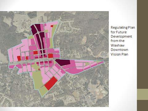
114

115 Changes since the public hearing: N. Providence Planning & Community Development office 323 N. Broome Farmers Market Property Water Tower property Red barn Properties N of E. South Main A protest petition was filed for 323 N. Broome Street on September 6, This petition is invalid for the following reasons: Not timely Does not meet the area requirement Is not on the Town of Waxhaw protest petition form

116 Another letter of protest was submitted 9/23 and signed by residents in the King Street area asking that they be left out of the new rezonings. They are opposed to NMX on McKibben Street and south of E. South Main Street. The letter was not received in time nor intended to be a protest petition, but to make the Board aware of residents concerns. UN Medium density residential, wide range of building types, medium size blocks NMX Higher density residential, mixed used buildings, wide sidewalks MS Historic, mixed use buildings, similar to TC but building heights in scale with historic downtown TC Larger mixed use buildings with a mix of uses OS Active and passive recreational areas, development limited to park facilities


117 Restrictive Frontages will achieve a specific design by limiting permitted frontages types
Town of Waxhaw Board of Commissioners. Waxhaw Police Department Community Meeting Room Thursday February 23, 2016
 Town of Waxhaw Board of Commissioners Waxhaw Police Department Community Meeting Room Thursday February 23, 2016 Petition RZ-004006-2015 A request by applicants Shirel Yaloz-Femia and Rocco Femia, on behalf
Town of Waxhaw Board of Commissioners. Waxhaw Police Department Community Meeting Room Tuesday January 12, 2016
 Town of Waxhaw Board of Commissioners Waxhaw Police Department Community Meeting Room Tuesday January 12, 2016 Petition RZ-003994-2015 A request by the Town of Waxhaw Planning & Community Development Department,
Present: Mayor Pro Tem Erin Kirkpatrick, Commissioners Joyce Blythe, Sean Poccia and Michael Stewart.
 April 9 th, 2013 Museum of the Waxhaws 6:30 p.m. Moved to: Waxhaw Woman s Club 6:40 p.m. Public Hearings/Regular Meeting Agenda The Mayor and Town Board of Commissioners met in the regular meeting location
MEETING TYPE: Board of Commissioners - Regular. MEETING DATE: 28 Feb STAFF RESPONSIBLE: Maxx Oliver. DEPARTMENT: Planning & Zoning Division
 MEETING TYPE: Board of Commissioners - Regular MEETING DATE: 28 Feb 2017 STAFF RESPONSIBLE: Maxx Oliver DEPARTMENT: Planning & Zoning Division DESCRIPTION Action on Francis Initial Zoning Petition RZ-005299-2016
MEETING TYPE: Board of Commissioners - Regular. MEETING DATE: 21 Nov STAFF RESPONSIBLE: Chris Rice. DEPARTMENT: Planning & Zoning Division
 MEETING TYPE: Board of Commissioners - Regular MEETING DATE: 21 Nov 2016 STAFF RESPONSIBLE: Chris Rice DEPARTMENT: Planning & Zoning Division DESCRIPTION Action on David Francis Text Amendment Petition
May 28, 2013 Museum of the Waxhaws 6:30 p.m. Museum of the Waxhaws. Regular Meeting
 May 28, 2013 Museum of the Waxhaws 6:30 p.m. Museum of the Waxhaws Regular Meeting The Mayor and Town Board of Commissioners met in the regular meeting location the Museum of the Waxhaws on May 28, 2013
Primary Districts Established 4
 4.1 GENERAL PURPOSE SECTION 4 PRIMARY DISTRICTS ESTABLISHED The Town of Waxhaw, North Carolina is hereby divided into PRIMARY ZONING DISTRICTS as designated herein and as shown on the Official Zoning Map.
ARTICLE 3 ZONING DISTRICTS AND ZONING MAP. Table of Contents
 ARTICLE 3 ZONING DISTRICTS AND ZONING MAP Table of Contents 3-1 Establishment of Zoning Districts... 1 A. General Use Zoning Districts... 1 B. Conditional Zoning Districts... 3 C. Overlay Zoning Districts...
Town of Holly Springs
 Meeting Date: 7/17/2018 Agenda Topic Cover Sheet / last modified June 13, 2018 Town of Holly Springs Town Council Meeting Agenda Form Agenda Placement: Public Hearing (Special Recognitions (awards, proclamations),
Item No: AIR Agenda Date: 27 Oct Staff Responsible: Chris Rice Prepared For: RE:
 Item No: AIR - 0072 Agenda Date: 27 Oct 2015 Staff Responsible: Chris Rice Prepared For: RE: DESCRIPTION Petition TA-003717-2015 is a request by staff to amend Section 21.7.3.A of the Waxhaw Unified Development
REQUEST FOR COUNCIL ACTION
 REQUEST FOR COUNCIL ACTION To: From: Mayor & City Council Dan Boles, AICP, Senior Planner Date: November 18, 2014 Subject: Applicant Presentation: Staff Presentation: Hoggan Lane Plat Amendment Jarin Dana
PLANNING COMMISSION. Agenda Item # 4.
 PLANNING COMMISSION Agenda Item # 4. CASE SUMMARY Special Use Permit Planning Commission December 5, 2012 SU-1-1212 Jeff Walton, 910-341-3260, jeff.walton@wilmingtonnc.gov Staff recommendation CONDITIONAL
TOWN OF WAXHAW P.O. Box N. Broome St. Waxhaw, N.C Telephone (704) Fax (704)
 Fax (704)") TOWN OF WAXHAW P.O. Box 6 1150 N. Broome St. Waxhaw, N.C 28173 Telephone (704) 843-2195 Fax (704) 843-2196 www.waxhaw.com Hours: Monday-Friday 8:00 a.m. to 5:00 p.m. February 16, 2015 Planning Board Regular
TOWN OF WAXHAW P.O. Box 6 1150 N. Broome St. Waxhaw, N.C 28173 Telephone (704) 843-2195 Fax (704) 843-2196 www.waxhaw.com Hours: Monday-Friday 8:00 a.m. to 5:00 p.m. February 16, 2015 Planning Board Regular
LEMOORE PLANNING COMMISSION Regular Meeting AGENDA Lemoore Council Chamber 429 C Street. May 14, :00 p.m.
 LEMOORE PLANNING COMMISSION Regular Meeting AGENDA Lemoore Council Chamber 429 C Street May 14, 2018 7:00 p.m. 1. Pledge of Allegiance 2. Call to Order and Roll Call 3. Public Comment This time is reserved
LINCOLN COUNTY PLANNING & INSPECTIONS DEPARTMENT
 To: Board of Commissioners From: Randy Hawkins, Zoning Administrator Date: August 4, 2015 Re: Planning Board recommendations (08/03/15) UDO Proposed Amendments #2015-3 Lincoln County Planning and Inspections
ARLINGTON COUNTY, VIRGINIA
 ARLINGTON COUNTY, VIRGINIA County Board Agenda Item Meeting of September 18, 2004 DATE: August 19, 2004 SUBJECTS: A. GP-297-04-1 GENERAL LAND USE PLAN AMENDMENT from Service Commercial (Personal and business
2/22/2016. Planning and Zoning. David Owens March 2016 SOME CONTEXT
 Planning and Zoning David Owens March 2016 SOME CONTEXT 1 N.C. Population 1900 1.6 million 1950 2.4 million 2015 10 million 2 3 Population Growth Housing Units/ Square Mile Source: UNC Carolina Population
STAFF PRESENT: Community Development Director: Nathan Crane Secretary: Dorinda King
 1 0 1 0 1 Highland City Planning Commission April, The regular meeting of the Highland City Planning Commission was called to order by Planning Commission Chair, Christopher Kemp, at :00 p.m. on April,.
Marcel Williams, MPC Project Planner
 TO: FROM: The Planning Commission MPC Staff DATE: SUBJECT: Petition to Rezone Property Heath Shelton, Owner Jay Maupin, Agent 2026 Habersham Street Aldermanic District: 2, Bill Durrence County Commission
Planning Department Oconee County, Georgia
 Planning Department Oconee County, Georgia STAFF REPORT REZONE CASE #: 6985 DATE: October 31, 2016 STAFF REPORT BY: Andrew C. Stern, Planner APPLICANT NAME: Williams & Associates, Land Planners PC PROPERTY
Town of Holly Springs Town Council Meeting Agenda Cover Sheet
 Town of Holly Springs Town Council Meeting Agenda Cover Sheet Meeting Date: Feb. 19, 2019 Agenda Item #: 8c Agenda Placement: Public Hearing (Recognitions (awards, proclamations), Requests & Communications
Planning Board. December 17, 2013 at 7:00pm Council Chambers, 201 S Main St. Meeting Agenda
 Planning Board Meeting Agenda December 17, 2013 at 7:00pm Council Chambers, 201 S Main St Invocation 1. Approve minutes of the November 4, 2013 special meeting 2. Approve minutes of the November 19, 2013
Dan Buday, Judy Clock, June Cross, Becky Doan, Toni Felter, Francis (Brownie) Flanders and John Hess
 Flanders and John Hess") Monday, December 13, 2010 7:00 p.m. 210 State Street, City Hall, Council Chambers, Charlevoix, Michigan A) CALL TO ORDER The meeting was called to order by Chairman John Hess at 7:03 p.m. B) ROLL CALL
Monday, December 13, 2010 7:00 p.m. 210 State Street, City Hall, Council Chambers, Charlevoix, Michigan A) CALL TO ORDER The meeting was called to order by Chairman John Hess at 7:03 p.m. B) ROLL CALL
PROCEEDINGS OF THE ST. CLOUD PLANNING COMMISSION. A meeting of the St. Cloud Planning Commission was held on May 10, 2011, at 6 p.m.
 PROCEEDINGS OF THE ST. CLOUD PLANNING COMMISSION A meeting of the St. Cloud Planning Commission was held on May 10, 2011, at 6 p.m. in the St. Cloud City Hall Council Chambers. Members present were Anderson,
O-I (Office-Institutional) and AG-1(Agricultural)
 and AG-1(Agricultural)") PROPERTY INFORMATION ADDRESS 3503 and 3505 Bethany Bend DISTRICT, LAND LOTS 2/1 973 and 974 OVERLAY DISTRICT State Route 9 PETITION NUMBERS EXISTING ZONING O-I (Office-Institutional) and AG-1(Agricultural)
PROPERTY INFORMATION ADDRESS 3503 and 3505 Bethany Bend DISTRICT, LAND LOTS 2/1 973 and 974 OVERLAY DISTRICT State Route 9 PETITION NUMBERS EXISTING ZONING O-I (Office-Institutional) and AG-1(Agricultural)
Town of Cary, North Carolina Rezoning Staff Report 13-REZ-31 Weston PDD Amendment at Centregreen Park Town Council Meeting March 13, 2014
 Town of Cary, North Carolina Rezoning Staff Report 13-REZ-31 Weston PDD Amendment at Centregreen Park Town Council Meeting March 13, 2014 REQUEST This proposed amendment to the Town of Cary Official Zoning
Rezoning Petition ZONING COMMITTEE RECOMMENDATION September 6, 2011
 Rezoning Petition 2011-044 ZONING COMMITTEE RECOMMENDATION September 6, 2011 REQUEST LOCATION SUMMARY OF PETITION PROPERTY OWNER PETITIONER AGENT/REPRESENTATIVE Current Zoning: BP(CD), business park, conditional
HB-S RM8-S RS9 RM18 HB-S RS9 DOCKET #: W2872. PROPOSED ZONING: RM8-S (Child Day Care Center) EXISTING ZONING: RS9 and RM8-S
 EXISTING ZONING: RS9 and RM8-S") 150' 80' RS9 UNIVERSITY PW STANLEYVILLE DR HB-S LB 123' 70' PROPOSED BELTWAY!( RM8-S S 289' NOEL DR 202' NITA AV MILL CREEK DOCKET #: W2872 PROPOSED ZONING: RM8-S (Child Day Care Center) EXISTING ZONING:
150' 80' RS9 UNIVERSITY PW STANLEYVILLE DR HB-S LB 123' 70' PROPOSED BELTWAY!( RM8-S S 289' NOEL DR 202' NITA AV MILL CREEK DOCKET #: W2872 PROPOSED ZONING: RM8-S (Child Day Care Center) EXISTING ZONING:
City of Fayetteville, Arkansas Page 1 of 1
 City of Fayetteville, Arkansas 113 West Mountain Street Fayetteville, AR 72701 (479) 575-8323 Legislation Text File #: 2015-0400, Version: 1 RZN 15-5148 (402 E. 7TH ST./NIEDERMAN): AN ORDINANCE REZONING
Town of Cary, North Carolina Rezoning Staff Report 14-REZ-31 Cary Park PDD Amendment (Waterford II) Town Council Meeting January 15, 2015
 Town Council Meeting January 15, 2015") Town of Cary, North Carolina Rezoning Staff Report 14-REZ-31 Cary Park PDD Amendment (Waterford II) Town Council Meeting January 15, 2015 REQUEST To amend the Town of Cary Official Zoning Map by amending
Town of Cary, North Carolina Rezoning Staff Report 14-REZ-31 Cary Park PDD Amendment (Waterford II) Town Council Meeting January 15, 2015 REQUEST To amend the Town of Cary Official Zoning Map by amending
PARISH OF ASCENSION OFFICE OF PLANNING AND DEVELOPMENT PLANNING DEPARTMENT
 PARISH OF ASCENSION OFFICE OF PLANNING AND DEVELOPMENT PLANNING DEPARTMENT 1. Meeting Called to Order by Chairman 2. Roll Call of Members 3. Pledge of Allegiance 4. Introduction of Staff 5. Minutes (A)
CITY OF ALBERT LEA PLANNING COMMISSION ADVISORY BOARD
 CITY OF ALBERT LEA PLANNING COMMISSION ADVISORY BOARD 9/1/2015, 5:30 p.m. City Council Chambers AGENDA A. CALL TO ORDER AND ROLL CALL B. APPROVAL OF THE AGENDA C. APPROVAL OF MINUTES 1. PC Minutes from
CITY OF ELK GROVE CITY COUNCIL STAFF REPORT
 AGENDA ITEM NO. 9.2 CITY OF ELK GROVE CITY COUNCIL STAFF REPORT AGENDA TITLE: A public hearing to consider a Specific Plan Amendment to the Laguna Ridge Specific Plan and a Rezone of approximately 4.14
AGENDA ITEM. Two Separate Public Hearings relating to the Eighth Avenue S./Orange Place Enclave Annexation
 DATE PREPARED: May 20, 2015 AGENDA ITEM PREPARED BY: Marisa M. Barmby, AICP, Senior Planner Central Florida Regional Planning Council AGENDA DATE: June 1, 2015 and June 8, 2015 REQUESTED ACTION: Two Separate
Spartanburg County Planning and Development Department
 Spartanburg County Planning and Development Department MINUTES Planning and Development Commission County Council Chambers, 4:30 p.m. June 6, 2017 Members Present: Members Absent: Staff Present: Whit Kennedy,
THE AREA PLAN COMMISSION OF ST. JOSEPH COUNTY, IN AGENDA
 THE AREA PLAN COMMISSION OF ST. JOSEPH COUNTY, IN AGENDA Tuesday, June 20, 2017 Fourth-Floor Council Chambers 3:30 p.m. County-City Building, South Bend, IN PUBLIC HEARINGS: 1. Rezonings: A. A combined
AGENDA ITEM COVER SHEET
 AGENDA ITEM COVER SHEET Use this form when submitting items for the Town Council Agenda PUBLIC HEARING No. 06 Meeting Date: 11/21/2017 Requesting Department: Presenter(s): Planning Department Amanda Bunce,
PLANNING COMMISSION MEETING November 6, :00 P.M. COMMISSION ROOM/CITY HALL AGENDA
 City of Auburndale Auburndale, Florida 33823 #1 Bobby Green Plaza P. O. Box 186 Community Development Department Phone (863) 965-5530 Fax (863) 965-5507 PLANNING COMMISSION MEETING 4:00 P.M. COMMISSION
VILLAGE OF DOWNERS GROVE PLAN COMMISSION VILLAGE HALL COUNCIL CHAMBERS 801 BURLINGTON AVENUE. January 7, :00 p.m. AGENDA
 VILLAGE OF DOWNERS GROVE PLAN COMMISSION VILLAGE HALL COUNCIL CHAMBERS 801 BURLINGTON AVENUE January 7, 2019 7:00 p.m. 1. Call to Order AGENDA 2. Roll Call a. Pledge of Allegiance 3. Approval of Minutes
A favorable recommendation to the City Council is requested.
 To: Sycamore Plan Commission From: Brian Gregory, City Manager Date: November 9, 2017 Re: November 13, 2017 Plan Commission Meeting The Plan Commission has one action item and three workshop items. I.
PLANNING COMMISSION STAFF REPORT
 PLANNING COMMISSION STAFF REPORT West Capitol Hill Zoning Map Amendment Petition No. PLNPCM2011-00665 Located approximately at 548 W 300 North Street, 543 W 400 North Street, and 375 N 500 West Street
A. Consideration of the unapproved December 8, 2015 minutes B. Consideration of the unapproved January 12, 2016 minutes
 OFFICIAL AGENDA PLANNING & ZONING COMMISSION CITY OF STARKVILLE, MISSISSIPPI MEETING OF TUESDAY, April 12, 2016 CITY HALL - COURT ROOM, 110 West Main Street, 5:30 PM I. CALL TO ORDER II. III. IV. PLEDGE
City of Sachse, Texas Page 1
 City of Sachse, Texas Meeting Agenda 3815 Sachse Road, Building B Sachse, TX 75048 Planning & Zoning Commission Monday, September 24, 2018 6:30 PM Council Chambers Conference Room / Council Chambers To
CITY OF ST. CLOUD PLANNING COMMISSION AGENDA th STREET; BUILDING A, 3 rd FLOOR, CITY COUNCIL CHAMBERS TUESDAY, DECEMBER 19, 2017, 6:00 PM
 CITY OF ST. CLOUD PLANNING COMMISSION AGENDA 1300 9 th STREET; BUILDING A, 3 rd FLOOR, CITY COUNCIL CHAMBERS TUESDAY, DECEMBER 19, 2017, 6:00 PM OPENING BUSINESS: Pledge of Allegiance Roll Call Approval
M-- I NUTES GLYNN COUNTY PLANNING COMMISSION OCTOBER 5, :00 A.M. Wayne Stewart, Chairman Georgia DeSain Glenda Jones Jack Kite Richard Parker
 M-- NUTES GLYNN COUNTY PLANNNG COMMSSON OCTOBER 5, 1993 9:00 A.M. PRESENT: ABSENT: ALSO PRESENT: STAFF PRESENT: Wayne Stewart, Chairman Georgia DeSain Glenda Jones Jack Kite Richard Parker ra Moore Lee
RS9 LB-S RSQ-S RS9 RS9 DOCKET: W2822 PROPOSED ZONING: LB EXISTING ZONING: RS-9. PETITIONER: J&J Properties of W-S, LLC, for property owned by Same
 HAYMOUNT ST RS9 IP DOCKET: W2822 PROPOSED ZONING: LB POPE RD CLEMMONSVILLE RD EXISTING ZONING: RS-9 RSQ-S LB-S OLD SALISBURY RD WINSTON-SALEM ZONING FORSYTH COUNTY ZONING PETITIONER: J&J Properties of
BOARD OF ZONING ADJUSTMENT STAFF REPORT Date: April 1, 2019
 # 3 BOA-000865-2019 BOARD OF ZONING ADJUSTMENT STAFF REPORT Date: April 1, 2019 CASE NUMBER 6244 APPLICANT NAME LOCATION VARIANCE REQUEST Fort Conde Restoration Venture, LLC 113-A Monroe Street (Southeast
Lincoln County Board of Commissioner s Agenda Item Cover Sheet
 Lincoln County Board of Commissioner s Agenda Item Cover Sheet Board Meeting Date: Agenda Item Type: Consent Agenda: Public Hearing: Regular Agenda: Presentation Time (est): Submitting Person: Phone Number/Ext:
FRANKLIN COUNTY PLANNING BOARD. May 8, 2018
 FRANKLIN COUNTY PLANNING BOARD May 8, 2018 The Franklin County Planning Board held its regular monthly meeting on Tuesday, May 8, 2018 in the Franklin County Administration Building, Commissioners Meeting
MINUTES. Council Members Present: Mayor Sears, Councilmen James Cobb, Tim Sack and Hank Dickson and Councilwomen Linda Hunt-Williams and Cheri Lee.
 Holly Springs Town Council Regular Meeting Sept. 2, 2014 MINUTES The Holly Springs Town Council met in regular session on Tuesday, Sept. 2, 2014 in the Council Chambers of Holly Springs Town Hall, 128
RM-8-S(Multifamily andtownhouse) RS9. RM-8-S(Multifamily) FLOODWAY FLOODWAYFRINGE
 RS9. RM-8-S(Multifamily) FLOODWAY FLOODWAYFRINGE") RS9 RM-8-S(Multifamily andtownhouse) RM-8-S(Multifamily) FLOODWAY FLOODWAYFRINGE February 21, 2001 Shadow Group, LLC c/o Barbara Greene P. O. Box 41229 Greensboro, NC 27404 RE: ZONING MAP AMENDMENT W-2452
RS9 RM-8-S(Multifamily andtownhouse) RM-8-S(Multifamily) FLOODWAY FLOODWAYFRINGE February 21, 2001 Shadow Group, LLC c/o Barbara Greene P. O. Box 41229 Greensboro, NC 27404 RE: ZONING MAP AMENDMENT W-2452
CITY OF MERCED Planning Commission MINUTES
 CITY OF MERCED Planning Commission MINUTES Merced City Council Chambers Wednesday, December 4, 2013 Vice-Chairperson MACKIN called the meeting to order at 7:00 p.m., followed by a moment of silence and
MEETING MINUTES GRAND HAVEN CHARTER TOWNSHIP PLANNING COMMISSION APRIL 18, 2016
 MEETING MINUTES GRAND HAVEN CHARTER TOWNSHIP PLANNING COMMISSION APRIL 18, 2016 I. CALL TO ORDER Kantrovich called the meeting of the Grand Haven Charter Township Planning Commission to order at 7:30 p.m.
Request. Recommendation. Recommended Motion. Planning Division Department of Community and Economic Development
 PLANNING COMMISSION STAFF REPORT Legislative Item 900 South 900 East Rezone Zoning Map Amendment PLNPCM2010-00360 700 East 900 East, 700 South 900 South December 12, 2012 Applicant: City Council Luke Garrott
Page # 1 of 2 Posted: March 4, 2016
 For More Information, Contact: Kathy Rathel Customer Service Technician City of Winter Garden 300 West Plant Street Winter Garden, FL 34787 407.656.4111 ext. 5149 krathel@cwgdn.com PLANNING & ZONING BOARD
DRAFT Smithfield Planning Board Minutes Thursday, May 7, :00 P.M., Town Hall, Council Room
 DRAFT Smithfield Planning Board Minutes Thursday, May 7, 2015 6:00 P.M., Town Hall, Council Room Members Present: Chairman Eddie Foy Vice-Chairman Stephen Upton Daniel Sanders Gerald Joyner Mark Lane Jack
Petition R17-12 Villages at Skybrook North Conditional District Rezoning Revision to delete 10 garage recess requirement.
 Petition R17-12 Villages at Skybrook North Conditional District Rezoning Revision to delete 10 garage recess requirement. PART 1: PROJECT SUMMARY Applicant: Laureldale, LLC Property Owner: Laureldale,
Honorable Mayor and Members of the City Council
 Office of the City Manager ACTION CALENDAR June 11, 2013 To: From: Honorable Mayor and Members of the City Council Christine Daniel, City Manager Submitted by: Eric Angstadt, Director, Planning & Development
RS9-S (Residential Building, Single Family)
") SHERWOOD FOREST RD RS9-S (Residential Building, Single Family) COUNTRY CLUB RD S 200 66 MAYFIELD RD 132 MUIRFELD DR (PVT) TURNBERRY CT (PVT) MERION CT (PVT) 191 MAYFIELD RD ANITA DR PINETUCK LN (PVT) MUIRFELD
SHERWOOD FOREST RD RS9-S (Residential Building, Single Family) COUNTRY CLUB RD S 200 66 MAYFIELD RD 132 MUIRFELD DR (PVT) TURNBERRY CT (PVT) MERION CT (PVT) 191 MAYFIELD RD ANITA DR PINETUCK LN (PVT) MUIRFELD
ORDINANCE NO. NOW, THEREFORE, BE IT ORDAINED BY THE CITY COUNCIL OF THE CITY OF BRYAN, TEXAS:
 LOCATION MAPS: ORDINANCE NO. AN ORDINANCE OF THE CITY OF BRYAN, TEXAS, AMENDING CHAPTER 130, ZONING, OF THE CITY OF BRYAN CODE OF ORDINANCES, BY CHANGING THE ZONING CLASSIFICATION FROM AGRICULTURAL - OPEN
CITY OF BELLEVIEW REGULAR COMMISSION MEETING AGENDA
 CITY OF BELLEVIEW REGULAR COMMISSION MEETING AGENDA BELLEVIEW CITY HALL Commission Room Mayor CHRISTINE K. DOBKOWSKI Seat 1 MICHAEL J. GOLDMAN Seat 2 GARY W. ERNST 1/15/2019 Seat 3 RONALD T. LIVSEY 6:00
TOWN OF CARY. PARCEL INFORMATION Parcel # Realid # Area
 TOWN OF CARY CONDITIONAL USE ZONING PERMIT 00-REZ-37 / 00-LPA-20 APPLICANT(S) Salem Castles, Inc. C/o Thomas Booth 8312 Fayetteville Rd., Suite E Raleigh, NC 27603 OWNER(S) Carroll and Shelia Ogle 215
REZONING, COMPREHENSIVE PLAN AMENDMENT, & UDO AMENDMENT PACKET
 TOWN OF HOLLY SPRINGS REZONING, COMPREHENSIVE PLAN AMENDMENT, & UDO AMENDMENT PACKET General Use Rezoning, Conditional Use Rezoning, Comprehensive Plan Amendment, and Unified Development Ordinance Amendment
Town of Round Hill Planning Commission Meeting July 11, :00 p.m.
 Town of Round Hill Planning Commission Meeting July 11, 2017 7:00 p.m. A regular meeting of the Town of Round Hill Planning Commission was held Tuesday, July 11, 2017, at 7:00 p.m. at the Town Office 23
Staff Report PLANNING DIVISION COMMUNITY & ECONOMIC DEVELOPMENT. Alley Closure
 Staff Report PLANNING DIVISION COMMUNITY & ECONOMIC DEVELOPMENT To: From: Salt Lake City Planning Commission Doug Dansie, 801-535-6182, doug.dansie@slcgov.com Date: March 23, 2016 Re: PLNPCM2015-00941
09/15 Agenda. Documents: 9.3 PB AGENDA.PDF Documents: STAFF REPORT.PDF Documents: STAFF REPORT.PDF.
 1. 09/15 Agenda Documents: 9.3 PB AGENDA.PDF 2. 1509-1 Documents: 1509-1 STAFF REPORT.PDF 3. 1509-2 Documents: 1509-2 STAFF REPORT.PDF 4. 09/15 Minutes Documents: 09.02.15 PB MINUTES.PDF IREDELL COUNTY
PLANNING AND ZONING COMMISSION MARCH 28, 2018 CITY HALL S COUNCIL 5:00 P.M.
 PLANNING AND ZONING COMMISSION MARCH 28, 2018 CITY HALL S COUNCIL CHAMBERS @ 5:00 P.M. P&Z PRESENT P&Z ABSENT STAFF PRESENT GUESTS PRESENT Ned Sheats Julio Cerda Jaime Acevedo Carlos Chapa John R. Guerra
Master Plan Review SILVER SPRING CBD. Approved and Adopted February Updated January 2013
 Master Plan Review SILVER SPRING CBD Approved and Adopted February 2000 BACKGROUND ZONING CODE REWRITE In 2007, the Montgomery County Council directed the Planning Department to undertake a comprehensive
Town Center South End Development Area District
 175.28 ESTABLISHMENT OF DISTRICTS. In order to carry out the purpose and intent of this chapter, the area of the is hereby divided into eighteen (18) Zoning District Classifications and one overlay zoning
PLANNING AND ZONING COMMISSION FEBRUARY 20, :30 P.M. PLANNING AND ZONING MEMBERS PRESENT MEMBERS ABSENT: STAFF PRESENT:
 PLANNING AND ZONING COMMISSION FEBRUARY 20, 2018 5:30 P.M. PLANNING AND ZONING MEMBERS PRESENT Chair Lester Fettig Omar Crisp Paulino Castillo Lydia Alaniz Bryant Ward Jessica Walker Jeremy Langley MEMBERS
City of Charlotte. Charlotte-Mecklenburg Government Center 600 East 4th Street Charlotte, NC Zoning Agenda. Monday, December 14, 2015
 City of Charlotte Charlotte-Mecklenburg Government Center 600 East 4th Street Charlotte, NC 28202 Monday, Council Chambers City Council Zoning Meeting - Mayor Jennifer W. Roberts - - Mayor Pro-Tem Vi Lyles
Implementation. Approved Master Plan and SMA for Henson Creek-South Potomac 103
 Implementation Approved Master Plan and SMA for Henson Creek-South Potomac 103 104 Approved Master Plan and SMA for Henson Creek-South Potomac Sectional Map Amendment The land use recommendations in the
Town of Holly Springs Town Council Meeting Agenda Cover Sheet
 Town of Holly Springs Town Council Meeting Agenda Cover Sheet Meeting Date: Jan. 15, 2019 Agenda Item #: 7d Agenda Placement: Public Hearing (Recognitions (awards, proclamations), Requests & Communications
Conditional Use Permit case no. CU 14-06: Bristol Village Partners, LLC
 PLANNING AND ZONING COMMISSION STAFF REPORT August 7, 2014 Conditional Use Permit case no. CU 14-06: Bristol Village Partners, LLC CASE DESCRIPTION: LOCATION: LEGAL DESCRIPTION: EXISTING LAND USE: ZONING:
Zoning Regulations of the Town of Redding Connecticut
 Zoning Regulations of the Town of Redding Connecticut Statutory zoning authority was adopted for the Town of Redding, and a Zoning Commission established as provided by law, at a Town Meeting held May
A REGULAR MEETING MINUTES PLANNING AND ZONING BOARD JANUARY 05, 2009
 A REGULAR MEETING MINUTES PLANNING AND ZONING BOARD JANUARY 05, 2009 CALL TO ORDER Vice-Chairman Jerry Carris called the meeting of the City of Winter Garden Planning and Zoning Board to order at 6:38
Lincoln County Board of Commissioner s Agenda Item Cover Sheet
 Lincoln County Board of Commissioner s Agenda Item Cover Sheet Board Meeting Date: Agenda Item Type: Consent Agenda: Public Hearing: Regular Agenda: Presentation Time (est): Submitting Person: Phone Number/Ext:
LOCATION MAP: AERIAL PHOTOGRAPH, 2015:
 LOCATION MAP: AERIAL PHOTOGRAPH, 2015: ORDINANCE NO. AN ORDINANCE OF THE CITY OF BRYAN, TEXAS, AMENDING CHAPTER 130, ZONING, OF THE CITY OF BRYAN CODE OF ORDINANCES, BY CHANGING THE ZONING CLASSIFICATION
PUBLIC HEARINGS Loren and Debra Pelzer Variance for additional approach on parcel
 ALBANY TOWNSHIP PLANNING COMMISSION Monthly Meeting and PUBLIC HEARING February 13, 2018 The February 13, 2018 meeting of the Albany Planning Commission was called to order at 7:30 P.M. by Chair Ryan Pratt
COUNTY OF LINCOLN, NORTH CAROLINA
 COUNTY OF LINCOLN, NORTH CAROLINA 302 NORTH ACADEMY STREET, SUITE A, LINCOLNTON, NORTH CAROLINA 28092 PLANNING AND INSPECTIONS DEPARTMENT 704-736-8440 OFFICE 704-732-9010 FAX To: George Wood, county manager
Tyrone Planning Commission Agenda May 24, :00 PM
 Tyrone Planning Commission Agenda May 24, 2018 7:00 PM Planning Commission I. Call to Order Jeff Duncan Chairman II. Approval of Agenda David Nebergall Vice-Chairman Carl Schouw Commissioner Dia Hunter
Ann Item # AGENDA MEMORANDUM
 Ann Item # AGENDA MEMORANDUM Meeting Date: January 7, 2014 To: From: Title: Honorable Mayor and Members of Town Council Mark Stevens, Town Manager Ordinance No. 2013 37: An Ordinance Approving a Public
Meeting Announcement and Agenda Mt. Pleasant Zoning Board of Appeals. Wednesday, April 25, :00 p.m. City Hall Commission Chamber
 Meeting Announcement and Agenda Mt. Pleasant Zoning Board of Appeals Wednesday, April 25, 2018-7:00 p.m. City Hall Commission Chamber I. Roll Call: Assmann, Berkshire, Friedrich, Orlik, Raisanen, White
BLUE ASH CITY COUNCIL. October 27, 2016
 Page 1 1. MEETING CALLED TO ORDER A special meeting of the Council of the City of Blue Ash, Ohio, was held on October 27, 2016. Mayor Lee Czerwonka called the meeting to order in the Blue Ash Conference
Indicates Council-recommended changes Introduced by: Mr. Tackett Date of introduction: June 14, 2016 SUBSTITUTE NO. 1 TO ORDINANCE NO.
 Indicates Council-recommended changes Introduced by: Mr. Tackett Date of introduction: June 14, 2016 SUBSTITUTE NO. 1 TO ORDINANCE NO. 16-067 TO AMEND NEW CASTLE COUNTY CODE CHAPTER 40 (ALSO KNOWN AS THE
ARLINGTON COUNTY, VIRGINIA
 ARLINGTON COUNTY, VIRGINIA County Board Agenda Item Meeting of July 19, 2014 DATE: July 8, 2014 SUBJECTS: A. ZOA-14-03 Zoning Ordinance amendments to: 1. Revise Map 34-1 (Sign Map) to update the placement
Lincoln County Board of Commissioner s Agenda Item Cover Sheet
 Lincoln County Board of Commissioner s Agenda Item Cover Sheet Board Meeting Date: Agenda Item Type: Consent Agenda: Public Hearing: Regular Agenda: Presentation Time (est): Submitting Person: Phone Number/Ext:
General District Zoning Cheat Sheet
 General District Zoning Cheat Sheet Initial zoning and rezoning of property included in the application that would allow uses in the proposed district subject to the standards of the Unified Development
MINUTES OF THE REGULAR MEETING OF. May 08, Staff members present: Jim Hewitt, Ginny Owens, David Mahoney
 -- '" LEAVENWORTH COUNTY PLANNING COMMISSION MINUTES OF THE REGULAR MEETING OF May 08, 1996 Meeting called to order at 6:33p.m. f^ Members present: John Hattok, Peggy Heintzelman, Mark Kole, Sam Maxwell,
Mayor Robert Backon, Mayor Pro Tem Robert Megowen, Councilors Rachel Lankton, Gernot Joachim, Mike Needham, and Dan Salo.
 REGULAR MEETING HOUGHTON CITY COUNCIL WEDNESDAY, NOVEMBER 13, 2013 5:30 p.m. CITY COUNCIL CHAMBERS, CITY CENTER PRESENT: Mayor Robert Backon, Mayor Pro Tem Robert Megowen, Councilors Rachel Lankton, Gernot
CITY OF MONTROSE PLANNING COMMISSION AGENDA City Council Chambers, 107 S Cascade Ave., Montrose, Colorado 5:00 p.m.
 CITY OF MONTROSE PLANNING COMMISSION AGENDA City Council Chambers, 107 S Cascade Ave., Montrose, Colorado 5:00 p.m., October 24, 2018 The 11:00 rule will be enforced. All public hearings scheduled and
Dennis Bordeaux Inspections Manager NOTICE OF PUBLIC HEARING NEW HANOVER COUNTY PLANNING BOARD MARCH 7, 2013
 NEW HANOVER COUNTY PLANNING & INSPECTIONS DEPARTMENT 230 GOVERNMENT CENTER DRIVE, SUITE 110 WILMINGTON, NORTH CAROLINA 28403 TELEPHONE (910) 798-7165 FAX (910) 798-7053 Chris O Keefe, AICP Planning & Inspections
Staff presented two options for the Commission to consider recommending to Town Council:
 Attendance: Chair Darrell Page; Commissioners: Ann Holland, Scott Burroughs, Steve Clark, Pam Barger, Pam Carter, Michael Aldridge (arrived at 7:39); Hilda Keeney, Planning and Zoning Clerk; Kassie Watts,
NOTICE OF MEETING AND AGENDA FOR THE PLANNING COMMISSION OF SPRINGVILLE, UTAH... JANUARY 23, 2018
 NOTICE OF MEETING AND AGENDA FOR THE PLANNING COMMISSION OF SPRINGVILLE, UTAH............................ JANUARY 23, 2018 Notice is hereby given that the Planning Commission will hold a public meeting
Action Recommendation: Budget Impact:
 City of Fayetteville Staff Review Form 2018-0477 Legistar File ID 9/18/2018 City Council Meeting Date - Agenda Item Only N/A for Non-Agenda Item Garner Stoll Submitted By 8/28/2018 Submitted Date Action
CITY OF TAFT PLANNING COMMISSION REGULAR MEETING WEDNESDAY, JANUARY 20, 2016 CITY HALL COUNCIL CHAMBERS 209 E. KERN ST.
 CITY OF TAFT PLANNING COMMISSION REGULAR MEETING AGENDA WEDNESDAY, JANUARY 20, 2016 CITY HALL COUNCIL CHAMBERS 209 E. KERN ST., TAFT, CA 93268 AS A COURTESY TO ALL - PLEASE TURN OFF CELL PHONES Any writings
ROSEMEAD CITY COUNCIL STAFF REPORT
 ROSEMEAD CITY COUNCIL STAFF REPORT TO THE HONORABLE MAYOR AND CITY COUNCIL FROM JEFF ALLRED CITY MANAGER DATE JUNE 9 2015 6 SUBJECT MUNICIPAL CODE AMENDMENT 15 02 AMENDING CHAPTERS 17 04 AND 17 72 OF TITLE
CROMARTIE ST 220 WALLACE ST WINSTON-SALEM STATEUNIVERSITY STADIUM DR
 CROMARTIE ST 220 CROMARTIE ST (PVT) 150 10 WALLACE ST WINSTON-SALEM STATEUNIVERSITY STADIUM DR March 15, 2001 Winston-Salem State University (State of North Carolina) c/o Phillip Gilley 601 Martin Luther
Town of Holly Springs
 Meeting Date: 9/18/2018 Agenda Topic Cover Sheet / last modified June 13, 2018 Town of Holly Springs Town Council Meeting Agenda Form Agenda Placement: Public Hearing (Special Recognitions (awards, proclamations),
Action Recommendation: Budget Impact:
 City of Fayetteville Staff Review Form 2018-0744 Legistar File ID 1/3/2019 City Council Meeting Date - Agenda Item Only N/A for Non-Agenda Item Garner Stoll 12/14/2018 CITY PLANNING (630) Submitted By