PLANNING COMMISSION AGENDA February 13, 2017
|
|
|
- Christina Rogers
- 5 years ago
- Views:
Transcription
1 PLANNING COMMISSION AGENDA February 13, :00 P.M CITY HALL I. ANNOUNCEMENTS: II. MINUTES: Approval of the December 12, 2016 Planning Commission Meeting Minutes Approval of the December 19, 2016 Planning Commission Workshop Minutes Approval of the January 6, 2016 Pre-Planning Commission Minutes Approval of the February 10, 2017 Pre-Planning Commission Minutes III. PUBLIC HEARING-SWEARING IN: Do you solemnly swear or affirm that the responses given and statements made in this hearing before the Planning Commission will be the whole truth and nothing but the truth. If so, answer, I do. IV. PUBLIC HEARING-CONSENT ITEMS: (All matters included under the Consent Agenda are considered routine by the Planning Commission. They will be enacted by one motion in the form listed below, without separate discussion of each item, unless any person present Planning Commissioner, Planning Staff or citizen -- requests an item or items to be removed from the Consent Agenda. Any item removed from the Consent Agenda will be considered separately at the end of the Consent Agenda. If you would like any of the items below considered separately, please say so when the Planning Commission Chairman announces the Consent Agenda) A. PC16-960FSU, Final Subdivision Plat, 462 W South Street, KAI Properties The Applicant is requesting approval of a final subdivision plat for the purposes of subdividing 462 W. South Street into two separate lots for future residential development. (NAC #10)(Butler) V. MISCELLANEOUS B. Capital Improvement Program, FY Staff is requesting recommendations from the Planning Commission to the Mayor and Board of Aldermen for priority projects in the FY CIP. (Kershner/Collard) 1
2 PC Agenda C. PC16-787FSU, Final Subdivision Plat, Mount Olivet Cemetery Staff is requesting approval for revisions to the previously issued conditions of approval for the final subdivision plat to consolidate parcels and portions of parcels owned by Mount Olivet Cemetery located at 511 and 515 S. Market Street. (NAC #10)(Collard) VI. NEW BUSINESS: D. PC16-790FSI, Final Site Plan, Riverside Corporate Park Lot 206 The Applicant is requesting final site plan approval to construct a 5,371 square foot convenience store with gas sales and a 16,320 square foot one-story office building on Lot 206 located on Monocacy Boulevard. The Applicant is also requesting a modification to Section 607 of the Land Management Code (LMC) entitled, Parking and Loading Standards. (NAC #12)(Reppert) E. PC16-791FSI, Final Site Plan, Poet s Walk The Applicant is requesting final site plan approval to construct a 37,196 square foot nursing home/domiciliary care/adult living facility at the corner of Gas House Pike and Monocacy Boulevard. The Applicant is also requesting a change in the land use designation assigned to the parcel on the approved Mixed Employment (MXE) master plan from commercial to employment. The Applicant is also requesting approval of a modification to Section 605 of the Land Management Code (LMC) entitled, Landscaping Standards. (NAC#12)(Bogdan) F. PC16-792PFCP, Preliminary Forest Conservation Plan, Poet s Walk The Applicant is requesting approval of a preliminary forest conservation plan in conjunction with the site plan application for the construction of a nursing home/domiciliary care/adult living facility at the corner of Gas House Pike and Monocacy Boulevard. The Applicant will be retaining 2.14 acres of forest onsite. The Applicant is also requesting approval of a modification to Section 721 of the Land Management Code (LMC) entitled, Forest Conservation, to allow for the removal of eight specimen trees. (NAC #12)(Bogdan) G. PC ZMA, Zoning Map Amendment, 200 E 2 nd Street, The Visitation Academy The Applicant is requesting a recommendation from the Planning Commission to the Mayor and Board of Aldermen for the removal of the Institutional (IST) floating zone from the Property upon which the original base zone of Downtown Residential (DR) would be reinstated, while maintaining the designation of the Historic Preservation Overlay (HPO). (NAC #11)(Bogdan) This is the first of two required public hearings
3 PC Agenda H. PC16-561ZMA, Zoning Map Amendment, Walnut and Locust Street and Linden Avenue Properties The Planning Department is requesting a recommendation from the Planning Commission to the Mayor and Board of Aldermen to rezone the properties located at 901, 903, 905, 907, 909, 913, and 917 Walnut Street, 8 Locust Street, and 6-10 Linden Avenue from General Commercial (GC) to Low Density Residential (R6). (NAC #8) (Butler) This is the first of two required public hearings I. PC16-981ZTA, Zoning Text Amendment, Subdivision Regulations The Planning Department is seeking a recommendation from the Planning Commission to the Mayor and Board of Aldermen for amendments to Article 3, Section 301, General Procedural Requirements, Article 5, Subdivision Regulations, Article 10, Definitions, and Article 11, Submission Requirements as they pertain to the subdivision process. (Collard) A complete and final agenda will be available for review prior to the meeting at the Planning Department located at 140 West Patrick Street and on the Internet at The meeting will be broadcast live on City Government Cable Channel 99 as well as streamed and archived on the City s website at For information regarding the agenda, minutes, or public meetings of the Planning Commission please contact Jessica Murphy at (301) Individuals requiring special accommodations are requested to call 5 days prior to the meeting to make arrangements. The City of Frederick Government does not discriminate based on race, color, religion, sex, national origin, age, marital status, veteran status, disability, sexual orientation, gender identity, genetic information, or any other legally protected group in employment or in the provision of services
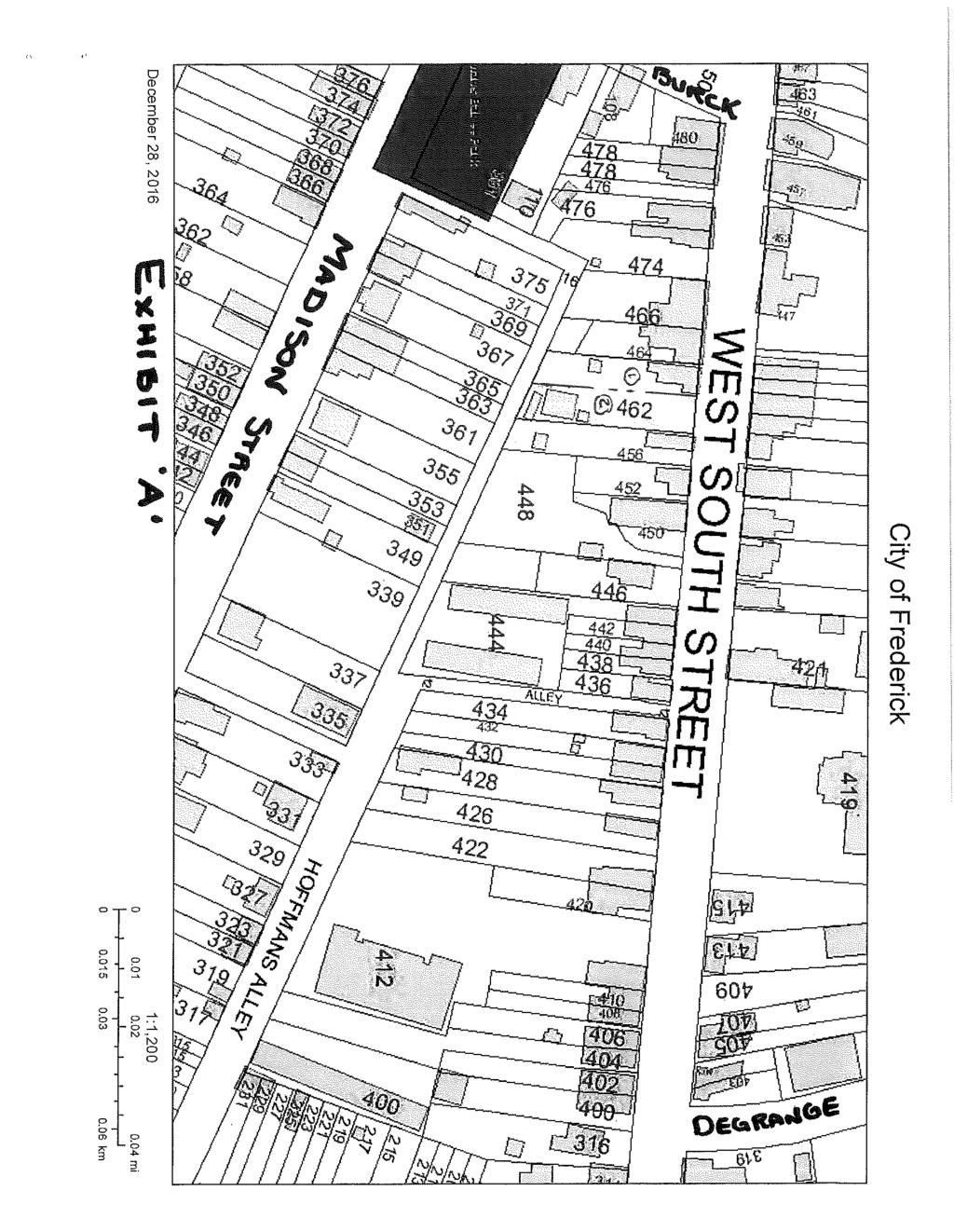
4 PROJECT INFORMATION CITY OF FREDERICK PLANNING COMMISSION PROJECT STAFF REPORT February 13, 2017 AGENDA ITEM: A. NAME OF PROJECT: KAI Property Investments 462 W South Street TYPE OF PROJECT: Final Subdivision Plat CASE NUMBER: PC16-960FSU APPLICANT/OWNER: ADDRESS: KAI Property Investments, LLC 462 W. South Street Frederick, MD PROPERTY LOCATION: 462 W. South Street REVIEWED BY: Tierre Butler DATE: February 6, 2017 EXHIBITS: Section 515 Narrative PROJECT PROPOSAL The Applicant is requesting final subdivision plat approval in order to subdivide existing 0.21-acre lot into two (2) residential lots. BACKGROUND INFORMATION The subject property ( Property ) is located at 462 W. South Street. The Property is zoned Downtown Residential, DR. There are currently no existing structures located on the Property. The previously existing building was approved for demolition without delay by the Historic Preservation Commission by application HPC on June 24, 2016 and was removed by permit shortly after. PRIOR CASES Annexation Zoning Map Amendment Sketch Plan Master Plan Preliminary Subdivision Plan Case Number & Date of Approval N/A N/A N/A N/A N/A Planning Department 140 W. Patrick St. Frederick, MD Fax
5 Final Subdivision Plan Final Site Plan Forest Stand Delineation Preliminary Forest Conservation Plan Zoning Board of Appeals Cases Archeological Assessment N/A N/A N/A N/A N/A N/A DEVELOPMENT CHARACTERISTICS Total Lot Area Property Zoning Number & Type of Units Roadway Dedication Open Space (HOA) Park Land Dedication Area Lot 1: 4,466sqft Lot 2: 4,890sqft Total: 9,356sqft DR (Downtown Residential) N/A N/A N/A Dedication is not practical ($1,000.00) fee shall be applied to each new dwelling unit created which will be used to fund parkland improvements. ENVIRONMNETAL CHARACTERISTICS Disturbed Lot Area Impervious Surface Ratio Floodplain on Site Disturbed Floodplain Nontidal Wetlands on Site Disturbed Wetlands MDE Permit Required Area None None None None None None No FACILITIES AND SERVICE Road Name Comprehensive ROW Access Provision Plan Classification W. South Street Collector Road 60 N/A FIRE & RESCUE Distance to Fire Service Distance to Ambulance Service Approved by City Fire Engineer 0.6 miles 0.6 miles N/A 2
6 NAC NAC# 10 Meeting Date 02/02/2017 Number of Attendees 0 Comments None. NAC meeting was originally scheduled for January 23, 2017 but was cancelled due to City of Frederick Public schools closing. APFO TYPE APPLICABILITY ISSUED (Y/N) CAPF-WL Exempt per Sec 4-9(a)(3)(c) N/A CAPF-SL Exempt per Sec 4-10(a)(3)(c) N/A CAPF-R Exempt per Sec 4-11(a)(3)(c) N/A CAPF-SCH Not applicable N/A STAFF COMMENTS & ANALYSIS REVIEWING AUTHORITY In reviewing a final subdivision plat application the Commission must consider the criteria outlined in Article 5, Section 507 of the Land Management Code (LMC), which includes conformance with the Comprehensive Plan, compliance with all of the applicable criteria of Articles 4,6,7, and 8 of the LMC, and consistency with any roads and streets shown on the transportation element of the Comprehensive Plan. Staff has reviewed the application for compliance with the applicable sections of the LMC and offers the following analysis. LAND USE The Applicant is proposing to subdivide the 9,356sq ft parcel into a 4,466sqft parcel to be identified as Lot 1 and a 4,890sqft parcel to be identified as Lot 2. Both lots will be large enough to accommodate either a single-family, detached home or a two-family dwelling. A final site plan is not required for the construction of single family, detached units, however should the Applicant pursue a two-family dwelling, a final site plan would be necessary. Per Section 515(a) of the (LMC) lots on a preliminary subdivision plat or final subdivision plat for the resubdivision of any residential lot, tract or other parcel of land that is part of or surrounded by an existing residential subdivision previously recorded in a plat book, including proposed consolidation of previously recorded lots, shall be of the same character as other lots within the existing residential block, neighborhood or subdivision, based upon the following characteristics. In the Applicants narrative they indicated that the subdivision is consistent with the seven characteristics outlined in Section 515 of the LMC. Based on the attached Exhibit. A. Street Frontage: 3
7 Staff concurs that the subdivision is consistent with existing street frontage. Both lots can accommodate either a single family home or a two family dwelling which would require a minimum of 20 feet of street frontage. The proposed subdivision contains 30 feet of street frontage per lot. B. Alignment: Staff concurs that the subdivision is in alignment with the existing historic structures that front along West South Street. C. Size: Staff concurs that the subdivision meets the minimum lot size requirement to accommodate a single family or a two family dwelling. The minimum lot size for a single family consists of 2,000 sqft and 3,000 sqft for a two family. The proposed subdivision contains 4,466sqft for Lot 1 and 4,890sqft for Lot 2. D. Shape: Staff concurs that subdivision is consistent with the shape of existing properties located on both adjacent sides of the subject property. E. Width: Staff s Analysis: Staff concurs that subdivision is consistent in width of adjacent properties located at 464 and 456 W. South Street. F. Area: Staff concurs that subdivision is consistent with the existing area of properties located along West South Street. G. Suitability for Residential Use: Staff s Analysis: Staff concurs that the subdivision is suitable for residential use. Prior to demolition of the previous structure, the Property was being used for residential use. The Applicant has stated that it is the intent to continue to use the Property for the same use. The proposal does not appear to have any adverse impacts on the neighboring properties and meets the criteria under Article 5 Subdivisions, Section 515, Residential Resub division of the LMC. This application is subject to Section 608 of the LMC for the dedication of public parkland. As dedication is not practical and the Property is within the National Register 4
8 Historic District a one thousand dollar ($1,000.00) fee shall be applied to each new lot created which will be used to fund parkland improvements within the defined area. That fee is to be paid prior to subdivision plat recordation. The Land Use Map of 2010 Comprehensive Plan identifies the Property as High Density Residential, which is consistent with the DR zoning district. Based on compliance with the standards for the DR. district, the proposed subdivision is consistent with the Comprehensive Plan Land Use Map. It also supports several policies and implementation strategies of the Plan including: Land Use Policy 1. Encourage development to be compatible with the character of existing or planned development in the vicinity. a. Identify impediments to infill development. Housing Policy 2. Encourage the development of compact residential neighborhoods. a. Encourage infill development (development that occurs on vacant or abandoned parcels in an otherwise built-up portion of the City) and redevelopment (new development that replaces or substantially refurbishes existing structures) that is compatible with surrounding land uses. 3. Support diverse residential development in the City a. Add new residential units within the downtown. Per the 2030 Roadway Classification map, W South Street is considered an arterial roadway. The Westinghouse, Church, Kerr & Company plat for W South Street shows the ultimate road right of way at 60 which is generally consistent with the right of way requirements for a collector roadway in the city, however, this road is significantly constrained by the existing historic structures that front along it and therefore, additional right of way dedication is not needed. STAFF RECOMMENDATION In accordance with Section 507 of the Land Management Code, Staff recommends unconditional approval of subdivision PC16-960FSU for the subdivision of the 0.21 acre lot into two residential lots, based on compliance with the residential resubdivision criteria established under Section 515(a) of the Land Management Code and based on the following findings: 1) The resulting lots are in compliance with all the applicable standards of Articles 4, 6,7, and 8. 2) The Plat is consistent with the 2010 Comprehensive Plan Land Use Map and Land Use and Housing policies of the Comprehensive Plan. 3) That there are no new roads proposed and that existing roads and their rights of way are adequate and reflect existing constraints imposed by the build environment. 5
9
10
11
12 PROJECT INFORMATION CITY OF FREDERICK PLANNING COMMISSION PROJECT STAFF REPORT February 13, 2017 AGENDA ITEM: B. NAME OF PROJECT: Capital Improvement Program TYPE OF PROJECT: N/A CASE NUMBER: N/A APPLICANT: City of Frederick 140 W Patrick Street Frederick, MD PHONE NUMBER: (301) REVIEWED BY: Zack Kershner/Gabrielle Collard DATE: February 6, 2017 EXHIBITS: Draft Recommendation Letter Recommendation Letter from the Bicycle Pedestrian Advisory Committee PROJECT PROPOSAL To review and make recommendations on the the draft Capital Improvement Program (CIP) for FY BACKGROUND INFORMATION Per the City Charter, the Planning Commission must submit annually to the Mayor a list of capital improvements that the Commission finds necessary or desirable to be constructed during the forthcoming four-year period. The list should be arranged in order of preference, with recommendations as to which projects shall be constructed in which year. In order to facilitate this discussion, Staff has provided the Commission with a copy of the draft CIP. After evaluating the document, the Commission may submit the projects and the timing as proposed in the draft or may choose to submit a modified listing of projects and their priority for completion. Planning Department 140 W. Patrick St. Frederick, MD Fax
13 STAFF COMMENTS & ANALYSIS The items in the CIP range from maintenance of existing infrastructure to major new public improvements. These projects reflect every functional area of the City from the Department of Public Works to the Police Department and Airport. The Commission discussed the draft at the workshop on January 17, 2017 and identified three priorities to forward on to the Board for their consideration. Staff has evaluated these recommendations and has identified corresponding sections of the 2010 Comprehensive Plan that are supported or implemented by the recommendations: Recommendation: 1. Provide funding as proposed for Phase II of the Rails with Trails project (Project #380004). 2. Fully fund the local share of $60, for the upgrade to the Shared Use Path in Baker Park (Project #380001). A. Transportation Element Policy TE 6, Promote alternatives to the single occupant vehicle B. Transportation Element Policy TE7, Promote bicycle and pedestrian mobility in the City of Frederick. C. Recreation Element, Policy 2, Expand the City s trail network to improve pedestrian and bicycle access to parks and regional trails. D. Environment Element Policy 4, Achieve energy savings and air quality benefits for the City by requiring energy-efficient site design and building construction. E. Community Character and Design Element, Policy 5, The City s capital improvement projects shall make a positive contribution to the City s character. Recommendation: 3. That funding for the Downtown Hotel Project continued to be included in the CIP. A. Land Use Element Policy 3, Allow land uses that build upon regional and local economic assets. B. Economic Development Element Policy 5, Encourage revitalization and reinvestment in traditional business corridors. C. Economic Development Element, Policy 6, Maintain and enhance downtown s role as a hub of government, arts, culture, and commerce. STAFF RECOMMENDATION Staff supports the approval of the draft recommendation letter. 2
14
15 Randy McClement Mayor Aldermen Kelly M. Russell President Pro Tem Michael C. O Connor Philip Dacey Joshua Bokee Donna Kuzemchak February 21, 2017 Mayor Randy McClement & The City of Frederick Board of Aldermen 101 N. Court Street Frederick, Maryland Re: FY Capital Improvement Program (CIP) Dear Mayor and Board of Aldermen, The Planning Commission s role in the Capital Improvements Program (CIP) process is to submit, annually, a list of candidate projects to the Mayor and Board of Aldermen. In reviewing the draft CIP, the Commission has considered those projects that are scheduled for potential funding in the next four years. This review is the mechanism for complying with the Annotated Code of Maryland and provisions of the Maryland Economic Growth Resource Protection and Planning Act of At the February 13, 2017 Planning Commission meeting the Commission reviewed the draft CIP. On a motion made by Commissioner and seconded by Commissioner, the Commission voted 5-0, in favor of a positive recommendation to the Mayor and Board of Aldermen for the projects and their timing as contained in the CIP with the following considerations: 1. Provide funding as proposed for Phase II of the Rails with Trails project (Project #380004). 2. Fully fund the local share of $60, for the upgrade to the Shared Use Path in Baker Park (Project #380001). 3. That funding for the Downtown Hotel Project continued to be included in the CIP. Thank you for the opportunity to provide our recommendation on this very important matter. Sincerely, Barb Nicklas Planning Commission Chair
16 PROJECT INFORMATION CITY OF FREDERICK PLANNING COMMISSION PROJECT STAFF REPORT February 13, 2017 AGENDA ITEM: C. NAME OF PROJECT: Mount Olivet Cemetery TYPE OF PROJECT: Final Subdivision Plat CASE NUMBER: PC16-787FSU PROPERTY OWNER: Mount Olivet Cemetery ADDRESS: PO Box 565 Frederick MD CONTRACT PURCHASER/ DEVELOPER: ADDRESS: PHONE NUMBER: See Owner APPLICANT: RF Gauss & Associates, C/o Mr. Chris Gauss ADDRESS: P. O. BOX 128 Emmitsburg, MD PHONE NUMBER: (301) PROPERTY LOCATION: 511 and 515 S. Market Street REVIEWED BY: Gabrielle Collard DATE: February 6, 2017 EXHIBITS: Planning Commission Follow-Up Letter (12/19/2016) Staff Report (12/5/2016) PROJECT PROPOSAL Staff is requesting approval for revisions to the previously issued conditions of approval for the final subdivision plat to consolidate parcels and portions of parcels owned by Mount Olivet Cemetery located at 511 and 515 S. Market Street. 1
17 BACKGROUND INFORMATION The request for final subdivision plat approval was originally discussed at the December 12, 2016 Planning Commission meeting. The item was included on the consent agenda however; Staff requested that the item be pulled for discussion due to concerns related to the need for right-of-way dedication along Stadium Drive. As the Commission will recall, Parcel ES1/635, a 14.4 square foot portion of which is being added to 511 S. Market Street, has frontage along Stadium Drive, which is considered a minor arterial roadway per the 2010 Comprehensive Plan. Per Section 507 of the Land Management Code (LMC), which establishes the criteria for subdivision plat approval, plats must include roads and streets shown on the transportation element of the master plan and must include either full width dedication of right-of-way or, in cases where the subdivision only includes one-half of the road cross-section, the dedication of half of the full right-ofway. Based on the roadway classification, Staff requested the dedication of the half-section for a 60 right-of-way and that an encroachment agreement is executed for fencing and any other improvement that would fall with the public right-of-way post-dedication. The plat was approved with three conditions as follows: 1) The right of way along Stadium Drive be dedicated to the City to the full extent of the 6o depicted on the plat along the frontage of parcel ES1/635. 2) That a right of way encroachment agreement be executed for the fencing and any other improvements within the right of way of Stadium Drive once dedicated. 3) That note #7 on the plat be revised to reference the correct Westinghouse, Church, Kerr Plat. STAFF COMMENTS & ANALYSIS Since December, Staff and the Applicant have discussed the conditions of approval and have concluded that a more appropriate right-of-way for Stadium Drive is 45 since the Comprehensive Plan identifies Stadium Drive as a local road. The roadway currently exists as a local road and there are no major improvements planned. Stadium Drive is expected to remain two-lanes for the foreseeable future as the intersection of New Design Road/Monocacy Blvd and S. Market Street/MD 355 to the south, a controlled intersection, would more appropriately provide the safest and most efficient turning movement for traffic heading northbound on Market Street. Staff is requesting that the conditions of approval be amended so as to specifically require a dedication of only 22.5 from the pavement centerline of Stadium Drive towards the Applicant s property. After the dedication is completed, there will still be the need for a right-of-way encroachment agreement; however, instead of covering a substantial area of Planning Department 140 W. Patrick St. Frederick, MD Fax
18 the fencing, only one corner pillar and any minimal extent of fencing will need to be included in the encroachment agreement. The Applicant has provided a revised plat that depicts the requested right-of-way dedication and has added a note to the plat memorializing the analysis of the right of way needs for this section of Stadium Drive. STAFF RECOMMENDATION In accordance with Section 507 of the Land Management Code, Staff recommends approval of the final subdivision plat, PC16-787FSU, for the consolidation of parcels at 511 and 515 S Market Street finding that: 1) The resulting lots are in compliance with all the applicable standards of Articles 4, 6,7, and 8, 2) The plat is consistent with the Land Use Map of the 2010 Comprehensive Plan; and 3) That there are no new roads proposed and that the existing roads and their rights of way are consistent with the transportation element of the Comprehensive Plan. With the following condition: 1) That a right of way encroachment agreement be executed with the City for any private improvements that will still remain within the public right-of- way to the corner of South Market Street/Stadium Drive intersection, once the new plat is executed. 2
19
20 PROJECT INFORMATION CITY OF FREDERICK PLANNING COMMISSION PROJECT STAFF REPORT December 12, 2016 AGENDA ITEM: B. NAME OF PROJECT: Mount Olivet Cemetery TYPE OF PROJECT: Final Subdivision Plat CASE NUMBER: PC16-787FSU PROPERTY OWNER: Mount Olivet Cemetery ADDRESS: PO Box 565 Frederick MD CONTRACT PURCHASER/ DEVELOPER: ADDRESS: PHONE NUMBER: See Owner APPLICANT: RF Gauss & Associates, C/o Mr. Chris Gauss ADDRESS: P. O. BOX 128 Emmitsburg, MD PHONE NUMBER: (301) PROPERTY LOCATION: 511 and 515 S Market Street REVIEWED BY: Gabrielle Collard DATE: December 5, 2016 EXHIBITS: N/A PROJECT PROPOSAL The Applicant is requesting approval of a final subdivision plat to consolidate parcels and portions of parcels currently owned by Mount Olivet Cemetery at 511 and 515 S Market Street. 1
21 Mount Olivet Cemetery, located at 515 S. Market Street, is comprised of multiple parcels of land that have been aggregated over time. The parcel located at 511 S. Market Street, (Parcel 810/432), which is improved with a single-family detached structure is also under the same ownership. The majority of the cemetery is zoned Institutional (IST) and a portion is located within the Historic Preservation Overlay (HPO); this includes the iconic structure fronting S Market Street which has served as administrative office space, however, that structure and the surrounding land area identified as Parcel ES 1/635 on the subject plat is zoned Downtown Commercial Residential (DB). 511 S. Market Street is also zoned DB and is within the HPO. The Applicant is not proposing any physical improvements at this time, merely a shifting of existing parcel lines to simplify the ownership. Currently, Parcel 810/432 (511 S Market Street) is two separate parcels (810/432 and 324/393). The Applicant will be taking one portion of 324/393 (Parcel C) and adding it to 810/432 (511 S Market) and the other portion (Parcel D which has a garage accessing the alley) will be added to Parcel 1/476 along with a sliver of land (Parcel B) which is currently part of 810/432 (S Market Street). As a result, Parcel 324/393 will no longer exist. A sliver of 810/432 (Parcel A) will be added to Parcel ES 1/365. Staff would note that the existing garage is nonconforming with regards to the required accessory structure setback of 3 from interior property lines and due to the fact that it is physically constructed over a property line. The property line that is the subject of the nonconformity is not being altered by this plat and as such, no further action is necessary at this time. However, the Applicant should be aware of the issue as there could be future implications if the building were destroyed or there were improvements proposed that exceed the scope of routine maintenance and repair. In accordance with Section 507 of the Land Management Code (LMC), Staff has reviewed the application to ensure compliance with the applicable regulations of Articles 4, 6, 7, and 8 of the Code and finds that the resulting parcels comply with the zoning and setback requirements established therein, except as noted above relative to the nonconformity which is compliant with Article 9 of the Code. BACKGROUND INFORMATION PRIOR CASES Annexation Zoning Map Amendment Sketch Plan Master Plan Preliminary Subdivision Plan Final Subdivision Plan Case Number & Date of Approval N/A N/A N/A N/A N/A N/A Planning Department 140 W. Patrick St. Frederick, MD Fax
22 Final Site Plan Forest Stand Delineation Preliminary Forest Conservation Plan Zoning Board of Appeals Cases Archeological Assessment None N/A N/A N/A N/A DEVELOPMENT CHARACTERISTICS Total Lot Area Property Zoning Number & Type of Units Roadway Dedication Open Space (HOA) Park Land Dedication Area Institutional (IST) and Downtown Commercial Residential (DB) within the Historic Preservation Overlay (HPO) and Highway Noise Protection Overlay (HNO) No new units N/A N/A N/A ENVIRONMNETAL CHARACTERISTICS Disturbed Lot Area Impervious Surface Ratio Floodplain on Site Disturbed Floodplain Nontidal Wetlands on Site Disturbed Wetlands MDE Permit Required Area N/A N/A N/A N/A N/A N/A N/A FACILITIES AND SERVICE Road Name Comprehensive ROW Access Provision Plan Classification S Market Street Minor Arterial Existing SCHOOLS (existing feeder situation) Equated Additional Name Enrollment Capacity Enrollment Elementary School Middle School High School 2
23 FIRE & RESCUE Distance to Fire Service Distance to Ambulance Service United Steam 1.11 miles United Steam 1.11 miles Approved by City Fire Engineer 10/3/2016 LEGAL AGREEMENTS Type of Agreement Easement Agreements Forest Conservation Agreements Date Submitted & Approved by Office of Legal Services N/A N/A ARCHITECTURE AND URBAN DESIGN REVIEW Applicability N/A Classification Building Type Class Design Elements Required Design Elements Met Design Elements Utilized Modifications Remarks NAC NAC# 10 Meeting Date 10/17/2016 Number of Attendees 10 Comments No comments 3
24 APFO TYPE APPLICABILITY ISSUED (Y/N) CAPF-WL N/A N/A CAPF-SL N/A N/A CAPF-R N/A N/A CAPF-SCH N/A N/A STAFF COMMENTS & ANALYSIS REVIEWING AUTHORITY In reviewing a final subdivision plat application the Commission must consider the criteria outlined in Article 5, Section 507 of the Land Management Code (LMC), which includes conformance with the Comprehensive Plan, compliance with all of the applicable criteria of Articles 4, 6, 7, and 8 of the LMC, and consistency with any roads and streets shown on the transportation element of the Comprehensive Plan. Staff has reviewed the application for compliance with the applicable sections of the LMC and offers the following analysis. LAND USE Mount Olivet Cemetery is comprised of multiple parcels of land that have been aggregated over time. The parcel located at 511 S. Market Street, (Parcel 810/432), which is improved with a single-family, detached structure is also under the same ownership and the Applicant now seeks to market this property for sale. In doing so, they would like to ensure that the lot has rear, alley access and parking. The majority of the Cemetery is zoned Institutional (IST), a floating zone designation designed to reflect its use, and a portion is located within the Historic Preservation Overlay (HPO); this includes the iconic structure fronting S Market Street which has served as administrative offices. The structure and the surrounding land area identified as Parcel ES 1/635 on the subject plat is zoned Downtown Commercial Residential (DB). 511 S. Market Street is also zoned DB and is within the HPO. The Applicant is not proposing any physical improvements at this time, merely a shifting of existing parcel lines to prepare a portion of the site for sale. Currently, Parcel 810/432 (511 S Market Street) is two separate parcels (810/432 and 324/393). The Applicant will be taking one portion of 324/393 (Parcel C) and adding it to 810/432 (511 S Market) to provide future parking, and the other portion (Parcel D which has a garage accessing the alley) will be added to Parcel 1/476 along with a sliver of land (Parcel B) which is currently part of 810/432 (S Market Street). As a result, Parcel 324/393 will no longer exist. A sliver of 810/432 (Parcel A) will be added to Parcel ES 1/365. The two slivers of property contain retaining walls that the Cemetery would like to maintain ownership of after the transfer of 511 S Market Street. 4
25 The existing garage on Parcel D is nonconforming with regards to the required accessory structure setback of 3 from interior property lines and due to the fact that it is physically constructed over a property line. The property line that is the subject of the nonconformity is not altered by this plat and as such, no further action is necessary at this time. However, the Applicant should be aware of the issue as there could be future implications if the building were destroyed or there were improvements proposed that exceed the scope of routine maintenance and repair. In addition, the consolidation will result in the new lot area of 511 S Market Street being split between two different zoning districts, IST and DB. The front portion of the property will retain the DB designation, where the new addition area at the rear of the lot will remain IST. Zoning boundaries can only be modified through a zoning map amendment in accordance with Section 306 of the LMC and as such, unless the Applicant/future property owner seeks to have the floating zone lifted, the property will remain split zoned until such time as the City conducts a subsequent comprehensive rezoning. Split zoning property is not prohibited under the LMC however, there could be implications in the future pending the intended use of the lot. As one lot being used for residential purposes, any accessory use or structure proposed for the lot would be subject to Section 803 of the LMC and should not be impeded by the split zoning. However, future additions that encroach into the IST portion of the lot may be prohibited. The conversion of the rear of the lot to some other institutional use would be subject to further site plan approval and would be marginal as there is limited lot area and institutional uses by their very nature tend to be more expansive. In accordance with Section 507 of the Land Management Code (LMC), Staff has reviewed the application to ensure compliance with the applicable regulations of Articles 4, 6, 7, and 8 of the Code and finds that the resulting parcels comply with the zoning and setback requirements established therein, except as noted above relative to the nonconformity which is compliant with Article 9 of the Code. The Land Use Map of the 2010 Comprehensive Plan depicts the Cemetery as institutional use however, 511 S Market Street is identified as mixed use which is consistent with the DB zoning on the Property. The proposed resubdivision is consistent with the Comprehensive Plan designation as it makes 511 S Market Street better situated for sale and continued use in accordance with the DB district. The 2030 Roadway Classification Map does not depict any new roads in this vicinity and the plat has been reviewed to determine if adequate right of way exists to accommodate any future improvements contemplated on that map and no further dedication is necessary at this time. 5
26 STAFF RECOMMENDATION In accordance with Section 507 of the Land Management Code, Staff recommends approval of the final subdivision plat, PC16-787FSU, for the consolidation of parcels at 511 and 515 S Market Street finding that: 1) The resulting lots are in compliance with all the applicable standards of Articles 4, 6,7, and 8, 2) The plat is consistent with the Land Use Map of the 2010 Comprehensive Plan; and 3) That there are no new roads proposed and that the existing roads and their rights of way are consistent with the transportation element of the Comprehensive Plan. With the following conditions: 1) The right of way along Stadium Drive be dedicated to the City to the full extent of the 6 depicted on the plat along the frontage of parcel ES1/635. 2) That a right of way encroachment agreement be executed for the fencing and any other improvements within the right of way of Stadium Drive once dedicated. 3) That note #7 on the plat be revised to reference the correct Westinghouse, Church, Kerr Plat. 6
27 CITY OF FREDERICK PLANNING COMMISSION PROJECT STAFF REPORT February 13, 2017 PROJECT INFORMATION AGENDA ITEM: D. NAME OF PROJECT: Riverside Corporate Park Lot 206 TYPE OF PROJECT: Final Site Plan CASE NUMBER: PC16-790FSI APPLICANT: Harris, Smariga & Associates, Inc. ADDRESS: 125 S. Carroll Street, Suite 100, Frederick, MD PHONE NUMBER: (301) DEVELOPER/OWNER: Riverside Technology Park IV LLC St. John s Properties ADDRESS: 5104 Pegasus Court, Suite A, Frederick, MD PHONE NUMBER: PROPERTY LOCATION: East of Monocacy Boulevard & North of Gas House Pike REVIEWED BY: Pam Reppert DATE: February 6, 2017 EXHIBITS: Modification Request Letter PROJECT PROPOSAL The Applicant is requesting approval to construct a 5,371 s.f. Royal Farms convenience store with gas sales and a 16,320 s.f. one-story office building on Lot 206 within the Riverside Corporate Park Mixed Use Employment Center (MXE) located off of Monocacy Blvd. The Applicant is also requesting a modification to Section 607(h), Loading Space Requirements, to reduce the size of loading spaces required. BACKGROUND INFORMATION The subject property ( Property ) is part of the Riverside Corporate Park MXE Master Plan which was approved in accordance with the 1986 Zoning Ordinance. LMC Section 910 pertaining to existing development approvals allows for the site plan to continue Planning Department 140 W. Patrick St. Frederick, MD Fax
28 being reviewed under the 1986 Ordinance, however, the Applicant has chosen to pursue site plan approval in accordance with the standards of the LMC as it affords a greater amount of flexibility with regards to standards like parking. On June 10, 2013, the Planning Commission approved final site plan PC12-835FSI for two flex space buildings on this lot. On November 17, 2016, the Mayor and Board of Aldermen approved Ordinance G-16-27, which established convenience stores with gas sales as a permitted use in the M1 district with a maximum limit on the amount of convenience store area set at 6,000 s.f. PRIOR CASES Case Number & Date of Approval Annexation June 1985 MXE Concept Plan PC00-218MAP 3/15/01 MXE Execution Plan Phase 3 PC01-025MXE 6/11/01 PC01-199MXE 10/08/01 PC03-165MXE 8/11/ MXE 8/11/ MXE 7/12/ MXE 4/17/12 Preliminary Subdivision Plan PC00-17PSU 2/14/2000 Final Subdivision Plan PC00-59FSU 4/10/2000 Final Site Plan PC12-835FSI 6/10/2013 PC16-790FSI to be heard tonight Forest Stand Delineation /14/01 Preliminary Forest Conservation Plan /9/01 Final Forest Plan North Rosenstock FCP 12/6/01 LOT CHARACTERISTICS Total Lot Area Total Open Space ROW dedication Number & Type of Lots Zoning of Property Area (acres or square feet) 3.73 acres 1.46 acres None 1 MXE employment lot Mixed Employment (MXE) and Airport Overlay (AO) COMMENTS: This property is being developed under the MXE requirements, per the MXE Phase 1, Concept Plan, approved by the Board of Aldermen on March 15, LEGAL AGREEMENTS Type of Agreement Cross Access Easement Agreement Utility Easement Agreements Notes NA Prior to IP approval 2
29 NAC NAC# 12 Meeting Date October 11, 2016 Number of Attendees 12 Comments No concerns APFO TYPE APPLICABILITY ISSUED (Y/N) CAPF-WL Section 4-9(a) EXEMPT CAPF-SL Section 4-10(a) EXEMPT CAPF-R Section 4-11(a) EXEMPT CAPF-SCH NA NA STAFF COMMENTS & ANALYSIS REVIEWING AUTHORITY AND RESPONSIBILITY In reviewing a final site plan, the Commission must consider the criteria outlined in Section 309(e) of the LMC which includes compliance with all of the standards criteria of Articles 4, 5, 6, 7, and 8 of the LMC, conformance with any area or master plan approved for the subject property, the adequacy of facilities and services to accommodate the impacts of the development, and lastly, where applicable, the provision of Moderately Priced Dwelling Units (MPDUs). Compliance with the MPDU provisions is not required as the site is nonresidential. As discussed above, the lot is subject to an approved master plan and as such, Staff has reviewed the application for compliance with that master plan as well as all other applicable sections of the LMC and to determine the adequacy of facilities to serve the development and offers the following analysis. Land Use Per LMC Section 418, Mixed Use Employment Center (MXE), the MXE has four (4) land use categories: Commercial, Recreational, Employment, and Civic/Institutional and Cultural. Lot 206 falls within the Employment section of the MXE which allows uses permitted in the Manufacturing/Office (MO) and Light Industrial (M1) zones per LMC Table Convenience stores with gas sales and office uses are both permitted uses in the M1 zone and therefore, are allowed on this lot. The Applicant is proposing to construct the project in two phases: Phase 1 being the Royal Farms convenience store with gas pumps fronting Monocacy Blvd, and Phase 2 being the office building located in the rear of the lot. In accordance with Section 309(l) of the LMC, Phase 2 shall begin within three years of the completion of Phase 1; otherwise, the site plan becomes void unless the expiration is extended. 3
30 The subject property is within the Airport Overlay (AO) District and as such, requires the Applicant to file a form As a condition of approval, the Applicant must obtain FAA approval and Note #27 must be completed with the approval date(s). Parking and Access Management The amount of parking proposed to be installed as part of Phase 1 exceeds the amount of parking allowed under Section 607 for a convenience store with gas sales. Section 607 requires a minimum of 11 spaces based on the square footage, but allows no more than 54 spaces. The Applicant is proposing to install 65 spaces. Should the Applicant not proceed with Phase 2, the resulting site will be nonconforming with regards to parking. The Applicant is requesting a modification to Section 607(h), Table for the minimum loading requirements. The site is required two large (12 x 50 ) loading spaces one for each of the buildings -- and the Applicant is proposing two small (9 x 20 ) loading spaces instead. Per Section 309, before granting a modification, the Commission must find that: 1. The modification will not be contrary to the purpose and intent of the Code; 2. The modification is consistent with the Comprehensive Plan; and 3. The application includes compensating design or architectural features so as to meet overall objectives of the particular requirement. The purpose and intent of establishing minimum loading standards is to ensure that sites are properly designed to function under the day-to-day operational needs of businesses without negatively impact public rights of way and vehicular traffic. Staff supports the modification to reduce loading space sizes since the tenants are anticipated to rely on box type delivery trucks and full tractor trailer deliveries will not be necessary, except for the fueling trucks which will use the paved area above the fuel tanks separate from the designated loading spaces. The Environmental Element of the 2010 Comprehensive Plan promotes the use of best management practices to minimize the impacts of development. Included among the implementation strategies is the development of regulations that reduce the amount of tree loss and impervious cover for new projects. While the reduction of the loading space size does not impact the amount of canopy cover on this site, eliminating the need for unnecessarily large loading spaces does insure a more efficient use of the site, reduces stormwater runoff, and is more environmentally friendly. Lastly, the site should be designed with compensating architectural or design features to mitigate for the modification requested. The Applicant will still be providing adequate loading spaces that are keeping in line with the anticipated needs of the tenants in a manner that maximizes the use of the site. At the December 2016 Planning Commission workshop several questions were raised regarding the site design including access management, the circulation of truck traffic on 4
31 the site, lighting, and the potential conflict between the fueling station and the adjacent stormwater management pond. With regards to access management, there were questions as to how southbound traffic on Monocacy Blvd would access the site and if a left turn lane on Monocacy Blvd were necessary or appropriate. The City Traffic Engineer has reviewed the feasibility of a southbound left turn lane from Monocacy Blvd to Spires Way (left turns in) or opening Spires Way at Monocacy Blvd as a full movement intersection (left turns in and out) and does not support additional changes at the intersection to permit any left turn movement for the following reasons: 1. Permitting additional movements at the intersection would directly impinge on the functionality of Monocacy Blvd (already affected by the Spires Way extension), an Urban Primary Arterial, intended to provide necessary regional connection and traffic throughput to the east side of the City as well as necessary local roadway connections through well-defined, adequately-spaced, and appropriatelycontrolled intersections. 2. Permitting additional movements at the intersection would establish precedents and could further reduce the functionality of Monocacy Blvd as new development projects are initiated. 3. The proposed uses on Lot 206 already have adequate means of access via external roadways such as Gas House Pike and Progress Drive, and internal roadways such as Spires Way and Precision Way (which connects Gas House Pike and Progress Drive to Spires Way). Spires Way must therefore maintain existing right-turn in/right-turn out control at Monocacy Blvd. Staff had recommended to the Applicant that they may consider merging the existing acceleration lane and deceleration lane on northbound Monocacy Blvd between Gas House Pike and Spires Way into a single auxiliary lane, which could permit a safer lane change or weave between through vehicles on Monocacy Blvd, vehicles decelerating to access Spires Way/Royal Farms, and vehicles accelerating after turning right from Gas House Pike. The Applicant is not proposing to make the recommended improvements at this time. With regards to truck traffic, there was concern that the nature of the site and its location could attract a large volume of truck traffic. There is no regulatory standard that requires truck-specific parking spaces, aside from loading, for the proposed uses; however, the Applicant did indicate that an adjacent site under their ownership could be available for truck drivers visiting the site and that Spires Way was a private drive that could also support on-street parking. It was mentioned that there should be adequate directional signage for fuel truck deliveries to use the Gas House Pike entrance and not Spires Way. With regards to lighting, it was noted that the lighting plan showed spillover onto the adjacent properties including others owned by St. John s Properties and the private 5
32 stormwater management pond. This has been adjusted to eliminate spillover onto the private stormwater management pond and the property to the east, although the lighting levels still exceed 0.0 footcandle along the northern property line adjacent to Spires Way. As a private internal drive, Staff finds this minimal spillover acceptable and possibly even beneficial in so much as it contributes to pedestrian and vehicular safety along the drive. Lastly, with regards to the fueling station, Staff has confirmed that while pervious pavement would not be desirable, the use does not pose any unusual or specific threat to the adjacent stormwater management pond and instead, providing filtration and absorption of any potential contaminants is part of the function of stormwater management facilities. The MXE floating zone is intended to create well integrated communities with a mixture of land uses with good vehicular and pedestrian connectivity. Lots are all interconnected by private drives. Lot 206 will share the private access, Spires Way, off of Monocacy Blvd. Spires Way is actually constructed on Lots 206 and 207 and continues through to Lots 204 and 205. With this type of interconnectivity between lots, a shared access and maintenance easement agreement has been executed and recorded to serve all four lots. Architectural Elevations Per Section 418(f), during the site plan review of a property located within an MXE, the Commission may require that architectural renderings of buildings, streetscapes or public areas be presented to assure that the appearance, size and type of building material or other aspects of the design are in keeping with the purposes and intent of the MXE district. In the alternative, the applicant may submit a set of architectural covenants to be recorded on all or part of the MXE land area, and upon approval of these covenants by the Planning Commission, individual architectural review of buildings by the Planning Commission in the areas subject to the covenants shall not be required, provided that evidence is provided to the Planning Commission and the Office of Legal Services that the covenants have been duly recorded. Lot 206 is part of the North Rosenstock land area of the MXE, which has previously recorded covenants (L2701/F867) for the development to be reviewed under. The Applicant has provided elevations on pages A2.0, A2.1, and A8.0 of the site plan for the convenience store and gasoline station canopy. At the Planning Commission workshop, the rear elevation was noted as having a long blank wall and the Commission requested additional architectural detailing, including possibly faux window treatments. The submission packet for the Commission s consideration at this time does not include any revisions to the elevations and should the Commission still seek additional detailing, Staff recommends this as a condition of approval. Impact Analysis As part of the MXE, the site plan is exempt from testing under the Adequate Public Facilities Ordinance (APFO) based on having a previously approved preliminary 6
33 subdivision plat; however, under Section 1203 Traffic Impact Studies (TIS), the Applicant must obtain approval of a traffic impact study to determine if there is a need for additional improvements or contributions to other improvements impacted by the project. The TIS was approved as of January 20, 2017 During the original MXE Master Plan process, an Eastside Regional [Traffic] Study was conducted and an overall building square footage for the entire land area was assigned in order to generate trip calculations and determine the impact and infrastructure improvements needed. Certain assumptions about the distribution of building square footage to individual lots were made based on percentage of land within the MXE. Thereafter, per Section 418(m), the owner/developer has been required to submit an Annual Report that documents the status of the MXE to include actual and projected build-out and the corresponding ratio of AM and PM peak hour traffic achieved as compared to the original project traffic projections from the Eastside Regional Study. On May 28, 2009, a Developer s Rights and Responsibilities Agreement (DRRA) was executed between the City of Frederick and Riverside Industrial Properties, LLC (developer) with purpose of formalizing the Eastside Regional Study trip maximums for the developed and undeveloped lots within the MXE as well as memorializing certain road improvements and their obligation in regard to any future road improvements if the maximum(s) are exceeded. With this application, Staff reevaluated trip generation for the proposed uses on the lot to confirm that the overall morning and evening peak-hour trip generation within Riverside Corporate Park still falls under the limitations set by 2009 DRRA. The original study assumed 32,496 s.f. of industrial park space on Lot 206; however, the new use of a convenience store with gas sales generates different trip patterns that results in an addition of 4,500 daily trips to the site. After considering the new use, uses within the Riverside Corporate Park will still be within the terms established in the DRRA. STAFF RECOMMENDATION Staff recommends approval of modification to Section 607(h) of the Land Management Code (LMC) entitled, Parking and Loading Standards, to provide 9 x20 loading space(s) for Phases 1 and 2 finding that: 1. The modification will not be contrary to the purpose and intent of the Code as the site will provide adequate loading spaces for the anticipated uses; and 2. The modification is consistent with the Environment Element of the 2010 Comprehensive Plan; and 3. That designing the site to reflect the actual anticipated needs of the tenants minimizes unnecessary impervious areas without compromising the functioning of the site. In accordance with the applicable provisions of Articles 4, 6, 7, and 8 of the LMC and all other provisions incorporated therein, based on the findings that the site plan is consistent with the approved master plan and that site is adequately served by public facilities, Staff 7
34 recommends approval of the final site plan PC16-790FSI for Riverside Lot 206 with the following conditions to be met: 1. Correct Signage Note 11 to reflect maximum wall signage/canopy for Phase 1 is 159 s.f. and Phase 2 maximum wall signage is 408 s.f. Please be advised that two 100 s.f. freestanding signs and maximum wall signage allotments slightly exceed the 756 s.f. maximum lot amount permitted and signage amounts will need to comply at building permit. 2. The planting list on the landscaping plan indicates 35 trees, however 34 are shown on the drawing itself. Verify the number of trees provided on site per Section 605(c)(5), correct as necessary. 3. Add previous site plan case number and approval date. 4. Correct typo in Note 21 the. 5. Obtain FAA approval and complete Note 27 with approval date. 6. Update Plan History Note 13 with previous final site plan PC12-835FSI and approval date. 7. Add a note to provide TIS approval date. 8. Revise the elevations to depict additional architectural detailing on the rear facade. 9. Add furniture elements to elevation sheets and label outdoor furniture on drawing sheet Identify pedestrian pathways through the site with pattern or shading for onsite identification to be installed, such as brush colored concrete. 11. Provide directional signage for fuel trucks to Gas House Pike entrance and appropriate do not enter for trucks traffic signage into Spires Way. 8
35 PROJECT INFORMATION CITY OF FREDERICK PLANNING COMMISSION PROJECT STAFF REPORT February 13, 2017 AGENDA ITEM: E. NAME OF PROJECT: Poet's Walk TYPE OF PROJECT: Final Site Plan CASE NUMBER: PC16-791FSI PROPERTY OWNER: Ed Smariga, J&R Limited Partnership ADDRESS: 125 South Carroll Street Suite 150 Frederick, MD DEVELOPER: Jeff Lessens, Buckeye Development, LCC ADDRESS: 125 South Carroll Street Suite 150 Frederick, MD PHONE NUMBER: (301) APPLICANT: Fran Zeller, Harris Smariga & Associates ADDRESS: 125 South Carroll Street Suite 100 Frederick, MD PHONE NUMBER: (301) PROPERTY LOCATION: Intersection of Gas House Pike and Monocacy Boulevard REVIEWED BY: Grace Bogdan DATE: February 6, 2017 EXHIBITS: Applicant Response to comments dated January 23, 2017 PROJECT PROPOSAL The Applicant is requesting final site plan approval for the construction of a new 37,196 square foot nursing home/domiciliary care/adult living facility located on Gas House Pike at the corner of Monocacy Boulevard. Concurrent with the final site plan approval, the Applicant is also requesting approval of the following: 1) A change in the land use designation originally assigned to this parcel on the approved Master Plan for the Riverside Corporate Park (PC00-218MAP) from commercial to employment; and 2) A modification to LMC Section 605(e) to decrease the landscape buffer requirement along the property line adjacent to the PRK zone and to remove the requirement to include a wall, fence, or berm along property line. Planning Department 140 W. Patrick St. Frederick, MD Fax
36 BACKGROUND INFORMATION The parcel is located within the master planned, Riverside Corporate Park Mixed Employment (MXE) project that was originally approved in 2003 with subsequent revisions. The Master Plan approved a commercial land use designation for this particular site. Nursing homes/domiciliary care/adult living facilities are not permitted in commercial areas of an MXE, therefore the Applicant has requested a change in land use to employment, for which adult living facilities are allowed as a conditional use. The Zoning Board of Appeals (ZBA) approved a Conditional Use Permit for the use at this location on August 23, 2016 with the condition that the Applicant receive Planning Commission approval for the land use change within the Riverside MXE and final site plan. PRIOR CASES Annexation Zoning Map Amendment Sketch Plan Master Plan Preliminary Subdivision Plan Final Subdivision Plan Final Site Plan Forest Stand Delineation Preliminary Forest Conservation Plan Zoning Board of Appeals Cases Archeological Assessment Case Number & Date of Approval N/A N/A STF15-883SP Riverside MXE PC00-218MAP N/A N/A PC16-791FSI to be heard tonight STF14-61FSD PC16-792FCSB to be heard tonight ZBA16-589CU ARCH DEVELOPMENT CHARACTERISTICS Total Lot Area Property Zoning Number & Type of Units Roadway Dedication Open Space (HOA) Park Land Dedication Area acres MXE N/A 1.63 acres N/A N/A ENVIRONMNETAL Area CHARACTERISTICS Disturbed Lot Area 2.84 acres Impervious Surface Ratio 25% Floodplain on Site Y Disturbed Floodplain N Nontidal Wetlands on Site N Disturbed Wetlands N MDE Permit Required N 2
37 FACILITIES AND SERVICE Road Name Comprehensive Plan ROW Access Provision Classification Gas House Pike Urban primary arterial 80 Y Monocacy Boulevard Urban primary arterial 100 N FIRE & RESCUE Distance to Fire Service 2.8 miles Distance to Ambulance Service 2.8 miles Approved by City Fire Engineer January 27, 2017 LEGAL AGREEMENTS Type of Agreement Easement Agreements Forest Conservation Agreements Date Submitted & Approved by Office of Legal Services Proposed easement to City of Frederick along Gas House Pike and at southern portion of site for City Golf Course tee. Staff recommends prior to unconditional approval Required prior to building permit NAC NAC# 12 Meeting Date October 11, 2016 Number of Attendees 2 Comments none APFO TYPE APPLICABILITY ISSUED (Y/N) CAPF-WL Exempt per Section 4-9(a)(2) Y CAPF-SL Exempt per Section 4-10(a)(2) Y CAPF-R Exempt per Section 4-11(a)(2) Y CAPF-SCH Exempt per Section 4-12(a)(1)(d) N/A STAFF COMMENTS & ANALYSIS REVIEW AUTHORITY AND RESPONSIBILITY In reviewing a final site plan, the Commission must consider the criteria outlined in Section 309(e) of the LMC which includes compliance with all of the applicable criteria of Articles 4, 5, 6, 7, and 8 of the LMC, conformance with any area or master plan approved for the subject property, the adequacy of facilities and services to accommodate 3
38 the impacts of the development, and lastly, where applicable, the provision of Moderately Priced Dwelling Units (MPDU). The Property is subject to a previously approved master plan, Riverside Corporate Park MXE, and has been reviewed in that context. While the proposed use has characteristics of a residential development it is not subject to the MPDU requirements. Staff has reviewed the application for compliance with the other applicable sections of the LMC as well as for the adequacy of facilities to serve the development and offers the following analysis. LAND USE Land uses permitted within the MXE zone are limited to four general categories: commercial, recreational, employment, and civic/institutional; the Property is designated as commercial, which does not permit nursing homes/domiciliary care/adult living facilities. The change in land use to employment designation would invoke land uses allowed within the MO (Manufacturing/Office) and M1 (Light Industrial) districts. Nursing homes/domiciliary care/adult living facilities are permitted as a conditional use in these districts, subject to approval by the ZBA. The property received conditional use approval in August of Per Section 418(f)(5) of the LMC, the Planning Commission may approve changes to the locations of land uses on the Master Plan, as part of the final site plan, if: 1) The amount or percentage of commercial development on the site does not increase from the Master Plan approval, and 2) Any such amendments do not cause any land use components of the MXE to be changed by more than 25 percent of the land area previously designated for that particular component. Any amendment beyond these thresholds requires an amendment to the Master Plan itself and approval by the Mayor and Board. The Applicant s justification for the change of land use request (See Response to Comments dated November 28, 2016) states overall land use of the approved Master Plan would decrease commercial from 9% to 7.3%, increase employment from 65% to 66.7%. Specifically, the change would decrease existing commercial land use by 18.2% and increase employment by 2.5%. Both land use changes would be less than 25% of the land area previously designated for that particular component, consistent with the LMC requirement. Additional analysis was conducted by Staff and considered by the ZBA during the conditional use approval. That analysis found that impacts specifically related to adult care living facilities are less intense than office and manufacturing uses in terms of potential nuisance activity such as noise, vibration, and other impacts. A memory care facility (the specific type of adult living facility proposed for this site) would function similar to a professional office, and traffic would be significantly less than a commercial use as the patients would reside at this location, limiting trips to visitors, deliveries, and employees. The ZBA approved the conditional use with the finding of that that an adult living facility at this location would not adversely impact the surrounding land uses and would be in harmony with the LMC and Comprehensive Plan. 4
39 SITE DESIGN Due to the site s location adjacent to the Monocacy River, the ongoing Monocacy Boulevard improvement project and the County s Sewer Force Main project, the developable area of the parcel is limited to the north eastern portion. The site is currently undeveloped and predominantly covered in forest. There is an existing golf cart path through the Property which will be relocated. With this request for final site plan approval, the Applicant will be dedicating a large portion of property fronting Monocacy Boulevard for future road improvements, and proposes an easement to the City along Gas House Pike for related Monocacy Boulevard upgrades. Frederick County also owns a sewer easement through the Property and the Applicant proposes an easement at the southern portion of the Property to the City to allow the golf course tee to remain. Staff has previously reviewed several iterations of the site design, with the current design being the most limited in terms of footprint and impacts to the adjacent forest, slope, and the Monocacy River. In exchange for the easement and ROW dedication mentioned above, the Applicant has requested a 20 foot wide easement along the south eastern property line on the Golf Course property to facilitate the landscape screening (See below). The Director of Public Works and Staff from the Parks & Recreation Department have reviewed the proposed easement and do not have any concerns. Staff recommends a condition of approval to require recordation of all proposed easements prior to unconditional approval. PARKING AND ACCESS MANAGEMENT The parking has been reduced through the planning process to 45 parking spaces (maximum allowed 60). At Staff s request, the Applicant has also provided two bicycle spaces at the employee entrance on the northern side of the building. While not required for this specific use per Section 607, the site s location is along both City and County path systems which may provide viable transportation alternatives for employees. LANDSCAPING The Applicant is requesting a modification to the required Level III/IV buffer for MXE properties that are adjacent to an Open Space (PRK) zoning district. In lieu of a landscape buffer on the development parcel, the Applicant proposes a 20 foot landscaping easement on the Golf Course to provide offsite screening. The Level III/IV screening also requires a fence, berm, or wall along the property line. The Applicant does not propose this feature and instead has provided a six foot board-on-board fence to screen the service area. At the Planning Commission Workshop on January 17, 2016, there were questions regarding the placement of the fence and whether the generator and trash would be enclosed. The Applicant has clarified in the submittal that the trash enclosure would be either wood or masonry, and that the generator would not be enclosed. In addition to the proposed landscaping easement, the Applicant s justification letter states that the intent of the buffer is to screen typically industrial uses within an MXE from parkland and open space, but this particular use of the Property is compatible with the adjacent golf course and that the building will utilize four-sided architecture to minimize any visual impacts. Before granting a modification, the Commission shall find that: A. The modification will not be contrary to the purpose and intent of the Code; B. The modification is consistent with the Comprehensive Plan; and C. The application includes compensating design or architectural features so as to meet overall objectives of the particular requirement. 5
40 Land Use Element Policy 1 encourages development to be compatible with the character of existing or planned development in the vicinity. It has been determined by the ZBA that a nursing home/domiciliary care/adult living facility at this location would not adversely impact the surrounding land uses and granting this modification would not change the nature of the use. The proposed landscaping plan meets all other landscaping requirements contained in Section 605 of the LMC including appropriate parking lot landscaping and property landscaping. The Applicant has claimed a portion of the existing forest as tree plantings, as allowed by Section 605(b)(2). In response to comments received at the Planning Commission Workshop on January 17, 2017, the Applicant has moved the landscaping around the building away to allow airflow through exterior vents. ENVIRONMENTAL RESOURCES Review of the Phase 1 Archeological Report for the Property has been completed by the City Consultant and a letter stating No Further Action Required has been issued, however a final copy of the report must be provided to the Planning Department. UTILITIES & TRAFFIC ANALYSIS The application is exempt from the Adequate Public Facilities Ordinance (APFO) under the Riverside Corporate Park Master Plan. During the original MXE Master Plan process, an Eastside Regional [Traffic] Study was conducted and an overall building square footage for the entire land area was assigned in order to generate trip calculations and determine the impact and infrastructure improvements needed. Certain assumptions about the distribution of building square footage to individual lots were made based on percentage of land within the MXE. Thereafter, per Section 418(m), the owner/developer has been required to submit an Annual Report that documents the status of the MXE to include actual and projected build-out and the corresponding ratio of AM and PM peak hour traffic achieved as compared to the original project traffic projections from the Eastside Regional Study. On May 28, 2009, a Developer s Rights and Responsibilities Agreement (DRRA) was executed between the City of Frederick and Riverside Industrial Properties, LLC (developer) with purpose of formalizing the Eastside Regional Study trip maximums for the developed and undeveloped lots within the MXE as well as memorializing certain road improvements and their obligation in regard to any future road improvements if the maximum(s) are exceeded. The Applicant has submitted a traffic memo, as required by the DRRA, which has been reviewed by the Engineering Department with no further comments. As mentioned above, the final site plan proposes to dedicate 1.63 acres fronting Monocracy Boulevard and an easement along Gas House Pike to the City of Frederick for future Monocacy Boulevard improvements. The dedication proposal within the final site plan has been reviewed by the Engineering Department to ensure consistency with the City Capital Improvement Project CIP Subsequent to the site plan approval, the City will be responsible for drafting and recordation of the final dedication plat. Similarly, the City will be responsible for installing street improvements along Gas House Pike. 6
41 STAFF RECOMMENDATION Staff recommends approval of the following modification to Section 605(e), Landscape Buffers and Berms, to the requirement of 20 buffer and construction of a fence, berm, or wall along the property line adjacent to PRK zoning district finding that: 1. The modification will not be contrary to the purpose and intent of the Code as the buffer required by the Code will be provided on the adjacent City Golf Course property through a landscape easement; 2. The modification is consistent with the 2010 Comprehensive Plan specifically Land Use Element Policy 1 as the proposed modification will screen the service area of the proposed use, but still allow views to the Golf Course as the nursing home/domiciliary care/adult living facility is compatible with the adjacent City Golf Course; and 3. The inclusion of a 20 easement on the City Golf Course property to allow the landscape buffer and four sided architecture are sufficient compensating features to meet the overall objectives of the Landscape Buffers and Berms requirements. Staff recommends approval of the change in location of land uses on the Master Plan, finding that: 1. The amount and percentage of commercial development on the side will not increase from the Master Plan approval; and 2. This amendment will not cause any land use component of the Riverside Corporate Park MXE to be changed by more than 25% of the land area previously designated for that particular component. This amendment will result in a decrease existing commercial land use by 18.2% and increase employment by 2.5%. In accordance with the applicable provisions of Articles 4, 6, 7, and 8 of the LMC and all other provisions incorporated therein, based on the findings that the site plan is consistent with the approved master plan and that site is adequately served by public facilities, Staff recommends approval of the final site plan PC16-791FSI for Poet s Walk with the following conditions to be met: 1. All applicable easements including the landscaping easement granted to the Property on the City Golf Course, the easement on the Property to the City for the existing golf tee, and the easement along the frontage of the Property along Gas House Pike to the City for road improvements must be executed. 2. The dedication plat for the right of way along Monocacy Blvd and Gas House Pike must be recorded. 3. Submit four copies of the final Phase 1 Archeological Report to the Planning Department. 7
42
43
44
45
46
47
48
49
50
51
52 PROJECT INFORMATION CITY OF FREDERICK PLANNING COMMISSION PROJECT STAFF REPORT February 13, 2017 AGENDA ITEM: F. NAME OF PROJECT: Poet's Walk TYPE OF PROJECT: Preliminary Forest Conservation Plan CASE NUMBER: PC16-792PFCP PROPERTY OWNER: Ed Smariga, J&R Limited Partnership ADDRESS: 125 South Carroll Street Suite 150 Frederick, MD DEVELOPER: Jeff Lessens, Buckeye Development, LCC ADDRESS: 125 South Carroll Street Suite 150 Frederick, MD PHONE NUMBER: (301) APPLICANT: Fran Zeller, Harris Smariga & Associates ADDRESS: 125 South Carroll Street Suite 100 Frederick, MD PHONE NUMBER: (301) PROPERTY LOCATION: Intersection of Gas House Pike and Monocacy Boulevard REVIEWED BY: Grace Bogdan DATE: February 6, 2017 EXHIBITS: Applicant Response to comments dated January 23, 2017 Modification Request Application PROJECT PROPOSAL The Applicant is requesting approval of a Preliminary Forest Conservation Plan for the related Poet s Walk Final Site Plan application and approval of a modification request to Section 721(d)(2)(C) to allow the removal of eight specimen trees. BACKGROUND INFORMATION A Forest Stand Delineation Plan (FSD) was approved for this site in 2014 (STF14-16FSD) which remains in effect for five years per Section 721 of the Land Management Code (LMC). The FSD identified one forest stand covering 5 of the acre parcel. The forest continues south of the Property towards and along the Monocacy River. Planning Department 140 W. Patrick St. Frederick, MD Fax
53 A Preliminary Forest Conservation Plan is required for development projects that exceed 40,000 square feet of land disturbance and requires compliance with the Forest Conservation Act and Section 721 of the Land Management Code (LMC). PRIOR CASES Annexation Zoning Map Amendment Sketch Plan Master Plan Preliminary Subdivision Plan Final Subdivision Plan Final Site Plan Forest Stand Delineation Preliminary Forest Conservation Plan Zoning Board of Appeals Cases Archeological Assessment Case Number & Date of Approval N/A N/A STF15-883SP Riverside MXE PC00-218MAP N/A N/A PC16-791FSI to be heard tonight STF14-61FSD PC16-792PFCP to be heard tonight ZBA16-589CU ARCH DEVELOPMENT CHARACTERISTICS Total Lot Area Property Zoning Number & Type of Units Roadway Dedication Open Space (HOA) Park Land Dedication Area acres MXE N/A 1.63 acres N/A N/A ENVIRONMNETAL Area CHARACTERISTICS Disturbed Lot Area 2.84 acres Impervious Surface Ratio 25% Floodplain on Site Y Disturbed Floodplain N Nontidal Wetlands on Site N Disturbed Wetlands N MDE Permit Required N FACILITIES AND SERVICE Road Name Road Name Road Name Road Name Gas House Pike Gas House Pike Gas House Gas House Pike Pike Monocacy Boulevard Monocacy Boulevard Monocacy Boulevard Monocacy Boulevard 2
54 FIRE & RESCUE Distance to Fire Service 2.8 miles Distance to Ambulance Service 2.8 miles Approved by City Fire Engineer January 27, 2017 LEGAL AGREEMENTS Type of Agreement Easement Agreements Forest Conservation Agreements Type of Agreement Easement Agreements Forest Conservation Agreements NAC NAC# 12 Meeting Date October 11, 2016 Number of Attendees 2 Comments none APFO TYPE APPLICABILITY ISSUED (Y/N) CAPF-WL Exempt per Section 4-9(a)(2) Y CAPF-SL Exempt per Section 4-10(a)(2) Y CAPF-R Exempt per Section 4-11(a)(2) Y CAPF-SCH Exempt per Section 4-12(a)(1)(d) N/A STAFF COMMENTS & ANALYSIS REVIEW AUTHORITY AND RESPONSIBILITY In reviewing this plan, the Commission must consider the criteria outlined in Section 721 of the LMC and compliance with the State Forest Conservation Act. LAND USE The subject property is acres and is currently undeveloped. Of the 5.07 acres of existing forest, 2.93 acres will be cleared for the construction of an adult living facility (PC16-791FSI) and 2.14 acres will be retained and put into a long term forest conservation easement. Per Section 721 of the LMC, no additional mitigation is required as the amount of forest to be cleared is less than the break even point allowed by the Forest Conservation Act. Within the 2.93 acres to be cleared, the Applicant proposes the removal of eight specimen trees defined as those having a diameter at breast height 3
55 (DBH) of 25 or more Specimen trees shall not be removed per Section 721(2)C unless the Applicant can demonstrate certain qualifications. The following are conditions required by the LMC and the Applicant response is in italics: 1. Special conditions peculiar to the property would cause the unwarranted hardship; Specimen Trees are scattered throughout the site. With several located in the center of the site. Saving all of these trees would eliminate the reasonable ability to build on the site. 2. The enforcement of this section will deprive the applicant of rights commonly enjoyed by others in similar areas; Given that half of the specimen trees are in poor health, their retention would not guarantee their survival and would place risk on the users of the site given the extent of decay. Retaining all the specimen trees would essentially render the site undevelopable depriving the owner rights enjoyed by others. 3. Granting of the modification will not confer on the applicant a special privilege that would be denied to other applicants; In attempt to mitigate the removal of the specimen trees we have provided a Forest Retention Easement that exceeds the break even threshold. As such the owner has balanced site development with required retention area and complied with the requirements of the City s Forest Conservation Ordinance by saving sufficient existing forest and not being required to plant additional areas. 4. The modification request is not based on conditions or circumstances which are the result of actions by the applicant; Owners actions did not result in the existing forest condition found on site. 5. The request does not arise from a condition relating to land or building use, either permitted or nonconforming, in a neighboring property; and Not applicable to this project. 6. The granting of a modification will not adversely affect water quality. The proposed clearing for the Poet s Walk facility is located over 500 from the edge of the Monocacy River s average flow water surface. By concentrating development as far as possible from the Monocacy River we have provided a large riparian buffer that would serve to protect the water quality of the River. Furthermore, the site will provide stormwater management in accordance with the current Environmental Site Design (ESD) to Maryland Environmental Protection (MEP) requirements. As evident in the final site plan application, the Applicant has revised the site design to limit grading and related impacts to forest to the maximum extent possible. Of the 16 specimen trees on site, half will be preserved. It should be noted that the Forest Stand Delineation Plan that was approved by Planning Department Staff in 2014 indicated five of the eight trees proposed for removal are in poor condition. The amount of trees being removed is the minimum necessary for the development of the site. 4
56 STAFF RECOMMENDATION Staff recommends approval of the following modification to Section 721(d)(2)C, Retention Priority - Modifications, to remove eight specimen trees finding that: 1. Retention of all specimen trees that are scattered throughout the site would cause an unwarranted hardship and an inability to reasonably develop; 2. The enforcement of this section will deprive the applicant of rights commonly enjoyed by others in similar areas because the site is heavily wooded and retention of all specimen trees would render the site undevelopable; 3. Granting of this modification would not confer on the Applicant a special privilege that would be denied to other Applicants as the Preliminary Forest Conservation Plan will preserve more forest than required by the Forest Conservation Act and complies with all other regulations; 4. This modification request is not based on conditions that are the result of actions by the Applicant; 5. The request is not due to a condition relating to the land of a neighboring property as all the specimen trees to be removed are located on the subject property; 6. The granting of this modification would not adversely affect water quality as the site has been designed to avoid the Monocacy River to provide as large a riparian buffer as possible and according to the current Environmentally Sensitive Design (ESD) requirements of the State of Maryland. Staff recommends unconditional approval of the Poet s Walk Preliminary Forest Conservation Plan (PC16-792PFCP) in accordance with Section 721 of the LMC and the State Forest Conservation Act. 5
57
58
59
60 PROJECT INFORMATION CITY OF FREDERICK PLANNING COMMISSION PROJECT STAFF REPORT February 13, 2017 AGENDA ITEM: NAME OF PROJECT: TYPE OF PROJECT: CASE NUMBER: G 200 E 2 nd Street, The Visitation Academy Zoning Map Amendment PC ZMA PROPERTY OWNER: The Visitation Academy Inc ADDRESS: 200 E 2 nd Street, Frederick, MD APPLICANT: Chris Smariga, Harris Smariga and Associates ADDRESS: 125 S Carroll Street #100 Frederick, MD PHONE NUMBER: (301) REPRESENATIVE: Rand Weinberg & Noel Manalo, Miles & Stockbridge P.C. ADDRESS: 30 W Patrick St Suite 600 Frederick, MD PHONE NUMBER: (301) PROPERTY LOCATION: 200 E.2 nd Street REVIEWED BY: Grace Bogdan DATE: February 6, 2017 EXHIBITS: Applicant Submittal PROJECT PROPOSAL The Applicant is requesting a recommendation from the Planning Commission to the Mayor and Board of Aldermen for approval of the removal of the Institutional (IST) floating zone from the Property upon which the original base zone of Downtown Residential (DR) would be reinstated, while maintaining the designation of the Historic Preservation Overlay (HPO). This is the first of two required public hearings and as such, no action is required at this time. Planning Department 140 W. Patrick St. Frederick, MD Fax
61 BACKGROUND INFORMATION The Property has historically been utilized by the Visitation Academy school and the convent and cloistered gardens for the Sisters of the Visitation. With the adoption of the 2005 Land Management Code (LMC) and the approval of the comprehensive rezoning conducted in 2005, the Institutional (IST) Zoning District was created as a floating zone to be used for facilities such as schools, hospitals, churches, and other similar uses that are designed to accommodate for the congregation of people. The Visitation Academy was rezoned from Downtown Residential (DR) to Institutional (IST) as part of the comprehensive rezoning (PC05-045ZMA). The Academy school permanently closed in summer of 2016 and the site is currently vacant. The Applicant is requesting removal of the floating zone and reversion to the base zoning (DR) at this current juncture to allow the site to be considered for redevelopment opportunities not otherwise permitted in the IST zoning district. PRIOR CASES Annexation Zoning Map Amendment Sketch Plan Master Plan Preliminary Subdivision Plan Final Subdivision Plan Final Site Plan Forest Stand Delineation Preliminary Forest Conservation Plan Zoning Board of Appeals Cases Archeological Assessment Case Number & Date of Approval N/A PC05-045ZMA & PC08-306ZMA N/A N/A N/A PC08-245FSU N/A N/A N/A N/A N/A DEVELOPMENT CHARACTERISTICS Total Lot Area Property Zoning Number & Type of Units Roadway Dedication Open Space (HOA) Park Land Dedication Area acres IST Historic Preservation Overlay (HPO N/A N/A N/A N/A FACILITIES AND SERVICE Road Name Comprehensive ROW Access Provision Plan Classification E 2 nd Street Local 60 N E Church Street Local 60 Y Chapel Alley Local 16 N 2
62 NAC NAC# 11 Meeting Date January 12 and 17, 2017 Number of Attendees 25 and 50, respectively Comments - Lack of parking, new project would proliferate issue - Request for comprehensive review of downtown projects - Concern regarding lack of criteria for review - Concern for preservation of historical integrity - Interest in DR development regulations - Interest in how to stay involved in public process See Staff Comments & Analysis below APFO TYPE APPLICABILITY ISSUED (Y/N) CAPF-WL CAPF-SL CAPF-R CAPF-SCH Not applicable STAFF COMMENTS & ANALYSIS REVIEWING AUTHORITY Section 306 of the Land Management Code (LMC) allows the Board of Aldermen to allow parcels designated as a floating zone to revert to the base zone applied by the City. A property owner may apply for a different base zoning, however in this circumstance the Applicant is requesting reversion to the original base zoning, DR. Removal of the floating zone does not require the Applicant to demonstrate either a change or a mistake as mandated with traditional Euclidian zoning map amendments, nor does this require the Planning Commission or Mayor and Board of Aldermen to make findings of fact required for placement of a floating zone. ANAYLYSIS The Applicant has stated in their letter dated December 22, 2016 that the reversion from IST to DR would better facilitate infill development opportunities. That letter also cites policies from the Comprehensive Plan such as Municipal Growth Element (MGE) Policy 1 the City will continue to encourage redevelopment of underutilized land within the current municipal boundaries and Economic Development (ED) Policy 6 maintain and enhance downtown s role as the hub of government, arts, culture, and commerce. As discussed under the Reviewing Authority section of this report, the Planning Commission and the Board do not have to make findings of fact relative to the standard criteria for rezoning such as population change, availability of public facilities, etc. 3
63 These standards only apply to a request to apply a floating zone designation. In addition, the standard test of change or mistake does not apply nor does the Commission and Board have to consider the appropriateness of the zone when reverting to the base zone of DR. In approving the zoning maps in 2005 and the subsequent comprehensive rezoning completed in 2012, both a base and an overlay and floating zone map were adopted. In reverting to the original base zoned of DR, the Mayor and Board are simply reverting to the zoning district that was already vetted as part of those processes and deemed appropriate. At the Planning Commission Workshop held on January 17, 2017, there was a question regarding the ability to place conditions on the rezoning approval to require building stabilization to ensure the historical integrity is not compromised while not in use. Section 306 of the LMC states that the Mayor and Board of Aldermen may condition project approval when placing the Institutional Zoning on a property, however there is no allowance for this when removing a floating zone from a property. There were two public meetings held on the application, one held at the City s Annex building on January 12 and the second, a presentation at the regular meeting of the Neighborhood Advisory Council (NAC) 11 on January 17, The purpose of both meetings was to present the request for rezoning to the public and to receive comments and concerns. Both meetings were well attended by the public where concerns focused on the next stage of the process, its future redevelopment. These concerns ranged from density, building height and a lack of parking to the request that the future growth potential in the downtown be comprehensively addressed. The Applicant has stated that there is no current buyer or proposal for the future use of the site, and this application for rezoning is to allow the site to be more marketable for future buyers. Staff responded to specific questions about applicable development standards for the DR district, but emphasized that because the site is within the Historic Preservation Overlay (HPO) compliance with the Historic Preservation Design Guidelines will play a large role in determining what development maximums are appropriate in the context of the surrounding neighborhood for any future redevelopment proposals. The site is approximately three acres. A parcel of this size is uncommon in Downtown Frederick and therefore, presents high potential for infill redevelopment. Section 404 of the LMC outlines uses that are permitted by right or as a conditional use for both the IST and DR zoning districts. Staff would note that the DR district does restrict most commercial and retail uses, however commercial uses that are accessory to a residential use would be allowed with a conditional use permit. The IST district prohibits most commercial and retail uses as well, but permits other uses that would serve the public at large. There are several other sections of the Code which allow for alternative and flexible development standards specific to the reuse of historic properties. Under Section 813, the Zoning Board of Appeals (ZBA) can authorize, as a conditional use, the use of a historically significant structure for purposes not otherwise permitted (either by right or as a conditional use) in the zoning district in which it is located. These alternative uses include restaurant, restaurant with entertainment, winery, antique or gift shop, museum, cultural center, business or professional office, or any other use functionally similar to one of the foregoing. In addition, Section 804 allows for the Historic Preservation 4
64 Commission to determine that a historic building or structure is no longer economically viable in its current use or uses. Upon reaching this conclusion, the uses that are permitted in the DBO district could be extended to the DR district. While this application is specific to the removal of the IST zone and reversion to the DR zoning district, it should be noted that any future development of the site will likely require a public hearing process. As stated before, the site is within the HPO and therefore, any exterior work will require compliance with the Historic Preservation Design Guidelines and approval by the Historic Preservation Commission (HPC). Secondly, future development will likely trigger the need for final site plan approval by the Planning Commission. Section 309 of the LMC requires final site plan applications to conduct the following public process: post and mail public notices, NAC meeting, Planning Commission Workshop, and PC Hearing for approval. STAFF RECOMMENDATION This is the first of two required public hearings on the request for rezoning of the Properties and a second hearing will be held on March 13 th at which time the Planning Commission can make a recommendation to the Mayor and Board of Aldermen. 5
65
66
67
68
69
70
71
72

73

74
75 PROJECT INFORMATION CITY OF FREDERICK PLANNING COMMISSION PROJECT STAFF REPORT February 13, 2017 AGENDA ITEM: D. NAME OF PROJECT: Walnut Street, Locust Street and Linden Avenue Rezonings TYPE OF PROJECT: Zoning Map Amendment CASE NUMBER: PC16-561ZMA APPLICANT/OWNER: ADDRESS: City of Frederick Planning Department 140 W Patrick Street Frederick, MD (301) PROPERTY LOCATION: 901,903,905,907,909,913,and 917 Walnut Street 8 Locust Street, 6,7,8,9 and 10 Linden Avenue REVIEWED BY: Tierre Butler DATE: February 6, 2017 EXHIBITS: Exhibit 1, Zoning Map Amendment Application PROJECT PROPOSAL The City of Frederick is requesting a recommendation from the Planning Commission ( Commission ) to the Mayor and Board of Aldermen ( Board ) for the rezoning of the subject properties from General Commercial (GC) to Low Density Residential, R6 while maintaining the Highway Noise Overlay (HNO) as currently designated. This is the first of two required public hearings and as such no action is required at this time. BACKGROUND INFORMATION The subject properties ( Properties ) were originally zoned Medium Residential, R-3 prior to the City s 2005 Comprehensive Rezoning and the adoption of the Land Management Code (LMC). As a result of the rezoning they were changed from R-3 to General Commercial, GC. The initial R-3 zoning classification was defined as medium density residential allowing single family, detached units on lots with a minimum size of 6,000 square feet. Planning Department 140 W. Patrick St. Frederick, MD Fax
76 When the zoning map was prepared in 2005 the boundary between commercial zoning and residential zoning was drawn down the middle of Walnut Street. This occurred even through there were residential properties along the north side of Walnut Street. This mapping error affects 13 properties on Walnut and Locust Streets and Linden Avenue. This mistake effectively made the houses on these lots non conforming, which severely limits improvements and additions that property owners may wish to pursue. The residential properties adjacent to the Properties are currently zoned R6 as well. The Properties are partially located within the Highway Noise Overlay (HNO), which establishes a buffer from certain highways within which noise impacted residential uses are further regulated in accordance with section 422 of the LMC. DEVELOPMENT CHARACTERISTICS Total Lot Area Property Zoning Number & Type of Units Roadway Dedication Open Space (HOA) Park Land Dedication Area N/A General Commercial N/A N/A N/A N/A NAC NAC# 8 Meeting Date Number of Attendees Comments N/A N/A STAFF COMMENTS & ANALYSIS REVIEWING AUTHORITY In accordance with Section 306 of the Land Management Code (LMC) for all zoning map amendment requests the Commission and the Board must make findings of fact in accordance with subsection(d)(3)(a), which pertains to impacts of the request on population, infrastructure, etc. In addition, Section 306 establishes criteria specific to the type of rezoning action requested. In the case of an individual rezoning- defined as a change in a property/properties zoning classification from one base district to another base district which is not conducted subsequent to a comprehensive analysis of the property or area- the Commission and the Board must also make findings based on a change or mistake as outlined in more detail below. 2
77 ANALYSIS With regards to Section 306(d)(3)(a) and Title of the Annotated Code of Maryland, Land Use Article, Staff offers the following comments on the findings of fact. Per Section 306(d)(3)(a) of the Land Management Code and Section of the Annotated Code of Maryland, Land Use Article, the Planning Commission shall consider the following findings of fact when making a recommendation on a zoning map amendment: A. Population change: The Properties are currently zoned for nonresidential use despite the lots being improved with residential structures/uses. Under the request, residential units would once again be permitted on the lots, however, the Properties are already developed, and therefore, there would be no increase in population as a direct result of this rezoning. B. The availability of public facilities: Once again, the Properties are currently zoned for nonresidential use, albeit developed for residential purposes. The redevelopment of the Properties under the commercial zoning designation would most likely generate a greater impact on public facilities, including roads and water and sewer line capacity and treatment, while residential development generates a greater impact on facilities like schools and life safety resources. However, because the units are existing and no new redevelopment is proposed at this time, the residential impacts are already accounted for. C. Present and future transportation: For the reasons stated above, the rezoning of the Properties to reflect the current uses thereon will most likely result in a decrease in the potential for impacts on the existing and planned transportation infrastructure. D. Compatibility with existing and proposed development for the area: The residential properties adjacent to the Properties are currently zoned R6 as well. E. The relationship of the proposed amendment to the City s Comprehensive Plan: Rezoning the Properties to reflect the existing residential uses supports numerous overarching goals and objectives of the 2010 Comprehensive Plan. By rezoning and eliminating the nonconforming status of the Properties, barriers to reinvestment will be reduced/eliminated, allowing these lots to remain competitive in the market place. Residential opportunities in close proximity to major transportation networks and nonresidential land uses promotes goals related to compact development design and sustainability. In accordance with both Maryland State Law and the LMC, an applicant for a rezoning outside of the comprehensive rezoning process, excluding floating and overlay zoning requests, has a strong burden to document that one of the following has occurred: 3
78 1. A substantial change in the character of the neighborhood where the property is located since the last comprehensive zoning map amendment: or 2. A mistake in the existing zoning classification of the property. This text is commonly referred to as change or mistake. An applicant claiming a mistake has the burden of showing strong evidence in order to overcome the strong presumption of the correctness of the existing zoning. The Commission shall make a factual determination as to whether the applicant provided sufficient evidence of mistake. The Board shall consider the Commission s determination and may accept or modify it. One of the central Policies shaping the 2005 Comprehensive Rezoning efforts was to avoid the creation of nonconforming uses except in those areas where the Comprehensive Plan Land Use Map advocated for changes. In adopting the new zoning maps and the LMC, some of the districts were revised substantively whereas, other districts were maintained with new nomenclature, Where only the naming conventions were changed, the goal was to best match the existing, built environment with new classifications. Staff researched the Properties that are part of this application and could not find any requests to rezone these parcels from residential to commercial or reference to conversations that affect and as such, Staff would conclude that an error was made in rezoning the Properties to render them non conforming. Staff is confident that if the Commission and the Board were aware at the time of 2005 Comprehensive Rezoning that the Properties were developed as residential lots, then the zoning would have remained residential. STAFF RECOMMENDATION This is the first of two required public hearings on the request for rezoning of the Properties and a second hearing will be held on March 13 th at which time the Planning Commission can make a recommendation to the Mayor and Board of Aldermen. 4
79
80
81

82
PLANNING COMMISSION AGENDA May 8, 2017
 PLANNING COMMISSION AGENDA May 8, 2017 6:00 P.M CITY HALL I. ANNOUNCEMENTS: II. MINUTES: Approval of the April 10, 2017 Planning Commission Meeting Minutes Approval of the April 17, 2017 Planning Commission
Planning Commission Hearing Minutes DATE: July 10, PC MEMBERS PC MEMBERS ABSENT STAFF PRESENT Barbara Nicklas Chair
 Planning Commission Hearing Minutes DATE: July 10, 2017 PC MEMBERS PC MEMBERS ABSENT STAFF PRESENT Barbara Nicklas Chair Arlene Perkins Vice Chair Kelly Russell Alderman & Secretary Katie Isaac Gabrielle
Planning Commission Workshop: TUESDAY, February 21, :00 P.M.
 Planning Commission Workshop: TUESDAY, February 21, 2017 2:00 P.M. Located in Conference Room C of the Municipal Office Annex, 140 West Patrick Street. CASE NO. APPLICATION TYPE PC17-49FSI Final Site Plan
Planning Commission Hearing Minutes August 8, 2016
 Planning Commission Hearing Minutes August 8, 2016 PC MEMBERS PC MEMBERS ABSENT STAFF PRESENT Alderman Russell Arlene Perkins Ron Burns Katie House Ron Burns I. ANNOUNCEMENTS: Gabrielle Collard -Division
Planning Commission Hearing Minutes August 10, 2015
 Planning Commission Hearing Minutes August 10, 2015 PC MEMBERS PC MEMBERS ABSENT STAFF PRESENT Alderman Russell Kate McConnell Barbara Nicklas Andrew Brown Arlene Perkins I. ANNOUNCEMENTS: Gabrielle Collard
PLANNED UNIT DEVELOPMENT & SUBDIVISION STAFF REPORT Date: April 18, 2019
 PLANNED UNIT DEVELOPMENT & SUBDIVISION STAFF REPORT Date: April 18, 2019 DEVELOPMENT NAME SUBDIVISION NAME Springhill Village Subdivision Springhill Village Subdivision LOCATION 4350, 4354, 4356, 4358,
Draft Model Access Management Overlay Ordinance
 Draft Model Access Management Overlay Ordinance This model was developed using the City of Hutchinson and the Trunk Highway 7 corridor. The basic provisions of this model may be adopted by any jurisdiction
MONTGOMERY COUNTY PLANNING DEPARTMENT THE MARYLAND-NATIONAL CAPITAL PARK AND PLANNING COMMISSION
 MONTGOMERY COUNTY PLANNING DEPARTMENT THE MARYLAND-NATIONAL CAPITAL PARK AND PLANNING COMMISSION MCPB Item No. Date: 12/4/14 Preliminary Plan No. 120140200, Northwood Knolls Description Patrick Butler,
BY repealing and reenacting, with amendments,
 ORDINANCE NO. G-15-22 AN ORDINANCE concerning the rezoning of the Renn Farm Property FOR TH E PURPOSE of amending the Official Zoning Maps to place the Mixed Use Floating Zone (MU-2) on the property located
MONTGOMERY COUNTY PLANNING DEPARTMENT THE MARYLAND-NATIONAL CAPITAL PARK AND PLANNING COMMISSION
 MONTGOMERY COUNTY PLANNING DEPARTMENT THE MARYLAND-NATIONAL CAPITAL PARK AND PLANNING COMMISSION MCPB Item No. 8 Date: 03-07-13 Sonoma, Preliminary Plan, 120130040 Melissa Williams, Senior Planner, Melissa.williams@montgomeryplanning.org,
FREQUENTLY USED PLANNING & ZONING TERMS
 City Of Mustang FREQUENTLY USED PLANNING & ZONING TERMS Abut: Having property lines, street lines, or zoning district lines in common. Accessory Structure: A structure of secondary importance or function
Chapter Planned Residential Development Overlay
 Chapter 19.29 Planned Residential Development Overlay Sections 010 Purpose 020 Scope 030 Definitions 030 Minimum Size 040 Allowable Uses 050 Minimum Development Standards 060 Density Bonus 070 Open Space
WHEREAS, the staff of The Maryland-National Capital Park and Planning Commission recommended APPROVAL of the application with conditions; and
 R E S O L U T I O N WHEREAS, Redeemed Christian Church of God is the owner of a 2.83-acre parcel of land known as Lot 9, Lot 19, P/O Lot 1 and P/O Lot 18, Block B, Plat Book A, Plat 5, said property being
ARTICLE 3: Zone Districts
 ARTICLE 3: Zone Districts... 3-1 17.3.1: General...3-1 17.3.1.1: Purpose and Intent... 3-1 17.3.2: Districts and Maps...3-1 17.3.2.1: Applicability... 3-1 17.3.2.2: Creation of Districts... 3-1 17.3.2.3:
PGCPB No File No R E S O L U T I O N
 R E S O L U T I O N WHEREAS, Jemal s Calvert II, LLC is the owner of a 1.69-acre parcel of land known as Greenhorne & O Mara s Addition to Riverdale Gardens, Parcel 1, said property being in the 19th Election
RECOMMENDATION: Approval subject to the following conditions:
 RECOMMENDATION: Approval subject to the following conditions: 1) Approval under this preliminary plan is limited to 2 lots for 2 dwelling units 2) The record plat must note that the preliminary plan is
County of Sonoma Agenda Item Summary Report
 County of Sonoma Agenda Item Summary Report Agenda Item Number: 36 (This Section for use by Clerk of the Board Only.) Clerk of the Board 575 Administration Drive Santa Rosa, CA 95403 To: Board of Supervisors
City of Peachtree City. Annexation Review Process
 City of Peachtree City Annexation Review Process Page 1 Annexation Review Process Step One: Initial annexation information The following information is to be completed by the property owner and/ or their
Town of Cary, North Carolina Rezoning Staff Report 14-REZ-31 Cary Park PDD Amendment (Waterford II) Town Council Meeting January 15, 2015
 Town Council Meeting January 15, 2015") Town of Cary, North Carolina Rezoning Staff Report 14-REZ-31 Cary Park PDD Amendment (Waterford II) Town Council Meeting January 15, 2015 REQUEST To amend the Town of Cary Official Zoning Map by amending
Town of Cary, North Carolina Rezoning Staff Report 14-REZ-31 Cary Park PDD Amendment (Waterford II) Town Council Meeting January 15, 2015 REQUEST To amend the Town of Cary Official Zoning Map by amending
ARTICLE VII. NONCONFORMITIES. Section 700. Purpose.
 ARTICLE VII. NONCONFORMITIES. Section 700. Purpose. The purpose of this chapter is to regulate and limit the development and continued existence of legal uses, structures, lots, and signs established either
SUBJECT: Application for Planned Unit Development and Rezoning 1725 Winnetka Road
 TO: FROM: CHAIRMAN BILL VASELOPULOS AND MEMBERS OF THE PLAN & ZONING COMMISSION STEVE GUTIERREZ DIRECTOR OF COMMUNITY DEVELOPMENT MEETING DATE: September 5, 2017 SUBJECT: Application for Planned Unit Development
PLANNED DEVELOPMENT DISTRICT STANDARDS. Cadence Site
 PLANNED DEVELOPMENT DISTRICT STANDARDS Cadence Site A Planned Development District 1. Statement of General Facts, Conditions and Objectives Property Size: Approximately 57.51 Acres York County Tax Map
this page left intentionally blank DENVER ZONING CODE
 Article 1. GENERAL PROVISIONS this page left intentionally blank Contents ARTICLE 1. GENERAL PROVISIONS DIVISION 1.1 GENERAL...1.1-1 Section 1.1.1 Purpose...1.1-1 Section 1.1.2 Intent...1.1-1 Section 1.1.3
O-I (Office-Institutional) and AG-1(Agricultural)
 and AG-1(Agricultural)") PROPERTY INFORMATION ADDRESS 3503 and 3505 Bethany Bend DISTRICT, LAND LOTS 2/1 973 and 974 OVERLAY DISTRICT State Route 9 PETITION NUMBERS EXISTING ZONING O-I (Office-Institutional) and AG-1(Agricultural)
PROPERTY INFORMATION ADDRESS 3503 and 3505 Bethany Bend DISTRICT, LAND LOTS 2/1 973 and 974 OVERLAY DISTRICT State Route 9 PETITION NUMBERS EXISTING ZONING O-I (Office-Institutional) and AG-1(Agricultural)
Planning Department Oconee County, Georgia
 Planning Department Oconee County, Georgia STAFF REPORT REZONE CASE #: 6985 DATE: October 31, 2016 STAFF REPORT BY: Andrew C. Stern, Planner APPLICANT NAME: Williams & Associates, Land Planners PC PROPERTY
ARTICLE IV: DEVELOPMENT STANDARDS
 ARTICLE IV: DEVELOPMENT STANDARDS IV-53 409 PRIVATE STREETS A private street means any way that provides ingress to, or egress from, property by means of vehicles or other means, or that provides travel
Planning Commission Application Summary
 Planning Commission Application Summary Project Name: Ballard Property Rezone Address: 12773 & 12775 South 300 East, 415 East Pheasant View Dr. Current Zoning: RA1 (Residential 40,000 sq. ft. minimum)
SUBJECT PARCEL(S) Property Owner(s) TMS Number Approximate Acreage Carolina Park Development, LLC
 Property Owner(s) TMS Number Approximate Acreage Carolina Park Development, LLC") Staff Report Special Planning Commission Meeting November 19, 2014 For reference, the Zoning Code and Land Development Regulations are available online. AGENDA ITEM 5c. SKETCH PLAN APPROVAL REQUEST: Request
Staff Report Special Planning Commission Meeting November 19, 2014 For reference, the Zoning Code and Land Development Regulations are available online. AGENDA ITEM 5c. SKETCH PLAN APPROVAL REQUEST: Request
PLANNING COMMISSION REPORT Regular Agenda -Public Hearing Item
 PDP-13-00518 Item No. 3B- 1 PLANNING COMMISSION REPORT Regular Agenda -Public Hearing Item PC Staff Report 2/24/14 ITEM NO. 3B PRELIMINARY DEVELOPMENT PLAN FOR HERE @ KANSAS; 1101 INDIANA ST (SLD) PDP-13-00518:
M-43 CORRIDOR OVERLAY ZONE
 ARTICLE 26.00 M-43 CORRIDOR OVERLAY ZONE Section 26.01 Findings A primary function of the M-43 state highway is to move traffic through the Township and to points beyond. As the primary east-west arterial
ZONING AMENDMENT & SUBDIVISION STAFF REPORT Date: November 3, 2016
 ZONING AMENDMENT & SUBDIVISION STAFF REPORT Date: November 3, 2016 APPLICANT NAME SUBDIVISION NAME David Shumer 5955 Airport Subdivision CITY COUNCIL DISTRICT District 6 5955 Airport Boulevard, 754 Linlen
October 8, Section 402 Appendix A, "Land Management Code" The Code of the City of Frederick, 1966 (as amended)
") PLANNING COMMISSION THE CITY OF FREDERICK MAYOR AND BOARD OF ALDERMEN ORDINANCE NO: G-18-27 LEGISLATIVE HISTORY PUBLIC HEARING: September 11, 2018 October 8, 2018 RECOMMENDATION SUBMITTED TO MAYOR & BOARD:
PLANNING COMMISSION THE CITY OF FREDERICK MAYOR AND BOARD OF ALDERMEN ORDINANCE NO: G-18-27 LEGISLATIVE HISTORY PUBLIC HEARING: September 11, 2018 October 8, 2018 RECOMMENDATION SUBMITTED TO MAYOR & BOARD:
REPORT OF THE PLANNING AND DEVELOPMENT DEPARTMENT FOR APPLICATION FOR REZONING ORDINANCE TO PLANNED UNIT DEVELOPMENT MAY 18, 2017
 BEL REPORT OF THE PLANNING AND DEVELOPMENT DEPARTMENT FOR APPLICATION FOR REZONING ORDINANCE 2016-805 TO PLANNED UNIT DEVELOPMENT MAY 18, 2017 The Planning and Development Department hereby forwards to
Mount Airy Planning Commission March 26, Staff Report
 Mount Airy Planning Commission March 26, 2018 Staff Report Special Exception Request Mixed Use Development in CC District Recommendation to Board of Appeals CASE MA-A-18-01 Applicant: Location: Zoning:
b) Tangerine Corridor Overlay District 1) Tangerine Corridor District Regulations
 Tangerine Corridor Overlay District 1) Tangerine Corridor District Regulations") Attachment 1 Tangerine Road Corridor Overlay District Section 27.10.D.3.f.vi.b Initiation of Code Amendment September 2, 2014, Planning and Zoning Commission b) Tangerine Corridor Overlay District 1) Tangerine
Attachment 1 Tangerine Road Corridor Overlay District Section 27.10.D.3.f.vi.b Initiation of Code Amendment September 2, 2014, Planning and Zoning Commission b) Tangerine Corridor Overlay District 1) Tangerine
SECTION 10.7 R-PUD (RESIDENTIAL PLANNED UNIT DEVELOPMENT) ZONE
 ZONE") Article X Zones 10-20 SECTION 10.7 R-PUD (RESIDENTIAL PLANNED UNIT DEVELOPMENT) ZONE A. PURPOSE AND INTENT: The R-PUD Residential PUD Zone is intended to provide alternative, voluntary zoning procedures
Article X Zones 10-20 SECTION 10.7 R-PUD (RESIDENTIAL PLANNED UNIT DEVELOPMENT) ZONE A. PURPOSE AND INTENT: The R-PUD Residential PUD Zone is intended to provide alternative, voluntary zoning procedures
TABLE OF CONTENTS. 1.1 Official Title Effective date Authority
 Chapter 1: GENERAL PROVISIONS TABLE OF CONTENTS 1.1 Official Title... 1-1 1.2 Effective date... 1-1 1.3 Authority... 1-1 1.3.1 General Authority... 1-1 1.3.2 References to North Carolina General Statutes...
Section 4 Master Plan Framework
 Section 4 Master Plan Framework 4.1 PURPOSE The Master Plan, as an implementation tool of the SPC District, establishes the primary framework for the overall development of the Property. Detailed site
In order to permit maximum applicability of the PUD District, PUD-1 and PUD-2 Districts are hereby created.
 ARTICLE III. PUD ned Unit Development Overlay District 205-128. Purpose. The PUD ned Unit Development Overlay District is intended to provide flexibility in the design of planned projects; to encourage
Town of Cary, North Carolina Rezoning Staff Report 12-REZ-27 Morris Branch Town Council Public Hearing January 24, 2013
 Town of Cary, North Carolina Rezoning Staff Report 12-REZ-27 Morris Branch Town Council Public Hearing January 24, 2013 REQUEST To amend the Town of Cary Official Zoning Map to rezone approximately 9.0
Staff Report for Council Public Meeting
 Agenda Item 3.3 Staff Report for Council Public Meeting Date of Meeting: September 27, 2017 Report Number: SRPRS.17.134 Department: Division: Subject: Planning and Regulatory Services Development Planning
STAFF REPORT FOR MAJOR SUBDIVISION
 STAFF REPORT FOR MAJOR SUBDIVISION FINAL PLAT CASE NO. FA-13-001 HEARING DATE: November 6, 2013 CASE NAME: Solterra Subdivision Filing No. 14 PROCEDURE: Planning Commission ADDRESS OF MAJOR SUBDIVISION
Courtyards at Kinnamon Park Sketch Plan
 Courtyards at Kinnamon Park Sketch Plan Courtyards at Kinnamon Park Sketch Plan Staff Analysis PART 1: PROJECT SUMMARY Applicant: EPCON Communities Property Owner: Johnsie M. Kinnamon Heirs, Douglas and
REPORT OF THE PLANNING AND DEVELOPMENT DEPARTMENT FOR APPLICATION FOR REZONING ORDINANCE TO PLANNED UNIT DEVELOPMENT SEPTEMBER 22, 2016
 BEL REPORT OF THE PLANNING AND DEVELOPMENT DEPARTMENT FOR APPLICATION FOR REZONING ORDINANCE 2016-576 TO PLANNED UNIT DEVELOPMENT SEPTEMBER 22, 2016 The Planning and Development Department hereby forwards
TOTTENHAM SECONDARY PLAN
 TOTTENHAM SECONDARY PLAN AMENDMENT NO. 11 TO THE OFFICIAL PLAN OF THE TOWN OF NEW TECUMSETH The following text and schedules to the Official Plan of the Town of New Tecumseth constitute Amendment No. 11
MONTGOMERY COUNTY PLANNING DEPARTMENT THE MARYLAND-NATIONAL CAPITAL PARK AND PLANNING COMMISSION
 MONTGOMERY COUNTY PLANNING DEPARTMENT THE MARYLAND-NATIONAL CAPITAL PARK AND PLANNING COMMISSION MCPB Item No.: Date: 06-21-12 The Plantations, Preliminary Plan -120090240 Benjamin Berbert, Senior Planner,
SITE PLAN REVIEW ADMINISTRATIVE REVIEW. Please Note: Once submitted to the County, all application materials become a matter of public record.
 200 W. Oak Street, 3rd Floor Fort Collins, CO 80521 (970) 498-7683 / larimer.org/planning SITE PLAN REVIEW ADMINISTRATIVE REVIEW The submittal requirements listed in this packet are intended to collect
Glades County Staff Report and Recommendation REZONING
 Glades County Staff Report and Recommendation REZONING CASE NUMBER: RZ15-01 DATE: October 2, 2015 CASE TYPE: Application for Rezoning REQUEST: J.J. Wiggins Memorial Trust is requesting a rezoning of 22.1±
Financial Impact Statement There are no immediate financial impacts associated with the adoption of this report.
 STAFF REPORT Planning and Development Department Subject: Application by RYC Property to rezone a portion of lands on John Murray Dr. and Megan Lynn Dr. from R2 to R3 and to enter into a Development Agreement
DEVELOPMENT DEPARTMENT STAFF REPORT THE PARK AT 5 TH
 DEVELOPMENT DEPARTMENT STAFF REPORT ARB Meeting Date: July 3, 2018 Item #: _PZ2018-293_ THE PARK AT 5 TH Request: Site Address: Project Name: Parcel Number: Applicant: Proposed Development: Current Zoning:
AMENDED ZONING BY-LAW ARTICLE SENIOR LIVING COMMUNITY
 AMENDED ZONING BY-LAW ARTICLE 13.5 - SENIOR LIVING COMMUNITY ARTICLE : To see if the Town will vote to amend the Zoning Bylaw as follows: 2. By deleting existing Section 13.5, Senior Living Community,
Article Optional Method Requirements
 Article 59-6. Optional Method Requirements [DIV. 6.1. MPDU DEVELOPMENT IN RURAL RESIDENTIAL AND RESIDENTIAL ZONES Sec. 6.1.1. General Requirements... 6 2 Sec. 6.1.2. General Site and Building Type Mix...
Town of Clinton, Connecticut Action Plan for the Historic Unilever Property and Area. Steering Committee Meeting #5 Implementation Strategies
 Town of Clinton, Connecticut Action Plan for the Historic Unilever Property and Area Steering Committee Meeting #5 Implementation Strategies Wednesday, March 19, 2014 6:30pm Steering Committee Meeting
Burlington Planning Board PLANNED DEVELOPMENT DISTRICT RULES AND REGULATIONS. As Amended through March 19, 2015
 Burlington Planning Board PLANNED DEVELOPMENT DISTRICT RULES AND REGULATIONS Introduction As Amended through March 19, 2015 A Planned Development District (PDD) allows a landowner or developer (the Proponent
ALL ORDINANCES IN CONFLICT HEREWITH; PROVIDING FOR AN EFFECTIVE DATE.
 ORDINANCE 2013-07 AN ORDINANCE AMENDING THE CODE OF ORDINANCES OF THE TOWN OF LONGBOAT KEY, FLORIDA, BY AMENDING THE ZONING CODE, DIVISION 3, COMMERCIAL REVITALIZATION, CHAPTER 158.180, DISTRIBUTION OF
STAFF REPORT. Community Development Director PO Box 4755 Beaverton, OR 97076
 STAFF REPORT HEARING DATE: July 7, 2010 TO: Planning Commission STAFF: Jana Fox, Assistant Planner PROPOSAL: Southeast Beaverton Office Commercial Zoning Map Amendment (ZMA2010-0006) LOCATION: The subject
PLANNED UNIT DEVELOPMENT & SUBDIVISION STAFF REPORT August 18, 2016
 PLANNED UNIT DEVELOPMENT & SUBDIVISION STAFF REPORT August 18, 2016 DEVELOPMENT NAME SUBDIVISION NAME Mullinax Ford Subdivision Mullinax Ford Subdivision LOCATION CITY COUNCIL DISTRICT District 6 Southeast
DEVELOPMENT DEPARTMENT STAFF REPORT DRESDEN HEIGHTS PHASE II DCI
 DEVELOPMENT DEPARTMENT Meeting Date: January 10, 2019 Item #: PZ2019-393 Project Name: Applicant and Owner: Proposed Development: Requests: STAFF REPORT DRESDEN HEIGHTS PHASE II DCI Dresden Heights Phase
JUSTIFICATION STATEMENT FOR PRELIMINARY PLAN NO Preliminary Plan Justification for Chevy Chase Lake
 I. INTRODUCTION JUSTIFICATION STATEMENT FOR PRELIMINARY PLAN NO. 120150130 Preliminary Plan Justification for Chevy Chase Lake Applicant, CC Associates LLC (the Applicant ), by its attorneys, Linowes and
Hamilton County Regional Planning Commission
 Hamilton County Regional Planning Commission March 1, 2012 Colerain Township Staff Report Zone Map Amendment: Case No.: ZA2012-01 Joseph Toyota Prepared By: Amy Bancroft, Land Use Planner ACTION REQUESTED:
ARTICLE 23 CONDOMINIUM STANDARDS
 ARTICLE 23 CONDOMINIUM STANDARDS Section 23.01 Intent. The intent of this Article is to provide regulatory standards for condominiums and site condominiums similar to those required for projects developed
ARTICLE 15 - PLANNED UNIT DEVELOPMENT
 Section 15.1 - Intent. ARTICLE 15 - PLANNED UNIT DEVELOPMENT A PUD, or Planned Unit Development, is not a District per se, but rather a set of standards that may be applied to a development type. The Planned
SPECIAL ZONING DISTRICTS
 SPECIAL ZONING DISTRICTS 5.01 5.99 RESERVED 5.100 PLANNED DEVELOPMENTS: Purpose: This district is intended to accommodate unified design of residential, commercial, office, professional services, retail
Cobb County Community Development Agency Zoning Division 1150 Powder Springs St. Marietta, Georgia 30064
 Cobb County Community Development Agency Zoning Division 1150 Powder Springs St. Marietta, Georgia 30064 Case # Z-63 Public Hearing Dates: PC: 11-06-18 BOC: 11-20-18 SITE BACKGROUND Applicant: Loyd Development
STAFF REPORT FOR MAJOR SUBDIVISION
 STAFF REPORT FOR MAJOR SUBDIVISION FINAL PLAT CASE NO. FA-14-001 HEARING DATE: January 6, 2016 CASE NAME: Solterra Subdivision Filing No. 16 PROCEDURE: Planning Commission ADDRESS OF MAJOR SUBDIVISION
UPPER MOUNT BETHEL TOWNSHIP NORTHAMPTON COUNTY, PENNSYLVANIA
 UPPER MOUNT BETHEL TOWNSHIP NORTHAMPTON COUNTY, PENNSYLVANIA JOINDER DEED / LOT CONSOLIDATION TOWNSHIP REVIEW PROCESS When accepting proposed Joinder Deeds / Lot Consolidations, review the Joinder Deed
LAND USE AND ZONING OVERVIEW
 OVERVIEW OF PLANNING POLICIES LAND USE AND ZONING OVERVIEW The Minneapolis Plan for Sustainable Growth and Other Adopted Plans Community Planning and Economic Development Development Services Division
AGENDA ITEM SUMMARY GLADES COUNTY BOARD OF COUNTY COMMISSIONERS
 AGENDA ITEM SUMMARY GLADES COUNTY BOARD OF COUNTY COMMISSIONERS SUBJECT: Case Number COMP17-01, Legend Moto LLC This is a Legislative Hearing. DEPARTMENT REQUEST: The Community Development Department requests
Salem Township Zoning Ordinance Page 50-1 ARTICLE 50.0: PUD PLANNED UNIT DEVELOPMENT
 Salem Township Zoning Ordinance Page 50-1 ARTICLE 50.0 PLANNED UNIT DEVELOPMENT Section 50.01 Purpose The provisions of this Article provide enabling authority and standards for the submission, review,
CHAPTER 21.12: NONCONFORMITIES
 CHAPTER 21.12: NONCONFORMITIES 21.12.010 GENERAL PROVISIONS... 12-2 A. Purpose... 12-2 B. Authority to Continue... 12-2 C. Determination of Nonconformity Status... 12-3 D. Government Agency Property Acquisitions...
ARTICLE 15. RULES, REGULATIONS AND DEFINITIONS
 ARTICLE 15. RULES, REGULATIONS AND DEFINITIONS Section 1. Interpretation and Construction: The following rules and regulations regarding interpretation and construction of the Ulysses-Grant County, Kansas,
POLK COUNTY DEVELOPMENT REVIEW COMMITTEE CASE OVERVIEW
 POLK COUNTY DEVELOPMENT REVIEW COMMITTEE CASE OVERVIEW DRC Date: January 10, 2019 Level of Review: 4 PC Date: March 6, 2019 Type: Text Amendments BoCC Date: May 7, 2019 July 2, 2019 Case Numbers: Case
All items include discussion and possible action to approve, modify, deny, or continue unless marked otherwise.
 Jim Hindle Chairman Jim Collins Planning Commissioner Larry Prater Planning Commissioner Summer Pellett- Planning Commissioner Storey County Planning Commission Meeting Agenda Thursday November 1, 2018
1999 Town Center West Proposal
 Crescent Square June 10, 2014 Page 2 1999 Town Center West Proposal Food-4- Less Retail Not a Part On June 10, 2004, the City Council and Planning Commission conducted a joint workshop to review conceptual
Subtitle 24 Revision to incorporate SGT SB 236 8/3/2012 STAFF DRAFT 2
 Subtitle 24 Revisions DRAFT 2 Definitions: Section 24-101 Remainder Agricultural Parcel-On or after October 1, 2012 pursuant to Section 9-206 of the Environment Article a remainder parcel is created by
ARTICLE OPTIONAL METHOD REGULATIONS
 ARTICLE 59-6. OPTIONAL METHOD REGULATIONS DIV. 6.1. MPDU DEVELOPMENT IN RURAL RESIDENTIAL AND RESIDENTIAL ZONES SEC. 6.1.1. GENERAL REQUIREMENTS... 6 2 SEC. 6.1.2. GENERAL SITE AND BUILDING T PE MIX...
STAFF REPORT FOR MAJOR SUBDIVISION
 STAFF REPORT FOR MAJOR SUBDIVISION FINAL PLAT CASE NO. FA-12-003 HEARING DATE: November 6, 2013 CASE NAME: Solterra Subdivision Filing No. 13 PROCEDURE: Planning Commission ADDRESS OF MAJOR SUBDIVISION
Staff Report: Date: Applicant: Property Identification: Acreage of Request: Current Zoning of Requested Area: Requested Action: Attached:
 Staff Report: Completed by Jeff Palmer Director of Planning & Zoning Date: November 7, 2018, Updated November 20, 2018 Applicant: Greg Smith, Oberer Land Developer agent for Ronald Montgomery ET AL Property
STAFF REPORT FOR MAJOR SUBDIVISION
 STAFF REPORT FOR MAJOR SUBDIVISION FINAL PLAT CASE NO. FA-12-002 HEARING DATE: September 5, 2012 CASE NAME: Solterra Subdivision Filing No. 12 PROCEDURE: Planning Commission ADDRESS OF MAJOR SUBDIVISION
Presentation. Agenda Item # 1. Meeting Date February 3, Erkin Ozberk, Planner. Prepared By. Brian T. Kenner City Manager.
 Agenda Item # 1 Presentation Meeting Date February 3, 2014 Prepared By Approved By Erkin Ozberk, Planner Brian T. Kenner City Manager Discussion Item Background Update on Montgomery County s Zoning Code
HOUSING ELEMENT GOALS, OBJECTIVES, & POLICIES
 HOUSING ELEMENT GOALS, OBJECTIVES, & POLICIES GOAL H-1: ENSURE THE PROVISION OF SAFE, AFFORDABLE, AND ADEQUATE HOUSING FOR ALL CURRENT AND FUTURE RESIDENTS OF WALTON COUNTY. Objective H-1.1: Develop a
PLANNED UNIT DEVELOPMENT & SUBDIVISION STAFF REPORT Date: July 20, 2017
 PLANNED UNIT DEVELOPMENT & SUBDIVISION STAFF REPORT Date: July 20, 2017 DEVELOPMENT NAME SUBDIVISION NAME LOCATION Rangeline Crossing III Subdivision Rangeline Crossing III Subdivision 5289 Halls Mill
II. What Type of Development Requires Site Plan Review? There are five situations where a site plan review is required:
 I. What is a Site Plan Review? Site Plan Review is a process where the construction of new buildings, new additions, and certain types of canopies and/or tax-exempt institutions are reviewed by the City
The following regulations shall apply in the R-E District:
 "R-E" RESIDENTIAL ESTATE DISTRICT (8/06) The following regulations shall apply in the R-E District: 1. Uses Permitted: The following uses are permitted. A Zoning Certificate may be required as provided
CASE SUMMARY Conditional District Zoning Modification Planning Commission January 9, 2013 CD M1212
 CASE SUMMARY Conditional District Zoning Modification Planning Commission January 9, 2013 CD-3-109-M1212 Jim Diepenbrock, Associate Planner jim.diepenbrock@wilmingtonnc.gov 910-341-3257 Staff recommendation
Glades County Staff Report and Recommendation Unified Staff Report for Small Scale Plan Amendment and Rezoning
 Glades County Staff Report and Recommendation Unified Staff Report for Small Scale Plan Amendment and Rezoning CASE NUMBERS: COMP17-02 and RZ17-02 DATE of STAFF REPORT: May 1, 2017 CASE TYPE: Application
Village of Glenview Zoning Board of Appeals
 Village of Glenview Zoning Board of Appeals STAFF REPORT August 20, 2012 TO: Chairman and Zoning Board of Appeals Commissioners FROM: Planning and Economic Development Department CASE #: Z2012-025 LOCATION:
Preliminary Plan
 The Maryland-National Capital Park and Planning Commission Prince George's County Planning Department Development Review Division 301-952-3530 Note: Staff reports can be accessed at www.mncppc.org/pgco/planning/plan.htm.
THE SUBDIVISION AND LAND DEVELOPMENT REVIEW PROCESS
 THE SUBDIVISION AND LAND DEVELOPMENT REVIEW PROCESS INTRODUCTION: Howard County Subdivision and Land Development Regulations are intended to promote the health, safety and general welfare of County residents.
CHAPTER 22 SUBDIVISION AND LAND DEVELOPMENT
 CHAPTER 22 SUBDIVISION AND LAND DEVELOPMENT 22-101. Title 22-102. Legislative Intent Part 1 General Provisions 22-201. Development Permits Part 2 Administration 22-301. Fee Schedule Part 3 Fee Schedule
ZRTD , Glenn Drive. M. Tyler Klein, AICP, Project Manager, Planning and Zoning John Merrithew, Acting Director, Planning and Zoning
 DEPARTMENT OF PLANNING Date of Hearing: AND ZONING STAFF REPORT # 4 BOARD OF SUPERVISORS PUBLIC HEARING SUBJECT: ELECTION DISTRICT: ZRTD-2014-0003, 22675 Glenn Drive Broad Run CRITICAL ACTION DATE: September
ARTICLE XI CONDITIONAL USE PERMITS
 ARTICLE XI CONDITIONAL USE PERMITS 11.1 Purpose. The City of Hailey recognizes that certain uses possess unique and special characteristics with respect to their location, design, size, method of operation,
Zoning Code Amendments Completed and Proposed. November 2009 COMPLETED CODE AMENDMENTS. Parking Regulations Effective Sept 28, 2009 Ordinance No.
 Zoning Code Amendments Completed and Proposed COMPLETED CODE AMENDMENTS Amendment/Issue Parking Regulations Effective Sept 28, 2009 Ordinance No. 1454 Residential Density in Planned Developments Effective
AN ORDINANCE TO AMEND SECTION OF THE RAPID CITY MUNICIPAL CODE TO ALLOW FOR ADMINISTRATIVE DISSOLUTION OF PLANNED DEVELOPMENTS
 Ordinance No. 6231 AN ORDINANCE TO AMEND SECTION 17.50.050 OF THE RAPID CITY MUNICIPAL CODE TO ALLOW FOR ADMINISTRATIVE DISSOLUTION OF PLANNED DEVELOPMENTS WHEREAS, the City of Rapid City has adopted a
Article Floating Zone Requirements
 Division 5.1. In General Article 59-5. Floating Zone Requirements Section 5.1.1. Zone Categories There are 4 categories of Floating zones: A. Residential Floating zones (Division 5.2); B. Commercial/Residential
PLANNING COMMISSION STAFF REPORT
 PLANNING COMMISSION STAFF REPORT West Capitol Hill Zoning Map Amendment Petition No. PLNPCM2011-00665 Located approximately at 548 W 300 North Street, 543 W 400 North Street, and 375 N 500 West Street
Cover Letter with Narrative Statement
 Cover Letter with Narrative Statement March 31, 2017 rev July 27, 2017 RE: Rushton Pointe Residential Planned Unit Development Application for Public Hearing for RPUD Rezone PL2015 000 0306 Mr. Eric Johnson,
CHAPTER 5. PLANNED UNIT DEVELOPMENT REGULATIONS
 Section 5.1. Purpose CHAPTER 5. PLANNED UNIT DEVELOPMENT REGULATIONS 5.1. PURPOSE The purpose for Planned Unit Developments (PUDs) is established in Section 4.5 Zoning District Purpose Statements. 5.2.
Town of Cary, North Carolina Rezoning Staff Report 14-REZ-20 Habitat for Humanity Evans Road Town Council Meeting October 16, 2014
 Town of Cary, North Carolina Rezoning Staff Report 14-REZ-20 Habitat for Humanity Evans Road Town Council Meeting October 16, 2014 REQUEST To amend the Town of Cary Official Zoning Map by rezoning 0.53
Tuss and Lisa Taylor. Agriculture
 ZONE CHANGE STAFF REPORT CCPC City-County Planning Commission warrenpc.org (270) 842-1953 1141 State Street Bowling Green, KY 42101 DOCKET/CASE/APPLICATION NUMBER 2018-29-Z-CO PUBLIC HEARING DATE July