AGENDA ORMOND BEACH PLANNING BOARD Regular Meeting
|
|
|
- Imogen Williams
- 5 years ago
- Views:
Transcription
1 AGENDA ORMOND BEACH PLANNING BOARD Regular Meeting May 8, :00 PM City Commission Chambers 22 South Beach Street Ormond Beach, FL PURSUANT TO SECTION , FLORIDA STATUTES, IF ANY PERSON DECIDES TO `APPEAL ANY DECISION MADE BY THE PLANNING BOARD WITH RESPECT TO ANY MATTER CONSIDERED AT THIS PUBLIC MEETING, THAT PERSON WILL NEED A RECORD OF THE PROCEEDINGS AND FOR SUCH PURPOSE, SAID PERSON MAY NEED TO ENSURE THAT A VERBATIM RECORD OF THE PROCEEDING IS MADE, INCLUDING THE TESTIMONY AND EVIDENCE UPON WHICH THE APPEAL IS TO BE BASED. PERSONS WITH A DISABILITY, SUCH AS A VISION, HEARING OR SPEECH IMPAIRMENT, OR PERSONS NEEDING OTHER TYPES OF ASSISTANCE, AND WHO WISH TO ATTEND CITY COMMISSION MEETINGS OR ANY OTHER BOARD OR COM- MITTEE MEETING MAY CONTACT THE CITY CLERK IN WRITING, OR MAY CALL FOR INFORMATION REGARDING AVAILABLE AIDS AND SERVICES. I. ROLL CALL II. III. IV. INVOCATION PLEDGE OF ALLEGIANCE NOTICE REGARDING ADJOURNMENT THE PLANNING BOARD WILL NOT HEAR NEW ITEMS AFTER 10:00 PM UNLESS AUTHORIZED BY A MAJORITY VOTE OF THE BOARD MEMBERS PRESENT. ITEMS WHICH HAVE NOT BEEN HEARD BEFORE 10:00 PM MAY BE CONTINUED TO THE FOLLOWING THURSDAY OR TO THE NEXT REGULAR MEETING, AS DETERMINED BY AFFIRMATIVE VOTE OF THE MAJORITY OF THE BOARD MEMBERS PRESENT (PER PLANNING BOARD RULES OF PROCEDURE, SECTION 2.7). V. APPROVAL OF THE MINUTES: April 10, 2014 VI. VII. PLANNING DIRECTOR'S REPORT PUBLIC HEARINGS A. LUPA : 815, 855, 915, and 935 Ocean Shore Boulevard Condominium Associations, Small Scale Comprehensive Plan Amendment This is a request submitted by Gary Mann, authorized agent on behalf of the property owners of Shoreham Beach Condominium, Ormond Ocean Club North, Ormond Holiday Club, and The Bent Palm Club properties located at 815, 855, 915, and 935 Ocean Shore Boulevard, respectively, for a Small Scale Comprehensive Plan Land Use Map amendment. This application seeks to amend the four properties with a total acreage of from the existing land use designation of City of Ormond Beach High Density Residential to Ormond Beach Tourist Commercial to continue historical short-term rental/transient lodging. [ Planning Board Agenda.docx]
2 Planning Board Agenda Page 2 B. RZ : 815, 855, 915, and 935 Ocean Shore Boulevard Condominium Associations, Amendment to Official Zoning Map This is a request to amend the City s Official Zoning Map by Gary Mann, authorized agent on behalf of the property owners of Shoreham Beach Condominium, Ormond Ocean Club North, Ormond Holiday Club, and The Bent Palm Club properties located at 815, 855, 915, and 935 Ocean Shore Boulevard, respectively. This application seeks to amend the four properties with a total acreage of from the existing zoning classification of R-6 (Multifamily Medium-High Density Zoning District) to B-6 (Oceanfront Tourist Commercial Zoning District) C. SE : 200 Highland Avenue A1A Landscapting, LLC, Special Exception for Outdoor Activity Use This is a request for a Special Exception submitted by Tom Anthony, A1A Landscaping (applicant), to allow an outdoor activity use to include permanent product display including pavers and pergolas, and sales of finished hardscape material under certain conditions. The subject property is located at 200 Highland Avenue and zoned B-4 (Central Business). D. LUPA : 640 North Nova Road, Tomoka Oakwood North Condominium Association, Small Scale Comprehensive Plan Amendment This is a request submitted by Martin Wohl, authorized representative of the property owners for the Tomoka Oakwood North Condominium, to change the existing Future Land Use designation of a ±4.64-acre parcel from Medium Density Residential to Ormond Beach High Density Residential located at 640 N. Nova Road. The purpose of this application to provide a land use designation that would allow the existing developed site density of units per acre to be conforming with the city s Comprehensive Plan. E. RZ : 640 North Nova Road, Tomoka Oakwood North Condominium Association, Amendment to Official Zoning Map This is a request submitted by Martin Wohl, authorized representative of the property owners for the Tomoka Oakwood North Condominium, to amend the City s Official Zoning Map for the Tomoka Oakwood North Condominiums, a 90 unit Condominium on a ±4.64-acre parcel located at 640 North Nova Road from the existing zoning classification of R-5 (Multifamily Medium Density Zoning District) to R-6 (Multifamily Medium-High Density Zoning District). [ Planning Board Agenda.docx]
3 Planning Board Agenda Page 3 F. LDC : LDC Amendment Amending the Multifamly Density and Height of Section 2-19, R-6 Multifamily Medium High Density Zoning District This is a request by Martin Wohl, authorized representative of the property owners for the Tomoka Oakwood North Condo Association to amend Chapter 2, Article II, District Regulations, Section 2-19, R-6, Multifamily Medium-High Density Zoning District of the Land Development Code (LDC). The amendment proposes to amend the dimensional standards for the multifamily density from 12 units per acre to 32 units per acre and the multifamily maximum building height from 30 to 75. G. SE : Special Exception and 821 North US Highway 1, Special Exception for Recreational Facilities, Outdoor. This is a request submitted by George Moremen (applicant), with authorization of the property owner, L & J Building Enterprises, Inc., for a Special Exception to allow recreational facilities, outdoor at 815 and 821 North US Highway 1 within the B-8 (Commercial) zoning district. The request proposes a phased project that would provide an office and parking at 821 North US Highway 1. Kayak/canoe/paddle board launching, outdoor storage of kayaks/canoes/paddle boards, walking paths, volleyball area, gazeboes, picnic tables, game toss area and other related outdoor recreational activities are proposed at 815 North US Highway 1. VIII. IX. OTHER BUSINESS MEMBER COMMENTS X. ADJOURNMENT [ Planning Board Agenda.docx]
4 April 10, 2014 M I N U T E S ORMOND BEACH PLANNING BOARD Regular Meeting 7:00 PM City Commission Chambers 22 South Beach Street Ormond Beach, FL PURSUANT TO SECTION , FLORIDA STATUTES, IF ANY PERSON DECIDES TO APPEAL ANY DECISION MADE BY THE PLANNING BOARD WITH RESPECT TO ANY MATTER CONSIDERED AT THIS PUBLIC MEETING, THAT PERSON WILL NEED A RECORD OF THE PROCEEDINGS AND FOR SUCH PURPOSE, SAID PERSON MAY NEED TO ENSURE THAT A VERBATIM RECORD OF THE PROCEEDING IS MADE, INCLUDING THE TESTIMONY AND EVIDENCE UPON WHICH THE APPEAL IS TO BE BASED. PERSONS WITH A DISABILITY, SUCH AS A VISION, HEARING OR SPEECH IMPAIRMENT, OR PERSONS NEEDING OTHER TYPES OF ASSISTANCE, AND WHO WISH TO ATTEND CITY COMMISSION MEETINGS OR ANY OTHER BOARD OR COMMITTEE MEETING MAY CONTACT THE CITY CLERK IN WRITING, OR MAY CALL FOR INFORMATION RE- GARDING AVAILABLE AIDS AND SERVICES. I. ROLL CALL Members Present Lewis Heaster Harold Briley, Vice Chair Rita Press Al Jorczak Doug Wigley (excused) Pat Behnke (excused) Doug Thomas (excused) Staff Present Ric Goss, AICP, Planning Director Steven Spraker, AICP, Senior Planner S. Lauren Kornel, AICP, Senior Planner Randy Hayes, City Attorney Melanie Nagel, Recording Technician II. INVOCATION Lewis Heaster led the invocation. III. PLEDGE OF ALLEGIANCE IV. NOTICE REGARDING ADJOURNMENT NEW ITEMS WILL NOT BE HEARD BY THE PLANNING BOARD AFTER 10:00 PM UNLESS AUTHORIZED BY A MAJORITY VOTE OF THE BOARD MEMBERS PRESENT. ITEMS WHICH HAVE NOT BEEN HEARD BEFORE 10:00 PM MAY BE CONTINUED TO THE FOLLOWING THURSDAY OR TO THE NEXT REGULAR MEETING, AS DETERMINED BY AFFIRMATIVE VOTE OF THE MAJORITY OF THE BOARD MEMBERS PRESENT (PER PLANNING BOARD RULES OF PROCEDURE, SECTION 2.7). V. MINUTES March 13, 2014 Mr. Heaster moved to approve the March 13, 2014 Minutes. Mr. Jorczak seconded the motion. Vote was called, and the motion unanimously approved. Page 1 of 10
5 VI. PLANNING DIRECTOR S REPORT None. VII. PUBLIC HEARINGS A. SE : 869 South Atlantic Avenue Riptides Raw Bar and Grill, Special Exception for Outdoor Activity Mr. Spraker stated this is a request for a Special Exception to allow outdoor activity to be used at 869 South Atlantic Avenue. Mr. Spraker explained the location, orientation, and characteristics of the property, and presented the staff report. Mr. Spraker stated staff is recommending approval of the application. Vice Chairman Briley asked if there were any questions from the board members. The Board had none. Mr. Walter Kraszlowsky, 901 S. Atlantic Avenue, lives in the neighboring condominium, and is exposed to music every night from the Beach Bucket until 9:00 PM, and is concerned about music going until 10:00 PM at Riptides and is opposed to the request. Ms. Press stated that several other locations have outdoor music and they have to abide by the restrictions on how loud they can be, and if they have two reports to code enforcement, that would be it. It is difficult to tell one restaurant they can t have outdoor music when others are allowed to. The way the rules are written, it does give protection to the residents. Mr. Heaster questioned the establishment behind Riptides having outdoor music, and are they currently in violation of the codes? Mr. Spraker replied that if they are doing outdoor music and have no Special Exceptions, then yes they are in violation. Each application has to stand on its own and get a sound check, and have to go to Planning Board and City Commission. Mr. Heaster asked if Riptides has ever had any other outdoor music. Mr. Spraker understands that they have been doing outdoor music for awhile, and were not aware of the restrictions in the City s Land Development Code. Once Dimitri s went through the process, Riptides was made aware of it, and immediately came in for an application to allow it under conditions. Mr. Heaster was concerned about the consistency of code enforcement for different establishments. He would like to mirror what Dimitri s has, and keep the same restrictions for other places in that corridor on beachside that may request the same. Mr. Briley would like to take it one step further and see uniformity throughout the city. Ms. Press thinks it is a good idea to stay consistent in that one corridor. She asked to hear from the applicant about the hours. Mr. Brad Hoffman, owner of Riptides, stated they have done live music for almost a year, from mid-february through October. They are a family business and usually don t have music after 10:00 PM. Occasionally on the weekend they will bring in an artist for the Page 2 of 10
6 afternoon, starting at 1:00 PM, and then possibly a second artist at 6:00 PM. That is why he requested 1:00 10:00 PM. Mr. Heaster moved to approve SE with the hours of Sunday through Thursday, 4:00 8:00 PM, and Friday and Saturday, 11:00 AM 11:00 PM. Ms. Press seconded the motion. The motion carried unanimously (4-0). B. LUPA and LUPA : 275 and 395 Williamson Boulevard, Scale Comprehensive Plan Amendment. Ms. Kornel stated this is a request to change the existing Future Land Use designation at 275 and 395 Williamson Boulevard from County Commercial to Low Intensity Commercial. The total acreage is 5.15 acres. Ms. Kornel explained the location, orientation, and characteristics of the property, and presented the staff report. Ms. Kornel stated staff is recommending approval of the amendment. Ms. Press asked if the Low Intensity Commercial allows for a drive-thru on that property. Rob Merrill, of Cobb Cole at 149 S. Ridgewood, Daytona Beach, on behalf of the owner, explained that the approved zoning that will be discussed for approval in the next item, does allow for a pharmacy drive-thru. Mr. Goss explained that the characteristics are much different between a drive-thru restaurant and pharmacy. The pharmacy drive-thru would be just dropping off and picking up, whereas the restaurant drive-thru people wait in line to order and then pick up. Vice Chair Briley asked if there were any more comments. Mr. Heaster moved to approve LUPA and LUPA as submitted. Ms. Press seconded the motion. Vote was called, and the motion unanimously approved (4-0). C. RZ and RZ : 275 and 395 Williamson Boulevard, Amendment to Official Zoning Map. Ms. Kornel stated this is a request to amend the Official Zoning Map for 5.15 acres located at 275 and 395 Williamson Boulevard from County Business Planned Unit Development to City of Ormond Beach Planned Business Development. Ms. Kornel explained the location, orientation, and characteristics of the property, and presented the staff report. Ms. Kornel stated staff is recommending approval of the amendment. Rob Merrill, of Cobb Cole at 149 S. Ridgewood, Daytona Beach, on behalf of the owner, wanted to point out that the zoning would also include banks with drive-thru, not just pharmacy. Vice Chair Briley asked if there were any more comments. Mr. Jorczak moved to approve RZ and RZ as submitted. Ms. Press seconded the motion. Vote was called, and the motion unanimously approved (4-0). D. LUPA and 1301 West Granada Boulevard, Small Scale Land Use Map Amendment. Page 3 of 10
7 Mr. Spraker stated this is a request to amend the existing land use designation of the 2.53 acre parcel at 1287 West Granada Boulevard from Office/Professional to Low Intensity Commercial, and to amend the existing land use designation of the 2.47 acre parcel at 1301 West Granada Boulevard from Suburban Low Density Residential to Low Intensity Commercial. Mr. Spraker explained the location, orientation, and characteristics of the property, and presented the staff report with a recommendation for denial based upon the following findings: 1. The proposed application intensifies the property beyond that of any office use. The introduction of two drive-thru restaurants and commercial space will serve only to increase traffic and fragment other retail centers of their tenants. Policy states, the City shall not encourage development proposals that require comprehensive plan amendments in order to be consistent with the City s FLUM in terms of land use and density or intensity for property that is located on Multi-Modal Corridors where current and projected 2017 level-of-service standards are not being met. Current and future projected levels of service indicate W. Granada Boulevard between I-95 and Clyde Morris Road is LOS E. The adopted LOS for the City is LOS C. 2. The proposed land use change is for speculative purposes. There is no demonstrated need for the community to have additional commercial space. The City s Economic Development Plan adopted by Resolution provides a Retail Gap Analysis and found out of 14 sectors, only two sectors had more demand than supply. The top 5 retail opportunities from those sectors within a 3 mile radius indicates a need for: A. Gas stations; B. Pharmacies; C. Other Convenient stores; D. Nursery and Garden Centers; and E. Office supplies/stationary stores. The applicant identifies this 26,000 square foot building as a neighborhood retail center. Neighborhood retail centers market area has a 0-3 mile radius. 3. The Department analyzed the data provided by the applicant indicating no market for additional office space. Staff found 19 retail shopping centers having 57 vacant spaces containing 190,802 square feet. The reported vacancy rate was 37% with an average rental rate of $12.53 a square foot. Thirty-two office complexes were analyzed and 50 spaces were reported vacant involving 137,788 square feet. The reported vacancy rate was 33.8% with a rental rate of $12.52 an average rental rate of square foot. 4. While both Retail and Office Sectors are improving, there is no immediate need for additional commercial or office space at the current time. There is a high reported vacancy rate for both uses. 5. Using Location Quotients (LC) which have one or greater indicates the occupation has a higher share of employment than average. The LC for food and service sector is The LC for Retail & Sales Sector is Twenty-Five percent (25%) of the local economy is Food/Services and Retail/Sales with a median hourly wage of $9.06 and $10.72 respectively. Healthcare support and office support occupations pay Page 4 of 10
8 $11.66 and $12.88 per hour respectively. Jobs are important, but quality jobs are even more important. Existing land use designations should remain unchanged when it can be demonstrated that there is sufficient office and retail space for users. 6. The policies cited by the applicant in support of increased commercial land use are development related policies not land use policies. These development-related policies are used to guide and require applications for Planned Business Developments (rezoning) to mitigate and exceed minimum standards. However, the applicant failed to address Comp Plan Policy regarding development proposals that require a comprehensive plan amendment in order to be consistent. The applicant did not address the multi-modal requirements. 7. The introduction of 26,000 commercial square feet on elongated parcels will create the same issues that the City has experienced with Amaral Plaza on US 1 North. Increased signage will be needed because not all 26,000 square feet will have exposure to W. Granada Boulevard. Successful commercial by its very nature must be designed to have ease of access from all directions (median cuts) and to divert trips which in turn attract a greater number and percentage of trips which in turn require larger and larger signs. West Granada Boulevard is not designed for commercial development to capture a percentage of 35,000 vehicles a day, because of the minimal number of medians that exist, the wide median buffer with landscaping, and the requirement for monument signs. However, it is these very same attributes (vehicle volume, aesthetics) that attract commercial development. 8. The applicant partially justified the requested land use plan amendment based upon the commercial land use plan amendment approved for 1298 West Granada Boulevard. This property had commercial in the county. The city had a choice. The city could annex and give the property a similar land use and development based upon Comp Plan Policy or the city could permit the project to develop under Volusia County standards and annex the property upon site plan approval. Staff deliberated over the various Comprehensive Plan policies, and chose to annex the property prior to development. The city s annexation of the subject property should not be used or construed as support of the city to commercialize West Granada Boulevard. 9. The subject property constitutes a large area of land in this corridor with Suburban Low Density Residential and Office/Professional. This application shall set the future policy direction of how this section of Granada Boulevard will look and feel. If approved, staff would expect that there would be additional amendments to amend property to the Low Intensity Commercial land use. 10. As demonstrated and shown in Policy of the Future Land Use Element, Commercial land uses are more intensive than Office Professional. Staff is not supportive of the intensification of West Granada Boulevard recommends denial. Mr. Jorczak asked about the approved structure that has already been permitted, if it fully complies with the current EAR program and permitted land usage. Mr. Spraker answered yes. Page 5 of 10
9 Ms. Press questioned if buildings put on these properties would have to be orientated towards the depth, as opposed to the width. Could a building be put across both lots, facing Granada? Mr. Spraker stated that it is a possibility. Mr. Glenn Storch, who represents the contract purchases for the two properties, stated there are two contract purchases and they are working together to develop these sites. The property on the west side has been owned by a gentleman for about 30 years, and the other property has been marketed several times, but the market just isn t there. Regulations that made sense years ago do not make sense any more. There is no market for Office Professional on Granada, but there is a market for Retail. There is a need for additional restaurants in this area. We want to encourage investment in this community. We need people who want to build. If the government requires construction of un-needed office buildings, just so they can have what is needed, it will not encourage investment. Mr. Jorczak questioned Mr. Spraker about the limitation of 900 daily trips, and how that is policed and known if it goes above that number. Mr. Spraker explained there is a Trip Generation Manual that gives a trip generation for each use of property and there is concern for the impact of the trip. Mr. Jorczak asked if it was ever cross-checked after the facility is in. Mr. Spraker replied that no one actually goes and counts the number of cars in and out. Mr. Jorczak asked that with some of the concessions that Glenn mentioned relocating the access road, eliminating other uses would that change staff s recommendation? Mr. Spraker explained that those were items that were already in the original application submittal. The access road was part of the original approval, and there is an existing access easement there, and they would have to vacate and relocate it. Mr. Jorczak requested Mr. Spraker to explain to the Board some examples of uses that could go into the commercial property across the street that was brought into the city. Mr. Spraker explained that the existing land use in the county allowed up to 50,000 sq. ft. of general commercial. They could do any type of retail, drive-thru, office, restaurant, basically anything you can do in a commercial center. Mr. Paul Holub, 675 N. Beach St, stated that this is the most important and passionate application he has ever filed with the City of Ormond Beach. The medical professionals are not expanding, but are merging with larger facilities. Office professionals are working out of their homes. If Mr. Holub wanted to put a retail store in this location, under today s code, in order to put in 20,000 sq. ft. of retail, he has to put in 21,000 sq. ft. of office, which will sit vacant. It makes no sense. Retail businesses do not want to go to Nova or U.S. 1, but they want to be on Granada, close to Lowes, Walmart & I95. And if not Granada, they will go to other communities. Mr. Holub showed a list of several retail chains who have inquired within the last year as to available land in Ormond Beach. Some of them would go into a retail center, others need to be free-standing or need to be an end cap. There is a restaurant chain that wants to go on this property right now. We are asking for the Board s support on the application, and the only provision would be to do a PBD on the west side of the property that abuts Seminole Drive. Page 6 of 10
10 Mr. Kit Cory, attorney for the property owner, wanted to confirm that this project move forward, and they are willing to move the existing easement from the east to the west. The family is asking for the Board s support. Mr. Roger Strcula, 265 Kenworth Ave, engineer for the project across the street, and is involved in the land use amendment for that project also. The type of development that is being proposed is not going to increase the net trips, because there will be all of the passby trips going to Walmart and Lowes, whereas office type use will be all new trips. You re not looking at the same type of consistencies, but just looking at the ITE Manual. What is in his consistencies report states that the proposed use is going to have a lesser impact than what s currently allowed. Mr. John Toth, Prudential Real Estate, 120 S Palmetto, Daytona Beach, confirmed that there is no need for additional office space in this area. Florida Hospital has a new campus with available office space, and physicians are now working on campus. There just is no demand for office space. There are only a few parcels left on Granada, and a few opportunities to get it right. Mr. Harley Hoffman, 108 Seminole Dr, lives on the adjoining residential property, and is also the Civic Association president for the 193 homes in this area. He would like to talk about the human aspects and implications of this development. The Civic Association has not taken a stand or vote on this application, because they don t know what is happening. Whichever way it goes, they will probably have a vote and present something to the Board and City Commission. We believe in the PED process as a way to stay involved in everything. From the standpoint of the Civic Association and as a landowner, the worst possible scenario would be an absentee owner buy this property and hang on to it for development years down the road. Either a home owner needs to be living there, or someone needs to come in and develop it. We like the idea that local developers are interested in this property and will work with the Civic Association. Our recommendation is to give this land use change and zoning application a chance to work. Mr. Bill Blackburn, an attorney from Georgia, represents franchisees coming into this county, who think Ormond Beach is a wonderful community. His client is representing Zaxby s who is interested in this property. He feels it will create additional jobs for the community, additional tax revenue, and they would hope to add to the community experience by putting back into the community. Ms. Press asked if this was a definite that Zaxby s would be one of the tenants. Mr. Blackburn stated that the east property is presently under contract to jointly develop with Mr. Holub, subject to getting everything worked out. City Attorney Hayes interjected that this is an application for a land use change, not a development project. If the board members are inclined to approve the land use change, the process that will come next is the development review and approval process. The process is as defined by the land development code. Ms. Press asked what options were to be discussed. Mr. Hayes replied they could approve the application for the land use change, or deny the application. Ms. Press asked if they deny the application, what happens then. Mr. Hayes replied that it keeps the land use that it has. If it s approved, it would only change the land use, not any decisions on what specific use will go in or not. Page 7 of 10
11 Mr. Briley asked if they don t approve the land use change, then they won t change the zoning. Mr. Hayes replied that Mr. Briley was correct. Whether the Board changes the land use or not, will determine whether or not the property should be re-zoned. Mr. Heaster feels that the reason the Board exists is to review items such as this. Obviously times change, markets change, and the Board serves to make changes that make sense with what the trends are. It is also very rare to have neighborhoods support something like this and to come here and they re enthusiastic about the project. Also, to have a developer who has a history of projects in close proximity and works with the neighborhoods says a lot. Ms. Press is going to support this because she doesn t think it is fair to pigeon-hole a developer into something they can t use, and there will be more types of businesses that can go into these properties if there is a change. It is essential that the neighborhood in the surrounding area have a say in what goes in. Mr. Jorczak stated no matter what we do, we have traffic issues on 40. Another point, it is a commercial area, and we need to look at the best use of the property. We have a property that does need to be developed, and present land use and zoning would limit the use of the property. Mr. Briley stated that there isn t a lot of retail along Granada, and we don t have a lot of opportunities for retail development. He would rather see this as retail since we lack retail along this corridor. Mr. Holub addressed the Board asking them to consider support of the application as written, without the staff s additional conditions. Those conditions would be an issue for Zaxby s to proceed and close on the property. Staff requested a Planned Business Development, and a tap on the daily trips. Mr. Holub would do a PBD as this project gets into the next phase of the development. City Attorney Hayes addressed the group and explained that there is a process for land use changes and a process for zoning changes. The Land Use change, as presented, has given the Board many options to consider, to help them make a decision on approving the Land Use or not. But some of what the Board has heard is not appropriate for the Land Use change, but is appropriate for the Zoning item. Mr. Briley stated that when the Board talks about re-zoning, they can talk about potential uses rather than specific uses, since there is no application before them for a specific use. Vice Chair Briley asked if there were any more comments. Mr. Heaster moved to approve LUPA , Option A, as submitted. Mr. Jorczak seconded the motion. Vote was called, and the motion unanimously approved (4-0). E. RZ : 1287 and 1301 West Granada Boulevard Zoning Map Amendment. Mr. Spraker stated this is an application for re-zoning the two properties that just had the Land Use change. The application was to take both properties, 1287 and 1301 West Granada Boulevard from existing zoning of Planned Business Development and Suburban Residential to B-8. Mr. Spraker stated the Mr. Holub, for his parcel, was willing to go to the PBD. Page 8 of 10
12 Mr. Holub explained that a commitment was made to the neighbors that on 1301, they would go through a PBD, and since that portion was not advertised, they would have to withdraw that portion of it, advertise, and come back with a PBD. Mr. Briley questioned if the Board should just approve both parcels for B-8, and then come back and change the one to PBD. City Attorney Hayes stated that parcel 1287 should be considered from PBD to B-8 zoning, and to withdraw the application currently before them for the property at B-8 would only require an administrative site plan approval process for the project itself. The property at 1301 would be taken through the PBD process, which is a different category and hasn t been advertised. Mr. Heaster asked how it worked with staggering the times, since the PBD has to be advertised, and then it would come back before the Board? Mr. Spraker stated that the application would be amended to go from B-8 to PBD, they would perform the site plan, perform the neighborhood meeting, and then come back to the Board. Mr. Heaster asked if the Land Use would go on to the City Commission, and Mr. Spraker explained that the Land Use would continue on. Vice Chair Briley asked if there were any more comments. Mr. Heaster moved to approve RZ for parcel #1 at 1287 W. Granada Blvd. from PBD to B-8 and withdrawing parcel #2 at 1301 W. Granada Blvd. Ms. Press seconded the motion. Vote was called, and the motion unanimously approved (4-0). OTHER BUSINESS None. VIII. MEMBER COMMENTS Mr. Jorczak wanted to recognize the airport manager, Steven Lichliter, who is an active member in the Civil Air Patrol in Ormond Beach. That squadron has won the southeast region championship for cadets within the Civil Air Patrol. That is quite an accomplishment. Ms. Press wanted to say that this was one of the toughest decisions she has had to make on this board. It was difficult and she is hoping it will all work out. Ms. Press also noted that the civic group that is very much involved in unoccupied homes, will be making a presentation on May 6 at the workshop. Mr. Heaster stated that tonight is a good example of why he enjoys serving on this Board, and working with staff. He knows the staff puts a lot of time into presentations, there was good discussion, he respects their stance on things that are best for the city, and he appreciates when things come up and they supply the Board with information and help them through the process. He also thanked Harold for stepping in as Chair and doing an excellent job with the meeting. Page 9 of 10
13 Mr. Briley thanked staff. He thinks the market is changing, and he s not sure how much of an opportunity there will be for new retail on Granada. He feels this is a common sense thing to make this retail. Mr. Jorczak said one of his biggest concerns to the restaurant concept is whether there is a drive-thru or not. It is a nightmare at the Dunkin Donuts on Nova with traffic backed up to go through the drive-thru lane. He doesn t know what we can do to minimize the impact on the artery, but when we get into the zoning issue with respect to Zaxby s, if we don t get an ingress/egress road off of there, we will have a huge problem. Mr. Goss stated that since there is no market for Professional Office in the future, perhaps we need to go back and investigate the Multi-Model Plan. The Plan was based on the existing land use. Trips were calculated based upon the corridor s existing land use, based upon what you could develop. If we re going to introduce commercial, we should go back and look at the Plan and re-calculate it based upon commercial. Mr. Briley asked if there were any more questions. There were no additional questions. IX. ADJOURNMENT The meeting was adjourned at 10:00 p.m. Respectfully submitted, Ric Goss, AICP, Planning Director ATTEST: Harold Briley, Vice Chair Minutes transcribed by Melanie Nagel. Page 10 of 10
14 STAFF REPORT City of Ormond Beach Department of Planning DATE: May 8, 2014 SUBJECT: 815, 855, 915, and 935 Ocean Shore Boulevard Small-Scale Land Use Plan Amendment APPLICANT: Gary Mann, authorized agent on behalf of the property owners of Shoreham Beach Condominium, Ormond Ocean Club North, Ormond Holiday Club, and The Bent Palm Club properties NUMBER: LUPA PROJECT PLANNER: Becky Weedo, AICP, CFM, Senior Planner INTRODUCTION: This is a request submitted by Gary Mann, authorized agent on behalf of the property owners of Shoreham Beach Condominium, Ormond Ocean Club North, Ormond Holiday Club, and The Bent Palm Club properties located at 815, 855, 915, and 935 Ocean Shore Boulevard, respectively, for a Small Scale Comprehensive Plan Land Use Map amendment. This application seeks to amend the four properties with a total acreage of from the existing land use designation of City of Ormond Beach High Density Residential to Ormond Beach Tourist Commercial (see Exhibit A) to continue historical short-term rental/transient lodging. There are no site or building improvements proposed as part of this application. BACKGROUND: There are four properties at 815, 855, 915, and 935 Ocean Shore Boulevard owned by Ormond Holiday Club Association, Incorporated, a Florida Non Profit Corporation; Ormond Ocean Club North, Incorporated, a Florida Non Profit Corporation; Shoreham Condominium Association, Incorporated, a Florida Non Profit Corporation; and The Bent Palm Club, Incorporated, a Florida Non Profit Corporation; and other individual owners (see Exhibit B). The subject properties are completely built out with condominium structures. The Ormond Holiday Club Condominium is located at 815 Ocean Shore Boulevard and was built around 1969 with 39 units. The Ormond Ocean Club North was built around 1971 with 47 units and is located at 855 Ocean Shore Boulevard. The Shoreham Condominium located at 915 Ocean Shore Boulevard was built around 1970 with approximately 56 units. The Bent Palm Club condominium located at 935 Ocean Shore Boulevard was constructed in 1972 and completed in 1973 with 41 units. The four properties are currently zoned Ormond Beach R-6 (Multifamily Medium-High Density). The expected zoning classification will be Ormond Beach B-6 (Oceanfront Tourist Commercial) and will follow upon the completion of the administrative land use change. The proposed land use amendment tentative schedule of the subject properties are as follows:
15 815, 855, 915, 935 Ocean Shore Blvd LUPA Staff Report.doc May 8, 2014 Page 2 Action/Board Date Planning Board May 8, 2014 Transmit to Volusia County Growth Management Commission and adjoining jurisdictions May 12, 2014 City Commission 1 st Reading July 1, 2014 City Commission 2 nd Reading July 15, 2014 Transmit to Florida Department of Economic Opportunity July 21, 2014 (DEO) In December 2013 staff received a number of inquiries regarding the use of transient lodging at 815, 855, 915 and 935 Ocean Shore Boulevard. Transient lodging is defined in the Land Development Code as, "short-term rental of any residential dwelling for a period of less than six (6) months. The term "transient lodging" also includes a facility providing sleeping quarters to the general public for a fee, such that the facility must be licensed by the state for a hotel, motel timeshare resort, bed and breakfast, executive suite or similar use." The current land use and zoning designation for the properties located at 815, 855, 915 and 935 Ocean Shore Boulevard is High Density Residential (HDR) and R-6 respectively. The R6 designation currently does not permit transient lodging. Ordinance (Exhibit C) was the zoning ordinance in effect from 1956 from The R- 4 (Multi-family residences (Oceanfront)) zoning district permitted multi-family units, hotels and motels as permitted uses. In researching the permit cards from the Building Department, all four structures above were permitted/constructed between 1969 and The permit cards also contain the zoning of the properties (R-4) and the fact that Ordinance was in effect. Ordinance was a major zoning ordinance rewrite that also included multiple property re-zonings. Ordinance eliminated the permitted uses of hotel/motels from the R-4 zoning district. The four properties above were rezoned to R-6 that also did not include hotel/motel uses as an allowed use. Staff verified that there were no rezonings of the above properties prior to 1978 by reviewing historical Ordinance titles. Assuming that the above properties had a hotel/motel component, Ordinance rendered them legal non-conforming uses. The condominium properties were unable to produce evidence to substantiate their respective claims that transient rentals complied at all times with applicable regulations since Consequently, in the absence of clear evidence that the condo developments were approved as transient housing, they are not considered lawful uses. An unlawful use may not be grandfathered. Therefore, the only way to continue the original use of short term rentals/transient lodging was for the properties to submit an application for a land use and zoning map amendment to Tourist Commercial and B-6 (Oceanfront Tourist Commercial) respectively. The Planning Department received letters from all four affected properties. The Bent Palm Club (935 Ocean Shore Boulevard); Shoreham Club (915 Ocean Shore Boulevard), Ormond Ocean Club North (855 Ocean Shore Boulevard); and Ormond Holiday Club (815 Ocean Shore Boulevard) support the land use and zoning change (Exhibit D). ANALYSIS The proposed land use amendment is an applicant initiated change to the land use designation of the subject property from Ormond Beach High Density Residential to Ormond Beach Tourist Commercial on the future land use map (Exhibit B) in order to continue the historic short term rental/transient lodging use. Staff has reviewed the proposed Future Land
16 815, 855, 915, 935 Ocean Shore Blvd LUPA Staff Report.doc May 8, 2014 Page 3 Use Map amendment based upon the criteria under Policy of the Future Land Use Element of the City Comprehensive Plan: 1. Whether the future land use amendment is consistent with the Comprehensive Plan Goals, Objectives and Policies. City s Comprehensive Plan: The future land use designation presently assigned to the subject property is High Density Residential. The directive text of the city s Comprehensive Plan states the following for the High Density Residential land use category: Purpose: To provide lands suitable for the development of multi-family residential structures. Institutional uses may be permitted in accordance with the maximum floor area ratio. Density: Minimum units per acre Maximum FAR: 0.3 The request is for an amendment to the City Tourist Commercial land use category. The directive text of the City s Comprehensive Plan states the following for the Tourist Commercial category: Purpose: A multi-use land use category to provide uses along the Atlantic Ocean, SR A1A and highway interchanges, that include transit availability, retail services, tourist attractions, restaurants, multi-family and lodging to visitors to the City. For projects that propose a mixture of residential and nonresidential uses, the minimum FAR should be 0.2. Density: Maximum: 32 units per acre. Maximum FAR: 1.5 Below are specific Goals, Objectives, and Policies of the Comprehensive Plan that are applicable to this application: OBJECTIVE 1.2. COMMERCIAL LAND USE Future Land Use Element POLICY Future Land Use Element POLICY Future Land Use Element Ensure that adequate amounts of land are available to meet the commercial land use needs of the community (Staff Analysis: This amendment is consistent with this objective.) Preserve the single-family estate character of oceanfront properties north of Granada Boulevard. Preserve the existing beachside, singlefamily residential areas, south of Granada Boulevard and east of South Atlantic Avenue, by maintaining their land use designation of Low Density Residential. (Staff Analysis: The proposed amendment does not decrease any existing Low Density Residential land use designations.) Provide the opportunity, through zoning and other land use controls, for the development of a variety of housing types (i.e., single-family, duplex, townhouse, multi-family) in both conventional, planned unit and cluster type developments that will meet the varied needs of the citizens of Ormond Beach. Staff Analysis: This amendment is consistent with this policy.)
17 815, 855, 915, 935 Ocean Shore Blvd LUPA Staff Report.doc May 8, 2014 Page 4 POLICY Future Land Use Element POLICY Future Land Use Element POLICY Future Land Use Element POLICY Future Land Use Element Enhance community livability in the central core and older sections of the City by encouraging infill as appropriate, transit oriented development and walkable residential areas. (Staff Analysis: This amendment is consistent with this policy.) New development and redevelopment shall not exceed the FAR established in Section B of the Future Land Use Element. Parking garages shall not be calculated as floor area ratio. (Staff Analysis: This amendment is consistent with this policy.) Tourist oriented hotel/motel development and appropriate support facilities shall be located along A1A south of Granada Boulevard and near highway interchanges, and shall not be permitted to intrude into established residential areas north of Granada Boulevard nor established residential areas east of South Atlantic Avenue, further westward of A1A than is currently permitted south of Granada Boulevard. (Staff Analysis: The existing condominium units are currently being rented for shorter time periods less than six months. The intent of this amendment is to allow the historic short-term rental previously allowed before the 1978 Zoning Ordinance major modification. This amendment does not create any additional intrusion into established residential areas. Maintain the tourist commercial character of the A1A corridor, except as noted in Policies and Design guidelines should be established for all new development along the ocean so that, in the future, buildings will be homogeneous and compatible with surrounding constructions and will represent a common theme. Maintain oceanfront setbacks for properties located along the Atlantic Ocean. Oceanfront development should be airy and open with a minimum of interference with the ocean view and breeze. (Staff Analysis: This amendment is consistent with this policy.) Planning staff concludes that the amendment is consistent with the Goals, Objectives, and Policies of the Comprehensive Plan. 2. Whether the proposed plan amendment meets the criteria established in the Florida Statutes: In accordance with Chapter (1), Florida Statutes, any local government comprehensive plan amendments directly related to proposed small-scale development activities may be approved without regard to statutory limits on the frequency of consideration of amendments to the local comprehensive plan. A small-scale development amendment may be adopted only under the following conditions: a. The proposed amendment involves a use of 10 acres or fewer. The subject property is ±7.62 acres (less than 10 acres) b. The cumulative annual effect of the acreage for all small scale development amendments adopted by the local government does not exceed a maximum of 120 acres in a calendar year.
18 815, 855, 915, 935 Ocean Shore Blvd LUPA Staff Report.doc May 8, 2014 Page 5 The proposed small-scale amendment complies with this requirement. The following represents amendments currently approved in calendar year 2014: Case # Address ±Acreage W. Granada Boulevard & 75 North Nova Road N US Highway & 395 Williamson Boulevard and 1301 West Granada Bouleva 5.00 Total Acres Calendar Year acres c. The proposed amendment does not involve a text change to the goals, policies, and objectives of the local government s comprehensive plan, but only proposes a land use change to the future land use map for a site-specific small scale development activity. However, text changes that relate directly to, and are adopted simultaneously with, the small scale future land use map amendment shall be permissible under this section. The proposed amendment is solely to the Future Land Use Map and does not propose any text amendments to the City s Comprehensive Plan. d. The property that is the subject of the proposed amendment is not located within an area of critical state concern, unless the project subject to the proposed amendment involves the construction of affordable housing units meeting the criteria of s (3), and is located within an area of critical state concern designated by s or by the Administration Commission pursuant to s (1). The site location is not located within an area of state critical concern, and this criterion does not apply. 3. Whether the land use is an appropriate use of the land.
19 815, 855, 915, 935 Ocean Shore Blvd LUPA Staff Report.doc May 8, 2014 Page 6 North Land Use: The adjacent land uses and zoning are as follows: Land Use and Zoning Designations of Adjacent Property Future Land Use Current Land Uses Designation Zoning Single-family home Ormond Beach Tourist Commercial Ormond Beach B-6 Oceanfront Tourist Commercial South Single-family home Ormond Beach Low Density Residential East Atlantic Ocean N/A N/A West Single-family homes Ormond Beach Low Density Residential Ormond Beach R-1 Residential Estate Ormond Beach R-2.5 Single-Family Low- Medium Density The applicant has requested a land use amendment to assign the City Tourist Commercial future land use category. There are four residential land use categories: Rural Estate/Agriculture, Rural Residential, Suburban Low Density Residential, and Low Density. None of the listed Residential land use categories are compatible with zoning districts that allow transient lodging. The City s Comprehensive Plan has five potential commercial land use categories as follows: Category Maximum Density (units per acre) Maximum FAR (Floor Area Ratio) Existing Areas General Commercial Nova Road, US1 (Nova Road to Wilmette Avenue) Heavy Commercial US1 (Granada Blvd. to Hand Avenue) Tourist Commercial South Atlantic Avenue, Ocean Shore Blvd., Interchange Blvd., Granada Blvd. and I-95, and US1 and I-95 Office/Professional Low Intensity Commercial Granada Boulevard, Clyde Morris Blvd., Hand Avenue North US1 The existing Floor Area Ratio for the most intense condominium is 0.75 so the Tourist Commercial is the only land use applicable. Also, the Tourist Commercial land use designation is the most appropriate as it is generally applied to properties along the Atlantic Ocean and is compatible with the adjacent land uses on the north side of the subject property.
20 815, 855, 915, 935 Ocean Shore Blvd LUPA Staff Report.doc May 8, 2014 Page 7 3. Whether there is adequate infrastructure to serve the proposed land use. Impact analysis examines the maximum expected impacts of the current designation versus the requested designation based on a preliminary development scenario. This analysis is not meant to replace or contradict the findings of a Concurrency Management Review. However, the relative differences between designations can provide useful information in the long-range planning process. Below is an analysis of the existing and proposed land use categories and the maximum Density and Floor Area Ratio (FAR) for residential and commercial developments. High Density Residential Current Future Land Use Density Maximum Acres Units per Acre Maximum Dwelling Units Allowed 935 Ocean Shore Blvd Ocean Shore Blvd Ocean Shore Blvd Ocean Shore Blvd Total Proposed Future Land Use Density Tourist Commercial (B-6 allows up to 64 transient lodging units) Acres Maximum Units per Acre Maximum Transient Lodging Units Allowed Current Dwelling Units 935 Ocean Shore Blvd Ocean Shore Blvd Ocean Shore Blvd Ocean Shore Blvd Total Increase/Decrease +245 Current Future Land Use FAR High Density Maximum Maximum Lot S.F. Residential FAR Building SF 935 Ocean Shore Blvd 82, , Ocean Shore Blvd 71, , Ocean Shore Blvd 88, , Ocean Shore Blvd 90, ,000 Total 332,015 99,604 Proposed Future Land Use FAR Tourist Commercial Lot S.F. Maximum FAR Maximum Building SF Approx. Existing FAR 935 Ocean Shore Blvd 82, , Ocean Shore Blvd 71, , Ocean Shore Blvd 88, , Ocean Shore Blvd 90, , Total 332, ,024
21 815, 855, 915, 935 Ocean Shore Blvd LUPA Staff Report.doc May 8, 2014 Page 8 Transportation: The ITE Trip Generation Rates (9 th Edition), ITE Code # 311 (All Suites Hotel) with a potential of 488 rooms was used for the future land use analysis. Under the City s Land Development Code, a hotel would only be allowed seven floors, parking requirements would limit the number of rooms permitted, and the side yard setback requirements for oceanfront properties is very limiting as well. The Land Development Code allows up to 64 commercial lodging units per acre. A maximum scenario of 488 based on 64 commercial lodging units per acre is very liberal. This was compared to the existing use of Residential Condo/Townhouse ITE Trip Generation Code 230 as detailed below: Existing Land Use Residential Condo/Townhouse ITE # Units Maximum Scenario DU ITE Avg Trip Gen Rate Avg Daily Trips 935 Ocean Shore 230 DU Ocean Shore 230 DU Ocean Shore 230 DU Ocean Shore 230 DU Total 243 1,412 Proposed Land Use All Suites Hotel ITE # Units Maximum Scenario Rooms ITE Avg Trip Gen Rate Avg Daily Trips 935 Ocean Shore 311 Suites Ocean Shore 311 Suites Ocean Shore 311 Suites Ocean Shore 311 Suites Total 488 2,392 Increase/Decrease In the event an additional 245 suites were constructed for transient lodging, the Level of Service for the segment of SRA1A from Neptune to SR 40 is B in 2013, 2020, and 2025 based upon FDOT s Traffic Trend Analysis Tool. The adopted Level of Service is LOS C. Road capacity is projected to be available in the future to absorb an additional 245 suites. Since the site is already developed and the intent of this amendment is to designate a compatible Future Land Use to allow the historic short-term rental/transient lodging, the proposed change will not generate an increase in new trips at this time. If the site is redeveloped in the future, a concurrency analysis will be required. Water & Sewer: The subject property is developed and located in the utility service area of the City of Ormond Beach and will not generate an increase in demand. Stormwater Management: The site is developed and was constructed prior to current stormwater regulations. Any new development will require stormwater review. Solid Waste: This property is developed and will not generate an increase in demand. Schools: The site is developed as a residential use. The land use amendment is for a commercial land use so there will be no impacts to schools as a result of the subject land use amendment.
22 815, 855, 915, 935 Ocean Shore Blvd LUPA Staff Report.doc May 8, 2014 Page 9 Other Services: City police and fire protection services serve this area. The parcel is located within an approximate 4-5 minute response time from emergency facilities. 4. Whether the proposed map amendment impacts surrounding jurisdictions. The property is not located next to another City and there are no impacts expected to any surrounding jurisdiction. CONCLUSION: Staff supports the land use amendment from Volusia County High Density Residential to Ormond Beach Tourist Commercial. The small scale land use map amendment is an administrative amendment required to assign a City Future Land Use Map designation to the subject parcel. Staff has determined that the Ormond Beach Tourist Commercial land use category is appropriate for the following reasons: 1. The amendment meets the Goals, Objectives, and Policies of the City s comprehensive plan; 2. The amendment meets the requirements established in the Florida Statutes; 3. The proposed land use is an appropriate use of land; 4. There is adequate infrastructure to serve the proposed land use. Since the site is already developed, there will be no change to impacts on facilities and services as a result of the proposed change in land use from Ormond Beach High Density Residential to Ormond Beach Tourist Commercial ; and 5. The proposed land use will not impact surrounding jurisdictions. Public Input: The Planning Department received a note from Mrs. Margaret Damare expressing her desire that all plans remain status quo. The request in writing has been attached for the record (Exhibit E). RECOMMENDATION: Staff recommends that the Planning Board recommend APPROVAL of Case # LUPA a Future Land Use map amendment for ±7.62 acres from the existing land use designation of Ormond Beach High Density Residential to City of Ormond Beach Tourist Commercial for the Bent Palm Club (935 Ocean Shore Boulevard); Shoreham Club (915 Ocean Shore Boulevard), Ormond Ocean Club North (855 Ocean Shore Boulevard); and Ormond Holiday Club (815 Ocean Shore Boulevard). Attachments: Exhibit A: Existing and Proposed Future Land Use Map Exhibit B: Legal, Depiction, and Ownership Information Exhibit C: Ordinance Exhibit D: Letters of Authorization Exhibit E: Public Input Letter
23 Lynn Cir P/I Father Flynn Way TC Ann Rustin Dr 935 ( ) Marie Cir Amend Future Land Use from (HDR) High Density Residential LDRto (TC) Tourist Commercial 915 ( ) 815, 855, 915 and 935 OCEAN SHORE BLVD Ormwood Dr HDR 855 ( ) Ellicott Dr LDR 815 ( ) University Cir Ocean Shore Blvd (S.R. A1A) Legend Standish Dr Ormond Beach Future Land Use Low Density Residential (LDR) High Density Residential (HDR) Tourist Commercial (TC) Dianne Dr Alden Pl Public/Institutional (P/I) PROPOSED FUTURE LAND USE MAP 815, 855, 915 and 935 OCEAN SHORE BLVD Prepared By: The City of Ormond Beach µn.t.s. G.I.S. Department - April 14, 2014 Wedgewood Circle North
24 EXHIBIT B 815 Ocean Shore Boulevard Legal Description, Depiction, and Ownership Information Legal Description THE SOUTH 490 OF THAT PORTION OF FRACTIONAL SECTION 2 LYING EASTERLY OF OCEAN SHORE BOULEVARD, TOWNSHIP 14 SOUTH, RANGE 32 EAST, VOLUSIA COUNTY, FLORIDA AND ALSO LOT 48, STANDISH SHORES, OF RECORD IN MAP BOOK 9, PAGE 127, PUBLIC RECORDS OF VOLUSIA COUNTY, FLORIDA. TOGETHER WITH ANY AND ALL RIPARIAN RIGHTS AND SHORE RIGHTS THAT MAY BE APPERTAINING THERETO. Depiction:
25 Ownership Information: Volusia County Property Appraiser's Office Property Record Card (PRC) Full Parcel ID Short Parcel ID Owner Name ORMOND HOLIDAY CLUB CNDO ASSOC WORTHINGTON BETTY J TE CLEVELAND CAROL K APPLE REBECCA MCDONALD 815 OCEAN SHORE BLVD 10B LLC HURLBURT JOHN C & BLAIR GRAHAM JESSE E & KATHLEEN T INMAN HUGH M JR TR & HOLIDAY CLUB LAND HOLDINGS LLC GOUGH THOMAS J & CAROL F WALTERS SANDRA F TR CRENSHAW DONALD L & JEAN W & HURLBURT JOHN C & BLAIR H STAKER WILLIAM C & SUSAN A ROMAIN BRIAN A & DEBORAH A HAYWARD ANDREW S MANCINIK JEFFERSON J & GUNBY POLLY P TRUSTEE BLALOCK JOHN C JR & JANE N Location 815 OCEAN SHORE BLVD ORMOND 815 OCEAN SHORE BLVD UT 1 ORMOND 815 OCEAN SHORE BLVD UT 10 ORMOND 815 OCEAN SHORE BLVD UT 10A ORMOND 815 OCEAN SHORE BLVD UT 10B ORMOND 815 OCEAN SHORE BLVD UT 11 ORMOND 815 OCEAN SHORE BLVD UT 11A ORMOND 815 OCEAN SHORE BLVD UT 11B ORMOND 815 OCEAN SHORE BLVD UT 12 ORMOND 815 OCEAN SHORE BLVD UT 12A ORMOND 815 OCEAN SHORE BLVD UT 12B ORMOND 815 OCEAN SHORE BLVD UT 13 ORMOND 815 OCEAN SHORE BLVD UT 13A ORMOND 815 OCEAN SHORE BLVD UT 13B ORMOND 815 OCEAN SHORE BLVD UT 1A ORMOND 815 OCEAN SHORE BLVD UT 1B ORMOND 815 OCEAN SHORE BLVD UT 2 ORMOND 815 OCEAN SHORE BLVD UT 2A ORMOND 815 OCEAN SHORE BLVD UT 2B ORMOND
26 ORMOND HOLIDAY CLUB ASSOC INC TIMMER GERALDINE A RICHARDSON THREE SISTERS PROPERTIES LLC CLEVELAND CAROL K WILLIAMS BRITT TRTEE ETAL WALTERS SANDRA F TR 815 OCEAN SHORE BLVD 5 LLC FALLAW WILLIAM H & MARTHA K NORRIS WILLIAM A III TR WILSON MERLE SNIPES CLEVELAND CAROL HURLBURT JOAN W TTEE CLEVELAND CAROL K THREE SISTERS PROPERTIES LLC GLOVER DAVID Z & LEE F KEMP DANIEL L & BRENDA J CARTER FAMILY PROPERTIES LP THREE SISTERS PROPERTIES LLC GOUGH HOLDING CORP RUHL KENNETH & JILL SUSAN GOUGH HOLDING CORP 815 OCEAN SHORE BLVD UT 3 ORMOND 815 OCEAN SHORE BLVD UT 3A ORMOND 815 OCEAN SHORE BLVD UT 3B ORMOND 815 OCEAN SHORE BLVD UT 4 ORMOND 815 OCEAN SHORE BLVD UT 4A ORMOND 815 OCEAN SHORE BLVD UT 4B ORMOND 815 OCEAN SHORE BLVD UT 5 ORMOND 815 OCEAN SHORE BLVD UT 5A ORMOND 815 OCEAN SHORE BLVD UT 5B ORMOND 815 OCEAN SHORE BLVD UT 6 ORMOND 815 OCEAN SHORE BLVD UT 6A ORMOND 815 OCEAN SHORE BLVD UT 6B ORMOND 815 OCEAN SHORE BLVD UT 7 ORMOND 815 OCEAN SHORE BLVD UT 7A ORMOND 815 OCEAN SHORE BLVD UT 7B ORMOND 815 OCEAN SHORE BLVD UT 8 ORMOND 815 OCEAN SHORE BLVD UT 8A ORMOND 815 OCEAN SHORE BLVD UT 8B ORMOND 815 OCEAN SHORE BLVD UT 9 ORMOND 815 OCEAN SHORE BLVD UT 9A ORMOND 815 OCEAN SHORE BLVD UT 9B ORMOND
27 EXHIBIT B 855 Ocean Shore Boulevard Legal Description, Depiction, and Ownership Information Legal Description THE SOUTH 490 OF THAT PORTION OF FRACTIONAL SECTION 2 LYING EASTERLY OF OCEAN SHORE BOULEVARD, TOWNSHIP 14 SOUTH, RANGE 32 EAST, VOLUSIA COUNTY, FLORIDA AND ALSO LOT 48, STANDISH SHORES, OF RECORD IN MAP BOOK 9, PAGE 127, PUBLIC RECORDS OF VOLUSIA COUNTY, FLORIDA. TOGETHER WITH ANY AND ALL RIPARIAN RIGHTS AND SHORE RIGHTS THAT MAY BE APPERTAINING THERETO. Depiction:
28 Ownership Information: Volusia County Property Appraiser's Office Property Record Card (PRC) Full Parcel ID Short Parcel ID Owner Name ORMOND OCEAN CLUB NORTH ASSOC FERRARA ANDREA & CARLA HANDLEY LEON & MARY V ORR RENEE BEACHIN DAYS LLC WALDEN WILLIAM A JR & IORIO SAMMY A & CAROL A ORMOND OCEAN CLUB NORTH INC PEARCE DOUGLAS & MARY MURPHY CHARLOTTE T TRUSTEE VEAL MARVIN LEON & VICKI REX LAWRENCE G VEAL MARVIN LEON & VICKI MORT MICHAEL J & ANISSA M DIXON OTHA C HASSLINGER PAUL E & CAROLYN R STOOTHOFF FREDERICK J & JANE VEAL MARVIN LEON & VICKI K DURGIN LINDA F TR & Location 855 OCEAN SHORE BLVD ORMOND 855 OCEAN SHORE BLVD 1010 ORMOND 855 OCEAN SHORE BLVD 1020 ORMOND 855 OCEAN SHORE BLVD 1030 ORMOND 855 OCEAN SHORE BLVD 1040 ORMOND 855 OCEAN SHORE BLVD 1050 ORMOND 855 OCEAN SHORE BLVD 1060 ORMOND 855 OCEAN SHORE BLVD 1070 ORMOND 855 OCEAN SHORE BLVD 1080 ORMOND 855 OCEAN SHORE BLVD 1090 ORMOND 855 OCEAN SHORE BLVD 1100 ORMOND 855 OCEAN SHORE BLVD 1110 ORMOND 855 OCEAN SHORE BLVD 1120 ORMOND 855 OCEAN SHORE BLVD 1130 ORMOND 855 OCEAN SHORE BLVD 1140 ORMOND 855 OCEAN SHORE BLVD 1150 ORMOND 855 OCEAN SHORE BLVD 1160 ORMOND 855 OCEAN SHORE BLVD 2160 ORMOND 855 OCEAN SHORE BLVD 2170 ORMOND
29 SUNSET LLC MOON DENNIS M & BRENDA S FAMBRO WILLIAM P & MARY C HARBERT LOIS S TRUSTEE GOODSON CHARLES L & DOROTHY E BUGGYHUT LLC WILD HARRY E JR & SJUGGERUD MICHAEL A MCGARRY CHERYL L TR GOUGH HOLDING CORP HALE STEPHEN P & KAREN M CHION DONALD C CO-TR & ANDERSEN MAUREEN G & JOSEPH L HALLIDAY CHRISTOPHER M & TONKIN CAROL A FISHER JOHN W & GAIL A WILLIS SCOTT D & GOODSON SHERRY D & HEDRICK M ERIC & WANDA LEWIS LOUISE E WOOD RAYMOND S JR & JILL H DIXON BRUCE & OTHA 855 OCEAN SHORE BLVD 2180 ORMOND 855 OCEAN SHORE BLVD 219 ORMOND 855 OCEAN SHORE BLVD 2200 ORMOND 855 OCEAN SHORE BLVD 2210 ORMOND 855 OCEAN SHORE BLVD 2220 ORMOND 855 OCEAN SHORE BLVD 2230 ORMOND 855 OCEAN SHORE BLVD 2240 ORMOND 855 OCEAN SHORE BLVD 2250 ORMOND 855 OCEAN SHORE BLVD 2260 ORMOND 855 OCEAN SHORE BLVD 2270 ORMOND 855 OCEAN SHORE BLVD 2280 ORMOND 855 OCEAN SHORE BLVD 2290 ORMOND 855 OCEAN SHORE BLVD 2300 ORMOND 855 OCEAN SHORE BLVD 2310 ORMOND 855 OCEAN SHORE BLVD 2320 ORMOND 855 OCEAN SHORE BLVD 2330 ORMOND 855 OCEAN SHORE BLVD 2340 ORMOND 855 OCEAN SHORE BLVD 2350 ORMOND 855 OCEAN SHORE BLVD 2360 ORMOND 855 OCEAN SHORE BLVD 2370 ORMOND 855 OCEAN SHORE BLVD 2380 ORMOND 855 OCEAN SHORE BLVD 2390 ORMOND
30 MARVEL CAROL J TRUSTEE AVERETT JAMES & RUTH MUNDY MATE Y COHELEY JOHN A & WENDI B BANNISTER CHARLES HILL & THOMAS MARION ALDERMAN TR ORMOND BEACH RETREAT LLC 855 OCEAN SHORE BLVD 2400 ORMOND 855 OCEAN SHORE BLVD 2410 ORMOND 855 OCEAN SHORE BLVD 2420 ORMOND 855 OCEAN SHORE BLVD 2430 ORMOND 855 OCEAN SHORE BLVD 4440 ORMOND 855 OCEAN SHORE BLVD 4450 ORMOND 855 OCEAN SHORE BLVD 4460 ORMOND
31 EXHIBIT B 915 Ocean Shore Boulevard Legal Description, Depiction, and Ownership Information Legal Description THAT PORTION OF FRACTIONAL SECTION 2, TOWNSHIP 14 SOUTH, RANGE 32 EAST, VOLUSIA COUNTY, FLORIDA, DESCRIBED AS FOLLOWS: BEGIN AT A POINT IN THE EASTERLY LINE OF OCEAN SHORE BOULEVARD, AN 80 STREET AS NOW LAID OUT, SAID POINT BEING A DISTANCE OF SOUTHERLY OF THE INTERSECTION OF SAID LINE WITH THE NORTH LINE OF THE SOUTH 490 OF SAID FRACTION SECTION 2; THENCE NORTHERLY ALONG THE WESTERLY LINE OF OCEAN SHORE BOULEVARD, A DISTANCE OF TO THE NORTH LINE OF THE SOUTH OF THE NORTH 490 OF THE SOUTH 980 OF FRACTIONAL SECTION 2; THENCE EAST ALONG SAID LINE, A DISTANCE OF TO A POINT; THENCE NORTHERLY AND AT RIGHT ANGLES TO THE LAST LINE, A DISTANCE OF 80 TO A POINT; THENCE EAST AND PARALLEL TO THE SOUTH LINE OF FRACTIONAL SECTION 2, A DISTANCE OF 100 MORE OR LESS TO THE SHORE LINE OF THE ATLANTIC OCEAN; THENCE SOUTHERLY ALONG SAID SHORE LINE A DISTANCE OF 180 MORE OF LESS TO A POINT IN A LINE THAT IS PERPENDICULAR TO OCEAN SHORE BOULEVARD FROM THE POINT OF BEGINNING OF THIS DESCRIPTION; THENCE WESTERLY ALONG SAID LINE A DISTANCE OF 300 MORE OR LOESS, TO THE POINT OF BEGINNING. Depiction:
32 Ownership Information: Volusia County Property Appraiser's Office Property Record Card (PRC) Full Parcel ID Short Parcel ID Owner Name SHOREHAM BEACH CONDO ASSOC SHOREHAM BEACH CONDO ASSOC SHANTZ ROBERT J & JEANNINE M BETTY DEWBERRY FAMILY CASSIDY JOSEPH W JR & STOCKHAMMER STANLEY F & KEMP JIMMY W & KAY M BEARD MARY H TOWNSEND BARRETT S TR & BEARD JAMES H & MARY H KESLER THURMAN D & VICKIE D WILSON JOHNIE R JR & MARY ANN KIRBY PAMELA ELLEN TRS & SCHANTZ GORDON K ETAL ROWLEY BRIAN H & CHERYL L DAVILA DIANNE ADAMS GREGORY T THOMAS JOHN J & JUNE M BATEMAN DAVID F & BRENDA S Location 915 OCEAN SHORE BLVD ORMOND 915 OCEAN SHORE BLVD ORMOND 915 OCEAN SHORE BLVD 1010 ORMOND 915 OCEAN SHORE BLVD 1020 ORMOND 915 OCEAN SHORE BLVD 1030 ORMOND 915 OCEAN SHORE BLVD 1040 ORMOND 915 OCEAN SHORE BLVD 1060 ORMOND 915 OCEAN SHORE BLVD 1070 ORMOND 915 OCEAN SHORE BLVD 1080 ORMOND 915 OCEAN SHORE BLVD 2010 ORMOND 915 OCEAN SHORE BLVD 2020 ORMOND 915 OCEAN SHORE BLVD 2030 ORMOND 915 OCEAN SHORE BLVD 2040 ORMOND 915 OCEAN SHORE BLVD 2050 ORMOND 915 OCEAN SHORE BLVD 2060 ORMOND 915 OCEAN SHORE BLVD 2070 ORMOND 915 OCEAN SHORE BLVD 2080 ORMOND 915 OCEAN SHORE BLVD 3010 ORMOND 915 OCEAN SHORE BLVD 3020 ORMOND
33 TAFFARO JOSEPH T HINKLE WILLIAM J & BARBARA J E ADAMS ANTHONY W & RITA L MILLER LORRAINE R FAWCETT ALAN C ROBINSON EARL G & WOERNER MARJORIE H PAAVOLA GEORGE E & KAREN J TRS EIBEN EARL L JR & DAWN R SLOVAK MARY PAGE W TTEE KENNEDY MAUREEN A & MACLEOD KATHI HARRELL ROBERT L MACLEOD SCOTT L & ALISON M HOLCOMB LINDA L MEYER DANIEL & HILDA GAUTHIER CHRISTIANE & CHALMERS MURRAY O & SUZANNE T HARNEY THOMAS M & CATHERINE R REILLY NOREEN M WRIGHT PEGGY W TRS WINSTEAD WILHELMINA 915 OCEAN SHORE BLVD 3040 ORMOND 915 OCEAN SHORE BLVD 3050 ORMOND 915 OCEAN SHORE BLVD 3060 ORMOND 915 OCEAN SHORE BLVD 3070 ORMOND 915 OCEAN SHORE BLVD 3080 ORMOND 915 OCEAN SHORE BLVD 4010 ORMOND 915 OCEAN SHORE BLVD 4020 ORMOND 915 OCEAN SHORE BLVD 4030 ORMOND 915 OCEAN SHORE BLVD 4040 ORMOND 915 OCEAN SHORE BLVD 4050 ORMOND 915 OCEAN SHORE BLVD 4060 ORMOND 915 OCEAN SHORE BLVD 4070 ORMOND 915 OCEAN SHORE BLVD 4080 ORMOND 915 OCEAN SHORE BLVD 5010 ORMOND 915 OCEAN SHORE BLVD 5020 ORMOND 915 OCEAN SHORE BLVD 5030 ORMOND 915 OCEAN SHORE BLVD 5040 ORMOND 915 OCEAN SHORE BLVD 5050 ORMOND 915 OCEAN SHORE BLVD 5060 ORMOND 915 OCEAN SHORE BLVD 5070 ORMOND 915 OCEAN SHORE BLVD 5080 ORMOND 915 OCEAN SHORE BLVD 6010 ORMOND
34 KEMP ALVIN LEE JR & PATTI S POIRIER RANDELL J & DEBRA H VEZINA CHARLES STILLION GLENN W & JUDITH M TR CAPUTO MICHAEL R & NORA SIMRIL DONALD L & GAIL H LAYSON ZED C JR TR & BOGDAN STEPHEN R & SANDRA J GORMAN JOHNSON GRESHAM TR SHOREHAM BEACH ASSOC INC BOGDAN STEPHEN R & SANDRA J YOELAO-LAGANA ARCHAREEPOM ROKICSAK VINCENT P BURTON ALAN H YORK COLLIN & LEIDIGH LAURA HARDING KENNETH & 915 OCEAN SHORE BLVD 6020 ORMOND 915 OCEAN SHORE BLVD 6030 ORMOND 915 OCEAN SHORE BLVD 6040 ORMOND 915 OCEAN SHORE BLVD 6050 ORMOND 915 OCEAN SHORE BLVD 6060 ORMOND 915 OCEAN SHORE BLVD 6070 ORMOND 915 OCEAN SHORE BLVD 6080 ORMOND 915 OCEAN SHORE BLVD 7010 ORMOND 915 OCEAN SHORE BLVD 7020 ORMOND 915 OCEAN SHORE BLVD 7030 ORMOND 915 OCEAN SHORE BLVD 7040 ORMOND 915 OCEAN SHORE BLVD 7050 ORMOND 915 OCEAN SHORE BLVD 7060 ORMOND 915 OCEAN SHORE BLVD 7070 ORMOND 915 OCEAN SHORE BLVD 7080 ORMOND 915 OCEAN SHORE BLVD 8010 ORMOND 915 OCEAN SHORE BLVD 8020 ORMOND
35 EXHIBIT B 935 Ocean Shore Boulevard Legal Description, Depiction, and Ownership Information Legal Description The North 490' of the South 98O', excepting therefrom the South ; thereof, of that portion of Fractional Section 2 lying Easterly of Ocean Shore Boulevard, an 80' street as now' laid out, Township 14 South, Range 32 East, Volusia County, Florida, excepting therefrom the following described property; Begin at a point in the North line of the South ' of the North 490' of the South 980' of said Fractional Section 2, said point being a distance of East of the intersection of said line with the Easterly line of Ocean Shore Boulevard; thence North and at right angles to last line, a distance of 8.0' to a point; thence East and parallel to the South line of Fractional Section 2, a distance of 100' more or less to the shore line of the Atlantic Ocean; thence Southerly along said shore line, a distance of 8' more or less to the North line of the South ' of the North 490 of the South 980' of said Fractional Section 2; thence West a distance of 100' more or less to the point of beginning. Depiction:
36 Ownership Information: Volusia County Property Appraiser's Office Property Record Card (PRC) Full Parcel ID Short Parcel ID Owner Name ORMOND CONDO CLUB ASSOC JONES ALFRED W JR ADAMS KATHRYN K TR HATCHER MARION F TR TOWNSEND BARRETT S TR & KEMP DAVID & GAIL BENT PALM CLUB INC SPINELLI WILLIAM G & STEPHANIE KINNETT FAMILY LLC TAFT JOHN L & A MARGARET L/E SHIPLETT JAMES R & IMOGENE E CERISANO JOHN E TRUSTEE & BERLINSKY JAY H & KATHLEEN J BARRY PALM LLC DUNCAN PATRICIA JONES & SANDERSON MARY H TR ROGER HOLLER CHEVROLET CO NOVAK WILLIAM P & JANET A TREVARTHEN ROBERT & SALLY BOSWELL SUPPLY LTD Location 935 OCEAN SHORE BLVD ORMOND BEACH OCEAN SHORE BLVD 1010 ORMOND BEACH OCEAN SHORE BLVD 1020 ORMOND BEACH OCEAN SHORE BLVD 1030 ORMOND BEACH OCEAN SHORE BLVD 1040 ORMOND BEACH OCEAN SHORE BLVD 1050 ORMOND BEACH OCEAN SHORE BLVD 1060 ORMOND BEACH OCEAN SHORE BLVD 1070 ORMOND BEACH OCEAN SHORE BLVD 1080 ORMOND BEACH OCEAN SHORE BLVD 1090 ORMOND BEACH OCEAN SHORE BLVD 1100 ORMOND BEACH OCEAN SHORE BLVD 1110 ORMOND BEACH OCEAN SHORE BLVD 2010 ORMOND BEACH OCEAN SHORE BLVD 2020 ORMOND BEACH OCEAN SHORE BLVD 2030 ORMOND BEACH OCEAN SHORE BLVD 2040 ORMOND BEACH OCEAN SHORE BLVD 2050 ORMOND BEACH OCEAN SHORE BLVD 2060 ORMOND BEACH OCEAN SHORE BLVD 2070 ORMOND BEACH OCEAN SHORE BLVD 2080 ORMOND BEACH MCKENNA MARGARET E & 935 OCEAN SHORE BLVD 2090 ORMOND BEACH
37 FELLOWS DALE H & NANCY E BOBBITT MARY IRENE KELLUM C RICHARD & ROSE MARY COLLINS JILL M TR & WYLLIE MARILYN L VARUNOK PETER & CATHERINE WEBSTER GEORGE D & DULCIE D JERNIGAN BEN W JR TR RASCHKE CARL H & LORRAINE S SPLAIN REV TRUST TIDWELL JENNY L GAILEY JACQUELYN TRS GRACA SANDRA S JTRS & LOTZ THEO & TOROK ERNEST CATALFAMO CARMEN J TR & RUSSELL JOHN & NANCY DRISCOLL JOHN R & JUDITH NELDNER ROBERT F & PEGGY M LANIER JACK L TR HOPPER MARGARET W 935 OCEAN SHORE BLVD 2100 ORMOND BEACH OCEAN SHORE BLVD 2110 ORMOND BEACH OCEAN SHORE BLVD 2120 ORMOND BEACH OCEAN SHORE BLVD 2130 ORMOND BEACH OCEAN SHORE BLVD 2140 ORMOND BEACH OCEAN SHORE BLVD 2150 ORMOND BEACH OCEAN SHORE BLVD 2160 ORMOND BEACH OCEAN SHORE BLVD 2170 ORMOND BEACH OCEAN SHORE BLVD 2180 ORMOND BEACH OCEAN SHORE BLVD 2190 ORMOND BEACH OCEAN SHORE BLVD 2200 ORMOND BEACH OCEAN SHORE BLVD 2210 ORMOND BEACH OCEAN SHORE BLVD 3010 ORMOND BEACH OCEAN SHORE BLVD 3020 ORMOND BEACH OCEAN SHORE BLVD 3030 ORMOND BEACH OCEAN SHORE BLVD 3040 ORMOND BEACH OCEAN SHORE BLVD 4010 ORMOND BEACH OCEAN SHORE BLVD 4020 ORMOND BEACH OCEAN SHORE BLVD 4030 ORMOND BEACH OCEAN SHORE BLVD 4040 ORMOND BEACH OCEAN SHORE BLVD 4050 ORMOND BEACH 32176
38
39
40
41
42
43
44
45
46
47 STAFF REPORT City of Ormond Beach Department of Planning DATE: May 8, 2014 SUBJECT: 815, 855, 915, and 935 Ocean Shore Boulevard, Zoning Map Amendment APPLICANT: Gary Mann, authorized agent on behalf of the property owners of Shoreham Beach Condominium, Ormond Ocean Club North, Ormond Holiday Club, and The Bent Palm Club properties NUMBER: RZ PROJECT PLANNER: Becky Weedo, AICP, CFM, Senior Planner INTRODUCTION: This is a request to amend the City s Official Zoning Map by Gary Mann, authorized agent on behalf of the property owners of Shoreham Beach Condominium, Ormond Ocean Club North, Ormond Holiday Club, and The Bent Palm Club properties located at 815, 855, 915, and 935 Ocean Shore Boulevard, respectively. This application seeks to amend the four properties with a total acreage of from the existing zoning classification of R-6 (Multifamily Medium-High Density Zoning District) to B-6 (Oceanfront Tourist Commercial Zoning District) (See Exhibit A). BACKGROUND: There are four properties at 815, 855, 915, and 935 Ocean Shore Boulevard owned by Ormond Holiday Club Association, Incorporated, a Florida Non Profit Corporation; Ormond Ocean Club North, Incorporated, a Florida Non Profit Corporation; Shoreham Condominium Association, Incorporated, a Florida Non Profit Corporation; The Bent Palm Club, Incorporated, a Florida Non Profit Corporation; and other individual owners (see Exhibit B). The subject properties are completely built out as condominiums. The rezoning is contingent on the land use amendment from High Density Residential to Tourist Commercial which is being processed concurrently with this application. In December 2013 staff received a number of inquiries regarding the use of transient lodging at 815, 855, 915 and 935 Ocean Shore Boulevard. Transient lodging is defined in the Land Development Code as, "short-term rental of any residential dwelling for a period of less than six (6) months. The term "transient lodging" also includes a facility providing sleeping quarters to the general public for a fee, such that the facility must be licensed by the state for a hotel, motel timeshare resort, bed and breakfast, executive suite or similar use." The current land use and zoning designation for the properties located at 815, 855, 915 and 935 Ocean Shore Boulevard is High Density Residential (HDR) and R-6 respectively. The R6 designation currently does not permit transient lodging. Ordinance (Exhibit C) was the zoning ordinance in effect from 1956 from The R- 4 (Multi-family residences (Oceanfront)) zoning district permitted multi-family units, hotels and motels as permitted uses. In researching the permit cards from the Building Department, all four structures above were permitted/constructed between 1969 and The permit cards also contain the zoning of the properties (R-4) and the fact that Ordinance was in effect.
48 RZ May 8, , 855, 915, and 935 Ocean Shore Boulevard, Zoning Map Amendment Page 2 Ordinance was a major zoning ordinance rewrite that also included multiple property re-zonings. Ordinance eliminated the permitted uses of hotel/motels from the R-4 zoning district. The four properties above were rezoned to R-6 that also did not include hotel/motel uses as an allowed use. Staff verified that there were no rezonings of the above properties prior to 1978 by reviewing historical Ordinance titles. Assuming that the above properties had a hotel/motel component, Ordinance rendered them legal non-conforming uses. The condominium properties were unable to produce evidence to substantiate their respective claims that transient rentals complied at all times with applicable regulations since Consequently, in the absence of clear evidence that the condo developments were approved as transient housing, they are not considered lawful uses. An unlawful use may not be grandfathered. Therefore, the only way to continue the original use of short term rentals/transient lodging was for the properties to submit an application for a land use and zoning map amendment to Tourist Commercial and B-6 (Oceanfront Tourist Commercial). The Planning Department received letters from all four affected properties. The Bent Palm Club (935 Ocean Shore Boulevard); Shoreham Club (915 Ocean Shore Boulevard), Ormond Ocean Club North (855 Ocean Shore Boulevard); and Ormond Holiday Club (815 Ocean Shore Boulevard) supporting the land use and zoning change (Exhibit D). The purpose of this zoning map amendment is to assign a city zoning classification to the subject property consistent with the Ormond Beach Tourist Commercial land use designation to ensure conformity. The proposed rezoning from R-6 to B-6 is contingent upon adopting the land use change. Subsequent to Planning Board review, the rezoning will be reviewed by the City Commission for final action on August 6, 2014 (1 st hearing) and August 19, 2014 (2 nd adoption hearing). Project Description: The project currently consists of the following: Property Address Lot SF Acres Existing Building SF Max Allow SF (1) Existing FAR Existing DU Max Allowed (2) 935 Ocean Shore 82, ,031 24, Ocean Shore 71, ,310 21, Ocean Shore 88, ,410 26, Ocean Shore 90, ,949 27, Note: (1) Based on institutional of 0.30 FAR allowed. (2) Current R-6 Zoning District regulations only allow 12 units/acre. A concurrent LDC amendment is proposed to change the allowable units peracre from 12 to 32 consistent with the City Comprehensive Plan. The allowable uses in the R-6 zoning district are: Permitted: Community Residential Home, Dwelling, Duplex, Dwelling, Single-Family Detached, and School, Public. Conditional: Adult Day Care Center, Adult Family Care Home, Assisted Living Facility, Cluster Subdivision, Single- Family, Dwelling, Multifamily, Family Day Care Home, Foster Home, Golf Course and Country Club, Group Home, Nursing Home, Parks and Recreation Facilities (Private and Public), Patio Home Subdivision, Public Facilities, Public Utilities, School (Private), Telecommunication Tower or Antenna (Camouflaged), Townhouses, Water Survival Instruction, Wind Energy System, and Zero Lot Line Subdivisions. Special Exception: Child Care Facility, Historic Preservation Mixed Use, and House of Worship.
49 RZ May 8, , 855, 915, and 935 Ocean Shore Boulevard, Zoning Map Amendment Page 3 ANALYSIS: There is a separate land use amendment that proposes a change from High Density Residential to Tourist Commercial. If approved as Tourist Commercial, these are the following options for zoning designations: Comprehensive Plan Future Land Use Map Designation Corresponding Compatible Zoning District B-6, Oceanfront Tourist Commercial B-7, Highway Tourist Commercial Tourist Commercial PRD, Planned Residential Development PBD, Planned Business Development Chapter 2, Article I Zoning Districts, Section 2.02 Future Land Use Map Designations and Zoning Districts, Table 2-2 Staff analyzed the potential City zoning districts under the proposed future land use designation of Tourist Commercial as follows: Zoning District Oceanfront Tourist Commercial (B-6) Highway Tourist Commercial (B-7) Planned Residential Development (PRD) Staff Review Intended for oceanfront tourist development as envisioned in the comprehensive plan with the goal of establishing a high-quality environment for the development of oceanfront properties for transient lodging and high-density residential development related to tourism and seasonal occupancy. The district strives for efficient use of the land, preservation of ocean breezes, marine habitats, ocean amenities for and maintenance of view sheds, landscaping, open space and beach access for visitors and residents alike. Architectural and urban design features are also important. Intended for a variety of tourist facilities and tourist related support activities in an attractive setting which will promote pedestrian activity and reinforces positive visitor experience. This district is designed for use within or in close proximity to other districts within which major Transient Lodging development has occurred or is permitted. Since this zoning designation is for developments primarily along US 1 and SR 40 at the I-95 interchanges, it is not applicable. The purpose of the PRD, Planned Residential Development District classification is to provide more flexibility with regard to land use, density and dimensional standards, and other requirements of the LDC, to encourage developments that incorporate innovative concepts of site planning, coordinated architectural and functional design, higher level of amenities, increased amounts of open space, recreation and landscaping, and a better living environment overall. Since this is for planned residential developments, this zoning district is not applicable. Planned Business Development (PBD) Intended for individual sites that desire to negotiate certain site development standards, such as permitted uses, dimensional standards, or phasing. Since this is for planned developments, this zoning district is not applicable.
50 RZ May 8, , 855, 915, and 935 Ocean Shore Boulevard, Zoning Map Amendment Page 4 Staff concluded the B-6, Oceanfront Tourist Commercial Zoning District is the most applicable as it is intended for high-quality development of oceanfront properties for transient lodging and high-density residential development related to tourism and seasonal occupancy. Also, it allows the historical use of short-term rental/transient lodging to continue as conforming. Zoning and Adjacent Land Uses The adjacent land uses and zoning classifications are illustrated in the following table: North South Land Use and Zoning Designations of Adjacent Property Current Land Uses Single-family home Single-family home Future Land Use Designation Ormond Beach Tourist Commercial Ormond Beach Low Density Residential Zoning Ormond Beach B-6 Oceanfront Tourist Commercial Ormond Beach R-1 Residential Estate East Atlantic Ocean N/A N/A West Single-family homes Ormond Beach Low Density Residential Ormond Beach R-2.5 Single-Family Low- Medium Density CONCLUSION/CRITERIA FOR APPROVAL: Section 1-18 D.3. of the Land Development Code states that the Planning Board shall review non-planned development rezonings based on the Development Order criteria in Section 1-18.E. of the Land Development Code which are analyzed below: 1. The proposed development conforms to the standards and requirements of this Code and will not create undue crowding beyond the conditions normally permitted in the zoning district, or adversely affect the public health, safety, welfare or quality of life. No specific development is proposed and the request is based on the applicant s request to change the zoning district from R-6 to B-6 such that the property will be conforming. The zoning map amendment is contingent on a City future land use being assigned and will not adversely affect public health, safety, welfare, or the quality of life. Subsequent to the land use and zoning amendments a Land Development Code amendment will be needed to increase the density and height of the multifamily Dimensional Standards. 2. The proposed development is consistent with the Comprehensive Plan. There is a separate land use map amendment that proposes a land use change from High Density Residential to Tourist Commercial. The requested B-6 Zoning District is allowed under the Tourist Commercial land use category thereby making the rezoning consistent with the Comprehensive Plan. No further development other than the existing condominiums is proposed at this time.
51 RZ May 8, , 855, 915, and 935 Ocean Shore Boulevard, Zoning Map Amendment Page 5 3. The proposed development will not adversely impact environmentally sensitive lands or natural resources, including but not limited to water bodies, wetlands, xeric communities, wildlife habitats, endangered or threatened plants and animal species or species of special concern, wellfields, and individual wells. The subject property is currently developed and built out in accordance with approval from Ormond Beach. There is no new construction proposed. Therefore, the criterion is not applicable. 4. The proposed use will not substantially or permanently depreciate the value of surrounding property; create a nuisance; or deprive adjoining properties of adequate light and air; create excessive noise, odor, glare, or visual impacts on the neighborhood and adjoining properties. This proposed zoning map amendment is not anticipated to have a significant impact on adjacent properties and the existing Condominium will continue to operate as it historically has. 5. There are adequate public facilities to serve the development, including but not limited to roads, sidewalks, bike paths, potable water, wastewater treatment, drainage, fire and police safety, parks and recreation facilities, schools, and playgrounds. The property is currently developed and built out. There is no construction proposed. Therefore, the criterion is not applicable. 6. Ingress and egress to the property and traffic patterns are designed to protect and promote motorized vehicle and pedestrian/bicycle safety and convenience, allow for desirable traffic flow and control, and provide adequate access in case of fire or catastrophe. This finding shall be based on a traffic report where available, prepared by a qualified traffic consultant, engineer or planner which details the anticipated or projected effect of the project on adjacent roads and the impact on public safety. The property is currently developed and built out. There is no new construction proposed. Therefore this criterion is not applicable. 7. The proposed development is functional in the use of space and aesthetically acceptable. The property is currently developed and built out. There is no new construction proposed. Therefore, the criterion is not applicable. 8. The proposed development provides for the safety of occupants and visitors. The property is currently developed and built out. There is no new construction proposed. Therefore, the criterion is not applicable. 9. The proposed use of materials and architectural features will not adversely impact the neighborhood and aesthetics of the area. The property is currently developed and built out. There is no new construction proposed. Therefore the criterion is not applicable. 10. The testimony provided at public hearings. This application has not been heard and no public testimony has been provided.
52 RZ May 8, , 855, 915, and 935 Ocean Shore Boulevard, Zoning Map Amendment Page 6 Section 1-18.E.3 of the Land Development Code states that the City Commission shall consider rezonings based on the consistency with the Comprehensive Plan. The rezoning is consistent based upon the following points: Currently there is approximately 6.0 acres of property designated Tourist Commercial land use and B-6 (Oceanfront Tourist Commercial) zoning adjacent to the north of the subject properties. Also, there is approximately 5.0 acres designated as Tourist Commercial land use and B-7 Tourist Commercial zoning across SR A1A directly to the north. Since the Tourist Commercial and the B-6 Zoning District already exist, a new designation along Ocean Shore Boulevard along the ocean is not occurring but simply an extension of the existing land use and zoning districts to the south. The impacts on facilities and services will not change as a result of the requested zoning amendment from R-6 to B-6. The proposed city zoning classification of B-6 is the most applicable for the intent of continuing the historical short-term rental/transient lodging use that the current R-6 Zoning District does not allow. The request is consistent with the compatibility matrix outlined in the Land Development Code for the Future Land Use Plan Map designation of Tourist Commercial. There is a concurrent proposed amendment to the Land Development Code to amend the R-6 Zoning District to change the maximum building height from 30 to 75 and 12 units per acre to 32 units per acre consistent with the Comprehensive Plan. Even if the proposed Land Development Code amendment is approved, 915 Ocean Shore Boulevard (Shoreham Condominiums) will still be nonconforming as it is currently built out at approximately dwelling units per acre. If the amendment to rezone the properties to B-6 is approved, the Shoreham Condominiums will become conforming allowing up to 64 commercial lodging units. Public Input: The Planning Department received a note from Mrs. Margaret Damare expressing her desire that all plans remain status quo. The request in writing has been attached for the record (Exhibit E). RECOMMENDATION: Staff recommends that the Planning Board recommend APPROVAL to the City Commission of Case RZ , a request by Gary Mann, authorized representative of the property owners for the Bent Palm Club (935 Ocean Shore Boulevard); Shoreham Club (915 Ocean Shore Boulevard), Ormond Ocean Club North (855 Ocean Shore Boulevard); and Ormond Holiday Club (815 Ocean Shore Boulevard), to amend the Official Zoning Map to change the zoning classification from R-6 (Multifamily Medium-High Density) to B-6 (Oceanfront Tourist Commercial). Attachments: Exhibit A: Zoning Map Exhibit B: Legal, Depiction, and Ownership Information Exhibit C: Ordinance Exhibit D: Letters of Authorization Exhibit E: Public Input Letter Exhibit F: Section 2-27 of the LDC, B-6 zoning district
53 Lynn Cir B-7 Father Flynn Way B-6 Ann Rustin Dr 935 ( ) Marie Cir Amend Zoning from (R-6) Multi-Family Medium-High Density to (B-6) Oceanfront Tourist Commercial Margara Cir 915 ( ) 815, 855, 915 and 935 OCEAN SHORE BLVD Ormwood Dr R ( ) Ellicott Dr R ( ) University Cir Legend Ormond Beach Zoning B-6 Oceanfront Tourist Commerical B-7 Highway Tourist Commerical R-1 Residential Estate Standish Dr R-2.5 Single-Family Low-Medium Density Dianne Dr Alden Pl Ocean Shore Blvd (S.R. A1A) R-6 Multi-Family Medium-High Density PROPOSED ZONING MAP 815, 855, 915 and 935 OCEAN SHORE BLVD Prepared By: The City of Ormond Beach µn.t.s. G.I.S. Department - April 14, 2014 Wedgewood Circle North R-1
54 EXHIBIT B 815 Ocean Shore Boulevard Legal Description, Depiction, and Ownership Information Legal Description THE SOUTH 490 OF THAT PORTION OF FRACTIONAL SECTION 2 LYING EASTERLY OF OCEAN SHORE BOULEVARD, TOWNSHIP 14 SOUTH, RANGE 32 EAST, VOLUSIA COUNTY, FLORIDA AND ALSO LOT 48, STANDISH SHORES, OF RECORD IN MAP BOOK 9, PAGE 127, PUBLIC RECORDS OF VOLUSIA COUNTY, FLORIDA. TOGETHER WITH ANY AND ALL RIPARIAN RIGHTS AND SHORE RIGHTS THAT MAY BE APPERTAINING THERETO. Depiction:
55 Ownership Information: Volusia County Property Appraiser's Office Property Record Card (PRC) Full Parcel ID Short Parcel ID Owner Name ORMOND HOLIDAY CLUB CNDO ASSOC WORTHINGTON BETTY J TE CLEVELAND CAROL K APPLE REBECCA MCDONALD 815 OCEAN SHORE BLVD 10B LLC HURLBURT JOHN C & BLAIR GRAHAM JESSE E & KATHLEEN T INMAN HUGH M JR TR & HOLIDAY CLUB LAND HOLDINGS LLC GOUGH THOMAS J & CAROL F WALTERS SANDRA F TR CRENSHAW DONALD L & JEAN W & HURLBURT JOHN C & BLAIR H STAKER WILLIAM C & SUSAN A ROMAIN BRIAN A & DEBORAH A HAYWARD ANDREW S MANCINIK JEFFERSON J & GUNBY POLLY P TRUSTEE BLALOCK JOHN C JR & JANE N Location 815 OCEAN SHORE BLVD ORMOND 815 OCEAN SHORE BLVD UT 1 ORMOND 815 OCEAN SHORE BLVD UT 10 ORMOND 815 OCEAN SHORE BLVD UT 10A ORMOND 815 OCEAN SHORE BLVD UT 10B ORMOND 815 OCEAN SHORE BLVD UT 11 ORMOND 815 OCEAN SHORE BLVD UT 11A ORMOND 815 OCEAN SHORE BLVD UT 11B ORMOND 815 OCEAN SHORE BLVD UT 12 ORMOND 815 OCEAN SHORE BLVD UT 12A ORMOND 815 OCEAN SHORE BLVD UT 12B ORMOND 815 OCEAN SHORE BLVD UT 13 ORMOND 815 OCEAN SHORE BLVD UT 13A ORMOND 815 OCEAN SHORE BLVD UT 13B ORMOND 815 OCEAN SHORE BLVD UT 1A ORMOND 815 OCEAN SHORE BLVD UT 1B ORMOND 815 OCEAN SHORE BLVD UT 2 ORMOND 815 OCEAN SHORE BLVD UT 2A ORMOND 815 OCEAN SHORE BLVD UT 2B ORMOND
56 ORMOND HOLIDAY CLUB ASSOC INC TIMMER GERALDINE A RICHARDSON THREE SISTERS PROPERTIES LLC CLEVELAND CAROL K WILLIAMS BRITT TRTEE ETAL WALTERS SANDRA F TR 815 OCEAN SHORE BLVD 5 LLC FALLAW WILLIAM H & MARTHA K NORRIS WILLIAM A III TR WILSON MERLE SNIPES CLEVELAND CAROL HURLBURT JOAN W TTEE CLEVELAND CAROL K THREE SISTERS PROPERTIES LLC GLOVER DAVID Z & LEE F KEMP DANIEL L & BRENDA J CARTER FAMILY PROPERTIES LP THREE SISTERS PROPERTIES LLC GOUGH HOLDING CORP RUHL KENNETH & JILL SUSAN GOUGH HOLDING CORP 815 OCEAN SHORE BLVD UT 3 ORMOND 815 OCEAN SHORE BLVD UT 3A ORMOND 815 OCEAN SHORE BLVD UT 3B ORMOND 815 OCEAN SHORE BLVD UT 4 ORMOND 815 OCEAN SHORE BLVD UT 4A ORMOND 815 OCEAN SHORE BLVD UT 4B ORMOND 815 OCEAN SHORE BLVD UT 5 ORMOND 815 OCEAN SHORE BLVD UT 5A ORMOND 815 OCEAN SHORE BLVD UT 5B ORMOND 815 OCEAN SHORE BLVD UT 6 ORMOND 815 OCEAN SHORE BLVD UT 6A ORMOND 815 OCEAN SHORE BLVD UT 6B ORMOND 815 OCEAN SHORE BLVD UT 7 ORMOND 815 OCEAN SHORE BLVD UT 7A ORMOND 815 OCEAN SHORE BLVD UT 7B ORMOND 815 OCEAN SHORE BLVD UT 8 ORMOND 815 OCEAN SHORE BLVD UT 8A ORMOND 815 OCEAN SHORE BLVD UT 8B ORMOND 815 OCEAN SHORE BLVD UT 9 ORMOND 815 OCEAN SHORE BLVD UT 9A ORMOND 815 OCEAN SHORE BLVD UT 9B ORMOND
57 EXHIBIT B 855 Ocean Shore Boulevard Legal Description, Depiction, and Ownership Information Legal Description THE SOUTH 490 OF THAT PORTION OF FRACTIONAL SECTION 2 LYING EASTERLY OF OCEAN SHORE BOULEVARD, TOWNSHIP 14 SOUTH, RANGE 32 EAST, VOLUSIA COUNTY, FLORIDA AND ALSO LOT 48, STANDISH SHORES, OF RECORD IN MAP BOOK 9, PAGE 127, PUBLIC RECORDS OF VOLUSIA COUNTY, FLORIDA. TOGETHER WITH ANY AND ALL RIPARIAN RIGHTS AND SHORE RIGHTS THAT MAY BE APPERTAINING THERETO. Depiction:
58 Ownership Information: Volusia County Property Appraiser's Office Property Record Card (PRC) Full Parcel ID Short Parcel ID Owner Name ORMOND OCEAN CLUB NORTH ASSOC FERRARA ANDREA & CARLA HANDLEY LEON & MARY V ORR RENEE BEACHIN DAYS LLC WALDEN WILLIAM A JR & IORIO SAMMY A & CAROL A ORMOND OCEAN CLUB NORTH INC PEARCE DOUGLAS & MARY MURPHY CHARLOTTE T TRUSTEE VEAL MARVIN LEON & VICKI REX LAWRENCE G VEAL MARVIN LEON & VICKI MORT MICHAEL J & ANISSA M DIXON OTHA C HASSLINGER PAUL E & CAROLYN R STOOTHOFF FREDERICK J & JANE VEAL MARVIN LEON & VICKI K DURGIN LINDA F TR & Location 855 OCEAN SHORE BLVD ORMOND 855 OCEAN SHORE BLVD 1010 ORMOND 855 OCEAN SHORE BLVD 1020 ORMOND 855 OCEAN SHORE BLVD 1030 ORMOND 855 OCEAN SHORE BLVD 1040 ORMOND 855 OCEAN SHORE BLVD 1050 ORMOND 855 OCEAN SHORE BLVD 1060 ORMOND 855 OCEAN SHORE BLVD 1070 ORMOND 855 OCEAN SHORE BLVD 1080 ORMOND 855 OCEAN SHORE BLVD 1090 ORMOND 855 OCEAN SHORE BLVD 1100 ORMOND 855 OCEAN SHORE BLVD 1110 ORMOND 855 OCEAN SHORE BLVD 1120 ORMOND 855 OCEAN SHORE BLVD 1130 ORMOND 855 OCEAN SHORE BLVD 1140 ORMOND 855 OCEAN SHORE BLVD 1150 ORMOND 855 OCEAN SHORE BLVD 1160 ORMOND 855 OCEAN SHORE BLVD 2160 ORMOND 855 OCEAN SHORE BLVD 2170 ORMOND
59 SUNSET LLC MOON DENNIS M & BRENDA S FAMBRO WILLIAM P & MARY C HARBERT LOIS S TRUSTEE GOODSON CHARLES L & DOROTHY E BUGGYHUT LLC WILD HARRY E JR & SJUGGERUD MICHAEL A MCGARRY CHERYL L TR GOUGH HOLDING CORP HALE STEPHEN P & KAREN M CHION DONALD C CO-TR & ANDERSEN MAUREEN G & JOSEPH L HALLIDAY CHRISTOPHER M & TONKIN CAROL A FISHER JOHN W & GAIL A WILLIS SCOTT D & GOODSON SHERRY D & HEDRICK M ERIC & WANDA LEWIS LOUISE E WOOD RAYMOND S JR & JILL H DIXON BRUCE & OTHA 855 OCEAN SHORE BLVD 2180 ORMOND 855 OCEAN SHORE BLVD 219 ORMOND 855 OCEAN SHORE BLVD 2200 ORMOND 855 OCEAN SHORE BLVD 2210 ORMOND 855 OCEAN SHORE BLVD 2220 ORMOND 855 OCEAN SHORE BLVD 2230 ORMOND 855 OCEAN SHORE BLVD 2240 ORMOND 855 OCEAN SHORE BLVD 2250 ORMOND 855 OCEAN SHORE BLVD 2260 ORMOND 855 OCEAN SHORE BLVD 2270 ORMOND 855 OCEAN SHORE BLVD 2280 ORMOND 855 OCEAN SHORE BLVD 2290 ORMOND 855 OCEAN SHORE BLVD 2300 ORMOND 855 OCEAN SHORE BLVD 2310 ORMOND 855 OCEAN SHORE BLVD 2320 ORMOND 855 OCEAN SHORE BLVD 2330 ORMOND 855 OCEAN SHORE BLVD 2340 ORMOND 855 OCEAN SHORE BLVD 2350 ORMOND 855 OCEAN SHORE BLVD 2360 ORMOND 855 OCEAN SHORE BLVD 2370 ORMOND 855 OCEAN SHORE BLVD 2380 ORMOND 855 OCEAN SHORE BLVD 2390 ORMOND
60 MARVEL CAROL J TRUSTEE AVERETT JAMES & RUTH MUNDY MATE Y COHELEY JOHN A & WENDI B BANNISTER CHARLES HILL & THOMAS MARION ALDERMAN TR ORMOND BEACH RETREAT LLC 855 OCEAN SHORE BLVD 2400 ORMOND 855 OCEAN SHORE BLVD 2410 ORMOND 855 OCEAN SHORE BLVD 2420 ORMOND 855 OCEAN SHORE BLVD 2430 ORMOND 855 OCEAN SHORE BLVD 4440 ORMOND 855 OCEAN SHORE BLVD 4450 ORMOND 855 OCEAN SHORE BLVD 4460 ORMOND
61 EXHIBIT B 915 Ocean Shore Boulevard Legal Description, Depiction, and Ownership Information Legal Description THAT PORTION OF FRACTIONAL SECTION 2, TOWNSHIP 14 SOUTH, RANGE 32 EAST, VOLUSIA COUNTY, FLORIDA, DESCRIBED AS FOLLOWS: BEGIN AT A POINT IN THE EASTERLY LINE OF OCEAN SHORE BOULEVARD, AN 80 STREET AS NOW LAID OUT, SAID POINT BEING A DISTANCE OF SOUTHERLY OF THE INTERSECTION OF SAID LINE WITH THE NORTH LINE OF THE SOUTH 490 OF SAID FRACTION SECTION 2; THENCE NORTHERLY ALONG THE WESTERLY LINE OF OCEAN SHORE BOULEVARD, A DISTANCE OF TO THE NORTH LINE OF THE SOUTH OF THE NORTH 490 OF THE SOUTH 980 OF FRACTIONAL SECTION 2; THENCE EAST ALONG SAID LINE, A DISTANCE OF TO A POINT; THENCE NORTHERLY AND AT RIGHT ANGLES TO THE LAST LINE, A DISTANCE OF 80 TO A POINT; THENCE EAST AND PARALLEL TO THE SOUTH LINE OF FRACTIONAL SECTION 2, A DISTANCE OF 100 MORE OR LESS TO THE SHORE LINE OF THE ATLANTIC OCEAN; THENCE SOUTHERLY ALONG SAID SHORE LINE A DISTANCE OF 180 MORE OF LESS TO A POINT IN A LINE THAT IS PERPENDICULAR TO OCEAN SHORE BOULEVARD FROM THE POINT OF BEGINNING OF THIS DESCRIPTION; THENCE WESTERLY ALONG SAID LINE A DISTANCE OF 300 MORE OR LOESS, TO THE POINT OF BEGINNING. Depiction:
62 Ownership Information: Volusia County Property Appraiser's Office Property Record Card (PRC) Full Parcel ID Short Parcel ID Owner Name SHOREHAM BEACH CONDO ASSOC SHOREHAM BEACH CONDO ASSOC SHANTZ ROBERT J & JEANNINE M BETTY DEWBERRY FAMILY CASSIDY JOSEPH W JR & STOCKHAMMER STANLEY F & KEMP JIMMY W & KAY M BEARD MARY H TOWNSEND BARRETT S TR & BEARD JAMES H & MARY H KESLER THURMAN D & VICKIE D WILSON JOHNIE R JR & MARY ANN KIRBY PAMELA ELLEN TRS & SCHANTZ GORDON K ETAL ROWLEY BRIAN H & CHERYL L DAVILA DIANNE ADAMS GREGORY T THOMAS JOHN J & JUNE M BATEMAN DAVID F & BRENDA S Location 915 OCEAN SHORE BLVD ORMOND 915 OCEAN SHORE BLVD ORMOND 915 OCEAN SHORE BLVD 1010 ORMOND 915 OCEAN SHORE BLVD 1020 ORMOND 915 OCEAN SHORE BLVD 1030 ORMOND 915 OCEAN SHORE BLVD 1040 ORMOND 915 OCEAN SHORE BLVD 1060 ORMOND 915 OCEAN SHORE BLVD 1070 ORMOND 915 OCEAN SHORE BLVD 1080 ORMOND 915 OCEAN SHORE BLVD 2010 ORMOND 915 OCEAN SHORE BLVD 2020 ORMOND 915 OCEAN SHORE BLVD 2030 ORMOND 915 OCEAN SHORE BLVD 2040 ORMOND 915 OCEAN SHORE BLVD 2050 ORMOND 915 OCEAN SHORE BLVD 2060 ORMOND 915 OCEAN SHORE BLVD 2070 ORMOND 915 OCEAN SHORE BLVD 2080 ORMOND 915 OCEAN SHORE BLVD 3010 ORMOND 915 OCEAN SHORE BLVD 3020 ORMOND
63 TAFFARO JOSEPH T HINKLE WILLIAM J & BARBARA J E ADAMS ANTHONY W & RITA L MILLER LORRAINE R FAWCETT ALAN C ROBINSON EARL G & WOERNER MARJORIE H PAAVOLA GEORGE E & KAREN J TRS EIBEN EARL L JR & DAWN R SLOVAK MARY PAGE W TTEE KENNEDY MAUREEN A & MACLEOD KATHI HARRELL ROBERT L MACLEOD SCOTT L & ALISON M HOLCOMB LINDA L MEYER DANIEL & HILDA GAUTHIER CHRISTIANE & CHALMERS MURRAY O & SUZANNE T HARNEY THOMAS M & CATHERINE R REILLY NOREEN M WRIGHT PEGGY W TRS WINSTEAD WILHELMINA 915 OCEAN SHORE BLVD 3040 ORMOND 915 OCEAN SHORE BLVD 3050 ORMOND 915 OCEAN SHORE BLVD 3060 ORMOND 915 OCEAN SHORE BLVD 3070 ORMOND 915 OCEAN SHORE BLVD 3080 ORMOND 915 OCEAN SHORE BLVD 4010 ORMOND 915 OCEAN SHORE BLVD 4020 ORMOND 915 OCEAN SHORE BLVD 4030 ORMOND 915 OCEAN SHORE BLVD 4040 ORMOND 915 OCEAN SHORE BLVD 4050 ORMOND 915 OCEAN SHORE BLVD 4060 ORMOND 915 OCEAN SHORE BLVD 4070 ORMOND 915 OCEAN SHORE BLVD 4080 ORMOND 915 OCEAN SHORE BLVD 5010 ORMOND 915 OCEAN SHORE BLVD 5020 ORMOND 915 OCEAN SHORE BLVD 5030 ORMOND 915 OCEAN SHORE BLVD 5040 ORMOND 915 OCEAN SHORE BLVD 5050 ORMOND 915 OCEAN SHORE BLVD 5060 ORMOND 915 OCEAN SHORE BLVD 5070 ORMOND 915 OCEAN SHORE BLVD 5080 ORMOND 915 OCEAN SHORE BLVD 6010 ORMOND
64 KEMP ALVIN LEE JR & PATTI S POIRIER RANDELL J & DEBRA H VEZINA CHARLES STILLION GLENN W & JUDITH M TR CAPUTO MICHAEL R & NORA SIMRIL DONALD L & GAIL H LAYSON ZED C JR TR & BOGDAN STEPHEN R & SANDRA J GORMAN JOHNSON GRESHAM TR SHOREHAM BEACH ASSOC INC BOGDAN STEPHEN R & SANDRA J YOELAO-LAGANA ARCHAREEPOM ROKICSAK VINCENT P BURTON ALAN H YORK COLLIN & LEIDIGH LAURA HARDING KENNETH & 915 OCEAN SHORE BLVD 6020 ORMOND 915 OCEAN SHORE BLVD 6030 ORMOND 915 OCEAN SHORE BLVD 6040 ORMOND 915 OCEAN SHORE BLVD 6050 ORMOND 915 OCEAN SHORE BLVD 6060 ORMOND 915 OCEAN SHORE BLVD 6070 ORMOND 915 OCEAN SHORE BLVD 6080 ORMOND 915 OCEAN SHORE BLVD 7010 ORMOND 915 OCEAN SHORE BLVD 7020 ORMOND 915 OCEAN SHORE BLVD 7030 ORMOND 915 OCEAN SHORE BLVD 7040 ORMOND 915 OCEAN SHORE BLVD 7050 ORMOND 915 OCEAN SHORE BLVD 7060 ORMOND 915 OCEAN SHORE BLVD 7070 ORMOND 915 OCEAN SHORE BLVD 7080 ORMOND 915 OCEAN SHORE BLVD 8010 ORMOND 915 OCEAN SHORE BLVD 8020 ORMOND
65 EXHIBIT B 935 Ocean Shore Boulevard Legal Description, Depiction, and Ownership Information Legal Description The North 490' of the South 98O', excepting therefrom the South ; thereof, of that portion of Fractional Section 2 lying Easterly of Ocean Shore Boulevard, an 80' street as now' laid out, Township 14 South, Range 32 East, Volusia County, Florida, excepting therefrom the following described property; Begin at a point in the North line of the South ' of the North 490' of the South 980' of said Fractional Section 2, said point being a distance of East of the intersection of said line with the Easterly line of Ocean Shore Boulevard; thence North and at right angles to last line, a distance of 8.0' to a point; thence East and parallel to the South line of Fractional Section 2, a distance of 100' more or less to the shore line of the Atlantic Ocean; thence Southerly along said shore line, a distance of 8' more or less to the North line of the South ' of the North 490 of the South 980' of said Fractional Section 2; thence West a distance of 100' more or less to the point of beginning. Depiction:
66 Ownership Information: Volusia County Property Appraiser's Office Property Record Card (PRC) Full Parcel ID Short Parcel ID Owner Name ORMOND CONDO CLUB ASSOC JONES ALFRED W JR ADAMS KATHRYN K TR HATCHER MARION F TR TOWNSEND BARRETT S TR & KEMP DAVID & GAIL BENT PALM CLUB INC SPINELLI WILLIAM G & STEPHANIE KINNETT FAMILY LLC TAFT JOHN L & A MARGARET L/E SHIPLETT JAMES R & IMOGENE E CERISANO JOHN E TRUSTEE & BERLINSKY JAY H & KATHLEEN J BARRY PALM LLC DUNCAN PATRICIA JONES & SANDERSON MARY H TR ROGER HOLLER CHEVROLET CO NOVAK WILLIAM P & JANET A TREVARTHEN ROBERT & SALLY BOSWELL SUPPLY LTD Location 935 OCEAN SHORE BLVD ORMOND BEACH OCEAN SHORE BLVD 1010 ORMOND BEACH OCEAN SHORE BLVD 1020 ORMOND BEACH OCEAN SHORE BLVD 1030 ORMOND BEACH OCEAN SHORE BLVD 1040 ORMOND BEACH OCEAN SHORE BLVD 1050 ORMOND BEACH OCEAN SHORE BLVD 1060 ORMOND BEACH OCEAN SHORE BLVD 1070 ORMOND BEACH OCEAN SHORE BLVD 1080 ORMOND BEACH OCEAN SHORE BLVD 1090 ORMOND BEACH OCEAN SHORE BLVD 1100 ORMOND BEACH OCEAN SHORE BLVD 1110 ORMOND BEACH OCEAN SHORE BLVD 2010 ORMOND BEACH OCEAN SHORE BLVD 2020 ORMOND BEACH OCEAN SHORE BLVD 2030 ORMOND BEACH OCEAN SHORE BLVD 2040 ORMOND BEACH OCEAN SHORE BLVD 2050 ORMOND BEACH OCEAN SHORE BLVD 2060 ORMOND BEACH OCEAN SHORE BLVD 2070 ORMOND BEACH OCEAN SHORE BLVD 2080 ORMOND BEACH MCKENNA MARGARET E & 935 OCEAN SHORE BLVD 2090 ORMOND BEACH
67 FELLOWS DALE H & NANCY E BOBBITT MARY IRENE KELLUM C RICHARD & ROSE MARY COLLINS JILL M TR & WYLLIE MARILYN L VARUNOK PETER & CATHERINE WEBSTER GEORGE D & DULCIE D JERNIGAN BEN W JR TR RASCHKE CARL H & LORRAINE S SPLAIN REV TRUST TIDWELL JENNY L GAILEY JACQUELYN TRS GRACA SANDRA S JTRS & LOTZ THEO & TOROK ERNEST CATALFAMO CARMEN J TR & RUSSELL JOHN & NANCY DRISCOLL JOHN R & JUDITH NELDNER ROBERT F & PEGGY M LANIER JACK L TR HOPPER MARGARET W 935 OCEAN SHORE BLVD 2100 ORMOND BEACH OCEAN SHORE BLVD 2110 ORMOND BEACH OCEAN SHORE BLVD 2120 ORMOND BEACH OCEAN SHORE BLVD 2130 ORMOND BEACH OCEAN SHORE BLVD 2140 ORMOND BEACH OCEAN SHORE BLVD 2150 ORMOND BEACH OCEAN SHORE BLVD 2160 ORMOND BEACH OCEAN SHORE BLVD 2170 ORMOND BEACH OCEAN SHORE BLVD 2180 ORMOND BEACH OCEAN SHORE BLVD 2190 ORMOND BEACH OCEAN SHORE BLVD 2200 ORMOND BEACH OCEAN SHORE BLVD 2210 ORMOND BEACH OCEAN SHORE BLVD 3010 ORMOND BEACH OCEAN SHORE BLVD 3020 ORMOND BEACH OCEAN SHORE BLVD 3030 ORMOND BEACH OCEAN SHORE BLVD 3040 ORMOND BEACH OCEAN SHORE BLVD 4010 ORMOND BEACH OCEAN SHORE BLVD 4020 ORMOND BEACH OCEAN SHORE BLVD 4030 ORMOND BEACH OCEAN SHORE BLVD 4040 ORMOND BEACH OCEAN SHORE BLVD 4050 ORMOND BEACH 32176
68
69
70
71
72
73
74
75
76
77 SECTION 2-27: B-6: OCEANFRONT TOURIST COMMERCIAL Zoning District A. PURPOSE: The Oceanfront Tourist Commercial (B-6) zoning district is specifically designed for oceanfront tourist development as envisioned in the Comprehensive Plan with the goal of establishing a high quality environment for the development of oceanfront properties for Transient Lodging and high-density residential development related to tourism and seasonal occupancy. The district strives for efficient use of the land, preservation of ocean breezes, marine habitats, ocean amenities for and maintenance of view sheds, landscaping, open space, and beach access for visitors and residents alike. Architectural and urban design features are also important. B. DIMENSIONAL STANDARDS Setbacks Type Density Maximum Building Height Maximum Building Coverage Maximum Impervious Lot Coverage Minimum Lot Size Minimum Lot Width Minimum Lot Depth a. Front b. Side c. Street Side/ Corner d. Rear Yard, Oceanfront Yard Single-Family % 75% 20,000 SF 100 N/A 30 8 total Duplex % 75% 20,000 SF 100 N/A 30 8 total Multi-Family % 75% 30,000 SF 150 N/A 30 Commercial % 75% 30,000 SF 150 N/A plus 5 additional combined side yard required for each story over 2 25 plus 5 additional combined side yard required for each story over Yards adjacent to the ocean shall be considered rear yards, and no structure, except for sun-decks and walkways provided in this Section and Chapter 3, Article II (Coastal Management), shall extend beyond a line projected between the average setback of all buildings within eight hundred feet (800 ) of each side lot line of the lot upon which the proposed building is to be constructed or within a building setback otherwise established under Florida Statutes or Chapter 3, Article II of this Code, whichever is greater. Such line shall run parallel with the street right-of-way line. C. PERMITTED USES D. CONDITIONAL USES E. SPECIAL EXCEPTION USES F. OTHER STANDARDS 1. Adult Day Care Center 2. Clubs and Fraternal Organizations 3. Community Residential Home 4. Dwelling, Duplex 5. Dwelling, Single-Family, Detached 6. School, Public 7. Transient Lodging 1. Adult Family Care Home 2. Community Residential Home 3. Dwelling, Multi-Family 4. Family Day Care Home 5. Foster Home 6. Group Home 7. Park and Recreation Facilities, Private 8. Park and Recreation Facilities, Public 9. Public Facilities 10. Public Utilities 11. Nightclub 12. Recreation Facilities, Indoor 13. Telecommunications Towers, Camouflaged 14. Wind Energy Systems 1. Outdoor Activity 2. Outdoor Storage 3. Recreation Facilities, Outdoor 4. Type A Restaurant All development must comply with setback requirements for: 1. Wetlands (Chapter 3, Article II) 2. Special corridors and buffer requirements (Chapter 3, Article I) 3. See Conditional and Special Exception regulations (Chapter 2, Article IV) 4. Preservation of Breezeway, Views, and Access to Light and Air a. In order that landward properties may continue to enjoy the several ocean amenities, no structural obstruction may completely impede light, air, ocean view and breezes for a distance of more than 100) (except as provided for below) as measured along the front property line parallel to the beach. b. Distance between Buildings. No building shall be located closer than 30 to any other building on the same lot. However, a connecting walkway or service connection between buildings is allowed, provided that the ground floor or first story is open and in no way obstructed for a vertical distance of 15 from ground level so as to impede the free flow of light, air, ocean view and breezes. c. Restriction of Building Mass. The length of the building at its longest point measured along the front lot line parallel to the beach shall not exceed one hundred thirty percent (130%) of the depth of the buildable area utilized by the principal structure, measured perpendicular to the front lot line. In order for a building to exceed 100, but not more than 200, in length as measured along the front property line parallel to the beach, the following requirements must be met: (1) The 30 that would have been required between two buildings shall be added to the combined side yard setback. (2) If two or more principal structures, one of which exceeds 100 in length, are constructed on the same lot, the minimum distance between the principal structures shall increase at a rate of 0.3 feet for each foot that the longest building exceeds Multi-family and duplex residential dwelling units shall have the following minimum square footage per bedroom: 1 Bedroom = 600 SF 3 Bedroom = 900 SF 2 Bedroom = 750 SF Ea. Additional Bedroom = 150 SF G. PERMITTED ACCESSORY USES: Accessory uses customarily associated with, dependent on and incidental to their permitted principal uses, provided that such uses conform to the regulations set forth in Chapter 2, Article III.
 NUMBER: SE 14-078 PROJECT PLANNER: S.")
78 STAFF REPORT City of Ormond Beach Department of Planning DATE: April 25, 2014 SUBJECT: 200 Highland Avenue, A1A Landscaping: Special Exception for Outdoor Activity Use APPLICANT: Tom Anthony, A1A Landscaping (applicant) NUMBER: SE PROJECT PLANNER: S. Laureen Kornel, AICP, Senior Planner INTRODUCTION: This is a request for a Special Exception submitted by Tom Anthony, A1A Landscaping (applicant), to allow an outdoor activity use to include permanent product display including pavers and pergolas, and sales of finished hardscape material under certain conditions. The subject property is located at 200 Highland Avenue and zoned B-4 (Central Business). BACKGROUND: The applicant owns and operates a hardscape design center store on property ±0.517 acres in size. As illustrated in Exhibit 1, the subject property has approximately 110 linear feet of frontage on Highland Avenue and is located ±250 feet east from the intersection of North Yonge Street and Highland Avenue. The front east side of the subject property proposed for the pavers and pergolas is landscaped with seven 5-6 foot high viburnum shrubs and fenced with black pickets. The southern boundary of the area is fenced with solid wood. Existing Landscaped buffer along east side of the front of the property Within the B-4 zoning district, outdoor activity requires a Special Exception. The issue of outdoor activity has been an item of discussion by the Planning Board and the City Commission in It was decided by the City Commission at the recommendation of the Planning Board to continue requiring a Special Exception for outdoor activity. [200 Highland Avenue, Outdoor Activity, Special Exception PB Staff Report.doc]

79 200 Highland Avenue, A1A Landscaping: Special Exception for Outdoor Activity Use April 25, 2014 Tom Anthony, A1A Landscaping (applicant) Page 2 Below is an aerial illustration of the site and table which provides the existing uses and land use/zoning designations surrounding the subject property. Site Aerial 200 Highland Avenue (A1A Landscaping) Direction Current Land Uses Future Land Use Designation Zoning Classification North Vacant Land General Commercial and Low Density Residential B-4 (Central Business) and R-3(Single-Family Medium Density) South Vacant Land General Commercial B-4 (Central Business) East Single Family Residential Home Low Density Residential R-3 (Single-Family Medium Density) West Vacant Land General Commercial B-4 (Central Business) PROJECT DESCRIPTION: 1. The outdoor product display would be year round and include pavers as well as pergolas; 2. There would be no impedance to pedestrian traffic or means of ingress/egress; 3. The outdoor product display of merchandise would be displayed 24 hours a day. 4. There are no bulk or raw materials proposed at this site. 5. There will be no outdoor product display within the required landscape buffer area of 20 feet between the subject property (commercial) and the property located directly adjacent to and to the east (residential) of the subject property. The landscaped buffer will be automatically irrigated. Below are illustrations showing the project area and also roughly depicting the desired outdoor display of merchandise: [200 Highland Avenue, Outdoor Activity, Special Exception PB Staff Report.doc]


80 200 Highland Avenue, A1A Landscaping: Special Exception for Outdoor Activity Use April 25, 2014 Tom Anthony, A1A Landscaping (applicant) Page 3 Proposed project area located within fenced area only Desired outdoor display of merchandise showing pavers and typical pergola ANALYSIS: There are multiple Land Development Code sections related to the outdoor display and sales of merchandise. Section 1-22 of the Land Development Code defines outdoor activity as the display of merchandise offered for sale or any activity, such as live entertainment, outside the building walls of a completely enclosed building. Within the B-4 zoning district outdoor activity is regulated as a Special Exception with review/recommendation by the Planning Board and a final decision by the City Commission. The Special Exception requires review of the criteria of the following Land Development Code Sections: 1. Section 2-57.O.1, Outdoor Activity (applies to specific use); 2. Section 2-56: General criteria and Special Exception review criteria (applies to all Special Exception requests); 3. Section 1-15.E: Planned Developments and Special Exceptions (Planning Board criteria for all Special Exceptions); and 4. Section 1-18.E: Criteria for Issuance of Development Order (City Commission criteria for all Special Exceptions). [200 Highland Avenue, Outdoor Activity, Special Exception PB Staff Report.doc]
81 200 Highland Avenue, A1A Landscaping: Special Exception for Outdoor Activity Use April 25, 2014 Tom Anthony, A1A Landscaping (applicant) Page 4 The following other Sections of the Land Development Code are applicable to permanent outdoor storage, display, and sales of merchandise. Section 2-50.U, Outdoor Activities, of the Land Development Code allows the outdoor sale of merchandise through a special event permit four times per year for fourteen days (56 days) with certain conditions. The conditions include that the outdoor sale of merchandise is limited to what is sold inside the business. If the Special Exception is approved, the property would still be eligible for the outdoor activities events of the accessory use section of the Land Development Code for 56 days per year. Section 2-50-V, Outdoor Storage, Parking, or Use of Personal Property, of the Land Development Code states the following: 2. Commercial a. Outdoor storage of any type is prohibited in all commercial zoning districts unless a development order is received from the City Commission as a Special Exception or Planned Development or a Special Event permit is obtained. Section 3-06, Buffer area requirements, of the Land Development Code requires calculated landscaped buffers between specific land uses. In this case, since the subject property which has a Commercial land use abuts a residential property with a Low Density Residential land use, the Code requires a 20 foot area buffer where no outdoor display of product is permitted. The calculated landscaped buffer will be automatically irrigated and consist of 2 trees, 20 shrubs and 20 ground cover in accordance with the trees and plants guide of Section 3-02 of the city s Land Development Code. 1. Section 2-57.O.1, Outdoor Activity Criteria: Section 2-57.O.1 of the Land Development Code outlines the criteria for outdoor activity: O- 1. OUTDOOR ACTIVITY 1. If located adjacent to a residential use, appropriate screening and buffering shall be provided to minimize noise and glare impact to the maximum extent feasible. The proposed outdoor activity is minimal and there is no noise or glare impact to any residential uses. There exists a six foot high buffer of planted shrubs along the east side of the subject property that acts as a visual screen between the subject property and 180 Highland Avenue where a single family house stands. However, because the subject commercial property abuts residential property, the Land Development Code requires a 20-foot automatically irrigated landscape buffer area. The calculated buffer is required along the east side of the subject property from the front of the property back to the south side of the proposed product display area as shown on the attached survey attached as Exhibit 2. The landscaped buffer area will consist of 2 trees, 20 shrubs and 20 ground cover in accordance with the city s trees and plants guidelines. [200 Highland Avenue, Outdoor Activity, Special Exception PB Staff Report.doc]
82 200 Highland Avenue, A1A Landscaping: Special Exception for Outdoor Activity Use April 25, 2014 Tom Anthony, A1A Landscaping (applicant) Page 5 2. A site plan displaying the area for activity and pedestrian movement shall be required. As illustrated in Exhibit 2, the applicant has provided a site plan that delineates the area for permanent outdoor storage, display, and sales of merchandise. The location of the proposed merchandise has no impact on pedestrian movement. 3. Outdoor music shall provide a sound study demonstrating compliance with the adopted maximum decibel levels. There is no outdoor music proposed and this criterion is not applicable. 2. Section 2-56: Special Exception Criteria Section 2-56 of the Land Development Code outlines the general criteria for all Special Exception approvals: A. Off-street parking loading and service areas shall be provided and located such that there is no adverse impact on adjoining properties, beyond that generally experienced in the district. The Special Exception request involves a developed retail property. There are no changes proposed to the parking areas and there will be no adverse impacts regarding parking. B. Required yards, screening or buffering, and landscaping shall be consistent with the district in general, the specific needs of the abutting land uses, Chapter 3, Article 1, and other applicable provisions of this Code. The Special Exception application is limited to the display of outdoor merchandise. There are no proposed changes to the existing site landscaping since the use is permitted. C. Size, location, or number of conditional or Special Exceptions in an area shall be limited so as to maintain the overall character of the district in which said conditional or Special Exceptions are located. There have been several applications for Special Exceptions regarding outdoor activity that include the following: 1. Dairy Queen, 1626 N. US Highway 1, outdoor product display; 2. Curb Appeal Hardscaping, 661 North Nova Road, - outdoor product display; 3. Lowe s at 1340 West Granada Boulevard outdoor product display; 4. Kickstart Saloon at 906 North US Highway1 Special Event activities; 5. Caffeine s at 49 West Granada Boulevard outdoor music; 6. Rivergrille at 950 North US Highway 1 outdoor music; and [200 Highland Avenue, Outdoor Activity, Special Exception PB Staff Report.doc]
83 200 Highland Avenue, A1A Landscaping: Special Exception for Outdoor Activity Use April 25, 2014 Tom Anthony, A1A Landscaping (applicant) Page 6 7. Tropic Casual at 294 South Yonge Street outdoor product display. The Special Exception would not negatively impact the overall character of the area along Highland Avenue that includes a mix of commercial and residential land uses. D. Hours of operation may be limited and the City may require additional information on structural design and site arrangement, to assure the compatibility of the development with existing and proposed uses in the surrounding area. The hours of the outdoor product display are 24 hours a day, seven days a week. A six foot high fence and landscaped buffer stand between the subject property and the adjacent residential property. An automatically irrigated landscaped buffer totaling 20 feet will be required along the east side of the subject property. The Planning Board and City Commission previously approved 24 hours a day, seven days a week outside storage for Curb Appeal Landscaping and for Lowe s. E. The Special Exception shall not generate hazardous waste or require use of hazardous materials in its operation without use of City-approved mitigative techniques. This Special Exception request will not generate hazardous waste. F. All development proposed as a Special Exception within or adjacent to a historic district shall be reviewed based on applicable criteria stated herein for residential, commercial or mixed use development and shall also comply with appearance and design guidelines for historic structures. The project is not located within, or adjacent to, a historic district and this criteria does not apply to the project development. G. Outdoor lighting shall have no spillover onto adjacent property or rights-ofway beyond the building site property line and the lumens shall not exceed two (2) foot-candles at the property line. No additional lighting is proposed at this time and the application is solely for permanent outdoor product display, and sales of merchandise. Any additional lighting would be reviewed by the Site Plan Review Committee. 3. Section 1-15.E: Planning Board Criteria and Section 1-18.E: City Commission Criteria Sections 1-15.E. and 1-18.E of the Land Development Code establish the Planning Board and City Commission Development Order criteria. The Land Development Code states that the following criteria shall be considered: [200 Highland Avenue, Outdoor Activity, Special Exception PB Staff Report.doc]
84 200 Highland Avenue, A1A Landscaping: Special Exception for Outdoor Activity Use April 25, 2014 Tom Anthony, A1A Landscaping (applicant) Page 7 1. The proposed development conforms to the standards and requirements of this Code and will not create undue crowding beyond the conditions normally permitted in the zoning district, or adversely affect the public health, safety, welfare or quality of life. The Land Development Code does not prohibit outdoor activity. Section 2-50.U allows retailers temporary outdoor activity four times per year for 14 days for each event. Within the B-4 zoning district, the outdoor activity use is allowed through a Special Exception with the criteria focusing on impacts to residential uses and the provision of an exhibit demonstrating the limits of the activity. Approving this request is not expected to create negative impacts to residential uses due to the required landscape buffer on the east side the property as shown in Exhibit 2. The request will not adversely affect the public health, safety, welfare or quality of life. 2. The proposed development is consistent with the Comprehensive Plan. The site has a Future Land Use designation of General Commercial, which is consistent with the proposed use. The Future Land Use Element states that the Commercial land use category is designed, To provide for the sales of retail goods and services, high density multi-family, professional offices and services, and restaurants, depending on the range of population to be served and the availability of transit. The retail sales of merchandise, either inside or outside of the building, is consistent with the General Commercial land use category. 3. The proposed development will not adversely impact environmentally sensitive lands or natural resources, including but not limited to waterbodies, wetlands, xeric communities, wildlife habitats, endangered or threatened plants and animal species or species of special concern, wellfields, and individual wells. The proposed application for outdoor storage, display, and sales of merchandise will not adversely impact environmentally sensitive lands or natural resources and is an existing developed site. 4. The proposed use will not substantially or permanently depreciate the value of surrounding property; create a nuisance; or deprive adjoining properties of adequate light and air; create excessive noise, odor, glare, or visual impacts on the neighborhood and adjoining properties. The proposed application for outdoor storage, display, and sales of merchandise will not depreciate the value of surrounding property if the merchandise is displayed per the proposed plan. Included with this report under Exhibit 2 are two letters from property owners located within 300 feet of the subject property. [200 Highland Avenue, Outdoor Activity, Special Exception PB Staff Report.doc]
85 200 Highland Avenue, A1A Landscaping: Special Exception for Outdoor Activity Use April 25, 2014 Tom Anthony, A1A Landscaping (applicant) Page 8 5. There are adequate public facilities to serve the development, including but not limited to roads, sidewalks, bike paths, potable water, wastewater treatment, drainage, fire and police safety, parks and recreation facilities, schools, and playgrounds. Public facilities currently serve the site and there would be no impact to the existing infrastructure. 6. Ingress and egress to the property and traffic patterns are designed to protect and promote motorized vehicle and pedestrian/bicycle safety and convenience, allow for desirable traffic flow and control, and provide adequate access in case of fire or catastrophe. This finding shall be based on a traffic report where available, prepared by a qualified traffic consultant, engineer or planner which details the anticipated or projected effect of the project on adjacent roads and the impact on public safety. The Special Exception application would have no impact to traffic patterns or vehicle movement. 7. The proposed development is functional in the use of space and aesthetically acceptable. There is no development proposed with the outdoor activity application. 8. The proposed development provides for the safety of occupants and visitors. There are no changes to the site and there is safe movement on the site for occupants and visitors. 9. The proposed use of materials and architectural features will not adversely impact the neighborhood and aesthetics of the area. The outdoor improvements (paved floor and pergolas) are aesthetic improvements. As shown in Exhibit 2, a 20-foot automatically irrigated landscaped buffer will be required along the east side of the proposed outdoor product display area so that the outside activity will be buffered from the residential homes to the east. 10. The testimony provided at public hearings. This application has not been reviewed in a public forum and no testimony has been provided. RECOMMENDATION: It is expected that the application will be reviewed by the City Commission on June 17, It is recommended that the Planning Board APPROVE the application for the outdoor, display, and sales of merchandise per the attached site plan exhibit and conditions listed below for the Ormond Beach A1A Landscaping store located at 200 Highland Avenue: Proposed Conditions: 1. The permanent outdoor product display, and sales of merchandise shall be year round; [200 Highland Avenue, Outdoor Activity, Special Exception PB Staff Report.doc]
86 200 Highland Avenue, A1A Landscaping: Special Exception for Outdoor Activity Use April 25, 2014 Tom Anthony, A1A Landscaping (applicant) Page 9 2. There would be no impedance to pedestrian traffic or means of egress; 3. The outdoor product display of merchandise would be 24 hours a day 7 days a week; 4. Outdoor finished product can only be displayed, or sold within the delineated areas shown on the site plan exhibit; 5. There will be no outside storage of bulk materials such as rocks, stones, mulch or other raw materials. 6. Delineated outdoor product display areas shall be defined by the paver area; 7. A 20-foot automatically irrigated landscape buffer area of 20 feet will be required along the east side of the subject property from the front of the property back to the south side of the proposed product display area as shown on the attached survey. The landscaped buffer area will consist of 2 trees, 20 shrubs and 20 ground cover in accordance with the city s trees and plants guidelines. 8. Finished product cannot encroach outside the defined area and must not be located within the agreed 20-foot landscaped buffer along the east side of the subject property as illustrated in the attached survey. 9. If within any one (1) year period, there are two (2) demonstrated code violations of the outdoor storage, display, and sales of merchandise per the site plan attached, as proven through the Special Master code enforcement system, the right to permanent outdoor storage, display, and sales of merchandise under the Special Exception development order shall be automatically revoked without further action of the City Commission. Upon the issuance of a second notice of code enforcement violation by either a Neighborhood Improvement Officer or Police Officer the ability to have until the finding of the Special Master hearings are complete. If the Special Master determines that a second violation has occurred, the ability to have outdoor music shall thereafter be deemed to have been revoked. If the Special Master determines that no violation occurred, the applicant shall be permitted to resume the permanent outdoor storage, display, and sales of merchandise. Exhibits: Exhibit 1: Location Map Exhibit 2: Applicant Provided Information [200 Highland Avenue, Outdoor Activity, Special Exception PB Staff Report.doc]
87 EXHIBIT 1 Location Map
88 Woodland Ave Dix Ave N Ridgewood Ave )l Highland Ave SUBJECT PROPERTY Selden Ave 200 HIGHLAND AVE ( ) Lincoln Ave N Yonge St (US Hwy 1) Ford St N Perrott Dr Lincoln Ave N Washington St New Britain Ave W Granada Blvd (S.R. 40) S Washington St FEC R.R.?ã 200 HIGHLAND AVE LOCATION MAP Prepared By: The City of Ormond Beach µn.t.s. G.I.S. Department - April 15, 2014
89 EXHIBIT 2 Applicant Provided Information
90
91
92

93 STAFF REPORT City of Ormond Beach Department of Planning DATE: April 25, 2014 SUBJECT: 640 N. Nova Road Small-Scale Land Use Map Amendment APPLICANT: Martin Wohl, authorized representative of the Tomoka Oakwood North Condominium NUMBER: LUPA PROJECT PLANNER: S. Laureen Kornel, AICP, Senior Planner INTRODUCTION: This is a request submitted by Martin Wohl, authorized representative of the property owners for the Tomoka Oakwood North Condominium, to change the existing Future Land Use designation of a ±4.64-acre parcel from Medium Density Residential to Ormond Beach High Density Residential located at 640 N. Nova Road. The purpose of this application to provide a land use designation that would allow the existing developed site density of units per acre to be conforming with the city s Comprehensive Plan. BACKGROUND: The property located at 640 N. Nova Road was developed with the Tomoka Oaks North Condominium permitted in 1973 and consists of 90 units. The subject property currently has a Future Land Use Map designation of Medium Density Residential and fronts the west side of North Nova Road. As illustrated below, the property abuts vacant land to the north and Escondido at Tomoka Condominiums to the south. To the east of the property lies a retention pond and there are single family homes to the west. The property is currently developed as a five-story condominium and there are presently no plans for further site development. Tomoka Oaks North Condominium S:/2014/PB/Tomoka Oakwood North Condominium
94 LUPA /640 N. Nova Road Small-Scale Land Use Map Amendment April 25, 2014 Martin Wohl, authorized representative of the Tomoka Oakwood North Condominium Page 2 Along with the land use application a zoning amendment is being processed to change the current zoning classification from R-5 (Multifamily Medium Density) to R-6 (Multifamily Medium-High Density). Subsequent to Planning Board review, the land use amendment will be submitted to the Volusia County Growth Management Commission for review, followed by review by the City Commission for final action. The tentative land use amendment schedule of the subject property is as follows: Action/Board Date Planning Board May 8, 2014 Transmit to Volusia County Growth Management Commission May 9, 2014 City Commission 1 st Reading July 1, 2014 City Commission 2 nd Reading July 15, 2014 Transmit to Florida Department of Economic Opportunity July 21, 2014 In June 2013, the Planning Department completed a Determination for Conformity or Nonconformity for the Tomoka Oakwood North Condominium, located at 640 North Nova Road. The zoning of the property is R-5 (Multifamily Medium Density) which allows a density of 12 units per acre. In addition, the maximum height allowed under the multifamily R-5 zoning district is 30 feet. However, the Tomoka Oakwood North Condominium has an existing density of units per acre with a building height of five stories thereby exceeding the allowed maximum density height of the R-5 zoning district. Consequently, the subject property is considered a legal nonconformity as it pertains to density and height. If a catastrophic event were to occur, the maximum units permitted to be built back would only be 56 units while the height would only be permitted for up to 30 feet. Subsequent to issuing the attached Non-Conforming Determination status dated June 21, 2013, planning staff was advised that Fannie Mae, would not purchase mortgages of condominium units if the property is a legal non-conforming use and if destroyed cannot be rebuilt as is. Further research indicated that the current Fannie May rules were likely changed in about 2009 after the housing bubble. The only recent sales that have occurred at 640 North Nova Road are cash purchases. It appears there have been no recently approved mortgages for any of the units located in the subject condominium complex. ANALYSIS: The applicant has proposed an amendment that seeks to change the land use designation of the subject property from Medium Density Residential to High Density Residential as a remedy to density and height nonconformities. Policy of the Future Land Use Element of the City s Comprehensive Plan provides the review S:/2014/PB/Tomoka Oakwood North Condominium
95 LUPA /640 N. Nova Road Small-Scale Land Use Map Amendment April 25, 2014 Martin Wohl, authorized representative of the Tomoka Oakwood North Condominium Page 3 criteria for land use map amendments. The policy states the following criteria shall be used in reviewing Comprehensive Plan amendments: 1. Consistency with the Goals, Objectives, and Policies of this Plan; 2. Consistency with state requirements, including 9J-5 and Florida Statutes requirements; 3. If the amendment is a map amendment, is the proposed change an appropriate use of land; 4. If the amendment is a map amendment, the impacts on the Level of Service of public infrastructure including schools, roadways, utilities, stormwater, and park and recreation facilities; and 5. If the amendment is a map amendment, impacts to surrounding jurisdictions. Staff has reviewed the proposed Future Land Use Map amendment based upon the following criteria provided above: 1. Consistency with the Goals, Objectives, and Policies of this Plan. City s Comprehensive Plan: The future land use designation presently assigned to the subject property is Medium Density Residential. The directive text of the city s Comprehensive Plan states the following for the Medium Density Residential land use category: Purpose: To allow a variety of highly aesthetic dwelling units, encouraging the establishment of recreation areas and open space and discouraging look-alike rows of dwellings. MDR also allows the development of relatively low density duplex, townhouse and multi-family projects which emphasize open space and maintain a low profile, thus maximizing the compatibility with single-family areas. Institutional uses may be permitted in accordance with the maximum floor area ratio. Density: Minimum 5-12 units per acre except in the Downtown Community Redevelopment Area where 5-15 units shall be allowed. Maximum FAR: 0.3 The request is for an amendment to the City High Density Residential land use category. The directive text of the city s Comprehensive Plan states the following for High Density Residential category: Purpose: To provide lands suitable for the development of multi-family residential structures. Institutional uses may be permitted in accordance with the maximum floor area ratio. Density: Minimum units per acre Maximum FAR: 0.3 Below are specific Goals, Objectives, and Policies of the Comprehensive Plan that are applicable to this application: S:/2014/PB/Tomoka Oakwood North Condominium
96 LUPA /640 N. Nova Road Small-Scale Land Use Map Amendment April 25, 2014 Martin Wohl, authorized representative of the Tomoka Oakwood North Condominium Page 4 OBJECTIVE 1.1. RESIDENTIAL LAND USE Future Land Use Element Ensure the availability of adequate lands to meet the residential land use needs of the community. POLICY Future Land Use Element Provide the opportunity, through zoning and other land use controls, for the development of a variety of housing types (i.e., single-family, duplex, townhouse, multi-family) in both conventional, planned unit and cluster type developments, that will meet the varied needs of the citizens of Ormond Beach. POLICY Future Land Use Element Continuously review and modify development and building regulations to provide for sound residential communities and quality housing. POLICY Future Land Use Element Medium and high density multi-family residential development shall be encouraged near employment centers with convenient access to public recreational facilities, the thoroughfare system and mass transit routes. POLICY Future Land Use Element Enhance community livability in the central core and older sections of the City by encouraging infill as appropriate, transit oriented development and walkable residential areas. The purpose of this amendment is to amend the land use designation of the subject property to a land use category that would allow the current units per acre which was permitted in The amendment to High Density Residential would not change the physical construction of the property, but would make the existing use conforming to the density provisions of the city s Comprehensive Plan. The request is consistent with the adopted Comprehensive Plan. 2. Consistency with state requirements, including 9J-5 and Florida Statutes requirements. S:/2014/PB/Tomoka Oakwood North Condominium
97 LUPA /640 N. Nova Road Small-Scale Land Use Map Amendment April 25, 2014 Martin Wohl, authorized representative of the Tomoka Oakwood North Condominium Page 5 Florida Statute: In accordance with Chapter (1), Florida Statutes, any local government comprehensive plan amendments directly related to proposed small-scale development activities may be approved without regard to statutory limits on the frequency of consideration of amendments to the local comprehensive plan. A small-scale development amendment may be adopted only under the following conditions: a. The proposed amendment involves a use of 10 acres or fewer and: The subject property is ±4.64 acres (less than 10 acres). b. The cumulative annual effect of the acreage for all small scale development amendments adopted by the local government does not exceed a maximum of 120 acres in a calendar year. The proposed small-scale amendment complies with this requirement and will be the sixth amendment for the current year The following table illustrates previous small scale future land use amendments for 2014: Case # Address ±Acreage W. Granada Boulevard & 75 North Nova Road N US Highway & 395 Williamson Boulevard and 1301 West Granada Boulevard c. The proposed amendment does not involve a text change to the goals, policies, and objectives of the local government s comprehensive plan, but only proposes a land use change to the future land use map for a sitespecific small scale development activity. However, text changes that relate directly to, and are adopted simultaneously with, the small scale future land use map amendment shall be permissible under this section. The proposed amendment is solely to the Future Land Use Map and does not propose any text amendments to the City s Comprehensive Plan. d. The property that is the subject of the proposed amendment is not located within an area of critical state concern, unless the project subject to the proposed amendment involves the construction of affordable housing units meeting the criteria of s (3), and is located within an area of critical state concern designated by s or by the Administration Commission pursuant to s (1). The site location is not located within an area of state critical concern, and this criterion does not apply. S:/2014/PB/Tomoka Oakwood North Condominium
98 LUPA /640 N. Nova Road Small-Scale Land Use Map Amendment April 25, 2014 Martin Wohl, authorized representative of the Tomoka Oakwood North Condominium Page 6 3. Whether the land use is an appropriate use of the land. Land Use: The adjacent land uses and zoning are as follows: Land Use and Zoning Designations of Adjacent Property Current Land Uses Future Land Use Designation Zoning North Vacant Land Medium Density Residential R-5 (Multifamily Medium Density) South Escondido Condominiums Medium Density Residential R-5 (Multifamily Medium Density) East Retention Pond Office Professional B-1 (Professional Office/Hospital) West Single Family Homes Low Density Residential R-2 (Single-Family Low Density) The future land use designation presently assigned to the subject property is Medium Density Residential and the requested designation is High Density Residential. The comprehensive plan identifies four other potential residential land use categories as follows: Land Use Category Maximum Density (units per acre) Maximum FAR (Floor Area Ratio) Existing Areas Rural Estate/Agriculture 1 unit per 5 acres 0.2 Durrance Acres, Woodland Trail and Pine Bluff, and Pineland Trail Rural Residential Suburban Low Density Residential 1 unit per 2.5 acres to 1 unit per acre units per acre 0.2 Broadwater, Laurelwood lane, Lynwood Land and Parrulli Drive, Old Tomoka Road 0.2 West Ormond Beach Low Density Residential 4.3 units per acre 0.2 Throughout Ormond Beach S:/2014/PB/Tomoka Oakwood North Condominium
99 LUPA /640 N. Nova Road Small-Scale Land Use Map Amendment April 25, 2014 Martin Wohl, authorized representative of the Tomoka Oakwood North Condominium Page 7 The applicant has requested a land use amendment to change the land use to High Density Residential so that the property with be conforming with respect to its density. All of the other residential land use categories have densities below 15 units per acre. Since the properties existing density is units per acre, the only applicable land use designation to allow the existing developed property to be conforming is the High Density Residential land use category. Staff did consider the commercial land uses that allow residential density but did not believe that it was appropriate to amend the land use to a commercial designation. By assigning the High Density Residential designation to the subject property, the property would be conforming in the land use density. If the land use amendment is approved, the property would be required to be rezoned from R-5 to R-6 and a Land Development Code amendment will be required to further ensure conformity by increasing the density and height of the R-6 Zoning District. The subject property is located along Nova Road, a major arterial roadway and higher density residential is an appropriate use of land. The development provides a transition from the major roadway to the single-family residential located to the west of the property. The proposed High Density Residential city land use designation is compatible with adjacent land uses. 4. Whether there is adequate infrastructure to serve the proposed land use. Infrastructure: Impact analysis examines the maximum expected impacts of the current designation versus the requested designation based on a preliminary development scenario. This analysis is not meant to replace or contradict the findings of a Concurrency Management Review. However, the relative differences between designations can provide useful information in the long-range planning process. This analysis is based on ±4.64 developed acres to be assigned the High Density Residential land use. It is important to note that the subject property is an existing developed condominium development with no proposed further development. The purpose of the amendment is to allow the development to be conforming as it was when constructed in There would be no impact as the result of the land use amendment because the infrastructure impacts have been existing since 1974 when constructed. For the purpose of the land use amendment, staff has analyzed the potential impacts and concluded there are no negative infrastructure impacts. Below is a summary of the existing density and intensity of the Medium Density Residential land use: S:/2014/PB/Tomoka Oakwood North Condominium
100 LUPA /640 N. Nova Road Small-Scale Land Use Map Amendment April 25, 2014 Martin Wohl, authorized representative of the Tomoka Oakwood North Condominium Page 8 Existing Land Use "Medium Density Residential" Land area in acres 4.64 Square footage of land area 202,118 FAR Permitted 0.3 Maximum square footage, existing land use 60,636 MDR Maximum residential 12 Property maximum residential Below is a summary of the proposed density and intensity of the High Density Residential land use: Proposed Land Use "High Density Residential" Land area in acres 4.64 Square footage of land area 202,118 FAR Permitted 0.3 Maximum square footage, existing land use 60,636 MDR Maximum residential 32 Property maximum residential The change in land use would allow an additional 92 residential units and would not change the allowable square footage of institutional land uses of 60,636 square feet. Transportation: Based on the ITE Trip Generation Rates (9 th Edition), ITE use #232, a high rise residential condominium with 90 units is estimated to generate 376 daily trips. Below is the analysis of residential and institutional land uses for the proposed land use change: Residential (Multifamily) Institutional (Child care facility) ITE # ITE Traffic rate Acres Square Footage Existing Density Proposed Density Average Trips - Existing land use Average Trips - proposed land use Net difference , , , , In summary, the most intensive traffic use would be an institutional use, such as a child care facility. In the event of an Institutional use or 92 additional units, the Level of Service for the segment of Nova Road from US Highway 1 to Wilmette Avenue is LOS A in 2013, 2020 and 2025 based upon FDOT s Traffic Trend Analysis Tool. The adopted Level of Service is LOS C. Road capacity is projected to be available S:/2014/PB/Tomoka Oakwood North Condominium
101 LUPA /640 N. Nova Road Small-Scale Land Use Map Amendment April 25, 2014 Martin Wohl, authorized representative of the Tomoka Oakwood North Condominium Page 9 in the future to absorb either an institutional use or 92 additional units. There is no negative impact on current and projected LOS based upon a.30 floor area ratio for each land use. The site is already developed and a change in Future Land Use to High Density Residential will not generate an increase in new trips at this time. Water & Sewer: The City of Ormond Beach operates a single water treatment plant with a rated capacity of 12 million gallons per day (MGD). The current committed capacity is 6 MGD. The permitted capacity of the wastewater treatment plant is 8 MGD with a committed capacity of 4 MGD. Both water and sewer lines are located within the area proposed for development. Below is the analysis of residential and institutional land uses for the proposed land use change: Residential (Multifamily) Institutional (Child care facility) Gallons of water per day Acres Square Footage Existing Density Proposed Density Average useexisting land use Average use - proposed land use Net difference , , , , % of SF , , , The land use would increase the maximum theoretical demand for water and sewer based on the increase of 92 units. The amendment would have no impact to the institutional theoretical maximum because the floor area ratio is the same for both land uses. There are sufficient water and sewer services for the existing developed site and the theoretical maximum allowed by the land use change. Stormwater Management: The site is developed and was constructed in accordance with the Ormond Beach stormwater regulations. Any future redevelopment of the site would require stormwater review. Solid Waste: This property is developed and will not generate an increase in demand since the property is already being served by the City of Ormond Beach. Schools: Attached to this report is a determination from the Volusia County School Board. The site is developed as a 5-story condominium and there will be no additional impacts to schools as a result of the subject land use amendment. Other Services: City police and fire protection services serve this area. The parcel is located within an approximate 4-5 minute response time from emergency facilities. 5. Whether the proposed map amendment impacts surrounding jurisdictions. The developed property is not located next to another city and there are no new impacts expected to any surrounding jurisdiction. CONCLUSION: Staff supports the land use amendment from Medium Density Residential to High Density Residential. Since the existing parcel is developed as a S:/2014/PB/Tomoka Oakwood North Condominium
102 LUPA /640 N. Nova Road Small-Scale Land Use Map Amendment April 25, 2014 Martin Wohl, authorized representative of the Tomoka Oakwood North Condominium Page 10 condominium, this small-scale land use map amendment is an amendment required to assign a City Future Land Use Map designation to the subject parcel such that the property will be conforming to the density criteria established in the city s Comprehensive Plan. Staff believes that the High Density Residential land use category is appropriate for the following reasons: 1. The amendment meets the Goals, Objectives, and Policies of the City s comprehensive plan; 2. The amendment meets the criteria established in the City s Comprehensive Plan and Florida Statute; 3. The proposed land use is an appropriate use of land; and 4. There is adequate infrastructure to serve the proposed land use. Since the site is already developed, there will be no change to impacts on facilities and services as a result of the requested change in land use from Medium Density Residential to High Density Residential. 5. The proposed land use will not impact surrounding jurisdictions. RECOMMENDATION: Staff recommends that the Planning Board recommend APPROVAL of Case # LUPA a Future Land Use map amendment to change the land use for ±4.64 acres from the existing land use designation of Medium Density Residential to High Density Residential for 640 N. Nova Road. Attachments Exhibit 1: Location Aerial and Photo Exhibit 2: Future Land Use Maps Exhibit 3: Legal Description and Survey Exhibit 4: Nonconforming Determination Exhibit 5: School Board Determination S:/2014/PB/Tomoka Oakwood North Condominium
103 EXHIBIT 1 Location Aerial and Photo
104 N US Hwy 1 N Saint Andrews Dr )l SUBJECT PROPERTY 640 NORTH NOVA ROAD ( ) FEC R.R. Tomoka Oaks Blvd S Saint Andrews Dr Wynford Ct Talaquah Blvd N Ravensfield Ln Carrington Ln µ?á N Nova Rd (S.R. 5A) Tomoka Meadows Blvd Arborvue Trl AERIAL MAP 640 NORTH NOVA ROAD Prepared By: The City of Ormond Beach G.I.S. Department - April 9, 2014 N.T.S.

105 640 N. Nova Road (Tomoka Oakwood North Condominiums)
106 EXHIBIT 2 Future Land Use Maps
107 N US Hwy 1 N Saint Andrews Dr GC )l SUBJECT PROPERTY MDR OS/C 640 NORTH NOVA ROAD ( ) FEC R.R. LDR OS/C Tomoka Oaks Blvd O/P OS/C Legend S Saint Andrews Dr Ormond Beach Future Land Use Low Density Residential (LDR) Wynford Ct Talaquah Blvd Medium Density Residential (MDR) Office/Professional (O/P) General Commercial (GC) Public/Institutional (P/I) N Ravensfield Ln Carrington Ln MDR?Á P/I OS/C O/P N Nova Rd (S.R. 5A) MDR P/I Tomoka Meadows Blvd Open Space/Conservation (OS/C) CURRENT FUTURE LAND USE MAP 640 NORTH NOVA ROAD Prepared By: The City of Ormond Beach µn.t.s. G.I.S. Department - April 9, 2014 Arborvue Trl
108 N US Hwy 1 N Saint Andrews Dr GC )l SUBJECT PROPERTY MDR OS/C Amend Future Land Use from (MDR) Medium Density Residential to (HDR) High Density Residential FEC R.R. LDR OS/C Tomoka Oaks Blvd O/P OS/C Legend S Saint Andrews Dr Ormond Beach Future Land Use Low Density Residential (LDR) Wynford Ct Talaquah Blvd Medium Density Residential (MDR) Office/Professional (O/P) General Commercial (GC) Public/Institutional (P/I) N Ravensfield Ln Carrington Ln MDR?Á P/I OS/C O/P N Nova Rd (S.R. 5A) MDR P/I Tomoka Meadows Blvd Open Space/Conservation (OS/C) PROPOSED FUTURE LAND USE MAP 640 NORTH NOVA ROAD ( ) Prepared By: The City of Ormond Beach µn.t.s. G.I.S. Department - April 9, 2014 Arborvue Trl
109 EXHIBIT 3 Legal Description and Survey
110
111 EXHIBIT 4 Nonconforming Determination
112 Planning 22 S. Beach Street Ormond Beach Florida (386) Fax (386) June 21, 2013 Ms. Anne Leon 380 S. Nova Road Ormond Beach, Florida Re: Non-conforming Determination for 640 N. Nova Road Dear Ms. Leon: The property located at 640 N. Nova Road is acres (mol) with 90 units depicted in the Tomoka Oaks Condominium North plat documents filed with the Volusia County Clerk of the Circuit Court dated December A copy of which is attached. The current zoning for the property is R-5, Multi-family Medium Density Zoning. The characteristics of the improvements on this site were compared to the zoning district regulations to determine non-conformities. The following conformities and nonconformities were found should the structure be destroyed beyond 50%. STANDARDS CONFORMING NON- CONFORMING 1. TYPE - MFD X 2. DENSITY (12 U/A) X 3. MAXIMUM HEIGHT X 4. MAXIMUM LOT X COVERAGE 5. MAXIMUM ISR X 6. MINIMUM LOT AREA X 7. MINIMUM WIDTH X 8. MINIMUM LOT DEPTH X 9. SETBACKS A) FRONT X B) SIDE X C) REAR X With respect to the non-conformities, the built density per acre is units/acre and the building on site is considered a multi-family structure. Maximum units permitted should the structure be destroyed are approximately 56 units. The maximum height permitted in the R5 zoning is 30 feet. The current building is 5 stories tall and exceeds the permitted height. Consequently, the property is considered a legal nonconformity as it pertains to density and height. A review of outstanding code violations was made and none were found. A letter dated July 15, 2011 from the Building Official and Acting Fire Chief to June Lank, President of the Association, suggesting that the electrical chases in each unit be fire caulked was found. These chases if fire caulked would prohibit the spread of smoke to abutting units visit our website:
113 in the event of a fire. This was not a fire code requirement but it was strongly suggested. In speaking with the Building Official, he remembers the Association had people come in to discuss it and believes it was done but was not sure since no permit was required. Should you have further questions regarding this letter, please do not hesitate to contact me. Sincerely, Richard P. Goss, AICP Planning Director Page 2 of 2
114 EXHIBIT 5 School Board Determination
115 Kornel, Laureen From: Sent: To: Subject: Tuesday, April 22, :28 PM Kornel, Laureen RE: 640 N. Nova Road As a developed parcel with existing residential, this parcel is already developed at a greater density than is currently permitted by the existing land use. I understand the basis for the amendment and believe the existing development will be consistent with the new land use. Further evaluation for school capacity is not necessary. I appreciate your ongoing communication and coordination efforts. Saralee L. Morrissey, AICP Director, Planning Volusia County Schools ext Make no little plans; they have no magic to stir men's blood... Make big plans, aim high in hope and work. ~Daniel Burnham From: Kornel, Laureen [mailto:laureen.kornel@ormondbeach.org] Sent: Wednesday, April 16, :39 AM To: Morrissey, Saralee L. Subject: 640 N. Nova Road Sarah, The city is currently processing a small scale land use amendment in order to rectify a nonconformity with the subject property located at 640 N. Nova Road. The land use change is from Medium Density Residential (5 12 units per acre) to High Density Residential (12 32 units per acre). The subject property is 4.64 acres and is already developed with a condominium (90 units). The current density is roughly 20 units per acre. The maximum units per acre under the proposed land use will be 32 units per acre, however, no further development of the site is proposed. I am attaching the proposed land use change map for your reference. If you need any other information, please advice. I would be grateful if you could get back to me by April 24, Thank you. S. Laureen Kornel, AICP Senior Planner City of Ormond Beach 22 S. Beach Street, Room 104 Ormond Beach, FL Phone: e mail: kornel@ormondbeach.org Please take a moment to complete our Customer Service Questionnaire. 1
116 STAFF REPORT City of Ormond Beach Department of Planning DATE: April 25, N. Nova Road, Tomoka Oakwood North Condominium, SUBJECT: Zoning Map Amendment Martin Wohl, Tomoka Oakwood North Condominium APPLICANT: Association NUMBER: RZ PROJECT PLANNER: S. Laureen Kornel, AICP, Senior Planner INTRODUCTION: This is a request submitted by Martin Wohl, authorized representative of the property owners for the Tomoka Oakwood North Condominium, to amend the City s Official Zoning Map for the Tomoka Oakwood North Condominiums, a 90 unit Condominium on a ±4.64-acre parcel located at 640 North Nova Road from the existing zoning classification of R-5 (Multifamily Medium Density Zoning District) to R-6 (Multifamily Medium-High Density Zoning District). BACKGROUND: The subject property has a current zoning classification of R-5 and is developed with the Tomoka Oakwood North Condominium, a 90 unit Condominium, five stories in height permitted in The property abuts vacant land to the north and Escondido at Tomoka Condominiums to the south. To the east of the property lies a retention pond and there are single family homes to the west. There are no plans for further development of the site. The rezoning is contingent on the land use amendment from Medium Density Residential to High Density Residential which is being processed concurrently with this application. In June 2013, the Planning Department completed a Determination for Conformity or Nonconformity for the Tomoka Oakwood North Condominium, located at 640 North Nova Road. The zoning at the time of the determination was and remains R-5 (Multifamily Medium Density) which currently allows a density of 12 units/acre. In addition, the maximum height allowed under the multifamily R-5 zoning district is 30 feet. However, the Tomoka Oakwood North Condominium has an existing density of units/acre with a building height of five stories thereby exceeding the allowed maximum density height of the R-5 zoning district. Consequently, the subject property is considered a legal nonconformity as it pertains to density and height. If a catastrophic event were to occur, the maximum units permitted to be built back would only be 56 units while the height would only be permitted for up to 30 feet. Subsequent to issuing the Non-Conforming Determination status dated June 21, 2013, planning staff was advised that Fannie Mae, would not purchase mortgages of condominium units if the property is a legal non-conforming use and if destroyed cannot be rebuilt as is. Further research indicated that the current Fannie May rules were likely [640 N. Nova Road Rezoning PB Report]
117 RZ April 25, N. Nova Road, Tomoka Oakwood North Condominium, Zoning Map Amendment Page 2 changed in about 2009 after the housing bubble. The only recent sales that have occurred at 640 North Nova Road are cash purchases. It appears there have been no recently approved mortgages for any of the units located in the subject condominium complex. The Tomoka Oakwood North Condominium was approved by the City of Ormond Beach and construction completed in A review of the city s past Land Development Codes shows that development of the subject property was in accordance with Ordinance at such time when the Land Development Code allowed a multifamily density of 30 units per acre and a building height of 7 stories, or seventy-five feet. Staff reviewed the city s ordinances between 1971 before the development of the subject property and 1978 and could only find a change in density and height in 1978 with Ordinance identifying the multifamily density as 10 units per acre and a height requirement of two stories, not to exceed 30 feet. With the adoption of Ordinance , a zoning code re-write of the 1956 Ordinance, the subject property was made nonconforming in terms of height and density. Based upon the subject property s current density and height nonconformities the applicant has first requested a land use amendment to address the density issue and also filed a zoning amendment from R-5 to R-6. However, as previously stated, the R-6 zoning district only allows a density of 12 units per acre and a height of 30. As such, the applicant is also requesting a separate Land Development Code amendment to amend the multifamily density from 12 units per acre to 32 units per acre and the height from 30 to 75 to reflect the development entitlements of the property at the time of development. The city is presently processing a separate land use amendment from Medium Density Residential to High Density Residential. The purpose of this zoning map amendment is to assign a city zoning classification to the subject property consistent with the Ormond Beach High Density Residential land use designation to ensure conformity. Subsequent to completing the land use and zoning amendment, a Land Development Code amendment will be processed to increase the density and height of the multifamily Dimensional Standards from 12 units per acre to 32 units per acre and from 30 to 75 respectively. The proposed rezoning from R-5 to R-6 is contingent upon adopting the land use change. Subsequent to Planning Board review, the rezoning will be reviewed by the City Commission for final action on August 6, 2014 (1 st hearing) and August 19, 2014 (2 nd adoption hearing). PROJECT DESCRIPTION: The project consists of a 90 unit, five-story building along with a naturally landscaped buffer along the front, rear and south side of the project, and parking along the front and sides of the buildings. The project has one access point along North Nova Road. The specified permitted uses under the R-5 zoning district are Community Residential Home, Dwelling Duplex, Dwelling Single Family Detached and School, Public. [640 N. Nova Road Rezoning PB Report]
118 RZ April 25, N. Nova Road, Tomoka Oakwood North Condominium, Zoning Map Amendment Page 3 ANALYSIS: There is a separate land use amendment that proposes a change from Medium Density Residential to High Density Residential. If approved as High Density Residential, these are the following options for zoning designations: Comprehensive Plan Future Land Use Map Designation Corresponding Compatible Zoning District High Density Residential T-1, Manufactured/Mobile Home R-6, Multifamily Medium-High Density Chapter 2, Article I Zoning Districts, Section 2.02 Future Land Use Map Designations and Zoning Districts, Table 2-2 The T-1, Manufactured/Mobile Home zoning district is not an appropriate zoning district to assign to the subject property under the High Density Residential land use category since the property is already developed with condominiums. R-6, Multifamily Medium-High Density Zoning District According to Chapter 2, Article II, Section 2-19 of the Land Development Code, the purpose of the R-6 zoning district is: to provide for the development of multiple-family residential developments at medium to high densities.. Consistency with Comprehensive Plan The property is designated as Medium Density Residential and is seeking a land use map amendment to High Density Residential. The directive text of High Density Residential land use designation within the Future Land Use Element of the Comprehensive Plan states, Purpose: To provide lands suitable for the development of multi-family residential structures. Institutional uses may be permitted in accordance with the maximum floor area ratio. Density: Minimum units per acre Maximum FAR: 0.3 [640 N. Nova Road Rezoning PB Report]
119 RZ April 25, N. Nova Road, Tomoka Oakwood North Condominium, Zoning Map Amendment Page 4 Zoning and Adjacent Land Uses The adjacent land uses and zoning classifications are illustrated in the following table: Land Use and Zoning Designations of Adjacent Property Current Land Uses Future Land Use Designation Zoning North Vacant Land Medium Density Residential R-5 (Multifamily Medium Density) South Escondido Condominiums Medium Density Residential R-5 (Multifamily Medium Density) East Retention Pond Office Professional B-1 (Professional Office/Hospital) West Single Family Homes Low Density Residential R-2 (Single-Family Low Density) CONCLUSION/CRITERIA FOR APPROVAL: Section 1-18 D.3. of the Land Development Code states that the Planning Board shall review non-planned development rezonings based on the Development Order criteria in Section 1-18.E. of the Land Development Code which are analyzed below: 1. The proposed development conforms to the standards and requirements of this Code and will not create undue crowding beyond the conditions normally permitted in the zoning district, or adversely affect the public health, safety, welfare or quality of life. No specific development is proposed and the request is based on the applicant s request to change the zoning district from R-5 to R-6 such that the property will be conforming. The zoning map amendment is contingent on a City future land use being assigned and will not adversely affect public health, safety, welfare, or the quality of life. Subsequent to the land use and zoning amendments a Land Development Code amendment will be needed to increase the density and height of the multifamily Dimensional Standards. 2. The proposed development is consistent with the Comprehensive Plan. There is a separate land use map amendment that proposes a land use change from Medium Density Residential to High Density Residential. The requested R-6 Zoning District is allowed under the High Density Residential land use category thereby making the rezoning consistent with the Comprehensive Plan. No further development other than the existing condominium is proposed at this time. 3. The proposed development will not adversely impact environmentally sensitive lands or natural resources, including but not limited to water bodies, wetlands, xeric communities, wildlife habitats, endangered or threatened [640 N. Nova Road Rezoning PB Report]
120 RZ April 25, N. Nova Road, Tomoka Oakwood North Condominium, Zoning Map Amendment Page 5 plants and animal species or species of special concern, wellfields, and individual wells. The subject property is currently developed and built out in accordance with approval from Ormond Beach. There is no new construction proposed. Therefore, the criterion is not applicable. 4. The proposed use will not substantially or permanently depreciate the value of surrounding property; create a nuisance; or deprive adjoining properties of adequate light and air; create excessive noise, odor, glare, or visual impacts on the neighborhood and adjoining properties. This proposed zoning map amendment is not anticipated to have a significant impact on adjacent properties and the existing Condominium will continue to operate as it historically has. 5. There are adequate public facilities to serve the development, including but not limited to roads, sidewalks, bike paths, potable water, wastewater treatment, drainage, fire and police safety, parks and recreation facilities, schools, and playgrounds. The property is currently developed and built out. There is no construction proposed. Therefore, the criterion is not applicable. 6. Ingress and egress to the property and traffic patterns are designed to protect and promote motorized vehicle and pedestrian/bicycle safety and convenience, allow for desirable traffic flow and control, and provide adequate access in case of fire or catastrophe. This finding shall be based on a traffic report where available, prepared by a qualified traffic consultant, engineer or planner which details the anticipated or projected effect of the project on adjacent roads and the impact on public safety. The property is currently developed and built out. There is no new construction proposed. Therefore this criterion is not applicable. 7. The proposed development is functional in the use of space and aesthetically acceptable. The property is currently developed and built out. There is no new construction proposed. Therefore, the criterion is not applicable. 8. The proposed development provides for the safety of occupants and visitors. The property is currently developed and built out. There is no new construction proposed. Therefore, the criterion is not applicable. 9. The proposed use of materials and architectural features will not adversely impact the neighborhood and aesthetics of the area. The property is currently developed and built out. There is no new construction proposed. Therefore the criterion is not applicable. 10. The testimony provided at public hearings. This application has not been heard and no public testimony has been provided. [640 N. Nova Road Rezoning PB Report]
121 RZ April 25, N. Nova Road, Tomoka Oakwood North Condominium, Zoning Map Amendment Page 6 Section 1-18.E.3 of the Land Development Code states that the City Commission shall consider rezonings based on the consistency with the Comprehensive Plan. The rezoning is consistent based upon the following points: The impacts on facilities and services will not change as a result of the requested zoning amendment from R-5 to R-6. The proposed city zoning classification of R-6 allows exactly the same permitted uses as the current R-5 Zoning District. The request is consistent with the compatibility matrix outlined in the Land Development Code for the Future Land Use Plan Map designation of High Density Residential. RECOMMENDATION: Staff recommends that the Planning Board recommend APPROVAL to the City Commission of Case RZ , a request by Martin, Wohl, authorized representative of the property owners for the Tomoka Oaks Condominium to amend the Official Zoning Map to change the zoning classification of 640 North Nova Road, as described in the attached legal description, from R-5 (Multifamily Medium Density) to R-6 (Multifamily Medium-High Density). Attachments: Exhibit 1: Photo and Location Aerial Exhibit 2: Zoning Map Exhibit 3: Legal Description and Survey Exhibit 4: Section 2-19 of the LDC, R-6 Zoning District [640 N. Nova Road Rezoning PB Report]
122 EXHIBIT 1 Location Aerial


123 N US Hwy 1 N Saint Andrews Dr )l SUBJECT PROPERTY 640 NORTH NOVA ROAD ( ) FEC R.R. Tomoka Oaks Blvd S Saint Andrews Dr Wynford Ct Talaquah Blvd N Ravensfield Ln Carrington Ln µ?á N Nova Rd (S.R. 5A) Tomoka Meadows Blvd Arborvue Trl AERIAL MAP 640 NORTH NOVA ROAD Prepared By: The City of Ormond Beach G.I.S. Department - April 9, 2014 N.T.S.
124 EXHIBIT 2 Zoning Map
125 PBD N US Hwy 1 N Saint Andrews Dr B-8 )l PRD SUBJECT PROPERTY R-2 SE 640 NORTH NOVA ROAD ( ) FEC R.R. Tomoka Oaks Blvd Legend Ormond Beach Zoning B-1 Professional Office-Hospital B-8 Commerical S Saint Andrews Dr R-2 Single-Family Low Density Wynford Ct Talaquah Blvd R-5 Multi-Family Medium Density R-6 Multi-Family Medium-High Density PBD Planned Business Development PRD Planned Resdential Development N Ravensfield Ln Carrington Ln R-5?Á N Nova Rd (S.R. 5A) B-1 R-6 Tomoka Meadows Blvd SE Special Environmental CURRENT ZONING MAP 640 NORTH NOVA ROAD Prepared By: The City of Ormond Beach µn.t.s. G.I.S. Department - April 9, 2014 Arborvue Trl SE
 Multi-Family Medium Density to (R-6) Multi-Family Medium-High Density")


126 PBD N US Hwy 1 N Saint Andrews Dr B-8 )l SUBJECT PROPERTY SE PRD R-2 FEC R.R. Amend Zoning from (R-5) Multi-Family Medium Density to (R-6) Multi-Family Medium-High Density Tomoka Oaks Blvd Legend Ormond Beach Zoning B-1 Professional Office-Hospital B-8 Commerical S Saint Andrews Dr R-2 Single-Family Low Density Wynford Ct Talaquah Blvd R-5 Multi-Family Medium Density R-6 Multi-Family Medium-High Density PBD Planned Business Development PRD Planned Resdential Development N Ravensfield Ln Carrington Ln R-5?Á N Nova Rd (S.R. 5A) B-1 R-6 Tomoka Meadows Blvd SE Special Environmental PROPOSED ZONING MAP 640 NORTH NOVA ROAD ( ) Prepared By: The City of Ormond Beach µn.t.s. G.I.S. Department - April 9, 2014 Arborvue Trl SE
127 EXHIBIT 3 Legal Description and Survey
128
129 EXHIBIT 4 Section 2-19 of the LDC, R-6 Zoning District
130
131 STAFF REPORT City of Ormond Beach Department of Planning DATE: April 25, 2014 SUBJECT: Land Development Code Amendment: Chapter 2, Article II, District Regulations APPLICANT: Martin Wohl, Tomoka Oakwood North Condominium Association NUMBER: LDC PROJECT PLANNER: S. Laureen Kornel, AICP, Senior Planner INTRODUCTION: This is a request by Martin Wohl, authorized representative of the property owners for the Tomoka Oakwood North Condo Association to amend Chapter 2, Article II, District Regulations, Section 2-19, R-6, Multifamily Medium-High Density Zoning District of the Land Development Code (LDC). The amendment proposes to amend the dimensional standards for the multifamily density from 12 units per acre to 32 units per acre and the multifamily maximum building height from 30 to 75. BACKGROUND: This Land Development Code amendment is based on the applicant s request as the result of density and height nonconformities on property located at 640 North Nova Road, also known as the Tomoka Oakwood North Condominium. However, by amending the R-6 multifamily density and height, the proposed amended zoning district will apply to all properties zoned R-6 within the city limits. The Tomoka Oakwood North Condominium was approved by the City of Ormond Beach and construction completed in A review of the city s past Land Development Codes shows that development of the subject property was in accordance with Ordinance at such time when the Land Development Code allowed a multifamily density of 30 units per acre and a building height of 7 stories, or seventy-five feet. Staff reviewed the city s ordinances between 1971 before the development of 640 North Nova Road and 1978 after development of 640 North Nova Road and could only find a change in density and height in 1978 with Ordinance identifying the multifamily density as 10 units per acre and a height requirement of two stories, not to exceed 30 feet. With the adoption of Ordinance , a zoning code re-write of the 1956 Ordinance, the subject property was made non-conforming in terms of height and density. [Chapter 2, Article II, R-6 Density and Height PB Staff Report.doc]
132 LDC Amendment Chapter 2, Article II, District Regulations March 25, 2014 Planning Board Staff Report Page 2 In 2013 the Planning Department received a request for a zoning determination for 640 North Nova Road. The zoning determination revealed two nonconformities as follows: 1. The existing building density was calculated to be units per acre based on acres with 90 units. The current Medium Density Residential (MDR) land use designation and R-5 Zoning District multifamily dimensional standards only allow a density of up to 12 units per acre. Maximum units permitted should the structure be destroyed are approximately 56 units. The condominium would not be allowed to build back at its current density or 90 units; and 2. The current building height is five stories tall which exceeds the maximum 30 foot height requirement of the current R-5 zoning district. Consequently, the property is considered a legal nonconforming property with respect to density and height. As such, recent Federal regulations forbid mortgage lenders from writing mortgages subject to contingent limitations on future rebuilding. In this particular case, having a nonconforming density and height would prevent the right to build back at the current density and height due to a catastrophic event. In addition, the density and height nonconformities prevents potential buyers of condominium units from acquiring mortgages and also keeps owners of condominium units from taking reverse mortgages or an equity line of credit. To remedy the density and height nonconformities, the applicant has requested a land use change from Medium Density Residential ( MDR ) to High Density Residential ( HDR ) such that the property will meet the density standard of the HDR land use category. Since the R-5 Zoning District, which is the current zoning of the property is not allowed under the HDR land use category, the applicant has also requested a change in zoning districts from the R-5 Zoning District to the R-6 Zoning District. However, the R-6 zoning district only allows up to 12 units per acre and a maximum height of 30 feet. As such, the applicant has requested an amendment to the city s Land Development Code to amend the density to 32 units/acre with a maximum height of 75 feet under the multifamily dimensional standards of the R-6 Zoning District. The amendment is applicant initiated, but would impact all properties that have the R-6 zoning designation. The analysis of this report identifies specific properties with the R-6 zoning designation and what impact the amendments could have. It is reasonable that the City s highest residential zoning category should allow the maximum City allowance in terms of density and height. In order for an R-6 zoning property to achieve that High Density Residential land use density of 32 units per acre, it would be required to obtain a Planned Development. As illustrated below, an analysis of the potential impacts of the proposed amendment to properties currently zoned with the R-6 Zoning District was completed. It should be noted that the data collected for these properties was collected using surveys, the city s mapping system as well has historical data through previous staff reports, the county s property appraiser website and aerial views from the internet. Any property consisting of two stories or less was assumed to be less than 30 feet tall unless otherwise indicated. [Chapter 2, Article II, R-6 Density and Height PB Staff Report.doc] Page 2 of 11
133 LDC Amendment Chapter 2, Article II, District Regulations March 25, 2014 Planning Board Staff Report Page 3 Property Address/Community Name City of Ormond Beach R-6 Zoned Properties Density (units per acre) Estimated Height (feet or stories) Existing Condition Bermuda Estates N/A 2 Story Zoned Planned Residential Development but maintains the R-6 Zoning District Standards. Conforming with respect to height and density. Shadow Lakes Apartment Complex Tomoka Meadows (Townhomes/Condos) 19 2 Story 188 units developed on acres with nonconforming density. The proposed amendment would make the apartment complex conforming for density. N/A 2 Story Conforming with respect to height and density. 55 N. Washington N/A 2 Story (likely 30 feet) 140 Lincoln Avenue (Ormond Shores Apartments) 100 New Britain (Housing Authority) 815 Ocean Shore Boulevard (Ormond Holiday Club Condominiums) 855 Ocean Shore Boulevard (Ormond Ocean Club North) Developed with a school with nonconforming height. Height will become conforming as a result of proposed amendment Story Nonconforming density and height. The proposed amendment would make the property conforming. N/A 1 Story Conforming with respect to height and density Story Property is in the process of changing their land use and zoning to remedy nonconformities. The proposed amendment will ultimately make the Condominium conforming Story Property is in the process of changing land use and Zoning. The proposed amendment will ultimately make the Condominium conforming. [Chapter 2, Article II, R-6 Density and Height PB Staff Report.doc] Page 3 of 11
134 LDC Amendment Chapter 2, Article II, District Regulations March 25, 2014 Planning Board Staff Report Page 4 Property Address/Community Name 915 Ocean Shore (Shoreham Condominium) 935 Ocean Shore Boulevard (The Bent Palm Club Condominiums) City of Ormond Beach R-6 Zoned Properties Cont d Density (units per acre) Estimated Height (feet or stories) Story (88.67 feet with height exemption) Existing Condition Property is in the process of changing land use and Zoning. The proposed amendment will ultimately make the Condominium conforming Story Property is in the process of changing land use and Zoning. The proposed amendment will ultimately make the Condominium conforming. 89 S. Atlantic Avenue Story (154 feet with height exemption) S. Atlantic Avenue (Tranquility Base Condominiums) 395 S. Atlantic Avenue (Tidesfall Condominiums) 20 Tomoka Avenue (Riverbridge Condominiums) 84 S. Beach Street (Rio Robles Apartments) Nonconforming due to density. The property will continue to be nonconforming due to its density. N/A 1 Story Conforming with respect to height and density feet and maintains a height exemption Nonconforming due to density. The proposed amendment will ultimately make the Condominium conforming in terms of density Story Nonconforming due to density and height. The proposed amendment will ultimately make the Condominium conforming Story Nonconforming due to density. The proposed amendment will ultimately make the Condominium conforming. [Chapter 2, Article II, R-6 Density and Height PB Staff Report.doc] Page 4 of 11
.")
135 LDC Amendment Chapter 2, Article II, District Regulations March 25, 2014 Planning Board Staff Report Page 5 Of the 15 properties maintaining the R-6 zoning district analyzed, a total of 10 properties are considered nonconforming. 10 of the properties have a density greater than 12 units per acre and 6 of the properties are over 30 feet tall (3 properties maintain a height exemption). By amending the R-6 zoning district to increase the density per acres as well as the height, most of the properties list above will become conforming. Ideally a higher density land use or zoning district should transition into a lower density land use or zoning district to prevent or minimize high-low density compatibility issues. However, as illustrated below, generally properties currently maintaining the R-6 zoning district, the zoning district that maintains the most intense density, are buffered from single family homes by using vegetated buffers, parking lots or rights-of-ways. Specifically, 640 N. Nova Road which was approved at 30 units per acre and 75 feet in the early 1970 s and was developed next to single family development, has shown no appreciable difference in property degradation due to high-low density compatibility issues. The following aerials illustrate typical transitions areas between R-6 zoned properties and other adjacent single family zoned properties. 640 N. Nova Road has a significant vegetated buffer along the west side of the property between itself and single family homes. [Chapter 2, Article II, R-6 Density and Height PB Staff Report.doc] Page 5 of 11


136 LDC Amendment Chapter 2, Article II, District Regulations March 25, 2014 Planning Board Staff Report Page 6 Bermuda Estates also transitions from multifamily to single family along its east side by using a vegetated buffer. Shadow lakes maintains a vegetated buffer along its eastern boundary though there are no single family homes in the immediate area. [Chapter 2, Article II, R-6 Density and Height PB Staff Report.doc] Page 6 of 11
 maintain a vegetated buffer along the western boundaries of their properties.")

137 LDC Amendment Chapter 2, Article II, District Regulations March 25, 2014 Planning Board Staff Report Page 7 20 Tomoka Avenue (Riverbridge Condominiums) and 84 S. Beach Street (Rio Robles Apartments) maintain a vegetated buffer along the western boundaries of their properties. Rio Robles Apartments is buffered with vegetation along its southern boundary where it abuts single family. Typically the Oceanside condominiums transition by using parking lots, the A1A right-ofway and vegetation across from single family. Land use and zoning amendments for the property located at 640 N. Nova Road are being processed separately from the subject Land Development Code amendment. The land use, zoning and LDC amendments as requested by the applicant, will provide a remedy for the two density and height nonconformities such that the property will be [Chapter 2, Article II, R-6 Density and Height PB Staff Report.doc] Page 7 of 11
138 LDC Amendment Chapter 2, Article II, District Regulations March 25, 2014 Planning Board Staff Report Page 8 conforming and correct a zoning issue for height and density for the R-6 zoning district. In addition, the proposed amendment would also address the limited density and height for all other R-6 zoned property in the City of Ormond Beach. LDC AMENDMENT: Below (and also in Exhibit A) is a summary of the requested Land Development Code amendments to Amend Section 2-19, R-6 Multifamily High Density Zoning District: Type Multifamily Dimensional Standard Density(units/acre) Maximum Building Height Proposed change and Purpose of amendment: The amendment increases the multifamily density from 12 units per acre to 32 units per acre. By increasing the density (units per acre) the density nonconformity located at 640 N. Nova Road will be remedied. The amendment would also address the limited density for the other R-6 zoned properties accept for 89 S. Atlantic Avenue which has an existing density of 79 units per acre. The amendment increases the maximum building height from 30 to 75. By increasing the height, the height nonconformity located at 640 N. Nova Road will be remedied. The amendment would also address the limited height for the other R-6 zoned property. ANALYSIS: The proposed amendment is necessary to establish density and height dimensional standards under the multifamily R-6 Zoning District of the LDC such that 640 N. Nova Road will be conforming and to allow other similarly zoned property to achieve the density permitted under the High Density Residential land use. There are certain criteria that must be evaluated before adoption of an amendment according to the Land Development Code (LDC), the Planning Board must consider the following criteria when making their recommendation. 1. The proposed development conforms to the standards and requirements of this Code and will not create undue crowding beyond the conditions normally permitted in the zoning district, or adversely affect the public health, safety, welfare or quality of life. No specific development is proposed. The proposed Land Development Code amendment will not create undue crowding beyond the conditions normally permitted in the zoning district, or adversely affect the public health, safety, welfare or quality of life. The purpose of the amendment is to amend the density and height of the R-6 zoning district to remedy nonconformities affecting the applicant s developed property and other similarly zoned properties. [Chapter 2, Article II, R-6 Density and Height PB Staff Report.doc] Page 8 of 11
139 LDC Amendment Chapter 2, Article II, District Regulations March 25, 2014 Planning Board Staff Report Page 9 2. The proposed development is consistent with the Comprehensive Plan. No specific development is proposed. The proposed LDC amendments are consistent with the Comprehensive Plan. Objective 2.1 of the Future Land Use Element of the Comprehensive Plan discusses the need to update Land Development Code regulations as necessary. The Comprehensive Plan land use designation for properties with the R-6 zoning is High Density Residential with a permitted density of 32 units per acre. These properties have been identified as where more intense residential development is expected to occur. The Land Development Code is inconsistent with the adopted Comprehensive Plan because the R-6 zoning district is limiting potential development to 12 units per acre with a maximum height of 30 feet. There is not a mechanism for high density residential to develop at 12 units per acre and a 30 foot height limit. The R-6 zoning district standards would force new residential development to seek a rezoning to Planned Development and makes existing high density residential properties nonconforming. One recent example of a case where an applicant was forced to apply for rezoning to a Planned Development was with the rezoning of 550 Williamson Boulevard (Crown Pointe). The existing density of that property was units per acre thereby preventing the consideration of the possible rezoning of the property to R-6. In the Crowne Point case, there were other nonconformities that forced the rezoning to Planned Residential Development. However, because the R-6 density is currently limited to 12 units per acre, the R-6 zoning could not be considered as a possible option. The proposed amendment would eliminate the inconsistency between the High Density Residential land use and the R-6 zoning designation. 3. The proposed development will not adversely impact environmentally sensitive lands or natural resources, including but not limited to waterbodies, wetlands, xeric communities, wildlife habitats, endangered or threatened plants and animal species or species of special concern, wellfields, and individual wells. No specific development is proposed. The proposed Land Development Code amendments will not have adverse impact on environmentally sensitive lands. 4. The proposed use will not substantially or permanently depreciate the value of surrounding property; create a nuisance; or deprive adjoining properties of adequate light and air; create excessive noise, odor, glare, or visual impacts on the neighborhood and adjoining properties. As previously stated, an analysis of city properties maintaining the R-6 zoning district was completed. It appears that there are no undeveloped R-6 properties. In the event of redevelopment, the city would review, on a case by case basis, any new proposal and its potential impacts to surrounding properties. For example, there are provisions in the land development code designed to minimize impacts by ensuring that buffers between uses are in place. The proposed Land Development Code amendment is not anticipated to have a significant adverse impact on surrounding property; create a nuisance; or deprive adjoining properties of adequate light and air; [Chapter 2, Article II, R-6 Density and Height PB Staff Report.doc] Page 9 of 11
140 LDC Amendment Chapter 2, Article II, District Regulations March 25, 2014 Planning Board Staff Report Page 10 create excessive noise, odor, glare or visual impacts on adjoining properties. By maintaining the existing density and height standards, existing properties would have difficulty financing the sale of units and could lead to foreclosures and signs of blight. 5. There are adequate public facilities to serve the development, including but not limited to roads, sidewalks, bike paths, potable water, wastewater treatment, drainage, fire and police safety, parks and recreation facilities, schools, and playgrounds. The proposed Land Development Code amendments are not applicable to public facilities. 6. Ingress and egress to the property and traffic patterns are designed to protect and promote motorized vehicle and pedestrian/bicycle safety and convenience, allow for desirable traffic flow and control, and provide adequate access in case of fire or catastrophe. This finding shall be based on a traffic report where available, prepared by a qualified traffic consultant, engineer or planner which details the anticipated or projected effect of the project on adjacent roads and the impact on public safety. There is no development proposed for this amendment. The application pertains to changing the multifamily density and maximum building height of the R-6 Zoning District in Chapter 2, Article II of a Land Development Code. 7. The proposed development is functional in the use of space and aesthetically acceptable. There is no development proposed for this amendment. The application pertains to changing the multifamily density and maximum building height of the R-6 Zoning District in Chapter 2, Article II of a Land Development Code. 8. The proposed development provides for the safety of occupants and visitors. There is no development proposed for this amendment. The application pertains to changing the multifamily density and maximum building height of the R-6 Zoning District in Chapter 2, Article II of a Land Development Code. 9. The proposed use of materials and architectural features will not adversely impact the neighborhood and aesthetics of the area. There is no development proposed for this amendment. The application pertains to changing the multifamily density and maximum building height of the R-6 Zoning District in Chapter 2, Article II of a Land Development Code. 10. The testimony provided at public hearings. There has not been a public hearing at this time. The comments from the Planning Board meeting will be incorporated into the City Commission packet. [Chapter 2, Article II, R-6 Density and Height PB Staff Report.doc] Page 10 of 11
141 LDC Amendment Chapter 2, Article II, District Regulations March 25, 2014 Planning Board Staff Report Page 11 RECOMMENDATION: It is expected that the amendment will be reviewed by the City Commission on July 1, 2014 (1 st reading) and July 15, 2014 (2 nd reading). It is recommended that the Planning Board APPROVE LDC , a request by Martin Wohl, authorized representative of the property owners for the Tomoka Oakwood North Condo Association, to amend Chapter 2, Article II, District Regulations, of the LDC as shown above and in Exhibit A. [Chapter 2, Article II, R-6 Density and Height PB Staff Report.doc] Page 11 of 11
142 Exhibit A - Amendment Amend the multifamily density and height dimensional standards of Section 2-19, R-6, Multifamily Medium- High Density Zoning District from 12 units/acre to 32 units/acre and from 30 to 75 respectively. No changes to the allowed uses are proposed.
143 SECTION 2-19: R-6: MULTI-FAMILY MEDIUM-HIGH DENSITY Zoning District A. PURPOSE: The purpose of the Multi-Family Medium-High (R-6) zoning district is to provide for the development of multiple-family residential developments at medium to high densities. B. DIMENSIONAL STANDARDS 1. Type 2. Density (Units per Acre) 3. Maximum Building Height 4. Maximum Building Coverage 5. Maximum Impervious Lot Coverage 6. Minimum Lot Size 7. Minimum Lot Width 8. Minimum Lot Depth 9. a. Front Single-Family % 75% 8,625 SF total ; or Cluster % 75% 6,500 SF 65 Ocean Yard Setbacks: Yards adjacent to the ocean shall be total considered rear yards, and no structure, except for sun decks and Patio % 75% 6,325 SF total walkways provided in this Section and Chapter 3, Article II (Coastal Management), shall extend beyond a line projected between the Zero-Lot-Line % 75% 5,000 SF , average setback of all buildings within 800 of each side lot line of the Multi-Family % 75% 43,560 SF lot upon which the proposed building is to be constructed or within a building setback otherwise established under Florida Statutes or Duplex % 75% 10,000 SF Chapter 3, Article II of this Code, whichever is greater. Such line shall Townhouse % 75% 6,900 SF run parallel with the street right of way line. b. Rear c. Side d. Street Side/ Corner C. PERMITTED USES D. CONDITIONAL USES E. SPECIAL EXCEPTION USES F. OTHER STANDARDS 1. Community Residential Home 2. Dwelling, Duplex 3. Dwelling, Single Family Detached 4. School, Public 1. Adult Day Care Center 2. Adult Family Care Home 3. Assisted Living Facility 4. Cluster Subdivision, Single Family 5. Community Residential Home 6. Dwelling, Multi-family 7. Family Day Care Home 8. Foster Home 9. Golf Course and Country Club 10. Group Home 11. Nursing Home 12. Parks and Recreation Facilities, Private 13. Parks and Recreation Facilities, Public 14. Patio Home Subdivision 15. Public Facilities 16. Public Utilities 17. School, Private 18. Telecommunication Tower or Antennae, Camouflaged 19. Townhouse 20. Wind Energy System 21. Zero-Lot Line Subdivision 1. Child Care Facility 2. Historic Preservation Mixed Use 3. House of Worship Setbacks e. Waterbody All development must comply with the following requirements: 1. Wetlands (Chapter 3, Article II) 2. Special corridors and buffer requirements (Chapter 3, Article I) 3. See Conditional and Special Exception regulations (Chapter 2, Article IV) 4. Use of dwelling units for Transient Lodging is prohibited in order to protect and maintain the residential character of the zoning district. 5. Single-family residential buildings shall have the following minimum floor area: Type 1-Story Split Level 2-Story A 1,500 SF 1,800 SF 2,100 SF B 1,350 SF 1,650 SF 2,000 SF C 1,150 SF 1,400 SF 1,750 SF 6. Multi-family, duplex and triplex residential dwelling units shall have the following minimum square footage per bedroom: One = 750 SF Two = 900 SF G. PERMITTED ACCESSORY USES: Accessory uses customarily associated with, dependent on and incidental to their permitted principal uses, provided that such uses conform to the regulations set forth in Chapter 2, Article III. H. SPECIAL STANDARDS: Three = 1,050 SF Each Additional Bedroom = 150 SF Nonconformance: Single-family residential lots having a minimum lot area of 7,500 square feet, a minimum width of 75, and are located in areas of the City where established street patterns and lot configurations are generally consistent with the 75 / 7,500 square foot standard, shall be deemed to be conforming lots, subject to the setback and buffer requirements of Ordinance 78-35, as existed on December 31, Parcels within such districts may be divided into lots having minimum lot areas of 7,500 square feet and minimum widths of 75, provided the structure on each lot meets the setback and buffer requirements of Ordinance However, where the recorded plat or Covenants indicate front yards in excess of current City standards for principal buildings, said plat or Covenants shall first be properly amended prior to the issuance of a building permit. Approved Plats: Setbacks that are less restrictive than the standards listed above are acceptable, provided that they are either shown on the approved plat or a less restrictive standard was in place at the time of recording the original plat.
, with authorization of the property owner, L & J")
144 STAFF REPORT City of Ormond Beach Department of Planning DATE: May 1, 2014 SUBJECT: 815 and 821 North US Highway 1, Special Exception for Recreational Facilities, Outdoor APPLICANT: George Moremen NUMBER: SE PROJECT PLANNER: Steven Spraker, AICP, Senior Planner INTRODUCTION: This is a request submitted by George Moremen (applicant), with authorization of the property owner, L & J Building Enterprises, Inc., for a Special Exception to allow recreational facilities, outdoor at 815 and 821 North US Highway 1 within the B-8 (Commercial) zoning district. The request proposes a phased project that would provide an office and parking at 821 North US Highway 1. Kayak/canoe/paddle board launching, outdoor storage of kayaks/canoes/paddle boards, walking paths, volleyball area, gazeboes, picnic tables, game toss area and other related outdoor recreational activities are proposed at 815 North US Highway 1. BACKGROUND: Below is a site aerial illustrating the surrounding area and a table summarizing the surrounding land uses. Site Aerial: Surrounding Uses 1 SITE SITE 3 Source: Bing map [ , 815 and 821 North US Highway 1, PB Staff Report.docx]
 & R-2 Strickland Creek Space/Conservation (Low Density Residential) South 2 Restaurant General Commercial B-8 (Commercial) West 3")

145 815 and 821 North US Highway 1, Special Exception for Recreational Facilities, Outdoor May 1, 2014 George Moremen Page 2 Surrounding Uses with Land Use and Zoning Designations: Use Future Land Use Designation Zoning SE (Special East 1 Dodson & Open Environmental) & R-2 Strickland Creek Space/Conservation (Low Density Residential) South 2 Restaurant General Commercial B-8 (Commercial) West 3 Ditches Open Space/Conservation SE (Special Environmental) North 4 Commercial General Commercial B-8 (Commercial) The application includes two separate properties as described below: 821 North US Highway 1: This property is developed as a mixture of office and warehouse uses and was constructed in Existing businesses include Lou s Plumbing and Elegant Limousines. 821 Source: Bing maps 815 North US Highway 1: This property is currently vacant. 815 Source: Bing maps [ , 815 and 821 North US Highway 1, PB Staff Report.docx]
146 815 and 821 North US Highway 1, Special Exception for Recreational Facilities, Outdoor May 1, 2014 George Moremen Page 3 PROJECT DESCRIPTION: The applicant has applied for an outdoor recreational facilities use which is a Special Exception use in the B-8 (Commercial) zoning district. The specific recreational use is focused around the rentals and use of kayaks/canoes/paddle boards and includes a land area activity center. The attached applicant information (see ATTACHMENT 2) provides the name of the use as The Daytona OAKS Outfitters with the OAKS standing for Outdoors Adventures Kayak Spirit. The applicant has described the proposed use as an eco-tourism use that seeks to allow individuals, business groups, church/school groups, and community organizations the opportunity to kayaks/canoes/paddle boards within the abutting creeks including Strickland, Dodson, and Thompson or for longer trips, the Tomoka River. The project site is located in close proximity to Sanchez Park and the Tomoka State Park which can provide additional recreational activities. The project has the following attributes: 1. The office and parking for the outdoor recreational facilities use shall occur at 821 North US Highway The outdoor recreational facilities uses shall occur at 815 North US Highway 1 (vacant lot) and will include: a. Gazebos; b. Picnic tables; c. Waterfront chairs and swings; d. Fire pits; e. Game toss area (bean bag, horseshoes, and similar games); f. Play area (including Frisbee and ball catching); g. Basket shooting; h. Sand paths; i. Volleyball area; j. Storage and distribution shed; and k. Fenced in kayak and canoe stacker storage area. 3. The improvements are proposed to be phased and would be added as the kayaks/canoes/paddle boards rental business grows and succeeds. ANALYSIS: The subject properties are zoned B-8 (Commercial) and a recreational facility, outdoors is allowed as a Special Exception use. Section 2-57 of the Land Development Code provides specific conditions for the proposed use and is listed below: 1. Located on an arterial or major collector road. Staff response: The property is located on North US Highway 1 which is listed in the City s Comprehensive Plan as an arterial road. [ , 815 and 821 North US Highway 1, PB Staff Report.docx]
147 815 and 821 North US Highway 1, Special Exception for Recreational Facilities, Outdoor May 1, 2014 George Moremen Page 4 2. Designed to minimize noise and glare impacts on adjoining conforming residential uses and residential districts. Staff response: The subject property is uniquely located abutting Dodson and Strickland Creek and the land areas within the creek are owned by the State of Florida. The closest residential uses are located along West Street and Putnam and Cumberland Avenue approximately 850 linear feet from the subject property. It is not expected that the proposed would have any impacts to residential uses. 3. Hours of operation may be limited if the site is adjacent to a residential use. Staff response: The applicants submittal states the office hours are 10 am to 5 pm on Monday to Friday and as needed to provide service to scheduled trips. The applicant submittal further states that the recreational facilities hours would tentatively be planned for: Friday: 5pm to 10:30 pm; Saturday: until 10:30 pm; Sunday: 2pm till dusk (or completing a schedule combo guided excursion tour including sunset/moonlit tour) Monday Thursday: 5 pm till dusk (or completing a schedule combo guided excursion tour including sunset/moonlit tour) The property is not immediately abutting residential uses and the hours of operation can vary based on the season. Staff would not recommend establishing hours of operation restriction for the proposed use. 4. A detailed lighting plan shall be provided showing all outdoor lighting fixtures, type and wattage. Glare shall be minimized. The proposed recreational facilities, outdoors is in its infancy and the applicant is not proposing any exterior lights at this time at 815 North US Highway 1. The primary operation would be in daylight hours and if (when) additional lighting is added, staff would recommend that it be approved by the Site Plan Review Committee. Staff has the following comments in reviewing the application: 1. Staff would recommend that a condition be added that no improvements, including sandy paths be added within the 25 Greenbelt buffer. 2. There are existing Palm trees that serve as the properties landscape buffer along North US Highway The storage shed shall be required to meet the principal building setbacks of 20 on the side yards, 30 on the waterfront yard. 4. The gazebos shall be considered accessory structures and would have a required setback of 7.5 for the side and rear yards. 5. A 6 buffer shall be maintained along the south property line, abutting 801 North US Highway 1. [ , 815 and 821 North US Highway 1, PB Staff Report.docx]
148 815 and 821 North US Highway 1, Special Exception for Recreational Facilities, Outdoor May 1, 2014 George Moremen Page 5 6. No outdoor music has been proposed. Staff would recommend prohibiting live entertainment and any other music shall comply with the requirements of the Code of Ordinances. 7. Any addition of lighting to the property at 815 North US Highway 1 shall require approval of the Site Plan Review Committee. 8. The applicant can phase improvements to the vacant property at 815 North US Highway 1 and the exhibit is considered conceptual. Specific improvements, such as gazebos or play areas can be moved as deem necessary by the applicant, with final review and approval by the Site Plan Review Committee. In addition the conditions listed above, Special Exceptions require review of the criteria of the following Land Development Code Sections: 1. Section 2-56: General criteria and Special Exception review criteria (applies to all Special Exception requests); 2. Section 1-15.E: Planned Developments and Special Exceptions (Planning Board criteria for all Special Exceptions); and 3. Section 1-18.E: Criteria for Issuance of Development Order (City Commission criteria for all Special Exceptions). Section 2-56: Special Exception Criteria Section 2-56 of the Land Development Code outlines the general criteria for all Special Exception approvals: A. Off-street parking loading and service areas shall be provided and located such that there is no adverse impact on adjoining properties, beyond that generally experienced in the district. Staff response: Parking and loading shall occur at 821 North US Highway 1 and are not expected to generate any adverse impacts to surrounding properties. B. Required yards, screening or buffering, and landscaping shall be consistent with the district in general, the specific needs of the abutting land uses, Chapter 3, Article 1, and other applicable provisions of this Code. Staff response: The requested recreational facilities, outdoor shall not impact any landscaping or modifying the existing buffers along property boundaries. C. Size, location, or number of conditional or Special Exceptions in an area shall be limited so as to maintain the overall character of the district in which said conditional or Special Exceptions are located. Staff response: The subject property is among a very limited number of properties surrounded by environmentally sensitive lands along the 800 and 900 block of North US1. There have not been any other Special Exceptions that [ , 815 and 821 North US Highway 1, PB Staff Report.docx]
149 815 and 821 North US Highway 1, Special Exception for Recreational Facilities, Outdoor May 1, 2014 George Moremen Page 6 would impact the overall character of the surrounding area. The recreational facilities, outdoor is unique in utilizing the existing environmental assets that surround the subject properties. D. Hours of operation may be limited and the City may require additional information on structural design and site arrangement, to assure the compatibility of the development with existing and proposed uses in the surrounding area. Staff response: As stated in the analysis section of this report, staff does not recommend specific hours of operation limitations for the recreational facilities, outdoor use. The subject property is not in close proximity to residential uses and the operation of the use shall require flexibility in scheduling of outings. E. The Special Exception shall not generate hazardous waste or require use of hazardous materials in its operation without use of City-approved mitigative techniques. Staff response: This Special Exception request for recreational facilities, outdoor will not generate hazardous waste. F. All development proposed as a Special Exception within or adjacent to a historic district shall be reviewed based on applicable criteria stated herein for residential, commercial or mixed use development and shall also comply with appearance and design guidelines for historic structures. Staff response: The request for recreational facilities, outdoor shall not impact the appearance or design of buildings as it relates to historic structures. G. Outdoor lighting shall have no spillover onto adjacent property or rights-ofway beyond the building site property line and the lumens shall not exceed two (2) foot-candles at the property line. Staff response: As stated in the analysis section of this report, there are no current plans for outdoor lighting. If the business operations of the use are successful and outdoor lighting is needed, staff would recommend that the Site Plan Review Committee review and approve any lighting plans. Section 1-15.E: Planning Board Criteria and Section 1-18.E: City Commission Criteria Sections 1-15.E. and 1-18.E of the Land Development Code establish the Planning Board and City Commission Development Order criteria. The Land Development Code states that the following criteria shall be considered: 1. The proposed development conforms to the standards and requirements of this Code and will not create undue crowding beyond the conditions normally permitted in the zoning district, or adversely affect the public health, safety, welfare or quality of life. [ , 815 and 821 North US Highway 1, PB Staff Report.docx]
150 815 and 821 North US Highway 1, Special Exception for Recreational Facilities, Outdoor May 1, 2014 George Moremen Page 7 Staff response: The Land Development Code establishes the recreational facilities, outdoor as a Special Exception use with certain conditions and public hearing standards. The proposed use at 815 and 821 North US Highway 1 would not create crowding beyond the conditions normally permitted in the zoning district, or adversely affect the public health, safety, welfare or quality of life. 2. The proposed development is consistent with the Comprehensive Plan. Staff response: The site has a Future Land Use designation of Commercial, which is consistent with the proposed use. The intent of the Commercial land use is to provide a broad range of uses. The proposed recreational facilities, outdoor is an appropriate use and the application is consistent with the adopted Comprehensive Plan. 3. The proposed development will not adversely impact environmentally sensitive lands or natural resources, including but not limited to waterbodies, wetlands, xeric communities, wildlife habitats, endangered or threatened plants and animal species or species of special concern, wellfields, and individual wells. Staff response: The proposed application for recreational facilities, outdoor will not adversely impact environmentally sensitive lands or natural resources. The project shall provide an opportunity for individuals to access the natural resources of the City. 4. The proposed use will not substantially or permanently depreciate the value of surrounding property; create a nuisance; or deprive adjoining properties of adequate light and air; create excessive noise, odor, glare, or visual impacts on the neighborhood and adjoining properties. Staff response: The recreational facility, outdoor use is not expected to substantially or permanently depreciate the value of surrounding property. The use is expected to provide an outdoor eco-tourism use along North US Highway There are adequate public facilities to serve the development, including but not limited to roads, sidewalks, bike paths, potable water, wastewater treatment, drainage, fire and police safety, parks and recreation facilities, schools, and playgrounds. Staff response: Public facilities currently serve the site at 821 North US Highway 1 and there would be no impact to the existing infrastructure as the result of this application. [ , 815 and 821 North US Highway 1, PB Staff Report.docx]
151 815 and 821 North US Highway 1, Special Exception for Recreational Facilities, Outdoor May 1, 2014 George Moremen Page 8 6. Ingress and egress to the property and traffic patterns are designed to protect and promote motorized vehicle and pedestrian/bicycle safety and convenience, allow for desirable traffic flow and control, and provide adequate access in case of fire or catastrophe. This finding shall be based on a traffic report where available, prepared by a qualified traffic consultant, engineer or planner which details the anticipated or projected effect of the project on adjacent roads and the impact on public safety. Staff response: The request for recreational facilities, outdoor will not impact ingress or egress or any aspect of site access. 7. The proposed development is functional in the use of space and aesthetically acceptable. Staff response: The concept plan is functional and will permit the recreational facilities, outdoor. As the business succeeds, additional improvements can make to the site. 8. The proposed development provides for the safety of occupants and visitors. Staff response: The requested application of recreational facilities, outdoor will not impact the safety of occupants and visitors. 9. The proposed use of materials and architectural features will not adversely impact the neighborhood and aesthetics of the area. Staff response: There is no new building development for the recreational facilities, outdoor and this criterion is not applicable. 10. The testimony provided at public hearings. Staff response: This application has not been reviewed in a public forum and no testimony has been provided. RECOMMENDATION: It is expected that the application will be reviewed by the City Commission on June 17, It is recommended that the Planning Board APPROVE the application for the recreational facilities as shown on the attached conceptual exhibit, outdoor located at 815 and 821 North US Highway 1 as follows: 1. No improvements, including sandy paths, shall be allowed within the 25 Greenbelt buffer. 2. The storage shed shall be required to meet the principal building setbacks of 20 on the side yards, 30 on the waterfront yard. 3. The gazebos shall be considered accessory structures and would have a required setback of 7.5 for the side and rear yards. 4. A 6 buffer shall be maintained along the south property line, abutting 801 North US Highway Outside live entertainment is prohibited and any other music shall comply with the requirements of the Code of Ordinances. [ , 815 and 821 North US Highway 1, PB Staff Report.docx]
152 815 and 821 North US Highway 1, Special Exception for Recreational Facilities, Outdoor May 1, 2014 George Moremen Page 9 6. Any addition of lighting to the property at 815 North US Highway 1 shall require approval of the Site Plan Review Committee. 7. The applicant can phase improvements to the vacant property at 815 North US Highway 1 and the exhibit is considered conceptual. Specific improvements, such as gazebos or play areas can be moved as deem necessary by the applicant, with final review and approval by the Site Plan review Committee. Attachments: 1. Maps/Pictures. 2. Applicant provided information. [ , 815 and 821 North US Highway 1, PB Staff Report.docx]
153 ATTACHMENT 1 Site maps and pictures

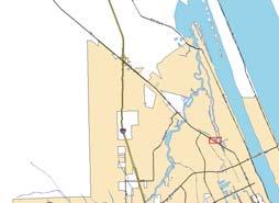

154 266 ft
155 Aerial view of 815 and 821 North US1 Source: Bing maps
156 Aerial view of 815 and 821 North US1 (broader view) Source: Bing maps
157 821 North US Highway 1 proposed office location
158 815 North US Highway 1 looking east from US1
159 815 North US Highway 1 existing palm trees along US1
160 815 North US Highway 1 looking west from creek
161 815 North US Highway 1 south view
162 815 North US Highway 1 looking east from property
163 815 North US Highway 1 looking east into creeks
164 ATTACHMENT 2 Applicant provided information
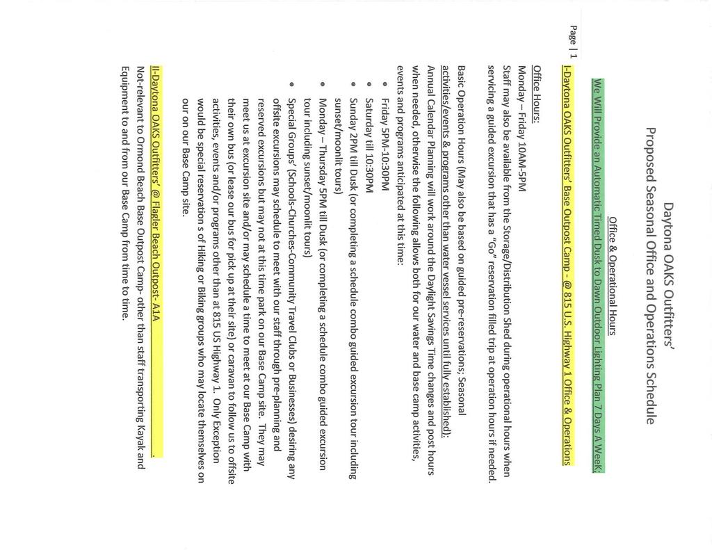
165
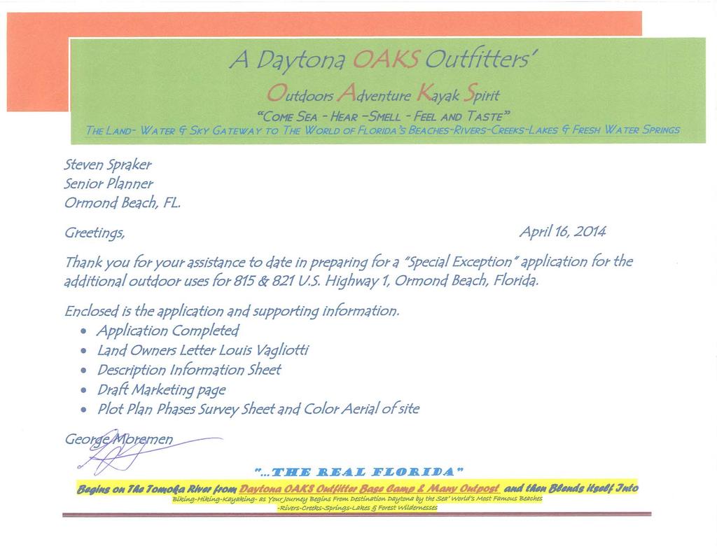
166
167
168
169
170
STAFF REPORT City of Ormond Beach Department of Planning
 STAFF REPORT City of Ormond Beach Department of Planning DATE: February 5, 2014 SUBJECT: 875 Sterthaus Drive, Ormond Renaissance Condominium, Comprehensive Plan Amendment over ten acres APPLICANT: Parker
STAFF REPORT. City of Ormond Beach Department of Planning. Administrative. S. Laureen Kornel, AICP, Senior Planner
 STAFF REPORT City of Ormond Beach Department of Planning DATE: May 5, 2011 SUBJECT: Vacant former Wendy's - 1561 North US Highway 1 Small Scale Land Use Map Amendment APPLICANT: PROJECT PLANNER: Administrative
ROSEMEAD CITY COUNCIL STAFF REPORT
 ROSEMEAD CITY COUNCIL STAFF REPORT TO THE HONORABLE MAYOR AND CITY COUNCIL FROM JEFF ALLRED CITY MANAGER DATE JUNE 9 2015 6 SUBJECT MUNICIPAL CODE AMENDMENT 15 02 AMENDING CHAPTERS 17 04 AND 17 72 OF TITLE
Glades County Staff Report and Recommendation Unified Staff Report for Small Scale Plan Amendment and Rezoning
 Glades County Staff Report and Recommendation Unified Staff Report for Small Scale Plan Amendment and Rezoning CASE NUMBERS: COMP17-02 and RZ17-02 DATE of STAFF REPORT: May 1, 2017 CASE TYPE: Application
PLANNING AND ZONING BOARD Council Chambers 3048 S. Atlantic Avenue Daytona Beach Shores, Florida Monday, January 11, :30 a.m.
 PLANNING AND ZONING BOARD Council Chambers 3048 S. Atlantic Avenue Daytona Beach Shores, Florida Monday, January 11, 2016 8:30 a.m. AGENDA CALL TO ORDER AUDIENCE REMARKS: Time for citizens and members
VILLAGE OF PALM SPRINGS VILLAGE COUNCIL MINUTES REGULAR MEETING, COUNCIL CHAMBERS, JULY 25, 2013
 VILLAGE OF PALM SPRINGS VILLAGE COUNCIL MINUTES REGULAR MEETING, COUNCIL CHAMBERS, JULY 25, 2013 CALL TO ORDER, ROLL CALL, INVOCATION, AND PLEDGE OF ALLEGIANCE Mayor Bev Smith called the regular meeting
MINUTES REGULAR MEETING BOARD OF ADJUSTMENT March 19, Mr. Harshaw called the March 19, 2015, Board of Adjustment Meeting to order at 1:00 p.m.
 MINUTES REGULAR MEETING BOARD OF ADJUSTMENT March 19, 2015 A regular meeting of the City of Daytona Beach Board of Adjustment was held on Thursday, March 19, 2015, at 1:00 p.m. in City Hall Commission
AGENDA ITEM SUMMARY GLADES COUNTY BOARD OF COUNTY COMMISSIONERS
 AGENDA ITEM SUMMARY GLADES COUNTY BOARD OF COUNTY COMMISSIONERS SUBJECT: Case Number COMP17-02, RFYC, LLC This is a Legislative Hearing. DEPARTMENT REQUEST: The Community Development Department requests
MINUTES. REGULAR MEETING - PLANNING BOARD March 24, Mr. Hoitsma called the meeting to order at 6:00 p.m.
 MINUTES REGULAR MEETING - PLANNING BOARD March 24, 2016 Minutes for the Regular Planning Board Meeting for the City ofdaytona Beach, Florida, held on Thursday, March 24, 2016 at 6:00 p.m. in the Commission
CITY COUNCIL PUBLIC HEARING MARCH 20, 2017 SUBJECT:
 CITY COUNCIL PUBLIC HEARING MARCH 20, 2017 SUBJECT: INITIATED BY: APPEAL OF THE PLANNING COMMISSION APPROVAL OF A REQUEST TO EXPAND AN EXISTING RESTAURANT WITHIN THE EXISTING LOBBY AND ROOFTOP AREA WITH
AGENDA PLANNING COMMISSION Tuesday, April 18, :00 PM City Council Chambers 125 East Avenue B, Hutchinson, Kansas
 AGENDA PLANNING COMMISSION Tuesday, April 18, 2017 5:00 PM City Council Chambers 125 East Avenue B, Hutchinson, Kansas 1. ROLL CALL Macklin Woleslagel Bisbee (Chair) Hamilton Peirce Vacant Carr Hornbeck
CITY OF BELLEVIEW PLANNING & ZONING BOARD AGENDA
 CITY OF BELLEVIEW PLANNING & ZONING BOARD AGENDA BELLEVIEW CITY HALL COMMISSION ROOM 5:30 PM IF A PERSON SHOULD DESIRE TO APPEAL ANY DECISION MADE BY THE BOARD, A VERBATIM RECORD OF THE PROCEEDINGS WHICH
Glades County Staff Report and Recommendation REZONING
 Glades County Staff Report and Recommendation REZONING CASE NUMBER: RZ15-01 DATE: October 2, 2015 CASE TYPE: Application for Rezoning REQUEST: J.J. Wiggins Memorial Trust is requesting a rezoning of 22.1±
ARTICLE 3: Zone Districts
 ARTICLE 3: Zone Districts... 3-1 17.3.1: General...3-1 17.3.1.1: Purpose and Intent... 3-1 17.3.2: Districts and Maps...3-1 17.3.2.1: Applicability... 3-1 17.3.2.2: Creation of Districts... 3-1 17.3.2.3:
PLANNING COMMISSION MINUTES - CITY OF INVER GROVE HEIGHTS. Tuesday, May 20, :00 p.m. City Hall Chambers Barbara Avenue
 PLANNING COMMISSION MINUTES - CITY OF INVER GROVE HEIGHTS Tuesday, 7:00 p.m. City Hall Chambers - 8150 Barbara Avenue Chair Hark called the Planning Commission meeting to order at 7:00 p.m. Commissioners
CITY OF WINTER PARK Planning & Zoning Board
 CITY OF WINTER PARK Planning & Zoning Board Regular Meeting December 4, 2012 City Hall, Commission Chambers 7:00 p.m. MINUTES Chair Whiting called the meeting to order at 7:00 p.m. in the Commission Chambers
VILLAGE OF DOWNERS GROVE PLAN COMMISSION VILLAGE HALL COUNCIL CHAMBERS 801 BURLINGTON AVENUE. June 2, :00 p.m. AGENDA
 VILLAGE OF DOWNERS GROVE PLAN COMMISSION VILLAGE HALL COUNCIL CHAMBERS 801 BURLINGTON AVENUE June 2, 2014 7:00 p.m. AGENDA 1. Call to Order 2. Roll Call a. Pledge of Allegiance 3. Approval of Minutes April
ADA TOWNSHIP PLANNING COMMISSION MINUTES OF THE JUNE 15, 2017 MEETING
 ADA TOWNSHIP PLANNING COMMISSION MINUTES OF THE JUNE 15, 2017 MEETING A meeting of the was held on Thursday, June 15, 2017, 7:00 p.m. at the Ada Township Offices, 7330 Thornapple River Dr., Ada, MI. I.
AGENDA ITEM SUMMARY GLADES COUNTY BOARD OF COUNTY COMMISSIONERS
 AGENDA ITEM SUMMARY GLADES COUNTY BOARD OF COUNTY COMMISSIONERS SUBJECT: Case Number COMP17-01, Legend Moto LLC This is a Legislative Hearing. DEPARTMENT REQUEST: The Community Development Department requests
Dan Buday, Judy Clock, June Cross, Becky Doan, Toni Felter, Francis (Brownie) Flanders and John Hess
 Flanders and John Hess") Monday, December 13, 2010 7:00 p.m. 210 State Street, City Hall, Council Chambers, Charlevoix, Michigan A) CALL TO ORDER The meeting was called to order by Chairman John Hess at 7:03 p.m. B) ROLL CALL
Monday, December 13, 2010 7:00 p.m. 210 State Street, City Hall, Council Chambers, Charlevoix, Michigan A) CALL TO ORDER The meeting was called to order by Chairman John Hess at 7:03 p.m. B) ROLL CALL
Community Dev. Coord./Deputy City Recorder
 1 2 3 4 5 6 7 8 9 10 11 12 13 14 15 16 17 18 19 20 21 22 23 24 25 26 27 28 29 30 31 32 33 34 35 36 37 38 39 40 41 42 43 44 45 46 NORTH OGDEN PLANNING COMMISSION MEETING MINUTES December 18, 2013 The North
Planning and Development Services Department
 Planning and Development Services Department M E M O R A N D U M TO: Planning and Zoning Commission THROUGH: Mark Satterlee, AICP, Planning & Development Services Director Leslie Olson, AICP, Planning
MINUTES OF THE TOWN OF LADY LAKE REGULAR PLANNING AND ZONING BOARD MEETING LADY LAKE, FLORIDA. May 8, :30 p.m.
 MINUTES OF THE TOWN OF LADY LAKE REGULAR PLANNING AND ZONING BOARD MEETING LADY LAKE, FLORIDA May 8, 2017 5:30 p.m. The Planning and Zoning Board Meeting was held in the Town Hall Commission Chambers at
AGENDA FOR THE HEARING EXAMINER
 AGENDA FOR THE HEARING EXAMINER Tuesday, September 4, 2018 9:00 AM Council Chambers 1. HEARINGS CALLED TO ORDER 2. HEARINGS A. Case # VA18-0016; Address: 5205 Sea Gull Court; Applicant: Robert W Schmid
Community Development Department Planning Division 1600 First Street + P.O. Box 660 Napa, CA (707)
") Community Development Department Planning Division 1600 First Street + P.O. Box 660 Napa, CA 94559-0660 (707) 257-9530 PLANNING COMMISSION STAFF REPORT May 7, 2015 AGENDA ITEM# 6.A. PL15-0041 UNIVERSAL
Community Development Department Planning Division 1600 First Street + P.O. Box 660 Napa, CA 94559-0660 (707) 257-9530 PLANNING COMMISSION STAFF REPORT May 7, 2015 AGENDA ITEM# 6.A. PL15-0041 UNIVERSAL
ORDINANCE NO:
 ORDINANCE NO: 2016-05 AN ORDINANCE OF THE CITY OF DAYTONA BEACH SHORES, VOLUSIA COUNTY FLORIDA, RELATING TO COMPREHENSIVE PLANNING; AMENDING THE CITY OF DAYTONA BEACH SHORES COMPREHENSIVE PLAN, AMENDING
The meeting was called to order by Acting Chairman Lee Dorson. Also present was Bill Mann, Senior Planner and Recording Secretary Amber Lehman.
 Held Monday, October 13, 2008 at 7:00 P.M. in the Council Chambers, 11 North 3 rd Street, Jacksonville Beach, Florida Call to Order The meeting was called to order by Acting Chairman Lee Dorson. Roll Call
PALM BEACH COUNTY PLANNING, ZONING AND BUILDING DEPARTMENT ZONING DIVISION ZONING COMMISSION VARIANCE STAFF REPORT 06/05/2014
 PALM BEACH COUNTY PLANNING, ZONING AND BUILDING DEPARTMENT ZONING DIVISION ZONING COMMISSION VARIANCE STAFF REPORT 06/05/2014 APPLICATION NO. ZV-2013-03120 CODE SECTION REQUIRED PROPOSED VARIANCE (V1)
Paseo de la Riviera. August 12, 2015
 Paseo de la Riviera August 12, 2015 1 2 3 Existing Future Land Use Map Existing Zoning Map 4 5 6 7 Review Timeline 1 2 3 4 5 Development Review Committee: 10.31.14 Zoning Code Text, Future Land Use Map,
CITY OF MANHATTAN BEACH [DRAFT] PLANNING COMMISION MINUTES OF REGULAR MEETING JANUARY 28, 2015
![CITY OF MANHATTAN BEACH [DRAFT] PLANNING COMMISION MINUTES OF REGULAR MEETING JANUARY 28, 2015](/thumbs/94/121103169.jpg "CITY OF MANHATTAN BEACH [DRAFT] PLANNING COMMISION MINUTES OF REGULAR MEETING JANUARY 28, 2015") CITY OF MANHATTAN BEACH [DRAFT] PLANNING COMMISION MINUTES OF REGULAR MEETING JANUARY 28, 2015 A Regular Meeting of the Planning Commission of the City of Manhattan Beach, California, was held on the 28
CITY OF MANHATTAN BEACH [DRAFT] PLANNING COMMISION MINUTES OF REGULAR MEETING JANUARY 28, 2015 A Regular Meeting of the Planning Commission of the City of Manhattan Beach, California, was held on the 28
BOARD OF ADJUSTMENT MEETING CITY OF ST. PETE BEACH
 BOARD OF ADJUSTMENT MEETING CITY OF ST. PETE BEACH 155 Corey Avenue St. Pete Beach, Florida Wednesday, 11/15/2017 2:00 p.m. Call to Order Pledge of Allegiance Roll Call 1. Changes to the Agenda Agenda
CITY OF WEST PALM BEACH ZONING BOARD OF APPEALS
 CITY OF WEST PALM BEACH ZONING BOARD OF APPEALS Meeting Date: November 2, 2017 Zoning Board of Appeals Case No. 3356 Dr. Alice Moore Apartments Variances Location Aerial I. REQUEST Site is outlined in
MINUTES OF THE TOWN OF LADY LAKE REGULAR PLANNING AND ZONING BOARD MEETING LADY LAKE, FLORIDA. February 8, :30pm
 MINUTES OF THE TOWN OF LADY LAKE REGULAR PLANNING AND ZONING BOARD MEETING LADY LAKE, FLORIDA 5:30pm The Planning and Zoning Board Meeting was held in the Town Hall Commission Chambers at 409 Fennell Blvd.,
STAFF REPORT. City of Ormond Beach Department of Planning. Exception for Outdoor Activity
 STAFF REPORT City of Ormond Beach Department of Planning DATE: March 7, 2019 SUBJECT: Lucky s Market, 101 East Granada Boulevard: Special Exception for Outdoor Activity APPLICANT: Wendy L. Petrillo-Rundle,
Conditional Use Permit case no. CU 14-06: Bristol Village Partners, LLC
 PLANNING AND ZONING COMMISSION STAFF REPORT August 7, 2014 Conditional Use Permit case no. CU 14-06: Bristol Village Partners, LLC CASE DESCRIPTION: LOCATION: LEGAL DESCRIPTION: EXISTING LAND USE: ZONING:
REGULAR MEETING OF LURAY PLANNING COMMISSION APRIL 13, 2016
 REGULAR MEETING OF LURAY PLANNING COMMISSION The Luray Planning Commission met on Wednesday, April 13, 2016 at 7:00 p.m. in regular session. The meeting was held in the Luray Town Council Chambers at 45
Village WASHINGTON TOWNSHIP MASTER PLAN SYNTHESIS. Page 197
 Village P l a n WASHINGTON TOWNSHIP MASTER PLAN SYNTHESIS Page 197 SECTION 11.0 MASTER PLAN SYNTHESIS INTRODUCTION The proposals presented in the various plans result in a graphic synthesis: The Land Use
CITY OF INDIAN ROCKS BEACH BOARD OF ADJUSTMENTS AND APPEALS
 MINUTES CITY OF INDIAN ROCKS BEACH BOARD OF ADJUSTMENTS AND APPEALS The Regular Meeting of the Indian Rocks Beach Board of Adjustments and Appeals was held on April 21, 2009, at 7:00 p.m., in the City
STAFF REPORT. Community Development Director PO Box 4755 Beaverton, OR 97076
 STAFF REPORT HEARING DATE: July 7, 2010 TO: Planning Commission STAFF: Jana Fox, Assistant Planner PROPOSAL: Southeast Beaverton Office Commercial Zoning Map Amendment (ZMA2010-0006) LOCATION: The subject
UNAPPROVED MINUTES PLANNING COMMISSION REGULAR MEETING CITY OF WYOMING, MINNESOTA DECEMBER 9, :00 PM
 UNAPPROVED MINUTES PLANNING COMMISSION REGULAR MEETING CITY OF WYOMING, MINNESOTA DECEMBER 9, 2008 7:00 PM CALL TO ORDER: Michael Thomas called the Regular Meeting of the Wyoming Planning Commission to
Page # 1 of 2 Posted: March 4, 2016
 For More Information, Contact: Kathy Rathel Customer Service Technician City of Winter Garden 300 West Plant Street Winter Garden, FL 34787 407.656.4111 ext. 5149 krathel@cwgdn.com PLANNING & ZONING BOARD
ZONING CLASSIFICATION SUMMARY SHEET
 Growth and Resource Management Planning and Development Services 123 West Indiana Avenue Room 202 DeLand, Florida 32720-4253 Telephone (386) 943-7059 Fax (386) 626-6570 www.volusia.org ZONING CLASSIFICATION
SARPY COUNTY BOARD OF ADJUSTMENT MINUTES OF MEETING May 14, 2015
 l. CALL MEETING TO ORDER SARPY COUNTY BOARD OF ADJUSTMENT MINUTES OF MEETING May 14, 2015 A meeting of the Board of Adjustment of Sarpy County, Nebraska was convened in open and public session at the call
PLANNING AND ECONOMIC DEVELOPMENT DEPARTMENT
 PLANNING AND ECONOMIC DEVELOPMENT DEPARTMENT 205 S. Willowbrook Ave., Compton, CA 90220 (310) 605-5532 Fax: (310) 761-1488 www.comptoncity.org PLANNING COMMISSION MINUTES WEDNESDAY, OCTOBER 11, 2017 7:00
September 25, 2000 Minutes. September 25, 2000
 Page 1 of 6 Book B, Pages 335-340 September 25, 2000 The Marion County Board of County Commissioners met in special session in Commission chambers at 9:01 a.m. on Monday, September 25 9, 2000 at the Marion
Members present: Burchill, Yacoub, Yoerg, Potter, Rhoades and Casanova
 PLAN COMMISSION Members present: Burchill, Yacoub, Yoerg, Potter, Rhoades and Casanova Others present: Richard Stout, Tim and Betty Caruso, Jim Zeller, Jennifer O Neill, Matt Frisbie, Alan Catchpool, Jeff
A-G-E-N-D-A REGULAR MEETING PLANNING BOARD CITY HALL CONFERENCE ROOM 308 E. STADIUM DRIVE TUESDAY, AUGUST 23, :30 P.M.
 A-G-E-N-D-A REGULAR MEETING PLANNING BOARD CITY HALL CONFERENCE ROOM 308 E. STADIUM DRIVE TUESDAY, AUGUST 23, 2016 5:30 P.M. 1. Meeting called to order. 2. Roll Call. 3. Set Meeting Agenda. 4. Approval
Midwest City, Oklahoma Zoning Ordinance
 2010 Midwest City, Oklahoma Zoning Ordinance 9/2/2010 Table of Contents Section 1. General Provisions... 5 1.1. Citation... 5 1.2. Authority... 5 1.3. Purpose... 5 1.4. Nature and Application... 5 1.5.
O-I (Office-Institutional) and AG-1(Agricultural)
 and AG-1(Agricultural)") PROPERTY INFORMATION ADDRESS 3503 and 3505 Bethany Bend DISTRICT, LAND LOTS 2/1 973 and 974 OVERLAY DISTRICT State Route 9 PETITION NUMBERS EXISTING ZONING O-I (Office-Institutional) and AG-1(Agricultural)
PROPERTY INFORMATION ADDRESS 3503 and 3505 Bethany Bend DISTRICT, LAND LOTS 2/1 973 and 974 OVERLAY DISTRICT State Route 9 PETITION NUMBERS EXISTING ZONING O-I (Office-Institutional) and AG-1(Agricultural)
Tyrone Planning Commission Agenda May 24, :00 PM
 Tyrone Planning Commission Agenda May 24, 2018 7:00 PM Planning Commission I. Call to Order Jeff Duncan Chairman II. Approval of Agenda David Nebergall Vice-Chairman Carl Schouw Commissioner Dia Hunter
LOCAL PLANNING AGENCY MEETING Martin County Commissioner Chambers 2401 S.E. Monterey Road Stuart, Florida MEETING MINUTES- November 5, 2015
 LOCAL PLANNING AGENCY MEETING Martin County Commissioner Chambers 2401 S.E. Monterey Road Stuart, Florida 34996 MEETING MINUTES- November 5, 2015 Present: Chairman Jim Moir Vice Chairperson Crystal Lucas
AGENDA PLANNING AND ZONING BOARD CITY OF DEERFIELD BEACH, FLORIDA May 2, 2013
 AGENDA PLANNING AND ZONING BOARD CITY OF DEERFIELD BEACH, FLORIDA May 2, 2013 The following is the agenda of a regular meeting of the Planning and Zoning Board of the City of Deerfield Beach, a municipal
PUBLIC NOTICE & AGENDA PLAN COMMISSION City Hall Forum State Street, Beloit, WI :00 PM Wednesday, November 07, 2018
 PUBLIC NOTICE & AGENDA PLAN COMMISSION City Hall Forum - 100 State Street, Beloit, WI 53511 7:00 PM Wednesday, November 07, 2018 1. CALL TO ORDER AND ROLL CALL 2. MINUTES 2.a. Consideration of the Minutes
PLANNING COMMISSION STAFF REPORT
 PLANNING COMMISSION STAFF REPORT West Capitol Hill Zoning Map Amendment Petition No. PLNPCM2011-00665 Located approximately at 548 W 300 North Street, 543 W 400 North Street, and 375 N 500 West Street
ORDINANCE NO
 Item 4 Attachment A ORDINANCE NO. 2017-346 AN ORDINANCE OF THE CITY COUNCIL OF THE CITY OF CALABASAS, CALIFORNIA AMENDING CHAPTER 17.22 OF THE CALABASAS MUNICIPAL CODE, AFFORDABLE HOUSING, TO BRING INTO
HISTORIC PRESERVATION BOARD BOARD AGENDA
 HISTORIC PRESERVATION BOARD BOARD AGENDA Historic Preservation Board Regular Meeting - Monday, November 24, 2014-6:00 p.m. City Hall - City Commission Chambers, 100 North U.S. #1, Fort Pierce, Florida
CITY OF PINELLAS PARK, FLORIDA PLANNING AND ZONING COMMISSION MINUTES REGULAR MEETING August 3, 2017
 CITY OF PINELLAS PARK, FLORIDA PLANNING AND ZONING COMMISSION MINUTES REGULAR MEETING August 3, 2017 The meeting was called to order at 7:00 p.m. by Dennis Shelley, Chairperson. ROLL CALL PRESENT: ABSENT:
STAFF REPORT. Permit Number: Laurier Enterprises, Inc. Kitsap County Board of Commissioners; Kitsap County Planning Commission
 STAFF REPORT Permit Number: 15 00740 Laurier Enterprises, Inc. DATE: December 18, 2015 TO: FROM: Kitsap County Board of Commissioners; Kitsap County Planning Commission Katrina Knutson, AICP, Senior Planner,
Be linked by an internal circulation system (i.e., walkways, streets, etc.) to other structures within the IPUD;
 to other structures within the IPUD;") 2. HALIFAX ACTIVITY CENTER A. DESCRIPTIONS OF FUTURE LAND USE DESIGNATIONS Each of the future land use designations specified by Phase I of the Halifax Activity Center Plan, and the relationship of these
2. HALIFAX ACTIVITY CENTER A. DESCRIPTIONS OF FUTURE LAND USE DESIGNATIONS Each of the future land use designations specified by Phase I of the Halifax Activity Center Plan, and the relationship of these
Planning Department Oconee County, Georgia
 Planning Department Oconee County, Georgia STAFF REPORT REZONE CASE #: 6985 DATE: October 31, 2016 STAFF REPORT BY: Andrew C. Stern, Planner APPLICANT NAME: Williams & Associates, Land Planners PC PROPERTY
PORTER COUNTY PLAN COMMISSION Regular Meeting Minutes April 26, 2017
 PORTER COUNTY PLAN COMMISSION Regular Meeting Minutes April 26, 2017 The regular meeting of the was held at 5:30 p.m. on Wednesday, April 26, 2017 in the Porter County Administrative Center, 155 Indiana
COLERAIN TOWNSHIP ZONING COMMISSION Regular Meeting Tuesday, September 19, :00 p.m.
 COLERAIN TOWNSHIP ZONING COMMISSION Regular Meeting Tuesday, September 19, 2017-6:00 p.m. Colerain Township Government Complex 4200 Springdale Road - Cincinnati, OH 45251 1. Meeting called to order. Pledge
Appendix A: Guide to Zoning Categories Prince George's County, Maryland
 Appendix A: Guide to Zoning Categories Prince George's County, Maryland RESIDENTIAL ZONES 1 Updated November 2010 R-O-S: Reserved Open Space - Provides for permanent maintenance of certain areas of land
Cape Coral Planning & Zoning Commission/Local Planning. Agency AGENDA. Wednesday, October 5, :00 AM Council Chambers
 Cape Coral Planning & Zoning Commission/Local Planning Agency 1. CALL TO ORDER A. Chair Read 2. MOMENT OF SILENCE AGENDA Wednesday, October 5, 2016 9:00 AM Council Chambers 3. PLEDGE OF ALLEGIANCE TO THE
PALM BEACH COUNTY PLANNING, ZONING AND BUILDING DEPARTMENT ZONING DIVISION
 PALM BEACH COUNTY PLANNING, ZONING AND BUILDING DEPARTMENT ZONING DIVISION Application No.: CA-2012-00688 Control No.: 2011-00552 Applicant: Garry Bernardo Owners: Garry Bernardo Agent: Frogner Consulting,
LAKE NONA PARCEL 10 & 11
 October 17, 2017 Staff Report to the Municipal Planning Board CASE #DRI2017-10003 GMP2017-10012 GMP2017-10013 ZON2017-10005 Item #2 LAKE NONA PARCEL 10 & 11 Location Map Subject Site SUMMARY Owner James
PALM BEACH COUNTY PLANNING, ZONING AND BUILDING DEPARTMENT ZONING DIVISION ZONING COMMISSION VARIANCE STAFF REPORT 07/05/2012
 PALM BEACH COUNTY PLANNING, ZONING AND BUILDING DEPARTMENT ZONING DIVISION ZONING COMMISSION VARIANCE STAFF REPORT 07/05/2012 APPLICATION NO. CODE SECTION REQUIRED PROPOSED VARIANCE ZV-2012-00690 3.D.1.A
Community Advisory Committee (CAC) Meeting #7 West Anaheim Youth Center May 26, 2016
 Meeting #7 West Anaheim Youth Center May 26, 2016") Community Advisory Committee (CAC) Meeting #7 West Anaheim Youth Center May 26, 2016 1 Project Team City: David Belmer Planning and Building Director Jonathan Borrego, AICP Planning Services Manager Gustavo
Community Advisory Committee (CAC) Meeting #7 West Anaheim Youth Center May 26, 2016 1 Project Team City: David Belmer Planning and Building Director Jonathan Borrego, AICP Planning Services Manager Gustavo
AGENDA FOR THE HEARING EXAMINER
 AGENDA FOR THE HEARING EXAMINER Tuesday, August 21, 2018 9:00 AM Council Chambers 1. HEARINGS CALLED TO ORDER 2. HEARINGS A. Case # ZA18-0008*; Acreage: 20,604-sq. ft; Address: 1514 SE 4th Street; Applicant:
Implementation. Approved Master Plan and SMA for Henson Creek-South Potomac 103
 Implementation Approved Master Plan and SMA for Henson Creek-South Potomac 103 104 Approved Master Plan and SMA for Henson Creek-South Potomac Sectional Map Amendment The land use recommendations in the
2. Rezone a portion of the lot from R2 (Small Lot Residential) to RD2 (Duplex: Housing Lane).
 to RD2 (Duplex: Housing Lane).") Public Notice September 6, 2018 Subject Property Subject Property: 337 Hastings Ave Lot 24, District Lot 1, Group 7, Similkameen Division Yale (Formerly Yale-Lytton) District, Plan 932 Application: The
Public Notice September 6, 2018 Subject Property Subject Property: 337 Hastings Ave Lot 24, District Lot 1, Group 7, Similkameen Division Yale (Formerly Yale-Lytton) District, Plan 932 Application: The
CITY OF PLANT CITY PLANNING BOARD
 CITY OF PLANT CITY PLANNING BOARD September 14, 2017 Thursday, 8:00 AM AGENDA Call Meeting to Order Approval of Minutes: August 10, 2017 Public Comments New Business PB-2017-08: Karen Drive Rezoning: A
Town of Duck, North Carolina Department of Community Development Text Amendment: Short Term Rentals Agenda Item 3b
 TO: Chairman Blakaitis and Members of the Town of Duck Planning Board FROM: Joe Heard, AICP, Director of Community Development DATE: July 13, 2016 RE: Proposal At its meeting on April 6, 2016, the Duck
CITY OF WINTER PARK Planning & Zoning Board. Regular Meeting September 6, 2016 City Hall, Commission Chambers MINUTES
 CITY OF WINTER PARK Planning & Zoning Board Regular Meeting September 6, 2016 City Hall, Commission Chambers 6:00 p.m. MINUTES Chairman James Johnston called the meeting to order at 6:00 p.m. in the Commission
PLANNING AND DEVELOPMENT COMMISSION (PDC) SUMMARY MINUTES January 3, 2019
 SUMMARY MINUTES January 3, 2019") PLANNING AND DEVELOPMENT COMMISSION (PDC) SUMMARY MINUTES Members Present: Cheryl Phillips, 1 st Vice Chair; William Garvin, 2 nd Vice Chair; Joel Brender; James Brooks; Sondra Moylan; Donny Harrelson,
PLANNING AND DEVELOPMENT COMMISSION (PDC) SUMMARY MINUTES Members Present: Cheryl Phillips, 1 st Vice Chair; William Garvin, 2 nd Vice Chair; Joel Brender; James Brooks; Sondra Moylan; Donny Harrelson,
BOARD OF ADJUSTMENT MEETING MINUTES May 10, 2017
 MINUTES ARE NOT VERBATIM BOARD OF ADJUSTMENT MEETING MINUTES May 10, 2017 The regular meeting of the Okaloosa County Board of Adjustment was held Wednesday, May 10, 2017 at 1:30 p.m., in the Okaloosa County
TOWN OF CUTLER BAY 4. PUBLIC HEARING: MOTION RECOMMENDING ADOPTION OF THE FOLLOWING ORDINANCE:
 TOWN OF CUTLER BAY Mayor Paul S. Vrooman Vice-Mayor Edward P. MacDougall Councilmember Timothy J. Meerbott Councilmember Ernest N. Sochin Councilmember Peggy R. Bell Town Manager Steve Alexander Town Attorney
MESA COUNTY PLANNING COMMISSION December 10, 2009 PUBLIC HEARING MINUTES
 MESA COUNTY PLANNING COMMISSION December 10, 2009 PUBLIC HEARING MINUTES Chairman Justman called to order a scheduled hearing of the Mesa County Planning Commission at 6:03p.m. Secretary Flynn led the
CITY OF PINELLAS PARK, FLORIDA PLANNING AND ZONING COMMISSION MINUTES REGULAR MEETING July 6, Brenda Braitling
 CITY OF PINELLAS PARK, FLORIDA PLANNING AND ZONING COMMISSION MINUTES REGULAR MEETING July 6, 2017 The meeting was called to order at 7:00 p.m. by Dennis Shelley, Chairperson. ROLL CALL PRESENT: ABSENT:
Prince George s County Zoning Ordinance and Subdivision Regulations Rewrite March 13, 2017
 Prince George s County Zoning Ordinance and Subdivision Regulations Rewrite March 13, 2017 The Maryland National Capital Park & Planning Commission 1 Worksessions Schedule Topic Date Zone Structure January
TREASURE COAST REGIONAL PLANNING COUNCIL M E M O R A N D U M. To: Council Members AGENDA ITEM 4G
 TREASURE COAST REGIONAL PLANNING COUNCIL M E M O R A N D U M To: Council Members AGENDA ITEM 4G From: Date: Subject: Staff March 16, 2007 Council Meeting Local Government Comprehensive Plan Review Draft
PLANNING & ZONING COMMISSION CITY OF PALMER, ALASKA REGULAR MEETING THURSDAY, JULY 17, :00 P.M. - COUNCIL CHAMBERS
 PLANNING & ZONING COMMISSION CITY OF PALMER, ALASKA REGULAR MEETING THURSDAY, JULY 17, 2014 7:00 P.M. - COUNCIL CHAMBERS A. CALL TO ORDER: The regular meeting of the Planning and Zoning Commission was
CITY OF PALM BEACH GARDENS CITY COUNCIL Agenda Cover Memorandum Meeting Date: November 1, 2018 Ordinance 24, 2018 / *Ordinance 25, 2018
 CITY OF PALM BEACH GARDENS CITY COUNCIL Agenda Cover Memorandum Meeting Date: November 1, 2018 Subject/Agenda Item: 11940 U.S. Highway One Small-Scale Comprehensive Plan Future Land Use Map Amendment and
Special Use Permit #SUP , Youssef Home Fitness Studio Occoquan Magisterial District
 COUNTY OF PRINCE WILLIAM 5 County Complex Court, Prince William, Virginia 22192-9201 PLANNING (703) 792-7615 FAX (703) 792-4401 OFFICE Internet www.pwcgov.org Christopher M. Price, AICP Acting Director
THE REDEVELOPMENT PLAN
 PAGE 37 THE REDEVELOPMENT PLAN FUTURE LAND USE The Silver Terrace Redevelopment Area is currently designated as Redevelopment Area #4 on the City of Delray Beach Future Land Use Map (FLUM). This designation
Amendment to the Zoning and Subdivision Ordinances; Consider Repeal Cluster Development Standards
 2 Board of Supervisors Meg Bohmke, Chairman Gary F. Snellings, Vice Chairman Jack R. Cavalier Thomas C. Coen L. Mark Dudenhefer Wendy E. Maurer Cindy C. Shelton February 28, 2018 Thomas C. Foley County
MEMORANDUM. Douglas Hutchens, Interim City Manag~ August 4, 2016 / Greg Rice, Director of Planning & Development
 Agenda Item: Meeting Date: PH-1 8/18/16 TO: THROUGH: DATE: FROM: SUBJECT: PRESENTER: RECOMMENDATION: BUDGET IMP ACT: PAST ACTION: NEXT ACTION: ATTACHMENTS: BACKGROUND: City Commission MEMORANDUM Douglas
ORDINANCE City of DeBary Comprehensive Plan Amendments Page 1 of 3
 ORDINANCE 01-15 AN ORDINANCE OF THE CITY COUNCIL OF DEBARY, FLORIDA, AMENDING THE CITY S COMPREHENSIVE PLAN FUTURE LAND USE ELEMENT TEXT AMENDING COMPREHENSIVE PLAN POLICY 5.406 CONCERNING THE SOUTHEAST
EXHIBIT B FINDINGS OF FACT BEND DEVELOPMENT CODE (BDC) UPDATE AMENDMENT PZ
 UPDATE AMENDMENT PZ") EXHIBIT B FINDINGS OF FACT BEND DEVELOPMENT CODE (BDC) UPDATE AMENDMENT PZ 18-0524 Procedural Findings Notice of the proposed amendments was provided to the Department of Land Conservation and Development
EXHIBIT B FINDINGS OF FACT BEND DEVELOPMENT CODE (BDC) UPDATE AMENDMENT PZ 18-0524 Procedural Findings Notice of the proposed amendments was provided to the Department of Land Conservation and Development
NOTICE OF MEETING AND AGENDA FOR THE PLANNING COMMISSION OF SPRINGVILLE, UTAH... JANUARY 23, 2018
 NOTICE OF MEETING AND AGENDA FOR THE PLANNING COMMISSION OF SPRINGVILLE, UTAH............................ JANUARY 23, 2018 Notice is hereby given that the Planning Commission will hold a public meeting
EDGERTON CITY HALL PLANNING COMMISSION MEETING REGULAR SESSION March 12, 2019
 EDGERTON CITY HALL PLANNING COMMISSION MEETING REGULAR SESSION The met in regular session with Chair John Daley calling the meeting to order at 7:00 p.m. All present participated in the Pledge of Allegiance.
STAFF REPORT. Permit Number: Unlimited. Kitsap County Board of Commissioners; Kitsap County Planning Commission
 STAFF REPORT Permit Number: 15 00550 Unlimited DATE: March 2, 2016 TO: FROM: Kitsap County Board of Commissioners; Kitsap County Planning Commission Katrina Knutson, AICP, Senior Planner, DCD and Jeff
CITY PLANNING BOARD BOARD AGENDA
 CITY PLANNING BOARD BOARD AGENDA Planning Board Regular Meeting - Tuesday, March 11, 2014-6:00 p.m. City Hall - City Commission Chambers, 100 North U.S. #1, Fort Pierce, Florida 1. CALL TO ORDER 2. PLEDGE
Susan E. Andrade 91 Sherry Ave. Bristol, RI
 STATE OF RHODE ISLAND AND PROVIDENCE PLANTATIONS MINUTES THE ZONING BOARD OF REVIEW OF BRISTOL, RHODE ISLAND 02 OCTOBER 2017 7:00 PM BRISTOL TOWN HALL BRISTOL, RHODE ISLAND BEFORE THE TOWN OF BRISTOL ZONING
June 21, 2018 Planning and Land Development Regulation Commission (PLDRC)
") Page 1 of 13 GROWTH AND RESOURCE MANAGEMENT DEPARTMENT PLANNING AND DEVELOPMENT SERVICES DIVISION 123 W. Indiana Avenue, DeLand, FL 32720 (386) 736-5959 PUBLIC HEARING: CASE NO: SUBJECT: LOCATION: APPLICANT:
Page 1 of 13 GROWTH AND RESOURCE MANAGEMENT DEPARTMENT PLANNING AND DEVELOPMENT SERVICES DIVISION 123 W. Indiana Avenue, DeLand, FL 32720 (386) 736-5959 PUBLIC HEARING: CASE NO: SUBJECT: LOCATION: APPLICANT:
Cascade Charter Township, Zoning Board of Appeals Minutes July 14, 2015 Page 1
 ZONING MINUTES Cascade Charter Township Zoning Board of Appeals Tuesday, July 14, 2015 7:00 P.M. Cascade Library Wisner Center 2870 Jackson Avenue SE ARTICLE 1. ARTICLE 2. ARTICLE 3. Chairman Casey called
Tyrone Planning Commission Agenda
 Tyrone Planning Commission Agenda October 26, 2017 7:00 PM I. Call to Order II. Approval of Agenda Tyrone Planning Commission Will James Chairman Jeff Duncan Vice-Chairman Marlon Davis Commissioner David
PALM BEACH COUNTY PLANNING, ZONING AND BUILDING DEPARTMENT ZONING DIVISION
 PALM BEACH COUNTY PLANNING, ZONING AND BUILDING DEPARTMENT ZONING DIVISION Application No.: Z-2016-00663 Application Name: Autism School Control No.: 2014-00133 Applicant: Dayna2, LLC Owners: Dayna2, LLC
CITY OF WEST PALM BEACH PLANNING BOARD Meeting Date: July 17, 2018 Planning Board Case No. 1670I
 CITY OF WEST PALM BEACH PLANNING BOARD Meeting Date: July 17, 2018 Planning Board Case No. 1670I Palms Gateway Commercial Planned Development (CPD) Southeast Corner of Belvedere Road and Australian Avenue
City of South Daytona
 City of South Daytona Community Development Dept. Post Office Box 214960 South Daytona, FL 32121 386/322-3020 FAX 386/322-3029 MEMORANDUM To: From: Date: Re: Joseph W. Yarbrough, City Manager John Dillard,