Action Items
|
|
|
- Constance Neal
- 5 years ago
- Views:
Transcription
1
2 Action Items
3
4
5
6
7 Act 247 Reviews
8 Subdivision & Land Development


9 Act 247 Reviews of Proposed Development during June 2014 Symbols 3 8 Residential Lots/Units Non-Residential @ Other D D 1-10,000 10, , ,001-1,200,000 Mixed Use Not Consistent with Livable Landscapes2 Note: Excludes lot line revisions, lot consolidations, second reviews, sketch plans, and surface parking, UNLESS those reviews cited unique or significant community impacts # PLAN # PLAN TITLE 1 LD Children's House 2 LD The Cockerham Tract 3 LD Whitehall Veteran Housing 4 LD Walnut Ridge 5 LD Atwater Lot 11A 6 LD The Shops at Coventry 7 LD Hoover Building Specialists, LLC 8 LD Qihe Food Corp 9 LD Northwyn Court Apartments 10 SD The Cockerham Tract 11 SD CG King LP 12 SD The Comerford Tract 13 SD Lot 11A for Atwater 14 SD Maple Alley LLC 15 SD Elizabeth R. Moran 16 SD Mary Beth Joseph Livable Landscapes2 Growth Areas Urban Suburban Suburban Center Rural Resource Areas Agricultural Rural Rural Center Overlay Features Natural Landscape Municipalities Miles
10 To: Chester County Planning Commission From: Planning Staff Re: 247 Activity - 6/1/2014 to 6/30/2014 SUBDIVISION AND LAND DEVELOPMENT APPLICATIONS Applications consist of the following land use types: 2014 YEAR TO DATE 2013 YEAR TO DATE 2013 TOTAL LAND USE PROP. LOTS/UNITS PROP. LOTS/UNITS PROP. LOTS/UNITS PROP. LOTS/UNITS Sfr Apt ,430 Ths Twn Mh Agr Com Ind Ins TOTALS: , ,590 UNOFFICIAL SKETCH PLAN EVALUATIONS Applications consist of the following land use types: 2014 YEAR TO DATE 2013 YEAR TO DATE 2013 TOTAL LAND USE PROP. LOTS/UNITS PROP. LOTS/UNITS PROP. LOTS/UNITS PROP. LOTS/UNITS Sfr Apt Ths Twn Mh Agr Com Ind Ins TOTALS:
11 Subdivision & Land Development Review Reports
12 Subdivision and Land Development Reviews 6/1/2014 thru 6/30/2014 Community Name Municipality Plan # Title Acreage Land Use Lots/Units Roads (L Feet) (+, -, N/R) Landscapes2 Central Downingtown Borough SD Mary Beth Joseph 0.36 Sfr 3 + Ths Upper Uwchlan Township LD Children's House 0.99 Ins 1 + Eastern East Whiteland Township LD The Cockerham Tract Ths 51 1,864 + East Whiteland Township SD The Cockerham Tract Ths 2 + Sfr Tredyffrin Township LD Atwater Lot 11A Com 1 + Tredyffrin Township SD Lot 11A for Atwater Com 2 + Willistown Township SD Elizabeth R. Moran Sfr 3 + Northern East Vincent Township LD Whitehall Veteran Housing 3.49 Apt 49 + Honey Brook Township LD Hoover Building Specialists, LLC Com 4 + North Coventry Township LD The Shops at Coventry Com 1 + Southeastern East Marlborough Township LD Walnut Ridge Ths 61 2,165 + Southwestern Parkesburg Borough SD Maple Alley LLC 0.36 Sfr 2 + Penn Township LD Qihe Food Corp Agr 1 + West Fallowfield Township SD CG King LP Agr 3 N/R West Chester East Bradford Township SD The Comerford Tract Sfr 4 + West Whiteland Township LD Northwyn Court Apartments 5.80 Apt 20 + County Totals ,029 Municipalities Reviews Acreage Lots/Units Linear Feet There are 15 plans consistent, 0 plans inconsistent, and 1 plans with no relevance to Landscapes2. June 26, 2014 Page 1 of 1
13 Structure Square Footage/Use Per Land Development for 6/1/2014 thru 6/30/2014 Municipality Planning Square Number of Total Number Title Footage Structure Use Buildings Lots/Units Acreage Honey Brook Township LD Hoover Building Specialists, LLC 84,227 Com Retail North Coventry Township LD The Shops at Coventry 13,540 Com Retail Penn Township LD Qihe Food Corp 13,920 Agr Mushroom House Tredyffrin Township LD Atwater Lot 11A 45,404 Com Office Building Upper Uwchlan Township LD Children's House 5,264 Ins Child Daycare Grand Total 5 162, June 26, 2014 Page 1 of 1
14 Subdivision & Land Development Letters
15 June 2, 2014 Cary Vargo, Manager Upper Uwchlan Township 140 Pottstown Pike Chester Springs, PA Re: Preliminary Land Development - Children's House # LD Upper Uwchlan Township Dear Mr. Vargo: A preliminary land development plan entitled Children s House, prepared by Horizon Engineering, and dated April 30, 2014, was received by this office on May 6, The land development is situated on the northeast corner of Garrison Drive and Elmhurst Drive and involves the construction of a 5,264 square foot day care facility on a 0.99 acre site (UPI # ). The project site, which is served by public water and sewer, is located in the R-2 Residential and F2 Flexible Development Overlay zoning districts. This plan is reviewed by the Chester County Planning Commission in accord with the provisions of Section 502 of the Pennsylvania Municipalities Planning Code (MPC). This report does not review the plan for compliance to all aspects of your ordinance, as this is more appropriately done by agents of Upper Uwchlan Township. We offer the following comments on the proposed land development for your consideration: BACKGROUND: 1. The Chester County Planning Commission previously reviewed the subdivision plan which created this parcel. CCPC# , Windsor Ridge, dated September 12, 2002, which addressed the creation of 442 residential units (228 single-family detached units, and 214 townhouse units), a 5,890 square foot community center, a 5,890 square foot day care/private office building, and acres of open space from a acre site, was approved by Upper Uwchlan Township on July 21, 2003 (the approved plan for the Windsor Ridge development identified the current project site as the location of future daycare/professional office space). Recording Note 6 on Sheet 1 of the current plan submission states that the stormwater management design of the Windsor Ridge development anticipated the proposed improvements shown on the current plan submission, thus no additional stormwater management is proposed as part of this application. We also note the plan identifies that the 21 parking spaces for this facility have already been constructed. LANDSCAPES: 2. The project site is located within the Suburban Landscape designation of Landscapes2, the 2009 County Comprehensive Plan. The location of the proposed land development is consistent with the guidelines of the Suburban Landscape. ccplanning@chesco.org Web site:
16 Page: 2 June 2, 2014 Re: Preliminary Land Development - Children's House # LD Upper Uwchlan Township ADMINISTRATIVE NOTES: 3. The plan submission indicates that conditional use approval is required for this project. The Township should verify that any conditions of approval are incorporated into the final plan. The final plan should accurately note the date and any conditions set as part of the conditional use approval. The PA Municipalities Planning Code (MPC) allows the Township to add reasonable conditions and safeguards, in addition to those expressed in the zoning ordinance, as it may deem necessary to implement the purposes of the MPC and the zoning ordinance. 4. The Township should receive written confirmation that the applicant meets all licensing and registration requirements regulated by the PA Department of Public Welfare - Office of Children, Youth and Families, and any other applicable state regulations pertaining to child day care facilities. 5. A minimum of four (4) copies of the plan should be presented at the Chester County Planning Commission for endorsement to permit recording of the final plan in accord with the procedures of Act 247, the Pennsylvania Municipalities Planning Code, and to meet the requirements of the Recorder of Deeds and the Assessment Office. RECOMMENDATION: The Commission recommends that all Upper Uwchlan Township requirements be satisfied, and the issues raised in this letter be addressed, before action is taken on this plan. Sincerely, RTB/PF cc: Ronald T. Bailey, AICP Secretary Nace Properties LLC Pulte Homes of PA Limited Partnership Horizon Engineering David Leh, P.E., Gilmore and Associates, Township Engineer Chester County Department of Children, Youth and Families
17 Terry Woodman, Manager East Whiteland Township 209 Conestoga Road Frazer, PA June 2, 2014 Re: Preliminary Land Development - The Cockerham Tract # LD East Whiteland Township Dear Ms. Woodman: A preliminary land development plan entitled The Cockerham Tract, prepared by Commonwealth Engineers, Inc., and dated April 30, 2014, was received by this office on May 6, The land development is situated on the west side of Planebrook Road south of Route 202 and involves the construction of 51 townhouse units, and 1,864 linear feet of private roadway, on a acre site (UPI # and # ). The project site, which is served by public water and sewer, is located in the RM Medium Density Residential zoning district A traffic access study, prepared by Heinrich & Klein Associates, Inc., dated April 10, 2014, was included with the plan submission. The Act 247 County Referral Form indicates that a homeowners association will be responsible for the proposed common facilities/areas of the development. The applicant also proposes the subdivision of the acre parent tract, which is addressed by the Commission in a separate review (CCPC# SD , dated June 2, 2014). There is an existing residence on Lot 2 (2.41 acres). The proposed townhouse units will be located on Lot 1, which is bisected by a 315 foot wide PECO overhead transmission line right-of-way. Townhouse units 1 to 35 will be located on the south side of the PECO overhead transmission line right-of-way and townhouse units 36 to 51 will be located on the north side of this right-of-way. This plan is reviewed by the Chester County Planning Commission in accord with the provisions of Section 502 of the Pennsylvania Municipalities Planning Code (MPC). This report does not review the plan for compliance to all aspects of your ordinance, as this is more appropriately done by agents of East Whiteland Township. We offer the following comments on the proposed land development for your consideration: LANDSCAPES: 1. The project site is located within the Suburban and Natural Landscapes designations of Landscapes2, the 2009 County Comprehensive Plan. The location of the proposed subdivision is consistent with the guidelines of the Suburban Landscape. WATERSHEDS: 2. Watersheds, An Integrated Water Resources Plan for Chester County and Its Watersheds, was adopted in 2002 as the water resources component of Landscapes. Watersheds indicates that the proposed development activity is located within the (East) Valley Creek watershed. The highest priority management objectives identified in Watersheds for consideration in land development ccplanning@chesco.org Web site:
18 Page: 2 June 2, 2014 Re: Preliminary Land Development - The Cockerham Tract # LD East Whiteland Township and land use planning within the (East) Valley Creek watershed include: reduce stormwater runoff, restore water quality of impaired streams, and protect/enhance historic, cultural and recreational resources. It is recommended that these concerns and conditions be taken into consideration in final site design decisions. Specific strategies for implementation to effectively address these items can be found in Part 8 of Watersheds. A more detailed listing of water resources management needs and resources to be protected within the (East) Valley Creek watershed can be found in Part 10 of Watersheds. 3. In February 2011, the Valley Creek Watershed Act 167 Stormwater Management Plan was approved by the Pennsylvania Department of Environmental Protection (DEP). All land disturbance and land development activities that occur within the (East) Valley Creek watershed must comply with the stormwater management standards included in the approved (East) Valley Creek Act 167 Plan and the requirements of the municipality s Act 167 stormwater ordinance. Implementation of the Act 167 Plan and ordinances will help reduce the impacts of stormwater and pollutant runoff to Chester County s streams and groundwater. It is recommended that the municipal engineer thoroughly review the proposed plans to ensure compliance with the applicable standards of the (East) Valley Creek Act 167 Plan. 4. The site is located in an area designated by the Pennsylvania Department of Environmental Protection (DEP) as a Special Protection Watershed. Special Protection Watersheds are important because Chester County s High Quality and Exceptional Value Watersheds may be especially sensitive to degradation and pollution that could result from development. The DEP or the municipality may impose stricter limitations on proposed wastewater and stormwater discharges in these watersheds, and special care should be exercised in the design, construction, operation and maintenance of stormwater control facilities in these areas to prevent degradation of the waters of the Commonwealth. 5. The proposed activity is located within a watershed for which Total Maximum Daily Load (TMDL) pollutant load reduction requirements have been established by PA Department of Environmental Protection (DEP). It is recommended that the municipal engineer and the applicant review the applicable TMDL report and ensure that the proposed activity will not increase the relevant pollutant loading to the water body, and, to ensure that the proposed activity achieves pollutant load reductions to the extent practical or as required by municipal or state regulations. Information regarding TMDLs for Chester County water bodies can be found at (click on the TMDLs/Water Quality Improvement link in the left navigation panel for further information). 6. The proposed activity is located within an area that drains to a surface water body that has been listed by PA Department of Environmental Protection (DEP) as impaired and not achieving the applicable state water quality standards. It is recommended that the municipal engineer and the applicant review the DEP information regarding the sources and causes of the impairment for the receiving water body and ensure that the proposed activity will not increase the relevant pollutant loading to the water body. Information regarding listed impairments for Chester County water bodies can be found at (click on the TMDLs/Water Quality Improvement link in the left navigation panel for further information).
19 Page: 3 June 2, 2014 Re: Preliminary Land Development - The Cockerham Tract # LD East Whiteland Township PRIMARY ISSUES: 7. The applicant should contact PECO to obtain use restrictions associated with the PECO rights-of-way which traverse the site. The applicant should provide the Township with appropriate documentation that PECO has reviewed and approved the proposed development activity within the existing rights-of-way, which includes proposed roadway, sidewalk and utility construction. 8. The site is underlain by carbonate geology in which the presence or potential may exist for formation and/or expansion of solution channels, sinkholes and other potentially dangerous karst features and the associated risk of groundwater contamination. These features present significant risks and challenges that often can be overcome and avoided with careful stormwater management design. The location, type, and design of stormwater facilities and best management practices (BMPs) should be based on a site evaluation conducted by a qualified licensed professional that ascertains the subsurface soil, rock and groundwater conditions that are relevant to formation of karst features, and the PA BMP Manual or other design guidance acceptable to the Municipal Engineer. Where site conditions preclude achieving the required stormwater infiltration or water quality volume, other conservation development design techniques and BMPs should be used to reduce as much as possible the total volume and pollutant load of stormwater released to streams. 9. The Title Plan (Sheet 3) depicts a proposed 25 foot wide right of way on the west side of Planebrook Road. The 2004 Road Functional Classification Technical Memorandum by the Chester County Planning Commission classifies Planebrook Road as a major collector road. The memorandum recommends a 60 to 80 foot-wide right-of-way for major collector roads to accommodate future road improvement. We suggest that the applicant provide a 30 foot wide right-of-way on the west side of Planebrook Road, which should be offered for dedication to the Township. 10. Vehicular access for all 51 townhouse is proposed from a single driveway entrance on Planebrook Road, and we note that the applicant is requesting a waiver from the minimum access for residential development standards in Section D of the Township Subdivision and Land Development Ordinance. The 1994 Circulation Handbook prepared by the Chester County Planning Commission recommends that a maximum of 24 dwellings utilize a single access (page 4-43). The applicant and Township should consider providing a secondary and/or emergency access connection to this project site. We note that both the existing driveway entrance on Lot 2, and the existing driveway entrance driveway from the adjoining parcel to the south (UPI# ) that currently provides access to the accessory buildings on the southern portion of the site, could be developed into emergency access connections. 11. We suggest that the applicant and Township investigate the feasibility of providing a sidewalk/trail extension to Planebrook Road, in order to provide a pedestrian connection to the Township Trail network. We note the Proposed Township-Wide Trail System Map in the Township s 2003 Park and Recreation Plan identifies an Additional Trail Link corridor along Planebrook Road. ADMINISTRATIVE NOTES: 12. The applicant is requesting seven waivers from the provisions of the Township Subdivision and Land Development Ordinance, and three waivers from the provisions of the Township Stormwater Management Ordinance. Waiver requests should only be considered following the determination that the proposed project either meets the purpose of these requirements or does not create the impacts that these provisions are intended to manage.
20 Page: 4 June 2, 2014 Re: Preliminary Land Development - The Cockerham Tract # LD East Whiteland Township 13. The site contains land within the 100 year flood plain associated with the tributary to Valley Creek that traverses the western portion of the site. Although it does not appear that any development activity will encroach into the floodplain, the applicant should be aware that the County Planning Commission opposes, and the Federal Emergency Management Agency and Pennsylvania Department of Environmental Protection regulate filling or development in the floodplain. Development within a floodplain can increase the magnitude and frequency of normally minor floods, and present health and safety problems. 14. The site contains delineated wetlands. Although it does not appear that any development activity will encroach into the delineated wetland area, the applicant should be aware that placement of fill in wetlands is regulated by the Corps of Engineers in accordance with Section 404 of the Clean Water Act (1977) and the Department of Environmental Protection under Chapter 105 Rules and Regulations for the Bureau of Dams and Waterway Management. 15. The site contains areas of hydric (wet) soils (Ho Holly and ClB Clarksburg) which have limitations to development. These limitations include drainage problems due to low permeability, low runoff rates and sub-surface saturation. While it does not appear that any development activity will occur in hydric soil areas, the applicant should be aware that when construction takes place on these soils, it interferes with the natural drainage of the land. 16. The plan submission does not specifically identify the total open space being proposed by the applicant. This information should be provided by the applicant. 17. The item on the attached agency contact list should be addressed and reflected in the proposed land development. 18. A minimum of four (4) copies of the plan should be presented at the Chester County Planning Commission for endorsement to permit recording of the final plan in accord with the procedures of Act 247, the Pennsylvania Municipalities Planning Code, and to meet the requirements of the Recorder of Deeds and the Assessment Office. RECOMMENDATION: The Commission recommends that the issues raised in this letter be addressed and all East Whiteland Township requirements be satisfied before action is taken on this plan. Sincerely, RTB/PF Attachment cc: Planebrook Partners LLC Barry M. & Linda L. Cockerham Commonwealth Engineers, Inc. William Holmes, Board of Supervisors Chair Gregory Davis, Planning Commission Chair Maureen Perri, Planning Commission Secretary Chester County Conservation District Ronald T. Bailey, AICP Secretary
21 June 3, 2014 Mary E. Flagg, Manager/Secretary/Treasurer East Vincent Township 262 Ridge Rd. Spring City, PA Re: Preliminary Land Development - Whitehall Veteran Housing # LD East Vincent Township Dear Ms. Flagg: A preliminary land development plan entitled "Whitehall Veteran Housing", prepared by CEDARVILLE Engineering Group LLC, and dated April 17, 2014 and last revised May 7, 2014, was received by this office on May 9, The land development is situated on east side Route 724, north of Park Road and involves the construction of a 49 unit apartment building for housing Veterans with associated facilities, including restoration of the existing historic building sited on a 3.49 acre parcel (UPI # ). The site is served by public water and public sewer. The project site is located in the GC-General Commercial and HR-High Density Residential zoning districts. This plan is reviewed by the Chester County Planning Commission in accord with the provisions of Section 502 of the Pennsylvania Municipalities Planning Code (MPC). This report does not review the plan for compliance to all aspects of your ordinance, as this is more appropriately done by agents of East Vincent Township. We offer the following comments on the proposed land development for your consideration: LANDSCAPES: 1. The project site is located within the Urban Landscape designation of Landscapes2, the 2009 County Comprehensive Plan. The location of the proposed land development is consistent with the guidelines of the Urban Landscape. WATERSHEDS: 2. In July 2013, the County-Wide Act 167 Stormwater Management Plan for Chester County, PA was approved by the Pennsylvania Department of Environmental Protection (DEP). All land disturbance and land development activities that occur within Chester County must comply with the stormwater management standards included in the approved Act 167 Plan and the requirements of the municipality s County-Wide Act 167 stormwater ordinance. Implementation of the Act 167 Plan and ordinances will help reduce the impacts of stormwater and pollutant runoff to Chester County s streams and groundwater. It is recommended that the municipal engineer thoroughly review the proposed plans to ensure compliance with the applicable standards of the County-Wide Act 167 Plan. ccplanning@chesco.org Web site:
22 Page: 2 June 3, 2014 Re: Preliminary Land Development - Whitehall Veteran Housing # LD East Vincent Township 3. The proposed activity is located within an area that drains to a surface water body that has been listed by PA Department of Environmental Protection (DEP) as impaired and not achieving the applicable state water quality standards. It is recommended that the municipal engineer and the applicant review the DEP information regarding the sources and causes of the impairment for the receiving water body and ensure that the proposed activity will not increase the relevant pollutant loading to the water body. Information regarding listed impairments for Chester County water bodies can be found at (click on the TMDLs/Water Quality Improvement link in the left navigation panel for further information). 4. Watersheds, An Integrated Water Resources Plan for Chester County and Its Watersheds, was adopted in 2002 as the water resources component of Landscapes. Watersheds indicates that the proposed development activity is located within the Stony Run watershed. The highest priority management objectives identified in Watersheds for consideration in land development and land use planning within the Stony Run watershed include: Implementation of comprehensive water management, Protection of ground water quality and quantity, and Protection of vegetated riparian corridors. It is recommended that these concerns and conditions be taken into consideration in final site design decisions. Specific strategies for implementation to effectively address these items can be found in Part 8 of Watersheds. A more detailed listing of water resources management needs and resources to be protected within the Stony Run watershed can be found in Part 10 of Watersheds. PRIMARY ISSUES: We endorse the use of rain gardens in the design of the stormwater management facilities. The Township Engineer should verify that the design and capacity of the proposed stormwater facilities conforms to ordinance provisions; The Township should verify that the design and location of all proposed outdoor lighting is consistent with ordinance requirements. The light fixtures should be of the full cut-off variety and illumination should be directed inward from the periphery of the site and be oriented to reduce glare and visual impact on the adjoining roadways and land uses. Prior to granting final plan approval, the Township should verify that the plan conforms to the decision issued by the Township Zoning Hearing Board decision, and any conditions of approval issued by the Board should be indicated on the final plan. On sheet C-2 of the plan under the heading Existing Features Notes, note #11 states that there are no historic resources located on the site. The Township s Historic Resources Map identifies the existing building as a Class 2 historic resource and that adjoining parcels on New Street are also Class 2 resources. This note should be revised prior to final approval of the plan. We endorse the applicant's intent to restore the existing building (the Whitehall Inn) and use its facade as a theme in the external design of the new construction. ADMINISTRATIVE NOTES: 9. The item on the attached agency contact form should be addressed and reflected in the proposed land development.
23 Page: 3 June 3, 2014 Re: Preliminary Land Development - Whitehall Veteran Housing # LD East Vincent Township RECOMMENDATION: The Commission recommends that the issues raised in this letter be addressed and all East Vincent Township requirements be satisfied before action is taken on this plan. Sincerely, Ronald T. Bailey, AICP Secretary RTB/GPB Attachment: cc: Lisa Ann Connelly CEDARVILLE Engineering Group LLC Mission First Housing Development Corp. Columbus Property Management & Development, Inc. Mark Dunphy, Board of Supervisors Chairman Bruce Weinsteiger, Planning Commission Chairman Ron Furiato, Planning Commission Secretary Chester County Conservation District
24 Jane R. Laslo, Manager East Marlborough Township 721 Unionville Rd. Kennett Square, PA Re: Final Land Development - Walnut Ridge # LD East Marlborough Township Dear Ms. Laslo: June 9, 2014 A final land development plan entitled "Walnut Ridge", prepared by Gilmore & Associates, Inc., and dated May 25, 2007 and last revised January 30, 2014, was received by this office on May 9, The land development is situated on the west side of Walnut Road, south of Hadleys Mill Road and involves the construction of 61townhouses, 2,165 linear feet of new road and associated facilities on a acre site (UPI # , , ). The site will be served by public water and public sewer. The project site is located in the LI-Limited Industrial zoning district. This plan is reviewed by the Chester County Planning Commission in accord with the provisions of Section 502 of the Pennsylvania Municipalities Planning Code (MPC). This report does not review the plan for compliance to all aspects of your ordinance, as this is more appropriately done by agents of East Marlborough Township. We offer the following comments on the proposed land development for your consideration: BACKGROUND: 1. The Chester County Planning Commission has previously reviewed a preliminary land development proposal for this site. That review, CCPC# 12305, dated November , addressed the construction of 61 townhouses and associated facilities sited on three existing parcels totaling acres. Prior to the above mentioned review, the CCPC reviewed a conditional use proposal for 68 townhouses in November 2005, which was subsequently approved in May of LANDSCAPES: 2. The project site is located within the Suburban Center Landscape designation of Landscapes2, the 2009 County Comprehensive Plan. The location of the proposed land development is consistent with the guidelines of the Suburban Center Landscape. WATERSHEDS: 3. Watersheds, An Integrated Water Resources Plan for Chester County and Its Watersheds, was adopted in 2002 as the water resources component of Landscapes. Watersheds indicates that the proposed development activity is located within the east branch subbasin of the Red Clay Creek watershed. The highest priority management objectives identified in Watersheds for consideration in land development and land use planning within the Red Clay Creek watershed include: ccplanning@chesco.org Web site:
25 Page: 2 June 9, 2014 Re: Final Land Development - Walnut Ridge # LD East Marlborough Township Reduction of stormwater runoff, Restoration of water quality of impaired streams, and, Protection of vegetated riparian corridors. It is recommended that these concerns and conditions be taken into consideration in final site design decisions. Specific strategies for implementation to effectively address these items can be found in Part 8 of Watersheds. A more detailed listing of water resources management needs and resources to be protected within the Red Clay Creek watershed can be found in Part 10 of Watersheds. PRIMARY ISSUES: We acknowledge the offer of additional right-of-way on Walnut Road. The Township should verify the design and specifications of retaining walls and slope stabilization. Our records indicate that the plan received conditional use approval in May Prior to granting final plan approval, the Township should verify that any conditions of approval are incorporated into the final plan. We endorse the incorporation of subsurface stormwater facilities and the adoption of a stormwater facilities maintenance plan into the submission. The Township Engineer should verify that the design and capacity of the proposed stormwater facilities conforms to ordinance provisions. 7. The plan indicates that a Home Owners Association will be responsible for the roads, common facilities and areas. Ownership, maintenance, use provisions, restrictions, and liability responsibilities associated with any common held amenities should be written into the Home Owners' Association (HOA) document. The HOA document should include provisions which allow the Township to: Intervene and maintain common owned facilities; Determine the schedule for Association formation; Timing for construction of common facilities; and Determine the schedule for transfer of ownership from developer to the HOA of common facilities. The HOA document should be submitted as part of the application to the municipality to be reviewed by an attorney versed in home owners' association documents to evaluate the document for its completeness and compliance. 8. The applicant is requesting seven (7) waivers from the provisions of the Township Subdivision and Land Development Ordinance. Waiver requests should only be considered following the determination that the proposed project either meets the purpose of these requirements or does not create the impacts that these provisions are intended to manage. 9. Because of the previous use on these parcels, the applicant should demonstrate that the site meets all federal, state and local standards related to soil contamination and/or remediation. 10. We endorse the plan to remove invasive plant species from the development site as indicated on Landscaping and Lighting Plan (Sheet 11).
26 Page: 3 June 9, 2014 Re: Final Land Development - Walnut Ridge # LD East Marlborough Township 11. The Township and the applicant should reconsider the use of "Hollys (Ilex)" in the landscaping design. This is because of a blight currently affecting this species. 12. Units 1-9 and are oriented so that the rear of the townhouses face Walnut Road. The Township and the applicant should verify that the landscaping along the west side is designed to effectively screen the view of the rear of these units. A properly designed landscape buffer will also have the effect of reducing road noise. ADMINISTRATIVE NOTES: The items on the attached agency contact form should be addressed and reflected in the proposed land development. A minimum of five (5) copies of the plan should be presented at the Chester County Planning Commission for endorsement to permit recording of the final plan in accord with the procedures of Act 247, the Pennsylvania Municipalities Planning Code, and to meet the requirements of the Recorder of Deeds, the Assessment Office, and the Health Department. RECOMMENDATION: The Commission recommends that the issues raised in this letter be addressed and all East Marlborough Township requirements be satisfied before action is taken on this plan. Sincerely, Ronald T. Bailey, AICP Secretary RTB/GPB Attachment: cc: C/o Sam Carlo, Orleans Homes Gilmore & Associates, Inc. Harvest Fresh Mushroom Farm, Inc. Orleans Corporation Chester County Health Department Chester County Conservation District
27 June 9, 2014 William F. Martin, Manager Tredyffrin Township 1100 DuPortail Road Berwyn, PA Re: Preliminary/Final Land Development - Atwater Lot 11A # LD Tredyffrin Township Dear Mr. Martin: A preliminary/final land development plan entitled Atwater Lot 11A, prepared by Chester Valley Engineers, Inc., and dated May 12, 2014, was received by this office on May 16, The land development is situated on the south side of Yellow Springs Road between Atwater Drive and Church Road and involves the construction of a two-story 45,404 square foot office building, and 182 parking spaces, on a 6.85 acre portion of UPI # (14.04 acres), Lot 11 of the Atwater development. Vehicular access will be provided from Atwater Drive. The project site, which is served by public water and sewer, is located in the PIP Planned Industrial Park zoning district. On May 16, 2014, the County Planning Commission received a separate preliminary/final subdivision plan submission for Lot 11 of the Atwater development (UPI# ). This subdivision plan, which proposes the creation of two lots from the acre site, is addressed by the Commission in a separate review (CCPC# SD , dated June 9, 2014). The proposed office building is located on Lot 11A, and no development activity is currently proposed for Lot 11B. This plan is reviewed by the Chester County Planning Commission in accord with the provisions of Section 502 of the Pennsylvania Municipalities Planning Code (MPC). This report does not review the plan for compliance to all aspects of your ordinance, as this is more appropriately done by agents of Tredyffrin Township. We offer the following comments on the proposed land development for your consideration: BACKGROUND: 1. The County Planning Commission has conducted numerous subdivision and land development reviews of the Atwater (formerly Cedar Hollow Business Park) development since The latest submission within the Tredyffrin Township portion of the development, which addressed a minor realignment of the portions of Lots 9 and 16 along Atwater Drive, in order to accommodate a minor shift in the location of Atwater Drive, was reviewed by the Commission on May 7, 2013 (CCPC# ). According to our records, this plan has not been approved by Tredyffrin Township. The May 9, 2014 Traffic Summary (prepared by Traffic Planning and Design Inc.) included with the current plan submission identifies that, while the Atwater site was originally planned for a total of 2,614,911 square feet of office space, only approximately 472,000 square feet of office space has been constructed to date. ccplanning@chesco.org Web site:
28 Page: 2 June 9, 2014 Re: Preliminary/Final Land Development - Atwater Lot 11A # LD Tredyffrin Township LANDSCAPES: 2. The project site is located within the Suburban and Natural Landscapes designation of Landscapes2, the 2009 County Comprehensive Plan. The location of the proposed land development is consistent with the guidelines of the Suburban Landscape. WATERSHEDS: 3. Watersheds, An Integrated Water Resources Plan for Chester County and Its Watersheds, was adopted in 2002 as the water resources component of Landscapes. Watersheds indicates that the proposed development activity is located within the (East) Valley Creek watershed. The highest priority management objectives identified in Watersheds for consideration in land development and land use planning within the (East) Valley Creek watershed include: reduce stormwater runoff, restore water quality of impaired streams, and protect/enhance historic, cultural and recreational resources. It is recommended that these concerns and conditions be taken into consideration in final site design decisions. Specific strategies for implementation to effectively address these items can be found in Part 8 of Watersheds. A more detailed listing of water resources management needs and resources to be protected within the (East) Valley Creek watershed can be found in Part 10 of Watersheds. 4. In February 2011, the Valley Creek Watershed Act 167 Stormwater Management Plan was approved by the Pennsylvania Department of Environmental Protection (DEP). All land disturbance and land development activities that occur within the (East) Valley Creek watershed must comply with the stormwater management standards included in the approved (East) Valley Creek Act 167 Plan and the requirements of the municipality s Act 167 stormwater ordinance. Implementation of the Act 167 Plan and ordinances will help reduce the impacts of stormwater and pollutant runoff to Chester County s streams and groundwater. It is recommended that the municipal engineer thoroughly review the proposed plans to ensure compliance with the applicable standards of the (East) Valley Creek Act 167 Plan. 5. The proposed activity is located within a watershed for which Total Maximum Daily Load (TMDL) pollutant load reduction requirements have been established by PA Department of Environmental Protection (DEP). It is recommended that the municipal engineer and the applicant review the applicable TMDL report and ensure that the proposed activity will not increase the relevant pollutant loading to the water body, and, to ensure that the proposed activity achieves pollutant load reductions to the extent practical or as required by municipal or state regulations. Information regarding TMDLs for Chester County water bodies can be found at (click on the TMDLs/Water Quality Improvement link in the left navigation panel for further information). 6. The proposed activity is located within an area that drains to a surface water body that has been listed by PA Department of Environmental Protection (DEP) as impaired and not achieving the applicable state water quality standards. It is recommended that the municipal engineer and the applicant review the DEP information regarding the sources and causes of the impairment for the receiving water body and ensure that the proposed activity will not increase the relevant pollutant loading to the water body. Information regarding listed impairments for Chester County water bodies can be found at (click on the TMDLs/Water Quality Improvement link in the left navigation panel for further information).
29 Page: 3 June 9, 2014 Re: Preliminary/Final Land Development - Atwater Lot 11A # LD Tredyffrin Township 7. The site is located in an area designated by the Pennsylvania Department of Environmental Protection (DEP) as a Special Protection Watershed. Special Protection Watersheds are important because Chester County s High Quality and Exceptional Value Watersheds may be especially sensitive to degradation and pollution that could result from development. The DEP or the municipality may impose stricter limitations on proposed wastewater and stormwater discharges in these watersheds, and special care should be exercised in the design, construction, operation and maintenance of stormwater control facilities in these areas to prevent degradation of the waters of the Commonwealth. PRIMARY ISSUES: 8. As stated in our review of the concurrent subdivision plan submission (CCPC# SD , dated June 9, 2014), the applicant, Tredyffrin Township and East Whiteland Township should ensure that the trails in the Atwater development connect to the Patriots Path trail network, as depicted on page 39 of the Patriots Path Plan (the map on page 39 indicates that the proposed Patriots Path corridor traverses Lot 11 of Atwater). The Commission would like to see the Patriot s Path constructed as part of the overall Atwater development to the standards described in the Patriot s Path Plan, which is available online at: This trail would also provide a pedestrian connection to the adjacent Valley Creek Park. If full development of the Patriot s Path cannot be done, the Commission would like to see, at a minimum, a rough graded bench and easement for future placement of the trail. 9. The Atwater development is located within a carbonate geology area. The applicant should demonstrate compliance with all applicable ordinance design standards for construction in carbonate geology areas. As stated in the Commission s previous reviews of the Atwater development, the Township engineer should review the hydraulic relationship of the Cedar Hollow Quarry and the Catanach Quarry. We understand that these quarries are connected through carbonate fractures and solution channels. 10. The site plan does not clearly identify whether the sidewalk provided along the north side of Atwater Drive on Lot 12 to the west will be extended along Lots 11A and 11B. This should be clarified by the applicant. 11. The building tenant(s) should consider utilizing staggered office opening and closing times, in order to spread out traffic volumes during the AM and PM peak hour periods. Landscapes2 promotes travel demand management strategies such as telecommuting, flex time, ridesharing, on-site daycare, and compressed work week schedules, for reducing both energy demand and consumption (Energy Conservation Policy 1.6). ADMINISTRATIVE NOTES: 12. The site contains areas of hydric (wet) soils (EdC Edgemont) which have limitations to development. These limitations include drainage problems due to low permeability, low runoff rates and sub-surface saturation. On-site alterations to existing drainage patterns should be carefully inspected by the Township Engineer to insure that off-site drainage conditions are not negatively affected. 13. The item on the attached agency contact list should be addressed and reflected in the proposed land development.
30 Page: 4 June 9, 2014 Re: Preliminary/Final Land Development - Atwater Lot 11A # LD Tredyffrin Township 14. A minimum of four (4) copies of the plan should be presented at the Chester County Planning Commission for endorsement to permit recording of the final plan in accord with the procedures of Act 247, the Pennsylvania Municipalities Planning Code, and to meet the requirements of the Recorder of Deeds and the Assessment Office. RECOMMENDATION: The Commission recommends that all Tredyffrin Township requirements be satisfied, and the issues raised in this letter be addressed, before action is taken on this plan. Sincerely, RTB/PF Attachment cc: Ronald T. Bailey, AICP Secretary Trammell Crow Development Inc. Chester Valley Engineers, Inc. Michael Heaberg, Board of Supervisors Chair, Tredyffrin Township Reaves Lukens, Planning Commission Chair, Tredyffrin Township Matt Baumann, Director of Planning and Zoning, Tredyffrin Township Zach Barner, Planning and Zoning Coordinator, Tredyffrin Township Terry Woodman, Manager, East Whiteland Township Chester County Conservation District
31 Kevin Hennessey, Manager North Coventry Township 845 South Hanover Street Pottstown, PA June 26, 2014 Re: Final Land Development Plan - The Shops at Coventry # LD North Coventry Township Dear Mr. Hennessey: A final land development plan entitled "The Shops at Coventry", prepared by Taylor Wiseman Taylor and dated March 31, 2014, was received by this office on May 27, The land development is situated on the north side of West Schuylkill Road (State Route 724) and involves the construction of a 13,540 square foot retail facility on the acre Coventry Mall site (UPI # , ), including 78 parking spaces. The new structure will replace a 12,630 square foot building that will be removed. The parking on the tract is based on the minimum required number of spaces for the entire Coventry Mall. The site is served by public water and public sewer facilities and is located in the C-1 Highway Commercial zoning district. This plan is reviewed by the Chester County Planning Commission in accord with the provisions of Section 502 of the Pennsylvania Municipalities Planning Code. This report does not review the plan for compliance to all aspects of your ordinance, as this is more appropriately done by agents of North Coventry Township. We offer the following comments on the proposed land development for your consideration: LANDSCAPES: 1. The project site is located within the Urban Landscape designation of Landscapes2, the 2009 County Comprehensive Plan. The Urban Landscape includes the County s historic population centers, which demonstrate a traditional development pattern characterized by grid street patterns with alleys. These areas serve as centers for commercial, civic, and cultural activities for the surrounding area. The location of the proposed land development is consistent with the guidelines of the Urban Landscape. PRIMARY ISSUES: 2. The design of the proposed stormwater management facilities includes a bio-retention area. The County Planning Commission endorses the use of innovative stormwater management practices. The Township may wish to ask the applicant whether a long-term maintenance plan for this facility will be prepared. ccplanning@chesco.org Web site:
32 Page: 2 June 26, 2014 Re: Final Land Development Plan - The Shops at Coventry # LD North Coventry Township 3. The scale of sheet 3 of 15 (Record Plan) is 1"=50', not 1"=30' as indicated on the plan. 4. The plan provides 78 parking spaces at this site. The Township s Zoning Ordinance appears to require, at most, 70 spaces for this facility (based on five spaces per 1000 square feet of gross usable floor area as required by Section D.; the proposed building contains 13,540 square feet and a portion of that floor area may not be usable as defined in the Zoning Ordinance). Although this is a final land development plan, we suggest that the Township and the applicant consider deferring the actual paving of some of the proposed parking spaces until a time when the applicant or the Township determines that the parking spaces are actually necessary. Until that time, the reserved spaces could be landscaped and the stormwater drainage facilities could be installed as shown. The spaces near the driveway into the Mall to the east could be considered for reservation. Alternatively, the spaces to the south of the building along Route 724 could be considered for reservation because no stormwater facilities are proposed for this area. ADMINISTRATIVE NOTE: 5. A minimum of four copies of the plan should be presented at the Chester County Planning Commission for endorsement to permit recording of the final plan in accord with the procedures of Act 247, the Pennsylvania Municipalities Planning Code, and to meet the requirements of the Recorder of Deeds and the Assessment Office. RECOMMENDATION: The Commission recommends that the issues raised in this letter be addressed and all North Coventry Township requirements be satisfied before action is taken on this plan. Sincerely, Ronald T. Bailey, AICP Secretary RTB/WSB cc: U.S. Bank National Association Jim Marks III, North Coventry Township Board of Supervisors Chairman Jay Kline, North Coventry Township Planning Commission Chairman Taylor Wiseman Taylor Star Construction & Restoration LLC U.S. Bank National Association
33 Toni Antonini, Township Administrator Honey Brook Township PO Box 1281 Honey Brook, PA June 27, 2014 Re: Preliminary Land Development Plan - Hoover Building Specialists, LLC # LD Honey Brook Township Dear Ms. Antonini: A preliminary land development plan entitled "Hoover Building Specialists, LLC", prepared by Commonwealth Engineers Inc. and dated May 13, 2014, was received by this office on May 28, The land development is situated on the west side of Horseshoe Pike (State Route 322), to the north of Honey Brook Borough and involves the construction of two commercial structures containing a total of 84,227 square feet, and 258 parking spaces on a acre site (UPI # , , , , ). Existing structures on the site will be removed. The site will be served by public water and public sewer facilities and is located in the I - Industrial zoning district. This plan is reviewed by the Chester County Planning Commission in accord with the provisions of Section 502 of the Pennsylvania Municipalities Planning Code. This report does not review the plan for compliance to all aspects of your ordinance, as this is more appropriately done by agents of Honey Brook Township. We offer the following comments on the proposed land development for your consideration: LANDSCAPES: 1. The site is located within the Rural Landscape designation of Landscapes2, the 2009 County Comprehensive Plan. The Rural Landscape is characterized by open space dominated by woodland and undeveloped areas. It contains agriculture and scattered residential development on relatively large lots, or subdivisions with protected common open space. Development is primarily served by on-lot sewer and water systems. The location of the proposed land development is consistent with the guidelines of the Rural Landscape because the site is in commercial use. WATERSHEDS: 2. The is located in an area designated by the Pennsylvania Department of Environmental Protection (DEP) as a Special Protection Watershed, as noted on Sheets 2-6. Special Protection Watersheds are important because Chester County s High Quality and Exceptional Value Watersheds may be especially sensitive to degradation and pollution that could result from development. The DEP or the municipality may impose stricter limitations on proposed wastewater and stormwater discharges in these watersheds, and special care should be exercised in the design, construction, operation and maintenance of stormwater control facilities in these areas to prevent degradation of the waters of the Commonwealth. ccplanning@chesco.org Web site:
34 Page: 2 June 27, 2014 Re: Preliminary Land Development Plan - Hoover Building Specialists, LLC # LD Honey Brook Township 3. Watersheds, An Integrated Water Resources Plan for Chester County and Its Watersheds, was adopted in 2002 as the water resources component of Landscapes. Watersheds indicates that the proposed development activity is located within the Brandywine Creek watershed. The highest priority management objectives identified in Watersheds for consideration in land development and land use planning within the Brandywine Creek watershed include: reduce stormwater runoff, restore water quality of impaired streams, and protect vegetated riparian corridors. It is recommended that these concerns and conditions be taken into consideration in final site design decisions. Specific strategies for implementation to effectively address these items can be found in Part 8 of Watersheds. A more detailed listing of water resources management needs and resources to be protected within the Brandywine Creek watershed can be found in Part 10 of Watersheds. PRIMARY ISSUES: The Township s emergency service providers should be requested to review the plan to ensure that safe access and egress is provided for this site. The Township Fire Marshal should verify the design and location of all proposed fire-protection facilities, especially if construction and building materials are to be stored either inside or outside of the structures. The plan shows 258 parking spaces among the two structures. We suggest that the applicant and the Township evaluate the actual anticipated parking demand for this facility, and determine whether all the proposed parking spaces will be necessary. If fewer spaces are required, we suggest that the extra spaces could be landscaped and held in reserve instead of being paved. The reserve spaces could be installed in the future if it becomes evident that they are actually needed. Reserving parking spaces in this manner can help to reduce initial construction costs, limit the creation of impervious surfaces, and increase opportunities for landscaping. The proposed stormwater management facilities include a vegetated stormwater management and wetland filter basin. The County Planning Commission endorses the use of innovative stormwater management practices. The Township should verify that the design and location of any proposed outdoor lighting conforms to Township ordinance requirements. The illumination should be directed inward from the periphery of the site and be oriented to reduce glare and visual impact on the adjoining roadways and land uses. Also, the plan should indicate whether a site identification sign will be located along Horseshoe Pike. The 2004 Road Functional Classification Technical Memorandum by the Chester County Planning Commission classifies Horseshoe Pike (State Route 322) as a major arterial road. The memorandum recommends a 100 to 150 foot-wide right-of-way for major arterial roads to accommodate future road improvement. We recommend that the applicant contact PennDOT to determine the appropriate right-of-way for this section of Horseshoe Pike.
35 Page: 3 June 27, 2014 Re: Preliminary Land Development Plan - Hoover Building Specialists, LLC # LD Honey Brook Township The Township should ensure that this proposal conforms to the requirements of the Chester County Department of Emergency Services relating to the provision of emergency radio in-building amplifying equipment, to ensure the continuity of reliable emergency radio communications using the Chester County radio system. The applicant should contact the County Department of Emergency Services Technical Division at for more information on this issue. Sheet 3 contains a map note title that refers to "Proposed Riding Ring and Stables". The applicant should clarify this note. ADMINISTRATIVE NOTES: The item on the attached agency contact form should be addressed and reflected in the proposed land development. A minimum of four copies of the plan should be presented at the Chester County Planning Commission for endorsement to permit recording of the final plan in accord with the procedures of Act 247, the Pennsylvania Municipalities Planning Code, and to meet the requirements of the Recorder of Deeds and the Assessment Office. RECOMMENDATION: The Commission recommends that the issues raised in this letter be addressed and all Honey Brook Township requirements be satisfied before action is taken on this plan. Sincerely, Ronald T. Bailey, AICP Secretary RTB/WSB Attachment cc: Richard Hoover, RicMar Real Estate John McHugh, Honey Brook Township Board of Supervisors Chairman Susan Lacy, Honey Brook Township Planning Commission Chair Leslie Siebert, Honey Brook Township Planning Commission Secretary Vic Kelly, Commonwealth Engineers Inc. County Department of Emergency Services Technical Division Rich Avicolli, PennDOT Francis J. Hanney, PennDOT
36 W. A. Finnen, Secretary Penn Township 260 Lewis Rd. West Grove, PA June 26, 2014 Re: Final Land Development - Qihe Food Corp # LD Penn Township Dear Mr. Finnen: A final land development plan entitled "Qihe Food Corp", prepared by Trans-Pacific Engineering Corp., and dated November 15, 2013 was received by this office on June 13, The land development is situated on the northeast side of Philips Mill Road, south of Hilton Road and involves the construction of four green houses totaling 13,900 square feet (approx.), on a acre site (UPI # A). No new sewage disposal or water supply is proposed. The project site is located in the R-1 Residential zoning district. This plan is reviewed by the Chester County Planning Commission in accord with the provisions of Section 502 of the Pennsylvania Municipalities Planning Code (MPC). This report does not review the plan for compliance to all aspects of your ordinance, as this is more appropriately done by agents of Penn Township. We offer the following comments on the proposed land development for your consideration: BACKGROUND: 1. The Chester County Planning Commission has previously reviewed a sketch land development plan for this site. That review, LD , dated January 17, 2014 which addressed the construction of a greenhouse facility for mushroom production on a acre site. LANDSCAPES: 2. The project site is located within the Rural Landscape designation of Landscapes2, the 2009 County Comprehensive Plan. The Rural Landscape is characterized by open space dominated by woodland and undeveloped areas. It contains agriculture and scattered residential development on relatively large lots, or subdivisions with protected common open space. Development is primarily served by on-lot sewer and water systems. The location of the proposed land development is consistent with the guidelines of the Rural Landscape. PRIMARY ISSUES: The plan does not indicate the location of the existing well. The Township should not act on this submission until the well location is shown on the plan. This is necessary to verify that minimum isolation distances between wells and sewage absorption areas and/or other features can be achieved. The applicant and the Township should verify the yield from the existing well to determine if it is capable of supporting agricultural production. The Township should verify that the proposed plan conforms to any landscaping and screening requirements in the R-1 zoning district. ccplanning@chesco.org Web site:
37 Page: 2 June 26, 2014 Re: Final Land Development - Qihe Food Corp # LD Penn Township 5. The plan does not show any of the infrastructure normally associated with indoor agriculture such as loading docks, processing and/or packing facilities and parking for trucks and employees. The applicant should explain either in a narrative and/or on the plan how the operation will function and what level of truck traffic is to be expected at this site The applicant should revise the spelling of the applicant's name as it appears on the development parcel on each sheet, which is spelled QIBE, prior to the Township taking action on this submission. The White Clay Creek Watershed has been designated a Wild and Scenic River by the National Parks Service. The Township should verify that the plan is consistent with Management Plan for the White Clay Creek Wild and Scenic River. ADMINISTRATIVE NOTES: 8. The item(s) on the attached agency contact form should be addressed and reflected in the proposed land development. RECOMMENDATION: The Commission recommends that the issues raised in this letter be addressed and all Penn Township requirements be satisfied before action is taken on this plan. Sincerely, RTB/GPB Attachment cc: Qihe Food Corp. Trans-Pacific Engineering Corp. Chester County Conservation District Chester County Health Department Ronald T. Bailey, AICP Secretary
38 Michael A. Cotter, Manager West Whiteland Township 101 Commerce Drive Exton, PA June 20, 2014 Re: Final Land Development - Northwyn Court Apartments # LD West Whiteland Township Dear Mr. Cotter: A final land development plan entitled Northwyn Court Apartments, prepared by Commonwealth Engineers, Inc., and dated April 11, 2014, was received by this office on June 9, The 5.8 acre project site (UPI # ) is situated on the north side of Boot Road east of Hillcrest Road, and the south side of Ship Road, and contains two existing apartment buildings containing 32 dwelling units. The applicant proposes the construction of a 20-unit apartment building, along with sidewalk, stormwater management, vehicular and parking facility improvements (97 parking spaces will be provided). The project site, which is served by public water and sewer, is located in the R-2 Residential zoning district. This plan is reviewed by the Chester County Planning Commission in accord with the provisions of Section 502 of the Pennsylvania Municipalities Planning Code (MPC). This report does not review the plan for compliance to all aspects of your ordinance, as this is more appropriately done by agents of West Whiteland Township. We offer the following comments on the proposed land development for your consideration: LANDSCAPES: 1. The project site is located within the Suburban Landscape designation of Landscapes2, the 2009 County Comprehensive Plan. The location of the proposed land development is consistent with the guidelines of the Suburban Landscape. WATERSHEDS: 2. Watersheds, An Integrated Water Resources Plan for Chester County and Its Watersheds, was adopted in 2002 as the water resources component of Landscapes. Watersheds indicates that the proposed development activity is located within the Chester Creek watershed. The highest priority management objectives identified in Watersheds for consideration in land development and land use planning within the Chester Creek watershed include: reduce stormwater runoff, restore water quality of impaired streams, and protect vegetated riparian corridors. It is recommended that these concerns and conditions be taken into consideration in final site design decisions. Specific strategies for implementation to effectively address these items can be found in Part 8 of Watersheds. A more detailed listing of water resources management needs and resources to be protected within the Chester Creek watershed can be found in Part 10 of Watersheds. ccplanning@chesco.org Web site:
39 Page: 2 June 20, 2014 Re: Final Land Development - Northwyn Court Apartments # LD West Whiteland Township 3. In July 2013, the County-Wide Act 167 Stormwater Management Plan for Chester County, PA was approved by the Pennsylvania Department of Environmental Protection (DEP). All land disturbance and land development activities that occur within Chester County must comply with the stormwater management standards included in the approved Act 167 Plan and the requirements of the municipality s County-Wide Act 167 stormwater ordinance. Implementation of the Act 167 Plan and ordinances will help reduce the impacts of stormwater and pollutant runoff to Chester County s streams and groundwater. It is recommended that the municipal engineer thoroughly review the proposed plans to ensure compliance with the applicable standards of the County-Wide Act 167 Plan. PRIMARY ISSUES: 4. The plan depicts a proposed 25 foot wide ultimate right-of-way on the north side of Boot Road (State Route 2020). The 2004 Road Functional Classification Technical Memorandum by the Chester County Planning Commission classifies Boot Road as a minor arterial road. The memorandum recommends an 80 to 120 foot-wide right-of-way for minor arterial roads to accommodate future road improvement. We recommend that the applicant contact PennDOT to determine the appropriate right-of-way for this section of Boot Road. 5. The plan depicts a proposed 25 foot wide ultimate right-of-way on the south side of Ship Road (State Route 1001). The 2004 Road Functional Classification Technical Memorandum by the Chester County Planning Commission classifies Ship Road as a major collector road. The memorandum recommends a 60 to 80 foot-wide right-of-way for major collector roads to accommodate future road improvement. We recommend that the applicant contact PennDOT to determine the appropriate right-of-way for this section of Ship Road. 6. The County Planning Commission endorses the incorporation of sidewalks along Boot Road and Ship Road, which will provide pedestrian access to the adjoining commercial parcels to the east. Sidewalks are an essential element for new construction in the Suburban Landscape. 7. The County Planning Commission endorses the proposed emergency access driveway entrance onto Ship Road. The County Planning Commission s 1994 Circulation Handbook (page 4-43) recommends that all major development should have two access points for emergency access provisions. ADMINISTRATIVE NOTES: 8. The plan indicates that the proposed emergency access entrance on Ship Road, and the proposed sidewalks along Ship Road, will traverse existing Sunoco pipeline rights-of-way. The applicant should contact Sunoco to obtain use restrictions associated with this existing right-of-way. The details of the location of the right-of-way and any use restrictions associated with this right-of-way should be incorporated into the deeds of all lots/the affected parcels. A 25-foot wide setback should be provided from the edge of the rights-of-way to any occupied structure. The applicant should provide the Township with appropriate documentation that Sunoco has reviewed and approved the proposed development activity within the existing right-of-way. 9. The plan indicates that, on September 12, 2013, the Township Zoning Hearing Board granted five variances for this project, with three conditions of approval. Prior to granting final plan approval, the Township should verify that the plan conforms to the decision issued by the Township Zoning Hearing Board.
40 Page: 3 June 20, 2014 Re: Final Land Development - Northwyn Court Apartments # LD West Whiteland Township 10. The items on the attached agency contact list should be addressed and reflected in the proposed land development. 11. A minimum of four (4) copies of the plan should be presented at the Chester County Planning Commission for endorsement to permit recording of the final plan in accord with the procedures of Act 247, the Pennsylvania Municipalities Planning Code, and to meet the requirements of the Recorder of Deeds and the Assessment Office. RECOMMENDATION: The Commission recommends that all West Whiteland Township requirements be satisfied and the issues raised in this letter be addressed before action is taken on this plan. Sincerely, RTB/PF Attachment cc: Cornerstone Communities Provco Cornerstone Boot Road L.P. Commonwealth Engineers, Inc. Steve Soles, Board of Supervisors Chair Andy Wright, Planning Commission Chair John Weller, Planning Commission Secretary Chester County Conservation District Rich Avicolli, District Permits Manager, PennDOT Francis J. Hanney, P.E., PennDOT Ronald T. Bailey, AICP Secretary
41 June 2, 2014 Terry Woodman, Manager East Whiteland Township 209 Conestoga Road Frazer, PA Re: Preliminary Subdivision - The Cockerham Tract # SD East Whiteland Township Dear Ms. Woodman: A preliminary subdivision plan entitled The Cockerham Tract, prepared by Commonwealth Engineers, Inc., and dated April 30, 2014, was received by this office on May 6, The subdivision is situated on the west side of Planebrook Road south of Route 202 and involves the creation of two lots from a acre site (UPI # and # ). The project site, which is served by public water and sewer, is located in the RM Medium Density Residential zoning district. There is an existing residence on Lot 2 (2.41 acres). The applicant proposes the construction of 51 townhouse units on Lot 1, which is addressed by the Commission in a separate review (CCPC# LD , dated June 2, 2014). This plan is reviewed by the Chester County Planning Commission in accord with the provisions of Section 502 of the Pennsylvania Municipalities Planning Code (MPC). This report does not review the plan for compliance to all aspects of your ordinance, as this is more appropriately done by agents of East Whiteland Township. We offer the following comments on the proposed subdivision for your consideration: LANDSCAPES: 1. The project site is located within the Suburban and Natural Landscapes designations of Landscapes2, the 2009 County Comprehensive Plan. The location of the proposed subdivision is consistent with the guidelines of the Suburban Landscape. ADMINISTRATIVE NOTES: 2. The project site is traversed by several utility rights-of-way, most notably a 315 foot wide PECO overhead transmission line right-of-way. The details of these easements should be incorporated into the deeds of the appropriate parcels. 3. A minimum of four (4) copies of the plan should be presented at the Chester County Planning Commission for endorsement to permit recording of the final plan in accord with the procedures of Act 247, the Pennsylvania Municipalities Planning Code, and to meet the requirements of the Recorder of Deeds and the Assessment Office. ccplanning@chesco.org Web site:
42 Page: 2 June 2, 2014 Re: Preliminary Subdivision - The Cockerham Tract # SD East Whiteland Township RECOMMENDATION: The Commission recommends that all East Whiteland Township requirements be satisfied, and the administrative notes raised in this letter be addressed, before action is taken on this subdivision plan. Sincerely, RTB/PF cc: Planebrook Partners LLC Barry M. & Linda L. Cockerham Commonwealth Engineers, Inc. William Holmes, Board of Supervisors Chair Gregory Davis, Planning Commission Chair Maureen Perri, Planning Commission Secretary Chester County Conservation District Ronald T. Bailey, AICP Secretary
43 Gina M. Wheeler, Manager/Secretary West Fallowfield Township 3095 Limestone Road, Suite 1 Cochranville, PA Re: Final Subdivision and Land Development Plan- CG King LP # SD West Fallowfield Township Dear Ms. Wheeler: June 6, 2014 A final subdivision (lot add-on) and land development plan entitled "CG King LP", prepared by Regester Associates Inc. and dated April 2, 2014, was received by this office on May 8, The site is situated on the north side of Schoff Road, west of Bailey Crossroads Road and involves the creation of three lots from a two-lot parcel, totaling acres (UPI # , ). The site contains one dwelling and all lots will be served by on-site water and sewer facilities. The site is located in the AG - Agricultural zoning district. One proposed additional structure is shown on the grading and erosion and sedimentation plan for proposed lot 1, which contains the dwelling, and primary and secondary sewage disposal areas are shown on proposed lot 2. This plan is reviewed by the Chester County Planning Commission in accord with the provisions of Section 502 of the Pennsylvania Municipalities Planning Code. This report does not review the plan for compliance to all aspects of your ordinance, as this is more appropriately done by agents of West Fallowfield Township. We have no comments on the design of the proposed subdivision. ADMINISTRATIVE NOTES: The items on the attached agency contact form should be addressed and reflected in the proposed subdivision. A minimum of five copies of the plan should be presented at the Chester County Planning Commission for endorsement to permit recording of the final plan in accord with the procedures of Act 247, the Pennsylvania Municipalities Planning Code, and to meet the requirements of the Recorder of Deeds, the Assessment Office, and the Health Department. RECOMMENDATION: The Commission recommends that all West Fallowfield Township requirements be satisfied before action is taken on this plan. Sincerely, Ronald T. Bailey, AICP Secretary ccplanning@chesco.org Web site:
44 Page: 2 June 6, 2014 Re: Final Subdivision and Land Development Plan - CG King LP # SD West Fallowfield Township RTB/WSB Attachment cc: Regester Associates, Inc. Curt King, CG King LP Moccasin Run Golf Club, Inc. Brandon E. Althouse, West Fallowfield Township Board of Supervisors Chairman Bonita B. Walton, West Fallowfield Township Planning Commission Chair Eleanor Bush, West Fallowfield Township Planning Commission Secretary Chester County Health Department Chester County Conservation District Curt King, CG King LP
45 June 3, 2014 Michael P. Lynch, Manager East Bradford Township 666 Copeland School Road West Chester, PA Re: Final Subdivision - The Comerford Tract # SD East Bradford Township Dear Mr. Lynch: A final subdivision plan entitled The Comerford Tract, prepared by Commonwealth Engineers, Inc., and dated November 4, 2013, and last revised April 24, 2014, was received by this office on May 8, The subdivision is situated between Sunset Hollow Road and Connor Road west of Copeland School Road and involves the reconfiguration of five existing parcels totaling acres (UPI# , , , , ) into four residential lots. There are existing residences on Lots 2 and 4. Vehicular access to the proposed residence on Lot 1 will be provided from Connor Road (State Route 3063). Vehicular access to the proposed residence on Lot 3 will be provided by a shared private roadway from Copeland School Road. The proposed single-family residences on Lots 1 and 3 will be served by on-site water and sewer. The project site is located in the R-2 Residential zoning district. This plan is reviewed by the Chester County Planning Commission in accord with the provisions of Section 502 of the Pennsylvania Municipalities Planning Code (MPC). This report does not review the plan for compliance to all aspects of your ordinance, as this is more appropriately done by agents of East Bradford Township. We offer the following comments on the proposed subdivision for your consideration: BACKGROUND: 1. The Chester County Planning Commission previously reviewed an earlier version of this subdivision plan, dated November 4, 2013, which only proposed the creation of three residential lots from UPI# , acres (CCPC# SD , dated December 5, 2013). LANDSCAPES: 2. The project site is located within the Suburban Landscape and Natural Landscape designations of Landscapes2, the 2009 County Comprehensive Plan. The location of the proposed subdivision is consistent with the guidelines of the Suburban Landscape. WATERSHEDS: 3. The portion of the project site within the Broad Run subbasin of the Brandywine Creek watershed is designated by the Pennsylvania Department of Environmental Protection (DEP) as a Special Protection Watershed. Special Protection Watersheds are important because Chester County s High Quality and Exceptional Value Watersheds may be especially sensitive to degradation and pollution that could result from development. The DEP or the municipality may impose stricter ccplanning@chesco.org Web site:
46 Page: 2 June 3, 2014 Re: Final Subdivision - The Comerford Tract # SD East Bradford Township limitations on proposed wastewater and stormwater discharges in these watersheds, and special care should be exercised in the design, construction, operation and maintenance of stormwater control facilities in these areas to prevent degradation of the waters of the Commonwealth. 4. The proposed activity is located within a watershed for which Total Maximum Daily Load (TMDL) pollutant load reduction requirements have been established by PA Department of Environmental Protection (DEP). It is recommended that the municipal engineer and the applicant review the applicable TMDL report and ensure that the proposed activity will not increase the relevant pollutant loading to the water body, and, to ensure that the proposed activity achieves pollutant load reductions to the extent practical or as required by municipal or state regulations. Information regarding TMDLs for Chester County water bodies can be found at (click on the TMDLs/Water Quality Improvement link in the left navigation panel for further information). 5. The proposed activity is located within an area that drains to a surface water body that has been listed by PA Department of Environmental Protection (DEP) as impaired and not achieving the applicable state water quality standards. It is recommended that the municipal engineer and the applicant review the DEP information regarding the sources and causes of the impairment for the receiving water body and ensure that the proposed activity will not increase the relevant pollutant loading to the water body. Information regarding listed impairments for Chester County water bodies can be found at (click on the TMDLs/Water Quality Improvement link in the left navigation panel for further information). PRIMARY ISSUES: 6. The site plan depicts the location of a proposed trail corridor along the western portion of the site that extends from Sunset Hollow Road to Conner Road. Prior to taking action on this subdivision proposal, the Township should resolve all matter pertaining to the Official Map designation of this site according to the provisions of Section 406 of the PA Municipalities Planning Code. According to our copy of the current Township Official Map (adopted August 14, 2012), three of the parcels that comprise the project site are situated in a Land Proposed for Future Conservation Easement designation, and they are also traversed by proposed Township trail corridors (we note the southern portion of the trail corridor depicted on the Official Map extends from Copeland School Road to Conner Road, and the western segment extends along the western boundary of the project site to Sunset Hollow Road). The applicant and Township agreeing to place a conservation easement on this site, limiting development activity to two additional residential units and the construction of a Township trail, would be consistent with the policies of Landscapes2. 7. The site plan does not provide any design details for the proposed trail corridor. This information should be provided by the applicant. The Commission recommends that the applicant and Township consider utilizing all-weather materials in the construction of this trail corridor, which will accommodate a wider variety of uses, and be handicapped-accessible. Additionally, we recommend that the proposed trails be constructed prior to the Township issuing any building occupancy permits for this development. ADMINISTRATIVE NOTES: 8. Vehicular access to Lots 2 and 3 will be provided from a shared driveway entrance situated within a proposed private right-of-way. The details of this shared access arrangement should be incorporated into the deeds of the affected lots.
47 Page: 3 June 3, 2014 Re: Final Subdivision - The Comerford Tract # SD East Bradford Township 9. The site plan does not provide a driveway profile for Lot 1, which traverses moderate to steep slopes (a site plan note indicates that the maximum driveway slope will be 10 percent). We recommend that the applicant provide a parking area where the driveway for Lot 1 meets Conner Road, for possible use during inclement weather. 10. A site plan note on Sheet 1 indicates the applicant proposes a 30 foot wide ultimate right-of-way on the north side of Conner Road (State Route 3063). The 2004 Road Functional Classification Technical Memorandum by the Chester County Planning Commission classifies Conner Road as a major collector road. The memorandum recommends a 60 to 80 foot-wide right-of-way for major collector roads to accommodate future road improvement. The proposed right-of-way is appropriate for a major collector road. We suggest that this area be identified as a dedicated right-of-way, and be offered for dedication to PennDOT. 11. A site plan note on Sheet 1 indicates that the applicant proposes a 30 foot wide ultimate right-of-way on the west side of Copeland School Road (State Route 3065), which is offered for dedication. The 2004 Road Functional Classification Technical Memorandum by the Chester County Planning Commission classifies Copeland School Road as a minor collector road. The memorandum recommends a 60 to 80 foot-wide right-of-way for minor collector roads to accommodate future road improvement. The proposed right-of-way is appropriate for a minor collector road. 12. The plan depicts the location of two PECO rights-of-way along northern portion of Lots 1 and 2, and we note that the proposed trail corridor traverses these rights-of-way. The details of the location of these rights-of-way, and any associated use restrictions, should be incorporated into the deeds of Lots 1 and 2. The applicant should provide the Township with appropriate documentation that PECO has reviewed and approved the proposed development activity within the existing rights-of-way. 13. According to County Tax Assessment records, the land of the proposed subdivision appears to be subject to an Act 319 (Clean and Green) covenant. We advise the applicant to contact the Chester County Tax Assessment Office (telephone # ) regarding this subdivision. 14. The applicant is requesting 12 waiver & deferral requests from the provisions of the Township Subdivision and Land Development Ordinance. Waiver requests should only be considered following the determination that the proposed project either meets the purpose of these requirements or does not create the impacts that these provisions are intended to manage. 15. The applicant should verify the accuracy of the parcel boundary shown on the site plan between UPI# and # (the boundary shown on the plan does not correspond to County mapping records). 16. The items on the attached agency contact list should be addressed and reflected in the proposed subdivision. 17. A minimum of five (5) copies of the plan should be presented at the Chester County Planning Commission for endorsement to permit recording of the final plan in accord with the procedures of Act 247, the Pennsylvania Municipalities Planning Code, and to meet the requirements of the Recorder of Deeds, the Assessment Office, and the Health Department.
48 Page: 4 June 3, 2014 Re: Final Subdivision - The Comerford Tract # SD East Bradford Township RECOMMENDATION: The Commission recommends that all East Bradford Township requirements be satisfied, and the issues raised in this letter be addressed, before action is taken on this plan. Sincerely, RTB/PF Attachment cc: Patrick J. & Katheryn K. Comerford Commonwealth Engineers, Inc. Chester County Health Department Rich Avicolli, District Permits Manager, PennDOT Francis J. Hanney, P.E., PennDOT Chester County Conservation District Chester County Tax Assessment Office Ronald T. Bailey, AICP Secretary
49 William F. Martin, Manager Tredyffrin Township 1100 DuPortail Road Berwyn, PA June 9, 2014 Re: Preliminary/Final Subdivision - Lot 11A for Atwater # SD Tredyffrin Township Dear Mr. Martin: A preliminary/final subdivision plan entitled Lot 11A for Atwater, prepared by Chester Valley Engineers, Inc., and dated May 12, 2014, was received by this office on May 16, The subdivision is situated on the south side of Yellow Springs Road between Atwater Drive and Church Road and involves the creation of two lots from a acre site (UPI # ), Lot 11 of the Atwater development. The project site, which is served by public water and sewer, is located in the PIP Planned Industrial Park zoning district. On May 16, 2014, the County Planning Commission received a separate preliminary/final land development plan for proposed Lot 11A (6.84 acres). The land development plan, which addresses the construction of a two-story 45,404 square foot office building, and 182 parking spaces, is addressed by the Commission in a separate review (CCPC# LD , dated June 9, 2014). No development activity is currently proposed for Lot 11B. This plan is reviewed by the Chester County Planning Commission in accord with the provisions of Section 502 of the Pennsylvania Municipalities Planning Code (MPC). This report does not review the plan for compliance to all aspects of your ordinance, as this is more appropriately done by agents of Tredyffrin Township. We offer the following comments on the proposed subdivision for your consideration: LANDSCAPES: 1. The project site is located within the Suburban and Natural Landscapes designation of Landscapes2, the 2009 County Comprehensive Plan. The location of the proposed subdivision is consistent with the guidelines of the Suburban Landscape. PRIMARY ISSUES: 2. The applicant, Tredyffrin Township and East Whiteland Township should ensure that the trails in the Atwater development connect to the Patriots Path trail network, as depicted on page 39 of the Patriots Path Plan (the map on page 39 indicates that the proposed Patriots Path corridor traverses Lot 11 of Atwater). The Commission would like to see the Patriot s Path constructed as part of the overall Atwater development to the standards described in the Patriot s Path Plan, which is available online at: This trail would also provide a pedestrian connection to the adjacent Valley Creek Park. If full development of the Patriot s Path cannot be done, the Commission would like to see, at a minimum, a rough graded bench and easement for future placement of the trail. ccplanning@chesco.org Web site:
50 Page: 2 June 9, 2014 Re: Preliminary/Final Subdivision - Lot 11A for Atwater # SD Tredyffrin Township 3. We suggest that, as part of the approval process for the subdivision on Lot 11, the applicant should identify the future use(s) envisioned for Lot 11B, along with specifying how vehicular access will be provided to Lot 11B. It appears that vehicular access to Lot 11B from Atwater Drive is constrained, due to an existing stormwater management basin on the western portion of Lot 11B. ADMINISTRATIVE NOTES: 4. The project site is traversed by several easements, including Tredyffrin Township Municipal Authority easements (there is an existing pumping station on Lot 11A, which will remain). Additionally, the proposed land development plan for Lot 11A (refer to CCPC# LD ) depicts a proposed access and utility easement along the border between the proposed lots. The details of these easements should be incorporated into the deeds of the affected lots. 5. A minimum of four (4) copies of the plan should be presented at the Chester County Planning Commission for endorsement to permit recording of the final plan in accord with the procedures of Act 247, the Pennsylvania Municipalities Planning Code, and to meet the requirements of the Recorder of Deeds and the Assessment Office. RECOMMENDATION: The Commission recommends that the issues raised in this letter be addressed and all Tredyffrin Township requirements be satisfied before action is taken on this plan. Sincerely, RTB/PF cc: Ronald T. Bailey, AICP Secretary Trammell Crow Development Inc. Chester Valley Engineers, Inc. Michael Heaberg, Board of Supervisors Chair, Tredyffrin Township Reaves Lukens, Planning Commission Chair, Tredyffrin Township Matt Baumann, Director of Planning and Zoning, Tredyffrin Township Zach Barner, Planning and Zoning Coordinator, Tredyffrin Township Terry Woodman, Manager, East Whiteland Township Chester County Conservation District
51 June 6, 2014 L. James Thomas, Manager Parkesburg Borough 315 West First Avenue, Building 1 Parkesburg PA Re: Final Subdivision - Maple Alley LLC # SD Parkesburg Borough Dear Mr. Thomas: A final subdivision plan entitled Maple Alley LLC, prepared by Gerhart Engineering Company, and dated December 7, 2013, and last revised April 10, 2014, was received by this office on May 16, The subdivision is situated to the west of West Bridge Street north of West First Avenue and involves the creation of two residential lots from a 0.36 acre site (UPI #8-5-4). The project site, which is served by public water and sewer, is located in the R-2 Residential zoning district. This plan is reviewed by the Chester County Planning Commission in accord with the provisions of Section 502 of the Pennsylvania Municipalities Planning Code (MPC). This report does not review the plan for compliance to all aspects of your ordinance, as this is more appropriately done by agents of Parkesburg Borough. We offer the following comments on the proposed subdivision for your consideration: BACKGROUND: 1. The Chester County Planning Commission previously reviewed a subdivision proposal for this site which also proposed the creation of two residential lots (CCPC# SD , dated July 13, 2012). According to our records, this prior plan submission has not been approved by the Borough. LANDSCAPES: 2. The project site is located within the Urban Landscape designation of Landscapes2, the 2009 County Comprehensive Plan. The location of the proposed subdivision is consistent with the guidelines of the Urban Landscape. ADMINISTRATIVE NOTES: 3. Vehicular access to the site will be provided from a shared private driveway. The details of this access arrangement should be incorporated into the deeds of the appropriate parcels. 4. A minimum of four (4) copies of the plan should be presented at the Chester County Planning Commission for endorsement to permit recording of the final plan in accord with the procedures of Act 247, the Pennsylvania Municipalities Planning Code, and to meet the requirements of the Recorder of Deeds and the Assessment Office. ccplanning@chesco.org Web site:
52 Page: 2 June 6, 2014 Re: Final Subdivision - Maple Alley LLC # SD Parkesburg Borough RECOMMENDATION: The Commission recommends that all Parkesburg Borough requirements be satisfied, and the administrative issues raised in this letter be addressed, before action is taken on this plan. Sincerely, RTB/PF cc: Ecobuilt Efficient Buildings Maple Alley LLC Gerhart Engineering Company Timothy E. Gerhart Kathleen Rick, Borough Council President Joseph Reali, Planning Commission Chair Ronald T. Bailey, AICP Secretary
53 David R. Burman, Manager Willistown Township 40 Lloyd Avenue, Suite 204/206 Malvern, PA June 13, 2014 Re: Final Subdivision - Elizabeth R. Moran # SD Willistown Township Dear Mr. Burman: A final subdivision plan entitled "Elizabeth R. Moran", prepared by Chester Valley Engineers, and dated January 27, 2014, was received by this office on May 30, The subdivision is situated on the southwest corner of Green Lane and Sugartown Road and involves the creation of 3 lots from on a acre site (UPI # and ). There are existing residences on Lot 1 and the remaining acreage of UPI# The project site, which is served by onsite water and sewer, is located in the RU Rural zoning district. This plan is reviewed by the Chester County Planning Commission in accord with the provisions of Section 502 of the Pennsylvania Municipalities Planning Code (MPC). This report does not review the plan for compliance to all aspects of your ordinance, as this is more appropriately done by agents of Willistown Township. We offer the following comments on the proposed subdivision for your consideration: BACKGROUND: 1. The County Planning Commission recently reviewed a subdivision proposal for this site pertaining to the consolidation of three existing parcels into two (CCPC# SD , dated December 2, 2013). According to our records, this prior subdivision plan was approved by the Township on December 16, The current submission involves the re-subdivision of the two parcels created by the previously approved plan back into three distinct parcels (we note that the configuration of Lot 2 of the current plan submission is similar to the configuration of former UPI# ). LANDSCAPES: 2. The project site is located within the Rural and Natural Landscape designations of Landscapes2, the 2009 County Comprehensive Plan. The location of the proposed subdivision is consistent with the guidelines of the Rural Landscape. PRIMARY ISSUE: 3. We suggest that the applicant and Township investigate the feasibility of vehicular access to Lot 2 being provided from the existing driveway entrance on the adjoining parcel to the west (UPI ). Shared driveways can reduce the number of new access points on public roads, limit impervious coverage, reduce earth disturbance and lower construction costs. ADMINISTRATIVE NOTES: 4. Plan Note 17 states that UPI# is subject to a grant easement with the Willistown Conservation Trust (the Township Official Map also indicates that this parcel is subject to a ccplanning@chesco.org Web site:
54 Page: 2 June 13, 2014 Re: Final Subdivision - Elizabeth R. Moran # SD Willistown Township conservation easement). The applicant should provide the Township with appropriate documentation that the Willistown Conservation Trust has reviewed and approved the proposed subdivision plan. 5. The site is located in an area designated by the Pennsylvania Department of Environmental Protection (DEP) as a Special Protection Watershed. Special Protection Watersheds are important because Chester County s High Quality and Exceptional Value Watersheds may be especially sensitive to degradation and pollution that could result from development. The DEP or the municipality may impose stricter limitations on proposed wastewater and stormwater discharges in these watersheds, and special care should be exercised in the design, construction, operation and maintenance of stormwater control facilities in these areas to prevent degradation of the waters of the Commonwealth. 6. The site is located within an agricultural security area adopted by the Township in accordance with the Agricultural Security Area Act (Act 43). Adoption of an agricultural security area is a public policy statement for the preservation of agriculture. 7. According to County Tax Assessment records, UPI# appears to be subject to an Act 319 (Clean and Green) covenant. We advise the applicant to contact the Chester County Tax Assessment Office (telephone # ) regarding this subdivision. 8. The applicant is requesting two waivers from the provisions of the Township Subdivision and Land Development Ordinance. Waiver requests should only be considered following the determination that the proposed project either meets the purpose of these requirements or does not create the impacts that these provisions are intended to manage. 9. The item on the attached agency contact list should be addressed and reflected in the proposed subdivision. 10. A minimum of five (5) copies of the plan should be presented at the Chester County Planning Commission for endorsement to permit recording of the final plan in accord with the procedures of Act 247, the Pennsylvania Municipalities Planning Code, and to meet the requirements of the Recorder of Deeds, the Assessment Office, and the Health Department. RECOMMENDATION: The Commission recommends that all Willistown Township requirements be satisfied and the issues raised in this letter be addressed before action is taken on this plan. Sincerely, RTB/PF Attachment cc: Elizabeth R. Moran Chester Valley Engineers, Inc. Robert T. Lange, Board of Supervisor Chair Rita Reves, Planning Commission Chair Chester County Health Department Chester County Tax Assessment Office Ronald T. Bailey, AICP Secretary
55 June 20, 2014 Steve Sullins, Manager Downingtown Borough Municipal Government Center 4 West Lancaster Avenue Downingtown, PA Re: Final Subdivision - Mary Beth Joseph # SD Downingtown Borough Dear Mr. Sullins: A final subdivision plan entitled Mary Beth Joseph, prepared by Chester Valley Engineers, Inc., and dated May 21, 2014, was received by this office on June 3, The subdivision is situated on the east side of Stuart Avenue north of West Pennsylvania Avenue and involves the creation of three residential lots from a 0.36 acre site (UPI # ). The applicant proposes the construction of a two family (twin) dwelling unit on Lots 2 and 3 (there is an existing residence on Lot 1). The project site, which is served by public water and sewer, is located in the R-4 Single Family Detached/Two Family/Multi-Family zoning district. This plan is reviewed by the Chester County Planning Commission in accord with the provisions of Section 502 of the Pennsylvania Municipalities Planning Code (MPC). This report does not review the plan for compliance to all aspects of your ordinance, as this is more appropriately done by agents of Downingtown Borough. We offer the following comments on the proposed subdivision for your consideration: LANDSCAPES: 1. The project site is located within the Urban Landscape designation of Landscapes2, the 2009 County Comprehensive Plan. The location of the proposed land development is consistent with the guidelines of the Urban Landscape. ADMINISTRATIVE NOTES: 2. A plan note on Sheet 1 identifies that, on September 21, 2010, the Borough Zoning Hearing Board granted several variances for this plan submission. Prior to granting final plan approval, the Borough should verify that the plan conforms to the decision issued by the Borough Hearing Board. Any conditions of approval issued by the Board should be indicated on the final plan. 3. A minimum of four (4) copies of the plan should be presented at the Chester County Planning Commission for endorsement to permit recording of the final plan in accord with the procedures of Act 247, the Pennsylvania Municipalities Planning Code, and to meet the requirements of the Recorder of Deeds and the Assessment Office. ccplanning@chesco.org Web site:
56 Page: 2 June 20, 2014 Re: Final Subdivision - Mary Beth Joseph # SD Downingtown Borough RECOMMENDATION: The Commission recommends that all Downingtown Borough requirements be satisfied and the administrative issues raised in this letter be addressed before action is taken on this plan. Sincerely, RTB/PF cc: DMJ Investments LLC Chester Valley Engineers, Inc. Carolyn Whitelock, Planning Commission Secretary Ronald T. Bailey, AICP Secretary
57 Proposed Plan and Ordinance Reviews

58 ORDINANCE PROPOSALS 6/1/14 to 6/30/14 The staff reviewed proposals for: - 3 Comprehensive Plan Updates - 1 Zoning Map Amendment - 13 Zoning Ordinance Amendments FILE NO. MUNICIPALITY TOPIC CP Elverson Borough Proposed - Comprehensive Plan CP Pocopson Township Proposed - Comprehensive Plan Elverson Borough proposes to adopt a new Comprehensive Plan, as an update to its 1995 Plan. This Comprehensive Plan was prepared under the Chester County Vision Partnership Program (VPP) Pocopson Township Comprehensive Plan LANDSCAPES 2 CONSISTENCY Consistent Consistent CP City of Coatesville Proposed - Comprehensive Plan The proposed amendments to the City s Comprehensive Plan includes: a full update to Land Use element; a list and mapping of future land use and revitalization focus areas; land use and zoning recommendations using the Transect Method to address existing and future development and redevelopment; and additional recommendations to transportation and circulation. ZM East Whiteland Township Proposed - Zoning Map Amendment The Township has received a zoning map amendment petition from RLD Atwater JV LLC, pertaining to the Turnpike Interchange Overlay District designations for the Atwater tract generally situated on the east side of Morehall Road north of Great Valley Parkway East. The applicant proposes that a 3.79 acre portion of the existing Turnpike Interchange Overlay District - O/BPS be changed to Turnpike Interchange Overlay District RMH, as depicted on the second sheet of Attachment A Zoning Exhibit. Consistent Consistent June 30, 2014 Page 1 of 3
59 FILE NO. MUNICIPALITY TOPIC ZA West Goshen Township Proposed - Zoning Ordinance Amendment The Township has proposed the following amendments to its Zoning Ordinance: add a definition for the term Fort Worth Insert Tower ; and the addition of subsection (5.1) to Section B, regarding the establishment of special regulations for the attachment of commercial communication antennas and their support members to electrical transmission towers by the use of Forth Worth Insert Towers, which will be permitted by conditional use. ZA East Whiteland Township Proposed - Zoning Ordinance Amendment The Township has received a zoning ordinance and zoning map amendment petition, which requests the creation of a new zoning district, the RRD Residential Revitalization District, along with changing the zoning designation of three parcels totaling (approximately) 23.1 acres, situated on the eastern and southern end of South Malin Road south of Route 30, from I Industrial to RRD Residential Revitalization. The Commission reviewed an earlier version of this amendment on May 6, 2014 (CCPC# ZA ). ZA London Grove Township Proposed - Zoning Ordinance Amendment Zoning ordinance amendment to add a density bonus for Historic Preservation. ZA Upper Uwchlan Township Proposed - Zoning Ordinance Amendment This amendment regulates wireless communication facilities. LANDSCAPES 2 CONSISTENCY Not Relevant Inconsistent Consistent Consistent ZA Phoenixville Borough Proposed - Zoning Ordinance Amendment Phoenixville Borough proposes minor revisions and technical corrections to the zoning ordinance adopted by the Borough on December 10, ZA East Brandywine Township Proposed - Zoning Ordinance Amendment The Township proposes to amend its zoning ordinance to implement the Guthriesville Village Master Plan via creating a Traditional Neighborhood Development District (TND-1) in the core of the village, a Traditional Neighborhood Development Overlay (TND-2) in areas adjacent to the village core, and related provisions. This zoning amendment was prepared under the Chester County Vision Partnership Program (VPP). The Commission reviewed an earlier version of this amendment on May 2, 2014 (CCPC# ZA ). Consistent Consistent June 30, 2014 Page 2 of 3
60 FILE NO. MUNICIPALITY TOPIC ZA Spring City Borough Proposed - Zoning Ordinance Amendment This amendment creates a MRC Mixed Residential Community Overlay District, which includes bulk, lot and density regulations. The MRC District would be located at the northeast intersection of Wall Street and Hunsberger Road. ZA Schuylkill Township Proposed - Zoning Ordinance Amendment Revisions to the Official Township Historic Resources Map. LANDSCAPES 2 CONSISTENCY Consistent Consistent ZA West Chester Borough Proposed - Zoning Ordinance Amendment The proposed amendments to the Borough zoning ordinance include changing the zoning designation of UPI# (28.7 acres), situated on the west side of South Bolmar Street south of East Union Street, from ID Industrial to MU Mixed Use, along with amending the use and design regulations of the MU Mixed Use District. ZA Warwick Township Proposed - Zoning Ordinance Amendment This amendment permits temporary lodging as accessory uses for golf course members and their guests in guest quarters on the golf course or on adjacent lots. The temporary lodging shall not exceed four consecutive weeks or ten weeks per year by any individual. ZA East Pikeland Township Proposed - Zoning Ordinance Amendment Establishing the Kimberton Village Core Overlay District with district provisions and inclusion in the East Pikeland Zoning Map. ZA East Whiteland Township Proposed - Zoning Ordinance Amendment The Township proposes the addition of LED signage standards to the ROC/R Regionally Oriented Commercial-Residential zoning district. The Commission reviewed an earlier version of this amendment of August 26, 2013 (CCPC# ZA ). ZA East Marlborough Township Proposed - Zoning Ordinance Amendment Adding regulations pertaining to billboards in the C-2 and MU zoning districts and associated provisions. Consistent Consistent Consistent Not Relevant Not Relevant TOTAL NUMBER OF ORDINANCE PROPOSALS WITH RELEVANCE TO LANDSCAPES2: 14 TOTAL NUMBER OF ORDINANCE PROPOSALS CONSISTENT WITH LANDSCAPES2: 13 June 30, 2014 Page 3 of 3
61 Ordinance Reviews Letters
62 June 2, 2014 Lori Kolb, Secretary Elverson Borough P.O. Box 206 Elverson, PA Re: Comprehensive Plan # CP Elverson Borough Dear Ms. Kolb: The Chester County Planning Commission has reviewed the proposed Comprehensive Plan as submitted pursuant to the provisions of the Pennsylvania Municipalities Planning Code, Section The referral for review was received by this office on April 22, We offer the following comments to assist in your review of the proposed plan: DESCRIPTION: 1. Elverson Borough proposes to adopt a new Comprehensive Plan, as an update to its 1995 Plan. This Comprehensive Plan was prepared under the Chester County Vision Partnership Program (VPP), funded in part through a grant from the Chester County Board of Commissioners. LANDSCAPES: 2. As identified on page 1-5: Relationship to Landscapes2, Elverson Borough is situated within the Urban, Natural and Rural Landscape designations of Landscapes2, the 2009 Chester County Comprehensive Plan. The proposed Comprehensive Plan update is consistent with the goals and policies of Landscapes2. COMMENTS: 3. The County Planning Commission commends Elverson Borough on updating its Comprehensive Plan. The draft document text is concise and easy to read, and the maps and graphics throughout the document are easy to interpret. 4. To assist in the Plan s implementation, we recommend that all members of Borough Council, the Borough s Planning Commission, and Zoning Hearing Board, be provided with official copies after adoption. We also suggest that the Borough consider reprinting the Implementation Strategies tables as a separate document, in addition to its inclusion in the Comprehensive Plan, and posting them on the Borough website. This will allow the Borough s goals and objectives and implementation strategy, as well as the work program necessary for their implementation, to be read and distributed more widely. ccplanning@chesco.org Web site:
63 Page: 2 June 2, 2014 Re: Comprehensive Plan # CP Elverson Borough RECOMMENDATION: The County Planning Commission commends Elverson Borough on updating its Comprehensive Plan. The Borough should adopt the Comprehensive Plan after consideration of the comments contained in this review. We request an official copy of the decision made by Borough Council, as required by Section 306(b) of the Pennsylvania Municipalities Planning Code. This will allow us to maintain a current file copy of your plan. Sincerely, RTB/PF cc: Shirley Crehan, Borough Council President David Stoltzfus, Planning Commission Chair Ronald T. Bailey, AICP Secretary
64 June 11, 2014 Susan Simone, Secretary Pocopson Township PO Box 1 Pocopson, PA Re: Comprehensive Plan # CP Pocopson Township Dear Ms. Simone: The Chester County Planning Commission has reviewed the proposed Comprehensive Plan as submitted pursuant to the provisions of the Pennsylvania Municipalities Planning Code, Section The referral for review was received by this office on May 6, We offer the following comments to assist in your review of the proposed plan: LANDSCAPES: 1. The updated Chester County Comprehensive Plan, Landscapes2, was adopted on November 9, Landscapes2 contains a Livable Landscapes map that represents a guide for accommodating expected growth while maintaining the quality of life in the County, as detailed in Chapter 4. According to the Livable Landscapes map Pocopson Township is located within the Rural and Suburban Landscapes. The Rural Landscape is characterized by open space, woodlands and undeveloped areas. It contains agriculture and scattered residential development on relatively large lots, or subdivisions with protected common open space. Development is primarily served by on-lot sewer and water systems. The Suburban Landscape is dominated by the built environment and is largely served by public sewer and water systems and an auto-dominated transportation network. This Landscape includes developed areas and nearby areas that are planned for additional future development. It is typically characterized by residential subdivisions containing primarily single-family housing. This landscape also contains concentrations of non-residential land uses and the largest employment centers in the county. The proposed Comprehensive Plan is consistent with the guidelines of the Rural and Suburban Landscapes. COMMENT: 2. We commend the municipality for drafting a document that combines an exhaustive inventory for each chapter with measured analysis to formulate cogent and achievable recommendations. The presentation of the text and mapping is professional and the document is easy to read and should serve the Township effectively over the next decade. ccplanning@chesco.org Web site:
65 Page: 2 June 11, 2014 Re: Comprehensive Plan # CP Pocopson Township RECOMMENDATION: Pocopson Township should adopt the proposed Comprehensive Plan. We request an official copy of the decision made by the Board of Supervisors, as required by Section 306(b) of the Pennsylvania Municipalities Planning Code. This will allow us to maintain a current file copy of your plan. Sincerely, Ronald T. Bailey, AICP Secretary RTB/GPB cc: Ricki Stumpo, Board of Supervisors Chair Gary Summers, Planning Commission Chairman
66 June 6, 2014 Kirby Hudson, Manager City of Coatesville One City Hall Place Coatesville, PA Re: Coatesville City Comprehensive Plan Addendum Act 247 and Vision Partnership Planning Grant - Combined Review VPP Contract # Act 247 Review # CP Dear Mr. Hudson: The referral for review was received by this office on May 23, This letter serves as both the official Act 247 review pursuant to the provisions of Section of the Pennsylvania Municipalities Planning Code, and the Vision Partnership Review required by Section 7.3 of the Vision Partnership Program Grant Manual (January 2012). This review notes the project s consistency with Landscapes2 and with the Vision Partnership Program (VPP) Grant Contract and Scope of Work, as well as providing additional comments for consideration by the municipality prior to adoption. Justin Smiley served as the VPP Grant Monitor for this project. Consistency with Landscapes2 and the VPP Grant Contract are required prior to VPP grant reimbursement. DESCRIPTION OF THE PLAN ADDENDUM: The City has proposed the following amendments to its Comprehensive Plan. 1. A full update to Land Use element including: a new vision, goals, objectives, and economic development initiatives of where the City will be in ten years. 2. A list and mapping of future land use and revitalization focus areas. 3. Land Use and Zoning recommendations using the Transect Method to address existing and future development and redevelopment in the City. 4. The Transect Method recommendations (p. 4-1 to 4-7) would be used to define new amendments to the City s Zoning Ordinance, Zoning Map, and Subdivision & Land Development Ordinance. 5. Additional recommendations to transportation and circulation are also provided. 6. Implementation Strategies for 54 new and/or updated initiatives are included with roles and responsibilities and timing. ccplanning@chesco.org Web site:
67 Page: 2 June 6, 2014 Coatesville City Comprehensive Plan Addendum VPP Contract # Act 247 Review # CP CONSISTENCY WITH LANDSCAPES2 Landsapes2, the Chester County Comprehensive Policy Plan, was adopted in According to the Landscapes2 map and plan, the following landscapes types are most relevant to the proposed plan/amendment: 1. Urban Landscape: Objective LU 2 for this landscape states: Target urban landscapes as the core centers of population, employment, commerce, institutions, services, and culture, using Smart Growth and smart transportation principles. The proposal is consistent with this landscape. The following specific Landscapes2 objectives or policies are of particular relevance to the proposal: 1. LU 1.1: Promote the urban and suburban landscapes as designated growth areas of Chester County. 2. LU 1.2: Promote the use of Smart Growth principles as the guide for development activities. 3. LU 1.6: Promote the use of the Commonwealth of Pennsylvania Keystone Principles for Growth, Investment & Resource Conservation. 4. LU 2: Target urban landscapes as the core centers of population, employment, commerce, institutions, services and culture, using Smart Growth and smart transportation principles. 5. LU 2.1: Locate a diversity of businesses, agencies, and organizations in downtown areas, and allow for increased building heights, where appropriate, to provide a stable employment base. 6. LU 2.2: Provide a diversity of housing types at appropriate urban densities for all income levels. 7. LU 2.3: Improve the inter-modal transportation network serving urban areas. 8. LU 2.8: Encourage mixed use development within urban landscapes, which integrates residential, commercial, and other uses as critical components of a sustainable community. 9. OSG 3.1: Encourage local, multi-municipal, county-wide comprehensive planning that addresses greenways and trails from a network approach. 10. OSG 3.6: Encourage the establishment of local and regional bicycle networks that link paths, trails, sidewalks, and bike routes along low-volume roadways or roadways with shoulders suitable for bicycles. 11. T 2.2: Promote development design and density that encourages bicycling and walking, including sidewalks or other pedestrian facilities in urban and suburban centers. 12. T 2.3: Provide standards for non-motorized travel and improve the roadway network to encourage bicycling and walking. 13. T 3.2: Promote land use diversity, density, and design in the designated growth areas that supports current and potential public transportation services.
68 Page: 3 June 6, 2014 Coatesville City Comprehensive Plan Addendum VPP Contract # Act 247 Review # CP T 6: Provide an efficient, flexible, and managed parking system that encourages and supports economic development, alternative transportation modes, travel demand strategies and environmental stewardship. 15. ED 5.1: Integrate economic development planning with land use planning and target commercial and industrial uses to designated growth areas. 16. ED 5.4: Encourage municipalities within designated growth areas to reserve opportunities for, and provide incentives to attract businesses and spur economic growth. 17. ED 5.7: Support expansion of local passenger rail service to the City of Coatesville and far western suburbs to encourage revitalization of the urban centers along the Route 30 corridor. CONSISTENCY WITH VPP GRANT CONTRACT AND SCOPE OF WORK The plan amendment is consistent with the VPP Grant Contract and has addressed Tasks listed in Scope of Work (Appendix B, dated March 9, 2012). In addition, the plan amendment appears to be in conformance with the Municipalities Planning Code. OTHER COMMENTS: In addition to the comments regarding consistency with Landscapes2 and the VPP scope of work, we offer the following comments for consideration by the City prior to finalizing this document: 1. The title of the draft plan is misleading, as the plan is not actually a full Comprehensive Plan update, but an addendum to the Comprehensive Plan primarily updating the Land Use element of the plan. A suggested title could read as follows: City of Coatesville Comprehensive Plan Addendum: Update to the Land Use Element of the Comprehensive Plan. 2. The Vision of the Plan is not clearly spelled out on page 2-1. Mr. Collins describes the New City / Old City as the Vision to the Plan, but the Vision should be worded from the perspective of the City as a whole, not from one individual. 3. It is unclear in the text what the difference is between the Ideas List versus the Alpha List. The differences between the two lists should be explained and the lists themselves should be relocated to the Appendix as source material. Reference to the lists in the Appendix should take place of the page number references on page Map B-9 should be reference on page 5-2 under Circulation Improvements on Streets in the Vicinity of the Train Station and Extension of Streets at the Flats sections. 5. The Brandywine Creek (Hibernia) Trail, Multi-Use Trail Feasibility Study (2005) is mentioned but not elaborated upon under the Brandywine Creek Trail (Riverwalk) section. This was discussed at the last Comprehensive Plan meeting in May 2014 to include at the least a reference to the plan and its alignment. Some of the Study s recommendations should be referenced on page 5-3 as it relates to Coatesville. 6. The Implementation Table should reference the Goal and/or Objective related to the Initiative. 7. The Brandywine Creek Greenway Strategic Plan should be referenced in Appendix A since mapping and corresponding text are used in Appendix B. 8. Map B-2: under Focus Area One the word Parking is unreadable.
69 Page: 4 June 6, 2014 Coatesville City Comprehensive Plan Addendum VPP Contract # Act 247 Review # CP RECOMMENDATION Based on our review, the proposed plan is consistent with Landscapes2 and the VPP Scope of Work. We recommend that the City address the issues raised under Other Comments prior to adoption. We request an official copy of the decision made by the City Council, as required by Section 306(b) of the Pennsylvania Municipalities Planning Code. This will allow us to maintain a current municipal file. Upon review and adoption of the Comprehensive Plan update, the City may apply for reimbursement under Section 9.0 of the Vision Partnership Grant Manual (January 2012). Sincerely, RTB/JAS cc: Ronald T. Bailey, AICP Secretary Joseph Hamrick, Council President Mark Kahler, Planning Commission Chair Thomas Comitta Associates, Inc. Carol Stauffer, Chester County Planning Commission Justin Smiley, Chester County Planning Commission
70 Casey LaLonde, Manager West Goshen Township 1025 Paoli Pike West Chester, PA June 2, 2014 Re: Zoning Ordinance Amendment - Wireless Communication Facilities # ZA West Goshen Township Dear Mr. LaLonde: The Chester County Planning Commission has reviewed the proposed ordinance amendment as submitted pursuant to the provisions of the Pennsylvania Municipalities Planning Code, Section 609(e). The referral for review was received by this office on May 9, We offer the following comments to assist in your review of the proposed ordinance amendment. DESCRIPTION OF THE AMENDMENT: 1. West Goshen Township has proposed the following amendments to its Zoning Ordinance: A. Add a definition for the term Fort Worth Insert Tower ; and B. The addition of subsection (5.1) to Section B, regarding the establishment of special regulations for the attachment of commercial communication antennas and their support members to electrical transmission towers by the use of Forth Worth Insert Towers, which will be permitted by conditional use. COMMENT ON THE AMENDMENT: 2. While the County Planning Commission endorses the co-location of communication antennae on antennae support structures, the Township should clearly specify the rationale for this amendment. While it appears that the proposed standards are designed for a specific product, they are very similar if not identical to the existing wireless communications standards in the Township zoning ordinance. If the Township has concerns with how its zoning ordinance regulates wireless communication facilities, then the Township should examine and update these standards in a comprehensive manner. RECOMMENDATION: West Goshen Township should consider the comment in this letter before acting on the proposed zoning amendment. We request an official copy of the decision made by the Board of Supervisors, as required by Section 609(g) of the Pennsylvania Municipalities Planning Code. This will allow us to maintain a current file copy of your ordinance. Sincerely, RTB/PF Ronald T. Bailey, AICP Secretary ccplanning@chesco.org Web site:
71 Terry Woodman, Manager East Whiteland Township 209 Conestoga Road Frazer, PA June 3, 2014 Re: Zoning Ordinance and Zoning Map Amendment RRD Residential Revitalization District # ZA East Whiteland Township Dear Ms. Woodman: The Chester County Planning Commission has reviewed the proposed ordinance amendment as submitted pursuant to the provisions of the Pennsylvania Municipalities Planning Code, Section 609(e). The referral for review was received by this office on May 9, We offer the following comments to assist in your review of the proposed ordinance amendment. DESCRIPTION OF THE AMENDMENT: 1 East Whiteland Township has received a zoning ordinance and zoning map amendment petition which requests the following revisions to the Township Zoning Ordinance: A. The creation of a new zoning district, the RRD Residential Revitalization District, whose purpose is to provide for and encourage reuse, redevelopment and revitalization of tracts that either will or have undergone remediation pursuant to the Pennsylvania Land Recycling and Environmental Remediation Standards Act for single-family attached dwellings and multifamily residential dwellings. The list of uses permitted by-right and by special exception is provided in Attachment A, and the development standards are provided in Attachment B. The proposed ordinance language includes a maximum tract density of 20 dwelling units per gross tract acre, and a maximum height of principal structures of 50 feet; and B. Change the zoning designation of three parcels totaling (approximately) 23.1 acres (UPI# , and ), situated on the eastern and southern end of South Malin Road south of Route 30, from I Industrial to RRD Residential Revitalization. COMMENTS ON THE AMENDMENT: 2. The County Planning Commission has previously reviewed two earlier versions of this zoning ordinance and zoning map amendment petition, the latest of which occurred on May 6, 2014 (CCPC# ZA ). In both prior instances, the County Planning Commission recommended that the Township deny the zoning ordinance and zoning map amendment petition, because it did not appear that this location can support the density being proposed due to its existing physical and environmental characteristics. 3. According to our comparison between the previously reviewed amendment petition and the current submission, the proposed changes appear to be limited to amending the Use Classification table (Attachment A ) to exclude multiplexes, midrise apartments and garden apartments as permitted multifamily dwellings, along with revising the descriptive language for the proposed parking ccplanning@chesco.org Web site:
72 Page: 2 June 3, 2014 Re: Zoning Ordinance and Zoning Map Amendment RRD Residential Revitalization District # ZA East Whiteland Township standards in Section D to reflect the exclusion of these specific multifamily dwelling types. The County Planning Commission has no additional comments on this zoning ordinance and zoning map amendment petition at this time. The Township should refer to the comments contained in the Commission s previous review (CCPC# ZA ) in its evaluation of the applicant s petition. RECOMMENDATION: While the County Planning Commission supports single-family attached and multi-family residential development in the Suburban Landscape where infrastructure capacity can support such development, along with the implementation of adaptive reuse and infill strategies to redevelop abandoned industrial brownfield sites for moderate to high density multi-family housing designation, it does not appear that this location can support the density being proposed due to its existing physical and environmental characteristics. Additionally, the amendment petition does not appear to be consistent with the Township s Comprehensive Plan and its vision for Community Mixed Use. The Commission recommends that East Whiteland Township deny the applicant s zoning ordinance and zoning map amendment petition. We request an official copy of the decision made by the Board of Supervisors, as required by Section 609(g) of the Pennsylvania Municipalities Planning Code. This will allow us to maintain a current file copy of your ordinance. Sincerely, RTB/PF cc: William Holmes, Board of Supervisors Chair Gregory Davis, Planning Commission Chair Maureen Perri, Planning Commission Secretary Constitution Drive Partners, L.P. 115 Strafford Ave. LLC Ronald T. Bailey, AICP Secretary
73 June 3, 2014 Steve Brown, Manager London Grove Township 372 Rosehill Rd. Suite 100 West Grove, PA Re: Zoning Ordinance Amendment Qualified Historic Building Preservation Density Bonus # ZA London Grove Township Dear Mr. Brown: The Chester County Planning Commission has reviewed the proposed ordinance amendment as submitted pursuant to the provisions of the Pennsylvania Municipalities Planning Code, Section 609(e). The referral for review was received by this office on May 15, We offer the following comments to assist in your review of the proposed ordinance amendment. DESCRIPTION OF THE AMENDMENT: 1. In the first section of the amendment Section B of the zoning ordinance is renumbered Section B.1. The next section adds a new subsection, Section B.2, which would permit an additional dwelling unit, beyond the calculated density, for each Qualified Historic Building retained and preserved as part of the development plan. The final section of the amendment defines the term Qualified Historic Building. COMMENTS ON THE AMENDMENT: 2. We endorse the Township's efforts to preserve historic buildings by offering developers an incentive, however we suggest that part of the importance of preserving historic buildings includes preserving the context of the building or group of buildings. We suggest that the Township consider adding language that would include sufficient land around these structures to also preserve the setting of Qualified Historic Buildings. If the Township felt that a further incentive would be necessary to preserve the context of these buildings, it might consider crediting the land that provided the context as part of required open space of the development. 3. The Township should consider expanding the definition of Qualified Historic Building to add qualifications pertaining to additional density. We suggest that depending on what buildings appear on the Township's Historic Resources Map, a historic farmstead could encompass several Qualified Historic Buildings, which may result in a density bonus beyond the intent of this amendment. ccplanning@chesco.org Web site:
74 Page: 2 June 3, 2014 Re: Zoning Ordinance Amendment - Qualified Historic Building Preservation Density Bonus # ZA London Grove Township RECOMMENDATION: London Grove Township should consider the comments in this letter before acting on the proposed amendment. We request an official copy of the decision made by the Board of Supervisors, as required by Section 609(g) of the Pennsylvania Municipalities Planning Code. This will allow us to maintain a current file copy of your ordinance. Sincerely, Ronald T. Bailey, AICP Secretary RTB/GPB cc: Michael Pickel, Board of Supervisors Chairman David Connors, Board of Supervisors Vice-Chairman Rick Schroder, Planning Commission Chairman Marylin Venegas, Planning Commission Secretary
75 Cary Vargo, Manager Upper Uwchlan Township 140 Pottstown Pike Chester Springs, PA June 12, 2014 Re: Zoning Ordinance Amendment - Wireless Communications Regulations # ZA Upper Uwchlan Township Dear Mr. Vargo: The Chester County Planning Commission has reviewed the proposed ordinance amendment as submitted pursuant to the provisions of the Pennsylvania Municipalities Planning Code, Section 609(e). The referral for review was received by this office on May 20, We offer the following comments to assist in your review of the proposed ordinance amendment. COMMENTS ON THE AMENDMENT: This amendment revises the Township's wireless communication facility regulations. Tower-based wireless communications facilities are regulated by conditional use in the LI Limited Industrial District, and the proposed revisions improve on the current version in a number of areas. Notable provisions in the proposed amendment include: Co-location. The Township requires the co-location of wireless communications facilities on existing facilities, unless the applicant demonstrates that co-location is not possible. This provision discourages the unnecessary proliferation of such facilities. Monopole design. The Township requires the use of monopole-type wireless communications towers, i.e., wire-stabilized structures are not permitted. However, Section B.(7) refers to "...anchors for guy-wires...", while monopoles presumably will not use guy-wires. The Township should clarify this provision. Maximum Township review period. The amendment provides for a maximum 150-day review period for decisions on proposed wireless communications facilities. This time frame is consistent with relevant federal case law. Stealth technology. The Township requires that wireless communications facilities be designed to blend in with their surroundings to minimize aesthetic impact. Bonding. The Township requires a bond in the amount of $100,000 for tower-based wireless communications facilities ($25,000 for non-tower-based communications facilities) to assure that the provisions of the ordinance are observed. This is an unusual provision. The provision of financial security is regulated by MPC Section 509 and is usually required for facilities that will become the responsibility of a municipality, such as roads and utilities, but not for privately-owned facilities. ccplanning@chesco.org Web site:
76 Page: 2 June 12, 2014 Re: Zoning Ordinance Amendment - Wireless Communications Regulations # ZA Upper Uwchlan Township The Township also requires an annual safety review. This is also an unusual provision, because most municipalities do not require safety reviews of other structures or of structures that can cause collateral damage upon failure, such as billboards or towers. Section A.(3) requires applicants to demonstrate that wireless communications facilities are designed to the standards of the American National Standards Institute and the Telecommunications Industry Association, as well as designed to sustain wind loads of 100 mph. These provisions presumably will help to ensure the long-term safety of the facilities. Non-tower wireless communications facilities. Non-tower wireless communications facilities are permitted in all districts. This provision encourages the use of existing structures, and can help discourage the unnecessary proliferation of communication tower facilities. RECOMMENDATION: Upper Uwchlan Township should consider the comments in this letter before acting on the proposed amendment. We request an official copy of the decision made by the Board of Supervisors, as required by Section 609(g) of the Pennsylvania Municipalities Planning Code. This will allow us to maintain a current file copy of your ordinance. Sincerely, Ronald T. Bailey, AICP Secretary RTB/WSB cc: David Leh. P.E., Gilmore and Associates
77 E. Jean Krack, Borough Manager Phoenixville Borough 351 Bridge Street, 2 nd Floor Phoenixville, PA June 3, 2014 Re: Zoning Ordinance Amendment Various Amendments # ZA Phoenixville Borough Dear Mr. Krack: The Chester County Planning Commission has reviewed the proposed ordinance amendment as submitted pursuant to the provisions of the Pennsylvania Municipalities Planning Code, Section 609(e). The referral for review was received by this office on May 20, We offer the following comments to assist in your review of the proposed ordinance amendment. DESCRIPTION OF THE AMENDMENT: 1. Phoenixville Borough has proposed the following amendments to its Zoning Ordinance: A. New or amended definitions for the following terms in Section : mixed-use growth; municipal use; open space, public; and tract area; B. Delete the definitions for the following terms from Section and add them to Section : footcandle; full cutoff; glare; Illuminance; light trespass; and lumen; C. Delete the definitions for the following terms from (proposed) Section and add them to Section : solar energy; solar energy system; wind energy facility; and wind turbine; D. Amend Section Regulations and Standards Applicable to All Zoning Districts; E. Amend the parking standards in Section ; F. Amend Section Trails; G. Renumber existing Section Miscellaneous Provisions as Section , and add a new Section Fences; H. Amend Section A, to change the length of term of a zoning hearing board member from three (3) to five (5) years; and I. Replace the District Specifications tables in Attachment 1 with the updated tables provided in this draft ordinance. COMMENTS ON THE AMENDMENT: 2. The County Planning Commission reviewed the Borough s comprehensive update of its zoning ordinance on December 3, 2013 (CCPC# ZO ), which was created to implement the recommendations of the 2011 Phoenixville Borough Comprehensive Plan, as well as being written in a manner consistent with the Phoenixville Regional Comprehensive Plan. According to our records, the Borough adopted the updated zoning ordinance on December 10, We acknowledge that the proposed ordinance addresses minor revisions and technical corrections to the recently adopted zoning ordinance. The proposed ordinance language appears to be appropriate. ccplanning@chesco.org Web site:
78 Page: 2 June 3, 2014 Re: Zoning Ordinance Amendment - Various Amendments # ZA Phoenixville Borough 3. The Borough should ensure that the actual date of adoption is accurately reflected throughout the proposed ordinance. We note that an adoption date of June 10, 2014 is identified in both the draft Ordinance itself and the left hand column of the seven District Specifications tables. RECOMMENDATION: Phoenixville Borough should adopt the proposed zoning ordinance amendment after consideration of the comments contained in this review. We request an official copy of the decision made by Borough Council, as required by Section 609(g) of the Pennsylvania Municipalities Planning Code. This will allow us to maintain a current file copy of your ordinance. Sincerely, RTB/PF cc: James C. Kovaleski, Borough Council President Teena Peters, Planning Commission Chair Bev Wassel, Planning Commission Secretary Ronald T. Bailey, AICP Secretary

79 June 4, 2014 Scott T. Piersol, Manager East Brandywine Township 1214 Horseshoe Pike Downingtown, PA Re: Guthriesville Village Master Plan Implementation - East Brandywine Township Act 247 and Vision Partnership Planning Grant - Combined Review VPP Contract #13785 Act 247 Review #ZA Dear Mr. Piersol: This letter serves as both the official Act 247 review pursuant to the provisions of Section 609(e) of the Pennsylvania Municipalities Planning Code, and the Vision Partnership Program (VPP) Grant Review required by Section 7.3 of the VPP Grant Manual. This review notes the project s consistency with Landscapes2 and with the VPP Grant Contract and Scope of Work. Consistency with Landscapes2 and the VPP Grant Contract are required prior to VPP grant reimbursement. PROJECT DESCRIPTION: East Brandywine Township has proposed the following amendments to its Zoning Ordinance. 1. Text Amendments to Chapter 399, Zoning, of the Township Code to implement the Guthriesville Village Master Plan via creating a Traditional Neighborhood Development District (TND-1) in the core of the village, a Traditional Neighborhood Development Overlay (TND-2) in areas adjacent to the village core, and related provisions. 2. Guthriesville Village Development Strategy Plan map (to be included as Zoning Appendix A). 3. Guthriesville Village Manual of Written and Graphic Design Standards for use by applicants in the preparation of proposals for traditional neighborhood development (Pa MPC 708-A). BACKGROUND: The County Planning Commission has reviewed two earlier versions of this zoning amendment, the latest of which occurred on May 2, 2014 (VPP Contract #13785, Act 247 Review # ZA ). We acknowledge that the comments provided within the Other Comments section of our previous review letter have generally been addressed by the Township in the latest version of this amendment. We have no additional comments on the proposed ordinance language. CONSISTENCY WITH LANDSCAPES2: This project supports and implements Landsapes2, Chester County s Comprehensive Policy Plan through enhancing the village of Guthriesville in its historic setting while promoting economic development opportunities as well as creating and fostering a mixed-use Township center. ccplanning@chesco.org Web site:
80 Page: 2 June 4, 2014 Guthriesville Village Master Plan Implementation - East Brandywine Township VPP Contract #13785 Act 247 Review #ZA CONSISTENCY WITH VPP GRANT CONTRACT AND SCOPE OF WORK: The project is consistent with the VPP Grant Contract (dated October 13, 2011) and has addressed the tasks listed in Scope of Work (Appendix B of the Grant Contract). RECOMMENDATION: Based on our review, the proposed zoning ordinance amendments are consistent with Landscapes2 and the VPP Scope of Work. We recommend that the Township adopt the zoning ordinance amendment. Upon adoption, the Township may apply for reimbursement under Section 9.0 of the Vision Partnership Grant Manual. We request an official copy of the decision made by Board of Supervisors, as required by Section 306(b) of the Pennsylvania Municipalities Planning Code. This will allow us to maintain a current municipal file. Sincerely, RTB/JGS/PF cc: Hudson L. Voltz, Board of Supervisors Chair Bruce Rawlings, Planning Commission Chair David Sweet, Planning Consultant Ronald T. Bailey, AICP Secretary
81 Dennis Rittenhouse, Manager Spring City Borough 6 South Church Street Spring City, PA Re: Zoning Ordinance Amendment - MRC Mixed Residential Community Overlay District # ZA Spring City Borough Dear Mr. Rittenhouse: June 20, 2014 The Chester County Planning Commission has reviewed the proposed ordinance amendment as submitted pursuant to the provisions of the Pennsylvania Municipalities Planning Code, Section 609(e). This amendment creates a MRC Mixed Residential Community Overlay District, which includes bulk, lot and density regulations. The MRC District would be located at the northeast intersection of Wall Street and Hunsberger Road. A sketch plan was submitted with the zoning amendment. The referral for review was received by this office on May 21, We offer the following comments to assist in your review of the proposed ordinance amendment. LANDSCAPES: 1. The location of the proposed MRC Mixed Residential Community Overlay District is within the Urban Landscape designation of Landscapes2, the 2009 County Comprehensive Plan. The Urban Landscape includes the County s historic population centers, which demonstrate a traditional development pattern characterized by grid street patterns with alleys. These areas serve as centers for commercial, civic, and cultural activities for the surrounding area. The location of the proposed zoning map amendment is consistent with the guidelines of the Urban Landscape. COMMENTS ON THE AMENDMENT: 2. Prior to taking action on this amendment, the Borough should ensure that the proposed zoning map amendment is generally consistent with its municipal Comprehensive Plan, as set forth in Section 603(j) of the Pennsylvania Municipalities Planning Code. Map 13-1 Future Land Use in the 1992 Spring City Borough Comprehensive Plan Update designates the area of the proposed overlay district for low, medium and high density residential land uses, as well as for a mobile home park. Map 15-1 Circulation Plan proposes the extension of the adjacent street pattern into this site, which is reflected by the sketch plan that was submitted with the zoning amendment. 3. The County Planning Commission supports ordinances that encourage infill development in Urban Landscapes such as Spring City Borough. As the Borough considers this amendment, we suggest that the following design elements also be considered: Minimum open space requirements. The sketch plan that accompanied the draft ordinance shows open space and recreational areas, but the amendment should formalize the requirement for such areas by requiring minimum open space and recreational areas. Public transit opportunities. The SEPTA 139 bus route serves Spring City via New and Main Streets. However, the Borough should consider whether provisions should be made to construct bus shelters in the future if they are justified by anticipated ridership. ccplanning@chesco.org Web site:
82 Page: 2 June 20, 2014 Re: Zoning Ordinance Amendment - MRC Mixed Residential Community Overlay District # ZA Spring City Borough Street extensions. The sketch plan extends some of the adjacent streets, but the amendment should formalize the requirement for extending the streets. Landscaping. Minimum landscape requirements should be included. Design compatibility with the existing Borough architectural character. The ordinance should require designs that reflect the types of architecture in the adjacent parts of Spring City. The Borough should also review the following Planning Tools available on the Commission s Discover the Future website at for assistance in drafting the ordinance language: Traditional Neighborhood Development: Roadway Connectivity: Compact Development Design: Sustainability. The Borough may also wish to encourage sustainable development designs and practices, which are discussed at Green Roofs/Green Construction/Green Building Codes at: 4. We recommend that the proposed ordinance require the construction of sidewalks not only within the residential development, but on the peripheral roadways also. The 2003 Spring City Borough Revitalization Plan recommends the installation of sidewalks along Wall Street and Hunsberger Road as "high priority" items, as shown on Figure 10 "Proposed Pedestrian Improvements". 5. The amendment appears to permit the MRC District to be applied as a by-right use. To help ensure that the provisions of the proposed district are met and to encourage the creation of superior development designs, we suggest that the MRC District be regulated by conditional use instead of as a by-right use. The conditional use process will give residents the opportunity to review and comment on proposed designs during a public hearing. The Pennsylvania Municipalities Planning Code allows a Borough to add reasonable conditions and safeguards, in addition to those expressed in the zoning ordinance, as it may deem necessary to implement the purposes of the conditional use. 6. In Section 2004 "Design Standards", E.1., "percent" should be added after "No more than twenty..."
83 Page: 3 June 20, 2014 Re: Zoning Ordinance Amendment - MRC Mixed Residential Community Overlay District # ZA Spring City Borough RECOMMENDATION: Spring City Borough should consider the comments in this letter before acting on the proposed amendment. We request an official copy of the decision made by Borough Council, as required by Section 609(g) of the Pennsylvania Municipalities Planning Code. This will allow us to maintain a current file copy of your ordinance. Sincerely, Ronald T. Bailey, AICP Secretary RTB/WSB cc: Louis S. Diguiseppe, Spring City Borough Council President Jim Burns, Spring City Borough Planning Commission Chairman Taylor Boyd, Spring City Borough Planning Commission Secretary
84 Dan Olpere, Interim Manager West Chester Borough 401 East Gay Street West Chester, PA June 13, 2014 Re: Zoning Ordinance and Zoning Map Amendment MU Mixed Use District # ZA West Chester Borough Dear Mr. Olpere: The Chester County Planning Commission has reviewed the proposed ordinance amendment as submitted pursuant to the provisions of the Pennsylvania Municipalities Planning Code, Section 609(e). The referral for review was received by this office on May 29, We offer the following comments to assist in your review of the proposed ordinance amendment. DESCRIPTION OF THE AMENDMENT: 1. West Chester Borough has proposed the following amendments to its Zoning Ordinance: A. Amend the definition of the term family in Section 112-7; B. Amend sub-section B of Section , pertaining to the minimum distance standard that a student home shall be located from a group home, church, educational use or housing for the elderly; C. Amend the use regulations for the MU-Mixed Use District in Section ; and D. The addition of sub-section H to Section , the Design Standards of the MU Mixed Use district, which requires that all residential buildings in the Mixed Use district shall be set back a minimum of 200 feet from any property zoned ID Industrial. 2. The Borough also proposes the following amendments to its zoning map, as described in Section of the draft Ordinance and also depicted on Exhibit A-1: Revised Zoning Map dated May 7, 2014: A. Change the zoning designation of a portion of UPI# (2.21 acres), situated on the southeast corner of East Chestnut Street and North Matlack Avenue, from TC-Town Center to NC-2 Neighborhood Conservation; and B. Change the zoning designation of UPI# (28.7 acres), situated on the west side of South Bolmar Street south of East Union Street, and adjoining West Goshen Township to the east, from ID Industrial to MU Mixed Use. COMMENTS ON THE AMENDMENT: 3. The proposed zoning map amendment to UPI (aka the Wyeth site) appears to be consistent with the Borough s 2001 Comprehensive Plan. The Recommendations for Planning Area 8 (page 32) in the Borough s Plan include the creation of a new Residential Mixed Use district in this area to permit the development of residential, office and light industrial uses, developed in accord with Traditional neighborhood design principals. We also acknowledge that the adjoining parcels to the north and to the west of UPI# are currently zoned MU Mixed Use. ccplanning@chesco.org Web site:
85 Page: 2 June 13, 2014 Re: Zoning Ordinance and Zoning Map Amendment MU Mixed Use District # ZA West Chester Borough 4. According to our analysis of the proposed ordinance language, the revisions to the use regulations of the MU Mixed Use district appear to be limited to removing Light Industrial uses from the list of permitted principal uses. The Borough, in its evaluation of the proposed amendment, should determine the exact number of nonconforming uses that would be created with the adoption of this amendment. We also recommend that the Borough review the Mixed-Use Development and Ordinances Planning Tool available on the Commission s Discover the Future website in its long term development of the Mixed Use District provisions: The Borough s Mixed Use district is situated within the Urban Landscape designation of Landscapes2, the 2009 Chester County Comprehensive Plan. The County s vision for the urban landscape includes: revitalization and infrastructure upgrades; a traditional grid street pattern, a complete sidewalk system, mass transit service, and advanced technology communications infrastructure, and open space dominated by small parks and areas protecting natural resources. 5. The proposed zoning map amendment to a portion of UPI# appears to be based upon the recommended zoning map amendment specified on page 28 and Map #3G of the Borough s 2001 Comprehensive Plan. The County Planning Commission has reviewed several plan submissions for this site, the latest of which, CCPC# SD and LD , both dated May 8, 2013, addressed the consolidation of five existing parcels into a single 2.21 acre parcel, along with the construction of a 206 unit apartment building on this 2.21 acre site. According to our records, the two plan submissions were approved by the Borough on May 14, The Commission stated in its review of CCPC# LD that the proposed development is consistent with the guidelines of the Urban Landscape designation of Landscapes2, the 2009 Chester County Comprehensive Plan, and we have no additional comments on the zoning and redevelopment of this site at this time. 6. The proposed definition of family and the revised student home regulations appear to be related to a previous zoning amendment pertaining to Group Homes, Group Quarters Institutions and Homes for Handicapped Individuals intended for the Borough to be in compliance with the Federal Fair Housing Act (CCPC# ZA , dated February 3, 2014). According to our records, this prior zoning amendment has not been adopted by the Borough. If this prior amendment has been adopted by the Borough, then we request that the Borough provide the Commission a copy of this adopted ordinance, so that we can provide accurate reviews of future plan and ordinance amendment submissions. 7. Prior to taking action on this amendment, the Borough should ensure that they have met the posting and notification requirements for zoning map amendments as set forth in Section 609 of the PA Municipalities Planning Code (PA MPC). RECOMMENDATION: West Chester Borough should consider the comments in this letter before acting on the proposed zoning ordinance and zoning map amendment.
86 Page: 3 June 13, 2014 Re: Zoning Ordinance and Zoning Map Amendment MU Mixed Use District # ZA West Chester Borough We request an official copy of the decision made by Borough Council, as required by Section 609(g) of the Pennsylvania Municipalities Planning Code. This will allow us to maintain a current file copy of your ordinance. Sincerely, RTB/PF cc: Ronald T. Bailey, AICP Secretary Jordan C. Norley, Borough Council President, West Chester Borough Allen Burke, Planning Commission Chair, West Chester Borough Suzzane Adams, Planning Commission Secretary, West Chester Borough Michael Perrone, Building Housing and Codes Enforcement Director, West Chester Borough Casey LaLonde, Manager, West Goshen Township
87 June 16, 2014 Charles Jacob, Chairman Warwick Township Board of Supervisors 2500 Ridge Road Elverson, PA Re: Zoning Ordinance Amendment - Temporary Lodging at Golf Courses # ZA Warwick Township Dear Mr. Jacob: The Chester County Planning Commission has reviewed the proposed ordinance amendment as submitted pursuant to the provisions of the Pennsylvania Municipalities Planning Code, Section 609(e). The referral for review was received by this office on June 5, We offer the following comments to assist in your review of the proposed ordinance amendment. This amendment permits temporary lodging as accessory uses for golf course members and their guests in guest quarters on the golf course or on adjacent lots that are owned or controlled by the golf course. Golf courses are permitted in the RA-Residential/Agricultural district. The duration of the temporary lodging shall not exceed four consecutive weeks or ten weeks per year by any individual. Lodging units must be located not less than 500 feet from an independently-owned single family dwelling and not less than 500 feet of a public right-of-way. LANDSCAPES: 1. The proposed amendment relates to the RA-Residential/Agricultural district. This district is located within the Agricultural Landscape and Rural Landscape designations of Landscapes2, the 2009 County Comprehensive Plan. The Agricultural Landscape is dominated by commercial agriculture, agricultural security areas, large areas permanently protected by agricultural easements, and areas where the local municipality demonstrates a commitment to effective agricultural zoning. This landscape is characterized by large agricultural areas, and is not planned to accommodate projected growth. The Rural Landscape is characterized by open space, woodlands and undeveloped areas. It contains agriculture and scattered residential development on relatively large lots, or subdivisions with protected common open space. Development is primarily served by on-lot sewer and water systems. The amendment is consistent with the guidelines of the Agricultural Landscape and the Rural Landscape because the temporary lodgings will be located in low-density areas. COMMENT ON THE AMENDMENT: 2. The Township may wish to place a limit on the number or density of lodging units that will be permitted on a golf course, and decide whether the temporary dwellings may be in attached units or in separate structures. ccplanning@chesco.org Web site:
88 Page: 2 June 16, 2014 Re: Zoning Ordinance Amendment - Temporary Lodging at Golf Courses # ZA Warwick Township RECOMMENDATION: Warwick Township should consider the comment in this letter before acting on the proposed amendment. We request an official copy of the decision made by the Board of Supervisors, as required by Section 609(g) of the Pennsylvania Municipalities Planning Code. This will allow us to maintain a current file copy of your ordinance. Sincerely, Ronald T. Bailey, AICP Secretary RTB/WSB cc: Fred Reisser, Warwick Township Planning Commission Chairman Olga Karkalas, Warwick Township Planning Commission Secretary
89 Kimberly B. Moretti, Manager East Pikeland Township PO Box 58 Kimberton, PA June 20, 2014 Re: Zoning Ordinance Amendment Kimberton Village Overlay District # ZA East Pikeland Township Dear Ms. Moretti: The Chester County Planning Commission has reviewed the proposed ordinance amendment as submitted pursuant to the provisions of the Pennsylvania Municipalities Planning Code, Section 609(e). The referral for review was received by this office on June 9, We offer the following comments to assist in your review of the proposed ordinance amendment. DESCRIPTION OF THE AMENDMENT: 1. The proposed zoning ordinance establishes a new zoning overlay district; the Kimberton Village Core Overlay district. The amendment submission also includes a zoning map amendment to delineate the new overlay district on the East Pikeland Township Zoning Map. The text amendment includes the addition of the Kimberton Village Core Overlay District to Section 300. A new section (Section 2700) is added which contains: a purpose statement, applicability, use regulations, area and bulk regulations and design standards. The final section of the amendment revises the zoning map to delineate the five (5) parcels that constitute the overlay district. LANDSCAPES: 2. The area affected by the proposed zoning ordinance and map change is located within the Suburban Landscape designation of Landscapes2, the 2009 County Comprehensive Plan. The types of uses and density proposed are consistent with the guidelines of the Suburban Landscape. COMMENTS ON THE AMENDMENT: In support of creating a unifying design theme as outlined in the Purpose statements, we suggest that the Township consider creating a Kimberton Village Overlay District Design Guide. This would provide samples of street furniture, architectural features and other design elements that the Township would consider desirable elements for use in the overlay district. The Township should review the wording related to the term "traffic circle" as used in Section C. The area of the proposed zoning ordinance and map amendment is designated as Village and Natural Resource Conservation Areas on the Future Land Use Map in the Phoenixville Regional Comprehensive Plan. The proposed ordinance language appears to be consistent with the regional comprehensive plan. ccplanning@chesco.org Web site:
90 Page: 2 June 20, 2014 Re: Zoning Ordinance Amendment - Kimberton Village Overlay District # ZA East Pikeland Township RECOMMENDATION: East Pikeland Township should consider the comments in this letter before acting on the proposed amendment. We request an official copy of the decision made by the Board of Supervisors, as required by Section 609(g) of the Pennsylvania Municipalities Planning Code. This will allow us to maintain a current file copy of your ordinance. Sincerely, Ronald T. Bailey, AICP Secretary RTB/GPB cc: Ronald Graham, Chairman, East Pikeland Township Board of Supervisors
91 Terry Woodman, Manager East Whiteland Township 209 Conestoga Road Frazer, PA June 20, 2014 Re: Zoning Ordinance Amendment - LED Signage in the ROC/R Zoning District # ZA East Whiteland Township Dear Ms. Woodman: The Chester County Planning Commission has reviewed the proposed ordinance amendment as submitted pursuant to the provisions of the Pennsylvania Municipalities Planning Code, Section 609(e). The referral for review was received by this office on June 9, We offer the following comments to assist in your review of the proposed ordinance amendment. DESCRIPTION OF THE AMENDMENT: 1. East Whiteland Township has proposed the following amendments to its Zoning Ordinance: A. Add definitions for the following terms to Section : LED; LED Scene Content; LED Static Content; LED Video Content; Luminance; NITS; Sign, Exterior LED; and Sign, Interior LED; B. Amend the procedural standards for Signs in the ROC/R Regionally Oriented Commercial-Residential District set forth in Section A; C. Change the current designation of Section E Conflict provisions to Section F; and D. The addition of a new subsection E LED Signage to Section , the signage standards of the ROC/R Regionally Oriented Commercial-Residential zoning district. COMMENTS ON THE AMENDMENT: 2. The County Planning Commission previously reviewed a zoning amendment pertaining to LED Signage in the ROC/R zoning district (CCPC# ZA , dated August 26, 2013). We acknowledge that while the prior ordinance language required the applicant to submit a separate Master LED Signage Plan in addition to a Master Signage Plan, proposed Section A in the current amendment administers LED signage as part of the overall Master Signage Plan. We endorse this revision in the proposed ordinance language. 3. We recommend the reasonable regulation of changeable message signs because they are designed to compete for drivers attention. We suggest that the Township review the research from the American Association of State Highway and Transportation Officials (AASHTO), regarding roadside advertising and driver distraction, which is summarized at: ccplanning@chesco.org Web site:
92 Page: 2 June 20, 2014 Re: Zoning Ordinance Amendment - LED Signage in the ROC/R Zoning District # ZA East Whiteland Township For example, AASHTO recommends controlling variable daytime and nighttime luminance intensities, frequency of message changes, sequential messages, animated messages, length of numbers in messages (such as telephone numbers) as well as personalized messages (which can display messages that are prompted by cellphone linkage to individual vehicles). 4. While Section E(2)(f) states that images for LED signs shall include public art, the proposed ordinance language does not provide any rationale or expressed public interest in the Township regulating this issue in its zoning ordinance. This issue should be addressed by the Township in consultation with its Solicitor. 5. The Township Solicitor should review and comment on the appropriateness of any definitions or regulations that address sign content (for example, the obscenity provisions in subsections (h) and (i) of Section E(2)). 6. The term Interior LED Sign (aka Sign, Interior LED ), its definition and its regulations are not clearly consistent. These provisions should be clarified. We note that, while the definition of an Interior LED sign is an LED sign that is not intended to be viewed from any public roadway, Section E(2)(b) states that an Interior LED sign may encompass the entire façade of the building or structure on which it is displayed. 7. While the proposed ordinance language specifies that an Exterior LED sign (defined as an LED sign that can be viewed from Route 202 and/or Route 29 ) shall not exceed a maximum of 35 percent of all facades of the building or structure on which is displayed, the ordinance does not specify a maximum square footage requirement for Interior LED signage. We recommend that the Township should consider a specific square footage requirement for Interior LED signage. RECOMMENDATION: East Whiteland Township should consider the comments in this letter before acting on the proposed amendment. We request an official copy of the decision made by the Board of Supervisors, as required by Section 609(g) of the Pennsylvania Municipalities Planning Code. This will allow us to maintain a current file copy of your ordinance. Sincerely, RTB/PF cc: William Holmes, Board of Supervisors Chair Gregory Davis, Planning Commission Chair Maureen Perri, Planning Commission Secretary Ronald T. Bailey, AICP Secretary
93 June 20, 2014 Jane R. Laslo, Manager East Marlborough Township 721 Unionville Rd. Kennett Square, PA Re: Zoning Ordinance Amendment Billboard Signs # ZA East Marlborough Township Dear Ms. Laslo: The Chester County Planning Commission has reviewed the proposed ordinance amendment as submitted pursuant to the provisions of the Pennsylvania Municipalities Planning Code, Section 609(e). The referral for review was received by this office on June 11, We offer the following comments to assist in your review of the proposed ordinance amendment. DESCRIPTION OF THE AMENDMENT: 1. The first sections of the proposed amendment would add Billboard Signs to those uses permitted by conditional use in the C-2 Highway Commercial and MU-Multiple Use zoning districts. The third section of the amendment adds a definition for "Billboard Sign" to the definitions of Section The final section of the amendment adds a new subsection, being Section 1707 addressing provisions relating to Billboard Signs as a Principal Use. COMMENT ON THE AMENDMENT: 2. We recommend the reasonable regulation of changeable message signs because they are designed to compete for drivers attention and the two zoning districts where Billboard Signs are permitted are located along the heavily travelled U.S. Route 1 corridor. We suggest that the Township review the research from the American Association of State Highway and Transportation Officials (AASHTO), regarding roadside advertising and driver distraction, which is summarized at: For example, AASHTO recommends controlling variable daytime and nighttime luminance intensities, frequency of message changes, sequential messages, animated messages, length of numbers in messages (such as telephone numbers) as well as personalized messages (which can display messages that are prompted by cellphone linkage to individual vehicles). ccplanning@chesco.org Web site:
94 Page: 2 June 20, 2014 Re: Zoning Ordinance Amendment - Billboard Signs # ZA East Marlborough Township RECOMMENDATION: East Marlborough Township should consider the comment in this letter before acting on the proposed amendment. We request an official copy of the decision made by the Board of Supervisors, as required by Section 609(g) of the Pennsylvania Municipalities Planning Code. This will allow us to maintain a current file copy of your ordinance. Sincerely, RTB/GPB Ronald T. Bailey, AICP Secretary
95 June 4, 2014 Terry Woodman, Manager East Whiteland Township 209 Conestoga Road Frazer, PA Re: Proposed Zoning Map Amendment - Turnpike Interchange Overlay District - RMH # ZM East Whiteland Township Dear Ms. Woodman: The Chester County Planning Commission has reviewed the proposed amendment as submitted pursuant to the provisions of the Pennsylvania Municipalities Planning Code, Section 609(e). The referral for review was received by this office on May 20, We offer the following comments to assist in your review of the proposed map amendment: DESCRIPTION OF THE ZONING MAP AMENDMENT: 1. East Whiteland Township has received a zoning map amendment petition from RLD Atwater JV LLC, pertaining to the Turnpike Interchange Overlay District designations for the Atwater tract generally situated on the east side of Morehall Road north of Great Valley Parkway East. The applicant proposes that a 3.79 acre portion of the existing Turnpike Interchange Overlay District - O/BPS be changed to Turnpike Interchange Overlay District RMH, as depicted on the second sheet of Attachment A Zoning Exhibit. COMMENTS ON THE ZONING MAP AMENDMENT: 2. The County Planning Commission conducted three reviews of the proposed Turnpike Interchange Overlay District, the latest of which occurred on August 26, 2011 (CCPC# ZA ). According to our records, the proposed Turnpike Interchange Overlay district was adopted by East Whiteland Township on September 14, The current submission involves a minor revision to the sub-overlay districts created by the previously approved zoning map amendment. As stated in the Commission s prior reviews, the Overlay District is consistent with both the Suburban Landscape and Natural Landscape Overlay designations of Landscapes2, the 2009 Chester County Comprehensive Plan. 3. Prior to taking action on this amendment, the Township should ensure that they have met the posting and notification requirements for zoning map amendments as set forth in Section 609 of the PA Municipalities Planning Code (PA MPC). RECOMMENDATION: East Whiteland Township should consider the comments in this letter before acting on the proposed zoning map amendment. ccplanning@chesco.org Web site:
96 Page: 2 June 4, 2014 Re: Proposed Zoning Map Amendment - Turnpike Interchange Overlay District - RMH # ZM East Whiteland Township We request an official copy of the decision made by the Board of Supervisors, as required by Section 609(g) of the Pennsylvania Municipalities Planning Code. This will allow us to maintain a current file copy of your plan. Sincerely, RTB/PF cc: Ronald T. Bailey, AICP Secretary William Holmes, Board of Supervisors Chair Gregory Davis, Planning Commission Chair Maureen Perri, Planning Commission Secretary RLD Atwater JV LLC Riley Riper Hollin & Colagreco (Attn. Louis J. Colagreco Jr.)
97
98 Act 537 Reviews
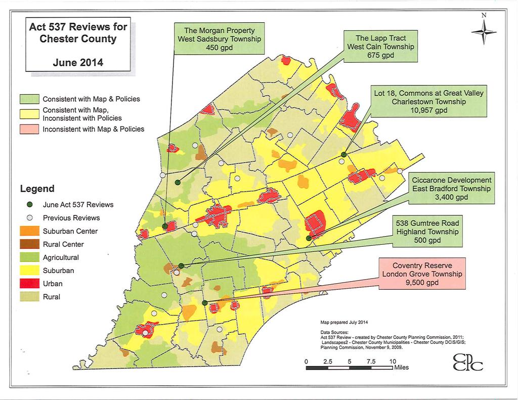
99
100
101
102 Minor Revisions
103
104
105
106
107
108
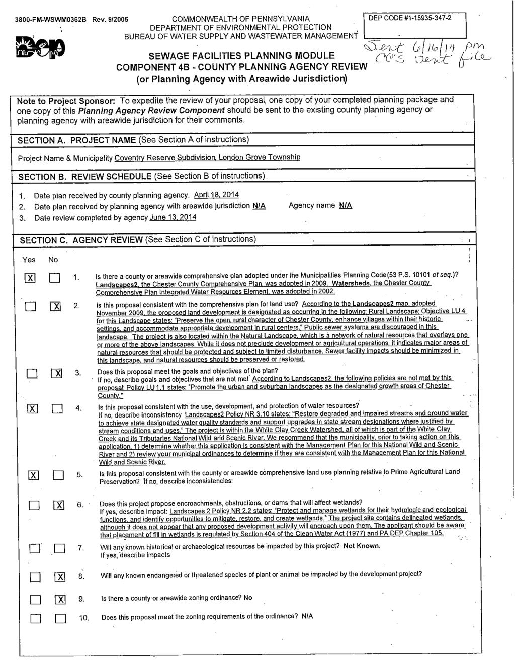
109
Action Items
 Action Items Report of Nominating Committee Election of 2015 Officers Act 247 Reviews Subdivision & Land Development Act 247 Reviews of Proposed Development during December 2014 8 6 Symbols 8 8 8 9
 Action Items Reporting of the Nominating Committee and Election of 2014 Officers Act 247 Reviews Subdivision & Land Development Act 247 Reviews of Proposed Development during December 2013 Symbols 15
Memorandum To: From: CC: Date: Re:
 Memorandum To: Paul Singer From: Craig M. Bonenberger, SEO/ Jason P. Shaner, PE CC: File 090026 Date: 4/20/2009 Re: 1550 Pottstown Pike Feasibility Study The site under investigation is an 18 acre tract
ORDINANCE PROPOSALS. 6/1/2016 to 6/30/2016 REVIEW DATE. Total. The staff reviewed proposals for: Comprehensive Plans
 ORDINANCE PROPOSALS 6/1/2016 to 6/30/2016 The staff reviewed proposals for: Comprehensive Plans Miscellaneous Ordinance (Misc.) Amendments Subdivision and Land Development Ordinance (SLDO) Amendments Zoning
Article 7: Residential Land Use and Development Requirements
 Article 7: Residential Land Use and Section 701: Statement of Intent (A) (B) (C) The intent of Article 7 is to develop certain land use and development requirements for the residential uses within Cumru
TOWNSHIP OF SALISBURY LEHIGH COUNTY, PENNSYLVANIA. PLANNING COMMISSION MEETING MINUTES September 12, 2017 START TIME 7:30 PM
 TOWNSHIP OF SALISBURY LEHIGH COUNTY, PENNSYLVANIA PLANNING COMMISSION MEETING MINUTES September 12, 2017 START TIME 7:30 PM The regularly scheduled public meeting of the Salisbury Township Planning Commission
MAJOR SUBDIVISION PRELIMINARY PLAT CHECKLIST
 TOWNSHIP OF EGG HARBOR PLANNING BOARD/ZONING BOARD OF ADJUSTMENT 3515 BARGAINTOWN ROAD EGG HARBOR TOWNSHIP, NJ 08234 MAJOR SUBDIVISION PRELIMINARY PLAT CHECKLIST The following checklist is designed to
ARTICLE 15 - PLANNED UNIT DEVELOPMENT
 Section 15.1 - Intent. ARTICLE 15 - PLANNED UNIT DEVELOPMENT A PUD, or Planned Unit Development, is not a District per se, but rather a set of standards that may be applied to a development type. The Planned
YCCD EROSION & SEDIMENT POLLUTION CONTROL (E&SPC) PROGRAM SERVICES FEE SCHEDULE, RULES, & GUIDELINES
 PROGRAM SERVICES FEE SCHEDULE, RULES, & GUIDELINES") YCCD EROSION & SEDIMENT POLLUTION CONTROL (E&SPC) PROGRAM SERVICES FEE SCHEDULE, RULES, & GUIDELINES Adopted by the YCCD Board of Directors on December 14, 2018 Effective January 1, 2019. I. Authority
YCCD EROSION & SEDIMENT POLLUTION CONTROL (E&SPC) PROGRAM SERVICES FEE SCHEDULE, RULES, & GUIDELINES Adopted by the YCCD Board of Directors on December 14, 2018 Effective January 1, 2019. I. Authority
SITE PLAN REVIEW PROCEDURES SECTION DEVELOPMENTS REQUIRING SITE PLAN APPROVAL
 SECTION 22.01 PURPOSE ARTICLE XXII PROCEDURES The purpose of this Article is to establish uniform requirements of procedure for all developments in the Township. Certain specific types of minor development
ARTICLE 24 SITE PLAN REVIEW
 ARTICLE 24 SITE PLAN REVIEW 24.1 PURPOSE: The intent of these Ordinance provisions is to provide for consultation and cooperation between the land developer and the Township Planning Commission in order
Amendment to the Zoning and Subdivision Ordinances; Consider Repeal Cluster Development Standards
 2 Board of Supervisors Meg Bohmke, Chairman Gary F. Snellings, Vice Chairman Jack R. Cavalier Thomas C. Coen L. Mark Dudenhefer Wendy E. Maurer Cindy C. Shelton February 28, 2018 Thomas C. Foley County
BEFORE THE LANCASTER TOWNSHIP BOARD OF SUPERVISORS BUTLER COUNTY, PENNSYLVANIA FINDINGS OF FACT, CONCLUSIONS OF LAW AND DECISION FINDINGS OF FACT
 BEFORE THE LANCASTER TOWNSHIP BOARD OF SUPERVISORS BUTLER COUNTY, PENNSYLVANIA IN RE: Conditional Use and Preliminary ) and Final Land Development Applications ) for Planned Unit Development by ) Arden
O-I (Office-Institutional) and AG-1(Agricultural)
 and AG-1(Agricultural)") PROPERTY INFORMATION ADDRESS 3503 and 3505 Bethany Bend DISTRICT, LAND LOTS 2/1 973 and 974 OVERLAY DISTRICT State Route 9 PETITION NUMBERS EXISTING ZONING O-I (Office-Institutional) and AG-1(Agricultural)
PROPERTY INFORMATION ADDRESS 3503 and 3505 Bethany Bend DISTRICT, LAND LOTS 2/1 973 and 974 OVERLAY DISTRICT State Route 9 PETITION NUMBERS EXISTING ZONING O-I (Office-Institutional) and AG-1(Agricultural)
Open Space Model Ordinance
 Open Space Model Ordinance Section I. Background Open space development has numerous environmental and community benefits, including: 1) Reduces the impervious cover in a development. Impervious cover
W E S T T O W N T O W N S H I P 1039 Wilmington Pike P.O. Box 79 West Chester, PA Westtown, PA PHONE: (610) FAX: (610)
 FAX: (610)") W E S T T O W N T O W N S H I P 1039 Wilmington Pike P.O. Box 79 West Chester, PA 19382 Westtown, PA 19395 PHONE: (610) 692-1930 FAX: (610) 692-9651 APPLICATION FOR APPROVAL OF PRELIMINARY PLAN Plan title:
W E S T T O W N T O W N S H I P 1039 Wilmington Pike P.O. Box 79 West Chester, PA 19382 Westtown, PA 19395 PHONE: (610) 692-1930 FAX: (610) 692-9651 APPLICATION FOR APPROVAL OF PRELIMINARY PLAN Plan title:
Level III Preliminary and Final Site Plans Development Review Application Portland, Maine Planning and Urban Development Department Planning Division
 Level III Preliminary and Final Site Plans Development Review Application Portland, Maine Planning and Urban Development Department Planning Division Portland s Planning and Urban Development Department
APPLICATION PROCEDURE
 ANTRIM PLANNING BOARD P. O. Box 517 Antrim, New Hampshire 03440 Phone: 603-588-6785 FAX: 603-588-2969 APPLICATION FORM AND CHECKLIST FOR MINOR OR MAJOR SITE PLAN REVIEW File Date Received By APPLICATION
FRESHWATER WETLANDS PROTECTION IN NEW JERSEY Tools for Municipal Action
 FRESHWATER WETLANDS PROTECTION IN NEW JERSEY Tools for Municipal Action The Freshwater Wetlands Protection Act INTENT OF FRESHWATER WETLANDS LAW The New Jersey legislature passed the Freshwater Wetlands
TOWN OF ORO VALLEY PLANNING & ZONING COMMISSION MEETING DATE: December 6, 2011
 PLANNING & ZONING COMMISSION MEETING DATE: December 6, 2011 TO: FROM: SUBJECT: PLANNING & ZONING COMMISSION Matt Michels, Senior Planner mmichels@orovalleyaz.gov; tel. 229-4822 Public Hearing: Rancho de
SUBJECT PARCEL(S) Property Owner(s) TMS Number Approximate Acreage Carolina Park Development, LLC
 Property Owner(s) TMS Number Approximate Acreage Carolina Park Development, LLC") Staff Report Special Planning Commission Meeting November 19, 2014 For reference, the Zoning Code and Land Development Regulations are available online. AGENDA ITEM 5c. SKETCH PLAN APPROVAL REQUEST: Request
Staff Report Special Planning Commission Meeting November 19, 2014 For reference, the Zoning Code and Land Development Regulations are available online. AGENDA ITEM 5c. SKETCH PLAN APPROVAL REQUEST: Request
CHAPTER XVIII SITE PLAN REVIEW
 CHAPTER XVIII SITE PLAN REVIEW Section 18.1 Section 18.2 Description and Purpose. The purpose of this chapter is to provide standards and procedures under which applicants would submit, and the Township
Staff Report: Date: Applicant: Property Identification: Acreage of Request: Current Zoning of Requested Area: Requested Action: Attached:
 Staff Report: Completed by Jeff Palmer Director of Planning & Zoning Date: November 7, 2018, Updated November 20, 2018 Applicant: Greg Smith, Oberer Land Developer agent for Ronald Montgomery ET AL Property
Planning Department Oconee County, Georgia STAFF REPORT
 Planning Department Oconee County, Georgia STAFF REPORT REZONE CASE #: 7332 DATE: November 28, 2017 STAFF REPORT BY: Gabriel Quintas, Planner APPLICANT NAME: Smith Planning Group PROPERTY OWNER: John Hadden
PLANNED UNIT DEVELOPMENT & SUBDIVISION STAFF REPORT Date: April 18, 2019
 PLANNED UNIT DEVELOPMENT & SUBDIVISION STAFF REPORT Date: April 18, 2019 DEVELOPMENT NAME SUBDIVISION NAME Springhill Village Subdivision Springhill Village Subdivision LOCATION 4350, 4354, 4356, 4358,
Special Use Permit - Planned Unit Development Checklist. Property Address:
 Special Use Permit - Planned Unit Development Checklist Special Use Permit Number. Parcel Code/s #28-11- - - Property Address: Applicant: ARTICLE VIII Ordinance Reference - Section 8.1.2 Permit Procedures:
UPPER MOUNT BETHEL TOWNSHIP NORTHAMPTON COUNTY, PENNSYLVANIA
 UPPER MOUNT BETHEL TOWNSHIP NORTHAMPTON COUNTY, PENNSYLVANIA JOINDER DEED / LOT CONSOLIDATION TOWNSHIP REVIEW PROCESS When accepting proposed Joinder Deeds / Lot Consolidations, review the Joinder Deed
ARTICLE VI. SUBDIVISION STANDARDS, PUBLIC
 ARTICLE VI. SUBDIVISION STANDARDS, PUBLIC IMPROVEMENTS, AND DESIGN REQUIREMENTS ARTICLE VI. SUBDIVISION STANDARDS, PUBLIC IMPROVEMENTS, AND DESIGN REQUIREMENTS DIVISION 1. GENERAL PROVISIONS Sec. 21-6100.
REPORT TO THE SHELBY COUNTY PLANNING COMMISSION From the Department of Development Services Planning Services. February 4, 2019
 REPORT TO THE SHELBY COUNTY PLANNING COMMISSION From the Department of Development Services Planning Services February 4, 2019 Case No. Request for Rezoning Approval From E-1 to E-2 SD This is a request
Article XII. R-1 Agricultural-Low Density Residential District
 Article XII R-1 Agricultural-Low Density Residential District Section 1200. Declaration of Legislative Intent In expansion of the Declaration of Legislative Intent and Statement of Community Development
Town of Shelburne, Vermont
 Town of Shelburne, Vermont CHARTERED 1763 P.O. BOX 88 5420 SHELBURNE ROAD SHELBURNE, VT 05482 www.shelburnevt.org 802-985-5118 * * Also available in alternate formats in accordance with the Americans With
ATTENDING THE MEETING Robert Balogh, Vice-Chairman Sonia Stopperich, Supervisor Marcus Staley, Supervisor Bob Ross, Supervisor
 SPECIAL HEARING - TUESDAY, APRIL 12, 2016 PAGE 1 The North Strabane Township Board of Supervisors held a Special Meeting- Conditional Use Hearing, Tuesday, April 12, 2016, at approximately 6:30 P.M., at
4. facilitate the construction of streets, utilities and public services in a more economical and efficient manner;
 PVPC MODEL BYLAW BY-RIGHT CLUSTER ZONING BYLAW Prepared by Pioneer Valley Planning Commission Revised: October 2001 1.00 Development 1.01 Development Allowed By Right Development in accordance with this
PRELIMINARY PLAN CHECKLIST Major Land Development Projects. To initiate the application, the applicant shall submit to the Administrative Officer:
 PRELIMINARY PLAN CHECKLIST Major Land Development Projects To initiate the application, the applicant shall submit to the Administrative Officer: 1. The application review fee, as established by the South
ARTICLE 9 SPECIFICATIONS FOR DOCUMENTS TO BE SUBMITTED
 ARTICLE 9 SPECIFICATIONS FOR DOCUMENTS TO BE SUBMITTED SECTION 950 GENERALLY All applications shall be properly signed and filed by the owner or, with the owner s specific written consent, a contract purchaser
Moore Township Planning Commission 2491 Community Drive, Bath, Pennsylvania Telephone: FAX: Rev:12/23/2013
 2491 Community Drive, Bath, Pennsylvania Telephone: 610-759-9449 FAX: 610-759-9448 Rev:12/23/2013 APPLICATION FORM FOR A SITE PLAN PER MOORE TOWNSHIP ZONING ORDINANCE SECTION 200-58.1 NORTHAMPTON COUNTY,
HOPEWELL TOWNSHIP YORK COUNTY PA PLANNING COMMISSION MINUTES FOR MAY 19, 2017 MUNICIPAL BUILDING 7:00 PM
 HOPEWELL TOWNSHIP YORK COUNTY PA PLANNING COMMISSION MINUTES FOR MAY 19, 2017 MUNICIPAL BUILDING 7:00 PM Yost called the May 2017 Planning Commission meeting to order at 7:01 p.m. In attendance were Chairman
A. ARTICLE 16 - STEEP SLOPE CONSERVATION DISTRICT
 1600. 1601.A. ARTICLE 16 - STEEP SLOPE CONSERVATION DISTRICT SECTION 1600 PURPOSE The purpose of this Article is to expand upon the Community Development Objectives associated with environmental protection
PLANNED DEVELOPMENT DISTRICT STANDARDS. Cadence Site
 PLANNED DEVELOPMENT DISTRICT STANDARDS Cadence Site A Planned Development District 1. Statement of General Facts, Conditions and Objectives Property Size: Approximately 57.51 Acres York County Tax Map
Rule 80. Preservation of Primary Agricultural Soils Revised and approved by the Land Use Panel during its public meeting on January 31, 2006.
 Rule 80. Preservation of Primary Agricultural Soils Revised and approved by the Land Use Panel during its public meeting on January 31, 2006. (A) Purpose. In accordance with 10 V.S.A. Sections 6025(b)
CONCEPTUAL MASTER PLAN CHECKLIST Major Land Development Project
 CONCEPTUAL MASTER PLAN CHECKLIST Major Land Development Project To initiate the application, the applicant shall submit to the Administrative Officer: 1. The application review fee, as established by the
SUBDIVISION APPLICATION CHECKLIST SKETCH PLAN PRELIMINARY PLAT FINAL PLAT
 RECEIVED STAMP SUBDIVISION APPLICATION CHECKLIST SKETCH PLAN PRELIMINARY PLAT FINAL PLAT A checklist of background information and submission requirements for processing of a sketch plan, preliminary plat
Staff Report: Date: Applicant: Property Identification: Acreage of Request: Current Zoning of Requested Area: Requested Action: Attached:
 Staff Report: Completed by Jeff Palmer Director of Planning & Zoning Date: November 7, 2018 Applicant: Greg Smith, Oberer Land Developer agent for Ronald Montgomery ET AL Property Identification: Frontage
ADAMS COUNTY CONSERVATION DISTRICT S
 Approved by District Board on 12-15-2016 I. Authority & Applicability of Fees for Services A. Authority - The Adams County Conservation District is delegated with the responsibility to administer the Commonwealth
BUFFALO TOWNSHIP PLANNING COMMISSION REGULAR MONTHLY MEETING AUGUST 2, 2017
 The Regular Monthly Meeting of the Buffalo Township Planning Commission was called to order on August 2, 2017, at 7:40 p.m. in the Buffalo Township Municipal Building by the Chairman, Ray Smetana. This
CHAPTER 6 CHESAPEAKE BAY PRESERVATION AREAS AND STREAM PROTECTION AREAS
 CHAPTER 6 CHESAPEAKE BAY PRESERVATION AREAS AND STREAM PROTECTION AREAS 6.1 INTRODUCTION Virginia s Chesapeake Bay Preservation Area (CBPA) Designation and Management Regulations (9VAC10-20 et seq.) require
Chapter 100 Planned Unit Development in Corvallis Urban Fringe
 100.100 Scope and Purpose. Chapter 100 Planned Unit Development in Corvallis Urban Fringe (1) All applications for land divisions in the Urban Residential (UR) and Flood Plain Agriculture (FPA) zones within
LAND USE ASSUMPTIONS REPORT POTENTIAL FUTURE DEVELOPMENT WEST WHITELAND TOWNSHIP, CHESTER COUNTY, PA
 LAND USE ASSUMPTIONS REPORT POTENTIAL FUTURE DEVELOPMENT WEST WHITELAND TOWNSHIP, CHESTER COUNTY, PA Adopted June 17, 2015 by Township Resolution No. 2015-30 Prepared by Theurkauf Design & Planning, LLC
Salem Township Zoning Ordinance Page 50-1 ARTICLE 50.0: PUD PLANNED UNIT DEVELOPMENT
 Salem Township Zoning Ordinance Page 50-1 ARTICLE 50.0 PLANNED UNIT DEVELOPMENT Section 50.01 Purpose The provisions of this Article provide enabling authority and standards for the submission, review,
STAFF REPORT FOR MAJOR SUBDIVISION
 STAFF REPORT FOR MAJOR SUBDIVISION FINAL PLAT CASE NO. FA-13-001 HEARING DATE: November 6, 2013 CASE NAME: Solterra Subdivision Filing No. 14 PROCEDURE: Planning Commission ADDRESS OF MAJOR SUBDIVISION
APPLICATION FOR SUBDIVISION APPROVAL OF A SKETCH PLAN with checklist
 Prior to filing any application for SUBDIVISION approval, the applicant shall request in writing that the zoning administrator schedule a pre-submission conference. APPLICATION TO THE PLANNING BOARD TOWN
LOWER FREDERICK TOWNSHIP PLANNING COMMISSION
 LOWER FREDERICK TOWNSHIP PLANNING COMMISSION General Meeting Minutes January 18, 2018 53 Spring Mount Rd. Schwenksville, Pa. 19473 Meeting called to order at 7:02 pm. Present for Roll Call: Members: Chuck
AGENDA STATEMENT NO BUSINESS OF THE PLANNING COMMISSION City of Victoria, Minnesota STAFF REPORT. Casco Ventures (Developer)
") AGENDA STATEMENT NO. 17-1 BUSINESS OF THE PLANNING COMMISSION City of Victoria, Minnesota STAFF REPORT TO: Planning Commission PREPARED BY: Erin Smith, Senior Planner RE: Waterford Landing Project Rezoning
AGENDA STATEMENT NO. 17-1 BUSINESS OF THE PLANNING COMMISSION City of Victoria, Minnesota STAFF REPORT TO: Planning Commission PREPARED BY: Erin Smith, Senior Planner RE: Waterford Landing Project Rezoning
Planning Justification Report
 Planning Justification Report, Township of Puslinch FARHI HOLDINGS CORPORATION Updated January 27, 2017 Zelinka Priamo Ltd. Page i TABLE OF CONTENTS Page No. 1.0 1.1 1.2 1.3 2.0 2.1 2.2 2.3 2.4 2.5 3.0
Bowie Marketplace Residential Detailed Site Plan Statement of Justification January 13, 2017 Revised February 2, 1017
 Bowie Marketplace Residential Detailed Site Plan Statement of Justification January 13, 2017 Revised February 2, 1017 Submitted on behalf of: BE Bowie LLC 5410 Edson Lane, Suite 220 Rockville, MD 20852
MS MINOR SUBDIVISION TREVITHICK
 MS-02-015 341.12 MINOR SUBDIVISION TREVITHICK A request by Danny Trevithick for a one-lot Minor Subdivision on five acres. The property is zoned A-35 (Agricultural) District and is located ¼ mile south
Planning Department Oconee County, Georgia
 Planning Department Oconee County, Georgia STAFF REPORT REZONE CASE #: 6985 DATE: October 31, 2016 STAFF REPORT BY: Andrew C. Stern, Planner APPLICANT NAME: Williams & Associates, Land Planners PC PROPERTY
ARTICLE I. IN GENERAL
 Adopted by City Council on December 7, 2009 AN ORDINANCE TO AMEND AND REORDAIN CHAPTER 10 (WATER PROTECTION) OF THE CODE OF THE CITY OF CHARLOTTESVILLE, 1990, AS AMENDED, BY DELETING SECTIONS 10-51 AND
ARTICLE 5 MINOR SUBDIVISION/LAND DEVELOPMENT
 ARTICLE 5 MINOR SUBDIVISION/LAND DEVELOPMENT SECTION 501 ONLY FINAL PLAN REQUIRED The classification of a proposed subdivision as a "Minor Subdivision" shall only require the submission, review and approval
PLANNING BOARD APPLICATION FORM TOWNSHIP OF BETHLEHEM 405 MINE ROAD ASBURY, NEW JERSEY Date of Application: Township Application Number:
 Township of Bethlehem Page 1 of 8 PLANNING BOARD APPLICATION FORM TOWNSHIP OF BETHLEHEM 405 MINE ROAD ASBURY, NEW JERSEY 08802 Date of Application: Township Application Number: Jurisdiction: Planning Board
COMMUNITY MEETING EXHIBITS
 COMMUNITY MEETING EXHIBITS EXHIBIT 1 : Meeting Agenda EXHIBIT 2 : Presentation Posters EXHIBIT 3 : Attendance Sign-In Sheet EXHIBIT 4 : Letters to Property Owners EXHIBIT 5 : Photos of Meeting EXHIBIT
STAFF REPORT FOR MAJOR SUBDIVISION
 STAFF REPORT FOR MAJOR SUBDIVISION FINAL PLAT CASE NO. FA-12-003 HEARING DATE: November 6, 2013 CASE NAME: Solterra Subdivision Filing No. 13 PROCEDURE: Planning Commission ADDRESS OF MAJOR SUBDIVISION
SEWAGE FACILITIES PLANNING MODULE
 Code. COMMONWEALTH OF PENNSYLVANIA DEPARTMENT OF ENVIRONMENTAL PROTECTION BUREAU OF WATER STANDARDS AND FACILITY REGULATION SEWAGE FACILITIES PLANNING MODULE Component 3s. Small Flow Treatment Facilities
Legal Description Part of the Western Half of the Eastern Half of the Northwest Quarter of Section 30, Le Ray Township
 Owner and Applicant s 20448 State Highway 83 Mankato, MN 56001 Request and Location Request for review and approval of a Conditional Use Permit to allow an Elder Care Residential Unit to be constructed
County of Loudoun. Department of Planning MEMORANDUM
 County of Loudoun Department of Planning MEMORANDUM DATE: September 3, 2013 TO: FROM: Marchant Schneider, Project Manager Land Use Review Marie Genovese, AICP, Planner III, Community Planning SUBJECT:
Section Intent
 Section 246. 1. Intent 2. Authority a. It is the intent of these Transfer of Development Rights (TDR s) regulations to encourage the preservation of natural resources and facilitate orderly growth in the
WHEREAS, the staff of The Maryland-National Capital Park and Planning Commission recommended APPROVAL of the application with conditions; and
 R E S O L U T I O N WHEREAS, Redeemed Christian Church of God is the owner of a 2.83-acre parcel of land known as Lot 9, Lot 19, P/O Lot 1 and P/O Lot 18, Block B, Plat Book A, Plat 5, said property being
TOWNSHIP OF BORDENTOWN LAND DEVELOPMENT APPLICATION CHECKLIST. General Requirements for all Applications
 TOWNSHIP OF BORDENTOWN LAND DEVELOPMENT APPLICATION CHECKLIST This CHECKLIST has been adopted in accordance with Section 25:807 of the Land Development Ordinance of the Township of Bordentown and will
Chapter 22 PLANNED UNIT DEVELOPMENT.
 Chapter 22 PLANNED UNIT DEVELOPMENT. Sec. 22.1 INTENT. The use of land and the construction and use of buildings and other structures as Planned Unit Developments in Georgetown Township may be established
ARTICLE V PRELIMINARY PLAN SUBMISSION
 ARTICLE V PRELIMINARY PLAN SUBMISSION 501. Plan Requirements a. On or before the 25 th day of the month prior to a regularly scheduled meeting of the Planning Commission, the applicant shall submit two
CHAPTER34 PRUD - PLANNED RESIDENTIAL UNIT DEVELOPMENT
 CHAPTER34 PRUD - PLANNED RESIDENTIAL UNIT DEVELOPMENT 17-34-1 17-34-2 17-34-3 17-34-4 17-34-5 17-34-6 17-34-7 17-34-8 17-34-9 Purpose Planned Residential Unit Development Defined Planned Residential Unit
ARTICLE 14 PLANNED UNIT DEVELOPMENT (PUD) DISTRICT
 DISTRICT") ARTICLE 14 PLANNED UNIT DEVELOPMENT (PUD) DISTRICT Section 14.01 Intent. It is the intent of this Article to allow the use of the planned unit development (PUD) process, as authorized by the Michigan Zoning
ARTICLE 14 PLANNED UNIT DEVELOPMENT (PUD) DISTRICT Section 14.01 Intent. It is the intent of this Article to allow the use of the planned unit development (PUD) process, as authorized by the Michigan Zoning
The following regulations shall apply in the R-E District:
 "R-E" RESIDENTIAL ESTATE DISTRICT (8/06) The following regulations shall apply in the R-E District: 1. Uses Permitted: The following uses are permitted. A Zoning Certificate may be required as provided
Larimer County Planning Dept. Procedural Guide for 1041 PERMITS
 - Larimer County Planning Dept. Procedural Guide for 1041 PERMITS PLEASE NOTE: A PRE-APPLICATION CONFERENCE IS REQUIRED PRIOR TO SUBMITTING THIS APPLICATION. PURPOSE: State Statutes allow local governments
TOOELE COUNTY LAND USE ORDINANCE CHAPTER 31 Page 1
 CHAPTER 31 PLANNED COMMUNITY ZONE (P-C) Section 31-1 Definitions. 31-2 Purpose. 31-3 Land use districts. 31-4 P-C zone area minimum requirements. 31-5 Permitted uses. 31-6 Conditional uses. 31-7 Planning
CONDITIONAL USE PERMIT Application Packet
 CONDITIONAL USE PERMIT Application Packet Community Development Department 1020 East Pioneer Road, Draper, UT 84020 (801) 576-6539 Fax (801) 576-6526 Dear Applicant, This application packet has been developed
STRABAN TOWNSHIP PLANNING COMMISSION Alan Zepp, George Mauser, Patt Kimble, Sharon Hamm, John Boblits
 STRABAN TOWNSHIP PLANNING COMMISSION Alan Zepp, George Mauser, Patt Kimble, Sharon Hamm, John Boblits The Straban Township Planning Commission met this date, as publicly advertised, at 7:00 p.m. in the
Town of Falmouth s Four Step Design Process for Subdivisions in the Resource Conservation Zoning Overlay District
 Town of Falmouth s Four Step Design Process for Subdivisions in the Resource Conservation Zoning Overlay District All subdivisions shall be designed in accordance with the following four-step process.
Napa County Planning Commission Board Agenda Letter
 Agenda Date: 9/20/2017 Agenda Placement: 8C Napa County Planning Commission Board Agenda Letter TO: FROM: Napa County Planning Commission Charlene Gallina for David Morrison - Director Planning, Building
CHAPTER 5. PLANNED UNIT DEVELOPMENT REGULATIONS
 Section 5.1. Purpose CHAPTER 5. PLANNED UNIT DEVELOPMENT REGULATIONS 5.1. PURPOSE The purpose for Planned Unit Developments (PUDs) is established in Section 4.5 Zoning District Purpose Statements. 5.2.
PALM BEACH COUNTY PLANNING, ZONING AND BUILDING DEPARTMENT ZONING DIVISION
 PALM BEACH COUNTY PLANNING, ZONING AND BUILDING DEPARTMENT ZONING DIVISION Application No.: Z/CA-2013-00493 Application Name: Trails Charter School Control No.: 2013-00085 Applicant: MG3 ALF Military LLC
YORK TOWNSHIP SUBDIVISION AND LAND DEVELOPMENT ORDINANCE. 6/25/2012 Adopted 9/11/2012 Ordinance
 YORK TOWNSHIP SUBDIVISION AND LAND DEVELOPMENT ORDINANCE 6/25/2012 Adopted 9/11/2012 Ordinance 2012-12 Table of Contents ARTICLE I APPLICABILITY, AUTHORITY, TITLE & PURPOSE...1 SECTION 101. APPLICABILITY...1
SITE DEVELOPMENT PLAN REQUIREMENTS CHECKLIST
 SITE DEVELOPMENT PLAN REQUIREMENTS CHECKLIST Completed DRC Application for Review Required for Application Process DRC Processing Fee 1 Commercial $2,500.00 Fire Department Review Fee 150.00 Total $2,650.00
CHAPTER 3 PRELIMINARY PLAT
 10-3-1 10-3-3 SECTION: CHAPTER 3 PRELIMINARY PLAT 10-3-1: Consultation 10-3-2: Filing 10-3-3: Requirements 10-3-4: Approval 10-3-5: Time Limitation 10-3-6: Grading Limitation 10-3-1: CONSULTATION: Each
TOTTENHAM SECONDARY PLAN
 TOTTENHAM SECONDARY PLAN AMENDMENT NO. 11 TO THE OFFICIAL PLAN OF THE TOWN OF NEW TECUMSETH The following text and schedules to the Official Plan of the Town of New Tecumseth constitute Amendment No. 11
PLANNED UNIT DEVELOPMENTS (Ordinance No.: 3036, 12/3/07; Repealed & Replaced by Ordinance No.: 4166, 10/15/12)
") 159.62 PLANNED UNIT DEVELOPMENTS (Ordinance No.: 3036, 12/3/07; Repealed & Replaced by Ordinance No.: 4166, 10/15/12) A. PURPOSE 1. General. The Planned Unit Development (PUD) approach provides the flexibility
159.62 PLANNED UNIT DEVELOPMENTS (Ordinance No.: 3036, 12/3/07; Repealed & Replaced by Ordinance No.: 4166, 10/15/12) A. PURPOSE 1. General. The Planned Unit Development (PUD) approach provides the flexibility
THE CITY OF MOBILE, ALABAMA
 THE CITY OF MOBILE, ALABAMA LETTER OF DECISION March 9, 2018 Byrd Surveying, Inc. 2609 Halls Mill Road Mobile, AL 36606 Re: 4439 Rangeline Road (Northwest corner of Rangeline Road and Halls Mill Road).
STAFF REVIEW MARCH 13, Preliminary Consent - Major Subdivision. Showfield, LLC Davis, Bowen & Friedel, Inc. R-2, Residential Low Density
 STAFF REVIEW MARCH 13, 2019 Application Title Application Type Owner Engineer Showfield City Preliminary Consent - Major Subdivision Showfield, LLC Davis, Bowen & Friedel, Inc. Tax Map and Parcel 335-8.00-46.00
SUBDIVISION, PLANNED UNIT DEVELOPMENT, ZONING AMENDMENT, & SIDEWALK WAIVER STAFF REPORT Date: July 19, 2018
 SUBDIVISION, PLANNED UNIT DEVELOPMENT, ZONING AMENDMENT, & SIDEWALK WAIVER STAFF REPORT Date: July 19, 2018 NAME SUBDIVISION NAME LOCATION West Mobile Properties, LLC U.S. Machine Subdivision 556, 566,
SPECIAL ZONING DISTRICTS
 SPECIAL ZONING DISTRICTS 5.01 5.99 RESERVED 5.100 PLANNED DEVELOPMENTS: Purpose: This district is intended to accommodate unified design of residential, commercial, office, professional services, retail
R E S O L U T I O N. 2. Development Data Summary
 R E S O L U T I O N WHEREAS, the Prince George's County Planning Board is charged with the approval of Detailed Site Plans pursuant to Part 3, Division 9 of the Zoning Ordinance of the Prince George's
FINAL DRAFT 12/1/16, Rev. to 7/18/17
 FINAL DRAFT 12/1/16, Rev. to 7/18/17 (As Adopted 8/8/17 Effective 9/1/17) SHELTON PLANNING AND ZONING COMMISSION Proposed Amendments to Zoning Regulations I. Amend Section 23 PERMITTED USES by inserting
Rapid City Planning Commission Conditional Use Permit Project Report
 Rapid City Planning Commission Conditional Use Permit Project Report September 21, 2017 Applicant Request(s) Case # 17UR020 Conditional Use Permit to allow a mini-storage facility Companion Case(s) # Item
YORK TOWNSHIP SUBDIVISION AND LAND DEVELOPMENT ORDINANCE. Adopted 9/11/2012 Ordinance Amended 10/28/2013 Ordinance
 YORK TOWNSHIP SUBDIVISION AND LAND DEVELOPMENT ORDINANCE Adopted 9/11/2012 Ordinance 2012-12 Amended 10/28/2013 Ordinance 2013-7 Table of Contents ARTICLE I APPLICABILITY, AUTHORITY, TITLE & PURPOSE...1
THE CITY OF MOBILE, ALABAMA
 THE CITY OF MOBILE, ALABAMA LE 'I IER OF DECISION Kimberly Clark Mobile Operations 200 Africatown Blvd. Prichard, AL 36610 Re: 100 & 200 Africatown Boulevard (Northeast corner of Bay Bridge Road and Paper
SECTION 10.7 R-PUD (RESIDENTIAL PLANNED UNIT DEVELOPMENT) ZONE
 ZONE") Article X Zones 10-20 SECTION 10.7 R-PUD (RESIDENTIAL PLANNED UNIT DEVELOPMENT) ZONE A. PURPOSE AND INTENT: The R-PUD Residential PUD Zone is intended to provide alternative, voluntary zoning procedures
Article X Zones 10-20 SECTION 10.7 R-PUD (RESIDENTIAL PLANNED UNIT DEVELOPMENT) ZONE A. PURPOSE AND INTENT: The R-PUD Residential PUD Zone is intended to provide alternative, voluntary zoning procedures
1101 MAIN STREET ANDREWS NC PHONE FAX MAYOR NANCY J. CURTIS MEMORANDUM
 1101 MAIN STREET ANDREWS NC 28901 PHONE 828-321-3113 FAX 828-321-4159 MAYOR NANCY J. CURTIS ALDERMAN RAY FRAZIER ALDERMAN JERRY PULLIUM ALDERMAN GARY JAMES ALDERMAN PHIL HORTON MEMORANDUM March 7, 2017
ZONING HEARING BOARD OF WARWICK TOWNSHIP BUCKS COUNTY, PENNSYLVANIA Warwick Road Warrington, PA 18976
 ZONING HEARING BOARD OF WARWICK TOWNSHIP BUCKS COUNTY, PENNSYLVANIA Docket No. 15-7 Applicants: Owners: Subject Property: Requested Relief: Adam and Karen Sailor 2195 Warwick Road Warrington, PA 18976
GROSVENOR-STRATHMORE METRO STATION MANDATORY REFERRAL APPLICATION NORTH BETHESDA, MD
 GROSVENOR-STRATHMORE METRO STATION MANDATORY REFERRAL APPLICATION NORTH BETHESDA, MD Submission by: Fivesquares JDA at Grosvenor Metro, LLC On behalf of Washington Metropolitan Area Transit Authority 1
Deerfield Township Community Development Department
 STAFF REVIEW Deerfield Township Community Development Department To: From: Hayfaa Wadih, AICP Lois McKnight, AICP Meeting Date: October 20, 2014 Continued from October 13, 2014 Re: Major PUD Modification