BOARD OF SUPERVISORS PUBLIC HEARING STAFF REPORT. ZMAP , Waterside Dulles East (a.k.a. Dulles 2000) Broad Run
|
|
|
- Reynold Wilcox
- 5 years ago
- Views:
Transcription
1 Date of Hearing: May 10, 2017 BOARD OF SUPERVISORS PUBLIC HEARING STAFF REPORT #5 SUBJECT: ELECTION DISTRICT: ZMAP , Waterside Dulles East (a.k.a. Dulles 2000) Broad Run CRITICAL ACTION DATE: June 6, 2017 STAFF CONTACTS: APPLICANT: Judi Birkitt, AICP, Planning and Zoning Manager, Planning and Zoning Ricky Barker, AICP, Director, Planning and Zoning Edward J. Hoy, President Chantilly Crushed Stone PURPOSE: The purpose of this application is to rezone land acquired in a land swap between Dulles East and the planned Waterside development. The land swap enables an alternate alignment for future Shaw Road that will allow Dulles East to have sufficient Shaw Road access when they develop their property. Dulles East is located on the east side of Route 28, the west side of Shaw Road, and south of Old Ox Road. RECOMMENDATIONS: Planning Commission: On March 28, 2017, the Planning Commission (Commission) forwarded (8-1, Scheel opposed) this application to the Board of Supervisors (Board) with a recommendation of approval, subject to the Proffer Statement and based on the Findings for Approval. Staff: Staff supports Board approval subject to the Proffer Statement dated April 24, 2017 (Attachment 1) and based on the Findings of Approval (Attachment 2). Staff has concluded that the proposed PD-RDP zoning district is consistent with the Revised General Plan s land use policies, which anticipate Route 28 Core uses in the area. The Proffer Statement (Attachment 1) has been signed and approved to legal form by the County Attorney s Office. The item is ready for action.
2 Item #5, ZMAP , Waterside - Dulles East (a.k.a. Dulles 2000) Board of Supervisors Public Hearing May 10, 2017 Page 2 APPLICATION INFORMATION: APPLICANT Chantilly Crushed Stone Edward J. Hoy, President PARCELS/ACREAGE REPRESENTATIVE Walsh Colucci Lubeley & Walsh PC Mike Romeo mromeo@thelandlawyers.com TAX MAP NUMBER PIN ACRES /94/////////33E (portion) 1.39 /94/////////33E (portion) 0.9 Total Acres 2.29 ACCEPTANCE DATE June 6, 2016 ZONING ORDINANCE Revised 1993 POLICY AREA Suburban Policy Area (Sterling Community) LOCATION West and east sides of Shaw Road (Route 636), south of Old Ox Road (Route 606), and north of Innovation Avenue (Route 209) EXISTING ZONING PD-TC (Planned Development Town Center) Route 28 Taxing District AI (Airport Impact) Overlay District, outside of but within one (1) mile of the Ldn 60 aircraft noise contour QN (Quarry Notification) Overlay District-Loudoun Quarry and Loudoun Note Area PLANNED LAND USE Route 28 Core uses at a recommended FAR of 1.5 to 2.0 for Mixed Use Office Centers CONTEXT: Location/Site Access The subject property is located west of Waterside, between Shaw Road and Route 28, south of Old Ox Road (Route 606), and north of Innovation Avenue (Route 209). The subject property is situated approximately 1,687 feet south of intersection of Shaw Road and Old Ox Road (Route 606). The site can be accessed from Shaw Road. Existing Conditions The subject property is unimproved and characterized by relatively level terrain and scattered pine and deciduous trees. The subject property contains no wetlands or floodplain. The subject property lies within the Quarry Notification (QN) Overlay District, the Route 28 Tax District, and Metrorail Tax District. The subject property also lies within the Airport Impact (AI) Overlay of the Washington Dulles International Airport, outside of but within one (1) mile of the Ldn 60 aircraft noise contour.

3 Item #5, ZMAP , Waterside - Dulles East (a.k.a. Dulles 2000) Board of Supervisors Public Hearing May 10, 2017 Page 3 Surrounding Properties Surrounding properties include Shaw Road and Luck Stone Quarry/approved Waterside Town Center to the east and south, Route 28 to the west, and a hotel to the north. Directions - From Leesburg, take Leesburg Pike (Route 7) east to Sully Highway (Route 28). Merge onto Route 28 south. Take Route 28 south to Old Ox Road (Route 606) east towards the Town of Herndon. Turn right onto Shaw Road (Route 636). The land being exchanged is located on both side of the future extension of Shaw Road. Figure 1. Vicinity Map.

4 Item #5, ZMAP , Waterside - Dulles East (a.k.a. Dulles 2000) Board of Supervisors Public Hearing May 10, 2017 Page 4 PROPOSAL: As part of a land exchange, the Waterside property owners transferred (conveyed by deed) 2.29 acres to the Dulles East property owner. The purpose of this application is to rezone the newly acquired 2.29 acres from PD-TC under the Revised 1993 Zoning Ordinance to PD-RDP under the Revised 1993 Zoning Ordinance. The existing Dulles East property is zoned PD-RDP under the 1972 Zoning Ordinance, so approval of this rezoning would result in the Dulles East property being governed under two different zoning ordinances. Figure 2. Land Exchange. The Applicant has submitted a Proffer Statement for the newly acquired 2.29 acres; the Proffer Statement is minimal and proffers substantial conformance to a 1-sheet Concept Development Plan. This application does not include a development proposal for Dulles East s newly acquired 2.29 acres. The CDP and Proffer Statement approved with ZMAP , Dulles 2000, will continue to govern the remainder of the Dulles East property, which is not subject to this application. BACKGROUND: Dulles East (Dulles 2000), ZMAP On April 3, 1989, the Board approved ZMAP , Dulles 2000, a rezoning of 28.8 acres from PD-IP (Planned Development-Industrial Park) and PD-GI (Planned Development-General Industrial) to PD-RDP (Planned Development- Research Development Park) under the 1972 Zoning Ordinance. The approved, yet not constructed, development program consists of 800,000 square feet of research and development uses at an FAR (floor area ratio) of up to The approved Concept Development Plan showed three access points along Shaw Road.
5 Item #5, ZMAP , Waterside - Dulles East (a.k.a. Dulles 2000) Board of Supervisors Public Hearing May 10, 2017 Page 5 During review of the Waterside applications (ZMAP SPEX , SPEX , SPMI , and SPMI ), Dulles East property owners expressed objections to the proposal because the Shaw Road alignment shown on the Waterside CDP would decrease Dulles East s number of access points on Shaw Road from three to one. The two parties have since negotiated a land swap agreement. The land swap restores Dulles East s three Shaw Road access points. BLAD On November 9, 2016, the County administratively approved a Boundary Line Adjustment, which reflects the land exchange. Planning Commission The Commission held a public hearing on this application on March 28, At the time of the Commission s public hearing, the Dulles East application was considered jointly with the Waterside applications (Waterside Town Center, ZMAP and ZCPA ). The Commission forwarded (8-1, Scheel opposed) this application to the Board with a recommendation of approval, subject to the Proffer Statement dated June 1, 2016 and based on the Findings for Approval (Attachment 2). The Commission concluded that rezoning the acquired acreage was reasonable in order to be consistent with the existing Dulles 2000 PD-RDP zoning. One public speaker spoke in favor of both the Dulles East and Waterside applications. During the Public Hearing, the Commission advised the applicant to separate the request to rezone the exchanged land from the request to increase the residential units. Regarding the concurrent applications, the Commission voted (9-0) to forward the Waterside applications to a work session for further discussion. Waterside seeks approval to rezone the acreage that Waterside acquired in the land swap and also seeks to increase the number of multi-family residential units by 405 units (from 2,595 to 3,000). Discussion focused upon the proposed additional 405 multi-family residential units. The Commission questioned whether the proffers required residential units to be located above first floor commercial uses. Staff clarified that the proffers required multi-family units, which could be either in free-standing apartment buildings or over first floor commercial uses. The Waterside work session is expected to occur during May 2017, depending upon when the Applicant submits revised materials. The Applicant has held Community Meetings regarding this application with adjacent property owners. There are no public comments regarding the subject application on Loudoun Online Land Application System (LOLA). Staff has received no , phone, or in person comments regarding this application. The staff reports and associated attachments can be viewed online on the Loudoun Online Land Applications System (LOLA) at search ZMAP OUTSTANDING ISSUES: There are no outstanding issues with this application identified by staff. The Proffer Statement has been signed and approved to legal form by the County Attorney s Office (Attachment 1). The item is ready for action.
6 Item #5, ZMAP , Waterside - Dulles East (a.k.a. Dulles 2000) Board of Supervisors Public Hearing May 10, 2017 Page 6 POLICY ANALYSIS: Zoning Map Amendment Petition (ZMAP) Criteria for Approval - Zoning Ordinance Section (E) of the Revised 1993 Zoning Ordinance states that if an application is for a reclassification of property to a different zoning district classification on the Zoning Map, the Planning Commission shall give reasonable consideration to six (6) factors or criteria for approval. These criteria for approval are organized below by category, followed by Staff s analysis. A. Land Use: ZO (E)(1) Appropriateness of the proposed uses based on the Comprehensive Plan, trends in growth and development, the current and future requirements of the community as to land for various purposes as determined by population and economic studies and other studies and the encouragement of the most appropriate use of land throughout the locality. Analysis There is no outstanding land use issues. The full range of uses permitted in the proposed PD-RDP zoning district is consistent with the Revised General Plan land use policies. The subject property is located within the Sterling Suburban Community. The Route 28 Corridor Plan identifies the subject property as part of the Route 28 Core. Within the Core, the Route 28 Corridor Plan envisions high-quality, high intensity office developments that take advantage of the economic opportunities associated with frontage on Route 28 (Revised General Plan, Chapter 6, Route 28 Corridor Plan, Route 28 Core Policies, text.) B. Compatibility: ZO (E)(2) The existing character and use of the subject property and suitability for various uses, compatibility with uses permitted and existing on other property in the immediate vicinity, and conservation of land values. Analysis There are no outstanding compatibility issues. The full range of uses permitted in the proposed PD-RDP zoning district would be compatible with the existing hotel use to the north and the proposed Waterside uses to the east and south. C. Environmental and Heritage Resources: ZO (E)(5) Potential impacts on the environment or natural features including but not limited to wildlife habitat, wetlands, vegetation, water quality (including groundwater), topographic features, air quality, scenic, archaeological, and historic features, and agricultural and forestal lands and any proposed mitigation of those impacts. Analysis There are no outstanding environmental issues. The rezoning would not result in environmental impacts. The subject property contains no wetlands, floodplain, or heritage resources. The Applicant addressed stormwater management and water quality for the larger property with the original Dulles 2000 application. Future development on the subject property would be subject to the development standards in the Facilities Standards Manual.
7 Item #5, ZMAP , Waterside - Dulles East (a.k.a. Dulles 2000) Board of Supervisors Public Hearing May 10, 2017 Page 7 D. Transportation: ZO (E)(3) Adequacy of sewer and water, transportation, and other infrastructure to serve the uses that would be permitted on the property if it were reclassified to a different zoning district [emphasis added]. Analysis There are no outstanding transportation issues. The transportation network can adequately serve the subject property. Approval of the rezoning of the acquired acreage would result in no new trips for the Dulles East site. As there was a land exchange of approximately two acres, the rezoning adds no acreage to the Dulles East project. E. Fiscal Impacts: ZO (E)(4) The requirements for airports, housing, schools, parks, playgrounds, recreational areas and other public services. Analysis The rezoning does not include any proposed residential units. The non-residential uses that are permitted within the proposed PD-RDP zoning district typically generate more revenue than they require in public expenditures. F. Public Utilities/Public Safety: ZO (E)(3) Adequacy of sewer and water, transportation, and other infrastructure to serve the uses that would be permitted on the property if it were reclassified to a different zoning district. (6) The protection of life and property from impounding structure failures. [emphasis added]. Analysis There are no outstanding public utilities/safety issues. The original rezoning for the larger Dulles 2000 application addressed public utilities and fire and rescue contributions (public water and sewer available and per square foot contribution to volunteer department provided per Board adopted policy). ZONING ANALYSIS: Analysis There are no outstanding zoning issues. The application is in general compliance with the zoning regulations in PD-RDP (Planned Development Research and Development Park) zoning districts. The existing Dulles East property is zoned PD-RDP under the 1972 Zoning Ordinance, so approval of this rezoning would result in the Dulles East property being governed under two different zoning ordinances PD-RDP under the 1972 Zoning Ordinance and PD-RDP under the Revised 1993 Zoning Ordinance.
8 Item #5, ZMAP , Waterside - Dulles East (a.k.a. Dulles 2000) Board of Supervisors Public Hearing May 10, 2017 Page 8 SUGGESTED MOTIONS: 1. I move that the Board of Supervisors forward ZMAP , Waterside - Dulles East, to the June 6, 2017, Board of Supervisors Business Meeting for action. OR 2a. I move that the Board suspend the rules. AND 2b. I move that the Board of Supervisors approve ZMAP , Waterside - Dulles East,, subject to the Proffer Statement dated April 24, 2017, and based on the Findings for Approval as provided in Attachments 1 and 2 to the May 10, 2017, Board of Supervisors Public Hearing Staff Report. OR 3. I move an alternative motion. ATTACHMENTS: 1. Proffer Statement (April 24, 2017) 2. Findings for Approval 3. Statement of Justification 4. Review Agency Comments 5. Response to Referral Comments 6. Concept Development Plan (April 19, 2017)

9 Attachment 1


10
11 Findings for Approval ZMAP , Waterside Dulles East 1. The proposed PD-RDP (Planned Development Research and Development Park) zoning district is consistent with the Revised General Plan s land use policies, which anticipate Route 28 Core uses in the area. 2. The proposed rezoning reflects a land exchange between the Dulles East and Waterside property owners; such land exchange ensures that the Dulles East property will have adequate access along its Shaw Road frontage. 3. The land exchange and the Shaw Road realignment plan would not have a negative impact upon the public road network or adjacent property owners. The proposed rezoning will help facilitate a Shaw Road alignment that implements the road network envisioned in the 2010 Countywide Transportation Plan. 4. The rezoning proposal will remap Dulles East s newly acquired acreage from the PD-TC (Planned Development Town Center) to the PD-RDP (Planned Development Research and Development Park) zoning district; this will provide consistent zoning within the existing Dulles 2000 property. Attachment 2
12 Chantilly Crushed Stone, Inc. Waterside Town Center ZMAP ZCPA Waterside Dulles 2000 ZMAP Statement of Justification May 25, 2016 Revised October 11, 2016 Introduction Chantilly Crushed Stone ( CCS, or the Applicant ) is the owner of more than 330 acres of land east of Route 28 and west of the Loudoun/Fairfax County line. Operating for more than 50 years as a stone quarry, the land was rezoned in 2015 to reflect the changing environment of the Route 28 corridor and facilitate significant economic development. The Waterside application (ZMAP ) approved 3.8 million square feet of non-residential development and 2,595 residential units strategically located throughout six zoning districts (the Original Waterside ). Development at Waterside is predicated on the Applicant completing significant transportation linkages, including the widening of Route 606, the extension of Davis Drive, both north and south of Route 606, and the realignment and construction of Shaw Road to connect Route 606 with Innovation Avenue. The Waterside Town Center application facilitates the land swap that was discussed as part of the original Waterside rezoning. It s the formalization of the solution brokered between the adjacent property owners (CCS and Dulles East VIII, LLC ( Dulles East ), with the help of the County, to secure Shaw Road frontage for the Dulles East parcels, all as further explained below. The proposed rezoning and concept plan amendment applications look to complement the approved Waterside development by adding additional residential development to the Town Center - Core in a complementary and consistent manner to the multifamily units already approved in the Fringe. At the same time, it removes the portion of land that is being transferred to Dulles East, and re-zones that acreage to complement the rest of the Dulles East holdings. Property Location and Plan Designation The land owned by both CCS and Dulles East is located within the Route 28 Core and Business areas and within the Mixed-use Office Center Development Node. It is all south of Route 606 and west of Shaw Road; Route 28 is to the west. The 2.18 acres that CCS is acquiring will be assumed within PIN while the 2.33 acres that Dulles East is acquiring will be assumed within PINs and all upon approval and recordation of the boundary line adjustment, BLAD Zoning and Boundary Line Adjustment The land swap between Dulles East and CCS adds 2.18 acres of land to the Original Waterside application at the same time it removes 2.33 acres of land. That acreage is reflected on BLAD v6 Attachment 3
13 , which shifts the boundaries to allow Dulles East to maintain frontage along future Shaw Road. Because the boundary line adjustment shifts property lines, the revised parcels will be split zoned. This zoning application will address that. Specifically, PINs and were components of the original Waterside application so they are primarily zoned PD-TC. The areas being transferred to Dulles East will be re-zoned PD-RDP with ZMAP At the same time, that acreage will be exempted from the Waterside ZMAP proffers. The land CCS is gaining from the boundary line adjustment will be portions of PINs and that are currently zoned PD- RDP. ZMAP will re-zone the portions of those parcels being shifted to Waterside as PD-TC and subject to them to the CCS proffers while exempting them from the Dulles 2000 proffers approved with ZMAP Therefore, in both instances, the requested rezonings will allow the entire parcels to have the same zoning designation: the Dulles East lands will be zoned PD-RDP and the CCS parcel will be zoned PD-TC. We recognize that the Dulles East land will be governed by two different zoning ordinances; this will need to be rectified in a subsequent zoning application. The Waterside proffers will only apply to land owned by CCS and FEA Properties, a CCS-affiliated entity that owns some of the land contained within the original Waterside application. Further, the land being given by Dulles East would be released from the Dulles 2000 proffers and be subject to the Waterside proffers. Proposal The Waterside Town Center application blends the land being acquired by CCS with the land originally included within the Waterside application and facilitates a logical extension of the Town Center to the north and west. Although the new land is just over two acres, it allows preconfigured land bays to be adjusted into more buildable blocks so the proposed development would actually span eight acres. The grid-like street network would be extended to align the reconfigured land bays and connect with Dulles East land farther to the north and residential towers, similar to those approved elsewhere within the town center, would be erected to provide additional housing opportunity in the heart of the Waterside development. The request would add 405 new multifamily units in a location within the Town Center already approved for 1.7 million square feet of non-residential development. Conversely, just 500 residential units were approved for that part of the Town Center with the original application, so this application would breathe an evening presence into the Town Center with the addition of residents. The units would all be supported by structured parking. The original Waterside application was a thoughtful blend of residential and commercial uses that related not just to each other but to the existing uses surrounding the property. Industrial and large-scale retail uses are located north of Route 606 with office and additional community retail lining the south side of that important roadway. Residential was focused south of Route 606 with the highest intensities located in the Town Center Fringe with direct access to the Route 28 Metro station, and an active-adult community planned with significant open space along the lake s eastern edge. This ZCPA only affects the PD-TC portion of the property; the PD-IP, PD-CC-SC, PD-CC-CC, PD-OP and R-16 land bays remain unchanged. Further, the ZMAP only affects the 4.51 acres that are subject to the boundary line adjustment and allows the land being acquired by CCS to be zoned PD-TC and the land being acquired by Dulles East to be zoned Revised 1993 PD-RDP. Importantly, no buildings or development are proposed on the land being acquired by Dulles East and no proffers are being offered. Rather, that land would be further developed and zoned as part of a subsequent Dulles East zoning application v6
14 The proffers, transportation improvements and design guidelines will all continue to guide this revised Waterside application; minor if any revisions are expected with those elements of the Waterside application. Compliance with the Revised General Plan The Property is located east of Route 28 and is guided by the Route 28 Corridor Plan (the Route 28 Plan ). The land subject to the Town Center application is specifically located in the Route 28 Core, Mixed-Use Office Center Development Node, which calls for residential to support office development. Transportation A full transportation study was completed by Gorove/Slade Associates, Inc. It is submitted under separate cover with this application. Summary The Waterside Town Center application complements the original Waterside zoning by rezoning the 2.18 acres it is proposing to add to the PD-TC zoning district to allow a consolidated development. The amenities and improvements pledged with the original application will all remain in place and be completed by the Applicant to support not just the original proposal, but the additional units offered with the Town Center application. Issues for Consideration (Section ) (1) Appropriateness of the proposed uses based on the Comprehensive Plan, trends in growth and development, the current and future requirements of the community as to land for various purposes as determined by population and economic studies and other studies and the encouragement of the most appropriate use of land throughout the locality. The proposed rezoning completes the original Waterside application and blends with the uses already approved. The residential units are located within the area that is planned for Mixed- Use and will complement the adjacent development. (2) The existing character and use of the subject property and suitability for various uses, compatibility with uses permitted and existing on other property in the immediate vicinity, and conservation of land values. The application introduces less than three (3) acres of land into the Waterside application, less than 1% of the land area covered by the original zoning. Leaving that land zoned PD-RDP would render it undevelopable by the Applicant, because its location is linear and therefore doesn t create the same buildable blocks that are created by rezoning it PD-TC to match the rest of the CCS land in this vicinity. Waterside is a thoughtful blend of residential and commercial uses that relate not just to each other but to the existing uses surrounding the property. Industrial and large-scale retail uses are located north of Route 606 with office and additional community retail lining the south side of that important roadway. Residential is focused south of Route 606 with the highest intensities located in the Town Center Fringe and with this application, the Town Center Core, with direct v6
15 access to the Route 28 Metro station, and an active-adult community planned with significant open space along the lake s eastern edge. The additional housing opportunity in the heart of Waterside activates the evening atmosphere in the Town Center and enlivens the Core, as anticipated by the Zoning Ordinance. (3) Adequacy of sewer and water, transportation, and other infrastructure to serve the uses that would be permitted on the property if it were reclassified to a different zoning district. The Applicant has already committed to work with all the utility companies to ensure adequate power, water and sewer are established for the Waterside property; this additional land would be served as well. Further, all development at Waterside is predicated on the Applicant completing significant upfront transportation improvements. (4) The requirements for airports, housing, schools, parks, playgrounds, recreational areas and other public services. The public amenities provided with the original Waterside rezoning will more than serve the additional units proposed here. (5) Potential impacts on the environment or natural features including but not limited to wildlife habitat, wetlands, vegetation, water quality (including groundwater), topographic features, air quality, scenic, archaeological, and historic features, and agricultural and forestall lands and any proposed mitigation of those impacts. Similar to the original zoning request, this rezoning would have more positive impacts on the natural environment than the current adjacent quarrying use. (6) The protection of life and property from impounding structure failures. A redevelopment will meet all required County and State standards in respect to development. Requested Modification This application continues all of the modifications requested with the original Waterside application and requests an additional modification to recognize the new development proposed. 1. Section F.3 Adjacent to Other Nonresidential Districts. Thirty five (35) [feet] for buildings, parking, outdoor storage, and loading areas, except where a greater area is required by Section Requested Modification. Allow the buildings within this new portion of Waterside to be within 16 feet of an adjacent non-residential district. No request is being made to the established setback between the buildings and the street. Justification. The zoning district line between the PD-RDP and proposed PD-TC district matches the property line between CCS and Dulles East, which is located at the curb line, rather than running down the middle of the street, which is more typical. The property line location is a result of the boundary line adjustment that was agreed upon with the first Waterside zoning case; it was agreed that it would be easier for the entire road to be owned v6
16 by one owner rather than splitting the ownership of the road in two. The buildings within this new portion of Waterside are set back between 16 and 20 feet from the curb, matching the already approved setbacks for internal streets at Waterside, which is 15 to 20 feet. No additional density is sought with this request, as the building adheres to the already approved setback from the street. Please see Exhibit A which demonstrates the streetscape. The modification is merely needed to recognize that the BLA established the property lines and thus zoning district lines so the internal roads would be wholly within the Dulles East property, rather than shared by two property owners. Additionally, the buildings, proposed at five and eight stories, within this portion of Waterside remain well below the approved heights of 200 feet, leaving significant density on the table. 2. Section Land Assembly Requirements. (A). The maximum size of the Town Center Core shall be twenty (20) acres. Requested Modification. Allow the maximum size of the Town Center Core to be increased from the previously approved 39 acres to 41 acres. Justification. The 2012 Waterside application established a 98-acre Town Center district, which this application maintains. Following approval of that application, the Applicant entered into a boundary line adjustment with its eastern neighbor to provide that neighbor frontage along Shaw Road. To accomplish that, CCS is giving a little more than two (2) acres from the Town Center Fringe district in Land Bay D-2 -- in exchange for a little more than two (2) acres adjacent to Land Bay D-1, which is the Town Center Core. Therefore, that new land would be added to the Core district, which would increase the Core above the previously approved 39 acres. Importantly, the overall size of the PD-TC district does not expand. The modification is needed because the land being acquired is adjacent to land within Waterside s Core, not Fringe. The proposed use residential is allowed in either district v6

17 EXHIBIT A
18 County of Loudoun Department of Planning MEMORANDUM DATE: August 29, 2016 TO: FROM: SUBJECT: Judi Birkitt, AICP, Project Manager Land Use Review Judi Birkitt, AICP, Senior Planner Land Use Review ZCPA , Waterside ZMAP , Waterside Town Center ZMAP , Dulles East EXECUTIVE SUMMARY The purpose of these applications is to: 1) Formalize a land swap between Waterside and Dulles East - The reason for the land swap is to realign future Shaw Road (from what is shown on the approved Waterside Concept Development Plan (CDP)) so that Dulles East will have sufficient Shaw Road access when they develop their property. 2) Add 405 residential units (multi-family above first floor commercial) to Waterside in the previously approved Town Center Fringe and Town Center Core - This would increase Waterside s maximum number of multi-family residential units from 2,595 units to 3,000 units. No changes are proposed to the non-residential component. The Applicant has submitted a Statement of Justification, an amended Concept Development Plan (CDP) (March 26, 2016), and draft Proffer Statements (May 25, 2016) for Waterside and Dulles East. BACKGROUND Waterside - On September 2, 2015, the Board approved Waterside, ZMAP , SPEX , SPEX , SPMI , and SPMI ( Original Waterside ). The approval allowed for the redevelopment of the existing 335-acre Chantilly Quarry property, which is generally located at the intersections of Shaw Road and 606, into a mixed use development/town center. The approved development program included: 2,200 multi-family residential dwelling units, 395 age-restricted dwelling units at a density of up to 13.3 dwelling units per acre, and 3.8 million square feet of nonresidential uses at a collective overall Floor Area Ratio (FAR) of up to Also approved Attachment 4

. At its nearest point, the Waterside development is 0.")
19 ZMAP Waterside Town Center and ZMAP , Dulles East August 29, 2016 Community Planning 1 st Referral Page 2 of 10 were Special Exceptions for an Automotive Service Station, Fire and Rescue Station, and two Public Schools. The property is currently phasing out its existing quarry use; its final project is Phase 2 of the Metro Silver Line. Figure 1. Land Swap Previous Property Line Although Waterside is not included in the Silver Line Small Area Plan Comprehensive Plan Amendment (CPAM), the 335-acre Waterside development is located entirely within the Metrorail Service District (created on December 5, 2012). At its nearest point, the Waterside development is 0.5 mile from Fairfax County s Innovation Center Metrorail Station, and Waterside s Town Center Core is one mile from the future Innovation Station. Waterside is approximately 2 miles east of future Loudoun Gateway Station and approximately 1.5 miles northeast of the Washington Dulles International Airport Station acres acquired by Dulles East Dulles East 2.2 acres acquired by Waterside New Property Line Waterside Dulles East (Dulles 2000) - The Dulles East property is located west of Waterside, between Shaw Road and Route 28. On April 3, 1989, the Board of Supervisors (Board) approved ZMAP , Dulles 2000, a rezoning of 28.8 acres from PD-IP (Planned Development-Industrial Park) and PD-GI (Planned Development-General Industrial) to PD-RDP (Planned Development-Research Development Park) under the 1972 Zoning Ordinance. The approved, yet not constructed development program consists of 800,000 square feet of research and development uses at an FAR (floor area ratio) of up to During review of the Original Waterside applications, Dulles East property owners expressed objections to the proposal because the Shaw Road alignment shown on the Original Waterside CDP would decrease Dulles East s number of access points on Shaw Road from three to one. The two parties have since negotiated a land swap agreement, creating the need for these current applications. The land swap restores Dulles East s three Shaw Road access points. PROPOSAL The Applicant, Chantilly Crushed Stone, seeks approval of the following zoning concept plan amendment and two zoning map amendments.

20 ZMAP Waterside Town Center and ZMAP , Dulles East August 29, 2016 Community Planning 1 st Referral Page 3 of 10 ZCPA , Waterside The Applicant proposes a Zoning Concept Plan Amendment to revise the proffers and the CDP approved with the 335-acre Original Waterside applications that were approved on September 2, The amendments would reflect the land swap, the revised Shaw Road alignment, and an additional 405 multi-family residential units on the Waterside property. ZMAP , Waterside Town Center In the land swap, Waterside acquired 2.2 acres from Dulles East and now seeks to rezone the newly acquired acreage from PD- RDP (Planned Development-Research Development Park) under the 1972 Zoning Ordinance to PD-TC (Planned Development-Town Center). The 2.2 acres would enlarge the Town Center Core from 14 to 16 acres; 330 multi-family residential units are proposed Within the Town Core, and 75 multi-family residential units are proposed within the Town Fringe. Figure 2. Vicinity Map.
 2.3 acres to Dulles East. The Applicant seeks to rezone Dulles East s newly acquired 2.3 acres from PD-TC to PD-RDP under the Revised 1993 Zoning Ordinance.")
21 ZMAP Waterside Town Center and ZMAP , Dulles East August 29, 2016 Community Planning 1 st Referral Page 4 of 10 ZMAP , Dulles East - As part of the land swap, Waterside transferred (conveyed by deed) 2.3 acres to Dulles East. The Applicant seeks to rezone Dulles East s newly acquired 2.3 acres from PD-TC to PD-RDP under the Revised 1993 Zoning Ordinance. The existing Dulles East property is zoned PD-RDP under the 1972 Zoning Ordinance, so approval of this rezoning would result in the Dulles East property being governed under two different zoning ordinances. The Applicant has submitted a separate Proffer Statement for the newly acquired 2.3 acres; the Proffer Statement is minimal and proffers substantial conformance to Sheet 17 of the plan set. These applications do not include a development proposal for Dulles East s newly acquired 2.3 acres. Therefore, this referral does not include an analysis of Dulles East s newly acquired acreage. The CDP and Proffer Statement approved with ZMAP , Dulles 2000, will continue to govern the remainder of the Dulles East property, which is not subject to this application. COMPREHENSIVE PLAN CONFORMANCE The application has been reviewed for conformance with the County s Revised General Plan (the Plan ), to include the Route 28 Corridor Plan (adopted March 15, 2011), Route 28 Core policies of the Suburban Policy Area (Sterling Community) of Chapter 6, Green Infrastructure policies of Chapter 5, and the Implementation policies for Town Centers in Chapter 11. ANALYSIS A. LAND USE & COMPATIBILITY Both the Waterside and the Dulles East subject properties are located within the Sterling Suburban Community. Both subject properties are mapped for Route 28 Core uses and have a Mixed-Use Office Center Overlay (Revised General Plan, Chapter 6, Route 28 Corridor Land Development Patterns Map). The Plan envisions nonresidential FARs between 0.6 and 1.0 in Office Clusters within the Route 28 Core and between 1.5 and 2.0 FAR with incentives for the southern Mixed Use Center area (Revised General Plan, Chapter 6, Route 28 Corridor Plan, Office Clusters Policy 10). The subject properties are located along both sides of Shaw Road and are visible from Route 28 (Sully Road), which is considered one of the County s premier business corridors. The Route 28 Corridor Plan envisions the Route 28 Corridor as a business environment that supports significant job growth and economic activity Figure 3. Planned Land Use Map. Land Swap Areas
22 ZMAP Waterside Town Center and ZMAP , Dulles East August 29, 2016 Community Planning 1 st Referral Page 5 of 10 in varied settings. By attracting premier businesses, the corridor is envisioned to significantly contribute to the County s overall fiscal health and economy. The Route 28 Corridor Plan identifies the subject properties as part of the Route 28 Core. Within the Core, the Route 28 Corridor Plan envisions high-quality, high intensity office developments that take advantage of the economic opportunities associated with frontage on Route 28 (Revised General Plan, Chapter 6, Route 28 Corridor Plan, Route 28 Core Policies, text.) In addition to the Core, the Route 28 Corridor Plan identifies three Mixed-Use Office Centers to further stimulate economic activity along the corridor and promote the County s image as a world-class business destination. The Waterside Town Center subject property (newly acquired 2 acres) is within the Mixed-Use Office Center overlay. Mixed- Use Office Centers are intended to be developed as 24/7 amenity-rich environments unique to the corridor that appeal to a broad spectrum of employees, business tenants, and residents. (Revised General Plan, Chapter 6, Route 28 Corridor Plan, Mixed-Use Office Center Policies, Policy 7). The policy designates the southern gateway of the Route 28 Corridor as suitable for one Mixed-Use Office Center, of at least 50 acres but no more than 90 acres. Dulles World Center (ZMAP ) is the County s approved 60-acre mixed-use center at the southern portion of the corridor. With approval of the Original Waterside, the approved mixed-used center at the southern gateway increased to 146 acres. With the Original Waterside, the Board previously approved 2,595 residential units as a component of a vibrant, activity-rich, live-work center. The Board found that a mixed-use center would be the best use in the vicinity of the Metrorail. One of the reasons for the approval was to attract employment uses to the project. Staff questions how more residential units would attract more employment uses as other factors such as access, connectivity to major thoroughfares, adequate utility infrastructure among other factors are considered by potential employers for locating their businesses. The County s Revised General Plan does not envision residential development on the subject property. Staff recommends that the Applicant revise the application to eliminate the proposed additional residential units. Additional residential development could potentially place unnecessary pressures on the County s tax base. Community Planning Staff support the boundary line adjustment and commend the Applicant for collaborating with the adjacent property owner to achieve a mutually beneficial Shaw Road alignment. Regarding the request to increase the number of residential units, the applications provide no compelling reason to increase the project s residential units by an additional 405 residential units, bringing the project s total to 3,000 residential units. The Plan did not envision the residential approved previously with the Original Waterside applications, and the Plan does not support additional residential development on the acreage acquired in the land swap. Community Planning staff recommends that the Applicant revise the application to eliminate
23 ZMAP Waterside Town Center and ZMAP , Dulles East August 29, 2016 Community Planning 1 st Referral Page 6 of 10 the proposed additional residential units. Based on Route 28 Core Plan policies, the subject property is appropriate for high employment generating uses. B. EXISTING CONDITIONS & ENVIRONMENTAL The subject property is located approximately 1,687 feet south of intersection of Shaw Road and Old Ox Road (Route 606). The northern parcel (0.23 acres) consists of a truck pull-off and is almost completely paved; the small unpaved portion is significantly disturbed by road construction, use, and maintenance. The larger southern parcel (2.06 acres) consists of relatively level terrain covered in young secondary growth pine and scattered deciduous trees. Both parcels drain into the nearby Indian Creek, approximately 215 feet to the west of the northern parcel. The Applicant s ETS Review letter indicates that there are no wetlands on the subject property. The parcels contain no floodplain. A water main runs parallel to Shaw Road through both parcels. The southern parcel is heavily disturbed between Shaw Road and the water main. An abandoned power-line corridor bisects the southern parcel from north to south. The Applicant has submitted and Endangered and Threatened Species (ETS) Review letter (dated March 26, 2016) for Staff review. The ETS Review letter indicates that the federally-threatened northern long-eared bat has potential to be present on the subject property; coordination with the U.S. Fish and Wildlife Service may be needed prior to any proposed tree clearing activities. The state-threatened wood turtle has a confirmed occurrence within two miles of the study area. Perennial streams are not present within the study area; therefore, the wood turtle is not anticipated to be a constraint during the wetland permitting process. Thunderbird Archeology conducted a Phase I cultural resources investigation of the newly acquired acreage in March They identified no historic or archaeological resources and recommended no further work. Staff concurs with the recommendations of the ETS Review and archaeology report. The Applicant addressed stormwater management and water quality with the Original Waterside applications. No changes are proposed to the previously approved environmental proffers. As proposed, environmental proffers would extend and apply to the Waterside Town Center subject property. Forest Resources The Green Infrastructure policies call for the preservation, protection, and management of forests and natural vegetation for the various economic and environmental benefits that they provide (Revised General Plan, Chapter 5, Forests, Trees and Vegetation Policies 1). The Green Infrastructure policies call for the submittal and approval of a tree conservation or forest management plan prior to any land development that demonstrates a management strategy that ensures the long-term sustainability of any designated tree save area (Revised General Plan, Chapter 5, Forests, Trees and Vegetation Policies 3). Of the Original Waterside s 335 acres, 15 acres are identified as Tree Conservation Areas (TCA). Proffer XII.D Tree Conservation Areas (a draft proffer in the current applications that was carried forward from the Original Waterside) proffers tree conservation measures
24 ZMAP Waterside Town Center and ZMAP , Dulles East August 29, 2016 Community Planning 1 st Referral Page 7 of 10 for TCAs. The newly acquired acreage is wooded. Sheet 5 identifies the tree cover as young mature to mature Shortleaf Pine, Virginia Pine, Eastern Red Cedar, White Oak and Tree of Heaven between 3 and 14 DBH. The application does not identify tree conservation areas or specimen trees on the 2.2-acre subject property (ZMAP ). The Applicant should consider identifying Tree Conservation Areas on the newly acquired Waterside Town Center acreage to demonstrate that this additional acreage is in conformance with County forest resources policies. C. SITE AND BUILDING DESIGN According to the Mixed-Use Office Center Policies of the Plan, mixed use office centers shall develop as vertically integrated mixed-use buildings, such as multi-story office and residential buildings with commercial storefronts at ground level. The Centers shall have the distinctive characteristics of an urban environment with pedestrian-oriented building facades, ground-floor shops and civic amenities, and streets culminating in distinctive public spaces. Pedestrian circulation shall be enhanced by short blocks arranged in a rectilinear grid-street pattern (Revised General Plan, Chapter 6, Suburban Policy, Route 28 Core Policies, Mixed-Use Office Center Policies, Policy 8). The proffered Design Guidelines (May 26, 2015) approved with the Original Waterside address the above design policies. As proffered, the previously approved Design Guidelines would apply to the newly acquired Waterside Town Center acreage. However, none of the illustratives in the Design Guidelines include or depict the newly acquired acreage, land configuration, or revised Shaw Road alignment. To ensure that the envisioned high quality working and living environment applies to the newly acquired property, Community Planning Staff recommends updating the Design Guidelines to include the newly acquired property and the revised Shaw Road alignment. D. AFFORDABLE HOUSING Since multi-family elevator-serviced buildings greater than 4 stories are proposed, the Zoning Ordinance does not require Affordable Dwelling Units. However, the Applicant is expected to comply with the County s unmet housing needs policies. Plan policies encourage the development of housing for special needs populations (low income residents, elderly residents requiring congregate care, disabled residents, and the homeless) as well as the application of universal design principles (Revised General Plan, Chapter 2, Housing, Guiding Principles Policies 8 & 11). The applications address unmet housing needs with proffers to construct actual units across a broad segment of the County s income spectrum. The Original Waterside proffered up to 312 unmet housing needs units, or 12 percent of the residential units. The Applicant has increased the maximum number of unmet housing needs units to 360, which corresponds to the additionally proposed 405 residential units.
25 ZMAP Waterside Town Center and ZMAP , Dulles East August 29, 2016 Community Planning 1 st Referral Page 8 of 10 Since the application proposes less than 20 dwelling units per acre, no unmet housing needs units are required by the Zoning Ordinance. The Applicant addresses the unmet housing needs policies of the Revised General Plan by increasing the proffered number of unmet housing needs units proportionate to the proposed increase in residential units. E. CAPITAL FACILITIES The Applicant proposes 405 multi-family units that were not anticipated by the current Plan. The total capital impact of the project based on the current Capital Intensity Factors (CIF) is approximately $7.8 million. County policy anticipates that the Applicant will pay current Capital Intensity Factors (CIF) of $21,830 per multi-family unit, excluding the 48 proffered unmet housing needs units (UNHU s) (see Attachment 1). The Plan does not envision residential development on the subject property. While this is a land use concern, it is also important in consideration of the County s planning for public facilities. The Plan states that the County will consider the adequacy of public facilities and services when reviewing any zoning application for a more intensive use or density (Revised General Plan, Chapter 3, General Public Facilities Policy 3). The Original Waterside includes a substantial residential component within an area of the County where such uses are not anticipated. The current applications propose 405 additional residential unit in an area where residential is not anticipated. As such, the proposed residences are not counted in County service demand projections. The Applicant proposes no additional onsite amenities to serve the additional 405 units in the current application. As proposed, the amenities proffered with the Original Waterside would also serve the additional 405 residential units. With the Original Waterside, the Applicant proffered amenities specifically for the 395 age-restricted units. Recreational amenities previously proffered to serve the 2,605 approved and proposed non-age-restricted units are as follows: 15,000 square feet of courtyard space (5,000 per land bay for D-1, D2, and D-3) 2,400 square feet of swimming pools 15,000 square feet of interior amenity space (5,000 per land bay for D-1, D2, and D-3), which collectively shall include at least 3 of the following: o Business Center o Entertainment Room o Meeting Room o Yoga/pilates/exercise room o Fitness Center 3,500 square feet of outdoor play area The additional residential development could impact the County s ability to provide necessary services and amenities, such as schools, libraries, emergency services, parks, and recreational areas. Existing facilities may be strained and face capacity issues as they attempt to absorb the demands from previously uncontemplated residential development and the new added residential.
26 ZMAP Waterside Town Center and ZMAP , Dulles East August 29, 2016 Community Planning 1 st Referral Page 9 of 10 The Applicant proffers to provide the current Capital Intensity Factor (CIF) of $21,830 per unit for the additional 357 non-unhu multi-family units. The application does not propose additional on-site amenities to serve the 405 added residential units. Increasing the residential component, together with not providing additional amenities, may exceed the provisions of facilities and services in an area not planned to support this type of growth. F. ZONING MODIFICATIONS The Waterside Town Center rezoning application (ZMAP ) includes the following two requested modifications of the Revised 1993 Zoning Ordinance ( the Ordinance ): 1) To modify Section 4-805(F)(3) to allow buildings within Block L to be located within 16 feet of an adjacent non-residential district. As justification, the Applicant states that the need for the modification is because of...where the property line and zoning district line fall. Such line follows the curb line rather than running down the middle of the street. Therefore, the buildings in Block L would be closer to the zoning district line because the parallel parking and half of the travel lanes are located within the PD- RDP zoning district. (Applicant s Statement of Justification). In order to implement a modification, it must be clear where such modification applies. Sheet 11 of the CDP states that the modification applies to areas that are adjacent to other non-residential district. The Statement of Justification indicates that the modification applies to Block L. The CDP does not identify blocks. On the CDP, the land area is divided by land bays. The modification request and the justification are unclear. For implementation purposes, the CDP will need to clearly identify the specific location in which this modification is being proposed. If the modification applies only to Block L, then Block L will need to be labeled on the CDP; Block L appears only in nonproffered illustratives. 2) To increase the maximum size of the Town Center Core from the previously approved 39 acres to 41 acres. According to Section the Ordinance, the maximum size of the Town Center Core is 20 acres. As Community Planning staff explained during review of the Original Waterside applications, the purpose of limiting a Town Center Core to 20 acres is to promote walkability within a pedestrian-oriented environment. Increasing the size of the Town Center Core further conflicts with the district s purpose of providing dwellings, shops, and workplaces within close walkable proximity to each other. Regarding both proposed modifications, Article 6 of the Ordinance states that no modification shall be approved unless the Board finds that such modification to the regulations will achieve an innovative design, improve upon the existing regulations, or otherwise exceed the public purpose of the existing
27 ZMAP Waterside Town Center and ZMAP , Dulles East August 29, 2016 Community Planning 1 st Referral Page 10 of 10 regulation. The application does not demonstrate how the proposed modifications fulfill this Ordinance requirement. The application does not include any proposed mitigation measures to offset the proposed modifications. RECOMMENDATION Community Planning Staff supports the boundary line adjustment and commend the Applicant for collaborating with the adjacent property owner to achieve a mutually beneficial Shaw Road alignment. Community Planning Staff recognizes that the Board approved a residential component with the Original Waterside applications. The Board found that a mixed use project would be the best use in the vicinity of a future Metrorail station and could help generate the employment uses envisioned by the Plan for the Route 28 Corridor. However, County policy does not support the request to increase the number of residential units by 405 (from 2,595 to 3,000). The application does not provide a compelling reason to increase the project s residential component. Realigning Shaw Road does not justify the increase. The Plan does not envision residential within the Route 28 Core. Based on Route 28 Core Plan policies, the subject property is appropriate for high employment generating uses, specifically office clusters. Community Planning Staff does not support approval of the proposed zoning modifications, as they do not achieve an innovative design, improve upon the existing regulations, or otherwise exceed the public purpose of the existing regulation. Further, no mitigation is proposed to offset the modifications. cc: Ricky Barker, AICP, Director Chris Garcia, AICP, Assoc. AIA, LEED-GA, Program Manager
28 Attachment 3- Capital Facilities Impact Analysis (Eastern Region-includes Ashburn, Potomac, and Sterling) ZMAP , Waterside TOTAL PROJECTED CAPITAL FACILITIES IMPACT The total projected capital facilities impact of the proposed development is calculated using the approved capital intensity factors for the proposed unit mix. Revised Capital Intensity Factors (CIFs) were adopted by the Board of Supervisors on December 10, Housing Type Total Number of Units Capital Intensity Factors Projected Capital Facilities Impact Single-Family Detached (SFD) 0 $52, $0.00 Single-Family Attached (SFA) 0 $37, $0.00 Multi-Family (MF) 405 $21, $8,841, Multi-Family Stacked (MF Stacked) 0 $25, $0.00 TOTAL 405 $8,841, Total Units $8,841,284 Total Projected Capital Facilities Impact ANTICIPATED CAPITAL FACILITIES CONTRIBUTION The anticipated capital facilities contribution of the proposed development takes into account Affordable Dwelling Units (ADUs) and the number of units permitted by the base density. 1. Number of Market Rate Units Subject to Capital Facilities Proffer Guidelines Housing Type Total Number of Units Number of Proposed ADUs/UMHU Number of Market Rate Units Single-Family Detached (SFD) Single-Family Attached (SFA) Multi-Family (MF) Multi-Family Stacked (MF Stacked) TOTAL Capital Facilities Calculations for Market Rate Units Housing Type Total Number of Market Rate Units Capital Intensity Factors Capital Facilities Calculations for Market Rate Units Single-Family Detached (SFD) 0 $52, $0.00 Single-Family Attached (SFA) 0 $37, $0.00 Multi-Family (MF) 357 $21, $7,793, Multi-Family Stacked (MF Stacked) 0 $25, $0.00 TOTAL 357 $7,793, Capital Facility Credit for Base Density Units assuming Single Family Detached Dwellings Zoning District Acres Density Permitted By-right (du/acre) Base Density Units Capital Intensity Factor Capital Facility Credit for Base Density Units PD-RDP $52, $ $52, $ $52, $0.00 TOTAL 0 $ Anticipated Capital Facilities Contribution $7,793, $0.00 = $7,793, $7,793,428 Anticipated Capital Facilities Contribution Created on August 11, 2016
29 COUNTY OF LOUDOUN DEPARTMENT OF PLANNING AND ZONING ZONING ADMINISTRATION REFERRAL DATE: November 16, 2016 TO: FROM: APPLICATION: Judi Birkitt, Project Manager Mark A. Depo, Senior Planner, Zoning Administration Waterside, 2nd Submission Referral CASE NUMBER AND NAME: ZMAP & ZCPA , Waterside Town Center, and ZMAP , Waterside Dulles East. Staff has reviewed the 2nd submission of the rezoning ZMAP /ZCPA and ZMAP applications including the materials identified on the transmittal sheet dated November 14, Staff has no further comments related to the ZMAP /ZCPA Concept Development Plan or ZMAP Concept Development Plan.
30 COUNTY OF LOUDOUN DEPARTMENT OF PLANNING AND ZONING ZONING ADMINISTRATION REFERRAL DATE: August 3, 2016 TO: FROM: APPLICATION: Judi Birkitt, Project Manager Mark A. Depo, Senior Planner, Zoning Administration Waterside, 1 st Submission Referral CASE NUMBER AND NAME: ZMAP & ZCPA , Waterside Town Center, and ZMAP , Waterside Dulles East. TAX MAP/PARCEL NUMBER (PIN): ZMAP & ZCPA consists of /94////////33A ( ); /94////////61/ ( ); /94////////64/ ( ); /94////////65/ ( ); /94////////66/ ( ); /94////////69/ ( ); /94////////70/ ( ); /94////////70A ( ); /94////////71/ ( ); /94////////71A ( ); /94////////72/ ( ); /94////////73/ ( ), /94////////73A ( ), /94////////84/ ( ), /94//16/////2/ ( ); /95////////88/ ( ); and a portion of /95////////33E ( ) and /95////////33B ( ). ZMAP consists of /95////////33E ( ); /95////////33B ( ); and a portion of /94////////72/ ( ). Staff has reviewed the 1st submission of the rezoning ZMAP and ZCPA applications including the materials identified on the transmittal sheet dated June 6, The subject properties of ZMAP and ZCPA (previously ZMAP ) are currently zoned Planned Development-Industrial Park (PD-IP); Planned Development-Office Park (PD-OP); Planned Development-Commercial Center (Small Regional Center) (PD-CC(SC)); Planned Development-Commercial Center (Community Center) (PD-CC(CC)); Planned Development-Town Center Core (PD-TC); Planned Development-Town Center Fringe (PD-TC); and R-16 Townhouse/Multifamily Residential under the Revised 1993 Loudoun County Zoning Ordinance and Planned Development-Research and Development Park (PD-RDP) under the 1972 Loudoun County Zoning Ordinance. The subject properties of ZMAP are currently zoned PD-RDP under the 1972 Loudoun County Zoning Ordinance and PD-TC under the Revised 1993 Loudoun County Zoning Ordinance. CONCEPT DEVELOPMENT PLAN Cover Sheet (Sheet 1 of 17) 1. Include ZMAP , Waterside Dulles East, in the title and plan sheets. The two applications are running concurrently and ZMAP is a listed plan sheet (Sheet Index 17).
31 ZMAP & ZCPA Waterside Town Ctr and ZMAP Waterside Dulles East August 3, 2016 Page 2 2. Amend Sheet Index the clearly demonstrate the plan sheets related to ZMAP & ZCPA , Waterside Town Center, and the plan sheets related to ZMAP , Waterside Dulles East. Vicinity Map (Sheet 2 of 17) 3. General Notes: a. Amend Acreage column for properties PIN# and to provide current acreage. If desired by the Applicant, a comment at the bottom of the General Notes table may be added referencing the Boundary Line Adjustment (BLAD) and the properties involved in the BLAD. b. Amend Zoning District column for properties PIN# and to include 1972 Zoning Ordinance after the listed zoning district. North Existing Conditions Map (Sheet 3 of 17) 4. Zoning Checklist Notes: a. Amend Note 4 to state the actual property PIN# that contains floodplain as opposed to stating subject property. Additionally, state that the property is located partially within the Floodplain Overlay District and subject to Revised 1993 Zoning Ordinance Section b. Amend Note 7 to state The majority of property PIN and all other properties lies within the Airport Impact (AI) Overlay District LDN-60 1 mile buffer overlay district and subject to Revised 1993 Zoning Ordinance Section for consistency purposes, see Note 11. c. Amend Note 9 to state All of the properties as opposed to The subject property for consistency purposes. d. Amend Note 10 to state All of the properties are located in the Route 28 Tax District and subject to Revised 1993 Zoning Ordinance Section e. Amend Note 11 to state The majority of property PIN and all other properties lies within the Quarry Notification Overlay District and subject to Revised 1993 Zoning Ordinance Section f. Remove Note 12. The listed properties are not located on this plan sheet. South Existing Conditions Map (Sheet 4 of 17) 5. Zoning Checklist Notes: a. Per Note 3, are the ZMAP properties PIN# and included in the wetland delineation? The note should clearly reference the wetland delineation for the ZMAP and ZMAP properties. b. Amend Note 4 to state the actual properties PIN# that contains floodplain as opposed to stating subject property. Additionally, state that the properties are located partially within the Floodplain Overlay District and subject to Revised 1993 Zoning Ordinance Section c. Per Note 5, are the ZMAP properties PIN# and included in the archeological study? The note should clearly reference the archeological study for the ZMAP and ZMAP properties.
32 ZMAP & ZCPA Waterside Town Ctr and ZMAP Waterside Dulles East August 3, 2016 Page 3 d. Per Note 6, are there any burial sites located on ZMAP properties PIN# and ? The note should clearly reference the existence/non-existence of burial sites archeological for ZMAP and ZMAP properties. e. Amend Note 7 to state The majority of property PIN and all other properties lies within the Airport Impact (AI) Overlay District LDN-60 1 mile buffer overlay district and subject to Revised 1993 Zoning Ordinance Section for consistency purposes. f. Amend Note 9 to state All of the properties as opposed to The subject property for consistency purposes. g. Amend Note 10 to state All of the ZMAP & ZCPA properties are located in the Route 28 Tax District and subject to Revised 1993 Zoning Ordinance Section h. Amend Note 11 to state The majority of property PIN and all other ZMAP & ZCPA properties lies within the Quarry Notification Overlay District and subject to Revised 1993 Zoning Ordinance Section i. Amend Note 12 to add and subject to Revised 1993 Zoning Ordinance Section after Horsepen Run Proposed Development Tabulations, Landbay Map & Zoning Districts (Sheet 7 of 17) 6. Proposed Development Tabulations: a. Amend Note 2 to state, Refer to Zoning Ordinance Modification Matrix on Sheet 11. b. Amend Note 3 to state, SPEX for fire and rescue station approved on 9/2/2015 with ZMAP c. Amend Note 4 to state, SPMI & SPMI for public school approved on 9/2/2015 with ZMAP d. Amend Note 5 to state, SPEX for automobile service station approved on 9/2/2015 with ZMAP Amend the information related to the all special and minor special exception applications and include approval dates, such as Special Exception SPEX for Fire & Rescue Station in Landbay A-2 approved on September 2, (See Sheet 12). Staff recommends providing a title to these approved special exceptions such as, Special Exceptions Approved with ZMAP North Concept Development Plan (Sheet 8 of 17) 8. Denote the location of the listed special exception applications 1, 2 and 3 on the concept development plan, consistent with Sheet Remove information regarding the listed special exception applications 4 and 5. These applications are not located on this plan sheet. 10. Zoning Notes: Amend the beginning of Note 9 to state, The above three special exceptions
33 ZMAP & ZCPA Waterside Town Ctr and ZMAP Waterside Dulles East August 3, 2016 Page 4 South Concept Development Plan (Sheet 9 of 17) 11. Remove information regarding the listed special exception applications 1, 2 and 3. These applications are not located on this plan sheet. 12. Zoning Notes: Amend the beginning of Note 9 to state, The above two special exceptions Zoning Ordinance Modifications (Sheet 11 of 17) 13. Two modifications are being requested with this application: 1) the increase of the Town Center Core from 39 acres to 41 acres and 2) reduce the building setback to 16 feet in the PD-TC zoning district. ZMAP Concept Development Plan (Sheet 17 of 17) 14. The hatched area must be part of this application. Property that was part of the Concept Development Plan (CDP) of ZMAP that is governed by the 1972 Zoning Ordinance is being removed. The loss of area under ZMAP will decrease the floor area ration (FAR) and needs to be noted. Amend the CDP to reflect changes to ZMAP CDP. 15. General Notes: a. Amend Note 1 to reference amendments to both ZMAP and ZMAP b. Amend the referenced Boundary Line Adjustment in Note 1 from BLA to BLAD c. Amend Note 2 to reference amendments to both ZMAP and ZMAP d. Amend Note 4 to include separate notes for each overlay district affecting both 1972 and Revised 1993 Zoning Ordinances and reference Zoning Ordinance section of overlay districts the properties are subject to. e. Amend Note 5 to state proper application number ZMAP f. Per Note 10, are the ZMAP properties PIN# and included in the archeological study? The note should clearly reference the archeological study for the ZMAP and ZMAP properties. g. Per Note 11, are there any burial sites located on ZMAP properties PIN# and ? The note should clearly reference the existence/non-existence of burial sites archeological for ZMAP and ZMAP properties. h. Per Note 12, are the ZMAP properties PIN# and included in the wetland delineation? The note should clearly reference the wetland delineation for the ZMAP and ZMAP properties.
34 ZMAP & ZCPA Waterside Town Ctr and ZMAP Waterside Dulles East August 3, 2016 Page 5 REQUESTED MODIFICATIONS 16. Section F.3. The applicant proposes to decrease the building setback from 35 feet to 16 feet adjacent to non-residential districts, while maintaining the 35 feet setback for parking and outdoor storage and buffer/landscaping buffer of Section Zoning Staff cannot support the modification request at this time. No modifications shall be permitted which affect uses, density, or floor area ratio of the district. The applicant is proposing to increase the density in the two zoning districts that would be affected by the modification: PD-TC Fringe Landbay D-2 is increasing from 1,140 residential units to 1,215 and PD-TC Core Landbay D-1 is increasing from 500 residential units to 830. Furthermore, no modification will be granted for the primary purpose of achieving the maximum density on a site. The modification request does not demonstrate that the development will achieve an innovative design, improve upon the existing regulations, or otherwise exceed the public purpose of the existing regulation. Additionally, no materials demonstrating how the modification will be used in the design of the project have been provided. Provide materials demonstrating that the proposed modification 1) does not affect uses, density and floor area ratio; 2) is not being requested for the primary purpose of achieving the maximum density on a site; and 3) will achieve an innovative design, improve upon the existing regulations, or otherwise exceed the public purpose of the existing regulation. Additionally, it would be helpful if the applicant were to provide an area plan that highlights the request and demonstrates what the applicant has explained in their statement of justification. [ (A)(3) and (A)(5)] 17. Section 4-807(A). ZMAP approved an increase from the allowed 20 acre limit of the PD-TC-Core zoning district to 39 acres - 95% increase. The applicant is now proposing to further increase the PD-TC-Core zoning district from 39 acres to 41 acres. Staff cannot support the modification request at this time. With the exchange of property between Chantilly Crushed Stone and Dulles East, the Landbays of the proposed Waterside development can certainly be amended whereby the increase in acreage would occur in the PD-TC-Fringe, thereby not requiring a modification. No modifications shall be permitted which affect uses, density, or floor area ratio of the district. The applicant is proposing to increase the density in the PD-TC Core Landbay D-1 by increasing the residential units from 500 to 830. Furthermore, no modification will be granted for the primary purpose of achieving the maximum density on a site. The modification request does not demonstrate that the development will achieve an innovative design, improve upon the existing regulations, or otherwise exceed the public purpose of the existing regulation. Additionally, no materials demonstrating how the modification will be used in the design of the project have been provided. Provide materials demonstrating that the proposed modification 1) does not affect uses, density and floor area ratio; 2) is not being requested for the primary purpose of achieving the maximum density on a site; and 3) will achieve an innovative design, improve upon the existing regulations, or otherwise exceed the public purpose of the existing regulation. [ (A)(3) and (A)(5)] Section (A)(3) No modification shall be approved unless the Board of Supervisors finds that such modification to the regulations Section (A)(5) An application for modification shall include materials demonstrating how the modification will be used in the design of the project.
35 ZMAP & ZCPA Waterside Town Ctr and ZMAP Waterside Dulles East August 3, 2016 Page 6 STATEMENT OF JUSTIFICATION Pursuant to Section (E), the applicant shall address all the following in its statement of justification or plat unless not applicable. Issues of Consideration (1) Appropriateness of the proposed uses based on the Comprehensive Plan, trends in growth and development, the current and future requirements of the community as to land for various purposes as determined by population and economic studies and other studies and the encouragement of the most appropriate use of land throughout the locality. (2) The existing character and use of the subject property and suitability for various uses, compatibility with uses permitted and existing on other property in the immediate vicinity, and conservation of land values. (3) Adequacy of sewer and water, transportation, and other infrastructure to serve the uses that would be permitted on the property if it were reclassified to a different zoning district. (4) The requirements for airports, housing, schools, parks, playgrounds, recreational areas and other public services. (5) Potential impacts on the environment or natural features including but not limited to wildlife habitat, wetlands, vegetation, water quality (including groundwater), topographic features, air quality, scenic, archaeological, and historic features, and agricultural and forestal lands and any proposed mitigation of those impacts. (6) The protection of life and property from impounding structure failures. Zoning Justification Concerns Issue is addressed in the Statement of Justification. Zoning will defer Statement of Justification comments regarding this issue to the Department of Planning and Zoning, Comprehensive Planning. The applicant should expand the statement to address the suitability/compatibility of permitted and existing uses. Issue is addressed in the Statement of Justification. Zoning will defer Statement of Justification comments regarding this issue to the Department of Transportation and Capital Infrastructure. Issue is addressed in the Statement of Justification. Issue is addressed in the Statement of Justification. Zoning will defer Statement of Justification comments regarding this issue to the Environmental Review Team. Issue is addressed in the Statement of Justification. Zoning will defer Statement of Justification comments regarding this issue to the Environmental Review Team.
36 County of Loudoun Department of Transportation and Capital Infrastructure MEMORANDUM DATE: November 18, 2016 TO: Judi Birkitt, Project Manager Department of Planning and Zoning FROM: Rory L. Toth, CZA/CTM, Senior Transportation Planner DTCI, Transportation Planning & Operations Division SUBJECT: ZMAP & ZCPA Waterside Town Center ZMAP Waterside Dulles 2000 Second Referral Background This referral updates the status of comments noted in the first Department of Transportation and Capital Infrastructure (DTCI) referral on these applications dated August 19, These applications seek a Zoning Map Amendment (ZMAP ) in order to rezone approximately 2.2 acres from the PD- RDP (Planned Development-Research and Development Park) zoning district under the 1972 Zoning Ordinance to the PD-TC (Planned Development-Town Center) zoning district under the Revised 1993 Zoning Ordinance (Zoning Ordinance) in order to construct add an additional 405 multi-family dwelling units to the Waterside development (ZMAP ). The proposed 2.2 acres are being added to the land area already approved with the Waterside (ZMAP ) application. In addition, the application also seeks approval of a Zoning Concept Plan Amendment (ZCPA) to amend the proffers and concept development plan (CDP) approved with ZMAP Lastly, this application seeks approval of a Zoning Map Amendment (ZMAP ) in order to rezone approximately 2.33 acres from the PD-TC zoning district to the PD-RDP zoning district under the Zoning Ordinance and exempt said acreage from the approved Waterside ZMAP It is noted that an active boundary line adjustment application (BLAD ) proposes a land swap that will increase 2.18 acres in the original Waterside development and remove 2.33 acres of land from the original Waterside development. The subject property is located south of Old Ox Road (VA Route 606) and is located on the east and west sides of Shaw Road (VA Route 636). The Waterside Town Center site would be served by the closest site driveways along the west side of Shaw Road, with Road B being a fullmovement entrance and Block O limited to a right-in/right-out only entrance onto Shaw Road. It is noted that the Waterside Town Center TIS dated April 27, 2016, submitted at first referral, stated that the land area to be rezoned under ZMAP , i.e. the Waterside Dulles 2000 portion, will be submitted separately. It is noted that the Applicant provided a proposed trip generation for ZMAP at second submission. It is further noted that the Applicant did not provide a revised proffer statement for the Waterside Dulles 2000 development. This update is based on DTCI review of materials received from the Department of Planning and Zoning on October 17, 2016, including (1) an information sheet, dated October 14, 2016; (2) Response Letter to DTCI First Referral Comments dated October 11, 2016; (3) a Statement of Justification (SOJ)
37 ZMAP & ZCPA Waterside Town Center ZMAP Waterside Dulles 2000 DTCI Second Referral Comments November 18, 2016 Page 2 prepared by the Applicant, dated May 25, 2016, revised through October 11, 2016; (4) draft proffer statement for Waterside (including redline version), dated through May 25, 2016, revised through October 11, 2016; and (5) Draft Concept Development Plan (plan set), entitled Waterside and Waterside Dulles 2000 prepared by Christopher Consultants, dated February 26, 2016, revised through October 11, Status of Transportation Comments and Recommendations Staff comments from the first DTCI referral dated August 19, 2016, as well as the Applicant s responses (quoted directly from its October 11, 2016 response letter), and comment status are provided below. 1. Initial Staff Comment: (First Referral, August 19, 2016): DTCI notes that the TIS provided with this application only analyzes the traffic impacts associated with ZMAP , Waterside Town Center. The TIS states that a separate traffic study will be prepared for the Dulles 2000 portion associated with ZMAP The Applicant needs to provide a TIS for ZMAP so that DTCI may review the transportation impacts associated with that portion of the development program. Applicant s Response (October 11, 2016): A Traffic Impact Study, dated April 27, 2016, was submitted for the Waterside Town Center rezoning application (ZMAP ) to evaluate the impacts associated with the proposed uses on the Waterside property after the land swap with Dulles To address the impacts associated with the land Dulles 2000 will be receiving, the Applicant has prepared the below separate traffic study for the Dulles 2000 rezoning portion (application ZMAP ). Waterside is exchanging approximately 3 acres with the adjacent property, Dulles 2000, through a land swap. The land acquired by Waterside is being rezoned from PD-RDP to PD-TC, incorporated into the overall Waterside development and proposed for an additional 405 multi-family units. The land acquired by Dulles 2000 is being rezoned from PD-TC to PD-RDP, consistent with the rest of the Dulles 2000 site. The impacts associated with the additional 405 units were evaluated in the Waterside Town Center traffic impact study, while at the same time, the current by-right development for the entire Dulles 2000 site, prior to the land swap, (at 800,000 SF office/research and development uses) was included as background traffic in the traffic study. Hence, the Dulles 2000 property was studied at its full development potential, despite the overall size of the project reducing which would scale back the permitted density. Said another way, the site was accounted for. In reality, the land acquired by Dulles 2000 does not meet the 2-acre minimum lot size required by the PD-RDP zoning district and so cannot be developed as standalone projects, meaning any development there will be accompanied by its own traffic study. Additionally, the future owner of that land - Dulles East VIl, LLC - is currently preparing a zoning application that would incorporate the acreage subject to ZMAP with the rest of its holdings into a comprehensive mixed-use development. Notwithstanding the above, a trip generation comparison is provided below to show that the land swap results in no new trips for the

38 ZMAP & ZCPA Waterside Town Center ZMAP Waterside Dulles 2000 DTCI Second Referral Comments November 18, 2016 Page 3 Dulles 2000 site. As shown in Table 1, if the current FAR approval on the site is applied to the newly obtained land, it results in the same trip generation before and after the land swap. Table 1: Dulles 2000 Trip Generation Comment Status: The Applicant has provided a trip generation at second referral and confirmed that the trips associated with the previously approved zoning approvals are included in Background traffic in the previous TIS submitted at first referral. The Applicant further confirmed that the land swap results in no new trips for the Dulles 2000 site. Therefore, this comment is addressed. 2. Initial Staff Comment: (First Referral, August 19, 2016): Regarding Shaw Road access, it is noted that the Waterside Town Center TIS states that the land area to be rezoned under ZMAP , i.e. the Waterside Dulles 2000 portion, will be submitted separately. Therefore, it is unclear at this time where access points will be located for the Waterside Dulles 2000 site. Access to both the Waterside Town Center development and the Waterside Dulles 2000 development needs to be identified for the entirety of the proposed development along Shaw Road, and such access needs to meet VDOT spacing standards. It is noted that a meeting was held with adjacent property owners along Shaw Road in March 2015 prior to the approval of ZMAP to ensure that access points along Shaw Road were acceptable to all impacted property owners. Explain and confirm that such mutually agreed access along Shaw Road is not adversely altered with this application. Applicant s Response (October 11, 2016): Access to both the Waterside and Dulles 2000 applications were originally shown on ZMAP and replicated on ZMAP None of the mutually agreed upon access points have been altered with this application.
39 ZMAP & ZCPA Waterside Town Center ZMAP Waterside Dulles 2000 DTCI Second Referral Comments November 18, 2016 Page 4 Comment Status: The clarification needed to verify the proposed access points along Shaw Road was provided at second submission. Comment addressed. 3. Initial Staff Comment: (First Referral, August 19, 2016): DTCI notes that the phasing for the proposed development needs to be consistent with the timing of proffered construction of Shaw Road per the previously approved Waterside development ZMAP The proposed 405 multi-family units should not be occupied until Shaw Road is constructed as a four-lane roadway and open to traffic between Old Ox Road and Innovation Avenue. Applicant s Response (October 11, 2016): The phasing has not changed. Shaw Road will be built as noted above prior to the occupancy of any development, residential or non-residential, south of Route 606. Comment Status: Comment addressed. 4. Initial Staff Comment: (First Referral, August 19, 2016): DTCI notes that the 405 multi-family units proposed were not included in the previously approved Waterside application, were not part of the original TIS for the Waterside development and were not considered in the previous analysis which identifies needed mitigation measures. As this is a ZMAP and ZCPA application, there are roadway projects in the vicinity of this site where regional roadway contributions could be used to make improvements. Some of these projects in the vicinity of the site include widening sections of Old Ox Road that are not already accounted for in the original Waterside proffers and the planned bridge over the Dulles Toll Road, connecting Davis Drive in Loudoun County to Sunrise Valley Drive in Fairfax County. Therefore, DTCI recommends that the Applicant provide a regional road contribution of $6, per unit, consistent with other recent residential rezoning applications. DTCI notes this regional road contribution level is advisory only and not reflective of County policy at this time. Such contribution levels may be reviewed for possible adoption by the Board of Supervisors in the future. Applicant s Response (October 11, 2016): Nearly $30 million in off-site road improvements were proffered with the original application for 2,595 units, which equates to $11,325 on a per unit basis for regional roads. This proffered amount equates to $9,796 per unit, with the addition of the 405 units. The proffered contribution far exceeds the requested contribution of $6,000 per unit. The Applicant has more than fulfilled its regional road responsibilities and no additional proffer amount is added. Comment Status: DTCI notes that the requested regional road contribution level is advisory only and not reflective of County policy at this time. Therefore, DTCI has no further comment on this matter. 5. Initial Staff Comment: (First Referral, August 19, 2016): DTCI recommends that the Applicant commit to the same level of transit/shuttle service and TDM commitments agreed to with the previous Waterside ZMAP approval. Also, given the large increase in units within a town center environment, please clarify as to whether there are bus shelters in the vicinity of the proposed
40 ZMAP & ZCPA Waterside Town Center ZMAP Waterside Dulles 2000 DTCI Second Referral Comments November 18, 2016 Page 5 additional units as it is not clear from the previously approved design guidelines, as they are illustrative in nature. Applicant s Response (October 11, 2016): The Applicant will extend its commitment to transit to the additional residential land bays. One additional bus shelter will be provided as referenced in Proffer 9.P.2. Comment Status: DTCI notes that Sheet 26 of the Design Guidelines approved with the Waterside application show Proposed Transitway Stops. The Applicant needs to demonstrate that the bus shelter proposed with these applications is included in the Design Guidelines document. Conclusion Upon resolution of Comment 5 noted above, DTCI could support approval of these applications. DTCI staff is available to meet with the Applicant and discuss the comments noted in this referral. cc: Kathleen Leidich, AICP, Assistant Director, DTCI Lou Mosurak, AICP, Senior Coordinator, DTCI
41 County of Loudoun Department of Transportation and Capital Infrastructure MEMORANDUM DATE: August 19, 2016 TO: Judi Birkitt, Project Manager Department of Planning and Zoning FROM: Rory L. Toth, CZA/CTM, Senior Transportation Planner DTCI, Transportation Planning & Operations Division SUBJECT: ZMAP & ZCPA Waterside Town Center ZMAP Waterside Dulles 2000 First Referral Background This application seeks approval of a Zoning Map Amendment (ZMAP ) application in order to rezone approximately 2.2 acres from the PD-RDP (Planned Development-Research and Development Park) zoning district under the 1972 Zoning Ordinance to the PD-TC (Planned Development-Town Center) zoning district under the Revised 1993 Zoning Ordinance (Zoning Ordinance) in order to construct add an additional 405 multi-family dwelling units to the Waterside development (ZMAP ). The proposed 2.2 acres are being added to the land area already approved with the Waterside (ZMAP ) application. In addition, the application also seeks approval of a Zoning Concept Plan Amendment (ZCPA) to amend the proffers and concept development plan (CDP) approved with ZMAP Lastly, this application seeks approval of a Zoning Map Amendment (ZMAP ) in order to rezone approximately 2.33 acres from the PD- TC zoning district to the PD-RDP zoning district under the Zoning Ordinance and exempt said acreage from the approved Waterside ZMAP It is noted that an active boundary line adjustment application (BLAD ) proposes a land swap that will increase 2.18 acres in the original Waterside development and remove 2.33 acres of land from the original Waterside development. The subject property is located south of Old Ox Road (VA Route 606) and is located on the east and west sides of Shaw Road (VA Route 636). The Waterside Town Center site would be served by the closest site driveways along the west side of Shaw Road, with Road B being a full-movement entrance and Block O limited to a right-in/right-out only entrance onto Shaw Road. It is noted that the Waterside Town Center TIS states that the land area to be rezoned under ZMAP , i.e. the Waterside Dulles 2000 portion, will be submitted separately. Therefore, it is unclear at this time where access points will be located for the Waterside Dulles 2000 site. A vicinity map is provided as Attachment 1 (Figure 1), and the proposed site layout is shown on Attachment 2 (Figure 2). The Department of Transportation and Capital Infrastructure (DTCI) review of these applications is based on materials received from the Department of Planning and Zoning on June 6, 2016, including (1) an information sheet, dated June 6, 2016; (2) a Statement of Justification (SOJ) prepared by the
42 ZMAP & ZCPA Waterside Town Center ZMAP Waterside Dulles 2000 DTCI First Referral Comments August 19, 2016 Page 2 Applicant, dated May 25, 2016; (3) draft proffer statement for Waterside, revised through May 25, 2016 and draft proffer statement for Waterside Dulles 2000 dated June 1, 2016; (4) a Traffic Impact Study (TIS) entitled Waterside Town Center, prepared by Gorove/Slade Associates, Inc., dated April 27, 2016; and (5) Redline or blackline ZMAP Zoning Map Amendment Plat and ZCPA Zoning Concept Plan Amendment plat (plan set), entitled Waterside and Waterside Dulles 2000 prepared by Christopher Consultants, dated February 26, Compliance with the Countywide Transportation Plan The subject property is located within the Suburban Policy Area (Sterling Community). The transportation network is specifically governed by the policies of Countywide Transportation Plan (2010 CTP), the Bicycle & Pedestrian Mobility Master Plan (2003 Bike & Ped Plan), as well as Chapter 9 of the Revised General Plan. DTCI s assessment of the transportation network is based on review of existing, planned and programmed transportation facilities, review of the Applicant s traffic study, and applicable County policies. Existing, Planned and Programmed Transportation Facilities Existing and planned roadways in the vicinity of the site are described below. Descriptions for planned conditions of CTP roads are taken from Appendix 1 of the 2010 CTP; descriptions of planned bicycle and pedestrian facilities on CTP roads are taken from Appendix 6 of the 2010 CTP and the 2003 Bike & Ped Plan. Sully Road (VA Route 28) is a six-lane divided (U6M) principal arterial roadway with grade-separated interchanges at numerous locations, including Old Ox Road (VA Route 606) and Innovation Avenue (VA Route 209). In its ultimate condition, the 2010 CTP calls for the segment of VA Route 28 south of VA Route 606 to be widened to a ten-lane divided (U10M) limited access roadway and the segment north of VA Route 606 to be widened to an eight-lane (U8M) limited access roadway. Various hotspot improvements along VA Route 28 are under construction. Specifically, widening of the VA Route 28 bridges over the Dulles Toll Road to accommodate a fourth through lane in each direction is substantially complete, with funding provided through the Route 28 Tax District. Additionally, a fourth southbound lane between Sterling Boulevard and the Dulles Toll Road is under construction. According to 2015 Daily Traffic Volume Estimates from VDOT, the section of VA Route 28 from the Dulles Toll Road to Old Ox Road carries approximately 138,000 vehicles per day. Per Appendix 6 of the 2010 CTP, bicycle and pedestrian facilities are not envisioned on limited access roadways. However, these types of facilities are to be provided along other alternative alignments which serve the planned purpose. Shaw Road serves in this capacity as an alternate parallel road to VA Route 28 and is considered a baseline connecting roadway in the 2003 Bike & Ped Plan. The CDP approved with the original Waterside rezoning application commits to constructing a 10-foot wide trail along the east side and a sidewalk along the west side of Shaw Road at certain phases of development. Old Ox Road (VA Route 606) (segment between Pacific Boulevard and Shaw Road (VA Route 636)) is currently constructed as a major collector roadway and is built to its interim four-lane divided (U4M) condition. Left- and right-turn lanes from eastbound and westbound Old Ox Road onto Shaw Road are
43 ZMAP & ZCPA Waterside Town Center ZMAP Waterside Dulles 2000 DTCI First Referral Comments August 19, 2016 Page 3 in place. A grade-separated interchange is in place at VA Route 28. Per the 2010 CTP, Old Ox Road, east of VA Route 28, is ultimately planned as a six-lane median divided roadway (U6M) within a 120- foot ROW. Additional ROW is necessary to accommodate the ultimate section east of Shaw Road. A traffic signal is currently in place at the intersection of Shaw Road and Old Ox Road. According to 2015 Daily Traffic Volume Estimates from VDOT, the section of Old Ox Road from VA Route 28 to Rock Hill Road carries approximately 40,000 vehicles per day. It is important to note that there are numerous approved rezonings in the vicinity of the site which provide for roadway improvements and contributions. There are multiple transportation proffer commitments made with the approved Waterside ZMAP application. In particular, Proffer IX.A. 1 through 3 and Proffer X. B. and C commit to the widening of Route 606 and traffic signals at certain intersections into the Waterside development. Per ZMAP Proffer VII.F.2, Dulles World Center is to construct a second west-bound left-turn lane on Old Ox Road at Shaw Road prior to that development s second phase. Dulles World also proffered to provide fair-share regional road contributions and other regional roadway improvements in the area per Proffers VII.E.1 and VII.E.2. Gateway 2000 ZCPA /SPEX Proffer V calls for the extension of the existing leftturn lane from westbound VA Route 606 to southbound VA Route 636 to meet current VDOT standards and to reconstruct the median nose on the eastern side of the VA Route 606/VA Route 636 intersection to meet VDOT standards. The proffered improvements associated with Gateway 2000 ZCPA /SPEX are shown on CPAP Old Ox Road is referenced in the 2003 Bike & Ped Plan as a baseline connecting roadway along which bicycle and pedestrian facilities are envisioned. The 2003 Bike & Ped Plan identifies the intersection of Old Ox Road and VA Route 28 as a pedestrian improvement area. Furthermore, Appendix 6 of the 2010 CTP calls for one 10-foot wide shared use path (within the ROW or within a 14- foot wide public access easement) along each side of planned six-lane roads. Currently, there is an existing sidewalk on the southern side and a shared use path on the northern side of Old Ox Road between Pacific Boulevard and Shaw Road. Shaw Road (VA Route 636) (segment south of VA Route 606) currently functions as a local secondary roadway serving non-residential uses (hotels, quarry and asphalt plant) south of Old Ox Road. Per the 2010 CTP, this segment of Shaw Road is to be extended south to Innovation Avenue as a four-lane undivided (U4) minor collector. There are no recent VDOT daily traffic volume counts available for this section of Shaw Road. Again, it is important to note that there are numerous rezoning applications in the vicinity of the site which provide for roadway improvements and contributions. In particular, there are multiple transportation proffer commitments made with the approved Waterside ZMAP application. Proffer IX.C. 1 through 2 and Proffer X. D, E, F, and I commit to realigning Future Shaw Road south of the subject site and widen the roadway from two to four lanes. These proffers also commit to turn lanes and traffic signals at certain intersections along Shaw Road into the Waterside development. Per ZMAP Proffer VII.D.2, Dulles World Center is responsible to construct a two-lane undivided section of Shaw Road from Old Ox Road to Realigned Innovation Avenue prior to the second phase of that development. Per ZMAP Proffer VII.F.4, Dulles World Center is to adjust the signal timings at the Old Ox Road / Shaw Road intersection when warranted after the first phase of that development.
44 ZMAP & ZCPA Waterside Town Center ZMAP Waterside Dulles 2000 DTCI First Referral Comments August 19, 2016 Page 4 Shaw Road is referenced in the 2003 Bike & Ped Plan as a baseline connecting roadway along which bicycle and pedestrian facilities are envisioned. Also, Appendix 6 of the 2010 CTP calls for one 10- foot wide shared use path (within the ROW or within a 14-foot public access easement) and one sixfoot wide sidewalk along planned four-lane roads. Currently, there is a sidewalk on the west side of the existing section of Shaw Road south of Old Ox Road. The approved Waterside rezoning application proposes to construct a six-foot sidewalk along the west side of Shaw Road, including along the subject site frontage, and a 10-foot shared use path along the east side of Shaw Road south of Old Ox Road, consistent with 2010 CTP policies. Review of Applicant s Traffic Impact Study The Applicant s traffic impact study (TIS) analyzed the impacts of the proposed uses on the surrounding roadway network during the weekday AM Peak and PM Peak Hours. The TIS assumes site buildout in phases with Phase 1B in 2020, Phase II in 2025 and full build-out in The TIS did not provide an Existing 2016 Conditions analysis as the intersection listed below along Shaw Road have not been constructed at this time. However, the TIS analyzed Future Conditions without Development (Phase 1B 2020, Phase II 2025 and Full Build 2030), and Future Conditions with Development (Phase 1B 2020, Phase II 2025 and Full Build 2030). Intersection capacity analyses at the study area intersections were performed using Synchro (Version 8) software based on the Highway Capacity Manual (HCM 2000) data and methodology. The study area of the TIS included analysis of the following intersections. Shaw Road and Dulles 2000 Drive #2/Waterside Road C1 (Intersection 1) Shaw Road and Dulles 2000 Drive #2 (Right-In/Right-Out Only) (Intersection 2) Shaw Road and Waterside Road B (Intersection 3) Shaw Road and Waterside Block O Entrance (Right-In/Right-Out Only) (Intersection 4) Future Conditions Without Development (Phase 1B 2020) Assumptions, Traffic Volumes, and LOS Analysis The following proposed roadway improvements were assumed to be in place by background 2020 Phase 1B conditions. Innovation Avenue Improvements grade separated interchange at Route 28 and Innovation Avenue; realignment of Innovation Avenue. Old Ox Road widen from four-lanes to six-lanes along frontage of Waterside development. Shaw Road Extension extended between Old Ox Road and Innovation Avenue as a four-lane divided roadway. Shaw Road Traffic Signals Proffered traffic signals are in place along Shaw Road at Road B and at Road C1 when warranted. The following developments, Dulles World, Dulles 2000, Gateway 2000 and Waterside Phase 1B, shown graphically in Attachment 3 (Figure 3), are included in the Background Conditions (2020). All
45 ZMAP & ZCPA Waterside Town Center ZMAP Waterside Dulles 2000 DTCI First Referral Comments August 19, 2016 Page 5 of the trips from the background developments were added together in order to calculate Future Development without Development (2020) traffic volumes. Attachment 4 (Figure 4) shows the traffic volumes for Future Conditions Without Development (2020). Future Conditions without Development (2020) LOS is summarized in Table 1 of the TIS and shown graphically in Attachment 5 (Figure 5). All movements at the four identified intersections operate at an acceptable LOS (LOS D or better) during the AM and PM peak hours, with the exception of the eastbound and westbound movements at Intersection 3. However, this LOS will be mitigated and brought to an acceptable LOS with the installation of a traffic signal, when warranted, that is proffered as part of the previously approved Waterside application. Future Conditions Without Development (Phase II 2025) Assumptions, Traffic Volumes, and LOS Analysis No additional roadway improvements beyond those assumed in the Future without Development Phase 1B (2020) section of this referral were assumed to be in place. The following background developments, Dulles World (~85 percent build-out), Dulles 2000, Gateway 2000, Waterside Phase II, as shown previously in Attachment 3, are included in the Future Conditions without Development (2025). Total trips from the background developments were added together in order to calculate the Future without Development Phase II (2025) conditions. Attachment 6 (Figure 9) shows the traffic volumes for Future Conditions Without Development (2025). Future Conditions without Development (2025) LOS is summarized in Table 5 of the TIS and shown graphically in Attachment 7 (Figure 10). All movements at the four identified intersections operate at an acceptable LOS (LOS D or better) during the AM and PM peak hours, with the exception of the eastbound and westbound movements at Intersection 1. However, this LOS will be mitigated and brought to an acceptable LOS with the installation of a traffic signal, when warranted, that is proffered as part of the previously approved Waterside application. Future Conditions Without Development (Full Build 2030) Assumptions, Traffic Volumes, and LOS Analysis No additional roadway improvements beyond those assumed in the Future without Development Phase II (2025) section of this referral were assumed to be in place. The following background developments, Dulles World (Fully build-out), Dulles 2000, Gateway 2000, Waterside (Fully build out), are included in the Future Conditions without Development (2030). Total trips from the background developments were added together in order to calculate the Future without Development Full Build (2030) conditions. Attachment 8 (Figure 14) shows the traffic volumes for Future Conditions Without Development (2030). Future Conditions without Development (2030) LOS is summarized in Table 8 of the TIS and shown graphically in Attachment 9 (Figure 15). All movements at the four identified intersections operate at an acceptable LOS (LOS D or better) during the AM and PM peak hours assuming that traffic signals along Shaw Road at Intersections 1 and 3, when warranted, are installed, as were proffered with the previously approved Waterside application. Trip Generation The TIS divided the trip generation for the site into three phases: Phase 1B (2020), Phase II (2025) and Full Build (2030). As shown in Attachment 10 (Tables 2, 6 and 9), the proposal would add a total
46 ZMAP & ZCPA Waterside Town Center ZMAP Waterside Dulles 2000 DTCI First Referral Comments August 19, 2016 Page 6 additional 405 multi-family dwelling units to the Waterside development. The Tables below summarize the trip generation by phase and also give a comparison of trips by existing uses approved with the original Waterside application versus the additional 405 multi-family dwelling units. During Phase 1B, the 405 additional dwelling units will generate 61 more trips during the AM peak hour, 74 more trips during the PM peak hour and a total of 1,164 more daily trips. During Phase II (2025), the 405 additional dwelling units will generate 56 more trips during the AM peak hour, 67 more trips during the PM peak hour and a total of 1,060 more daily trips. At Buildout (2030), the 405 additional dwelling units will generate 54 more trips during the AM peak hour, 64 more trips during the PM peak hour and a total of 1,082 more daily trips. The decrease in trips generated by the proposed 405 multifamily units over time is due to additional internal capture of trips within the adjacent development as a greater mix of uses come on line. As noted later in the Transportation Comments section of this referral, DTCI notes that the TIS provided with this application only analyses the traffic impacts associated with ZMAP , Waterside Town Center. The TIS states that a separate traffic study will be prepared for the Dulles 2000 portion associated with ZMAP The Applicant needs to provide a TIS for ZMAP so that DTCI may review the transportation impacts associated with this development. Trip Distribution and Assignment The TIS (Table 3 below) assumed a distribution of site-generated trips based on travel patterns in the area as shown below. Table 3: Direction of Approach (Phase 1B 2020, Phase II 2025 and Buildout 2030) Road Name and Direction Direction of Approach To and from the north along Shaw Road 60% To and from the south along West Colonial Highway 40% Total 100% Source: Gorove Slade Waterside Town Center TIS and DTCI For all phases analyzed, the TIS indicates that 60 percent of development site-generated trips would access the site to/from the north on Shaw Road and 40 percent to/from the south along Shaw Road. Based on this distribution, the resulting assignment of site-generated trips for each phase is shown in Attachment 11 (Figures 6, 11 and 16). Total Future With Development (Phase 1B 2020) Assumptions, Traffic Volumes, and LOS Analysis Traffic Volumes and LOS Analysis The 405 multi-family unit site trips were added to the Future without Development Volumes (2020) in order to calculate the Future with Development (2020) traffic volumes. Attachment 12 (Figure 7) shows the traffic volumes for Future Conditions With Development (2020). Future Conditions with Development (2020) LOS is summarized in Table 4 of the TIS and shown graphically in Attachment 13 (Figure 8). All movements at the four identified intersections operate at an acceptable LOS (LOS D
47 ZMAP & ZCPA Waterside Town Center ZMAP Waterside Dulles 2000 DTCI First Referral Comments August 19, 2016 Page 7 or better) during the AM and PM peak hours, assuming the installation of a traffic signal at Intersection 3, when warranted, as was proffered as part of the previously approved Waterside application. Future Conditions With Development (Phase II 2025) Assumptions, Traffic Volumes, and LOS Analysis The 405 multi-family unit site trips were added to the Future without Development volumes (2025) in order to calculate the Future with Development (2025) traffic volumes. Attachment 14 (Figure 12) shows the traffic volumes for Future Conditions With Development (2025). Future Conditions with Development (2025) LOS is summarized in Table 7 of the TIS and shown graphically in Attachment 15 (Figure 13). All movements at the four identified intersections operate at an acceptable LOS (LOS D or better) during the AM and PM peak hours, assuming the installation of traffic signals at Intersections 1 and 3, when warranted, as was proffered as part of the previously approved Waterside application. Future Conditions With Development (Full Build 2030) Assumptions, Traffic Volumes, and LOS Analysis The 405 multi-family unit site trips were added to the Future without Development (2030) volumes in order to calculate the Future with Development (2030) traffic volumes. Attachment 16 (Figure 17) shows the traffic volumes for Future Conditions With Development (2030). Future Conditions with Development (2030) LOS is summarized in Table 10 of the TIS and shown graphically in Attachment 17 (Figure 18). All movements at the four identified intersections operate at an acceptable LOS (LOS D or better) during the AM and PM peak hours, assuming the installation of traffic signals at Intersections 1 and 3, when warranted, as was proffered as part of the previously approved Waterside application. Transportation Comments and Recommendations DTCI staff has reviewed the Applicant s submitted materials and has the following comments and recommendations: 1. DTCI notes that the TIS provided with this application only analyzes the traffic impacts associated with ZMAP , Waterside Town Center. The TIS states that a separate traffic study will be prepared for the Dulles 2000 portion associated with ZMAP The Applicant needs to provide a TIS for ZMAP so that DTCI may review the transportation impacts associated with that portion of the development program. 2. Regarding Shaw Road access, it is noted that the Waterside Town Center TIS states that the land area to be rezoned under ZMAP , i.e. the Waterside Dulles 2000 portion, will be submitted separately. Therefore, it is unclear at this time where access points will be located for the Waterside Dulles 2000 site. Access to both the Waterside Town Center development and the Waterside Dulles 2000 development needs to be identified for the entirety of the proposed development along Shaw Road, and such access needs to meet VDOT spacing standards. It is noted that a meeting was held with adjacent property owners along Shaw Road in March 2015 prior to the approval of ZMAP to ensure that access points along Shaw Road were acceptable to all impacted property owners. Explain and confirm that such mutually agreed access along Shaw Road is not adversely altered with this application.
48 ZMAP & ZCPA Waterside Town Center ZMAP Waterside Dulles 2000 DTCI First Referral Comments August 19, 2016 Page 8 3. DTCI notes that the phasing for the proposed development needs to be consistent with the timing of proffered construction of Shaw Road per the previously approved Waterside development ZMAP The proposed 405 multi-family units should not be occupied until Shaw Road is constructed as a four-lane roadway and open to traffic between Old Ox Road and Innovation Avenue. 4. DTCI notes that the 405 multi-family units proposed were not included in the previously approved Waterside application, were not part of the original TIS for the Waterside development and were not considered in the previous analysis which identifies needed mitigation measures. As this is a ZMAP and ZCPA application, there are roadway projects in the vicinity of this site where regional roadway contributions could be used to make improvements. Some of these projects in the vicinity of the site include widening sections of Old Ox Road that are not already accounted for in the original Waterside proffers and the planned bridge over the Dulles Toll Road, connecting Davis Drive in Loudoun County to Sunrise Valley Drive in Fairfax County. Therefore, DTCI recommends that the Applicant provide a regional road contribution of $6, per unit, consistent with other recent residential rezoning applications. DTCI notes this regional road contribution level is advisory only and not reflective of County policy at this time. Such contribution levels may be reviewed for possible adoption by the Board of Supervisors in the future. 5. DTCI recommends that the Applicant commit to the same level of transit/shuttle service and TDM commitments agreed to with the previous Waterside ZMAP approval. Also, given the large increase in units within a town center environment, please clarify as to whether there are bus shelters in the vicinity of the proposed additional units as it is not clear from the previously approved design guidelines, as they are illustrative in nature. Conclusion DTCI has no overall recommendation on these applications at this time. DTCI staff will provide a recommendation after it has reviewed the Applicant s responses to the comments noted in this referral. Depending on the Applicant s responses, DTCI may have additional comments. DTCI staff is available to meet with the Applicant and discuss the comments noted in this referral. ATTACHMENTS 1. Site Vicinity Map 2. Proposed Site Layout (TIS Figure 2) 3. Location of Background Developments (TIS Figure 3) 4. Future Conditions Without Development (2020) Lane Use & Volumes (TIS Figure 4) 5. Future Conditions Without Development (2020) LOS (TIS Figure 5) 6. Future Conditions Without Development (2025) Lane Use & Volumes (TIS Figure 9) 7. Future Conditions Without Development (2025) LOS (TIS Figure 10) 8. Future Conditions Without Development (2030) Lane Use & Volumes (TIS Figure 14) 9. Future Conditions Without Development (2030) LOS (TIS Figure 15)
49 ZMAP & ZCPA Waterside Town Center ZMAP Waterside Dulles 2000 DTCI First Referral Comments August 19, 2016 Page Trip Generation Tables for Phase IB (2020), Phase II (2025) and Buildout (2030) (TIS Tables 2, 6 and 9) 11. Site Generated Trip-Assignments (2020, 2025 and 2030) (TIS Figures 6, 11 and 16) 12. Future Conditions With Development (2020) Lane Use & Volumes (TIS Figure 7) 13. Future Conditions With Development (2020) LOS (TIS Figure 8) 14. Future Conditions With Development (2025) Lane Use & Volumes (TIS Figure 12) 15. Future Conditions With Development (2025) LOS (TIS Figure 13) 16. Future Conditions With Development (2030) Lane Use & Volumes (TIS Figure 17) 17. Future Conditions With Development (2030) LOS (TIS Figure 18) cc: Kathleen Leidich, AICP, Assistant Director, DTCI Lou Mosurak, AICP, Senior Coordinator, DTCI

50 CHARLES A. KILPATRICK, P.E. COMMISSIONER DEPARTMENT OF TRANSPORTATION 4975 Alliance Drive Fairfax, Va August 4, 2016 Judi Birkitt, Project Manager County of Loudoun Department of Planning MSC 62 1 Harrison Street, S.E. P.O. Box 7000 Leesburg, Virginia Re: Waterside Town Center, Waterside Dulles 2000 Loudoun County Application Numbers ZMAP , ZCPA , And ZMAP Dear Ms. Birkitt: We have reviewed the referenced applications and we offer the following comments. 1. The application should document that the proposed intersections and access points on Shaw Road and Davis Drive meet VDOT Minimum Spacing Standards per the VDOT Road Design Manual Appendix F. If you have any questions please call me at (703) Sincerely, Thomas B. Walker Land Use Engineer
51 From: Siebentritt, Heidi Sent: Wednesday, June 15, :04 PM To: Birkitt, Judi Cc: Griffiths, Joseph Garcia, Christopher Klusek, Richard Subject: Waterdside Application Judi, Per our discussion, I have no referral comment on this application. The proffered interpretive signage has not changed since the last Waterside application submission. Thanks, Heidi Heidi E. Siebentritt Historic Preservation Planner, Community Information & Outreach Division LOUDOUN COUNTY DEPARTMENT OF PLANNING & ZONING 1 Harrison Street, S.E. 3 rd Floor, Mail Stop #62 Leesburg, VA Direct: (703) Visit us on the Web at:
52 COUNTY OF LOUDOUN DEPARTMENT OF BUILDING AND DEVELOPMENT REFERRAL MEMORANDUM DATE: July 21, 2016 TO: FROM: THROUGH: CASE NUMBER AND NAME: PLAN SUBMISSION NUMBER: Judi Birkitt, Project Manager Eric Jewell, Senior Planner, B&D Land Dev. Planning Division Scott Berger, Division Manager ZMAP , ZCPA Waterside Town Center ZMAP Waterside Dulles st Submission This proposal requests a Zoning Concept Plan Amendment to amend the proffers and concept plan approved with ZMAP (Waterside), a rezoning of 2.2 acres from the PD-RDP zoning district (under the 1972 Zoning Ordinance) to the PD-TC zoning district and a rezoning of 2.33 acres from the PD-TC zoning district to the PD-RDP zoning district). The 2.33 acres being rezoned to PD-RDP will be exempted from ZMAP proffers. While we defer to the Department of Planning and Zoning regarding conformance of this proposal with General Plan policies and the Zoning Ordinance, we note the following: 1. The applicant s Statement of Justification indicates that the 2.33 acres that will be rezoned to PD- RDP and transferred to Dulles East VIII, LLC (Dulles East) will not be subject to any proffers and that importantly, no buildings or development are proposed on the land being acquired by Dulles East and no proffers are being offered. Rather, that land would be further developed and zoned as part of a subsequent Dulles East zoning application. However, staff questions what will prohibit or control development of that land until such time as the owner obtains additional zoning actions? It would appear that this land would be zoned PD-RDP with no restrictions (proffers), and as such, would be legally entitled to any and all development permitted by the PD-RDP district that would fit on the site (while meeting all ordinance requirements). Thank you for the opportunity to review and comment on this application. Please feel free to contact me at (703) or eric.jewell@loudoun.gov if you have any questions.
53 From: Zhu, Zhongqiang Sent: Tuesday, July 19, :17 PM To: Birkitt, Judi Cc: Cain, Bill Subject: ZMAP & ZCPA WATERSIDE TOWN CENTER. ZMAP WATERSIDE DULLES 2000 Hi Judi I have reviewed the applications of above. there are no floodplain associated with the project area of these application. Therefore, the Floodplain Management Team has no comments to offer at this time. Zhongqiang Zhu Water Resources Engineer **************************************************** Loudoun County Department of Building and Development, MSC 60 1 Harrison Street, SE, 3rd Floor PO Box 7000 Leesburg, VA Zhongqiang.Zhu@loudoun.gov


54 Loudoun County, Virginia Department of Fire, Rescue and Emergency Management 801 Sycolin Road, Suite 200 Leesburg, VA Phone Fax Memorandum To: Judi Birkitt, Project Manager From: Maria Figueroa Taylor, Fire-Rescue Planner Date: July 29, 2016 Subject: ZMAP & ZCPA Waterside Town Center ZMAP Waterside Dulles 2000 Thank you for the opportunity to review the above captioned application. The Fire-Rescue GIS and Mapping coordinator offered the following information regarding estimated response times: PIN Sterling, Station 11/15 Travel Time minutes, 12 seconds Travel times are determined using ESRI GIS network analyst along the county s street centerline with distance and speed limit being the criteria. Travel time is reported in minutes and seconds. For the approximate response time two minutes is added for turnout time. Approximate Response Time for Sterling, Station 11/15 7 minutes, 12 seconds The Fire and Rescue Planning Staff (in agreement with the Fire Marshal s office) is of the opinion that the submitted materials are not detailed enough to evaluate access and circulation of emergency vehicles. Staff respectfully requests an opportunity to review such details when available and offer comments and recommendations at that point. c: Project file Teamwork * Integrity * Professionalism * Service
55 July 7, 2016 MEMORANDUM TO: Judi Birkitt, MSC #60 Building and Development, Planning Division FROM: Joseph E. Lock MSC # 68 Rural Section Supervisor Division of Environmental Health SUBJECT: ZMAP & ZCPA Waterside Town Center, ZMAP Waterside Dulles 2000 PIN: , , , The above referenced project meets the requirements of Section of the LSDO for: Yes No N/A a. Proposed Sewage Systems _ X b. Proposed Wells _X The locations on the plat, submitted by Christopher Consultants, dated February 26, 2016, are correct as shown: a. Wells (existing and proposed) X_ b. Sewage Systems X Health Department staff recommends: Approval X _ Denial Approval with conditions _ Items that are incorrect/deficient are listed on the attached page. Attachments Yes No X _ If further information or clarification on the above project is required, please contact me at (703) JEL/JAB/jel C:ZMAPWatersideDulles2000.ZMAPReferral
 Steve Torpy, Director Karen Sheets, Deputy Director Jeremy Payne, Deputy Director Kristen Blaylock-Reed, Chairman, PROS Board,")
56 COUNTY OF LOUDOUN PARKS, RECREATION AND COMMUNITY SERVICES REFERRAL MEMORANDUM To: Judi Birkitt, Project Manager, Planning Department (MSC #62) From: CC: Mark A. Novak, Chief Park Planner, Facilities Planning and Development (MSC #78) Steve Torpy, Director Karen Sheets, Deputy Director Jeremy Payne, Deputy Director Kristen Blaylock-Reed, Chairman, PROS Board, Dulles District Jim Bonfils, PROS Board, Broad Run District Kenya Savage, PROS Board, Chair At-Large Allison Tinney, Open Space Member At-Large Kelly Foltman, Open Space Member At-Large Date: July 19, 2013 Subject: Waterside Town Center ZMAP , ZCPA Waterside Dulles 2000 ZMAP Election District: Broad Run Sub Planning Area: Sterling MCPI # , , , BACKGROUND: On September 2, 2015, the Board of Supervisors approved ZMAP a 3.8 million square feet of non-residential development and 2,595 residential units strategically located throughout six zoning districts. Development at Waterside is predicated on the Applicant completing significant transportation linkages, including the widening of Route 606, the extension of Davis Drive, both north and south of Route 606, and the realignment and construction of Shaw Road to connect Route 606 with Innovation Avenue. The proposed Waterside Town Center application facilitates the land swap that was discussed as part of the original Waterside rezoning. The applicant is proposing a Zoning Map Amendment ZMAP to rezone approximately 2.2 acres from the PD-RDP zoning district under the 1972 Zoning Ordinance to the PD-TC zoning district. Property being added to the approved Waterside ZMAP application area. A Zoning Map Amendment ZMAP to rezone approximately 2.33 acres from the PD-TC zoning district to the PD-RDP zoning district under the Revised 1993 Zoning Ordinance and exempt that acreage from the approved Waterside

57 Waterside Town Center ZMAP , ZCPA Water Dulles 2000 ZMAP July 19, 2016 Page 2 of 2 ZMAP proffers. A Zoning Concept Plan Amendment to amend the proffers and concept development plan approved with ZMAP Waterside. Fairfax County Approved ZMAP ZMAP ZMAP ZCPA LOCATION MAP COMMENTS/CONCLUSION: PRCS has reviewed the referenced application and has no issues with the application as presented. However, staff defers to Planning and Zoning for additional comments. If you have any questions or concerns regarding these comments, please do not hesitate to contact me at or mark.novak@loudoun.gov.


58


59
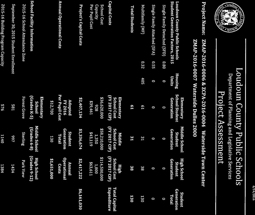
60
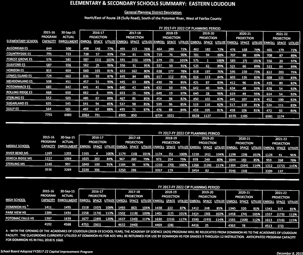
61


62 July 18, 2016 Ms. Judy Birkitt Department of Planning 1 Harrison Street, S.E. P. O. Box 7000 Leesburg, Virginia Re: ZMAP & ZCPA ; Waterside Town Center ZMAP ; Waterside Dulles 2000 Dear Ms. Birkitt: Loudoun Water has reviewed the referenced referral application. Public water and sanitary sewer service could be provided to this site through extension of existing facilities. We recommend that the applicant work with Loudoun Water to determine a phasing of the project that will accommodate current sewer capacity constraint, and allow for the modification of existing agreement between Loudoun Water and Fairfax County, which must occur prior to the project s build out. Should offsite easements be required to extend public water and/or sanitary sewer to this site, the applicant shall be responsible for acquiring such easements and dedicating them to the Authority at no cost the Authority. Public water and sanitary sewer service would be contingent upon the developer s compliance with the Authority s Statement of Policy; Rates, Rules and Regulations; and Design Standards. Sincerely, Julie Atwell Engineering Administrative Specialist
63 From: Hoddinott, George Sent: Monday, September 19, :27 AM To: Birkitt, Judi Cc: David, James Subject: DED Referral for Waterside DED has reviewed the above the application to rezone 2.2 acres to PD-TC. We do not have any comments at this time and do not plan on submitting a referral response. Please let me know if you need anything further as the application is processed. Thanks, George Hoddinott, CZO, Development Process Manager (o) Loudoun County, Virginia Economic Development #1 in new business investment in Virginia SmartAsset, 2015 & 2016 Biz.Loudoun.gov LoudounFarms.org LoudounSourceLink.org Facebook Twitter JUST A REMINDER THAT WE HAVE MOVED TO OUR NEW LOCATION Central Station Drive, Suite 300 Ashburn, VA 20147
64 Elizabeth M. Gilleran Director of Community Development T (703) F (703) community.development@herndon-va.gov TOWN COUNCIL Lisa C. Merkel, Mayor Jennifer Baker, Vice Mayor David A. Kirby Steven Lee Mitchell Sheila A. Olem Jasbinder Singh Grace Han Wolf July 18, 2016 By electronic mail: Judi.Birkitt@loudoun.gov Ms. Judi Birkitt Project Manager Loudoun County Department of Planning and Zoning P. O. Box 7000 Leesburg, VA RE: ZMAP & ZCPA Waterside Town Center ZMAP Waterside Dulles 2000 Dear Ms. Burkitt: Thank you for the memorandum seeking Town of Herndon review of the proposed amendment to the Waterside zoning map amendment. I understand the application is necessitated by a land swap along Shaw Road and it would add 2.18 acres to the original Waterside application area and remove 2.33 acres of land. An additional 405 dwelling units are proposed for Waterside which already is approved for 2,595 residential units. The applicant requests a modification to allow the maximum size of the Town Center Core to be increased from the previously approved 39 acres to 41 acres, even though the overall size of the PD-TC district does not grow. In previous correspondence from the Town of Herndon about the Waterside development, many concerns were raised. While 405 dwellings may seem a negligible increase to Loudoun County officials when compared to a total of 3,000 dwellings, the Town of Herndon remains concerned about impacts that are not confined to the development or to Loudoun County. For example, the traffic impact study does not account for the intersection of Shaw Road at Sterling Road (Route 606). Apparently, the applicant was not required to examine the impact of the proposed new residences on that intersection. A traffic study dated February 17, 2015, for a previous application by Waterside indicated that intersections at Shaw Road and Davis Drive on Old Ox Road would operate at low, though acceptable, levels of service (LOS E in the PM peak at Old Ox Road and Shaw Road, and LOS D at Old Ox Road and Davis Drive). The town staff inquires whether or not the levels of service on Old Ox Road would remain the same with the 405 additional dwellings proposed in the current application. Another question involves the assertion in the applicant s Statement of Justification that public amenities provided with the original Waterside rezoning will more than serve the additional units proposed here. As stated previously, many Loudoun residents participate in Town of Herndon organized recreation activities. While those residents do pay a fee, the fee does not cover the complete 777 Lynn Street, Herndon, VA P.O. Box 427, Herndon, VA herndon-va.gov
65 Judi Birkitt July 18, 2016 Page 2 cost of providing the activities and facilities and Herndon taxpayers subsidize recreation programs enjoyed by residents who do not live in the town. Nearly 65% of Herndon Community Center users are from outside the Town. Facilities like athletic fields and the indoor pool are already at capacity daily during peak hours. An appropriately sized park developed in the Waterside area with both active and passive uses would be invaluable to those residents and would help divert some demand from Loudoun County residents for Herndon s facilities. Finally, the town repeats its request that the applicant avoid routing, during construction of the three phases of Waterside construction, vehicles having a registered gross weight in excess of 7,500 pounds and destined for or leaving the development site through the Town of Herndon. The town experiences dump truck traffic on a regular basis, and the applicant s assertion with previous applications that no Waterside construction traffic would need to use town streets does not match our daily observations of commercial traffic. Sincerely, Elizabeth M. Gilleran, Director of Community Development Cc: Cindy Roeder, Director of Parks and Recreation Dana Heiberg, Senior Planner Kay Robertson, Senior Projects Planner 777 Lynn Street, Herndon, VA P.O. Box 427, Herndon, VA herndon-va.gov


66 Cooley Molly M. Novotny January 11, 2017 Judi Birkitt Loudoun County Department of Planning and Zoning 1 Harrison Street, SE Leesburg, Virginia Re: Response 2"d Submission Referral Comments Waterside Town Center ZMAP and ZCPA , Waterside Dulles East ZMAP Dear Judi: On behalf of Chantilly Crushed Stone (the "Applicant'), I write to respond to the comments we have received to date on the Waterside application. Each comment is repeated below in italics, followed immediately by our responses. Because the boundary line adjustment between the Applicant and Dulles East VIII, LLC has been recorded, this submission reflects the new parcel lines. Therefore, Dulles East VIII, LLC no longer owns any land being zoned to the PD-TC district and the Applicant no longer owns any land being zoned to the PD-RDP district. To clarify things moving forward and to ensure the Waterside proffers only apply to land owned by the Applicant, we have separated the applications. What was Sheet 17 is now Sheet 1 of ZMAP We have updated all ownership information. Following discussion with Staff we believe these applications are ready for public hearing and request they be placed on the February 28, 2017, Planning Commission calendar. Loudoun County Department of Planning and Zonins~ (November 16, 2016) Comment 1. Staff has no further comments re/ated to ZMAP CPA Concept Development Plan or ZMAP Concept Development Plan. Response: Comment appreciated and acknowledged. Loudoun County Department of Transportation (November ) Comment 1. The Applicant has provided a trip generation at second referral and confirmed that the trips associated with the previously approved zoning approvals are included in Background traffic in the previous TIS submitted at first referral. The Applicant further confirmed that the land swap results in no new trips for the Dulles 2000 site. Therefore, this comment is addressed. Response: Comment appreciated and acknowledged. Comment 2. The clarification needed to verify the proposed access points along Shaw Road was provided at second submission. Comment addressed v2 Cooley LLP One Freedom Square Reston Town Center Freedom Drive Reston, VA t: (703) f: (703) cooley.com Attachment 5

67 Cooley Judi Birkitt January 11, 2017 Page Two Response: Comment appreciated and acknowledged. Comment 3. Comment addressed. Response: Comment appreciated and acknowledged. Comment 4. DTCI notes that the requested regional road contribution level is advisory only and not reflective of County policy at this time. Therefore, DTCI has no further comment on this matter. Response: Comment acknowledged. Comment 5. DTCI notes that Sheet 26 of the Design Guidelines approved with the Waterside application show "Proposed Transitway Stops." The Applicant needs to demonstrate that the bus shelter proposed with these applications is included in the Design Guidelines document. Response: The Design Guidelines have been updated to incorporate the proposed bus shelter, as requested. For your reference, please find attached the revised Design Guidelines. Sincerely, Molly. Novot v2 Cooley LLP One Freedom Square Reston Town Center Freedom Drive Reston, VA t: (703) f: (703) cooley.com


68 Cooley Molly M. Novotny m novotny@cooley.com October 11, 2016 Judi Birkitt Loudoun County Department of Planning and Zoning 1 Harrison Street, SE Leesburg, Virginia Re: Waterside Town Center ZMAP , ZCPA , Waterside Dulles 2000 ZMAP Response to Staff Comments Dear Judi: On behalf of Chantilly Crushed Stone (the "Applicant"), I write to respond to the comments we have received to date on the Waterside application. Each comment is repeated below in italics, followed immediately by our responses. Loudoun County Department of Planning and Zoning (Dated August 3, 2016) CONCEPT DEVELOPMENT PLAN Cover sheet (Sheet 1 of 17) Comment 1. Include ZMAP , Waterside Dulles 2000, in the title and plan sheets. The two applications are running concurrently and ZMAP is a listed plan sheet (Sheet Index 17). Response: The plan sheets have been updated to include ZMAP , Waterside Dulles Because Sheet 17 is not subject to the Waterside proffers nor related to the CDP proffer sheet, the Applicant believes it is cleanest to keep that application number out of the title block. Comment 2. Amend Sheet Index to clearly demonstrate the plan sheets related to ZMAP & ZCPA , Waterside Town Center, and the plan sheets related to ZMAP , Waterside Dulles Response: A note has been added to the sheet index that clearly demonstrates the plan sheets related to ZMAP and ZCPA Waterside Town Center -- and the plan sheets related to ZMAP Waterside Dulles For reference, plan sheets 1-16 correspond to ZMAP and ZCPA and plan sheet 17 corresponds to ZMAP Vicinity Map (Sheet 2 of 17) Comment 3. General Nofes: v2 Cooley LLP Orie Freedom Square Reston Town Center Freedom Drive Reston, VA t: (703) f: (703) cooley.com


69 Cooley Judi Birkitt October 11, 2016 Page Two a. Amend Sheet Index to clearly demonstrate the plan sheets related to ZMAP & ZCPA , Waterside Town Center, and the plan sheets related to ZMAP , Waterside Dulles b. Amend Zoning District column for properties PIN# and to include "1972 Zoning Ordinance" after the listed zoning district. Response: Comment 3.a. Sheets 1 and 2 have been updated as requested. Comment 3.b. The Zoning District column on Sheet 2 has been updated for PIN Numbers and to include "1972 Zoning Ordinance" as requested. North Existing Conditions Map (Sheet 3 of 17) Comment 4. Zoning Checklist Notes: a. Amend Note 4 to state the actual property PIN# that contains floodplain as opposed to stating "subject property". Additionally, state that the property is located partially within the Floodplain Overlay District and subject to Revised 1993 Zoning Ordinance Section b. Amend Note 7 to state "The majority of property PIN and all other properties lies within the Airport Impact (AI) Overlay District LDN-60 7 mile buffer overlay district and subject to Revised 1993 Zoning Ordinance Section "for consistency purposes, see Note 11. c. Amend Note 9 to state "All of the properties..." as opposed to "The subject property..." for consistency purposes. d. Amend Note 70 to state `All of the properties are located in the Route 28 Tax District and subject to Revised 7993 Zoning Ordinance Section " e. Amend (Vote 11 to state "The majority of property PlN and all other properties lies within the Quarry Notification Overlay District and subject to Revised 1993 Zoning Ordinance Section f. Remove Note 72. The listed properties are not located on this plan sheet. Response: Plan Sheet 3 has been updated as requested above. South Existing Conditions Map (Sheet 4 of 17) Comment 5. Zoning Checklist Notes: a. Per Note 3, are the ZMAP properties PIN# and included in the wetland delineation? The note should clearly reference the wetland delineation for the ZMAP and ZMAP properties. b. Amend Note 4 to state the actual properties PIN# that contains floodplain as opposed fo stating "subject property". Additionally, state that the properties are located partially within the Floodplain Overlay District and subject to Revised 1993 Zoning Ordinance Section v2 Cooley LLP One Freedom Square Reston Town Center Freedom Drive Reston, VA t: (703) f: (703) cooley.com


70 Gooley Judi Birkitt October 11, 2016 Page Three c. Per Note 5, are the ZMAP properties PIN# and included in the archeological study? The note should clearly reference the archeological study for the ZMAP and ZMAP properties. d. Per Note 6, are there any burial sites located on ZMAP properties PIN# and ? The note should clearly reference the existence/non-existence of burial sites archeological for ZMAP and ZMAP properties. e. Amend Note 7 to state "The majority of property PIN and al! other properties lies within the Airport Impact (AI) Overlay District LDN-60 1 mile buffer overlay district and subject to Revised 7993 Zoning Ordinance Section "for consistency purposes. f. Amend Note 9 to state "All of the properties..." as opposed to "The subjecf property..." for consistency purposes. g. Amend Note 10 to state `All of the ZMAP & ZCPA properties are located in the Route 28 Tax District and subject to Revised 7993 Zoning Ordinance Section " h. Amend Note 71 to state "The majority of property PIN and all other ZMAP & ZCPA properties lies within the Quarry Notification Overlay District and subject fo Revised 7993 Zoning Ordinance Section i. Amend Note 72 to add "and subject to Revised 1993 Zoning Ordinance Section " after "Horsepen Run." Response: The referenced PINS were included in the wetland delineation and are now referenced in respective notes on sheets 4 and 17. Note 10 has been updated to read "All of the properties requesting rezoning are located in the Route 28 Tax District". The land being added from Dulles 2000 is zoned per the 1972 Zoning Ordinance. The notes have been revised to indicate that the land subject to ZMAP is governed by the Revised 1993 Zoning Ordinance. All of the additional comments have been addressed on the plan sheets as requested above. Proposed Development Tabulations, Larsdbay Map 8~ Zoning Districts (Sheet 7 of 17) Comment 6. Proposed Development Tabulations: a. Amend Note 2 to state, "Refer to Zoning Ordinance Modification Matrix on Sheet 71." b. Amend Note 3 to state, "SPEX for fire and rescue station approved on 9/2/2075 with ZMAP " c. Amend Note 4 to state, "SPMI & SPM for public school approved on 9/2/2015 with ZMAP " d. Amend Note 5 to state, "SPEX for automobile service station approved on 9/2/2015 with ZMAP " Response: Plan Sheet 6 has been updated as requested with the exception of Notes 4 and 5. The appropriate ZMAP reference for Notes 4 and 5 is ZMAP , which is indicated v2 Cooley LLP One Freedom Square Reston Town Center Freedom Drive Reston, VA t: (703) f: (703) cooley.cam


71 Cooley Judi Birkitt October 11, 2016 Page Four Comment 7. Amend the information related to all the special and minor special exception applications and include approval dates, such as "Special Exception SPEX for Fire &Rescue Station in Landbay A-2 approved on September 2, (See Sheet 72)". Staff recommends providing a title to these approved special exceptions such as, "Special Exceptions Approved with ZMAP " Response: Sheet 7 has been updated with a listing of the "Special Exceptions Approved with ZMAP ". ZMAP is not related to Waterside. North Concept Development Plan (Sheet 8 of 17) Comment 8. Denote the location of the listed special exception applications 7, 2 and 3 on the concept development plan, consistent with Sheet 9. Response: Sheet 8 has been updated to denote the location of the listed special exception applications 1, 2 and 3 for consistency with Sheet 9. Comment 9. Remove information regarding the listed special exception applications 4 and 5. These applications are not located on this plan sheet. Response: The information regarding special exception applications 4 and 5 have been removed from Plan Sheet 8. Comment 10. Zoning Notes: Amend the beginning of Note 9 to state, "The above three special exceptions..." Response: Note 9 has been amended on Sheet 8 as requested. South Concept Development Plan (Sheet 9 of 17) Comment 11. Remove information regarding the listed special exception applications 7, 2 and 3. These applications are not located on this plan sheet. Response: The information regarding the listed special exception applications 1 and 2 have been deleted from Plan Sheet 9 as requested. However, special exception application 3 is shown on the top of Plan Sheet 9, so we have not removed the information regarding that special exception. Comment 12. Zoning Notes: Amend the beginning of Note 9 to state, "the above two special exceptions..." Response: Note 9 on Plan Sheet 9 has been amended to read, "the above three special exceptions..." rather than the requested change. Plan Sheet 9 does illustrate three special exception applications: special exception applications 3, 4 and 5. Zoning Ordinance Modifications (Sheet 11 of 17) Comment 73. Two modifications are being requested with this application: 7) the increase of the Town Center Core from 39 acres to 47 acres and 2) to reduce the building setback to 16 feet in the PD-TC zoning district. Response: A note has been added to Plan Sheet 11 beneath the "Zoning Modification Matrix" that lists the two modifications that are being requested with this application v2 Cooley LLP One Freedom Square Reston Town Center Freedom Drive Reston, VA t: (703) f: (703) cooley.com
 of ZMAP 1987-0031 that is governed by the 1972 Zoning Ordinance is being removed.")

72 Cooley Judi Birkitt October 11, 2016 Page Five ZMAP Concept Development Plan (Sheet 77 of 17) Comment 14. The hatched area musf be part of this application. Property that was part of the Concept Deve%pment Plan (CDP) of ZMAP that is governed by the 1972 Zoning Ordinance is being removed. The loss of area under ZMAP will decrease the floor area ration (FAR) and needs to be noted. Amend the CDP to reflect changes to ZMAP CDP. Response: Acreage from the original ZMAP can be removed without needing to amend that original application. Portions of parent parcels are subdivided and regularly rezoned or developed outside of the original approval. Additionally, the BLA that is currently processing will add a similar acreage as to what is being removed back to the original PIN numbers included with ZMAP , thereby only negligibly, changing the acreage. The parcels that will remain subject to ZMAP remain zoned PD-RDP under the 1972 Zoning Ordinance, notwithstanding the removal of the area, the overall FAR within the district is constrained to a.60 FAR. Additionally, representatives of owner of the remainder parcel, Dulles East, attended our pre-application conference and asserted their intention to apply for a rezoning application for the remainder parcel before developing its property. These considerations will mitigate, if not eliminate, the aforementioned concerns. Comment 75. General Notes: a. Amend Note 7 to reference amendments to both ZMAP and ZMAP b. Amend the referenced Boundary Line Adjustment in Note 1 from "BLA " to "BEAD ". c. Amend Note 2 to reference amendments to both ZMAP and ZMAP d. Amend Note 4 to include separate notes for each overlay district affecting,both 1972 and Revised 1993 Zoning Ordinances and reference Zoning Ordinance section of overlay districts the properties are subject to. e. Amend Note 5 to state proper application number ZMAP f. Per Note 10, are the ZMAP properties PIN# and included in the archeological study? The note should clearly reference the archeological study for the ZMAP and ZMAP properties. g. Per Note 7 7, are there any burial sites located on ZMAP properties PIN# and ? The note should clearly reference the existence/non-existence of burial sites archeological for ZMAP and ZMAP properties. h. Per Note 72, are the ZMAP properties PlN# and included in the wetland delineation? The note should clearly reference the wetland delineation for the ZMAP and ZMAP properties. Response: Comment 15.a. This note and plan sheet address rezoning 2.33 acres that was originally rezoned with ZMAP and is now being rezoned with ZMAP The remaining land within the referenced parcels will remain governed by ZMAP and ZCPA , as indicated in the note v2 Cooley LLP One Freedom Square Reston Town Center Freedom Drive Reston, VA t: (703) f: (703) cooley.com


73 Cooley Judi Birkitt October 11, 2016 Page Six Comment 15.b. Note 1 on Plan Sheet 17 has been amended to reference BLAD , as requested. Comment 15.c. This note has been revised to just reference that one ZMAP number. Page 17 is the concept plan for the Duffles 2000 property so the only application referenced in this note will apply to that property: ZMAP Comment 15.d. Note 4 as originally shown on Sheet 4 has been expanded into Notes 4 7 on Sheet 17. The notes only reference the Revised 1993 Zoning Ordinance since the land being rezoned on this sheet is governed by the Revised 1993 Zoning Ordinance. The land governed by the 1972 Zoning Ordinance is not subject to this application, as noted by the hatching. Comment 15.e. Note 5 as originally shown on Sheet 4 is now Note 9. This note has been amended to state ZMAP , as requested. Comment 15.f. This note has been amended, as requested. It is now Note 14. Comment 15.g. This note has been amended, as requested. It is now Note 15. Comment 15.h. This note has been amended, as requested. It is now Note 16. REQUESTED MODIFICATIONS Comment 76. Section F.3. The applicant proposes to decrease the building setback from 35 feet to 76 feet adjacent to non-residential districts, while maintaining fhe 35 feet setback for parking and outdoor storage and buffer/landscaping buffer of Section Zoning Staff cannot support the modification request at this time. No modifications sha/1 be permitted which affect uses, density, or floor area ratio of the district. The applicant is proposing to increase the density in the two zoning districts that would be affected by the modification: PD-TC Fringe Landbay D-2 is increasing from 1,740 residential units to 7,275 and PD-TC Core Landbay D-1 is increasing from 500 residential units to 830. Furthermore, no modification will be granted for the primary purpose of achieving the maximum density on a site. The modification request does not demonstrate that the development will achieve an innovative design, improve upon the existing regulations, or otherwise exceed the public purpose of the existing regulation. Additionally, no materials demonstrating how the modification will be used in the design of the project have been provided. Provide materials demonstrating that the proposed modification 1) does not affect uses, density and floor area ratio; 2) is not being requested for the primary purpose of achieving the maximum density on a site; and 3) will achieve an innovative design, improve upon the existing regulations, or otherwise exceed the public purpose of the existing regulation. Additionally, it would be helpful if the applicant were to provide an area plan that highlights the request and demonstrates what the applicant has explained in their statement of justification. ~ (A)(3) and (A)(5)] Response: The requested modification allows the Applicant to create a uniform streetscape throughout the development. No surface parking spaces are proposed with this application, so the 35-foot parking setback is not applicable. Additionally, the proposed use in the PD-RDP district is office, which requires a 10-foot landscaped buffer per Section The Applicant is meeting that buffer. The reduced setback is necessary because of the location of the zoning district line not running in the middle of the street, which is typical. Were the zoning district line to match the center line of the road, the requested reduced setback would not be necessary. Rather, the setback request allows this portion of the project to be folded seamlessly into the rest of the Waterside project and mimic those already approved setbacks of 15 to 20 feet v2 Cooley LLP One Freedom Square Reston Town Center Freedom Drive Reston, VA t: (703) f: (703) cooley.com

.")
74 Cooley Judi Birkitt October 11, 2016 Page Seven for internal roads, improving upon the built environment from the existing regulations. With this submission, we have included a setback exhibit, attached here as Exhibit A, to show how the building relates to the street. The buildings are proposed to be five to eight stories in height, for a maximum height of 120 feet, well below the permitted 200 feet allowed, leaving significant density unused. Were the Applicant trying to maximize density with this request, the buildings would be at the maximum height, which they are not. Comment 77. Section 4-807(A). ZMAP approved an increase from the allowed 20 acre limit of the PD-TC-Core zoning district to 39 acres - 95% increase. The applicant is now proposing to further increase the PD-TC-Core zoning district from 39 acres to 47 acres. Staff cannot support the modification request at this time. With the exchange of property between Chantilly Crushed Stone and Dulles East, the Landbays of the proposed Waterside development can certainly be amended whereby the increase in acreage would occur in the PD-TC-Fringe, thereby not requiring a modification. No modifications shall be permitted which affect uses, density, or floor area ratio of the district. The applicant is proposing to increase the density in the PD-TC Core Landbay D-1 by increasing the residential units Pram 500 to 830. Furthermore, no modification will be granted for the primary purpose of achieving the maximum density on a site. The modification request does not demonstrate that the development will achieve an innovative design, improve upon the existing regulations, or otherwise exceed the public purpose of the existing regulation. Additionally, no materials demonstrating how the modification will be used in the design of the project have been provided. Provide materials demonstrating that the proposed modification 1) does not affect uses, density and floor area ratio; 2) is not being requested for the primary purpose of achieving the maximum density on a site; and 3) will achieve an innovative design, improve upon the existing regulations, or otherwise exceed the public purpose of the existing regulation. ( (A)(3) and (A)(5)] Section (A)(3) No modification shall be approved unless the Board of Supervisors finds that such modification to the regulations Section (A)(5) An application for modification shall include materials demonstrating how the modification will be used in the design of the project. Response: The appropriate ZMAP reference is ZMAP The location of the land being acquired by Chantilly Crushed Stone is adjacent to the Core, not the Fringe, which is why we have requested it be added to the Core. The proposed uses are residential, which is permitted in both the Fringe and Core areas of the PD-TC district. Additionally, there are no additional benefits the Applicant receives with designating this area as Core rather than Fringe. It is purely a geometric decision. Were the land adjacent to the Waterside Fringe, it would be added to that subdistrict, thus replacing land from the Fringe being swapped and no modification would be needed. STATEMENT OF JUSTIFICATION Pursuant to Section (E), the applicant shall address all the following in its statement of justification or plat unless not applicable. Issues of Consideration Zoning Justification Concerns (1) Appropriateness of the proposed uses based on Issue is addressed in the Statement of the Comprehensive Plan, trends in growth and Justification. Zoning will defer Statement of development, the current and future Justification. comments regarding this issue requirements of the community as to land for to the Department of Planning and Zoning, various purposes as determined by population Comprehensive Planning v2 Cooley LLP One Freedom Square Reston Town Center Freedom Drive Reston, VA t: (703) f: (703) cooley.com
 The existing character and use of the subject The applicant should expand the statement property and suitability for various uses, to address the suitability/compatibility of compatibility with")
 Adequacy of sewer and water, transportation, Issue is addressed in the Statement of and other infrastructure to serve the uses that Justification.")
75 Booley Judi Birkitt October 11, 2016 Page Eight and economic studies and other studies and the encouragement of the most appropriate use of land throughout the locality. (2) The existing character and use of the subject The applicant should expand the statement property and suitability for various uses, to address the suitability/compatibility of compatibility with uses permitted and existing permitted and existing uses. on other property in the immediate vicinity, and conservation of land values. (3) Adequacy of sewer and water, transportation, Issue is addressed in the Statement of and other infrastructure to serve the uses that Justification. Zoning will defer Statement of would be permitted on the property if it were Justification comments regarding this issue reclassified to a different zoning district. to the Department of Transportation and Ca ital Infrastructure. (4) The requirements for airports, housing, schools, Issue is addressed in the Statement of parks, playgrounds, recreational areas and other Justification. public services. (5) Potential impacts on the environment or natural Issue is addressed in the Statement of features including but not limited to wildlife Justification. Zoning will defer Statement of habitat, wetlands, vegetation, water quality Justification comments regarding this issue (including groundwater), topographic features, to the Environmental Review Team. air quality, scenic, archaeological, and historic features, and agricultural and forestal lands and any proposed mitigation of those impacts. (6) The protection of life and property from Issue is addressed in the Statement of impounding structure failures. Justification. Zoning will defer Statement of Justification comments regarding this issue to the Environmental Review Team. Response: The Applicant has updated the Statement of Justification where needed. Loudoun Countv Department of Building and Development (Dated Julv 21, 2016) Comment 1. The app/icanys Sfatement of Justification indicates that the 2.33 acres that will be rezoned to PD-RDP and transferred to Dulles East V/ll, LLC ("Dulles Ease) and will not be subject to any proffers and that "importantly, no buildings or development are proposed on the land being acquired by Dulles East and no proffers are being offered. Rather, that land would be further developed and zoned as part of a subsequent Dulles East zoning application." However, staff questions what will prohibit or control development of that land until such time as the owner obtains additional zoning actions? It would appear that this land would be zoned PD-RDP with no restrictions (proffers), and as such, would be legally entitled to any and all development permitted by the PD-RDP district that would fit on the site (while meeting all ordinance requirements). Response: The 2.33 acres is spread across five smaller areas that are not adjacent to each other. Their separate locations and small sizes (0.220 acres, acres, acres, acres and acres) render it impossible, or nearly impossible, to develop the parcels as they fail to meet minimum lot depths or v2 Cooley LLP One Freedom Square Reston Town Center Freedom Drive Reston, VA t: (703) D f: (703) cooley.com
 Comment 1.")
 is of the opinion that the submitted materials are not detailed enough to evaluate access and circulation of emergency")
76 Cooley Judi Birkitt October 11, 2016 Page Nine have adequate room to provide needed setbacks, parking and building. Further, Dulles East is currently preparing a zoning application that will include those parcels. Loudoun County Historic Preservation (Dated June 15, 2016) Comment 1. I have no referral comment on this application. Response: Acknowledged. Loudoun County Department of Fire, Rescue and Emergency Management (Dated July 29, 2016) Comment 1. The Fire and Rescue Planning Staff (in agreement with the Fire Marshal's office) is of the opinion that the submitted materials are not detailed enough to evaluate access and circulation of emergency vehicles. Staff respectfully requests an opportunity to review such details when available and offer comments and recommendations of that point. Response: During the site plan process, the Applicant will submit details addressing the access and circulation of emergency vehicles for review and approval. Loudoun County Department of Building and Development Flood Plain Management (Dated Julv Comment 1. I have reviewed the applications of above. There are no floodplain associated with the project area of these application. Therefore, the Floodplain Management Team has no comments to offer at this time. Response: Acknowledged. Loudoun County Division of Environmental Health (Dated July 7, 2016) Comment 7. The Health Department staff recommends "Approval." Response: Acknowledged. Town of Herndon (Dated July 18, 2016) Comment 1. The traffic impact study does not account for the intersection of Shaw Road at Sterling Road (Route 606). Apparently, the applicant was not required to examine the impact of the proposed new residences on that intersection. A traffic study dated February 17, 2015, for a previous application by Waterside indicated that intersections at Shaw Road and Davis Drive on Old Ox Road would operate at low, though acceptable, levels of service (LOS E in the PM peak at Old Ox Road and Shaw Road, and LOS D at Old Ox Road and Davis Drive). The town staff inquires whether or not the levels of service on Old Ox Road would remain the same with the 405 additional dwellings proposed in the current application. Response: Intersections are included in traffic studies when the proposed project is anticipated to account for 10 percent or more of the traffic through the intersection. Based on future volumes projected in the previous Waterside TIS, dated February 17, 2015, the trips generated by the proposed additional units would have a fair share percentage of 0.5% at Old Ox Road/Shaw Road and 0.2% at Old Ox Road/Davis Drive. Because the fair share impact percentages are below one percent (1 %), the proposed additional units are anticipated v2 Cooley LLP One Freedom Square Reston Town Center Freedom Drive Reston, VA t: (703) f: (703) cooley.com


77 Cooley Judi Birkitt October 11, 2016 Page Ten to have a negligible impact at those intersections and the County's guidelines do not call for it to be studied. Notwithstanding the above, the previous application proffered millions of dollars of transportation improvements in road construction and for intersection improvements, allowing for acceptable levels of service in the future conditions. Comment 2. Another question involves the assertion in the applicant's Statement of Justification that `public amenities provided with the original Waterside rezoning will more than serve the additional units proposed here." As stated previously, many Loudoun residents participate in Town of Herndon organized recreation activities. While those residents do pay a fee, the fee does not cover the complete cost of providing the activities and facilities and Herndon taxpayers subsidize recreation programs enjoyed by residents who do not live in the town. Nearly 65% of Herndon Community Center users are from outside the Town. Facilities like athletic fields and the indoor pool are already at capacity daily during peak hours. An appropriately sized park developed in the Waterside area with both active and passive uses would be invaluable to those residents and would help divert some demand from Loudoun County residents for Herndon's facilities. Response: More than half of the 189 acres in the original application was programmed as open space, including 18 acres in Landbay A-2 which was marked as a park if and until the need for the proffered school arises. In addition, with the millions of square footage of commercial development approved with the original application, one or more gyms and a variety of specialty exercise studios are anticipated that will meet many of the residents demands. The multi-family buildings will also provide for a variety of recreation amenities, including swimming pools. Comment 3. The town repeats its request that the applicant avoid routing, during construction of the three phases of Waterside construction, vehicles having a registered gross weight in excess of 7,500 pounds and destined for or leaving the development site through the Town of Herndon. The town experiences dump truck traffic on a regular basis, and the applicant's assertion with previous applications that no Waterside construction traffic would need to use town streets does not match our daily observations of commercial traffic. Response: Acknowledged. Loudoun County Water (Dated July 18, 2016) Comment 1. We recommend that the applicant work with Loudoun Water to determine a phasing of the project that will accommodate current sewer capacity constraint, and allow for the modification of existing agreement between Loudoun Water and Fairfax County, which must occur prior to the project's build out. Response: Acknowledged Comment 2. Should offsite easements be required to extend public water and/or sanitary sewer to this site, the applicant shall be responsible for acquiring such easements and dedicating them to the Authority at no cost the Authority. Public water and sanitary sewer service would be contingent upon the developer's compliance with the Authority's Statement of Policy; Rates, Rules and Regulations; and Design Standards. Response: Acknowledged. Loudoun County Parks. Recreation and Community Services (Dated July 19, 2076) v2 Cooley LLP One Freedom Square Reston Town Center Freedom Drive Reston, VA t: (703) f: (703) cooley.com
 Comment 9.")
, 37 middle school-age children (grades 6-8), and 38 high school-age")
78 Cooley Judi Birkitt October 11, 2016 Page Eleven Comment 7. PRCS has reviewed the referenced application and has no issues with the application as presented. However, staff defers to Planning and Zoning for additional comments. Response: Acknowledged. Loudoun County Public Schools (Dated June 14, 2016) Comment 9. Based on 2075 Loudoun County Public Schools student generation factors, the addrtiona! 405 multifamily units would generate a tofal of 130 more school-age children: 61 elementary school-age children (grades K-5), 37 middle school-age children (grades 6-8), and 38 high school-age children (grades 9-12). Response: Acknowledged. Comment 2. As calculations indicate that public schools account for a significant portion of Loudoun`s capita! expenditure costs, Schoo( Board sfatf requesfs that a proporfionate share of the applicant's capital facility contributions be set aside specifically for public school capital projects in the eastern Loudoun/Sterling subarea. This designation should be wifhin the applicants Capital Facilities Contribution proffer statement_ In addition to new school construction, majo~~ renovation and rehabilitation projects at existing school facilities are being reviewed by the School Board. The associated costs are significant and the proffer dollars will help offset such expenditures. Response: To avoid confusion, the Applicant is maintaining as much of the integrity of the original proffers with this application and so prefers to remain consistent with the wording of the capital facility proffer, which was originally drafted to be consistent with County policy. Understanding the impact of residential development, the Applicant with the original application dedicated two school sites in addition to capital facility fees. The appropriate Capital Facility Contributions are being provided with this application in accordance with the County guidelines, which includes money for schools. Comment 3. Safe walking paths remain an imporfant concern for the School Board, staff, and parents of children who attend our schools. The provided plat illustrates the applicants commitmenf to construct (rails and sidewalks on bofh sides of streets; this rs noted and appreciated. Response: Acknowledged. VDOT (Dated August 4, 2016) Comment 7. The application should document that the proposed intersections and access points on Shaw Road and Davis Drive meet VDOT Minimum Spacing Standards per the VDOT Road Design Manual Appendix F. Response: The roads are designed to meet VDOT Standards. Should they, at the time of acceptance, not adhere to the VDOT standards, the Applicant will request a waiver. Loudoun County Department of Transportation (Dated August 19, 2016) Comment 7. DTCI notes that the T1S provided with this application only analyzes the traffic impacts associated with ZMAP , Waterside Town Center. The TlS states that a separate traffic study will be prepared for the Dulles 2000 portion associated with ZMAP The Applicant needs to v2 Cooley LLP One Freedom Square Reston Town Center Freedom Drive Reston, VA 2D t: (703) f: (703) cooley.com
 to evaluate the impacts associated with the proposed uses on")

79 Cooley Judi Birkitt October 11, 2016 Page Twelve provide a TIS for ZMAP so that DTCI may review the transportation impacts associated with that portion of the development program. Response: A Traffic Impact Study, dated April 27, 2016, was submitted for the Waterside Town Center rezoning application (ZMAP ) to evaluate the impacts associated with the proposed uses on the Waterside property after the land swap with Dulles To address the impacts associated with the land Dulles 2000 will be receiving, the Applicant has prepared the below separate traffic study for the Dulles 2000 rezoning portion (application ZMAP ). Waterside is exchanging approximately 3 acres with the adjacent property, Dulles 2000, through a land swap. The land acquired by Waterside is being rezoned from PD-RDP to PD-TC, incorporated into the overall Waterside development and proposed for an additional 405 multi-family units. The land acquired by Dulles 2000 is being rezoned from PD-TC to PD-RDP, consistent with the rest of the Dulles 2000 site. The impacts associated with the additional 405 units were evaluated in the Waterside Town Center traffic impact study, while at the same time, the current by-right development for the entire Dulles 2000 site, prior to the land swap, (at 800,000 SF office/research and development uses) was included as background traffic in the traffic study. Hence, the Dulles 2000 property was studied at its full development potential, despite the overall size of the project reducing which would scale back the permitted density. Said another way, the site was accounted for. In reality, the land acquired by Dulles 2000 does not meet the 2-acre minimum lot size required by the PD-RDP zoning district and so cannot be developed as standalone projects, meaning any development there will be accompanied by its own traffic study. Additionally, the future owner of that land Dulles East VII, LLC is currently preparing a zoning application that would incorporate the acreage subject to ZMAP with the rest of its holdings into a comprehensive mixed-use development. Notwithstanding the above, a trip generation comparison is provided below to show that the land swap results in no new trips for the Dulles 2000 site. As shown in Table 1, if the current FAR approval on the site is applied to the newly obtained land, it results in the same trip generation before and after the land swap. Table 1: Dulles 2000 Trip Generation v7. Cooley LLP One Freedom Square Reston Town Center Freedom Drive Reston, VA t: (703) f: (703) cnoley.com
 760 340.0 ksf 3].8 64 382 54 301 355 2,752 General Office (57.5%) 710 460.")

80 Cooley Judi Birkitt October 11, 2016 Page Thirteen Weekday Land AM Peak Hour PM Peak Hour Weekday Development Use Size Units In Out Total In Out Total Total Before Land Swap -Approved Use per ZMAP * Ac. at FAR Research and Development Park (42.5%) ksf 3] ,752 General Office (57.5%) ksf Total Dulles 2000 Trips k5f , ,939 After Land Swap -Proposed New Trips Land Swap Size = 3 Ac Removed Trips Representing the Land Acquired by Waterside (3 Ac. at approved FAR)**: Research and Development Park (42.5% k5f General Office (57.5%) ksf Total Removed Trips 83.3 k5f ,182 Added Trips Representing the Land Acquired by Dulles 2000 (3 Ac. at approved FAR): Research and Development Park (42.5%) ksf General Office (57.5%) ksf Total Added Trips 833 k5f ,182 New Trips Added to Dulles *Per ZMAP Proffers, a minimum of 42.5% must consist of research and development uses **Note that the 3 Acres acquired by Waterside and rezoned to PD TC are analyzed in the Waterside Town Center Traffic Study. Comment 2. Regarding Shaw Road access, it is noted that the Waterside Town Center TIS states that the land area to be rezoned under ZMAP , i.e. the Waterside Dulles 2000 portion, will be submitted separately. Therefore, it rs unclear at this time where access points will be locafed for the Waterside Dulles 2000 site. Access to both the Waterside Town Center development and the Waterside Dulles 2000 development needs to be identified for the entirety of the proposed development along Shaw Road, and such access needs to meet VDOT spacing standards.!t is noted that a meeting was held with adjacent property owners along Shaw Road in March 2015 prior to the approval of ZMAP to ensure that access points along Shaw Road were acceptable to all impacted property owners. Explain and confirm that such mutually agreed access along Shaw Road is not adversely altered with this application. Response: Access to both the Waterside and Dulles 2000 applications were originally shown on ZMAP and replicated on ZMAP None of the mutually agreed upon access points have been altered with this application. Comment 3. DTCI notes that the phasing for the proposed development needs to be consistent with the timing of proffered construction of Shaw Road per the previously approved Waterside develo,nment ZMAP The proposed 405 multi-family units should not be occupied until Shaw Road is constructed as a four-lane roadway and open to traffic between Old Ox Road and Innovation Avenue. Response: The phasing has not changed. Shaw Road will be built as noted above prior to the occupancy of any development, residential or non-residential, south of Route 606. Comment 4. DTCI notes that the 405 multi-family units proposed were not included in the previously approved Waterside application, were nat part of the original TIS far the Waterside development and v2 Cooley LLP One Freedom Square Reston Town Center Freedom Drive Reston, VA t: (703) f: (703) cooley.com


81 Cooley Judi Birkitt October 11, 2016 Page Fourteen were not considered in fhe previous analysis which identifies needed mitigation measures. As this is a ZMAP and ZCPA application, there are roadway projects in the vicinity of this site where regional roadway contributions could be used to make improvements. Some of these projects in the vicinity of the site include widening sections of Old Ox Road that are not already accounted for in the original Waterside proffers and the planned bridge over the Dulles Toll Road, connecting Davis Drive in Loudoun County to Sunrise Va/ley Drive in Fairfax County. Therefore, DTCI recommends that the Applicant provide a regional road contribution of $6, per unit, consistent with other recent residential rezoning applications. DTC! notes this regional road contribution level is advisory only and not reflective of County policy at this time. Such contribution levels may be reviewed for possible adoption by the Board of Supervisors in the future. Response: Nearly $30 million in off-site road improvements were proffered with the original application for 2,595 units, which equates to $11,325 on a per unit basis for regional roads. This proffered amount equates to $9,796 per unit, with the addition of the 405 units. The proffered contribution far exceeds the requested contribution of $6,000 per unit. The Applicant has more than fulfilled its regional road responsibilities and no additional proffer is added. Comment 5. DTCI recommends thaf the Applicant commit to the same level of transit/shuttle service and TDM commitments agreed to with the previous Waterside ZMAP approval. Also, given the large increase in units within a town center environment, please clarify as to whether there are bus shelters in the vicinity of the proposed additional units as it is not clear from the previously approved design guidelines, as they are illustrative in nature. Response: The Applicant will extend its commitment to transit to the additional residential land bays. One additional bus shelter will be provided as referenced in Proffer 9.P.2. Loudoun County Department of Planning (Dated Auclust 29, 2016) Comment 1. Community Planning Staff support the boundary line adjustment and commend the Applicant for collaborating with the adjacent property owner to achieve a mutually beneficial Shaw Road alignment. Regarding the request to increase the number of residential units, the applications provide no compelling reason to increase the project's residential units by an additional 405 residential units, bringing the project's total to 3,000 residential units. The Plan did not envision the residential approved previously with the Original Waterside applications, and the Plan does not support additional residential development on the acreage acquired in the land swap. Community Planning staff recommends that the Applicant revise the application to eliminate the proposed additional residential units. Based on Route 28 Core Plan policies, the subject property is appropriate for high employment generating uses. Response: The approval of the original Waterside case showed that the County embraced residential within this portion of Route 28. This request looks to further strengthen the Town Core by adding three residential buildings that will support the millions of square feet of commercial already approved within Waterside. Comment 2. The Applicant addressed stormwater management and water quality with the Original Waterside applications. No changes are proposed to the previously approved environmental proffers. As proposed, environmental proffers would extend and apply to the Waterside Town Center subject property. Response: Acknowledged v2 Cooley LLP One Freedom Square Reslon Town Center Freedom Drive Reston, VA t: (703) f: (703) cooley.com


82 Cooley Judi Birkitt October 11, 2016 Page Fifteen Comment 3. The Applicant should consider identifying Tree Conservation Areas on the newly acquired Waterside Town Center acreage to demonstrate that this additional acreage is in conformance with County forest resources policies. Response: As this application is being incorporated into the Town Center Core it is proposed to be an urban environment. Comment 4. To ensure that the envisioned high quality working and living environment applies to the newly acquired property, Community Planning Staff recommends updating the Design Guidelines to include the newly acquired property and the revised Shaw Road alignment. Response: The Design Guidelines will be updated to include the new property. Comment 5. Since the application proposes less than 20 dwelling units per acre, no unmet housing needs units are required by the Zoning Ordinance. The Applicant addresses the unmet housing needs policies of the Revised General Plan by increasing the proffered number of unmet housing needs units proportionate to the proposed increase in residential units. Response: Acknowledged. Comment 6. The Applicant proffers to provide the current Capital Intensity Factor (CIF) of $21,830 per unit for the additional 357 non-unhu multi-family units. The application does not propose additional onsite amenities to serve the 405 added residential units. Increasing the residential component, together with not providing additional amenities, may exceed the provisions of facilities and services in an area not planned to support this type of growth. Response: The original application provided ample onsite amenities situated around a vast 55-acre lake, to which the new residents will have access to as well as an integrated trail and sidewalk network. The proposed buildings will include onsite amenities also available to the residents. Comment 7. The modification request and the justification are unclear. For implementation purposes, the CDP will need to clearly identify the specific location in which this modification is being proposed. If the modification applies only to Block L, then Block L will need fo be labeled on the CDP; Block L appears only in non-proffered illustratives. Response: Exhibit A to this letter shows original Waterside application, setbacks and street sections are illustrated in the Design Guidelines, a proffered document. Exhibit A is included in the Design Guidelines. Comment 8. Regarding both proposed modifications, Article 6 of the Ordinance states that "no modification shall be approved unless the Board finds that such modification to the regulations will achieve an innovative design, improve upon the existing regulations, or otherwise exceed the public purpose of the existing regulation". The application does not demonstrate how the proposed modifications fulfill this Ordinance requirement. The application does not include any proposed mitigation measures to offset the proposed modifications. Response: The requested modifications continue the fabric of the Town Center Core by extending the already approved streetscape section to the new land bay. Without the setback modification, the new land bay would appear as an inconsistent, unrelated appendage. The addition to the Town Center Core of two acres allows a natural extension of the already approved Town Center Core v2 Cooley LLP One Freedom Square Reston Town Center Freedom Urive Reston, VA t: (703) f: (703) cooley.com

")
83 Judi Birkitt October 11, 2016 Page Sixteen ley Sincerely, Molly. Novot Cooley LLP One Freedom Square Reston Town Center Freedom Drive Reston, VA t: (703) f: (703) cooley.com v2

84 EXHIBIT A EN~NA) ~ TRAVEL LANE ~ WALK S RNP (PO TRAVEL LANE (POTENTIAL) 'STRIP 'WALK STREET SCAPE ~ CURB TO CURB TYPE C1: INTERNAL ROAD (PRIVATE) (APPLY TO ROAD A, B, C AND D) STREET SCAPE DULLES'EAST VIII LIMITED PARTNERSHIP _ ~ ~,, ~ ~ {'~.- I~ ~ ~ ~~ `l \ `,, \ i ~~ ~ `~ ORIGINAL PROPERTY LINE REVISED----- PROPERTY LINE 20 ~ ~ i ~~ ~ 2 ~~ j p_1 0 o /; ii; i ~, ~ ROAD,A - ~%% i ~,- /- ~,~ ~~ ~ - ~~/%/%j /,/ 1 Y,//~ // ~! I ;/ 'I tea, \,'\ i ~ ~ ~ \ i%:; /~~ ~f1,\ '\ ~~ '\ y ~- ~i -n =~ / i, ~/ i;///~; ~~ / -- \\~ / -_
PLANNING COMMISSION PUBLIC HEARING STAFF REPORT ZRTD FAIRFAX MARBLE & GRANITE
 Date of Hearing: PLANNING COMMISSION PUBLIC HEARING STAFF REPORT SUBJECT: ELECTION DISTRICT: ZRTD-2016-0009 FAIRFAX MARBLE & GRANITE Broad Run CRITICAL ACTION DATE: September 27, 2017 STAFF CONTACTS: APPLICANT:
PLANNING COMMISSION PUBLIC HEARING STAFF REPORT ZRTD NVA DEVELOPMENT
 Date of Hearing: PLANNING COMMISSION PUBLIC HEARING STAFF REPORT SUBJECT: ELECTION DISTRICT: ZRTD-2016-0005 NVA DEVELOPMENT Broad Run CRITICAL ACTION DATE: July 18, 2017 STAFF CONTACTS: APPLICANT: Jacqueline
ZRTD , Glenn Drive. M. Tyler Klein, AICP, Project Manager, Planning and Zoning John Merrithew, Acting Director, Planning and Zoning
 DEPARTMENT OF PLANNING Date of Hearing: AND ZONING STAFF REPORT # 4 BOARD OF SUPERVISORS PUBLIC HEARING SUBJECT: ELECTION DISTRICT: ZRTD-2014-0003, 22675 Glenn Drive Broad Run CRITICAL ACTION DATE: September
County of Loudoun. Department of Planning MEMORANDUM
 County of Loudoun Department of Planning MEMORANDUM DATE: September 3, 2013 TO: FROM: Marchant Schneider, Project Manager Land Use Review Marie Genovese, AICP, Planner III, Community Planning SUBJECT:
PROFFER STATEMENT FAIRFAX MARBLE & GRANITE SUMMIT AT DULLES ZRTD
 PROFFER STATEMENT FAIRFAX MARBLE & GRANITE SUMMIT AT DULLES ZRTD 2016-0009 December 13, 2016 Dulles Summit LLC, the owner (hereinafter, the "Owner") of the parcel described as Loudoun County Tax Map Number
DEPARTMENT OF PLANNING Date of Hearing: September 9, 2015 AND ZONING STAFF REPORT BOARD OF SUPERVISORS PUBLIC HEARING
 SUBJECT: ELECTION DISTRICT: DEPARTMENT OF PLANNING Date of Hearing: AND ZONING STAFF REPORT BOARD OF SUPERVISORS PUBLIC HEARING ZMAP-2012-0017 & SPEX-2013-0007 Brambleton Business Campus Blue Ridge CRITICAL
LOUDOUN COUNTY BOARD OF SUPERVISORS PUBLIC HEARING. Wednesday, May 10, :00 p.m. Board Room, First Floor, Government Center AGENDA SUMMARY
 LOUDOUN COUNTY BOARD OF SUPERVISORS PUBLIC HEARING Wednesday, 6:00 p.m. Board Room, First Floor, Government Center I. CALL TO ORDER AGENDA SUMMARY II. BOARD OF SUPERVISORS PUBLIC HEARING ITEMS FOR CONSIDERATION:
County of Loudoun. Department of Planning and Zoning MEMORANDUM
 County of Loudoun Department of Planning and Zoning MEMORANDUM DATE: November 10, 2015 TO: FROM: Joe Griffiths, Project Manager Land Use Review Kelly Williams, Planner III Community Planning SUBJECT: ZRTD
DEPARTMENT OF PLANNING Date of Hearing: October 12, 2016 AND ZONING STAFF REPORT BOARD OF SUPERVISORS PUBLIC HEARING
 DEPARTMENT OF PLANNING Date of Hearing: October 12, 2016 AND ZONING STAFF REPORT BOARD OF SUPERVISORS PUBLIC HEARING #14 SUBJECT: ELECTION DISTRICT: ZCPA-2016-0005, PAUL VI CATHOLIC HIGH SCHOOL SPEX-2016-0006
PLANNING COMMISSION PUBLIC HEARING STAFF REPORT. Steve Barney, Project Manager, Planning & Zoning Ricky Barker, AICP, Director, Planning & Zoning
 Date of Hearing: PLANNING COMMISSION PUBLIC HEARING STAFF REPORT SUBJECT: ELECTION DISTRICT: ZRTD-2016-0001, Davis Drive Substation CMPT-2016-0003, Davis Drive Substation SPMI-2016-0015, Davis Drive Substation
BOARD OF SUPERVISORS PUBLIC HEARING
 DEPARTMENT OF PLANNING Date of Hearing: September 14, 2016 AND ZONING STAFF REPORT #12 BOARD OF SUPERVISORS PUBLIC HEARING SUBJECT: ELECTION DISTRICT: ZCPA-2015-0015, Stonewall Creek Business Park SPEX-2015-0039,
PUBLIC HEARING. ZMOD ASHBURN RESTAURANT PARK SIGN PLAN (Zoning Ordinance Modification)
") PUBLIC HEARING The LOUDOUN COUNTY PLANNING COMMISSION will hold a public hearing in the Board of Supervisors Meeting Room on the first floor of the County Government Center, 1 Harrison Street, S.E., Leesburg,
PUBLIC HEARING The LOUDOUN COUNTY PLANNING COMMISSION will hold a public hearing in the Board of Supervisors Meeting Room on the first floor of the County Government Center, 1 Harrison Street, S.E., Leesburg,
BOARD OF SUPERVISORS PUBLIC HEARING STAFF REPORT. ZMAP & SPEX , Lansdowne Continuing Care Facility. Ashburn
 Date of Hearing: May 10, 2017 #9 BOARD OF SUPERVISORS PUBLIC HEARING STAFF REPORT SUBJECT: ELECTION DISTRICT: ZMAP-2016-0004 & SPEX-2016-0071, Lansdowne Continuing Care Facility Ashburn CRITICAL ACTION
BOARD OF SUPERVISORS BUSINESS MEETING INFORMATION ITEM. Briefing Item: Land Development Applications November 9, 2016 Public Hearing
 BOARD OF SUPERVISORS BUSINESS MEETING INFORMATION ITEM Date of Meeting: November 1, 2016 # I-1 SUBJECT: ELECTION DISTRICT: STAFF CONTACTS: Briefing Item: Land Development Applications Public Hearing Countywide
PLANNING COMMISSION PUBLIC HEARING
 DEPARTMENT OF PLANNING Date of Hearing: AND ZONING STAFF REPORT PLANNING COMMISSION PUBLIC HEARING SUBJECT: ZMAP-2015-0008, SPEX-2016-0007, Continuing Care Facility, Adult Assisted Living SPEX-2016-0008,
INDIAN RIVER COUNTY, FLORIDA. The Honorable Members of the Planning and Zoning Commission DEPARTMENT HEAD CONCURRENCE
 Public Hearing Legislative INDIAN RIVER COUNTY, FLORIDA M E M O R A N D U M TO: The Honorable Members of the Planning and Zoning Commission DEPARTMENT HEAD CONCURRENCE Robert M. Keating, AICP; Community
DEPARTMENT OF PLANNING Date of Hearing: September 9, 2015 AND ZONING STAFF REPORT # 7 BOARD OF SUPERVISORS PUBLIC HEARING
 DEPARTMENT OF PLANNING Date of Hearing: AND ZONING STAFF REPORT # 7 BOARD OF SUPERVISORS PUBLIC HEARING SUBJECT: ELECTION DISTRICT: SPEX-2015-0027, Downs Park Broad Run CRITICAL ACTION DATE: September
BOARD OF SUPERVISORS PUBLIC HEARING
 DEPARTMENT OF PLANNING Date of Hearing: AND ZONING STAFF REPORT #17 BOARD OF SUPERVISORS PUBLIC HEARING SUBJECT: ELECTION DISTRICT: ZMAP 2006-0026 Lambert Property Dulles CRITICAL ACTION DATE: STAFF CONTACTS:
DEPARTMENT OF PLANNING Date of Hearing: July 8, 2015 AND ZONING STAFF REPORT BOARD OF SUPERVISORS PUBLIC HEARING
 SUBJECT: DEPARTMENT OF PLANNING Date of Hearing: AND ZONING STAFF REPORT BOARD OF SUPERVISORS PUBLIC HEARING SIDP-2015-0003, Cascades Overlook Sign Plan # 11 ELECTION DISTRICT: Sterling CRITICAL ACTION
BOARD OF SUPERVISORS PUBLIC HEARING AGENDA SUMMARY Board Room, First Floor, Government Center Wednesday, September 13, :00 P.M.
 Loudoun County, Virginia Board of Supervisors 1 Harrison Street, S.E., 5th Floor, P.O. Box 7000, Leesburg, VA 20177-7000 Telephone (703) 777-0204 Fax (703) 777-0421 www.loudoun.gov BOARD OF SUPERVISORS
PLANNING COMMISSION BRIEFING ITEM. Land Development Applications May 22, 2018, Planning Commission Public Hearing
 Date of Meeting: May 10, 2018 PLANNING COMMISSION BRIEFING ITEM Land Development Applications May 22, 2018, Planning Commission Public Hearing 6. SPEX-2017-0040 & ZRTD-2017-0005, 21673 Beaumeade Circle,
Town of Cary, North Carolina Rezoning Staff Report 14-REZ-31 Cary Park PDD Amendment (Waterford II) Town Council Meeting January 15, 2015
 Town Council Meeting January 15, 2015") Town of Cary, North Carolina Rezoning Staff Report 14-REZ-31 Cary Park PDD Amendment (Waterford II) Town Council Meeting January 15, 2015 REQUEST To amend the Town of Cary Official Zoning Map by amending
Town of Cary, North Carolina Rezoning Staff Report 14-REZ-31 Cary Park PDD Amendment (Waterford II) Town Council Meeting January 15, 2015 REQUEST To amend the Town of Cary Official Zoning Map by amending
COUNTY OF LOUDOUN DEPARTMENT OF PLANNING AND ZONING MEMORANDUM
 Attachment 1a A-1 A-2 COUNTY OF LOUDOUN DEPARTMENT OF PLANNING AND ZONING MEMORANDUM DATE: February 24, 2015 TO: FROM: Evan Harlow, Project Manager, Land Use Division Val Thomas, Planner, Zoning Administration
LOUDOUN COUNTY PLANNING COMMISSION AGENDA
 LOUDOUN COUNTY PLANNING COMMISSION AGENDA TUESDAY, DECEMBER 20, 2016 6:00 PM PUBLIC HEARING LOCATION: BOARD ROOM 1 st Floor, Govt. Center Citizens are encouraged to call the Department of Planning on the
BOARD OF SUPERVISORS BUSINESS MEETING ACTION ITEM
 BOARD OF SUPERVISORS BUSINESS MEETING ACTION ITEM Date of Meeting: October 4, 2016 # 15a SUBJECT: ELECTION DISTRICT: CRITICAL ACTION DATE: STAFF CONTACTS: TRANSPORTATION AND LAND USE COMMITTEE REPORT:
PLANNING COMMISSION BRIEFING ITEM. Land Development Applications May 22, 2018, Planning Commission Public Hearing P.C.
 Date of Meeting: May 22, 2018 PLANNING COMMISSION BRIEFING ITEM Land Development Applications May 22, 2018, Planning Commission Public Hearing 3. ZRTD-2018-0002, Dulles International Park Election District:
BOARD OF SUPERVISORS BUSINESS MEETING ACTION ITEM
 BOARD OF SUPERVISORS BUSINESS MEETING ACTION ITEM Date of Meeting: October 20, 2016 # 13b SUBJECT: ELECTION DISTRICT: CRITICAL ACTION DATE: STAFF CONTACTS: TRANSPORTATION AND LAND USE COMMITTEE REPORT:
PLANNING COMMISSION BRIEFING ITEM Land Development Application July 24, 2018, Planning Commission Public Hearing
 PLANNING COMMISSION BRIEFING ITEM Land Development Application July 24, 2018, Planning Commission Public Hearing ZRTD-2017-0011, Loudoun Tech Center Date of Meeting: July 12, 2018 Election District: Staff
PLANNING COMMISSION PUBLIC HEARING STAFF REPORT. ZCPA , Kincora Village Center
 Date of Hearing: April 24, 2018 PLANNING COMMISSION PUBLIC HEARING STAFF REPORT SUBJECT: ELECTION DISTRICT: ZCPA-2017-0008, Kincora Village Center Broad Run CRITICAL ACTION DATE: July 14, 2018 STAFF CONTACTS:
TOWN OF ORO VALLEY PLANNING & ZONING COMMISSION MEETING DATE: December 6, 2011
 PLANNING & ZONING COMMISSION MEETING DATE: December 6, 2011 TO: FROM: SUBJECT: PLANNING & ZONING COMMISSION Matt Michels, Senior Planner mmichels@orovalleyaz.gov; tel. 229-4822 Public Hearing: Rancho de
PLANNED UNIT DEVELOPMENT & SUBDIVISION STAFF REPORT Date: April 18, 2019
 PLANNED UNIT DEVELOPMENT & SUBDIVISION STAFF REPORT Date: April 18, 2019 DEVELOPMENT NAME SUBDIVISION NAME Springhill Village Subdivision Springhill Village Subdivision LOCATION 4350, 4354, 4356, 4358,
BOARD OF SUPERVISORS PUBLIC HEARING STAFF REPORT
 BOARD OF SUPERVISORS PUBLIC HEARING STAFF REPORT Date of Hearing: November 9, 2016 #11 SUBJECT: CPAM 2016-0003, PLAN AMENDMENT TO ESTABLISH SMALL AREA PLANNING AREAS AND TO MODIFY PROFFER POLICIES AND
BOARD OF SUPERVISORS PUBLIC HEARING STAFF REPORT. Pet Supply Services, LLC
 BOARD OF SUPERVISORS PUBLIC HEARING STAFF REPORT Date of Hearing: April 12, 2017 #6 SUBJECT: ELECTION DISTRICT: SPEX-2016-0056, Sterling Pet Depot Sterling CRITICAL ACTION DATE: June 19, 2017 STAFF CONTACTS:
City of Peachtree City. Annexation Review Process
 City of Peachtree City Annexation Review Process Page 1 Annexation Review Process Step One: Initial annexation information The following information is to be completed by the property owner and/ or their
LOUDOUN COUNTY BOARD OF SUPERVISORS PUBLIC HEARING. Wednesday, June 14, :00 p.m. Board Room, First Floor, Government Center AGENDA SUMMARY
 LOUDOUN COUNTY BOARD OF SUPERVISORS PUBLIC HEARING Wednesday, June 14, 2017 6:00 p.m. Board Room, First Floor, Government Center I. CALL TO ORDER AGENDA SUMMARY II. BOARD OF SUPERVISORS PUBLIC HEARING
RC ; Reclassification The Garrison at Stafford Proffer Amendment (formerly Stafford Village Center)
") Board of Supervisors Robert Bob Thomas, Jr., Chairman Laura A. Sellers, Vice Chairman Meg Bohmke Jack R. Cavalier Wendy E. Maurer Paul V. Milde, III Gary F. Snellings Anthony J. Romanello, ICMA CM County
Board of Supervisors Robert Bob Thomas, Jr., Chairman Laura A. Sellers, Vice Chairman Meg Bohmke Jack R. Cavalier Wendy E. Maurer Paul V. Milde, III Gary F. Snellings Anthony J. Romanello, ICMA CM County
Hearing Date: April 17, 2014
 Community Development Department SUBJECT: ACTION ITEM: PUBLIC HEARING: PLANNING COMMISSION STAFF REPORT Comprehensive Plan CPA #13-01; Comprehensive Plan Amendment (CPA) _ X_ YES X NO _ Hearing Date: April
CITY OF FORT COLLINS NATURAL AREAS AND CONSERVED LANDS EASEMENT POLICY
 CITY OF FORT COLLINS NATURAL AREAS AND CONSERVED LANDS EASEMENT POLICY Adopted January 3, 2012 PURPOSE: The purpose of the policy statement is to clarify the policies and procedures of the City of Fort
Implementation. Approved Master Plan and SMA for Henson Creek-South Potomac 103
 Implementation Approved Master Plan and SMA for Henson Creek-South Potomac 103 104 Approved Master Plan and SMA for Henson Creek-South Potomac Sectional Map Amendment The land use recommendations in the
Note: Staff reports can be accessed at
 The Maryland-National Capital Park and Planning Commission Prince George's County Planning Department Development Review Division 301-952-3530 Note: Staff reports can be accessed at www.mncppc.org/pgco/planning/plan.htm.
Attachment 4. Planning Commission Staff Report. June 26, 2017
 Planning Commission Staff Report June 26, 2017 Agenda #: Regular Agenda - 2 Title: Applicant: Request: Location: Existing Zoning: Proposed Use: Staff Planner: The Brands and The Brands West Eagle Crossing
Town of Cary, North Carolina Rezoning Staff Report 14-REZ-20 Habitat for Humanity Evans Road Town Council Meeting October 16, 2014
 Town of Cary, North Carolina Rezoning Staff Report 14-REZ-20 Habitat for Humanity Evans Road Town Council Meeting October 16, 2014 REQUEST To amend the Town of Cary Official Zoning Map by rezoning 0.53
Draft Zoning Changes for the 2nd Planning Board Public Hearing, January 22, 2018.
 Draft Zoning Changes for the 2nd Planning Board Public Hearing, January 22, 2018. No changes were made at the 1st Public Hearing. Proposed wording for the 1 st Public Hearing in red, eliminated text in
LOUDOUN COUNTY PLANNING COMMISSION AGENDA
 LOUDOUN COUNTY PLANNING COMMISSION AGENDA R E V I S E D TUESDAY, NOVEMBER 22, 2016 6:00 PM PUBLIC HEARING LOCATION: Board Room 1 st Floor, Govt. Center Citizens are encouraged to call the Department of
Comprehensive Plan Amendment #PLN , Reserve at Cannon Branch (Coles Magisterial District)
") COUNTY OF PRINCE WILLIAM 5 County Complex Court, Prince William, Virginia 22192-9201 PLANNING (703) 792-7615 FAX (703) 792-4758 OFFICE Internet www.pwcgov.org Christopher M. Price, AICP Director of Planning
COUNTY OF PRINCE WILLIAM 5 County Complex Court, Prince William, Virginia 22192-9201 PLANNING (703) 792-7615 FAX (703) 792-4758 OFFICE Internet www.pwcgov.org Christopher M. Price, AICP Director of Planning
PROFFER STATEMENT EVERGREEN MEADOWS ZMAP
 PROFFER STATEMENT EVERGREEN MEADOWS ZMAP 2016-0016 March 23, 2017 Cullen B. Tilman, the owner (the Owner ) of the properties identified as Loudoun County PIN ##202-29-7105; 202-29-6183; 202-29-5218; 202-29-4625;
Appendix A: Guide to Zoning Categories Prince George's County, Maryland
 Appendix A: Guide to Zoning Categories Prince George's County, Maryland RESIDENTIAL ZONES 1 Updated November 2010 R-O-S: Reserved Open Space - Provides for permanent maintenance of certain areas of land
PLANNING COMMISSION BRIEFING ITEM. Land Development Applications May 22, 2018 Planning Commission Public Hearing
 Date of Meeting: May 10, 2018 PLANNING COMMISSION BRIEFING ITEM Land Development Applications May 22, 2018 Planning Commission Public Hearing 4. ZCPA-2016-0010 & ZMOD-2016-0013 Glascock Field at Stone
ADDRESS / DESCRIPTION: Northeast corner of Sandbridge Road and Atwoodtown Road ELECTION DISTRICT: PRINCESS ANNE
 10 & 11 March 14, 2012 Public Hearing APPLICANT: MARLYN DEVELOPMENT CORPORATION PROPERTY OWNER: CORAL DEVELOPMENT, LLC STAFF PLANNER: Faith Christie REQUEST: Modification of Conditional Change of Zoning
O-I (Office-Institutional) and AG-1(Agricultural)
 and AG-1(Agricultural)") PROPERTY INFORMATION ADDRESS 3503 and 3505 Bethany Bend DISTRICT, LAND LOTS 2/1 973 and 974 OVERLAY DISTRICT State Route 9 PETITION NUMBERS EXISTING ZONING O-I (Office-Institutional) and AG-1(Agricultural)
PROPERTY INFORMATION ADDRESS 3503 and 3505 Bethany Bend DISTRICT, LAND LOTS 2/1 973 and 974 OVERLAY DISTRICT State Route 9 PETITION NUMBERS EXISTING ZONING O-I (Office-Institutional) and AG-1(Agricultural)
PLANNING COMMISSION REPORT Regular Agenda -Public Hearing Item
 PDP-13-00518 Item No. 3B- 1 PLANNING COMMISSION REPORT Regular Agenda -Public Hearing Item PC Staff Report 2/24/14 ITEM NO. 3B PRELIMINARY DEVELOPMENT PLAN FOR HERE @ KANSAS; 1101 INDIANA ST (SLD) PDP-13-00518:
Town of Cary, North Carolina Rezoning Staff Report. 956 W. Chatham Street. Town Council Meeting January 9, 2014
 Town of Cary, North Carolina Rezoning Staff Report 13-REZ-22 956 W. Chatham Street Town Council Meeting January 9, 2014 REQUEST To amend the Town of Cary Official Zoning Map by rezoning 0.85 acres located
GWINNETT COUNTY CSO CONSERVATION SUBDIVISION OVERLAY DISTRICT REQUIREMENTS
 GWINNETT COUNTY CSO CONSERVATION SUBDIVISION OVERLAY DISTRICT REQUIREMENTS Section 1316. CSO Conservation Subdivision Overlay District. 1. Purposes. The purposes of this overlay district are as follows:
WHEREAS, the staff of The Maryland-National Capital Park and Planning Commission recommended APPROVAL of the application with conditions; and
 R E S O L U T I O N WHEREAS, Redeemed Christian Church of God is the owner of a 2.83-acre parcel of land known as Lot 9, Lot 19, P/O Lot 1 and P/O Lot 18, Block B, Plat Book A, Plat 5, said property being
Preliminary Plan
 The Maryland-National Capital Park and Planning Commission Prince George's County Planning Department Development Review Division 301-952-3530 Note: Staff reports can be accessed at www.mncppc.org/pgco/planning/plan.htm.
Guide to Combined Preliminary and Final Plats
 Guide to Combined Preliminary and Final Plats Introduction The Douglas County is committed to providing open, transparent application processes to the public. This Guide is provided to assist anyone interested
PLANNING COMMISSION PUBLIC HEARING STAFF REPORT. SPEX , Werden Animal Clinic
 Date of Hearing: July 24, 2018 PLANNING COMMISSION PUBLIC HEARING STAFF REPORT SUBJECT: ELECTION DISTRICT SPEX-2018-0006, Werden Animal Clinic Dulles CRITICAL ACTION DATE: October 20, 2018 STAFF CONTACT(S):
Planning Department Oconee County, Georgia
 Planning Department Oconee County, Georgia STAFF REPORT REZONE CASE #: 6985 DATE: October 31, 2016 STAFF REPORT BY: Andrew C. Stern, Planner APPLICANT NAME: Williams & Associates, Land Planners PC PROPERTY
COUNTY OF LOUDOUN DEPARTMENT OF PLANNING AND ZONING MEMORANDUM
 COUNTY OF LOUDOUN DEPARTMENT OF PLANNING AND ZONING MEMORANDUM DATE: October 20, 2016 TO: FROM: SUBJECT: PURPOSE: Loudoun County Planning Commission Mark A. Depo, Zoning Administration Ricky Barker, Director,
Cover Letter with Narrative Statement
 Cover Letter with Narrative Statement March 31, 2017 rev July 27, 2017 RE: Rushton Pointe Residential Planned Unit Development Application for Public Hearing for RPUD Rezone PL2015 000 0306 Mr. Eric Johnson,
SECTION 16. "PUD" PLANNED UNIT DEVELOPMENT OVERLAY DISTRICT
 SECTION 6. "PUD" PLANNED UNIT DEVELOPMENT OVERLAY DISTRICT Subsection. Purpose. This district is established to achieve the coordinated integration of land parcels and large commercial and retail establishments
MONTGOMERY COUNTY PLANNING DEPARTMENT THE MARYLAND-NATIONAL CAPITAL PARK AND PLANNING COMMISSION
 MONTGOMERY COUNTY PLANNING DEPARTMENT THE MARYLAND-NATIONAL CAPITAL PARK AND PLANNING COMMISSION MCPB Item No. 8 Date: 03-07-13 Sonoma, Preliminary Plan, 120130040 Melissa Williams, Senior Planner, Melissa.williams@montgomeryplanning.org,
County of Loudoun. Department of Planning and Zoning MEMORANDUM. SUBJECT: SPEX & SPMI , Egypt Farm Lot 6 Heliport Second Referral
 County of Loudoun Department of Planning and Zoning MEMORANDUM DATE: November 14, 2014 TO: FROM: Marchant Schneider, Project Manager Land Use Review Marie Genovese, AICP Planner III, Community Planning
BOARD OF SUPERVISORS PUBLIC HEARING
 DEPARTMENT OF PLANNING Date of Hearing: October 12, 2016 AND ZONING STAFF REPORT # 15 BOARD OF SUPERVISORS PUBLIC HEARING SUBJECT: ZOAM-2016-0009, Affordable Dwelling Unit Regulations ELECTION DISTRICT:
PLANNING COMMISSION STAFF REPORT
 PLANNING COMMISSION STAFF REPORT West Capitol Hill Zoning Map Amendment Petition No. PLNPCM2011-00665 Located approximately at 548 W 300 North Street, 543 W 400 North Street, and 375 N 500 West Street
Bylaw No , being "Official Community Plan Bylaw, 2016" Schedule "A" DRAFT
 Bylaw No. 2600-2016, being "Official Community Plan Bylaw, 2016" Schedule "A" Urban Structure + Growth Plan Urban Structure Land use and growth management are among the most powerful policy tools at the
Chapter Planned Residential Development Overlay
 Chapter 19.29 Planned Residential Development Overlay Sections 010 Purpose 020 Scope 030 Definitions 030 Minimum Size 040 Allowable Uses 050 Minimum Development Standards 060 Density Bonus 070 Open Space
Courtyards at Kinnamon Park Sketch Plan
 Courtyards at Kinnamon Park Sketch Plan Courtyards at Kinnamon Park Sketch Plan Staff Analysis PART 1: PROJECT SUMMARY Applicant: EPCON Communities Property Owner: Johnsie M. Kinnamon Heirs, Douglas and
Draft Model Access Management Overlay Ordinance
 Draft Model Access Management Overlay Ordinance This model was developed using the City of Hutchinson and the Trunk Highway 7 corridor. The basic provisions of this model may be adopted by any jurisdiction
ARTICLE FIVE FINAL DRAFT
 ARTICLE FIVE 021218 FINAL DRAFT Sec. 503.6 Open Space Preservation Option Open Space Preservation Option Open Space Preservation developments may be approved in the AR, R-1, R-2 and R-3 zoning districts,
Staff Report. Planning Commission Public Hearing: October 17, 2007 Staff Recommendation: Denial
 COUNTY OF PRINCE WILLIAM 5 County Complex Court, Prince William, Virginia 22192-9201 PLANNING (703) 792-6830 Metro 631-1703, Ext. 6830 FAX (703) 792-4401 OFFICE Internet www.pwcgov.org Stephen K. Griffin,
4.2 LAND USE INTRODUCTION
 4.2 LAND USE INTRODUCTION This section of the EIR addresses potential impacts from the Fresno County General Plan Update on land use in two general areas: land use compatibility and plan consistency. Under
STAFF REPORT. Permit Number: Porter. Kitsap County Board of Commissioners; Kitsap County Planning Commission
 STAFF REPORT Permit Number: 15 00461 Porter DATE: November 9, 2015 TO: FROM: Kitsap County Board of Commissioners; Kitsap County Planning Commission Katrina Knutson, AICP, Senior Planner, DCD and Jeff
13 Sectional Map Amendment
 13 Sectional Map Amendment Introduction This chapter reviews land use and zoning policies and practices in Prince George s County and presents the proposed zoning in the sectional map amendment (SMA) to
4027 and 4031 Ellesmere Road Zoning Amendment and Draft Plan of Subdivision Applications - Request for Direction Report
 STAFF REPORT ACTION REQUIRED 4027 and 4031 Ellesmere Road Zoning Amendment and Draft Plan of Subdivision Applications - Request for Direction Report Date: August 22, 2013 To: From: Wards: Reference Number:
Chapter 100 Planned Unit Development in Corvallis Urban Fringe
 100.100 Scope and Purpose. Chapter 100 Planned Unit Development in Corvallis Urban Fringe (1) All applications for land divisions in the Urban Residential (UR) and Flood Plain Agriculture (FPA) zones within
Indicates Council-recommended changes Introduced by: Mr. Tackett Date of introduction: June 14, 2016 SUBSTITUTE NO. 1 TO ORDINANCE NO.
 Indicates Council-recommended changes Introduced by: Mr. Tackett Date of introduction: June 14, 2016 SUBSTITUTE NO. 1 TO ORDINANCE NO. 16-067 TO AMEND NEW CASTLE COUNTY CODE CHAPTER 40 (ALSO KNOWN AS THE
SUBDIVISION, PLANNED UNIT DEVELOPMENT, ZONING AMENDMENT, & SIDEWALK WAIVER STAFF REPORT Date: July 19, 2018
 SUBDIVISION, PLANNED UNIT DEVELOPMENT, ZONING AMENDMENT, & SIDEWALK WAIVER STAFF REPORT Date: July 19, 2018 NAME SUBDIVISION NAME LOCATION West Mobile Properties, LLC U.S. Machine Subdivision 556, 566,
Town of Cary, North Carolina Rezoning Staff Report 12-REZ-27 Morris Branch Town Council Public Hearing January 24, 2013
 Town of Cary, North Carolina Rezoning Staff Report 12-REZ-27 Morris Branch Town Council Public Hearing January 24, 2013 REQUEST To amend the Town of Cary Official Zoning Map to rezone approximately 9.0
Town of Cary, North Carolina Rezoning Staff Report 14-REZ-24 Indian Wells Road Properties Town Council Meeting November 20, 2014
 Town of Cary, North Carolina Rezoning Staff Report 14-REZ-24 Indian Wells Road Properties Town Council Meeting November 20, 2014 REQUEST To amend the Town of Cary Official Zoning Map by revising a condition
RS9 LB-S RSQ-S RS9 RS9 DOCKET: W2822 PROPOSED ZONING: LB EXISTING ZONING: RS-9. PETITIONER: J&J Properties of W-S, LLC, for property owned by Same
 HAYMOUNT ST RS9 IP DOCKET: W2822 PROPOSED ZONING: LB POPE RD CLEMMONSVILLE RD EXISTING ZONING: RS-9 RSQ-S LB-S OLD SALISBURY RD WINSTON-SALEM ZONING FORSYTH COUNTY ZONING PETITIONER: J&J Properties of
Section 1: US 19 Overlay District
 Section 1: US 19 Overlay District Section 1.1 Intent and Purpose The purpose of the US Highway 19 Overlay District is to manage access to land development along US Highway 19 in a manner that preserves
DRAFT FOR PUBLIC HEARING (rev. March, 2016)
") Chapter 200. ZONING Article VI. Conservation/Cluster Subdivisions 200-45. Intent and Purpose These provisions are intended to: A. Guide the future growth and development of the community consistent with
Chapter 200. ZONING Article VI. Conservation/Cluster Subdivisions 200-45. Intent and Purpose These provisions are intended to: A. Guide the future growth and development of the community consistent with
9. REZONING NO Vicinity of the northwest corner of 143 rd Street and Metcalf Avenue
 9. REZONING NO. 2002-15 Vicinity of the northwest corner of 143 rd Street and Metcalf Avenue 1. APPLICANT: Andrew Schlagel is the applicant for this request. 2. REQUESTED ACTION: The applicant is requesting
Financial Impact Statement There are no immediate financial impacts associated with the adoption of this report.
 STAFF REPORT Planning and Development Department Subject: Application by RYC Property to rezone a portion of lands on John Murray Dr. and Megan Lynn Dr. from R2 to R3 and to enter into a Development Agreement
STAFF REPORT. January 25, North York Community Council. Director, Community Planning, North District
 STAFF REPORT January 25, 2005 To: From: Subject: Purpose: North York Community Council Director, Community Planning, North District Refusal Report OPA & Rezoning Application 04 194214 NNY 33 OZ Applicant:
ARTICLE 15 - PLANNED UNIT DEVELOPMENT
 Section 15.1 - Intent. ARTICLE 15 - PLANNED UNIT DEVELOPMENT A PUD, or Planned Unit Development, is not a District per se, but rather a set of standards that may be applied to a development type. The Planned
Town of Cary, North Carolina Rezoning Staff Report 13-REZ-13 An Zou Property Town Council Meeting November 21, 2013
 Town of Cary, North Carolina Rezoning Staff Report 13-REZ-13 An Zou Property Town Council Meeting November 21, 2013 REQUEST To amend the Town of Cary Official Zoning Map by rezoning 0.63 acres located
ARTICLE 14 PLANNED UNIT DEVELOPMENT (PUD) DISTRICT
 DISTRICT") ARTICLE 14 PLANNED UNIT DEVELOPMENT (PUD) DISTRICT Section 14.01 Intent. It is the intent of this Article to allow the use of the planned unit development (PUD) process, as authorized by the Michigan Zoning
ARTICLE 14 PLANNED UNIT DEVELOPMENT (PUD) DISTRICT Section 14.01 Intent. It is the intent of this Article to allow the use of the planned unit development (PUD) process, as authorized by the Michigan Zoning
M-43 CORRIDOR OVERLAY ZONE
 ARTICLE 26.00 M-43 CORRIDOR OVERLAY ZONE Section 26.01 Findings A primary function of the M-43 state highway is to move traffic through the Township and to points beyond. As the primary east-west arterial
TOTTENHAM SECONDARY PLAN
 TOTTENHAM SECONDARY PLAN AMENDMENT NO. 11 TO THE OFFICIAL PLAN OF THE TOWN OF NEW TECUMSETH The following text and schedules to the Official Plan of the Town of New Tecumseth constitute Amendment No. 11
PC Staff Report 11/18/2013 Z Item No. 1-1
 Z-13-00401 Item No. 1-1 PLANNING COMMISSION REPORT Regular Agenda - Public Hearing Item PC Staff Report 11/18/2013 ITEM NO. 1: Z-13-00401 IG (General Industrial) District TO CS (Strip Commercial) District;
RM18 RS9 RM12 RS9 !( S DOCKET #: W3120 PROPOSED ZONING: GB-L EXISTING ZONING: HB-S. PETITIONER: Bank of North Carolina for property owned by Same
 DELANE DR DOCKET #: W3120 RM18 BARRY ST PROPOSED ZONING: GB-L RS9 EXISTING ZONING: HB-S IP OLD GREENSBORO RD WALES ST DENVER ST GEORGE BIG REDD CT LOUISE WILSON LN RM12!(DS MOSES LUCAS CT 585' 627' HB-S
COUNTY OF ALBEMARLE PLANNING STAFF REPORT SUMMARY
 COUNTY OF ALBEMARLE PLANNING STAFF REPORT SUMMARY Project Name: ZMA 2011-00006, Albemarle Health and Rehab Center and SP 2011-00014, Albemarle Health and Rehab Center Planning Commission Public Hearing:
Town of Cary, North Carolina Rezoning Staff Report 13-REZ-31 Weston PDD Amendment at Centregreen Park Town Council Meeting March 13, 2014
 Town of Cary, North Carolina Rezoning Staff Report 13-REZ-31 Weston PDD Amendment at Centregreen Park Town Council Meeting March 13, 2014 REQUEST This proposed amendment to the Town of Cary Official Zoning
Article Optional Method Requirements
 Article 59-6. Optional Method Requirements [DIV. 6.1. MPDU DEVELOPMENT IN RURAL RESIDENTIAL AND RESIDENTIAL ZONES Sec. 6.1.1. General Requirements... 6 2 Sec. 6.1.2. General Site and Building Type Mix...
1. Future Land Use FLU6.6.8 Land uses within the Rural Service Area portion of the Wekiva Study Area shall be limited to very low and low intensity
 1. Future Land Use FLU6.6.8 Land uses within the Rural Service Area portion of the Wekiva Study Area shall be limited to very low and low intensity uses to the greatest extent possible. Existing land uses
GROSVENOR-STRATHMORE METRO STATION MANDATORY REFERRAL APPLICATION NORTH BETHESDA, MD
 GROSVENOR-STRATHMORE METRO STATION MANDATORY REFERRAL APPLICATION NORTH BETHESDA, MD Submission by: Fivesquares JDA at Grosvenor Metro, LLC On behalf of Washington Metropolitan Area Transit Authority 1
TASK 2 INITIAL REVIEW AND ANALYSIS U.S. 301/GALL BOULEVARD CORRIDOR FORM-BASED CODE
 TASK 2 INITIAL REVIEW AND ANALYSIS U.S. 301/GALL BOULEVARD CORRIDOR FORM-BASED CODE INTRODUCTION Using the framework established by the U.S. 301/Gall Boulevard Corridor Regulating Plan (Regulating Plan),
STAFF REPORT PLN September 11, 2017
 Page: 1 TO: SUBJECT: GENERAL COMMITTEE APPLICATIONS FOR OFFICIAL PLAN AMENDMENT AND ZONING BY-LAW AMENDMENT 37 JOHNSON STREET WARD: WARD 1 PREPARED BY AND KEY CONTACT: SUBMITTED BY: GENERAL MANAGER APPROVAL: