PLANNING COMMISSION BRIEFING ITEM. Land Development Applications May 22, 2018, Planning Commission Public Hearing P.C.
|
|
|
- Rudolph Campbell
- 5 years ago
- Views:
Transcription
1 Date of Meeting: May 22, 2018 PLANNING COMMISSION BRIEFING ITEM Land Development Applications May 22, 2018, Planning Commission Public Hearing 3. ZRTD , Dulles International Park Election District: Staff Contact: Applicant Representatives: Broad Run Michael Stapor Kimberlee Welsh Hise, Walsh Colucci Lubeley & Walsh, P.C. Request: The applicant requests a zoning conversion to convert a acre parcel from PD-IP (Planned Development Industrial Park) under the 1993 Loudoun County Zoning Ordinance to the PD-IP zoning ordinance under the Revised 1993 Loudoun County Zoning Ordinance. Site Information: Size: acres Location: West side of Shaw Road, north of Old Ox Road and East of Route 28. Accessed through International Drive to the north of the parcel. Zoning: PD-IP (Planned Development Industrial Park) 1993 Loudoun County Zoning Ordinance Policy Area: Suburban (Sterling Community) Planned Land Use: Route 28 Core Existing Conditions: Vacant with an access road extending from International Drive to the north. There is a storm water ditch that runs along the eastern boundary of the parcel. Key Issues: Land Use: Compatibility: There are no outstanding land use issues. The Plan provides policy direction encouraging property owners within the District to convert to the Revised 1993 Loudoun County Zoning ordinance to provide consistent development patterns within the District. The proposed conversion to the most current zoning ordinance is appropriate. There are no outstanding compatibility issues with the existing surrounding uses. The range of uses allowed in the
2 proposed PD-IP zoning district are compatible with the uses in the vicinity. Environmental & Heritage Resources: Transportation: Fiscal Impacts: Public Utilities & Services: Public Comments: Application Status: There are no outstanding environmental issues. The zoning conversion application does not include a specific development proposal. There are no outstanding transportation issues. Consistent with the streamlined review process for zoning conversions in the District, the applicant has submitted the County s Traffic Statement for Route 28 ZMAP applications to the Current Zoning Ordinance (also known as the Route 28 Generalized Traffic Statement ). This generalized traffic statement provides current and future conditions of major roads and intersections throughout the District. The applicant has agreed to proffer a ten foot public access easement along Shaw Road and has demonstrated thirty five feet of right of way presently exists along Shaw Road. Staff has identified no outstanding issues. The rezoning is anticipated to create additional flexibility for the property owner and potential developers to respond to current market demands, which could generate employment opportunities and increase the tax base. Staff has identified no outstanding issues. The subject property is served by public water and sewer, provided by Loudoun Water. Residential uses are not permitted within the proposed PD-IP zoning district; therefore, the rezoning would not generate additional need for schools, libraries, and other public facilities that are typically associated with residential uses. There are no public comments on the Loudoun Online Land Applications (LOLA) system regarding the applications. Staff supports a Planning Commission recommendation of approval.

3 Vicinity Map

4 Concept Development Plan
5 PROFFER STATEMENT Dulles International Park, Parcel D-1A ZRTD April 17, 2018 Revised May 2, 2018 Dulles NCP, LLC, (the "Owner"), the owner of the property described as Loudoun County Tax Map Number /94//11/////D/ (PIN: ) (the "Property"), on behalf of itself and its successors in interest, hereby voluntarily proffers, pursuant to of the Code of Virginia (1950) as amended, that in the event the Property is rezoned by the Board of Supervisors of Loudoun County, Virginia, to the PD-IP (Planned Development-Industrial Park) zoning district, administered under the Revised 1993 Loudoun County Zoning Ordinance (the "Zoning Ordinance"), as may be amended from time to time, as substantially set forth on the Concept Development Plan described in Proffer I below, the development of the Property shall be in substantial conformance with the following8conditions ("Proffers"). These proffer conditions are the only conditions offered on this rezoning, provided that these proffers shall become effective only upon final approval of this Zoning Map Amendment application ZRTD , submitted by the Owner. I. CONCEPT DEVELOPMENT PLAN The development of the Property shall be in substantial conformance with Sheet 3 of 3, of the plan set titled DULLES INTERNATIONAL PARK ZONING MAP AMENDMENT APPLICATION ZRTD , dated February 5, 2018, with revisions through May 2, 2018, prepared by JCL Consulting, LLC, and incorporated herein by reference as Exhibit A (the "Concept Development Plan"). The Concept Development Plan shall control the general development, layout, and configuration of the Property, provided that all requirements and use limitations of the PD-IP zoning district of the Zoning Ordinance, as may be amended from time to time, shall be complied with and will take precedence over the Concept Development Plan. II. PUBLIC ACCESS EASEMENT The Owner shall grant and convey to the County, at no public cost, a ten foot (10 ) wide public access easement along the Property s frontage along Shaw Road (Route 636) shown as PROP. 10 ACCESS ESMT on Sheet 3 of the Concept Development Plan. Said easement shall be in a form approved by the County Attorney, and recorded among the land records of Loudoun County, Virginia prior to approval of the first zoning permit for uses on the Property following approval of this ZRTD The undersigned hereby warrants that all owners with any legal interest in the Property have signed the foregoing proffer statement, that no signature from any additional party is necessary for these Proffers to be binding and enforceable in accordance with their terms, that he/she has full authority to bind the Property to these conditions, and that the foregoing Proffers are entered into voluntarily. Attachment 1
6 ZRTD Page 2 OWNER: DULLES NCP, LLC, a Delaware limited liability company By: Name: Title: Date: STATE OF : COUNTY OF I, the undersigned notary public, in and for the state and city/county aforesaid, do hereby certify that as of Dulles NCP, LLC, whose name is signed to the forgoing Proffer Statement has acknowledged the same before me. Subscribed and sworn to before me this day of My Commission Expires: Notary Registration Number: Notary Public
7 Findings for Approval ZRTD Dulles International Park, Parcel D-1A 1. The conversion of the subject property to the Revised 1993 Loudoun County Zoning Ordinance is supported by the policies of the Revised General Plan. 2. The range of permitted and special exception uses in the proposed PD-IP zoning district under the Revised 1993 Loudoun County Zoning Ordinance are compatible with the surrounding existing PD-IP uses. Attachment 2
8 STATEMENT OF JUSTIFICATION ZRTD Dulles International Park Parcel D-1A PIN # Tax Map /94//11/////D/ January 25, 2018 Revised February 8, 2018 I. Introduction Dulles International Business Park LLC (the Applicant ) requests a Zoning Map Amendment in the Route 28 Tax District ( ZRTD ) for the zoning conversion of one parcel consisting of approximately acres, more particularly described as Loudoun County PIN # (the Property ), from the Planned Development-Industrial zoning district ( PD- IP ) under the Loudoun County 1993 Zoning Ordinance to the PD-IP zoning district under the Loudoun County Revised 1993 Zoning Ordinance as amended (the Zoning Ordinance ). This rezoning request would permit the development of all principal and accessory uses as permitted in of the current iteration of the Zoning Ordinance, including all future amendments thereto. The Property is located at International Drive, Sterling, Virginia in the Dulles Election District on the west side of Shaw Road (Route 636), east of Route 28 and north of Old Ox Road (Route 606). The Property is not improved and is currently vacant. The parcel to the north is zoned to the Planned Development Industrial Park ( PD-IP ) zoning district and improved with a warehouse building and a data center building (Loudoun County PIN # ). The parcel to the northwest is zoned PD-IP and improved with a data center building (Loudoun County PIN # ). The parcel to the south is also zoned to the PD-IP district (Loudoun County PIN # ) and is improved with a warehouse building. On the east side of Shaw Road across from the Property is a parcel zoned PD-IP and improved with flex-industrial buildings (Loudoun County PIN # ). II. Project Summary & Zoning The Applicant proposes this ZRTD to update the Property s zoning administration to the Zoning Ordinance, including all future amendments thereto. The Property is located in the Route 28 Tax District and zoned to the PD-IP Zoning District. Site plan STPL , JK Corporate Campus was conditionally approved on October 2, 2017 for office and warehouse uses, and site plan amendment SPAM , Dulles International Park Buildings C &D approved office, warehouse and data center uses and approved on July 27, Attachment 3
9 Dulles International Park ZRTD Page 2 of 2 III. Comprehensive Plan The Property is governed by the policies of Loudoun County s Revised General Plan (the Plan ), which designates the planned land use for the Property and adjacent parcels as Route 28 Core. The Property is located in the Sterling Community of the Suburban Policy Area. The proposed rezoning is consistent with Plan policies that encourage property owners to convert to the current Zoning Ordinance to provide consistent development patterns within the Route 28 District. For all of the reasons stated above, the Applicant requests a recommendation of approval by Staff and the Planning Commission and approval by the Board of Supervisors of the proposed zoning conversion application.
10 Stapor, Michael From: Williams, Kelly S. Sent: Friday, March 02, :13 AM To: Stapor, Michael Cc: Galindo, Daniel; Barker, Ricky W. Subject: ZRTD Dulles International Park, Parcel D1A Michael, Below are my referral comments for the Dulles International Park, Parcel D1A application. Let me know if you have questions. Kelly The subject site is governed by the policies outlined in Loudoun County s Revised General Plan. The site is located within the Sterling Community of the Suburban Policy Area and within the Route 28 Core policy area which supports the development of high quality, high intensity office developments with FARs between.06 to 1.0 (Revised General Plan, Chapter 6, Suburban Community Boundaries Map, Route 28 Corridor Plan Planned Land Use Map and Route 28 Core Policies, text). The County encourages Route 28 Tax District landowners within the corridor to rezone to appropriate zoning districts in the revised zoning ordinance that are consistent with the County s overall land use vision (Revised General Plan, Chapter 6, Route 28 Corridor Plan, Land Use, General Policies, Policy 22). The proposed conversion to the most current Zoning Ordinance is appropriate. The Revised General Plan policies support the proposed conversion, therefore Community Planning Staff recommends approval. Kelly Williams Planner, Community Planning Division Department of Planning & Zoning 1 Harrison Street S.E., 3 rd Floor Leesburg, Va Office: (703) Visit us on the web (click image): 1 Attachment 4.A
11 County of Loudoun Department of Planning & Zoning MEMORANDUM DATE: March 7, 2018 TO: FROM: CC: SUBJECT: Mike Stapor, Project Manager Josh Elkins, Planner Chris Mohn, Deputy Zoning Administrator ZRTD , Dulles International Park, Parcel D-1A Pin #: Tax Map #: /94//11/////D/ The subject property listed above (Property) is zoned Planned Development Industrial Park (PD-IP), under the 1993 Loudoun County Zoning Ordinance. The Property is located in the Route 28 Tax District, Corridor Office (CO) Optional Overlay. The Property is located within the LDN60 1-Mile Buffer of the Airport Impact Overlay District (AI) and the Quarry Notification Overlay District (QN). The proposed application proposes to rezone the Property to Planned Development Industrial Park (PD-IP), under the Revised 1993 Loudoun County Zoning Ordinance (the Zoning Ordinance) as amended. Staff has reviewed the information provided in the February 15, 2018 referral memorandum and offers the following comments: 1. Be advised that this referral applies solely to the requested ZRTD and does not imply or otherwise constitute approval of any existing uses and/or improvements, as such existing conditions are not subject to either review or approval with this application. Moreover, neither this referral nor approval of the ZRTD application constitutes a determination regarding the legality or permissibility of any potential future use and/or improvement on the Property. 2. Any Proffer statement submitted in connection with this application should indicate that the conversion is to the Revised 1993 Loudoun County Zoning Ordinance, as amended, if the applicant would like to utilize future amendments to the Zoning Ordinance. Attachment 4.B
12 ZRTD March 7, 2018 Page 2 of 2 3. Correct the zoning ordinance references in the Statement of Justification. The current zoning should reference the 1993 Loudoun County Zoning Ordinance as opposed to Loudoun County 1993 Zoning Ordinance. The proposed zoning should reference the Revised 1993 Loudoun County Zoning Ordinance as amended, as opposed to the Loudoun County Revised 1993 Zoning Ordinance. 4. Remove Notes 8, 9, 10, and 14 from the General Notes listed on the Cover Sheet. A ZRTD application should not list specific zoning ordinance requirements. The applicant will be required to demonstrate compliance with the Zoning Ordinance at future stages of development. 5. Under the Related Land Development Applications please list SPEX approved on 12/04/2000, SBPR which is currently active, and FPAL approved 05/26/ The owner information listed on the cover sheet does not match the owner information in County records. Please correct this information using the owner information from Loudoun County weblogis. 7. Remove the proposed entrance location from the ZRTD Concept Development Plan, Sheet 3.
13 County of Loudoun Department of Transportation and Capital Infrastructure MEMORANDUM DATE: May 2, 2018 TO: FROM: Michael Stapor, Project Manager Department of Planning and Zoning Deborah S. Miller, Transportation Planner DTCI, Transportation Planning & Operations Division SUBJECT: ZRTD Dulles International Park, Parcel D-1A Second Referral Background This referral updates the status of comments noted in the first Department of Transportation and Capital Infrastructure (DTCI) referral on this Zoning Map Amendment in the Route 28 Tax District (ZRTD) application dated April 9, This application seeks to rezone approximately acres from the PD-IP (Planned Development Industrial Park) zoning district under the 1993 Zoning Ordinance to the PD-IP zoning district under the Revised 1993 Zoning Ordinance as amended. The subject property is located at and International Drive (PIN # ), and is within the Suburban Policy Area (Sterling Community). The property is subject to conditions of approval for STPL , approved October 2, 2017, and SPAM , approved on July 27, The property is also subject to the regulations and policies of the Airport Overlay District and Route 28 Tax District. This update is based on DTCI review of materials received from the Department of Planning and Zoning on April 19, 2018, including (1) an Information Sheet, dated April 18, 2018; (2) Responses to DTCI first referral comments prepared by the Applicant, dated April 17, 2018; (4) a draft Proffer Statement prepared by the Applicant, dated April 17, 2018; and (5) a plan set including a Concept Development Plan (CDP) prepared by JCL Consultants, LLC, sealed March 19, Executive Summary Due to the general nature of this type of proposal, DTCI has provided comments for information only and, therefore, has no overall recommendation on this ZRTD application. Staff is available to meet with the Applicant to discuss the comments noted in this referral. Attachment 4.C
14 Status of Transportation Comments and Recommendations ZRTD Dulles International Park, Parcel D-1A DTCI Second Referral Comments May 2, 2018 Page 2 Staff comments from the first DTCI referral, dated April 9, 2018, as well as the Applicant s responses (quoted directly from the April 17, 2018 response letter), and comments status are provided below: 1. Initial Staff Comment (First Referral, April 9, 2018): This ZRTD application does not propose to limit the development of this property to a particular use. DTCI understands that zoning conversions typically do not involve a specified land use and that the Board of Supervisors wishes to facilitate the conversions by not requiring detailed plans and studies. Therefore, DTCI is not making specific recommendations regarding traffic impacts for this proposed conversion. Applicant s Response: Acknowledged. Comment Status: Advisory comment only. 2. Initial Staff Comment (First Referral, April 9, 2018): Due to the absence of specific development information, the Applicant s concept development plan cannot be evaluated for specific transportation improvements. Therefore, it is unclear what site-specific transportation related improvements may be needed. Applicant s Response: Acknowledged. Comment Status: Advisory comment only. 3. Initial Staff Comment (First Referral, April 9, 2018): DTCI notes that the section of Shaw Road (Route 636) along the frontage of the site is planned as a four-lane undivided (U4) local access urban collector road within a 70-foot wide right-of-way (ROW) per the 2010 CTP. The Applicant needs to demonstrate that sufficient ROW currently exists for this ultimate condition, or is proposed with this application. Applicant s Response: The Applicant has verified that 35-feet from the centerline of Shaw Road exists along the property frontage and has added a label to the Concept Development Plan. Comment Status: The ZTRD plat shows a 35-foot right-of-way (ROW) width from the centerline of Shaw Road to the property line of PIN , which conforms to the ultimate conditions of Shaw Road per the 2010 CTP. Comment addressed. 4. Initial Staff Comment (First Referral, April 9, 2018): Per Appendix 6 of the 2010 CTP, all planned four-lane roadways (i.e. this segment of Shaw Road) are to have a 10-foot shared use path on one side and a six-foot wide sidewalk on the other side of the roadway. Currently there are no trails or sidewalks along Shaw Road in the vicinity of the site. The Applicant should commit to providing additional ROW or a 10-foot wide public access easement to accommodate a future six-foot wide sidewalk along the entire site frontage with Shaw Road. The additional ROW or easement should be shown on the CDP.
15 ZRTD Dulles International Park, Parcel D-1A DTCI Second Referral Comments May 2, 2018 Page 3 Applicant s Response: The Applicant has included a proffer to grant and convey a 10-foot wide public access easement to the County along the property s frontage adjacent to Shaw Road prior to approval of the first zoning permit for the property. Comment Status: Comment partially addressed. Applicant has proffered to grant and convey to the County a 10-foot wide public access easement along the Shaw Road property frontage. However, this easement is not shown on the CDP. Applicant should show the approximate location of the 10-foot wide public access easement, as requested. Comment addressed subject to this addition to the CDP. 5. Initial Staff Comment (First Referral, April 9, 2018): The CDP (plan set) depicts no direct site access to Shaw Road. This is consistent with both approved STPL and approved SPAM Applicant s Response: Acknowledged. Comment Status: Advisory comment only. cc: Lou Mosurak, Senior Coordinator, DTCI
16 ZRTD Dulles International Park, Parcel D-1A DTCI Second Referral Comments May 2, 2018 Page 4 Loudoun County Print Map SITE ZRTD Dulles International Park Parcel D-1A ATTACHMENT 1
17 County of Loudoun Department of Transportation and Capital Infrastructure MEMORANDUM DATE: April 9, 2018 TO: FROM: Michael Stapor, Project Manager Department of Planning and Zoning Deborah S. Miller, Transportation Planner DTCI, Transportation Planning & Operations Division SUBJECT: ZRTD Dulles International Park, Parcel D-1A First Referral Background This application seeks approval of a Zoning Map Amendment in the Route 28 Tax District (ZRTD ) to rezone approximately acres from the PD-IP (Planned Development Industrial Park) zoning district under the 1993 Zoning Ordinance to the PD-IP zoning district under the Revised 1993 Zoning Ordinance as amended.. The subject property is located at and International Drive (PIN # ), and is within the Suburban Policy Area (Sterling Community). The property is subject to conditions of approval for STPL , approved October 2, 2017, and SPAM , approved on July 27, The property is also subject to the regulations and policies of the Airport Overlay District and Route 28 Tax District. A vicinity map is provided as Attachment 1. Department of Transportation and Capital Infrastructure (DTCI) review of these applications is based on materials received from the Department of Planning and Zoning on February 15, 2018, including (1) an Information Sheet, dated February 15, 2018; (2) a Statement of Justification prepared by the Applicant, dated February 8, 2018; (3) Route 28 Tax District Generalized Traffic Statement, dated July 12, 2012 and (4) a ZRTD plan set, including a Concept Development Plan (CDP), prepared by JCL Consulting, LLC., dated February 5, Executive Summary Due to the general nature of this type of proposal, DTCI has provided comments for information only and, therefore, has no overall recommendation on this ZRTD application. Staff is available to meet with the Applicant to discuss the comments noted in this referral. Countywide Transportation Plan Arterial and Collector Roadways The existing and planned transportation network is subject to the policies of the Countywide Transportation Plan (2010 CTP) and the Bicycle & Pedestrian Mobility Master Plan (2003 Bike Attachment 4.D
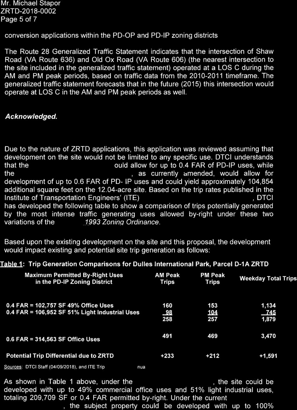
18 ZRTD Dulles International Park, Parcel D-1A DTCI First Referral Comments April 9, 2018 Page 2 & Ped Plan). Arterial and collector roadways in the vicinity of the proposed development are described below. Shaw Road VA Route 636 VA Route 606 (Old Ox Road) north to VA Route 846 (Sterling Boulevard) Functional Classification (CTP) Existing Condition Minor Collector Ultimate Condition Minor Collector Section/Lanes 2 lanes / ROW varies 4 lanes / 70 feet Bicycle and Pedestrian Facilities None Six-foot sidewalk along one side and a 10-foot shared-use path along the other side of roadway. Speed Limit 40 MPH TBD VDOT Traffic Counts 11,000 AADT (2016) Ultimate Improvements Notes Expansion to four-lane section with bike/ped facilities Left- and right-turn lanes required at major intersections Summary of Traffic Impacts Traffic Statement for Route 28 ZMAP Applications to the Current Zoning Ordinance The Route 28 Generalized Traffic Statement included with this application (provided as Attachment 2) was approved by the Board of Supervisors on May 20, 2008 and revised in July The purpose of this generalized traffic statement is to expedite the processing of zoning conversion (ZRTD) applications. The preparation and scoping of a separate traffic study requires additional time and expense prior to the acceptance of rezoning and special exception applications at the initial checklist stage. The use of a ready-made generalized traffic statement, which the Applicant includes with the initial application submittal, helps to facilitate this process. DTCI notes that the Route 28 Generalized Traffic Statement was primarily intended for conversion applications within the PD-OP and PD-IP zoning districts. The Route 28 Generalized Traffic Statement indicates that the intersection of Shaw Road (VA Route 636) and Old Ox Road (VA Route 606) (the nearest intersection to the site included in the generalized traffic statement) operated at a LOS C during the AM and PM peak periods, based on traffic data from the timeframe. The generalized traffic statement forecasts that in the future (2015) this intersection would operate at LOS C in the AM and PM peak periods as well. Trip Generation from Proposed Development Due to the nature of ZRTD applications, this application was reviewed assuming that development on the site would not be limited to any specific use. DTCI understands that the 1993 Zoning Ordinance would allow for up to 0.4 FAR of PD-IP uses, while the Revised 1993 Zoning Ordinance, as currently amended, would allow for development of up to 0.6 FAR of PD-
19 ZRTD Dulles International Park, Parcel D-1A DTCI First Referral Comments April 9, 2018 Page 3 IP uses and could yield approximately 104,854 additional square feet on the acre site. Based on the trip rates published in the Institute of Transportation Engineers (ITE) Trip Generation Report, 9th Edition, DTCI has developed the following table to show a comparison of trips potentially generated by the most intense traffic generating uses allowed by-right under these two variations of the Revised 1993 Zoning Ordinance. Based upon the existing development on the site and this proposal, the development would impact existing and potential site trip generation as follows: Table 1: Trip Generation Comparisons for Dulles International Park, Parcel D-1A ZRTD Maximum Permitted By-Right Uses in the PD-IP Zoning District AM Peak Trips PM Peak Trips Weekday Total Trips 1993 Zoning Ordinance 0.4 FAR = 102,757 SF 49% Office Uses 0.4 FAR = 106,952 SF 51% Light Industrial Uses , ,879 Revised 1993 Zoning Ordinance 0.6 FAR = 314,563 SF Office Uses ,470 Potential Trip Differential due to ZRTD ,591 Sources: DTCI Staff (04/09/2018), and ITE Trip Generation Manual, 9th Edition. As shown in Table 1 above, under the 1993 Zoning Ordinance, the site could be developed with up to 49% commercial office uses and 51% light industrial uses, totaling 209,709 SF or 0.4 FAR permitted by-right. Under the current Revised 1993 Zoning Ordinance, the subject property could be developed with up to 100% commercial office uses totaling 314,563 SF or 0.6 FAR permitted by-right. As such, this conversion could yield 233 more AM peak hour, 212 more PM peak hour, and 1,591 more daily vehicular trips than the existing zoning on the subject property. Transportation Comments and Recommendations Based upon review of the Applicant s submission materials, DTCI has the following comments: 1. This ZRTD application does not propose to limit the development of this property to a particular use. DTCI understands that zoning conversions typically do not involve a specified land use and that the Board of Supervisors wishes to facilitate the conversions by not requiring detailed plans and studies. Therefore, DTCI is not making specific recommendations regarding traffic impacts for this proposed conversion. 2. Due to the absence of specific development information, the Applicant s concept development plan cannot be evaluated for specific transportation improvements. Therefore, it is unclear what site-specific transportation related improvements may be needed. 3. DTCI notes that the section of Shaw Road (Route 636) along the frontage of the site is planned as a four-lane undivided (U4) local access urban collector road within a 70-foot wide right-of-way (ROW) per the 2010 CTP. The Applicant needs to demonstrate that sufficient ROW currently exists for this ultimate condition, or is proposed with this application.
20 ZRTD Dulles International Park, Parcel D-1A DTCI First Referral Comments April 9, 2018 Page 4 4. Per Appendix 6 of the 2010 CTP, all planned four-lane roadways (i.e. this segment of Shaw Road) are to have a 10-foot shared use path on one side and a six-foot wide sidewalk on the other side of the roadway. Currently there are no trails or sidewalks along Shaw Road in the vicinity of the site. The Applicant should commit to providing additional ROW or a 10-foot wide public access easement to accommodate a future six-foot wide sidewalk along the entire site frontage with Shaw Road. The additional ROW or easement should be shown on the CDP. 5. The CDP (plan set) depicts no direct site access to Shaw Road. This is consistent with both approved STPL and approved SPAM ATTACHMENTS 1. Site Vicinity Map 2. ZRTD Route 28 Generalized Traffic Statement (Revised July 2012) cc: Lou Mosurak, Senior Coordinator, DTCI

21 Loudoun County Print Map April 9, 2018 SITE ZRTD Dulles International Park Parcel D-1A ATTACHMENT 1
22 County of Loudoun Office of Transportation Services MEMORANDUM DATE: July 12, 2012 TO: FROM: Loudoun County Department of Planning and ZRTD ( Zoning Conversion ) Applicants Aaron Zimmerman, PTP, Senior Transportation Planner Lou Mosurak, AICP, Senior Coordinator SUBJECT: Route 28 Tax District Generalized Traffic Statement for ZRTD Applications Attached is the July 2012 version of the Generalized Traffic Statement for Zoning Map Amendment Applications in the Route 28 Tax District (aka ZRTD or Zoning Conversion applications). The attached document should be submitted as part of checklist review with all ZRTD applications and replaces the previous version of the Generalized Traffic Statement, dated May At that time, the Board of Supervisors authorized the generalized traffic statement approach for ZRTD applications as a means to facilitate the rezoning process for property owners in the Route 28 Tax District who choose to subject themselves to the most recent zoning text. The Board of Supervisors also directed staff to update the Generalized Traffic Statement on a regular basis as new information becomes available. The attached version of the Generalized Traffic Statement has a horizon year of Questions regarding the attached document should be directed to the Office of Transportation Services (OTS). ATTACHMENT July 2012 Generalized Traffic Statement cc: Andrew Beacher, Director, OTS Dale Castellow, Assistant Director, OTS ATTACHMENT 2


23 Loudoun County Office of Transportation Services GENERALIZED TRAFFIC STATEMENT FOR ZONING MAP AMENDMENT APPLICATIONS IN THE ROUTE 28 TAX DISTRICT (AKA ZRTD OR ZONING CONVERSION APPLICATIONS) MAY 2008 REVISED JULY 2012 INTRODUCTION The purpose of this report, prepared by the Office of Transportation Services with technical assistance provided by the Office of Mapping and Geographic Information and Gorove/Slade Associates, Inc., is to evaluate the increase in traffic on select roadways within the Route 28 Tax District as a result of converting from the 1972 and 1993 Zoning Ordinances to the Revised 1993 Zoning Ordinance. There are a number of parcels within the Route 28 Tax District that are still governed by the 1972 and 1993 Zoning Ordinances, and when converted to the Revised 1993 Zoning Ordinance could take advantage of new by-right uses that generate greater traffic. This document specifically aides the Loudoun County Board of Supervisors when evaluating zoning conversion (ZRTD) applications by providing traffic analysis summarizing existing and future traffic volumes and levels of service in the Route 28 Tax District along with an order of magnitude change in traffic as a result of the conversions. This ready-made generalized traffic statement memorandum for all ZRTD applications is intended to expedite the process of converting parcels to the Revised 1993 Zoning Ordinance without the need for Applicants to incur time and expense on the scoping and preparation of a separate traffic study; such an approach was authorized by the Board of Supervisors in May Information regarding road descriptions, existing (2011) hourly and daily traffic volumes, future (2015) hourly and daily traffic volumes, traffic volume increases resulting from conversions, and levels of service (LOS) at major intersections for the Route 28 corridor are presented in this report to establish a baseline comparison. In order to understand the traffic impacts of
24 Route 28 Tax District Generalized Traffic Statement for ZRTD Applications July 2012 different land use changes, a comparison of the trips generated between the highest intensity uses in the 1972, 1993 and Revised 1993 Zoning Ordinances was prepared. It is envisioned that this report would, in most cases, negate the need for individual traffic studies to be submitted for individual proposed ZRTD applications, thus providing a more streamlined process. BACKGROUND INFORMATION The PD-IP (Planned Development Industrial Park) district is established for light and medium industrial uses, office uses, and necessary supporting accessory uses and facilities, designed with a park-like atmosphere to complement surrounding land uses by means of appropriate siting of buildings and service areas, attractive architecture, and effective landscape buffering. As of September 2011, there were 2,167 acres of 1972 PD-IP and 1,564 acres of 1993 PD-IP land area remaining in the Route 28 Tax District. The PD-OP (Planned Development Office Park) district is established primarily for administrative, business and professional offices and necessary supporting accessory uses and facilities, designed with a park like atmosphere and environmentally sensitive design to accommodate and complement existing natural features including extensive landscaping, low ground coverage by buildings, buildings of moderate height, and careful attention to such aesthetic considerations as location and size of signs, lighting, parking and service areas and the like. As of September 2011, there were 15 acres of 1972 PD-OP and 179 acres of 1993 PD-OP land area remaining in the Route 28 Tax District. ROADWAY NETWORK The Route 28 Tax District is bounded by VA Route 7 to the north; Loudoun County Parkway, Smith Switch Road, and Lockridge Road to the west; the Dulles Toll Road, Dulles Greenway, Fairfax County, and Washington Dulles International Airport to the south; and the Washington & Old Dominion (W&OD) Trail, Cascades Parkway, and Potomac View Road to the east. A description of the existing conditions for selected CTP roadways within the vicinity of the Route 28 Tax District is presented below. Improvements to existing road segments and additional road segments anticipated to be in place in the near future (by 2015) are also noted. Please refer to Appendix 1 of the 2010 Countywide Transportation Plan (2010 CTP) for complete descriptions of all CTP roadways. Harry Byrd Highway (VA Route 7) from Potomac View Road (VA Route 637) west to Loudoun County Parkway (VA Route 607) is a six-lane, controlled access, median divided, principal arterial with grade-separated interchanges at Cascades Parkway, Algonkian Parkway/Atlantic Boulevard, VA Route 28, and Loudoun County Parkway. Left- and right-turn lanes are provided at all intersections. Page 2
25 Route 28 Tax District Generalized Traffic Statement for ZRTD Applications July 2012 Sully Road (VA Route 28) from the Dulles Toll Road (VA Route 267) north to VA Route 7 is a six-lane, controlled access, median divided, principal arterial with gradeseparated interchanges at the Dulles Toll Road, Innovation Avenue, Old Ox Road, Sterling Boulevard, Waxpool/Church Roads, Nokes Boulevard, and VA Route 7. There are also two northbound exit-only ramps provided at Cedar Green Road and Warp Drive (formerly Steeplechase Drive). The Cedar Green Road exit will close by Church Road (VA Route 625) from Cascades Parkway (VA Route 637) west to Atlantic Boulevard/Davis Drive (VA Route 1902/VA Route 868) is a four-lane, local access, median divided, major collector with left- and right-turn lanes at all intersections. Church Road (VA Route 625) from Atlantic Boulevard/Davis Drive (VA Route 1902/VA Route 868) west to VA Route 28 is a four-lane, limited access, median divided, major collector with a grade-separated interchange at VA Route 28. West of VA Route 28, Church Road is referred to as Waxpool Road. Left- and right-turn lanes are provided at its intersection with Atlantic Boulevard. Waxpool Road (VA Route 625) from VA Route 28 west to Pacific Boulevard (VA Route 1036) is a six-lane, limited access, median divided, major collector with a gradeseparated interchange at VA Route 28. Left- and right-turn lanes are provided at its intersection with Pacific Boulevard. Waxpool Road (VA Route 625) from Pacific Boulevard (VA Route 1036) west to Smith Switch Road (VA Route 1950) is a four- to six-lane, controlled access, median divided, major collector with left- and right-turn lanes at all intersections, including westbound and southbound free-right turns at Loudoun County Parkway. At the intersection with Smith Switch Road, Waxpool Road becomes the southern leg while the western leg changes name and route number to Farmwell Road (VA Route 640). Old Ox Road (VA Route 606) from the Fairfax County Line/Herndon Town Limits west to VA Route 28 is a four-lane, controlled access, median divided, major collector with a grade-separated interchange at VA Route 28. Left- and right-turn lanes are in place at major intersections. Old Ox Road (VA Route 606) from VA Route 28 west to the Dulles Greenway (VA Route 267) is a four- to six-lane, controlled access, median divided, major collector with grade-separated interchanges at VA Route 28 and the Dulles Greenway. Relocation Drive (VA Route 775) from Old Ox Road (VA Route 606) northeast to Pacific Boulevard (VA Route 1036) is a two-lane, local access, minor collector. Leftand right-turn lanes are in place at VA Route 606. Moran Road (VA Route 634) from Lockridge Road (VA Route 789) northeast to just west of VA Route 28 is a two- to four-lane, local access, undivided, major collector. Left- and right-turn lanes are in place at major intersections. Page 3
26 Route 28 Tax District Generalized Traffic Statement for ZRTD Applications July 2012 Atlantic Boulevard (VA Route 1902) from VA Route 7 south to Church Road (VA Route 625) is a four-lane, controlled access, median divided, major collector with a grade-separated interchange at VA Route 7/Algonkian Parkway. Left- and right-turn lanes are in place at major intersections. South of Church Road, this road is referred to as Davis Drive. Davis Drive (VA Route 868) from Church Road (VA Route 625) south to beyond Sterling Boulevard (VA Route 846) is a four-lane, local access, undivided, major collector with left- and right-turn lanes at major intersections. North of Church Road, this road is referred to as Atlantic Boulevard. Pacific Boulevard (VA Route 1036) from Old Ox Road (VA Route 606) north to Severn Way (VA Route 1748) is a four-lane, controlled access, median divided, major collector with left- and right-turn lanes at all intersections. Completion of the remaining segment of Pacific Boulevard between Relocation Drive (VA Route 775) and Dresden Street is anticipated by Pacific Boulevard (VA Route 1036) from Severn Way (VA Route 1748) north to Nokes Boulevard (VA Route 1793) is a two- to four-lane, local access, undivided, major collector. By 2015, Pacific Boulevard is planned to be extended northward from its current terminus at Nokes Boulevard/Future Gloucester Parkway (VA Route 2150) across Broad Run to Russell Branch Parkway (VA Route 1061) as a four-lane, controlled access, median divided and undivided, major collector. Loudoun County Parkway (VA Route 607) from VA Route 7 south to Waxpool Road (VA Route 625) is a two- to four-lane controlled access, undivided and median divided minor arterial with left- and right-turn lanes at major intersections. There is a grade-separated interchange at VA Route 7. The existing two-lane section in the vicinity of Redskins Park Drive is anticipated to be widened to a four-lane divided section by Cascades Parkway (VA Route 637) from Church Road (VA Route 625) north to Nokes Boulevard/Potomac View Road (VA Route 1793/637) is a four-lane, controlled access median divided minor collector with left- and right-turn lanes at all intersections. Cascades Parkway (VA Route 1794) from Nokes Boulevard/Potomac View Road (VA Route 1793/VA Route 637) north to VA Route 7 is a four-lane, controlled access median divided major collector with left- and right-turn lanes at all intersections. There is a grade-separated interchange at VA Route 7. Nokes Boulevard (VA Route 1793) opposite Potomac View Road (VA Route 637) from Cascades Parkway (VA Route 1794/637) west to Pacific Boulevard (VA Route 1036) is a four-lane, controlled access, median divided major collector. Left- and rightturn lanes are in place at all intersections. A grade-separated interchange is located at VA Route 28. West of Pacific Boulevard, Nokes Boulevard is planned to be extended westward as Future Gloucester Parkway to Loudoun County Parkway by Page 4
27 Route 28 Tax District Generalized Traffic Statement for ZRTD Applications July 2012 Shaw Road (VA Route 636) from Old Ox Road (VA Route 606) north to just south of Church Road (VA Route 625) is a two- to four-lane, local access, undivided, minor collector with left- and right-turn lanes at major intersections. South of Old Ox Road, Shaw Road currently serves as a driveway for a quarry and hotel. Sterling Boulevard (VA Route 846) from Pacific Boulevard (VA Route 1036) east to VA Route 28 is a four-lane, controlled access, median divided, major collector with left- and right-turn lanes at all intersections. There is a grade-separated interchange at VA Route 28. Sterling Boulevard (VA Route 846) from VA Route 28 east to the W&OD Trail is a four-lane, controlled access, median divided, minor arterial with left- and right-turn lanes at all intersections. Glenn Drive (VA Route 864) is currently a four-lane, undivided, local access, minor collector north of Sterling Boulevard (VA Route 846). It is planned to be extended north to intersect with Cedar Green Road by Figure 1 shows the existing and planned (by 2015) roadway network within and surrounding the Route 28 Tax District. Page 5
28 Figure 1: Existing Roadway Network 2167 ACRES 1564 ACRES GLO UCESTER ASHBUR N VILLAGE BLVD RUSSELL BRANCH COUNTRYSID UV 7 BLVD A LGONKIAN E PD-IP (1972) PD-IP (1993) CASCADES POTOM AC VIEW RD PALISADE F ARMW ELL RD UV 607 UV 28 UV 1902 UV 637 WAXP O OL R D 15 ACRES LOUDOUN CNT Y UV 625 CHURCH RD STER LING BLVD UV 868 LOCKRIDGE R D UV 634 UV 846 UV 1036 UV 775 UV 636 PD-OP (1972) 179 ACRES DULLES AIRPORT UV 606 UV 267 Interchange Locations Route 28 Tax District Zoned PD-IP (1972) UV 209 Zoned PD-IP (1993) Zoned PD-OP (1972) DULLES AIRPORT Zoned PD-OP (1993) CTP Roads (Existing/Anticipated by 2015) PD-OP (1993) Loudoun County Office of Transportation Services and the Office of Mapping and Geographic Information Zoning Current as of September 2011
29 Route 28 Tax District Generalized Traffic Statement for ZRTD Applications TRAFFIC VOLUMES AND LEVELS OF SERVICE (EXISTING AND PROJECTED) July 2012 Traffic volume data was summarized for the existing conditions with the base year of The Virginia Department of Transportation (VDOT) provides count data on major roadway links for both hourly and daily two-way volume estimates. The road link traffic volumes shown on Figure 2 are based on 2010 VDOT traffic count data that were grown by 1% to project 2011 conditions. A number of traffic studies have been prepared for land development projects in this area and have been submitted and reviewed by the County and VDOT. These studies have included projections for future years based on approved developments and historical growth in traffic. These studies have been referenced to develop future year 2015 traffic volumes for selected primary roadway links within the study area. Those projected 2015 daily and hourly two-way link volumes are shown on Figure 2. The traffic studies identified above also included information for both existing and future year levels of service (LOS). Levels of Service (ranging from A to F) represent an operational assessment of an intersection s ability to accommodate the traffic demand. LOS A identifies an intersection that has capacity in excess of demand. LOS E represents an intersection that has reached its capacity and cannot process any increase in demand. LOS F represents an intersection where demand is in excess of capacity. Level of Service data is provided on Figure 3 for both the existing (2011) and future (2015) conditions. As shown on Figure 3, the intersection of Loudoun County Parkway (VA Route 607) at Waxpool Road (VA Route 625) currently operates at LOS F during both AM and PM peak hour periods and is projected to continue operating at LOS F in The intersections of Pacific Boulevard at Waxpool Road (VA Route 625) and Sterling Boulevard (VA Route 846) at Shaw Road (VA Route 636) are projected to degrade from LOS D to LOS E during the PM peak hour period, based on traffic volume increases as a result of recently approved nearby developments. All other major study area intersections are projected to continue operating at LOS D or better during both AM and PM peak hour periods. Page 7
30 Figure 2: Existing (2011) and Future (2015) Traffic Volumes 2167 ACRES 1564 ACRES GLO UCESTER ASHBUR N VILLAGE BLVD RUSSELL BRANCH COUNTRYSID A LGONKIAN UV 7 BLVD E PD-IP (1972) PD-IP (1993) CASCADES POTOM AC VIEW RD PALISADE F ARMW ELL RD WAXP O OL R D 15 ACRES PD-OP (1972) 179 ACRES PD-OP (1993) LOUDOUN CNT Y DULLES AIRPORT LOCKRIDGE R D DULLES AIRPORT UV ,407 UV UV ,141 74,307 7,431 64,627 5,720 26,523 66,877 2,440 5,953 27,600 UV 625 2,540 14,282 1,428 UV 634 UV ,603 2,724 31,846 2,835 UV 775 UV 606 UV 267 UV ,862 UV 868 1,487 UV ,211 11, ,768 11,677 UV 209 UV 637 CHURCH RD STER LING BLVD 25,503 2,142 26,539 2,230 34,684 2,879 36,093 2,996 25,503 2,423 26,539 2, AADT 2011 HOURLY 2015 AADT 2015 HOURLY Interchange Locations Route 28 Tax District Zoned PD-IP (1972) Zoned PD-IP (1993) Zoned PD-OP (1972) Zoned PD-OP (1993) CTP Roads (Existing/Anticipated by 2015) Loudoun County Office of Transportation Services and the Office of Mapping and Geographic Information Zoning Current as of September 2011
31 Figure 3: Existing (2011) and Future (2015) Level of Service (LOS) 2167 ACRES 1564 ACRES GLO UCESTER ASHBUR N VILLAGE BLVD RUSSELL BRANCH COUNTRYSID UV 7 BLVD A LGONKIAN E C D PD-IP (1972) PD-IP (1993) C D CASCADES POTOM AC VIEW RD PALISADE F ARMW ELL RD UV 607 UV 28 C C UV 1902 C C C D C C UV 637 C D C D WAXP O OL R D F F F F 15 ACRES LOUDOUN CNT Y LOCKRIDGE C D UV 625 D E CHURCH RD STER LING BLVD UV 868 UV 634 UV 846 R D UV 1036 PD-OP (1972) 179 ACRES DULLES AIRPORT UV 606 UV 267 UV 775 UV 636 C C C D C C D E AM PM AM PM Interchange Locations Route 28 Tax District Zoned PD-IP (1972) UV 209 Zoned PD-IP (1993) Zoned PD-OP (1972) DULLES AIRPORT Zoned PD-OP (1993) CTP Roads (Existing/Anticipated by 2015) PD-OP (1993) Loudoun County Office of Transportation Services and the Office of Mapping and Geographic Information Zoning Current as of September 2011
32 TRIP GENERATION COMPARISON PD-IP CONVERSION Route 28 Tax District Generalized Traffic Statement for ZRTD Applications July 2012 A comparison of the trips generated by the highest intensity permitted uses in the PD-IP district based on the 1972, 1993, and Revised 1993 Zoning Ordinances was conducted. The results of the comparison are shown in the following table. The projections in Table 1 are based on the total square footage of existing 1972 and 1993 PD-IP zoning land area in the Route 28 Tax District, as well as the most intense traffic generating land uses permitted in each of the 1972, 1993, and Revised 1993 Zoning Ordinances. As shown in the table below, under the 1972 Zoning Ordinance, research and development uses are permitted by-right at a 0.4 FAR. In the 1993 Zoning Ordinance, flex office (49% office, 51% manufacturing) at a 0.4 FAR is the most intense traffic generating permitted byright use. If converted to the Revised 1993 Zoning Ordinance, the amount of office space permitted by-right would increase from 49% to 100% at a 0.4 FAR. Table 1: Trip Generation Comparison for PD-IP Conversions 1972 to Revised 1993 PD-IP Zoning District Most Intense Use Total Acreage Total Size ITE Code * PM Peak Trips 1972 PD-IP R&D (0.4 FAR) 2,167 37,757.8 ksf ,848 Revised 1993 PD-IP Office (0.4 FAR) 2,167 37,757.8 ksf ,368 Difference (All Parcels) +25,520 Difference (Per Acre) to Revised 1993 PD-IP Zoning District Most Intense Use Total Acreage Total Size ITE Code * PM Peak Trips 1993 PD-IP Flex Office (0.4 FAR) 1,564 27,251.1 ksf 710/140 25,860 Revised 1993 PD-IP Office (0.4 FAR) 1,564 27,251.1 ksf ,601 Difference (All Parcels) +4,741 Difference (Per Acre) * Note that the equations (not average rates) provided in ITE s Trip Generation Report, 8 th Edition were used to project trips. As shown Table 1 above, if the remaining 2,167 acres of 1972 PD-IP land area in the Route 28 Tax District were to be converted to the Revised 1993 Zoning Ordinance and then developed as the most intense by-right use (office at 0.4 FAR), 42,368 additional trips would be added to the surrounding roadway network. This represents a net 25,520 trip increase (or trips per acre) over the number of trips that would be generated if developed as a by-right research and development center under the 1972 Zoning Ordinance. If the remaining 1,564 acres of 1993 PD-IP land area in the Route 28 Tax District were to be converted to the Revised 1993 Zoning Ordinance and then developed as the most intense by-right use (office at 0.4 FAR), 30,601 additional trips would be added to the surrounding roadway network. This represents a net 4,741 trip increase (or 3.03 trips per acre) over the number of trips that would be generated if developed as by-right flex-office under the 1993 Zoning Ordinance. Page 10
33 TRAFFIC IMPACTS PD-IP CONVERSION Route 28 Tax District Generalized Traffic Statement for ZRTD Applications July 2012 The additional trips generated as shown in Table 1 were applied to the projected traffic volumes for 2015 (shown on Figure 2) to determine the percentage increase in volumes. To assist in the assigning of trips to the roadway network, the Route 28 Tax District was divided into six zones. Trips were generated for all the remaining 1972 PD-IP and 1993 PD-IP parcels within each zone, as well as for a typical 20-acre parcel, and then distributed to the most logical roadway segments immediately adjacent the zone. Trips were not assigned to roads beyond the limits of the zone. In order to analyze the cumulative traffic impacts of the zoning conversions throughout the entire Route 28 Tax District area and beyond, a traffic modeling exercise would need to be conducted. The percentage increase in traffic volumes on the select roadway network due to the conversion of 1972 PD-IP parcels to the Revised 1993 Zoning Ordinance is shown graphically on Figures 4 and 5 for all parcels within the specified zone and a typical 20-acre parcel, respectively. The percentage increase in traffic volumes on the select roadway network due to the conversion of 1993 PD-IP parcels to the Revised 1993 Zoning Ordinance is shown graphically on Figures 6 and 7 for all parcels within the specified zone and a typical 20-acre parcel, respectively. Page 11
34 Figure 4: Percentage Difference in Trips (PD-IP): Conversion from 1972 to Revised ACRES 1564 ACRES GLO UCESTER ASHBUR N VILLAGE BLVD RUSSELL BRANCH 104.3% 27.6% A25.1% 2.6% COUNTRYSID A LGONKIAN UV 7 BLVD E 2.9% PD-IP (1972) PD-IP (1993) CASCADES PALISADE POTOM AC VIEW RD F ARMW ELL RD UV % UV % UV % B 10.1% 32.5% WAXP O OL R D C 8.6% 4.4% D UV % 15 ACRES PD-OP (1972) 179 ACRES PD-OP (1993) LOUDOUN CNT Y DULLES AIRPORT LOCKRIDGE R D DULLES AIRPORT 9.7% UV % E UV % 12.0% UV 846 UV % UV 606 UV 267 UV % UV % UV 636 UV 209 F 46.8% CHURCH RD STER LING BLVD XX.X% % Difference in Trips Attributed to Conversion and Development of all Remaining Parcels in the Zone Interchange Locations Route 28 Tax District Zoned PD-IP (1972) Zoned PD-IP (1993) Zoned PD-OP (1972) Zoned PD-OP (1993) CTP Roads (Existing/Anticipated by 2015) Loudoun County Office of Transportation Services and the Office of Mapping and Geographic Information Zoning Current as of September 2011
35 Figure 5: Percentage Difference in Trips (PD-IP): Conversion from 1972 to Revised 1993 (20 Acre Parcel) 2167 ACRES 1564 ACRES GLO UCESTER ASHBUR N VILLAGE BLVD RUSSELL BRANCH 2.0% 0.5% A0.5% 0.3% COUNTRYSID A LGONKIAN UV 7 BLVD E 0.3% PD-IP (1972) PD-IP (1993) CASCADES PALISA D E POTOMAC VIEW RD F ARMW ELL RD UV % UV % UV % B 1.1% 3.6% WAXP O OL R D C 0.5% 0.4% D UV % 15 ACRES PD-OP (1972) 179 ACRES PD-OP (1993) LOUDOUN CNTY DULLES AIRPORT LOCKRIDGE R D DULLES AIRPORT 0.6% UV % 0.6% UV % 0.4% UV 846 UV 1036 UV % E UV 775 UV % UV UV UV 209 F 1.6% CHURCH RD STERLING BLVD XX.X% % Difference in Trips Attributed to Conversion and Development of a 20 Acre Parcel in the Zone Interchange Locations Route 28 Tax District Zoned PD-IP (1972) Zoned PD-IP (1993) Zoned PD-OP (1972) Zoned PD-OP (1993) CTP Roads (Existing/Anticipated by 2015) Loudoun County Office of Transportation Services and the Office of Mapping and Geographic Information Zoning Current as of September 2011
36 Figure 6: Percentage Difference in Trips (PD-IP): Conversion from 1972 to Revised ACRES 1564 ACRES GLO UCESTER ASHBUR N VILLAGE BLVD RUSSELL BRANCH 0.0% 0.0% A0.0% 0.7% COUNTRYSID A LGONKIAN UV 7 BLVD E 0.8% PD-IP (1972) PD-IP (1993) CASCADES PALISA DE POTOM AC VIEW RD F ARMW ELL RD UV % UV % UV % B 2.8% 9.0% WAXP O OL R D C 7.2% 0.7% D UV % 15 ACRES PD-OP (1972) 179 ACRES PD-OP (1993) LOUDOUN CNTY DULLES AIRPORT LOCKRIDGE R D DULLES AIRPORT 8.1% UV % 6.1% UV % 2.1% UV 846 UV 1036 UV 868 E UV 775 UV % UV 606 UV 267 UV % F 8.2% CHURCH RD STERLING BLVD XX.X% % Difference in Trips Attributed to Conversion and Development of all Remaining Parcels in the Zone Interchange Locations Route 28 Tax District Zoned PD-IP (1972) Zoned PD-IP (1993) Zoned PD-OP (1972) Zoned PD-OP (1993) CTP Roads (Existing/Anticipated by 2015) Loudoun County Office of Transportation Services and the Office of Mapping and Geographic Information Zoning Current as of September 2011
37 Figure 7: Percentage Difference in Trips (PD-IP): Conversion from 1972 to Revised 1993 (20 Acre Parcel) 2167 ACRES 1564 ACRES GLO UCESTER ASHBUR N VILLAGE BLVD RUSSELL BRANCH 1.0% 0.3% A0.2% 0.3% COUNTRYSID A LGONKIAN UV 7 BLVD E 0.2% PD-IP (1972) PD-IP (1993) CASCADES PALISA D E POTOMAC VIEW RD F ARMW ELL RD UV % UV % UV % B 0.5% 1.8% WAXP O OL R D C 0.2% 0.2% D UV % 15 ACRES PD-OP (1972) 179 ACRES PD-OP (1993) LOUDOUN CNTY DULLES AIRPORT LOCKRIDGE R D DULLES AIRPORT 0.3% UV % 0.3% UV % 0.2% UV 846 UV 1036 UV % E UV 775 UV % UV UV UV 209 F 0.8% CHURCH RD STERLING BLVD XX.X% % Difference in Trips Attributed to Conversion and Development of a 20 Acre Parcel in the Zone Interchange Locations Route 28 Tax District Zoned PD-IP (1972) Zoned PD-IP (1993) Zoned PD-OP (1972) Zoned PD-OP (1993) CTP Roads (Existing/Anticipated by 2015) Loudoun County Office of Transportation Services and the Office of Mapping and Geographic Information Zoning Current as of September 2011
38 Route 28 Tax District Generalized Traffic Statement for ZRTD Applications TRIP GENERATION COMPARISON PD-OP CONVERSION July 2012 A comparison of the trips generated by the highest intensity permitted uses in the PD-OP district based on the 1972, 1993, and Revised 1993 Zoning Ordinances was conducted. The results of the comparison are shown in the following table. The projections in Table 2 are based on the total square footage of existing 1972 and 1993 PD-OP zoning land area in the Route 28 Tax District, as well as the most intense traffic generating land uses permitted in each of the 1972, 1993, and Revised 1993 Zoning Ordinances. As shown in the table below, under both the 1972 and 1993 Zoning Ordinances, office uses are permitted by-right at a 0.4 FAR. If converted to the Revised 1993 Zoning Ordinance, the amount of office space permitted by-right would increase to a 0.6 FAR. Table 2: Trip Generation Comparison for PD-OP Conversions 1972/93 to Revised 1993 PD-OP Zoning District Most Intense Use Total Acreage Total Size ITE Code * PM Peak Trips 1972/1993 PD-OP Office (0.4 FAR) 194 3,380.3 ksf 710 3,944 Revised 1993 PD-OP Office (0.6 FAR) 194 5,070.4 ksf 710 5,837 Difference (All Parcels) +1,893 Difference (Per Acre) * Note that the equations (not average rates) provided in ITE s Trip Generation Report, 8 th Edition were used to project trips. As shown in Table 2 above, if the remaining 194 acres of PD-OP parcels in the Route 28 Tax District were to be converted to the Revised 1993 Zoning Ordinance and then developed byright as office at 0.6 FAR, 5,837 additional trips would be added to the surrounding roadway network. This represents a net 1,893 trip increase (or 9.76 trips per acre) over the number of trips that would be generated if developed by-right as office at a 0.4 FAR under either the 1972 or 1993 Zoning Ordinances. TRAFFIC IMPACTS PD-OP CONVERSION The additional trips generated as shown in Table 2 were applied to the projected traffic volumes for 2015 (shown on Figure 2) to determine the percentage increase in volumes. To assist in the assigning of trips to the roadway network, the Route 28 Tax District was divided into six zones. Trips were generated for all the remaining 1972 PD-OP and 1993 PD-OP parcels within each zone, as well as for a typical 20-acre parcel, and then distributed to the most logical roadway segments immediately adjacent the zone. Trips were not assigned to roads beyond the limits of the zone. In order to analyze the cumulative traffic impacts of the zoning conversions throughout the entire Route 28 Tax District area and beyond, a traffic modeling exercise would need to be conducted. Page 16
39 Route 28 Tax District Generalized Traffic Statement for ZRTD Applications July 2012 The percentage increase in traffic volumes on the select roadway network due to the conversion of 1972/1993 PD-OP parcels to the Revised 1993 Zoning Ordinance is shown graphically on Figures 8 and 9 for all parcels within the specified zone and a typical 20-acre parcel, respectively. Page 17
40 Figure 8: Percentage Difference in Trips (PD-OP): Conversion from 1972/1993 to Revised ACRES 1564 ACRES GLO UCESTER ASHBUR N VILLAGE BLVD RUSSELL BRANCH 2.9% 0.8% A0.7% 0.4% COUNTRYSID UV 7 BLVD A LGONKIAN E 0.4% PD-IP (1972) PD-IP (1993) CASCADES PALISA D E POTOMAC VIEW RD F ARMW ELL RD UV 607 UV % UV 1902 B 1.5% 4.7% WAXP O OL R D C D UV ACRES LOUDOUN CNTY UV % UV 868 PD-OP (1972) 179 ACRES LOCKRIDGE DULLES AIRPORT UV 634 UV % CHURCH RD STERLING BLVD R D E UV % UV UV UV 1036 UV 636 F XX.X% % Difference in Trips Attributed to Conversion and Development of all Remaining Parcels in the Zone Interchange Locations Route 28 Tax District Zoned PD-IP (1972) UV 209 Zoned PD-IP (1993) Zoned PD-OP (1972) DULLES AIRPORT Zoned PD-OP (1993) CTP Roads (Existing/Anticipated by 2015) PD-OP (1993) Loudoun County Office of Transportation Services and the Office of Mapping and Geographic Information Zoning Current as of September 2011
41 Figure 9: Percentage Difference in Trips (PD-OP): Conversion from 1972/1993 to Revised 1993 (20 Acre Parcel) 2167 ACRES 1564 ACRES GLO UCESTER ASHBUR N VILLAGE BLVD RUSSELL BRANCH 3.9% 1.0% A0.9% 0.6% COUNTRYSID UV 7 BLVD A LGONKIAN E 0.6% PD-IP (1972) PD-IP (1993) CASCADES PALISA D E POTOMAC VIEW RD F ARMW ELL RD UV 607 UV % UV 1902 B 2.1% 6.9% WAXP O OL R D C D UV ACRES LOUDOUN CNTY UV % UV 868 PD-OP (1972) 179 ACRES LOCKRIDGE DULLES AIRPORT UV 634 UV % CHURCH RD STERLING BLVD R D E 3.2% UV UV UV 775 UV 1036 UV 636 F XX.X% % Difference in Trips Attributed to Conversion and Development of a 20 Acre Parcel in the Zone Interchange Locations Route 28 Tax District Zoned PD-IP (1972) UV 209 Zoned PD-IP (1993) Zoned PD-OP (1972) DULLES AIRPORT Zoned PD-OP (1993) CTP Roads (Existing/Anticipated by 2015) PD-OP (1993) Loudoun County Office of Transportation Services and the Office of Mapping and Geographic Information Zoning Current as of September 2011
42 Route 28 Tax District Generalized Traffic Statement for ZRTD Applications July 2012 CONCLUSIONS This report provides a summary of traffic information for major road facilities within the Route 28 Tax District, including existing (2011) and projected (2015) daily traffic on major road links and LOS information for major intersections, in an effort to aid the Loudoun County Board of Supervisors when evaluating zoning conversion (ZRTD) applications. This report also presented a trip generation analysis that compared the potential impacts of the proposed zoning conversion of PD-IP and PD-OP land uses from the 1972 and 1993 Zoning Ordinances to the Revised 1993 Zoning Ordinance. Based on the analysis presented in this report, several conclusions are noted: There are 2,167 acres of 1972 PD-IP land area remaining in the Route 28 Tax District. The conversion of all these parcels to the Revised 1993 Zoning Ordinance would change the most intense use from research and development to office. This would generate an additional 25,520 PM peak hour trips, or trips per acre. As compared to the other conversion scenarios discussed in this report, converting from 1972 PD-IP to Revised 1993 PD-IP would allow a parcel to take advantage of new by-right uses that would add the most traffic to the surrounding roadway network. There are 1,564 acres of 1993 PD-IP land area remaining in the Route 28 Tax District. The conversion of all these parcels to the Revised 1993 Zoning Ordinance would change the most intense use from flex office (49% office, 51% manufacturing) to 100% office. This increased intensity of permitted office space would generate an additional 4,741 PM peak hour trips, or 3.03 trips per acre. There are only 194 acres of 1972/1993 PD-OP land area remaining in the Route 28 Tax District. The conversion of all these parcels to the Revised 1993 Zoning Ordinance would allow for 1.69 million SF of more developable office space due to an increase in permitted FAR from 0.4 to 0.6. This additional office space would generate an additional 1,893 PM peak hour trips, or 9.76 trips per acre. The intersection of Loudoun County Parkway (VA Route 607) at Waxpool Road (VA Route 625) currently operates at LOS F during both AM and PM peak hour periods, and is projected to continue operating at LOS F in the year The intersections of Loudoun County Parkway (VA Route 607) at Pacific Boulevard and Sterling Boulevard (VA Route 846) at Shaw Road (VA Route 636) are projected to degrade from LOS D to LOS E in the year 2015 during the PM peak hour. Therefore, the proposed site traffic which would access these road segments should be understood and reviewed carefully. Questions regarding this document should be directed to the Loudoun County Office of Transportation Services. Page 20
43 DATE: March 12, 2018 TO: FROM: Michael Stapor, Project Manager, Department of Planning and Zoning Buddy Rizer, Executive Director, DED Prepared By: Alex Gonski, Market Intelligence Manager, DED SUBJECT: Dulles International Park Parcel D-1A- ZRTD The Department of Economic Development s (DED) analysis of the application is provided below. Applicant Proposal 1. A Zoning Map Amendment to rezone PD-IP governed by the Revised 1993 Zoning Ordinance to PD-IP under the Revised 1993 Zoning Ordinance, as amended DED Response The proposed rezoning is for a property located within the Route 28 Corridor, which is envisioned as an airport-anchored gateway into Loudoun County in the Revised General Plan. The plan envisions this area as offering a positive and welcoming business environment that supports significant job growth and economic activity in varied settings, including higher FARs that enable the area to develop to its full potential. It also supports the conversion of properties to the Revised 1993 Zoning Ordinance, as amended. The property is currently vacant and has no building improvements. Conversion of the property to the most current ordinance will enable property improvements to be made that will add value to the commercial tax base and enhance the County s economic competiveness to attract, grow, and retain businesses in the immediate service area. Please contact Alex Gonski at alex.gonski@loudoun.gov or for any follow-up questions or concerns. Attachment 4.E biz.loudoun.gov
44 Stapor, Michael From: Sent: To: Cc: Subject: Rutyna, Mark Friday, March 16, :18 PM Stapor, Michael Wollard, Gregg; Cooper, Michael ZRTD DULLES INTERNATIONAL PARK, PARCEL D-1A Michael, Thank you for the opportunity to comment on DULLES INTERNATIONAL PARK, PARCEL D 1A, located at the approximate intersection of State Route 636 (Shaw Road) and International Drive, and the proposal to convert a vacant Planned Development Industrial Park parcel from the Loudoun County 1993 Zoning Ordinance to the Revised 1993 Zoning Ordinance. The Airports Authority does not object to the proposal. If you have any questions, please let me know. Thank you. Mark Rutyna, CAPM, C.M. Airport Planner 1 Aviation Circle, MA-32D Washington, DC T: F: Mark.Rutyna@mwaa.com mwaa.com 1 Attachment 4.F


45 Attachment 5

46
47
48
49
50

51
PROFFER STATEMENT FAIRFAX MARBLE & GRANITE SUMMIT AT DULLES ZRTD
 PROFFER STATEMENT FAIRFAX MARBLE & GRANITE SUMMIT AT DULLES ZRTD 2016-0009 December 13, 2016 Dulles Summit LLC, the owner (hereinafter, the "Owner") of the parcel described as Loudoun County Tax Map Number
PLANNING COMMISSION BRIEFING ITEM Land Development Application July 24, 2018, Planning Commission Public Hearing
 PLANNING COMMISSION BRIEFING ITEM Land Development Application July 24, 2018, Planning Commission Public Hearing ZRTD-2017-0011, Loudoun Tech Center Date of Meeting: July 12, 2018 Election District: Staff
County of Loudoun. Department of Planning and Zoning MEMORANDUM
 County of Loudoun Department of Planning and Zoning MEMORANDUM DATE: November 10, 2015 TO: FROM: Joe Griffiths, Project Manager Land Use Review Kelly Williams, Planner III Community Planning SUBJECT: ZRTD
PLANNING COMMISSION PUBLIC HEARING STAFF REPORT ZRTD FAIRFAX MARBLE & GRANITE
 Date of Hearing: PLANNING COMMISSION PUBLIC HEARING STAFF REPORT SUBJECT: ELECTION DISTRICT: ZRTD-2016-0009 FAIRFAX MARBLE & GRANITE Broad Run CRITICAL ACTION DATE: September 27, 2017 STAFF CONTACTS: APPLICANT:
ZRTD , Glenn Drive. M. Tyler Klein, AICP, Project Manager, Planning and Zoning John Merrithew, Acting Director, Planning and Zoning
 DEPARTMENT OF PLANNING Date of Hearing: AND ZONING STAFF REPORT # 4 BOARD OF SUPERVISORS PUBLIC HEARING SUBJECT: ELECTION DISTRICT: ZRTD-2014-0003, 22675 Glenn Drive Broad Run CRITICAL ACTION DATE: September
PLANNING COMMISSION PUBLIC HEARING STAFF REPORT ZRTD NVA DEVELOPMENT
 Date of Hearing: PLANNING COMMISSION PUBLIC HEARING STAFF REPORT SUBJECT: ELECTION DISTRICT: ZRTD-2016-0005 NVA DEVELOPMENT Broad Run CRITICAL ACTION DATE: July 18, 2017 STAFF CONTACTS: APPLICANT: Jacqueline
PLANNING COMMISSION BRIEFING ITEM. Land Development Applications May 22, 2018, Planning Commission Public Hearing
 Date of Meeting: May 10, 2018 PLANNING COMMISSION BRIEFING ITEM Land Development Applications May 22, 2018, Planning Commission Public Hearing 6. SPEX-2017-0040 & ZRTD-2017-0005, 21673 Beaumeade Circle,
County of Loudoun. Department of Planning MEMORANDUM
 County of Loudoun Department of Planning MEMORANDUM DATE: September 3, 2013 TO: FROM: Marchant Schneider, Project Manager Land Use Review Marie Genovese, AICP, Planner III, Community Planning SUBJECT:
DEPARTMENT OF PLANNING Date of Hearing: September 9, 2015 AND ZONING STAFF REPORT # 7 BOARD OF SUPERVISORS PUBLIC HEARING
 DEPARTMENT OF PLANNING Date of Hearing: AND ZONING STAFF REPORT # 7 BOARD OF SUPERVISORS PUBLIC HEARING SUBJECT: ELECTION DISTRICT: SPEX-2015-0027, Downs Park Broad Run CRITICAL ACTION DATE: September
LOUDOUN COUNTY PLANNING COMMISSION AGENDA
 LOUDOUN COUNTY PLANNING COMMISSION AGENDA TUESDAY, DECEMBER 20, 2016 6:00 PM PUBLIC HEARING LOCATION: BOARD ROOM 1 st Floor, Govt. Center Citizens are encouraged to call the Department of Planning on the
LOUDOUN COUNTY BOARD OF SUPERVISORS PUBLIC HEARING. Wednesday, May 10, :00 p.m. Board Room, First Floor, Government Center AGENDA SUMMARY
 LOUDOUN COUNTY BOARD OF SUPERVISORS PUBLIC HEARING Wednesday, 6:00 p.m. Board Room, First Floor, Government Center I. CALL TO ORDER AGENDA SUMMARY II. BOARD OF SUPERVISORS PUBLIC HEARING ITEMS FOR CONSIDERATION:
PUBLIC HEARING. ZMOD ASHBURN RESTAURANT PARK SIGN PLAN (Zoning Ordinance Modification)
") PUBLIC HEARING The LOUDOUN COUNTY PLANNING COMMISSION will hold a public hearing in the Board of Supervisors Meeting Room on the first floor of the County Government Center, 1 Harrison Street, S.E., Leesburg,
PUBLIC HEARING The LOUDOUN COUNTY PLANNING COMMISSION will hold a public hearing in the Board of Supervisors Meeting Room on the first floor of the County Government Center, 1 Harrison Street, S.E., Leesburg,
BOARD OF SUPERVISORS PUBLIC HEARING AGENDA SUMMARY Board Room, First Floor, Government Center Wednesday, September 13, :00 P.M.
 Loudoun County, Virginia Board of Supervisors 1 Harrison Street, S.E., 5th Floor, P.O. Box 7000, Leesburg, VA 20177-7000 Telephone (703) 777-0204 Fax (703) 777-0421 www.loudoun.gov BOARD OF SUPERVISORS
BOARD OF SUPERVISORS PUBLIC HEARING STAFF REPORT. Pet Supply Services, LLC
 BOARD OF SUPERVISORS PUBLIC HEARING STAFF REPORT Date of Hearing: April 12, 2017 #6 SUBJECT: ELECTION DISTRICT: SPEX-2016-0056, Sterling Pet Depot Sterling CRITICAL ACTION DATE: June 19, 2017 STAFF CONTACTS:
COUNTY OF LOUDOUN DEPARTMENT OF PLANNING AND ZONING MEMORANDUM
 Attachment 1a A-1 A-2 COUNTY OF LOUDOUN DEPARTMENT OF PLANNING AND ZONING MEMORANDUM DATE: February 24, 2015 TO: FROM: Evan Harlow, Project Manager, Land Use Division Val Thomas, Planner, Zoning Administration
PLANNING COMMISSION PUBLIC HEARING STAFF REPORT. Steve Barney, Project Manager, Planning & Zoning Ricky Barker, AICP, Director, Planning & Zoning
 Date of Hearing: PLANNING COMMISSION PUBLIC HEARING STAFF REPORT SUBJECT: ELECTION DISTRICT: ZRTD-2016-0001, Davis Drive Substation CMPT-2016-0003, Davis Drive Substation SPMI-2016-0015, Davis Drive Substation
BOARD OF SUPERVISORS PUBLIC HEARING STAFF REPORT. ZMAP , Waterside Dulles East (a.k.a. Dulles 2000) Broad Run
 Broad Run") Date of Hearing: May 10, 2017 BOARD OF SUPERVISORS PUBLIC HEARING STAFF REPORT #5 SUBJECT: ELECTION DISTRICT: ZMAP-2016-0007, Waterside Dulles East (a.k.a. Dulles 2000) Broad Run CRITICAL ACTION DATE:
Date of Hearing: May 10, 2017 BOARD OF SUPERVISORS PUBLIC HEARING STAFF REPORT #5 SUBJECT: ELECTION DISTRICT: ZMAP-2016-0007, Waterside Dulles East (a.k.a. Dulles 2000) Broad Run CRITICAL ACTION DATE:
COUNTY OF LOUDOUN DEPARTMENT OF PLANNING AND ZONING MEMORANDUM
 COUNTY OF LOUDOUN DEPARTMENT OF PLANNING AND ZONING MEMORANDUM DATE: October 20, 2016 TO: FROM: SUBJECT: PURPOSE: Loudoun County Planning Commission Mark A. Depo, Zoning Administration Ricky Barker, Director,
LOUDOUN COUNTY BOARD OF SUPERVISORS PUBLIC HEARING. Wednesday, June 14, :00 p.m. Board Room, First Floor, Government Center AGENDA SUMMARY
 LOUDOUN COUNTY BOARD OF SUPERVISORS PUBLIC HEARING Wednesday, June 14, 2017 6:00 p.m. Board Room, First Floor, Government Center I. CALL TO ORDER AGENDA SUMMARY II. BOARD OF SUPERVISORS PUBLIC HEARING
BOARD OF SUPERVISORS BUSINESS MEETING ACTION ITEM
 BOARD OF SUPERVISORS BUSINESS MEETING ACTION ITEM Date of Meeting: October 20, 2016 # 13b SUBJECT: ELECTION DISTRICT: CRITICAL ACTION DATE: STAFF CONTACTS: TRANSPORTATION AND LAND USE COMMITTEE REPORT:
9. REZONING NO Vicinity of the northwest corner of 143 rd Street and Metcalf Avenue
 9. REZONING NO. 2002-15 Vicinity of the northwest corner of 143 rd Street and Metcalf Avenue 1. APPLICANT: Andrew Schlagel is the applicant for this request. 2. REQUESTED ACTION: The applicant is requesting
BOARD OF SUPERVISORS BUSINESS MEETING ACTION ITEM
 BOARD OF SUPERVISORS BUSINESS MEETING ACTION ITEM Date of Meeting: October 4, 2016 # 15a SUBJECT: ELECTION DISTRICT: CRITICAL ACTION DATE: STAFF CONTACTS: TRANSPORTATION AND LAND USE COMMITTEE REPORT:
PROFFER STATEMENT EVERGREEN MEADOWS ZMAP
 PROFFER STATEMENT EVERGREEN MEADOWS ZMAP 2016-0016 March 23, 2017 Cullen B. Tilman, the owner (the Owner ) of the properties identified as Loudoun County PIN ##202-29-7105; 202-29-6183; 202-29-5218; 202-29-4625;
PLANNING COMMISSION BRIEFING ITEM. Land Development Applications May 22, 2018 Planning Commission Public Hearing
 Date of Meeting: May 10, 2018 PLANNING COMMISSION BRIEFING ITEM Land Development Applications May 22, 2018 Planning Commission Public Hearing 4. ZCPA-2016-0010 & ZMOD-2016-0013 Glascock Field at Stone
At the Pleasure of the Board
 BOARD OF SUPERVISORS PUBLIC HEARING STAFF REPORT Date of Hearing: November 9, 2016 #5 SUBJECT: ELECTION DISTRICT: CRITICAL ACTION DATE: STAFF CONTACTS: Grant of Permanent Utility Easement to NOVEC, Kirkpatrick
Draft Model Access Management Overlay Ordinance
 Draft Model Access Management Overlay Ordinance This model was developed using the City of Hutchinson and the Trunk Highway 7 corridor. The basic provisions of this model may be adopted by any jurisdiction
DEPARTMENT OF PLANNING Date of Hearing: September 9, 2015 AND ZONING STAFF REPORT BOARD OF SUPERVISORS PUBLIC HEARING
 SUBJECT: ELECTION DISTRICT: DEPARTMENT OF PLANNING Date of Hearing: AND ZONING STAFF REPORT BOARD OF SUPERVISORS PUBLIC HEARING ZMAP-2012-0017 & SPEX-2013-0007 Brambleton Business Campus Blue Ridge CRITICAL
BOARD OF SUPERVISORS BUSINESS MEETING INFORMATION ITEM. Briefing Item: Land Development Applications November 9, 2016 Public Hearing
 BOARD OF SUPERVISORS BUSINESS MEETING INFORMATION ITEM Date of Meeting: November 1, 2016 # I-1 SUBJECT: ELECTION DISTRICT: STAFF CONTACTS: Briefing Item: Land Development Applications Public Hearing Countywide
Operating Standards Attachment to Development Application
 Planning & Development Services 2255 W Berry Ave. Littleton, CO 80120 Phone: 303-795-3748 Mon-Fri: 8am-5pm www.littletongov.org Operating Standards Attachment to Development Application 1 PLANNED DEVELOPMENT
BOARD OF SUPERVISORS PUBLIC HEARING STAFF REPORT. ZMAP & SPEX , Lansdowne Continuing Care Facility. Ashburn
 Date of Hearing: May 10, 2017 #9 BOARD OF SUPERVISORS PUBLIC HEARING STAFF REPORT SUBJECT: ELECTION DISTRICT: ZMAP-2016-0004 & SPEX-2016-0071, Lansdowne Continuing Care Facility Ashburn CRITICAL ACTION
DEPARTMENT OF PLANNING Date of Hearing: October 12, 2016 AND ZONING STAFF REPORT BOARD OF SUPERVISORS PUBLIC HEARING
 DEPARTMENT OF PLANNING Date of Hearing: October 12, 2016 AND ZONING STAFF REPORT BOARD OF SUPERVISORS PUBLIC HEARING #14 SUBJECT: ELECTION DISTRICT: ZCPA-2016-0005, PAUL VI CATHOLIC HIGH SCHOOL SPEX-2016-0006
PLANNING COMMISSION PUBLIC HEARING STAFF REPORT. SPEX , Werden Animal Clinic
 Date of Hearing: July 24, 2018 PLANNING COMMISSION PUBLIC HEARING STAFF REPORT SUBJECT: ELECTION DISTRICT SPEX-2018-0006, Werden Animal Clinic Dulles CRITICAL ACTION DATE: October 20, 2018 STAFF CONTACT(S):
PGCPB No File No R E S O L U T I O N
 R E S O L U T I O N WHEREAS, Jemal s Calvert II, LLC is the owner of a 1.69-acre parcel of land known as Greenhorne & O Mara s Addition to Riverdale Gardens, Parcel 1, said property being in the 19th Election
19 June 9, 2010 Public Hearing APPLICANT AND PROPERTY OWNER: KEMP ENTERPRISES, INC.
 19 June 9, 2010 Public Hearing APPLICANT AND PROPERTY OWNER: KEMP ENTERPRISES, INC. STAFF PLANNER: Karen Prochilo REQUEST: Change of Zoning District Classification, Conditional A-24 Apartment District
Town of Cary, North Carolina Site Plan Staff Report Centregreen Park at Weston (13-SP-067) Town Council Quasi-Judicial Hearing April 3, 2014
 Town Council Quasi-Judicial Hearing April 3, 2014") Town of Cary, North Carolina Site Plan Staff Report Centregreen Park at Weston (13-SP-067) Town Council Quasi-Judicial Hearing April 3, 2014 REQUEST Withers and Ravenel, on behalf of Highwoods Realty Limited
Town of Cary, North Carolina Site Plan Staff Report Centregreen Park at Weston (13-SP-067) Town Council Quasi-Judicial Hearing April 3, 2014 REQUEST Withers and Ravenel, on behalf of Highwoods Realty Limited
BOARD OF SUPERVISORS PUBLIC HEARING
 DEPARTMENT OF PLANNING Date of Hearing: AND ZONING STAFF REPORT #17 BOARD OF SUPERVISORS PUBLIC HEARING SUBJECT: ELECTION DISTRICT: ZMAP 2006-0026 Lambert Property Dulles CRITICAL ACTION DATE: STAFF CONTACTS:
SECTION 7000 LAND DEVELOPMENT REQUIREMENTS
 SECTION 7000 LAND DEVELOPMENT REQUIREMENTS 7000 LAND DEVELOPMENT REQUIREMENTS... 1 7001 LEGISLATIVE AUTHORITY... 1 7001.1 LAND DEVELOPMENT... 1 7001.1.1 Title 40, Idaho Code... 1 7001.1.2 Idaho Code 40-1415
RC ; Reclassification The Garrison at Stafford Proffer Amendment (formerly Stafford Village Center)
") Board of Supervisors Robert Bob Thomas, Jr., Chairman Laura A. Sellers, Vice Chairman Meg Bohmke Jack R. Cavalier Wendy E. Maurer Paul V. Milde, III Gary F. Snellings Anthony J. Romanello, ICMA CM County
Board of Supervisors Robert Bob Thomas, Jr., Chairman Laura A. Sellers, Vice Chairman Meg Bohmke Jack R. Cavalier Wendy E. Maurer Paul V. Milde, III Gary F. Snellings Anthony J. Romanello, ICMA CM County
DEPARTMENT OF PLANNING Date of Hearing: July 8, 2015 AND ZONING STAFF REPORT BOARD OF SUPERVISORS PUBLIC HEARING
 SUBJECT: DEPARTMENT OF PLANNING Date of Hearing: AND ZONING STAFF REPORT BOARD OF SUPERVISORS PUBLIC HEARING SIDP-2015-0003, Cascades Overlook Sign Plan # 11 ELECTION DISTRICT: Sterling CRITICAL ACTION
Rezoning Petition Final Staff Analysis May 21, 2018
 Rezoning Petition 2017-182 Final Staff Analysis May 21, 2018 REQUEST LOCATION Current Zoning: R-3 (single family) and no zoning (current NC State right-of-way) Proposed Zoning: B-2(CD) (general business,
PLANNED UNIT DEVELOPMENT & SUBDIVISION STAFF REPORT Date: April 18, 2019
 PLANNED UNIT DEVELOPMENT & SUBDIVISION STAFF REPORT Date: April 18, 2019 DEVELOPMENT NAME SUBDIVISION NAME Springhill Village Subdivision Springhill Village Subdivision LOCATION 4350, 4354, 4356, 4358,
COUNTY OF ALBEMARLE PLANNING STAFF REPORT SUMMARY
 COUNTY OF ALBEMARLE PLANNING STAFF REPORT SUMMARY Project Name: ZMA 2010-00015, Cedar Hill Planning Commission Worksession: February 15, 2011 Public Hearing: Not scheduled Staff: Judith C. Wiegand, AICP
SUBJECT PARCEL(S) Property Owner(s) TMS Number Approximate Acreage Carolina Park Development, LLC
 Property Owner(s) TMS Number Approximate Acreage Carolina Park Development, LLC") Staff Report Special Planning Commission Meeting November 19, 2014 For reference, the Zoning Code and Land Development Regulations are available online. AGENDA ITEM 5c. SKETCH PLAN APPROVAL REQUEST: Request
Staff Report Special Planning Commission Meeting November 19, 2014 For reference, the Zoning Code and Land Development Regulations are available online. AGENDA ITEM 5c. SKETCH PLAN APPROVAL REQUEST: Request
BOARD OF SUPERVISORS BUSINESS MEETING ACTION ITEM. At the pleasure of the Board
 BOARD OF SUPERVISORS BUSINESS MEETING ACTION ITEM Date of Meeting: March 7, 2017 # 7 SUBJECT: ELECTION DISTRICT: CRITICAL ACTION DATE: STAFF CONTACTS: Tall Oaks Water and Sewer Project Service Agreement
Hearing Date: April 17, 2014
 Community Development Department SUBJECT: ACTION ITEM: PUBLIC HEARING: PLANNING COMMISSION STAFF REPORT Comprehensive Plan CPA #13-01; Comprehensive Plan Amendment (CPA) _ X_ YES X NO _ Hearing Date: April
1 September 9, 2015 Public Hearing
 1 September 9, 2015 Public Hearing APPLICANT & PROPERTY OWNER: HOLLOMON- BROWN FUNERAL HOME, INC. STAFF PLANNER: Carolyn A.K. Smith REQUEST: Change of Zoning (R-5D Residential District to Conditional O-2
Comprehensive Plan Amendment #PLN , Reserve at Cannon Branch (Coles Magisterial District)
") COUNTY OF PRINCE WILLIAM 5 County Complex Court, Prince William, Virginia 22192-9201 PLANNING (703) 792-7615 FAX (703) 792-4758 OFFICE Internet www.pwcgov.org Christopher M. Price, AICP Director of Planning
COUNTY OF PRINCE WILLIAM 5 County Complex Court, Prince William, Virginia 22192-9201 PLANNING (703) 792-7615 FAX (703) 792-4758 OFFICE Internet www.pwcgov.org Christopher M. Price, AICP Director of Planning
SIMPLIFIED SITE PLAN
 SIMPLIFIED SITE PLAN WHAT IS A SIMPLIFIED SITE PLAN? A simplified site plan can be an engineered, or nonengineered plan, drawn to scale, showing uses and structures, either proposed or existing, for a
ARTICLE 3: Zone Districts
 ARTICLE 3: Zone Districts... 3-1 17.3.1: General...3-1 17.3.1.1: Purpose and Intent... 3-1 17.3.2: Districts and Maps...3-1 17.3.2.1: Applicability... 3-1 17.3.2.2: Creation of Districts... 3-1 17.3.2.3:
Guide to Combined Preliminary and Final Plats
 Guide to Combined Preliminary and Final Plats Introduction The Douglas County is committed to providing open, transparent application processes to the public. This Guide is provided to assist anyone interested
PLANNING COMMISSION STAFF REPORT
 PLANNING COMMISSION STAFF REPORT REZONING CASE: RZ-16-001 REPORT DATE: March 8, 2016 CASE NAME: Trailbreak Partners Rezoning PLANNING COMMISSION DATE: March 16, 2016 ADDRESSES OF REZONING PROPOSAL: 5501
PLANNING COMMISSION STAFF REPORT
 PLANNING COMMISSION STAFF REPORT REZONING CASE: RZ-15-002 REPORT DATE: January 26, 2016 CASE NAME: Thursday Lunch Club Rezoning PLANNING COMMISSION DATE: February 17, 2016 ADDRESS OF REZONING PROPOSAL:
REZONING FROM SINGLE FAMILY RESIDENTIAL (3.1 UNITS TO THE ACRE) (R-1-D) TO PLANNED MOBILITY 0.25 (PM-0.25)
 (R-1-D) TO PLANNED MOBILITY 0.25 (PM-0.25)") Page2 PM - 0.25 Zoning District Ordinance AM-12-09/12-92500009 REZONING FROM SINGLE FAMILY RESIDENTIAL (3.1 UNITS TO THE ACRE) (R-1-D) TO PLANNED MOBILITY 0.25 (PM-0.25) The Property is currently designated
Page2 PM - 0.25 Zoning District Ordinance AM-12-09/12-92500009 REZONING FROM SINGLE FAMILY RESIDENTIAL (3.1 UNITS TO THE ACRE) (R-1-D) TO PLANNED MOBILITY 0.25 (PM-0.25) The Property is currently designated
PLANNING COMMISSION PUBLIC HEARING STAFF REPORT. ZCPA , Kincora Village Center
 Date of Hearing: April 24, 2018 PLANNING COMMISSION PUBLIC HEARING STAFF REPORT SUBJECT: ELECTION DISTRICT: ZCPA-2017-0008, Kincora Village Center Broad Run CRITICAL ACTION DATE: July 14, 2018 STAFF CONTACTS:
BOARD OF SUPERVISORS FINANCE/GOVERNMENT OPERATIONS AND ECONOMIC DEVELOPMENT COMMITTEE ACTION ITEM
 BOARD OF SUPERVISORS FINANCE/GOVERNMENT OPERATIONS AND ECONOMIC DEVELOPMENT COMMITTEE ACTION ITEM Date of Meeting: October 10, 2017 # 10 SUBJECT: ELECTION DISTRICT: Contract Award and FY 2018 Capital Improvement
Planning & Zoning Commission
 Planning & Zoning Commission Planning & Development Department August 14, 01 Zoning Map Amendment MAP-1-0001 (Bay View Section 4) Request Rezone approximately 1.19 acres from OS (Open Space) to RSF- (Residential
PLANNING COMMISSION BRIEFING ITEM. Land Development Applications July 24, 2018, Planning Commission Public Hearing
 Date of Meeting: July 12, 2018 PLANNING COMMISSION BRIEFING ITEM Land Development Applications July 24, 2018, Planning Commission Public Hearing SPEX-2018-0006, Werden Animal Clinic Election District:
ZONING AMENDMENT, PLANNED UNIT DEVELOPMENT & SUBDIVISION STAFF REPORT Date: August 8, 2013
 ZONING AMENDMENT, PLANNED UNIT DEVELOPMENT & SUBDIVISION STAFF REPORT Date: August 8, 2013 NAME SUBDIVISION NAME PV-Magnolia, LLC Twelve Trees Subdivision LOCATION 2860, 2862 and 2866 Pleasant Valley Road
Guide to Minor Developments
 Guide to Minor Developments Introduction The Douglas County (DCD) is committed to providing open, transparent application processes to the public. This Guide is provided to assist anyone interested in
Guide to Replats. Step 1. Step 2. Step 3. Step 4. Step 5. Step 6. Step 7. Step 8. Step 9. Step 10
 Guide to Replats Introduction Douglas County is committed to providing open, transparent application processes to the public. This Guide is provided to assist anyone interested in the procedures and expectations
Town of Cary, North Carolina Rezoning Staff Report 14-REZ-31 Cary Park PDD Amendment (Waterford II) Town Council Meeting January 15, 2015
 Town Council Meeting January 15, 2015") Town of Cary, North Carolina Rezoning Staff Report 14-REZ-31 Cary Park PDD Amendment (Waterford II) Town Council Meeting January 15, 2015 REQUEST To amend the Town of Cary Official Zoning Map by amending
Town of Cary, North Carolina Rezoning Staff Report 14-REZ-31 Cary Park PDD Amendment (Waterford II) Town Council Meeting January 15, 2015 REQUEST To amend the Town of Cary Official Zoning Map by amending
WHEREAS, the staff of The Maryland-National Capital Park and Planning Commission recommended APPROVAL of the application with conditions; and
 R E S O L U T I O N WHEREAS, Redeemed Christian Church of God is the owner of a 2.83-acre parcel of land known as Lot 9, Lot 19, P/O Lot 1 and P/O Lot 18, Block B, Plat Book A, Plat 5, said property being
Guide to Preliminary Plans
 Guide to Preliminary Plans Introduction The Douglas County is committed to providing open, transparent application processes to the public. This Guide is provided to assist anyone interested in the procedures
Courtyards at Kinnamon Park Sketch Plan
 Courtyards at Kinnamon Park Sketch Plan Courtyards at Kinnamon Park Sketch Plan Staff Analysis PART 1: PROJECT SUMMARY Applicant: EPCON Communities Property Owner: Johnsie M. Kinnamon Heirs, Douglas and
Section 4 Master Plan Framework
 Section 4 Master Plan Framework 4.1 PURPOSE The Master Plan, as an implementation tool of the SPC District, establishes the primary framework for the overall development of the Property. Detailed site
AAAA. Planning and Zoning Staff Report Lake Shore Land Holdings, LLC CU-PH Analysis
 AAAA Planning and Zoning Staff Report Lake Shore Land Holdings, LLC CU-PH2016-28 Hearing Date: April 21, 2016 Development Services Department Applicant: BRS Architects/Cindy Huebert Staff: Kyle McCormick,
PLANNING COMMISSION BRIEFING ITEM. Land Development Applications July 24, 2018, Planning Commission Public Hearing
 Date of Meeting: July 12, 2018 PLANNING COMMISSION BRIEFING ITEM Land Development Applications July 24, 2018, Planning Commission Public Hearing ZCPA 2016 0014, ZRTD 2016 0006, SPEX 2016 0045, SPEX 2016
4 June 11, 2014 Public Hearing
 4 June 11, 2014 Public Hearing APPLICANT: FRANKLIN JOHNSTON MANAGEMENT DEVELOPMENT, L.L.C. PROPERTY OWNER: TRUSTEES OF FIRST LYNNHAVEN BAPTIST CHURCH STAFF PLANNER: Stephen J. White REQUEST: Change of
Conveyance of City Land at Intersection of Grady Avenue and Preston Avenue
 CITY OF CHARLOTTESVILLE, VIRGINIA CITY COUNCIL AGENDA Agenda Date: June 5, 2017 Action Required: Presenter: Staff Contacts: Title: Public Hearing and Adoption of Ordinance S. Craig Brown, City Attorney
WIREGRASS RANCH DRI/MPUD MASTER ROADWAY PLAN CONDITIONS OF APPROVAL PDD DRC
 WIREGRASS RANCH DRI/MPUD MASTER ROADWAY PLAN CONDITIONS OF APPROVAL DRC 1. This Master Roadway Plan (the MRP) replaces and supersedes the Roadway Alignment and Construction Phasing Plan (File No. GM06-737)
3 NOVEMBER 9, 2011 Public Hearing APPLICANT:
 REQUEST: Conditional Change of Zoning (B-2 & I-1 to Conditional A-18) 3 NOVEMBER 9, 2011 Public Hearing APPLICANT: S.L. NUSBAUM REALTY COMPANY PROPERTY OWNER: USF PROPCO II, LLC STAFF PLANNER: Leslie Bonilla
Planning Department Oconee County, Georgia
 Planning Department Oconee County, Georgia STAFF REPORT REZONE CASE #: 6985 DATE: October 31, 2016 STAFF REPORT BY: Andrew C. Stern, Planner APPLICANT NAME: Williams & Associates, Land Planners PC PROPERTY
Request Subdivision Variance (Section 4.4(c)(1) of the Subdivision Regulations) Staff Recommendation Approval. Staff Planner Jonathan Sanders
(1) of the Subdivision Regulations) Staff Recommendation Approval. Staff Planner Jonathan Sanders") Applicant & Owner Public Hearing February 14, 2018 City Council Election District Bayside Agenda Item 4 Request Subdivision Variance (Section 4.4(c)(1) of the Subdivision Regulations) Staff Recommendation
Applicant & Owner Public Hearing February 14, 2018 City Council Election District Bayside Agenda Item 4 Request Subdivision Variance (Section 4.4(c)(1) of the Subdivision Regulations) Staff Recommendation
Requests Conditional Rezoning (I-1 Light Industrial to Conditional A-36 Apartment) Staff Planner Kristine Gay
 Staff Planner Kristine Gay") Applicant Franklin Johnston Group Management & Development, L.L.C Property Owner ABP VA (Virginia Beach), L.L.C Public Hearing October 12, 2016 City Council Election District Bayside Agenda Item 11 Requests
Applicant Franklin Johnston Group Management & Development, L.L.C Property Owner ABP VA (Virginia Beach), L.L.C Public Hearing October 12, 2016 City Council Election District Bayside Agenda Item 11 Requests
BOARD OF SUPERVISORS PUBLIC HEARING
 DEPARTMENT OF PLANNING Date of Hearing: AND ZONING STAFF REPORT # 5 BOARD OF SUPERVISORS PUBLIC HEARING SUBJECT: ELECTION DISTRICT: SPEX-2014-0015 & SPEX-2014-0016 BECO Substation Expansion at Kincora
PC Staff Report 11/18/2013 Z Item No. 1-1
 Z-13-00401 Item No. 1-1 PLANNING COMMISSION REPORT Regular Agenda - Public Hearing Item PC Staff Report 11/18/2013 ITEM NO. 1: Z-13-00401 IG (General Industrial) District TO CS (Strip Commercial) District;
County of Loudoun. Department of Planning and Zoning MEMORANDUM. SUBJECT: SPEX & SPMI , Egypt Farm Lot 6 Heliport Second Referral
 County of Loudoun Department of Planning and Zoning MEMORANDUM DATE: November 14, 2014 TO: FROM: Marchant Schneider, Project Manager Land Use Review Marie Genovese, AICP Planner III, Community Planning
PLANNED DEVELOPMENT REZONING APPLICATION
 PLANNED DEVELOPMENT REZONING APPLICATION IMPORTANT INSTRUCTIONS TO ALL APPLICANTS: You must schedule an appointment to submit this application. To request an appointment please call 813-272-5600. All requirements
BARROW COUNTY, GEORGIA
 BARROW COUNTY, GEORGIA Application For Rezoning, Special Use, and Change in Conditions BARROW COUNTY DEPARTMENT OF PLANNING AND DEVELOPMENT 30 North Broad Street Winder, Georgia 30680 770-307-3034 APPLICATION
Town of Cary, North Carolina Rezoning Staff Report 12-REZ-27 Morris Branch Town Council Public Hearing January 24, 2013
 Town of Cary, North Carolina Rezoning Staff Report 12-REZ-27 Morris Branch Town Council Public Hearing January 24, 2013 REQUEST To amend the Town of Cary Official Zoning Map to rezone approximately 9.0
MPC STAFF REPORT REZONING MAP AMENDMENT ALDERMANIC DISTRICT 1 COUNTY COMMISSION DISTRICT 5 April 3, 2013 MPC FILE NUMBER.
 MPC STAFF REPORT REZONING MAP AMENDMENT ALDERMANIC DISTRICT 1 COUNTY COMMISSION DISTRICT 5 April 3, 2013 MPC FILE NUMBER. 13-000929-ZA REZONING SUMMARY Report Status Initial Report Petitioner/Property
ADMINISTRATIVE ITEMS REPORT April 3, b. CORRECTION/ZMAP & ZMOD Evergreen Commerce Center
 ADMINISTRATIVE ITEMS REPORT April 3, 2018 # 2 ACTION ITEMS a. Budget Adjustments b. CORRECTION/ZMAP-2016-0020 & ZMOD-2016-0018 Evergreen Commerce Center c. Authorization for The County Administrator to
PLANNING COMMISSION PUBLIC HEARING
 DEPARTMENT OF PLANNING Date of Hearing: AND ZONING STAFF REPORT PLANNING COMMISSION PUBLIC HEARING SUBJECT: ZMAP-2015-0008, SPEX-2016-0007, Continuing Care Facility, Adult Assisted Living SPEX-2016-0008,
Section 1: US 19 Overlay District
 Section 1: US 19 Overlay District Section 1.1 Intent and Purpose The purpose of the US Highway 19 Overlay District is to manage access to land development along US Highway 19 in a manner that preserves
Application Package for
 Rebecca Horner, AICP, CZA Director of Planning COUNTY OF PRINCE WILLIAM 5 County Complex Court, Suite 210 Prince William, Virginia 22192-9201 (703) 792-7615 FAX (703) 792-4401 www.pwcgov.org/planning PLANNING
Department of Planning & Development Services
 Department of Planning & Development Services S T A F F R E P O R T June 9, 2015 CASE NO: ZA15-048 PROJECT: Preliminary Plat for Southlake Town Square Phase IV (Granite Place) EXECUTIVE SUMMARY: Cooper
Belcher 1 USING THE EASEMENT ASSIGNMENT PROCESS FOR EFFICIENT UTILITY RELOCATION OF A LOCALLY ADMINISTERED PROJECT
 Belcher 0 USING THE EASEMENT ASSIGNMENT PROCESS FOR EFFICIENT UTILITY RELOCATION OF A LOCALLY ADMINISTERED PROJECT Paper No. -0 Submitted to the Transportation Research Board for presentation at the st
PLANNING COMMISSION REPORT Regular Agenda Public Hearing Item
 PC Staff Report 11/12/12 Item No. 2B- 1 PLANNING COMMISSION REPORT Regular Agenda Public Hearing Item ITEM NO. 2B: A TO GPI; 110 ACRES; E OF K-10 & N OF W 6 TH ST (MKM) : Consider a request to rezone approximately
STAFF REPORT FOR REZONE #R JANUARY 15, 2015 PAGE PC-1 CVH INVESTMENTS LLC 455 E. GOBBI ST UKIAH, CA 95482
 STAFF REPORT FOR REZONE #R 4-2014 JANUARY 15, 2015 PAGE PC-1 OWNERS: JACK L. COX TTEE ET AL PO BOX 1389 UKIAH, CA 95482 CVH INVESTMENTS LLC 455 E. GOBBI ST UKIAH, CA 95482 APPLICANT: SUBJECT: PROPOSAL:
Request Subdivision Variance (to Section 4.4 (b) of the Subdivision Regulations) Staff Planner Kevin Kemp
 of the Subdivision Regulations) Staff Planner Kevin Kemp") Applicant Property Owner & Highland Parish Community Public Hearing July 13, 2016 City Council Election District Princess Anne Agenda Item 6 Request Subdivision Variance (to Section 4.4 (b) of the Subdivision
Applicant Property Owner & Highland Parish Community Public Hearing July 13, 2016 City Council Election District Princess Anne Agenda Item 6 Request Subdivision Variance (to Section 4.4 (b) of the Subdivision
REZONING, COMPREHENSIVE PLAN AMENDMENT, & UDO AMENDMENT PACKET
 TOWN OF HOLLY SPRINGS REZONING, COMPREHENSIVE PLAN AMENDMENT, & UDO AMENDMENT PACKET General Use Rezoning, Conditional Use Rezoning, Comprehensive Plan Amendment, and Unified Development Ordinance Amendment
Committed to Service
 Committed to Service Paul Woods, President Rebecca W. Arnold, Vice President Sara M. Baker, Commissioner Jim D. Hansen, Commissioner Kent Goldthorpe, Commissioner August 25, 2017 Development Services TO:
BOARD OF SUPERVISORS PUBLIC HEARING
 DEPARTMENT OF PLANNING Date of Hearing: September 14, 2016 AND ZONING STAFF REPORT #12 BOARD OF SUPERVISORS PUBLIC HEARING SUBJECT: ELECTION DISTRICT: ZCPA-2015-0015, Stonewall Creek Business Park SPEX-2015-0039,
COMPREHENSIVE PLAN FUTURE LAND USE MAP AMENDMENT APPLICATION
 COUNTY STAFF DATA ONLY Date Received: Project No. CPA-20 - GADSDEN COUNTY DEPARTMENT OF PLANNING & COMMUNITY DEVELOPMENT 1-B East Jefferson Street, Post Office Box 1799, Quincy, FL 32353-1799 PLANNING
PLANNED UNIT DEVELOPMENT APPLICATION
 ` PLANNED UNIT DEVELOPMENT APPLICATION CHESAPEAKE PLANNING DEPARTMENT PUD Creation PUD Modification APPLICATION NUMBER: (Assigned by Chesapeake Planning Department) GENERAL INFORMATION Project 1. Applicant(s):
Staff Report: Date: Applicant: Property Identification: Acreage of Request: Current Zoning of Requested Area: Requested Action: Attached:
 Staff Report: Completed by Jeff Palmer Director of Planning & Zoning Date: November 7, 2018, Updated November 20, 2018 Applicant: Greg Smith, Oberer Land Developer agent for Ronald Montgomery ET AL Property
INDUSTRIAL PROPERTY SALE - OFFERING MEMORANDUM. 106 EXECUTIVE DRIVE Sterling, VA 20166
 INDUSTRIAL PROPERTY SALE - OFFERING MEMORANDUM 106 EXECUTIVE DRIVE Sterling, VA 20166 TABLE OF CONTENTS 01 EXECUTIVE SUMMARY :: The Offering :: Recent Improvements :: Location Highlights :: Site Highlights
CONDITIONAL USE PERMIT APPLICATION FOR AN EXCAVATION/BORROW PIT
 CONDITIONAL USE PERMIT APPLICATION FOR AN EXCAVATION/BORROW PIT CHESAPEAKE PLANNING DEPARTMENT APPLICATION NUMBER: (Ased by Chesapeake Planning Department) GENERAL INFORMATION Project 1. Applicant(s) Intending
DENTON Developer's Handbook
 DENTON Developer's Handbook A guide for land development in the City of Denton Department of Development Services 2017 2 Table of Contents 1. City of Denton Development Process...5 Role of the Development
RECOMMENDATION Following the public hearing, consider Zoning Case PD14-16, with a Development Plan.
 Staff Report Zoning Case PD14-16 (Helzer Tract) Planning and Zoning Meeting Date: 12-17-14 Document Being Considered: Ordinance RECOMMENDATION Following the public hearing, consider Zoning Case PD14-16,