Marketing Package Padilla Bay SFR Development Land 9695 Bayview Edison Road Bow, WA 98232
|
|
|
- Bertina Ford
- 5 years ago
- Views:
Transcription

1 R E A L E S T A T E E L E V A T E D Marketing Package Padilla Bay SFR Development Land 9695 Bayview Edison Road Bow, WA /- acres SFR development land $1,995,000 - $11,978/acre Potential for up to 33+/- high-end, custom home lots Two points of ingress/egress High elevation land provides excellent views of the Padilla Bay, the San Juan Islands, and the Cascade Mountain range Rural Reserve Zoning - Allows 1 lot per 10 acres or 2 lots per 10 acres through CaRD clustering program Skagit County PUD water (mountain stream) available for site Conveniently located between Anacortes and Mount Vernon/Burlington Options for smaller parcels detailed on the following page Additional information available in Due Diligence Vault - Call for access James Browder Co-founder, Broker jim@kulshancommercial.com Allen Stockbridge, JD, CCIM Founder, Designated Broker allen@kulshancommercial.com CBA: NWMLS:
2 Executive Summary Padilla Bay Executive Summary The Padilla Bay properties in Skagit County, WA consist of nine contiguous lots with a total area of acres. Three of the lots are 40 acres in size, two of the lots are 20 acres, one lot is 4.7 acres, and the remaining three lots together make a 60 wide, 2,500 long owned property access from the main county road to the west. In addition, there is an easement from the northern boundary to Bayview Edison Road. All of the properties included are zoned RRV (Rural Reserve), which allows the following: one residential housing unit per ten acre lot (yielding 16 total residences) or what is called 2 for 10, which allows two one-acre residential housing units located on each ten acre lot (yielding 32 residences) with the remaining eight acres permanently designated open space agricultural. The highest and best use of this unique site, in our view, would be to develop 16 single family custom, luxury homes. Quality architectural standards could be maintained with the possible formation of a community association for the development. Housing could be clustered together on site as another option. Skagit County Planning calls this a CaRD system and may be employed, if practical or desired, placing the remaining acreage designated as open space. Outbuildings or non-residential structures such as livestock barns, equestrian center, golf course would be allowed to be built on the open space. The 160+/- acre development site has outstanding vantage points throughout, overlooking the Padilla Bay, the San Juan Islands to the northwest, the Chuckanut Mountain Range to the north, the North Cascade Mountains to the east and the Samish River Basin in the foreground. Perhaps the most important feature of the development site from a technical standpoint, is the Skagit County P.U.D. (Public Utility District) has an eight inch water main less than one quarter mile from the west entrance of the Bayview Edison Road properties. A main line water extension to property would be a considerable advantage over drilling new wells on the building sites. The property has important geographical features that make residential development possible without applying for variances or special use permits. For example: the entire site is outside of the Skagit Aquifer where there are moratoriums on well drilling; the site has few wetlands to mitigate; and septic can be installed on the building sites. and mountain ranges showcasing northwest Washington State. The neighborhood is tranquil, yet is only 20 minutes away from Anacortes and Mount Vernon, major retail, employment and recreation centers. Skagit Regional Airport, Amtrak, Interstate 5, various transportation hubs, boat launches, marinas, state parks, wildlife preserves and recreational amenities are all within a few minutes drive from the site. James Browder Co-founder, Broker jim@kulshancommercial.com Allen Stockbridge, JD, CCIM Founder, Designated Broker allen@kulshancommercial.com

3 Maps Pacific Northwest Padilla Bay Development Site

4 Maps Regional Padilla Bay Development Site

5 Maps Aerial Cap Sante Marina Anacortes SITE Skagit Regional Airport

6 Maps Aerial
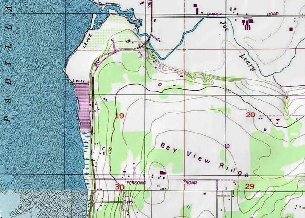
7 Maps Topographic

8 Zoning Map and Description Zoning Description This site is zoned Rural Reserve (RRv), which is designed to allow low-density development and to preserve the open space character of the areas zoned Rural Reserve. Lands that are zoned RRv are typically transitional zones between resource and non-resource lands. SITE There are many permitted uses under RRv including, but not limited to, detached single family dwelling units, agriculture, home based business, and residential accessory units. The density that can be acheived is between 1 and 33 units and is explained in detail on the following page. Zoning Map Key Rural Reserve (RRv) Rural Intermediate (RI) Rural Village Residential (RVR) Bayview Ridge Heavy Industrial (BR-HI) Bayview Ridge Light Industrial (BR-LI) Aviation Related (AVR) Rural Marine Industrial (RMI) Rural Business (RB)

9 Density Skagit County allows density to be calculated two different ways. The first and most simple calculation is one single family dwelling unit per 10 acres of land. This would allow up to acre lots. Density 16 vs. 32 Units Recent Example of CaRD System The second is calculated using a process called Conservation and Reserve Development, or CaRD, which clusters density on large plots of land in order to both increase total density as well as preserve larger pieces of land. The maximum density that can be achieved under this system is two detached single family dwelling units per 10 acres of land. An example of another nearby development that was completed using the CaRD system is shown on the right. The original piece of land is outlined in green. Each parcel included inside the green outline are lots that were created using this process. Open Space In order to achieve a density of two houses per 10 acres, the density was required to be clustered, as you can see to the right. The remaining land became designated as open space, which restricts most further development. Exceptions include agricultural uses, equestrian use, and golf courses, among a small variety of similar uses. In addition, the open space land is required to be owned by one entity and cannot be divided further. Interests in the entity can be split, but the land itself must remain as it is at the time of the subdivision. It appears common to establish a homeowner s association to hold the open space land. The open space land could have a nonresidential community use such as an equestrian center or a golf course. Under this caluclation of density, the site would allow up to 32 1-acre lots, with the remaining land permanently designated as open space.
10 Development Considerations Cost to Develop Lots The price to install the infrastructure for a 16-lot development would amount to approximately $80,000 per lot. The price to install the infrastructure for a 32-lot development would amount to between $50,000 and $65,000 per lot. This will include: Paved road up to one mile length Curb (including minimal side walk) Gutter, storm drainage, and retention pond Pressurized water lines Puget Sound Energy power This will not include: Septic installation: between $12,000-15,000 per lot Permits for PUD: system development fee of around $12,400 hookup per lot Impact fees Landscaping if needed Change of Land Tax Status To develop the land for SFR, the owner would need to remove the Agricultural Discount status. At that point, the land would be assessed at Market Value, which is currently about $2,110/acre. Thereupon, the owner would need to: Pay back taxes for past seven years on the discrepancy between rates Pay market rate taxes for current year Pay 12% interest on back taxes for current and past 7 years For example, the total due would be $48, for Parcel #34507 (40 acres) if discount was removed There would be a 20% savings if notice is given 2 years in advance to remove Agricultural Discount Assuming that the other parcels were assessed at a similar value, we estimate that the total back-taxes that must be paid to develop this land would be about $194,000.
11 Development Considerations Skagit County PUD Water The current end of the Skagit County Public Utility District s water line is currently less than 1,000 feet from the southwest corner of the site, marked by a star on the map to the right. Consulting with an engineer to determine the cost of extending the line is necessary, but we believe that the cost will be somewhere in the $ per linear foot range, both to get it to the site and to extend the line through the site. The distance to extend the line to the site is about 700+/- feet. Upon completion of this development, it is possible that the landowners to the East of this site would be interested in further development. In that event, a latecomer agreement could force the new developers to share the expense of the water line extension. Latecomer agreements can be established through the Skagit County PUD and are valid for up to 10 years. Hookup fees per lot are about $12,400/lot and are payable at the time of building permit application. Larger maps similar to the image to the right can be found in the Due Diligence Vault. Location of Skagit County PUD water line

12 Maps Hydric Soils Hydric Soil Map The map at the right shows what is known of the site s wetlands condition. The small green circles on the site indicate existing wetlands, according to the National Wetland Inventory. Although the Buyer will need to conduct a wetlands delineation to confirm the location of these wetlands, as well as potential others, the lack of wetlands shown here is a good sign. It is likely that most of the site will be buildable. Hydric Soil Map Key 200 Foot Area Hydric Soils National Wetland Inventory Air Photo Interpretation of Wetland Boundaries
13 Links Links Skagit County - Maps Interactive Map Comp Plan/Zoning Critical Areas FEMA 100 yr Floodplain Hydric Soils Skagit County Code Unified Development Rural Reserve (Site) Zoning EDASC Board of Realtors City Websites - City of Mount Vernon City of Burlington City of Anacortes - Recreational - San Juan Islands - North Cascades - Skagit County - Pacific Northwest
14 Due Diligence Vault Due Diligence Vault Directory Maps - Comp Plan/Zoning - Critical Areas - FEMA 100 yr Floodplain - Hydric Soils - Skagit PUD/Water - Skagit Top Skagit County Code - Unified Development - Rural Reserve (Site) Zoning Please contact the listing brokers for access to these materials.
STAFF REPORT. Permit Number: Porter. Kitsap County Board of Commissioners; Kitsap County Planning Commission
 STAFF REPORT Permit Number: 15 00461 Porter DATE: November 9, 2015 TO: FROM: Kitsap County Board of Commissioners; Kitsap County Planning Commission Katrina Knutson, AICP, Senior Planner, DCD and Jeff
4. facilitate the construction of streets, utilities and public services in a more economical and efficient manner;
 PVPC MODEL BYLAW BY-RIGHT CLUSTER ZONING BYLAW Prepared by Pioneer Valley Planning Commission Revised: October 2001 1.00 Development 1.01 Development Allowed By Right Development in accordance with this
FINAL DRAFT 12/1/16, Rev. to 7/18/17
 FINAL DRAFT 12/1/16, Rev. to 7/18/17 (As Adopted 8/8/17 Effective 9/1/17) SHELTON PLANNING AND ZONING COMMISSION Proposed Amendments to Zoning Regulations I. Amend Section 23 PERMITTED USES by inserting
CHAPTER 3 PRELIMINARY PLAT
 10-3-1 10-3-3 SECTION: CHAPTER 3 PRELIMINARY PLAT 10-3-1: Consultation 10-3-2: Filing 10-3-3: Requirements 10-3-4: Approval 10-3-5: Time Limitation 10-3-6: Grading Limitation 10-3-1: CONSULTATION: Each
ARTICLE FIVE FINAL DRAFT
 ARTICLE FIVE 021218 FINAL DRAFT Sec. 503.6 Open Space Preservation Option Open Space Preservation Option Open Space Preservation developments may be approved in the AR, R-1, R-2 and R-3 zoning districts,
Appendix J - Planned Unit Development (PUD)
") Appendix J - Planned Unit Development (PUD) Intent and Purpose The purpose of the PUD is: 1. To provide development that is consistent with the Comprehensive Land Use Plan and promote the goals and objectives
Appendix J - Planned Unit Development (PUD) Intent and Purpose The purpose of the PUD is: 1. To provide development that is consistent with the Comprehensive Land Use Plan and promote the goals and objectives
PLANNING & DEVELOPMENT SERVICES 1800 Continental Place Mount Vernon, WA Inspections Office Fax 360.
 PLANNING & DEVELOPMENT SERVICES 1800 Continental Place Mount Vernon, WA 98273 Inspections 360.416.1330 Office 360.416-1320 Fax 360.416-1340 Date Received: Administrative Setback Reduction Checklist Pursuant
Chapter 100 Planned Unit Development in Corvallis Urban Fringe
 100.100 Scope and Purpose. Chapter 100 Planned Unit Development in Corvallis Urban Fringe (1) All applications for land divisions in the Urban Residential (UR) and Flood Plain Agriculture (FPA) zones within
DRAFT FOR PUBLIC HEARING (rev. March, 2016)
") Chapter 200. ZONING Article VI. Conservation/Cluster Subdivisions 200-45. Intent and Purpose These provisions are intended to: A. Guide the future growth and development of the community consistent with
Chapter 200. ZONING Article VI. Conservation/Cluster Subdivisions 200-45. Intent and Purpose These provisions are intended to: A. Guide the future growth and development of the community consistent with
ARTICLE 13 CONDOMINIUM REGULATIONS
 ARTICLE 13 CONDOMINIUM REGULATIONS Section 13.01 Purpose. The purpose of this Article is to regulate projects that divide real property under a contractual arrangement known as a condominium. New and conversion
2017 Docket of Proposed Policy, Code, and Map Amendments
 2017 Docket of Proposed Policy, Code, and Map Amendments Plain text = existing code with no changes Strikethrough = existing code to be deleted Underlined = new code to be added Double Strikethrough =
APPLICATION REVIEW CHECKLISTS
 APPLICATION REVIEW CHECKLISTS The following must be submitted with and are part of each application. No application is complete until all required documentation has been submitted to the Community Development
A. Preserve natural resources as identified in the Comprehensive Plan.
 1370.08 Conservation Residential Overlay District. Subd. 1 Findings. The City finds that the lands and resources within the Conservation Residential Overlay District are a unique and valuable resource
Staff Report: Date: Applicant: Property Identification: Acreage of Request: Current Zoning of Requested Area: Requested Action: Attached:
 Staff Report: Completed by Jeff Palmer Director of Planning & Zoning Date: November 7, 2018 Applicant: Greg Smith, Oberer Land Developer agent for Ronald Montgomery ET AL Property Identification: Frontage
Condominium Unit Requirements.
 ARTICLE 19 CONDOMINIUM REGULATIONS Section 19.01 Purpose. The purpose of this Article is to regulate projects that divide real property under a contractual arrangement known as a condominium. New and conversion
RECOMMENDATION Following the public hearing, consider Zoning Case PD14-16, with a Development Plan.
 Staff Report Zoning Case PD14-16 (Helzer Tract) Planning and Zoning Meeting Date: 12-17-14 Document Being Considered: Ordinance RECOMMENDATION Following the public hearing, consider Zoning Case PD14-16,
AN ORDINANCE AMENDING THE CITY ZONING ORDINANCE AND THE OFFICIAL CODE OF THE CITY OF CLARKSVILLE RELATIVE TO CLUSTER OPTION DEVELOPMENTS
 ORDINANCE 74-2012-13 AN ORDINANCE AMENDING THE CITY ZONING ORDINANCE AND THE OFFICIAL CODE OF THE CITY OF CLARKSVILLE RELATIVE TO CLUSTER OPTION DEVELOPMENTS BE IT ORDAINED BY THE CITY COUNCIL OF THE CITY
Special Use Permit - Planned Unit Development Checklist. Property Address:
 Special Use Permit - Planned Unit Development Checklist Special Use Permit Number. Parcel Code/s #28-11- - - Property Address: Applicant: ARTICLE VIII Ordinance Reference - Section 8.1.2 Permit Procedures:
FINAL SPUD APPLICATION
 The Planning & Development Services Department is here to assist you with your development application pursuant to the Community Development Code (CDC). This publication outlines the Final SPUD Development
Investment Opportunity Rupley Site
 Investment Opportunity Rupley Site Site size 5.28 acres Location Northwest corner of exit 48 off of South Huntington Access I-5 freeway, street access directly from South Huntington (on truck route), BNSF
OFFERING MEMORANDUM. POTENTIAL WATERFRONT REAL ESTATE DEVELOPMENT PUGET SOUND SALISH SEA
 OFFERING MEMORANDUM www.governorspointopportunity.com P r i c e Reduced! $7,950,000 Now offered at $6,950,000 ($868,750 per lot for 8 lots) POTENTIAL WATERFRONT REAL ESTATE DEVELOPMENT PUGET SOUND SALISH
Applying Open Space Design Techniques Lowell, MA 5/21/13
 Applying Open Space Design Techniques Lowell, MA 5/21/13 An Introduction to the State s Open Space Design / Natural Resource Protection Zoning Model Bylaw Kurt Gaertner Massachusetts Executive Office of
Marion County Board of County Commissioners
 Marion County Board of County Commissioners Date: 12/29/2015 P&Z: 12/28/2015 BCC: 1/12/2016 Item Number 160113Z Type of Application Rezoning Request From: A-1 (General Agriculture) To: PUD (Planned Unit
GOALS, OBJECTIVES, AND STRATEGIES
 GOALS, OBJECTIVES, AND STRATEGIES What follows is a series of goals, recommendations and actions that reflect the themes outlined in the Mineral Springs Vision Plan (incorporated into this document as
Draft Zoning Changes for the 2nd Planning Board Public Hearing, January 22, 2018.
 Draft Zoning Changes for the 2nd Planning Board Public Hearing, January 22, 2018. No changes were made at the 1st Public Hearing. Proposed wording for the 1 st Public Hearing in red, eliminated text in
PLANNED UNIT DEVELOPMENTS
 PLANNED UNIT DEVELOPMENTS SECTION 9.01 DESCRIPTION AND PURPOSE. A. The purpose of a planned unit development (PUD) is to permit greater flexibility in development than is generally possible under standard
City of Leavenworth DEPARTMENT OF DEVELOPMENT SERVICES MAJOR SUBDIVISION APPLICATION 1
 Proposed Name of Subdivision: City of Leavenworth DEPARTMENT OF DEVELOPMENT SERVICES MAJOR SUBDIVISION APPLICATION 1 FOR PRELIMINARY SUBDIVISION APPROVAL This application must be filled out legibly, in
SUBMITTAL REQUIREMENTS: The number indicates the number of copies for submittal (if applicable).
.") Office Use Only Preliminary Long Plat Long Subdivision Applicant Checklist PLANNING, COMMUNITY, & ECONOMIC DEVELOPMENT DEPARTMENT PRELIMINARY LONG PLAT LONG SUBDIVISION CHECKLIST Mailing Address: P.O.
Office Use Only Preliminary Long Plat Long Subdivision Applicant Checklist PLANNING, COMMUNITY, & ECONOMIC DEVELOPMENT DEPARTMENT PRELIMINARY LONG PLAT LONG SUBDIVISION CHECKLIST Mailing Address: P.O.
PROPOSED POLICY THE FUTURE OF THE AGRICULTURAL RESERVE
 PROPOSED POLICY THE FUTURE OF THE AGRICULTURAL RESERVE AG RESERVE VS. AG PRESERVE Ag Reserve: Refers to the area bounded by the Turnpike on the east, Clint Moore Road on the South, the Arthur Marshall
SUBMITTAL REQUIREMENTS: The number indicates the number of copies for submittal (if applicable).
.") Office Use Only Preliminary Long Plat Long Subdivision Applicant Checklist PLANNING, COMMUNITY, & ECONOMIC DEVELOPMENT DEPARTMENT FINAL LONG PLAT LONG SUBDIVISION CHECKLIST Mailing Address: P.O. Box 547,
Office Use Only Preliminary Long Plat Long Subdivision Applicant Checklist PLANNING, COMMUNITY, & ECONOMIC DEVELOPMENT DEPARTMENT FINAL LONG PLAT LONG SUBDIVISION CHECKLIST Mailing Address: P.O. Box 547,
Staff Report: Date: Applicant: Property Identification: Acreage of Request: Current Zoning of Requested Area: Requested Action: Attached:
 Staff Report: Completed by Jeff Palmer Director of Planning & Zoning Date: November 7, 2018, Updated November 20, 2018 Applicant: Greg Smith, Oberer Land Developer agent for Ronald Montgomery ET AL Property
Planning & Development Services
 Planning & Development Services 1 8 0 0 C o n t i n e n t a l P l a c e M o u n t V e r n o n, W a s h i n g t o n 9 8 2 7 3 o f f i c e 3 6 0-4 1 6-1 3 2 0 p d s @ c o. s k a g i t. w a. u s w w w. s
Open Space Model Ordinance
 Open Space Model Ordinance Section I. Background Open space development has numerous environmental and community benefits, including: 1) Reduces the impervious cover in a development. Impervious cover
ARTICLE XI - CONSERVATION SUBDIVISIONS
 ARTICLE XI - CONSERVATION SUBDIVISIONS Section 1101: Purpose and Intent. This Article is intended to provide for residential subdivisions that are designed based first and foremost on the preservation
TOWNSHIP OF BORDENTOWN LAND DEVELOPMENT APPLICATION CHECKLIST. General Requirements for all Applications
 TOWNSHIP OF BORDENTOWN LAND DEVELOPMENT APPLICATION CHECKLIST This CHECKLIST has been adopted in accordance with Section 25:807 of the Land Development Ordinance of the Township of Bordentown and will
STAFF REPORT. Permit Number: Unlimited. Kitsap County Board of Commissioners; Kitsap County Planning Commission
 STAFF REPORT Permit Number: 15 00550 Unlimited DATE: March 2, 2016 TO: FROM: Kitsap County Board of Commissioners; Kitsap County Planning Commission Katrina Knutson, AICP, Senior Planner, DCD and Jeff
Action Recommendation: Budget Impact:
 City of Fayetteville Staff Review Form 2018-0477 Legistar File ID 9/18/2018 City Council Meeting Date - Agenda Item Only N/A for Non-Agenda Item Garner Stoll Submitted By 8/28/2018 Submitted Date Action
CHAPTER 10 Planned Unit Development Zoning Districts
 CHAPTER 10 Planned Unit Development Zoning Districts Section 10.1 Intent and Purpose The Planned Unit Development (PUD) districts are intended to offer design flexibility for projects that further the
ARTICLE 14 PLANNED UNIT DEVELOPMENT (PUD) DISTRICT
 DISTRICT") ARTICLE 14 PLANNED UNIT DEVELOPMENT (PUD) DISTRICT Section 14.01 Intent. It is the intent of this Article to allow the use of the planned unit development (PUD) process, as authorized by the Michigan Zoning
ARTICLE 14 PLANNED UNIT DEVELOPMENT (PUD) DISTRICT Section 14.01 Intent. It is the intent of this Article to allow the use of the planned unit development (PUD) process, as authorized by the Michigan Zoning
Tentative Map Application Review Procedures
 FOR REFERENCE ONLY This page is not part of the application. Tentative Map Application Review Procedures The tentative map process in Churchill County is designed to provide a mechanism in order to divide
Medium Density Residential Development Opportunity
 Medium Density Residential Development Opportunity 2 Land Tracts totaling 747 Acres Available individual or whole. 138 Park Farm Lane Stafford, VA 22406 Presented by: Wilson Greenlaw, CCIM Vice President
CONDITIONAL USE PERMIT Application Packet
 CONDITIONAL USE PERMIT Application Packet Community Development Department 1020 East Pioneer Road, Draper, UT 84020 (801) 576-6539 Fax (801) 576-6526 Dear Applicant, This application packet has been developed
Umatilla County Department of Land Use Planning
 Umatilla County Department of Land Use Planning 216 SE 4 th ST, Pendleton, OR 97801, (541) 278-6252 Property Line Adjustment, Type V Application & Information Packet PROCESSING THE APPLICATION The application
Proposed Overland Park Kansas Ordinance RE-1 Residential Estates Community
 18.171 RE-1 Residential Estate Community 18.171.010 Statement of intent. The zoning of property as RE-1, (Residential Estates Community, 1 dwelling unit per Gross acre density), is intended to provide
Article Optional Method Requirements
 Article 59-6. Optional Method Requirements [DIV. 6.1. MPDU DEVELOPMENT IN RURAL RESIDENTIAL AND RESIDENTIAL ZONES Sec. 6.1.1. General Requirements... 6 2 Sec. 6.1.2. General Site and Building Type Mix...
RECOMMENDATION REPORT
 SARPY COUNTY PLANNING & BUILDING DEPARTMENT RECOMMENDATION REPORT CHANGE OF ZONE (CZ 18-005) PRELIMINARY PLAT (PP 18-007) FINAL PLAT (FP 18-008) SCHOLTING ESTATES APPLICANT: DIANE SCHOLTING PLANNING COMMISSION
SUBDIVISION APPLICATION CHECKLIST SKETCH PLAN PRELIMINARY PLAT FINAL PLAT
 RECEIVED STAMP SUBDIVISION APPLICATION CHECKLIST SKETCH PLAN PRELIMINARY PLAT FINAL PLAT A checklist of background information and submission requirements for processing of a sketch plan, preliminary plat
Major Subdivision Application Packet. Revised June 2018
 Major Subdivision Application Packet Revised June 2018 Caroline County Department of Planning and Community Development 233 West Broaddus Avenue Bowling Green, VA 22427 www.co.caroline.va.us Phone: 804-633-4303
FUTURE LAND USE. City of St. Augustine Comprehensive Plan EAR-Based Amendments
 FUTURE LAND USE City of St. Augustine Comprehensive Plan EAR-Based Amendments Future Land Use Element FLU Goal To create an environment within the City and adjacent areas in which its residents have the
610 LAND DIVISIONS AND PROPERTY LINE ADJUSTMENTS OUTSIDE A UGB
 ARTICLE VI: LAND DIVISIONS AND PROPERTY LINE ADJUSTMENTS VI-21 610 LAND DIVISIONS AND PROPERTY LINE ADJUSTMENTS OUTSIDE A UGB 610-1 Property Line Adjustments (Property Line Relocation) A property line
ZONING PERMIT APPLICATION
 ZONING PERMIT APPLICATION OFFICE USE ONLY Date Received: FILE NO. 120 DAY EXPIRATION Purpose: Some types of land use activities listed in the Lake County Zoning Ordinance are allowed to occur with a minimal
Frequently Asked Questions
 Frequently Asked Questions Q: What is The Ridge at Hangman? A: The Ridge at Hangman is a 930 acre Planned Unit Development residential community surrounding the Hangman Valley Golf Course that will contain
Article 7: Residential Land Use and Development Requirements
 Article 7: Residential Land Use and Section 701: Statement of Intent (A) (B) (C) The intent of Article 7 is to develop certain land use and development requirements for the residential uses within Cumru
Planning Department Oconee County, Georgia
 Planning Department Oconee County, Georgia STAFF REPORT REZONE CASE #: 6985 DATE: October 31, 2016 STAFF REPORT BY: Andrew C. Stern, Planner APPLICANT NAME: Williams & Associates, Land Planners PC PROPERTY
VARIANCE PROCESS APPLICATION
 The Department is here to assist you with your development application pursuant to the Community Development Code (CDC). This publication outlines the Variance Process Development Application process of
CARA CURREY Engineered, Approved SFR Lots. Auburn, WA
 CARA CURREY 206.334.0571 carac@windermere.com 55 Engineered, Approved SFR Lots Auburn, WA Mountain View Meadows Auburn, WA 55 Engineered SFR Lots TODD PETTIT 206.940.0212 tpettit@windermere.com Click Links
Purpose: Regulations:
 Administrative Procedures for the Designation and Refinement Of Chesapeake Bay Preservation Area Boundaries Guidance on the Chesapeake Bay Preservation Area Designation and Management Regulations September,
FINAL DRAFT 10/23/06 ARTICLE VI
 FINAL DRAFT 10/23/06 ARTICLE VI 185-41.1. Planned Residential Development A. Purpose and Intent. The purposes of the Planned Residential Development (PRD) bylaw are to maintain the rural character of Dover,
Comprehensive Plan /24/01
 IV The is a central component of the Comprehensive Plan. It is an extension of the general goals and policies of the community, as well as a reflection of previous development decisions and the physical
Kitsap County Department of Community Development. Administrative Staff Report
 Kitsap County Department of Community Development Administrative Staff Report Report Date: Application Complete Date: March 15, 2018 Application Submittal Date: March 12, 2018 Project Name: Nikki Lee Salon
City of Fayetteville, Arkansas Page 1 of 1
 City of Fayetteville, Arkansas 113 West Mountain Street Fayetteville, AR 72701 (479) 575-8323 Legislation Text File #: 2018-0288, Version: 1 RZN 18-6176 (714 S. COLLEGE AVE./CAMERON): AN ORDINANCE TO REZONE
COMMUNITY DEVELOPMENT. Staff Report. Site Plan Review. SP June 19, 2018
 COMMUNITY DEVELOPMENT 333 Broadalbin Street SW, PO Box 490, Albany, Oregon 97321-0144 BUILDING 541-917-7553 PLANNING 541-917-7550 Staff Report Site Plan Review SP-18-18 June 19, 2018 Summary On May 1,
MAJOR SUBDIVISION APPLICATION
 Revised 2.26.18 The Department is here to assist you with your development application pursuant to the Community Development Code (CDC). This publication outlines the Major Subdivision Development Application
LAND USE PERMIT INFORMATION PACKET
 DOES YOUR PROJECT NEED A LAND USE PERMIT? Assume the answer to this question is YES! Almost all construction, repair, remodeling or excavation work needs Land Use Permit in Hamburg Township. Please call
BUILD-OUT ANALYSIS GRANTHAM, NEW HAMPSHIRE
 BUILD-OUT ANALYSIS GRANTHAM, NEW HAMPSHIRE A Determination of the Maximum Amount of Future Residential Development Possible Under Current Land Use Regulations Prepared for the Town of Grantham by Upper
ORDINANCE NO
 ORDINANCE NO. 2006-06 AN ORDINANCE OF THE TOWN OF SOUTHWEST RANCHES, FLORIDA, AMENDING THE CODE OF ORDINANCES OF THE TOWN OF SOUTHWEST RANCHES, CHAPTER 39, UNIFIED LAND DEVELOPMENT CODE, SECTION 010-030,
Jurisdictional Determination Request
 This form is intended for use by anyone requesting a jurisdictional determination (JD) from the U.S. Army Corps of Engineers, Wilmington District (Corps). Please include all supporting information, as
2030 General Plan. December 6, 7 pm
 2030 General Plan GPAC Meeting #9 GPAC Meeting #9 December 6, 7 pm City Council Input on Working Draft Land Use Map Council discussed GPAC & PC versions of the working draft land use map 11/28 Council
FRESHWATER WETLANDS PROTECTION IN NEW JERSEY Tools for Municipal Action
 FRESHWATER WETLANDS PROTECTION IN NEW JERSEY Tools for Municipal Action The Freshwater Wetlands Protection Act INTENT OF FRESHWATER WETLANDS LAW The New Jersey legislature passed the Freshwater Wetlands
CHECKLIST FOR DEVELOPMENT REVIEW
 CHECKLIST FOR DEVELOPMENT REVIEW Petitions and related documents and plans for land development or other proposals regulated by Title 16 of the Municipal Code (Development Ordinance) and Title 17 of the
SUBCHAPTER 23-3: DENSITY AND INTENSITY REGULATIONS
 SUBCHAPTER 23-3: DENSITY AND INTENSITY REGULATIONS Section 23.301 Purpose The purpose of this Subchapter is to indicate the maximum permitted density (for residential projects) and maximum permitted intensity
SITE PLAN REVIEW PROCEDURES SECTION DEVELOPMENTS REQUIRING SITE PLAN APPROVAL
 SECTION 22.01 PURPOSE ARTICLE XXII PROCEDURES The purpose of this Article is to establish uniform requirements of procedure for all developments in the Township. Certain specific types of minor development
Initial Subdivision Applications Shall Include the Following:
 Initial Subdivision Applications Shall Include the Following: 1) Subdivision Application Form: completely filled out (12 copies) 2) Plat: The Plat must adhere to the requirements set forth in the Town
TOWNSHIP OF ALGOMA COUNTY OF KENT, MICHIGAN. Minutes of a regular meeting of the Township Board of the Township of Algoma, Kent
 Site Plan No. 0410 --- TOWNSHIP OF ALGOMA COUNTY OF KENT, MICHIGAN Minutes of a regular meeting of the Township Board of the Township of Algoma, Kent County, Michigan, held in the Algoma Township Hall,
SECTION PLANNED RESIDENTIAL UNIT DEVELOPMENT
 SECTION 1609. PLANNED RESIDENTIAL UNIT DEVELOPMENT It is the purpose of this section to encourage more imaginative and livable housing environments within the Residential Districts, as noted, through a
Procedures For Collecting and Monitoring Data
 DRAFT Kitsap County Buildable Lands Program Procedures For Collecting and Monitoring Data Page 1 12/1/05 Introduction This procedures report is intended to provide guidelines for Kitsap County and its
Article 2 Application Type and Standards Requirements
 Article 1 Article 2 Division 1 Application Type and Standards Requirements General Provisions Sec. 2.1.1 Division 2 Division 3 Division 4 Division 5 Division 6 Division 7 Division 8 Division 9 Sec. 2.9.1
APPLICATION FOR SUBDIVISION APPROVAL OF A SKETCH PLAN with checklist
 Prior to filing any application for SUBDIVISION approval, the applicant shall request in writing that the zoning administrator schedule a pre-submission conference. APPLICATION TO THE PLANNING BOARD TOWN
AGENDA STATEMENT NO BUSINESS OF THE PLANNING COMMISSION City of Victoria, Minnesota STAFF REPORT. Casco Ventures (Developer)
") AGENDA STATEMENT NO. 17-1 BUSINESS OF THE PLANNING COMMISSION City of Victoria, Minnesota STAFF REPORT TO: Planning Commission PREPARED BY: Erin Smith, Senior Planner RE: Waterford Landing Project Rezoning
AGENDA STATEMENT NO. 17-1 BUSINESS OF THE PLANNING COMMISSION City of Victoria, Minnesota STAFF REPORT TO: Planning Commission PREPARED BY: Erin Smith, Senior Planner RE: Waterford Landing Project Rezoning
Chapter ZONING Sections: Title and purpose.
 Chapter 14.16 ZONING Sections: 14.16.010 Title and purpose. 14.16.020 Scope. 14.16.030 Districts, maps and boundaries. 14.16.100 Rural Village Commercial (RVC). 14.16.110 Rural Center (RC). 14.16.120 Rural
SHOOP RANCH WEST 1,807 + ACRES WISE & DENTON COUNTIES, NEW FAIRVIEW, TX BRYAN PICKENS REPUBLICRANCHES.COM
 SHOOP RANCH WEST 1,807 + ACRES WISE & DENTON COUNTIES, NEW FAIRVIEW, TX BRYAN PICKENS Partner/Broker 214-552-4417 bryan@republicranches.com REPUBLICRANCHES.COM Wise & Denton Counties 1,807 +/-Acres Large
ZONING CLASSIFICATION SUMMARY SHEET
 Growth and Resource Management Planning and Development Services 123 West Indiana Avenue Room 202 DeLand, Florida 32720-4253 Telephone (386) 943-7059 Fax (386) 626-6570 www.volusia.org ZONING CLASSIFICATION
A. Location. A MRD District may be permitted throughout the County provided it meets the standards established herein.
 752. Multi-Residential District (MRD) The Multi-Residential (MRD) District is intended to provide opportunities for rural, suburban and urban density mixed-residential developments consistent with the
Chapter LAND DIVISIONS
 Chapter 14.18 LAND DIVISIONS Sections: 14.18.000 General. 14.18.100 Preliminary subdivisions. 14.18.200 Final subdivisions. 14.18.300 Conservation and Reserve Developments (CaRDs) An alternative division
BANK OWNED. Southwest Dixon Specific Plan Land ±58.29 ACRES SWC West A Street & George Lane Dixon, CA CONTACT US PROPERTY HIGHLIGHTS
 FOR SALE Dixon, CA BANK OWNED PROPERTY HIGHLIGHTS DEVELOPMENT POTENTIAL POTENTIAL TREE GROUND CONTACT US KRIS RILEY +1 916 781 4861 Kris.riley@cbre.com Lic. 01290492 PETER NIXON +1 916 781 4819 peternixon@cbre.com
OFFERING MEMORANDUM. Apple Valley Self Storage Coshocton Avenue Howard, OH 43028
 Apple Valley Self Storage 22011 Coshocton Avenue Howard, OH 43028 OFFERING MEMORANDUM Alec J. Pacella, CCIM NAI Daus 23240 Chagrin Blvd., Suite 250 Cleveland, OH 44122 216-455-0886 apacella@naidaus.com
Concept Plan Project Narrative For 852 River Ranch Court
 Concept Plan Project Narrative For 852 River Ranch Court Date: January 5, 2016 Prepared by: Robert W. Jones II, P.E. Vortex Engineering, Inc. 2394 Patterson Rd., Ste 201 Grand Junction, CO 81505 970-245-9051
Venice 295 Acres for Residential Development Venice, FL Sarasota County
 Venice 295 Acres for Residential Development Excellent Location for an Upscale Residential Development Close to Venice Beaches, Marinas, Golf, Shopping, Restaurants, Schools, Publix 2 Venice Myakka River
TITLE 14 SKAGIT COUNTY CODE CHAPTER ZONING
 1 1 1 1 1 1 1 1 0 1 0 1 0 1 TITLE 1 SKAGIT COUNTY CODE CHAPTER 1.1 ZONING Sections: 1.1.0 Title and Purpose... 1.1.00 Scope.... 1.1.00 Districts, Maps and Boundaries.... 1.1.0 Rural Village Commercial
Wapiti Ridge Estates Area Structure Plan SE W5M. December Prepared For:
 SE 13-20-1 W5M December 2000 Prepared For: 393494 Alberta Limited, and The Municipal District of Foothills No. 31 Prepared By: Kristi Beunder Professional Planning Services Calgary, Alberta Ph: 201-3309
APPLICATION PROCEDURE
 ANTRIM PLANNING BOARD P. O. Box 517 Antrim, New Hampshire 03440 Phone: 603-588-6785 FAX: 603-588-2969 APPLICATION FORM AND CHECKLIST FOR MINOR OR MAJOR SITE PLAN REVIEW File Date Received By APPLICATION
PLANNED RESIDENTIAL DEVELOPMENT (PRD)
") PLANNED RESIDENTIAL DEVELOPMENT SECTION 10. PLANNED RESIDENTIAL DEVELOPMENT (PRD) 10.1 Purpose Planned Residential Development allows by special permit from the Board an alternative pattern of residential
PLANNED RESIDENTIAL DEVELOPMENT SECTION 10. PLANNED RESIDENTIAL DEVELOPMENT (PRD) 10.1 Purpose Planned Residential Development allows by special permit from the Board an alternative pattern of residential
STANDARDS FOR EVALUATING PROPOSALS
 STANDARDS FOR EVALUATING PROPOSALS Amended by Resolution No. 2011-1; February 2, 2011 Pursuant to Government Code Section 56375, Santa Cruz LAFCO has established standards for the evaluation of proposals.
A.3. ARTICLE 7 PLAN REQUIREMENTS FOR MINOR SUBDIVISION AND/OR LAND DEVELOPMENT
 700. 701.A.3. ARTICLE 7 PLAN REQUIREMENTS FOR MINOR SUBDIVISION AND/OR LAND DEVELOPMENT SECTION 700 PURPOSE The purpose of this Article is to set forth a streamlined set of Plan Requirements for minor
UNRESERVED REAL ESTATE AUCTION
 UNRESERVED REAL ESTATE AUCTION For Darren & Dallas Roth 1 Deeded Quarter (Includes Home & Buildings) 58226 Hwy 18 Tuesday, June 26, 2018 Real Estate sells at 12:00 PM Held in conjunction with Roth Farm
CITY OF INVER GROVE HEIGHTS 8150 Barbara Avenue Inver Grove Heights, MN (651)
") 8150 Barbara Avenue Inver Grove Heights, MN 55077 (651) 450-2545 www.invergroveheights.org FINAL PLANNED UNIT DEVELOPMENT (City Code Section 10-13A) The following must be submitted prior to review and
8150 Barbara Avenue Inver Grove Heights, MN 55077 (651) 450-2545 www.invergroveheights.org FINAL PLANNED UNIT DEVELOPMENT (City Code Section 10-13A) The following must be submitted prior to review and
Comprehensive Plan 2030
 Introduction Land use, both existing and future, is the central element of a Comprehensive Plan. Previous chapters have discussed: Projected population growth. The quality housing available in the Township
STAFF REPORT and INFORMATION FOR THE HEARING EXAMINER. Project: Westphal Accessory Dwelling Unit (ADU)
") KITSAP COUNTY DEPARTMENT OF COMMUNITY DEVELOPMENT 614 DIVISION STREET MS-36, PORT ORCHARD WASHINGTON 98366-4682 LARRY KEETON, DIRECTOR (360) 337-7181 FAX (360) 337-4925 HOME PAGE - www.kitsapgov.com STAFF
KITSAP COUNTY DEPARTMENT OF COMMUNITY DEVELOPMENT 614 DIVISION STREET MS-36, PORT ORCHARD WASHINGTON 98366-4682 LARRY KEETON, DIRECTOR (360) 337-7181 FAX (360) 337-4925 HOME PAGE - www.kitsapgov.com STAFF
GENESEE COUNTY SMART GROWTH PLAN 2010 Review Report
 GENESEE COUNTY SMART GROWTH PLAN 2010 Review Report Prepared for the Genesee County Legislature by Genesee County Department of Planning County Building II 3837 West Main Street Road Batavia, NY 14020
PLANNED UNIT DEVELOPMENT & SUBDIVISION STAFF REPORT Date: September 15, 2016
 # 10 SUB2016-00089 PLANNED UNIT DEVELOPMENT & SUBDIVISION STAFF REPORT Date: September 15, 2016 NAME SUBDIVISION NAME LOCATION Lot 12 Laughlin Industrial Park Subdivision Lot 12 Laughlin Industrial Park