TOWN OF RIB MOUNTAIN PLANNING COMMISSION MEETING March 14, 2018
|
|
|
- Brett Chase
- 5 years ago
- Views:
Transcription
1
2 TOWN OF RIB MOUNTAIN PLANNING COMMISSION MEETING March 14, 2018 Chairperson Harlan Hebbe, called the meeting of the Plan Commission to order at 6:30 pm. Other Plan Commission members present included Jim Hampton, Laura McGucken, Tom Steele and Ryan Burnett. Jay Wittman was excused. Also present were Community Development Director, Steve Kunst, and Building Inspector / Assistant Zoning Administrator, Paul Kufahl. MINUTES: Motion by Tom Steele, second by Laura McGucken to approve the minutes of the February 14, 2018 Plan Commission meeting, as presented. Motion carried 4-0. Ryan Burnett abstained. PUBLIC HEARINGS: a. Ben and Nicole Fisher, owners, request conditional use approval to allow for the keeping of bees and chickens at the property addressed 5601 Blackberry Drive. Parcel # Docket # Community Development Director, Steve Kunst, indicated the applicant is seeking approval for a lowdensity husbandry use to allow for the keeping of bees and chickens. Kunst noted the code allows for buildings and containment areas to be reviewed and/or approved on a case-by-case basis through the conditional use process. He indicated the applicant s proposed location for hives and chickens would be more than 100 feet from the rear property line and over 200 feet from both side property lines. Ben and Nicole Fisher, applicants, noted they have no intention of becoming a commercial bee keeping operation and the request is purely hobby related. They indicated the request for one (1) hive per 2500 square feet of lot size is based on existing ordinances in the Village of Weston and that they do not intend to have 80 hives. Plan Commission members had the following questions for the applicants: - How many hives do you intend to have? - How large are individual hives? - How much honey does a hive produce and do you plan to sell it from your residence? - Is there any black bear activity in your area and, if so, are you concerned about hive destruction or potential increased nuisance to the neighbors? - How large is the indicated containment area and how many hives could you realistically have in that space? - How many chickens do you plan to have? - How do you plan to house the chickens? 1
3 The applicants responded with the following; - The first year will likely be one or two hives with the possibility for additional hives in future if interest grows, but there is no final maximum number in mind at this time. - A typical hive size is about 17 inches by 24 inches with 4 stacked boxes, two at 10 inches and two at 6 ½ inches in height. - The first year the hive won t produce any honey as the focus will be establishing the hive, but after that you may be able to get about 70 pounds of honey, per hive, each year and the intent is to keep some for personal use and sell to friends and coworkers, but no sale of the product will be done at the residence. - There is currently bear activity in the area. A fence will likely be used around the containment area to deter bears, skunks and other animals from the hives. They did not believe the presence of the hives would increase the current bear activity - The containment area indicated on the aerial image by the pool is approximately 20 feet by 12 feet, which would have the capability to house approximately 15 hives. - Right now they are considering a maximum of five (5) and no roosters, but requested eight (8) in the application in case they enjoy it and would like to increase their numbers in the future. - The plan is to house the chickens in a small coop in the same area as the bee hives. Commissioners and the applicant briefly discussed animal interactions with the hives and the application of an electric fence for deterrent purposes. Commissioners stated they were generally ok with the keeping of bees and chickens because of the rural nature and size of the subject property, but wanted to discuss capping the number of hives and chickens. Chairman Hebbe opened and closed the public comment period at 6:51 with no public comment received. After the public comment period, the Plan Commission members and applicants discussed the maximum number of hives and chickens. Commissioners were comfortable with 10 or less hives and up to eight (8) chickens with no roosters. The applicant requested 15 to 20 hives in the event they would want to expand further and not have to pay for an additional hearing. Motion by Tom Steele, second by Laura McGucken to recommend approval of the low-density husbandry land use at the property addressed 5601 Blackberry Drive, limited to a maximum of 10 bee hives, 8 hen chickens and a containment area within 25 feet of the former pool area. Motion Carried 5-0 2
4 NEW BUSINESS: a. Paul Hackel / Riverside Land Surveying, applicant, request a pre-application discussion regarding a potential rezoning and subdivision development. Docket # Kunst opened discussion by noting the applicant seeks Plan Commission feedback on the concept of rezoning approximately 29 acres on the north side of South Mountain Road, between Red Bud and Thornapple Roads to facilitate the development of six (6) new single family lots ranging from approximately acres, and two stormwater outlots. The location of the proposed road intersection with South Mountain Road is based on correspondence from the Marathon County Highway Department. As proposed, the land needs to be rezoned, subdivided via County Plat, and an exemption granted from the Town and County maximum cul-de-sac length provisions. Nathan Wincentsen, Riverside Land Surveying, stated the presented lot layout is conceptual at this point until they have the wetlands delineated later this year. He noted the wetland locations will ultimately dictate the total number of lots and the road location. Wincentsen indicated all lots would be greater than two acres and Mr. Hackel is also planning to purchase the 40 acres to the north of the subject property for personal use and potential future development, with the understanding that a road connection to either Thornapple or back to South Mountain Road would be required to do so. Kunst presented the Commission with the Town s Future Road map, which indicated a future connection to Thornapple in this approximate area. There was some discussion about the topography and location of the stormwater outlots and the likelihood for private sewer systems. Wincentsen noted a lot of the details are related to the wetland delineation, but the anticipated soils should allow for mound systems. He also noted that the existing residences water well is at 300 feet. Commissioners indicated they were generally acceptable of the density and the proposed lot sizes and reemphasized the need for a second road connection should the applicant choose to develop beyond what is presented. CORRESPONDENCE / QUESTIONS / TOWN BOARD UPDATE: a. Update on short-term rental ordinance discussion. Docket # Kunst notified Plan Commission the Town Board directed them to establish some regulations to regulate short-term rentals versus an outright prohibition of the use. Kunst presented Commissioners with case law and sample ordinances related to this topic. b. Discussion on Plan Commission Rules of Order Chairman Hebbe reminded Commissioners to restrict conversation related to agenda items to active meetings. 3
5 Future Development Considerations Laura McGucken stated the Town and Plan Commission need to be forward thinking related to commercial retail development given the losses of large National retailers in the Wausau Center Mall and general retail development trends. Countywide Addressing Kunst noted the Town s final brief has been submitted to the Court and that no decisions have been made, to-date. PUBLIC COMMENT: None Received ADJOURN: Motion by Tom Steele, second by Laura McGucken to adjourn the Plan Commission Meeting. Motion carried 5-0. Meeting adjourned at 7:45 pm. Respectfully Submitted, Paul Kufahl, Building Inspector / Assistant Zoning Administrator 4
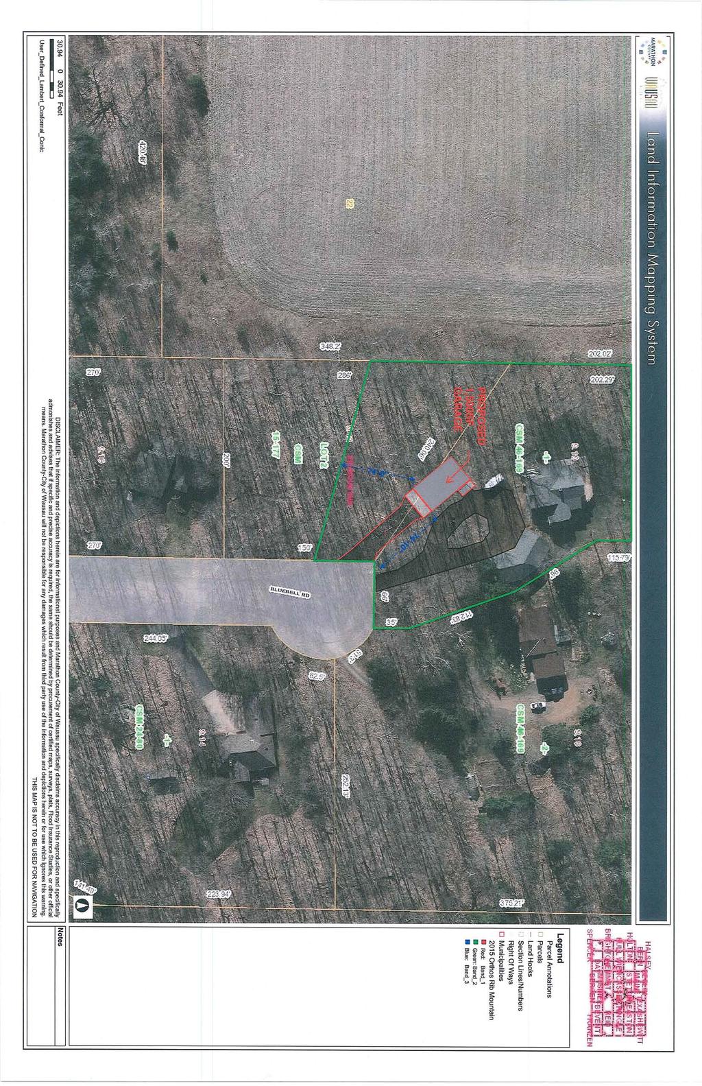
6 REPORT TO PLANNING COMMISSION FROM: Steve Kunst, Community Development Director DATE: April 5, 2018 SUBJECT: Conditional Use Request Detached Accessory Building APPLICANT: Cory Holzhauer, owner PROPERTY ADDRESS: 6950 Bluebell Road REQUEST: Conditional Use approval to allow construction of a 30 ft. by 50 ft. accessory building resulting in 1,500 square feet of total accessory building area, side wall heights exceeding 12 feet, and a second driveway. ZONING: Suburban - 2 (SR-2) ADJACENT ZONING: SR-2 (South, East, and West); ER-1 (North) NARRATIVE: The applicant is seeking Plan Commission recommendation for construction of a 30 ft. x 50 ft. detached garage (1,500 ft 2 ). Per RMMC Sec (8)(d), any one property may have greater than 1,000 square feet and up to a maximum of 1,500 square feet of accessory building area with Conditional Use approval. In addition, the proposal calls for side wall heights greater than 12 feet. Requests for side wall heights greater than 12 ft. are also considered as a conditional use. At the time this report was generated, the final height had yet to be determined. The proposal calls for the exterior building materials (siding and shingles) to match the residence. Further, Street and Park Superintendent, Scott Turner, noted the Public Works Department is ok with the second driveway. Turner recommended either the two driveways come together at the right-of-way or be separated by feet for snow plowing purposes. POSSIBLE ACTION: 1. Recommend approval of the conditional use to allow construction of a 1,500-square foot detached garage with a side wall height greater than 12 feet at the property addressed 6950 Bluebell Road, as presented. 2. Recommend approval of the conditional use to allow construction of a 1,500-square foot detached garage with a side wall height greater than 12 feet at the property addressed 6950 Bluebell Road, with conditions/modifications. 3. Recommend denial of the conditional use to allow construction of a 1,500-square foot detached garage with a side wall height greater than 12 feet at the property addressed 6950 Bluebell Road.
7 BLUEBELL RD SAGE LN FLAMEFLOWER RD GOLDENROD RD FIRETHORN RD BANEBERRY GOLDENROD RD GOLDENROD RD GOLDENROD RD FIRETHORN RD 7175 CT 1809 GOLDENROD RD Rib Mountain: "Where Nature, Family, and Sport Come Together" Prepared by: Map Printed: 4/5/2018 Parcel Outline Parcel Address Zoning Districts Unzoned CR-5ac Countryside EO Estate Office ER-1 Estate MR-4 Mixed NC Neighborhood Commercial OR Outdoor Recreation RA-1 Rural Agricultural RA-2 Rural Agricultural ROW RR Rural SC Suburban Commercial SI Suburban Industrial SO Suburban Office SR-2 Suburban SR-3 Suburban UC Urban Commercial UDD Unified Development UR-8 Urban Building Outline Road Centerline Water Feature Feet ± DISCLAIMER: The information and depictions contained herein are for informational purposes only; Mi-Tech specifically disclaims accuracy in this reproduction and advises that if specific and precise accuracy is required that certified maps, surveys, plats, or other official means be obtained. There is no Statement of Accurracy for any parcel data; the parcel layer is considered an Index Parcel Layer not a Cadastral Parcel Layer. For planing purposes only.
8
9
10
11
12
13
14 REPORT TO PLAN COMMISSION FROM: Steve Kunst, Community Development Director DATE: April 5, 2018 SUBJECT: Future Land Use and Zoning Map Amendments APPLICANT: PROPERTY OWNER(S): Paul Hackel, applicant Scott & Lori Geurink PROPERTY LOCATION: 6200 South Mountain Road & the NE ¼ of the SE ¼, Section 18 REQUEST: Future Land Use and Zoning Map Amendments to allow for future subdivision of the property. FUTURE LAND USE DESIGNATION: Cropland and Forestland FUTURE LAND USE DESIGNATION REQUEST: ADJACENT DESIGNATIONS: Cropland, Forestland, and ZONING: Rural (35-acre minimum lot size) ZONING REQUEST: Estate 1 (One-acre minimum lot size) ADJACENT ZONING: ER-1 (East); RA-2 (South); RA-1 (North); RR (West) NARRATIVE: The applicant seeks an amendment the Town of Rib Mountain s Comprehensive Plan Future Land Use Map from Cropland and Forest Land to and the Town Zoning Map from Rural to Estate -1 (ER-1) for approximately 70 acres of land on the north side of South Mountain Road, between Red Bud and Thornapple Roads. The intent is to subdivide the parcel into single-family residential lots in the future. ADDITIONAL INFORMATION: Per RMMC, after the application is complete, the Zoning Administrator shall prepare a written evaluation of the applicant's requested map amendment. The Zoning Administrator shall determine to what extent the proposed amendment addresses each of the following questions: 1. How does the proposed Official Zoning Map amendment further the purposes of this Chapter as outlined in Section and the applicable rules and regulations of the Wisconsin Department of Natural Resources (DNR) and the Federal Emergency Management Agency (FEMA)? The overriding purpose of Section is to protect the heath, safety, morals and general welfare of the public. The zoning map amendment is consistent with the general landscape of the Town as well as the goals, objectives, and policies of the Town s Comprehensive Plan. 2. Which of the following factors has arisen that are not properly addressed on the current Official Zoning Map? a. The designations of the Official Zoning Map should be brought into conformity with the Comprehensive Master Plan; Not applicable b. A mistake was made in mapping on the Official Zoning Map. (That is, an area is developing in a manner and purpose different from that for which it is mapped.) NOTE: If this reason is cited, it must be demonstrated that the discussed inconsistency between actual land use and designated zoning is not intended, as the Town may intend to stop an undesirable land use pattern from spreading; Not applicable 1
15 c. Factors have changed, (such as the availability of new data, the presence of new roads or other infrastructure, additional development, annexation, or other zoning changes), making the subject property more appropriate for a different zoning district; Not applicable d. Growth patterns or rates have changed, thereby creating the need for an Amendment to the Official Zoning Map. The Town is experiencing a shortage of available residential lots as previously platted lands are nearly completely developed. The areas planned for future residential development as part of the 2005 Future Land Use maps have developed or are in the process of developing. 3. How does the proposed amendment to the Official Zoning Map maintain the desired consistency of land uses, land use intensities, and land use impacts as related to the environs of the subject property? Rib Mountain is primarily a single-family community west of I-39/US 51. The proposal calls for the Estate -1 zoning district, which is intended to be mapped in areas of larger lot residential development outside of the Sanitary District. The proposal is consistent with those standards. Further, lands a few hundred feet east of the subject property were rezoned in the same fashion in POSSIBLE ACTION: 1. Recommend approval of the Comprehensive Plan Future Land Use Map amendment from Cropland and Forest Land to and the Zoning Map amendment from Rural to Estate 1 for the properties described above, as presented. 2. Recommend approval of the Comprehensive Plan Future Land Use Map amendment from Cropland and Forest Land to and the Zoning Map amendment from Rural to Estate 1 for the properties described above, with modifications. 3. Recommend denial of the Comprehensive Plan Future Land Use Map amendment from Cropland and Forest Land to and the Zoning Map amendment from Rural to Estate 1 for the properties described above. 2
16 BUTTERNUT RD CROCUS RD THORNAPPLE RD DOGWOOD RD SOUTH MOUNTAIN RD SOUTH MOUNTAIN RD SOUTH MOUNTAIN RD 6301 RED BUD RD SOUTH MOUNTAIN RD DOGWOOD RD 6221 Rib Mountain: "Where Nature, Family, and Sport Come Together" Prepared by: Map Printed: 4/5/2018 Parcel Outline Parcel Address Zoning Districts Unzoned CR-5ac Countryside EO Estate Office ER-1 Estate MR-4 Mixed NC Neighborhood Commercial OR Outdoor Recreation RA-1 Rural Agricultural RA-2 Rural Agricultural ROW RR Rural SC Suburban Commercial SI Suburban Industrial SO Suburban Office SR-2 Suburban SR-3 Suburban UC Urban Commercial UDD Unified Development UR-8 Urban Building Outline Road Centerline Water Feature Feet ± DISCLAIMER: The information and depictions contained herein are for informational purposes only; Mi-Tech specifically disclaims accuracy in this reproduction and advises that if specific and precise accuracy is required that certified maps, surveys, plats, or other official means be obtained. There is no Statement of Accurracy for any parcel data; the parcel layer is considered an Index Parcel Layer not a Cadastral Parcel Layer. For planing purposes only.
TOWN OF RIB MOUNTAIN PLANNING COMMISSION MEETING February 14, 2018
 TOWN OF RIB MOUNTAIN PLANNING COMMISSION MEETING February 14, 2018 Chairperson Harlan Hebbe, called the meeting of the Plan Commission to order at 6:30 pm. Other Plan Commission members present included
TOWN OF RIB MOUNTAIN PLANNING COMMISSION MEETING December 14, 2016
 TOWN OF RIB MOUNTAIN PLANNING COMMISSION MEETING December 14, 2016 Acting Chairman, Jay Wittman, called the meeting to order at 6:32 pm. Other Plan Commission members present included Tom Steele, Jim Hampton,
TOWN OF RIB MOUNTAIN PLANNING COMMISSION MEETING June 14, 2017
 TOWN OF RIB MOUNTAIN PLANNING COMMISSION MEETING June 14, 2017 Chairperson Harlan Hebbe, called the meeting of the Plan Commission to order at 6:30 pm. Other Plan Commission members present included Jim
TOWN OF RIB MOUNTAIN PLANNING COMMISSION MEETING June 13, 2018
 TOWN OF RIB MOUNTAIN PLANNING COMMISSION MEETING June 13, 2018 Chairperson Harlan Hebbe, called the meeting of the Plan Commission to order at 6:30 pm. Other Plan Commission members present included Laura
TOWN OF RIB MOUNTAIN PLANNING COMMISSION MEETING November 11, 2015
 TOWN OF RIB MOUNTAIN PLANNING COMMISSION MEETING November 11, 2015 Chairman Kevin Mataczynski called the meeting to order at 6:30pm. Other Plan Commission members present included Jim Hampton, Tom Steele,
Staff Report: Date: Applicant: Property Identification: Acreage of Request: Current Zoning of Requested Area: Requested Action: Attached:
 Staff Report: Completed by Jeff Palmer Director of Planning & Zoning Date: November 7, 2018, Updated November 20, 2018 Applicant: Greg Smith, Oberer Land Developer agent for Ronald Montgomery ET AL Property
TOWN OF RIB MOUNTAIN PLANNING COMMISSION MEETING December 14, 2011
 Tom Mueller, Chairman, called the meeting of the Plan Commission to order at 7:03 p.m. Members present included, James Hampton, Tom Steele, Kevin Mataczynski, Laura McGucken and Lee Benes. Also present
Staff Report: Date: Applicant: Property Identification: Acreage of Request: Current Zoning of Requested Area: Requested Action: Attached:
 Staff Report: Completed by Jeff Palmer Director of Planning & Zoning Date: November 7, 2018 Applicant: Greg Smith, Oberer Land Developer agent for Ronald Montgomery ET AL Property Identification: Frontage
ADA TOWNSHIP PLANNING COMMISSION MINUTES OF THE JUNE 15, 2017 MEETING
 ADA TOWNSHIP PLANNING COMMISSION MINUTES OF THE JUNE 15, 2017 MEETING A meeting of the was held on Thursday, June 15, 2017, 7:00 p.m. at the Ada Township Offices, 7330 Thornapple River Dr., Ada, MI. I.
PUD Ordinance - Cascade Lakes Plat #10 of 1995
 PUD Ordinance - Cascade Lakes Plat #10 of 1995 CASCADE CHARTER TOWNSHIP Ordinance #10 of 1995 AN ORDINANCE TO AMEND THE CASCADE CHARTER TOWNSHIP ZONING ORDINANCE AND ZONING MAP TO ESTABLISH THE CASCADE
NOTICE FOR PUBLIC HEARING
 NOTICE FOR PUBLIC HEARING A public hearing as required by the General Code of Ordinances for Marathon County Chapter 17 Zoning Code will be held by the Marathon County Board of Adjustment at 9:00 a.m.,
Urban Planning and Land Use
 Urban Planning and Land Use 701 North 7 th Street, Room 423 Phone: (913) 573-5750 Kansas City, Kansas 66101 Fax: (913) 573-5796 Email: planninginfo@wycokck.org www.wycokck.org/planning To: From: City Planning
Chapter 100 Planned Unit Development in Corvallis Urban Fringe
 100.100 Scope and Purpose. Chapter 100 Planned Unit Development in Corvallis Urban Fringe (1) All applications for land divisions in the Urban Residential (UR) and Flood Plain Agriculture (FPA) zones within
Comprehensive Plan 2030
 Introduction The purpose of this chapter of the Comprehensive Plan is to accurately describe, in words and images, the goals and visions for the future of Clearfield, as determined by the people who live
CHARTER TOWNSHIP OF VAN BUREN PLANNING COMMISSION AGENDA Wednesday, April 25, :30 PM, Board of Trustees Room
 CHARTER TOWNSHIP OF VAN BUREN PLANNING COMMISSION AGENDA Wednesday, April 25, 2018 7:30 PM, Board of Trustees Room CALL TO ORDER: ROLL CALL: APPROVAL OF AGENDA: MINUTES: ITEM #1: Approval of minutes from
CHAPTER 8. Section Zoning Districts. For the purpose of this Section, the City is hereby divided into the following use districts:
 CHAPTER 8 LAND AND BUILDING REGULATIONS 826. ZONING - DISTRICT PROVISIONS Section 826.01. Zoning Districts. For the purpose of this Section, the City is hereby divided into the following use districts:
Planning Department Oconee County, Georgia
 Planning Department Oconee County, Georgia STAFF REPORT REZONE CASE #: 6985 DATE: October 31, 2016 STAFF REPORT BY: Andrew C. Stern, Planner APPLICANT NAME: Williams & Associates, Land Planners PC PROPERTY
TO: Glynn County Islands Planning Commission. Karl W. Bursa, AICP, Planner II. PP3105 Stillwater Phase III. DATE: November 10, 2015
 COMMUNITY DEVELOPMENT DEPARTMENT Planning and Zoning Division 1725 Reynolds Street, Suite 200, Brunswick, GA 31520 Phone: 912-554-7428/Fax: 1-888-252-3726 TO: Glynn County Islands Planning Commission FROM:
A favorable recommendation to the City Council is requested.
 To: Sycamore Plan Commission From: Brian Gregory, City Manager Date: November 9, 2017 Re: November 13, 2017 Plan Commission Meeting The Plan Commission has one action item and three workshop items. I.
RIVERTON CITY PLANNING COMMISSION MEETING AGENDA. May 12, 2016
 RIVERTON CITY PLANNING COMMISSION MEETING AGENDA May 12, 2016 Notice is hereby given that the Riverton City Planning Commission will hold a meeting beginning at 6:30 p.m. on May 12, 2016 at Riverton City
ARTICLE 14 PLANNED UNIT DEVELOPMENT (PUD) DISTRICT
 DISTRICT") ARTICLE 14 PLANNED UNIT DEVELOPMENT (PUD) DISTRICT Section 14.01 Intent. It is the intent of this Article to allow the use of the planned unit development (PUD) process, as authorized by the Michigan Zoning
ARTICLE 14 PLANNED UNIT DEVELOPMENT (PUD) DISTRICT Section 14.01 Intent. It is the intent of this Article to allow the use of the planned unit development (PUD) process, as authorized by the Michigan Zoning
O-I (Office-Institutional) and AG-1(Agricultural)
 and AG-1(Agricultural)") PROPERTY INFORMATION ADDRESS 3503 and 3505 Bethany Bend DISTRICT, LAND LOTS 2/1 973 and 974 OVERLAY DISTRICT State Route 9 PETITION NUMBERS EXISTING ZONING O-I (Office-Institutional) and AG-1(Agricultural)
PROPERTY INFORMATION ADDRESS 3503 and 3505 Bethany Bend DISTRICT, LAND LOTS 2/1 973 and 974 OVERLAY DISTRICT State Route 9 PETITION NUMBERS EXISTING ZONING O-I (Office-Institutional) and AG-1(Agricultural)
1. The meeting was called to Order with Roll Call by Chairman Richard Hemphill.
 PLANNING COMMISSION City Hall, 32905 W. 84 th Street 6:00 PM., August 22nd, 2017 MINUTES 1. The meeting was called to Order with Roll Call by Chairman Richard Hemphill. 2. Roll Call: Allenbrand Absent
Watertown City Council
 City of Watertown Watertown City Council 2/14/2017 Agenda Item: Riverpointe Subdivision 2 nd Replat Request for Action: Sketch Plan Department: Planning Request for Action Request: Paxmar, LLC (Applicant)
PLANNING COMMISSION REPORT Regular Agenda Public Hearing Item
 PC Staff Report 11/12/12 Item No. 2B- 1 PLANNING COMMISSION REPORT Regular Agenda Public Hearing Item ITEM NO. 2B: A TO GPI; 110 ACRES; E OF K-10 & N OF W 6 TH ST (MKM) : Consider a request to rezone approximately
Planning Department Oconee County, Georgia STAFF REPORT
 Planning Department Oconee County, Georgia STAFF REPORT REZONE CASE #: 7332 DATE: November 28, 2017 STAFF REPORT BY: Gabriel Quintas, Planner APPLICANT NAME: Smith Planning Group PROPERTY OWNER: John Hadden
B. The Plan is in conformity with the Comprehensive Plan.
 ARTICLE 17 PLANNING UNIT DEVELOPMENT 17.01 INTENT The purpose of this Section is to permit the creation of new Planned Unit Developments, permitted as Conditional Uses where maximum variations of design
PUBLIC NOTICE & AGENDA PLAN COMMISSION City Hall Forum State Street, Beloit, WI :00 PM Wednesday, November 07, 2018
 PUBLIC NOTICE & AGENDA PLAN COMMISSION City Hall Forum - 100 State Street, Beloit, WI 53511 7:00 PM Wednesday, November 07, 2018 1. CALL TO ORDER AND ROLL CALL 2. MINUTES 2.a. Consideration of the Minutes
Mohave County General Plan
 63 64 65 66 67 68 69 70 71 The Land Use Diagram is not the County's zoning map. 13 It is a guide to future land use patterns. Zoning and area plan designations may be more restrictive than the land use
Highway 278 in Paulding County, Georgia. Highway 278 provides direct access
 F O R S A L E 4 4. 8 6 + / - A CR E S AND A 1 / 2 U N D IVID E D F E E S IM P L E O W NE R S H IP INT E R E ST IN 6. 0 0 6 + / - A CR E S P AUL D ING C O UNT Y, G E O RG I A COMMENTS: This opportunity
RP-2, RP-3, RP-4, AND RP-5 PLANNED RESIDENTIAL DISTRICTS
 6.10 - RP-2, RP-3, RP-4, AND RP-5 PLANNED RESIDENTIAL DISTRICTS 6.10.1 GENERAL DESCRIPTION: 6.10.1.1 The regulations established in this Section are intended to provide optional methods of land development
CITY OF MEDINA ORDINANCE NO. ### AN ORDINANCE REGARDING THE KEEPING OF CHICKENS AND HONEY BEES; AMENDING CHAPTER 8 OF THE CITY CODE
 CITY OF MEDINA ORDINANCE NO. ### AN ORDINANCE REGARDING THE KEEPING OF CHICKENS AND HONEY BEES; AMENDING CHAPTER 8 OF THE CITY CODE The City Council of the City of Medina ordains as follows: SECTION I.
ADA TOWNSHIP PLANNING COMMISSION MINUTES OF THE MARCH 16, 2006 MEETING
 ADA TOWNSHIP PLANNING COMMISSION MINUTES OF THE MARCH 16, 2006 MEETING A regular meeting of the Ada Township Planning Commission was held on Thursday, March 16, 2006, at the Ada Township Offices, 7330
CITY OF FLOWERY BRANCH ZONING ADMINISTRATOR S REPORT
 CITY OF FLOWERY BRANCH ZONING ADMINISTRATOR S REPORT TO: Mayor and City Council, City of Flowery Branch DATE OF REPORT: March 31, 2017 SUBJECT REQUEST: MEETING DATES: APPLICANT: OWNER(S): PROPOSED USE:
TO: Glynn County Mainland Planning Commission. Eric Lee Johnson, Planning Division Manager. PP2944 McKenzie Gardens. DATE: November 20, 2014
 MEMO COMMUNITY DEVELOPMENT DEPARTMENT Planning and Zoning Division 1725 Reynolds Street, Suite 200, Brunswick, GA 31520 Phone: 912-554-7428/Fax: 1-888-252-3726 TO: Glynn County Mainland Planning Commission
LOCATION MAP: AERIAL PHOTOGRAPH, 2015:
 LOCATION MAP: AERIAL PHOTOGRAPH, 2015: ORDINANCE NO. AN ORDINANCE OF THE CITY OF BRYAN, TEXAS, AMENDING CHAPTER 130, ZONING, OF THE CITY OF BRYAN CODE OF ORDINANCES, BY CHANGING THE ZONING CLASSIFICATION
NEWTON COUNTY BOARD OF COMMISSIONERS REQUEST FOR REZONING
 NEWTON COUNTY BOARD OF COMMISSIONERS REQUEST FOR REZONING CASE NUMBER PROPOSED LAND USE MAP EXISTING LAND USE MAP PROPOSED ZONING EXISTING ZONING WATERSHED LOCATION OWNER PETITIONER REPRESENTATIVE N/A
LARAMIE COUNTY PLANNING & DEVELOPMENT DEPARTMENT
 LARAMIE COUNTY PLANNING & DEVELOPMENT DEPARTMENT Planning Building MEMORANDUM TO: FROM: Laramie County Planning Commission Brett Walker, Planner DATE: January 25, 2018 TITLE: Review and action of a Subdivision
SUMNER COUNTY PLANNING COMMISSION MINUTES NOVEMBER 27, :00 P.M.
 SUMNER COUNTY PLANNING COMMISSION MINUTES 5:00 P.M. SUMNER COUNTY ADMINISTRATION BUILDING BETHEL BROWN COUNTY CHAMBERS 355 N. BELVEDERE DRIVE GALLATIN, TN. 37066 MEMBERS PRESENT: LUTHER BRATTON, CHAIRMAN
LOCAL PLANNING AGENCY MEETING Martin County Commissioner Chambers 2401 S.E. Monterey Road Stuart, Florida MEETING MINUTES- November 5, 2015
 LOCAL PLANNING AGENCY MEETING Martin County Commissioner Chambers 2401 S.E. Monterey Road Stuart, Florida 34996 MEETING MINUTES- November 5, 2015 Present: Chairman Jim Moir Vice Chairperson Crystal Lucas
1. Call to Order 2. Roll Call 3. Approval of Minutes: a. November 15, 2016 Planning Commission Meeting
 PLANNING COMMISSION MEETING AGENDA REGULAR MEETING TUESDAY, JANUARY 17, 2017 6:30 PM Regular Meeting 1. Call to Order 2. Roll Call 3. Approval of Minutes: a. November 15, 2016 Planning Commission Meeting
Town of Prairie du Sac Sauk County, WI. Land Division Ordinance 07-3
 Town of Prairie du Sac Sauk County, WI Land Division Ordinance 07-3 1.01 DISCLAIMER (1) Multiple Jurisdictions. All persons reviewing the provisions of this Ordinance should be aware that the Town of Prairie
MINUTES JOINT MEETING LINCOLN COUNTY and SIOUX FALLS PLANNING COMMISSIONS 7:00 pm July 14, 2010
 MINUTES JOINT MEETING LINCOLN COUNTY and SIOUX FALLS PLANNING COMMISSIONS 7:00 pm July 14, 2010 Commissioners Room - Lincoln County Court House A joint meeting of Lincoln County and Sioux Falls Planning
MINUTES OF THE LINCOLN COUNTY PLANNING COMMISSION June 18, 2018 COUNTY PLANNING COMMISSION MEMBERS PRESENT: Tyler Klatt, Ron Albers, Darrel Sogn,
 MINUTES OF THE LINCOLN COUNTY PLANNING COMMISSION June 18, 2018 COUNTY PLANNING COMMISSION MEMBERS PRESENT: Tyler Klatt, Ron Albers, Darrel Sogn, Monty Derousseau, Stacey Namminga, Jim Schmidt STAFF PRESENT:
M E M O R A N D U M. Meeting Date: October 23, Item No. F-1. Planning and Zoning Commission. Daniel Turner, Planner I
 M E M O R A N D U M Meeting Date: October 23, 2017 Item No. F-1 To: From: Subject: Planning and Zoning Commission Daniel Turner, Planner I PUBLIC HEARING: Consider a recommendation of a of Planned Development
AN ORDINANCE TO CREATE THE ALDEN RIDGE PUD As Recommended to the Lowell Township Board by the Lowell Township Planning Commission January 11, 2016
 CHARTER TOWNSHIP OF LOWELL COUNTY OF KENT, MICHIGAN AN ORDINANCE TO CREATE THE ALDEN RIDGE PUD As Recommended to the Lowell Township Board by the Lowell Township Planning Commission January 11, 2016 At
PUD, HPUD, OSC Rezoning & Conceptual Plan Application (Planned Unit Development, Haggerty Road Planned Unit Development, Open Space Community)
") Township Use Only RZ #: Date: Hearing Date: Fee Paid: PUD, HPUD, OSC Rezoning & Conceptual Plan Application (Planned Unit Development, Haggerty Road Planned Unit Development, Open Space Community) Project
Township Use Only RZ #: Date: Hearing Date: Fee Paid: PUD, HPUD, OSC Rezoning & Conceptual Plan Application (Planned Unit Development, Haggerty Road Planned Unit Development, Open Space Community) Project
TOWN OF RIB MOUNTAIN PLANNING COMMISSION MEETING January 27, 2016
 TOWN OF RIB MOUNTAIN PLANNING COMMISSION MEETING January 27, 2016 Chairman Kevin Mataczynski called the meeting to order at 6:30 pm. Other Plan Commission members present included Jim Hampton, Laura McGucken,
Township of Collier 2418 Hilltop Road Presto, PA 15142
 Township of Collier 2418 Hilltop Road Presto, PA 15142 Fees: Major: 2 checks $600 + $50 per lot & $1700 Escrow) APPLICATION FOR SUBDIVISION major FINAL only Plans must be folded Rolled plans will not be
ADA TOWNSHIP PLANNING COMMISSION MINUTES OF THE JANUARY 17, 2019 MEETING
 ADA TOWNSHIP PLANNING COMMISSION MINUTES OF THE JANUARY 17, 2019 MEETING A meeting of the was held on Thursday, January 17, 2019, at 7:00 p.m. at the Ada Township Offices, 7330 Thornapple River Dr., Ada,
SUBJECT PARCEL(S) Property Owner(s) TMS Number Approximate Acreage Carolina Park Development, LLC
 Property Owner(s) TMS Number Approximate Acreage Carolina Park Development, LLC") Staff Report Special Planning Commission Meeting November 19, 2014 For reference, the Zoning Code and Land Development Regulations are available online. AGENDA ITEM 5c. SKETCH PLAN APPROVAL REQUEST: Request
Staff Report Special Planning Commission Meeting November 19, 2014 For reference, the Zoning Code and Land Development Regulations are available online. AGENDA ITEM 5c. SKETCH PLAN APPROVAL REQUEST: Request
WASECA PLANNING COMMISSION TUESDAY, FEBRUARY 14, :00 P.M. CITY COUNCIL CHAMBERS 508 SOUTH STATE STREET
 WASECA PLANNING COMMISSION TUESDAY, FEBRUARY 14, 2017 7:00 P.M. CITY COUNCIL CHAMBERS 508 SOUTH STATE STREET Any person speaking to the Commission shall first give to the Recording Secretary of the Commission
PUD Ordinance - Caravelle Village #7 of 1995
 PUD Ordinance - Caravelle Village #7 of 1995 CASCADE CHARTER TOWNSHIP Ordinance #17 of 1995 AN ORDINANCE TO AMEND THE CASCADE CHARTER TOWNSHIP ZONING ORDINANE AND ZONING MAP TO ESTABLISH THE CARAVELLE
PLANNED UNIT DEVELOPMENT (PUD) AREA PLAN/REZONING REVIEW PROCEDURE
 AREA PLAN/REZONING REVIEW PROCEDURE") PLANNED UNIT DEVELOPMENT (PUD) AREA PLAN/REZONING REVIEW PROCEDURE Professional inquiries will be made to our Township Planning Consultant, Township Engineer, and Township Attorney to get their opinions
PLANNED UNIT DEVELOPMENT (PUD) AREA PLAN/REZONING REVIEW PROCEDURE Professional inquiries will be made to our Township Planning Consultant, Township Engineer, and Township Attorney to get their opinions
SECTION 5: ACCESSORY USES
 SECTION 5: ACCESSORY USES A. In Any District Subject to the restrictions of the Zoning Resolution, a use, equipment or item customarily incidental to an existing permitted use on a lot shall also be permitted
DIVISION 9. PLANNED URBAN DEVELOPMENT CLASSIFICATION BY SPECIAL USE FOR ALL ZONING DISTRICTS Sec Statement Of Purpose: (a) Planned
 Planned") DIVISION 9. PLANNED URBAN DEVELOPMENT CLASSIFICATION BY SPECIAL USE FOR ALL ZONING DISTRICTS Sec. 12-169. Statement Of Purpose: (a) Planned developments are such substantially different character from
DIVISION 9. PLANNED URBAN DEVELOPMENT CLASSIFICATION BY SPECIAL USE FOR ALL ZONING DISTRICTS Sec. 12-169. Statement Of Purpose: (a) Planned developments are such substantially different character from
Bethel Romanian Church - Rezone, RZ
 / Planning and Zoning Staff Report Bethel Romanian Church - Rezone, RZ2018-0023 Hearing Date: November 15, 2018 Development Services Department Owners: Bethel Romanian Church, Corp. Applicant: Viorel Botos
The following regulations shall apply in the R-E District:
 "R-E" RESIDENTIAL ESTATE DISTRICT (8/06) The following regulations shall apply in the R-E District: 1. Uses Permitted: The following uses are permitted. A Zoning Certificate may be required as provided
Draft Model Access Management Overlay Ordinance
 Draft Model Access Management Overlay Ordinance This model was developed using the City of Hutchinson and the Trunk Highway 7 corridor. The basic provisions of this model may be adopted by any jurisdiction
1. ROLL CALL Richardson (Vice-Chair) Vacant Bisbee Hamilton Wells Roberts-Ropp Carr (Chair) Peterson Swearer
 Vacant Bisbee Hamilton Wells Roberts-Ropp Carr (Chair) Peterson Swearer") AGENDA BOARD OF ZONING APPEALS Tuesday, January 22, 2019 5:30 PM City Council Chambers 125 East Avenue B, Hutchinson, Kansas 1. ROLL CALL Richardson (Vice-Chair) Vacant Bisbee Hamilton Wells Roberts-Ropp
AGENDA BOARD OF ZONING APPEALS Tuesday, January 22, 2019 5:30 PM City Council Chambers 125 East Avenue B, Hutchinson, Kansas 1. ROLL CALL Richardson (Vice-Chair) Vacant Bisbee Hamilton Wells Roberts-Ropp
PLANNING COMMISSION Thursday, September 5, :00 p.m. Council Chambers, Administration Building 100 Ribaut Road, Beaufort, South Carolina
 PLANNING COMMISSION Thursday, September 5, 2013 6:00 p.m. Council Chambers, Administration Building 100 Ribaut Road, Beaufort, South Carolina In accordance with South Carolina Code of Laws, 1976, Section
LARAMIE COUNTY PLANNING & DEVELOPMENT DEPARTMENT
 LARAMIE COUNTY PLANNING & DEVELOPMENT DEPARTMENT Planning Building MEMORANDUM TO: FROM: Laramie County Planning Commission Jean Vetter, Senior Planner DATE: January 26, 2017 TITLE: Review and action of
DEPARTMENT OF PLANNING & ZONING COMPREHENSIVE PLANNING LAND PRESERVATION FOREST CONSERVATION GIS AGENDA
 DEPARTMENT OF PLANNING & ZONING COMPREHENSIVE PLANNING LAND PRESERVATION FOREST CONSERVATION GIS AGENDA WASHINGTON COUNTY PLANNING COMMISSION PUBLIC REZONING INFORMATION MEETING AND REGULAR MEETING April
STATE OF MICHIGAN COUNTY OF BERRIEN ORONOKO CHARTER TOWNSHIP PRIVATE ROAD ORDINANCE ORDINANCE NO. 65
 STATE OF MICHIGAN COUNTY OF BERRIEN ORONOKO CHARTER TOWNSHIP PRIVATE ROAD ORDINANCE ORDINANCE NO. 65 AN ORDINANCE TO REQUIRE THAT ALL LOTS OR PARCELS OF LAND WHICH DO NOT ABUT PUBLIC STREETS ABUT A PRIVATE
REQUEST FOR COUNCIL ACTION
 REQUEST FOR COUNCIL ACTION To: From: Mayor & City Council Dan Boles, AICP, Senior Planner Date: November 18, 2014 Subject: Applicant Presentation: Staff Presentation: Hoggan Lane Plat Amendment Jarin Dana
ACTION FORM BRYAN CITY COUNCIL
 ACTION FORM BRYAN CITY COUNCIL DATE OF COUNCIL MEETING: July 8, 2014 DATE SUBMITTED: June 17, 2014 DEPARTMENT OF ORIGIN: Development Services SUBMITTED BY: Maggie Dalton MEETING TYPE: CLASSIFICATION: ORDINANCE:
STAFF REPORT. Permit Number: Porter. Kitsap County Board of Commissioners; Kitsap County Planning Commission
 STAFF REPORT Permit Number: 15 00461 Porter DATE: November 9, 2015 TO: FROM: Kitsap County Board of Commissioners; Kitsap County Planning Commission Katrina Knutson, AICP, Senior Planner, DCD and Jeff
MINUTES JOINT MEETING LINCOLN COUNTY and SIOUX FALLS PLANNING COMMISSIONS 7:00 pm August 10, 2011
 MINUTES JOINT MEETING LINCOLN COUNTY and SIOUX FALLS PLANNING COMMISSIONS 7:00 pm August 10, 2011 Commissioners Room - Lincoln County Court House A joint meeting of the Lincoln County and Sioux Falls Planning
Open Space Model Ordinance
 Open Space Model Ordinance Section I. Background Open space development has numerous environmental and community benefits, including: 1) Reduces the impervious cover in a development. Impervious cover
Kitsap County Department of Community Development
 Kitsap County Department of Community Development Staff Report and Recommendation Annual Comprehensive Plan Amendment Process for 2018 George s Corner LAMIRD Boundary Adjustment Report Date 7/16/2018 Hearing
FRANKLIN COUNTY PLANNING BOARD. April 12, 2016
 FRANKLIN COUNTY PLANNING BOARD April 12, 2016 The Franklin County Planning Board held its regular monthly meeting on Tuesday, April 12, 2016 in the Franklin County Administration Building, Commissioners
Planning Commission Application Summary
 Planning Commission Application Summary Project Name: Ballard Property Rezone Address: 12773 & 12775 South 300 East, 415 East Pheasant View Dr. Current Zoning: RA1 (Residential 40,000 sq. ft. minimum)
PALM BEACH COUNTY PLANNING, ZONING AND BUILDING DEPARTMENT ZONING DIVISION
 PALM BEACH COUNTY PLANNING, ZONING AND BUILDING DEPARTMENT ZONING DIVISION Application No.: Z2003-094 Control No.: 2003-094 Petitioner: Mark A. & Susan L. Reinhold Owner: Mark A. & Susan L. Reinhold Agent:
Staff Report for Council Public Meeting
 Agenda Item 3.3 Staff Report for Council Public Meeting Date of Meeting: September 27, 2017 Report Number: SRPRS.17.134 Department: Division: Subject: Planning and Regulatory Services Development Planning
CHAPTER 1268 R-1-F (SINGLE FAMILY RESIDENTIAL, GOLF COURSE COMMUNITY)
") CHAPTER 1268 R-1-F (SINGLE FAMILY RESIDENTIAL, GOLF COURSE COMMUNITY) 1268.01 PURPOSE: The R-1-F (Single Family Residential - Golf Course Community) zoning district has been established to permit residential
CHAPTER 1268 R-1-F (SINGLE FAMILY RESIDENTIAL, GOLF COURSE COMMUNITY) 1268.01 PURPOSE: The R-1-F (Single Family Residential - Golf Course Community) zoning district has been established to permit residential
Commissioner Carter asked what this would do for the Town of Midland.
 Attendance: Chair Darrell Page; Commissioners: Ann Holland, Scott Burroughs, Steve Clark, Pam Carter; Hilda Keeney, Planning and Zoning Clerk; Kassie Watts, Town Planner; Doug Paris, Town Manager Absent:
GENERAL DESCRIPTION STAFF RECOMMENDATION IMPLEMENTATION REQUIREMENTS
 Application No.: 891418 Applicant: AREA-WIDE MAP AMENDMENT Rezone two parcels from Moderate Density Single Family (MSF) to Neighborhood Center (NC) and Employment Center (EC). Charles Bitton GENERAL DESCRIPTION
SUBDIVISION AND LAND DEVELOPMENT. 185 Attachment 20
 185 Attachment 20 APPENDIX S Plat No. Date of Submission Twp. Fee $ Dauphin Co. Fee $ TOWNSHIP OF DERRY SUBDIVISION OR LAND DEVELOPMENT PLAN SUBMISSION APPLICATION This block for Twp. use only 1. Title
City of Brooklyn Park Planning Commission Staff Report
 City of Brooklyn Park Planning Commission Staff Report Agenda Item: 6D Meeting Date: August 9, 2017 Originating Agenda Section: Public Hearing Department: Community Development Resolution: X Ordinance:
City of Independence
 City of Independence Request for a Text Amendment to the Zoning Ordinance to Allow Solar Gardens in the AG-Agriculture Zoning District To: From: Planning Commission Mark Kaltsas, City Planner Meeting Date:
Final Plat Trails at Redwood Falls, Ph. 1 Hinckley Township EXECUTIVE SUMMARY
 Final Plat Trails at Redwood Falls, Ph. 1 Hinckley Township Meeting: December 5, 2018 App. No.: 069-2017-PP Owner: Skyland Land Company LLC Engineer: TGC Engineering, T. Crane Parcel Nos.: 016-03A-38-012,
Wood County Planning Commission May 6, 5:30pm
 Wood County Planning Commission May 6, 2008 @ 5:30pm The Wood County Planning Commission met in regular session on Tuesday, May 6, 2008 at the County Office Building in Bowling Green. Planning Commission
THE CITY OF RAYMORE, MISSOURI Single-Family Residential Zoning Districts
 THE CITY OF RAYMORE, MISSOURI Single-Family Residential Zoning Districts REGULATIONS COMMON TO ALL DISTRICTS: Uses permitted in each district include detached single-family dwellings, manufactured homes
4.2 RESIDENTIAL ZONING DISTRICTS
 4.2 RESIDENTIAL ZONING DISTRICTS A. Purpose: To define regulations and standards for each residential zoning district in the City. The following sections identify uses, regulations, and performance standards
PRELIMINARY SUBDIVISION PLAN APPLICATION INSTRUCTIONS
 City of Chesapeake Department of Planning Post Office Box 15225 Chesapeake, Virginia 23328-5225 (757) 382-6176 FAX (757) 382-6406 PRELIMINARY SUBDIVISION PLAN APPLICATION INSTRUCTIONS PURPOSE A preliminary
REQUEST FOR COUNCIL ACTION Date: July 9, 2015 Item No.: 13. Department Approval: Administrator Approval: Agenda Section:
 Date Application Received: 5/28/15 Date Application Considered as Complete: 5/28/15 60-Day Review Period Expires: NA REQUEST FOR COUNCIL ACTION Date: July 9, 2015 Item No.: 13 Department Approval: Administrator
PUD Ordinance - Thornapple Manor #2 of 1998
 PUD Ordinance - Thornapple Manor #2 of 1998 CASCADE CHARTER TOWNSHIP Ordinance #2 of 1998 AN ORDINANCE TO AMEND THE CASCADE CHARTER TOWNSHIP ZONING ORDINANCE AND ZONING MAP TO ESTABLISH THORNAPPLE MANOR
MINUTES OF THE JOINT MEETING MINNEHAHA COUNTY & SIOUX FALLS PLANNING COMMISSIONS June 22, 2015
 MINUTES OF THE JOINT MEETING MINNEHAHA COUNTY & SIOUX FALLS PLANNING COMMISSIONS June 22, 2015 A joint meeting of the County and City Planning Commissions was held on June 22, 2015 at 7:00 p.m. in the
STAFF REPORT. Community Development Director PO Box 4755 Beaverton, OR 97076
 STAFF REPORT HEARING DATE: July 7, 2010 TO: Planning Commission STAFF: Jana Fox, Assistant Planner PROPOSAL: Southeast Beaverton Office Commercial Zoning Map Amendment (ZMA2010-0006) LOCATION: The subject
Organized with a "core" curriculum (the first five modules) and "electives" (the remaining modules in the program.
 and electives (the remaining modules in the program.") Introduction Sponsored by The North Carolina Chapter - American Planning Association These materials are the result of an effort by volunteer members of the North Carolina Chapter of the American Planning
Introduction Sponsored by The North Carolina Chapter - American Planning Association These materials are the result of an effort by volunteer members of the North Carolina Chapter of the American Planning
RECOMMENDATION Following the public hearing, consider Zoning Case PD14-16, with a Development Plan.
 Staff Report Zoning Case PD14-16 (Helzer Tract) Planning and Zoning Meeting Date: 12-17-14 Document Being Considered: Ordinance RECOMMENDATION Following the public hearing, consider Zoning Case PD14-16,
Action Recommendation: Budget Impact:
 City of Fayetteville Staff Review Form 2018-0744 Legistar File ID 1/3/2019 City Council Meeting Date - Agenda Item Only N/A for Non-Agenda Item Garner Stoll 12/14/2018 CITY PLANNING (630) Submitted By
APPLICATION FOR SUBDIVISION APPROVAL OF A SKETCH PLAN with checklist
 Prior to filing any application for SUBDIVISION approval, the applicant shall request in writing that the zoning administrator schedule a pre-submission conference. APPLICATION TO THE PLANNING BOARD TOWN
SECTION 10 STANDARD PLATS
 SECTION 10 - STANDARD PLATS Subdivision 1: Purpose Standard Plats allow the subdivision of land into lots smaller than the minimum metes and bounds size in the zoning district, and control road development
/ Planning and Zoning Commission Staff Report Jay Walker- All Terra Consulting - RZ
 / Planning and Zoning Commission Staff Report Jay Walker- All Terra Consulting - Hearing Date: January 17, 2019 Development Services Department Applicant: Jay Walker All Terra Consulting Staff: Jennifer
REZONING APPLICATION INSTRUCTIONS
 REZONING APPLICATION INSTRUCTIONS All required information, as stated on the Rezoning Application Checklist, must be included to qualify as a complete application. Upon receipt, staff will review the application
REPRESENTATIVE: Centerline Solutions Table Mountain Parkway Golden, CO 80403
 COMMISSIONERS: DARRYL GLENN (PRESIDENT) MARK WALLER (PRESIDENT PRO TEMPORE) STAN VANDERWERF LONGINOS GONZALEZ PEGGY LITTLETON PLANNING AND COMMUNITY DEVELOPMENT DEPARTMENT CRAIG DOSSEY, EXECUTIVE DIRECTOR
Meeting Minutes New Prague Planning Commission Wednesday, June 27, 2018
 Meeting Minutes New Prague Planning Commission Wednesday, 1. Call Meeting to Order The meeting was called to order at 6:30 p.m. by Member Bob Gilman with the following members present: Amy Jirik, Matt
Amendment to the Zoning and Subdivision Ordinances; Consider Repeal Cluster Development Standards
 2 Board of Supervisors Meg Bohmke, Chairman Gary F. Snellings, Vice Chairman Jack R. Cavalier Thomas C. Coen L. Mark Dudenhefer Wendy E. Maurer Cindy C. Shelton February 28, 2018 Thomas C. Foley County
City Council Agenda Item #14_ Meeting of Oct. 8, Concept plan for Marsh Run Two Redevelopment at and Wayzata Blvd.
 City Council Agenda Item #14_ Meeting of Oct. 8, 2018 Brief Description Recommendation Concept plan for Marsh Run Two Redevelopment at 11650 and 11706 Wayzata Blvd. Continue discussion of the concept plan