MAP , MAP , and MAP
|
|
|
- Arron Jackson
- 5 years ago
- Views:
Transcription
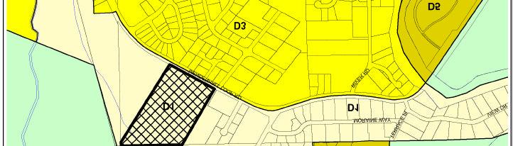
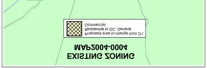
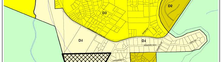
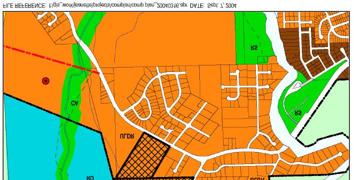
1 MEMORANDUM CITY AND BOROUGH OF JUNEAU 155 S. Seward Street, Juneau, AK DATE: September 30, 2004 TO: FROM: FILE NO: Planning Commission Nathan Bishop, Planner Community Development Department MAP , MAP , and MAP PROPOSAL: MAP : A zone change request to change a acre parcel (TR B2 USS 1796) from D-1 Residential to D-5 Residential on the Back Loop Road near the Montana Creek road. GENERAL INFORMATION Applicant: Property Owner: Property Address: Legal Description: Parcel Code Number: Site Size: Zoning: Utilities: Access: Existing Land Use: Surrounding Land Use: Charles Ramage Catherine & Paul Barrett Living Trust Mendenhall Loop Road USS 1796 TR B2 4-B , square feet D1 City water and sewer to lot Mendenhall Loop Rd. Vacant R.V. Park and vacant land
2 Planning Commission File No.: MAP , 4, 6 September 30, 2004 Page 2 of 5 PROPOSAL: MAP : A zone change request to change a 5.78 acre parcel (Lot 2 Glacier Lands Subdivision) from D-1 Residential to GC, General Commercial along the Montana Creek Road. GENERAL INFORMATION Applicant: Property Owner: Property Address: Wayne Coogan Coogan General LLC 5600 Montana Creek Road Legal Description: Glacier Lands Lot 2 Parcel Code Number: Site Size: Zoning: Utilities: Access: Existing Land Use: Surrounding Land Use: 4-B , square feet D1 On lot sewer and City water Montana Creek Rd. Contractor storage and heavy macinery repair Shooting Range, and sand and gravel quarry PROPOSAL: MAP : A zone change request to change a acre parcel (USS 2178, TR 1) from D-1 Residential to D-3 along Montana Creek Road directly west of the Montana Creek Subdivision. GENERAL INFORMATION Applicant: Property Owner: Property Address: Sandy Bicknell Roscoe Bicknell III, Roscoe Bicknell IV 5401 Montana Creek Road Legal Description: USS 2178 TR 1 Parcel Code Number: Site Size: 4-B ,917, square feet
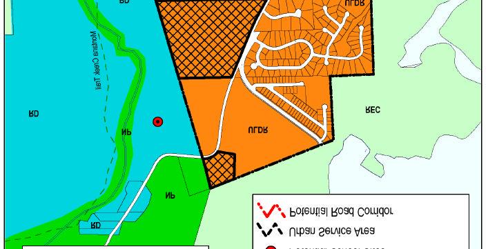
3 Planning Commission File No.: MAP , 4, 6 September 30, 2004 Page 3 of 5 Zoning: Utilities: Access: Existing Land Use: Surrounding Land Use: D1 City Water and Sewer to parcel Montana Creek Road Sand and Gravel Quarry, and Contractor Storage Vacant REZONINGS Initiation A rezoning may be initiated by the Director, the Commission, or the Assembly at any time during the year. A developer or property owner may initiate a request for rezoning in January or July only. Adequate public notice shall be provided by the director to inform the public that a rezoning has been initiated. Restrictions on rezonings Rezoning requests covering less than two acres shall not be considered unless the rezoning constitutes an expansion of an existing zone. Rezoning requests which are substantially the same as a rezoning request rejected within the previous 12 months shall not be considered. A rezoning shall not allow uses which violate the land use maps of the Comprehensive Plan. Procedure A rezoning shall follow the procedure for a major development permit except for the following: (1) The Commission decision for approval shall constitute only a recommendation to the Assembly. (2) As soon as possible after the Commission's recommendation, the Assembly shall provide public notice and hold a public hearing on the proposed rezoning. A rezoning shall be adopted by ordinance, and any conditions thereon shall be contained in the ordinance. Upon adoption of any such ordinance, the Director shall cause the official zoning map to be changed in accordance therewith. Comprehensive Plan Designation The Comprehensive Plan land use designation of the subject parcel is Urban Low Density Residential (ULDR). This designation is intended for residential land for detached single-family units, duplex and zero-lot-line units at densities of one to six units per acre; it may include
4 Planning Commission File No.: MAP , 4, 6 September 30, 2004 Page 4 of 5 mobile homes where specifically permitted. As the densities of the D1, D3, and D5 zoning districts are all below the threshold of six units per an acre, they are all permissible uses of lands within the ULDR designation. Zoning The following districts are established to provide a healthy, safe and pleasant environment for residential living protected from incompatible and disruptive activities: (a) The D-1, residential district is intended to accommodate primarily single-family and duplex residential development in areas outside the urban service boundary at a density of one dwelling unit per acre. Certain D-l zoned lands, however, may exist within the urban service boundary in transition areas if public sewer or water are absent but planned for. The D-1 classification will be changed to a higher density upon provision of services. (b) The D-3, residential district is intended to accommodate primarily single-family and duplex residential development at a density of three dwelling units per acre. D-3 zoned lands are primarily located outside the urban service boundary where public utilities are not provided. The density reflects the existing pattern of development of properties in the district. There is a limited amount of D-3 zoned lands located within the urban service boundary. These are lands for which a lower density is deemed appropriate or, in the case of transition zones, where the zoning wall be changed to a higher density when sewer and water are provided. This zoning designation predates the West Valley Rezone in 1997, where a significant amount of land within the Urban Service Boundary was zoned D3. (c) The D-5, residential district is intended to accommodate primarily single-family and duplex residential development at a density of five dwelling units per acre. D-5 zoned lands are located in the urban service boundary and are served or can be served by public water and sewer. (d) The GC, general commercial district, is intended to accommodate most commercial uses. Commercial activities are permitted outright in the zone except for those few uses that are listed as conditional uses to ensure compatibility.
5 Planning Commission File No.: MAP , 4, 6 September 30, 2004 Page 5 of 5 Attached to this report you will find the following documents: 1. Memorandum from previous CDD Director, Cheryl Easterwood; regarding the 1997 Upper West Mendenhall Valley Zone Change. 2. Map Detailing Staffs recommendation for the 1997 Zone Change 3. Public Response Table tallying publics recommendation for the Zone Change 4. Map showing areas reference in the Public Response Table. 5. Map showing Juneau Wetlands Management Plan, Management Designations of subject area 6. Recent wetlands delineation of Barrett Parcel by Army Corp of Engineers. 7. Recent wetlands delineation of Bicknell Parcel by Art Dunn. 8. Planning Commission Minutes Special Meeting on Zone Change. 9. West Mendenhall Valley Zoning Map as Recommended by the Planning Commission 10. West Mendenhall Valley Zoning Map as Adopted by Ordinance Letter from Chuck Ramage addressing the Barrett Parcel rezone request. These documents should provide you with a good understanding of the recent history surrounding the zoning designations of the subject parcels. The recent wetland delineations provided by the Applicants is new information that has not been considered in previous hearings.


6


7


8

9
Rezone property from RR(T)D3, D1(T)D3, and RR(T)D15 to D3 and D15 along North Douglas Highway.
D3, D1(T)D3, and RR(T)D15 to D3 and D15 along North Douglas Highway.") DATE: TO: FROM: Planning Commission Chrissy McNally, Planner Community Development Department FILE NO.: AME2013 0016 PROPOSAL: Rezone property from RR(T)D3, D1(T)D3, and RR(T)D15 to D3 and D15 along North
DATE: TO: FROM: Planning Commission Chrissy McNally, Planner Community Development Department FILE NO.: AME2013 0016 PROPOSAL: Rezone property from RR(T)D3, D1(T)D3, and RR(T)D15 to D3 and D15 along North
*** PUBLIC NOTICE ***
 *** PUBLIC NOTICE *** UAS ADMINISTRATIVE SERVICES BUILDING LEASE DISPOSAL PLAN JUNEAU, ALASKA The University of Alaska is offering for lease an approximately 10,000 square foot, one-story commercial and
United States Post Office and Multi-Family Residential; and, Single- Family Residence with an Apartment
 Planning Commission File No.: AME2013 0009 January 9, 2014 Page 2 of 9 Existing Land Use: United States Post Office and Multi-Family Residential; and, Single- Family Residence with an Apartment Surrounding
Community Development Department. This memorandum provides points of clarification as requested for the above noted project.
 MEMORANDUM Community Development Department Date: November 13, 2014 To: From: Planning Commission Travis Goddard, Planning Manager Community Development Department File No: AME2013 0016 Re: Supplemental
Jonathan Lange, Planner Community Development Department
 DATE: March 10, 2014 TO: FROM: Planning Commission Jonathan Lange, Planner Community Development Department FILE NO.: AAP2014 0001 PROPOSAL: A Conditional Use permit application for an accessory apartment
LAND USE. Land Cover. Current Land Use
 LAND USE Land Cover To begin the process at a more general level, land cover information was assembled to identify general patterns of developed/undeveloped areas. The data used to present this information
Mohave County General Plan
 63 64 65 66 67 68 69 70 71 The Land Use Diagram is not the County's zoning map. 13 It is a guide to future land use patterns. Zoning and area plan designations may be more restrictive than the land use
2013 CBJ LAND STUDY NEIGHBORHOOD SUMMARY ANALYSIS
 Overview: For 2013, the overall assessment process included 3 major components; 1) cluster modeling of the land; 2)revert structure value to Replacement Cost New Less Depreciation (Cost Approach) and 3)
SECTION 10 AGRICULTURAL ZONES
 10.1 Agricultural (A) Zone (1) Permitted Uses: abattoir agricultural use cemetery communications facility conservation use farm equipment dealer farm produce outlet farm produce storage feed mill forestry
LAND USE INTRODUCTION EXISTING CONDITIONS
 INTRODUCTION This chapter describes land use in the Lemon Creek area using maps and data that show designations of all properties by the 2013 Comprehensive Plan, zoning code, and locations of developed
BOARD OF ZONING ADJUSTMENT STAFF REPORT Date: September 10, 2018
 BOARD OF ZONING ADJUSTMENT STAFF REPORT Date: September 10, 2018 CASE NUMBER 6205 APPLICANT NAME LOCATION Branch Towers III, LLC 2500 Burden Lane (West terminus of Burden Lane) VARIANCE REQUEST SURFACING:
ORDINANCE NO. NOW, THEREFORE, BE IT ORDAINED BY THE CITY COUNCIL OF THE CITY OF BRYAN, TEXAS:
 LOCATION MAPS: ORDINANCE NO. AN ORDINANCE OF THE CITY OF BRYAN, TEXAS, AMENDING CHAPTER 130, ZONING, OF THE CITY OF BRYAN CODE OF ORDINANCES, BY CHANGING THE ZONING CLASSIFICATION FROM AGRICULTURAL - OPEN
CHAPTER 50 LAND USE ZONES ARTICLE 50 BASIC PROVISIONS
 CHAPTER 50 LAND USE ZONES ARTICLE 50 BASIC PROVISIONS 50.010 - PURPOSE The purposes of this chapter are to establish land use zones required to implement the goals and policies of the Klamath County Comprehensive
MPC STAFF REPORT REZONING MAP AMENDMENT ALDERMANIC DISTRICT 1 COUNTY COMMISSION DISTRICT 5 April 3, 2013 MPC FILE NUMBER.
 MPC STAFF REPORT REZONING MAP AMENDMENT ALDERMANIC DISTRICT 1 COUNTY COMMISSION DISTRICT 5 April 3, 2013 MPC FILE NUMBER. 13-000929-ZA REZONING SUMMARY Report Status Initial Report Petitioner/Property
The applicant is requesting the rezoning of a 0.38-acre lot from R-T (Residential Transitional) to I-G (General Industrial).
 to I-G (General Industrial).") LINCOLN COUNTY PLANNING & INSPECTIONS DEPARTMENT 302 NORTH ACADEMY STREET, SUITE A, LINCOLNTON, NORTH CAROLINA 28092 704-736-8440 OFFICE 704-736-8434 INSPECTION REQUEST LINE 704-732-9010 FAX To: Board
LINCOLN COUNTY PLANNING & INSPECTIONS DEPARTMENT 302 NORTH ACADEMY STREET, SUITE A, LINCOLNTON, NORTH CAROLINA 28092 704-736-8440 OFFICE 704-736-8434 INSPECTION REQUEST LINE 704-732-9010 FAX To: Board
Master Plan Review POTOMAC. Approved and Adopted March Updated January 2013
 Master Plan Review POTOMAC Approved and Adopted March 2002 BACKGROUND ZONING CODE REWRITE In 2007, the Montgomery County Council directed the Planning Department to undertake a comprehensive zoning ordinance
Rapid City Planning Commission Rezoning Project Report
 Rapid City Planning Commission Rezoning Project Report April 21, 2016 Item #9 Applicant Request(s) Case # 16RZ011; a request to rezone property from Central Business District to General Commercial District
Planning Department Oconee County, Georgia
 Planning Department Oconee County, Georgia STAFF REPORT REZONE CASE #: 6985 DATE: October 31, 2016 STAFF REPORT BY: Andrew C. Stern, Planner APPLICANT NAME: Williams & Associates, Land Planners PC PROPERTY
(Not to exceed a total of 10 minutes nor more than 2 minutes for any individual).
.") I. ROLL CALL II. III. IV. APPROVAL OF AGENDA APPROVAL OF MINUTES A. March 20, 2017 Minutes PUBLIC PARTICIPATION ASSEMBLY STANDING COMMITTEE LANDS AND RESOURCES COMMITTEE THE CITY AND BOROUGH OF JUNEAU,
I. ROLL CALL II. III. IV. APPROVAL OF AGENDA APPROVAL OF MINUTES A. March 20, 2017 Minutes PUBLIC PARTICIPATION ASSEMBLY STANDING COMMITTEE LANDS AND RESOURCES COMMITTEE THE CITY AND BOROUGH OF JUNEAU,
891941, , : COMPREHENSIVE PLAN AMENDMENT, COMMUNITY PLAN AMENDMENT, AND AREA-WIDE MAP AMENDMENT
 Application Nos. 891941, 891909, 891940: COMPREHENSIVE PLAN AMENDMENT, COMMUNITY PLAN AMENDMENT, AND AREA-WIDE MAP AMENDMENT Amendments to designate five parcels as Rural Industrial Center in the Alderton
Eric Feldt, Planner II, CFM Community Development Department
 DATE: August 28, 2014 TO: FROM: Board of Adjustment Eric Feldt, Planner II, CFM Community Development Department FILE NO.s: VAR2014 0017 & VAR2014 0018 PROPOSAL: A Variance to reduce two side yard setbacks
CHAPTER 2: ZONING DISTRICTS
 CHAPTER 2: ZONING DISTRICTS 2.1. GENERAL 2.1.1. Purpose To carry out the purpose and provisions of this Code, the County is divided into zoning districts. This chapter establishes the base zoning districts
REPORT OF THE PLANNING AND DEVELOPMENT DEPARTMENT FOR APPLICATION FOR REZONING ORDINANCE TO PLANNED UNIT DEVELOPMENT AUGUST 20, 2015
 BEL REPORT OF THE PLANNING AND DEVELOPMENT DEPARTMENT FOR APPLICATION FOR REZONING ORDINANCE TO PLANNED UNIT DEVELOPMENT AUGUST 20, 2015 The Planning and Development Department hereby forwards to the Planning
PLAINFIELD CHARTER TOWNSHIP COMMUNITY DEVELOPMENT DEPARTMENT PLANNING, ZONING & BUILDING SERVICES MEMORANDUM
 PLAINFIELD CHARTER TOWNSHIP COMMUNITY DEVELOPMENT DEPARTMENT PLANNING, ZONING & BUILDING SERVICES 6161 BELMONT AVENUE N.E. BELMONT, MI 49306 PHONE 616-364-1190 FAX: 616-364-1170 www.plainfieldchartertwp.org
RE: 6. GILL/GREEN COMPREHENSIVE PLAN AMENDMENT, REZONING AND PRELIMINARY PLAT
 commission memo DATE: Thursday - August 9, 2018 TO: Marion Planning & Zoning Commission FROM: David N. Hockett, AICP Principal Planner RE: 6. GILL/GREEN COMPREHENSIVE PLAN AMENDMENT, REZONING AND PRELIMINARY
Staff Report. Planning Commission Public Hearing: October 17, 2007 Staff Recommendation: Denial
 COUNTY OF PRINCE WILLIAM 5 County Complex Court, Prince William, Virginia 22192-9201 PLANNING (703) 792-6830 Metro 631-1703, Ext. 6830 FAX (703) 792-4401 OFFICE Internet www.pwcgov.org Stephen K. Griffin,
Amendment No. 41. City of Mississauga Planning Area
 Amendment No. 41 to Mississauga Official Plan for the City of Mississauga Planning Area Amendment No. 41 to Mississauga Official Plan for the City of Mississauga Planning Area The following text and Map
PLANNING COMMISSION REPORT Regular Agenda - Public Hearing Item
 Z-11-25-09; Z-11-26-09; Z-11-28-09 Item No. 2-1 PC Staff Report 3/28/11 PLANNING COMMISSION REPORT Regular Agenda - Public Hearing Item ITEM NO. 2A RM32 TO MU;.19 ACRES; 1340 TENNESSEE ST (MJL) Z-1-1-11:
Village WASHINGTON TOWNSHIP MASTER PLAN SYNTHESIS. Page 197
 Village P l a n WASHINGTON TOWNSHIP MASTER PLAN SYNTHESIS Page 197 SECTION 11.0 MASTER PLAN SYNTHESIS INTRODUCTION The proposals presented in the various plans result in a graphic synthesis: The Land Use
Marion County Board of County Commissioners
 Marion County Board of County Commissioners Date: 12/29/2015 P&Z: 12/28/2015 BCC: 1/12/2016 Item Number 160113Z Type of Application Rezoning Request From: A-1 (General Agriculture) To: PUD (Planned Unit
The petition proposes to allow a for-sale townhouse community located in Southwest Charlotte, across from the McDowell Nature Preserve.
 Rezoning Petition 2018-110 Pre-Hearing Staff Analysis April 15, 2019 REQUEST LOCATION Current Zoning: R-3 (single family residential) Proposed Zoning: R-8MF(CD) (multi-family residential, conditional)
A. Location. A MRD District may be permitted throughout the County provided it meets the standards established herein.
 752. Multi-Residential District (MRD) The Multi-Residential (MRD) District is intended to provide opportunities for rural, suburban and urban density mixed-residential developments consistent with the
STAFF REPORT. Permit Number: Unlimited. Kitsap County Board of Commissioners; Kitsap County Planning Commission
 STAFF REPORT Permit Number: 15 00550 Unlimited DATE: March 2, 2016 TO: FROM: Kitsap County Board of Commissioners; Kitsap County Planning Commission Katrina Knutson, AICP, Senior Planner, DCD and Jeff
2. Second dwellings and medical hardships per Article 10.
 Article 7: Zoning Districts and Zoning Map Section 135: NON-URBAN ZONING DISTRICT (NU) A. Purpose The intent of this district is to allow agricultural, recreational, wildlife, forestry, open space, farming
City of Valdosta Land Development Regulations
 Chapter 206 Section 206-1 Base Zoning Districts Standards for Uses, Structures, and Property Development (B) (C) Principal Uses and Structures. Principal uses and structures permitted in each base zoning
Existing Land Use. Typical densities for single-family detached residential development in Cumberland County: 1
 Existing Land Use A description of existing land use in Cumberland County is fundamental to understanding the character of the County and its development related issues. Economic factors, development trends,
SALMON CREEK TO VANDERBILT HILL THANE ROAD LEMON CREEK AREA JUNEAU DOWNTOWN SWITZER CREEK AREA DOUGLAS ISLAND - WEST JUNEAU
 BUILDING PERMIT REVIEW STATUS by Location as of 8:00am on 2/4/2019 Please note this report is updated once daily, Monday through Friday and is only to be used as an estimation of plan review status. Plan
PUTNAM TOWNSHIP. Schedule of Development Review Fees. As adopted by the Putnam Township Board August 16, 1995 Effective September 22, 1995
 PUTNAM Schedule of Development Review Fees As adopted by the Putnam Township Board August 16, 1995 Effective September 22, 1995 (Rev. 11-28-00) (Rev. 8-30-02) (Rev. 6-17-05) (Rev. 10-8-07) (Rev. 2-27-09)
SECTION 3. Housing. Appendix A LAND USE DEFINITIONS
 SECTION 3 Housing A Appendix A LAND USE DEFINITIONS A-2 Housing Commission Attachment B Appendix A Land Use Definitions INTRODUCTION The Land Use Map (Figure A-1) of Community Vision 2040 illustrates the
LAND USE. Land Use Pattern. C. Land Use West Anchorage District Plan
 C. Land Use West Anchorage District Plan LAND USE Existing and future land use is a major focus of the West Anchorage District Plan (WADP). Initial guidance for addressing land use in West Anchorage is
NW AUBURN NEIGHBORHOOD PLAN BRAGG AVENUE MLK DRIVE
 NW AUBURN NEIGHBORHOOD PLAN BRAGG AVENUE MLK DRIVE Educational Meeting #2 December 13, 2016 STUDY AREA 1.38 square miles 880 acres 730 developable acres Population: 3,171 (2010 Census Block Data) SHUG
Hamilton County Regional Planning Commission
 Hamilton County Regional Planning Commission March 1, 2012 Colerain Township Staff Report Zone Map Amendment: Case No.: ZA2012-01 Joseph Toyota Prepared By: Amy Bancroft, Land Use Planner ACTION REQUESTED:
R e z o n i n g A p p l i c a t i o n S u b m i s s i o n R e q u i r e m e n t s
 H O R R Y C O U N T Y P L A N N I N G & Z O N I N G 1 3 0 1 2 N D A V E., S U I T E 1 D - 0 9 C O N W A Y, S. C. 2 9 5 2 6 P H O N E : 8 4 3. 9 1 5. 5 3 4 0 F A X : 8 4 3. 9 1 5. 6 3 4 1 R e z o n i n
ii. That the driveway access from Desloges Road be controlled with a gate and access only be used for maintenance and emergency purposes; and,
 Presented To: Planning Committee Request for Decision Melissa Cotesta - Application for rezoning in order to permit a contractor s yard and warehouse, Pioneer Road, Sudbury Presented: Monday, Jun 27, 2016
Marcel Williams, MPC Project Planner
 TO: FROM: The Planning Commission MPC Staff DATE: SUBJECT: Petition to Rezone Property Heath Shelton, Owner Jay Maupin, Agent 2026 Habersham Street Aldermanic District: 2, Bill Durrence County Commission
Future Land Use Categories & Nodes December 23, Future Land Use Categories
 Future Land Use Categories & Nodes December 23, 2015 A note regarding nodes: Descriptions for nodes are located in the general recommendations handout. Node locations are set in part by the Auburn Interactive
A Conditional Use permit for the development of a floriculture farm on two lots in North Douglas.
 DATE: June 27, 2014 TO: FROM: Planning Commission Jonathan Lange, Planner Community Development Department FILE NO.: USE2014 0007 PROPOSAL: A Conditional Use permit for the development of a floriculture
PC Staff Report 11/18/2013 Z Item No. 1-1
 Z-13-00401 Item No. 1-1 PLANNING COMMISSION REPORT Regular Agenda - Public Hearing Item PC Staff Report 11/18/2013 ITEM NO. 1: Z-13-00401 IG (General Industrial) District TO CS (Strip Commercial) District;
PLANNING COMMISSION STAFF REPORT
 PLANNING COMMISSION STAFF REPORT REZONING CASE: RZ-16-001 REPORT DATE: March 8, 2016 CASE NAME: Trailbreak Partners Rezoning PLANNING COMMISSION DATE: March 16, 2016 ADDRESSES OF REZONING PROPOSAL: 5501
ADMINISTRATION RECOMMENDATION(S) 2018 January 25. That Calgary Planning Commission recommends APPROVAL of the proposed Land Use Amendment.
 2018 January 25. That Calgary Planning Commission recommends APPROVAL of the proposed Land Use Amendment.") Page 1 of 8 EXECUTIVE SUMMARY This land use amendment application seeks to redesignate a single residential parcel from a Residential Contextual One Dwelling (R-C1) District to a Residential Contextual
Page 1 of 8 EXECUTIVE SUMMARY This land use amendment application seeks to redesignate a single residential parcel from a Residential Contextual One Dwelling (R-C1) District to a Residential Contextual
South of White Rock Rezoning Kick-off Meeting
 South of White Rock Rezoning Kick-off Meeting May 6, 2010, 2:00 P.M. American River Room Overview Property owners seeking to restore previous zoning designations City now completing map revisions (north
REPORT OF THE PLANNING AND DEVELOPMENT DEPARTMENT FOR APPLICATION FOR REZONING ORDINANCE TO PLANNED UNIT DEVELOPMENT SEPTEMBER 22, 2016
 BEL REPORT OF THE PLANNING AND DEVELOPMENT DEPARTMENT FOR APPLICATION FOR REZONING ORDINANCE 2016-576 TO PLANNED UNIT DEVELOPMENT SEPTEMBER 22, 2016 The Planning and Development Department hereby forwards
MINUTES PLANNING COMMISSION CITY AND BOROUGH OF JUNEAU, ALASKA REGULAR MEETING MAY 11, 2004
 MINUTES PLANNING COMMISSION CITY AND BOROUGH OF JUNEAU, ALASKA REGULAR MEETING MAY 11, 2004 The Regular Meeting of the City and Borough of Juneau Planning Commission, held in the Assembly Chambers of the
Amendments to Chapter proposed by the Assembly Title 21 Committee
 Amendments to Chapter 21.04 proposed by the Assembly Title 21 Committee All page numbers refer to the S version. PZC recommended additions are underlined. PZC recommended deletions are in [BRACKETS AND
BUILDING PERMIT APPLICATIONS 09/01/2016 to 09/30/2016
 City and Borough of Juneau, Alaska Page 1 of 6 BUILDING PERMIT APPLICATIONS 09/01/2016 to 09/30/2016 Permit No. Date Permit Dwell Description Rec'd Date Status Units Valuation Property Address Property
*** PUBLIC NOTICE ***
 Reference 4 *** PUBLIC NOTICE *** UNIVERSITY OF ALASKA BILL RAY CENTER OFFICE BUILDING AND PARKING LOT DISPOSAL PLAN JUNEAU, ALASKA The University of Alaska ( University ) is offering for sale an approximately
Town of Hamburg. Planning Board Work Session. January 7, Minutes
 Town of Hamburg Planning Board Work Session January 7, 2009 Minutes The Town of Hamburg Planning Board met for a Work Session on Wednesday, January 7, 2009 at 7:30 p.m. in Room 7B of Hamburg Town Hall,
LINCOLN COUNTY PLANNING & INSPECTIONS DEPARTMENT
 LINCOLN COUNTY PLANNING & INSPECTIONS DEPARTMENT 302 NORTH ACADEMY STREET, SUITE A, LINCOLNTON, NORTH CAROLINA 28092 704-736-8440 OFFICE 704-736-8434 INSPECTION REQUEST LINE 704-732-9010 FAX To: Board
SALMON CREEK TO VANDERBILT HILL THANE ROAD LEMON CREEK AREA JUNEAU DOWNTOWN SWITZER CREEK AREA DOUGLAS ISLAND - WEST JUNEAU
 BUILDING PERMIT REVIEW STATUS by Location as of 8:00am on 1/2/2019 Please note this report is updated once daily, Monday through Friday and is only to be used as an estimation of plan review status. Plan
City of Spokane Infill Development. June 30, 2016
 City of Spokane Infill Development June 30, 2016 Today s Agenda Introductions Background and Adopted Policy Infill Forms: Facilitated Group Discussion Small-Group Discussions Groups Report Out Next Steps
CITY AND BOROUGH OF JUNEAU
 CITY AND BOROUGH OF JUNEAU Over-the-Counter Land Sale Brochure Renninger Subdivision Lots 4 & 5 Lands Manager Greg Chaney and Deputy Lands Manager Dan Bleidorn mark Lot 4 in the Renninger Subdivision.
ASSEMBLY AGENDA/MANAGER'S REPORT THE CITY AND BOROUGH OF JUNEAU, ALASKA August 31, :00 PM. City Hall Assembly Chambers Regular Meeting
 Packet Page of ASSEMBLY AGENDA/MANAGER'S REPORT THE CITY AND BOROUGH OF JUNEAU, ALASKA August, 0 :00 PM City Hall Assembly Chambers Regular Meeting 0- I. FLAG SALUTE II. ROLL CALL III. SPECIAL ORDER OF
Rezoning Petition Final Staff Analysis July 16, 2018
 Rezoning Petition 2018-041 Final Staff Analysis July 16, 2018 REQUEST LOCATION Current Zoning: R-5 (single family residential, and UR-2(CD) (urban residential, conditional) Proposed Zoning: UR-2(CD) (urban
Bethel Romanian Church - Rezone, RZ
 / Planning and Zoning Staff Report Bethel Romanian Church - Rezone, RZ2018-0023 Hearing Date: November 15, 2018 Development Services Department Owners: Bethel Romanian Church, Corp. Applicant: Viorel Botos
LEE COUNTY, FLORIDA DEPARTMENT OF COMMUNITY DEVELOPMENT ZONING DIVISION STAFF REPORT. A. Applicant: Ronald Principato/ Principato Accessory Apartment
 LEE COUNTY, FLORIDA DEPARTMENT OF COMMUNITY DEVELOPMENT ZONING DIVISION STAFF REPORT TYPE OF CASE: CASE NUMBER: SPECIAL EXCEPTION SEZ2010-00002 HEARING EXAMINER DATE: JUNE 30, 2010 I. APPLICATION SUMMARY:
Chapter 2 Land Use. State of Land Use
 Ch2 6/21/2016 1 Chapter 2 Land Use The responsibility of a municipality to manage and regulate land use is rooted in its need to protect the health, safety, and welfare of local citizens. Although only
Town of Cary, North Carolina Rezoning Staff Report 14-REZ-31 Cary Park PDD Amendment (Waterford II) Town Council Meeting January 15, 2015
 Town Council Meeting January 15, 2015") Town of Cary, North Carolina Rezoning Staff Report 14-REZ-31 Cary Park PDD Amendment (Waterford II) Town Council Meeting January 15, 2015 REQUEST To amend the Town of Cary Official Zoning Map by amending
Town of Cary, North Carolina Rezoning Staff Report 14-REZ-31 Cary Park PDD Amendment (Waterford II) Town Council Meeting January 15, 2015 REQUEST To amend the Town of Cary Official Zoning Map by amending
GENERAL DESCRIPTION STAFF RECOMMENDATION IMPLEMENTATION REQUIREMENTS
 Application No.: 891418 Applicant: AREA-WIDE MAP AMENDMENT Rezone two parcels from Moderate Density Single Family (MSF) to Neighborhood Center (NC) and Employment Center (EC). Charles Bitton GENERAL DESCRIPTION
FEC The purpose of the Flexible Use Employment Center classification is to provide for areas of employment uses situated on individual sites or in
 FEC The purpose of the Flexible Use Employment Center classification is to provide for areas of employment uses situated on individual sites or in campus-style parks. Primary uses in the FEC classification
Buildable Lands Analysis within the Overall UGB Expansion Process
 CHAPTER 3. BUILDABLE LANDS ANALYSIS The buildable lands inventory is intended to identify lands that are available for development within the UGB. The inventory is sometimes characterized as supply of
8Land Use. The Land Use Plan consists of the following elements:
 8Land Use 1. Introduction The Land Use Plan consists of the following elements: 1. Introduction 2. Existing Conditions 3. Opportunities for Redevelopment 4. Land Use Projections 5. Future Land Use Policies
Planning Commission Application Summary
 Planning Commission Application Summary Project Name: Creekside Estates Zone Change and Land Use Amendment Address: 571 West 11400 South Current Zoning: RA1 Hearing Date: July 14, 2016 Summary of Request
ARTICLE B ZONING DISTRICTS
 ARTICLE B ZONING DISTRICTS Sec. 8-3021 Established. In order to protect the character of existing neighborhoods; to prevent excessive density of population in areas which are not adequately served with
DIVISION 1 PURPOSE OF DISTRICTS
 ARTICLE 2 ZONING DISTRICTS AND MAP DIVISION 1 PURPOSE OF DISTRICTS Section 2.101 Zoning Districts. For the purpose of this Ordinance, the City of Richmond is hereby divided into districts as follows: DISTRICT
COUNTY OF LINCOLN, NORTH CAROLINA
 COUNTY OF LINCOLN, NORTH CAROLINA 302 NORTH ACADEMY STREET, SUITE A, LINCOLNTON, NORTH CAROLINA 28092 PLANNING AND INSPECTIONS DEPARTMENT 704-736-8440 OFFICE 704-732-9010 FAX To: George Wood County Manager
PLANNED UNIT DEVELOPMENT STAFF REPORT Date: October 19, 2017
 PLANNED UNIT DEVELOPMENT STAFF REPORT Date: October 19, 2017 DEVELOPMENT NAME LOCATION Custom Boat Storage 3975 Demetropolis Road (East side of Demetropolis Road, 0.2± miles South of Halls Mill Road.)
Marion County Planning & Zoning Commission
 Marion County Planning & Zoning Commission Date: 10/1/2013 P&Z: 10/28/2013 BCC: 11/19/2013 Item Number 131106Z Type of Application Rezoning Request Zoning change from R- 1 Single-Family Dwelling to R-4
PLANNING RATIONALE 680 BRONSON AVENUE OTTAWA, ONTARIO PROPOSED ZONING BY-LAW AMENDMENT
 PLANNING RATIONALE 680 BRONSON AVENUE OTTAWA, ONTARIO PROPOSED ZONING BY-LAW AMENDMENT FRANK PARAVAN APRIL 2014 Planning Rationale Introduction FOTENN Consultants Inc. has been engaged by Frank and Michael
TREASURE COAST REGIONAL PLANNING COUNCIL M E M O R A N D U M. February 19, 2010 Regional Planning Council Meeting
 TREASURE COAST REGIONAL PLANNING COUNCIL M E M O R A N D U M To: Council Members AGENDA ITEM 5G From: Date: Subject: Staff February 19, 2010 Regional Planning Council Meeting Local Government Comprehensive
PLANNING & DEVELOPMENT
 PLANNING & DEVELOPMENT STAFF REPORT Rezoning PETITION: APPLICANT: PROPERTY OWNER: TYPE OF REQUEST: SIZE OF TRACT: LOCATION: (#17-22) Rezone from A-PUD (Agri-Business Planned Unit Development) to A-PUD
ARTICLE 1 Development Code Applicability
 CITY OF GRASS VALLEY MUNICIPAL CODE - TITLE 17 - DEVELOPMENT CODE ARTICLE 1 Development Code Applicability Chapter 17.10 - Purpose and Applicability of Development Code... 1-3 17.10.010 - Purposes of the
Comprehensive Plan 2015 to 2030 STATE OF LAND USE
 Chapter 2 Land Use The responsibility of a municipality to manage and regulate land use is rooted in its need to protect the health, safety, and welfare of local citizens. Although only acting as one section
Dennis & Donna Blanchard, Agent. Dennis & Donna Blanchard/Disbrow Builders, Inc.
 Nassau County Growth Management Department 96161 Nassau Place Yulee, FL 32097 (904) 491-7328 (904) 491-3611 FAX Date of Hearing: March 3, 2015 BOARD MEMBERS Thomas Ford (Chairman) Gene Bennett John Stack
Rezoning Petition Pre-Hearing Staff Analysis December 4, 2018
 Rezoning Petition 2018-108 Pre-Hearing Staff Analysis December 4, 2018 REQUEST Current Zoning: I-1 (light industrial) Proposed Zoning: R-22MF(CD) (multi-family residential, conditional) LOCATION Approximately
REPORT OF THE PLANNING AND DEVELOPMENT DEPARTMENT FOR APPLICATION FOR REZONING ORDINANCE TO PLANNED UNIT DEVELOPMENT MAY 18, 2017
 BEL REPORT OF THE PLANNING AND DEVELOPMENT DEPARTMENT FOR APPLICATION FOR REZONING ORDINANCE 2016-805 TO PLANNED UNIT DEVELOPMENT MAY 18, 2017 The Planning and Development Department hereby forwards to
Metropolitan Planning Commission. DATE: April 5, 2016
 TO: FROM: Metropolitan Planning Commission MPC Staff DATE: April 5, 2016 SUBJECT: Petition of Nine Line Inc. Robert McCorkle, Agent PIN: 2-1034-01-002 380.5 Acres Aldermanic District: 5 (Shabazz) County
Official Community Plan (OCP) LAND USE HANDBOOK
 LAND USE HANDBOOK") Official Community Plan (OCP) LAND USE HANDBOOK APRIL 2018 1 Land use designations are one of the key implementation tools for achieving the growth strategy and managing development in the city. They establish
Official Community Plan (OCP) LAND USE HANDBOOK APRIL 2018 1 Land use designations are one of the key implementation tools for achieving the growth strategy and managing development in the city. They establish
STAFF SUMMARY OF Z17-10 CONDITIONAL ZONING DISTRICT APPLICATION
 STAFF SUMMARY OF Z17-10 CONDITIONAL ZONING DISTRICT APPLICATION APPLICATION SUMMARY Case Number: Z17-10 Request: Conditional B-2 Zoning District in order to expand an existing retail and warehousing business
(B) On lots less than 1.5 acres, accessory buildings shall have a maximum size of 672 square feet in area.
 On lots less than 1.5 acres, accessory buildings shall have a maximum size of 672 square feet in area.") Setbacks in Commercial Districts: (1) Downtown Business District: Setbacks from State Highways 70 and 155 shall be the lesser of a minimum of 100 feet or the footprint of the present principal building
Setbacks in Commercial Districts: (1) Downtown Business District: Setbacks from State Highways 70 and 155 shall be the lesser of a minimum of 100 feet or the footprint of the present principal building
KNOXVILLE/KNOX COUNTY METROPOLITAN PLANNING COMMISSION SUBDIVISION REPORT - CONCEPT/USE ON REVIEW
 KNOXVILLE/KNOX COUNTY METROPOLITAN PLANNING COMMISSION SUBDIVISION REPORT - CONCEPT/USE ON REVIEW FILE #: 9-SC-17-C 9-I-17-UR AGENDA ITEM #: 17 AGENDA DATE: 9/14/2017 SUBDIVISION: APPLICANT/DEVELOPER:
City of Greer Planning Commission Minutes July 17, 2017
 City of Greer Planning Commission Minutes July 17, 2017 Members Present: Member(s) Absent: Staff Present: Kevin Tumblin, Chairman Don Foster Judy O. Jones Mark Hopper Brian Martin Micky Montgomery Suzanne
CITY OF PORT ORCHARD
 CITY OF PORT ORCHARD ZONING DESIGNATIONS (Adapted from POMC Chapter 20.34 Zoning Districts, as adopted 6/13/2017) 20.34.110 Greenbelt zone (Gb). (1) Purpose. It is the purpose of the greenbelt zone to
MS MINOR SUBDIVISION TREVITHICK
 MS-02-015 341.12 MINOR SUBDIVISION TREVITHICK A request by Danny Trevithick for a one-lot Minor Subdivision on five acres. The property is zoned A-35 (Agricultural) District and is located ¼ mile south
River Rock Estates Sketch Plan, a proposed major subdivision in S24, T35N R2W NMPM on County Rd 119 (PLN18-336)
") MEMORANDUM Archuleta County Development Services Planning Department 1122 HWY 84 P. O. Box 1507 Pagosa Springs, Colorado 81147 970-264-1390 Fax 970-264-3338 TO: Archuleta County Planning Commission FROM:
MEMORANDUM Archuleta County Development Services Planning Department 1122 HWY 84 P. O. Box 1507 Pagosa Springs, Colorado 81147 970-264-1390 Fax 970-264-3338 TO: Archuleta County Planning Commission FROM:
PAPRlamird4-Lairds Corner
 PAPRlamird4-Lairds Corner Lamird Report This report provides the written record of local circumstances that explains how the Lairds Corner LAMIRD ( this lamird ) fits within the rural element goals of
STAFF REPORT FOR Z19-01 CONDITIONAL ZONING DISTRICT APPLICATION
 STAFF REPORT FOR Z19-01 CONDITIONAL ZONING DISTRICT APPLICATION APPLICATION SUMMARY Case Number: Z19-01 Request: To rezone the southern 2 acres of the subject property along Piner Road to (CZD) B-1 in
Comprehensive Plan Amendment #PLN , Reserve at Cannon Branch (Coles Magisterial District)
") COUNTY OF PRINCE WILLIAM 5 County Complex Court, Prince William, Virginia 22192-9201 PLANNING (703) 792-7615 FAX (703) 792-4758 OFFICE Internet www.pwcgov.org Christopher M. Price, AICP Director of Planning
COUNTY OF PRINCE WILLIAM 5 County Complex Court, Prince William, Virginia 22192-9201 PLANNING (703) 792-7615 FAX (703) 792-4758 OFFICE Internet www.pwcgov.org Christopher M. Price, AICP Director of Planning
HOOD RIVER COUNTY EXCEPTIONS DOCUMENT. (Amended 12/17/84)
") HOOD RIVER COUNTY EXCEPTIONS DOCUMENT 1984 (Amended 12/17/84) COUNTY EXCEPTIONS DOCUMENT The Hood River County Comprehensive Land Use Plan is the basic instrument used for County land use planning. It
HOOD RIVER COUNTY EXCEPTIONS DOCUMENT 1984 (Amended 12/17/84) COUNTY EXCEPTIONS DOCUMENT The Hood River County Comprehensive Land Use Plan is the basic instrument used for County land use planning. It
MONTGOMERY COUNTY PLANNING DEPARTMENT THE MARYLAND-NATIONAL CAPITAL PARK AND PLANNING COMMISSION
 MONTGOMERY COUNTY PLANNING DEPARTMENT THE MARYLAND-NATIONAL CAPITAL PARK AND PLANNING COMMISSION MCPB Item No. 10 Date: 6-20-13 Zoning Text Amendment (ZTA) No. 13-05, US 29 Overlay Zone Standards Gregory
City of Astoria Comprehensive Plan URBAN GROWTH
 URBAN GROWTH CP.110 CP.110. Background Summary. Astoria has a population of 9,477 (2010 US Census). The total land area within the Urban Growth Boundary (UGB) is 3,474.2 acres with total land area of 4,450