CHAGRIN HIGHLANDS ORANGE SOUTH Orange Village, Ohio
|
|
|
- Delilah Bailey
- 5 years ago
- Views:
Transcription

1 CHAGRIN HIGHLANDS ORANGE SOUTH Orange Village, Ohio Preliminary Land Use Plan Submission Developer CHAGRIN HIGHLANDS, LTD. Submitted by The Richard E. Jacobs Group LLC Cleveland, Ohio October 2015
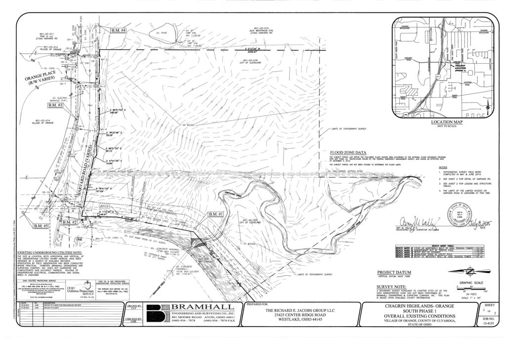
2 Introduction This Preliminary Land Use Plan Submission is presented to the City of Orange Village to reaffirm and update the Preliminary Land Use Plan Submittal for Chagrin Highlands approved by Orange Village March 3, Chagrin Highlands, Ltd. intends to continue the development of high quality corporate office and mixed-use commercial projects in the Orange South District made possible by the Interstate 271 Interchange at Harvard Road and the related transportation and utility infrastructure improvements completed in support of the Chagrin Highlands project. This submittal remains consistent with the original planning for the area as guided by the Planned Mixed-Use Development District (PM-UD) zoning with emphasis on offering a superior location for development of office buildings, hotels, full-service restaurants and similar allowed uses. The Orange South District of Chagrin Highlands presents a unique opportunity to provide highly-visible, easily accessed, well served, and attractive real estate sites. The overall project will continue to preserve significant environmental features while incorporating lawns, street trees, street lights, setbacks, open space, and generous landscaping to create an appealing and desirable setting for new development. A carefully planned and thoughtfully designed, phased development strategy is intended. Existing Conditions The existing conditions of the Orange South District remain substantially unchanged since the original plan submittal. A copy of the current Overall Existing Conditions Survey for Orange South Phase 1 prepared by Bramhall Engineering and Surveying is included with the attached Drawings. Chagrin Highlands, Ltd. has completed reevaluation of current wetland conditions and related environmental investigations and surveys in preparation of this submittal. The Orange North District of Chagrin Highlands across Harvard Road has been fully developed. The Orange Place roadway and related utility infrastructure has been completed generally as planned. Development access to Orange South will be opposite the Orange Place intersection at Harvard Road as previously envisioned. 1 P age
3 The adjacent property to the east of the Orange South District remains undeveloped. More recent rezoning of single family residential land east of the Orange North District has allowed for progress on development of the large, retail and mixed-use Pinecrest project. Demolition and site preparation for this project has commenced. Primary access to this project is planned from the Orange Place intersection of Harvard Road. Development Plan The Preliminary Land Use Plan for Orange South is presented on Drawing 01-LU. Of the 77.8 acre district, 12.1 acres are anticipated to be used for roadways, easements, and stormwater areas; 4.9 acres will be used for restaurants; 2.8 acres for a hotel; 27.6 acres for office development; and 30.4 acres will remain open space and conservation areas. These proposed areas conform with general regulations of the PM-UD zoning limiting hotels to 25% of the total developable area and requiring that 20% PM-UD are be maintained as open space. Phase 1 development includes initial roadway development, two restaurants fronting on Harvard Road, a select service hotel, and access improvements to cross Hawthorne Creek. The Hawthorn Creek crossing will make available a corporate office site fronting I-271, planned for Phase 2 of the Orange South District. Future Development phase(s) may extend the new roadway for additional office development east of Hawthorne Creek. Drawing 02-DP illustrates an overall Conceptual Development Plan. For planning purposes, a yield of 20,000 square feet of restaurant space, a 170 room hotel, and 450,000 square feet of office space is considered 250,000 square feet in Phase 2 and 200,000 square feet in a Future Phase. The new road will intersect Harvard Road opposite Orange Place. The Phase 1 roadway segment will follow a straight alignment along the eastern side of the property to preserve developable land resources east of Hawthorne Creek and to help maintain setback and buffer requirements to the adjacent residential zoned property. This alignment will also accommodate future roadway connection(s) to the undeveloped property to the east as requested by Orange Village. The restaurant and hotel buildings comprising Phase 1 will conform with all height and yard requirements of the PM-UD zoning and will continue to reference the Chagrin Highlands Design Guidelines to establish 2 P age
4 appropriate architectural, landscaping, and signage character and materiality. Parking fields will also conform with all size, yard, landscape, and buffer requirements of the PM-UD zoning. Access and arrangement of parking fields will be integrated to provide clear, organized internal circulation with limited connections to the new road. Parking field setbacks from Harvard Road are proposed to exceed PM-UD requirements as requested by Orange Village. A shared stormwater management facility is planned for all of Phase 1. Drawing 03-SP illustrates the Preliminary Site Plan for Phase 1 of Orange South. A Preliminary Parcel Plan, Drawing 04-PP, illustrates the preliminary subdivision plan for Phase 1 of Orange South along with parking and building zoning setbacks. A full Zoning Code Analysis for the Phase 1 Site Plan is included in Appendix A. Traffic New traffic trips generated by development in Orange South will access Harvard Road by the proposed new road forming the southern leg of the Orange Place intersection. Traffic volumes and patterns for all of Chagrin Highlands were incorporated into the original comprehensive traffic planning for the I-271/Harvard Road interchange, Harvard Road Improvements, and Orange Place Extension including development of Orange South. Verification that current traffic conditions are consistent with original projections and incorporation of signal modification and lane configuration of the new road as recommended by traffic engineers was anticipated for development of Orange South. However, with the addition of the large Pinecrest development, a more thorough analysis of the overall impact of new traffic trips is required. At the request of Chagrin Highlands, Ltd. and Orange Village, the developer of Pinecrest has engaged TMS Engineers to complete studies of both projects. The Orange South study is expected to consider some future traffic potential for the undeveloped land east of Orange South as requested by Orange Village. The Orange South study analyzed the Harvard Road intersections at the southbound and northbound Interstate 271 Ramps, Orange Place (adding the south leg of the intersection), and Brainard Road. The study recommends that no road improvements are required to serve existing traffic conditions nor to serve future traffic conditions 3 P age
5 without the development. The study also recommends that no road improvements are required at the adjacent intersections to mitigate traffic associated with development of Phases 1 and 2 of Orange South. The recommendations for Development Access at the Orange Place/Harvard Road intersection include upgrading the traffic signal to add the new north bound approach, constructing a dedicated left turn lane and shared through/right turn lane for the new northbound approach, and modifying eastbound, westbound, and southbound approach pavement markings and signage to correlate with new through and turn movements. At full project build-out, the need for a second northbound left turn lane is forecast, however TMS suggests that traffic conditions be re-evaluated after completion of the first two project phases. The study projects the westbound through and left turn lane stacking lengths on Harvard Road at Orange Place. With the original road improvements, pavement was constructed to accommodate a Harvard Road westbound left turn lane into Orange South. While the required signal stacking length is available, the current analysis now indicates that the through traffic queues could limit access to this left turn lane during peak traffic hours. Resolving this modest conflict would require modification of the median island, signage, and landscaping in Harvard Road east of Orange Place. Chagrin Highlands requests that this condition also be re-evaluated after completion of the first two project phases. While the accessibility provided by the I-271/Harvard Road interchange allows for easy commuting, planned office development concentrates morning traffic arrival and evening departure trips at peak hours as a function of commuting patterns. In addition to retail and restaurant development, Pinecrest proposes to add 150,000 square feet of office development to the general area. The Orange South study indicates that at full build-out the I-271 ramp terminals may require improvements specifically addition of a second left turn on the southbound exit ramp. This excess demand could be attributed to the new office space projected for Pinecrest, which was not considered with the original traffic planning for Chagrin Highlands. TMS notes that any modifications to the interstate exit ramps will require an interchange Modification Study coordinated with the Ohio Department of Transportation. The Executive Summary from the Traffic Impact Study for Proposed Orange South dated October 09, 2015 is included in Appendix B. 4 P age
6 Utilities Utility infrastructure planning for the 630 acre Chagrin Highlands property has been ongoing since the project inception. Numerous improvement projects have been planned and completed to coordinate with roadway or other improvements and to facilitate various developments. Various utility provisions to serve the Orange South District were included with the original improvements made to Harvard Road and for Orange North. Consideration of each of these individually is below: Storm Sewer Closed storm sewers were included along the Harvard Road frontage improvements to drain adjacent portions of the Harvard Road, Orange Place, and Pinecrest right of way along with some of the adjacent land areas to the north. This system discharges through open and closed drainage systems in ODOT right of way at the NB I-271 ramps into Hawthorne Creek. Separate closed storm sewer systems will be constructed for both the new road and the Phase 1 development sites conveying runoff to a shared stormwater management pond. The stormwater management system will be designed to meet current OEPA NPDES permit requirements and Orange Village ordinances to address runoff quantity and quality criteria before discharging stormwater runoff to Hawthorne Creek. Sanitary Sewer Sanitary sewerage treatment for all of Chagrin Highlands including Orange South is provided by the Northeast Ohio Regional Sewer District (NEORSD)Southerly Wastewater Treatment Plant. Conveyance of wasterwater from Orange Village sanitary sewers to the treatment facility is through trunk sewers operated and maintained by the Cuyahoga County Public Works Sewer Maintenance Division. As part of the Chagrin Highlands development, a 21 sanitary trunk sewer was extended from Richmond Road to Harvard Road on the west side of I-2171 through Warrensville Heights. A 15 branch of this County sewer project was extended under I-271 in Harvard Road to serve Orange North and adjacent areas. This sewer main was further extended as part of the Orange Place road improvements. While portions of Orange South could also be served by this gravity sewer extension in Harvard Road, initial planning suggested that due to 5 P age
7 topographic constraints of the property, a new gravity sewer branch extension should be made to the south. Several alternatives have been reviewed and the most practical route was back to the Richmond Road trunk sewer where it crosses east under I-271 at Taylor Road. County officials indicate that future improvements may be needed to the existing downstream 18 sewer segments in Taylor Road. This alignment would require approximately 950 lineal feet of off-site sewer line from the Taylor Road manhole to reach the southern boundary of the Orange South District. An easement to cross adjacent private property for this sewer extension has been recorded. At least 2,500 lineal feet of additional sewer would be required to reach Phase 1 development areas. The significant expense and difficulty of extending and improving sewers along this route has been a lingering obstacle to development in Orange South. As an alternative, current utility planning for Orange South proposes to extend gravity sewer from Harvard Road for Phase 1 development as previously considered and utilize private lift stations for Phase 2 and Future Phase office projects. This connection location would simply be to an upstream branch of the same trunk sewer system. An analysis of sanitary sewer demand for Orange South by Osborn Engineering is included in Appendix C. During their analysis of the capacity of the existing sanitary sewer in Harvard Road, Osborn Engineering coordinated with Hugh Blocksidge at the Cuyahoga County Department of Public Works to determine the most accurate assessment possible. Not having recent flow or capacity information available, the Department of Public Works installed flow meters in the area of the Orange South development to gather realtime data. The result of this flow metering stated that the available capacity (average daily design flow) for future development is MGD. Based on the proposed Land Use Plan, Phases 1-3 of Orange South will have an average daily design flow sewer demand of 0.09 MGD. This existing capacity of the sewer in Harvard Road is well above the proposed demand generated from Orange South and provides additional capacity for other future developments in the immediate vicinity. The Pinecrest project is also being planned to connect to the Orange Place/Harvard Road sanitary sewer. While the impacts of this new demand are still being analyzed, preliminary discussions with the Village Engineer and County Public Works officials indicate that both Pinecrest and Orange South may be accommodated in the 15 sewer in Harvard Road, however these additions could limit other previously considered service areas without future improvements to the 15 sewer. 6 P age
8 Water Water service is provided to Chagrin Highlands by the City of Cleveland Division of Water (CWD). As part of the Chagrin Highlands development, a new 16-inch water main was constructed in Harvard Road between Richmond Road and Orange Place. A 12-inch main was constructed within Orange Place to serve Orange North and a 12-inch water main was also stubbed across Harvard Road for future expansion into Orange South. Impacts of new demand imposed by the Pinecrest project are still being analyzed. The stubbed 12-inch main will be extended with the Phase 1 roadway improvements. Previous system analysis and discussions with CWD have indicated that ultimately, as development of Orange South progresses, looping of this main to the south would be desirable. Again, several alternatives have been reviewed and the most practical route was an off-site loop to the 12 water main in Renaissance Parkway. An easement for this water main has also been recorded. Gas Gas service is provided to Chagrin Highlands by East Ohio Gas. Preliminary plans are to extend a new gas main for Orange South internally within an easement adjacent to the east side of the new road. Electric Electric service is provided to Chagrin Highlands by First Energy. Conduit systems for underground distribution were included with Harvard Road improvements and conduits were stubbed across Harvard Road for expansion into Orange South. Preliminary plans are to extend this underground system within an easement on the west side of the new road. Communications Telephone and cable communications services are provided to Chagrin Highlands by AT&T and Time-Warner. Conduit systems for underground distribution were included with Harvard Road improvements. Preliminary plans are to extend these systems within an easement on the west side of the new road. Transmission Lines In addition to the utility distribution systems discussed above, the Orange South property is traversed by two major transmission systems 7 P age
9 a 26-inch high pressure gas main owned by East Ohio Gas and 135kV high voltage electric transmission lines owned by First Energy. No modification of these transmission facilities is planned within Orange South at this time. Drawing 05-US illustrates a Utility Study and Drawing 06-GS illustrates a Grading Study for Phase 1 of Orange South. Conservation Easement As part of the original wetland permitting for Chagrin Highlands a conservation easement was recorded over significant environmentally sensitive areas including Hawthorne Creek in Orange South. The current easement holder for Chagrin Highlands is Western Reserve Land Conservancy. Gaps in these easement areas were left for stream crossings to provide access and to allow for development of areas that otherwise would have been land locked. As detailed development and engineering plans were not available for these crossing in all of Chagrin Highlands, the easement allows for future modification with certain restrictions including replacement of any removed easement areas. Site planning for Phase 1 of the Orange South project includes area for an entrance and access driveway to the Phase 2 office site fronting I The existing gap in the conservation easement in this vicinity was found to be impractical for developing the necessary access and a modification to the conservation easement is required. An initial meeting with Western Reserve earlier this year indicated that they would be accepting of any changes permitted by the Army Corps of Engineers. Environmental permitting for both Phase 1 and Phase 2 is currently underway. Drawing 07-EM illustrates the Proposed Easement Modification Map showing areas removed and added to the conservation easement. Conclusion This Preliminary Land Use Plan Submission provides a more detailed supplement for the Orange South District to the 1998 Plan previously approved by Orange Village. 8 P age
10 With this guidance, Chagrin Highlands can continue carefully executed, high quality projects in compliance with Village codes and zoning regulations. Expansion into the Orange South District with an efficient use of land resources will continue to bring integrated economic development to Orange Village while respecting the environment. As a part of the master-planned Chagrin Highlands project, this new development will incorporate the strong streetscape, architectural, and landscape design required by the Design Guidelines. The comprehensive information contained in this submittal provides the framework for conformance with the design and development standards intended by the Planned Mixed-Use Development District. 9 P age
11 Drawings Orange South Phase 1 - Overall Existing Conditions 01 LU: Preliminary Land Use Plan 02 DP: Conceptual Development Plan 03 SP: Preliminary Site Plan Phase 1 04 PP: Preliminary Parcel and Setback Plan 05 US: Utility Study 06 GS: Grading Study 07 EM: Proposed Easement Modification Map
12

13 LEGEND E E TR TL TS S PB HT J:\ REJG Orange South Topographic Survey\DRAWINGS\(Page 02) Harvard Road Existing Conditions.dwg, Plotted: Jul 08, :52am REVISION C W P C R W EXISTING UNDERGROUND UTILITIES NOTE: BEFORE YOU DIG ANYWHERE IN OHIO! OHIO LAW REQUIRES 48 HOURS BUT NO MORE THAN 10 WORKING DAYS NOTICE TO UTILITIES BEFORE YOU EXCAVATE, DRILL, BLAST OR DEMOLISH (NON MEMBERS MUST BE CALLED DIRECTLY) TICKET NOS.: A & A DATE: BY: DESCRIPTION: AMK ISSUED TO CLIENT FOR PRELIMINARY REVIEW AMK ISSUED TO CLIENT PROJECT DATUM SURVEY NOTE: DRAWN BY: CAT CHECKED BY: AMK NOTES PREPARED FOR: THE RICHARD E. JACOBS GROUP LLC CENTER RIDGE ROAD WESTLAKE, OHIO FLOOD ZONE DATA CHAGRIN HIGHLANDS- ORANGE SOUTH PHASE 1 HARVARD ROAD EXISTING CONDITIONS VILLAGE OF ORANGE, COUNTY OF CUYAHOGA, STATE OF OHIO 2 SHEET OF JOB NO
14 Buffer Proposed Road 3.0 acres N SCALE IN FEET Harvard Road Buffer Proposed Restaurant 2.9 acres Proposed Restaurant 2.0 acres Proposed Hotel 2.8 acres Phase 1 Future Phase Future Phase Phase 2 Proposed Office 11.3 acres Utility Easements Conservation Phase 1 Phase 2 Future Phase Phase 2 Proposed Office 16.3 acres Land Use Legend Road ±3.0 acres Easement ±6.2 acres Restaurant ±4.9 acres Hotel ±2.8 acres Office ±27.6 acres Conservation Buffer / Conservation ±30.4 acres Interstate 271 Stormwater ±2.9 acres Total ±77.8 acres Preliminary Land Use Plan Chagrin Highlands ~ Orange South ~ Orange Village, Ohio 01-LU CFF 09-OCT-2015
15 Harvard Road Exit Ramp NB Interstate 271 EXISTING ELECTRIC EASEMENT EXISTING GAS EASEMENT Harvard Road Orange Place SIGNALIZED INTERSECTION SIGNALIZED INTERSECTION PROPOSED RESTAURANT ±11,000 SF PROPOSED RESTAURANT ±5,740 SF Proposed Road ±1.81 ACRES ±3.37 ACRES ±2.23 ACRES PROPOSED HOTEL 6 FLOORS 170 ROOMS ±2.90 ACRES Interstate 271 EXISTING ELECTRIC EASEMENT NB Harvard Road Exit Ramp EXISTING GAS EASEMENT EXISTING ELECTRIC EASEMENT PROPOSED DRIVEWAY FUTURE DEVELOPMENT STORMWATER ±1.22 ACRES EXISTING CONSERVATION EASEMENT HAWTHORNE CREEK HAWTHORNE CREEK (EXPANSION) PROPOSED OFFICE PROPOSED PARCEL ±20.17 ACRES Phase 1 Phase 2 Future Phase Phase 2 Conceptual Development Plan Chagrin Highlands ~ Orange South ~ Orange Village, Ohio Phase 1 Future Phase EXISTING CONSERVATION EASEMENT DRAINAGE EASEMENT EXISTING GAS EASEMENT Future Phase Phase 2 STORMWATER SCALE IN FEET N DP CFF 09-OCT-2015
16 Orange Place SIGNALIZED INTERSECTION Proposed Road ±1.81 ACRES PROPOSED RESTAURANT ±11,000 SF ±3.37 ACRES PROPOSED HOTEL 6 FLOORS 170 ROOMS Harvard Road PROPOSED RESTAURANT ±5,740 SF ±2.23 ACRES ±2.90 ACRES ±1.22 ACRES STORMWATER EXISTING GAS EASEMENT EXISTING CONSERVATION EASEMENT SIGNALIZED INTERSECTION EXISTING ELECTRIC EASEMENT N SCALE IN FEET NB Interstate 271 Preliminary Site Plan - Phase 1 Chagrin Highlands ~ Orange South ~ Orange Village, Ohio 03-SP CFF 09-OCT-2015
17 Harvard Road Orange Place ' N 01 12' 34" E 86.38' S 78 31' 43" E 83.45' 20' FRONT PARKING STREET SETBACK S 78 20' 48" E 50' HARVARD ROAD LANDSCAPE SETBACK 75' FRONT BUILDING STREET SETBACK N 00 07' 39" W 10.32' S 89 51' 53" E 40.41' S 89 51' 53" E 19.86' S 47 41' 00" E 55.09' S 78 20' 48" E ' S 89 51' 53" E 20' FRONT PARKING STREET SETBACK 50' HARVARD ROAD LANDSCAPE SETBACK 75' FRONT BUILDING STREET SETBACK ' S 89 51' 53" E R = 30.00' A = 47.09' Δ = 89 55' 33" CH = 42.40' N 45 10' 20" E R = 30.00' A = 47.16' Δ = 90 04' 27" CH = 42.45' S 44 49' 40" E 35.94' N 10 51' 46" E ' N 10 51' 46" E 10' SIDE AND REAR PARKING SETBACK 50' SIDE OR REAR BUILDING SETBACK ' S 89 47' 26" E Proposed Road 35' PARKING OR ROADWAY SETBACK FROM RESIDENTIAL PROPERTY 100' MIN. BUILDING SETBACK FROM RESIDENTIAL PROPERTY ' N 00 12' 34" E ' N 00 12' 34" E ' N 00 12' 34" E 90.00' S 89 47' 26" E 40.00' N 00 12' 34" E 45.00' S 89 47' 26" E ' S 89 47' 26" E 50' SIDE BUILDING STREET SETBACK 87.43' S 89 47' 26" E ' N 00 12' 34" E ' N 00 12' 34" E N 04 33' 15" W ' ' N 00 12' 34" E N 04 58' 23" E ' ' 15' UTILITY EASEMENT N 00 12' 34" E 15' UTILITY EASEMENT ' N 00 12' 34" E 72.26' 28.19' N 45 12' 34" E 9.43' S 44 47' 26" E R = ' A = ' Δ = 90 00' 00" CH = ' S 89 47' 26" E 25.72' S 89 47' 26" E N 00 12' 34" E ' ' S 44 47' 26" E 50' SIDE OR REAR BUILDING SETBACK 50' SIDE OR REAR BUILDING SETBACK 10' SIDE AND REAR PARKING SETBACK 50' SIDE OR REAR BUILDING SETBACK R = ' A = ' Δ = 45 00' 00" CH = ' S 67 17' 26" E 50' SIDE OR REAR BUILDING SETBACK 50' SIDE OR REAR BUILDING SETBACK ' S 44 47' 26" E 20' FRONT PARKING STREET SETBACK PARCEL A (ROADWAY) ±1.81 ACRES 20' FRONT PARKING STREET SETBACK PARCEL B ±3.37 ACRES PARCEL C ±2.23 ACRES R = ' A = ' Δ = 90 00' 00" CH = ' S 89 47' 26" E 2 x HEIGHT BUILDING SETBACK FROM RESIDENTIAL PROPERTY (±220') 1.1 x HEIGHT FRONT BUILDING STREET SETBACK (±121') PARCEL D ±2.90 ACRES PARCEL E (STORMWATER) ±1.22 ACRES 7.34' S 60 11' 29" E 0 20 Preliminary Parcel and Setback Plan Chagrin Highlands ~ Orange South ~ Orange Village, Ohio 35.00' ' ' N 89 47' 26" W 87.43' S 89 47' 26" E 40.00' N 00 12' 34" E SCALE IN FEET 04-PP CFF 09-OCT-2015 N 70.00' S 89 47' 26" E
18 <-- 15" PVC PROPOSED GAS MAIN 15' UTILITY EASEMENT Orange Place FH Proposed Road FH PROPOSED 12" FH FH WATERMAIN EXTENSION 15' UTILITY EASEMENT EXISTING 12" WATER STUB EXISTING ELECTRIC CONDUIT STUB PROPOSED UNDERGROUND TELEPHONE PROPOSED UNDERGROUND ELECTRIC PROPOSED RESTAURANT WATER SERVICES, TBD PROPOSED RESTAURANT ELECTRIC SERVICES, TBD PROPOSED RESTAURANT TELEPHONE SERVICES, TBD PROPOSED RESTAURANT GAS SERVICES, TBD PROPOSED HOTEL WATER SERVICE, TBD PROPOSED HOTEL GAS SERVICE, TBD PROPOSED HOTEL TELEPHONE SERVICE, TBD PROPOSED HOTEL ELECTRIC SERVICE, TBD PROPOSED PHASE 2 WATER SERVICE, TBD Phase 1 Future Phase --> 15" PVC Harvard Road PROPOSED GRAVITY SANITARY SEWER EXTENSION PROPOSED GRAVITY SANITARY SEWER EXTENSION PROPOSED FUTURE PHASE SANITARY SEWER FORCE MAIN PROPOSED GRAVITY SANITARY SEWER EXTENSION PROPOSED GRAVITY SANITARY SEWER EXTENSION SANITARY SEWER FORCE MAIN PROPOSED PHASE 2 EXISTING SAN MH #14 N SCALE IN FEET NB Interstate 271 Utility Study Chagrin Highlands ~ Orange South ~ Orange Village, Ohio 05-US CFF 09-OCT-2015
19 RIM RIM RIM RIM RIM FF 1168 FF 1164 FF 1166 RIM RIM 1161 RIM RIM RIM RIM RIM RIM RIM RIM RIM RIM RIM RIM RIM RIM RIM RIM RIM 1152 RIM RIM RIM 1161 RIM 1161 RIM RIM RIM RIM Grading Study Chagrin Highlands ~ Orange South ~ Orange Village, Ohio FF TOP 1152 HWL 1151 NWL 1145 BOT SCALE IN FEET N GS CFF 09-OCT-2015 Phase 1 Future Phase RIM 1155
20 RIM RIM RIM REMOVED EASEMENT AREA 0.63 ACRES 1153 ADDED EASEMENT AREA 0.85 ACRES EXISTING EASEMENT AREA 12.5 ACRES Phase 1 Phase 2 EXISTING ODOT DRAINAGE EASEMENT EXISTING GAS EASEMENT EXISTING ELECTRIC EASEMENT 1150 Legend Avoided Wetlands Impacted Wetlands Existing Easement Area ±12.50 acres Removed Easement Area Added Easement Area ±0.63 acres ±0.85 acres N Net Easement Area ±12.72 acres SCALE IN FEET Proposed Easement Modification Map Chagrin Highlands ~ Orange South ~ Orange Village, Ohio 07-EM CFF 09-OCT-2015
21 Appendix A Zoning Code Analysis
22 Chapter 1173 Planned Mixed-Use Development District Section PURPOSES AND INTENT. (a) The Planned Mixed-Use Development (PM-UD) District is established to encourage the comprehensive design and integrated development of large tracts of land suitable for a variety of mutually supportive office, commercial and transient residential uses. (b) The general purposes of this District are served by the following basic principles: (1) Comprehensive planning of large tracts promotes more ordered urban growth, providing opportunities for the integration of various development projects in clearly identifiable growth centers throughout the region. (2) With comprehensive planning, different uses can be successfully integrated to provide functional convenience, efficiencies in the provision of public services and infrastructure and more consistent levels of activity in an area throughout the day, at night and on weekends. (3) With comprehensive planning and integrated design, higher densities of development can be accommodated while maintaining environmental quality. The general benefits of density include greater productivity of land; more efficient utilization of transportation and utilities systems; more convenient access between developments; the provision of a higher level of pedestrian and open space amenities; and the concentration within a limited area of people necessary to support retail, convenience service and entertainment functions. (4) Comprehensive planning and design of large tracts provides for the more detailed definition and administration of architectural and landscape design controls, producing a visually harmonious and pleasing development environment. (c) These various advantages of comprehensively planned and designed mixed-use developments cannot be achieved by application of existing standards for individual use types. The PM-UD District, therefore, is a special zoning classification, providing for a variety of development types under special development standards that are only appropriate to the uses in planned combination PERMITTED MAIN USES. (a) Intent. The intent of the PM-UD District is not to limit the variety of potential uses in the development, but to insure that only uses of a compatible and mutually supportive nature are included, at sufficient density, and with sufficient architectural landscape design conformity to achieve the overall benefits of mixed-use development. Compliance accepted accepted accepted accepted accepted accepted accepted (b) Permitted Main Uses. The following main uses are permitted in a PM-UD District: (1) Office buildings and offices including business, financial, professional, governmental, public utility, executive and complies administrative. (2) Hotels and motels subject, however, to the restrictions contained in Section (a). complies (3) Full service restaurants. complies (4) Banks and other financial services. n/a Page 1 of 6
23 (5) Park land use which shall be the designated use within the PM-UD District until such time as a request is made and approved for another permitted main use. (6) Other uses similar to those enumerated above as determined by the Planning and Zoning Commission and confirmed by Council. (c) Full Service Restaurant. As used in this Chapter, Full Service Restaurant means a place where food and beverages are sold and consumed on-premises within a completely enclosed building; provided, however, that limited outdoor seating and carry-out service may be permitted. A Full Service Restaurant shall have a host and/or hostess to seat customers, provide table service to customers with food orders taken and food delivered to tables by waiters and/or waitresses, and shall offer alcoholic beverages for consumption on premises. complies n/a will comply AREA REGULATIONS. The following area regulations shall apply to each development site in a PM-UD District: (a) Site Area. A minimum of one hundred twenty-five (125) acres in the Village is required for each Planned, Mixed- Use Development District. This area may, however, be separated by interstate freeways, local highways or existing public right-of-way or utilities easements, but shall otherwise be comprised of contiguous acreage. No more than twenty-five percent (25%) of the developable area in the Village may be devoted to motel and/or hotel usages. "Developable area", as used in this subsection, shall be deemed to include all required setback areas including but not limited to parking and building setbacks. To provide greater flexibility to the development and implementation process, the overall Planned Mixed-Use Development District may be subdivided subsequent to overall plan approval. Individual parcels thus created, however, shall remain subject to the development requirements and design standards established in the overall plan for the development district. complies Gross Area ±126 ac Total Area ON and OS = acres Net Assessment Area = 86.0 acres Allowable Hotel Area = 21.5 acres Current Hotel Area = 5.6 acres Proposed Additional Hotel Area = 2.8 acres (b) Site Coverage. Total impervious coverage throughout the development site is limited to a maximum of eighty percent (80%) of the overall site area in the Village. Impervious coverage includes building footprints, all paved vehicular surfaces such as access drives, parking, service and loading area, and paved pedestrian facilities including pathways and plazas. (c) Open Space. A minimum of twenty percent (20%) of the development site area in the Village shall be maintained as permeable surface open space, including areas of preservation of the existing natural landscape and new planting areas. Landscaped portions of off-street parking areas shall qualify as part of the open space requirements. complies complies HEIGHT REGULATIONS. Considering the varying building types in a mixed-use development, different height regulations are proposed for each of the primary uses. (a) Office Buildings. No office building in a Planned Mixed-Use Development shall be more than one hundred twenty (120) feet. (b) Hotel Development. The maximum height of buildings containing hotel functions shall be no more than one hundred twenty (120) feet. This height limit is to be maintained, regardless of the mixture of supporting or independent functions, such as meeting rooms, restaurants or rentable office space, included in the same structure. will comply will comply Page 2 of 6
24 YARD REGULATIONS. Considering a Planned Mixed-Use Development is initially planned as a total entity, without necessarily specifying subdivision into individual development parcels, these yard regulations apply only to the entire development site. If the site is subdivided subsequent to overall planned approval, boundary setbacks and design requirements must be maintained in all affected parcels, but internal parcels created by subdivision are not subject to these yard regulations. (a) Street Setbacks. The location of buildings and off-street parking areas within a PM-UD District shall be in accordance with the following schedule: Harvard Road and Other Dedicated Streets Front Building Setback From Right-of-Way Line (Building height 60 feet or less): 75 feet (Building height greater than 60 feet): 100 feet or building height x 1.1, whichever is greater. Front Parking Setback: 20 feet Side Building Setback (Building height 60 feet or less): 50 feet complies (Building height greater than 60 feet): Equal to height of building complies Side/Rear Parking and/or Roadway Setback: 10 feet except where adjoining residential property in which case complies parking and/or roadway shall be set back a minimum of 35 feet. (b) Side and Rear Yard Setbacks. All side and rear yards of a Planned Mixed-Use Development site are to be adequately buffered from adjacent development, with setback requirements varying according to the nature of such development: (1) Yards adjoining residential property shall be the greater of 100 feet; or complies A. Equal to the height of the building times 1.1 if north of Harvard Road; n/a B. Equal to the height of the building times 2 if south of Harvard Road. n/a (2) For yards adjoining commercial and institutional property, the minimum building setback is 50 feet; and complies (3) For yards adjacent to an interstate highway rights of way, the minimum building setback is 50 feet; however, the wall of a parking garage may be set back a minimum of ten feet from such right of way. complies complies complies, 50+ feet provided along Harvard Road complies CIRCULATION AND ACCESS TO STREETS. Successful planning of an integrated Mixed-Use Development will depend, to a large extent, on the definition of an efficient vehicular circulation system. The basic elements of such a system are: (a) Direct access to the regional transportation network; (b) Appropriate connection to existing streets through and around the site that maintains the designed capacity of these streets; and (c) A clear pattern of internal circulation that provides adequate access to all functions within the development and appropriately distributes site generated traffic to the existing street system of the area. complies complies complies Page 3 of 6
25 OFF-STREET PARKING AND LOADING. Off-street parking in a PM-UD District shall be in accordance with the following schedule: Building Use: Required Parking Spaces Office buildings and offices including business, financial, professional, governmental, public utility, executive and administrative: 3.5 spaces for each 1,000 square feet of gross floor area, excluding atrium, basement or penthouse areas used for storage, maintenance or mechanical facilities. Warehouse, showroom, research facility, or similar flex type development: 1.25 spaces for each 1,000 square feet of gross floor area. Retail, restaurant, hotel and commercial entertainment uses: 5 spaces for each 1,000 square feet of gross leasable area for defined retail centers within the development. 4 spaces for each 1,000 square feet of gross leasable area for retail development over 10,000 gross square feet combined with other main uses in a single structure. Retail of less than 10,000 gross square feet combined with other main uses requires no additional space. Hotel, 1 space for each guest room or 0.75 spaces for each guest room when combined with or immediately adjacent to other main uses. will comply n/a complies n/a n/a complies DESIGN AND PERFORMANCE STANDARDS. Detailed architectural and landscape design guidelines shall be prepared for each Planned Mixed-Use Development which shall respond specifically to the environmental character of the area, the form of existing development surrounding the site, and the particular nature of the development proposed. These guidelines shall be based on the following general requirements and standards: (a) Architectural Character. A Planned Mixed-Use Development is to achieve a high level of architectural design, with will comply strong visual relationships between buildings throughout the development. Architectural guidelines shall describe the proposed formal design principles for each building type and specify appropriate proportions materials, finishes, colors, window type, decorative features, and other relevant stylistic elements. (b) Landscape and Open Space. Outdoor spaces throughout a Planned Mixed-Use Development are to be organized complies in an integrated system of focused activity places and interconnecting pedestrian pathways that serve to encourage pedestrian movement between buildings and to strengthen visual and functional connections between different areas of the development. Landscape design guidelines shall describe the proposed general character of elements of critical dimensions, and shall specify appropriate varieties of plant materials, paving types, lighting, signage, and other open space furnishings. (c) Streets and Access Drives. New streets proposed within the planned development site and connections to existing will comply streets shall be designed to accepted engineering standards for the projected traffic volumes and intended design speeds. (d) Parking Facilities. Parking spaces in surface lots shall be designed to the following standards: (1) At least seventy percent (70%) of the required spaces are to be a minimum size of 9 feet by 18 feet. The complies remaining spaces may be designated for compact cars only and shall measure 7.5 feet by 18 feet. (2) At least five percent (5%) of the total area designed for 50 or more cars shall be reserved for planting islands. complies Landscaped islands shall be at least five feet in width. (3) In addition to the internal landscaping requirement, parking areas are to be screened to a height of 30 inches will comply from adjacent street rights of way. Page 4 of 6
26 (4) Parking areas are to be visually screened to a minimum height of five (5) feet above pavement where adjoining a residential district. A combination of earth berms and landscape plantings can be used. n/a PLANNING AND ZONING COMMISSION ADMINISTRATION. In order to administer and carry into execution the provisions of Chapter 1173, the Planning and Zoning Commission accepted shall have full power and authority to do or perform any and all acts provided for herein and necessary or incident to the successful administration and execution of the Zoning Code. Such powers so granted are subject to the powers reserved to Council by Charter or ordinance. "Commission" means the Planning and Zoning Commission PRELIMINARY LAND USE PLAN. The owner of any parcel of land which has been placed in a Planned Mixed-Use Development District (PM-UD) may submit to the Planning and Zoning Commission a preliminary land use plan for use of all of that parcel of land. If the parcel is part of contiguous undeveloped land belonging to the same owner, the preliminary plan shall include all such undeveloped land. Proof of ownership shall be filed with the plan. The preliminary plan shall show evidence of unified ownership or control of the area applied for and evidence of financial capability of such owner to carry out the general type of development contemplated for the area. The preliminary plan shall set forth the proposed streets and areas to be devoted to specific land uses. The Commission shall act in approving or disapproving any such preliminary land use plan not later than forty-five (45) days after its receipt by the Commission, unless the Commission extends the time for a reasonable period for good cause. Following action by the Commission, the land use plan shall be submitted to the Village Council for its review and approval by motion. provided PROPOSAL FOR DETAILED DEVELOPMENT PLAN. (a) The owner of any parcel of land for which a preliminary land use plan has been approved pursuant to Section may submit a proposal for a detailed development plan of the land. (b) Such proposal shall be accompanied by and supported by development drawings, including site plans showing proposed roads, and streets, portions of the parcel to be devoted to specific land uses, locations of buildings, off-street parking areas, loading and unloading areas, architectural sketches and plans for landscape improvements. The developer shall submit a sewer and water plan expected to form the basis for approval by governmental and regulatory entities. The developer shall also submit data showing the average and maximum volume of traffic expected to be generated by the development, together with a plan for handling such traffic. When the plan provides for only a partial development of a parcel, sufficient tentative planning for the remainder of the parcel shall be submitted to permit evaluation of the probable development of the entire parcel. The Village Engineer and the Law Director shall advise the Planning and Zoning Commission regarding engineering and legal requirements to comply with all applicable engineering standards and municipal laws. will comply will comply Page 5 of 6
27 APPROVAL BY COMMISSION. (a) Before giving its approval to a final proposal for a detailed development plan, the Planning and Zoning Commission may request such changes in the proposal as it deems necessary to make such planned development in keeping with the spirit and intent of this zoning district and within the limitations of the preliminary land use plan that has theretofore been approved by the Commission. The Commission may also add requirements necessary to comply with the spirit and intent of this Zoning Code. (b) If the Commission finds that such proposed detailed development plan is in accordance with the preliminary land use plan theretofore approved, and is in keeping with the spirit and intent of this zoning district and meets all the conditions which the Commission in its discretion may have imposed, the Commission may approve or disapprove the detailed development plan and certify its approval or disapproval and recommendations to Council. The Commission shall act in approving or disapproving any such detailed development plan proposal not later than forty-five (45) days after its receipt by the Commission, unless the Commission extends the time for a reasonable period for good cause. accepted accepted ARCHITECTURAL REQUIREMENTS. The Planning and Zoning Commission shall require substantially uniform architectural treatment within the development in order to achieve a harmonious and consistent blend of improvements. accepted Page 6 of 6
28 Appendix B Traffic Impact Study, Executive Summary
29 TRAFFIC IMPACT STUDY PROPOSED ORANGE SOUTH ORANGE VILLAGE, OHIO OCTOBER 9, 2015 Prepared For: PINE ORANGE, LLC 1138 WEST 9 TH STREET, 2 ND FLOOR CLEVELAND, OHIO Prepared By: TMS ENGINEERS, INC CASE PARKWAY SOUTH #7 TWINSBURG, OHIO 44087
30 EXECUTIVE SUMMARY This Traffic Impact Study (TIS) has been prepared at the request of Pine Orange LLC for the proposed Orange South multi-use development. The project site is bordered by Harvard Road to the north and Interstate 271 to the west in Orange Village, Cuyahoga County, Ohio. Figure 1, Page 2 shows the proposed location of the development. The proposed development is expected to consist of restaurants, a hotel, and office space. The full build out analysis of the development will include 20,000 square feet of restaurants, 450,000 square feet of office space, and a 170 room hotel. The development of 320 residential units on the Weintraub site will also be included in the analysis. The site plan details three phases of development for the site. The first phase will include the 20,000 square feet of restaurants and the 170 room hotel. The second phase will include 250,000 square feet of office space. The third phase or future phase as labeled on the site plan will include the Weintraub residential component and an additional 200,000 square feet of office space. Development access is proposed via a new roadway that would line up directly across from Orange Place. The proposed roadway would become the south approach of a four-way signalized intersection at Harvard Road and Orange Place. Figure 2, Page 3 shows the proposed preliminary land use plan for the Orange South development. The year 2016 will be analyzed as the opening year and include phase 1 generated traffic. The year 2018 will analyzed with the phase 2 portion of the site generated traffic. The year 2036 will be analyzed as the design year for the twenty year analysis and will include the full build out of the site. The Pinecrest multi-use development is proposed to be built on the north side of Harvard Road. The Pinecrest development has been analyzed in a series of Traffic Impact Studies. The most recent version of the Pinecrest TIS was dated June 24, This TIS for the proposed Orange South development includes the traffic forecast data and recommendations from the June 24, 2015 Pinecrest TIS. The study analyzed the following existing intersections located within the study area: 1. Harvard Road & I-271 Southbound Entrance/Exit Ramp 2. Harvard Road & I-271 Northbound Exit Ramp 3. Harvard Road & Orange Place 4. Harvard Road & Brainard Road The weekday AM peak hour of traffic was determined to be 8:00 AM to 9:00 AM and the weekday PM peak hour of traffic was found to be 5:00 PM to 6:00 PM. These periods will be analyzed since they reflect the period of the highest volume of traffic flow for both the roadway and the development. Current AM and PM peak hour traffic volumes were shown in Figure 5. Traffic Impact Study: Orange South - Orange Village, Ohio
31 The proposed development will generate additional traffic which may impact the area roadways. This traffic impact study presents an assessment of the impact of the traffic generated by the proposed development on the existing road network adjacent to the site. The results of the analysis have been used to determine what improvements will be required to handle the traffic which will be associated with this use. The proposed Orange South development is expected to generate the following average hourly traffic during the AM and PM peak periods in 2016: ITE TRIP GENERATION RESULTS ORANGE SOUTH MULTI-USE DEVELOPMENT PHASE 1 TOTAL NEW TRIPS Peak Hour Between 7-9 AM (Enter/Exit) TRIPS END Peak Hour Between 4-6 PM (Enter/Exit) The proposed Orange South development is expected to generate the following average hourly traffic during the AM and PM peak under the full build Year 2018 conditions: ITE TRIP GENERATION RESULTS ORANGE SOUTH MULTI-USE DEVELOPMENT PHASE 1 & 2 TOTAL NEW TRIPS Peak Hour Between 7-9 AM (Enter/Exit) TRIPS ENDS Peak Hour Between 4-6 PM (Enter/Exit) The proposed Orange South development is expected to generate the following average hourly traffic during the AM and PM peak under the full build Year 2036 conditions: ITE TRIP GENERATION RESULTS ORANGE SOUTH MULTI-USE DEVELOPMENT PHASE 1 & 2 & Future TOTAL NEW TRIPS Peak Hour Between 7-9 AM (Enter/Exit) TRIPS ENDS Peak Hour Between 4-6 PM (Enter/Exit) Recommended Improvements to Serve Existing Conditions No improvements were found to be necessary to accommodate the existing 2015 traffic at the study area intersections. Traffic Impact Study: Orange South - Orange Village, Ohio
32 Recommend Improvements to Serve Future Conditions without the Development No improvements were found to be necessary to accommodate the expected 2016, 2018, and 2036 No Build traffic at the study area intersections. Recommended Improvements to Mitigate the Traffic Associated with the Development The following lane use and traffic control are recommended at the intersection of Harvard Road and the I-271 Southbound Ramps to accommodate the 2036 site generated (Build) traffic: - Construct a second southbound left turn lane. No additional improvements were found to be necessary to accommodate the expected 2016, 2018, 2036 Build traffic at the remaining study area intersections. Development Access Recommendations The following lane use and traffic control are recommended at the intersection of Harvard Road and Orange Place/Proposed Roadway to accommodate the 2016 and 2018 site generated (Build) traffic: - Install a westbound left turn lane. - Construct the proposed northbound approach to consist of a left turn lane and a shared through/right turn lane. - Upgrade the traffic signal installation to include the proposed northbound approach. The following lane use and traffic control are recommended at the intersection of Harvard Road and Orange Place/Proposed Roadway to accommodate the 2036 site generated (Build) traffic: - Install a westbound left turn lane. - Construct the proposed northbound approach to consist of two left turn lanes and a shared through/right turn lane. - Upgrade the traffic signal installation to include the proposed northbound approach. The following improvements are also recommended to improve the operation of the traffic signal control installations at the intersections of Orange Place with Harvard Road and the proposed Pinecrest Site Driveway under all development phases. - Update the intersection traffic signal timings to ensure the timing and coordination of the two intersections is optimized for the additional traffic generated from the proposed Orange South and Pinecrest developments. Conclusions The 2036 improvements are based on twenty year predicted traffic volumes determined from historical traffic data and anticipated development generated traffic for the full build out of the Orange South development. It should also be noted that before any improvements can be implemented at the I-271 Southbound Ramps it would also be necessary to prepare an Interchange Modification Study to be reviewed and approved by the Ohio Department of Transportation. Traffic Impact Study: Orange South - Orange Village, Ohio
9. REZONING NO Vicinity of the northwest corner of 143 rd Street and Metcalf Avenue
 9. REZONING NO. 2002-15 Vicinity of the northwest corner of 143 rd Street and Metcalf Avenue 1. APPLICANT: Andrew Schlagel is the applicant for this request. 2. REQUESTED ACTION: The applicant is requesting
Section 7.22: Multifamily Assisted Housing in AA-30 Residential Zone (MAHZ) [Note: an additional line will be added to the Table in Article 3, 3.1.
 [Note: an additional line will be added to the Table in Article 3, 3.1.") Section 7.22: Multifamily Assisted Housing in AA-30 Residential Zone (MAHZ) [Note: an additional line will be added to the Table in Article 3, 3.1.1A] 7.22.1 Purpose The purpose of this Special Regulation
Section 7.22: Multifamily Assisted Housing in AA-30 Residential Zone (MAHZ) [Note: an additional line will be added to the Table in Article 3, 3.1.1A] 7.22.1 Purpose The purpose of this Special Regulation
ARTICLE 23 CONDOMINIUM STANDARDS
 ARTICLE 23 CONDOMINIUM STANDARDS Section 23.01 Intent. The intent of this Article is to provide regulatory standards for condominiums and site condominiums similar to those required for projects developed
610 LAND DIVISIONS AND PROPERTY LINE ADJUSTMENTS OUTSIDE A UGB
 ARTICLE VI: LAND DIVISIONS AND PROPERTY LINE ADJUSTMENTS VI-21 610 LAND DIVISIONS AND PROPERTY LINE ADJUSTMENTS OUTSIDE A UGB 610-1 Property Line Adjustments (Property Line Relocation) A property line
-MENDOCINO COUNTY PLANNING AND BUILDING SERVICES- DIVISION OF LAND REGULATIONS TITLE 17
 ARTICLE VI -- GENERAL REGULATIONS AND PROVISIONS Sec. 17-50. Sec. 17-51 General Plan. Sec. 17-52 Lot and Block Design and Configuration. Sec. 17-53 Lot Access. Sec. 17-54 Private Roads. Sec. 17-55 Water
Chapter 22 PLANNED UNIT DEVELOPMENT.
 Chapter 22 PLANNED UNIT DEVELOPMENT. Sec. 22.1 INTENT. The use of land and the construction and use of buildings and other structures as Planned Unit Developments in Georgetown Township may be established
Salem Township Zoning Ordinance Page 50-1 ARTICLE 50.0: PUD PLANNED UNIT DEVELOPMENT
 Salem Township Zoning Ordinance Page 50-1 ARTICLE 50.0 PLANNED UNIT DEVELOPMENT Section 50.01 Purpose The provisions of this Article provide enabling authority and standards for the submission, review,
M-43 CORRIDOR OVERLAY ZONE
 ARTICLE 26.00 M-43 CORRIDOR OVERLAY ZONE Section 26.01 Findings A primary function of the M-43 state highway is to move traffic through the Township and to points beyond. As the primary east-west arterial
In order to permit maximum applicability of the PUD District, PUD-1 and PUD-2 Districts are hereby created.
 ARTICLE III. PUD ned Unit Development Overlay District 205-128. Purpose. The PUD ned Unit Development Overlay District is intended to provide flexibility in the design of planned projects; to encourage
UPPER MOUNT BETHEL TOWNSHIP NORTHAMPTON COUNTY, PENNSYLVANIA
 UPPER MOUNT BETHEL TOWNSHIP NORTHAMPTON COUNTY, PENNSYLVANIA JOINDER DEED / LOT CONSOLIDATION TOWNSHIP REVIEW PROCESS When accepting proposed Joinder Deeds / Lot Consolidations, review the Joinder Deed
ARTICLE 14 PLANNED UNIT DEVELOPMENT (PUD) DISTRICT
 DISTRICT") ARTICLE 14 PLANNED UNIT DEVELOPMENT (PUD) DISTRICT Section 14.01 Intent. It is the intent of this Article to allow the use of the planned unit development (PUD) process, as authorized by the Michigan Zoning
ARTICLE 14 PLANNED UNIT DEVELOPMENT (PUD) DISTRICT Section 14.01 Intent. It is the intent of this Article to allow the use of the planned unit development (PUD) process, as authorized by the Michigan Zoning
Draft Model Access Management Overlay Ordinance
 Draft Model Access Management Overlay Ordinance This model was developed using the City of Hutchinson and the Trunk Highway 7 corridor. The basic provisions of this model may be adopted by any jurisdiction
Rezoning Petition Final Staff Analysis May 21, 2018
 Rezoning Petition 2017-182 Final Staff Analysis May 21, 2018 REQUEST LOCATION Current Zoning: R-3 (single family) and no zoning (current NC State right-of-way) Proposed Zoning: B-2(CD) (general business,
PLANNED UNIT DEVELOPMENT (PUD)
") SECTION 38.01. ARTICLE 38 PLANNED UNIT DEVELOPMENT (PUD) Purpose The purpose of this Article is to implement the provisions of the Michigan Zoning Enabling Act, Public Act 110 of 2006, as amended, authorizing
SECTION 38.01. ARTICLE 38 PLANNED UNIT DEVELOPMENT (PUD) Purpose The purpose of this Article is to implement the provisions of the Michigan Zoning Enabling Act, Public Act 110 of 2006, as amended, authorizing
SECTION 10.7 R-PUD (RESIDENTIAL PLANNED UNIT DEVELOPMENT) ZONE
 ZONE") Article X Zones 10-20 SECTION 10.7 R-PUD (RESIDENTIAL PLANNED UNIT DEVELOPMENT) ZONE A. PURPOSE AND INTENT: The R-PUD Residential PUD Zone is intended to provide alternative, voluntary zoning procedures
Article X Zones 10-20 SECTION 10.7 R-PUD (RESIDENTIAL PLANNED UNIT DEVELOPMENT) ZONE A. PURPOSE AND INTENT: The R-PUD Residential PUD Zone is intended to provide alternative, voluntary zoning procedures
ORDINANCE WHEREAS, the adoption of this Ordinance shall not be construed as an admission that the aforesaid claim has merit or is correct; and
 ORDINANCE 12-24 AN ORDINANCE OF THE CITY OF WINTER GARDEN, FLORIDA, REPEALING ORDINANCE 12-02 AND REPLACING IT WITH THE AMENDMENTS TO ARTICLE V OF CHAPTER 118 OF THE WINTER GARDEN CODE OF ORDINANCES CONTAINED
Cover Letter with Narrative Statement
 Cover Letter with Narrative Statement March 31, 2017 rev July 27, 2017 RE: Rushton Pointe Residential Planned Unit Development Application for Public Hearing for RPUD Rezone PL2015 000 0306 Mr. Eric Johnson,
Town of Cary, North Carolina Rezoning Staff Report 12-REZ-27 Morris Branch Town Council Public Hearing January 24, 2013
 Town of Cary, North Carolina Rezoning Staff Report 12-REZ-27 Morris Branch Town Council Public Hearing January 24, 2013 REQUEST To amend the Town of Cary Official Zoning Map to rezone approximately 9.0
Operating Standards Attachment to Development Application
 Planning & Development Services 2255 W Berry Ave. Littleton, CO 80120 Phone: 303-795-3748 Mon-Fri: 8am-5pm www.littletongov.org Operating Standards Attachment to Development Application 1 PLANNED DEVELOPMENT
BY THE CITY COMMISSION ORDINANCE NO.:
 BY THE CITY COMMISSION ORDINANCE NO.: 2005-0868 AN ORDINANCE BY THE CITY COMMISSION OF THE CITY OF DADE CITY, FLORIDA CREATING A DEVELOPMENT REVIEW PROCEDURES ORDINANCE; PROVIDING FOR INTENT, PURPOSE,
ARTICLE 12 PLANNED UNIT DEVELOPMENT DISTRICTS (PUDS) Sec Intent CHARTER TOWNSHIP OF BRIGHTON ZONING ORDINANCE
 Sec Intent CHARTER TOWNSHIP OF BRIGHTON ZONING ORDINANCE") ARTICLE 12 PLANNED UNIT DEVELOPMENT DISTRICTS (PUDS) Sec. 12-01 Intent 1 2 (a) The intent of this Article is to permit the coordinated development on larger sites, protect significant natural features
ARTICLE 12 PLANNED UNIT DEVELOPMENT DISTRICTS (PUDS) Sec. 12-01 Intent 1 2 (a) The intent of this Article is to permit the coordinated development on larger sites, protect significant natural features
ARTICLE 15 - PLANNED UNIT DEVELOPMENT
 Section 15.1 - Intent. ARTICLE 15 - PLANNED UNIT DEVELOPMENT A PUD, or Planned Unit Development, is not a District per se, but rather a set of standards that may be applied to a development type. The Planned
City of Grande Prairie Development Services Department
 City of Grande Prairie Development Services Department COUNTRYSIDE SOUTH OUTLINE PLAN Prepared by: GPEC Consulting Ltd. #202, 10712-100th Street Grande Prairie, AB Council Resolution of August 20, 2001
TOWN OF LEWISTON PLANNING BOARD APPLICATION
 TOWN OF LEWISTON PLANNING BOARD APPLICATION DESCRIPTION OF PROPOSED REQUEST: Name of Property Owner: Phone #: Name of Applicant:Phone #: Address or Location of Proposal:_SBL# Size of Parcel or Structure:Existing
The following regulations shall apply in the R-E District:
 "R-E" RESIDENTIAL ESTATE DISTRICT (8/06) The following regulations shall apply in the R-E District: 1. Uses Permitted: The following uses are permitted. A Zoning Certificate may be required as provided
Town of Cary, North Carolina Rezoning Staff Report 14-REZ-31 Cary Park PDD Amendment (Waterford II) Town Council Meeting January 15, 2015
 Town Council Meeting January 15, 2015") Town of Cary, North Carolina Rezoning Staff Report 14-REZ-31 Cary Park PDD Amendment (Waterford II) Town Council Meeting January 15, 2015 REQUEST To amend the Town of Cary Official Zoning Map by amending
Town of Cary, North Carolina Rezoning Staff Report 14-REZ-31 Cary Park PDD Amendment (Waterford II) Town Council Meeting January 15, 2015 REQUEST To amend the Town of Cary Official Zoning Map by amending
ELK RAPIDS TOWNSHIP ANTRIM COUNTY, MICHIGAN ORDINANCE NO
 ELK RAPIDS TOWNSHIP ANTRIM COUNTY, MICHIGAN ORDINANCE NO. 3-2011 AN ORDINANCE TO REPLACE THE SUBDIVISION CONTROL ORDINANCE WITH A NEW SUBDIVISION DEVELOPMENT ORDINANCE, IN ACCORD WITH THE LAND DIVISION
Medical Marijuana Special Exception Use Information
 Medical Marijuana Special Exception Use Information The Special Exception Use information below is a modified version of the Unified Development Code. It clarifies the current section 5:104 Special Exceptions
SUBJECT PARCEL(S) Property Owner(s) TMS Number Approximate Acreage Carolina Park Development, LLC
 Property Owner(s) TMS Number Approximate Acreage Carolina Park Development, LLC") Staff Report Special Planning Commission Meeting November 19, 2014 For reference, the Zoning Code and Land Development Regulations are available online. AGENDA ITEM 5c. SKETCH PLAN APPROVAL REQUEST: Request
Staff Report Special Planning Commission Meeting November 19, 2014 For reference, the Zoning Code and Land Development Regulations are available online. AGENDA ITEM 5c. SKETCH PLAN APPROVAL REQUEST: Request
Staff Report: Date: Applicant: Property Identification: Acreage of Request: Current Zoning of Requested Area: Requested Action: Attached:
 Staff Report: Completed by Jeff Palmer Director of Planning & Zoning Date: November 7, 2018, Updated November 20, 2018 Applicant: Greg Smith, Oberer Land Developer agent for Ronald Montgomery ET AL Property
PLANNED DEVELOPMENT DISTRICT STANDARDS. Cadence Site
 PLANNED DEVELOPMENT DISTRICT STANDARDS Cadence Site A Planned Development District 1. Statement of General Facts, Conditions and Objectives Property Size: Approximately 57.51 Acres York County Tax Map
Approved 58 Unit Residential Condo Development for Sale. For Sale: Price Upon Request
 Approved 58 Unit Residential Condo Development for Sale 185 Thorpe Street Fairfield, 06824 For Sale: Price Upon Request u u u u Approved 58 Unit Residential Condo Development For Sale on 6.7 Acres in Fairfield
Be linked by an internal circulation system (i.e., walkways, streets, etc.) to other structures within the IPUD;
 to other structures within the IPUD;") 2. HALIFAX ACTIVITY CENTER A. DESCRIPTIONS OF FUTURE LAND USE DESIGNATIONS Each of the future land use designations specified by Phase I of the Halifax Activity Center Plan, and the relationship of these
2. HALIFAX ACTIVITY CENTER A. DESCRIPTIONS OF FUTURE LAND USE DESIGNATIONS Each of the future land use designations specified by Phase I of the Halifax Activity Center Plan, and the relationship of these
ARTICLE 13 CONDOMINIUM REGULATIONS
 ARTICLE 13 CONDOMINIUM REGULATIONS Section 13.01 Purpose. The purpose of this Article is to regulate projects that divide real property under a contractual arrangement known as a condominium. New and conversion
I. Requirements for All Applications. C D W
 108-16.1. Application checklists. Checklist for Required Submissions to the Planning Board or Zoning Board of Adjustment of Monroe Township All required submissions are to be made to the Administrative
a. To insure compatible relationships between land use activities;
 PART B SECTION VIII INSTITUTIONAL DISTRICTS Article 1 Planned Institutional District 1. Purpose and Intent: It is the purpose and intent of this district to permit and encourage the orderly, cooperative
SECTION 16. "PUD" PLANNED UNIT DEVELOPMENT OVERLAY DISTRICT
 SECTION 6. "PUD" PLANNED UNIT DEVELOPMENT OVERLAY DISTRICT Subsection. Purpose. This district is established to achieve the coordinated integration of land parcels and large commercial and retail establishments
Charter Township of Plymouth Zoning Ordinance No. 99 Page 208 Article 21: Residential Unit Developments Amendments: ARTICLE XXI
 Charter Township of Plymouth Zoning Ordinance No. 99 Page 208 ARTICLE XXI RESIDENTIAL UNIT DEVELOPMENTS PURPOSE The purpose of the Residential Unit Development (RUD) is to permit two (2) optional methods
619. Planned Development District (PD)
") 619. Planned Development District (PD) Intent. The purpose of the Planned Development District (sometimes hereinafter referred to as PD) is to provide opportunities to create more desirable environments
619. Planned Development District (PD) Intent. The purpose of the Planned Development District (sometimes hereinafter referred to as PD) is to provide opportunities to create more desirable environments
SPECIAL ZONING DISTRICTS
 SPECIAL ZONING DISTRICTS 5.01 5.99 RESERVED 5.100 PLANNED DEVELOPMENTS: Purpose: This district is intended to accommodate unified design of residential, commercial, office, professional services, retail
Condominium Unit Requirements.
 ARTICLE 19 CONDOMINIUM REGULATIONS Section 19.01 Purpose. The purpose of this Article is to regulate projects that divide real property under a contractual arrangement known as a condominium. New and conversion
CITY OF SPRINGDALE, OHIO SPRINGDALE BUILDING DEPARTMENT SPRINGFIELD PIKE SPRINGDALE, OHIO TELEPHONE: (513)
") CITY OF SPRINGDALE, OHIO SPRINGDALE BUILDING DEPARTMENT 11700 SPRINGFIELD PIKE SPRINGDALE, OHIO 45246 TELEPHONE: (513) 346-5730 SUBMISSION REQUIREMENTS AND INSTRUCTIONS FOR MAJOR CHANGE TO A PRELIMINARY
CITY OF SPRINGDALE, OHIO SPRINGDALE BUILDING DEPARTMENT 11700 SPRINGFIELD PIKE SPRINGDALE, OHIO 45246 TELEPHONE: (513) 346-5730 SUBMISSION REQUIREMENTS AND INSTRUCTIONS FOR MAJOR CHANGE TO A PRELIMINARY
SUBDIVISION APPLICATION CHECKLIST SKETCH PLAN PRELIMINARY PLAT FINAL PLAT
 RECEIVED STAMP SUBDIVISION APPLICATION CHECKLIST SKETCH PLAN PRELIMINARY PLAT FINAL PLAT A checklist of background information and submission requirements for processing of a sketch plan, preliminary plat
CITY OF OCOEE LAND DEVELOPMENT CODE SUFFICIENCY TABLE WITH NOTES
 CITY OF OCOEE LAND DEVELOPMENT CODE SUFFICIENCY TABLE WITH NOTES The Sufficiency Table is a checklist to help identify the types of information and documentation needed for various types of projects. The
Request for Action form is also defined as an application to be considered by the Planning Commission.
 CITY OF NORTH RIDGEVILLE INSTRUCTIONS FOR FILING REQUEST FOR ACTION APPLICATIONS WITH THE PLANNING COMMISSION (Please read the full instruction as it will help in providing a full complete application)
Glades County Staff Report and Recommendation Unified Staff Report for Small Scale Plan Amendment and Rezoning
 Glades County Staff Report and Recommendation Unified Staff Report for Small Scale Plan Amendment and Rezoning CASE NUMBERS: COMP17-02 and RZ17-02 DATE of STAFF REPORT: May 1, 2017 CASE TYPE: Application
Special Use Permit - Planned Unit Development Checklist. Property Address:
 Special Use Permit - Planned Unit Development Checklist Special Use Permit Number. Parcel Code/s #28-11- - - Property Address: Applicant: ARTICLE VIII Ordinance Reference - Section 8.1.2 Permit Procedures:
CONDOMINIUM REGULATIONS
 ARTICLE 37 CONDOMINIUM REGULATIONS SECTION 37.01. Purpose The purpose of this Article is to regulate projects that divide real property under a contractual arrangement known as a condominium. New and conversion
Residential Major Subdivision Review Checklist
 Residential Major Subdivision Review Checklist Plan Submittal Requirements: 2 full sets of stamped plans Electric submittal - all plans contained in a single PDF 3 full sets if commercial kitchen or dining
ORDINANCE NOW THEREFORE, BE IT ENACTED BY THE CITY COMMISSION OF THE CITY OF WINTER GARDEN, FLORIDA, AS FOLLOWS:
 ORDINANCE 12-02 AN ORDINANCE OF THE CITY OF WINTER GARDEN, FLORIDA, AMENDING ARTICLE V OF CHAPTER 118 OF THE WINTER GARDEN CODE OF ORDINANCES ENTITLED PLANNED UNIT DEVELOPMENTS CREATING URBAN VILLAGE PLANNED
ARTICLE 900 PLAT AND PLAN REQUIREMENTS
 ARTICLE 900 PLAT AND PLAN REQUIREMENTS SEC. 900.1 ITEMS TO BE SHOWN ON PLAT OR PLAN General (1) Property lines of all property owners adjacent to the exterior boundaries of the project shall be located
Section 4 Master Plan Framework
 Section 4 Master Plan Framework 4.1 PURPOSE The Master Plan, as an implementation tool of the SPC District, establishes the primary framework for the overall development of the Property. Detailed site
ORANGE BLOSSOM GARDENS PLANNED UNIT DEVELOPMENT PREPARED BY: COASTAL ENGINEERING CONSULTANTS, INC.
 ORANGE BLOSSOM GARDENS A PLANNED UNIT DEVELOPMENT PREPARED BY: COASTAL ENGINEERING CONSULTANTS, INC. REVISED OCTOBER 19, 1992 BY THE COLLIER COUNTY LONG RANGE PLANNING DEPARTMENT REVISED DECEMBER, 2008
WASCO COUNTY PRELIMINARY SUBDIVISION APPLICATION
 WASCO COUNTY PRELIMINARY SUBDIVISION APPLICATION DETAILED SPECIFIC WRITTEN REQUEST File Number: SDV- Number of Proposed Lots & their Dimensions: PRELIMINARY SUBDIVISION PLAN REQUIREMENTS The approval of
(a) Commercial uses on Laurel Avenue, abutting the TRO District to the
 Commercial uses on Laurel Avenue, abutting the TRO District to the") 32X Zoning Code 150.36 TRANSITIONAL RESIDENTIAL OVERLAY DISTRICT. (A) Intent and purpose. (1) It is the intent of the Transitional Residential Overlay District (hereinafter referred to as the "TRO District")
32X Zoning Code 150.36 TRANSITIONAL RESIDENTIAL OVERLAY DISTRICT. (A) Intent and purpose. (1) It is the intent of the Transitional Residential Overlay District (hereinafter referred to as the "TRO District")
b) Tangerine Corridor Overlay District 1) Tangerine Corridor District Regulations
 Tangerine Corridor Overlay District 1) Tangerine Corridor District Regulations") Attachment 1 Tangerine Road Corridor Overlay District Section 27.10.D.3.f.vi.b Initiation of Code Amendment September 2, 2014, Planning and Zoning Commission b) Tangerine Corridor Overlay District 1) Tangerine
Attachment 1 Tangerine Road Corridor Overlay District Section 27.10.D.3.f.vi.b Initiation of Code Amendment September 2, 2014, Planning and Zoning Commission b) Tangerine Corridor Overlay District 1) Tangerine
WRITTEN DECISION OF THE HAYDEN CITY COUNCIL REGARDING MAPLE GROVE PRELIMINARY SUBDIVISION APPLICATION (SUB-0013) HAYDEN SIGNATURE, LLC
 HAYDEN SIGNATURE, LLC") WRITTEN DECISION OF THE HAYDEN CITY COUNCIL REGARDING MAPLE GROVE PRELIMINARY SUBDIVISION APPLICATION (SUB-0013) HAYDEN SIGNATURE, LLC Application of Hayden Signature, LLC, an Idaho limited liability company,
WRITTEN DECISION OF THE HAYDEN CITY COUNCIL REGARDING MAPLE GROVE PRELIMINARY SUBDIVISION APPLICATION (SUB-0013) HAYDEN SIGNATURE, LLC Application of Hayden Signature, LLC, an Idaho limited liability company,
Appendix J - Planned Unit Development (PUD)
") Appendix J - Planned Unit Development (PUD) Intent and Purpose The purpose of the PUD is: 1. To provide development that is consistent with the Comprehensive Land Use Plan and promote the goals and objectives
Appendix J - Planned Unit Development (PUD) Intent and Purpose The purpose of the PUD is: 1. To provide development that is consistent with the Comprehensive Land Use Plan and promote the goals and objectives
REPORT TO THE SHELBY COUNTY PLANNING COMMISSION From the Department of Development Services Planning Services. February 4, 2019
 REPORT TO THE SHELBY COUNTY PLANNING COMMISSION From the Department of Development Services Planning Services February 4, 2019 Case No. Request for Rezoning Approval From E-1 to E-2 SD This is a request
Watkinsville First Baptist Church Building and Parking Masterplan Norton Road & Simonton Bridge Road Oconee County Georgia
 Watkinsville First Baptist Church Building and Parking Masterplan Norton Road & Simonton Bridge Road Oconee County Georgia Special Use Approval A-1 CUP to A-1 with Special Use Approval Total Site Area
SECTION 23 PLANNED RESIDENTIAL DEVELOPMENT FOR ELDERLY PERSONS
 SECTION 23 PLANNED RESIDENTIAL DEVELOPMENT FOR ELDERLY PERSONS 23.1 General: In order to provide for the special needs of elderly and handicapped persons who may require multifamily type living accommodations,
PERMITTED USES: Within the MX-1 Mixed Use Neighborhood District the following uses are permitted:
 6.25 MX-1 - MIXED USE NEIGHBORHOOD 6.25.1 INTENT: The purpose of the MX-1 Mixed Use Neighborhood District is to accommodate the development of a wide-range of residential and compatible non-residential
DIVISION 2 - CONSTRUCTION PLAN AND MISCELLANEOUS REQUIREMENTS
 DIVISION 2 - CONSTRUCTION PLAN AND MISCELLANEOUS REQUIREMENTS 2.1 Required Plan Sheets 2.2 Drawing Requirements 2.3 Graphic Standards 2.4 Easements 2.5 Utility Locations 2.6 Private Facility Locations
Application for Preliminary Plat Checklist
 Application for Preliminary Plat Checklist Note: No portion of an existing parcel may be sold or transferred to another party without first legally subdividing the property according to the City of Richmond
City of Sanibel. Planning Department STAFF REPORT
 City of Sanibel Planning Department STAFF REPORT Planning Commission Meeting: July 23, 2013 Planning Commission Agenda Item: No 7b. Application Number: 13-7438DP Applicant Name: Attorney Beverly Grady
CITY OF SPRINGDALE, OHIO SPRINGDALE BUILDING DEPARTMENT SPRINGFIELD PIKE SPRINGDALE, OHIO TELEPHONE: (513)
") CITY OF SPRINGDALE, OHIO SPRINGDALE BUILDING DEPARTMENT 11700 SPRINGFIELD PIKE SPRINGDALE, OHIO 45246 TELEPHONE: (513) 346-5730 SUBMISSION REQUIREMENTS AND INSTRUCTIONS FOR MINOR REVISIONS TO PUD/TRANSITION
CITY OF SPRINGDALE, OHIO SPRINGDALE BUILDING DEPARTMENT 11700 SPRINGFIELD PIKE SPRINGDALE, OHIO 45246 TELEPHONE: (513) 346-5730 SUBMISSION REQUIREMENTS AND INSTRUCTIONS FOR MINOR REVISIONS TO PUD/TRANSITION
ARTICLE 9 SPECIFICATIONS FOR DOCUMENTS TO BE SUBMITTED
 ARTICLE 9 SPECIFICATIONS FOR DOCUMENTS TO BE SUBMITTED SECTION 950 GENERALLY All applications shall be properly signed and filed by the owner or, with the owner s specific written consent, a contract purchaser
EXHIBIT D. Planned Unit Development Written Description April 13, 2016 Rouen Cove Phase II PUD
 1 EXHIBIT D Planned Unit Development Written Description April 13, 2016 Rouen Cove Phase II PUD Development # 8986.001 Developer: Curtis L. Hart Hart Resources LLC 8051 Tara Lane Jacksonville, Florida
MAJOR SUBDIVISION PRELIMINARY PLAT CHECKLIST
 TOWNSHIP OF EGG HARBOR PLANNING BOARD/ZONING BOARD OF ADJUSTMENT 3515 BARGAINTOWN ROAD EGG HARBOR TOWNSHIP, NJ 08234 MAJOR SUBDIVISION PRELIMINARY PLAT CHECKLIST The following checklist is designed to
CHAPTER XVIII SITE PLAN REVIEW
 CHAPTER XVIII SITE PLAN REVIEW Section 18.1 Section 18.2 Description and Purpose. The purpose of this chapter is to provide standards and procedures under which applicants would submit, and the Township
CITY OF SPRINGDALE, OHIO SPRINGDALE BUILDING DEPARTMENT SPRINGFIELD PIKE SPRINGDALE, OHIO TELEPHONE: (513)
") CITY OF SPRINGDALE, OHIO SPRINGDALE BUILDING DEPARTMENT 11700 SPRINGFIELD PIKE SPRINGDALE, OHIO 45246 TELEPHONE: (513) 346-5730 SUBMISSION REQUIREMENTS AND INSTRUCTIONS FOR REVISIONS TO APPROVED DEVELOPMENT
CITY OF SPRINGDALE, OHIO SPRINGDALE BUILDING DEPARTMENT 11700 SPRINGFIELD PIKE SPRINGDALE, OHIO 45246 TELEPHONE: (513) 346-5730 SUBMISSION REQUIREMENTS AND INSTRUCTIONS FOR REVISIONS TO APPROVED DEVELOPMENT
PLANNED UNIT DEVELOPMENT & SUBDIVISION STAFF REPORT Date: April 18, 2019
 PLANNED UNIT DEVELOPMENT & SUBDIVISION STAFF REPORT Date: April 18, 2019 DEVELOPMENT NAME SUBDIVISION NAME Springhill Village Subdivision Springhill Village Subdivision LOCATION 4350, 4354, 4356, 4358,
PLANNED UNIT DEVELOPMENTS (Ordinance No.: 3036, 12/3/07; Repealed & Replaced by Ordinance No.: 4166, 10/15/12)
") 159.62 PLANNED UNIT DEVELOPMENTS (Ordinance No.: 3036, 12/3/07; Repealed & Replaced by Ordinance No.: 4166, 10/15/12) A. PURPOSE 1. General. The Planned Unit Development (PUD) approach provides the flexibility
159.62 PLANNED UNIT DEVELOPMENTS (Ordinance No.: 3036, 12/3/07; Repealed & Replaced by Ordinance No.: 4166, 10/15/12) A. PURPOSE 1. General. The Planned Unit Development (PUD) approach provides the flexibility
PLANNED UNIT DEVELOPMENT & SUBDIVISION STAFF REPORT Date: November 17, 2016
 PLANNED UNIT DEVELOPMENT & SUBDIVISION STAFF REPORT Date: November 17, 2016 DEVELOPMENT NAME SUBDIVISION NAME LOCATION Autonation Ford of Mobile Autonation Ford of Mobile Subdivision 901, 909, and 925
ARTICLE 100 SUBDIVISION APPLICATION PROCEDURE AND APPROVAL PROCESS
 ARTICLE 100 SUBDIVISION APPLICATION PROCEDURE AND APPROVAL PROCESS 100.01 General Procedure 100.02 Exempt Subdivision 100.03 Administrative Subdivision 100.04 Major Subdivision 100.05 Signing and Recording
Financial Impact Statement There are no immediate financial impacts associated with the adoption of this report.
 STAFF REPORT Planning and Development Department Subject: Application by RYC Property to rezone a portion of lands on John Murray Dr. and Megan Lynn Dr. from R2 to R3 and to enter into a Development Agreement
SITE DEVELOPMENT PLAN REQUIREMENTS CHECKLIST
 SITE DEVELOPMENT PLAN REQUIREMENTS CHECKLIST Completed DRC Application for Review Required for Application Process DRC Processing Fee 1 Commercial $2,500.00 Fire Department Review Fee 150.00 Total $2,650.00
CITY OF SPRINGDALE, OHIO SPRINGDALE BUILDING DEPARTMENT SPRINGFIELD PIKE SPRINGDALE, OHIO TELEPHONE: (513)
") CITY OF SPRINGDALE, OHIO SPRINGDALE BUILDING DEPARTMENT 11700 SPRINGFIELD PIKE SPRINGDALE, OHIO 45246 TELEPHONE: (513) 346-5730 SUBMISSION REQUIREMENTS AND INSTRUCTIONS FOR DEVELOPMENT PLAN APPROVAL An
CITY OF SPRINGDALE, OHIO SPRINGDALE BUILDING DEPARTMENT 11700 SPRINGFIELD PIKE SPRINGDALE, OHIO 45246 TELEPHONE: (513) 346-5730 SUBMISSION REQUIREMENTS AND INSTRUCTIONS FOR DEVELOPMENT PLAN APPROVAL An
TOOELE COUNTY LAND USE ORDINANCE CHAPTER 31 Page 1
 CHAPTER 31 PLANNED COMMUNITY ZONE (P-C) Section 31-1 Definitions. 31-2 Purpose. 31-3 Land use districts. 31-4 P-C zone area minimum requirements. 31-5 Permitted uses. 31-6 Conditional uses. 31-7 Planning
SECTION 4: PRELIMINARY PLAT
 SECTION 4: PRELIMINARY PLAT After the completion of the sketch plan process, if submitted, the owner or developer shall file with the City an application for preliminary plat. The preliminary plat stage
FINAL SUBDIVISION AND LAND DEVELOPMENT PLAN CHECKLIST. Plan Name. Applicant's Name:
 TOWNSHIP OF UPPER ST. CLAIR FINAL SUBDIVISION AND LAND DEVELOPMENT PLAN CHECKLIST Date Filed Plan Name PLC Applicant's Name: Phone Filing Date for Final Application Final Plat 114.22. FINAL APPLICATION
LINCOLN COUNTY PLANNING & INSPECTIONS DEPARTMENT
 LINCOLN COUNTY PLANNING & INSPECTIONS DEPARTMENT 302 NORTH ACADEMY STREET, SUITE A, LINCOLNTON, NORTH CAROLINA 28092 704-736-8440 OFFICE 704-736-8434 INSPECTION REQUEST LINE 704-732-9010 FAX To: Board
APPLICATION PACKET SINGLE FAMILY CLUSTER HOUSING OPTION REVIEW
 APPLICATION PACKET SINGLE FAMILY CLUSTER HOUSING OPTION REVIEW COMMUNITY DEVELOPMENT DEPARTMENT CHARTER TOWNSHIP OF PLYMOUTH 9955 N. Haggerty Road Plymouth, MI 48170 Fees Revised 9.13.2017 1. PURPOSE APPLICATION
Town of Bristol Rhode Island
 Town of Bristol Rhode Island Subdivision & Development Review Regulations Adopted by the Planning Board September 27, 1995 (March 2017) Formatted: Highlight Formatted: Font: 12 pt Table of Contents TABLE
O-I (Office-Institutional) and AG-1(Agricultural)
 and AG-1(Agricultural)") PROPERTY INFORMATION ADDRESS 3503 and 3505 Bethany Bend DISTRICT, LAND LOTS 2/1 973 and 974 OVERLAY DISTRICT State Route 9 PETITION NUMBERS EXISTING ZONING O-I (Office-Institutional) and AG-1(Agricultural)
PROPERTY INFORMATION ADDRESS 3503 and 3505 Bethany Bend DISTRICT, LAND LOTS 2/1 973 and 974 OVERLAY DISTRICT State Route 9 PETITION NUMBERS EXISTING ZONING O-I (Office-Institutional) and AG-1(Agricultural)
Site Plan Application
 Site Plan Application City of St. Pete Beach Community Development Department 155 Corey Avenue St. Pete Beach, Florida 33706 (727) 367-2735 www.stpetebeach.org Case Number: PROPERTY OWNER: Name: Address:
APPLICATION PACKET SINGLE FAMILY CLUSTER HOUSING OPTION REVIEW
 APPLICATION PACKET SINGLE FAMILY CLUSTER HOUSING OPTION REVIEW COMMUNITY DEVELOPMENT DEPARTMENT CHARTER TOWNSHIP OF PLYMOUTH 9955 N. Haggerty Road Plymouth, MI 48170 Fees Revised 7/01/2012 1. PURPOSE APPLICATION
PLANNED RESIDENTIAL DEVELOPMENT (PRD)
") PLANNED RESIDENTIAL DEVELOPMENT SECTION 10. PLANNED RESIDENTIAL DEVELOPMENT (PRD) 10.1 Purpose Planned Residential Development allows by special permit from the Board an alternative pattern of residential
PLANNED RESIDENTIAL DEVELOPMENT SECTION 10. PLANNED RESIDENTIAL DEVELOPMENT (PRD) 10.1 Purpose Planned Residential Development allows by special permit from the Board an alternative pattern of residential
Section 1: US 19 Overlay District
 Section 1: US 19 Overlay District Section 1.1 Intent and Purpose The purpose of the US Highway 19 Overlay District is to manage access to land development along US Highway 19 in a manner that preserves
II. What Type of Development Requires Site Plan Review? There are five situations where a site plan review is required:
 I. What is a Site Plan Review? Site Plan Review is a process where the construction of new buildings, new additions, and certain types of canopies and/or tax-exempt institutions are reviewed by the City
ARTICLE 24 SITE PLAN REVIEW
 ARTICLE 24 SITE PLAN REVIEW 24.1 PURPOSE: The intent of these Ordinance provisions is to provide for consultation and cooperation between the land developer and the Township Planning Commission in order
SPECIAL EXCEPTION APPLICATION LEVY COUNTY, FLORIDA. Fee: (see fee schedule) Validation No.
 Validation No.") Filing Date Petition No. SE Fee: (see fee schedule) Validation No. TO THE LEVY COUNTY PLANNING COMMISSION: Special exceptions are intended to provide for land uses and activities not permitted by right
Filing Date Petition No. SE Fee: (see fee schedule) Validation No. TO THE LEVY COUNTY PLANNING COMMISSION: Special exceptions are intended to provide for land uses and activities not permitted by right
Planned Residential Development ( PRD ) Application
 Application") FOR PLANNING USE ONLY Application # PRD Application Fee $ Receipt No. Filing Date Completeness Date Planned Residential Development ( PRD ) Application A. PROJECT INFORMATION 1. Project Name: 2. Address
FOR PLANNING USE ONLY Application # PRD Application Fee $ Receipt No. Filing Date Completeness Date Planned Residential Development ( PRD ) Application A. PROJECT INFORMATION 1. Project Name: 2. Address
CITY PLAN COMMISSION STAFF REPORT
 CITY PLAN COMMISSION STAFF REPORT SUBJECT: Request for a Change of Zoning and Preliminary Development Plan FROM: Mara Perry, Director of Planning & Development MEETING DATE: November 6, 2017 PETITION:
Community Development
 Land Use Petition RZ-15-008 Date of Staff Recommendation Preparation: 7/13/2015 Revised to Incorporate Planning Commission Recommendations: August 4, 2015 PROJECT LOCATION: DISTRICT/SECTION/LANDLOT(S):
1 September 9, 2015 Public Hearing
 1 September 9, 2015 Public Hearing APPLICANT & PROPERTY OWNER: HOLLOMON- BROWN FUNERAL HOME, INC. STAFF PLANNER: Carolyn A.K. Smith REQUEST: Change of Zoning (R-5D Residential District to Conditional O-2
ARTICLE 24 PRIVATE ROAD, SHARED PRIVATE DRIVEWAY AND ACCESS EASEMENT STANDARDS
 ARTICLE 24 PRIVATE ROAD, SHARED PRIVATE DRIVEWAY AND ACCESS EASEMENT STANDARDS SECTION 24.00 INTENT AND PURPOSE The standards of this Article provide for the design, construction and maintenance of private
CHAPTER IV IMPLEMENTATION
 CHAPTER IV IMPLEMENTATION Chapter Outline IV. Implementation Page A. Public Works Projects/Public Infrastructure IV-1 1. Facilities Master Plan Overview IV-1 2. Facilities Master Plan Service Standards
ZONING AMENDMENT, SUBDIVISION & SIDEWALK WAIVER REQUEST STAFF REPORT Date: November 16, 2006
 ZONING AMENDMENT, SUBDIVISION & SIDEWALK WAIVER REQUEST STAFF REPORT Date: November 16, 2006 NAME SUBDIVISION NAME Terhaar & Cronley Investment Partnership P & E Subdivision LOCATION 4210 and 4218 Halls
FINAL SPUD APPLICATION
 The Planning & Development Services Department is here to assist you with your development application pursuant to the Community Development Code (CDC). This publication outlines the Final SPUD Development