TAX INCREMENT FINANCING REDEVELOPMENT PLAN & PROJECT
|
|
|
- Leslie Leonard
- 5 years ago
- Views:
Transcription
1 TAX INCREMENT FINANCING REDEVELOPMENT PLAN & PROJECT... SOUTHWEST CORRIDORS REDEVELOPMENT PROJECT AREA. Prepared for: City of Collinsville, Illinois March 25, 2016 ST. LOUIS, MISSOURI
2 TIF Redevelopment Plan & Project Southwest Corridors Redevelopment Project Area Collinsville, Illinois ACKNOWLEDGMENTS MAYOR John Miller CITY COUNCIL Jeff Stehman Jeff Kypta Nancy Moss Cheryl Brombolich ACTING CITY MANAGER Mitch Bair CITY CLERK Kim Wasser CORPORATE COUNSEL Steve Giacoletto UPTOWN COORDINATOR / ACTING ECONOMIC DEVELOPMENT DIRECTOR Leah Joyce 03/25/2016 i
3 TIF Redevelopment Plan & Project Southwest Corridors Redevelopment Project Area Collinsville, Illinois TABLE OF CONTENTS SECTION/SUB-SECTION TITLE PAGE NUMBER SECTION 1 INTRODUCTION... 1 SECTION 2 STATUTORY BASIS FOR TAX INCREMENT FINANCING AND SUMMARY OF FINDINGS Introduction... 3 Summary of Findings... 4 SECTION 3 BASIS FOR ELIGIBILITY OF THE AREA AND FINDINGS Introduction... 5 Statutory Qualifications... 5 Investigation and Analysis of Blighting Factors Analysis of Conditions in the Area Summary of Eligibility Factors for the Area SECTION 4 REDEVELOPMENT PLAN Introduction General Land Uses to Apply Objectives Program Policies to Accomplish Objectives Redevelopment Projects Estimated Redevelopment Project Costs Description of Redevelopment Project Costs SECTION 5 OTHER FINDINGS AND REQUIREMENTS Conformance with Comprehensive Plan Area, on the Whole, Not Subject to Growth and Development Would Not be Developed but for TIF Assessment of Financial Impact Estimated Date for Completion of the Redevelopment Projects /25/2016 ii
4 TIF Redevelopment Plan & Project Southwest Corridors Redevelopment Project Area Collinsville, Illinois Most Recent Equalized Assessed Valuation Redevelopment Valuation Source of Funds Nature and Term of Obligations Fair Employment Practices and Affirmative Action Reviewing and Amending the TIF Plan SECTION 6 HOUSING IMPACT STUDY Introduction Housing Impact Study Part Housing Impact Study Part EXHIBITS: C Summary of Blighting and Conservation Area Factors D Comparison of EAV Growth Rates ( ) I Estimated Redevelopment Project Costs J EAV Trends ( ) APPENDICES Appendix A Mapping Exhibit A Redevelopment Project Area Boundary West - East Exhibit B Existing Land Use West - East Exhibit E Year Developed in Relation to Comprehensive Plan West - East Exhibit F Existing Conditions West - North - South - East Exhibit G Right-of-Way Conditions West - East Exhibit H General Land Use Plan West - East Appendix B Inducement Ordinance (16-5) Appendix C Legal Description Appendix D Photographs of Existing Conditions Appendix E PIN List, Property Owners, and 2014 EAV with Map Appendix F Flood Evaluation Letters and Exhibits 03/25/2016 iii
5 Southwest Corridors Redevelopment Project Area City of Collinsville, Illinois SECTION 1 INTRODUCTION The City of Collinsville (the City ) is located approximately 14 miles east of St. Louis, Missouri in both Madison and St. Clair Counties, Illinois. The City was established along a primary transportation corridor that linked to the National Road which began in Maryland and terminated in Vandalia, Illinois. This critical corridor for westward expansion and interstate commerce would later become US Highway 40. Today Collinsville remains located on major transportation corridors including Interstates 55, 70, 255, U.S. Route 40, Illinois Routes 157 and 159, and is close to the Mississippi River and major railroad lines. On January 25, 2016 the Collinsville City Council passed Resolution 16-5 stating the City s intent to pursue the creation of a tax increment finance (TIF) Redevelopment Project Area for a portion of the City to induce development interest within the area (see Appendix B). The area being considered for designation as a TIF area generally includes the St. Louis Road, Collinsville Road, and Bluff Road commercial corridors from Fairmount Racetrack on the west to Jefferson Avenue on the east and along Bluff Road north to Interstate 55/70. This area includes commercial properties, public uses, public utilities, parks, mixed use properties, and intervening residential properties. The area is referred to herein as the Southwest Corridors Redevelopment Project Area (the Area ). The boundaries of the Area are as shown on Exhibit A - Redevelopment Project Area Boundary in Appendix A. For a full written description of the boundary of the Area, refer to the Legal Description contained in Appendix C. The City s commercial areas are located along the major transportations corridors previously noted. Two of the most important of these are those located along the St. Louis / Collinsville Road and Bluff Road corridors. The St. Louis / Collinsville Road corridor area is one of the City s older thoroughfares, its name coming from the fact that it leads to St. Louis and municipalities to the west of the City. This corridor has quite a few businesses located along its right-of-way, mainly independently owned and operated by local business persons. The Bluff Road corridor is similarly historic and important, serving as a primary north-south transportation connection along the bluffs facing the Mississippi River Valley. The Area has been, and continues to be, important to the economic well-being of the City, encompassing many local and neighborhood-oriented businesses. As the Area has aged and locations along Interstate 55/70 have become more popular with major retailers, it has experienced a gradual decline. The City is concerned that the Area will continue to decline and impact businesses and the surrounding residential properties. In order to arrest this decline and improve the blighted conditions within the Area, the City desires to utilize TIF as a mechanism for inducing new private investment to revitalize the Area. 03/25/2016 1
6 Southwest Corridors Redevelopment Project Area City of Collinsville, Illinois The Area contains approximately 857 acres, including public rights-of-way. There are a total of 346 parcels of real property, of which 80% have improvements (e.g., buildings, parking areas, etc). Much of the built environment in this Area, including improvements in public rights-of-way, suffers from age and physical deterioration. Only 69 parcels within the Area are considered vacant land, as this term is defined by the Illinois Tax Increment Allocation Redevelopment Act (65 ILCS 5/ et. seq., the Act ). Not all properties have conditions that would qualify them individually under the definitions contained in the Act. However, the area as a whole meets the eligibility requirements of the Act. The conditions that qualify both improved and vacant land for tax increment financing are documented in Section 3 of this Plan. The City may consider the use of tax increment financing, as well as other economic development resources as available, to facilitate private investment within the Area. It is the intent of the City to induce the investment of significant private capital in the Area, with the stated goal of inducing spillover investment in neighboring areas. In accordance with Section (n)(5) of the Act, a housing impact study is included as part of this this Redevelopment Plan and Project (the Plan ) as the the proposed Redevelopment Plan may result in the displacement of ten (10) or more inhabited housing units. The Act sets forth the requirements and procedures for establishing a Redevelopment Project Area and adopting a Redevelopment Plan. The following sections of this report present the findings of eligibility and the Redevelopment Plan and Project for the Area, as well as other findings, evidence, and documentation required by the Act 03/25/2016 2
7 Southwest Corridors Redevelopment Project Area City of Collinsville, Illinois SECTION 2 STATUTORY BASIS FOR TAX INCREMENT FINANCING AND SUMMARY OF FINDINGS Introduction Tax increment financing (TIF) is a local funding mechanism created by the "Tax Increment Allocation Redevelopment Act (the Act ). The Act is found at 65 ILCS 5/ et. seq. As used, herein, the term Redevelopment Project means any public and private development project in furtherance of the objectives of a Redevelopment Plan. The term Redevelopment Project Area means an area designated by the municipality, which is not less in the aggregate than 1-1/2 acres and in respect to which the municipality has made a finding that there exist conditions that cause the area to be classified as an industrial park conservation area, a blighted area or a conservation area, or a combination of both blighted areas and conservation areas. Redevelopment Plan means the comprehensive program of the municipality for development or redevelopment intended by the payment of redevelopment project costs to reduce or eliminate those conditions, the existence of which qualified the Redevelopment Project Area as a blighted area or conservation area or combination thereof or industrial park conservation area, and thereby to enhance the tax bases of the taxing districts which extend into the Redevelopment Project Area. The concept behind the tax increment law is straightforward and allows a municipality to carry out redevelopment activities on a local basis. Redevelopment that occurs in a designated Redevelopment Project Area results in an increase in the equalized assessed valuation (EAV) of the property and, thus, generates increased real property tax revenues. This increase or "increment" can be used to finance "redevelopment project costs" such as land acquisition, site clearance, building rehabilitation, interest subsidy, construction of public infrastructure, and other redevelopment project costs as permitted by the Act. The Illinois General Assembly made various findings in adopting the Act; among them were: 1. That there exists in many municipalities within the State blighted, conservation and industrial park conservation areas; and 2. That the eradication of blighted areas and the treatment and improvement of conservation areas by redevelopment projects are essential to the public interest and welfare. These findings were made on the basis that the presence of blight, or conditions that lead to blight, is detrimental to the safety, health, welfare and morals of the public. 03/25/2016 3
8 Southwest Corridors Redevelopment Project Area City of Collinsville, Illinois To ensure that the exercise of these powers is proper and in the public interest, the Act specifies certain requirements that must be met before a municipality can proceed with implementing a Redevelopment Plan. One of these requirements is that the municipality must demonstrate that a Redevelopment Project Area qualifies under the provisions of the Act. With the definitions set forth in the Act, a Redevelopment Project Area may qualify either as a blighted area, a conservation area, or a combination of both blighted area and conservation area, or an industrial park conservation area. Summary of Findings The following findings and evidentiary documentation is made with respect to the proposed Redevelopment Project Area: 1. The Area as a whole meets the statutory requirements as a blighted/conservation area. Furthermore, the factors necessary to make these findings exist to a meaningful extent and are distributed throughout the Area. 2. The Area exceeds the statutory minimum size of 1-1/2 acres. 3. The Area contains contiguous parcels of real property. 4. If this Plan is adopted and implemented by the City, it is reasonable to say that all properties included in the Area would benefit substantially from being included in the Area. 5. The Redevelopment Project Area, as a whole, has not been subject to growth and development through investment by private enterprise and would not reasonably be anticipated to occur without public assistance. Further evidence of this is presented in Section 3 and throughout this document. 03/25/2016 4
9 Southwest Corridors Redevelopment Project Area City of Collinsville, Illinois SECTION 3 BASIS FOR ELIGIBILITY OF THE AREA AND FINDINGS Introduction The Area includes property along Collinsville Road, St. Louis Road, Bluff Road, and a number of streets intersecting these corridors. The Area extends roughly from Fairmount Racetrack on the west to Jefferson Avenue on the east (at the westernmost boundary of TIF No. 1 on St. Louis Road in the City of Collinsville) and also from Collinsville Road north along Bluff Road to Interstate 55/70. See Appendix C for a complete boundary description. A Redevelopment Project Area, according to the Act, is that area designated by a municipality in which the finding is made that there exist conditions that cause the area to be classified as a blighted area, conservation area, or combination thereof, or an industrial park conservation area. The criteria and the individual factors defining each of these categories of eligibility are defined in the Act. This Section documents the relevant statutory requirements and how the Area meets the eligibility criteria Statutory Qualifications The Act defines the factors that must be present in order for an area to qualify for TIF. The following provides the statutory definitions of the qualifying factors relating to a blighted area and a conservation area: 1. Eligibility of a Blighted Area The Act states that a blighted area means any improved or vacant area within the boundaries of a redevelopment project area located within the territorial limits of the municipality where: [Emphasis with bold text added.] A. If improved, industrial, commercial, and residential buildings or improvements are detrimental to the public safety, health, or welfare because of a combination of five (5) or more of the following factors, each of which is (i) present, with that presence documented to a meaningful extent, so that a municipality may reasonably find that the factor is clearly present within the intent of the Act, and (ii) reasonably distributed throughout the improved part of the Redevelopment Project Area: [Emphasis with bold and underlined text added.] Dilapidation. An advanced state of disrepair or neglect of necessary repairs to the primary structural components of buildings, or improvements in such a combination that a documented building condition analysis determines that major repair is required or the defects are so serious and so extensive that the buildings must be removed. [Emphasis with underlined text added.] 03/25/2016 5
10 Southwest Corridors Redevelopment Project Area City of Collinsville, Illinois Obsolescence. The condition or process of falling into disuse. Structures have become ill-suited for the original use. [Emphasis with underlined text added.] Deterioration. With respect to buildings, defects including, but not limited to, major defects in the secondary building components such as doors, windows, porches, gutters, and downspouts, and fascia. With respect to surface improvements, that the condition of roadways, alleys, curbs, gutters, sidewalks, off-street parking, and surface storage areas evidence deterioration, including, but not limited to, surface cracking, crumbling, potholes, depressions, loose paving material, and weeds protruding through paved surfaces. [Emphasis with underlined text added.] Presence of structures below minimum code standards. All structures that do not meet the standards of zoning, subdivision, building, fire, and other governmental codes applicable to property, but not including housing and property maintenance codes. [Emphasis with underlined text added.] Illegal use of individual structures. The use of structures in violation of applicable federal, State, or local laws, exclusive of those applicable to the presence of structures below minimum code standards. [Emphasis with underlined text added.] Excessive vacancies. The presence of buildings that are unoccupied or under-utilized and that represent an adverse influence on the area because of the frequency, extent, or duration of the vacancies. [Emphasis with underlined text added.] Lack of ventilation, light, or sanitary facilities. The absence of adequate ventilation for light or air circulation in spaces or rooms without windows, or that require the removal of dust, odor, gas, smoke, or other noxious airborne materials. Inadequate natural light and ventilation means the absence of skylights or windows for interior spaces or rooms and improper window sizes and amounts by room area to window area ratios. Inadequate sanitary facilities refers to the absence or inadequacy of garbage storage and enclosure, bathroom facilities, hot water and kitchens, and structural inadequacies preventing ingress and egress to and from all rooms and units within a building. [Emphasis with underlined text added.] Inadequate utilities. Underground and overhead utilities such as storm sewers and storm drainage, sanitary sewers, water lines, and gas, telephone, and electrical services that are shown to be inadequate. Inadequate utilities are those that are: (i) of insufficient capacity to serve the uses in the redevelopment project area, (ii) deteriorated, antiquated, obsolete, or in disrepair, or (iii) lacking within the redevelopment project area. [Emphasis with underlined text added.] 03/25/2016 6
11 Southwest Corridors Redevelopment Project Area City of Collinsville, Illinois Excessive land coverage and overcrowding of structures and community facilities. The over-intensive use of property and the crowding of buildings and accessory facilities onto a site. Examples of problem conditions warranting the designation of an area as one exhibiting excessive land coverage are: (i) the presence of buildings either improperly situated on parcels or located on parcels of inadequate size and shape in relation to present-day standards of development for health and safety, and (ii) the presence of multiple buildings on a single parcel. For there to be a finding of excessive land coverage, these parcels must exhibit one or more of the following conditions: insufficient provision for light and air within or around buildings, increased threat of spread of fire due to the close proximity of buildings, lack of adequate or proper access to a public right-of-way, lack of reasonably required off-street parking, or inadequate provision for loading and service. [Emphasis with underlined text added.] Deleterious land use or layout. The existence of incompatible land-use relationships, buildings occupied by inappropriate mixed-uses, or uses considered to be noxious, offensive, or unsuitable for the surrounding area. [Emphasis with underlined text added.] Environmental clean-up. The proposed redevelopment project area has incurred Illinois Environmental Protection Agency or United States Environmental Protection Agency remediation costs for, or a study conducted by an independent consultant recognized as having expertise in environmental remediation has determined a need for, the clean-up of hazardous waste, hazardous substances, or underground storage tanks required by State or federal law, provided that the remediation costs constitute a material impediment to the development or redevelopment of the redevelopment project area. [Emphasis with underlined text added.] Lack of community planning. The proposed redevelopment project area was developed prior to or without the benefit or guidance of a community plan. This means that the development occurred prior to the adoption by the municipality of a comprehensive or other community plan, or that the plan was not followed at the time of the area s development. This factor must be documented by evidence of adverse or incompatible land-use relationships, inadequate street layout, improper subdivision, parcels of inadequate shape and size to meet contemporary development standards, or other evidence demonstrating an absence of effective community planning. [Emphasis with underlined text added.] The total equalized assessed value of the proposed redevelopment project area has declined for three (3) of the last five (5) calendar years prior to the year in which the redevelopment project area is designated, or is increasing at an annual rate that is less than the balance of the municipality for three (3) of the last five (5) calendar years for 03/25/2016 7
12 Southwest Corridors Redevelopment Project Area City of Collinsville, Illinois which information is available, or is increasing at an annual rate that is less than the Consumer Price Index for All Urban Consumers published by the United States Department of Labor or successor agency for three (3) of the last five (5) calendar years prior to the year in which the redevelopment project area is designated. [Emphasis with underlined text added.] B. If vacant, the sound growth of the Redevelopment Project Area is impaired by a combination of two (2) or more of the following factors, each of which is (i) present, with that presence documented to a meaningful extent, so that a municipality may reasonably find that the factor is clearly present within the intent of the Act, and (ii) reasonably distributed throughout the vacant part of the redevelopment project area to which it pertains: [Emphasis with bold text added.] Obsolete platting of vacant land that results in parcels of limited or narrow size, or configurations of parcels of irregular size or shape that would be difficult to develop on a planned basis and in a manner compatible with contemporary standards and requirements, or platting that failed to create rights-of-ways for streets or alleys, or that created inadequate right-of-way widths for streets, alleys, or other public rights-of-way, or that omitted easements for public utilities. Diversity of ownership of parcels of vacant land sufficient in number to retard or impede the ability to assemble the land for development. Tax and special assessment delinquencies exist, or the property has been the subject of tax sales under the Property Tax Code within the last five (5) years. Deterioration of structures or site improvements in neighboring areas adjacent to the vacant land. The area has incurred Illinois Environmental Protection Agency or United States Environmental Protection Agency remediation costs for, or a study conducted by an independent consultant recognized as having expertise in environmental remediation has determined a need for, the clean-up of hazardous waste, hazardous substances, or underground storage tanks required by State or federal law, provided that the remediation costs constitute a material impediment to the development or redevelopment of the Redevelopment Project Area. The total equalized assessed value of the proposed Redevelopment Project Area has declined for three (3) of the last five (5) calendar years prior to the year in which the Redevelopment Project Area is designated, or is increasing at an annual rate that is less than the balance of the municipality for three (3) of the last five (5) calendar years for 03/25/2016 8
13 Southwest Corridors Redevelopment Project Area City of Collinsville, Illinois which information is available, or is increasing at an annual rate that is less than the Consumer Price Index for All Urban Consumers published by the United States Department of Labor or successor agency for three (3) of the last five (5) calendar years prior to the year in which the Redevelopment Project Area is designated. C. If vacant, the sound growth of the redevelopment project area is impaired by one of the following factors that (i) is present, with that presence documented, to a meaningful extent so that a municipality may reasonably find that the factor is clearly present within the intent of the Act and (ii) is reasonably distributed throughout the vacant part of the redevelopment project area to which it pertains: (C) The area, prior to its designation, is subject to (i) chronic flooding that adversely impacts on real property in the area as certified by a registered professional engineer or appropriate regulatory agency or (ii) surface water that discharges from all or a part of the area and contributes to flooding within the same watershed, but only if the redevelopment project provides for facilities or improvements to contribute to the alleviation of all or part of the flooding. D. Vacant land which is being farmed is also subject to additional criteria in order to be included within the boundaries of the a TIF Redevelopement Project Area. Vacant land is defined in the Act as any parcel or combination of parcels of real property without industrial, commercial and residential buildings which has not been used for commercial agricultural purposes within 5 years prior to the designation of the redevelopment area, unless the parcel is included in an industrial park conservation area or the parcel has been subdivided; (65 ILCS 5/ (v)). Each of the large vacant parcels that are also subject to the flooding-related conditions noted above (the Maag, Keller, and Collinsville LLC tracts) located within the Project Area has been used for commercial agricultural purposes within the last five years. However, prior to the adoption of this Plan, the owners of each of these parcels will seek to obtain approval by the City of a final plat. 03/25/2016 9
14 Southwest Corridors Redevelopment Project Area City of Collinsville, Illinois 2. Eligibility of a Conservation Area The Act further states that a conservation area means any improved area within the boundaries of a redevelopment project area located within the territorial limits of the municipality in which 50% or more of the structures in the area have an age of 35 years or more. Such an area is not yet a blighted area, but because of a combination of three (3) or more of the [13 factors applicable to the improved area] is detrimental to the public safety, health, morals or welfare, and such an area may become a blighted area. [Emphasis with bold and underlined text added. Bracketed text replaces following factors from the Act.] Investigation and Analysis of Blighting Factors In determining whether or not the Area meets the eligibility requirements of the Act, research and field surveys were conducted using a variety of sources including the following: Contacts with City of Collinsville staff and residents knowledgeable of Area conditions and history. On-site field examination of conditions within the Area by experienced staff of PGAV Planners. PGAV Planners personnel are trained in techniques and procedures of documenting conditions of real property, streets, etc. and in determining eligibility of designated areas for tax increment financing. Use of definitions contained in the Act. Adherence to basic findings of need as established by the Illinois General Assembly in establishing tax increment financing, which became effective January 10, Examination of Madison County and St. Clair County real property tax assessment records and mapping data. Review of previous plans and studies, including the 1963 Collinsville Comprehensive Plan, 1973 Comprehensive Plan, 1997 Comprehensive Plan, current (2006) Comprehensive Plan, Uptown Master Plan, 2007 City of Collinsville Water Treatment Plant Capacity Study, and current City of Collinsville Zoning Code. To ensure that the exercise of these powers is proper and in the public interest, the Act specifies certain requirements that must be met before a municipality can proceed with implementing a redevelopment project. One of these is that the municipality must demonstrate that the Area qualifies. An analysis of the physical conditions and presence of blighting factors relating to the Area was commissioned by the City. The result and documentation of this effort are summarized below. 03/25/
15 Southwest Corridors Redevelopment Project Area City of Collinsville, Illinois Analysis of Conditions in the Area On several separate dates in June 2015, PGAV Planners conducted field investigations to document existing conditions in the Area, these conditions were verified on February 18, This survey inventoried exiting land uses in the Area, which are depicted on Exhibit B Existing Land Use in Appendix A. The existing uses in the Area are a mix of single and multi-family residential, commercial, and vacant land. PGAV Planners also inventoried existing conditions within the Area. Exhibit C Summary of Blighting and Conservation Area Factors, provides a quantitative summary of the conditions that were documented within the Area. In determining eligibility, it is not required that each and every property or building in the Area be blighted or otherwise qualify. Rather, it is the Area, as a whole, that must be determined to be eligible. Exhibit C SUMMARY OF BLIGHTING AND CONSERVATION AREA FACTORS Southwest Corridors Redevelopment Project Area City of Collinsville, Illinois Total % No. of improved parcels % No. of vacant parcels 69 20% Total parcels % No. of buildings % No. of buildings 35 years or older % No. housing units 429 No. housing units occupied 423 Sub-Area Count 9 100% IMPROVED LAND FACTORS: No. of deteriorated buildings % No. of parcels with site improvements that are deteriorated % Deteriorated street and/or sidewalk pavement (by Sub-Area) 9 100% No. of dilapidated buildings 7 2% No. of obsolete buildings 32 9% No. of structures below minimum code No. of buildings lacking ventilation, light or sanitation facilities No. of building with illegal uses Excessive Vacancies 22 6% No. of parcels with excessive land coverage or overcrowding of structures 48 17% Inadequate utilities (by Sub-Area) 7 78% Deleterious land use or layout (by Sub-Area) 7 78% Lack of community planning % Declining or Sub-par EAV Growth VACANT LAND FACTORS (2 or More): Obsolete Platting 38 55% Diversity of Ownership Tax Delinquencies Deterioration of Struct. Or Site Improvements in Neighboring Areas 61 88% Environmental Clean-up Declining or Sub-par EAV Growth 1 Not determined nd 1 nd 1 nd 1 Yes nd 1 nd 1 nd 1 Yes 2 Parcels & are counted as both improved land and undeveloped land. 03/25/
16 Southwest Corridors Redevelopment Project Area City of Collinsville, Illinois 1. Findings on Improved Area A. Summary of Findings on Age of Structures: Age is a prerequisite factor in determining a Redevelopment Project Area's qualification as a "conservation area", but not for qualification as a blighted area. As is clearly set forth in the Act, 50% or more of the structures in the Redevelopment Project Area must have an age of 35 years or greater in order to meet this criteria. The Area contains 363 buildings, of which 282 (78%) are 35 years of age or older as determined by assessment data, and field surveys. Thus, more than 50% of the buildings exceed 35 years of age and, therefore, the age threshold is met for qualifying the Area as a conservation area. B. Summary of Findings on Deterioration: Deteriorated conditions were recorded on 207 (57%) of the 363 buildings in the Area. The field survey of exterior building conditions in the Area found structures with major defects in the secondary structural components, including windows, doors, gutters, downspouts, masonry and other fascia materials, etc. These deteriorated building conditions were observed on buildings throughout the Area. Deteriorated building conditions are indicative of deferred maintenance and a lack of investment. The extent to which a structure and the associated site improvements are deteriorated is a measure of the property s stability and market value for its current use or potential reuse. Deteriorated site improvements, which include parking lots, driveways, sidewalks, signs, light poles/fixtures and fences, are also found on 178 (64%) of the 277 improved parcels in the Area. Also significant are deteriorated street and alley pavement, curb and gutters, and sidewalks located within street rights-of-way throughout the Area (9, or 100%, of the Area s 9 sub-areas). C. Summary of Findings on Dilapidation: Dilapidated conditions were observed on seven buildings in the Area. While this occurrence of dilapidated buildings is relatively small, the presence of these conditions detracts from the value and desirability of nearby properties. The majority of these dilapidated buildings are located near the intersection of the corridor with the Interstate 255, giving a negative first impression of Collinsville to visitors entering the City from the I-255 exit. D. Summary of Findings on Obsolescence: This factor is represented by obsolete buildings or improvements that have become ill-suited for their original use. Thus, obsolescence is the condition or process of falling into disuse. A total of 32 (9%) of the 363 buildings in the Area exhibited evidence of obsolescence. In some instances it may not be economically feasible to bring these improvements to modern standards and therefore redevelopment of the site would be needed. 03/25/
17 Southwest Corridors Redevelopment Project Area City of Collinsville, Illinois E. Summary of Findings Regarding Excessive Vacancies: Excessive vacancies were documented in 22 of the 363 buildings in the Area. The vacancy ratio, from a building count standpoint, is not insignificant at 6%, but by commercial real estate standards is not considered excessive. However, when measured in terms of the impact upon the corridor, these vacancies are in some of the most visible portions. These vacant commercial buildings create an image of economic distress that discourages reinvestment. In addition, while some buildings are not technically vacant, they are grossly underutilized, in many cases with uses not originally intended for the structure. F. Summary of Findings Regarding Excessive Land Coverage and Overcrowding of Structures and Community Facilities: A relatively high percentage of the commercial properties in the Area have excessive land coverage. Excessive land coverage is characterized by a large percentage of building and paving coverage on their respective lots. Little or no landscaping is provided and there is an obvious lack of adequate off-street parking and loading areas. There are instances along the corridor where vehicles backing out of a parking space must back into a traffic lane. This is not a safe design for vehicles or pedestrians and has caused accidents within the Area. Excessive land coverage also contributes to stormwater drainage issues within the Area. Of the 277 improved parcels in the Area, 48 (17%) exhibited evidence of excessive land coverage. G. Summary of Findings Regarding Inadequate Utilities: The Area suffers from inadequate utilities throughout. In particular, the Area suffers from inadequate stormwater drainage and sewer systems. The lack of proper stormwater facilities and connections within the Area causes flooding and extended periods of standing water in several locations throughout. There is a substantial difference in elevation from the east side of Bluff Road and the west edge of the Area. To the east of Bluff Road rise the bluffs that overlook the Mississippi River valley. Consequently, stormwater drains primarily from the eastern to the western portions of the Area. There is a lack of adequate stormwater infrastructure in the Area to accommodate the runoff, resulting in a continual slow-moving flow of runoff in some cases and standing water in other cases. Areas of particular concern are the areas west of Bluff Road and portions of St. Louis Road at both Caseyville Road and at Sycamore and Davis Place. In addition, the areas surrounding Shop n Save and Rural King lack adequate stormwater drainage or even drainage ditches. A moderate rain event in this area was observed by PGAV Planners during the visit to the site. During this event, the water running off the parking lots for these businesses collected adjacent to, and behind them, and filled to a level several feet deep in places. This water also floods over into the adjacent residential areas. A pump system then slowly pumps this water to a nearby retention pond. This creates a situation where the area is continually wet for extended periods of time. The continual presence of slow-moving and standing water in the Area is unsanitary and serves as a breeding ground for mosquitos. 03/25/
18 Southwest Corridors Redevelopment Project Area City of Collinsville, Illinois Much of the western residential portion of the Area is currently on septic sewer systems, rather than being connected to the City s sewer system which feeds to the sewage treatment plant located within the Business District. This unfortunate situation, combined with chronic flooding of these residential parcels, is both unsanitary and unsafe. Residents of these portions of the Area must pour their water directly into neighboring ditches if the septic systems are not able to handle the volume. This is potentially due to a combination of the age of the septic systems and the continually saturated ground to which the systems empty. This situation is an unsanitary public health issue that needs to be addressed through infrastructure improvements. Lastly, both the water treatment plant and the waste water facility are located within the Area. The water treatment plant, in particular, is inadequate to serve the Area. The facility was constructed in the 1950s and is nearing production capacity. According to a capacity study undertaken by URS for the City in 2007/8, the plant has significant deficiencies. The report notes: The storage capacity of finished water within the City s water distribution system is also limited and has gained the recent attention of the Illinois Environmental Protection Agency s (IEPA) Bureau of Water. The City has approximately two million gallons (MG) of finished water storage at the plant and in its distribution system, which is less than one day of water storage at Average Daily Demand (ADD). The plant is limited by its recarbonation basin based on the recommended Ten States Standards, which is the industry design guidelines to which Illinois communities are required to follow. The report recommends that the plant be upgraded with newer recarbonation treatment technologies, such as carbonic acid treatment, to address this issue. In addition, the report notes that the IEPA has cited the City for not having sufficient distribution system storage. IEPA requires the City to have storage equal to an average day customer demand as recommended in the Ten State Standards The additional storage could be provided either from a ground or elevated storage tank. The report identifies HVAC and needed structural upgrades related to seismic design codes at the plant among a host of other issues. All totaled, the plant requires an estimated $14.1 million in upgrades in order for the Area to have adequate water treatment facilities. H. Summary of Findings Regarding Deleterious Land Use or Layout: Incompatible land use relationships (e.g. commercial uses adjacent to residential uses without adequate buffers or screening) were documented in 7 (78%) of 9 sub-areas. Much of the Area was originally subdivided in an autocentric and disconnected fashion, with little regard given to proper street or pedestrian connections. In addition, a number of uses have changed over time, and consequently the manner in which they were platted makes little sense for their current use and would hamper future land use. With poor land use planning predominate throughout the Area, there are a plethora of land use conflicts, particularly between commercial and residential uses. This situation adversely impacts the properties within the Area and depresses land values, among other negative impacts. 03/25/
19 Southwest Corridors Redevelopment Project Area City of Collinsville, Illinois I. Summary of Findings Regarding Declining or Lagging Rate of Growth of Total Equalized Assessed Valuation: This factor is applicable to vacant areas as well as improved areas. The total equalized assessed valuation (EAV) for the Area has declined and has not kept pace with the the consumer price index (CPI) for five (5) of the last five (5) calendar years. A comparison of EAV for the Area and the CPI is shown as Exhibit D Comparison of EAV Growth Rates ( ). Exhibit D Comparison of EAV Growth Rates ( ) Southwest Corridors Redevelopment Project Area City of Collinsville, Illinois Tax Year EAV of Redevelopment Area Growth Rate CPI* Project Area Less Than CPI? 2009 $ 17,533, $ 17,417, Annual Percent Change -0.7% 1.6% YES 2011 $ 17,179, Annual Percent Change -1.4% 3.2% YES 2012 $ 16,719, Annual Percent Change -2.7% 2.1% YES 2013 $ 16,112, Annual Percent Change -3.6% 1.5% YES 2014 $ 16,032, Annual Percent Change -0.5% 1.6% YES * Consumer Price Index for All Urban Consumers. Source: U.S. Bureau of Labor Statistics J. Summary of Findings Regarding Lack of Community Planning: The Area suffers from a lack of community planning. The Area was developed prior to or without the benefit or guidance of a community plan in many cases. In other cases, the plan was not followed at the time of the Area s development. This has led to adverse and incompatible land-use relationships, inadequate street layout, improper subdivision, and parcels of inadequate shape and size to meet contemporary development standards. Exhibit E Year Developed in Relation to Comprehensive Plan in Appendix A details when the parcel was developed and whether it was prior to the creation of the Comprehensive Plan or developed in noncompliance with the Comprehensive Plan. 2. Findings on Vacant Land Sixty-nine of the 346 parcels are unimproved land (20%). While this is not a particularly large number, the undeveloped land comprises 36% of the land area. The following narrative summarizes the qualifying factors present that apply to vacant land, as contained in the definition of blighted area in the Act. 03/25/
20 Southwest Corridors Redevelopment Project Area City of Collinsville, Illinois K. Summary of Findings on Obsolete Platting: Of the 69 vacant parcels, 38 (55%) exhibit obsolete platting. These parcels either lack adequate access to public right-of-way or they are too small or narrow to accommodate development meeting contemporary development standards. L. Summary of Findings on Deterioration of Structures/Site Improvements in Neighboring Areas: Sixty-one (61) of the Area s vacant land parcels are adjacent to structures or site improvements that are to some extent deteriorated or 88%, as defined by the Act. These deteriorated conditions are a deterrent to investment and development of the vacant parcels. M. Summary of Findings on Declining or Sub-Par EAV Growth: This factor is applicable to vacant land as well as improved land. The total equalized assessed valuation (EAV) for the Area has declined and has not kept pace with CPI for five (5) of the last five (5) calendar years. A comparison of EAV for the Area and the balance of the City are shown in Exhibit D Comparison of EAV Growth Rates ( ) on the preceding page. In addition to the qualifications cited above related to vacant land as defined by the Act, the largest properties comprising the vacant land portions of the Area, certain vacant parcels are the subject of chronic flooding or create flooding via surface water drainage of adjacent properties within the same watershed. Subsection (a)(3)(C) of the Act indicates that vacant land may also qualify for designation as a blighted area if the area is subject to: (i) chronic flooding that adversely impacts on real property in the area as certified by a registered professional engineer or appropriate regulatory agency; or (ii) surface water that discharges from all or a part of the area and contributes to flooding within the same watershed, but only if the redevelopment project provides for facilities or improvements to contribute to the alleviation of all or part of the flooding. The significant vacant parcels within the Area include the Maag, Keller, and Collinsville LLC tracts. The Maag and Keller tracts are adjacent to each other generally in the southeast quadrant of the I- 55/I-255 interchange. Both of the properties have frontage to IL Route 157 with the Maag property abutting the north side of Keller property. The Collinsville LLC property is bordered on the north by St. Louis Road and on the east by IL Route 157. These parcels are depicted in Appendix F - Existing Conditions exhibits of this Redevelopment Plan. Observation during and after storm events by PGAV and City staff over time have suggested that portions of the Maag and Keller properties are subject to flooding on a regular basis and are contributing to flooding downstream in the watershed. The Collinsville LLC tract appeared to be contributing to flooding of the adjacent public baseball fields located west of the property, an agricultural field to the south, and the City s water treatment plant also to the west. 03/25/
21 Southwest Corridors Redevelopment Project Area City of Collinsville, Illinois In order to understand the impact of these flooding conditions and potential requirements for mitigation, the City retained the services of Hurst-Rosche, Inc. This is a firm of professional engineers who conducted an engineering analysis of the three tracts and adjacent areas. These studies confirm the existence of flooding conditions that meet the criteria for designation as a vacant blighted area under the provisions of Subsection (a)(3)(C) of the Act. The applicable opinion letters (one relating to each tract) that outline the findings and the ways in which private and public improvements can be constructed to mitigate these conditions are included in Appendix F. The estimated redevelopment project cost allocated for the Area shown in Exhibit I in the next Section (4) of this Redevelopment Plan include costs for stormwater and flood mitigation improvements and these needs are also recognize in the plan objectives and redevelopment projects identified in Section 4. Summary of Eligibility Factors for the Area The study found that the Area contains conditions that qualify it as a blighted/conservation area. Exhibit F Existing Conditions, shows the various sub-areas located throughout the Area. These sub-areas each qualify for either a blighted or a conservation area, with areas A, D, F, H, and I qualifying as a blighted area, and areas B, C, E, and G qualifying as a conservation area. The proportion of buildings that are 35 years old or older is 78%, which exceeds the statutory threshold of 50% (prerequisite for a conservation area ). The vacant land (unimproved) portion of the Area contains a relatively high incidence of at least two blighting factors, which causes the unimproved land to qualify as a blighted area. In addition, engineering studies conducted the conjunction with the evaluation of flooding conditions on and adjacent to the three largest vacant tracts by registered professional engineers has confirmed chronic flooding and surface water discarges on to adjoining properties. These are additional qualifying factors under the blighted area vacant land criteria of the Act. Qualifying factors are present to a meaningful extent and are distributed throughout the Area (see Appendix A: Exhibit F Existing Conditions and Exhibit G Right-of-Way Conditions). In addition, photos of various properties located in the Area are provided in Appendix D. The following summarizes the existence of the most predominant blighting/conservation factors existing within the Area: Age 78% of the buildings are over 35 years of age, thus exceeding the threshold for being considered a conservation area. Deterioration 57% of the buildings and 64% of parcels with site improvements exhibit signs of deterioration as defined in the Act. In addition, all of the sub-areas in the Area showed deteriorated rights-of-way. Inadequate Utilities Seven of the nine sub-areas had inadequate utilities. 03/25/
22 Southwest Corridors Redevelopment Project Area City of Collinsville, Illinois Deleterious Land Use or Layout the existence of incompatible land use relationships, and other deleterious land uses as defined by the Act was observed in seven of the nine sub-areas of the Area. Lack of Community Planning The proposed redevelopment project area was developed prior to or without the benefit or guidance of a community plan or the plan was not followed at the time of the Area s development for 80% of the parcels. Declining EAV The conditions summarized above help explain, in part, why the growth in the Area s equalized assessed valuation has declined and has failed to keep pace with CPI for five (5) of the last five (5) years. This factor applies to both improved and vacant land. Chronic Flooding and Surface Water Discharge Three large tracts of vacant land are subject to chronic flooding and/or create surface water discharge onto adjacent properties within the same watershed. The study found that the Redevelopment Project Area contains conditions that qualify it as a conservation area and as a blighted area, as these terms are defined in the Act, and that these parcels will continue to exhibit blighted conditions or conditions that will likely lead to blight without a program of intervention to induce private and public investment in the Area. These findings were made considering the numerous qualifying factors that are present to a meaningful extent and distributed throughout the Area. The qualifying conditions that exist in the Redevelopment Project Area are detrimental to the Area as a whole and the long-term interests of the taxing districts. The various projects contemplated in this tax increment program will serve to reduce or eliminate the deficiencies that qualify the Area under the Act and enhance the tax base of all overlapping taxing authorities. Therefore, it is concluded that public intervention is necessary because of the conditions documented herein and the lack of private investment in the Area. The City Council should review this analysis and, if satisfied with the findings contained herein, proceed with the adoption of these findings in conjunction with the adoption of the Redevelopment Plan and establishment of the Redevelopment Project Area. 03/25/
23 Southwest Corridors Redevelopment Project Area City of Collinsville, Illinois SECTION 4 REDEVELOPMENT PLAN Introduction This section outlines the Redevelopment Plan and Project for the Soutwest Corridors Redevelopment Project Area. Pursuant to the Act, when the finding is made that an area qualifies as either a conservation, blighted, combination of conservation and blighted areas, or industrial park conservation area, a Redevelopment Plan must be prepared. A Redevelopment Plan is defined in the Act as "the comprehensive program of the municipality for development or redevelopment intended by the payment of redevelopment project costs to reduce or eliminate those conditions the existence of which qualified the Redevelopment Project Area as a blighted area or conservation area or combination thereof or industrial park conservation area, and thereby to enhance the tax bases of the taxing districts which extend into the Redevelopment Project Area". General Land Uses to Apply The proposed general land uses to apply to the Area is presented in Exhibit H General Land Use Plan in Appendix A. The General Land Use Plan follows the proposed future land uses as identified in the City s Comprehensive Plan and proposes that much of the commercial uses remain in the Area. However, the General Land Use Plan indicates alternative land uses that may apply to certain portions of the Area as recommended by the Comprehensive Plan. Objectives The objectives for this Redevelopment Plan are as follows: 1. Reduce or eliminate those conditions that qualify the Area as eligible for tax increment financing by carrying out the Redevelopment Plan. 2. Prevent the recurrence of blighting conditions. 3. Enhance the real estate tax base for the City and all overlapping taxing districts through the implementation and completion of the activities identified herein. 4. Encourage and assist private investment, redevelopment and rehabilitation within the Area through the provision of financial assistance for redevelopment and rehabilitation as permitted by the Act. 5. Improve the overall environment of the Area including public safety and security measures so as to encourage new investment, wherever possible, in a manner that is compatible with surrounding land uses. 03/25/
24 Southwest Corridors Redevelopment Project Area City of Collinsville, Illinois 6. Provide for safe and efficient traffic circulation within the Area. 7. Complete all public and private actions required in this Redevelopment Plan in an expeditious manner. Program Policies to Accomplish Objectives The City has determined that it is appropriate to provide limited financial incentives for private investment within the Area. It has been determined, through redevelopment strategies explored by the City, that tax increment financing can constitute a key component of leveraging private investment within the Area. The City will incorporate appropriate provisions in any redevelopment agreement between the City and private investors to assure that redevelopment projects achieve the objectives stated herein and accomplish the various redevelopment projects described below. Redevelopment Projects To achieve the Plan objectives and the overall project proposed in the Plan, a number of public and private activities will need to be undertaken, including a combination of private developments and public investment in infrastructure improvements. Improvements and activities necessary to implement the Plan may include the following: 1. Private Redevelopment Activities: A. Rehabilitation of existing properties. Much of the existing building stock of the Area represents an economic asset to the City. Renovation of existing buildings is encouraged where feasible. Rehabilitation of existing properties may include adaptive reuse of older buildings, wherein buildings are renovated to accommodate a use other than what was originally located in the building, provided that the individual conversion of single-family dwellings is not encouraged. B. Construction of private buildings as part of redevelopment projects within the Area. In some cases, redevelopment might require demolition of buildings in the event that renovation is not feasible or to assemble property for redevelopment. Incompatible uses might also need to be removed to promote the sound long-term development of the Area. 2. Public Redevelopment Activities: Public improvements and support activities will be used to induce and complement private investment. These may include, but are not limited to, the following activities: A. Street improvements. Throughout the Area, deterioration and inadequacy of public improvements in the right-of-way was noted. The City would like to see extensive streetscape improvements within the Area. Repair and reconstruction of streets, replacement and extension of 03/25/
25 Southwest Corridors Redevelopment Project Area City of Collinsville, Illinois sidewalks, consolidation of curb cuts, construction of new curb and gutters and addressing other needs relative to existing improvements are proposed to help induce private investment. In order to attract retail, light industrial, and office development construction of new streets and related infrastructure (water, storm and sanitary sewers, street lighting etc.) is expected to be an included project activity. B. Flooding Mitigation. In order to mitigate the chronic flooding and surface water discharges that contribute to flooding on vacant properties it is expected that a combination of both public and private improvements in the form of drainage channel improvements, detention basins, and other flood control and drainage improvements will be undertaken. C. Land assembly and site preparation. In order to facilitate redevelopment it may be necessary for the City to assemble land or to assist in redevelopment by underwriting the cost of land assembly. Similarly, City participation in demolition of structures and other steps to prepare sites for development may be required in order to induce private investment. D. Marketing of properties and promoting development opportunities. The City will help to promote the opportunities available for investment in the Area. E. Building Renovation Program. As is noted in the documentation of conditions in the Area, there is considerable need for improvement of existing buildings in the Area. To that end, the City may financially assist in the private renovation of buildings. F. Other programs of financial assistance, as may be provided by the City. The Act defines eligible redevelopment project costs which are summarized further in this section. The City s involvement with revitalization and redevelopment activities may include all those authorized by the Act, as needed. 3. Land Assembly, Displacement Certificate & Relocation Assistance To achieve the objectives of the Plan, land assembly by the City and eventual conveyance to private entities may be necessary to attract private development interest. Therefore, property located within the Area may be acquired by the City, as necessary, to assemble various parcels of land to achieve marketable tracts or to implement a specific public or private redevelopment project. Relocation Assistance: In the event that households of low-income or very low-income persons inhabit any residential housing units where relocation of the occupants is required, relocation assistance will be provided to such persons. Affordable housing and relocation assistance shall not be less than that which would be provided under the Federal Uniform 03/25/
26 Southwest Corridors Redevelopment Project Area City of Collinsville, Illinois Relocation Assistance and Real Property Acquisition Policies Act of 1970 and the regulations under that Act, including the eligibility criteria. Affordable housing may be either in existing or newly constructed buildings. For purposes of this requirement in the Act, low-income households, very low-income households and affordable housing have the meanings set forth in the Illinois Affordable Housing Act. Estimated Redevelopment Costs The estimated costs associated with the eligible public redevelopment activities are presented in Exhibit I Estimated Redevelopment Project Costs. Exhibit I Estimated Redevelopment Project Costs Southwest Corridors Redevelopment Project Area Public Work or Improvements Description (Construction of sidewalks, streetscape improvements, utility relocation, roadway and utility construction, flood mitigation and storm water controls and other public improvements) Property Assembly & Relocation Costs (Acquisition of land, leasehold interests, and other property) Building Construction / Rehabilitation (Construction of new and renovation of existing buildings including façade improvements, interior remodeling and upgrades.) Estimated Cost (Plan) $26,000,000 $15,000,000 $5,000,000 Site Preparation (Demolition, environmental abatement, site grading and parking lot rehabilitation) Planning, Legal & Professional Services General Administration and Financing Contingency $5,000,000 $1,000,000 $2,000,000 $5,000,000 Total Estimated Budget $59,000,000 Notes: 1. All costs shown are in 2015 dollars. 2. Adjustments may be made among line items within the budget to reflect program implementation experience. 3. Municipal financing costs such as interest expense, capitalized interest, and cost of issuance of obligations are not quantified herein. These costs are subject ot prevailing market conditions and will be considered part of the total redevelopment cost if and when financing costs are incurred. 4. Private redevelopment costs and investment are in addition to the above. 5. The total estimated redevelopment project costs shall not be increased by more than 5% after adjustment for inflation from the date of the Plan adoption per subsection 11.74, 4.5 (c) of the Act. 03/25/
27 Southwest Corridors Redevelopment Project Area City of Collinsville, Illinois This estimate includes reasonable or necessary costs incurred, or estimated to be incurred, in the implementation of this Redevelopment Plan. These estimated costs are subject to refinement as specific plans and designs are finalized and experience is gained in implementing this Redevelopment Plan and do not include financing costs or interest payments that may be incurred in conjunction with redevelopment projects. In addition to the proposed TIF funding, the City may seek the assistance of various State of Illinois Departments (Department of Transportation, Department of Commerce and Economic Opportunity, etc.), or appropriate agencies of the Federal Government to assist in funding site preparation, infrastructure, or other required projects or improvements. To the extent additional funds can be secured from the State of Illinois, or any Federal program or other public or private sources, the City may use such funding sources in furtherance of the Redevelopment Plan and Project. The City is also pursuing the establishment of the Southwest Corridors Business District which will levy a one percent (1%) sales tax in an area that encompasses the majority of the Area. The Business District revenues will be collected for improvement and redevelopment of the Area and may be used in combination with the TIF funds for the implementation of the Redevelopment Plan and Project. Description of Redevelopment Costs The Costs that may be incurred by the City in implementing the Redevelopment Plan may include project costs and expenses as itemized in Exhibit I Estimated Redevelopment Project Costs on the previous page, subject to the definition of redevelopment project cost as contained in the Act, and any other costs that are eligible under said definition included in the Contingency line item. Itemized below is the statutory listing of redevelopment project costs currently permitted by the Act [bold typeface added for emphasis]. Note that some of the narrative below has been paraphrased (see full definitions in the Act). 1. Costs of studies, surveys, development of plans and specifications, wetland mitigation plans, implementation and administration of the Redevelopment Plan, including but not limited to staff and professional service costs for architectural, engineering, legal, environmental, financial, planning or other services, subject to certain limitations: A. There are limitations on contracts for certain professional services with respect to term, services, etc. B. Annual administrative costs shall not include general overhead or administrative costs of the municipality that would still have been incurred by the municipality if the municipality had not designated a Redevelopment Project Area or approved a Redevelopment Plan. C. Marketing costs are allowable if related to marketing sites within the Redevelopment Project Area to prospective businesses, developers and investors. 03/25/
28 Southwest Corridors Redevelopment Project Area City of Collinsville, Illinois 2. Property assembly costs, including but not limited to acquisition of land and other property, real or personal or interest therein, demolition of buildings, site preparation, site improvements that serve as an engineered barrier addressing ground level or below ground level environmental contamination, including but not limited to parking lots and other concrete or asphalt barriers, and the clearing and grading of land. 3. Costs of rehabilitation, reconstruction or repair or remodeling of existing public or private buildings, fixtures and leasehold improvements; and the cost of replacing an existing public building if, pursuant to the implementation of a redevelopment project, the existing public building is to be demolished to use the site for private investment or devoted to a different use requiring private investment. 4. Cost of construction of public works or improvements, except that redevelopment project costs shall not include the cost of constructing a new municipal public building principally used to provide offices, storage space, or conference facilities or vehicle storage, maintenance, or repair for administrative, public safety, or public works personnel and that it is not intended to replace an existing public building as provided for in paragraph 3 above, unless either: A. the construction of the new municipal building implements a redevelopment project that was included in a Redevelopment Plan that was adopted by the municipality prior to November 1, 1999; or B. the municipality makes a reasonable determination in the Redevelopment Plan, supported by information that provides the basis for that determination that the new municipal building is required to meet an increase in the need for public safety purposes anticipated to result from the implementation of the Redevelopment Plan. 5. Cost of job training and retraining projects, including the cost of welfare to work programs implemented by businesses located within the Redevelopment Project Area. 6. Financing costs, including but not limited to, all necessary and incidental expenses related to the issuance of obligations (see definition of obligations in the Act), and which may include payment of interest on any obligations issued thereunder including interest accruing during the estimated period of construction of any redevelopment project for which such obligations are issued and for not exceeding thirty-six (36) months thereafter, and including reasonable reserves related thereto. 7. To the extent the municipality by written agreement accepts and approves the same, all or a portion of a taxing district's capital costs resulting from the redevelopment project necessarily incurred or to be incurred within a taxing district in furtherance of the objectives of the Redevelopment Plan and project. 03/25/
29 Southwest Corridors Redevelopment Project Area City of Collinsville, Illinois A. For Redevelopment Project Areas designated (or Redevelopment Project Areas amended to add or increase the number of tax-increment-financing assisted housing units), an elementary, secondary, or unit school district s increased costs attributable to assisted housing units located within the Redevelopment Project Area for which the developer or redeveloper receives financial assistance through and agreement with the municipality or because the municipality incurs the cost of necessary infrastructure improvement projects within the boundaries of the assisted housing sites necessary for the completion of that housing as authorized by the Act, shall be paid by the municipality from the Special Tax Allocation Fund under certain conditions. For specific conditions and formulae used to determine payments due to a school district, see Subsection (q) (7.5) of the Act. 8. Relocation costs to the extent that a municipality determines that relocation costs shall be paid or it is required to make payment of relocation costs by Federal or State law or in order to satisfy Subsection (n) (7) of the Act (re: federal Uniform Relocation Assistance and Real Property Acquisition Policies Act requirements). 9. Payments in lieu of taxes (not common; see definition in Act). 10. Costs of job training, retraining, advanced vocational education or career education, including but not limited to courses in occupational, semi-technical or technical fields leading directly to employment, incurred by one or more taxing districts, provided that such costs: A. are related to the establishment and maintenance of additional job training, advanced vocational education or career education or career education programs for persons employed or to be employed by employers located in a Redevelopment Project Area; and B. when incurred by a taxing district(s) other than the municipality, are set forth in a written agreement between the municipality and the taxing district or taxing districts, which agreement describes the programs to be undertaken, including but not limited to the number of employees to be trained, a description of the training and services to be provided, the number and types of positions available or to be available, itemized costs of the program and sources of funds to pay for the same, and the terms of the agreement. Such costs include, specifically, the payment by community college districts of costs pursuant to Sections 3-37, 3-38, 3-40 and of the Public Community College Act, and by school districts of costs pursuant to Sections a and a of the School Code. 11. Interest costs incurred by a redeveloper related to the construction, renovation or rehabilitation of a redevelopment project provided that: A. such costs are to be paid directly from the special tax allocation fund established pursuant to this Act; 03/25/
30 Southwest Corridors Redevelopment Project Area City of Collinsville, Illinois B. such payments in any one year may not exceed 30% of the annual interest costs incurred by the redeveloper with regard to the redevelopment project during that year; C. if there are not sufficient funds available in the special tax allocation fund to make the payment pursuant to this paragraph, then the amounts so due shall accrue and be payable when sufficient funds are available in the special tax allocation fund; D. the total of such interest payments paid pursuant to this Act may not exceed 30% of the total (i) cost paid or incurred by the redeveloper for the redevelopment project, plus (ii) redevelopment project costs, excluding any property assembly costs and any relocation costs incurred by a municipality pursuant to this Act; E. the cost limits set forth in subparagraphs (b) and (d) above shall be modified for the financing of rehabilitation or new housing units for low-income households and very low-income households, as defined in Section 3 of the Illinois Affordable Housing Act. The percentage of 75% shall be substituted for 30% in subparagraphs (b) and (d) above; F. Instead of the eligible costs provided by subparagraphs (b) and (d) above, as modified in this subparagraph, and notwithstanding any other provision of the Act to the contrary, the municipality may pay from tax increment revenues up to 50% of the cost of construction of new housing units to be occupied by low-income households and very low-income households as defined in Section 3 of the Illinois Affordable Housing Act. For further provisions on financing and eligible costs, see Subsection (q) (11) of the Act. 12. Unless explicitly stated herein, the cost of construction of new privately owned buildings shall not be an eligible redevelopment project cost. 13. None of the redevelopment project costs enumerated above shall be eligible redevelopment project costs if those costs would provide direct financial support to a retail entity initiating operations in the Redevelopment Project Area, while terminating operations at another Illinois location within 10 miles of the Redevelopment Project Area but outside the boundaries of the Redevelopment Project Area municipality. For purposes of this paragraph, termination means closing of a retail operation that is directly related to the opening of the same operation or like retail entity owned or operated by more than 50% of the original ownership in a Redevelopment Project Area; but it does not mean closing an operation for reasons beyond the control of the retail entity, as documented by the retail entity, subject to a reasonable finding by the municipality that the current location contained inadequate space, had become economically obsolete, or was no longer a viable location for the retailer or serviceman. 03/25/
31 Southwest Corridors Redevelopment Project Area City of Collinsville, Illinois 14. No cost shall be a redevelopment project cost in a redevelopment project area if used to demolish, remove, or substantially modify a historic resource, after August 26, 2008 (the effective date of Public Act ), unless no prudent and feasible alternative exists. "Historic resource" for the purpose of this item (14) means A. place or structure that is included or eligible for inclusion on the National Register of Historic Places or B. contributing structure in a district on the National Register of Historic Places. This item (14) does not apply to a place or structure for which demolition, removal, or modification is subject to review by the preservation agency of a Certified Local Government designated as such by the National Park Service of the United States Department of the Interior. 03/25/
32 Southwest Corridors Redevelopment Project Area City of Collinsville, Illinois Conformance with the Comprehensive Plan SECTION 5 OTHER FINDINGS AND REQUIREMENTS The redevelopment projects proposed to be undertaken in implementing this Redevelopment Plan conform to the City s Comprehensive Plan: Collinsville 2020: Envisioning the City s Future (2006)., and the Future Land Use Plan Amendment (2016). In addition, all projects in the Area will comply with applicable codes and ordinances. The City s Comprehensive Plan includes several principles in Chapter 5, beginning on page 110, that apply to redevelopment within the Area. Land use and transportation impacts of any proposed development of the corridor are discussed on page 111 of the Comprehensive Plan as follows: As urban growth and redevelopment occurs, the City not only must protect existing development, but must also protect certain urban systems. For example, growth along major arterial roads must be carefully planned to allow the major thoroughfare to continue carrying traffic. Access within Collinsville to the regional highway network is important for a) convenience of residents and b) continued growth of commercial and business districts. The viability of the local arterial street system to carry future traffic is critical. Redevelopment along the corridors of Bluff Road, Collinsville Road, Beltline, Vandalia, St. Louis Road, and other local arterials must be done in a planned way. This Redevelopment Plan specifically meets these principles by planning for the unified redevelopment of the Area as an arterial road in order to protect and improve the corridor for the convenience of residents and continued growth of businesses. The recommendations for future land used development described beginning on page 118 of Chapter 5 in the Comprehensive Plan detail specific strategies for implementing the Comprehensive Plan s Future Land Use Map, as amended on February 22, 2016 (which is consistent with Exhibit H - General Land Use Plan in Appendix A of this Plan). The first recommendation identified calls for the creation of plans such as this one: Prepare financing plans, such as Tax Increment Financing districts, to stimulate redevelopment opportunities in identified Redevelopment Overlay Districts, and plan for infrastructure improvements. Another recommendation on page 119 of Chapter 5 calls for infrastructure improvements in portions of the City including the Area: Target capital improvements to maintain infrastructure in established neighborhoods, such as sidewalks [for] in-fill development. 03/25/
33 Southwest Corridors Redevelopment Project Area City of Collinsville, Illinois This Redevelopment Plan and related budget calls for significant infrastructure reinvestment within the Area, including utilities, stormwater facilities, and streetscape improvements (including sidewalks). In Chapter 6 - Implementation Strategy/Proposed Actions, the Comprehensive Plan includes a list of proposed actions which include the following that support this Redevelopment Plan: Both entryway improvement and direct access to I-255 should be maintained, encouraged and implemented. (p. 126) The identification of new and expanded funding sources for economic development, including infrastructure improvements, development incentives, marketing and staff is necessary. (p. 127) The City of Collinsville should maximize its economic development potential by diversifying its economic base. (p. 128) Create strong continuous corridor edges using either consistent building setbacks or continuous sequences of plant materials, street light standards and compatible signage. (p. 132) This Redevelopment Plan provides additional direction and a funding source for the implementation of these proposed actions identified within the Comprehensive Plan. The implementation of this Plan will encourage the redevelopment or renovation of vacant and obsolete sites (particularly around the I-255 intersection), provide for infrastructure improvements, diversify the City s economic base through retaining and expanding businesses within the Area, and improve the overall condition and aesthetics of the corridor. In addition, the City has amended the Future Land Use portion of Comprehensive Plan by Ordinance Number on February 22, 2016 to contemplate the land uses as proposed in this Redevelopment Plan and as shown on Exhibit H General Land Use Plan of Appendix A. Area, on the Whole, Not Subject to Growth and Development Upon examination of equalized assessed valuation data for the Area, it is clear that the Redevelopment Project Area, on the whole, has not been subject to growth and investment. The tax base of the Area has not kept pace with the rate of inflation or the rate of growth in the City over the last five years. There has not been sufficient private investment in the Area that would significantly reduce or eliminate the blighting conditions that exist and enhance the tax base of the City and other affected taxing districts. This fact is illustrated by the trend in the lagging growth of EAV of property in the Area, especially as it is compared to the rate of inflation. Exhibit J EAV Trends ( ) shows that inflation, as measured by the Consumer Price Index (CPI), has risen over the last five years at an average annual rate of 2.07%. During the same period, the rate of EAV growth of the Area was much lower than the rate of inflation. 03/25/
34 Southwest Corridors Redevelopment Project Area City of Collinsville, Illinois Exhibit J EAV Trends ( ) Southwest Corridors Redevelopment Project Area City of Collinsville, Illinois Annual Percent Change Percent Rate Redevelopment Project Area 1 $ 17,533,806 $ 16,032,421 $ (1,501,385) -8.56% -1.71% CPI - All Urban Consumers % 2.07% 1 Equalized Assessed Valuation (EAV) of the Redevelopment Project Area 2 Consumer Price Index for All Urban Consumers. Source: U.S. Bureau of Labor Statistics The EAV in the balance of the City grew by -8.56%, or an annual average rate of -1.71%, which did not even keep pace with the rate of inflation. Comparing the growth of EAV within the Area to inflation, it is clear that the Area has not been subject to growth and development relative to other urban areas. The evidence presented herein clearly shows that the Area, as a whole, has not been subject to growth and investment on the part of private enterprise. Would Not Be Developed, but for Tax Increment Financing It is the intent of this Plan to help overcome the economic disincentives portrayed. Without financial incentives to overcome these barriers, investment by private enterprise will not take place to the degree necessary to realize significant revitalization and/or redevelopment within the Area. The City has found that the Area would not reasonably be developed without the use of tax increment revenues. The City further commits that such incremental revenues will be utilized for the development and revitalization of the Area as provided in the Act. Underscoring the economic need for municipal financial assistance in the form of tax increment financing is the certainty that there will not be commitments for private development and revitalization without the City s commitment to provide such municipal financial assistance. Furthermore, the eligibility factors documented in this Plan contribute to the but for argument. These conditions discourage private investment, as the potential return on investment in the Area is too small relative to the risk or simply does not make economic sense. Many of the commercial buildings require significant investment to rehabilitate them for new or continued viable locations for businesses. In other cases, improvements to deteriorated or inadequate public infrastructure are needed to facilitate land development. Assessment of Financial Impact The City finds adoption of this Redevelopment Plan will not place significant additional demands on facilities or services for any local taxing body. Police and fire services and facilities appear to be adequate for the foreseeable future. 03/25/
35 Southwest Corridors Redevelopment Project Area City of Collinsville, Illinois The City and Joint Review Board will monitor the progress of the TIF program and its future impacts on all local taxing bodies. In the event significant adverse impediments are identified that increase demands for facilities or services in the future, the City will consider utilizing tax increment proceeds or other appropriate actions, to the extent possible, to assist in addressing the needs. Estimated Date for Completion of the Redevelopment Projects The estimated date for completion of the Redevelopment Project or retirement of obligations issued shall not be later than December 31st of the year in which the payment to the City Treasurer, as provided in subsection (b) of Section of the Act, is to be made with respect to ad valorem taxes levied in the 23rd calendar year after the year in which the ordinance approving the Area is adopted. Most Recent Equalized Assessed Valuation The most recent total EAV for the Area, from the Madison County and St. Clair Assessors is $16,032,421. A listing of the Parcel Identification Numbers, Owners and 2014 EAV for each parcel is located in Appendix E. The County Clerks of St. Clair County and Madison County will verify the base EAV for each parcel after adoption of the City ordinances approving the Redevelopment Plan and establishing the Area. Redevelopment Valuation Contingent on the adoption of this Plan and commitment by the City to the redevelopment program described herein, the City anticipates that the private redevelopment investment in the Area will increase the EAV of the Area by $85 million to $100 million (2015 dollars) upon completion of the redevelopment projects. Source of Funds The primary source of funds to pay for redevelopment project costs associated with implementing this Plan shall be funds collected pursuant to tax increment financing to be adopted by the City. Under such financing, tax increment revenue resulting from an increase in the EAV of property in the Area shall be allocated to a special fund each year (the "Special Tax Allocation Fund"). The assets of the Special Tax Allocation Fund shall be used to pay redevelopment project costs and retire any obligations incurred to finance redevelopment project costs. In order to expedite implementation of this Redevelopment Plan and construction of the public improvements, the City, pursuant to the authority granted to it under the Act, may issue bonds or other obligations to pay for the eligible redevelopment project costs. These obligations may be secured by future revenues to be collected and allocated to the Special Tax Allocation Fund. If available, revenues from other economic development funding sources, public or private, may be utilized. These may include State and Federal programs, local retail sales tax, business district revenues, applicable revenues from any adjoining tax increment financing areas, and land disposition proceeds 03/25/
36 Southwest Corridors Redevelopment Project Area City of Collinsville, Illinois from the sale of land in the Area, as well as other revenues. The final decision concerning redistribution of yearly tax increment revenues may be made a part of a bond ordinance. Nature and Term of Obligations Without excluding other methods of City or private financing, the principal source of funding will be those deposits made into the Special Tax Allocation Fund of monies received from the taxes on the increased EAV (above the initial EAV) of real property in the Area. These monies may be used to reimburse private or public entities for the redevelopment project costs incurred or to amortize obligations issued pursuant to the Act for a term not to exceed 20 years bearing an annual interest rate as permitted by law. Revenues received in excess of 100% of funds necessary for the payment of principal and interest on the bonds and not needed for any other redevelopment project costs or early bond retirements shall be declared as surplus and become available for distribution to the taxing bodies to the extent that this distribution of surplus does not impair the financial viability of the any projects. One or more bond issues may be sold at any time in order to implement this Redevelopment Plan. Fair Employment Practices and Affirmative Action The City will insure that all private and public redevelopment activities are constructed in accordance with fair employment practices and affirmative action by any and all recipients of TIF assistance. Reviewing and Amending the TIF Plan This Redevelopment Plan may be amended in accordance with the provisions of the Act. Also, the City shall adhere to all reporting requirements and other statutory provisions. 03/25/
37 Southwest Corridors Redevelopment Project Area City of Collinsville, Illinois SECTION 6 HOUSING IMPACT STUDY A. Introduction The purpose of this report is to conduct a housing impact study ( Housing Impact Study ) for the Southwest Corridors Redevelopment Project Area (the Area ) located in the City of Collinsville, Illinois (the City ). This study is prepared pursuant to the Illinois Tax Increment Allocation Redevelopment Act, 65 ILCS 5/ et seq., as amended (the Act ). There are no immediate plans to relocate any of the residential units located within the Area. However, the Future Land Use Plan Amendment to the City Comprehensive Plan depicts much of the Area where single- or multi-family housing currently existing to become commercial over time. This amendment to the Comprehensive Plan and the accompanying map was adopted by the Planning Commission on February 11 th, 2016 and forward to the City Council for approval by ordinance. The ordinance (16-16) establishing this amendment was approved by the City Council and signed by the Mayor on February 22 nd, The General Land Use Plan for this Redevelopment Area mirrors the Future Land Use Plan of the Comprehensive Plan and is included herein as Exhibit H. If it is decided that additional inhabited residential units, other than those identified in this Housing Impact Study, are to be displaced, an amendment to the this Redevelopment Plan would be necessary. Section (n)(7) of the Act states: [I]f, after the adoption of the redevelopment plan for the redevelopment project area, any municipality desires to amend its redevelopment plan to remove more inhabited residential units than specified in its original redevelopment plan, that change shall be made in accordance with the procedures in subsection (c) of Section As set forth in the Act, if a redevelopment plan for the Area results in the displacement of residents from ten or more inhabited residential units, or if the Area contains 75 or more inhabited residential units and the City is unable to certify that no displacement of residents will occur, the municipality shall prepare a housing impact study and incorporate the study in the feasibility report required by subsection (a) of Section An inventory of residential units was undertaken October 14th, 2015, and verified on February 18, 2016 by PGAV Planners staff. In addition to the field survey, PGAV also researched demographic and housing data using the US Census data available through ESRI s Business Analyst Online. Based on the survey and supporting sources, there are currently 412 occupied residential units. These units are distributed fairly evenly throughout the Area, with the majority of them being multi-family units. Because the Future Land Use Plan Amendment of the Comprehensive Plan and the General Land Use Plan for the Redevelopment Area anticipates much of the Area becoming commercial and the potential for the displacement of these units over an extended time period, this Housing Impact Study is being prepared under the assumption that ten or more of the inhabited residential units will eventually be displaced. 03/25/
38 Southwest Corridors Redevelopment Project Area City of Collinsville, Illinois Exhibit 1 Residential Units That May Be Removed identifies the parcels of real property where there are buildings with residential units that may be removed. In the case of multi-family buildings, the total number of units is indicated. PGAV identified the number and type of residential units in the Area that could potentially be relocated during a survey of residential units. A good faith estimate and determination of the number of residential units, and whether such residential units were inhabited, was based on the physical building survey and the ESRI Business Analyst calculations (based on the 2010 Decennial US Census). As set forth in the Act: Part I of the housing impact study shall include: (i) data as to whether the residential units are single family or multi family units, (ii) the number and type of rooms within the units, if that information is available, (iii) whether the units are inhabited or uninhabited, as determined not less than 45 days before the date that the ordinance or resolution required by subsection (a) of Section is passed, [setting time and place for public hearing] and (iv) data as to the racial and ethnic composition of the residents in the inhabited residential units. The data requirement as to the racial and ethnic composition of the residents in the inhabited residential units shall be deemed to be fully satisfied by data from the most recent federal census. Part II of the housing impact study shall identify the inhabited residential units in the proposed redevelopment project area that are to be or may be removed. If inhabited residential units are to be removed, then the housing impact study shall identify (i) the number and location of those units that will or may be removed, (ii) the municipality's plans for relocation assistance for those residents in the proposed redevelopment project area whose residences are to be removed, (iii) the availability of replacement housing for those residents whose residences are to be removed, and shall identify the type, location, and cost of the housing, and (iv) the type and extent of relocation assistance to be provided. B. Housing Impact Study Part I 1. Number and Type of Residential Units The Area contains one hundred and eighteen (118) single-family residential units and forty-nine (49) multi-family buildings that contain a total of three hundred (300) units. Combined, the Area contains a total of four hundred and eighteen (418) residential units. Exhibit 1 Residential Units That May Be Relocated depicts the location of these units. Table 1 Number of Housing Units by Type and Occupancy details the number and type of residential units that were inhabited and houses that were uninhabited as of February 18, /25/
39 Simpson Bruce St Arnold St Helen Pl Sycamore St Merrell Ave Mound St Monroe St S Jefferson Ave Fairview Ave Alpha Dr Summit Ave Legend Eastport Plaza Dr Collinsport Dr Brookhill Ct Fairmont Ave Fairmont Ave 255 Redevelopment Project Area Boundary Single-Family Residential Two-Family Residential Multi-Family Residential Mobile Home Mixed Use Gateway Dr Commerce Dr Eastport Plaza Dr N Bluff Rd Sandridge Dr Lafayette Rosemary Hill Rosary Hill Dr Reese Dr Walnut Dr Johnson Hill Rd Skyline View Dr Ramada Blvd Eastport Executive Dr Outer Rd N Bluff Rd / State Hwy Carlace Dr Alco Dr Vivian St The Mall Dr S Bluff Rd Canna Dr Glenview Pl Beverly Ln Watch Hill Rd Lockwood St Briarcliffe St Ridgemont St Westview Dr Hackberry Ct Ostle Dr Susan Ct Debbie Dr Waverly St Westmoreland Dr Fletcher Dr Westminster Dr Dewey Dr Klein Ct Division Dr Irene Dr Westridge Dr Westridge Ct Westbrook Ct Powell Ave W Clay St W Main St Daniel Dr Rose Ave Willoughby Ln Hartman Ave Mc Affee Ave Collinsville Rd 1 St Louis Rd 1 N Crown Dr 1 Walnut Dr Red Bud Dr Bluffview Ln Skyview Ln Sunset Dr Autumn Ridge Sumner Blvd Hillcrest St Mesa Dr Oxford Ct 1 Kenwood Ln Caseyville Rd Crestwood Ct Cypress Creek Rd 1 St Louis Rd Emilie St 1 1 Crestwood Dr Westwood Dr Emilie Ct Willowbrook Ln Park Ave Linwood Dr Sarah St Westbrook Ct O Farrell St Western Ave Moffett Ave Huffendick St Courtland Pl Collinsville Ave Bond Ave Wilcarin St Louis Rd Caseyville Rd « ,000 2,000 o March 2016 Feet S Bluff Rd Exhibit 1 Residential Units That May Be Relocated Southwest Corridors Redevelopment Project Area
40 Southwest Corridors Redevelopment Project Area City of Collinsville, Illinois 2. Number and Type of Rooms within Units The majority of the multi-family residences located within the Area are individual buildings, as opposed to large apartment complexes. The largest apartment complex is the fifty-two unit (52) motel conversion located along Mall Street. After searching Madison County Housing Authority, Illinois Housing Development Authority, and Socialserve s web sites, no explicitly advertised Section 8 housing was found inside of the Area. There are also one hundred and fourteen (114) single-family homes within the Area. Detailed room information for each unit was not available for the single-family residences. The Madison County assessment data was consulted in order to establish market values for the homes in the Area. 3. Number of Inhabited Units The Area contains one hundred and fourteen (114) inhabited single-family units and two hundred and ninety-eight (298) inhabited multi-family units for a total of four hundred and twelve (412) inhabited units. This constitutes an approximately 99 percent occupancy rate within the Area. 4. Race and Ethnicity of Residents Table 1 Number of Housing Units by Type and Occupancy Southwest Corridors Redevelopment Project Area Uninhabited Inhabited Total Single-Family Multi-Family Total The latest race, ethnicity, and household information is from the 2010 Decennial US Census. Since the boundary of the Area does not follow census geographies, ESRI s Business Analyst was used as the most accurate demographic data available. This program takes the geography of the Area and overlays it on the 2010 Census data resulting in the closest possible estimates. Table 2 Selected Population Characteristics presents the demographic data for the Area. The Business Analyst report reveals that in 2010there were a total of 546 people living in 266 households in the Area. In 2010, the nearly half (49%) of the units were rental. The median household income of the Area was $40,296. The Area is predominantly occupied by persons identifying themselves as White (71%), with African American being the largest minority population (16%). The other minority populations identified themselves as Other (5%), or Two or more races (7%). The ethnic makeup of the Area consists of 86% non-hispanic, and 14% Hispanic. 03/25/
41 Southwest Corridors Redevelopment Project Area City of Collinsville, Illinois Table 2 Selected Population Characteristics Southwest Corridors Redevelopment Project Area Persons 546 Households 266 Persons Per Household 2.3 Owner Occupied Units % Renter Occupied Units % Vacant Households 28 11% Median Household Income $ 40,296 Race White % African American 89 16% Other 25 5% Identified by two or more 37 7% Ethnicity Hispanic or Latino 78 14% Non Hispanic or Latino % Source: ESRI Business Analyst Online Census Profile and Demographic and Income Profile In summary, the typical resident is White, lives in a two person household and is Non-Hispanic or Latino. Residences are primarily small rental apartments. Housing Impact Study Part II A. Number and Location of Units That May Be Removed The City s Future Land Use Plan element of the Comprehensive Plan and the General Land Use Plan in this Redevelopment Plan anticipates the potential removal of four hundred and eighteen (418) existing residential units in the Area. A total of four hundred and twelve (412) occupied residential units were identified as units that may be removed from the Area, as well as six (6) uninhabited units. Exhibit 1 Residential Units That May Be Relocated identifies the location of these units. 03/25/
42 Southwest Corridors Redevelopment Project Area City of Collinsville, Illinois B. Relocation Plan The City s plan for relocation assistance for those qualifying residents in the Area whose residences are to be removed shall be consistent with the requirements set forth in Section (n)(7) of the Act. The terms and conditions of such assistance are described in Section E below. C. Availability of Replacement Housing In accordance with Section (n)(7) of the Act, the City shall make a good faith effort to ensure that affordable replacement housing for any qualifying displaced residents whose residence is removed is located near the Area. Although no advertised subsidized housing was found to be located in the Area, there still exists the possibility that these units are not listed on any of the typical sources. Therefore, replacement affordable housing was taken into consideration when looking for housing units in surrounding areas. 1. Market Rate Rental Housing To identify vacant, market rate rental housing in close proximity to the Area, unfurnished apartment units with monthly or annual rental rates were found listed in the Belleville News Democrat, Edwardsville Intelligencer, and Apartments.com during the first and second weeks of February To find adequate replacement housing all of Madison and St. Clair counties were researched. A total of sixty-three (63) apartment complexes were contacted with thirty (30) of them providing information on currently available rental units. The findings of this survey are shown in Table 3 Current Market Rate Rental Units. Two hundred and fourteen (214) units reported by the thirty (30) reporting apartment complexes do not equal the full two hundred and ninety eight (298) units that could potentially be relocated. However; it is likely that the other thirty-three (33) complexes may have enough available units to cover the remaining eighty-four (84) units. If these do not have enough unites, the City would need to assist those displaced to find other available housing. Table 3 Current Market Rate Rental Units Southwest Corridors Redevelopment Project Area Listings Average Monthly Rent One Bedroom 21 $515 Two Bedroom 84 $720 Three Bedroom 6 $987 Other Available Units NA Total 214 $0 1 Apartment complex provided the number of available units, but declined to provide rental details 03/25/
43 Southwest Corridors Redevelopment Project Area City of Collinsville, Illinois The average advertised rent for a one bedroom unit is $515, two bedroom units averaged $720, and three bedroom units averaged $987. The vast majority of surveyed units were two bedroom units. Rents ranged from a low of $465 for a one bedroom unit to $1,275 for a three bedroom unit. 2. Assisted Rental Housing Table 4 Assisted Rental Housing in Collinsville, Illinois Area lists a selection of assisted rental housing options in the vicinity of the Area. This data was obtained from the Madison County Housing Authority, Illinois Housing Development Authority, Socialserve.com, and other sources that list available assisted rental housing options in the Collinsville area. Table 4 Assisted Rental Housing in Collinsville, Illinois Area Southwest Corridors Redevelopment Project Area 1 Name Address Location Units Bed/Bath Rent Section 8? Family Idlewood Estates 125 Idlerun Collinsville, IL NA 2 Bed / 2 Bath $580 Yes Idlewood Estates 125 Idlerun Collinsville, IL NA 2 Bed / 1.5 Bath $575 Yes Idlewood Estates 125 Idlerun Collinsville, IL NA 2 Bed / 1 Bath $500 Yes Idlewood Estates 125 Idlerun Collinsville, IL NA 1 Bed / 1 Bath $475 Yes Green Door Apartment 101 Adeline Drive Belleville, IL NA 2 Bed / 1 Bath $675 No Williamsburg Apartments 505 South Jackson Street Belleville, IL 88 3 Bed / 1.5 Bath $625 Yes Copper Creek Crossings 228 Freedow Drive Belleville, IL NA 2 Bed / 1 Bath $580 Yes Centreville Courts 100 Grambling Court Centreville, IL or 3 Bed NA No Vintage Garden Apartments 1 Vintage Drive Granite City, IL NA 2 Bed / 1 Bath $428 Yes Vintage Garden Apartments 1 Vintage Drive Granite City, IL NA 1 Bed / 1 Bath $376 Yes Parsons Place 1060 N. 18th Street East St. Louis, IL NA 2 Bed $600 No Parsons Place (Townhomes) 1060 N. 18th Street East St. Louis, IL NA 2 Bed $750 No Parsons Place (Townhomes) 1060 N. 18th Street East St. Louis, IL NA 3 Bed $900 No May Apartments 1701 Bryant Avenue Edwardsville, L NA 2 Bed / 1 Bath $718 Yes May Apartments 1701 Bryant Avenue Edwardsville, L NA 1 Bed / 1 Bath $684 Yes Wedgewood Forest 50 Devon Court Edwardsville, L NA 2 Bed / 1 Bath $675 No Wedgewood Forest 50 Devon Court Edwardsville, L NA 1 Bed / 1 Bath $560 No Gaslight Walk 4078 #1 Kathy Drive Granite City, IL NA 1 Bed / 1 Bath $475 No Gaslight Walk 4078 #1 Kathy Drive Granite City, IL NA 2 Bed / 1 Bath $525 No Gaslight Walk 4078 #1 Kathy Drive Granite City, IL NA 1 Bed / 1 Bath $575 No Housing Authority Gateway Development 1676 Market Street Madison, IL NA 1 Bed / 1 Bath NA Yes Town and Country 2562 Parkview Dr. Granite City, IL 121 1, 2, or 3 Bed $721 Yes Washington Avenue Apartments 1530 Market Street Madison, IL 84 3 Bed / 2 Bath $680 Yes Meachum Crossing Apartments 928 Bob Collins Street Venice, IL 78 3 Bed / 2 Bath $575 Yes Bissell Apartments 1300 Klein Ave. Venice, IL 92 2 or 3 Bed NA Yes Seniors Woodland Towers 306 Pine Lake Road Collinsville, IL Bed / 1 Bath NA Yes St. Clair Village 409 Carlyle East Belleville, IL or 2 Bed NA No Valley Ridge Senior Community 8805 Braden Drive Caseyville, IL 41 1 or 2 Bed NA No Madison Senior Apartments 1601 Market Street Madison, IL 14 1 Bed / 1 Bath $397 Yes Greenwood Senior Apartments 1026 Greenwood Avenue Madison, IL 12 2 Bed NA No Cambridge House of Maryville 6960 State Route 162 Maryville, IL Bed / 2 Bath $584 Yes Cambridge House of Maryville 6960 State Route 162 Maryville, IL NA 1 Bed / 1 Bath $494 Yes Liberty Square Retirement Community 204 Liberty Square Drive Troy, IL 32 1 or 2 Bed NA No Wessel Acres Apartments 527 Lower Marine Dr. Troy, IL 24 2 Bed NA No Special Needs Southern Illinois Manors # Cool Valley Dr. Belleville, IL 6 NA NA No Mainstay Center th St Granite City, IL 12 1 Bed NA No 1 Sources: Madison County Housing Authority, Illinois Housing Development Authority, Socialserve.com, ApartmentFinder.com, and independent research. 03/25/
44 Southwest Corridors Redevelopment Project Area City of Collinsville, Illinois 3. For Sale Housing Table 5 Current For Sale Single Family Real Estate Listings identifies current listings by realtors for single family homes listed with a Collinsville address. The average asking price for a single family home in this sample is $105,086. Listing prices range from $11,000 to $247,500. This list includes all of the single-family residences, under $250,000, listed for sale on January 29, Since there were no homes valued at over $250,000 located within the Area, that portion of the market was not researched. In order to provide potential replacement housing for various residential values, the listings are provided by increments of $50,000. Of the existing properties in the Area to be redeveloped: 27 homes under $50,000, 34 homes between $50,001 -$100,000, 41 homes between $100,001 $150,000, 7 homes between $150,001 - $200,000, and 1 home between $200,001 - $250,000. Due to the large number of residences under $50,000 in the Area, homes in that segment were researched in neighboring municipalities including: Pontoon Beach, Fairmount City, and Caseyville. Listings Average Price One Bedroom 3 $37,300 Two Bedroom 60 $66,130 Three Bedrooms 98 $120,791 Four Bedrooms or more 23 $143,753 Total 184 $105,086 D. Replacement Housing Summary Table 5 Current For Sale Single Family Real Estate Listings 1 Southwest Corridors Redevelopment Project Area 1 All listings were City of Collinsville, with the exception of homes under $50,000, where additional listings were researched in Pontoon Beach, Fairmount City, and Caseyville (MLS) obtained from Realtor.com (January 29, 2016) The majority of the housing units in the Area are market rate rental units. The sample survey provided in this study reveals that there are potentially an adequate amount of rental units available in Madison and St. Clair counties to support the relocation requirements of this Redevelopment Plan over its potential lifespan. These replacement units range in size from one bedroom apartments to single-family homes. Market rate units range in price from $465 to $1275, depending on the number of bedrooms and quality of unit. Assisted rental units are available in Collinsville and other locations in Madison County and St. Clair counties. 03/25/
45 Southwest Corridors Redevelopment Project Area City of Collinsville, Illinois For the single family homes in the Area, comparable homes for sale with Collinsville addresses are available for all price points over $50,000. Replacement housing is available for the under $50,000 price point in nearby municipalities. E. Type and Extent of Relocation Assistance to Be Provided In the event that the implementation of the Southwest Corridors Redevelopment Project Area results in the removal of residential housing units in the Area, or the removal of residential housing units occupied by low income or very low income households, or the permanent displacement of low income or very low income households from such residential housing units, such households shall be provided affordable housing and relocation assistance not less than that which would be provided under the Federal Uniform Relocation Assistance and Real Property Acquisition Policies Act of 1970 and the regulations thereunder, including the eligibility criteria. The City shall make a good faith effort to ensure that affordable replacement housing for the aforementioned households is located in or near the Area. As used in the above paragraph, low income households, very low income households and affordable housing have such meanings set forth in Section 3 of the Illinois Affordable Housing Act, 310 ILCS 65/3. As of the date of this study, these statutory terms have the following meanings: (i) low income households means a single person, family or unrelated persons living together whose adjusted income is more than 50% but less than 80% of the median income of the area of the residence, adjusted for family size, as such adjusted income and median income are determined from time to time by the United States Department of Housing and Urban Development (HUD) for purposes of Section 8 of the United States Housing Act of 1937; (ii) very low income household means a single person, family or unrelated persons living together whose adjusted income is not more than 50% of the median income of the area of residence, adjusted for family size, as so determined by HUD; and (iii) affordable housing means residential housing that, so long as the same is occupied by low income households or very low income households, requires payment of monthly housing costs, including utilities other than telephone, of no more than 30 percent of the maximum allowable income for such households, as applicable. The household income limits that include the Area are shown in Table 6 FY 2015 HUD Income Classifications-St. Louis MSA-Illinois. Table 6 FY 2015 HUD Income Classifications - St. Louis MSA - Illinois Southwest Corridors Redevelopment Project Area 1 Person 2 Persons 3 Persons 4 Persons 5 Persons 6 Persons 7 Persons 8 Persons Extremely Low Income $14,800 $16,900 $20,090 $24,250 $28,410 $32,570 $36,730 $40,890 Very Low Income $24,650 $28,150 $31,650 $35,150 $38,000 $40,800 $43,600 $46,400 Low Income $39,400 $45,000 $50,650 $56,250 $60,750 $65,250 $69,750 $74,250 Source: 03/25/
46 Southwest Corridors Redevelopment Project Area City of Collinsville, Illinois Sources: U.S. Census Bureau, Census 2010 Summary File 1. ESRI converted Census 2000 data into 2010 geography. "Madison County Assessment Office." Madison County Assessment Office. n.d. Web. Feb Apartments.com. CoStar Group Inc., n.d. Web. Feb "Find Your Home." Belleville News-Democrat. Web. Feb "Madison County Homes." The Edwardsville Inteligencer. Web. Feb "The Final FY 2016 FMRs." HUD.gov. U.S. Department of Housing and Urban Development, n.d. Web. Feb "Find Rental Properties in Illinois." Socialserve.gov. n.d. Web. Feb Realtor.com. National Association of Realtors, n.d. Web. Feb /25/
47 Southwest Corridors Redevelopment Project Area City of Collinsville, Illinois APPENDICES 03/25/2016 A-1
48 Southwest Corridors Redevelopment Project Area City of Collinsville, Illinois APPENDIX A MAPPING 03/25/2016 A-2
49 Legend Redevelopment Project Area Boundary Collinsville Rd St Louis Rd ,500 Feet o March 2016 Exhibit A (West) Redevelopment Project Study Area Boundary Southwest Corridors Redevelopment Project Area
50 Legend Redevelopment Project Area Boundary 55 S Bluff Rd Collinsville Ave St Louis Rd St Louis Rd St Louis Rd S Bluff Rd «157 Caseyville Rd ,500 Feet o March 2016 Exhibit A (East) Redevelopment Project Study Area Boundary Southwest Corridors Redevelopment Project Area
51 Simpson Bruce St Arnold St Legend Eastport Executive Dr Redevelopment Project Area Boundary Single-Family Residential Commercial Service Industrial Two-Family Residential Multi-Family Residential Mobile Home Public/Semi-Public Public Parking Fairmont Ave Park / Recreation Mixed Use Commercial Office Commercial Retail Utility Argicultural Vacant / Undeveloped Land College St 255 VFW Ln Anderson Ave Rene Ave Collinsville Rd St Louis Rd Art St Joe St ,500 Feet o March 2016 Exhibit B (West) Existing Land Use Southwest Corridors Redevelopment Project Area
52 Helen Pl Sycamore St Merrell Ave Cleveland St Monroe St S Jefferson Ave Fairview Ave Summit Ave Eastport Plaza Dr Eastport Executive Dr Jardin Ct Bellevue Dr 55 TerLynn Dr Eastport Plaza Dr The Mall Dr Place Royal Outer Rd Place Petite S Bluff Rd N Bluff Rd / State Hwy 157 Plainview Dr Glenview Pl Beverly Ln Watch Hill Rd Ramada Blvd Lockwood St Briarcliffe St Ridgemont St Westview Dr Lafayette Hackberry Ct Ostle Dr Carlace Dr Susan Ct Fletcher Dr Legend Debbie Dr Newport Dr Westmoreland Dr Dewey Dr Waverly St Westminster Dr Redevelopment Project Area Boundary Single-Family Residential Westridge Dr Alco Dr Two-Family Residential Multi-Family Residential Mobile Home Mixed Use Commercial Office Commercial Retail Commercial Service Industrial Klein Ct Public/Semi-Public Irene Dr Public Parking Park / Recreation Utility Division Dr Argicultural Westridge Ct Vacant / Undeveloped Land Westbrook Ct Mound St Vivian St Powell Ave W Clay St Daniel Dr Rose Ave Willoughby Ln Hartman Ave Valley St Mc Affee Ave Canna Dr Linwood Dr W Main St Bluffview Ln Red Bud Dr Skyview Ln Sunset Dr Autumn Ridge Sumner Blvd Oxford Ct Crestwood Ct Cypress Creek Rd Emilie St Westwood Dr Emilie Ct Willowbrook Ln Crestwood Dr O Farrell St Westbrook Ct Huffendick St Collinsville Ave Wing Ave Bond Ave St Louis R La Salle St Walnut Dr Sarah St St Louis Rd N Crown Dr Hillcrest St Mesa Dr National Ter S Sumner Blvd Caseyville Rd Kenwood Ln Highland Pl St Louis Rd Davis Pl Park Ave Western Ave Moffett Ave Courtland Pl Wilcarin S Bluff Rd «157 Caseyville Rd ,500 Feet o March 2016 Exhibit B (East) Existing Land Use Southwest Corridors Redevelopment Project Area
53 Simpson Bruce St Arnold St Legend Redevelopment Project Area Boundary Undeveloped Developed Without the Guidance of a Comprehensive Plan Developed Between the 1963 and 1973 Comprehensive Plan. Not in Compliance with the Plan. Developed After the 1973 Comprehensive Plan or in Compliance with the Plan. Fairmont Ave VFW Ln Anderson Ave Rene Ave Collinsville Rd St Louis Rd Art St Joe St ,440 Feet o March 2016 Exhibit E (West) Year Developed in Relation to Comprehensive Plan Southwest Corridors Redevelopment Project Area
54 Helen Pl Sycamore St Merrell Ave Cleveland St Monroe St S Jefferson Ave Fairview Ave Summit Ave Eastport Plaza Dr Eastport Executive Dr Eastport Plaza Dr Outer Rd N Bluff Rd / State Hwy 157 Ramada Blvd Lafayette Carlace Dr Alco Dr Vivian St Jardin Ct Bellevue Dr 55 TerLynn Dr The Mall Dr Place Royal Place Petite S Bluff Rd Plainview Dr Glenview Pl Beverly Ln Watch Hill Rd Lockwood St Briarcliffe St Ridgemont St Westview Dr Hackberry Ct Ostle Dr Susan Ct Fletcher Dr Debbie Dr Legend Newport Dr Westmoreland Dr Waverly St Westminster Dr Dewey Dr Klein Ct Irene Dr Westridge Dr Westbrook Ct Mound St Powell Ave W Clay St Daniel Dr Rose Ave Willoughby Ln Redevelopment Project Area Boundary Undeveloped Developed Without the Guidance of a Comprehensive Plan Developed Between the 1963 and 1973 Comprehensive Plan. Not in Compliance with the Plan. Division Dr Westridge Ct Developed After the 1973 Comprehensive Plan or in Compliance with the Plan. Hartman Ave Valley St Mc Affee Ave Canna Dr Linwood Dr W Main St Bluffview Ln Red Bud Dr Skyview Ln Sunset Dr Autumn Ridge Sumner Blvd Oxford Ct Crestwood Ct Cypress Creek Rd Emilie St Westwood Dr Emilie Ct Willowbrook Ln Crestwood Dr O Farrell St Westbrook Ct Huffendick St Collinsville Ave Wing Ave Bond Ave St Louis R La Salle St Walnut Dr Sarah St St Louis Rd N Crown Dr Hillcrest St Mesa Dr National Ter S Sumner Blvd Caseyville Rd Kenwood Ln Highland Pl St Louis Rd Davis Pl Park Ave Western Ave Moffett Ave Courtland Pl Wilcarin S Bluff Rd «157 Caseyville Rd ,500 Feet o March 2016 Exhibit E (East) Year Developed in Relation to Comprehensive Plan Southwest Corridors Redevelopment Project Area
55 Fairmont Ave Art St Simpson Fairmont Ave College St Legend VFW Ln Redevelopment Project Area Boundary Rene Ave Anderson Ave Sub-Area Boundaries kj 35 Years of Age or More Joe St!( Deteriorated Structure ( Site Deteriorated #* Dilapidated Structure ") Obsolete Building GF Excessive Coverage V G Vacant Structure (Whole or Partial) Deterioration in Neighboring Areas ) Obsolete Platting ,000 Deleterious Land Use / Layout Inadequate Utlilities o Feet March 2016 Exhibit F (West) Existing Conditions Southwest Corridors Redevelopment Project Area
56 The Mall Dr Eastport Plaza Dr Canna Dr W Main St Legend Sandridge Dr Eastport Plaza Dr Redevelopment Project Area Boundary Sub-Area Boundaries Gateway Dr N Bluff Rd Lafayette kj 35 Years of Age or More!( Deteriorated Structure Ramada Blvd ( Site Deteriorated #* Dilapidated Structure Outer Rd GF ") Obsolete Building V Excessive Coverage Vacant Structure (Whole or Partial) N Bluff Rd / State Hwy 157 G Deterioration in Neighboring Areas Eastport Executive Dr ) Obsolete Platting Deleterious Land Use / Layout Inadequate Utlilities Ostle Dr Lockwood St Westview Dr Beverly Ln Watch Hill Rd Ridgemont St Waverly St Jardin Ct Bonne Terre Dr Marcia Ct Bellevue Dr Place Royal Place Petite Briarcliffe St Glenview Pl Crestwood Cir Oxford Ct Red Bud Dr Crestwood Dr Autumn Ridge ,000 Skyview Ln Sumner Blvd o Feet March 2016 Exhibit F (North) Existing Conditions Southwest Corridors Redevelopment Project Area
57 Bruce St Arnold St Canna Dr Red Bud Dr Skyview Ln Sumner Blvd Bluffview Ln Sunset Dr Walnut Dr Hillcrest St N Crown Dr Legend Redevelopment Project Area Boundary Sub-Area Boundaries kj 35 Years of Age or More!( Deteriorated Structure «157 ( Site Deteriorated #* Dilapidated Structure ") Obsolete Building GF Excessive Coverage V G Vacant Structure (Whole or Partial) Deterioration in Neighboring Areas ) Obsolete Platting S Bluff Rd ,000 Deleterious Land Use / Layout Inadequate Utlilities o Feet March 2016 Exhibit F (South) Existing Conditions Southwest Corridors Redevelopment Project Area
58 Helen Pl N Jefferson Ave Fairview Ave Fairview Ave S Jefferson Ave W Main St Westbrook Ct W Main St Linwood Dr Cleveland St Canna Dr Autumn Ridge Crestwood Cir Oxford Ct Crestwood Ct Westbrook Ct Red Bud Dr Crestwood Estate Westwood Dr Huffendick St Wing Ave Crestwood Dr O Farrell St Maple St Skyview Ln Emilie St Sycamore St Bluffview Ln Sunset Dr Glen Ave Sumner Blvd Cypress Creek Rd Willowbrook Ln Bond Ave La Salle St Walnut Dr Sarah St Hillcrest St Mesa Dr Kenwood Ln Park Ave Boskydells St Western Ave Moffett Ave Courtland Pl Orchard St National Ter S Sumner Blvd Caseyville Rd Highland Pl Davis Pl Legend Caseyville Rd Redevelopment Project Area Boundary Sub-Area Boundaries kj 35 Years of Age or More!( Deteriorated Structure ( Site Deteriorated #* Dilapidated Structure ") Obsolete Building GF Excessive Coverage V G Vacant Structure (Whole or Partial) Deterioration in Neighboring Areas ) Obsolete Platting ,000 Deleterious Land Use / Layout Inadequate Utlilities o Feet March 2016 Exhibit F (East) Existing Conditions Southwest Corridors Redevelopment Project Area
59 Arnold St Simpson Bruce St Legend Eastport Executive Dr Redevelopment Project Area Boundary Sub-Area Boundaries Deteriorated Sidewalk Deteriorated Curbs & Gutters Deteriorated Street Pavement Paper Street Fairmont Ave College St VFW Ln Rene Ave Anderson Ave Art St Joe St ,500 Feet o March 2016 Exhibit G (West) Right-of-Way Conditions Southwest Corridors Redevelopment Project Area
60 Helen Pl Sycamore St Merrell Ave Cleveland St Monroe St S Jefferson Ave Fairview Ave Eastport Plaza Dr Eastport Executive Dr Eastport Plaza Dr Outer Rd N Bluff Rd / State Hwy 157 Ramada Blvd Lafayette Legend Carlace Dr Redevelopment Project Area Boundary Sub-Area Boundaries Deteriorated Sidewalk Alco Dr Vivian St Summit Ave Jardin Ct Bellevue Dr TerLynn Dr The Mall Dr Place Royal Place Petite Beverly Ln Watch Hill Rd Lockwood St Ridgemont St Westview Dr Hackberry Ct Ostle Dr Susan Ct Fletcher Dr Debbie Dr Newport Dr Westmoreland Dr Deteriorated Curbs & Gutters Deteriorated Street Pavement Paper Street Dewey Dr Waverly St Klein Ct Division Dr Irene Dr Westridge Dr Westridge Ct Mound St Daniel Dr Rose Ave Willoughby Ln Valley St Glenview Pl Briarcliffe St Westminster Dr Powell Ave Hartman Ave Mc Affee Ave W Clay St Westbrook Ct Canna Dr Linwood Dr W Main St Bluffview Ln Red Bud Dr Skyview Ln Sunset Dr Autumn Ridge Sumner Blvd Oxford Ct Crestwood Ct Cypress Creek Rd Emilie St Westwood Dr Emilie Ct Willowbrook Ln Crestwood Dr O Farrell St Westbrook Ct Huffendick St Wing Ave Bond Ave Walnut Dr Sarah St N Crown Dr Hillcrest St Mesa Dr National Ter S Sumner Blvd Caseyville Rd Kenwood Ln Highland Pl Davis Pl Park Ave Western Ave Moffett Ave Courtland Pl Wilcarin S Bluff Rd «157 Caseyville Rd ,500 Feet o March 2016 Exhibit G (East) Right-of-Way Conditions Southwest Corridors Redevelopment Project Area
61 Simpson Bruce St Arnold St Legend Redevelopment Project Area Boundary Residential Retail/Hospitality/Office Retail/Recreation/Hospitality/Office Fairmont Ave Office/Distribution Institutional College St 255 VFW Ln Anderson Ave Rene Ave Collinsville Rd St Louis R Art St Joe St ,440 Feet o March 2016 Exhibit H (West) General Land Use Plan Southwest Corridors Redevelopment Project Area
62 Helen Pl Sycamore St Merrell Ave Cleveland St Monroe St S Jefferson Ave Fairview Ave Summit Ave Eastport Plaza Dr Eastport Executive Dr Jardin Ct Bellevue Dr 55 TerLynn Dr Eastport Plaza Dr The Mall Dr Place Royal Outer Rd Place Petite N Bluff Rd / State Hwy 157 Plainview Dr Beverly Ln Watch Hill Rd Ramada Blvd Lockwood St Ridgemont St Westview Dr Lafayette Hackberry Ct Ostle Dr Carlace Dr Legend Susan Ct Fletcher Dr Debbie Dr Newport Dr Westmoreland Dr Waverly St Westridge Dr Alco Dr Redevelopment Project Area Boundary Residential Retail/Hospitality/Office Retail/Recreation/Hospitality/Office Dewey Dr Klein Ct Office/Distribution Institutional Division Dr Irene Dr Westridge Ct Mound St Vivian St Daniel Dr Rose Ave Willoughby Ln Valley St S Bluff Rd Glenview Pl Briarcliffe St Westminster Dr Westbrook Ct Powell Ave W Clay St Hartman Ave Mc Affee Ave Canna Dr Linwood Dr W Main St Bluffview Ln Red Bud Dr Skyview Ln Sunset Dr Autumn Ridge Sumner Blvd Oxford Ct Crestwood Ct Cypress Creek Rd Emilie St Westwood Dr Emilie Ct Willowbrook Ln Crestwood Dr O Farrell St Westbrook Ct Huffendick St Collinsville Ave Wing Ave Bond Ave St Louis Rd La Salle St Walnut Dr Sarah St St Louis Rd N Crown Dr Hillcrest St Mesa Dr National Ter S Sumner Blvd Caseyville Rd Kenwood Ln Highland Pl St Louis Rd Davis Pl Park Ave Western Ave Moffett Ave Courtland Pl Wilcarin S Bluff Rd «157 Caseyville Rd ,500 Feet o March 2016 Exhibit H (East) General Land Use Plan Southwest Corridors Redevelopment Project Area
63 Southwest Corridors Redevelopment Project Area City of Collinsville, Illinois APPENDIX B Inducement Ordinance (16-5) 03/25/2016 A-3
64

65
66

67
68
69 Southwest Corridors Redevelopment Project Area City of Collinsville, Illinois APPENDIX C LEGAL DESCRIPTION (TO BE PROVIDED) 03/25/2016 A-4
70 Southwest Corridors Redevelopment Project Area City of Collinsville, Illinois APPENDIX D PHOTOGRAPHS OF EXISTING CONDITIONS 03/25/2016 A-5

.")

71 PHOTOGRAPHS OF EXISTING CONDITIONS St. Louis / Collinsville Road Redevelopment Project Area Collinsville, Illinois On June 22nd-25th, 2015 PGAV PLANNERS staff conducted a field review of the properties and improvements located inside the St. Louis / Collinsville Road Redevelopment Project Area (the Area ). The following pages contain a series of photographs taken on these dates, which PGAV PLANNERS believes to be representative of the conditions of the Area. Deterioration (Structures) The following pages contain pictures of structures exhibiting deterioration. The photos on this page are of several buildings located throughout Fairmount Park, and include deteriorated siding, windows and doors. (9301 Collinsville Road) Photos taken 06/22-25/2015 1


 Right: A mobile home with deteriorated")
 Left: A mobile home with deteriorated")
 Right: A mobile home with deteriorated")
 Left: An apartment building with")
72 PHOTOGRAPHS OF EXISTING CONDITIONS St. Louis / Collinsville Road Redevelopment Project Area Collinsville, Illinois Deterioration (Structures) (cont d) Left: A deteriorated mobile home with a wrecked vehicle and abandoned appliances out front. (24 Simpson Street) Right: A mobile home with deteriorated roofing, siding and windows. (100 Simpson Street) Left: A mobile home with deteriorated siding and skirting. (210 Arnold Street) Right: A mobile home with deteriorated siding, windows and doors. Note mold growing on the siding. (206 Arnold Street) Left: An apartment building with deteriorated siding, roofing, sofft and fascia. (4 Bruce Street) Right: The concrete loading dock is spalling, the door and canopy are rusted. (9500 Collinsville Road) Photos taken 06/22-25/2015 2


 Right: The roof on the barn has")
 Left: A vacant restaurant that has been")
73 PHOTOGRAPHS OF EXISTING CONDITIONS St. Louis / Collinsville Road Redevelopment Project Area Collinsville, Illinois Deterioration (Structures) (cont d) Left: Step cracking in the concrete block foundation. (435 South Bluff Road) Right: A vacant home with severe fire damage to the house and porch. (121 South Bluff Road) Left: A rear building with missing windows, and an open door which has allowed water inside of the structure leading to severe deterioration. (121 South Bluff Road) Right: The roof on the barn has collapsed. (121 South Bluff Road) Left: A vacant restaurant that has been gutted and has deteriorated fascia on the outside. (118 North Bluff Road) Right: A garage with deteriorated siding and doors. (1260 St. Louis Road) Photos taken 06/22-25/2015 3


 Left: This singlefamily home conversion has")
74 PHOTOGRAPHS OF EXISTING CONDITIONS St. Louis / Collinsville Road Redevelopment Project Area Collinsville, Illinois Deterioration (Structures) (cont d) Left: The siding on this bar is deteriorated. (215 Caseyville Road) Right: The siding on this commercial building is deteriorated. (121 South Bluff Road) Left: A crack in the foundation of JJ s Corner (1002 St. Louis Road) Right: The carport behind Westown Apartments is leaning, unsafe, and barricaded with folding chairs. (814 St. Louis Road) Left: This singlefamily home conversion has deteriorated siding and flashing. (808 St. Louis Road) Right: The windows and screens on this home are deteriorated. (628 St. Louis Road) Photos taken 06/22-25/2015 4


 Deterioration (Site Improvements) The following pages")

75 PHOTOGRAPHS OF EXISTING CONDITIONS St. Louis / Collinsville Road Redevelopment Project Area Collinsville, Illinois Deterioration (Structures) (cont d) Left: This home has deteriorated shingles. (516 St. Louis Road) Right: Deteriorated siding and exterior wall. (501 St. Louis Road) Deterioration (Site Improvements) The following pages contain pictures of deteriorated site improvements. Lower Left and Right: The parking lot at Fairmont Park is severely deteriorated. (9301 Collinsville Road) Photos taken 06/22-25/2015 5

 (cont")


 Below: A (9525")

 Right: A")

76 PHOTOGRAPHS OF EXISTING CONDITIONS St. Louis / Collinsville Road Redevelopment Project Area Collinsville, Illinois Deterioration (Site Improvements) (cont d) Above: The parking lot at Fairmont Park is severely deteriorated. (9301 Collinsville Road) Below: A deteriorated parking lot with standing water. (9501 Collinsville Road) Below: A deteriorated parking lot with standing water. (9525 Collinsville Road) Below: The rear loading area is deteriorated and has standing water. (9500 Collinsville Road) Left: A deteriorated parking lot with standing water. (9500 Collinsville Road) Right: A deteriorated driveway at a single family home. Photos taken 06/22-25/2015 6

 (cont d) Left: A deteriorated")
 Right: A leaning retaining")


77 PHOTOGRAPHS OF EXISTING CONDITIONS St. Louis / Collinsville Road Redevelopment Project Area Collinsville, Illinois Deterioration (Site Improvements) (cont d) Left: A deteriorated driveway with standing water. (35 Marcia Court) Right: A leaning retaining wall. (107 North Bluff Road) Left: A deteriorated commercial parking lot (123 North Bluff Road) Right: A deteriorated commercial parking lot. (316 Greenwood Place) Left: A deteriorated residential driveway. (900 St. Louis Road) Right: A deteriorated commercial parking lot. (800 St. Louis Road) Photos taken 06/22-25/2015 7

 (cont d) Right: A deteriorated")
 Left, Far Left, and Above: A")
 Deterioration (Right-of-Way) The")


78 PHOTOGRAPHS OF EXISTING CONDITIONS St. Louis / Collinsville Road Redevelopment Project Area Collinsville, Illinois Deterioration (Site Improvements) (cont d) Right: A deteriorated residential gravel driveway.(628 St. Louis Road) Left, Far Left, and Above: A deteriorated church parking lot. (723 St. Louis Road) Deterioration (Right-of-Way) The following pages contain pictures of deterioration in public right-of-way (Sidewalk, street pavement and/or curb and gutters). Left: A deteriorated sidewalk along the south side of St. Louis Road. Right: Deteriorated street pavement along Simpson Street. Photos taken 06/22-25/2015 8


79 PHOTOGRAPHS OF EXISTING CONDITIONS St. Louis / Collinsville Road Redevelopment Project Area Collinsville, Illinois Deterioration (Right-of-Way) (cont d) Left: Several of the concrete medians at the intersection of South Bluff Road and Collinsville Road are deteriorated. Right: The edge of the pavement along Beverly Lane is deteriorated. Left: The curbs and gutters along Mall Street are severely deteriorated. Right: Deteriorated pavement around a manhole cover on Marcia Court. Photos taken 06/22-25/2015 9


80 PHOTOGRAPHS OF EXISTING CONDITIONS St. Louis / Collinsville Road Redevelopment Project Area Collinsville, Illinois Deterioration (Right-of-Way) (cont d) Left: The shoulder of Caseyville Road is deteriorated. Right: A deteriorated sidewalk along the north side of St. Louis Road. Excessive Vacancies The following pages contain pictures of several of the unoccupied structures throughout the Area. Left: A former fast food restaurant. (9497 Collinsville Road) Right: A vacant home. (121 South Bluff Road) Photos taken 06/22-25/

 Left: This")
 Right: An unoccupied")
 Left: A gutted and")
 Right: A vacant")
 Left: A vacant")
81 PHOTOGRAPHS OF EXISTING CONDITIONS St. Louis / Collinsville Road Redevelopment Project Area Collinsville, Illinois Excessive Vacancies (cont d) Left: This apartment building is boarded up and vacant. (4 Bruce Street) Right: An unoccupied restaurant. (115 North Bluff Road) Left: A gutted and vacant commercial building. (118 North Bluff Road) Right: A vacant Restaurant. (122 North Bluff Road) Left: A vacant single-family home. (2 St. Louis Road) Right: A vacant used car dealership. (960 St. Louis Road) Photos taken 06/22-25/


82 PHOTOGRAPHS OF EXISTING CONDITIONS St. Louis / Collinsville Road Redevelopment Project Area Collinsville, Illinois Deleterious Land Use or Layout The following pages contain pictures depicting incompatible land use relationships. Left: A vacant multi-family apartment building adjacent to a vacant fast food restaurant. Right: A moving company with large trucks on the lot parked next to single-family home. Left: An unscreened commercial dumpster adjacent to residential homes. Right: Abandoned appliances stored behind a commercial business next to a residential home. Left: The rear of this business has an unscreened fence with auto parts, 55 gallon drums, trailers and trash all adjacent to residential properties. Right: Un-screened dumpsters on the school property adjacent to residential. Photos taken 06/22-25/


 Right: This commercial lot, which is shared with a")
 Left: JJ s corner has paved their entire lot up to")
83 PHOTOGRAPHS OF EXISTING CONDITIONS St. Louis / Collinsville Road Redevelopment Project Area Collinsville, Illinois Deleterious Land Use or Layout (cont d) Left: An industrial storage building adjacent to residential. Right: A unscreened dumpster sitting in the yard of a multi-family apartment building adjacent to singlefamily homes. Excessive Coverage The following pages contain pictures of parcels of inadequate size or shape for their current uses. Left: An eight unit apartment building with no offstreet parking. (208 Caseyville Road) Right: This commercial lot, which is shared with a four unit apartment building has paved the entire lot. (316 Greenwood Place) Left: JJ s corner has paved their entire lot up to the right-of-way. (1002 St. Louis Road) Right: This auto body shop is storing cars on the adjacent lot and outside of the screened fence. Photos taken 06/22-25/


84 PHOTOGRAPHS OF EXISTING CONDITIONS St. Louis / Collinsville Road Redevelopment Project Area Collinsville, Illinois Inadequate Utilities The following pages contain pictures of utilities that are of insufficient capacity to serve the Area. Left: Inadequate drainage on a commercial lot after a rainfall. (9500 Collinsville Road) Right: A full storm drain along Collinsville / St. Louis Road. Left & Right: The storm drain along Arnold Street is inadequate and the water is backing up into a residential yard. (114 Arnold Street) Left: Due to the amount of run off and the inadequate storm drainage the Rural King parking lot floods. (9525 Collinsville Road) Right: Flooding along Mall Street due to inadequate storm drainage. Photos taken 06/22-25/
85 Southwest Corridors Redevelopment Project Area City of Collinsville, Illinois APPENDIX E PIN LIST, PROPERTY OWNERS, AND 2014 EAV WITH MAP 03/25/2016 A-6
86 Property Identification Number (PIN) List & 2014 EAV Southwest Corridors Redevelopment Project Area City of Collinsville, Illinois TIF Map Locator No. Parcel ID No. (PIN) Property Owner Mailing Address City, State, Zip 2014 EAV CITY OF COLLINSVILLE 125 S CENTER ST COLLINSVILLE, IL $ FAIRMONT PARK INC, 9301 COLLINSVILLE RD COLLINSVILLE, IL $ 1,204, CITY OF COLLINSVILLE 125 S CENTER ST COLLINSVILLE, IL $ ODGEN FAIRMONT INC 9305 COLLINSVILLE RD COLLINSVILLE, IL $ 560, MCCALLISTER, TONYIA 71 ACORDI DR CASEYVILLE, IL $ 2, HART, STEVEN 24 SIMPSON ST COLLINSVILLE, IL $ 7, MCCALLISTER, LACEY 28 SIMPSON ST COLLINSVILLE, IL $ 1, JAMES, JERRY C/O REBECCA HARRIS COLLINSVILLE, IL $ 1, MCCALLISTER, JAMES BENTON 214 S CROWN DR COLLINSVILLE, IL $ 1, SCHREIBER, CHARLES & MELISSA 32 SIMPSON ST COLLINSVILLE, IL $ 1, WILLIAMS, JAMES 34 SIMPSON ST COLLINSVILLE, IL $ 1, WILLIAMS, JAMES & JOANN 146 SIMPSON ST COLLINSVILLE, IL $ 13, DUNLAP, MARY 146 SIMPSON RD COLLINSVILLE, IL $ DUNLAP, MARY 146 SIMPSON ST COLLINSVILLE, IL $ DUNLAP, MARY 146 SIMPSON ST COLLINSVILLE, IL $ DUNLAP, MARY 146 SIMPSON ST COLLINSVILLE, IL $ 6, DUNLAP, MARY 146 SIMPSON ST COLLINSVILLE, IL $ DUNLAP, MARY 146 SIMPSON ST COLLINSVILLE, IL $ DUNLAP, MARY 146 SIMPSON RD COLLINSVILLE, IL $ DUNLAP, MARY 146 SIMPSON ST COLLINSVILLE, IL $ DUNLAP, MARY 146 SIMPSON ST COLLINSVILLE, IL $ DUNLAP, MARY 146 SIMPSON ST COLLINSVILLE, IL $ DUNLAP, MARY 146 SIMPSON ST COLLINSVILLE, IL $ DUNLAP, MARY 146 SIMPSON ST COLLINSVILLE, IL $ DUNLAP, MARY 146 SIMPSON ST COLLINSVILLE, IL $ DUNLAP, MARY 146 SIMPSON ST COLLINSVILLE, IL $ DUNLAP, MARY 146 SIMPSON ST COLLINSVILLE, IL $ DUNLAP, MARY 146 SIMPSON ST COLLINSVILLE, IL $ PATEL, KISHORE RATAN JI 1084 REDWOLF CT FAIRVIEW HGTS, IL $ 3, TALL BROTHERS INC, 552 RAMADA BLVD COLLINSVILLE, IL $ 711, PATEL, KISHORE & RANTANJI 1084 REDWOLF CT FAIRVIEW HEIGHTS, IL $ 1, RAEDE, DAVID 1120 CARLACE DR COLLINSVILLE, IL $ 45, COMMERCIAL NET LEASE REALTY, % NATIONAL RETAIL PROP INC 450 S ORANGE AVE STE 900 ORLANDO, FL $ 392, GOLDEN, ARCH 520 RAMADA BLVD COLLINSVILLE, IL $ 588, DRURY DEVELOPMETN CORPORATION, 721 EMERSON RD SAINT LOUIS, MO $ FREIBERG, JAN AND OTIS 210 S CROWN DR COLLINSVILLE, IL $ DRURY DEVELOPMENT CORPORATION, 721 EMERSON RD SAINT LOUIS, MO $ 27, DRURY DEVELOPMENT CORPORATION, 721 EMERSON RD SAINT LOUIS, MO $ 10, DRURY DEVELOPMENT CORPORATION, 721 EMERSON RD SAINT LOUIS, MO $ 9, DRURY DEVELOPMENT CORPORATION, 721 EMERSON RD SAINT LOUIS, MO $ 9, DRURY DEVELOPMENT CORPORATION, 721 EMERSON RD SAINT LOUIS, MO $ 7, THE BANK OF EDWARDSVILLE, 330 W VANDALIA ST EDWARDSVILLE, IL $ 60, RAMPOLD, THEODORA 212 BEVERLY LN COLLINSVILLE, IL $ 37, DRURY DEVELOPMENT CORPORATION, 721 EMERSON RD SAINT LOUIS, MO $ 40, MYERS, RAYMOND IRVIN & PAULETTE KAY 208 BEVERLY LN COLLINSVILLE, IL $ 33, VANFOSSAN, BETTY 1100 OSTLE DR COLLINSVILLE, IL $ 39, BRADA, FRANK 1102 OSTLE DR COLLINSVILLE, IL $ 29, SCHULTZE, CAROL PASEO DE NORTE INDIO, CA $ 37, KLAUS, JOHN L & RUTH ANN 1108 OSTLE DR COLLINSVILLE, IL $ 53, BADGER, SUE 3448 LEVEE RD CENTRALIA, IL $ 33, BUCKNER, BARBARA PO BOX 91 COLLINSVILLE, IL $ 31, RACIC, KEVIN D AND LISA D 1103 OSTLE DR COLLINSVILLE, IL $ 39, CARPENTER, DEBORAH 1101 OSTLE DR COLLINSVILLE, IL $ 41, WASSELL, JOSEPH 1100 PLAINVIEW DR COLLINSVILLE, IL $ 33, SAPIENZA, JO ANN 1102 PLAINVIEW DR COLLINSVILLE, IL $ 25, NORBURY, SHARON LYNN 938 WHEATRIDGE DR TROY, IL $ 33, WEINACHT, KEVIN 2 KINGSLEY CT GLEN CARBON, IL $ 113, HAINES, LARRY G & HORTENSIA 1105 PLAINVIEW DR COLLINSVILLE, IL $ 40, MANEY, IRENE 1101 PLAINVIEW DR COLLINSVILLE, IL $ 30, QUATTO, FLORENCE S TTEE 300 N BLUFF RD COLLINSVILLE, IL $ 27, FIRST COLLINSVILLE BANK, 800 BELTLINE RD COLLINSVILLE, IL $ 251, MIDLAND STATES BANK, 1901 S 4TH ST EFFINGHAM, IL $ 26, MIDLAND STATES BANK, 1901 S 4TH ST EFFINGHAM, IL $ 26, GREAVES, EVELYN 200 HILLCREST AVE COLLINSVILLE, IL $ SANCHEZ, RUBEN 1809 S LOMBARD AVE CICERO, IL $ 50, JCE PROPERTIES LLC, 1 BURWELL DR LINCOLN, IL $ 61, TATE, FLETCHER R AND ALEXA PO BOX 382 MARYVILLE, IL $ 53, TATE, FLETCHER R AND ALEXA PO BOX 382 MARYVILLE, IL $ 15, AUSTIN, SCOTT D & DONNA M 1607 W MAIN ST COLLINSVILLE, IL $ 34, REID, WAYNE AND DANA F 1606 W MAIN ST COLLINSVILLE, IL $ 39, LOCAL UNION MALL ST COLLINSVILLE, IL $ 40, REISCH COMMERCIAL PROPERTIES LLC 2025 BLOSSOM BAY CT SAINT PETERS, MO $ 36, COLLINSVILLE HOMES INC 514 W MAIN COLLINSVILLE, IL $ 44, LENCO ENTERPRISES INC, 123 N BLUFF RD COLLINSVILLE, IL $ 213, INTERNATIONAL BROTHERHOOD, OF ELEC WORKERS LOCAL MALL ST COLLINSVILLE, IL $ 14, MORRIS, CHARLES 1 DESIGN MESA COLLINSVILLE, IL $ 16, METROPOLITAN FACILITIES INC, 1 DESIGN MESA COLLINSVILLE, IL $ 573, MORRIS, CHARLES 1 DESIGN MESA COLLINSVILLE, IL $ 14, MELDI, PATRICIA JO 2005 MALL ST COLLINSVILLE, IL $ 153, MELDI, PATRICIA JO 2005 MALL ST COLLINSVILLE, IL $ 19, CRONALD W DILLOW LIVING TRUST, 2006 MALL ST COLLINSVILLE, IL $ 79, CKINAMORE, ROBERT 2006 MALL ST COLLINSVILLE, IL $ 54, KINAMORE, ROBERT F AND PEGGY A 2006 MALL BUILDING 2 ST COLLINSVILLE, IL $ 19, R & E INVESTORS, 23 BRIARCLIFFE DR COLLINSVILLE, IL $ 27, CWILFONG, STEPHEN AND MARTIN RICHARD 2015 MALL ST COLLINSVILLE, IL $ 132, CWILFONG, STEPHEN & MARTIN RICHARD 2015 MALL ST COLLINSVILLE, IL $ 44, CRAUCKMAN, MICHAEL 1237 HIGH VALLEY LN SHILOH, IL $ 22, CWILFONG, STEPHEN AND MARTIN RICHARD 2015 MALL ST COLLINSVILLE, IL $ 44, C10082m62234 Truse 5720 N BELT W BELLEVILLE, IL $ 22, MARTIN, BRUCE 2348 WHISPER WALK DR SPRING HILL, FL $ 14, TRUST NO 409 BANK OF EDWARDSVILLE TTEE, 2015 MALL ST COLLINSVILLE, IL $ 97, WILFONG, STEPHEN AND MARTIN RICHARD 2015 MALL ST COLLINSVILLE, IL $ 5, JENNINGS, RANDALL L AND LINDA J 2020 MALL ST COLLINSVILLE, IL $ 305, SUGAR CAMP LAND TR, MAAG THOMAS R TR COLLINSVILLE, IL $ HERMAN LAMAR MOORE REVOCABLE TRUST 34 CHESHIRE DR MARYVILLE, IL $ STALEY, DAVID 3514 LAKE DR GRANITE CITY, IL $ 45, VMABVEND PROPERTY MANAGEMENT LLC, 12 DUNBRIDGE CT GLEN CARBON, IL $ 52, JCK PROPERTY MANAGEMENT LLC, 320 BILL LOU DR COLLINSVILLE, IL $ 52, NABULSI, NAZMI N AND AMMAL B 1520 RENOIR AVE SWANSEA, IL $ 96, NABULSI, NAZMI N AND AMMAL B 1520 RENOIR AVE BELLEVILLE, IL $ 45, NABULSI, NAZMI N AND AMMAL B 1520 RENOIR AVE SWANSEA, IL $ 45, BONNE TERRE TRUST, % HARTMANN RENTALS 2505 VANDALIA COLLINSVILLE, IL $ 41, GAULTNEY, KERRY M & DEBBIE MYERS 225 MEYER DR COLLINSVILLE, IL $ 97, MOORE, LILLIE 34 CHESHIRE DR MARYVILLE, IL $ 10, PAYNE, NELL K JOHN M TRUST 2101 GOLFVIEW DR COLLINSVILLE, IL $ 52, GEO GROUP INC, 100 REGENCY CTR COLLINSVILLE, IL $ 45, SCHANUEL, MARK J AND CONNIE S 5627 BANNISTER LN SMITHTON, IL $ 33, LAWBERG, MARY SUE 208 SAGE BRUSH DR BELLEVILLE, IL $ 41, MARCIA COURT LAND TRUST, % HARTMANN RENTALS 2505 VANDALIA COLLINSVILLE, IL $ 96, GAULTNEY, KERRY M & DEBBIE MYERS 225 MEYER DR COLLINSVILLE, IL $ 45, MOORE, LILLIE K TRUST 34 CHESHIRE DR MARYVILLE, IL $ 2, ONEAL, SYLVIA 12 HILLWOOD DR CASEYVILLE, IL $ 40, MARCIA COURT LAND TRUST, % TERRI LYNN LN 34 MARCIA CT COLLINSVILLE, IL $ 10, MARTINEZ-SOLANON, JULIANA 5 TERRI LYNN LN COLLINSVILLE, IL $ 32, SELENE RMOF REO ACQUISITION, 1270 NORTHLAND DR SAINT PAUL, MN $ 31,100
87 TIF Map Locator No. Parcel ID No. (PIN) Property Owner Mailing Address City, State, Zip 2014 EAV OSBORN & OSBORN LLC, 100 REGENCY CTR COLLINSVILLE, IL $ 39, MCCALLA, MICHAEL B & KAREN S 8429 STATE RT 143 EDWARDSVILLE, IL $ 42, BEACOATS, NICHOL 25 BELLEVUE DR COLLINSVILLE, IL $ 19, SELF, AUTUMN 23 BELLEVUE DR COLLINSVILLE, IL $ 38, SCHUETTLER, THOMAS 21 BELLEVUE DR COLLINSVILLE, IL $ 38, GARNER, CHARLES R & JUDY M 20 PLACE ROYALE COLLINSVILLE, IL $ 28, CONTRATTO, JERRY L & VIVIAN 22 PLACE DE COUR COLLINSVILLE, IL $ 27, MODGLIN, ROBERT 9108 BUNKUM RD FAIRVIEW HEIGHTS, IL $ 23, HEFLIN, MICHAEL SCOTT AND CATHERINE L 19 PLACE ROYALE COLLINSVILLE, IL $ 31, WILLIAMS, CAROLINE A 309 S KANSAS ST EDWARDSVILLE, IL $ 35, DUSEK, JAMES 17 BELLEVUE DR COLLINSVILLE, IL $ 36, LEHNEN, CARLYE 1 PLACE PETITE COLLINSVILLE, IL $ 33, STACK, JAMES & DONNA 251 S WILSON HEIGHTS RD COLLINSVILLE, IL $ 17, PACHECCO, JOSE R ALCAZAR PATRICIA 3 PLACE PETITE COLLINSVILLE, IL $ 28, EDWARDS, VERNON R AND BEVERLY L 4 PLACE PETITE COLLINSVILLE, IL $ 30, PHILLIPS, MICHAEL A & AMY L 5 PLACE PETITE COLLINSVILLE, IL $ 30, LYNCH, LESTER O JR & GERRY L 11 BELLEVUE DR COLLINSVILLE, IL $ 34, LENCO ENTERPRISES INC, 123 N BLUFF RD COLLINSVILLE, IL $ 6, BARTON, WILLIAM L JR & PAULINE B 5806 STATE ROUTE 162 GLEN CARBON, IL $ 91, MADISON COUNTY TRUSTEE PO BOX 96 EDWARDSVILLE, IL $ 1, ROBERT LLEWELLYN JONES AND REBECCA 253 OAKLAWN RD GLEN CARBON, IL $ 121, EMERY, ROBERT R AND LEONA V 2 BELLEVUE DR COLLINSVILLE, IL $ 35, FEDERAL NATIONAL MORTAGE ASSOCIATION PO BOX DALLAS, TX $ 28, MCKENZIE, MIKE AND JEAN 4913 GRANITE DR SMITHTON, IL $ 34, MURPHY, GLEN S JR & SHARON L 1975 LEMONTREE LN COLLINSVILLE, IL $ 31, DAVIDSON, JASON 6 BELLEVUE DR COLLINSVILLE, IL $ 28, CALDERA, JORGE 7 BELLEVUE DR COLLINSVILLE, IL $ 28, COLLIER, SHIRLEY 8 BELLEVUE DR COLLINSVILLE, IL $ 30, WRIGHT, TAMMY 9 BELLEVUE DR COLLINSVILLE, IL $ 28, YANG, SHULIN 10 BELLEVUE DR COLLINSVILLE, IL $ 37, DUFFIE, ASHLEY N 38 BELLEVUE DR COLLINSVILLE, IL $ 38, SOLICH, JOHN W & HELGA E 16 CHARLES DR CASEYVILLE, IL $ 42, TRICE, JAMES A & TANA L 40 BELLEVUE DR COLLINSVILLE, IL $ 38, BELLEVUE DRIVE LAND TRUST, % HARTMANN RENTALS 2505 VANDALIA COLLINSVILLE, IL $ 45, NELSON, KRISTA 42 BELLEVUE DR COLLINSVILLE, IL $ 30, BELLEVUE LAND TRUST, % HARTMANN RENTALS 2505 VANDALIA COLLINSVILLE, IL $ 49, BELLEVUE LAND TRUST, % HARTMANN RENTALS 45 BELLEVUE DR COLLINSVILLE, IL $ GAULTNEY, KERRY M & DEBBIE MYERS 225 MEYER DR COLLINSVILLE, IL $ 41, SIEGELE, MARVIN 2 BLUFFVIEW CT COLLINSVILLE, IL $ 10, REICHMUTH, MARTIN PO BOX 423 COLLINSVILLE, IL $ 55, REICHMUTH, MARTIN PO BOX 423 COLLINSVILLE, IL $ 57, GEO GROUP INC, 100 REGENCY CTR COLLINSVILLE, IL $ 52, GEO GROUP INC, 100 REGENCY CTR COLLINSVILLE, IL $ 52, STALEY, DAVID 3514 LAKE DR GRANITE CITY, IL $ 48, SUGAR CAMP LAND TR, 121 S BLUFF RD COLLINSVILLE, IL $ 6, SUGAR CAMP LAND TR, 121 S BLUFF RD COLLINSVILLE, IL $ 67, KELLER FARMS INC, 435 S BLUFF RD COLLINSVILLE, IL $ THE COLLINS CLUB INC, 1 COLUMBUS PLAZA COLLINSVILLE, IL $ 19, KELLER FARMS INC, 435 S BLUFF RD COLLINSVILLE, IL $ 46, KELLER FARMS INC, 435 S BLUFF RD COLLINSVILLE, IL $ 9, COLLINSVILLE COMMUNITY UNIT SCHOOL DIST 10, 201 W CLAY ST COLLINSVILLE, IL $ COLLINSVILLE COMMUNITY UNIT SCHOOL DIST 10, 201 W CLAY ST COLLINSVILLE, IL $ CITY OF COLLINSVILLE 125 S CENTER ST COLLINSVILLE, IL $ LUKEN INVESTMENT COMPANY, PO BOX 513 ALTON, IL $ 4, MELEER LLC, 4216 DEWITT AVE MATTOON, IL $ 299, G G SMITH L L C, 9501 COLLINSVILLE RD COLLINSVILLE, IL $ 199, IDOT, 1102 EASTPORT PLAZA DR COLLINSVILLE, IL $ COLLINSVILLE TOWNSHIP, HIGHWAY DEPT * 1407 N BLUFF RD COLLINSVILLE, IL $ COLLINSVILLE TOWNSHIP, HIGHWAY DEPT * 1407 N BLUFF RD COLLINSVILLE, IL $ COLLINSVILLE TOWNSHIP, HIGHWAY DEPT * 1407 N BLUFF RD COLLINSVILLE, IL $ COLLINSVILLE TOWNSHIP, HIGHWAY DEPT * 1407 N BLUFF RD COLLINSVILLE, IL $ COLLINSVILLE TOWNSHIP, HIGHWAY DEPT * 1407 N BLUFF RD COLLINSVILLE, IL $ COLLINSVILLE TOWNSHIP *, 305 E MAIN ST COLLINSVILLE, IL $ WALLACE, MICHAEL L & REBECCA L 210 ARNOLD ST COLLINSVILLE, IL $ 5, HITCH, JOHN 204 ARNOLD ST COLLINSVILLE, IL $ 1, HITCH, JOHN & DOROTHY 204 ARNOLD ST COLLINSVILLE, IL $ 4, HITCH, JOHN & DOROTHY 204 ARNOLD ST COLLINSVILLE, IL $ 6, MONTGOMERY, ROBERT L & LESLIE M 202 ARNOLD ST COLLINSVILLE, IL $ 8, MONTEZ, ARMANDO 10 BRUCE ST COLLINSVILLE, IL $ 5, AYRES, EVERETT Z & LEVETTA O 24 BRUCE ST COLLINSVILLE, IL $ 14, COOK, KENNETH R & JANICE LYNN 22 BRUCE ST COLLINSVILLE, IL $ 11, PARKER, ADAM RAY 1113 HELVETIA DR HIGHLAND, IL $ 11, NICHOLS, LORENA 18 BRUCE ST COLLINSVILLE, IL $ 7, MONTEZ, ARMANDO 10 BRUCE ST COLLINSVILLE, IL $ 6, MONTEZ, ARMANDO 10 BRUCE ST COLLINSVILLE, IL $ 9, MONTEZ, ARMANDO G & ROSA L 10 BRUCE ST COLLINSVILLE, IL $ 9, MONTEZ, ARMANDO 10 BRUCE ST COLLINSVILLE, IL $ 12, BARR, ROBERT 110 ARNOLD ST COLLINSVILLE, IL $ 2, CROWELL, EDMUND 215 WESTMORELAND DR COLLINSVILLE, IL $ 25, GROTZ, HELEN E & JUDITH L JOHNSON 401 OSPREY DR GRANITE CITY, IL $ 1, GROTZ, HELEN E & JUDITH L JOHNSON 401 OSPREY DR GRANITE CITY, IL $ 1, GROTZ, HELEN E & JUDITH L JOHNSON 401 OSPREY DR GRANITE CITY, IL $ 1, FORDBED DEVELOPMENT CO, N PENNSYLVANIA ST SUITE 100 INDIANAPOLIS, IN $ 35, ROMERO, FILEMON & ALICIA 106 ARNOLD ST COLLINSVILLE, IL $ 12, THIEL, ROBT & DAWN 108 ARNOLD ST COLLINSVILLE, IL $ 12, BARR, ROBERT 110 ARNOLD ST COLLINSVILLE, IL $ 11, MIMS, MABEL DARLENE & STEVE 114 ARNOLD ST COLLINSVILLE, IL $ 10, HAVLEN, PAUL AND PAMELA 118 ARNOLD ST COLLINSVILLE, IL $ 11, HUSTER, WILLIAM 122 ARNOLD ST COLLINSVILLE, IL $ 6, KELLY, ALLAN 380 VERMILLION DR O FALLON, IL $ 4, RIPLEY, THOMAS 126 ARNOLD ST COLLINSVILLE, IL $ 10, RIPLEY, THOMAS G M 128 ARNOLD ST COLLINSVILLE, IL $ 10, MAHAN, BOBBY 702 HOLLYWOOD HEIGHTS RD CASEYVILLE, IL $ 1, OTERO, RAYMUNDO & ESTELLA 1711 COLLINSVILLE RD COLLINSVILLE, IL $ 88, FIRST CHURCH OF NAZARENE, 1701 ST LOUIS RD COLLINSVILLE, IL $ KOP LAND TRUST US BUS RTE APT 40 COLLINSVILLE, IL $ 387, TRUSTEE OF KOP LAND TR 130 LADUE PINES DR. CREVE COEUR, MO $ 1, TRUSTEE OF KOP LAND TR 130 LADUE PINES DR. CREVE COEUR, MO $ 20, PESSIN, STEPHEN J. TRUSTEE 130 LADUE PINES DR. CREVE COEUR, MO $ 68, CITY OF COLLINSVILLE 125 S CENTER ST COLLINSVILLE, IL $ CITY OF COLLINSVILLE, 125 S CENTER ST COLLINSVILLE, IL $ MADISON COUNTY FIREMENS ASSOCIATION, 9510 COLLINSVILLE RD COLLINSVILLE, IL $ IDOT, 1102 EASTPORT PLAZA DR COLLINSVILLE, IL $ IDOT, 1102 EASTPORT PLAZA DR COLLINSVILLE, IL $ MADISON COUNTY FIREMANS ASSOCIATION, 9510 COLLINSVILLE AVE COLLINSVILLE, IL $ 35, CITY OF COLLINSVILLE 125 S CENTER ST COLLINSVILLE, IL $ CITY OF COLLINSVILLE 125 S CENTER ST COLLINSVILLE, IL $ CITY OF COLLINSVILLE 125 S CENTER ST COLLINSVILLE, IL $ CITY OF COLLINSVILLE, 125 S CENTER ST COLLINSVILLE, IL $ COLLINSVILLE LLC, 2440 W PENNWAY PO KANSAS CITY, MO $ 682, HAUSMAN, LEVI AND AMANDA 1600 SAINT LOUIS RD COLLINSVILLE, IL $ 43, COLLINSVILLE LLC, 2440 W PENNWAY PO KANSAS CITY, MO $ 6, COLLINSVILLE LLC, 2440 W PENNWAY PO KANSAS CITY, MO $ FISHER, MATTHEW 46 N CROWN ST COLLINSVILLE, IL $ 47, WAGNER, MICHAEL W AND KRISTIN V 8736 SEMITH RD TROY, IL $ 56, SEIDLER, CHAD D & CANDICE RAE 4 ST LOUIS RD COLLINSVILLE, IL $ 40, SCHUBERT, ROBERT T AND OLIVIA F 6 SAINT LOUIS RD COLLINSVILLE, IL $ 28, ROHLFING, JAMES J & STEPHANIE M 8 ST LOUIS RD COLLINSVILLE, IL $ 22, WAGNER, STACY 10 SAINT LOUIS RD COLLINSVILLE, IL $ 40,410
88 TIF Map Locator No. Parcel ID No. (PIN) Property Owner Mailing Address City, State, Zip 2014 EAV DUNCAN, ROY 12 SAINT LOUIS RD COLLINSVILLE, IL $ 40, PECK, MARGARET 14 SAINT LOUIS RD APT 1 COLLINSVILLE, IL $ 36, TENTING, JONATHAN 16 ST LOUIS RD COLLINSVILLE, IL $ 23, TENTING, HAROLD P JR & KATHY L 18 ST LOUIS RD COLLINSVILLE, IL $ 38, TENTING, MICHAEL J & BARBARA LYNN 20 ST LOUIS RD COLLINSVILLE, IL $ 23, KOSBERG, AMY 22 SAINT LOUIS RD COLLINSVILLE, IL $ 32, HALL, JASON J ERIN L 24 SAINT LOUIS RD COLLINSVILLE, IL $ 24, KURANT, JAMES E & JEALINE M 26 ST LOUIS RD COLLINSVILLE, IL $ 36, TURNER, KYLE 28 SAINT LOUIS RD COLLINSVILLE, IL $ 56, ST JOHNS CEMETERY & ASSN % FRANK UNGEROTT, 105 NATIONAL TER COLLINSVILLE, IL $ ST JOHNS EVANGELICAL & REFORMED CHURCH, 307 W CLAY ST COLLINSVILLE, IL $ ST JOHNS EVANGELICAL & REFORMED CHURCH, 307 W CLAY ST COLLINSVILLE, IL $ ST JOHNS EVANGELICAL, 307 W CLAY ST COLLINSVILLE, IL $ ST JOHNS EVANGELICAL & REFORMED CHURCH, 307 W CLAY ST COLLINSVILLE, IL $ ST JOHNS EVANGELICAL & REFORMED CHURCH, 307 W CLAY ST COLLINSVILLE, IL $ ST. JOHN'S CEMETERY ASSN. 307 W. CLAY ST COLLINSVILLE, IL $ ST. JOHN'S CEMETERY ASSN. 307 W. CLAY ST COLLINSVILLE, IL $ ST JOHNS CEMETERY, 105 NATIONAL TER COLLINSVILLE, IL $ ST. JOHN'S CEMETERY ASSN. 307 W. CLAY ST COLLINSVILLE, IL $ ST JOHNS CEMETERY & ASSN OF COLLINSVILLE, 105 NATIONAL TER COLLINSVILLE, IL $ ST JOHNS CEMETERY, 105 NATIONAL TER COLLINSVILLE, IL $ STINCHFIELD, JAMES 533 RICHTER HL COLLINSVILLE, IL $ 22, CARVER, JERRY L AND DEBRA L 276 TROY OFALLON RD TROY, IL $ 21, WELCH, THOMAS M & PAUL A 1234 ST LOUIS RD COLLINSVILLE, IL $ 32, WELCH, PAUL A & THOMAS M 1234 ST LOUIS RD COLLINSVILLE, IL $ 7, WELCH, PAUL A & THOMAS M 1234 ST LOUIS RD COLLINSVILLE, IL $ 42, WELCH, PAUL A & THOMAS M 1234 ST LOUIS RD COLLINSVILLE, IL $ 7, PAPACHRISANTHOU, PETER AND ANGELO 78 HILLSBOROUGH COLLINSVILLE, IL $ 26, WEARY, DEWITT III & TAMARRA T 8 COUNTRY LN COLUMBIA, IL $ 49, CITY OF COLLINSVILLE, 125 S CENTER ST COLLINSVILLE, IL $ MIKES AUTOMOTIVE MACHINE SHOP INC, 1150 SAINT LOUIS RD COLLINSVILLE, IL $ 125, MIKES AUTOMOTIVE MACHINE SHOP INC, 1150 SAINT LOUIS RD COLLINSVILLE, IL $ SIMON, JERRY 818 LA SALLE ST COLLINSVILLE, IL $ 10, SIMON, JERRY 818 LA SALLE ST COLLINSVILLE, IL $ 3, SIMON, JERRY 818 LA SALLE ST COLLINSVILLE, IL $ 60, SIMON, JERRY 818 LA SALLE ST COLLINSVILLE, IL $ BOUSE, RUDOLPH & JUDITH 400 BUNKER HILL DR. COLLINSVILLE, IL $ 103, WINFREE, TISA 19 LAKESHORE LN. COLLINSVILLE, IL $ 33, ECK, ROBERT C. 400 CASEYVILLE RD. COLLINSVILLE, IL $ 6, B & K AUTO SALES & SERVICES INC, 2104 VANDALIA COLLINSVILLE, IL $ 32, PATEL, PRAGNESH 411 N. MAIN ST. COLLINSVILLE, IL $ 32, GAGLIO, STEVEN J AND ALICIA 1010 ST LOUIS RD COLLINSVILLE, IL $ 45, TAYLOR, ROBERT 1002 ST LOUIS RD COLLINSVILLE, IL $ 17, TAYLOR, ROBERT 1002 ST LOUIS RD COLLINSVILLE, IL $ 37, RADER, ROBERT D & MARY ANN 98 HIGHLAND PL COLLINSVILLE, IL $ 31, DUFFY, BETTY 304 RIDGEMONT RD COLLINSVILLE, IL $ 16, RADER, ROBERT & MARY ANN 98 HIGHLAND PL COLLINSVILLE, IL $ WANDA LEE THOMAS LIVING TRUST 100 CRESTWOOD DR COLLINSVILLE, IL $ 36, WANDA LEE THOMAS LIVING TRUST 100 CRESTWOOD DR COLLINSVILLE, IL $ 155, WILLEFORD, DALE & JUNE 926 ST LOUIS RD COLLINSVILLE, IL $ 3, THOMAS, WILLIAM F. TRUSTEE 100 CRESTWOOD LN. COLLINSVILLE, IL $ 19, WILLEFORD, DALE & JUNE 926 ST LOUIS RD COLLINSVILLE, IL $ 41, MAXWELL, DAVID 922 ST LOUIS RD COLLINSVILLE, IL $ 33, SCHARDAN, EVELYN 918 SAINT LOUIS RD COLLINSVILLE, IL $ 53, TARRANT, DAVID E AND LOUIS A 133 HECK RD COLLINSVILLE, IL $ 38, TARRANT, DAVID E AND LOUIS A 133 HECK RD COLLINSVILLE, IL $ 3, TARRANT, DAVID E AND LOUIS A 133 HECK RD COLLINSVILLE, IL $ 3, RHINEHART, STEVE A AND LOUCINDA J 900 ST LOUIS RD COLLINSVILLE, IL $ 80, PYR TECH INC, 843 ST LOUIS RD COLLINSVILLE, IL $ 47, HILL, PHILLIP D & MARY J 841 ST LOUIS RD COLLINSVILLE, IL $ 35, ROAM, DELLA 839 SAINT LOUIS RD COLLINSVILLE, IL $ 25, ROAM, DELLA 839 SAINT LOUIS RD COLLINSVILLE, IL $ 5, COLLINSVILLE COMMUNITY UNIT SCHOOL DIST 10, 201 W CLAY ST COLLINSVILLE, IL $ BANKERS TRUST CO 811 SAINT LOUIS RD COLLINSVILLE, IL $ 29, KABIR INC, 809 ST LOUIS RD COLLINSVILLE, IL $ 86, KABIR INC, 809 ST LOUIS RD COLLINSVILLE, IL $ 6, KABIR INC, 809 ST LOUIS RD COLLINSVILLE, IL $ 2, JRG HOLDINGS BELLEVILLE LLC, PO BOX 9359 SAINT LOUIS, MO $ 319, KISH, JAY 808 SAINT LOUIS RD COLLINSVILLE, IL $ 102, WANDLING, CHARLES W & PATRICIA A 650 WESTERN AVE. COLLINSVILLE, IL $ 9, ALTENBERGER, MICHAEL K AND DINA L 114 SYCAMORE ST COLLINSVILLE, IL $ 21, ST LOUIS ROAD PROFESSIONAL BUILDING INC, 724 ST LOUIS RD COLLINSVILLE, IL $ 95, CONNER, JOEL N 630 LILLIAN ST COLLINSVILLE, IL $ 44, DALTON, ELIZABETH 718 SAINT LOUIS RD COLLINSVILLE, IL $ 55, WRIGLEY, DENNIS R & SHARON L 714 ST LOUIS RD COLLINSVILLE, IL $ 54, DAVIS, LEAMEAL G AND DEENA 710 SAINT LOUIS RD COLLINSVILLE, IL $ 35, FIRST BAPTIST CHURCH OF COLLINSVILLE, 723 ST LOUIS RD COLLINSVILLE, IL $ FIRST BAPTIST CHURCH OF COLLINSVILLE, 723 ST LOUIS RD COLLINSVILLE, IL $ FIRST BAPTIST CHURCH OF COLLINSVILLE, 723 ST LOUIS RD COLLINSVILLE, IL $ FIRST BAPTIST CHURCH OF COLLINSVILLE, 723 ST LOUIS RD COLLINSVILLE, IL $ FIRST BAPTIST CHURCH OF COLLINSVILLE TRS, 723 ST LOUIS RD COLLINSVILLE, IL $ WILSON, JAMES DAVID II & CAROLYN J 10 ROBIN LN COLLINSVILLE, IL $ 53, WILLIAMS, ROBERT AND DEBBIE 701 ST LOUIS RD COLLINSVILLE, IL $ 31, WELCH, PAUL A & CAROLYN J 104 IRENE DR COLLINSVILLE, IL $ 64, NOUD, TIMOTHY AND AMBER D 700 ST LOUIS RD COLLINSVILLE, IL $ 43, LEECH, TODD W & KRISTEN M 628 ST LOUIS RD COLLINSVILLE, IL $ 40, SCHWANDER, CARL & PAMELA 624 ST LOUIS RD COLLINSVILLE, IL $ 32, MENA, JAMES 620 SAINT LOUIS RD COLLINSVILLE, IL $ 34, LANAHAN, JOSHUA M AND NICOLE R 602 SAINT LOUIS RD COLLINSVILLE, IL $ 43, PICCHIOLDI, CAROL 600 ST LOUIS RD COLLINSVILLE, IL $ 47, ST LOUIS TRUST, % HARTMANN RENTALS 2505 VANDALIA COLLINSVILLE, IL $ 209, ST LOUIS TRUST, % HARTMANN RENTALS 2505 VANDALIA COLLINSVILLE, IL $ 209, CAUTRELL, KEVIN W AND ABIGAL M 538 SAINT LOUIS RD COLLINSVILLE, IL $ 31, TARRANT, DENNIS A 523 MAPLE ST COLLINSVILLE, IL $ 9, EDGEWOOD TRUST PO BOX 39 TROY, IL $ 53, ALBERTINA, MARK AND KYLE 520 ST LOUIS RD COLLINSVILLE, IL $ 41, CASON, MARY ELLEN 4 ARDELLEN WOODS CASEYVILLE, IL $ 19, TURNER, SEAN R AND HEIDI M 907 VANDALIA ST COLLINSVILLE, IL $ 26, HANLON, JOHN R & PAMELA C 515 ST LOUIS RD COLLINSVILLE, IL $ 24, BUCKMAN, GILBERT L & PATRICK J 511 ST LOUIS RD COLLINSVILLE, IL $ 30, GROGAN, WALTER PJR 505 ST LOUIS RD COLLINSVILLE, IL $ 31, RUZICKA, EDWIN R BARBARA L TRUST 905 EXPRESS DR BELLEVILLE, IL $ 24, FARENZENA, LOUIS T SR & ALBERTA 501 ST LOUIS RD COLLINSVILLE, IL $ 45, WOOD, SCOTT E & SUSAN L 518 ST LOUIS RD A COLLINSVILLE, IL $ 36, BARGER, DAVID C & AMANDA D 516 ST LOUIS RD COLLINSVILLE, IL $ 57, JRG HOLDINGS BELLEVILLE LLC, PO BOX 9359 SAINT LOUIS, MO $ 26, HERREN, JAMES F & GAIL L 506 ST LOUIS RD COLLINSVILLE, IL $ 58, JEAN M AND KENNETH J KOSTEN JOINT 19 PINERIDGE CT EDWARDSVILLE, IL $ 93, ROBERT S GROTHE LIVING TRUST, 720 LILLIAN ST COLLINSVILLE, IL $ 16, B & K AUTO SALES & SERVICES INC, 2104 VANDALIA ST COLLINSVILLE, IL $ 9, B & K AUTO SALES & SERVICES INC, 2104 VANDALIA ST COLLINSVILLE, IL $ 3, B & K AUTO SALES & SERVICES INC, 2104 VANDALIA ST COLLINSVILLE, IL $ 39, SEDELMEIER, CHARLES T TTEE & JEAN TTEE 417 SAINT LOUIS RD COLLINSVILLE, IL $ 43, MDK PROPERTIES LLC, 428 W UNION ST EDWARDSVILLE, IL $ - TOTAL $ 16,032,421
89 Fairmont Ave VFW Ln Anderson Ave Art St Joe St Simpson Fairmont Ave 70 55!(!( 3 20!(!(!(!(28!(!( 19!(!(27!(!( 18!(!( 17!(!( 26!(!( 25!(!( 1!(!( 16!(!( 15!(!( 24!(!( 23!(!( 2!(!( 4!(!( 14!(!( 13!(!( 12!(!( 11!(!( 10!(!( 9!(!( 8!(!( 7!(!( 6!(!(22 21!(!( 255!(!( 5 College St Rene Ave!(!( 4!(!( 208!(!(209 Legend!(!( 347 Redevelopment Project Area Boundary Parcel Locator ID ,000 o Feet March 2016 Parcel Locator (West) Southwest Corridors Redevelopment Project Area
90 Eastport Plaza Dr W Main St Sandridge Dr Gateway Dr N Bluff Rd Lafayette Legend Redevelopment Project Area Boundary Ramada Blvd!(!( 30!(!( 29!(!( 31!(!( 347 Parcel Locator ID Eastport Executive Dr Eastport Plaza Dr Outer Rd N Bluff Rd / State Hwy 157!(!( 41!(!( 40!(!( 33!(!( 34!(!( 37!(!( 39!(!( 38!(!( 35!(!( 36!(!( 32 55!(!( 50!(!( 57!(!( 42!(!( 49 Ostle Dr!(!( 58!(!( 43!(!( 44!(!( 48!(!( 47!(!( 51!(!( 52!(!( 56!(!( 55 Plainview Dr!(!( 59!(!( 45!(!( 46!(!(53 54!(!( Beverly Ln Lockwood St Westview Dr!(!( 60 Watch Hill Rd Ridgemont St Waverly St!(!( 89!(!( 90!(!( 88!(!( 87!(!( 86!(!(!(!( 85!(!( 61 84!(!(!(!(!(!( 73 83!(!(!(!( 93!(!( 72 92!(!( 82!(!( 94!(!( 81!(!( 98!(!(!(!(!(!( !(!( 97!(!(!(!(103!(!( 78 95!(!(!(!(104!(!(!(!(!(!( 99 96!(!(102!(!( !(!(109!(!(!(!(153!(!(100!(!( 110!(!( 62!(!( 101!(!(108!(!( !(!( 151!(!(!(!( !(!(!(!( 111!(!(!(!(!(!(149!(!( !(!( 106!(!(!(!( 74!(!( 117!(!( !(!( !(!(124!(!(!(!( 116!(!(146!(!(!(!( 145!(!( 113!(!( !(!( !(!( 114!(!(!(!( 115!(!(123!(!( !(!(121!(!( 126!(!(!(!(!(!( !(!(140!(!(129!(!( 139!(!(!(!( 138!(!( 127!(!( 137!(!(!(!(136!(!( !(!(134!(!( 133!(!(132!(!( 67 Jardin Ct Bonne Terre Dr Marcia Ct Bellevue Dr The Mall Dr Place Royal Place Petite!(!(131!(!( 63 Briarcliffe St!(!( 68!(!(155!(!(156!(!( 70!(!( 69 Glenview Pl!(!( 158!(!( 157 S Bluff Rd Canna Dr!(!( 160 Crestwood Cir Oxford Ct!(!( 159 Red Bud Dr Crestwood Dr Autumn Ridge ,000!(!( 162!(!( 161 Skyview Ln Sumner Blvd o Feet March 2016 Parcel Locator (North) Southwest Corridors Redevelopment Project Area
91 !(!(158!(!( 156!(!(157 S Bluff Rd Canna Dr!(!( 160 Red Bud Dr!(!(159 Autumn Ridge!(!( 168 Skyview Ln!(!(179!(!( 169!(!( 170!(!(171!(!( 172!(!(173!(!( 174!(!( 175!(!( 176!(!( 177!(!( 178!(!( 162!(!(161 Bluffview Ln Sunset Dr Sumner Blvd Glen Ave 255 Bruce St!(!(204!(!( 180!(!( 203!(!(!(!( !(!(!(!( !(!( 200!(!( 164!(!(183!(!( 199!(!(184!(!(165!(!( !(!(!(!( 186!(!(187!(!( 197!(!( 189!(!( 196!(!(!(!( !(!( 166!(!( 192!(!(194!(!(191!(!(!(!( !(!(214!(!(!(!( !(!( Arnold St Collinsville Rd!(!(215!(!( 163!(!( 212!(!(219 St Louis Rd!(!( 220!(!( 205!(!( 221!(!( 206!(!(222 N Crown Dr!(!(225!(!( 226!(!(!(!( 227!(!( !(!(230 Walnut Dr!(!( 240!(!( 241!(!( 243!(!(242!(!(236!(!(237!(!(!(!(232!(!(!(!( !(!(235!(!(238!(!(244!(!( 245!(!( 239!(!( 248 Hillcrest St!(!( 207!(!(212!(!(246!(!( 247!(!(208!(!( 210!(!( 211!(!( 223!(!( 209!(!( 211!(!( 217!(!(218!(!(224 «157 Legend!(!( 347 Redevelopment Project Area Boundary Parcel Locator ID S Bluff Rd ,000 o Feet March 2016 Caseyville Rd Parcel Locator (South) Southwest Corridors Redevelopment Project Area
92 S Bluff Rd W Main St Linwood Dr Westbrook Ct W Main St N Jefferson Ave Cleveland St Fairview Ave Fairview Ave Canna Dr Crestwood Cir Oxford Ct Crestwood Ct Westbrook Ct Red Bud Dr Autumn Ridge Crestwood Estate Westwood Dr Crestwood Dr Huffendick St Collinsville Ave Wing Ave St Louis Maple St!(!( 231!(!( 230 Skyview Ln Bluffview Ln!(!( 232!(!(233!(!(240!(!(241!(!(242!(!(243!(!(244!(!( 245!(!( 246 Sunset Dr Walnut Dr Glen Ave Sumner Blvd Hillcrest St Mesa Dr!(!(293!(!(310!(!(!(!(!(!( 294!(!(!(!( !(!(!(!( 236!(!(!(!( !(!( 259!(!( 260!(!( 270!(!(!(!(!(!( !(!( 248!(!(!(!( !(!(!(!( 283!(!( !(!( !(!(286!(!(!(!( !(!(!(!( 255!(!(258!(!(262!(!( 278!(!(279!(!(!(!(!(!( !(!(274!(!( !(!(263!(!(272!(!( !(!(!(!( !(!(265!(!(281!(!(253!(!(!(!(271!(!( !(!( 268!(!( 249!(!(!(!( National Ter Caseyville Rd Kenwood Ln Highland Pl Cypress Creek Rd Emilie St Willowbrook Ln Sarah St St Louis Rd!(!(299!(!( 300!(!(301!(!( 311!(!(309!(!(!(!( !(!(313!(!(306!(!(305!(!(304!(!(291!(!(!(!(!(!( !(!( 297!(!( 303 Davis Pl Park Ave Helen Pl!(!( 302 O Farrell St!(!( 312!(!(321!(!(!(!( 316!(!( Western Ave Sycamore St!(!( 322!(!(320!(!(319!(!(318!(!( 317!(!( 327!(!( 325!(!( 324!(!(323 Moffett Ave!(!(328!(!(326!(!(344!(!(343!(!(333!(!( !(!(!(!(!(!( !(!(!(!( 336!(!( Courtland Pl!(!(337!(!(338 S Jefferson Ave Orchard St Bond Ave!(!(!(!( 341!(!( !(!( 339 La Salle St Caseyville Rd Legend!(!( 347 Redevelopment Project Area Boundary Parcel Locator ID ,000 o Feet March 2016 Parcel Locator (East) Southwest Corridors Redevelopment Project Area
93 Southwest Corridors Redevelopment Project Area City of Collinsville, Illinois APPENDIX F FLOOD EVALUATION LETTERS AND EXHIBITS 03/25/2016 A-7
94
95
96
97

98
99
100
101
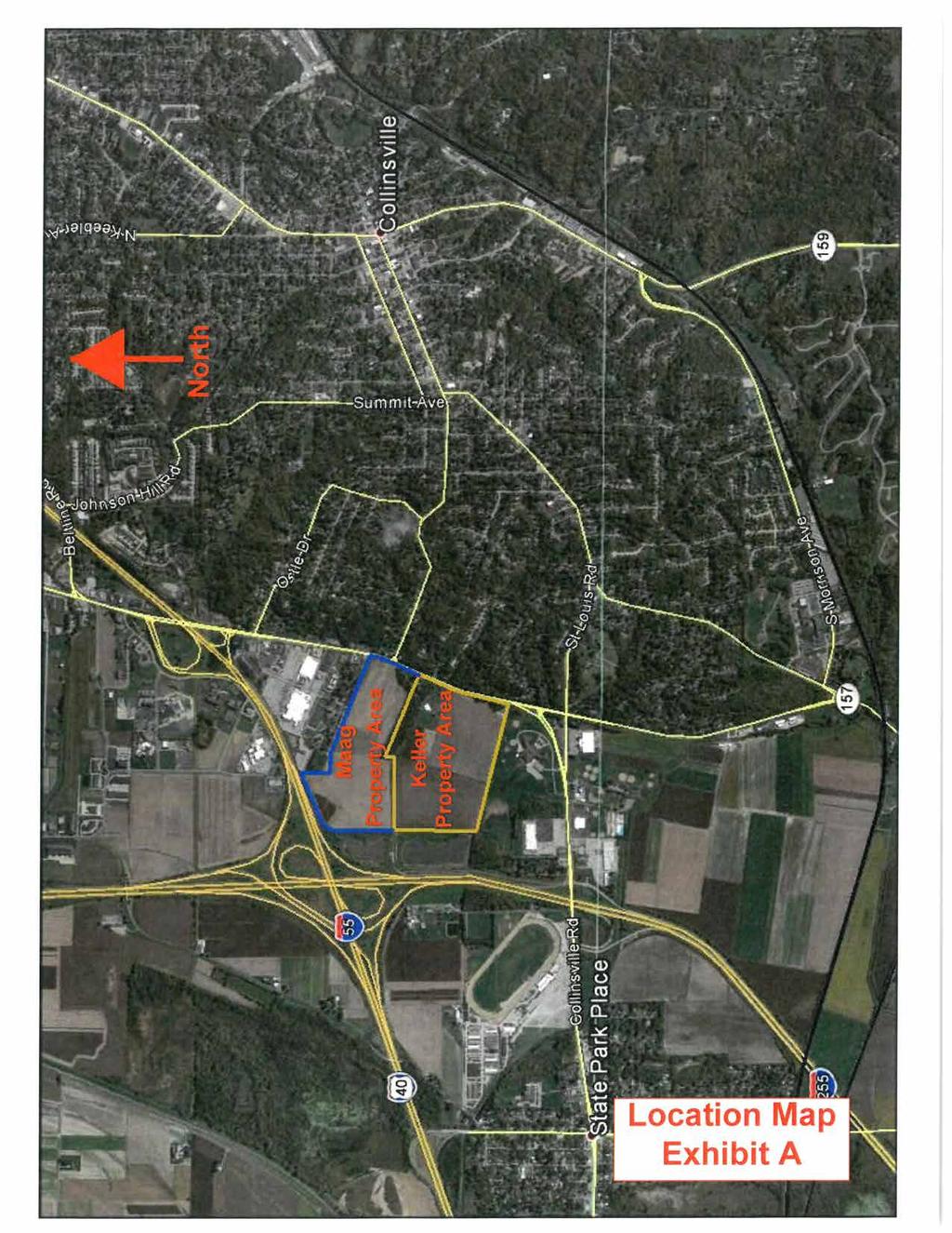
102
103 ' ( ') N.79 33'36"W. N.1 07'50"W ' 95.24' 95.24' N.2 34'01"W ' ' S.89 38'07"E. S.89 38'07"E. S.89 37'52"E ' S.89 35'04"E ' S.W. CORNER OF THE N.W. QUARTER OF THE N.E. QUARTER, SECTION 31, T.3N.-R.8W. SOUTHWEST CORNER OF THE NORTHEAST QUARTER OF SECTION 31, T.3N., R.8W. - STONE (FOUND) N.0 01'41"W ' N.1 07'50"W ' ' (2647.6') N.30 07'51"E ' 0 100' GRAPHIC SCALE 200' 300' 400' NORTHWEST CORNER OF THE NORTHWEST QUARTER OF SECTION 31, T.3N., R.8W. NORTHWEST CORNER OF THE STONE (FOUND) NORTHEAST QUARTER OF SECTION 31, T.3N., R.8W. CENTERLINE OF F.A.I ' (320.1') N.79 33'36"W ' ' (106'±) ' ' N.67 36'36"W. EASTERLY RIGHT OF WAY LINE OF F.A.I. 255 Edward T. Maag & Gordon E. Maag Doc. No. 2012R00071 N/F N.1 34'11"W ' N.20 15'48"E ' (1286.0') EAST LINE SECTION 31 WEST LINE SECTION 32 NORTH LINE SECTION 31 SOUTH LINE SECTION 30 Edward T. Maag & Gordon E. Maag Doc. No. 2012R00071 N/F ' S.0 36'27"E. N.65 40'31"E ' CENTERLINE OF F.A.I EXISTING SOUTHEASTERLY RIGHT OF WAY LINE OF F.A.I NORTHWEST CORNER OF THE NORTHWEST FRACTIONAL QUARTER OF SECTION 32, T.3N.-R.8W. STONE (FOUND) SOUTHEAST CORNER OF THE NORTH HALF OF THE NORTHEAST QUARTER, SECTION 31, T.3N.-R.8W. POINT OF BEGINNING TRACT 3 SOUTHEAST CORNER OF THE NORTHEAST QUARTER OF SECTION 31, T.3N., R.8W. - IRON PIN (FOUND) NORTHWEST CORNER OF U.S. SURVEY 514, CLAIM 572 & 573 CLAY TILE WITH CONCRETE (FOUND) ' (495') S.1 34'11"E ' CENTER OF DRAINAGE DITCH EASTERLY RIGHT OF WAY LINE OF F.A.I. 255 N.1 34'11"W ' S.1 34'11"E ' S.89 37'52"E. S.1 34'11"E. MAAG PROPERTY KELLER PROPERTY S.20 15'48"W ' CLAIM 572 & 573 U.S. SURVEY 514, S.75 30'50"E ' N.75 30'50"W ' S.28 15'48"W ' N.28 15'48"E ' N.75 30'50"W. N.75 30'50"W ' N.75 30'50"W ' S.75 30'50"E ' ' S.28 15'48"W ' N.28 15'48"E ' S.12 09'10"W. N.75 30'50"W ' ' S.75 30'50"E ' ' ' (881.75') ' (200.0') 95.71' N.67 23'24"E ' ' S.67 23'24"W ' N.67 36'36"W. S.67 36'36"E. S.40 31'06"W ' S.51 35'49"W ' ' N.78 05'08"W. Chord = ' S.56 49'28"W. Arc = ' N.69 27'14"E ' S.69 27'14"W. Radius = ' 52.93' ' ' 75.21' N.67 36'36"W. N.67 36'36"W ' S.78 05'08"E ' S.67 36'36"E ' N.67 36'36"W ' (475.29') (581.98') 95.71' N.67 36'36"W ' (1975.6') N.40 31'06"E ' S.24 15'40"W ' N.51 35'49"E. Chord = ' Arc = ' ' 52.93' Radius = ' N.56 49'28"E ' 75.21' Chord = ' S.18 21'24"W. Arc = ' Radius = ' Arc = ' Radius = ' Chord = ', N.11 26'48"E. N.20 15'48"E ' S.67 39'53"E ' (2107') (495') N/F LEGEND 5/8"Ø IRON PIN & CAP (SET) RIGHT OF WAY MARKER (FOUND) IRON PIPE (FOUND) IRON PIN (FOUND) STONE (FOUND) FENCE LINE CENTER OF EXISTING DRAINAGE DITCH ROAD RIGHT OF WAY LINE SECTION OR U.S. SURVEY LINE PARCEL LINE BOUNDARY OF SURVEYED TRACT RECORD DISTANCE NOW OR FORMERLY S.24 15'40"W ' Arc = 69.21' Radius = ' Chord = 69.20' S.23 37'42"W. CENTERLINE STATE ROUTE NUMBER 157 Arc = ' (604.7') Chord = ' S.18 10'54"W. Radius = ' ( ') S.24 15'40"W ' (25.68') S.74 50'36"E ' 90.00' N.66 21'55"W. N.37 40'14"W ' ' (316.5') S.24 15'40"W. SOUTH LINE OF U.S. SURVEY 392, CLAIM 602 LOT 1 SUBDIVISION PLATTED BY MARTIN JONES Edward T. Maag & Gordon E. Maag Doc. No. 2012R00071 N/F WEST LINE OF U.S. SURVEY 392, CLAIM 602 NORTHEAST CORNER OF THE NORTHWEST FRACTIONAL QUARTER OF SECTION 32, T.3N.-R.8W. STONE (FOUND) WEST LINE STATE ROUTE NUMBER 157 LOT 2 1 SOUTH 1/2, LOT BELLEVUE DRIVE - 50' WIDE LOTS 1-10 OF FONTAINEBLEAU PARK SUBDIVISION ' (385'±) 60 N.87 17'41"E LOTS OF THE SECOND ADDITION TO FONTAINEBLEAU PARK SUBDIVISION LOTS OF THE FIRST ADDITION TO FONTAINEBLEAU PARK SUBDIVISION GRAVEL DRIVE CENTER OF DRAINAGE DITCH GRAVEL DRIVE CENTER OF DRAINAGE DITCH POINT OF BEGINNING TRACT 2 INTERSECTION OF SOUTH LINE OF U.S. SURVEY 392, CLAIM 602 WITH WEST RIGHT OF WAY LINE OF STATE ROUTE 157 IRON PIPE (FOUND) S.14 32'04"W ' 50' S.67 36'36"E ' S.67 36'36"E ' MAIN STREET - 60' WIDE POINT OF BEGINNING TRACT 1 INTERSECTION OF WEST LINE OF SECTION 32 WITH SOUTH LINE OF U.S. SURVEY 392, CLAIM 602 IRON PIN AND CAP (FOUND) POINT OF BEGINNING TRACT 4 INTERSECTION OF NORTH LINE OF U.S. SURVEY 514, CLAIM 572 AND 573, WITH WEST RIGHT OF WAY LINE OF STATE ROUTE 157 RIGHT OF WAY MARKER (FOUND) 50' 60' ' ( ') GARAGE SHED HOUSE APPROXIMATE MAAG PROPERTY DIRT & ROCK DRIVEWAY ROCK APPROXIMATE KELLER PROPERTY 50' 60' Keller Farms, Inc. Book 4653, Page 4142 N/F (90.0') (160.0') Book 3532, Page 748 The Collins Club, Inc. N/F 50' 50' 50' Hurst-Rosche, Inc. PROFESSIONAL DESIGN NUMBER: E. TREMONT STREET HILLSBORO, IL PH: F: EAST ST. LOUIS, IL MARION, IL SPRINGFIELD, IL ARNOLD, MO NEOSHO, MO EXHIBIT B 2015 HURST-ROSCHE, INC.

104
105
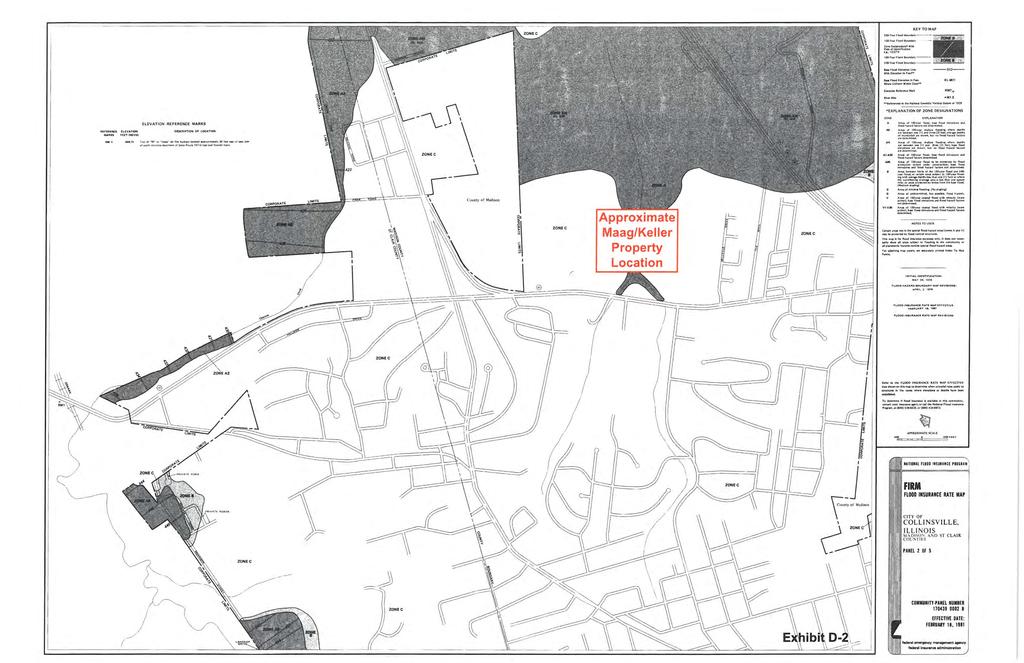
106
107
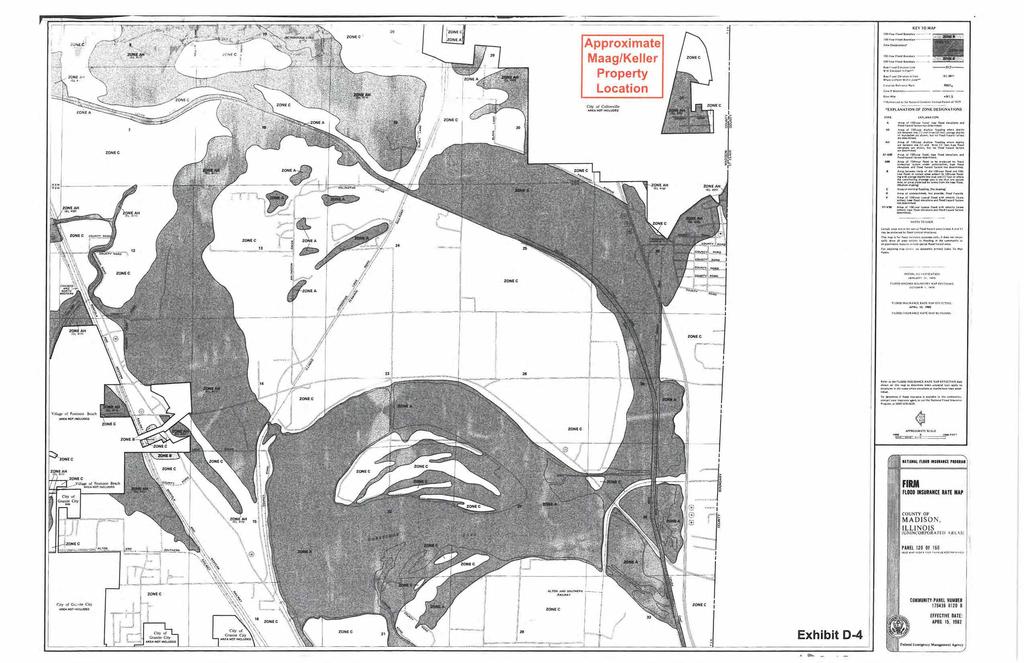
108
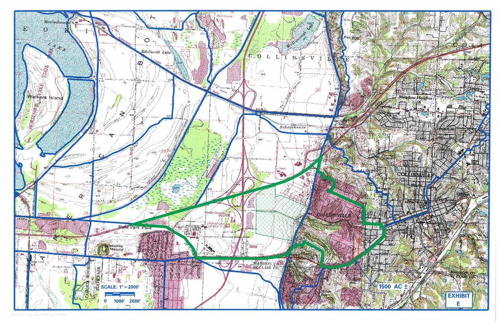
109

110
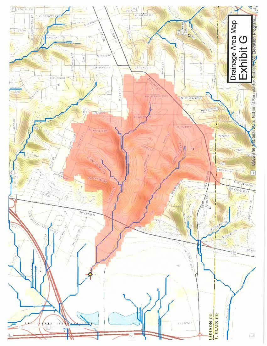
111
112
113
114
115

116
117
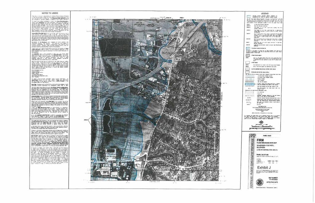
118
119
120
121
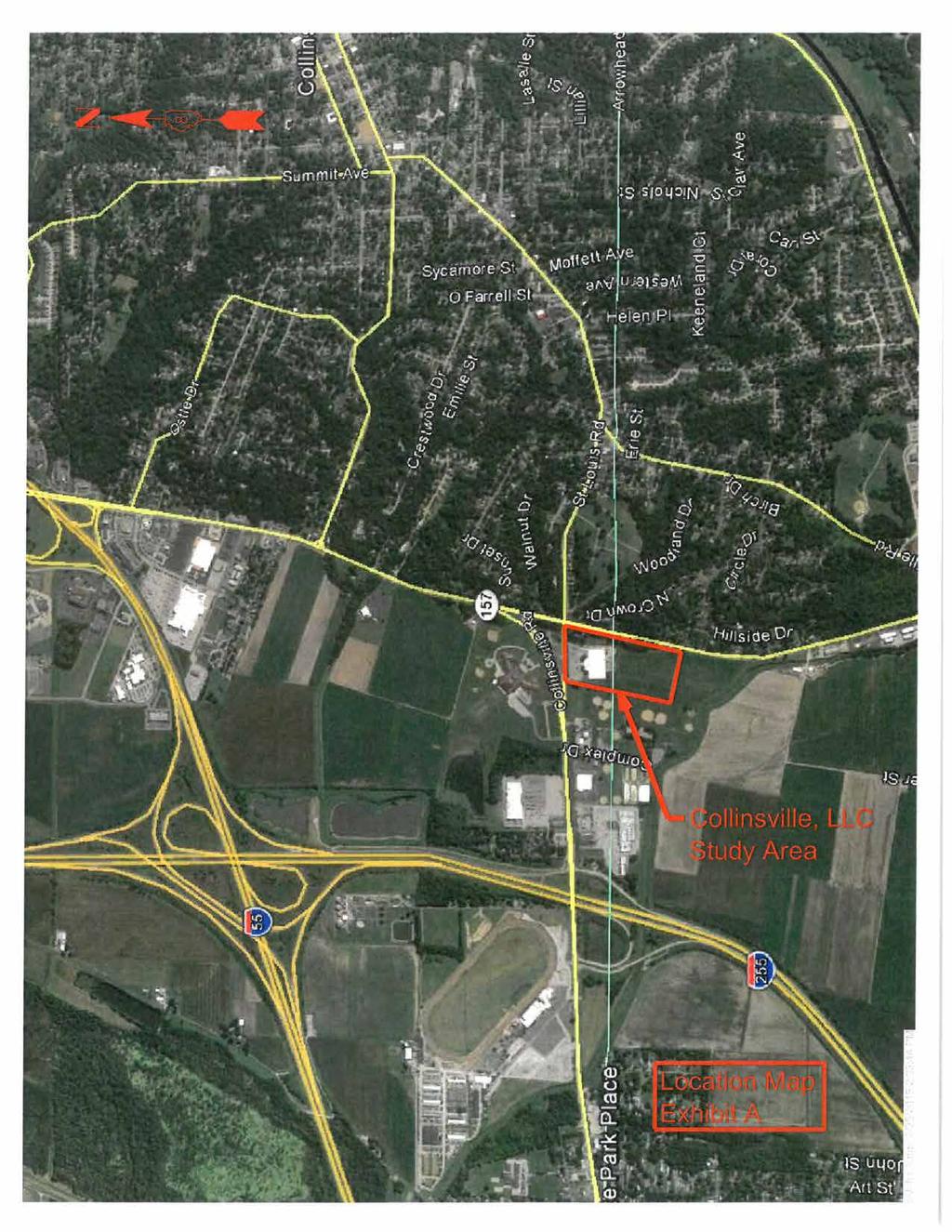
122
123 Hurst-Rosche, Inc. PROFESSIONAL DESIGN NUMBER: E. TREMONT STREET HILLSBORO, IL PH: F: EAST ST. LOUIS, IL MARION, IL SPRINGFIELD, IL ARNOLD, MO NEOSHO, MO GRAPHIC SCALE 0 50' 100' 150' 200' COLLINSVILLE LLC. PROPERTY EXHIBIT B 2015 HURST-ROSCHE, INC.

124
125
126
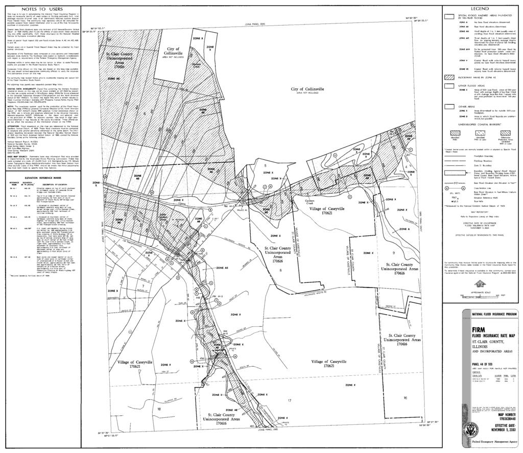
127

128

129 COLLINSVILLE ROAD COLLINSVILLE, LLC PROPERTY IL ROUTE ' GRAPHIC SCALE 50' 0 100' EXHIBIT F


130 Exhibit G-1


131 Exhibit G-2
Presence-Saint Joseph Medical Center Area Redevelopment Project Area
 CITY OF JOLIET, IL Presence-Saint Joseph Medical Center Area Redevelopment Project Area Tax Increment Financing Eligibility Study and Redevelopment Plan and Project November 2, 2016 CITY OF JOLIET, IL
Downtown Meridian Urban Renewal Area URBAN RENEWAL ELIGIBILITY REPORT. Prepared for The City of Meridian and The Meridian Development Corporation
 Downtown Meridian Urban Renewal Area URBAN RENEWAL ELIGIBILITY REPORT Prepared for The City of Meridian and The Meridian Development Corporation by McKibben + Cooper Architects June 19, 2002 Authorization
Tax Increment Financing District Eligibility Study and Redevelopment Plan and Project
 WOOD DALE, IL Wood Dale Road Redevelopment Project Area Tax Increment Financing District Eligibility Study and Redevelopment Plan and Project March 1, 2018 S. B. FRIEDMAN & COMPANY 221 N. LaSalle St. Suite
Redevelopment Project Plan and Eligibility Report for the: Cook County Project Area. Village of East Dundee, Illinois. Draft: July 18, 2012
 for the: Cook County Project Area Village of East Dundee, Illinois Draft: Created By: Vandewalle & Associates 2012 Table of Contents TABLE OF CONTENTS Table of Contents... i Executive Summary... 1 Part
Scales Mound Redevelopment Project Area Tax Increment Financing District Eligibility Study, Redevelopment Plan and Project
 Scales Mound Redevelopment Project Area Tax Increment Financing District Eligibility Study, Redevelopment Plan and Project Village of Scales Mound, Illinois DRAFT SUBMITTED: October 2012 Table of Contents
DRAFT. Conservation Area Analysis. for the Southwest Corner of Shawnee Mission Parkway & Maurer Road. Shawnee, Kansas. October 2014.
 Conservation Area Analysis for the Southwest Corner of Shawnee Mission Parkway & Maurer Road Shawnee, Kansas October 2014 DRAFT Prepared by: Polsinelli PC, Development Analysis Department 99 CONSERVATION
DEKALB CENTRAL BUSINESS DISTRICT Redevelopment Project Area
 CITY OF DEKALB, IL DEKALB CENTRAL BUSINESS DISTRICT Redevelopment Project Area Tax Increment Financing District Eligibility Study, Redevelopment Plan and Project, and Housing Impact Study June 4, 2018
RICHFIELD WAY REDEVELOPMENT PLAN
 VILLAGE OF MENOMONEE FALLS, WISCONSIN RICHFIELD WAY REDEVELOPMENT PLAN Prepared by: Village of Menomonee Falls, Wisconsin Community Development Authority Approved by the Community Development Authority
H 7291 S T A T E O F R H O D E I S L A N D
 LC000 01 -- H 1 S T A T E O F R H O D E I S L A N D IN GENERAL ASSEMBLY JANUARY SESSION, A.D. 01 A N A C T RELATING TO TOWNS AND CITIES -- REDEVELOPMENT AGENCIES AND PROJECTS Introduced By: Representatives
CITY OF ELMHURST TIF QUALIFICATION REPORT NORTH YORK STREET TIF DISTRICT
 Draft dated 03/14/12 CITY OF ELMHURST TIF QUALIFICATION REPORT NORTH YORK STREET TIF DISTRICT A study to determine whether all or a portion of an area located in the City of Elmhurst qualifies as a conservation
Dempster/Waukegan Redevelopment Project Area
 VILLAGE OF MORTON GROVE Dempster/Waukegan Redevelopment Project Area Tax Increment Financing District Eligibility Study, Redevelopment Plan and Project DATE: Feburary 29, 2012 Table of Contents SECTION
URBAN REVITALIZATION PLAN CITY OF DECORAH, IOWA 2014 DECORAH HOUSING URBAN REVITALIZATION AREA ADOPTED NOVEMBER 3, 2014
 URBAN REVITALIZATION PLAN CITY OF DECORAH, IOWA 2014 DECORAH HOUSING URBAN REVITALIZATION AREA ADOPTED NOVEMBER 3, 2014 Public Hearing held September 2, 2014 Second Public Hearing held October 6, 2014
Study Area Description Study Area Context Existing Land Use and Zoning Districts
 TABLE OF CONTENTS Table of Contents SECTION I: INTRODUCTION Definition of Blight Study Methodology Report Format SECTION II: AREA OVERVIEW AND DESCRIPTION Study Area Description Study Area Context Existing
Summary. Draft Redevelopment Plan Summary Flowery Branch Tax Allocation District # 1:
 Summary Draft Redevelopment Plan Summary Flowery Branch Tax Allocation District # 1: Flowery Branch Tax Allocation District Old Town and Commercial Gateways 1 Public Hearing Presentation November 21, 2007
THE REDEVELOPMENT PLAN
 PAGE 37 THE REDEVELOPMENT PLAN FUTURE LAND USE The Silver Terrace Redevelopment Area is currently designated as Redevelopment Area #4 on the City of Delray Beach Future Land Use Map (FLUM). This designation
Village of Port Jefferson Urban Renewal Plan
 Urban Renewal Plan Village of Port Jefferson Urban Renewal Plan Port Jefferson, New York PREPARED FOR Village of Port Jefferson Village Board 121 West Broadway Port Jefferson, NY 11777 631.473.4724 PREPARED
Maryland Park Lake District
 Maryland Park Lake District A REGIONAL DEVELOPMENT OPPORTUNITY City of Maryland Heights Area Context 2,535 Acres northwest of MO RT 364 (Page Ave Extension) Protected by a 500-Year COE/FEMA-certified levee
ARTICLE 23 CONDOMINIUM STANDARDS
 ARTICLE 23 CONDOMINIUM STANDARDS Section 23.01 Intent. The intent of this Article is to provide regulatory standards for condominiums and site condominiums similar to those required for projects developed
Hennepin County Department of. Housing, Community Works and Transit. Transit Oriented Development (TOD) Guidelines
 Guidelines") Hennepin County Department of Housing, Community Works and Transit 2007 Transit Oriented Development (TOD) Guidelines Hennepin County Transit Oriented Development (TOD) Bond Funds Hennepin County Housing,
Hennepin County Department of Housing, Community Works and Transit 2007 Transit Oriented Development (TOD) Guidelines Hennepin County Transit Oriented Development (TOD) Bond Funds Hennepin County Housing,
(b) The location of principal and accessory buildings on the lot and the relationship of each structure to the other.
 The location of principal and accessory buildings on the lot and the relationship of each structure to the other.") ARTICLE XIX SITE PLAN Sec. 20-1900 Site Plan Review Procedure - Intent The site plan review procedures are instituted to provide an opportunity for the Township Planning Commission to review the proposed
ARTICLE XIX SITE PLAN Sec. 20-1900 Site Plan Review Procedure - Intent The site plan review procedures are instituted to provide an opportunity for the Township Planning Commission to review the proposed
WASCO COUNTY PRELIMINARY SUBDIVISION APPLICATION
 WASCO COUNTY PRELIMINARY SUBDIVISION APPLICATION DETAILED SPECIFIC WRITTEN REQUEST File Number: SDV- Number of Proposed Lots & their Dimensions: PRELIMINARY SUBDIVISION PLAN REQUIREMENTS The approval of
Cobb County Community Development Agency Zoning Division 1150 Powder Springs St. Marietta, Georgia 30064
 Cobb County Community Development Agency Zoning Division 1150 Powder Springs St. Marietta, Georgia 30064 Case # Z-63 Public Hearing Dates: PC: 11-06-18 BOC: 11-20-18 SITE BACKGROUND Applicant: Loyd Development
City of Edwardsville, Kansas Special Benefit District Policy
 City of Edwardsville, Kansas Special Benefit District Policy Date Adopted: September 12, 2011 Section 1. Objective The objective is to establish a policy to finance public streets, sanitary sewers, water
ARTICLE VII. NONCONFORMITIES. Section 700. Purpose.
 ARTICLE VII. NONCONFORMITIES. Section 700. Purpose. The purpose of this chapter is to regulate and limit the development and continued existence of legal uses, structures, lots, and signs established either
WASHTENAW COUNTY BROWNFIELD REDEVELOPMENT AUTHORITY ACT 381 WORK PLAN TO CONDUCT ELIGIBLE DEQ RESPONSE AND/OR MSF NON-ENVIRONMENTAL ACTIVITIES
 WASHTENAW COUNTY BROWNFIELD REDEVELOPMENT AUTHORITY ACT 381 WORK PLAN TO CONDUCT ELIGIBLE DEQ RESPONSE AND/OR MSF NON-ENVIRONMENTAL ACTIVITIES 400 NORTH RIVER STREET THE HISTORIC THOMPSON BLOCK REDEVELOPMENT
610 LAND DIVISIONS AND PROPERTY LINE ADJUSTMENTS OUTSIDE A UGB
 ARTICLE VI: LAND DIVISIONS AND PROPERTY LINE ADJUSTMENTS VI-21 610 LAND DIVISIONS AND PROPERTY LINE ADJUSTMENTS OUTSIDE A UGB 610-1 Property Line Adjustments (Property Line Relocation) A property line
CITY OF EAU CLAIRE, WISCONSIN. SPECIAL ASSESSMENT POLICY (Dated: November 8, 2016)
") CITY OF EAU CLAIRE, WISCONSIN SPECIAL ASSESSMENT POLICY (Dated: November 8, 2016) (Adopted by reference by Ordinance No. 7207 adopted November 8, 2016) PURPOSE The purpose of this Policy is to assure fair
CITY OF EAU CLAIRE, WISCONSIN SPECIAL ASSESSMENT POLICY (Dated: November 8, 2016) (Adopted by reference by Ordinance No. 7207 adopted November 8, 2016) PURPOSE The purpose of this Policy is to assure fair
A. Land Use Relationships
 Chapter 9 Land Use Plan A. Land Use Relationships Development patterns in Colleyville have evolved from basic agricultural and residential land uses, predominate during the early stages of Colleyville
Understanding the Conditional Use Process
 Understanding the Conditional Use Process The purpose of this document is to explain the process of applying for and obtaining a conditional use permit in the rural unincorporated towns of Dane County.
Planning Department Oconee County, Georgia
 Planning Department Oconee County, Georgia STAFF REPORT REZONE CASE #: 6985 DATE: October 31, 2016 STAFF REPORT BY: Andrew C. Stern, Planner APPLICANT NAME: Williams & Associates, Land Planners PC PROPERTY
COUNCIL AGENDA ITEM DISCUSSION: CHANGE CODE REQUIREMENTS FOR IMPROVING BUILDINGS IN CODE VIOLATIONS
 Date: May 11, 2016 COUNCIL AGENDA ITEM DISCUSSION: CHANGE CODE REQUIREMENTS FOR IMPROVING BUILDINGS IN CODE VIOLATIONS REQUESTED BY: COUNCIL PREPARED BY: CITY PLANNER BACKGROUND / DESCRIPTION: Attached
ARTICLE 24 SITE PLAN REVIEW
 ARTICLE 24 SITE PLAN REVIEW 24.1 PURPOSE: The intent of these Ordinance provisions is to provide for consultation and cooperation between the land developer and the Township Planning Commission in order
MIDWAY CITY Municipal Code
 MIDWAY CITY Municipal Code TITLE 9 ANNEXATION CHAPTER 9.01 PURPOSE CHAPTER 9.02 GENERAL REQUIREMENTS CHAPTER 9.03 PROPERTY OWNER INITIATION OF ANNEXATION CHAPTER 9.04 PROCEDURES FOR CONSIDERATION OF PETITION
SECTION 7000 LAND DEVELOPMENT REQUIREMENTS
 SECTION 7000 LAND DEVELOPMENT REQUIREMENTS 7000 LAND DEVELOPMENT REQUIREMENTS... 1 7001 LEGISLATIVE AUTHORITY... 1 7001.1 LAND DEVELOPMENT... 1 7001.1.1 Title 40, Idaho Code... 1 7001.1.2 Idaho Code 40-1415
Delta Urban Renewal Authority Blight Study
 Delta Urban Renewal Authority Blight Study February 2017 1 Table of Contents 1. Introduction.3 1.1 Purpose..3 1.2 Colorado Urban Renewal Law..3 1.3 Study Methodology..5 2. Study Area Analysis.6 2.1 Study..6
Chapter Sidewalk Construction and Improvement Standards
 Chapter 19.22 Sidewalk Construction and Improvement Standards 19.22.010 Intent and policy. 19.22.020 Construction of this chapter, statement of purpose, fundamental principle. 19.22.030 Simultaneous construction
UPPER MOUNT BETHEL TOWNSHIP NORTHAMPTON COUNTY, PENNSYLVANIA
 UPPER MOUNT BETHEL TOWNSHIP NORTHAMPTON COUNTY, PENNSYLVANIA JOINDER DEED / LOT CONSOLIDATION TOWNSHIP REVIEW PROCESS When accepting proposed Joinder Deeds / Lot Consolidations, review the Joinder Deed
City of Lawrence Neighborhood Revitalization Plan and Program: 1101/1115 Indiana Street Lawrence, KS
 City of Lawrence Neighborhood Revitalization Plan and Program: 1101/1115 Indiana Street Lawrence, KS Definition: Area - used interchangeably with Property, referring to the property located at 1101/1115
SANDOVAL COUNTY PLANNING AND ZONING COMMISSION DECEMBER 10, 2015 PUBLIC HEARING
 SANDOVAL COUNTY PLANNING AND ZONING COMMISSION DECEMBER 10, 2015 PUBLIC HEARING To: Sandoval County Planning and Zoning Commission From: Sandoval County Planning and Zoning Division Staff Date: December
M-43 CORRIDOR OVERLAY ZONE
 ARTICLE 26.00 M-43 CORRIDOR OVERLAY ZONE Section 26.01 Findings A primary function of the M-43 state highway is to move traffic through the Township and to points beyond. As the primary east-west arterial
CHAPTER Committee Substitute for Committee Substitute for Senate Bill No. 2188
 CHAPTER 2004-372 Committee Substitute for Committee Substitute for Senate Bill No. 2188 An act relating to land development; amending s. 197.502, F.S.; providing for the issuance of an escheatment tax
4.2 RESIDENTIAL ZONING DISTRICTS
 4.2 RESIDENTIAL ZONING DISTRICTS A. Purpose: To define regulations and standards for each residential zoning district in the City. The following sections identify uses, regulations, and performance standards
Cent ral Neighborhoods U rban Ren ewal Plan ( )
") Central Neighborhoods Urban Renewal Plan City of Golden, Colorado Cent ral Neighborhoods U rban Ren ewal Plan (4.18.20 1 3) 010252\0001\1819714.2 Central Neighborhoods Urban Renewal Plan City of Golden,
Central Neighborhoods Urban Renewal Plan City of Golden, Colorado Cent ral Neighborhoods U rban Ren ewal Plan (4.18.20 1 3) 010252\0001\1819714.2 Central Neighborhoods Urban Renewal Plan City of Golden,
ZONING AMENDMENT, PLANNED UNIT DEVELOPMENT & SUBDIVISION STAFF REPORT Date: August 8, 2013
 ZONING AMENDMENT, PLANNED UNIT DEVELOPMENT & SUBDIVISION STAFF REPORT Date: August 8, 2013 NAME SUBDIVISION NAME PV-Magnolia, LLC Twelve Trees Subdivision LOCATION 2860, 2862 and 2866 Pleasant Valley Road
CHARTER TOWNSHIP OF KALAMAZOO KALAMAZOO COUNTY, MICHIGAN ORDINANCE NO. KALAMAZOO CHARTER TOWNSHIP SIDEWALK ORDINANCE
 CHARTER TOWNSHIP OF KALAMAZOO KALAMAZOO COUNTY, MICHIGAN ORDINANCE NO. KALAMAZOO CHARTER TOWNSHIP SIDEWALK ORDINANCE An Ordinance enacted pursuant to Michigan Public Act 246 of 1931 and Public Act 359
13-2 SUBDIVISION PLANS AND PLATS REQUIRED EXCEPTIONS Subdivision Plats Required To be Recorded
 ARTICLE XIII SUBDIVISIONS 13-1 INTENT AND PURPOSE 13-1-1 Intent: It is the intent of the County Commission through the adoption of this Article to more fully avail itself of the power granted under 17-27-601
Special Use Permit - Planned Unit Development Checklist. Property Address:
 Special Use Permit - Planned Unit Development Checklist Special Use Permit Number. Parcel Code/s #28-11- - - Property Address: Applicant: ARTICLE VIII Ordinance Reference - Section 8.1.2 Permit Procedures:
Watkinsville First Baptist Church Building and Parking Masterplan Norton Road & Simonton Bridge Road Oconee County Georgia
 Watkinsville First Baptist Church Building and Parking Masterplan Norton Road & Simonton Bridge Road Oconee County Georgia Special Use Approval A-1 CUP to A-1 with Special Use Approval Total Site Area
Initial Project Review
 Pierce County Department of Planning and Land Services, 2401 South 35th Street, Tacoma, WA (253) 798-7037 Initial Project Review Major Amendment to Preliminary Plat: Hawks Ridge Division 1 Application
ARTICLE 14 PLANNED UNIT DEVELOPMENT (PUD) DISTRICT
 DISTRICT") ARTICLE 14 PLANNED UNIT DEVELOPMENT (PUD) DISTRICT Section 14.01 Intent. It is the intent of this Article to allow the use of the planned unit development (PUD) process, as authorized by the Michigan Zoning
ARTICLE 14 PLANNED UNIT DEVELOPMENT (PUD) DISTRICT Section 14.01 Intent. It is the intent of this Article to allow the use of the planned unit development (PUD) process, as authorized by the Michigan Zoning
******************************************************************************
 AN ORDINANCE OF THE CITY COUNCIL OF THE CITY OF BAYTOWN, TEXAS, EXCLUDING LAND FROM REINVESTMENT ZONE NO. ONE, CITY OF BAYTOWN, TEXAS; INCLUDING LAND WITHIN THE ZONE; EXTENDING THE TERM OF SUCH ZONE; APPROVING
CHAPTER 3 PRELIMINARY PLAT
 10-3-1 10-3-3 SECTION: CHAPTER 3 PRELIMINARY PLAT 10-3-1: Consultation 10-3-2: Filing 10-3-3: Requirements 10-3-4: Approval 10-3-5: Time Limitation 10-3-6: Grading Limitation 10-3-1: CONSULTATION: Each
May 2011 REDEVELOPMENT PLAN FOR THE CALIMESA REDEVELOPMENT PROJECT AREA NO. 2 CALIMESA REDEVELOPMENT AGENCY. Ordinance introduced on, 2011
 May 2011 REDEVELOPMENT PLAN FOR THE CALIMESA REDEVELOPMENT PROJECT AREA NO. 2 CALIMESA REDEVELOPMENT AGENCY Ordinance introduced on, 2011 Ordinance adopted on, 2011 Redevelopment Plan Prepared for the
CLARK COUNTY NEIGHBORHOOD REVITALIZATION PLAN. Effective Date. January 1, Revised
 CLARK COUNTY NEIGHBORHOOD REVITALIZATION PLAN Effective Date January 1, 2007 Revised January 1, 2010 KANSAS NEIGHBORHOOD REVITALIZATION ACT K.S.A. 1996 Supp. 12-17, 114 et seq. This law authorizes any
Administration and Calculation of Servicing Agreement Fees and Development Levies
 Administration and Calculation of Servicing Agreement Fees and Development Levies Policy Title: Applies to: Reference # Administration and Calculation of Servicing Agreement Fees and City of Regina ###-XXX-##
Burlington Unincorporated Community Plan
 Burlington Unincorporated Community Plan June 30, 2010 Meeting Page 1 of 24 Table of Contents (Page numbers to be inserted) I. Background a. Location and Community Description b. Planning of Unincorporated
SUBDIVISION, PLANNED UNIT DEVELOPMENT, & PLANNING APPROVAL STAFF REPORT Date: February 1, 2007
 SUBDIVISION, PLANNED UNIT DEVELOPMENT, & PLANNING APPROVAL STAFF REPORT Date: February 1, 2007 DEVELOPMENT NAME SUBDIVISION NAME Pala Verde Mobile Home Park Subdivision Pala Verde Mobile Home Park Subdivision
ARTICLE IV: DEVELOPMENT STANDARDS
 ARTICLE IV: DEVELOPMENT STANDARDS IV-53 409 PRIVATE STREETS A private street means any way that provides ingress to, or egress from, property by means of vehicles or other means, or that provides travel
TABLE OF CONTENTS. I. Introduction II. Statutory Basis for Business District III. Blight Analysis... 7
 AI RPORT BUSI NESSDI STRI CT REDEVELOPMENT PLAN&PROJECT Febr uar y12,2018 TheVi l l ageof BETHALTO,I L TABLE OF CONTENTS SECTION PAGE I. Introduction... 2 II. Statutory Basis for Business District... 3
This is a conditional use permit request to establish a commercial wind energy conversion system.
 Public Works 600 Scott Boulevard South Hutchinson, Kansas 67505 620-694-2976 Road & Bridge Planning & Zoning Noxious Weed Utilities Date: March 28, 2019 To: From: Reno County Planning Commission Russ Ewy,
SUBDIVISION, PLANNED UNIT DEVELOPMENT, PLANNING APPROVAL, ZONING AMENDMENT, & SIDEWALK WAIVER REQUEST STAFF REPORT Date: February 17, 2010
 SUBDIVISION, PLANNED UNIT DEVELOPMENT, PLANNING APPROVAL, ZONING AMENDMENT, & SIDEWALK WAIVER REQUEST STAFF REPORT Date: February 17, 2010 APPLICANT NAME SUBDIVISION NAME DEVELOPMENT NAME LOCATION David
Chapter Plat Design (LMC)
") Chapter 18.14 Plat Design (LMC) Sections: 18.14.010 Lot width 18.14.020 Right-of-way requirements 18.14.030 Pipe stem lots 18.14.040 Division resulting in minimum lot sizes 18.14.050 Flood prone and bad
Chapter 18.14 Plat Design (LMC) Sections: 18.14.010 Lot width 18.14.020 Right-of-way requirements 18.14.030 Pipe stem lots 18.14.040 Division resulting in minimum lot sizes 18.14.050 Flood prone and bad
Neighborhood Renewal Program Policies and Procedures
 Neighborhood Renewal Program Policies and Procedures City of Mobile Neighborhood Renewal Program Policies and Procedures Table of Contents I. Mission Statement A. The New Plan for Old Mobile B. Goals and
DIVISION 1 PURPOSE OF DISTRICTS
 ARTICLE 2 ZONING DISTRICTS AND MAP DIVISION 1 PURPOSE OF DISTRICTS Section 2.101 Zoning Districts. For the purpose of this Ordinance, the City of Richmond is hereby divided into districts as follows: DISTRICT
BOARD OF COUNTY COMMISSIONERS ARCHULETA COUNTY, COLORADO RESOLUTION 2018-
 BOARD OF COUNTY COMMISSIONERS ARCHULETA COUNTY, COLORADO RESOLUTION 2018- ARCHULETA COUNTY IMPROPERLY DIVIDED PARCELS EXEMPTION INTERIM RESOLUTION - A RESOLUTION ADDRESSING PARCELS UNDER THE SIZE OF 35
PROPOSED AMENDMENTS TO THE DERBY ZONING REGULATIONS AUGUST 12, 2008
 ARTICLE II Definitions and word usage 195-7. Definitions and word usage. Modify the following: HOUSING FOR THE ELDERLY OLDER PERSONS Housing in accordance with and as defined in the United States Fair
CITY COUNCIL AND BURA AGENDA MEMORANDUM
 City and County of Broomfield, Colorado CITY COUNCIL AND BURA AGENDA MEMORANDUM To: From: By: Agenda Title Mayor, City Council, and Broomfield Urban Renewal Authority Charles Ozaki, City and County Manager
CITY OF FORT COLLINS NATURAL AREAS AND CONSERVED LANDS EASEMENT POLICY
 CITY OF FORT COLLINS NATURAL AREAS AND CONSERVED LANDS EASEMENT POLICY Adopted January 3, 2012 PURPOSE: The purpose of the policy statement is to clarify the policies and procedures of the City of Fort
PC Staff Report 11/18/2013 Z Item No. 1-1
 Z-13-00401 Item No. 1-1 PLANNING COMMISSION REPORT Regular Agenda - Public Hearing Item PC Staff Report 11/18/2013 ITEM NO. 1: Z-13-00401 IG (General Industrial) District TO CS (Strip Commercial) District;
Conditional Use Permit / Standard Subdivision Application
 Conditional Use Permit / Standard Subdivision Application Name of Proposed Subdivision: Total Area (Acres) Is Proposed Subdivision to be built in phases? Number of Lots If yes, how many phases? Applicant/Owner
2019 Township of Verona New Jersey. Determination of Area in Need of Redevelopment
 2019 Township of Verona New Jersey Property located at 1 Sunset Avenue, Verona, NJ 07044 Block 303 Lot 4 Determination of Area in Need of Redevelopment PREPARED FOR THE MAYOR & COUNCIL AND THE PLANNING
CITY OF LOGAN REDEVELOPMENT AGENCY. A Resolution approving the Auto Mall Community Development Project Area Plan
 -~ LOGAN CITY UNITED IN HRVICE fstt,blished 18t6 CITY OF LOGAN REDEVELOPMENT AGENCY Resolution No. IS-03 RDA A Resolution approving the Auto Mall Community Development Project Area Plan WHEREAS, the Redevelopment
ELK RAPIDS TOWNSHIP ANTRIM COUNTY, MICHIGAN ORDINANCE NO
 ELK RAPIDS TOWNSHIP ANTRIM COUNTY, MICHIGAN ORDINANCE NO. 3-2011 AN ORDINANCE TO REPLACE THE SUBDIVISION CONTROL ORDINANCE WITH A NEW SUBDIVISION DEVELOPMENT ORDINANCE, IN ACCORD WITH THE LAND DIVISION
SUBJECT: Application for Planned Unit Development and Rezoning 1725 Winnetka Road
 TO: FROM: CHAIRMAN BILL VASELOPULOS AND MEMBERS OF THE PLAN & ZONING COMMISSION STEVE GUTIERREZ DIRECTOR OF COMMUNITY DEVELOPMENT MEETING DATE: September 5, 2017 SUBJECT: Application for Planned Unit Development
Box Elder County Land Use Management & Development Code Article 3: Zoning Districts
 Chapter 3-6 Mobile Homes, Mobile Home Subdivisions, & Recreational Vehicle Parks Box Elder Zoning Ordinance as Adopted October 2007 Sections. 3-6-010. Purpose and Intent. 3-6-020. Conditional Use Permit
SUBDIVISION REGULATIONS OF THE CITY OF DERBY, KANSAS
 SUBDIVISION REGULATIONS OF THE CITY OF DERBY, KANSAS ARTICLE 1. TITLE, PURPOSE, AUTHORITY, JURISDICTION, APPLICABILITY AND EXEMPTIONS 100 TITLE. These regulations shall be known and may be cited as the
City of Sanibel. Planning Department STAFF REPORT
 City of Sanibel Planning Department STAFF REPORT Planning Commission Meeting: July 23, 2013 Planning Commission Agenda Item: No 7b. Application Number: 13-7438DP Applicant Name: Attorney Beverly Grady
TOTTENHAM SECONDARY PLAN
 TOTTENHAM SECONDARY PLAN AMENDMENT NO. 11 TO THE OFFICIAL PLAN OF THE TOWN OF NEW TECUMSETH The following text and schedules to the Official Plan of the Town of New Tecumseth constitute Amendment No. 11
ZONING ORDINANCE: OPEN SPACE COMMUNITY. Hamburg Township, MI
 ZONING ORDINANCE: OPEN SPACE COMMUNITY Hamburg Township, MI ARTICLE 14.00 OPEN SPACE COMMUNITY (Adopted 1/16/92) Section 14.1. Intent It is the intent of this Article to offer an alternative to traditional
Urban Revitalization Plan City of Perry, Iowa
 Urban Revitalization Plan City of Perry, Iowa Table of Contents Background... 3 Urban Revitalization Act... 3 City of Perry... 3 Housing Conditions... 3 Growth... 4 Land Use... 4 Urban Revitalization Plan
-MENDOCINO COUNTY PLANNING AND BUILDING SERVICES- DIVISION OF LAND REGULATIONS TITLE 17
 ARTICLE VI -- GENERAL REGULATIONS AND PROVISIONS Sec. 17-50. Sec. 17-51 General Plan. Sec. 17-52 Lot and Block Design and Configuration. Sec. 17-53 Lot Access. Sec. 17-54 Private Roads. Sec. 17-55 Water
9. REZONING NO Vicinity of the northwest corner of 143 rd Street and Metcalf Avenue
 9. REZONING NO. 2002-15 Vicinity of the northwest corner of 143 rd Street and Metcalf Avenue 1. APPLICANT: Andrew Schlagel is the applicant for this request. 2. REQUESTED ACTION: The applicant is requesting
TITLE 7. MUNICIPAL IMPROVEMENTS AND PUBLIC SERVICE PROJECTS
 MUNICIPAL IMPROVEMENTS AND PUBLIC SERVICE PROJECTS 7-1 TITLE 7. MUNICIPAL IMPROVEMENTS AND PUBLIC SERVICE PROJECTS CHAPTER 7-100. FREEWAY INTER- CHANGE DEVELOPMENT PLAN - REPORT. This report on the project
4.2 LAND USE INTRODUCTION
 4.2 LAND USE INTRODUCTION This section of the EIR addresses potential impacts from the Fresno County General Plan Update on land use in two general areas: land use compatibility and plan consistency. Under
ZONING AMENDMENT & SUBDIVISION STAFF REPORT Date: November 3, 2016
 ZONING AMENDMENT & SUBDIVISION STAFF REPORT Date: November 3, 2016 APPLICANT NAME SUBDIVISION NAME David Shumer 5955 Airport Subdivision CITY COUNCIL DISTRICT District 6 5955 Airport Boulevard, 754 Linlen
Section 1: US 19 Overlay District
 Section 1: US 19 Overlay District Section 1.1 Intent and Purpose The purpose of the US Highway 19 Overlay District is to manage access to land development along US Highway 19 in a manner that preserves
PLANNED UNIT DEVELOPMENT STAFF REPORT Date: October 19, 2017
 PLANNED UNIT DEVELOPMENT STAFF REPORT Date: October 19, 2017 DEVELOPMENT NAME LOCATION Custom Boat Storage 3975 Demetropolis Road (East side of Demetropolis Road, 0.2± miles South of Halls Mill Road.)
[First Reprint] ASSEMBLY, No STATE OF NEW JERSEY. 213th LEGISLATURE INTRODUCED DECEMBER 14, 2009
![[First Reprint] ASSEMBLY, No STATE OF NEW JERSEY. 213th LEGISLATURE INTRODUCED DECEMBER 14, 2009](/thumbs/96/127018551.jpg "[First Reprint] ASSEMBLY, No STATE OF NEW JERSEY. 213th LEGISLATURE INTRODUCED DECEMBER 14, 2009") [First Reprint] ASSEMBLY, No. STATE OF NEW JERSEY th LEGISLATURE INTRODUCED DECEMBER, 00 Sponsored by: Assemblyman JERRY GREEN District (Middlesex, Somerset and Union) Assemblyman FREDERICK SCALERA District
[First Reprint] ASSEMBLY, No. STATE OF NEW JERSEY th LEGISLATURE INTRODUCED DECEMBER, 00 Sponsored by: Assemblyman JERRY GREEN District (Middlesex, Somerset and Union) Assemblyman FREDERICK SCALERA District
Open Space Model Ordinance
 Open Space Model Ordinance Section I. Background Open space development has numerous environmental and community benefits, including: 1) Reduces the impervious cover in a development. Impervious cover
GENERAL PLAN, DEVELOPMENT CODE AND ZONING MAP AMENDMENT APPLICATION INFORMATION SHEET
 GENERAL PLAN, DEVELOPMENT CODE AND ZONING MAP AMENDMENT APPLICATION INFORMATION SHEET GENERAL INFORMATION This information sheet explains how an application requesting an amendment to the Truckee General
Bowie Marketplace Residential Detailed Site Plan Statement of Justification January 13, 2017 Revised February 2, 1017
 Bowie Marketplace Residential Detailed Site Plan Statement of Justification January 13, 2017 Revised February 2, 1017 Submitted on behalf of: BE Bowie LLC 5410 Edson Lane, Suite 220 Rockville, MD 20852
APPLICANT NAME SUBDIVISION NAME DEVELOPMENT NAME LOCATION. CITY COUNCIL DISTRICT Council District 4 PRESENT ZONING PROPOSED ZONING
 SUBDIVISION, PLANNED UNIT DEVELOPMENT, PLANNING APPROVAL, ZONING AMENDMENT, & SIDEWALK WAIVER REQUEST STAFF REPORT Date: February 17, 2010 APPLICANT NAME SUBDIVISION NAME DEVELOPMENT NAME LOCATION David
Cover Letter with Narrative Statement
 Cover Letter with Narrative Statement March 31, 2017 rev July 27, 2017 RE: Rushton Pointe Residential Planned Unit Development Application for Public Hearing for RPUD Rezone PL2015 000 0306 Mr. Eric Johnson,
EL DORADO COUNTY REDEVELOPMENT FEASIBILITY STUDY. County of El Dorado
 EL DORADO COUNTY REDEVELOPMENT FEASIBILITY STUDY County of El Dorado December 2007 TABLE OF CONTENTS I. INTRODUCTION... 1 Purpose of the Study...1 Approach to Selecting the Study Areas...3 Contents of
KERN COUNTY COMMUNITY DEVELOPMENT BLOCK GRANT APPLICATION
 KERN COUNTY COMMUNITY DEVELOPMENT BLOCK GRANT APPLICATION To be considered for CDBG assistance, please submit this completed application with the required attachments. Applications which do not contain
City of Valdosta Land Development Regulations
 Chapter 206 Section 206-1 Base Zoning Districts Standards for Uses, Structures, and Property Development (B) (C) Principal Uses and Structures. Principal uses and structures permitted in each base zoning
Public Facilities and Finance Element
 This Element of the General Plan addresses the following public facilities issues: Water Service, including both potable (drinkable) and non-potable water delivery. Sewer Service, and Financing and construction
Legal Description Part of the Western Half of the Eastern Half of the Northwest Quarter of Section 30, Le Ray Township
 Owner and Applicant s 20448 State Highway 83 Mankato, MN 56001 Request and Location Request for review and approval of a Conditional Use Permit to allow an Elder Care Residential Unit to be constructed
2019 Township of Verona New Jersey. Determination of Area in Need of Redevelopment
 2019 Township of Verona New Jersey For Property located at Block 2301 Lots 1 through 19 Township of Verona Determination of Area in Need of Redevelopment PREPARED FOR THE MAYOR & COUNCIL AND THE PLANNING
Memorandum: October 13, 2008 REVISED To: Trowbridge Township Planning Commission From: P. Hudson, AICP Re: Suggested New Ordinance
 1 Memorandum: October 13, 2008 REVISED 2-11-09 To: Trowbridge Township Planning Commission From: P. Hudson, AICP Re: Suggested New Ordinance Because of changes in both the Michigan Planning Enabling Act