Background Recommendations Appendix A Evolution of New York City s Zoning Resolution... 45
|
|
|
- Oliver Powers
- 5 years ago
- Views:
Transcription
1 CONTENTS Unified Bulk Prog ogram Executive Summary...i Unified Bulk Program Background... 1 Recommendations Appendix A Evolution of New York City s Zoning Resolution Appendix B Explanation of Existing Zoning Rules Appendix C Analysis of Building Height by Zoning District Appendix D Special Districts Appendix E Representative Bulk Envelopes for Certain Districts... 93
2 UNIFIED BULK PROGRAM Executiv ecutive e Summary The Unified Bulk Program is a sweeping reform of the city s Zoning Resolution designed to replace confusing, anachronistic and often contradictory regulations with rules that are intelligible, practical and consistent. It seeks to uphold values of urban form, streetscape, neighborhood character and scale, while also assuring that New York City is able to grow and develop the housing, commercial space and community facilities that its economy and populace require. The goal of the new text is to establish reasonable parameters for new development that give communities, developers and regulators a clear sense of what is and is not allowed in a given district, while allowing appropriate flexibility in the design of individual buildings. The numerous loopholes and interpretive gymnastics yielded by the present zoning will be eliminated. A public review and approval process will allow for sufficient flexibility to address unique conditions and allow for architectural innovation. Issues with the Current Zoning The current zoning generally sets appropriate controls on the amount of floor area that can be built, but the rules governing building height and massing reflect several competing visions of the city's development, often applied simultaneously in the same zoning districts. This confusing situation has developed over the years, as the City Planning Commission has repeatedly adopted amendments to limit or provide alternatives to the tower-in-the-park prototype underlying the 1961 Zoning Resolution. Tower-in-the-park zoning encourages the construction of tall buildings set back from the street, by allowing greater height and more floor area in return for the provision of open space. The resulting buildings have been subject to widespread criticism as anti-urban and disruptive of the dominant form and scale of most of the city's neighborhoods that were built largely under the original 1916 Zoning Resolution. Rather than eliminating tower-in-the-park zoning and imposing height limits to address the problem of out-of-scale buildings, the Commission has, over the years, taken a less direct approach, encumbering the 1961 Resolution with limited height districts, contextual districts, tower-on-a-base provisions, infill zoning and special districts, among other innovations. While generated with the best intentions, these zoning reforms have in the aggregate produced an unduly complex, incoherent and unpredictable set of regulations. Only experts understand the Zoning Resolution, and they often disagree on its meaning.
3 The average citizen or property owner has little hope of determining how a particular parcel of land may be developed. Not surprisingly, such zoning periodically yields unexpected and undesirable results in the form of buildings that are so big they violate the character of the neighborhoods around them. A number of specific features of the existing zoning contribute to this problem: Zoning lot mergers are critical to the successful functioning of the zoning. They enable developers to assemble small lots into the larger merged lots needed to build efficient, economical new buildings. The mergers also provide an incentive to preserve small existing buildings that are not built to the full permitted floor area, by enabling the transfer of the unused floor area from the site of a small existing building to the development site. Additional controls must be placed on zoning lot mergers, however, to avoid the transfer of excessive amounts of floor area to a development site from the already developed portion of a merged zoning lot. Transfers of floor area that go too far have produced buildings out-of-scale with their neighbors. Many development sites straddle zoning districts. The rules governing the development of these split lots are confusing and too permissive. As a result, split lots have provided an excuse for erasing the distinctions between different zoning districts, transferring inappropriately large amounts of floor area and producing oversized buildings. Many public spaces provided for in the Zoning Resolution have been successful, but floor area bonuses for residential plazas and certain other public spaces have too often produced larger buildings without providing meaningful public benefits. New commercial buildings contain increasingly sophisticated technology. Much of the space occupied by this equipment is treated as mechanical space and is deducted from the zoning floor area of a building under the existing zoning. In some cases, these deductions have amounted to more than a quarter of a building s floor space and so have enabled a building to become much larger than is contemplated in the zoning. It is certainly desirable for new buildings to use the new technology and appropriate that a reasonable amount of mechanical space be deducted from floor area calculations, but these deductions should not become so large that they subvert the bulk provisions of the zoning. ii
4 Contextual rules in some low-density districts apply to residences, but not to community facilities and commercial buildings. This reflects the fact that these nonresidential buildings require more bulk to fulfill their programmatic requirements. Zoning should recognize these differences in shape and size, but also place reasonable limits on their impact on surrounding communities. The realization of some of the less appealing possibilities inherent in the 1961 zoning appears with greater frequency now, because market conditions are more favorable than in most of the preceding 40 years and good development sites are in ever shorter supply. With each successive boom in the city s real estate economy, developers use the opportunities that remain in the 1961 zoning to build taller and bigger buildings. Now more than ever, reforms are needed to rebalance the zoning regulation and development economics. Recommendations The goal of the Unified Bulk Program is to produce zoning consistent with the following underlying principles: The Zoning Resolution should contain the simplest regulations compatible with the city's planning objectives. Height and setback controls should be designed to prevent new buildings from disrupting the prevailing character of communities in ways that are not anticipated in the zoning. In the highest-density areas with post-1961 towers, outside the central business districts, towers should be permitted, but should not continue to rise to evergreater heights. Each zoning district, outside designated central business districts, should have a height limit to provide certainty for residents, property owners and developers that future development will not exceed clearly defined limits. The height limits, together with setback controls, must provide effective caps on as-of-right building size that cannot be undermined by zoning lot mergers, deductions of mechanical space from floor area and other means. Development proposals that seek to exceed these limits should be subject to public review. The new zoning should not impede development of the housing, commercial buildings and community facilities needed to accommodate the people living and working in the iii
5 city. Specifically, the new zoning should accommodate the least costly building types at different densities, consistent with the city's planning objectives, particularly in lowdensity and medium-density districts where development is highly sensitive to costs. Current zoning density and floor area ratio standards are generally appropriate to meet the demand created by the city's population and employment. Unified Bulk Program The Unified Bulk Program is a sweeping set of changes to the bulk provisions of the Zoning Resolution. Below is a summary of the key elements of the program. Height and Setback Envelopes The proposed height limits and setback rules would replace the multiple alternative envelopes in the existing zoning with one or two simple building envelopes for each zoning district. The envelopes are designed to be flexible enough that all the permitted floor area could be used on a typical lot to produce a variety of designs consistent with the typical scale of development in the zoning district. They would constrain the transfer of unused development rights from existing buildings to a development site. They would eliminate the complex system of sky exposure planes, height factors and open space ratios designed to produce tower-in-the-park development, as well as several other bulk provisions adopted as an antidote to tower-in-the-park development. The Unified Bulk Program would not apply in the Special Midtown or Lower Manhattan Districts. Downtown Brooklyn, the Court Square Subdistrict and eventually other portions of Long Island City would have height limits appropriate for downtown business centers. Contextual zoning districts would not be changed. In medium-density and high-density districts (R6 to R10 and equivalents), the proposed building envelope would permit a contextual building that would hold the streetwall or a somewhat taller building set back from the street. Each district would have a height limit lower than what can be achieved under the existing zoning. These bulk controls would preclude the type of out-of-scale building, allowed under the existing zoning, which conflicts with the character of the surrounding district. For residential buildings, maximum and minimum heights for a contextual building's base and setback requirements above the base (derived from the Optional Quality Housing standards) are designed to provide streetwall continuity and a scale that corresponds generally to the built form typical of the zoning district. In high-density districts (R9, R10 and equivalents), all residential buildings iv
6 using the taller envelope would be required to comply with revised tower-on-a-base regulations, requiring that buildings hold the streetwall and setback above a base. Tower-ona-base rules would, for the first time, apply on narrow streets and would be modified to provide greater design flexibility without jeopardizing the objectives of limiting height, constraining zoning lot mergers and establishing a streetwall. A similar height and setback system would be established for non-residential development in lowdensity districts (R1 to R5 and equivalent districts). Commercial, community facility and manufacturing buildings, where permitted, would be subject to district height limits that would preserve the characteristic low scale of these areas at the street line, but provide greater flexibility on large sites where taller buildings could be constructed to preserve open space or to integrate new development with existing low-rise buildings. Residential buildings in the lowest-density districts (R1 and R2) would be subject to a contextual envelope to replace the obsolete 1961 height and setback rules. These provisions are not needed in R3 to R5 districts, where residential buildings are already limited to a contextual envelope. In the highest-density manufacturing districts (M1-6), no towers or plazas would be permitted, because these districts are dominated by large bulky pre-war loft buildings that hold the street wall and do not have towers. The one exception to this effort to maintain the established built form of these loft districts will be those M1-6 districts close to the Midtown Manhattan core where loft buildings are already mixed with office towers. Split Lots and Zoning Lot Mergers. The rules governing split lots would be tightened and simplified to ensure greater predictability in what may be developed and to assure that split lots are not used as an excuse for ignoring the distinctions between zoning districts. Restrictions on the transfer of bulk across a district boundary would be relaxed only where comparable districts have the same floor area, height, setback and bulk controls. To remove any ambiguity on the issue of which districts are comparable, the zoning would include a definitive list of the comparable districts. This change will prevent inappropriate shifts of floor area between districts. The height limits would constrain future zoning lot mergers, limiting excessive transfers of floor area by controlling the size and shape of what can be built. In addition, except in highdensity commercial districts (C4 to C6), all residential developments using the tower envelope would have a minimum tower lot coverage of 33%. This requirement will prevent v
7 the massing of development rights from a large merged zoning lot into a tower on a small portion of the lot, by requiring that the tower occupy at least 33% of the entire zoning lot. Density Controls. A single set of dwelling unit limits based on the amount of permitted floor area in a residential building would replace the more complicated existing density controls, based on zoning room counts in some districts and numbers of dwelling units in other districts. Bonuses for Public Space. Most public spaces provided for in the Zoning Resolution have produced tangible public benefits, but some have been found over the years to be of limited use. As-of-right bonuses for residential plazas and for other public open spaces that have not produced significant public benefits would be eliminated. Bonuses for residential plazas in high-density commercial districts (C4 to C6) would be allowed by special permit. Bonuses for commercial and community facility plazas, which are of greater value because of the more public nature of these buildings, would be retained. Authorizations and Special Permits. The Unified Bulk Program would include bulk waivers to assure that the tighter bulk constraints do not impose unexpected and onerous burdens in specific situations and do not unduly inhibit the design of architecturally innovative and distinguished buildings. Minor modifications of all streetwall, coverage, court and distance between building regulations would be available by City Planning Commission authorization, if found to be consistent with neighborhood character. More significant modifications, including height waivers and tower coverage, would be permitted only by City Planning Commission special permit. The special permit would require a finding that the proposed development has a high quality design. A panel of architects and others concerned with design issues would be established to advise the City Planning Commission on the design merits of these special permit applications. vi
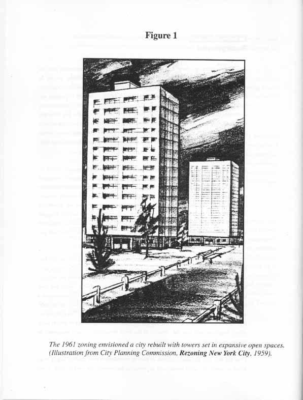
8 UNIFIED BULK PROGRAM Background Almost forty years ago, New York City adopted a bold new zoning resolution that was intended, together with urban renewal and highway construction, to remake the city. In the preceding decades, builders of apartment houses and multi-story commercial buildings, had achieved the greatest returns by covering as much of their property as possible and building as tall as was economically feasible. This produced a densely built environment that contrasted sharply with the openness of the proliferating post-war suburbs. The boroughs outside Manhattan developed a distinctive four-to-six story scale in many areas, particularly near transit lines. Where prewar office towers were built, they were frequently slim columns above a base with multiple setbacks that did not yield on the upper floors the large floor plate demanded by office users today. The Zoning Resolution adopted in 1961 was designed to create a more open city (Figure 1). Over the entire city, permitted density was cut by 80 percent. Many low-density residential districts were protected from apartment development for the first time. New development in all residence districts that permitted multiple dwellings and in middle-density to highdensity commercial and manufacturing districts, was to be modeled on pioneering developments of the late 1940's and 1950's, such as Stuyvesant Town and the Seagram Building. These developments consisted of towers surrounded by open space. Architects and planners referred to them as towers-in-a-park. They were marvels when built and some are icons today. The promise of the new Zoning Resolution was short lived. As soon as the first developments shaped by the new zoning began to appear in the mid-1960's, critics, who had applauded the density cuts of the 1961 reforms, realized how different the tall new buildings were from the dominant character of the city s neighborhoods, which had been developed under the pre-1961 zoning with shorter bulkier buildings that established a streetwall. The tower set back from the street, the archetypical building form of the 1961 zoning, was perceived as alien to New York's pedestrian-oriented streets. The light and air it produced did not make up for the damage inflicted on the organic mix of uses in older urban neighborhoods and the vibrancy of the city's streetscape now recognized as virtues, not drawbacks, of urban living. Over the next four decades, hundreds of zoning amendments were enacted largely in an effort to remedy the 1961 zoning and, in particular, the tower-in-the-park concept. These
9
10 amendments took many different forms, including special purpose districts, limited height districts, infill zoning, contextual districts, noncontextual districts with letter suffixes, quality housing rules, tower-on-a-base requirements, waterfront zoning all were intended to thwart the fundamental thrust of the 1961 zoning, to preserve the established character of New York's neighborhoods and to ensure that new buildings activated, rather than deadened, activity in the public streets. These multiple efforts have never been comprehensive enough to remove the tower-in-the-park concept as a guiding force in the Zoning Resolution and have not produced a comprehensive framework for guiding the city's future growth and development. Many of the reforms have been inconsistent or not properly integrated with each other. Instead the Zoning Resolution has become unduly complicated, inconsistent, ambiguous, out-of-date and difficult to enforce. The gaps and loopholes left by piecemeal reforms to the bulk regulations have permitted unexpected, inappropriate and out-of-scale developments to occur. The realization of some of the less appealing possibilities inherent in the 1961 zoning appears with greater frequency now, because market conditions are more favorable than in most of the preceding 40 years and good development sites are in ever shorter supply. With each successive boom in the city s real estate economy, developers use the opportunities that remain in the 1961 zoning to build taller and bigger buildings. A more detailed explanation of the existing rules is found in Appendix A. Most of the impact of post-1961 development has been felt in Manhattan, in a number of large subsidized housing projects and at the low-density edges of the city. A Department of City Planning survey of data on building heights in different zoning districts (Appendix B) confirms that the 1961 zoning had limited effect in the rest of the city. The built fabric in most of the city reflects the building types that emerged from the 1916 zoning. The scale of this pre-1961 development rarely exceeded six stories. Attempts by builders to break this pattern and take advantage of the greater heights to be achieved under the 1961 zoning have provoked controversy and community pressure to restrict development. The interaction between height and floor area under the 1961 zoning provoked early attempts to respond to these issues by reducing permitted floor area, even though the public controversy was really focused on built form. In the 1980's, contextual zoning demonstrated that existing densities could be maintained within a building envelope that reflected the prevailing height and massing of buildings. 2
11
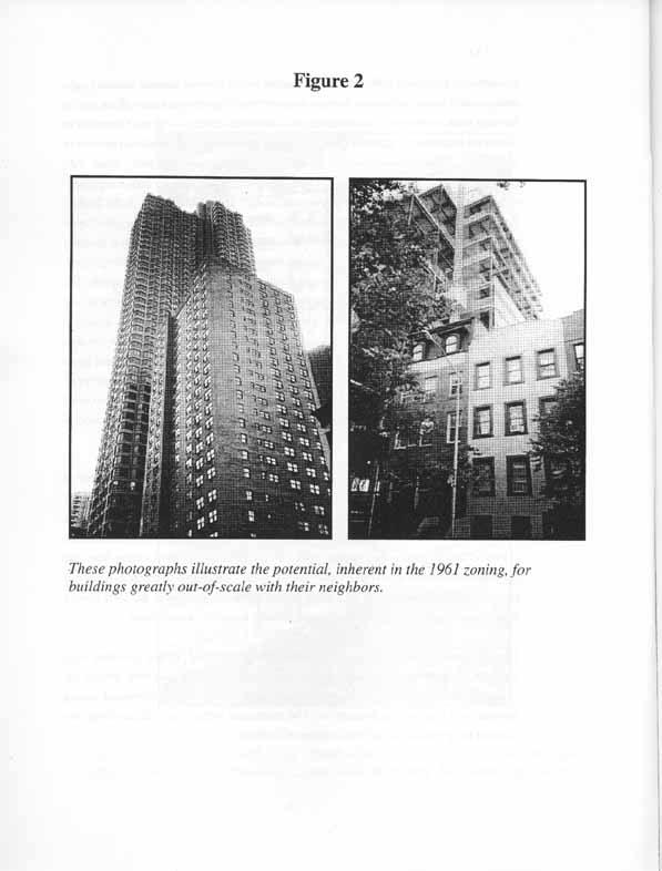
12 Most developments fit within the context of the city's communities. But the minority that fall outside this context create significant problems virtually wherever and whenever they are built (Figure 2). While such developments may be desired by both developers and future occupants, communities are bearing substantial and increasing costs from having them in their midst. These costs include the blockage of sky, light and air to existing residents and businesses; the localized impacts of living next to excessively large buildings; and the affront to the qualities that give value to diverse neighborhoods and make them economically attractive places to develop new buildings -- their streetscape and street life. The Unified Bulk Program would implement a coherent vision of a New York City that builds on the best of the city's urban character. At the same time, it is intended to simplify and rationalize the controls on the height and massing of new buildings throughout the city. Central to this system is a clearly stated height limit for each zoning district, outside of the central business districts. PROBLEMS WITH THE EXISTING ZONING Four decades of fixes have left a Zoning Resolution with deep flaws. The fundamental problems with the existing bulk provisions of the zoning are described below. Lack of a Clear Vision The Zoning Resolution fails to provide a coherent vision for the city's development. It has become a hodgepodge of regulations reflecting, not one, but several visions of the city's development, often applied simultaneously in the same zoning districts. Moreover, one of these visions the discredited tower-in-the-park prototype persists despite the fact that its credibility began to erode almost immediately after its adoption in Incomprehensibility The different regulatory systems embedded in the Zoning Resolution are intertwined in the text in ways that create both vast complexity and enormous uncertainty as to the meaning of the words. Repeated tinkering with the Zoning Resolution's text has led to errors, omissions, vagueness, and a host of situations that may be regulated in more than one way or not at all. In fact, only a handful of experts profess to understand the Zoning Resolution, and even they often disagree on its meaning. The average citizen 3
13
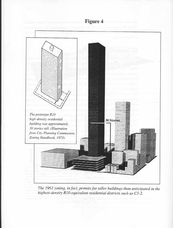
14 or property owner often has little hope of determining how a particular parcel of land may be developed. Unpredictability The Zoning Resolution is unpredictable in the sense that it periodically yields buildings that are so out-of-scale with their surroundings that they produce negative effects on neighborhood character in the form of reduced light and air on nearby streets and creating unattractive urban landscapes (Figure 3). This unpredictability results in part from the previously described problems of no single clear vision and of an unduly complex text, both of which produce a regulatory environment rife with loopholes and opportunities to take advantage of rules that are difficult to understand and enforce. The unpredictability also results from having zoning that was originally designed to allow buildings with heights and setbacks that are inconsistent with most of the built form of the city. In 1961, the City Planning Commission was prepared to make a radical departure from the past with the tower-in-the-park model and office buildings in the International Style. Unlike the 1916 zoning, which set a pattern for decades of new development, the 1961 zoning never received widespread acceptance and did not result in the rebuilding of the city, except in some parts of Manhattan. As a result, the new buildings that reach the tower heights possible under the 1961 zoning often are jarring and incompatible with their neighbors. They illustrate for many the unpredictability of the zoning, because they are inconsistent with the urban landscape with which most New Yorkers are comfortable. Price Premium for Height Among the city's residential areas, only areas subject to urban renewal and highend market-rate construction in certain parts of Manhattan below 96th Street experienced a radical change in built character under the 1961 zoning. As market-rate buildings became taller, the upper stories commanded a premium for expansive views. When the skyline thickened, these views could be achieved only at greater and greater heights. Although these ever-taller buildings were more expensive 4 When the current zoning went into effect in 1961, permitted tower coverage was increased from 25% to 40% because it was considered uneconomical to build tall slender buildings. The 40% tower in R9, R10 and equivalent districts was expected to produce buildings of approximately 30 stories for a 12 FAR building (12 FAR.40 coverage=30 stories). Today, it is more economical to build a narrower and taller residential building which may cost more to build per square foot but will yield significantly greater returns. In these highdensity districts this unanticipated shift to 40-, 50- story development or more under the 1961 zoning has provoked public criticism (Figure 4).
15
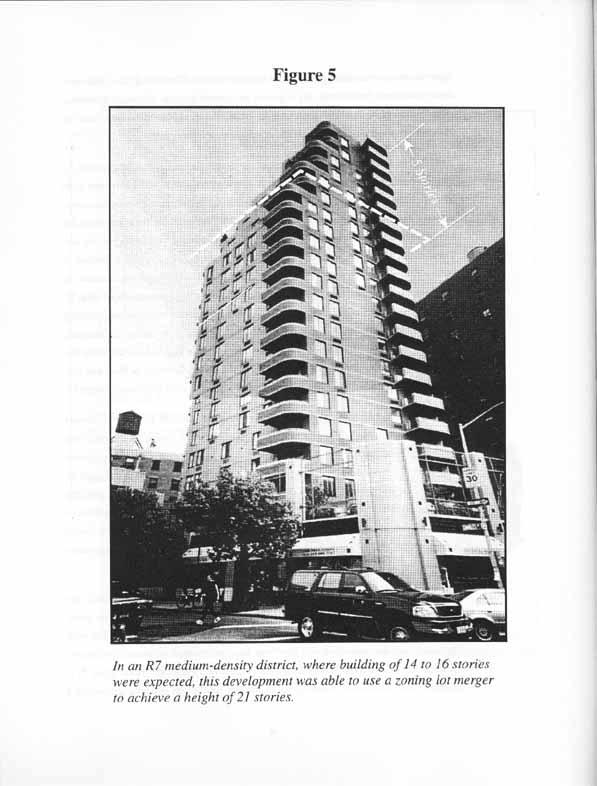
16 to build, the premium for views paid by Manhattan's wealthiest households increased at an even faster rate. With height at a premium and low-coverage towers financially feasible, zoning lot mergers became increasingly ambitious. A development site would be merged with adjoining lots containing buildings built to less than the permitted maximum floor area, so that a new building could become even bigger by using unbuilt floor area from the merged lots. Zoning lot mergers are critical to the successful functioning of the city. They enable developers to assemble small lots into the larger merged lots needed to build efficient, economical new buildings. The mergers also provide an incentive to preserve small existing buildings that are not built to the full permitted floor area, by enabling the transfer of the unused floor area from the site of a small existing building to the development site. Additional controls must be placed on zoning lot mergers, however, to avoid the transfer of excessive amounts of floor area to a development site from the already developed portion of a merged zoning lot. Transfers of floor area that go too far have produced buildings totally out-of-scale with their neighbors (Figure 5). The ambiguity of regulations controlling properties divided by zoning district boundaries ( split lots ) further enhanced the possibilities of zoning lot mergers. The many variations among zoning districts and the many alternative rules permissible within certain zoning districts made it difficult to discern when it was appropriate to shift building bulk across a zoning boundary, because two districts had substantially the same requirements, and when it was prohibited because the districts were fundamentally different in how they regulated bulk, floor area or other matters. A liberal interpretation of split lot rules has been the basis for some unusually expansive zoning lots with very tall buildings. A third feature of the zoning that has contributed to the growing heights is the increasing use of mechanical space deductions. As buildings have become more technologically sophisticated, more and more space for mechanical systems has been deducted from the computation of the floor area subject to floor area ratio controls, in some case amounting to more than 25 percent of a building s floor space. It is certainly desirable for new buildings to use the new technology and appropriate that a reasonable amount of mechanical space be deducted from floor area calculations, but these deductions should not become so large that they subvert the bulk provisions of the zoning. In the absence of height limits, zoning lot mergers, the manipulation of split 9
17
18 lot rules, and the deductibility of mechanical space have produced buildings wholly out of character with their neighbors. Midblock Towers On wide streets in high-density residential districts and commercial overlays, the zoning regulations require that tower developments have a base that enhances the streetscape and lowers the height of buildings. The absence of these controls on midblock sites permits towers to break up what is often a consistent streetscape of lower, buildings sited closer to the street, established under or before the 1916 zoning. The problem is compounded by rear yard equivalent rules that encourage midblock towers on lots that connect two parallel narrow street frontages to be placed in the center of the block and mandate open areas along the street frontages. These towers block light and air to the rear windows of neighboring properties and generally leave leftover space facing the street, which is often used for storing refuse. Deficiencies of 1961 Height and Setback rules The 1961 zoning created building envelopes considerably taller and otherwise out of character with most neighborhoods. Yet the envelopes have not encouraged the creative designs expected by their drafters in Most new buildings, particularly office and community facility buildings, are developed pursuant to the Alternate Sky Exposure Plane or tower regulations (see page 50), which allows buildings to set back from the street at grade and then rise to their full height without any additional setback. By reducing a building s lot coverage, these regulations require buildings to be significantly taller than necessary to absorb all of their on-site floor area. Moreover, the setback at the streetline often breaks established streetwall context. Even buildings, such as retail developments, that elect to use the Regular Sky Exposure Plane regulations (see p. 50) to maximize the size of their lower floor plates generally choose to limit the number of setbacks located above the building's base. Thus, practically no buildings are constructed in the wedding cake form, which was originally what the sky exposure plane regulations were intended to produce. The loss of the wedding cake is perhaps inevitable, because multiple setbacks are expensive to 11
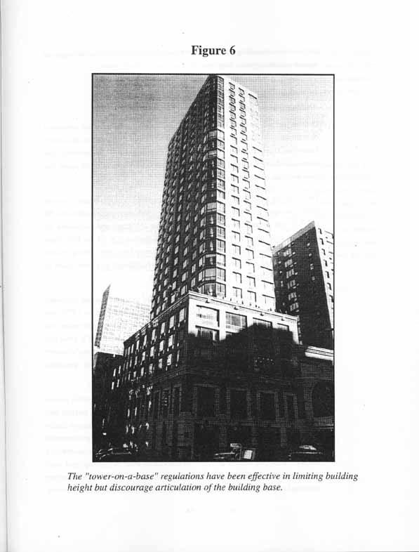
19 build and, in any event, there are few locations where this built form would be consistent with neighborhood character. In summary, the zoning should not encourage buildings to break the streetwall to achieve greater height, nor should it be based on an obsolete building form. Over the years, these basic issues have been addressed in a variety of ways, but the offending zoning provisions have never been eliminated and the solutions, in the form of new zoning districts and other additions to the text, have not dealt comprehensively with the problems. Contextual zoning has integrated new development with the city's existing built fabric, limiting height and the potential for zoning lot mergers, but contextual zoning does not apply everywhere nor to all types of buildings. In many districts, contextual rules apply only to residences. This reflects the fact that nonresidential buildings require more bulk to fulfill their programmatic requirements. In others, contextual buildings are only an option. Moreover, existing contextual rules are generally quite restrictive and do not work in neighborhoods that lack a narrowly defined context. Contextual provisions do not reflect the character of the full range of the city s built environments. In many high-density residential areas of Manhattan, tower-on-a-base rules recognize that towers are now an important part of the context, but limit both height and zoning lot mergers. These rules are more complex than necessary, and their complexity impedes the quality of new development. Under tower-on-a-base, 55% of a building s floor area must be located below the level of 150 feet. This rule is an indirect method of limiting a building s height. In theory, this floor area could be located between the base of the building and the 150-foot level. Rather than build costly setbacks, however, architects have chosen generally to maximize the volume at the base of the building allowing for the tower to rise after a single setback. This has produced buildings with minimum floor to ceiling heights, limited base articulation, and the limited use of recesses results in darker apartments with awkward layouts in the base where much of the floor area is packed (Figure 6). A simpler set of tower-on-a-base rules could achieve the desired result in terms of building form, without imposing undesirable limits on the design and interior layouts of the building base. 12
20
21 Problem Public Spaces Over the past two years, the Department of City Planning has reviewed and inventoried every privately owned public space in the city that is provided for pursuant to the Zoning Resolution. That work, which will be published in the spring of 2000, has confirmed what some critics have maintained for some time that certain types of public spaces that generated floor area bonuses do not produce meaningful public benefits. The tower-on-a-base amendment of 1994 eliminated the floor area bonus for on-site public open space for most residential buildings in high-density residential districts (R9 and R10 and commercial overlays). Eligibility for the bonus was maintained for residential buildings in the high-density commercial districts (C4, C5 and C6), where it was believed that the plazas would be a valued amenity for people working in these areas. Even in these districts, residential plazas have continued to present issues of design and usefulness. A lack of any design standards in the 1961 zoning led to unadorned and underused plazas. Even with design standards for residential plazas (adopted in 1977), the residential plaza bonus has failed to routinely produce attractive open spaces that benefit the public. In many cases, plazas are poorly designed and located in a way that discourages public use. Randomly placed plazas too often erode the streetwall character of residential neighborhoods and add to the heights of towers without providing meaningful public benefits. Bonuses for certain other types of open spaces, such as arcades, through-block arcades and sidewalk widenings, are available to all types of buildings despite the fact that they do not provide usable public open space, even in commercial or community facility buildings where a well-designed public space would be heavily used. The arcade bonus, which has been little used, results in buildings that are not consistent with the streetwall character of the city. Arcades also have the unfortunate effect of pushing retail space away from the streetline. Through-block arcades can provide a useable amenity as part of planned pedestrian network, as in the Special Midtown District, are of little use when provided randomly based on the location of development sites. Sidewalk widenings, where needed, have been incorporated into special district regulations. At other locations, the widenings are unnecessary and inconsistent with the streetwall character 13
22 of the city. Zoning should not offer incentives for public open spaces that do not truly provide a public amenity. Design as an Afterthought In spite of the city's rich architectural heritage, current development practice pays little attention to architectural detail or innovation. Design is driven by cost considerations, such as efficient floor plate size or minimizing setbacks, and potential revenue, which is a function of interior layout, finish, views and other factors. By its very nature, the zoning's regulatory structure, designed to prevent inappropriate development, sometimes lacks the flexibility to accommodate design creativity. It should be possible to devise review processes that will encourage architects to design striking and innovative buildings by allowing, in appropriate situations, departures from the bulk rules of general application. 14
23 UNIFIED BULK PROGRAM Recommendations New York City's neighborhoods range from single-family suburban-style homes to brownstones to steel and glass skyscrapers. New Yorkers care deeply about preserving the physical character of the neighborhoods where they live and work. At the same time, New Yorkers value the dynamism and creativity of the city and there is an expectation not to mention an economic necessity that the city will accommodate new uses and new buildings that reflect the cutting edge of the urban economy and the best contemporary architecture. The challenge of zoning reform is to strike the right balance between these competing visions with zoning that protects the essential character of our neighborhoods while accommodating the vibrancy and inventiveness that makes New York unique. In the effort to meet this challenge, the Unified Bulk Program follows five underlying principles. Value of Context New development should respect the prevailing character of neighborhoods. In most of the city, neighborhoods are characterized by generally consistent heights and a defined physical relationship between buildings and the street. For the most part, these qualities are the product of the 1916 zoning. Relatively little of the city fits the tower-in-the park model of the 1961 zoning. In those districts that have been transformed by modern towers, tower development should not be precluded, but it should not be encouraged to reach new heights. This focus on the value of context is a rejection of the vision of a city rebuilt with towers surrounded by open areas, which drove the 1961 Zoning Resolution. Practical buildings, with innovative and attractive architecture, can be built under zoning that incorporates the most enduring design values of earlier periods in the city's development. Height Limits Each zoning district, outside designated central business districts, should have a height limit to provide certainty for residents, property owners and developers that future development 17
24 will not exceed clearly defined limits. The height limits, together with setback controls, should allow for design flexibility while establishing effective parameters for an as-of-right building's envelope that cannot be undermined by zoning lot mergers, deductions of mechanical space from floor area and other techniques that have been used to increase the height and size of buildings without violating floor area limits. Development proposals that seek to exceed these limits should be subject to the Uniform Land Use Review Procedure. Practical Height and Setback Regulations New zoning regulations should accommodate the least costly building types at different densities consistent with the city's land use objectives. The proposed rules would continue to allow the lowest cost buildings now developed in low- density and middle-density districts. Only in high-density residential districts, where land is costly and rents and sale prices are the highest in the city, would the zoning require a setback above a building's base. Current Floor Area Ratio and Density Standards are Appropriate The current zoning generally establishes appropriate floor area ratio density standards to meet the needs of the city's population and employment. The 1961 zoning largely eliminated the excess capacity embodied in the 1916 zoning. Individual zoning map amendments are the proper remedy for those communities where the zoning is out of balance with the carrying capacity of the infrastructure or community character. Simplest Rules Consistent with Land Use Objectives While the zoning must address a series of policy objectives in a complex city, the zoning must be simple enough that developers and members of the public can understand it and government officials enforce it. The elements of the Unified Bulk Program are described on the following pages. THE PROPOSAL 18
25 Height and Setback Envelopes The proposed height limits and setback rules would replace the multiple alternative envelopes in the existing zoning with one or two simple building envelopes for each zoning district. They would eliminate, among other provisions, tower-in-a-park zoning, sky exposure planes and height factor zoning. The proposed envelopes are designed to be flexible enough that all the permitted floor area could be used on a typical lot to produce a variety of designs that are consistent with the typical scale of development in the zoning district. They are generally more restrictive in terms of height and bulk than the existing zoning, but allow more flexibility than a contextual zoning district. They are designed to allow all the permitted floor area to be used on a typical lot, but to limit the use of techniques that have produced out-of scale buildings, such as transfers of bulk across zoning district boundaries, zoning lot mergers, and deductions of mechanical space from zoning floor area. In the highest density districts (R9, R10 and equivalents), for example, the district height limits are designed to accommodate a roughly 10% allowance for mechanical space and 25% for off-site floor area from a zoning lot merger. Height and setback requirements in contextual zoning districts would not be changed under the Unified Bulk Program. In special districts, minimal changes needed to incorporate the new concepts and terminology of the Unified Bulk Program will be made where necessary (see Appendix D). The proposed height limits would not be applicable in the Special Midtown and Special Lower Manhattan Districts. In the waterfront, Unified Bulk would apply only to industrial uses currently exempt from the waterfront regulations In non-contextual medium-density and high-density districts (R6 to R10 and equivalents), two basic building types would be allowed (Figure 7). These would permit design flexibility consistent with the character of the city s neighborhoods. The envelopes would allow the full permitted floor area to be built in either (1) a shorter contextual building or (2) a taller building with a setback. The goal is to bring buildings back into scale in each district, but not to constrict them to a purely contextual shape. This approach also reflects the fact that in many districts development occurs in a context of taller buildings that do not hold the streetwall. Developers of nonresidential buildings would be able to make a choice about which of the two building types best fits with the program, economics and other elements of a project. Residential buildings would be limited to the contextual shape except in defined circumstances where a taller building would be appropriate. The maximum height of the more contextual building is governed by a standard height limit, which varies on 19
26 Figure 7 Setback must be provided at any level between the minimum and maximum base heights Standard Building Height Maximum base height Minimum base height ;; yy STANDARD ENVELOPE FOR RESIDENTIAL BUILDINGS
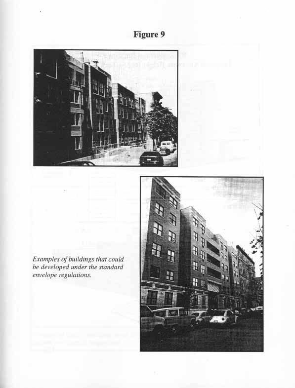
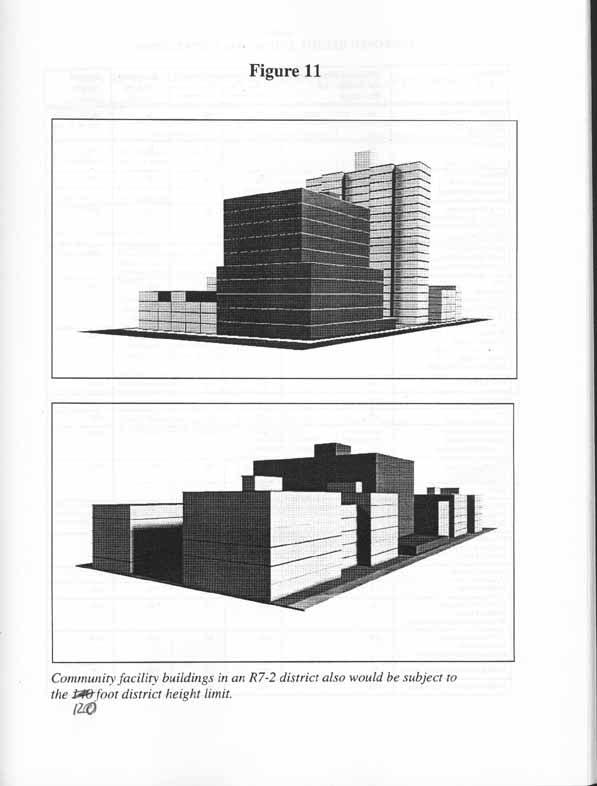
27 wide and narrow streets. The maximum height of the taller building is set by a district height limit. The district height limits are generally lower than the tallest building heights that can be achieved under the existing zoning. Each zoning district would have minimum and maximum heights for a residential building's base. To maintain the character of the streetscape, residential buildings using the contextual shape would not be permitted to set back below the district's minimum base height and would be required to set back above the maximum base height. The minimum required setback would be 10 feet on a wide street and 15 feet on a narrow street. The base heights and standard height limits for most districts are based on the existing Optional Quality Housing height limits. Figure 8 shows the standard envelope for an R7 district. Figure 9 shows examples of developments that could be built under the standard envelope. In noncontextual R6 through R8 and equivalent districts, residential buildings could exceed the standard height limit and rise to the district height limit only in limited locations where a block clearly does not have an established scale consistent with the standard height limit. These locations are: (1) full block development sites, (2) large-scale residential or general large-scale developments occupying a minimum of 1.5 acres, (3) sites adjacent to tall buildings (with one side lot line contiguous for at least 70 feet to a development that exceeds the zoning district's standard height limit by at least ten feet, and (4) sites adjacent to an elevated structure, such as a subway or bridge. In these situations, the building would be required to maintain a minimum 33% lot coverage at all levels below the top story in order to limit zoning lot mergers. (Figure 10 shows the alternate envelope for an R7 district). Commercial and community facility buildings, when developed at the street line, would be required to set back at the maximum base height. However, commercial and community facility buildings that set back at street level would not be required to set back farther at the maximum base height and could reach the district height limit (Figure 11). Exhibit 1 shows the minimum and maximum building base heights and the standard and district height limits for residential buildings in each district as well as district height limits. Exhibit 2 shows the applicability of height and setback envelopes by district. Drawings in Appendix E illustrate the building envelopes that would be permitted in selected zoning districts and compare them to what is permitted under existing zoning. 21
28 Figure 8 R7 Residential Building : Proposed Standard Height and Setback Regulations 15' REQUIRED SETBACK STANDARD BUILDING HEIGHT MAXIMUM BASE HEIGHT 65' 80' NARROW STREET NARROW STREET 200' FRONT ELEVATION 10' REQUIRED SETBACK 80' WIDE STREET 65' ELEVATION 60' (6 STORIES) SIDE ELEVATION 85' 15'
29
30 Figure 10 R7 Residential Building: Proposed Alternate Height and Setback Regulations 120' DISTRICT HEIGHT LIMIT ELEVATION 110' (11 STORIES) 15' 15' NARROW STREET NARROW STREET 65' MAXIMUM BASE HEIGHT 110' FRONT ELEVATION / HEIGHT LIMITS 120' DISTRICT HEIGHT LIMIT 10' ELEVATION 110' (11 STORIES) 65' MAXIMUM BASE HEIGHT WIDE STREET 10' 60' 30' SIDE ELEVATION / HEIGHT LIMITS
31
32 EXHIBIT 1 PROPOSED HEIGHT AND SETBACK ENVELOPES District Minimum Base Height for Residential Buildings Maximum Base Height w/o tower w/ tower Standard Height Limit District Height Limit CF bldgs. in R1 - R5 C1/C2 in R1 - R5 C3/C4-1/C8-1/M1-1 na 30 na na 50/ 90 beyond 100' of st. line R6 narrow na R6 wide C1/C2 in R6 C4-2/C4-3/C8-2/M1-2 R7-1, R7-2 narrow C1/C2 in R7-1, R7-2 narrow C1-6/C2-6/C4-4/C4-5 narrow M2-1/M2-3/M3 R7-1, R7-2 wide C1/C2 in R7-1, R7-2 wide C1-6/C2-6/C4-4/C4-5 wide R7-3 R8 narrow C1/C2 in R8 narrow C1-7/C4-2F/C6-1/C6-2/ C8-3/C8-4 narrow R8 wide C1/C2 in R8 wide C1-7/C4-2F/C6-1/C6-2/ C8-3/C8-4 wide M1-3/M1-4/M1-5/M2-2/M na na na na na M1-6 narrow na 125 na na 185 M1-6 wide na 150 na na 210 C7 na 65 na na 280 R9-1 R9 narrow C1/C2 in R9 narrow C1-8/C2-7/C6-3 narrow R9 wide C1/C2 in R9 wide C1-8/C2-7/C6-3 wide C6-1A R10 narrow C1/C2 in R10 narrow C1-9/C2-8 narrow R10 wide C1/C2 in R10 wide C1-9/C2-8 wide C4-6/C5-1 narrow C4-6/C5-1 wide C4-7/C5-2/C5-4/C6-4/ C6-5/C6-8 narrow M1-6 narrow -Midtown periphery C4-7/C5-2/C5-4/C6-4/ C6-5/C6-8 wide M1-6 wide-midtown periphery C5-3/C5-5/C6-6/C6-7/C6-9 narrow C5-3/C5-5/C6-6/C6-7/C6-9 wide
33 EXHIBIT 2 DESCRIPTION OF HEIGHT & SETBACK ENVELOPES BY BUILDING TYPE DISTRICT BUILDING TYPE Residential Community Facility Commercial Mixed R1 - R2& Equivalents R3 - R5 & Equivalents R6 - R8 & Equivalents R4A envelope; For lots of 9,500 sq. ft. or greater, 35' height limit Not Applicable Certain Lots* Standard Envelope (with setback required from streetwall between min. & max. base height) or District Height Limit with: 33% min. lot coverage at every story no setback from streetwall required (but setback required if within 10' of wide and 15' of narrow streetline) District Height Limit with setback required at maximum base height within 10' of wide and 15' of narrow streetline Residential portion of building must comply with residential regulations District Height Limit with setback required at maximum base height within 10' of wide and 15' of narrow of streetline District Height Limit with setback required at maximum base height within 10' of wide and 15' of narrow of streetline Residential portion of building must comply with residential regulations All Other Lots Standard Envelope R9 - R10 & Equivalents Standard Envelope or District Height Limit pursuant to Tower-on-a-Base regulations Standard Envelope or District Height Limit pursuant to Tower Regulations or Tower-ona-Base regulations if predominantly residential Standard Envelope or District Height Limit pursuant to Tower Regulations Standard Envelope or District Height. Limit pursuant to Tower Regulations or Tower-on-a-Base regulations if predominantly residential C Certain Lots includes: large scale residential developments, general large scale developments, full block zoning lots, zoning lots that have a side lot line that is contiguous for at least 70' with a zoning lot that contains a building on it which exceeds the Standard Height Limit by at least 10', and zoning lots adjacent to an elevated highway or railway.
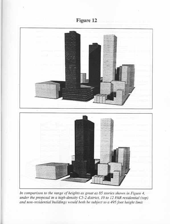
34 Height Limits in High-Density Commercial Districts In the high-density commercial districts (most C4, C5 and C6 districts), the district height limits are 420, 495 or 720 feet reflecting the amount of commercial floor area permitted. (Figure 12). These height limits were selected with the intention of allowing design flexibility within an envelope that accommodates a full build-out of the permitted floor area of a development site with a commercial tower occupying 40% of the zoning lot and floorto-floor heights of 12 feet, together with a limited allocation for mechanical space (10% of building floor area) and for floor area from a zoning lot merger (25%). The height limits are designed to cap both deductions from zoning floor area for mechanical space and transfers of floor area by zoning lot merger, which often have exceeded these percentages. Commercial and community facility buildings could set back from the street and then rise to the district height limit. Residential buildings would be subject to the same height limits in these commercial districts, but, unlike the commercial and community facility buildings, would be subject to the modified tower-on-a-base regulations described below. Bulk Requirements in High-Density Residential Districts The slimmer residential towers in high-density noncontextual residential districts (R9, R10 and C1 or C2 equivalents) have a more intimate relationship to the street and do not have the programmatic requirements of commercial and community facility buildings, which generate taller buildings. Accordingly, residential buildings in these districts would be subject not only to a shorter 360 foot height limit but to tighter building envelope requirements designed to produce a streetwall that respects the prevailing scale of development and allows adequate light. The height limit, but not the tighter building envelope, would apply to community facility buildings in these districts. Any tower with more than 25 percent of its floor area devoted to residential use would be subject to revised tower-on-a-base regulations (Figure 13). A residential building s base would be required to hold the streetwall and would have a maximum height of 85 feet. Tower-on-a-base rules would for the first time apply on narrow streets and would be modified to provide greater design flexibility without jeopardizing the objectives of limiting 28
35
August 24, 2011/Calendar No. 16
 CITY PLANNING COMMISSION _ August 24, 2011/Calendar No. 16 _ IN THE MATTER OF an application submitted by the Department of City Planning pursuant to Section 201 of the New York City Charter, for an amendment
November 17, 2004/Calendar No. 22
 CITY PLANNING COMMISSION November 17, 2004/Calendar No. 22 C 040495 ZSM IN THE MATTER OF an application submitted by 400 Park Avenue South LLC pursuant to Sections 197-c and 201 of the New York City Charter
BACKGROUND. The 1916 Zoning
 APPENDIX A Evolution of New Yor ork City s Zoning Resolution BACKGROUND New York City s built fabric is a product of the interaction between zoning and building regulations, advances in technology, and
East River Fifties/Sutton Place Rezoning Manhattan Community District 6 February 22, 2017 Applicant s Project Description
 East River Fifties/Sutton Place Rezoning Manhattan Community District 6 February 22, 2017 Applicant s Project Description LR Item 3 Project Description I. Introduction The applicant, East River Fifties
Goal 1 - Retain and enhance Cherry Creek North s unique physical character.
 Introduction This document summarizes the proposed new zoning for the area of roughly bordered by University Boulevard, Steele Street, 3rd Avenue, and 1st Avenue. It provides a high-level review of the
City of Coral Gables Planning and Zoning Staff Report
 City of Coral Gables Planning and Zoning Staff Report Applicant: Application: Public Hearing: Date & Time: Location: City of Coral Gables Zoning Code Text Amendment Giralda Plaza Overlay District Planning
Article 3. SUBURBAN (S-) NEIGHBORHOOD CONTEXT
 NEIGHBORHOOD CONTEXT") Article 3. SUBURBAN (S-) NEIGHBORHOOD CONTEXT this page left intentionally blank Contents ARTICLE 3. SUBURBAN (S-) NEIGHBORHOOD CONTEXT DIVISION 3.1 NEIGHBORHOOD CONTEXT DESCRIPTION...3.1-1 Section 3.1.1
Article 3. SUBURBAN (S-) NEIGHBORHOOD CONTEXT this page left intentionally blank Contents ARTICLE 3. SUBURBAN (S-) NEIGHBORHOOD CONTEXT DIVISION 3.1 NEIGHBORHOOD CONTEXT DESCRIPTION...3.1-1 Section 3.1.1
Draft for Public Review. The Market and Octavia Neighborhood Plan
 Draft for Public Review The Market and Octavia Neighborhood Plan San Francisco Planning Department As Part of the Better Neighborhoods Program December 00 . Housing People OBJECTIVE.1 MIXED-USE RESIDENTIAL
CB-5 INCLUSIONARY AIR RIGHTS
 WWW.NYINVESTMENTSALES.COM CB-5 INCLUSIONARY AIR RIGHTS CONFIDENTIALITY This offering was prepared by Cushman & Wakefi eld and has been reviewed by the Owner. It contains select information pertaining to
East Harlem Rezoning Proposal - Approved!
 This page is located on the NYC.gov Web site at http://www.nyc.gov/html/dcp/html/eastharlem/eastharlem1.shtml Projects & Proposals > Manhattan > East Harlem East Harlem Rezoning Proposal - Approved! REZONING
Appendix A: Guide to Zoning Categories Prince George's County, Maryland
 Appendix A: Guide to Zoning Categories Prince George's County, Maryland RESIDENTIAL ZONES 1 Updated November 2010 R-O-S: Reserved Open Space - Provides for permanent maintenance of certain areas of land
UNDERSTANDING THE TAX BASE CONSEQUENCES OF LOCAL ECONOMIC DEVELOPMENT PROGRAMS
 UNDERSTANDING THE TAX BASE CONSEQUENCES OF LOCAL ECONOMIC DEVELOPMENT PROGRAMS Richard K. Gsottschneider, CRE President RKG Associates, Inc. 277 Mast Rd. Durham, NH 03824 603-868-5513 It is generally accepted
DRAFT FOR DISCUSSION PURPOSES ONLY. Port Credit Local Area Plan Built Form Guidelines and Standards DRAFT For Discussion Purposes
 Port Credit Local Area Plan Built Form Guidelines and Standards DRAFT For Discussion Purposes 1 Local Area Plan - Project Alignment Overview Directions Report, October 2008 (General Summary Of Selected
College Avenue. Sowers Street. Calder Way. Beaver Avenue
 K L M Illustrative Master Plan: Collegiate District Calder Way Beaver Avenue High Street ner 16 Sowers Street Stre et 17 Hetzel Street 18 Gar Heister Street 15 Collegiate District 183 4-C: East End Collegiate
TASK 2 INITIAL REVIEW AND ANALYSIS U.S. 301/GALL BOULEVARD CORRIDOR FORM-BASED CODE
 TASK 2 INITIAL REVIEW AND ANALYSIS U.S. 301/GALL BOULEVARD CORRIDOR FORM-BASED CODE INTRODUCTION Using the framework established by the U.S. 301/Gall Boulevard Corridor Regulating Plan (Regulating Plan),
Streamlining the Entitlement Process for Transit-Oriented Development
 October 2012 Streamlining the Entitlement Process for Transit-Oriented Development Best Practices Summary Setting Ideas in Motion Introduction and Overview Entitlement Process: The legal method of obtaining
Keeping in Character:
 Keeping in Character: A Look at the Impacts of Recent Community- Initiated Rezonings in the East Village Building Heights in the East Village The East Village is noted for its humanscaled buildings, with
City of Coral Gables Planning and Zoning Staff Report
 City of Coral Gables Planning and Zoning Staff Report Applicant: Application: Public Hearing: Date & Time: Location: City of Coral Gables Giralda Restaurant Row Overlay Zoning Code Text Amendment Planning
CPC CA 3 SUMMARY
 CPC-2009-3955-CA 2 CONTENTS Summary Staff Report Conclusion 3 4 7 Appendix A: Draft Ordinance A-1 Attachments: 1. Land Use Findings 2. Environmental Clearance 1-1 2-1 CPC-2009-3955-CA 3 SUMMARY Since its
Subway station improvements in Downtown Brooklyn and in commercial zones of 10 FAR and above in Manhattan (6/28/04)
") Land Use Law Center Gaining Ground Information Database Topic: Resource Type: State: Jurisdiction Type: Municipality: Year (adopted, written, etc.): 2004 Community Type applicable to: Title: Document Last
Land Use Law Center Gaining Ground Information Database Topic: Resource Type: State: Jurisdiction Type: Municipality: Year (adopted, written, etc.): 2004 Community Type applicable to: Title: Document Last
TRANSFER OF DEVELOPMENT RIGHTS
 STEPS IN ESTABLISHING A TDR PROGRAM Adopting TDR legislation is but one small piece of the effort required to put an effective TDR program in place. The success of a TDR program depends ultimately on the
ZONING ORDINANCE: OPEN SPACE COMMUNITY. Hamburg Township, MI
 ZONING ORDINANCE: OPEN SPACE COMMUNITY Hamburg Township, MI ARTICLE 14.00 OPEN SPACE COMMUNITY (Adopted 1/16/92) Section 14.1. Intent It is the intent of this Article to offer an alternative to traditional
Zoning Analysis. 2.0 Residential Use. 1.0 Introduction
 Zoning Analysis 1.0 Introduction For zoning to be an effective community development tool, it must recognize the unique land use characteristics of the various portions of the community. The Lawrence Zoning
Appendix1,Page1. Urban Design Guidelines. Back to Back and Stacked Townhouses. DRAFT September 2017
 Appendix1,Page1 Urban Design Guidelines DRAFT September 2017 Back to Back and Stacked Townhouses Appendix1,Page2 Table of Contents 1 Introduction 1 1.1 Purpose 1 1.2 Urban Design Objectives 1 1.3 Building
DAVIDSON PLANNING ORDINANCE AMENDMENTS AFTER SEPTEMBER 2009 SECTION 9
 AMENDMENT ADOPTED 6/12/2012 Section 9.1.3.3.1 Wall Murals Entire Section Added: 9.1.3.3.1 Wall Murals DAVIDSON PLANNING ORDINANCE AMENDMENTS AFTER SEPTEMBER 2009 SECTION 9 Exterior wall murals are only
City of Reno October 30, 2012 Draft Midtown Zoning Text Amendments 1
 Section 18.08.405 Regional Center and Transit Corridor Overlay Districts (i) SVTC South Virginia Street Transit Corridor Overlay Zoning District. (1) Applicability. This Section 18.08.405(l)'s standards
ZOCO CHAIRMAN S PROPOSED DISCUSSION ISSUES PROPOSED ZONING ORDINANCE AMENDMENT ON SIGNS (SECTION 34)
") ZOCO CHAIRMAN S PROPOSED DISCUSSION ISSUES PROPOSED ZONING ORDINANCE AMENDMENT ON SIGNS (SECTION 34) 1. MODIFICATIONS [ 34.3] Staff proposal Under 34.3.A, staff proposes that the County Board be able to
ZOCO CHAIRMAN S PROPOSED DISCUSSION ISSUES PROPOSED ZONING ORDINANCE AMENDMENT ON SIGNS (SECTION 34) 1. MODIFICATIONS [ 34.3] Staff proposal Under 34.3.A, staff proposes that the County Board be able to
Poughkeepsie City Center Revitalization Plan
 Purpose and Need Purpose Increase job and educational opportunities for all residents Maximize fiscal productivity of downtown land uses Diversify retail mix Eliminate surface and building vacancies Create
PHASE 1 AMENDMENT TO THE STATION AREA REDEVELOPMENT PLAN BOROUGH OF NETCONG, MORRIS COUNTY, NEW JERSEY
 PHASE 1 AMENDMENT TO THE STATION AREA REDEVELOPMENT PLAN BOROUGH OF NETCONG, MORRIS COUNTY, NEW JERSEY PREPARED BY PHILLIPS PREISS GRYGIEL LLC PLANNING & REAL ESTATE CONSULTANTS AUGUST 2016 Adopted October
A Guide to Developing an Inclusionary Housing Program
 Richard Drdla Associates affordable housing consultants inc A Guide to Developing an Inclusionary Housing Program Developed for: Acorn Institute Canada Sept 2010 Acknowledgment This guide was prepared
ALL ORDINANCES IN CONFLICT HEREWITH; PROVIDING FOR AN EFFECTIVE DATE.
 ORDINANCE 2013-07 AN ORDINANCE AMENDING THE CODE OF ORDINANCES OF THE TOWN OF LONGBOAT KEY, FLORIDA, BY AMENDING THE ZONING CODE, DIVISION 3, COMMERCIAL REVITALIZATION, CHAPTER 158.180, DISTRIBUTION OF
Composition of traditional residential corridors.
 Page 1 of 7 St. Petersburg, Florida, Code of Ordinances >> PART II - ST. PETERSBURG CITY CODE >> Chapter 16 - LAND DEVELOPMENT REGULATIONS >> SECTION 16.20.060. CORRIDOR RESIDENTIAL TRADITIONAL DISTRICTS
Indicates Council-recommended changes Introduced by: Mr. Tackett Date of introduction: June 14, 2016 SUBSTITUTE NO. 1 TO ORDINANCE NO.
 Indicates Council-recommended changes Introduced by: Mr. Tackett Date of introduction: June 14, 2016 SUBSTITUTE NO. 1 TO ORDINANCE NO. 16-067 TO AMEND NEW CASTLE COUNTY CODE CHAPTER 40 (ALSO KNOWN AS THE
Ann Arbor Downtown Zoning Evaluation
 Ann Arbor Downtown Zoning Evaluation Options Workbook ENP & Associates in cooperation with the City of Ann Arbor September, 2013 Photo Courtesy of Andrew Horne, February 9, 2013 Introduction Thank you
Air Rights Reference Guide
 Air Rights Reference Guide Revision Date August 15, 2016 City Center Real Estate Inc. 1010 Fifth Avenue New York, NY 10028 ROBERT I. SHAPIRO Founder (212) 396-9705 ris@citycenternyc.com RONALD NOVITA Executive
4 LAND USE 4.1 OBJECTIVES
 4 LAND USE The Land Use Element of the Specific Plan establishes objectives, policies, and standards for the distribution, location and extent of land uses to be permitted in the Central Larkspur Specific
AN ANALYSIS OF LANDMARKED PROPERTIES IN MANHATTAN
 AN ANALYSIS OF LANDMARKED PROPERTIES IN MANHATTAN JUNE 2013 PREPARED BY LANDMARKS ANALYSIS OF MANHATTAN PROPERTIES OVERVIEW: An updated analysis of properties in Manhattan revealed that more than one in
White Paper of Manuel Jahn, Head of Real Estate Consulting GfK GeoMarketing. Hamburg, March page 1 of 6
 White Paper of Manuel Jahn, Head of Real Estate Consulting GfK GeoMarketing Hamburg, March 2012 page 1 of 6 The misunderstanding Despite a very robust 2011 in terms of investment transaction volume and
Attachment 4. Planning Commission Staff Report. June 26, 2017
 Planning Commission Staff Report June 26, 2017 Agenda #: Regular Agenda - 2 Title: Applicant: Request: Location: Existing Zoning: Proposed Use: Staff Planner: The Brands and The Brands West Eagle Crossing
Compatible-Scale Infill Housing (R-2 Zones) Project
 Project") Project Scope: A targeted amendment to the regulations for building bulk/height in the R-2 zones. Objectives: Allow more housing opportunities in the R-2A, R-2D, and R-2M zones, while ensuring the height
Project Scope: A targeted amendment to the regulations for building bulk/height in the R-2 zones. Objectives: Allow more housing opportunities in the R-2A, R-2D, and R-2M zones, while ensuring the height
3.1. OBJECTIVES FOR RESIDENTIAL LAND USE DESIGNATIONS GENERAL OBJECTIVES FOR ALL RESIDENTIAL DESIGNATIONS
 3. RESIDENTIAL LAND USE DESIGNATIONS INTRODUCTION The Residential land use designations provide for housing and other land uses that are integral to, and supportive of, a residential environment. Housing
Reviewing Mixed Use Proposals
 MIXED USE ZONING Citizens Guide Supplement 1 Things to Consider in Reviewing Mixed Use Proposals Using an Overlay District vs. Changing Underlying Zoning To achieve well-planned mixed use development,
3.1 Existing Built Form
 3.1 Existing Built Form There is a wide variety of built form in the study area, generally comprising 2 and 3 storey buildings. This stretch of Queen Street East is somewhat atypical of Toronto's main
SSAP 14 STATEMENT OF STANDARD ACCOUNTING PRACTICE 14 LEASES
 SSAP 14 STATEMENT OF STANDARD ACCOUNTING PRACTICE 14 LEASES (Issued October 1987; revised February 2000) The standards, which have been set in bold italic type, should be read in the context of the background
The demolition required for the project came before the Landmark Preservation Commission (LPC) on November 3, 2016, where no action was taken.
 on November 3, 2016, where no action was taken.") D E S I G N R E V I E W C O M M I T T E E S t a f f R e p o r t 2072 ADDISON STREET PRELIMINARY DESIGN REVIEW For Committee Discussion/ Majority Recommendation JULY 20, 2017 Design Review #DRCP2016-0002
D E S I G N R E V I E W C O M M I T T E E S t a f f R e p o r t 2072 ADDISON STREET PRELIMINARY DESIGN REVIEW For Committee Discussion/ Majority Recommendation JULY 20, 2017 Design Review #DRCP2016-0002
SECTION 73 CHESTER VILLAGE DISTRICT REGULATIONS
 SECTION 73 CHESTER VILLAGE DISTRICT REGULATIONS 73.1 AUTHORITY 73.1.1 Authority and Uniformity. It is the intention of the Commission to adopt use regulations and design standards for the area known as
LITTLE MOUNTAIN ADJACENT AREA REZONING POLICY
 LITTLE MOUNTAIN ADJACENT AREA REZONING POLICY JANUARY 2013 CONTENTS 1.0 INTENT & PRINCIPLES...1 2.0 APPLICATION...2 3.0 HOUSING TYPES, HEIGHT & DENSITY POLICIES...3 3.1 LOW TO MID-RISE APARTMENT POLICIES...4
PLNPCM : Attached Garage Regulations for Residential Districts ZONING TEXT AMENDMENT
 Staff Report PLANNING DIVISION COMMUNITY & ECONOMIC DEVELOPMENT To: From: Salt Lake City Planning Commission Daniel Echeverria (801) 535-7165 or daniel.echeverria@slcgov.com Date: September 3, 2015 Re:
Appendix J - Planned Unit Development (PUD)
") Appendix J - Planned Unit Development (PUD) Intent and Purpose The purpose of the PUD is: 1. To provide development that is consistent with the Comprehensive Land Use Plan and promote the goals and objectives
Appendix J - Planned Unit Development (PUD) Intent and Purpose The purpose of the PUD is: 1. To provide development that is consistent with the Comprehensive Land Use Plan and promote the goals and objectives
General Manager of Planning and Development Services in consultation with the Director of Legal Services
 POLICY REPORT DEVELOPMENT AND BUILDING Report Date: February 5, 2015 Contact: Anita Molaro Contact No.: 604.871.6479 RTS No.: 10821 VanRIMS No.: 08-2000-20 Meeting Date: February 17, 2015 TO: FROM: SUBJECT:
RE: Recommendations for Reforming Inclusionary Housing Policy
 Circulate San Diego 1111 6th Avenue, Suite 402 San Diego, CA 92101 Tel: 619-544-9255 Fax: 619-531-9255 www.circulatesd.org September 25, 2018 Chair Georgette Gomez Smart Growth and Land Use Committee City
Residential Neighborhoods and Housing
 Residential Neighborhoods and Housing 3 GOAL - To protect Greenwich as a predominantly residential community and provide for a variety of housing options The migration of businesses and jobs from New York
Chapter 17-2 Residential Districts
 Chapter 17-2 Residential Districts 17-2-0100 District Descriptions...2-1 17-2-0200 Allowed Uses...2-2 17-2-0300 Bulk and Density Standards...2-5 17-2-0400 Character Standards...2-18 17-2-0500 Townhouse
TRANSIT-ORIENTED DEVELOPMENT PLAN EXISTING CONDITIONS REPORT LAWRENCE TO BRYN MAWR MODERNIZATION
 TRANSIT-ORIENTED DEVELOPMENT PLAN EXISTING CONDITIONS REPORT LAWRENCE TO BRYN MAWR MODERNIZATION March 2018- FINAL DRAFT SITE SPECIFIC DEVELOPMENT CONCEPTS SITE SPECIFIC DEVELOPMENT CONCEPTS This report
Staff recommends the City Council hold a public hearing, listen to all pertinent testimony, and introduce on first reading:
 CITY COUNCIL PUBLIC HEARING JANUARY 16, 2018 SUBJECT: INITIATED BY: MULTI-FAMILY NEIGHBORHOODS ZONE TEXT AMENDMENTS: AMEND MINIMUM DENSITY REQUIREMENTS FOR R3 AND R4 DISTRICTS; AMEND THE DENSITY BONUS
Kassner Goodspeed Architects Ltd.
 Kassner Goodspeed Architects Ltd. 29 & State Street Developments Ltd. The Promenade at Robie South Case 20761: Application for Development Agreement Design Rationale The land assembly is a 1.3 Acre parcel
General Manager of Planning, Urban Design, and Sustainability in consultation with the Director of Legal Services
 POLICY REPORT DEVELOPMENT AND BUILDING Report Date: August 31, 2016 Contact: Anita Molaro Contact No.: 604.871.6489 RTS No.: 11651 VanRIMS No.: 08-2000-20 Meeting Date: October 18, 2016 TO: FROM: SUBJECT:
Class Lecture #2: Zoning
 Class Lecture #2: Zoning http://www.bestplacesin.com New York City College of Technology Arch 2430 Building Technology IV Professor Friedman Fall 2013 Zoning Zoning shapes the city. Compared with architecture
Sightline Report. produced by TitleVest. 212 West 18th Street, 3, New York, NY Created For: SAMPLE REPORT TitleVest Order No.
 Sightline Report produced by TitleVest 212 West 18th Street, 3, New York, NY Created For: SAMPLE REPORT TitleVest Order No.: SL-NY-654321 2016 First American Financial Corporation and/or its affiliates.
Mr. Carl Shannon, Senior Managing Director Tishman Speyer One Bush Street, Suite 450 San Francisco, CA November 21, 2014
 95 Brady Street San Francisco, CA 94103 415 541 9001 info@sfhac.org www.sfhac.org Mr. Carl Shannon, Senior Managing Director Tishman Speyer One Bush Street, Suite 450 San Francisco, CA 94104 Ref: 160 Folsom
38 th & Blake Height Amendments: Public Meeting #5 Building Design Comments July 13 th, 2016
 38 th & Blake Height Amendments: Public Meeting #5 Building Design Comments July 13 th, 2016 Table 1 1. Require people-oriented ground floors 2. Preserve sunlight, views, and architectural variety 3. Treat
Presentation to the Real Estate Institute of New Zealand 28 October 2016
 Presentation to the Real Estate Institute of New Zealand 28 October 2016 Disclaimer This presentation provides a high level overview of specific parts of the Proposed Auckland Unitary Plan Decisions Version
June 22, 2005/Calendar No. 14
 CITY PLANNING COMMISSION June 22, 2005/Calendar No. 14 C 050400 ZMQ IN THE MATTER OF an application submitted by the Department of City Planning pursuant to Sections 197-c and 201 of the New York City
Municipal Council has directed staff to report annually on the nature of Variances granted by the Committee of Adjustment.
 Report to Planning and Environment Committee To: Chair and Members Planning & Environment Committee From: George Kotsifas, P. Eng. Managing Director, Development & Compliance Services and Chief Building
Financial Instruments: Supply- and Demand-Side Examples Day 13 C. Zegras. Instruments
 Financial Instruments: Supply- and Demand-Side Examples 11.953 Day 13 C. Zegras Supply Side Instruments Value capture Joint development Impact fees Various densification bonuses, etc. Demand Side Location
Plan Dutch Village Road
 Plan Dutch Village Road Objective: The lands around Dutch Village Road are a minor commercial area that services the larger Fairview community. Maintaining the vibrancy of the area by planning for redevelopment
Public Review of the Slot Home Text Amendment
 Public Review of the Slot Home Text Amendment The proposed amendments to the Denver Zoning Code have been informed by the Slot Home Strategy Report. This document has been developed out of a robust process
Provide a diversity of housing types, responsive to household size, income and age needs.
 8 The City of San Mateo is a highly desirable place to live. Housing costs are comparably high. For these reasons, there is a strong and growing need for affordable housing. This chapter addresses the
Chair and Members of Committee of Adjustment Toronto and East York Panel. A0596/16TEY Yonge St New 5 Storey Non-residential Building
 Armando Barbini Planning and Permit Services Inc Armando Barbini 30 Brixham Terrace Toronto, On, M3M 2S1 (647) 991-3657 abarbini@rogers.com To: From: Chair and Members of Committee of Adjustment Toronto
CAN TRADITIONAL ZONING ACHIEVE OUR GOALS FOR DOWNTOWN ANN ARBOR?
 TRADITIONAL ZONING TRADITIONAL ZONING CAN TRADITIONAL ZONING ACHIEVE OUR GOALS FOR DOWNTOWN ANN ARBOR? A dense, mixed use core with flexible land uses A range of housing types and costs A walkable, pedestrian-oriented
Director, Community Planning, Toronto and East York District
 STAFF REPORT September 1, 2005 To: From: Subject: Toronto and East York Community Council Director, Community Planning, Toronto and East York District Further Report Applications to amend Official Plan
Modern Tower Blocks and Apartment Neighbourhoods: Toronto s Urban Asset
 Modern Tower Blocks and Apartment Neighbourhoods: Toronto s Urban Asset Toronto s heritage of modern residential towers is an important built legacy which distinguishes Toronto from other cities. While
Zoning Challenge and Appeal Form (for approved applications)
") Zoning Challenge and Appeal Form (for approved applications) Must be typewritten 1 Property Information Required for all challenges. BIS Job Number 122887224 BIS Document Number 7 Borough Manhattan House
Zoning Challenge and Appeal Form (for approved applications) Must be typewritten 1 Property Information Required for all challenges. BIS Job Number 122887224 BIS Document Number 7 Borough Manhattan House
April 3 rd, Monitoring the Infill Zoning Regulations. Review of Infill 1 and 2 and Proposed Changes
 April 3 rd, 2018 Monitoring the Infill Zoning Regulations Review of Infill 1 and 2 and Proposed Changes Presentation Overview Background Monitoring Findings (Committee of Adjustment) Infill 1 Concerns
DEVELOPMENT DEPARTMENT STAFF REPORT STAFF REPORT DRESDEN DRIVE TOWNHOMES DCI
 DEVELOPMENT DEPARTMENT STAFF REPORT Meeting Date: September 13, 2018 Item #: PZ2018-319 STAFF REPORT DRESDEN DRIVE TOWNHOMES DCI Request: Project Name: Development of Community Compact (DCI) and six concurrent
CHAPTER 40R LOCAL ZONING BYLAW GUIDANCE DOCUMENT
 CHAPTER 40R LOCAL ZONING BYLAW GUIDANCE DOCUMENT OVERVIEW This document has been developed by the Department of Housing and Community Development (DHCD, or the Department) to assist communities in drafting
PLANNED UNIT DEVELOPMENTS (Ordinance No.: 3036, 12/3/07; Repealed & Replaced by Ordinance No.: 4166, 10/15/12)
") 159.62 PLANNED UNIT DEVELOPMENTS (Ordinance No.: 3036, 12/3/07; Repealed & Replaced by Ordinance No.: 4166, 10/15/12) A. PURPOSE 1. General. The Planned Unit Development (PUD) approach provides the flexibility
159.62 PLANNED UNIT DEVELOPMENTS (Ordinance No.: 3036, 12/3/07; Repealed & Replaced by Ordinance No.: 4166, 10/15/12) A. PURPOSE 1. General. The Planned Unit Development (PUD) approach provides the flexibility
density framework ILLUSTRATION 3: DENSITY (4:1 FSR) EXPRESSED THROUGH BUILT FORM Example 1
 EXPRESSED THROUGH BUILT FORM Example 1") density framework 4 ILLUSTRATION 3: DENSITY (4:1 FSR) EXPRESSED THROUGH BUILT FORM INTRODUCTION The Downtown Core Area contains a broad range of building forms within its relatively compact area. These
density framework 4 ILLUSTRATION 3: DENSITY (4:1 FSR) EXPRESSED THROUGH BUILT FORM INTRODUCTION The Downtown Core Area contains a broad range of building forms within its relatively compact area. These
DEVELOPMENT STANDARDS FOR RESIDENTIAL PROJECTS RESIDENTIAL BUILDING TYPES: APPROPRIATE ZONES AND DENSITIES 2-1
 2 DEVELOPMENT STANDARDS FOR RESIDENTIAL PROJECTS RESIDENTIAL BUILDING TYPES: APPROPRIATE ZONES AND DENSITIES 2-1 This Chapter presents the development standards for residential projects. Section 2.1 discusses
7829 Glenwood Avenue Canal Winchester, Ohio November 19,2013
 7829 Glenwood Avenue Canal Winchester, Ohio 43110 614-920-1425 November 19,2013 Technical Director File Reference Number 2013-270 Financial Standards Accounting Board 401 Merritt 7 Norwalk, Connecticut
Reviewing Growth Management Planning for Housing
 Washington Research Council BRIEFLY Policy makers should avoid overly proscriptive regulation of the housing market, maximizing opportunities for residential and commercial development that is consistent
Bylaw No , being "Official Community Plan Bylaw, 2016" Schedule "A" DRAFT
 Bylaw No. 2600-2016, being "Official Community Plan Bylaw, 2016" Schedule "A" Urban Structure + Growth Plan Urban Structure Land use and growth management are among the most powerful policy tools at the
The History and Science behind the Legal Defense Reserves Calculator
 The History and Science behind the Legal Defense Reserves Calculator The Land Trust Alliance s Legal Defense Reserves Calculator is the latest in a series of efforts over the last ten years to help land
6. RESIDENTIAL ZONE REGULATIONS
 6. RESIDENTIAL ZONE REGULATIONS PART 6A PURPOSE OF CHAPTER (1) The purpose of this Chapter is to provide detailed regulations and requirements that are relevant only to residential zones and specific residential
Solutions to Questions
 Uploaded By Qasim Mughal http://world-best-free.blogspot.com/ Chapter 7 Variable Costing: A Tool for Management Solutions to Questions 7-1 Absorption and variable costing differ in how they handle fixed
Town of Gorham Development Transfer Fee Program SECTION XVIII DEVELOPMENT TRANSFER OVERLAY DISTRICT
 Town of Gorham Development Transfer Fee Program SECTION XVIII DEVELOPMENT TRANSFER OVERLAY DISTRICT [Note: The Development Transfer Overlay District (a Development Transfer Fee program) is included as
Chapter 1 Economics of Net Leases and Sale-Leasebacks
 Chapter 1 Economics of Net Leases and Sale-Leasebacks 1:1 What Is a Net Lease? 1:2 Types of Net Leases 1:2.1 Bond Lease 1:2.2 Absolute Net Lease 1:2.3 Triple Net Lease 1:2.4 Double Net Lease 1:2.5 The
To: Ogunquit Planning Board From: Lee Jay Feldman, Director of Planning Date: April 18, 2018 Re: Senior/Affordable Multi-Family Housing Assessment
 To: Ogunquit Planning Board From: Lee Jay Feldman, Director of Planning Date: April 18, 2018 Re: Senior/Affordable Multi-Family Housing Assessment I. Introduction The Planning Board held a workshop on
ORDINANCE NO
 Item 4 Attachment A ORDINANCE NO. 2017-346 AN ORDINANCE OF THE CITY COUNCIL OF THE CITY OF CALABASAS, CALIFORNIA AMENDING CHAPTER 17.22 OF THE CALABASAS MUNICIPAL CODE, AFFORDABLE HOUSING, TO BRING INTO
DEPARTMENT OF PLANNING JEFFERSON PARISH, LOUISIANA
 DEPARTMENT OF PLANNING JEFFERSON PARISH, LOUISIANA ZONING/COMPREHENSIVE PLAN TEXT STUDY REPORT DOCKET NO.: TXT-1-15 MINOR SUBDIVISION REGULATIONS ADVERTISING DATES: 12/24/14 12/31/14 1/7/15 SUMMARY NO.:
To achieve growth, property development, redevelopment and an improved tax base in the cities and boroughs in the Lehigh Valley.
 Most growth in property valuation is in townships. Between 1991 and 2004, the assessed valuation of the townships in the Lehigh Valley increased by more than $2.8 billion, an increase of 41%. At the same
PLANNING COMMISSION STAFF REPORT
 PLANNING COMMISSION STAFF REPORT AMENDMENTS TO CHAPTER 21A.40.050: 5 Foot Maximum Rear Setback for Accessory Structures Case # 4 April 2011 Planning and Zoning Division Department of Community and Economic
Village of Perry Zoning Ordinance Update Draft Diagnostic Report
 Village of Perry Zoning Ordinance Update Draft Diagnostic Report Background The Village of Perry began work on a new comprehensive plan in 2014. After a year of committee meetings and public outreach,
January 7, 2016 President Ann Lazarus San Francisco Board of Appeals 1650 Mission Street, Suite 304 San Francisco, California Re: Appellant's Br
 January 7, 2016 President Ann Lazarus San Francisco Board of Appeals 1650 Mission Street, Suite 304 San Francisco, California 94103 Re: Appellant's Brief In Support of Appeal No. 15-192 Regarding the Zoning
COPYRIGHTED MATERIAL. Comprehensive Site-Planning Overview. 1.1 Introduction. 1.2 Role of Government
 C h a p t e r 1 1.1 Introduction Comprehensive Site-Planning Overview Properly planned and conceptualized large-scale developments are benefits to communities, developers, and end users. The essence of
ARTICLE 3: Zone Districts
 ARTICLE 3: Zone Districts... 3-1 17.3.1: General...3-1 17.3.1.1: Purpose and Intent... 3-1 17.3.2: Districts and Maps...3-1 17.3.2.1: Applicability... 3-1 17.3.2.2: Creation of Districts... 3-1 17.3.2.3:
Rule of corner may need to be flexible i.e. context school, park. With a clustered approach. Should row housing go where fourplexes are?
 Fourplex Privacy Traffic issues by school (don t locate next to school) Highest density is furthest from park and school. Is this best? Family friendly (i.e. private green space, nicely designed, etc.)
ZONING CITY ACREAGE PERCENT OF CITY ACREAGE TOTAL. Residential Low (RL) 1, % Residential Medium (RM) % Residential High (RH) 228.
 1, % Residential Medium (RM) % Residential High (RH) 228.") PLANNING AND ECONOMIC DEVELOPMENT 200 NE Moe Street Poulsbo, Washington 98370 (360) 394-9748 fax (360) 697-8269 www.cityofpoulsbo.com plan&econ@cityofpoulsbo.com MEMO To: City Council and Mayor Erickson
PLANNING AND ECONOMIC DEVELOPMENT 200 NE Moe Street Poulsbo, Washington 98370 (360) 394-9748 fax (360) 697-8269 www.cityofpoulsbo.com plan&econ@cityofpoulsbo.com MEMO To: City Council and Mayor Erickson
SLAS 19 (Revised 2000) Sri Lanka Accounting Standard SLAS 19 (Revised 2000) LEASES
 Sri Lanka Accounting Standard SLAS 19 (Revised 2000) LEASES") Sri Lanka Accounting Standard SLAS 19 (Revised 2000) LEASES 265 Introduction This Standard (SLAS 19 (revised 2000) ) replaces Sri Lanka Accounting Standard SLAS 19, Accounting for Leases ( the original
Sri Lanka Accounting Standard SLAS 19 (Revised 2000) LEASES 265 Introduction This Standard (SLAS 19 (revised 2000) ) replaces Sri Lanka Accounting Standard SLAS 19, Accounting for Leases ( the original
ARTICLE VII. NONCONFORMITIES. Section 700. Purpose.
 ARTICLE VII. NONCONFORMITIES. Section 700. Purpose. The purpose of this chapter is to regulate and limit the development and continued existence of legal uses, structures, lots, and signs established either