Class Lecture #2: Zoning
|
|
|
- Leona Rose
- 5 years ago
- Views:
Transcription

1 Class Lecture #2: Zoning New York City College of Technology Arch 2430 Building Technology IV Professor Friedman Fall 2013

2 Zoning Zoning shapes the city. Compared with architecture and planning, zoning has a relatively short history as a means of organizing the way land is used. Yet zoning determines the size and use of buildings, where they are located and, in large measure, the density of the city s diverse neighborhoods. Along with the city s power to budget, tax, and condemn property, zoning is a key tool for carrying out planning policy. New York City has been a pioneer in the field of zoning since it enacted the nation s first comprehensive zoning ordinance in (NYC DCP)

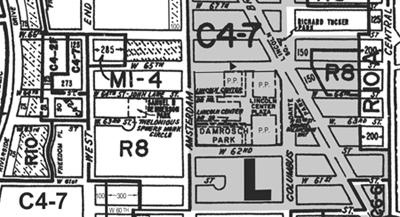
3 Zoning Borough:MANHATTANBlock:690Lot:29 Police Precinct:10 Owner:SOMATIC REALTY LLC Address: AVENUE Lot Area:23000 sf Lot Frontage:184'Lot Depth:125 Year Built:unknown Number of Buildings:0 Number of Floors:0 Gross Floor Area:0 sf (estimated) Residential Units:0Total # of Units:0 Land Use:Parking Facilities Zoning:C6 2 Commercial Overlay: Zoning Map #:8B Dept. of City Planning, PLUTO 11v2 2011
4 Basic Definitions Block A block is a tract of land bounded on all sides by streets or by a combination of streets, public parks, railroad rights of way, pierhead lines or airport boundaries. Lot or Zoning Lot A lot or zoning lot is a tract of land comprising a single tax lot or two or more adjacent tax lots within a block. An apartment building on a single zoning lot, for example, may contain separate condominium units, each occupying its own tax lot. Similarly, a building containing a row of townhouses may occupy several separate tax lots within a single zoning lot, or two or more detached homes on one zoning lot may each have its own tax lot. The zoning lot is the basic unit for zoning regulations and may be subdivided into two or more zoning lots, and two or more adjoining zoning lots on the same block may be merged, provided that all resulting zoning lots comply with applicable regulations. All buildings must have a block and lot designation Street numbers and names can change over time

5 Basic Definitions Block and Lot [Note: Reverse corner lot is where the main street front is smaller than the side frontage]
. http://www.nyc.gov/html/dcp/html/zone/glossary.")
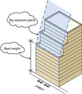
6 Basic Definitions Building Height Building height refers to a building s elevation as measured from the curb level or base plane to the roof of the building (except for permitted obstructions, such as elevator bulkheads).
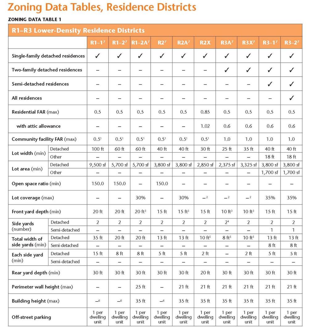
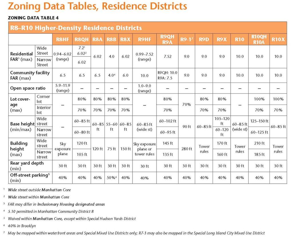
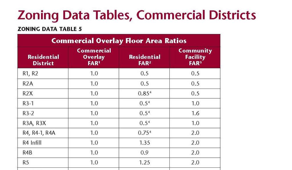
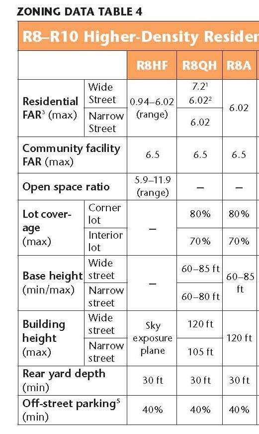
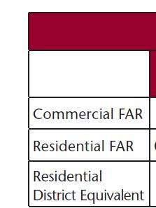
7 FAR Floor Area Ratio (FAR) The floor area ratio is the principal bulk regulation controlling the size of buildings. FAR is the ratio of total building floor area to the area of its zoning lot. Each zoning district has an FAR which, when multiplied by the lot area of the zoning lot, produces the maximum amount of floor area allowable on that zoning lot. For example, on a 10,000 square foot zoning lot in a district with a maximum FAR of 1.0, the floor area on the zoning lot cannot exceed 10,000 square feet.

8 FAR Floor Area Ratio (FAR)
, commercial (C) and manufacturing (M).")
9 USE New York City is divided into three basic zoning districts: residential (R), commercial (C) and manufacturing (M). The three basic districts are further divided into a range of lower, medium and higher density residential, commercial and manufacturing districts.

10 USE Limits are set to the population density of certain areas. This is to make sure large populations don t concentrate around areas without transportation and other amenities.
11 USE
12 USE
13 USE
14
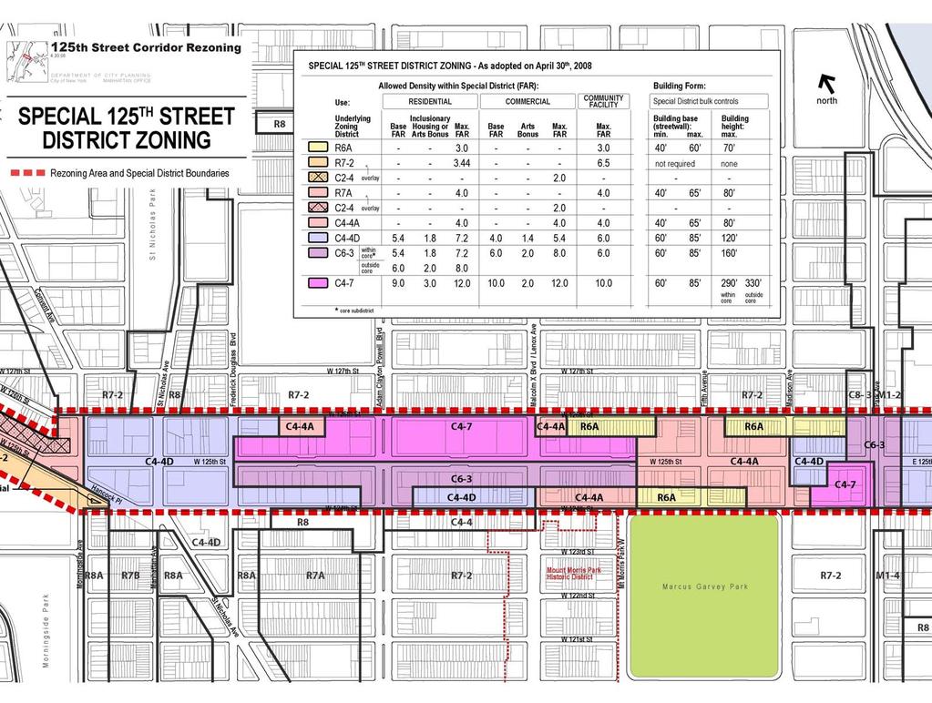
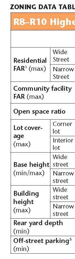
15 USE Any of these districts may in turn be overlaid by special purpose zoning districts tailored to the unique characteristics of certain neighborhoods. Some blockfronts in residential districts may have a commercial overlay district as well in order to provide neighborhood retail stores and services. Limited Height Districts, another type of overlay district, imposes height limits on new buildings in certain historic districts designated by the NYC Landmarks Preservation Commission. These overlay districts modify and supplement the controls of the underlying zoning districts. Each zoning district regulates: permitted uses listed in one or more of 18 use groups; the size of the building in relation to the size of the zoning lot, known as the floor area ratio or FAR; for residential uses, the number of dwelling units permitted, the amount of open space and plantings required on the zoning lot and the maximum amount of the lot that can be covered by a building; the distance between the building and the front, side and rear lot lines; the amount of required or permitted parking; and other features applicable to specific residential, commercial or manufacturing districts
16 USE Special Landmark District (Gray area)

17 USE Sub Groups

18 USE Sub Groups

19 USE Sub Groups
20 USE Sub Groups Incentive Zoning* Incentive zoning provides a bonus, usually in the form of additional floor area, in exchange for the provision of a public amenity or affordable housing. There are incentive bonuses for the provision of public plazas (privately owned public spaces), visual or performing arts spaces, subway improvements, theater preservation, FRESH food stores and affordable housing (Inclusionary Housing Program).


21 USE Sub Groups Inclusionary Housing Program: Provides two optional floor area incentives in exchange for the creation or preservation of affordable housing, on or off-site, pre-dominantly for lowincome households

22 USE Sub Groups Inclusionary Housing Program:

23 USE Sub Groups Quality Housing Program The Quality Housing Program, mandatory in contextual R6 through R10 residence districts and optional in non-contextual R6 through R10 districts -encourages development consistent with the character of many established neighborhoods. Its bulk regulations set height limits and allow high lot coverage buildings that are set at or near the street line. The Quality Housing Program also requires amenities relating to interior space, recreation areas and landscaping.

24 USE Sub Groups Transfer development Air Rights

25 USE Sub Groups Bonus for Arts

26 USE Sub Groups Merge lots to build a larger building


27 USE Sub Groups Merge lots to build a larger building Copyright: Metropolitan United Studio, LLP

28 USE Sub Groups

29 USE Sub Groups
30 Zoning Diagrams
31 Zoning Diagrams
32 Zoning Diagrams
33 Zoning Diagrams
34 Zoning Diagrams

35 Zoning Diagrams

36 Zoning Diagrams
37 Zoning Diagrams
38 Zoning Diagrams Axon
39 Zoning Diagrams Axon

40 Zoning Diagrams Axon

41 Zoning Special District Tenth Avenue Building Frontages Consistent with the existing built character of walk up apartment buildings and high streetwall loft buildings, bulk controls along Tenth Avenue would mandate a mix of low and high streetwalls and would help preserve light, air, and views for the High Line open space. Under these frontage regulations, the street wall of a building along Tenth Avenue could rise to between 35 feet and 45 feet in height for 25% of its Tenth Avenue frontage. This lowered streetwall would be required to be located at a street intersection. The remaining 75% of the street wall could rise to the maximum allowable building height.

42 Zoning Special District High Line Building Frontages To create a varied experience along the length of the High Line open space, portions of buildings would be required to set back from the High Line while other portions of buildings would be permitted to rise directly adjacent to, and connect with, the High Line. A maximum of 40% of a building s High Line frontage would be permitted to rise to the maximum allowable building height directly adjacent to the High Line structure. The remaining 60% (minimum) of a building s High Line frontage would be permitted to rise no higher than the level of the High Line before setting back a minimum of 25 feet.

43 Zoning Special District High Line Adjacency Controls: Required Open Space A minimum of 20% of the lot area would be required to be reserved as landscaped open space. To provide a visual extension of the High Line, the required open space would be located adjacent to and at a height not to exceed the level of the High Line. The required open space could not front on Tenth Avenue and could be used as a public or private space.

44 Zoning Special District High Line Adjacency Controls: West Side of the High Line Within 15 feet of the west side of the High Line structure, buildings could rise no higher than the level of the High Line. For lots that occupy more than 60 feet of narrow street frontage, an additional 15 foot setback would be required at the base height.

45 Sample Drawing
46 Sample Drawing
47 Sample Drawing

48 Sample Drawing
49 Sample Drawing
Air Rights Reference Guide
 Air Rights Reference Guide Revision Date August 15, 2016 City Center Real Estate Inc. 1010 Fifth Avenue New York, NY 10028 ROBERT I. SHAPIRO Founder (212) 396-9705 ris@citycenternyc.com RONALD NOVITA Executive
August 24, 2011/Calendar No. 16
 CITY PLANNING COMMISSION _ August 24, 2011/Calendar No. 16 _ IN THE MATTER OF an application submitted by the Department of City Planning pursuant to Section 201 of the New York City Charter, for an amendment
DECATUR ST STUYVESANT HEIGHTS BROOKLYN NY EXCLUSIVE OFFERING MEMORANDUM OFFERING HIGHLIGHTS SEVEN (7) APARTMENTS FOUR-STORY BROWNSTONE
 APARTMENTS FOUR-STORY BROWNSTONE") EXCLUSIVE OFFERING MEMORANDUM 58 DECATUR ST STUYVESANT HEIGHTS BROOKLYN NY 11216 OFFERING HIGHLIGHTS SEVEN (7) APARTMENTS FOUR-STORY BROWNSTONE IMMEDIATE PROXIMITY TO TRAINS WELL-MAINTAINED AND UPDATED
EXCLUSIVE OFFERING MEMORANDUM 58 DECATUR ST STUYVESANT HEIGHTS BROOKLYN NY 11216 OFFERING HIGHLIGHTS SEVEN (7) APARTMENTS FOUR-STORY BROWNSTONE IMMEDIATE PROXIMITY TO TRAINS WELL-MAINTAINED AND UPDATED
East River Fifties/Sutton Place Rezoning Manhattan Community District 6 February 22, 2017 Applicant s Project Description
 East River Fifties/Sutton Place Rezoning Manhattan Community District 6 February 22, 2017 Applicant s Project Description LR Item 3 Project Description I. Introduction The applicant, East River Fifties
Flatbush Rezoning and Text Amendments LR Item 3: Description of Proposal
 Project Description The New York City Department of City Planning (DCP), at the request of Community Board 14, elected officials and civic groups, proposes zoning map changes and zoning text amendments
8.1 Single Detached (RSI/A-H, J-K; RS2/A-H, J-K
 8. Residential Zones 8.1 Single Detached (RSI/A-H, J-K; RS2/A-H, J-K 8.1.1 Purpose The zone provides for single detached housing with a range of compatible secondary uses. Subdivision standards vary by
Sightline Report. produced by TitleVest. 212 West 18th Street, 3, New York, NY Created For: SAMPLE REPORT TitleVest Order No.
 Sightline Report produced by TitleVest 212 West 18th Street, 3, New York, NY Created For: SAMPLE REPORT TitleVest Order No.: SL-NY-654321 2016 First American Financial Corporation and/or its affiliates.
Town of Gorham Development Transfer Fee Program SECTION XVIII DEVELOPMENT TRANSFER OVERLAY DISTRICT
 Town of Gorham Development Transfer Fee Program SECTION XVIII DEVELOPMENT TRANSFER OVERLAY DISTRICT [Note: The Development Transfer Overlay District (a Development Transfer Fee program) is included as
June 22, 2005/Calendar No. 14
 CITY PLANNING COMMISSION June 22, 2005/Calendar No. 14 C 050400 ZMQ IN THE MATTER OF an application submitted by the Department of City Planning pursuant to Sections 197-c and 201 of the New York City
DEVELOPMENT STANDARDS FOR RESIDENTIAL PROJECTS RESIDENTIAL BUILDING TYPES: APPROPRIATE ZONES AND DENSITIES 2-1
 2 DEVELOPMENT STANDARDS FOR RESIDENTIAL PROJECTS RESIDENTIAL BUILDING TYPES: APPROPRIATE ZONES AND DENSITIES 2-1 This Chapter presents the development standards for residential projects. Section 2.1 discusses
Community Development Department City of Pismo Beach 760 Mattie Road Pismo Beach, CA Telephone: (805) / Fax: (805)
 / Fax: (805)") Community Development Department City of Pismo Beach 760 Mattie Road Pismo Beach, CA 93449 Telephone: (805) 773-4658 / Fax: (805) 773-4684 Address: APN: Area P Development Standards PISMO HEIGHTS PLANNING
Community Development Department City of Pismo Beach 760 Mattie Road Pismo Beach, CA 93449 Telephone: (805) 773-4658 / Fax: (805) 773-4684 Address: APN: Area P Development Standards PISMO HEIGHTS PLANNING
this page left intentionally blank DENVER ZONING CODE
 Article 1. GENERAL PROVISIONS this page left intentionally blank Contents ARTICLE 1. GENERAL PROVISIONS DIVISION 1.1 GENERAL...1.1-1 Section 1.1.1 Purpose...1.1-1 Section 1.1.2 Intent...1.1-1 Section 1.1.3
CB-5 INCLUSIONARY AIR RIGHTS
 WWW.NYINVESTMENTSALES.COM CB-5 INCLUSIONARY AIR RIGHTS CONFIDENTIALITY This offering was prepared by Cushman & Wakefi eld and has been reviewed by the Owner. It contains select information pertaining to
FREQUENTLY USED PLANNING & ZONING TERMS
 City Of Mustang FREQUENTLY USED PLANNING & ZONING TERMS Abut: Having property lines, street lines, or zoning district lines in common. Accessory Structure: A structure of secondary importance or function
Article Optional Method Requirements
 Article 59-6. Optional Method Requirements [DIV. 6.1. MPDU DEVELOPMENT IN RURAL RESIDENTIAL AND RESIDENTIAL ZONES Sec. 6.1.1. General Requirements... 6 2 Sec. 6.1.2. General Site and Building Type Mix...
BACKGROUND. The 1916 Zoning
 APPENDIX A Evolution of New Yor ork City s Zoning Resolution BACKGROUND New York City s built fabric is a product of the interaction between zoning and building regulations, advances in technology, and
November 17, 2004/Calendar No. 22
 CITY PLANNING COMMISSION November 17, 2004/Calendar No. 22 C 040495 ZSM IN THE MATTER OF an application submitted by 400 Park Avenue South LLC pursuant to Sections 197-c and 201 of the New York City Charter
Asking Price: $3,100,000
 Property Description: GFI Realty Services, LLC is pleased to present the exclusive offering of 1915-1919 Cornaga Avenue, two contiguous lots with 100 of frontage located in Far Rockaway, Queens. The parcels
CAN TRADITIONAL ZONING ACHIEVE OUR GOALS FOR DOWNTOWN ANN ARBOR?
 TRADITIONAL ZONING TRADITIONAL ZONING CAN TRADITIONAL ZONING ACHIEVE OUR GOALS FOR DOWNTOWN ANN ARBOR? A dense, mixed use core with flexible land uses A range of housing types and costs A walkable, pedestrian-oriented
Broker: Brett A. Sherman, CCIM Senior Vice President , Ext. 22
 EXECUTIVE SUMMARY Approved Development Opportunity for Sale MAJOR PRICE REDUCTION Westport, Connecticut 06880 For Sale at at $3,450,000.00 $2,675,000.00 2.41 acres of land for sale on the Post Road (Route
CHAPTER RESIDENTIAL AND OPEN SPACE ZONING DISTRICTS
 Residential and Open Space Zoning Districts 106.24.010 CHAPTER 106.24 - RESIDENTIAL AND OPEN SPACE ZONING DISTRICTS RESIDENTIAL AND OPEN SPACE ZONING DISTRICTS Sections: 106.24.010 - Purpose 106.24.020
City of Coral Gables Planning and Zoning Staff Report
 City of Coral Gables Planning and Zoning Staff Report Applicant: Application: Public Hearing: Date & Time: Location: City of Coral Gables Zoning Code Text Amendment Giralda Plaza Overlay District Planning
Chapter 17-2 Residential Districts
 Chapter 17-2 Residential Districts 17-2-0100 District Descriptions...2-1 17-2-0200 Allowed Uses...2-2 17-2-0300 Bulk and Density Standards...2-5 17-2-0400 Character Standards...2-18 17-2-0500 Townhouse
TABLE (A): TABLE OF DIMENSIONAL STANDARDS IN THE RESIDENTIAL ZONE DISTRICTS REQUIRED YARDS [4], [5] SIDE YARD (FT) REAR YARD (FT) R-1 DISTRICT
![TABLE (A): TABLE OF DIMENSIONAL STANDARDS IN THE RESIDENTIAL ZONE DISTRICTS REQUIRED YARDS [4], [5] SIDE YARD (FT) REAR YARD (FT) R-1 DISTRICT](/thumbs/85/92855381.jpg "TABLE (A): TABLE OF DIMENSIONAL STANDARDS IN THE RESIDENTIAL ZONE DISTRICTS REQUIRED YARDS [4], [5] SIDE YARD (FT) REAR YARD (FT) R-1 DISTRICT") ARTICLE : DENSITY, INTENSITY, & DIMENSIONAL STANDARDS Section -100: General Provisions TABLE 17--100(A): TABLE OF DIMENSIONAL STANDARDS IN THE RESIDENTIAL ZONE DISTRICTS R-1 DISTRICT AREA (SQ FT)[3] WIDTH
ARTICLE : DENSITY, INTENSITY, & DIMENSIONAL STANDARDS Section -100: General Provisions TABLE 17--100(A): TABLE OF DIMENSIONAL STANDARDS IN THE RESIDENTIAL ZONE DISTRICTS R-1 DISTRICT AREA (SQ FT)[3] WIDTH
ARTICLE VIII DEVELOPMENT STANDARDS
 ARTICLE VIII Section 1. Section 2. COMPLIANCE WITH REGULATIONS MATRIX Section 3. FOOTNOTES TO MATRIX Section 1. COMPLIANCE WITH REGULATIONS Except as hereinafter provided: 1. No building or land shall
ORDINANCE NO. ABINGTON TOWNSHIP MONTGOMERY COUNTY, PENNSYLVANIA
 REVISED 11.3.2018 ORDINANCE NO. ABINGTON TOWNSHIP MONTGOMERY COUNTY, PENNSYLVANIA AN ORDINANCE OF ABINGTON TOWNSHIP, MONTGOMERY COUNTY, PENNSYLVANIA, AMENDING THE ABINGTON TOWNSHIP ZONING ORDINANCE OF
3.1 Existing Built Form
 3.1 Existing Built Form There is a wide variety of built form in the study area, generally comprising 2 and 3 storey buildings. This stretch of Queen Street East is somewhat atypical of Toronto's main
Provide a diversity of housing types, responsive to household size, income and age needs.
 8 The City of San Mateo is a highly desirable place to live. Housing costs are comparably high. For these reasons, there is a strong and growing need for affordable housing. This chapter addresses the
Waikïkï Special District Amendments 2010 Initiative
 Waikïkï Special District Amendments 2010 Initiative Eliminate the Resort Commercial Precinct and merge it with the Resort Mixed Use Precinct Merger of the two precincts conforms to the intent of the Waikïkï
Faribault Place 3 rd Addition Preliminary Plat, Final Plat, & PUD
 Faribault Small Town Pride Big City Opportunities! December 5, 2016 Planning Commission Public Hearing Faribault Place 3 rd Addition Preliminary Plat, Final Plat, & PUD Location Maps Faribault 2 Requests
WASHINGTON COUNTY DEVELOPMENT CODE CHAPTER TWO ZONING REGULATIONS PART 2 DENSITY AND LOT REQUIREMENTS. Table of Contents
 WASHINGTON COUNTY DEVELOPMENT CODE CHAPTER TWO ZONING REGULATIONS PART 2 DENSITY AND LOT REQUIREMENTS Table of Contents SECTION 1. DENSITY... 2 1.1 Density in Districts... 2 1.2 Determination of Density
From Policy to Reality
 From Policy to Reality Updated ^ Model Ordinances for Sustainable Development 2000 Environmental Quality Board 2008 Minnesota Pollution Control Agency Funded by a Minnesota Pollution Control Agency Sustainable
The Philadelphia Code
 1 of 6 10/9/2014 10:06 AM The Philadelphia Code 14-507. /CDO, Central Delaware Riverfront Overlay District. 187 (1) Purpose. The Central Delaware Riverfront Overlay District is intended to connect the
Proposed Height and Setback Regulations
 APPENDIX E Representative Bulk Envelopes for Certain Districts 15' MAXIMUM 70' STANDARD BUILDING HEIGHT EL. 60' (6 STORIES) 60' 172' FRONT ELEVATION / STANDARD ENVELOPE 10' MAXIMUM 60' 70' STANDARD BUILDING
Transit Oriented Communities Affordable Housing Incentive Program Guidelines (TOC Guidelines)
") Transit Oriented Communities Affordable Housing Incentive Program Guidelines (TOC Guidelines) Implementing Section 6 of Measure JJJ, approved by the voters in November 2016, and added to Los Angeles Municipal
Transit Oriented Communities Affordable Housing Incentive Program Guidelines (TOC Guidelines) Implementing Section 6 of Measure JJJ, approved by the voters in November 2016, and added to Los Angeles Municipal
25 N 23rd STREET COMMERCIAL-RESIDENTIAL DEVELOPMENT
 SCOPE OF WORK The Owner proposes to develop an existing group of buildings for a Mixed Use and associated Off-Street Parking. The new development shall include 9 Commercial Spaces and 156 brand new apartments
MPN. S broad street corner development site. 701 s broad street, philadelphia, pa 19147
 S broad street corner development site 701 s broad street, philadelphia, pa 19147 1601 Walnut St, Philadelphia, PA 19102 215.413.4900 www.mpnrealty.com corner development site FOR SALE 701 s broad street
New Planning Code Summary: HOME-SF and Density Bonus Projects
 New Planning Code Summary: HOME-SF and Density Bonus Projects Amended/Added Sections: 206, 302 Case Number: 2014-001503PCA Board File/Enactment#: 150969/116-17 Sponsored by: Mayor Edwin Lee, Supervisors
N. Pottstown Pike Pottstown, PA
 Investment Sale Opportunity 347 N. Pottstown Pike Pottstown, PA Partnership. Performance. FULLY LEASED 11,000 SF OFFICE BUILDING Well located and stabilized asset in the heart of Exton on Pottstown Pike
State of Land Use and the Built Environment
 State of Land Use and the Built Environment The city approved more units for construction in 214 than in 213, but the level remained below that of the mid-2s. Meanwhile, city-initiated rezonings all but
RESOLUTION NO. PC
 RESOLUTION NO. PC 17-1235 A RESOLUTION OF THE PLANNING COMMISSION OF THE CITY OF WEST HOLLYWOOD, RECOMMENDING TO THE CITY COUNCIL APPROVAL OF A ZONE TET AMENDMENT AMENDING PORTIONS OF TITLE 19, WEST HOLLYWOOD
1. Multi-family dwellings, including town homes, apartments, or condominiums.
 Sec. 4-6.67 Planned Unit Development (PUD-M). a. Definition. A planned multi-family zoning district of three acres or more, consisting of townhouses, apartments, condominiums, single-family detached, single-family
Subway station improvements in Downtown Brooklyn and in commercial zones of 10 FAR and above in Manhattan (6/28/04)
") Land Use Law Center Gaining Ground Information Database Topic: Resource Type: State: Jurisdiction Type: Municipality: Year (adopted, written, etc.): 2004 Community Type applicable to: Title: Document Last
Land Use Law Center Gaining Ground Information Database Topic: Resource Type: State: Jurisdiction Type: Municipality: Year (adopted, written, etc.): 2004 Community Type applicable to: Title: Document Last
SECTION 7. RESIDENTIAL ZONING DISTRICTS
 SECTION 7. RESIDENTIAL ZONING DISTRICTS 7.1 RESIDENTIAL ZONING DISTRICTS PURPOSE STATEMENTS 7.2 PERMITTED AND SPECIAL USES 7.3 BULK AND SETBACK REGULATIONS 7.4 BUILDING HEIGHT SETBACK PLANE 7.5 GENERAL
Presentation to the Real Estate Institute of New Zealand 28 October 2016
 Presentation to the Real Estate Institute of New Zealand 28 October 2016 Disclaimer This presentation provides a high level overview of specific parts of the Proposed Auckland Unitary Plan Decisions Version
SECTION 15 - R3 - RESIDENTIAL THIRD DENSITY ZONE
 SECTION 15 - R3 - RESIDENTIAL THIRD DENSITY ZONE Within the Residential Third Density (R3) Zone, no person shall use any land, erect, alter, enlarge, use or maintain any building or structure for any use
Article 3. SUBURBAN (S-) NEIGHBORHOOD CONTEXT
 NEIGHBORHOOD CONTEXT") Article 3. SUBURBAN (S-) NEIGHBORHOOD CONTEXT this page left intentionally blank Contents ARTICLE 3. SUBURBAN (S-) NEIGHBORHOOD CONTEXT DIVISION 3.1 NEIGHBORHOOD CONTEXT DESCRIPTION...3.1-1 Section 3.1.1
Article 3. SUBURBAN (S-) NEIGHBORHOOD CONTEXT this page left intentionally blank Contents ARTICLE 3. SUBURBAN (S-) NEIGHBORHOOD CONTEXT DIVISION 3.1 NEIGHBORHOOD CONTEXT DESCRIPTION...3.1-1 Section 3.1.1
DRAFT FOR DISCUSSION PURPOSES ONLY. Port Credit Local Area Plan Built Form Guidelines and Standards DRAFT For Discussion Purposes
 Port Credit Local Area Plan Built Form Guidelines and Standards DRAFT For Discussion Purposes 1 Local Area Plan - Project Alignment Overview Directions Report, October 2008 (General Summary Of Selected
ZONING COMPATIBILITY & WORKSHEET
 ZONING COMPATIBILITY & WORKSHEET *** This worksheet shall be completed by the architect whom submitted signed and sealed plans for review.*** This document assists building permit applicants in determining
Truckee Development Code User s Guide TOWN OF TRUCKEE. A. Introduction...3. B. Organization of the Development Code 3
 TOWN OF TRUCKEE Development Code User s Guide A. Introduction...3 B. Organization of the Development Code 3 I. Development Code Enactment and Applicability.3 II. Zoning Districts and Allowable Land Uses....4
3.1. OBJECTIVES FOR RESIDENTIAL LAND USE DESIGNATIONS GENERAL OBJECTIVES FOR ALL RESIDENTIAL DESIGNATIONS
 3. RESIDENTIAL LAND USE DESIGNATIONS INTRODUCTION The Residential land use designations provide for housing and other land uses that are integral to, and supportive of, a residential environment. Housing
Puyallup Downtown Planned Action & Code Changes. January 10, 2017
 Puyallup Downtown Planned Action & Code Changes January 10, 2017 Purpose & Location Purpose Promote economic development and downtown revitalization Tools: Municipal Code amendments Change development
UPDATE Board of Selectmen June 20, 2017
 MAPLE STREET I-1 AREA DRAFT ZONING BYLAW & DEVELOPMENT STANDARDS Town of Danvers, MA UPDATE Board of Selectmen June 20, 2017 The Danvers Team: Brovitz Community Planning & Design Dodson & Flinker Danvers
Section 14 Commercial Zones
 Section 14 Commercial Zones 14.1 C1 Local Commercial 14.1.1 Purpose The purpose is to provide a zone for a limited range of local convenience services required by both the urban and rural population. 14.1.2
Boston East. Fort Point Associates, Inc. Urban Planning Environmental Consulting Project Permitting. May 31, 2013
 Boston East East Boston, Massachusetts Development Plan for PDA No. 92 May 31, 2013 submitted to Boston Redevelopment Authority submitted by Trinity Border Street, LLC prepared by Fort Point Associates,
6. RESIDENTIAL ZONE REGULATIONS
 6. RESIDENTIAL ZONE REGULATIONS PART 6A PURPOSE OF CHAPTER (1) The purpose of this Chapter is to provide detailed regulations and requirements that are relevant only to residential zones and specific residential
CHAPTER 2 GENERAL PROVISIONS
 CHAPTER 2 GENERAL PROVISIONS 200 ZONING DISTRICTS ESTABLISHED 201 SUPPLEMENTAL DISTRICTS ESTABLISHED 202 OFFICIAL ZONING MAP ESTABLISHED 203 DISTRICT BOUNDARY DESCRIPTION and INTERPRETATION 204 LIMITATION
DRAFT -- PROPOSED EXPANSION AND REVISIONS TO DIVISION 24. SPECIAL DISTRICT--COLLEGE AND UNIVERSITY NEIGHBORHOODS DISTRICT
 DRAFT -- PROPOSED EXPANSION AND REVISIONS TO DIVISION 24. SPECIAL DISTRICT--COLLEGE AND UNIVERSITY NEIGHBORHOODS DISTRICT Sec. 28-831. Purpose. The college and university neighborhoods district purposes
SECTION 7. RESIDENTIAL DISTRICTS
 SECTION 7. RESIDENTIAL DISTRICTS 7.1 RESIDENTIAL DISTRICTS PURPOSE 7.2 PERMITTED AND SPECIAL USES 7.3 YARD AND BULK REGULATIONS 7.4 GENERAL STANDARDS OF APPLICABILITY 7.5 FLOOR AREA RATIO MEASUREMENT AND
68 COOPER STREET. Inwood Residential Development Site
 68 Inwood Residential Development Site 68 PROPERTY HIGHLIGHTS: ±20,000 ZFA 1 Block away from the A Train Great potential for views 2 68 EXECUTIVE SUMMARY 68 INTRODUCTION Goldenwood Property Advisors (GPA)
the conditions contained in their respective Orders until January 1, 2025, at the discretion of the Director of Planning, Property and Development.
 Part 4: Use Regulations Temporary Uses and Structures Purpose the conditions contained in their respective Orders until January 1, 2025, at the discretion of the Director of Planning, Property and Development.
CITY PLANNING COMMISSION January 27, 2010 / Calendar No. 4
 CITY PLANNING COMMISSION January 27, 2010 / Calendar No. 4 C 100051 ZMM IN THE MATTER OF an application submitted by the New York City Department of Housing Preservation and Development pursuant to Sections
CHAPTER NORTH LAKE SPECIFIC PLAN
 North Lake Specific Plan 17.34.010 CHAPTER 17.34 - NORTH LAKE SPECIFIC PLAN Sections: 17.34.010 - Purpose of Chapter 17.34.020 - Purposes of SP-1 (North Lake Specific Plan) Overlay District 17.34.030 -
Chapter Residential Mixed Density Zone
 Chapter 19.16 Residential Mixed Density Zone 19.16.010 Purpose and Intent 19.16.020 Permitted Uses 19.16.030 Accessory Permitted Uses 19.16.040 Secondary Permitted Uses 19.16.050 Conditional Uses 19.16.060
PART 3 RESIDENTIAL ZONING DISTRICTS. Designation of Residential Zoning Districts and Purpose Statements.
 PART 3 S Section 301. Designation of and Purpose Statements. See Table 3-1 herein this Section for the designations and purpose statements of the respective Residential Zoning Districts which are shown
Appendix A: Guide to Zoning Categories Prince George's County, Maryland
 Appendix A: Guide to Zoning Categories Prince George's County, Maryland RESIDENTIAL ZONES 1 Updated November 2010 R-O-S: Reserved Open Space - Provides for permanent maintenance of certain areas of land
AN ORDINANCE AMENDING THE CITY ZONING ORDINANCE AND THE OFFICIAL CODE OF THE CITY OF CLARKSVILLE RELATIVE TO CLUSTER OPTION DEVELOPMENTS
 ORDINANCE 74-2012-13 AN ORDINANCE AMENDING THE CITY ZONING ORDINANCE AND THE OFFICIAL CODE OF THE CITY OF CLARKSVILLE RELATIVE TO CLUSTER OPTION DEVELOPMENTS BE IT ORDAINED BY THE CITY COUNCIL OF THE CITY
Article XII. R-1 Agricultural-Low Density Residential District
 Article XII R-1 Agricultural-Low Density Residential District Section 1200. Declaration of Legislative Intent In expansion of the Declaration of Legislative Intent and Statement of Community Development
Keeping in Character:
 Keeping in Character: A Look at the Impacts of Recent Community- Initiated Rezonings in the East Village Building Heights in the East Village The East Village is noted for its humanscaled buildings, with
ORDINANCE NO. C 34911
 ORDINANCE NO. C 34911 AN ORDINANCE relating to Residential Zones; amending SMC sections 17C.110.020, 17C.110.030, 17C.110.100, 17C.110.205, 17C.110.220, 17C.110.245, 17C.110.310, Table 17C.110-3 and adopting
City of Dade City, Florida Land Development Regulations ARTICLE 5: DENSITY, INTENSITY & DIMENSIONAL STANDARDS
 City of Dade City, Florida Land Development Regulations ARTICLE 5: DENSITY, INTENSITY & DIMENSIONAL STANDARDS ADOPTED AUGUST 12, 2014 ARTICLE 5: DENSITY, INTENSITY & DIMENSIONAL STANDARDS SECTION 5.1 DIMENSIONAL
SHAPING NEW BUILDINGS
 How does it look from the street? The proposed bulk controls result in more sky and light at the street level. Mid-rise Development No bulk controls Draft Plan Controls: Setbacks only Bigger Sky The streetwalls
INCLUSIONARY HOUSING PROGRAM IMPLEMENTATION GUIDELINES
 INCLUSIONARY HOUSING PROGRAM IMPLEMENTATION GUIDELINES JULY 2005 Department of Grants & Community Investment 1110 West Capitol Avenue West Sacramento, CA 95691 Phone: (916) 617-4555 Fax: (916) 372-1584
Article VII: Administration Chapter 4 - Special Permits by the City Planning Commission
 ZONING RESOLUTION Web Version THE CITY OF NEW YORK THE CITY OF NEW YORK Bill de Blasio, Mayor CITY PLANNING COMMISSION Carl Weisbrod, Director Article VII: Administration Chapter 4 - Special Permits by
Lacey UGA Residential density
 Thurston County Planning Department BOARD OF COUNTY COMMISSIONERS PUBLIC HEARING DRAFT AMENDMENTS TO THE CRITICAL AREAS REGULATIONS Residential density amendment to Title 21 Title 21 6/1/2012 Lacey UGA
ORDINANCE NO
 AN ORDINANCE OF THE CITY OF SANTA CRUZ AMENDING TITLE 24 OF THE SANTA CRUZ MUNICIPAL CODE, THE ZONING ORDINANCE, BY AMENDING CHAPTER 24.16 PART 3, DENSITY BONUS PROVISIONS FOR RESIDENTIAL UNITS BE IT ORDAINED
SUBJECT: Application for Planned Unit Development and Rezoning 1725 Winnetka Road
 TO: FROM: CHAIRMAN BILL VASELOPULOS AND MEMBERS OF THE PLAN & ZONING COMMISSION STEVE GUTIERREZ DIRECTOR OF COMMUNITY DEVELOPMENT MEETING DATE: September 5, 2017 SUBJECT: Application for Planned Unit Development
East Harlem Land-Use and Rezoning Initiative
 East Harlem Land-Use and Rezoning Initiative FINAL RECOMMENDATIONS Submitted by: With the support and participation of: Contact: George Sarkissian District Manager Community Board 11 1664 Park Avenue New
(a) Commercial uses on Laurel Avenue, abutting the TRO District to the
 Commercial uses on Laurel Avenue, abutting the TRO District to the") 32X Zoning Code 150.36 TRANSITIONAL RESIDENTIAL OVERLAY DISTRICT. (A) Intent and purpose. (1) It is the intent of the Transitional Residential Overlay District (hereinafter referred to as the "TRO District")
32X Zoning Code 150.36 TRANSITIONAL RESIDENTIAL OVERLAY DISTRICT. (A) Intent and purpose. (1) It is the intent of the Transitional Residential Overlay District (hereinafter referred to as the "TRO District")
Zoning Bylaw No. 3166
 Zoning Bylaw No. 3166 1) Overview Why a new Zoning Bylaw is Needed Key Improvements Recent Changes Public Consultation New Zoning Map Current Zoning Map Below-grade Parking Area Map Additional Setback
DIVISION 7. R-6 AND R-6A RESIDENTIAL ZONES* The purpose of the R-6 residential zone is:
 Date of Draft: March 6, 2015 DIVISION 7. R-6 AND R-6A RESIDENTIAL ZONES* Sec. 14-135. Purpose. The purpose of the R-6 residential zone is: (a) To set aside areas on the peninsula for housing characterized
MEMORANDUM. SUBJECT: BZA Case 18847, 3619 Georgia Avenue, N.W.
 MEMORANDUM TO: District of Columbia Board of Zoning Adjustment FROM: Stephen J. Mordfin, AICP, Case Manager Joel Lawson, Associate Director Development Review DATE: October 29, 2014 SUBJECT: BZA Case 18847,
COMMERCIAL/INDUSTRIAL DEVELOPMENT GUIDELINES
 COMMERCIAL/INDUSTRIAL DEVELOPMENT GUIDELINES Planning Division Sections Chapter 17.16 Commercial, Industrial Development Standards 17.16.010 Lot Size 17.16.020 Setbacks 17.16.030 Fences, Hedges and Walls
ARTICLE FIVE FINAL DRAFT
 ARTICLE FIVE 021218 FINAL DRAFT Sec. 503.6 Open Space Preservation Option Open Space Preservation Option Open Space Preservation developments may be approved in the AR, R-1, R-2 and R-3 zoning districts,
Town of Truckee. Contents. Article I - Development Code Enactment and Applicability. Chapter Purpose and Effect of Development Code...
 Town of Truckee TITLE 18 - DEVELOPMENT CODE Article I - Development Code Enactment and Applicability Chapter 18.01 - Purpose and Effect of Development Code... I-3 18.01.010 - Title... I-3 18.01.020 - Purposes
MEMORANDUM. Mr. Sean Tabibian, Esq. Dana A. Sayles, AICP, three6ixty Olivia Joncich, three6ixty. DATE May 26, 2017
 MEMORANDUM TO FROM Dana A. Sayles, AICP, three6ixty Olivia Joncich, three6ixty DATE VIA Email RE 3409 W. Temple Street, Los Angeles, CA 90026 Zoning Analysis and Entitlement Strategy three6ixty (the Consultant
Oceanside Zoning Ordinance
 Oceanside Zoning Ordinance 3006 Accessory Dwelling Units (1992 and Redevelopment Zoning Ordinance) Amendments Article 42 Accessory Dwelling Units (1986 Zoning Ordinance) New [Strike-thru = Deleted language,
DRAFT. Amendment to the Master Plan Land Use Element for Block 5002, Lot Township of Teaneck, Bergen County, New Jersey.
 DRAFT Amendment to the Master Plan Land Use Element for Block 5002, Lot 18.01 Township of Teaneck, Bergen County, New Jersey Prepared for: Township of Teaneck Planning Board Prepared by: Janice Talley,
Outline of Land Use Bylaw, 1P2007 Changes
 Outline of Land Use Bylaw, 1P2007 Changes Changes to single and multi-family builders, renovators, land developers and trades The City s new Land Use Bylaw, 1P2007 has been approved by Council. The new
BUILDING HEIGHTS. The following diagram depicts the maximum allowable building height in a +3 zone.
 BUILDING HEIGHTS The following diagram depicts the allowable building height in a +1 zone in an area with substantial topography. As the diagram demonstrates, the building has 4 floors (and would have
Town of Siler City - Unified Development Ordinance ARTICLE XII - Density and Dimensional Regulations
 ARTICLE XII - Density and Dimensional Regulations 167 Minimum Lot Size Subject to the provisions of 173 (Cluster Subdivisions) and all lots in the following zones shall have at least the amount of square
LOCATION: LUC AND UNDERLYING ZONING: OCP DESIGNATION:
 City of Surrey PLANNING & DEVELOPMENT REPORT File: 7916-0404-00 Planning Report Date: October 24, 2016 PROPOSAL: Terminate Land Use Contract No. 320 to permit the existing underlying Zone to come into
2. The modification is consistent with the objectives of this chapter.
 DRAFT February 11, 2009 BMC 20.28 Infill Housing 20.28.010 Purpose. This chapter establishes special development regulations for a series of housing forms that are different than the traditional detached
PD No. 15 Authorized Hearing Steering Committee Meeting #11
 PD No. 15 Authorized Hearing Steering Committee Meeting #11 January 7, 2019 Andrew Ruegg, Senior Planner Sustainable Development and Construction City of Dallas Staff Recommendation Steering committee
Glossary of Key Terms and Definitions The following terms and definitions are used in the unique context of this Specific Plan.
 Chapter 7. Glossary of Key Terms and Definitions The following terms and definitions are used in the unique context of this Specific Plan. Aerial Fuels Also Ladder Fuels, shall refer to live and dead vegetation
ORDINANCE NO. ABINGTON TOWNSHIP MONTGOMERY COUNTY, PENNSYLVANIA
 REVISED 8.15.18 ORDINANCE NO. ABINGTON TOWNSHIP MONTGOMERY COUNTY, PENNSYLVANIA AN ORDINANCE OF ABINGTON TOWNSHIP, MONTGOMERY COUNTY, PENNSYLVANIA, AMENDING THE ABINGTON TOWNSHIP ZONING ORDINANCE OF 2017,
Midwest City, Oklahoma Zoning Ordinance
 2010 Midwest City, Oklahoma Zoning Ordinance 9/2/2010 Table of Contents Section 1. General Provisions... 5 1.1. Citation... 5 1.2. Authority... 5 1.3. Purpose... 5 1.4. Nature and Application... 5 1.5.
CITY PLANNING COMMISSION October 27, 2010 / Calendar No. 13
 CITY PLANNING COMMISSION October 27, 2010 / Calendar No. 13 N 100294(A) ZRM IN THE MATTER OF an application submitted by CRP/Extell Parcel L, LP and CRP/Extell Parcel N, LP pursuant to Sections 197-c and
CITY OF EAU CLAIRE, WISCONSIN. SPECIAL ASSESSMENT POLICY (Dated: November 8, 2016)
") CITY OF EAU CLAIRE, WISCONSIN SPECIAL ASSESSMENT POLICY (Dated: November 8, 2016) (Adopted by reference by Ordinance No. 7207 adopted November 8, 2016) PURPOSE The purpose of this Policy is to assure fair
CITY OF EAU CLAIRE, WISCONSIN SPECIAL ASSESSMENT POLICY (Dated: November 8, 2016) (Adopted by reference by Ordinance No. 7207 adopted November 8, 2016) PURPOSE The purpose of this Policy is to assure fair
TOWN OF EPPING, NH ZONING ORDINANCES
 TOWN OF EPPING, NH ZONING ORDINANCES 2017 Contents ARTICLE 1: Preamble, Title & Purpose 3 ARTICLE 2: Zoning 4 1. Highway-Commercial 7 2.Residential-Commercial 11 3. West Epping Commercial Business Zone