Strategic Housing Development: Planning Report & Statement of Consistency. Residential Development. Kilcullen Road, Bluebell, Naas, Co Kildare
|
|
|
- Linette Underwood
- 5 years ago
- Views:
Transcription

1 Strategic Housing Development: Planning Report and Statement of Consistency Residential Development at Kilcullen Road, Bluebell, Naas, Co. Kildare on behalf of Ardstone Homes Ltd November 2018 Declan Brassil & Co. Ref: 17/045 i
2 TABLE OF CONTENTS 1 INTRODUCTION Prospective Applicant and Interest in Site Characteristics of Proposed Strategic Housing Development Nature & Purpose Possible Effects on the Environment Prior Consultations Consultation with Planning Authority Consultation with An Bord Pleanála SITE LOCATION & CONTEXT Site Location Site Description SITE HISTORY Subject Site Adjoining or Adjacent Sites PARTICULARS OF PROPOSED STRATEGIC HOUSING DEVELOPMENT Layout & Design Open Space, Access, Permeability & Parking Integration with Surrounding Land Use Universal Access Part V Services Infrastructure Architectural and Archaeological Heritage Possible Effects on the Environment Traffic and Transportation Public Transportation Traffic Assessment and Conclusions NATIONAL PLANNING POLICY CONTEXT National Planning Framework Draft Regional Spatial and Economic Strategy for the Eastern and Midland Region LOCAL PLANNING CONTEXT - STATEMENT OF CONSISTENCY Naas Town Development Plan Zoning Statement of Consistency Kildare County Development Plan (KCDP) Declan Brassil & Co. Ref: 17/045 ii
3 6.2.1 Core Strategy and Settlement Strategy Density Guiding Principles for Greenfield Edge Development Housing Mix Traffic and Transport Water Services and Infrastructure Community Infrastructure Natural Heritage and Green Infrastructure Residential Development Standards Car Parking Standards Bicycle Parking Standards Statement of Consistency SECTION 28 MINISTERIAL GUIDELINES - STATEMENT OF CONSISTENCY Sustainable Residential Development in Urban Areas - Guidelines for Planning Authorities Sustainable Urban Housing: Design Standards for New Apartments (2018) Draft Urban Development and Building Heights Guidelines for Planning Authorities (2018) Design Manual for Urban Roads & Streets Childcare Facilities Guidelines for Planning Authorities (2001) The Planning System and Flood Risk Management Guidelines for Planning Authorities Appropriate Assessment of Plans and Projects in Ireland Guidelines for Planning Authorities APPENDIX A PART V: Declan Brassil & Co. Ref: 17/045 iii
4 1 INTRODUCTION This Planning Report and Statement of Consistency accompanies a planning application by Ardstone Homes Ltd for permission for a residential development of 125 no. units and associated works at a site of approximately 3.76 ha, located in the townland of Bluebell, 1.4 km southwest of Naas town centre, County Kildare. This Report includes a statement setting out how the proposal is consistent with the objectives of the relevant County Development Plan, the Naas Town Development Plan and relevant section 28 Ministerial Guidelines. 1.1 Prospective Applicant and Interest in Site The prospective Applicant is Ardstone Homes Ltd. Ardstone Homes Ltd is registered under Company Register No and has its offices at 48 Fitzwilliam Square, Dublin 2. Ardstone Residential Partners Fund ICAV is the legal owners of 3.51 ha of the application site, comprising the main residential development site. Ardstone Residential Partners Fund ICAV has granted consent to Ardstone Homes Ltd to submit a planning application to An Board Pleanála. A letter of consent from Ardstone Residential Partners Fund ICAV accompanies this application. The application boundary includes lands outside the main development site (approximately 0.25ha) under the control of Arrow Finance Limited. This area of the site incorporates drainage infrastructure for the proposed development, including an underground attenuation tank, a pumping station and associated access off the Rathasker Road. A letter of consent from Arrow Finance Limited accompanies this applicaiton. Liam Queally, the owner of lands to the west of Rathasker Road, has provided a letter of consent to the applicant for drainage infrastructure to discharge at the Bluebell Stream through a wayleave on his lands to the west of the Rathasker Road. 1.2 Characteristics of Proposed Strategic Housing Development Nature & Purpose The proposed residential development provides for 125 no. new residential dwellings and associated infrastructure on a site of 3.76 ha located on the western side of the Kilcullen Road (R448), in the townland of Bluebell, Naas, Co Kildare. The site is located to the south of the Naas Inner Relief Road and 1.4 km from Naas Town Centre. The proposed residential development directly adjoins the existing residential areas of Broadfield View to the north and east. Pipers Hill, located approximately 500m to the southeast of the site, on the opposite site of the Kilcullen Road, consists of an existing educational campus and a large mixed use, primarily residential development currently under construction. The proposed development provides for a range of dwelling types including terraced, semi-detached and detached two storey houses. In addition, the proposed development includes 4 no. maisonette units in the Declan Brassil & Co. Ref: 17/045 1
5 north-eastern corner of the site, dormer style houses along the eastern boundary with Broadfield View and apartment units in a 4 storey building along the western boundary. The proposed development provides a total of 5,288 sqm of ancillary public open space (approx. 15% of the residential development site); 228 no. ancillary residential car parking spaces; 23 no. visitor parking spaces; an extension of the access road permitted under KCC Reg. Ref. 15/848 (ABP Reg. Ref. PL ) to provide pedestrian/cycle and vehicular access from the R448 Kilcullen Road to the east of the site; internal roadways; and, all associated and ancillary infrastructure, landscaping, boundary treatments and development works. The proposed development also includes the provision of a pumping station, attenuation tank, associated drainage infrastructure and a maintenance access on the eastern side of the Rathasker Road to the northwest of the main residential development site. This area is approximately 0.25 ha in extent and is zoned I for Agriculture in the Nass Town Development Plan No proposed dwellings are located outside lands zoned for residential development. It is noted that the permitted access road (KCC Reg. Ref. 15/848 and ABP Reg. Ref. PL ) to the subject lands is currently under construction and connects to the recently upgraded Kilcullen Road (R448) Possible Effects on the Environment An Environmental Report, and an AA Screening Report, accompany this application. Having regard to the context and character of the site and the receiving environment; the nature, extent, form and character of the proposed development; the Environmental Report has concluded that the proposal will not result in any significant adverse effects on the environment. The project has been screened for AA under the appropriate methodology. It has found that the proposed development does not present a risk of significant effects on the Qualifying Interests and Conservation Objectives of Mouds Bog SAC, Red Bog SAC or Poulaphouca Reservoir SPA. 1.3 Prior Consultations Consultation with Planning Authority In accordance with Section 5(2) of the Planning and Development (Housing) and Residential Tenancies Act 2016, formal pre-planning consultation took place with Kildare County Council (KCC) on 3 April 2018 under KCC pre-planning Reg. Ref. PP A revised site layout was issued to KCC on the 26 April 2018 by and an response with feedback on the revised layout was received from KCC on 2 May Consultation with An Bord Pleanála In accordance with Section 5 (1) of the Planning and Development (Housing) and Residential Tenancies Act 2016, formal pre planning consultation took place with An Bord Pleanála (ABP) and Kildare County Council on the 29 August 2018 under ABP Ref. ABP Following pre-application consultation with An Bord Pleanála, the Bord issued a Notice of Pre-Application Consultation Opinion on 20 September The manner in which the matters raised in the Opinion have been incorporated into the drawings and documents submitted with this application are specifically addressed in detail in separate correspondence accompanying this application. Declan Brassil & Co. Ref: 17/045 2

6 2 SITE LOCATION & CONTEXT 2.1 Site Location The subject lands are approximately 3.76 ha, located in the townland of Bluebell, Naas, Co. Kildare. The site is approximately 1.4 km to the south west of the centre of Naas and is connected from the R448 Kilcullen Road via an access road to the east that is currently under construction. Figure 2.1 Site Location Declan Brassil & Co. Ref: 17/045 3

7 The landscape in the immediate vicinity of the residential development site is defined by the existing residential estates of Esmondale, Broadfield View and Killashee View to the north and east, and by agricultural land to the west and south. Residential development in the vicinity of the site is primarily in the form of two storey detached and semi-detached houses, along with bungalow type dwellings in Broadfield View. The Pipers Hill Educational Campus is located approximately 500m to the southeast of the site on R448 Kilcullen Road and contains Pipers Hill College, Gaelscoil Nás Na Ríogh, St David s National School and the Educational and Training Boards of Ireland (ETBI). The Pipers Hill residential development, adjoining the educational campus, is currently under construction. 2.2 Site Description The site is roughly rectangular in shape and consists of part of 3 no. agricultural fields. Overhead power lines currently cross the site. Hedgerows and trees define the northern and eastern boundary with Broadfield View. The site is bounded to the north and east by Broadfield View, and to the south and west by agricultural lands and the Rathasker Road. The Pipers Hill educational centre and residential development is located on the opposite site of Kilcullen Road. The site will connect with the R448 Kilcullen Road to the east via an access road permitted by Kildare County Council under Reg. Ref. 15/848 (ABP Reg. Ref. PL ). Figure 2.2 Aerial View of Application Site Declan Brassil & Co. Ref: 17/045 4
8 3 SITE HISTORY Provided below is an overview of recent relevant planning history relating to the proposed development site and the lands in the immediate vicinity of the site. 3.1 Subject Site A review of Kildare County Council s (KCC) online planning register identified one application lodged in respect of the subject site. KCC Reg. Ref. 15/848 (ABP Reg. Ref. PL ): On the 08 June 2016, KCC granted permission, subject to 19 no. conditions, for development consisting of the construction of a new entrance, roadway and all ancillary works to access land zoned residential at Bluebell, Naas, County Kildare. On the 17 November 2015, KCC issued a Further Information Request for 20 no. items relating to the future development of the site, a masterplan for the residential lands and details of foul water, surface water and services. The decision of KCC was subject to a third party appeal and on the 28 October 2016, An Bord Pleanála upheld the decision of the planning authority to grant permission, subject to 6 no. conditions. The following conditions are relevant: Condition 3: The roadway shall be suitably fenced off from public use pending a grant of permission for development on the adjacent lands. Condition 4: The entrance and internal road network shall comply with the detailed standards of the planning authority for such road works. 3.2 Adjoining or Adjacent Sites A review of Kildare County Council s (KCC) online planning register identified multiple permissions for development relating to alterations to individual dwellings in the Broadfield View residential estate to the north and the development of Kilashee View to the east. There is extensive planning history relating to the ongoing development of Pipers Hill to the southeast, with relevant permissions detailed below. KCC Reg. Ref. 05/500021: On the 03 April 2007, Naas Town Council granted permission for development consisting of c.26m of access road to an educational campus submitted in a concurrent application; 271 no. dwellings of 5 house types; 8 no. dwellings on the administrative boundary of the Town Council and Kildare County Council; 18 no. apartments; 5 no. retail units and a single storey crèche on a site area of 14.9ha. The proposed development is part of an overall integrated tourism, recreational, educational, commercial and residential development on 130ha at Pipers Hill. The statutory notice states that a concurrent clarification of further information/revised plans will be submitted to Kildare County Council (KCC Ref. 05/437) for a post primary school and gym facility. The statutory notice also states that the remaining part of the site is reserved for the educational campus; an 18 hole championship golf course, driving range and clubhouse; a 100 bedroom nursing home; 4 no. enterprise office units; 274 no. dwellings plus the 8 no. dwellings that straddle the administrative boundary. Declan Brassil & Co. Ref: 17/045 5
9 Condition 2 states that phasing of the development shall be agreed in writing with the Planning Authority subject to the school and ancillary services being given advanced priority. In particular: a) No residential or neighbourhood centre development shall be occupied prior to the completion of the required foul sewer network linking the subject lands and the Osberstown Waste Water Treatment Plant. b) No residential or neighbourhood centre development shall be occupied prior to the completion of the direct connection of the Kilcullen Road to the Newbridge Road, and improvements from that connection point onto the Newbridge Road to the M7 Junction. c) With the exception of the proposed school, no residential or neighbourhood centre unit may be occupied prior to the implementation of proposed road improvements on the Kilcullen Road. Condition 41 states that the road improvements proposed under the Part 8 Procedure, located on the Kilcullen Road, in agreement with the developer shall be completed prior to the commencement of development. On the 14 April 2016, KCC issued a letter stating that conditions 2 (a), 2 (c) and 41 had been complied with. On the 02 April 2012, KCC granted an extension of duration of permission for the proposed development until 02 April 2017, under KCC Reg. Ref. 11/ KCC Reg. Ref. 07/500176: On the 15 August 2008, Naas Town Council granted permission for development consisting of an amendment of 05/ for a change of house types, consisting of the substitution of 127 no houses with 117 no. detached two storey houses. On the 04 June 2013, KCC granted an extension of duration of permission for the proposed development until 02 April 2017, under KCC Reg. Ref. 13/ It is noted that this amendment to parent permission 05/ has been subject to multiple additional amendments including the following: KCC Ref Amendments to elevational treatments KCC Ref Replacement of 7 no. houses with 9 no. houses KCC Ref Amendments to house types. KCC Reg. Ref : On the 31 January 2014, Naas Town Council refused permission for an amendment to Reg. Refs. 05/ and 07/ consisting of replacement of approximately 163 no. units with 188 units for 3 no. reasons including: Prematurity pending determination by the planning authority of the layout and implementation of improvement works to the R448 Kilcullen Road. Proposed development would be contrary to the principals of DMURS. Proposed development fails to comply with the development management standards due to uniformity of layout, lack of diversity in design and the lack of quality open space Declan Brassil & Co. Ref: 17/045 6
10 KCC Ref : On the 14 February 2017, KCC granted permission for development consisting of 243 houses, a crèche and associated site works. 4 PARTICULARS OF PROPOSED STRATEGIC HOUSING DEVELOPMENT 4.1 Layout & Design The proposed residential development provides for 125 no. new residential dwellings on a site of 3.76ha (3.51ha residential development area) located 580m south of the Naas Inner Relief Road, in the townland of Bluebell, approximately 1.4 km from Naas Town Centre, Co Kildare. The proposed residential development is in close proximity to the Pipers Hill development and educational campus to the southeast, on the opposite side of Kilcullen Road (R448). The proposed residential development comprises 12 no. one bed dwellings; 64 no. two bed dwellings; 24 no. three bed dwellings and 25 no. four bed dwellings. The proposed development provides for a range of dwelling types including terraced, semi-detached and detached two storey houses. In addition, the proposed development provides single storey, dormer style houses along the eastern boundary with Broadfield View and apartment units in a four-storey complex along the western boundary. The layout has been primarily informed by the site location and context, along with the policies, objectives and development standards of the Naas Town Development Plan and the Kildare County Development Plan Table 4.3 below provides the key site statistics for the proposed development. A breakdown of residential units is provided in Table 4.1 below, Table 4.2 indicates the varied housing mix. Table 4.1 Breakdown of Residential Units Description Quantity Mix % 1 Bed Apartments Bed Apartments Bed Maisonette Bed House Bed House Bed House TOTAL Declan Brassil & Co. Ref: 17/045 7
11 Table 4.2 Residential Unit Sizes Type Description No. of Units Beds Area (sqm) A1 Maisonette A2 Maisonette B1 Detached Dormer B1A Detached Dormer B2 Two storey, End of Terrace B3 Two Storey, Mid-Terrace C1 Two storey, Semi-Detached C2 Two Storey, Semi-Detached Mix (%) 3.2% 4.8% 35.2% 14.4% D1 Two Storey, Semi-Detached D2 Two Storey, Semi-Detached % D3 Two Storey, Semi-Detached D4 Two Storey, Detached % Apt 1 bed apartment unit % Apt 2 bed (3 person) apartment unit Apt 2 bed apartment (4 person) unit % Table 4.3 Key Site Statistics Site Statistics Total Site Area Residential Development Area 3.76 ha 3.51 ha No. of Units 125 Total Gross Floor Area Proposed Footprint of Buildings Net Density 11,845 sqm sqm 36 u/ha Plot Ratio 0.32 Site Coverage 18.4% Public Open Space 5,288 sqm Declan Brassil & Co. Ref: 17/045 8
12 4.2 Open Space, Access, Permeability & Parking The proposed development incorporates a total of 5,288 sqm (approximately 15% of the residential development site) of public open space, primarily arranged around a spine of 3 no. areas of high quality, usable, public open space. A large open space area of 2,160 sqm (Open Space C) is centrally located and provides a focal point for the scheme. The central open space incorporates a designated play area, kick about space and seating. An open space area of 1,323 sqm (Open Space D) is located to the north of the central open space, adjacent to the proposed apartment block and incorporates formal hard and soft landscaping with informal natural play opportunities. The third area of primary open space is situated to the southeast of the site (Open Space A & B), proximate to the main entrance of the development. This space has a cumulative area of 1,486 sqm and has been designed to create an attractive entrance to the proposed development, connecting with the road and associated landscaping (under construction), permitted under ABP Reg. Ref. PL (KCC Reg. Ref. 15/848). This open space area also provides a comprehensive screening solution from the Kilcullen Road and integrates the proposed development with the adjoining agricultural lands to the south and west. Two smaller areas of ancillary public open space are provided to the north (Open Space F) and south (Open Space E) of the site. Vehicular, pedestrian and cycle access will be primarily from the recently upgraded R448 Kilcullen Road to the south-east of the site via the permitted and under construction access road (KCC Reg. Ref. 15/848 and ABP Reg. Ref. PL ). In addition, the proposed development incorporates future potential pedestrian and vehicular connections on the north-western and south-western boundaries of the site to adjoining agricultural lands to the west to future proof connections to those lands in the event that they re zoned and prioritised for residential or other development in future reviews of the Naas LAP. The proposed development also provides for future pedestrian and cycle connectivity to Broadfield View to the northeast of the site, via an adjoining area of public open space in Broadfield View. The indicative location for a pedestrian pathway from the subject site through the open space area of Broadfield View has been provided with this application. The layout of the proposed development ensures that the pedestrian linkage can be readily facilitated. The delivery of the pedestrian connection is being progressed with Kildare County Council. A total of 251 car parking spaces are proposed to serve the proposed dwellings. 190 car parking spaces are provided for each house and 38 parking spaces are provided within the curtilage of the apartment block. 23 visitor spaces are provided in a mix of parallel and perpendicular car parking distributed throughout the site. 4.3 Integration with Surrounding Land Use The residential development site is bound to the north and east by the Broadfield View residential estate and by lands in agricultural use to the south and west. Residential development in the vicinity of the site is primarily in the form of two storey detached and semi-detached houses, along with bungalow type dwellings in Broadfield View. Declan Brassil & Co. Ref: 17/045 9
13 The scale, height and design of the proposed dwellings have had due regard to the existing residential developments to the north and east. The majority of dwellings are two-storey, with a four-storey apartment block (approximately 12.8m in height), incorporating a recessed third floor located to the north west of the site. Dwellings along the northern boundary with Broadfield View are two storeys and incorporate appropriate separation distances in excess of 22m to mitigate any residential amenity impacts on adjoining residents. Dwellings along the eastern boundary with Broadfield View are single storey duplex units and have been provided to prevent any potential overlooking of the existing single storey dwellings to the east and to avoid overshadowing of amenity space. Vehicular, cycle and pedestrian access to the development area will be provided via an extension of the permitted and under construction access road (KCC Reg. Ref. 15/848 / ABP Reg. Ref. PL ) from the Kilcullen Road (R448). The proposed development integrates with the permitted and under construction access road, which incorporates pedestrian footpaths and cycle paths from the recently upgraded Kilcullen Road (R448). The recently completed upgrades to the Kilcullen Road (R448) included the provision of improved pedestrian infrastructure and segregated cycle lanes. Future potential pedestrian and vehicular connections to the adjoining agricultural lands are provided at the north-western and south-western corners of the site. The development has also been designed to facilitate a pedestrian and cycle connection to Broadfield View to the northeast of the site, via an adjoining area of public open space. Indicative locations for the pedestrian pathway from the subject site through the open space area of Broadfield View have been provided with this application and will be progressed with Kildare County Council. The accompanying architectural plans and site plan that illustrate the general relationship between houses, accessibility, design quality of street and footpaths, permeability between open spaces and passive surveillance of the public realm. This results in a housing scheme that is well connected and integrated with its built and natural surroundings, and which has been designed to be attractive and safe for residents and members of the existing community. 4.4 Universal Access The proposed development has been designed with due regard to the principles of universal design, including the Building for everyone publications. Main features as follows: All homes have level access and inaccessible areas have been eliminated as far as possible. All apartments have access to both stair and lift cores. All houses are equipped with a habitable room and a visitable WC at entry level. The public realm and landscaping will be fully compliant with the requirements of Part M and is designed ensure accessibility on equal terms for people of a range of ages and physical mobility. A range of house types have been proposed in terms of both size and design meeting the aspirations of a range of people and households. The scheme includes both apartments and single storey dormer house types, which provide bedrooms at ground level, and are particularly accessible for people with disabilities as all accommodation can be provided on a single level. These homes are one and two bedroom in size and each enjoy open plan living spaces which are easy to negotiate for those with reduced mobility. The dormer houses are particularly fitting for families with Declan Brassil & Co. Ref: 17/045 10
14 accessibility needs, providing level access to generous gardens and easy circulation within and between spaces. Designated car parking is provided either within the curtilage of the homes or adjacent to the homes. Accessible car parking will be provided within the scheme and visitor parking is spread throughout the scheme reducing travel distances for visitors with reduced mobility. The proposed development presents a positive and varied aspect, avoiding unnecessary physical and visual barriers with legible, distinct and memorable character areas and spaces that aid wayfinding. Future connections to adjacent lands subject to future development have been proposed. The network of roads, paths and cycle routes ensure full permeability and connectivity throughout the scheme. 4.4 Part V It is intended to comply with Part V of the Planning and Development Act 2000 (as amended) by the transfer of built units on site. Based on the layout submitted herewith, it is envisaged that 13 no. units will be transferred to the Planning Authority. These dwellings consist of 4 no. one bed Maisonette units (House Type A1 and A2), 7 no. two bed terraced units (House Types B2 and B3) and 2 no. three bed semi-detached units (House Type C1). Consultations have taken place with the Housing Department of Kildare County Council in respect of identification of units, methodology for calculating values of land, site costs, normal construction and development costs and profit on those costs and other related costs. Appendix A includes the Part V letter from Kildare County Council confirming submission of the Part V proposal, the Kildare County Council Part V Proposal Sheet and associated unit costings, prepared by the applicant Ardstone Homes Ltd. A Part V site layout prepared by John Fleming Architects is also submitted with the application. Notwithstanding the information submitted herewith, all details of compliance with Part V requirements will be agreed with the Planning Authority upon the issue of any grant of planning permission. 4.5 Services Infrastructure An Infrastructure Design Report prepared by DBFL and is provided with this application. The surface water drainage system will collect surface-water run-off generated from the proposed residential development and has been designed in accordance with the Greater Dublin Code of Practice for Drainage Works and the Greater Dublin Strategic Drainage Study (GDSDS) and the requirements of Kildare County Council. The surface water outfall pipe is to be routed across adjacent lands to discharge to the Upper Bluebell Stream, approximately 380m to the west of the site, with a wayleave agreement to be put in place across third party lands. Letters of consent from the adjoining landowners regarding the surface and foul drainage infrastructure for the proposed development have been provided with the application. The proposed development incorporates the attenuation of storm water to limit discharge form the site, with storage facilities and SUDs elements being designed to allow infiltration or reductions in run off volumes and rates where possible. In addition, a flow control device will be provided downstream of the of the drainage system to ensure that the total run off from the site will be limited to the greenfield run off Declan Brassil & Co. Ref: 17/045 11
15 rate before final discharge. Attenuation structures have been designed to provide the required volume for a 100 year storm event (+20% climate change). It is noted that the drainage for the permitted road has been designed to work as a standalone infiltration based system that will be constructed in advance of the proposed development. Due to the topography of the site, the foul water network has been designed to discharge by gravity to a proposed pumping station to the north-west of the site, adjacent to the Rathasker Road. A letter of consent from the adjoining landowner regarding the surface and foul drainage infrastructure for the proposed development have been provided with the application. The rising main from the pump station will be directed through the site, along the permitted and under construction access road to discharge to the existing Irish Water sewer in the Kilcullen Road (R448). A new discharge manhole will be placed on the Kilcullen Road prior to connection to the existing network. Works between the site boundary and the Kilcullen Road are to be constructed under ABP Reg. Ref. PL (KCC Reg. Ref. 15/848). Pipe layouts generally follow the proposed road layout and each residential unit is to be served by individual 100mm diameter connections. Detailed design measures for the pumping station and foul layout will be agreed with Irish Water. The pumping station layout will be in accordance with the Irish Water Standard Detail STD-WW-26 and will include a 24 hour emergency storage tank. Foul connection for the proposed development can be facilitated, subject to a valid Irish Water connection agreement being put in place. A Pre-Connection Enquiry Form has been issued to Irish Water, and its response included with the application documentation (see appendix F of the Infrastructure Design Report). With regard to water supply, the proposed development will have one new water main connection to the existing 12 upvc water main in the Kilcullen Road (R448). A spur from the Kilcullen Road (R448) is to be constructed as part of the permitted road development. Individual houses will have their own connections to distribution mains via service connections and meter/boundary boxes. The water main layout and details, including valves, hydrants, metering etc. will be in accordance with Irish Water s Code of Practice and Standard Details for water infrastructure. 4.6 Architectural and Archaeological Heritage An Archaeological Assessment, prepared by IAC was provided with the request for pre-planning consultation with An Bord Pleanála. The first Archaeological Assessment for the site involved a detailed study of the archaeological and historical background of the development site and the surrounding area. This included information from the Record of Monuments and Places of Kildare, the topographical files in the National Museum and all available cartographic and documentary sources for the area, along with a field inspection to identify any previously unrecorded features of archaeological or historical interest. The Assessment noted that the site does not contain any recorded monuments and no potential archaeological features where recorded in historical maps or aerial photographs of the site. No features or structures of obvious archaeological significance were identified within the site during the field inspection. Archaeological investigations and stray finds from the wider landscape have produced evidence of human settlement and activity in the region. The assessment concluded that ground disturbances associated with the development may have an impact on previously unrecorded archaeological feature or deposits that survive beneath the current ground level, with no surface expression. The report recommended a Declan Brassil & Co. Ref: 17/045 12
16 programme of geophysical survey and targeted archaeological testing be carried out within the site and that provision be made for the resolution of any archaeological features or deposits that may be identified, if that is deemed the most appropriate manner to proceed with. Further to the recommendations of the IAC report, a Geophysical Survey was not carried out on site due to the presence of a standing crop. However, test trenching was undertaken on the subject site under licence from the Department of Culture, Heritage and the Gaeltacht (Licence No. 18E0485) and in consultation with the National Museum of Ireland. A revised Archaeological Assessment report, prepared by Archer Heritage and containing the results of the test trenching is enclosed with the planning application documentation and has been submitted to the Department of Culture, Heritage and the Gaeltacht. A total of 29 trenches were excavated across the site under archaeological supervision and no archaeological features were recorded during the course of the assessment. Due to the scale of the site and the constraints regarding geophysical testing, the report concludes that there is a low-medium potential for the survival of archaeological remains. The report recommends that any future development works be monitored by a suitably qualified archaeologist under licence and in consultation with the National Museum of Ireland. The site does not contain any protected structures or features of architectural significance and is not within any Architectural Conservation Areas or area of Archaeological Significance. The nearest protected structures and the Naas Architectural Conservation Area are located approximately 1.5km to the north of the site within the Town Centre. Therefore, no direct impact on the architectural heritage will arise as a result of the proposed development. 4.7 Possible Effects on the Environment An Environmental Report, and an AA Screening Report, accompany this application. The Appropriate Assessment Screening Report has been prepared by O Callaghan Moran & Associates. Having regard to the context and character of the site and the receiving environment; the nature, extent, form and character of the proposed development; the Environmental Report concludes that the assessments undertaken conclude that the proposal will not result in any significant adverse effects on the environment. Mitigation measures have been proposed to avoid, remedy or reduce any identified impacts. 4.8 Traffic and Transportation A Traffic & Transport Assessment Report (TTA) prepared by DBFL is submitted with this application. The scope of the TTA covers transport and sustainability issues including means of vehicular access, pedestrian, cyclist and public transport connections. The principal objective of the report is to quantify any level of impact across the local road network and subsequently ascertain both the existing and future operational performance of the local road network. The TTA has been prepared in reference to both national and local policy and guidance. Key publications consulted include: Traffic and Transportation Assessment Guidelines (May 2014) National Roads Authority; Traffic Management Guidelines Dublin Transportation Office & Department of the Environment and Local Government (May 2003); and Guidelines for Traffic Impact Assessments The Institution of Highways and Transportation. Declan Brassil & Co. Ref: 17/045 13
17 The proposed development connects to an access road and junction on the Kilcullen Road, which was granted planning permission in October 2018 under ABP Reg. Ref. PL (KCC Reg. Ref. 15/848). This access road and junction are currently under construction. The road layout of the proposed development provides for future potential vehicular and pedestrian connections to currently zoned agricultural lands to the west of the site. The layout design also incorporates an additional future pedestrian link in the northeastern corner of the site to the adjoining Broadfield View Residential Estate, through public open space within this estate. An indicative layout of a pedestrian route through the public open space has been provided with this application and can be provided in consultation with Kildare County Council Pedestrian & Cycle Linkages The Kilcullen Road (R448) is located to the south east of the site, is subject to a speed limit of 50 kph and benefits form the provision of street lighting on both sides of the road. Pedestrians and cyclists benefit from high quality pedestrian and cycle facilities along the route, which alternate between pedestrian footways with adjacent cycle tracks, pedestrian footways with adjacent on-road cycle lanes, and shared pedestrian/cycle tracks. A Toucan Cross is provided immediately to the north of the permitted and under construction access route to the subject site and further crossings are provided at the Pipers Hill/Kilcullen Road junction to the south. Pedestrian and cyclist facilities will be provided along both sides of the permitted and under construction site access route currently under construction and will tie into the Kilcullen Road infrastructure. Accordingly, the subject site will be highly accessible to both pedestrian and cyclists with permeable connections provided to the neighbouring lands via this access / egress junction Public Transportation JJ Kavanagh operates service number 139 along the Kilcullen Road corridor and connects Piper s Hill (south of the subject site) with Blanchardstown, also serving Naas, Sallins, Clane, Maynooth, Leixlip, and Ongar. This service is highly accessible with the closest interchange opportunities located within 65m of the site access junction currently under construction. There are also a variety of other bus services available serving Naas Town Centre including the following: Bus Eireann: 123, , 126N, 130 JJ Kavanagh: 717, 8460, 736A, 129 Dublin Coach: N7 Service KCoach from Monasterevin to Naas The interchange locations for these bus services are located at the Naas Post Office on Main Street in the town centre, located approximately 2km from the subject site. The closest train station to the subject site is the Sallins & Naas Station located approximately 5.6km north of the subject site. There are several high frequency peak period services operating daily to/from the station serving the following routes: Dublin Kildare / Portlaoise Dublin Waterford Declan Brassil & Co. Ref: 17/045 14
18 Dublin Galway Dublin Westport / Ballina There are 260 vehicle parking spaces available at the station, in addition to the provision of sheltered cycle parking and cycle lockers Traffic Assessment and Conclusions The TTA has carried out a range of assessments for an opening year of 2020 and future horizon years of 2025 and The TTA also considers the impact of committed residential development in the vicinity of the subject site, particularly in relation to the Pipers Hill Phase 2 residential development (KCC Reg. Ref. 16/ houses and a crèche of 560 sqm) located to the south east of the subject site on the opposite side of the Kilcullen Road. In order to determine the predicted level of traffic generated from the third party residential development, reference has been made to the Traffic Impact Assessment prepared by O Connor Sutton Cronin Consulting Engineers (September 2016) and submitted with the application. Based upon the information and analysis detailed within the TTA the principal findings are as follows: The proposed residential development is located proximate to sustainable forms of travel including walking, cycling and public transport. The proposals are in accordance with the land use zoning for the subject development site. The proposals comply fully with the local authority s development standards in terms of the quantum of car parking and bicycle parking spaces being provided on-site. The access junction and road from the Kilcullen Road (R448) to the subject site was granted by An Bord Pleanála in October 2016 (KCC Reg. Ref. 15/848 and ABP Reg. Ref. PL ) and is currently under construction. The analysis reveals that proposed residential development would result in an increase of only 1.25% (28 vehicle trips) in the AM peak period and 1.96% (25 vehicle trips) in the PM peak period, during the 2035 future horizon year at the Pipers Hill/Kilcullen Road junction. The junction analysis revealed that the junction access to the site, currently under construction and operating as a priority controlled arrangement, will operate with significant reserve capacity in the years assessed. The increase in traffic flows as a result of the proposed development is below the 5% threshold on the Kilcullen Road (R448) corridor and at the neighbouring Pipers Hill/Kilcullen Road junction. The TTA concludes that the subject development will generate minimal impacts across the local road network, based on the anticipated levels of traffic generated by the proposed development, the existing and future road infrastructure and the analysis conducted. It is considered that there are no significant traffic or transportation related reasons that should prevent the granting of planning permission for the proposed development. Declan Brassil & Co. Ref: 17/045 15
19 5 NATIONAL AND REGIONAL PLANNING POLICY 5.1 National Planning Framework The recently published National Planning Framework (NPF) is the Government s high-level strategic plan for shaping the future growth and development of Ireland to the year 2040 and replaces the National Spatial Strategy The NPF requires the preparation of Regional Spatial and Economic Strategies (RSES s) for each region by the Regional Assemblies to supersede the Regional Planning Guidelines, to be completed in early Regarding future housing development, National Policy Objective 32 of the NPF sets at target for the delivery of of 550,000 additional households by To meet projected population and economic growth, as well as increased household formation, annual housing output will need to increase to 30,000 to 35,000 homes per annum to 2027, with an average output of at least 25,000 new homes between 2018 and The key emphasis of the NPF is to ensure balanced regional growth, the promotion of compact development and the need to avoid urban sprawl. It is the aim of the NPF to have a roughly 50:50 distribution of growth between the Eastern and Midland region, and the Southern and Northern and Western regions, with 75% of growth to be outside of Dublin and its suburbs. The NPF sets targets for at least 40% of all new housing to be delivered within the existing built-up areas of cities, towns and villages on infill and/or brownfield sites. The rest of our homes will continue to be delivered at the edge of settlements and in rural areas. The NPF also promotes the provision of lifetime adaptable homes that can accommodate the changing needs of a household over time and a move from historical low density housing development to avoid urban sprawl, noting that apartments will become a more prevalent form of housing. This is underpinned by on-going population growth, movements towards smaller household sizes, an ageing and more diverse population, greater mobility in the labour market and a higher proportion of households in the rented sector. It is stated that an increase in the proportion of more compact forms of growth in the development of settlements of all sizes can contribute to the viability of services, shops and public transport, increase housing supply and enable more people to be closer to employment and recreational opportunities, as well as to walk or cycle more and use the car less. Kildare, Meath and Wicklow are included in the Mid-East area of the Eastern and Midland Region in the NPF. Under National Policy Objective 1b, the population of the Eastern and Midland Region is to increase by 490, ,000 to around 2.85 million people by Key future planning, development and placemaking policies for the Eastern and Midlands Region include: Enabling the complementary development of large and county towns in the wider Greater Dublin Area and Midland areas on the key strategic and public transport routes in a regionally co-ordinated manner, with an enhanced emphasis on measures to promote self-sustaining economic and employment based development opportunities to match and catch-up on rapid phases of housing delivery in recent years. Section 4.3 of the NPF states that there is a need to encourage population growth in towns of all sizes that are strong employment and service centres, where potential for sustainable growth exists, also supported by employment growth. National Policy Objective 5 promotes the development of cities and towns of Declan Brassil & Co. Ref: 17/045 16
20 sufficient scale and quality to compete internationally and to be drivers of national and regional growth, investment and prosperity. Section 6.6 of the NPF states that Ireland s future homes will: Be located in places that can support sustainable development places which support growth, innovation and efficient provision of infrastructure, are accessible to a range of local services, can encourage the use of public transport, walking and cycling and help tackle climate change. Be delivered in our cities and larger towns (where large scale housing demand exists), where homes and the appropriate supporting services can be delivered more efficiently and effectively at less cost to the State in the long-run. The proposed residential development is situated to the south of Naas, which acts as important economic driver in Kildare, accommodating a range of employment options and community services for the resident population and hinterland areas. In addition, the proposed development is located proximate to the pedestrian, cycle and public transport services along the Kilcullen Road, the emerging neighbourhood district and facilities provided in the Educational Campus to the southeast of the site at Pipers Hill. In accordance with the National Planning Framework, it is submitted that the proposed development will contribute to the housing growth targets and objectives regarding the consolidation of existing urban areas. The proposed density is 36 units per hectare incorporating a range of dwelling types, including traditional semi-detached and detached units, terraced 2 bed units, single storey dormers and apartments. The range of dwellings provided ensures that the development can accommodate a range of household types with varying needs. The dwellings have also been designed to be adaptable to changing needs over time. 5.2 Draft Regional Spatial and Economic Strategy for the Eastern and Midland Region The Draft Eastern and Midland Region Spatial and Economic Strategy (RSES) was published on 5 November 2018 for public consultation. Submissions or observations on the draft strategy can be submitted until 23 January The statutory purpose of the RSES is to support the implementation of National Framework Plan, Project Ireland 2040 and the economic policies and objectives of the Government by providing a long-term strategic planning and economic framework for the development of the Regions. Local Authorities will implement the RSES by way of review of all development plans after the adoption of the Strategy. In accordance with the policies and objectives of the National Framework Plan, the RSES targets a greater proportion of future housing development (up to 50% in Dublin, up to 30% in other towns) to be accommodated within and close to the existing built up urban areas. Section 1.3 of the RSES provides the settlement strategy for the region and identifies Naas as a Key Town in the Hinterland Area. The preferred settlement strategy contained in the RSES includes the consolidation of Dublin and the Regional Growth Centres of Athlone, Dundalk and Drogheda, supported by the growth of a limited number of self-sustaining settlements (Key Towns) such as Naas. Declan Brassil & Co. Ref: 17/045 17
21 Key Towns are defined as large, economically active towns that provide employment for their surrounding areas and with high-quality transport links and the capacity to act as growth drivers to complement the Regional Growth Centres. Section 4.6 states that Key Towns such as Naas have undergone relatively sustainable levels of growth in recent decades, where the ratio of jobs to resident workforce has remained high due to a more sustainable balance of employment and population. In this regard, Naas is the county town of Kildare and acts as a strong employment base, with a high ratio of jobs to resident workers of These growth settlements are stated to have the capacity and potential to accommodate above average growth, with commensurate employment growth on high quality public transport corridors aligned with requisite investment in services, amenities and sustainable transport. It is submitted that the proposed development of 125 dwellings in the Key Town of Naas, adjoining existing residential developments, and proximate to the emerging neighbourhood and educational district at Pipers Hill is consistent with the Draft Regional Spatial and Economic Strategy for the Eastern and Midland Region. The proposed development consolidates the existing urban area of Naas and the neighbourhood district at Pipers Hill, benefits from the pedestrian, cycle and public transport infrastructure on the Kilcullen Road and the facilities provided in the Educational Campus. The proposed development will contribute to achieving critical mass to support the significant investment in infrastructure and services for Nass and the wider area, ensuring that the town is of sufficient scale and quality to compete internationally and to be a driver of further regional growth, investment and prosperity. 6 LOCAL PLANNING CONTEXT - STATEMENT OF CONSISTENCY The proposed development site is located within the administrative area of Kildare County Council. The relevant statutory development plans are the Kildare County Development Plan, and the Naas Town Development Plan, , the former of which contains detailed planning guidance and policies for the residential development. 6.1 Naas Town Development Plan Zoning The majority of the subject site is zoned Objective C, New Residential in the Naas Under the Town Development Plan, to provide new residential development and other services incidental to residential development. Section 14.3 of the Plan provides a land use matrix for each zoning. Housing is the primary use in this zone, with residential development permitted in principle. The site area includes a small area (0.25 ha) to the north-west that is zoned Objective I, Agricultural to retain and protect agricultural uses. This area accommodates ancillary drainage infrastructure to service the residential development, including a pumping station and attenuation tank. No residential units are proposed on this area of zoned Agricultural land. Figure 6.1 below is an extract of the Naas Town Development Plan zoning map, illustrating the subject site in red. Declan Brassil & Co. Ref: 17/045 18

22 Figure 6.1 Land Use Zoning Objectives Map Statement of Consistency The majority of the application site is zoned Objective C for New Residential Development under the Naas Town Development Plan Dwellings are permitted in principle under the zoning objective. The proposed development is located on the southern urban fringe of Naas, directly adjoining the existing Broadfield View residential estate and proximate to the emerging neighbourhood district at Pipers Hill. The proposed development will contribute to achieving the critical mass to support the significant investment in infrastructure and services for Naas and the wider area. In addition, the proposed development provides for the consolidation of an existing urban area proximate to the emerging neighbourhood district at Pipers Hill to the southeast and public transport services along Kilcullen Road. Accordingly, it is considered that the proposed residential development is consistent with the zoning objective for the lands and associated residential development policies and objectives of the Naas Town Development Plan, which promote the consolidation of the urban area and the continued sustainable growth of Naas. Declan Brassil & Co. Ref: 17/045 19
23 6.2 Kildare County Development Plan (KCDP) Core Strategy and Settlement Strategy Naas is identified as a Large Growth Town within the Hinterland Area in the KDCP. Large Growth Towns are designated to act as important self-sustaining regional economic drivers, accommodating significant new investment in transport, housing, economic and commercial activity, while capitalising on international connectivity and high quality connections to Dublin City Centre. They also have a key role in supporting and servicing a wider local economy. It is the preferred development of the KCDP to focus on achieving critical mass in the Metropolitan urban areas (Maynooth, Leixlip, Celbridge, Kilcock) and in key towns and villages in the Hinterland (Naas, Newbridge, Athy, Kildare, Monasterevin and Kilcullen). In this regard, the Settlement Strategy seeks to direct growth into the Large Growth Towns, followed by Moderate Sustainable Growth Towns and Small Towns, whilst also recognising the settlement requirements of rural communities (Policy SS2). On this basis, the housing unit allocation (Table 3.3) for Naas provides for 4,842 no. units over the period Chapter 4 of the KCDP provides that residential expansion will focus on the creation of sustainable communities at locations that can be served by the necessary infrastructure. This approach will make the best use of the county s land and infrastructure resources by ensuring that new development is linked to existing transport services, physical and social infrastructure and amenities. The following policies and objectives of the KCDP are relevant to the proposed development: CS 1 Provide new housing provision in accordance with the County Settlement Hierarchy. CS 2 Direct appropriate levels of growth into the designated growth centres and moderate sustainable growth towns. CS 4 Deliver sustainable compact urban areas through a plan-led approach. SS 2 Direct growth into the Large Growth Towns, followed by Moderate Sustainable Growth Towns and Small Towns, whilst also recognising the settlement requirements of rural communities. HCO 4 Require the submission of a design statement with planning applications that incorporate 10 or more residential units. SR 1 Support sustainable residential development in established urban areas at appropriate locations, to support the ongoing viability of social and physical infrastructure and services, and to meet the future housing needs of the county. Standards in relation to residential development in established urban areas are set out under Chapter 17 of this Plan. SRO 1 Encourage the consolidation of existing settlements through well designed infill developments in existing residential areas, located where there are good connections to public transport and services and which comply with the policies and objectives of this Plan. HSO 2 Apply a 10% social housing requirement, pursuant to Part V of the Planning and Development Act 2000 (as amended) to all sites that are zoned solely for residential use, or for a mixture of residential and other uses. Declan Brassil & Co. Ref: 17/045 20

24 6.2.2 Density Having regard to the subject site s Outer suburban / Greenfield location within a large town, the KCDP promotes a density range between units per hectare, as shown in Figure 6.2 below. Figure 6.2 Indicative Density Levels It is noted that Section 4.5 of the KCDP states that densities should take account of the location of a site, the proposed mix of dwelling types and the availability of public transport services, with higher densities located within walking distance of town and district centres and high capacity public transport facilities. The following policies and objectives of the KCDP are relevant to the proposed development: LDO 1 Ensure that the density of residential development maximises the value of existing and planned physical and social infrastructure and makes efficient use of zoned lands in accordance with the Guidelines for Planning Authorities on Sustainable Residential Development in Urban Areas, DEHLG (2009). LDO 3 Require higher residential densities at appropriate locations as set out in the Guidelines for Planning Authorities on Sustainable Residential Development in Urban Areas, DEHLG (2009) Guiding Principles for Greenfield Edge Development Table 15.1 of the KCDP provides the following guidance in respect of greenfield developments on the edge of settlements: Development shall be of low intensity, providing a transition to the countryside. It shall generally be block structure and comprise a mix of house types. Apartments will not normally be permitted. Housing facing open countryside or addressing parkland may have the ability to absorb larger type houses. A broader variety of boundary treatments and the potential for direct vehicular access to dwellings should create a different character from other types of development within urban centres. Small pocket parks and more local areas of open space should be creatively incorporated into housing layouts, which should be overlooked in order to promote natural surveillance. These series of open Declan Brassil & Co. Ref: 17/045 21
25 spaces encourage integrated use and participation amongst the community, and in particular should provide for playgrounds, amenity space for residents and green links. Community facilities and neighbourhood centres and public transport linkages should be provided within an easy walking distance (400m) of any residential unit. Quality public realm shall be achieved using a high standard of quality finishes and treatments. Good public lighting shall be provided to the edge of open space, cycleways and pedestrian routes Housing Mix Section 4.6 of the KCDP states that housing variety and mix will be carefully considered when assessing planning applications for all residential developments. In addition, Section states that a Statement of Housing Mix shall be submitted with planning applications for 50 units or more within a Large Growth Town/Moderate Sustainable Growth Town. The following policies and objectives of the KCDP are relevant to the proposed development: MDO 1 Require that new residential developments provide for a wide variety of housing types, sizes and tenures. MDO 3 Require that applications for residential or mixed-use development with a residential element are accompanied by a Statement of Housing Mix, in accordance with Table 17.3, to address the mix of dwelling types proposed. The Statement of Housing Mix should demonstrate a need for such accommodation, based on local demand and the demographic profile of the area Traffic and Transport The following policies and objectives of the KCDP are relevant to the proposed development: WC 3 Ensure that connectivity for pedestrians and cyclists is maximised in new communities and improved within the existing areas in order to maximise access to town centres, local shops, schools, public transport services and other amenities. WC 6 Ensure that all roads in existing and new developments are designed in accordance with the principles, approaches and standards contained in the Design Manual for Urban Roads and Streets 2013, the NTA National Cycle Manual and other appropriate standards. LR 4 Ensure that all new streets in housing and mixed use schemes are designed, in accordance with: Design Manual for Urban Roads and Streets (2013); Sustainable Residential Development in Urban Areas (2009) and accompanying Best Practice Design Manual (2009); Architecture Towards a Sustainable Future: Delivering Quality within the Built Environment (2009); Any new guidance / standards from the DECLG; and Any other relevant design standards. Declan Brassil & Co. Ref: 17/045 22
26 LR 6 Ensure that all developments can provide full connectivity to the adjacent road network (pedestrian, cycle and vehicular) LR 7 Ensure that all developments allow for and ensure full connectivity (pedestrian, cycle and vehicular) to the adjacent lands which are zoned for development and lands which may be zoned for development in the future. RS 5 Ensure that the design and speed limits of street networks and associated junctions in new residential estates facilitate the implementation of: (i) Speed limits in accordance with the Guidelines for Setting and Managing Speed Limits in Ireland DTTS (2015); (ii) Design Manual for Urban Roads and Streets, DTTS and DECLG (2013). TM 6 Require all major developments to submit Traffic Impact Assessments and Mobility Management Plan Water Services and Infrastructure The following policies and objectives of the KCDP are relevant to the proposed development: WS 4 Ensure that adequate water services will be available to service development prior to the granting of planning permission and to require developers to consult with Irish Water regarding available capacity prior to applying for planning permission. WS 6 Work in conjunction with Irish Water to promote the ongoing upgrade and expansion of water supply services to meet the future needs of the county and the region including facilitating the provision and zoning of appropriate sites required for water services infrastructure as necessary. WW 4 Ensure that adequate wastewater services will be available to service development prior to the granting of planning permission. Applicants who are proposing to connect to the public wastewater network should consult with Irish Water regarding available capacity prior to applying for planning permission. WW 8 Require all new development to provide a separate foul and surface water drainage system and to prohibit the discharge of additional surface water to combined sewers other than in exceptional circumstances. WW 10 Refuse residential development that requires the provision of private waste water treatment facilities, other than single house systems. SW 5 Manage flood risk in the county in accordance with the requirements of the Planning System and Flood Risk Management Guidelines for Planning Authorities, DECLG and OPW (2009) and circular PL02/2014 (August 2014), in particular when preparing plans and programmes and assessing development proposals. For lands identified in the Strategic Flood Risk Assessment a site specific Flood Risk Assessment to an appropriate level of detail, addressing all potential sources of flood risk, is required, demonstrating compliance with the aforementioned Guidelines or any updated version of these guidelines, paying particular attention to residual flood risks and any proposed site specific flood management measures. Declan Brassil & Co. Ref: 17/045 23
27 SW 9 Limit the surface water run off from new developments through the use of Sustainable Urban Drainage Systems (SuDS). These systems should not adversely impact on open space provision in residential areas Community Infrastructure Section 11.6 of Volume 1 of the KCDP states that the Council will seek the provision of and access to services and facilities to meet the needs of the county s growing population over the period of the Plan. In this regard, Objective CO 2 states the following: Ensure that community facilities are provided in new communities on a phased basis in tandem with the provision of housing in accordance with approved Local Area Plans or Planning Schemes. In this regard, applicants will be required to submit a Social Infrastructure Assessment (SIA) for the following: Residential schemes on zoned land which are greater than 50 units. In addition, section 17.5 of Volume 1 of the KCDP states that childcare facilities shall be provided in accordance with the Childcare Facilities: Guidelines for Planning Authorities (DEHLG) and that one childcare facility is generally required to cater for 20 places in developments of 75 houses. This standard may be varied depending on local circumstances Natural Heritage and Green Infrastructure The following policies and objectives of the KCDP are relevant to the proposed development: NH 1 Facilitate, maintain and enhance as far as is practicable the natural heritage and amenity of the county by seeking to encourage the preservation and retention of woodlands, hedgerows, stonewalls, rivers, streams and wetlands. Where the removal of such features is unavoidable, appropriate measures to replace like with like should be considered, subject to safety considerations. NH 6 Ensure an Appropriate Assessment, in accordance with Article 6(3) and Article 6(4) of the Habitats Directive and with DEHLG guidance (2009), is carried out in respect of any plan or project not directly connected with or necessary to the management of a Natura 2000 site to determine the likelihood of the plan or project having a significant effect on a Natura 2000 site, either individually or in combination with other plans or projects and to ensure that projects which may give rise to significant cumulative, direct, indirect or secondary impacts on Natura 2000 sites will not be permitted (either individually or in combination with other plans or projects) unless for reasons of overriding public interest. GI 9 Ensure that proper provision is made for the consideration, protection and management of existing networks of woodlands, trees and hedgerows when undertaking, approving or authorising development. GI 11 Ensure that hedgerow removal to facilitate development is kept to an absolute minimum and, where unavoidable, a requirement for mitigation planting will be required comprising a hedge of similar length and species composition to the original, established as close as is practicable to the original and where possible linking in to existing adjacent hedges. Native plants of a local provenance should be used for any such planting. Declan Brassil & Co. Ref: 17/045 24
28 6.2.9 Residential Development Standards Section 17.2 and 17.3 of the KCDP states the following general standards relating to residential developments: Building Height: The appropriate maximum or minimum height of any building will be determined by the prevailing building height in the surrounding area; the proximity of existing housing and the formation of a cohesive streetscape pattern, including height and scale of proposed development relative to width of street or area of open space. Site Coverage: The maximum site coverage shall be 50% for residential development. Plot Ratio: Table 17.1 of the KCDP states that the plot ratio for outer suburban development, proximate to public transport is The plot ratio for outer suburban development, remote from public transport is Overlooking: In general, a minimum distance of 22 metres between opposing above ground floor level windows is required for habitable rooms. A separation distance of 35 metres will normally be required in the case of overlooking living room windows and balconies at upper floors. Section 17.4 of the KCDP states the following standards relating to residential developments and dwelling houses: Floor Areas and Storage Areas for Dwelling Houses: Figure 6.3 below is an extract of Table 17.4 of the KCDP, detailing the minimum floor and storage areas for dwelling houses. Storage should be additional to kitchen presses and bedroom furniture, but may be partly provided in these rooms. Storage should be provided off a hallway or landing to facilitate access. Hot presses or boiler space do not count as general storage areas. As a rule, no individual storage room within a dwelling should exceed 3.5sq metres. Adequate provision shall be made for the storage and collection of waste materials. Each house shall have adequate screened storage for at least 3 number wheelie bins. Dwellings may provide storage for bulky items outside individual units and this may satisfy part of the general storage requirement. Figure 6.3 Dwelling House Floor Areas and Storage Areas Unit Type (House) Floor Area (sqm) Storage Area (sqm) One Bedroom 55 3 Two Bedroom 85 6 Three Bedroom Four Bedroom Declan Brassil & Co. Ref: 17/045 25
29 Private Open Space requirements for Dwelling Houses: Figure 6.4 below is an extract of Table 17.5 of the KCDP, detailing the minimum private open space requirements for dwelling houses: Figure 6.4 Dwelling House Private Open Space Unit Type (House) Area (sqm) One Bedroom 48 Two Bedroom 55 Three Bedroom 60 Four Bedroom 75 Public Open Space: On Greenfield sites, the minimum area of open space required is 15% of the total site area. SUDS are not generally acceptable as a form of public open space provision, except where they contribute in a significant and positive way to the design and quality of open space. Where the Council considers that this is the case, in general a maximum of 10% of the open space provision shall be taken up by SUDS. Boundary Treatment: o A 1.8m 2m high wall of solid block, capped and plastered on both sides is generally acceptable as boundary treatment enclosing private open space; alternative treatments shall be considered on their merits. o Boundaries between the rear of existing and proposed dwellings shall be a minimum of 1.8m high, constructed as capped, rendered concrete block or brick walls. o o o o Post and wire or timber post and panel fencing is not permitted. Concrete post and base with timber panel fencing will be considered for the side boundaries between rear gardens, provided a 2m length of 1.8-2m high block wall, capped and plastered, is provided for the initial 2m from the rear building line of the house. 2m high screen walls should be provided between all areas of public space and rear gardens. Where concrete screen walls along the edge of public areas are proposed (e.g. open space or footpaths) they should be suitably rendered and capped. Proposals for planting along the public side of the wall shall be included on a landscaping plan. An additional inner grass verge shall be provided at the footpath to facilitate this if necessary. In the interest of passive surveillance, where side boundary walls adjoin the public footpath, the walls shall be a maximum of 1 metre in height as far as the rear building line of the dwelling (beyond which a 2m wall may be provided). Dual Aspect: All housing should be dual aspect. Declan Brassil & Co. Ref: 17/045 26
30 Waste Storage: Adequate provision for the storage and collection of 3 wheelie bins per dwelling, screened where necessary. Separation Distances: A minimum distance of 2.5m between semi-detached and detached housing. Section of the KCDP states the following states the following standards relating to apartment developments: Floor Areas and Storage Areas for Apartments: Figure 6.5 below is an extract of Table 17.6 of the KCDP, detailing the minimum floor and storage areas for Apartments. In apartment schemes of more than 10 units, the minimum floor areas below should be exceeded by at least 10% for the majority of apartments. All apartments shall have easily accessible general storage areas (in addition to kitchen / bedroom presses, hot press and boiler space). No individual storage room within an apartment should exceed 3.5 sq metres. Storage for bulky items may be provided outside apartment units in dedicated secure areas, e.g. at ground or basement level. (This storage may be used to satisfy up to 50% of the minimum storage requirements for an apartment, but shall not serve to reduce the minimum floor area required in each apartment unit). Figure 6.5 Apartment Floor Areas and Storage Areas Unit Type (Apartment) Floor Area (sqm) Storage Area (sqm) One Bedroom 45 3 Two Bedroom 73 6 Three Bedroom 90 9 Dual Aspect: At least 50% of apartments should be dual aspect. Floor to Ceiling Height: Ground level floor to ceiling heights shall be a minimum of 2.7m, and may be required to be higher in the case of any north-facing single aspect units, in multi-storey buildings or urban centre locations. Private and Communal Amenity Space requirements for Apartments: Private amenity space shall be provided, primarily accessible from the main living area of the apartment, generally in the form of balconies / terraces. Communal amenity space should be provided, suitable for passive recreation and including play spaces for smaller children. Figure 6.6 below is an extract of Table 17.7 of the KCDP, detailing the minimum private and communal amenity space requirements for apartments: Declan Brassil & Co. Ref: 17/045 27
31 Figure 6.6 Apartment Private and Communal Amenity Space Unit Type (Apartment) Private Space (sqm) Communal Space (sqm) One Bedroom 5 5 Two Bedroom 7 7 Three Bedroom Car Parking Standards Car parking standards are set out in Table 17.9 of the Plan and requires 2 spaces per house, 1.5 spaces per apartment unit, 1 visitor space per 4 apartments. The guidance emphasises the design quality of the street is paramount and that new residential development should not be dominated by car parking along access streets. In this regard it is advised that new developments take account of the different criteria regarding car parking, including: Vehicular parking for detached and semi-detached housing should be within curtilage of the house; Vehicular parking for apartments, where appropriate, should generally be at basement level. Where this is not possible, parking for apartments and terraced housing should be in informal groups overlooked by residential units; Consideration needs to be given to parking for visitors and people with disabilities Bicycle Parking Standards Section of Volume 1 of the KCDP states that the planning authority requires the provision of a minimum level of secure cycle parking facilities in association with new development. Table of Volume 1 of the KCDP sets out the cycle parking standards and requires the provision of 1 space per unit plus 1 visitor space per 2 units for apartment developments Statement of Consistency The proposed development is consistent with the requirements of the Core Strategy and the Settlement Strategy, which seeks to focus growth towards Large Growth Towns. The design and layout of the proposed development has been informed by the Kildare County Development Plan and has incorporated the relevant policies, objectives and development guidance contained therein. In this regard, it is noted that: The Architectural & Urban Design Statement by John Fleming Architects has been prepared to comply with Section 17.3 and Objective HCO 4, which requires the submission of a design statement for developments of 10 or more residential units. Declan Brassil & Co. Ref: 17/045 28
32 The proposed development of 125 units on a net site area of 3.51 ha provides a residential density of 36 units per hectare in accordance with Table 4.2 of the KCDP, which promotes a density range of units per ha for residential development at outer suburban and greenfield locations. A Statement of Housing Mix, required under Section and Objective MDO3 of the KCDP, is submitted with this application, demonstrating compliance with Objective MDO1 of the KCDP to provide housing variety and mix, and is consistent with the demand and demographic profile of the area. In accordance with Policy WC3, LR6 and LR7, the proposed layout seeks to achieve permeability and connectivity throughout the site, and to adjoining residential developments, the emerging Pipers Hill neighbourhood district and Nass town centre. Vehicular, cycle and pedestrian access to the proposed development from the Kilcullen Road (R448) will be primarily via the permitted and under construction access road (KCC Reg. Ref. 15/848 and ABP Reg. Ref. PL ). The proposed development also provides future pedestrian and vehicular access points to adjoining greenfield lands to the west of the site, facilitating permeability and connectivity to these lands in the event that they are zoned for development in future development plan reviews. In addition, the proposed development has been designed to facilitate connectivity to the adjoining Broadfield View estate, via an area of Public Open Space to the northeast of the site. The delivery of the pedestrian connection is being progressed with Kildare County Council. The Traffic and Transport Assessment and the DMURS Design Statement Technical Note, prepared by DBFL demonstrate compliance with Policy WC6, RS5 and TM6. Correspondence from Irish Water and the Infrastructure Design Report prepared by DBFL address compliance with Policy WS4, SW9, WW4, WW8 and WW10. In accordance with Policy SW5, a Site Specific Flood Risk Assessment prepared by DBFL is submitted with the application documentation. In accordance with Objective CO2 and Section 17.5, a Social Infrastructure Assessment is submitted with this application. It concludes that Naas and the adjoining Pipers Hill neighbourhood provide adequate community and social infrastructure, including childcare facilities, to cater for the population of the proposed development. In accordance with Policy NH1, GI9 and GI11, the proposed development has been designed to incorporate the retention of trees and hedgerows where feasible. It is intended to retain high quality and feature trees on the site. Where the removal of trees and hedgerows is unavoidable, the proposed development includes the provision of high quality landscaping and planting with native species to provide enhanced biodiversity on the site. In accordance with Policy NH6, an Appropriate Assessment Stage 1 Screening Report prepared by O Callaghan, Moran & Associates is submitted. It has concluded that the proposed development does not present a risk of significant effects on the Qualifying Interests and Conservation Objectives of Mouds Bog SAC, Red Bog SAC or Poulaphouca Reservoir SPA. The site coverage and plot ratio of the proposed development is 18.4% and 0.32 respectively, consistent with the requirements of the KCDP. Declan Brassil & Co. Ref: 17/045 29
33 The scale, height and design of the proposed dwellings has had due regard to the existing residential developments to the north and east. The majority of dwellings are two-storeys in height, with a four-storey apartment block located to the north west of the site. The proposed apartment block has been located at the lowest part of the site to mitigate any potential impacts on neighbouring properties and future residents. Dwellings along the northern boundary with Broadfield View are two storeys and incorporate appropriate separation distances in excess of 22m to mitigate against any residential amenity impacts on adjoining residents. Dwellings along the eastern boundary with Broadfield View are single storey duplex units and have been provided to prevent any potential overlooking of the single storey dwellings to the east and to avoid overshadowing of amenity space. The site layout and unit plans, along with the schedule of accommodation and residential standards document provided by John Fleming Architects demonstrates compliance with the requirements of the KCDP management standards for residential developments. The proposed development is arranged around a spine of high quality, usable, public open space, totalling an area of approximately 5,288sqm (approximately 15% of the subject site). Where possible and practical, natural features such as hedgerows and trees have been incorporated into the public open space. Surveillance of these public open spaces is provided by surrounding residential units. The Traffic and Transport Assessment prepared by DBFL and submitted with this consultation request confirms that the quantum of vehicular and cycle parking is in accordance with the requirements of the KCDP. 7 SECTION 28 MINISTERIAL GUIDELINES - STATEMENT OF CONSISTENCY The following is a list of Section 28 Ministerial Guidelines considered to be of particular relevance to the proposed development: Guidelines for Planning Authorities on Sustainable Residential Development in Urban Areas (including the associated Urban Design Manual ) (2009) Sustainable Urban Housing: Design Standards for New Apartments (March, 2018) Urban Development and Building Heights Guidelines for Planning Authorities, a Consultation Draft (August 2018) published by the Department of Housing, Planning and Local Government. Design Manual for Urban Roads and Streets Childcare Facilities Guidelines for Planning Authorities (2001) The Planning System and Flood Risk Management Guidelines for Planning Authorities (November, 2009) (including the associated technical appendices) Appropriate Assessment of Plans and Projects in Ireland Guidance for Planning Authorities (2009) Declan Brassil & Co. Ref: 17/045 30
34 The proposed development has been informed by the foregoing Guidelines and has incorporated the relevant policies and objectives as contained therein. Accordingly, it is submitted that the proposed development is consistent with the overarching purpose and principles of the Ministerial Guidelines outlined below. 7.1 Sustainable Residential Development in Urban Areas - Guidelines for Planning Authorities The Sustainable Residential Development in Urban Areas Guidelines, 2009 contain specific policies and objectives in relation to the scale and location of new residential development, the need for high quality design of residential areas and the use and development of infill, greenfield and brownfield sites. Chapter 3 of the Guidelines deals generally with the core principles of design including place-making, environmental responsibility, social equity and economic viability that are required when creating places of high quality and distinct identity. Box 2 in the Guidelines identifies 12 Best Practice Design Manual criteria which should be incorporated in the new residential as follows. 1. Context: How does the development respond to its surroundings? 2. Connections: How well is the new neighbourhood / site connected? 3. Inclusivity: How easily can people use and access the development? 4. Variety: How does the development promote a good mix of activities? 5. Efficiency: How does the development make appropriate use of resources, including land? 6. Distinctiveness: How do the proposals create a sense of place? 7. Layout: How does the proposal create people-friendly streets and spaces? 8. Public realm: How safe, secure and enjoyable are the public areas? 9. Adaptability: How will the buildings cope with change? 10. Privacy / amenity: How do the buildings provide a high quality amenity? 11. Parking: How will the parking be secure and attractive? 12. Detailed design: How well thought through is the building and landscape design? The Architectural & Urban Design Statement prepared by John Fleming Architects, included as part of this application, sets out the design rationale and the key criteria considered in the design process for the proposed development based on the 12 criteria identified above. 7.2 Sustainable Urban Housing: Design Standards for New Apartments (2018) The Sustainable Urban Housing: Design Standards for New Apartments 2018 builds upon and updates the 2015 guidelines based on current and predicted future housing requirements in Ireland. The revised guidelines take into account the Housing Agency National Statement on Housing Demand and Supply, the Government s action programme on housing and homelessness Rebuilding Ireland and Project Ireland 2040 and the National Planning Framework, published since the 2015 guidelines. Declan Brassil & Co. Ref: 17/045 31
35 The Guidelines state that it is critical to ensure that apartment living is an increasingly attractive and desirable housing option for a range of household types and tenures, reflecting contemporary household formation and housing demand patterns and trends, particularly in urban areas. It is submitted that the site layout, architectural drawings and the Schedule of Accommodation and Residential Standards document, prepared by John Fleming Architects, demonstrates the compliance of the proposed development with the relevant quantitative standards required under the 2018 Apartment Guidelines. In addition, the proposed apartment block has been carefully located to minimise any impacts on adjoining residential development, will provide high quality residential development on the subject site and actively contributes to a sustainable mix of units for a range of household types and tenures in Naas. 7.3 Draft Urban Development and Building Heights Guidelines for Planning Authorities (2018) The Draft Guidelines was published for public consultation in August 2018 and sets out the national planning policy guidance on building heights in relation to urban areas, building on the strategic policy framework established in the National Planning Framework. Subject to the public consultation process, the Guidelines will be published by the Minister under Section 28 of the Planning and Development Act 200 (as amended). National Planning Guidance provided in the NPF emphasises the need for urban consolidation through increased density and more compact forms of urban development. Section 1.9 of the Guidelines state that general building heights of at least three to four storeys, coupled with appropriate density, in locations outside what would be defined as city and town centre areas, and which would include suburban areas, must be supported in principle at development plan and development management levels. Furthermore, Sections of the Draft Guidelines state the following in relation to appropriate building heights in suburban/edge locations: Newer housing developments outside city and town centres and inner suburbs, i.e. the suburban edges of towns and cities, typically now include town-houses (2-3 storeys), duplexes (3-4 storeys) and apartments (4 storeys upwards). Such developments deliver medium densities, in the range of dwellings per hectare net. Such developments also address the need for more 1 and 2 bedroom units in line with wider demographic and household formation trends, while at the same time providing for the larger 3, 4 or more bedroom homes across a variety of building typology and tenure options, enabling households to meet changing accommodation requirements over longer periods of time without necessitating relocation. These forms of developments set out above also benefit from using traditional construction methods, which can enhance viability as compared to larger apartment-only type projects. Development should include an effective mix of 2, 3 and 4-storey development which integrates well into existing and historical neighbourhoods and 4 storeys or more can be accommodated alongside existing larger buildings, trees and parkland, river/sea frontage or along wider streets. Such development patterns are generally appropriate outside city centres and inner suburbs, i.e. the suburban edges of towns and cities, for both infill and greenfield development and should not be subject to specific height restrictions. Declan Brassil & Co. Ref: 17/045 32
36 Following adoption of these Draft Guidelines in October 2018, all Development Plans will need to be reviewed to ensure consistency with a number of Specific Planning Policy Requirements (SPPRs) contained therein, including SPPR 4, which states as follows It is a specific planning policy requirement that in planning the future development of greenfield or edge of city/town location for housing purposes, planning authorities must secure: 1. The minimum densities for such locations set out in the Guidelines issued by the Minister under Section 28 of the Planning and Development Act 2000 (as amended), titled Residential Development in Urban Areas (2007) or any amending or replacement Guidelines; 2. A greater mix of building heights and typologies in planning for the future development of suburban locations; and 3. Avoid mono-type building typologies (eg. two storey or own door house only), particularly, but not exclusively so in any one development of 100 units or more. In accordance with the Guidelines, the proposed development comprises the construction of 125 no. residential dwellings consisting of 93 houses, 4 no. Maisonette units in a two storey complex and 28 no. apartments in a four storey block on the western boundary of the site. The site is located to the south of Naas town centre, directly adjoining established residential estates to the north and east, with agricultural lands to the south and west. The proposed unit mix is provided below: Description Quantity Mix % 1 Bed Apartments Bed Apartments Bed Maisonette Bed House Bed House Bed House TOTAL The proposed development provides a medium density of 36 units per ha that is appropriate and integrated with the site context. The scale, height and design of the proposed dwellings has had due regard to the existing residential developments to the north and east, incorporating single storey duplex dwellings along the eastern boundary and setting the apartment block in the lowest part of the site. The Statement on Housing Mix demonstrates that the proposed development incorporates a range and mix of dwelling types based on local demand and the demographic profile of the area. Declan Brassil & Co. Ref: 17/045 33
37 7.4 Design Manual for Urban Roads & Streets A statement on consistency of the proposed scheme with the Design Manual for Urban Roads and Streets prepared by DBFL Consulting Engineers is submitted with this application. 7.5 Childcare Facilities Guidelines for Planning Authorities (2001) The Childcare Facilities Guidelines for Planning Authorities, June 2001, provide a framework to guide Planning Authorities and developers in assessing and formulating development proposals for childcare facilities. It is noted that these are a planning guidance document only, and standards set down in relevant childcare legislation take precedence. Section 2.4 of the Guidelines consider appropriate locations for childcare facilities, and with reference to facilities in new communities/larger new housing developments provides that: Planning authorities should require the provision of at least one childcare facility for new housing areas unless there are significant reasons to the contrary for example, development consisting of single bed apartments or where there are adequate childcare facilities in adjoining developments. For new housing areas, an average of one childcare facility for each 75 dwellings would be appropriate The threshold for provision should be established having regard to the existing geographical 5 distribution of childcare facilities and the emerging demographic profile of areas. Section of the Guidelines goes on to state that in relation to new housing areas, a standard of one childcare facility providing for a minimum 20 childcare places per approximately 75 dwellings may be appropriate. This is a guideline standard and will depend on the particular circumstances of each individual site. Appendix 2 of the Guidelines states that any modification to the indicative standard of one childcare facility per 75 dwellings should have regard to: 1. The make-up of the proposed residential area, i.e. an estimate of the mix of community the housing area seeks to accommodate. 2. The results of any childcare needs analysis carried out as part of a county childcare strategy or carried out as part of a local or action area plan or as part of the development plan in consultation with county childcare committees, which will have identified areas already well-served or alternatively, gap areas where there is under provision, will also contribute to refining the base figure. The proposed development provides a total of 125 no. dwellings, including 12 no. 1 bed units. Applying the Guidelines standard of 20 childcare spaces per 75 dwellings (discounting the proportion of 1 bed units), the proposed development will generate a requirement for approximately 30 no. childcare spaces. A Social Infrastructure Assessment is submitted with this planning application. The Assessment includes a review of childcare facilities in Naas, including a telephone survey to determine the level of spare capacity available within the identified childcare facilities. The review identified 23 no. childcare facilities operating within 5km of the subject site and 4 no. of the identified childcare providers were not able to be contacted or chose not to participate in the survey. The Declan Brassil & Co. Ref: 17/045 34
38 results of the telephone survey indicates that there are 19 no. facilities with approximately 148 no. childcare spaces available within 5km of the subject site in Naas. Of these, 5 no. facilities are located within 1.5kms of the subject site, with a spare capacity of approximately 65 no. childcare spaces. In addition, it is noted that while 54.4% of households in Naas comprised of households with children (couples and lone parents), there has been a decrease in the number of very young children (age 4 years and below) between 2011 and Furthermore, the residential development at Pipers Hill is currently under construction and also includes the provision of an additional childcare facility for the area, proximate to the proposed development. Based on the currently level and spare capacity of childcare facilities available within Naas, current population trends, and the proximity of the subject site to childcare facilities under construction, it is considered that the level of additional children arising from the proposed development will be adequately accommodated by existing and proposed facilities in the area. 7.6 The Planning System and Flood Risk Management Guidelines for Planning Authorities A Site Specific Flood Risk Assessment (SSFRA) prepared by DBFL is submitted with this application. The SSFRA assesses the proposed development in accordance with the requirements of The Planning System and Flood Risk Guidelines (2009). The OPW CFRAM flood extent maps indicate that the subject site is within Flood Zone C and is not affected by fluvial flood events. Consultation of the OPW flood maps website indicates that the site has not suffered from flooding in the past. ICPSS coastal flood extent maps indicate that the site is located far above and outside the extent of predicted tidal flooding. The potential for pluvial flooding has been mitigated through the design of the proposed drainage system in accordance with the GSDS recommendations and incorporating SUDS features, including: An adequately sized attenuation facility for a 1 in 100 year storm event plus 20% allowance for climate change Provision of a Hydro-Brake to control flow and restricting discharges to greenfield runoff rates The only identified potential residual source of flooding is from the surcharging or blockage of the drainage systems. This will be further mitigated by the maintenance of the drainage system on a regular basis to prevent possible blockages, the provision of finished floor levels that are higher than adjacent road levels and the establishment of exceedance overland flow routes. 7.7 Appropriate Assessment of Plans and Projects in Ireland Guidelines for Planning Authorities An Appropriate Assessment Screening Stage 1 Report has been undertaken for the proposed development in accordance with the Appropriate Assessment of Plans and Projects in Ireland Guidance for Planning Authorities (2009) and has been submitted with this application. The Appropriate Assessment Stage 1 Screening Report, prepared by prepared by O Callaghan, Moran & Associates notes that the site is not located within or adjacent to any areas classified or protected under legislation. The following SAC s and SPA s are located within 15km from the subject site: Mouds Bog SAC (Site Code: ) 8.0kms to the Northwest Declan Brassil & Co. Ref: 17/045 35
39 Red Bog SAC (Site Code: 00397) 8.0kms to the East Poulaphouca Reservoir (Site Code: ) 8.5kms to the Southeast The AA Screening Report concludes that the proposed development does not present a risk of significant effects on the Qualifying Interests and Conservation Objectives of Mouds Bog SAC, Red Bog SAC or Poulaphouca Reservoir SPA. Declan Brassil & Co. Ref: 17/045 36
40 APPENDIX A PART V: Declan Brassil & Co. Ref: 17/045 37
41
42

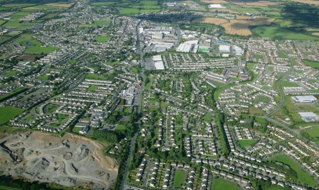
43 Part V Guidance
44 1. Legislation Planning applications for residential development of 10 units or more on zoned land must satisfy the requirements of Part V of the Planning and Development Act, 2000 (as amended), for the provision of social/affordable housing. Where an application for permission for development to which Part V of the Planning and Development Act 2000 (as amended) applies the application must be accompanied with details as to how it is proposed to comply with Section 96 of Part V of the Act. Failure to do so may result in the application being deemed invalid or a request for additional information. If the proposal is considered exempt under of Section 97 of the Planning and Development Act 2000 (as amended), a copy of the Certificate of Exemption under Section 97 must be submitted (or, where an application for a certificate of exemption has to be decided, a certified copy of the application must be submitted). If it is considered that under Section 96(13) of the Planning and Development Acts (as amended), that the planning application is for a development to which Part V Acts (as amended) does not apply details indicating the basis for such opinion must be submitted. 2. Pre Planning Contact Details Applicants are strongly advised to avail of the pre-planning process to compete a preplanning Part V proposal with the Housing Department. Failure to complete this process prior to the lodgement of an application may result in Part V proposals being sought by way of requests for further information. Please contact the following with any queries you have - Adrienne Cassidy ( ) or Mary McCarthy ( ) 3. Requirements for Valid Planning Applications One of the following must be submitted: 1) Where Section 96 of Part V of the Planning and Development Act 2000 (as amended) applies the following must be included, with your application form i. Details of such part or parts of the land which is subject to the application for permission or is or are specified by the Part V agreement, or houses situated on such aforementioned land or elsewhere in the planning authority s functional area proposed to be transferred to the planning authority, or details of houses situated on such aforementioned land or elsewhere in the planning authority s functional area proposed to be leased to the planning authority, or details of any combination of the foregoing, and ii. Given that at the planning application stage the detailed design cannot be finally determined and authorised until a grant of planning permission, an applicant for a
45 housing development must only provide details of the calculations and methodology for estimating values of land, site costs, normal construction and development costs and profit on those costs and other related costs such as an appropriate share of any common development works as required to comply with the provisions in Part V of the Act. Six Options under (i) above include: a) Transfer of land, with a map, to the same scale as the site location map, indicating the part or parts of the site proposed for transfer to the planning authority. b) Transfer of Housing on the application site with a list of the units and types of housing including floor plans and areas within the proposed development that are proposed to be transferred. c) Transfer of Housing off-site, with a list of the units and types of housing elsewhere in the functional area of the planning authority that are proposed to be transferred, and the indicative location of such units. d) Lease of Housing (on or off-site) with a list of the units and types of housing, including floor plans and areas, within the proposed development or elsewhere in the functional area of the planning authority that it is proposed to lease. e) Combination of Option 1 and any other options or options. f) Combination of any of Options ) 1 x Social Housing Exemption Certificate or 3) 1 x Social Housing Exemption Certificate application accompanied by a statutory declaration and 2 Site Location Maps (Scale of 1:1000), or 4)Where Section 96(13) of the Planning and Development Act 2000 (as amended) applies, details and evidence indicating the basis on which Section 96(13) is considered to apply should be submitted. 4. General Requirement The type of units required will depend on the location and demand for housing need in the vicinity of the subject site. The type of units required will be discussed at the pre-planning meeting. It is desirable that where Part V compliance is by means of on-site transfer of completed units, that the units are dispersed throughout the development. Please refer to the County Development Plan, the policy document 'Quality Housing for Sustainable Communities' and 'Sustainable Urban Housing: Design Standards for New Apartments' in relation to minimum design guidelines.
46 Part V Proposal Sheet Planning Reference Number N/A Name of Developer/Landowner Ardstone Homes Ltd Location of Development (include site location map, Site to be highlighted in red. ) Kilcullen Road, Bluebell, Naas, Co. Kildare Site area 3.76 ha / Residential Development Area 3.51ha Details of Proposed Development 125 Units Details of Proposed Part V (include site layout drawing with Part V Units clearly identified, unit drawings with room dimensions and storage provision identified and completed cost template for individual house types to be transferred as per attached cost template) Unit type House / Apartment please tick One bed Two bed Three bed Four bed H A House Type & House No.(s) A1 No. 94, 96 A2 No. 93, 95 H A B2- No. 30, 32, 62, 65, B3- No. 31, 63, 64 H A C1 No. 86, 87 No of Units Unit size (m2) Unit cost 220, , On Onsite/offsite Please tick Off On ` Off , On Off H A On Off Five bed H A On Off
47 Part V Design Assessment Template Space provision & room sizes for Typical Dwellings. N.B. Please complete space provision and room size template for each unit type to be delivered: Applicant: Ardstone Homes Ltd Site Location: Kilcullen Road, Bluebell, Naas, Co. Kildare No. of Part V units Proposed (10%): 13 Date: Dwelling types are defined in terms of: 1. The number of bedrooms, 2. The number of intended occupants and, 3. The number of storeys. Dwelling: 2Bed/4P/2 storey House Type B2 Assessment under DHPCLG best practice guidelines manual, Quality Housing for Sustainable Communities, Accommodation Target Floor. Areas (min.) Provision Min. width (min.) Provision Gross Floor Area 80m² 86.2 m² N/A Living Room 13m² 19.4 m² 3.8m 3.8 m Agg. Living Area 30m² 30.1 m² N/A Bedroom 1* (main bedroom) 13m² 13.3 m² 2.8m 3.1 m Bedroom 2 (Double) 11.4m² 12.2 m² 2.8m 2.8 m Bedroom 3 (Single) n/a n/a n/a n/a Comment or X Agg. Bedroom Area 25m² 25.5 m² N/A Storage 4m² Storage is calculated under CDP standards below as it exceeds DHPCLG manual N/A standards Accessible toilet at GF. or X (Statutory requirements for access for people with disabilities as set out in Part M TGD Building Regulations). Advisory notes. Main Bedroom* The area of the main Bedroom should be at least 13m² in a dwelling designed to accommodate three or more persons. Layout. 1. All proposed Part V units shall be pepper potted throughout the site and not located within a cluster. 2. The layout of the dwelling shall be designed to make effective use of natural daylight and sunlight, as far as practicable. 3. Dwellings should be orientated so that all major rooms get direct sunlight at sometime during the day. Circulation. 1. Access to each of the principal rooms, including the main bathroom/wc, should be directly from the main internal circulation area and not from another room, however,
48 the dining room may open off the main living room and/or the kitchen without direct access from the circulation area. 2. The kitchen should be located so that there is a convenient route to the front access door and the door leading to the rear garden, where provided. 3. In dwellings of two or more storeys, where there is no bedroom at entry level, there should be space within the living area at entry level that could conveniently and safely accommodate a bed space. 4. Doors and opening sections of windows shall not create hazards for users of circulation routes. Kitchen Layout. 1. The distance between floor units and an opposite wall, or opposite floor units, should be at least 1500mm. 2. It is desirable there should be a direct route, i.e. other than through another room, from the kitchen to the front door. 3. Adequate natural lighting and a direct view to the outside should be provided Bathroom. 1. Where a bathroom window is provided it should be located where it does not interfere with the shower area or bath and can be opened conveniently and safely, e.g., not directly over the bath. 2. The bathroom layout (relative position of fittings and circulation space) should facilitate later adaptation for wheelchair users, if required. 3. A bath should normally be provided and be fitted with a shower. Grab rails should be provided to assist entrance to, egress from and safe use of the shower. A suitable shower screen and any associated fittings should also be installed. Dwelling: 2Bed/4P/2 storey House Type B2 Assessment under Kildare County Development Plan , Development Management Standards. Min. Req mts Target (m²) Provision (m²) Comment (2 Bed House) or X Floor Area 85m² 86.6 m² Storage 6m² 7.2m² Private Open Space 55m² Varies m² Advisory Notes. County Development Plan - Policy (Development Management Standards) requirement. Storage. 1. Storage should be additional to kitchen presses and bedroom furniture, but may be partly provided in these rooms. (If storage provisions are to be proposed in such rooms, the plans shall clearly indicate in addition any such wardrobe/kitchen press unit provisions in each respective room) 2. General Storage provision should be provided on each floor. 3. Storage should be provided off a hallway or landing to facilitate access. 4. Hot presses or boiler space do not count as general storage areas. 5. As a rule, no individual storage room within a dwelling should exceed 3.5 sq metres. 6. Dwellings may provide storage for bulky items outside individual units and this may satisfy part of the general storage requirement. Part V Design Assessment Template
49 Space provision & room sizes for Typical Dwellings. N.B. Please complete space provision and room size template for each unit type to be delivered: Applicant: Ardstone Homes Ltd Site Location: Kilcullen Road, Bluebell, Naas, Co. Kildare No. of Part V units Proposed (10%): 13 Date: Dwelling types are defined in terms of: 4. The number of bedrooms, 5. The number of intended occupants and, 6. The number of storeys. Dwelling: 2Bed/4P/2 storey House Type B3 Assessment under DHPCLG best practice guidelines manual, Quality Housing for Sustainable Communities, Accommodation Target Floor. Areas (min.) Provision Min. width (min.) Provision Gross Floor Area 80m² 86.2 m² N/A Living Room 13m² 19.4 m² 3.8m 3.8 m Agg. Living Area 30m² 30.1 m² N/A Bedroom 1* (main bedroom) 13m² 13.3 m² 2.8m 3.1 m Bedroom 2 (Double) 11.4m² 12.2 m² 2.8m 2.8 m Bedroom 3 (Single) n/a n/a n/a n/a Comment or X Agg. Bedroom Area 25m² 25.5 m² N/A Storage 4m² Storage is calculated under CDP standards below as it exceeds DHPCLG manual N/A standards Accessible toilet at GF. or X (Statutory requirements for access for people with disabilities as set out in Part M TGD Building Regulations). Advisory notes. Main Bedroom* The area of the main Bedroom should be at least 13m² in a dwelling designed to accommodate three or more persons. Layout. 4. All proposed Part V units shall be pepper potted throughout the site and not located within a cluster. 5. The layout of the dwelling shall be designed to make effective use of natural daylight and sunlight, as far as practicable. 6. Dwellings should be orientated so that all major rooms get direct sunlight at sometime during the day. Circulation. 5. Access to each of the principal rooms, including the main bathroom/wc, should be directly from the main internal circulation area and not from another room, however, the dining room may open off the main living room and/or the kitchen without direct access from the circulation area.
50 6. The kitchen should be located so that there is a convenient route to the front access door and the door leading to the rear garden, where provided. 7. In dwellings of two or more storeys, where there is no bedroom at entry level, there should be space within the living area at entry level that could conveniently and safely accommodate a bed space. 8. Doors and opening sections of windows shall not create hazards for users of circulation routes. Kitchen Layout. 4. The distance between floor units and an opposite wall, or opposite floor units, should be at least 1500mm. 5. It is desirable there should be a direct route, i.e. other than through another room, from the kitchen to the front door. 6. Adequate natural lighting and a direct view to the outside should be provided Bathroom. 4. Where a bathroom window is provided it should be located where it does not interfere with the shower area or bath and can be opened conveniently and safely, e.g., not directly over the bath. 5. The bathroom layout (relative position of fittings and circulation space) should facilitate later adaptation for wheelchair users, if required. 6. A bath should normally be provided and be fitted with a shower. Grab rails should be provided to assist entrance to, egress from and safe use of the shower. A suitable shower screen and any associated fittings should also be installed. Dwelling: 2Bed/4P/2 storey House Type B3 Assessment under Kildare County Development Plan , Development Management Standards. Min. Req mts Target (m²) Provision (m²) Comment (2 Bed House) or X Floor Area 85m² 86.6 m² Storage 6m² 7.2m² Private Open Space 55m² Varies m² Advisory Notes. County Development Plan - Policy (Development Management Standards) requirement. Storage. 7. Storage should be additional to kitchen presses and bedroom furniture, but may be partly provided in these rooms. (If storage provisions are to be proposed in such rooms, the plans shall clearly indicate in addition any such wardrobe/kitchen press unit provisions in each respective room) 8. General Storage provision should be provided on each floor. 9. Storage should be provided off a hallway or landing to facilitate access. 10. Hot presses or boiler space do not count as general storage areas. 11. As a rule, no individual storage room within a dwelling should exceed 3.5 sq metres. 12. Dwellings may provide storage for bulky items outside individual units and this may satisfy part of the general storage requirement. Part V Design Assessment Template
51 Space provision & room sizes for Typical Dwellings. N.B. Please complete space provision and room size template for each unit type to be delivered: Applicant: Ardstone Homes Ltd. Site Location: Kilcullen Road, Bluebell, Naas, Co. Kildare No. of Part V units Proposed (10%): 13, 9 Dwellings, 4 Apartments Date: Dwelling types are defined in terms of: 7. The number of bedrooms, 8. The number of intended occupants and, 9. The number of storeys. Dwelling: 3Bed/5P/2 storey House Type C1 Assessment under DHPCLG best practice guidelines manual, Quality Housing for Sustainable Communities, Accommodation Target Floor. Areas (min.) Provision Min. width (min.) Provision Gross Floor Area 92m² m² N/A Living Room 13m² 16 m² 3.8m 3.8 m Agg. Living Area 34m² 44.7 m² N/A Bedroom 1* (main bedroom) 13m² 13.6 m² 2.8m 3.1 m Bedroom 2 (Double) 11.4m² 11.7 m² 2.8m 3.1 m Bedroom 3 (Single) 7.1 m² 8.2 m² 2.1m 2.1 m Comment or X Agg. Bedroom Area 32m² 33.5 m² N/A Storage 5m² Storage is calculated under CDP standards below as it exceeds DHPCLG manual N/A standards Accessible toilet at GF. or X (Statutory requirements for access for people with disabilities as set out in Part M TGD Building Regulations). Advisory notes. Main Bedroom* The area of the main Bedroom should be at least 13m² in a dwelling designed to accommodate three or more persons. Layout. 7. All proposed Part V units shall be pepper potted throughout the site and not located within a cluster. 8. The layout of the dwelling shall be designed to make effective use of natural daylight and sunlight, as far as practicable. 9. Dwellings should be orientated so that all major rooms get direct sunlight at sometime during the day. Circulation. 9. Access to each of the principal rooms, including the main bathroom/wc, should be directly from the main internal circulation area and not from another room, however, the dining room may open off the main living room and/or the kitchen without direct access from the circulation area.
52 10. The kitchen should be located so that there is a convenient route to the front access door and the door leading to the rear garden, where provided. 11. In dwellings of two or more storeys, where there is no bedroom at entry level, there should be space within the living area at entry level that could conveniently and safely accommodate a bed space. 12. Doors and opening sections of windows shall not create hazards for users of circulation routes. Kitchen Layout. 7. The distance between floor units and an opposite wall, or opposite floor units, should be at least 1500mm. 8. It is desirable there should be a direct route, i.e. other than through another room, from the kitchen to the front door. 9. Adequate natural lighting and a direct view to the outside should be provided Bathroom. 7. Where a bathroom window is provided it should be located where it does not interfere with the shower area or bath and can be opened conveniently and safely, e.g., not directly over the bath. 8. The bathroom layout (relative position of fittings and circulation space) should facilitate later adaptation for wheelchair users, if required. 9. A bath should normally be provided and be fitted with a shower. Grab rails should be provided to assist entrance to, egress from and safe use of the shower. A suitable shower screen and any associated fittings should also be installed. Dwelling: 3Bed/5P/2 storey House Type C1 Assessment under Kildare County Development Plan , Development Management Standards. Min. Req mts Target (m²) Provision (m²) Comment (2 Bed House) or X Floor Area 100m² m² Storage 9m² 9 m² Private Open Space 60m² Varies m² Advisory Notes. County Development Plan Policy (Development Management Standards) requirement. Storage. 13. Storage should be additional to kitchen presses and bedroom furniture, but may be partly provided in these rooms. (If storage provisions are to be proposed in such rooms, the plans shall clearly indicate in addition any such wardrobe/kitchen press unit provisions in each respective room) 14. General Storage provision should be provided on each floor. 15. Storage should be provided off a hallway or landing to facilitate access. 16. Hot presses or boiler space do not count as general storage areas. 17. As a rule, no individual storage room within a dwelling should exceed 3.5 sq metres. 18. Dwellings may provide storage for bulky items outside individual units and this may satisfy part of the general storage requirement. Important Note:

53 This guidance document is only intended to help assist designers in completing their design accordingly, however this document is not a substitute for the DHPCLG guideline manual titled Sustainable Urban Housing; Design Standards for new Apartments 2015, and designers shall ensure their design complies fully with this guidance document. Table Quality Housing for Sustainable Communities (DHPCLG) Target gross floor area and the minimum floor areas for Living, bedroom and storage areas likely to be required to satisfy requirements of normal living

54 Extract from Section Development Management Standards Kildare County Development Plan Part V Design Assessment Template Space provision & room sizes for Typical Apartments. N.B. Please complete space provision and room size template for each unit type to be delivered: Applicant: Ardstone Homes Ltd. Site Location: Kilcullen Road, Bluebell, Naas, Co. Kildare No. of Part V units Proposed (10%): 13, 9 Dwellings, 4 Apartments Date: Apartment types are defined in terms of the number of bedrooms being proposed. Please refer to DHPCLG guideline manual titled Sustainable Urban Housing; Design Standards for new Apartments 2015, for full details on apartment classification & design requirements. Apartment: 1 Bedroom - Unit Type A1 Assessment carried out in accordance with DHPCLG Sustainable Urban Housing; Design Standards for new Apartments Accommodation Target Flr. Areas (DoEHLG/KCC) Provision Min. width Provision Comment or X Gross Floor Area 45m² 52 m² Living/Dining area 23m² 27 m² 3.3m m Agg. Living Area 23m² 27 m² Bedroom 11.4m² 12 m² 2.8m 2.9 m Agg. Bedroom Area 11.4m² 12 m² Storage 3m² 3 m² Private Amenity 5m² Varies m² 1.5m 6.4 m Accessible toilet - (Part M-Building Regulations)
55 Extract from Section Development Management Standards Kildare County Development Plan Part V Design Assessment Template Space provision & room sizes for Typical Apartments. N.B. Please complete space provision and room size template for each unit type to be delivered: Applicant: Ardstone Homes Ltd. Site Location: Kilcullen Road, Bluebell, Naas, Co. Kildare No. of Part V units Proposed (10%): 13, 9 Dwellings, 4 Apartments Date: Apartment types are defined in terms of the number of bedrooms being proposed. Please refer to DHPCLG guideline manual titled Sustainable Urban Housing; Design Standards for new Apartments 2015, for full details on apartment classification & design requirements. Apartment: 1 Bedroom - Unit Type A2 Assessment carried out in accordance with DHPCLG Sustainable Urban Housing; Design Standards for new Apartments Accommodation Target Flr. Areas (DoEHLG/KCC) Provision Min. width Provision Comment or X Gross Floor Area 45m² 62 m² Living/Dining area 23m² 27 m² 3.3m m Agg. Living Area 23m² 27 m² Bedroom 11.4m² 12 m² 2.8m 3.2 m Agg. Bedroom Area 11.4m² 12 m² Storage 3m² 3 m² Private Amenity 5m² Varies 45-62m² 1.5m 6.2 m Accessible toilet - (Part M-Building Regulations) Advisory notes. Plans/Calculations. Floor areas should be in square metres and should be calculated from internal room dimensions. In addition planning drawings must include the principal dimensions of each room as well as the aggregate floor area of each room. Ceiling Height. It is a specific planning policy requirement that ground level apartment floor to ceiling heights shall be a minimum of 2.7m.
56 Lift & Stair cores. Requirement that up to a max. of 8 apartments per floor per individual stair/lift core may be provided in apartment schemes. P.T.O Storage. 1. Storage should be additional to kitchen presses and bedroom furniture, but may be partly provided in these rooms. In such cases this must be in addition to minimum aggregate living/dining/kitchen or bedroom floor areas. A store off a hallway or landing will facilitate access, but hot presses or boiler space will not count as general storage. As a rule, no individual storage room within an apartment should exceed 3.5 square metres. 2. It is a specific planning policy requirement that where secure, allocated ground or basement level storage is provided, it may be used to satisfy up to half of the minimum storage requirement for individual apartment units, but shall not serve to reduce the minimum floor area required to be provided within each individual apartment unit, as set out in the guidelines. 3. Apartment schemes may provide storage for bulky items outside individual units (i.e. at ground or basement level). Secure, ground floor storage space allocated to individual apartments and located close to the entrance to the apartment block is encouraged. This form of storage may be used for equipment such as, for example, bicycles or bicycle equipment, children s outdoor toys or buggies, however such storage does not satisfy bicycle parking requirements. Private Amenity Space. 1. Shall be clearly shown on design drawings. 2. Private amenity space shall be provided in the form of gardens or patos/terraces for ground floor apartments and balconies at upper levels. Where provided a ground level, private amenity space level shall incorporate boundary treatment appropriate to ensure privacy and security. 3. A minimum depth of 1.5 metres is required for balconies, in one useable length to meet the minimum floor area requirement. 4. Balconies should be primarily accessed from living rooms, although larger apartments may include wrap around and/or secondary balconies and should have level access from the main living space. Security. Where ground floor apartments are to be located adjoining the back of a public footpath or some other public area, consideration may be given to the provision of a privacy strip of approximately 1.5m in depth. Important Note: This guidance document is only intended to help assist designers in completing their design accordingly, however this document is not a substitute for the DHPCLG guideline manual titled Sustainable Urban Housing; Design Standards for new Apartments 2015, and designers shall ensure their design complies fully with this guidance document.
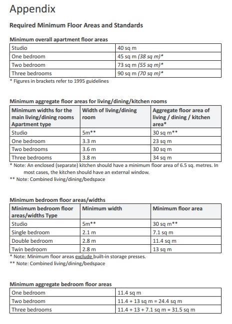
57
58 Extract from DHPCLG guideline manual titled Sustainable Urban Housing; Design Standards for new Apartments 2015 PTO
59 Specification Questionnaire Provide details on; Building Structure: (please select) Masonry Timber Frame Other Specify Windows: (please select) Timber Aluminium PVC Aluclad Other Specify (Preference is for PVC ) Internal: Kitchen specification: counter and door finish. Floor finishes: Bathroom (non slip tiling) Kitchen Utility room Hall Living room Ensuite Accessible toilet All other floors should be skimmed concrete finish Attic: Attics not to be floored Walkway to water tank from attic hatch No Stira type attic access just hatch door Wall Finishes: Bathroom Kitchen Ensuite Accessible toilet Bathroom Finishes Shower doors/ bath screen Yes * No Shaver lights Yes * No Fitted wardrobes Yes * No Fireplace/stove Yes * No White Goods Yes * No *Where Yes is selected, please furnish further details
60 External: Steel Garden shed on concrete base Yes * No Side Gate Yes * No Front gates and piers Yes * No Front and rear external lighting Yes * No Rear garden topsoil raked and seeded for lawn Yes * No Front garden topsoil raked and seeded for lawn Yes * No Side and rear boundary treatment Yes * No Front boundary treatment Yes * No Pebble finishes to exterior open spaces Yes No Wired in interconnected smoke/heat/fire alarms throughout Yes No Wired in carbon monoxide alarms (preference not to have just Battery powered) Yes No Preference for Hit & Miss type fencing as opposed to shiplap fencing Yes No Safety File Should be sufficiently compiled with all requisite as follows: Testing Certificates Yes No O & M Manuals Yes No Details of all subcontractors and their input Yes No *Where Yes is selected, please furnish further details Prompt delivery of safety file to the Council on completion of project Developer to provide an induction to the first tenant at the time of handover of the safety file There should be separate safety file for each house Services: Provide details on; Primary heating (Where unit has chimney, survey report & dvd to be furnished, Certification of smoke test required) GAS CENTRAL HEATING Renewable technology Heat Pumps Ventilation AERECO DEMAND CONTROL VENTILATION Do not wire up for intruder alarm TBC Heat pumps to be sited away from the house structure so as to negate against vibrations and noise - TBC Certification of Compliance with all aspects of the Building Regulations - YES
61 Departmental Caps


62
apply sustainability principles to all residential developments in Ardee;
 3. Housing 3.1 Introduction Ardee is currently experiencing considerable pressure for residential development as improved road infrastructure, together with the availability of serviced land, makes the
Development of a temporary grass multisport pitch and associated works (in addition to the previously approved park - Phase A).
.") To the Lord Mayor and Report No. 163/2018 Members of Dublin City Council Report of the Chief Executive (a) Planning and Development Act 2000 (as amended) & Planning and Development Regulations 2001 (as
To the Lord Mayor and Report No. 163/2018 Members of Dublin City Council Report of the Chief Executive (a) Planning and Development Act 2000 (as amended) & Planning and Development Regulations 2001 (as
CHESHIRE WEST AND CHESTER COUNCIL
 Item No. 10 CHESHIRE WEST AND CHESTER COUNCIL Planning Committee 1 st April 2014 APPLICATION NUMBER: 13/05410/FUL DESCRIPTION OF DEVELOPMENT: Residential development of 17 affordable dwellings and associated
Additional Policies & Objectives for Local Area Plans Dunshaughlin LAP. Dunshaughlin
 Dunshaughlin Strategic Policies SP 1 To operate an Order of Priority for the release of residential lands in compliance with the requirements of CS OBJ 6 of the County Development Plan as follows: i) The
RYEDALE SITES LOCAL PLAN MATTER 4 PROPOSED HOUSING SITE OPTION REF. 116 LAND AT MIDDLETON ROAD, PICKERING BARRATT HOMES & DAVID WILSON HOMES
 RYEDALE SITES LOCAL PLAN MATTER 4 PROPOSED HOUSING SITE OPTION REF. 116 LAND AT MIDDLETON ROAD, PICKERING BARRATT HOMES & DAVID WILSON HOMES REPRESENTOR ID: 1064 INTRODUCTION 1.1 We write on behalf of
PROPOSED DRAFT VARIATION NO. 5 MEATH COUNTY DEVELOPMENT PLAN
 PROPOSED DRAFT VARIATION NO. 5 MEATH COUNTY DEVELOPMENT PLAN 2013-2019 21 st NOVEMBER 2018 1.0 INTRODUCTION The Meath County Development Plan 2013-2019 was adopted on the 17 th December 2012 and came
RYEDALE SITES LOCAL PLAN MATTER 3 PROPOSED HOUSING SITE OPTION REF. 116 LAND AT MIDDLETON ROAD, PICKERING BARRATT HOMES & DAVID WILSON HOMES
 RYEDALE SITES LOCAL PLAN MATTER 3 PROPOSED HOUSING SITE OPTION REF. 116 LAND AT MIDDLETON ROAD, PICKERING BARRATT HOMES & DAVID WILSON HOMES REPRESENTOR ID: 1064 INTRODUCTION 1.1 We write on behalf of
POLICY & PROCEDURE FOR THE TAKING IN CHARGE OF RESIDENTIAL DEVELOPMENTS
 POLICY & PROCEDURE FOR THE TAKING IN CHARGE OF RESIDENTIAL DEVELOPMENTS TABLE OF CONTENTS 1 POLICY OBJECTIVE...1 2 POLICY OVERVIEW... 2 2.1 Legislative framework... 2 2.2 Policy Statement... 2 2.3 Policy
KILKENNY CITY AND ENVIRONS DEVELOPMENT PLAN Variation 3
 KILKENNY CITY AND ENVIRONS DEVELOPMENT PLAN 2014 2020 Variation 3 To alter the zoning in the Western Environs to maximise the potential housing supply in line with the Government s policy outlined in Rebuilding
WELCOME TIMESCALES. Thank you for attending Anthology s final public exhibition on the emerging plans for Kennington Stage. ANTHOLOGY S COMMITMENTS
 WELCOME Thank you for attending Anthology s final public exhibition on the emerging plans for Kennington Stage. Since the second consultation in October 2018, which asked your views on the preferred approach,
LITTLE MOUNTAIN ADJACENT AREA REZONING POLICY
 LITTLE MOUNTAIN ADJACENT AREA REZONING POLICY JANUARY 2013 CONTENTS 1.0 INTENT & PRINCIPLES...1 2.0 APPLICATION...2 3.0 HOUSING TYPES, HEIGHT & DENSITY POLICIES...3 3.1 LOW TO MID-RISE APARTMENT POLICIES...4
Planning Justification Report
 Planning Justification Report 101 Kozlov Street, Barrie, Ont. Destaron Property Management Ltd. November 2015 Revised February 2017 TABLE OF CONTENTS Page 1.0 INTRODUCTION... 1 2.0 DESCRIPTION OF SUBJECT
Flinders Avenue, Lara Planning Scheme Amendment Combined Application for Rezoning and Multi-Lot Subdivision Reference : Decembe
 143-179 Flinders Avenue, Lara Planning Scheme Amendment Combined Application for Rezoning and Multi-Lot Subdivision Reference: 14134-03 TGM Group Geelong Melbourne Ballarat 1/27-31 Myers Street (PO Box
TOTTENHAM SECONDARY PLAN
 TOTTENHAM SECONDARY PLAN AMENDMENT NO. 11 TO THE OFFICIAL PLAN OF THE TOWN OF NEW TECUMSETH The following text and schedules to the Official Plan of the Town of New Tecumseth constitute Amendment No. 11
DEVELOPMENT AGREEMENT APPLICATION
 151-11172 LYNNETT ROAD, SPRYFIELD DEVELOPMENT AGREEMENT APPLICATION JULY 28, 2016 1 Spectacle Lake Drive Dartmouth, NS B3B 1X7 Phone: 902-835-9955 Fax: 902-835-1645 www.wspgroup.com 151-11172 July 28,
ST. TERESA S GARDENS REGENERATION PARTNERSHIP
 ST. TERESA S GARDENS REGENERATION PARTNERSHIP ST. TERESA S GARDENS REGENERATION - Dublin City Council / DoECLG / Residents / St. Teresa s Regeneration Board St. Teresa s Gardens was initially designed
PIN , Part 1, Plan SR-713 in Lot 2, Concession 5, Township of McKim (1096 Dublin Street, Sudbury)
") STAFF REPORT Applicant: Dalron Construction Limited Location: PIN 02124-0103, Part 1, Plan SR-713 in Lot 2, Concession 5, Township of McKim (1096 Dublin Street, Sudbury) Official Plan and Zoning By-law:
STAFF REPORT Applicant: Dalron Construction Limited Location: PIN 02124-0103, Part 1, Plan SR-713 in Lot 2, Concession 5, Township of McKim (1096 Dublin Street, Sudbury) Official Plan and Zoning By-law:
Riverton Properties Ltd Proposed Special Housing Area
 Riverton Properties Ltd Proposed Special Housing Area Housing Accords and Special Housing Areas Act 2013 Expression of Interest 1 This Expression of Interest is made on behalf of Riverton Properties Ltd,
City of Grande Prairie Development Services Department
 City of Grande Prairie Development Services Department COUNTRYSIDE SOUTH OUTLINE PLAN Prepared by: GPEC Consulting Ltd. #202, 10712-100th Street Grande Prairie, AB Council Resolution of August 20, 2001
DEVELOPMENT OPPORTUNITY LAND EAST OF NEW ROAD MELBOURN, CAMBRIDGESHIRE, SG8 6BX
 DEVELOPMENT OPPORTUNITY LAND EAST OF NEW ROAD MELBOURN, CAMBRIDGESHIRE, SG8 6BX Illustrative Masterplan - Not to Scale An excellent opportunity to acquire a development site benefitting from outline planning
CASTLES OF CALEDON URBAN DESIGN REPORT
 CASTLES OF CALEDON URBAN DESIGN REPORT PROPOSED RESIDENTIAL DEVELOPMENT CALEDON, ONTARIO 10 JULY, 2015 TABLE CONTENTS: 1.0 DEVELOPMENT 4.0 CONCLUSION 1.1 Introduction 1.2 Castles of Caledon- Urban Design
NORTH LEEDS MATTER 2. Response to Leeds Sites and Allocations DPD Examination Inspector s Questions. August 2017
 NORTH LEEDS MATTER 2 Response to Leeds Sites and Allocations DPD Examination Inspector s Questions August 2017 CLIENT: TAYLOR WIMPEY, ADEL REFERENCE NO: CONTENTS 1.0 INTRODUCTION 2.0 TEST OF SOUNDNESS
Inverness Area Planning Advisory Committee Inverness County Planning Advisory Committee Inverness County Council Planning Staff (EDPC)
") STAFF REPORT To: From: Inverness Area Planning Advisory Committee Inverness County Planning Advisory Committee Inverness County Council Planning Staff (EDPC) Date: January 18, 2018 Reference: Request for
STAFF REPORT To: From: Inverness Area Planning Advisory Committee Inverness County Planning Advisory Committee Inverness County Council Planning Staff (EDPC) Date: January 18, 2018 Reference: Request for
Planning Rationale in Support of an Application for Plan of Subdivision and Zoning By-Law Amendment
 Planning Rationale in Support of an Application for Plan of Subdivision and Zoning By-Law Amendment The Kilmorie Development 21 Withrow Avenue City of Ottawa Prepared by: Holzman Consultants Inc. Land
Nga Potiki is a Treaty Settlement tribe with mana whenua over the Te Maunga, Mangatawa, Rangataua and Papamoa areas.
 THE NGA POTIKI HOUSING DEVELOPMENT PROPOSAL SPECIAL HOUSING AREA PROPOSAL 6 October 2014 Overview of proposal Nga Potiki plan to develop approximately 27 hectares of land in Papamoa for residential housing.
DUN LAOGHAIRE RATHDOWN COUNTY COUNCIL PLANNING AND DEVELOPMENT ACTS, SECTION 49 - SUPPLEMENTARY DEVELOPMENT CONTRIBUTION SCHEME.
 DUN LAOGHAIRE RATHDOWN COUNTY COUNCIL PLANNING AND DEVELOPMENT ACTS, 2000-2006 SECTION 49 - SUPPLEMENTARY DEVELOPMENT CONTRIBUTION SCHEME For GLENAMUCK DISTRICT DISTRIBUTOR ROAD SCHEME AND SURFACE WATER
PLANNING BRIEF SITE ND7, TEMPLE QUAY, BRISTOL
 PLANNING BRIEF SITE ND7, TEMPLE QUAY, BRISTOL Site Description Plot ND7 is located within the area known as Temple Quay North in central Bristol, north of the Floating Harbour, and is incorporated within
JOINT CORE STRATEGY FOR BROADLAND, NORWICH AND SOUTH NORFOLK EXAMINATION MATTER 3A GENERAL STRATEGY FOR THE GROWTH LOCATIONS
 Matter 3A General Strategy for the Growth Locations Representor No. 8826 JOINT CORE STRATEGY FOR BROADLAND, NORWICH AND SOUTH NORFOLK EXAMINATION MATTER 3A GENERAL STRATEGY FOR THE GROWTH LOCATIONS SUBMISSION
3.1. OBJECTIVES FOR RESIDENTIAL LAND USE DESIGNATIONS GENERAL OBJECTIVES FOR ALL RESIDENTIAL DESIGNATIONS
 3. RESIDENTIAL LAND USE DESIGNATIONS INTRODUCTION The Residential land use designations provide for housing and other land uses that are integral to, and supportive of, a residential environment. Housing
Dún Laoghaire-Rathdown County Council (DLR) Submission to The Joint Committee on Planning, Housing & Local Government 17 th October 2018
 Submission to The Joint Committee on Planning, Housing & Local Government 17 th October 2018") Dún Laoghaire-Rathdown County Council (DLR) Submission to The Joint Committee on Planning, Housing & Local Government 17 th October 2018 Introduction DLR welcomes the opportunity to make a submission to
Dún Laoghaire-Rathdown County Council (DLR) Submission to The Joint Committee on Planning, Housing & Local Government 17 th October 2018 Introduction DLR welcomes the opportunity to make a submission to
8.5.1 R1, Single Detached Residential District
 8.5.1 R1, Single Detached Residential District The purpose of this district is to provide for residential development in the form of single detached dwellings. Dwelling, Single Detached Home Business,
MAKING THE MOST EFFECTIVE AND SUSTAINABLE USE OF LAND
 165 SOC146 To deliver places that are more sustainable, development will make the most effective and sustainable use of land, focusing on: Housing density Reusing previously developed land Bringing empty
Notice of Intent to Lodge Formal Part 8 Planning Application
 Report to Elected Members North Central Area Committee Re: Development at Ayrfield-Belmayne Malahide Road Notice of Intent to Lodge Formal Part 8 Planning Application Social Housing Need: The site falls
Land at Sheldon Heath Road and Platt Brook Way, Sheldon, Birmingham, B26 2DS
 Committee Date: 06/02/2014 Application Number: 2013/08937/PA Accepted: 03/12/2013 Application Type: Full Planning Target Date: 04/03/2014 Ward: Sheldon Land at Sheldon Heath Road and Platt Brook Way, Sheldon,
Proposed Demolition of Existing Shop & Erection of New Build Development to Form 11 Flats
 Proposed Demolition of Existing Shop & Erection of New Build Development to Form 11 Flats Wern Goch Hirani Stores, 56 Wern Goch West, Cardiff CF23 7AB Design & Access Statement for Pre-Application Consultation
20 Edward Street Zoning Amendment Application - Preliminary Report
 STAFF REPORT ACTION REQUIRED 20 Edward Street Zoning Amendment Application - Preliminary Report Date: January 20, 2015 To: From: Wards: Reference Number: Toronto and East York Community Council Director,
FEASIBILITY REPORT. 1486, 1490 and 1494 Clementine. Prepared by: Lloyd Phillips & Associates Ltd. For: Ottawa Salus
 DRAFT FEASIBILITY REPORT 1486, 1490 and 1494 Clementine Prepared by: Lloyd Phillips & Associates Ltd. For: Ottawa Salus LPA File No. 1008 Lloyd Phillips & Associates June 9, 2010 Feasibility Report Page
East Herts District Plan Part 1: Strategy Sieve 5: Strategy Testing. Land Owner/Developer Questionnaire
 East Herts District Plan Part 1: Strategy Sieve 5: Strategy Testing Land Owner/Developer Questionnaire ugust 2012 rea of Search: 20. Ware East Sub-rea Call for Sites Ref: 05/020 (as subsection of larger
OPENING STATEMENT OF CORK CITY COUNCIL. to the JOINT OIREACHTAS COMMITTEE ON HOUSING, PLANNING AND LOCAL GOVERNMENT
 OPENING STATEMENT OF CORK CITY COUNCIL to the JOINT OIREACHTAS COMMITTEE ON HOUSING, PLANNING AND LOCAL GOVERNMENT 17 October 2018 Context Cork City Council wishes to thank the Oireachtas Committee for
NEWBRIDGE DESIGN STATEMENT. DDA Architects Ltd. 62 Brighton Square Rathgar Dublin 6 Ph (1)
") NEWBRIDGE DESIGN STATEMENT DDA Architects Ltd. 62 Brighton Square Rathgar Dublin 6 Ph. 00353 (1) 490.0499 www.ddaarch.ie INTRODUCTION In response to the Inspection Report on the Recommended Opinion ABP-300414-17
NEWBRIDGE DESIGN STATEMENT DDA Architects Ltd. 62 Brighton Square Rathgar Dublin 6 Ph. 00353 (1) 490.0499 www.ddaarch.ie INTRODUCTION In response to the Inspection Report on the Recommended Opinion ABP-300414-17
Committee Date: 17/07/2014 Application Number: 2014/02259/PA Accepted: 28/04/2014 Application Type: Full Planning Target Date: 23/06/2014
 Committee Date: 17/07/2014 Application Number: 2014/02259/PA Accepted: 28/04/2014 Application Type: Full Planning Target Date: 23/06/2014 Ward: Selly Oak 101 Hubert Road, Selly Oak, Birmingham, B29 6ET
1.0 Introduction. November 9, 2017
 November 9, 2017 Andrew Bone, Planner III Regional Planning Policy and Strategic Initiatives Halifax Regional Municipality 40 Alderney Drive Dartmouth, NS, B2Y 2N5 Subject: Application to amend the Bedford
HAUXTON MILL BUILDINGS CAMBRIDGE ROAD HAUXTON CAMBRIDGE
 FOR SALE BY INFORMAL TENDER UNIQUE DEVELOPMENT/CONVERSION OPPORTUNITIES HAUXTON MILL BUILDINGS CAMBRIDGE ROAD HAUXTON CAMBRIDGE ON THE INSTRUCTION OF CONTENTS 1. INTRODUCTION 2. DESCRIPTION 3. PLANNING
Committee Date: 17/07/2014 Application Number: 2014/02247/PA Accepted: 23/04/2014 Application Type: Full Planning Target Date: 18/06/2014
 Committee Date: 17/07/2014 Application Number: 2014/02247/PA Accepted: 23/04/2014 Application Type: Full Planning Target Date: 18/06/2014 Ward: Selly Oak 99 Hubert Road, Selly Oak, Birmingham, B29 6ET
Cressingham Gardens Estate, Brixton. DRAFT Masterplan Objectives for discussion. September 2015
 Cressingham Gardens Estate, Brixton DRAFT Masterplan Objectives for discussion September 2015 Contents Introduction 1 Project objectives 2 Masterplan objectives 4 Draft masterplan objectives for the Cressingham
Notice of Intention by Rob Huntley, a Reporter appointed by the Scottish Ministers
 Appeal: Notice of Intention T: 01324 696 400 F: 01324 696 444 E: dpea@scotland.gsi.gov.uk Notice of Intention by Rob Huntley, a Reporter appointed by the Scottish Ministers Planning appeal reference: PPA-250-2242
Appendix1,Page1. Urban Design Guidelines. Back to Back and Stacked Townhouses. DRAFT September 2017
 Appendix1,Page1 Urban Design Guidelines DRAFT September 2017 Back to Back and Stacked Townhouses Appendix1,Page2 Table of Contents 1 Introduction 1 1.1 Purpose 1 1.2 Urban Design Objectives 1 1.3 Building
AT Land Adjacent to Tollgate Cottage, Broughton Grounds Lane, Milton Keynes. Parish: Broughton & Milton Keynes Parish Council
 APPLICATION 06 Application Number: 13/00553/FUL Major Revision to plans approved under 11/01760/MKPC for Plots 59-71 to provide 16 affordable one, two and three bedroom apartments with associated parking
Chapter 5 Residential and Community Facilities
 Chapter 5 Residential and Community Facilities 5.1 Introduction During the years of the economic boom in Ireland, County Louth experienced considerable pressure for residential development. During this
Pre-Applica on Design Statement : Residen al Development, The Gas Works, 113 Bury Road, The ord, Norfolk 1
 13-188 Pre-Applica on Design Statement: Residen al Development, The Gas Works, 113 Bury Road, The ord, Norfolk Prepared by: Gary Johns Architects Date: October 2015 15-311 Pre-Applica on Design Statement
Simon Court 2-4 Neeld Crescent London NW4 3RR
 Location Simon Court 2-4 Neeld Crescent London NW4 3RR Reference: 17/1019/FUL Received: 20th February 2017 Accepted: 23rd February 2017 Ward: West Hendon Expiry 20th April 2017 Applicant: Proposal: Mr
Masshouse Plot 3, Land at Masshouse Lane/Park Street, Masshouse Plaza, City Centre, Birmingham, B5
 Committee Date: 21/08/2014 Application Number: 2014/02950/PA Accepted: 07/05/2014 Application Type: Full Planning Target Date: 06/08/2014 Ward: Nechells Masshouse Plot 3, Land at Masshouse Lane/Park Street,
Islington Avenue - Official Plan and Zoning By-law Amendment Application - Preliminary Report
 STAFF REPORT ACTION REQUIRED 3002-3014 Islington Avenue - Official Plan and Zoning By-law Amendment Application - Preliminary Report Date: Febuary 2, 2016 To: From: Wards: Reference Number: Etobicoke York
DEVELOPMENT DESCRIPTION AND LOCATION
 TIME : 09:01:59 PAGE : 1 18/1024 Trevor Quinn, P 22/08/2018 the construction of a 2 storey 3 bedroom house 111.6sqm, to include subdivision of the existing site, new entrance from adjacent cul-de-sac,
Planning Application 16/4008/F Rockwell 771 units off Anchor and Hope Lane SE7
 Annex (6 pages) Planning Application 16/4008/F Rockwell 771 units off Anchor and Hope Lane SE7 Evidence from Charlton Riverside Masterplan Summary (NB This is the Short Annex see also Long Annex for more
Planning Guidelines. Sustainable Urban Housing: Design Standards for New Apartments Guidelines for Planning Authorities
 28 Planning Guidelines Sustainable Urban Housing: Design Standards for New Apartments Guidelines for Planning Authorities Department of Housing, Planning and Local Government March 2018 Government of
INTRODUCTION This application is brought before committee as Councillor Howell has submitted a red card due to residents concerns.
 APPLICATION NO. APPLICATION TYPE SITE ADDRESS APP/15/00608/F Full 41 Green Road, Poole, BH15 1QH PROPOSALS Alterations and extensions to form a flat unit REGISTERED 13 May, 2015 APPLICANT DWP Housing Partnership
DCLG consultation on proposed changes to national planning policy
 Summary DCLG consultation on proposed changes to national planning policy January 2016 1. Introduction DCLG is proposing changes to the national planning policy framework (NPPF) specifically on: Broadening
50 and 52 Finch Avenue East - Official Plan and Zoning By-law Amendment Applications - Preliminary Report
 STAFF REPORT ACTION REQUIRED 50 and 52 Finch Avenue East - Official Plan and Zoning By-law Amendment Applications - Preliminary Report Date: August 16, 2016 To: From: Wards: Reference Number: North York
CONSULTATION STATEMENT
 October 2016 LB BIR.4109 BLOOR HOMES CONSULTATION STATEMENT Tanworth Lane, Cheswick Green PHASES 2 & 2A TOWN & COUNTRY PLANNING ACT 1990 (AS AMENDED) PLANNING AND COMPULSORY PURCHASE ACT 2004 Pegasus Group
DEVELOPMENT DESCRIPTION AND LOCATION IPC WASTE 17/279
 : 23/03/2017 Kildare County Council TIME : 10:17:53 PAGE : 1 PLANNING APPLICATIONS FROM 15/03/17 TO 21/03/17 17/279 Patrick Cummins P 15/03/2017 the erection of a straw bedded cattle shed, a manure pit
An Bord Pleanála. Inspector s Report. Single storey extension to rear at 26 Fitzroy Avenue, Drumcondra, Dublin 3.
 An Bord Pleanála Inspector s Report Appeal Reference No. Development: Planning Application Planning Authority: PL29N.245590 Single storey extension to rear at 26 Fitzroy Avenue, Drumcondra, Dublin 3. Dublin
M.O. DATE M.O. NUMBER 26/06/2018 DO18434 FILE NUMBER 17/764 APP. TYPE APPLICANTS NAME. DATE : 29/06/2018 Kildare County Council
 TIME : 16:43:08 PAGE : 1 17/764 Makros Limited P 30/06/2017 modifications to development permitted under Reg. Ref. 07/1450 (ABP Ref. PL09.299110 - subsequently withdrawn) & Reg. Ref. 13/155 to now provide
POLICY AMENDMENT AND LAND USE AMENDMENT RICHMOND (WARD 8) RICHMOND ROAD SW AND 24 STREET SW BYLAWS 10P2018 AND 52D2018
 RICHMOND ROAD SW AND 24 STREET SW BYLAWS 10P2018 AND 52D2018") Page 1 of 12 EXECUTIVE SUMMARY This land use amendment proposes to redesignate two parcels of approximately 0.30 hectares ± (0.74 acres ±) located in the community of Richmond from DC Direct Control District
Page 1 of 12 EXECUTIVE SUMMARY This land use amendment proposes to redesignate two parcels of approximately 0.30 hectares ± (0.74 acres ±) located in the community of Richmond from DC Direct Control District
P. H. Robinson Consulting Urban Planning, Consulting and Project Management
 PLANNING RATIONALE REPORT FOR SITE PLAN AND DRAFT PLAN OF CONDOMINIUM APPLICATIONS 73-75 HARVEY STREET CITY OF OTTAWA PREPARED BY: P H ROBINSON CONSULTING AUGUST 2012 1 This report has been prepared on
Metropolitan Cork Joint Retail Strategy. March 2015
 Metropolitan Cork Joint Retail Strategy March 2015 Cork City Council Comhairle Cathrach Chorcaí Cork County Council Comhairle Contae Chorcaí 1.0 Introduction 1.1 The Retail Planning Guidelines (RPG's)
H4. Residential Mixed Housing Suburban Zone
 H4. Residential Mixed Housing Suburban Zone H4.1. Zone description The Residential Mixed Housing Suburban Zone is the most widespread residential zone covering many established suburbs and some greenfields
Director, Community Planning, Etobicoke York District
 STAFF REPORT ACTION REQUIRED 3555 Don Mills Road Zoning By-law Amendment Application Preliminary Report Date: May 22, 2012 To: From: Wards: Reference Number: North York Community Council Director, Community
SOUTH TIPPERARY COUNTY COUNCIL
 SOUTH TIPPERARY COUNTY COUNCIL POLICY FOR THE TAKING IN CHARGE OF RESIDENTIAL DEVELOPMENTS 1 POLICY POLICY This document outlines South Tipperary County Council s policy and procedure in relation to taking
PLANNING. Cairngorms National Park Local Development Plan POLICY 1 - NEW HOUSING DEVELOPMENT Non-statutory Planning Guidance
 PLANNING Cairngorms National Park Local Development Plan POLICY 1 - NEW HOUSING DEVELOPMENT Non-statutory Planning Guidance Cairngorms National Park Local Development Plan Policy 1 New Housing Development
DRAFT LOCAL VALIDATION CHECKLIST FOR ALL APPLICATIONS
 DRAFT LOCAL VALIDATION CHECKLIST FOR ALL APPLICATIONS For public consultation 9 February to 9 March 2015 February 2015 1 NATIONAL REQUIREMENTS Application Form Design & Access Statement (DAS) If major
LAND OFF THETFORD ROAD WATTON, NORFOLK
 LAND OFF THETFORD ROAD WATTON, NORFOLK An exceptional opportunity to acquire a greenfield site benefitting from outline planning permission for the development of up to 180 dwellings. Approximately 7.4
APPLICATION No. 17/01532/MNR APPLICATION DATE: 29/06/2017
 COMMITTEE DATE: 11/10/2017 APPLICATION No. 17/01532/MNR APPLICATION DATE: 29/06/2017 ED: APP: TYPE: RIVERSIDE Full Planning Permission APPLICANT: Mr PROTHERO LOCATION: 49 DESPENSER STREET, RIVERSIDE, CARDIFF,
Planning & Development. Background. Subject Properties
 Planning & Development APPLICATION BRIEFING Prepared For: Planning Advisory Committee Submitted by: Jason Fox, Director of Planning & Development Date: Subject: Application by Meech Holdings Limited to
Wigan Core Strategy Examination Additional Hearing Sessions
 Wigan Core Strategy Examination Additional Hearing Sessions Morris Homes & Persimmon Homes Session on Specific Proposals to Meet the Identified Shortfall in Housing Land Golborne & Lowton 6 th March 2013
Planning Justification Report
 Planning Justification Report 103 and 105 Toronto Street Town of Markdale, Municipality of Grey Highlands Maverick Developments November 5, 2016 Zelinka Priamo Ltd. Page i TABLE OF CONTENTS Page No. 1.0
CITY OF VAUGHAN EXTRACT FROM COUNCIL MEETING MINUTES OF DECEMBER 9, 2014
 CITY OF VAUGHAN EXTRACT FROM COUNCIL MEETING MINUTES OF DECEMBER 9, 2014 Item 22, Report No. 41, of the Committee of the Whole, which was adopted without amendment by the Council of the City of Vaughan
Urban Design Brief. Proposed Medical / Dental Office 1444 Adelaide Street North. Vireo Health Facility Ltd.
 Urban Design Brief Proposed Medical / Dental Office Vireo Health Facility Ltd. November 27, 2013 TABLE OF CONTENTS Page No. INTRODUCTION... 1 SECTION 1 LAND USE PLANNING CONTEXT... 1 1.1 The Subject Lands...
South Dublin County Council Local Infrastructure Housing Activation Fund Proposal Ballycullen and Oldcourt Local Area Plan
 South Dublin County Council Local Infrastructure Housing Activation Fund Proposal Ballycullen and Oldcourt Local Area Plan October 2016 Ballycullen-Oldcourt Local Area Plan Table of Contents 1. Introduction
12, 14, 16 and 18 Marquette Avenue and 7 Carhartt Street Zoning By-law Amendment Application - Preliminary Report
 STAFF REPORT ACTION REQUIRED 12, 14, 16 and 18 Marquette Avenue and 7 Carhartt Street Zoning By-law Amendment Application - Preliminary Report Date: July 17, 2014 To: From: Wards: Reference Number: North
BIRMINGHAM DEVELOPMENT PLAN EXAMINATION 2014 MATTER E: GREEN BELT POLICY & THE LANGLEY SUE
 BIRMINGHAM DEVELOPMENT PLAN EXAMINATION 2014 MATTER E: GREEN BELT POLICY & THE LANGLEY SUE STATEMENT BY SAVILLS ON BEHALF OF THE LANGLEY SUE CONSORTIUM SEPTEMBER 2014 Question 1.Does policy TP10 set out
Dublin Mountain Golf Course
 Dublin Mountain Golf Course Brittas, Co. Dublin, D24 E653 102 Acres,, 41.28 Hectares An extensive parcel of land in a dramatic setting on the doorstep of the City. The Lands A single parcel of land extending
Section 2.1 Land use and Density
 2 Planning Scheme Framework Section 2.1 Land use and Density Overarching Principle To direct land-uses and densities across the SDZ lands in a manner that creates a sustainable urban district that is based
Persimmon Homes Severn Valley comment St Cuthbert (Out) Neighbourhood Plan Pre-Submission Consultation
 Neighbourhood Plan Pre-Submission Consultation") 150408 Persimmon Homes Severn Valley comment St Cuthbert (Out) Neighbourhood Plan Pre-Submission Consultation On Wednesday, 8 April 2015, 16:54, "Davis, Paul" wrote: See
150408 Persimmon Homes Severn Valley comment St Cuthbert (Out) Neighbourhood Plan Pre-Submission Consultation On Wednesday, 8 April 2015, 16:54, "Davis, Paul" wrote: See
PREPARED FOR: ADI DEVELOPMENT GROUP INC.
 Acronym Urban Design and Planning/Mark Sterling Consulting Inc. 111 Clendenan Avenue, Toronto, Ontario M6P 2W7 URBAN DESIGN BRIEF PROPOSED DEVELOPMENT 4880 VALERA ROAD, CITY OF BURLINGTON PREPARED FOR:
STAFF REPORT. Permit Number: Porter. Kitsap County Board of Commissioners; Kitsap County Planning Commission
 STAFF REPORT Permit Number: 15 00461 Porter DATE: November 9, 2015 TO: FROM: Kitsap County Board of Commissioners; Kitsap County Planning Commission Katrina Knutson, AICP, Senior Planner, DCD and Jeff
Bylaw No , being "Official Community Plan Bylaw, 2016" Schedule "A" DRAFT
 Bylaw No. 2600-2016, being "Official Community Plan Bylaw, 2016" Schedule "A" Urban Structure + Growth Plan Urban Structure Land use and growth management are among the most powerful policy tools at the
Information Memorandum
 Information Memorandum Frenchs Forest 67-75 Dareen Street 320-328 Warringah Road Agent - Stuart Bath 0416 207 215 INFORMATION Memorandum Sections 1 Executive Summary 2 About the property 3 Northern Beaches
H5. Residential Mixed Housing Urban Zone
 H5. Residential Mixed Housing Urban Zone [ENV-2016-AKL-000197: Robert Adams] Addition sought H5.1. Zone description The Residential Mixed Housing Urban Zone is a reasonably high-intensity zone enabling
State Environmental Planning Policy No 53 Metropolitan Residential Development
 1999 No 523 New South Wales State Environmental Planning Policy No 53 Metropolitan Residential Development under the Environmental Planning and Assessment Act 1979 His Excellency the Governor, with the
CA/15/2006/OUT. Canterbury City Council Military Road Canterbury Kent CT1 1YW. Crown copyright and database rights 2015 Ordnance Survey
 Scale 1:1,250 Map Dated: 28/10/2015 CA/15/2006/OUT Crown copyright and database rights 2015 Ordnance Survey 100019614 Canterbury City Council Military Road Canterbury Kent CT1 1YW AGENDA ITEM NO 10 PLANNING
UNIT 1 and 2, 23 SALISBURY GROVE, MYTCHETT, CAMBERLEY, GU16 6BP
 2014/0764 Reg Date 15/08/2014 Mytchett/Deepcu t LOCATION: PROPOSAL: TYPE: APPLICANT: OFFICER: UNIT 1 and 2, 23 SALISBURY GROVE, MYTCHETT, CAMBERLEY, GU16 6BP Change of Use from Class B1 (Offices) to Class
East Lothian Local Development Plan Main Issues Report. Proposed Residential Allocation Land at Glenkinchie. On behalf of Aithrie Estates
 East Lothian Local Development Plan Main Issues Report Proposed Residential Allocation Land at Glenkinchie On behalf of Aithrie Estates February 2015 PPCA Limited Job no: 916.11 East Lothian Local Development
HOUSING ISSUES REPORT
 HOUSING ISSUES REPORT 8, 12 & 14 HIGH PARK AVENUE AND 1908, 1910, 1914 & 1920 BLOOR STREET WEST CITY OF TORONTO PREPARED FOR: 619595 ONTARI O INC. February 2016 TABLE OF CONTENTS 1.0 INTRODUCTION 1 2.0
4027 and 4031 Ellesmere Road Zoning Amendment and Draft Plan of Subdivision Applications - Request for Direction Report
 STAFF REPORT ACTION REQUIRED 4027 and 4031 Ellesmere Road Zoning Amendment and Draft Plan of Subdivision Applications - Request for Direction Report Date: August 22, 2013 To: From: Wards: Reference Number:
Staff Report for Council Public Meeting
 Agenda Item 3.3 Staff Report for Council Public Meeting Date of Meeting: September 27, 2017 Report Number: SRPRS.17.134 Department: Division: Subject: Planning and Regulatory Services Development Planning
Corporate Report. Planning & Development Services, Implementation. Date of Report: January 7, 2013 Date of Meeting: January 21, 2013
 Corporate Report Report from Planning & Development Services, Implementation Date of Report: January 7, 2013 Date of Meeting: January 21, 2013 Report Number: PDS-019-2013 File: 60.46.394 Subject: Application
66 Isabella Street Rezoning Application - Preliminary Report
 STAFF REPORT ACTION REQUIRED 66 Isabella Street Rezoning Application - Preliminary Report Date: November 15, 2010 To: From: Wards: Reference Number: Toronto and East York Community Council Director, Community
M-43 CORRIDOR OVERLAY ZONE
 ARTICLE 26.00 M-43 CORRIDOR OVERLAY ZONE Section 26.01 Findings A primary function of the M-43 state highway is to move traffic through the Township and to points beyond. As the primary east-west arterial
[2010] VSC (2004) 18 VPR 229
![[2010] VSC (2004) 18 VPR 229](/thumbs/74/70555400.jpg "[2010] VSC (2004) 18 VPR 229") MOOT COURT 2017 PREPARED BY TIM RETROT VICTORIAN CIVIL AND ADMINISTRATIVE TRIBUNAL PLANNING PERMIT APPLICATION NO. TP418/2016 OUTLINE OF SUBMISSIONS ON BEHALF OF LIONHEART HOMES 93-95 VICTORIA STREET,
MOOT COURT 2017 PREPARED BY TIM RETROT VICTORIAN CIVIL AND ADMINISTRATIVE TRIBUNAL PLANNING PERMIT APPLICATION NO. TP418/2016 OUTLINE OF SUBMISSIONS ON BEHALF OF LIONHEART HOMES 93-95 VICTORIA STREET,