Proposed Demolition of Existing Shop & Erection of New Build Development to Form 11 Flats
|
|
|
- Cameron Harrell
- 5 years ago
- Views:
Transcription
1 Proposed Demolition of Existing Shop & Erection of New Build Development to Form 11 Flats Wern Goch Hirani Stores, 56 Wern Goch West, Cardiff CF23 7AB Design & Access Statement for Pre-Application Consultation Report Planning Advisor - R Hathaway MRTPI Plan R Ltd Architectural Services - Peter Legg Dlp Architecture


2 1. Existing Site and Context The character of Wern Goch West, like most of Llanederyn and Pentwyn are modern (circa 1970s) housing estates based on the Radburn layout. This type of estate design is typified by the back gardens of homes facing the street and the fronts of homes facing one another, over common areas or looking out onto woodland or open space. Aerial Image The housing comprises largely symmetrical two storey dwellings in a terraced or semi-detached form. Dispersed among the houses are some taller buildings and some with modernistic styling. While the building design is generally very bland the form and layout does produce a strong sense of rhythm to the character of the area. General Street Scene

3 Example of 4 Storey Block of Flats on Estate 2. The Site The accompanying dlp architectural plan views and elevational drawings indicate existing site conditions. The Radburn type layout clearly affects principle views as the rear of the properties front onto the main access from Wern Goch West. The site area covers 723 sq m and covers the end terrace property of 57 Wern Goch, the octagonal sided Wern Goch Retail Unit with asymmetrical mini spire over the retail store and the flat roofed 56 Wern Goch along with the rear concrete yards and grass forecourts connected with these. The site rises from east to west with the ground floor level of the retail store approximating at the first-floor level of 57 Wern Goch, the end terrace property. The retail store is therefore on retained higher ground that is enclosed by railings and by high brick wall that sides onto 57 Wern Goch. The site does not lie within an area of environmental protection for landscape, heritage or biodiversity classification. It does not lie within a flood zone.

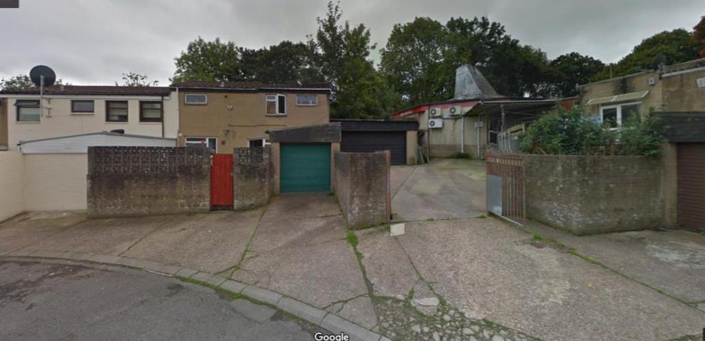
4 View of Part of Site Looking North View of Part of Site Looking South


5 Views looking North West

6 View Looking South East 3. Relevant Planning History 89/01456/N Proposed Extension to Shop Area Approved 12/09/89 95/00410/N Retain Satellite Dish Approved 21/04/ /00019/N Proposed First Floor Extension Approved 05/03/1998 A/98/00042/N -Advertisement - Approved 30/04/1998
7 4. Character of Proposed Development The proposal aims to redevelop the site to provide a higher number and greater range and choice of low cost housing provision in the Llanedeyn area. The development makes more efficient use of land but does so in a way that does not adversely impact on the character and appearance of the area. Indeed, private redevelopment on the estate will be a further encouragement to the regeneration of some of these now tired looking portions of the estate. The development proposes the demolition of 56 Wern Goch and the retail unit and its replacement with 11 flats comprising 1 x 1 bedroom, 4 x 2 bedroom and 6 x 3 bedroom and the retention of a retail unit of 27 sq m. The development would be serviced by six car parking spaces and 12 cycle spaces, all accommodated on the lower ground floor. The redeveloped site takes advantage of its existing unusual angular shape to provide flats in the highest section of the building with significant window openings and additional light/ventilation and views. The sizes of all the flats would be generous and would range in size from a one bedroom flat at 46 sq m to 85 sq m for a three bedroom flat. All flats would have good or reasonable outlooks and this plus their size and layout would make good quality accommodation in line with LDP requirements and housing needs. Access to the flats is either common access via steps from the lower ground floor from the rear courtyard off Wern Goch West or from the front (western) elevation via a concrete path. Flat 1 would have direct access from the concrete path to the west. The ground floor would comprise of: 1 x one bed flat approx. 46 sq m 1 x two bed flat approx. 72 sq m 2 x three bed flats ranging from 71 sq m to 85 sq m
8 . The first floor would comprise of: 1 x two bed flat 65 sq m 2 x three bed flats ranging from 76 sq m to 85 sq m The second floor would be limited to the former octagonal and higher portion of the existing site and would comprise of: 2 x three bed flats ranging from 73 to 76 sq m The third floor would be limited to the former octagonal and higher portion of the existing site and would comprise of: 2 x two bed flats approx. ranging from 73 to 76 sq m The redevelopment of the site would ensure that the unity of the terrace is respected with the redevelopment of the former 56 flat roofed Wern Goch becoming a symmetrical dual pitched roof to match the run of the terrace created by 54 and 55. The height of the ridges in this short run of terrace would increase to reflect the topography of the land. The design and appearance of the new dwelling would complement the existing terrace form. Similarly, the terrace that currently terminates on its western edge at 57 Wern Goch would be extended in a symmetrical dual pitched form to match the layout and building design at Wern Goch. Again, the extended terrace would match the character and appearance of the existing terrace. These would effectively form the wings of the central higher portion of the site. The extended terraces would meet the proposed four storey element of the development that would be angled on its east, west and southern sides as shown on the dlp drawings. The five short angles to the proposed four storey element reduce its bulk, scale and visual impact. The set back of the top floor achieves the
9 same impact in reducing the overall impact of the development in its setting. In order for the extended terraced form to match the existing character, the external materials to be used would be buff brickwork and grey upvc doors/windows with brown concrete roofing and red ridge tiles. While higher, the symmetrical form of the openings in the four-storey element, along with their largely horizontal emphasis, would help to integrate the development into its context. To ground the new four storey element into the existing urban context, the proposed ground floor materials would be buff brickwork with red/orange brickwork above on the first and second floors. To provide a contrast on the top floor the materials would change to vertical grey metal cladding. Windows and doors would be grey aluminium with glazed balustrades, A shared ground floor external amenity area of 80 sqm would be provided to the west (front) of flat 1. The third floor flats would be inset to allow for individual balconies to the two top flats of 14 sq m each. In terms of overlooking or overshadowing the development would not adversely impact on surrounding neighbours. Windows on the eastern, northern and western elevations are positioned so as to not adversely impact on surrounding areas. A glazed 1.8m opaque privacy screen would be positioned to the east of flat 1 given its proximity to the external parking area. 5. Access Existing Vehicular access to service the rear of the retail store and vehicular access to the rear of 56 and 57 Wern Goch West is provided via the adopted highway Wern Goch West, A concrete pavement on the southern side of the highway also provides pedestrian access. The site is located close to a bus stop (see Cardiff Council Map later).
10 A concrete path provides access to the front of the properties at 56 and 57 Wern Goch with the retail shop accessed via a ramp. One garage space is currently provided to serve 57 Wern Goch with two garage spaces for 56 and a forecourt proving operational parking for the retail unit. Proposed The proposed vehicular access to the redeveloped site would remain via the adopted Wern Goch West Road. Six resident car parking spaces are proposed accessed by double gates. Given the tenure of the flats and the likely socio-economic circumstances of the tenants and surrounding car ownership levels, car ownership levels of potential occupants are likely to be low. Given the sustainable nature of the site, the number of the site parking spaces is considered appropriate. Parking is also available on the highway. The scheme provides for 12 cycle store stands in a 14 sqm enclosed space. Access from the rear yard to the lower ground floor to the ground floor is provided via steps near alongside the cycle store. 6. Environmental and Ecological Sustainability Redevelopment of the site for residential use would be in keeping with uses in the surrounding area. In line with pre-application advice the development is supported by a landscaping scheme from Cardiff Treescapes (see attached).

11 This support helping to integrate the new development into the local area especially on its more open and green western, southern and eastern fringes. The rear yard area contains an area for bulk waste storage from the retail unit plus refuse storage area for the 11 flats. The refuse area is large enough to allow for: Dry Recycables 2 x 1100 litre bulk bins Food Waste 1 x 240 litre bins General Waste 2 X 1100 litre bulk bins Compost 1 x 240 litre bin The development also provides an area (minimum 5 sq m) for bulky waste. This complies with pre-application advice from the Council. 7. Community Safety The development of the site for housing would not increase any concerns about community safety on the site or in the local area.
12 8. Policy Framework Planning Policy Wales Ed9 Nov 2016 Chpt 4 Planning for Sustainability Chpt 9 Housing WG Advice Notes TAN 12 : Design (2009) Cardiff LDP (Adopted 2016) KP1: Level of Growth KP5: Good Quality and Sustainable Design KP6; New Infrastructure KP8: Sustainable Transport H3: Affordable Housing H6: Change of use or Redevelopment to Residential Use EN13: Air, noise, light pollution and land contamination T5: Managing Transport Impacts T6: Impact on Transport Networks and Services SPG to Adopted LDP Access, Circulation and Parking Standards 2010 Waste Collection and Storage Facilities 2007 Infill Sites 2017 Planning Obligations 2017
13 9. Assessment Key Policies The proposed development complies with the Council s relevant key policies that are applicable to the proposed development. Later assessment of the detailed Development Management criteria brings out aspects of design, infrastructure and access but in relation to the KPs the following high-level comments suffice: KP1: Level of Growth - the development of 11 homes on a brown field site makes a contribution to meeting the 45,415 dwellings required in Cardiff, off which windfall sites make up 5850, up to KP5: Good Quality and Sustainable Design as described in the Character of Proposed Development above the proposed development would contribute to creating more modern housing choice in Llanedyn and improve the quality of the character and appearance of the local area. Located on brownfield land with good accessibility to public transport and local facilities, the design adopts a more modern interpretation of housing provision. The development can also be implemented with no adverse harm to neighbouring properties. It is considered that in line with pre-application advice (see attached) the site could accommodate a development containing buildings of the scale and massing of those proposed. In particular is considered that the height of the four-storey building is acceptable, especially given the lower height of the supporting wings that complement the scale of the adjoining terraces and the presence of 4 storey blocks on the estate. Also, while higher, the development replaces an already slightly unusually building design within the local context. In line with preapplication advice the original notion of providing balconies was resisted given the Council s view that this feature would be out of character with the area.
14 As indicated in the Council s pre-application response, the proposed development would not be overbearing or unneighbourly upon the adjoining neighbours. In line with pre-application advice, access to the shared amenity area of 80 sq m is available through the building. This advice also indicated that this amount of space was acceptable. Added to this, are the 14 sq m external amenity per flat for the two flats on the top floor. This is formed by the top floor being recessed. KP6: New infrastructure the development provides for 11 affordable homes that will be owned and managed by a registered housing provider. Pre-application advice suggests that the Council will request affordable housing of 172,144 and Public Open Space 24,382. KP8: Sustainable Transport the development lies in a sustainable location with good walking and cycling access to local facilities and access to public transport as indicated below under detailed LDP Policy T1. Detailed Policies LDP Policy H3 seeks 20 per cent affordable housing contributions on brown field schemes above 5 units or 0.1 hectares. Pre application advice suggests that an affordable housing contribution and public open space contribution would be required as detailed above. LDP Policy H6 provides a framework for the assessment of applications for the change of use, conversion or redevelopment of redundant previously developed land and premises for residential purposes within settlement boundaries. The proposed development in brownfield land will support KP1 in bringing forward badly needed residential accommodation in a sustainable location in line with PPG Wales.
15 The policy strictly deals with redundant sites but as the policy deals with changes of use it is described below and meets the criteria set out in the policy given that: (1) The loss of local shops in older housing is not a new trend given the concentration of retailing into local centres and out of town areas. A local retailing centre would still be in close proximity. (2) Use of the site for residential purposes complements surrounding land uses and the form of development and amenity space is satisfactory; (3) N/A. (4) Community and transportation facilities are in relatively close proximity; and (5) No known contamination or other risks exist and suitable conditions can be attached to any consent. LDP Policy EN13 seeks to ensure that development would not be permitted that would be injurious to public health in relation to air, noise, light pollution and land contamination. The residential end use would not generate any adverse impacts in relation to air, noise and light while no known land contamination exists. The site would be built to modern day building regulations. LDP Policy T1 supports development which are easily accessible to essential services and facilities by walking and cycling. (1) The proposed building would bring a more modern interpretation into the locality and would not compromise the amenity of neighbours; (2) The development clearly recognises the transition from public highway to semi-public space and through design and layout supports pedestrian and cycling movements. It maintains the Radburn principles in relation to access and principle elevations and outlook. (3) The development encourages walking and cycling being on flat land, with easy access to a wide footway in close proximity to local facilities. The development also provides 12 cycling spaces under cover.
 As can be seen from the screen shot below from the Council s My Cardiff website information, the site")

16 (4) Vehicle speeds into the site would be slow due to the no through road. (5) As can be seen from the screen shot below from the Council s My Cardiff website information, the site lies close to a bus route. The surrounding topography is generally flat and this makes walking and cycling a more realistic choice than in a hilly area. The development also. My Maps Cardiff -Transport Opportunities Local Bus Stop Local Retail Centre
17 (6) The development provides for adequate car parking based on likely car ownership, cycle stands, amenity area and pedestrian movement along with adequate provision for protecting existing infrastructure and introducing new infrastructure. (7) The scheme provides for 12 undercover cycle spaces. (8) The issue or car free zones is not in and of itself relevant but the scheme provides for a lower than SPG standard amount of car parking that encourages cycling and walking. LDP Policy C2 supports the protection of existing community facilities. The current shop is a private business and in the current poor retail market climate cannot be sustained in the longer term. This s a national issue. LDP Policy C3 promotes the creation of safe environments and no increase in community safety concerns. The proposed development clearly defines private and semi-public space and there is no indication that it would lead to an increase in public community safety concerns. Plan R Ltd March
APPLICATION No. 17/01532/MNR APPLICATION DATE: 29/06/2017
 COMMITTEE DATE: 11/10/2017 APPLICATION No. 17/01532/MNR APPLICATION DATE: 29/06/2017 ED: APP: TYPE: RIVERSIDE Full Planning Permission APPLICANT: Mr PROTHERO LOCATION: 49 DESPENSER STREET, RIVERSIDE, CARDIFF,
3 Accommodation Road London NW11 8ED
 Location 3 Accommodation Road London NW11 8ED Reference: 17/1179/FUL Received: 15th February 2017 Accepted: 28th February 2017 Ward: Childs Hill Expiry 25th April 2017 Applicant: Mr Proposal: Creation
The application is being presented to the planning committee as Brentwood Borough Council is the applicant.
 COMMITTEE REPORT ITEM 09 Reference: 17/00682/FUL Ward: Brentwood South Site: Land Adjacent 3 King Edward Road Brentwood Essex Proposal: Construction of two x 2 bedroomed semi-detached dwellings. Plan Number(s):
The Horizon, 54 New Coventry Road, Sheldon, Birmingham, B26 3BB
 Committee Date: 17/07/2014 Application Number: 2014/02479/PA Accepted: 22/04/2014 Application Type: Full Planning Target Date: 22/07/2014 Ward: Sheldon The Horizon, 54 New Coventry Road, Sheldon, Birmingham,
SOUTH CAMBRIDGESHIRE DISTRICT COUNCIL. S/1744/05/F Thriplow House and Garage on land Adjacent 22 Middle Street for S Hurst
 SOUTH CAMBRIDGESHIRE DISTRICT COUNCIL REPORT TO: Development and Conservation Control Committee 2 nd November 2005 AUTHOR/S: Director of Development Services S/1744/05/F Thriplow House and Garage on land
16 Sevington Road London NW4 3SB
 Location 16 Sevington Road London NW4 3SB Reference: 18/5641/FUL Received: 19th September 2018 Accepted: 19th September 2018 Ward: West Hendon Expiry 14th November 2018 Applicant: Proposal: Hussaini Conversion
108 Holders Hill Road London NW4 1LJ
 Location 108 Holders Hill Road London NW4 1LJ Reference: 16/4234/FUL Received: 28th June 2016 Accepted: 7th July 2016 Ward: Finchley Church End Expiry 1st September 2016 Applicant: Proposal: Mr b menahem
DESIGN, ACCESS & PLANNING STATEMENT
 (MADRON STREET) LONDON SE1 5UB DESIGN, ACCESS & PLANNING STATEMENT The architectural response for the site has been designed with regard to the following: The New Southwark Plan The London Plan: Spatial
Land at The Quarter, Warstone Lane, Jewellery Quarter, Hockley, Birmingham, B18 6NG
 Committee Date: 30/05/2013 Application Number: 2013/01627/PA Accepted: 06/03/2013 Application Type: Full Planning Target Date: 05/06/2013 Ward: Ladywood Land at The Quarter, Warstone Lane, Jewellery Quarter,
Land at East Bay Close, Cardiff. Planning Statement Proposed Redevelopment to Provide Student Accommodation.
 Land at East Bay Close, Cardiff. Planning Statement Proposed Redevelopment to Provide Student Accommodation. 1. Introduction. 1.1. This Planning Statement is submitted in support of a detailed planning
apply sustainability principles to all residential developments in Ardee;
 3. Housing 3.1 Introduction Ardee is currently experiencing considerable pressure for residential development as improved road infrastructure, together with the availability of serviced land, makes the
Canterbury City Council Military Road Canterbury Kent CT1 1YW. Title: CA//16/02739/FUL. Author: Planning and Regeneration.
 O Crown copyright and database rights 2017 Ordnance Survey 100019614 Title: CA//16/02739/FUL Author: Planning and Regeneration Scale 1:1,250 Map Dated: 22/02/2017 Canterbury City Council Military Road
1 Cumbrian Gardens London NW2 1EB
 Location 1 Cumbrian Gardens London NW2 1EB Reference: 16/0469/FUL Received: 25th January 2016 Accepted: 29th January 2016 Ward: Golders Green Expiry 25th March 2016 Applicant: Mr REZA FARD Proposal: Conversion
34 Carver Street, Jewellery Quarter, Birmingham, B1 3AL
 Committee Date: 19/09/2013 Application Number: 2013/02379/PA Accepted: 03/05/2013 Application Type: Full Planning Target Date: 02/08/2013 Ward: Ladywood 34 Carver Street, Jewellery Quarter, Birmingham,
H4. Residential Mixed Housing Suburban Zone
 H4. Residential Mixed Housing Suburban Zone H4.1. Zone description The Residential Mixed Housing Suburban Zone is the most widespread residential zone covering many established suburbs and some greenfields
Rawlinson House, Lewisham, London SE13 5EL
 Rawlinson House, Lewisham, London SE13 5EL Client: Lewisham Homes Old Town Hall Catford London SE6 4RU Date: 18 February 2016 Job No: 2540-MA-N-RP-0001-D00 Martin Arnold Ltd 4 Gunnery Terrace The Royal
State Environmental Planning Policy No 53 Metropolitan Residential Development
 1999 No 523 New South Wales State Environmental Planning Policy No 53 Metropolitan Residential Development under the Environmental Planning and Assessment Act 1979 His Excellency the Governor, with the
How do I Object to Flats and Apartments in my Area?
 Guide How do I Object to Flats and Apartments in my Area? January 2017 Background This is an introduction to objecting to proposals for flats or apartments in your area. For more detailed information and
Proposals for the Redevelopment of the Magistrates Court & Police Station, Normandy Street / Orchard Lane, Alton
 THE SITE THE SITE The Site in Context WELCOME Welcome to our public exhibition in connection with our draft proposals ahead of a planning application being proposals for the redevelopment of the magistrates
Zone 8B Park Central, Spring Street, Birmingham, B15 2GD
 Committee Date: 08/05/2014 Application Number: 2014/01127/PA Accepted: 18/02/2014 Application Type: Full Planning Target Date: 20/05/2014 Ward: Ladywood Zone 8B Park Central, Spring Street, Birmingham,
1323 High Road London N20 9HR. Reference: 18/0709/FUL Received: 1st February 2018 Accepted: 1st February 2018 Ward: Totteridge Expiry 29th March 2018
 Location 1323 High Road London N20 9HR Reference: 18/0709/FUL Received: 1st February 2018 Accepted: 1st February 2018 Ward: Totteridge Expiry 29th March 2018 Applicant: Proposal: Mr M Shah Partial demolition
H6 Residential Terrace Housing and Apartment Buildings Zone
 H6. Residential Terrace Housing and Apartment Buildings Zone [CIV-2016-404-002333: Franco Belgiorno-Nettis]-Note: The properties affected by this appeal are identified on the Auckland Unitary Plan viewer.
H5. Residential Mixed Housing Urban Zone
 H5. Residential Mixed Housing Urban Zone [ENV-2016-AKL-000197: Robert Adams] Addition sought H5.1. Zone description The Residential Mixed Housing Urban Zone is a reasonably high-intensity zone enabling
Multi-unit residential uses code
 9.3.11 Multi-unit residential uses code 9.3.11.1 Application (1) This code applies to assessable development identified as requiring assessment against the Multi-unit residential uses code by the tables
RedStone Private Country Estate architectural guidelines
 RedStone Private Country Estate architectural guidelines urban design principles residential design guidelines > RedStone Village > StoneBridge > RiverView July 2007 Page 1 www.redstoneestate.co.za basic
Simon Court 2-4 Neeld Crescent London NW4 3RR
 Location Simon Court 2-4 Neeld Crescent London NW4 3RR Reference: 17/1019/FUL Received: 20th February 2017 Accepted: 23rd February 2017 Ward: West Hendon Expiry 20th April 2017 Applicant: Proposal: Mr
69 Cumbrian Gardens London NW2 1ED. Reference: 17/3513/FUL Received: 1st June 2017 Accepted: 1st June 2017 Ward: Golders Green Expiry 27th July 2017
 Location 69 Cumbrian Gardens London NW2 1ED Reference: 17/3513/FUL Received: 1st June 2017 Accepted: 1st June 2017 Ward: Golders Green Expiry 27th July 2017 Applicant: Mrs Heather Meyer Proposal: Conversion
H5. Residential Mixed Housing Urban Zone
 H5. Residential Mixed Housing Urban Zone H5.1. Zone description The Residential Mixed Housing Urban Zone is a reasonably high-intensity zone enabling a greater intensity of development than previously
ST. TERESA S GARDENS REGENERATION PARTNERSHIP
 ST. TERESA S GARDENS REGENERATION PARTNERSHIP ST. TERESA S GARDENS REGENERATION - Dublin City Council / DoECLG / Residents / St. Teresa s Regeneration Board St. Teresa s Gardens was initially designed
CHESHIRE WEST AND CHESTER COUNCIL
 Item No. 10 CHESHIRE WEST AND CHESTER COUNCIL Planning Committee 1 st April 2014 APPLICATION NUMBER: 13/05410/FUL DESCRIPTION OF DEVELOPMENT: Residential development of 17 affordable dwellings and associated
Pre-Applica on Design Statement : Residen al Development, The Gas Works, 113 Bury Road, The ord, Norfolk 1
 13-188 Pre-Applica on Design Statement: Residen al Development, The Gas Works, 113 Bury Road, The ord, Norfolk Prepared by: Gary Johns Architects Date: October 2015 15-311 Pre-Applica on Design Statement
INTRODUCTION This application is brought before committee as Councillor Howell has submitted a red card due to residents concerns.
 APPLICATION NO. APPLICATION TYPE SITE ADDRESS APP/15/00608/F Full 41 Green Road, Poole, BH15 1QH PROPOSALS Alterations and extensions to form a flat unit REGISTERED 13 May, 2015 APPLICANT DWP Housing Partnership
Committee Date: 17/07/2014 Application Number: 2014/02259/PA Accepted: 28/04/2014 Application Type: Full Planning Target Date: 23/06/2014
 Committee Date: 17/07/2014 Application Number: 2014/02259/PA Accepted: 28/04/2014 Application Type: Full Planning Target Date: 23/06/2014 Ward: Selly Oak 101 Hubert Road, Selly Oak, Birmingham, B29 6ET
SOUTH CAMBRIDGESHIRE DISTRICT COUNCIL. Director of Development Services
 SOUTH CAMBRIDGESHIRE DISTRICT COUNCIL REPORT TO: Development and Conservation Control Committee 6 th July 2005 AUTHOR/S: Director of Development Services S/6297/05/F - Cambourne Extension Over Garage and
Masshouse Plot 3, Land at Masshouse Lane/Park Street, Masshouse Plaza, City Centre, Birmingham, B5
 Committee Date: 21/08/2014 Application Number: 2014/02950/PA Accepted: 07/05/2014 Application Type: Full Planning Target Date: 06/08/2014 Ward: Nechells Masshouse Plot 3, Land at Masshouse Lane/Park Street,
Report of: DEVELOPMENT MANAGEMENT SECTION HEAD. 19 Cassiobury Park Avenue PARK
 PART A Report of: DEVELOPMENT MANAGEMENT SECTION HEAD Date of Committee: 26 th January 2012 Site address: 19 Cassiobury Park Avenue Reference Number : 11/01079/FULH Description of Development: Erection
CA/15/2006/OUT. Canterbury City Council Military Road Canterbury Kent CT1 1YW. Crown copyright and database rights 2015 Ordnance Survey
 Scale 1:1,250 Map Dated: 28/10/2015 CA/15/2006/OUT Crown copyright and database rights 2015 Ordnance Survey 100019614 Canterbury City Council Military Road Canterbury Kent CT1 1YW AGENDA ITEM NO 10 PLANNING
CA//15/02526/FUL. Canterbury City Council Military Road Canterbury Kent CT1 1YW. Crown copyright and database rights 2016 Ordnance Survey
 O Scale 1:1,250 Map Dated: 08/07/2016 CA//15/02526/FUL Crown copyright and database rights 2016 Ordnance Survey 100019614 Canterbury City Council Military Road Canterbury Kent CT1 1YW AGENDA ITEM NO 9
H4. Residential Mixed Housing Suburban Zone
 H4. Residential Mixed Housing Suburban Zone H4.1. Zone description The Residential Mixed Housing Suburban Zone is the most widespread residential zone covering many established suburbs and some greenfields
WELCOME TIMESCALES. Thank you for attending Anthology s final public exhibition on the emerging plans for Kennington Stage. ANTHOLOGY S COMMITMENTS
 WELCOME Thank you for attending Anthology s final public exhibition on the emerging plans for Kennington Stage. Since the second consultation in October 2018, which asked your views on the preferred approach,
PLANNING COMMITTEE 22/02/2006 SCHEDULE ITEM:- 11..Site Location; SOUTHALL COURT LADY MARGARET ROAD SOUTHALL MIDDLESEX UB1 2RG.
 PLANNING COMMITTEE 22/02/2006 SCHEDULE ITEM:- 11.Site Location; SOUTHALL COURT LADY MARGARET ROAD SOUTHALL MIDDLESEX UB1 2RG Form Letters49 PLANNING APPLICATION REPORT DATE: 22 February 2006 PLANNING COMMITTEE
MAKING THE MOST EFFECTIVE AND SUSTAINABLE USE OF LAND
 165 SOC146 To deliver places that are more sustainable, development will make the most effective and sustainable use of land, focusing on: Housing density Reusing previously developed land Bringing empty
UTT/17/2725/FUL (FELSTED) (Minor Councillor application)
 (Minor Councillor application)") UTT/17/2725/FUL (FELSTED) (Minor Councillor application) PROPOSAL: LOCATION: APPLICANT: AGENT: Proposed demolition of bungalow, outbuildings and workshop buildings and erection of 1 no. 5 bedroomed house
UTT/17/2725/FUL (FELSTED) (Minor Councillor application) PROPOSAL: LOCATION: APPLICANT: AGENT: Proposed demolition of bungalow, outbuildings and workshop buildings and erection of 1 no. 5 bedroomed house
St Johns Road, Isleworth
 St Johns Road, Isleworth and Access Statement Concept sketch looking south on St Johns Road rocktownsend.co.uk Date Contents. The Process. Consultations. Use. Amount 5. Layout. Scale. Landscaping 8. Appearance
Ku-ring-gai Local Environmental Plan No 194
 New South Wales Ku-ring-gai Local Environmental Plan No 194 under the Environmental Planning and Assessment Act 1979 I, the Minister Assisting the Minister for Infrastructure and Planning (Planning Administration),
Britannia House High Road London N12 9RY
 Location Britannia House 958-964 High Road London N12 9RY Reference: 16/2602/FUL Received: 20th April 2016 Accepted: 24th May 2016 Ward: Woodhouse Expiry 19th July 2016 Applicant: Aga Sleczka Proposal:
CHANGE OF USE FROM A RESIDENTIAL DWELLING TO HOUSE IN MULTIPLE OCCUPANCY WITH 7 LETTABLE ROOMS (RETROSPECTIVE)
") Application Number: 10/00433/FUL CHANGE OF USE FROM A RESIDENTIAL DWELLING TO HOUSE IN MULTIPLE OCCUPANCY WITH 7 LETTABLE ROOMS (RETROSPECTIVE) AT: 5 Rowton Heath, Oakhill, Milton Keynes FOR: Mr Michael
Application Number: 10/00433/FUL CHANGE OF USE FROM A RESIDENTIAL DWELLING TO HOUSE IN MULTIPLE OCCUPANCY WITH 7 LETTABLE ROOMS (RETROSPECTIVE) AT: 5 Rowton Heath, Oakhill, Milton Keynes FOR: Mr Michael
REFERENCE: F/04452/12 Received: 23 November 2012 Accepted: 23 November 2012 WARD(S): Woodhouse Expiry: 18 January 2013 Final Revisions:
: Woodhouse Expiry: 18 January 2013 Final Revisions:") LOCATION: 70 Granville Road, London, N12 0HT REFERENCE: F/04452/12 Received: 23 November 2012 Accepted: 23 November 2012 WARD(S): Woodhouse Expiry: 18 January 2013 Final Revisions: APPLICANT: PROPOSAL:
LOCATION: 70 Granville Road, London, N12 0HT REFERENCE: F/04452/12 Received: 23 November 2012 Accepted: 23 November 2012 WARD(S): Woodhouse Expiry: 18 January 2013 Final Revisions: APPLICANT: PROPOSAL:
Plan Dutch Village Road
 Plan Dutch Village Road Objective: The lands around Dutch Village Road are a minor commercial area that services the larger Fairview community. Maintaining the vibrancy of the area by planning for redevelopment
Appendix1,Page1. Urban Design Guidelines. Back to Back and Stacked Townhouses. DRAFT September 2017
 Appendix1,Page1 Urban Design Guidelines DRAFT September 2017 Back to Back and Stacked Townhouses Appendix1,Page2 Table of Contents 1 Introduction 1 1.1 Purpose 1 1.2 Urban Design Objectives 1 1.3 Building
P. H. Robinson Consulting Urban Planning, Consulting and Project Management
 PLANNING RATIONALE REPORT FOR SITE PLAN AND DRAFT PLAN OF CONDOMINIUM APPLICATIONS 73-75 HARVEY STREET CITY OF OTTAWA PREPARED BY: P H ROBINSON CONSULTING AUGUST 2012 1 This report has been prepared on
57 Foscote Road London NW4 3SE
 Location 57 Foscote Road London NW4 3SE Reference: 16/0572/FUL Received: 28th January 2016 Accepted: 1st February 2016 Ward: West Hendon Expiry 28th March 2016 Applicant: Mr Dan Tamir Proposal: Part single,
Tudor Court 2 Crewys Road London NW2 2AA
 Location Tudor Court 2 Crewys Road London NW2 2AA Reference: 18/3299/S73 Received: 30th May 2018 Accepted: 30th May 2018 Ward: Childs Hill Expiry 25th July 2018 Applicant: Mr Jack Frankel Proposal: Variation
Flat 3 43 Sunny Gardens Road London NW4 1SL
 Location Flat 3 43 Sunny Gardens Road London NW4 1SL Reference: 17/5349/FUL Received: 16th August 2017 Accepted: 22nd August 2017 Ward: Hendon Expiry 17th October 2017 Applicant: Proposal: Sunny Trio Limited
3.1. OBJECTIVES FOR RESIDENTIAL LAND USE DESIGNATIONS GENERAL OBJECTIVES FOR ALL RESIDENTIAL DESIGNATIONS
 3. RESIDENTIAL LAND USE DESIGNATIONS INTRODUCTION The Residential land use designations provide for housing and other land uses that are integral to, and supportive of, a residential environment. Housing
PLANNING DECISIONS FOR WEEK 2 DATED 07/01/2013 TO 11/01/2013
 In deciding a planning application the Planning Authority, in accordance with Section 34 (3) of the Planning and Development Act, 2000, as amended, has had regard to submissions and observations received
MILL ROAD DEPOT, CAMBRIDGE Design and Access Statement December
 66 MILL ROAD DEPOT, CAMBRIDGE Design and Access Statement December 2017 67 HOOPER STREET EAGLE GREEN EAGLE FOUNDRY STREET C H I S H O L M T R A I L THE LIMES Headly Street is the first new street encountered
Committee Date: 17/07/2014 Application Number: 2014/02247/PA Accepted: 23/04/2014 Application Type: Full Planning Target Date: 18/06/2014
 Committee Date: 17/07/2014 Application Number: 2014/02247/PA Accepted: 23/04/2014 Application Type: Full Planning Target Date: 18/06/2014 Ward: Selly Oak 99 Hubert Road, Selly Oak, Birmingham, B29 6ET
SOUTH CAMBRIDGESHIRE DISTRICT COUNCIL. Executive Director (Operational Services)/ Corporate Manager (Planning and New Communities)
/ Corporate Manager (Planning and New Communities)") SOUTH CAMBRIDGESHIRE DISTRICT COUNCIL REPORT TO: Planning Committee 3 November 2010 AUTHOR/S: Executive Director (Operational Services)/ Corporate Manager (Planning and New Communities) Notes: S/0244/10/F
SOUTH CAMBRIDGESHIRE DISTRICT COUNCIL REPORT TO: Planning Committee 3 November 2010 AUTHOR/S: Executive Director (Operational Services)/ Corporate Manager (Planning and New Communities) Notes: S/0244/10/F
LOT AREA AND FRONTAGE
 LOT AREA AND FRONTAGE Lot Area & Frontage for the R2.1 Zone Lot Area & Frontage for the R2.4 Zone Minimum Lot Minimum Lot Zone Area Width R2.1 700 sq m 18 m R2.4 600 sq m 16 m Lot Area means the total
AT Land Adjacent to Tollgate Cottage, Broughton Grounds Lane, Milton Keynes. Parish: Broughton & Milton Keynes Parish Council
 APPLICATION 06 Application Number: 13/00553/FUL Major Revision to plans approved under 11/01760/MKPC for Plots 59-71 to provide 16 affordable one, two and three bedroom apartments with associated parking
Sotheron Place, Fulham
 5 Minute Walk Stamford Bridge BUSES Fulham Broadway Fulham Road King s Road BUSES Harwood Road SITE 5 Minute Walk BUSES Wandsworth Bridge Road Imperial Road River Thames Imperial Wharf Chelsea Harbour
H Benchmark Review of
 HBenchmark Review of 1.0 Other Policy Approaches Review 1.1 This section provides a review of six other local planning authorities in Wales and England, strategies and policy frameworks for houses in multiple
PREPARED FOR: ADI DEVELOPMENT GROUP INC.
 Acronym Urban Design and Planning/Mark Sterling Consulting Inc. 111 Clendenan Avenue, Toronto, Ontario M6P 2W7 URBAN DESIGN BRIEF PROPOSED DEVELOPMENT 4880 VALERA ROAD, CITY OF BURLINGTON PREPARED FOR:
LITTLE MOUNTAIN ADJACENT AREA REZONING POLICY
 LITTLE MOUNTAIN ADJACENT AREA REZONING POLICY JANUARY 2013 CONTENTS 1.0 INTENT & PRINCIPLES...1 2.0 APPLICATION...2 3.0 HOUSING TYPES, HEIGHT & DENSITY POLICIES...3 3.1 LOW TO MID-RISE APARTMENT POLICIES...4
Urban Design Brief Dundas Street. London Affordable Housing Foundation. November Zelinka Priamo Ltd.
 Urban Design Brief 1039-1047 Dundas Street London Affordable Housing Foundation November 2017 Zelinka Priamo Ltd. TABLE OF CONTENTS Page No. INTRODUCTION... 3 SECTION 1 LAND USE PLANNING CONTEXT... 3 1.1
Requirements for accepted development and assessment benchmarks for assessable development
 9.3.10 Small Lot Housing Design Code 9.3.10.1 Application (1) This code applies to development identified as requiring assessment against the Small Lot Housing Design Code by the categories of development
905 Aldridge Road, Great Barr, Birmingham, B44 8NS
 Committee Date: 24/07/2014 Application Number: 2014/00125/PA Accepted: 02/06/2014 Application Type: Full Planning Target Date: 28/07/2014 Ward: Oscott 905 Aldridge Road, Great Barr, Birmingham, B44 8NS
50+54 BELL STREET NORTH
 50+54 BELL STREET NORTH SITE PLAN CONTROL APPLICATION OCTOBER 2014 PREPARED BY: FOTENN Consultants Inc. 223 Mcleod Street Ottawa, ON K2P OZ8 (613) 730-5709 PREPARED FOR: Ottawa Chinese Alliance Church
RURAL SETTLEMENT ZONE - RULES
 Chapter 38 RURAL SETTLEMENT ZONE - RULES INTRODUCTION This Chapter contains rules managing land uses in the. The boundaries of this zone are shown on the planning maps. There is limited opportunity for
Team Leader: Alex Harrison Minor Applications Team Leader Contact Details:
 APP 04 Application Number: 14/01203/FUL Minor Retrospective change of use from bed and breakfast (use class C1) to 13 bedroom house in multiple occupancy (use class Sui Generis) divided between 2 buildings
250, 252, 254 and 256 Royal York Road and 8 and 10 Drummond Street - Zoning By-law Amendment Application - Preliminary Report
 STAFF REPORT ACTION REQUIRED 250, 252, 254 and 256 Royal York Road and 8 and 10 Drummond Street - Zoning By-law Amendment Application - Preliminary Report Date: May 28, 2013 To: From: Wards: Reference
Land at corner of Longfellow Road and Popes Lane, Kings Norton, Birmingham, B30 1BH
 Committee Date: 11/12/2014 Application Number: 2014/06961/PA Accepted: 08/10/2014 Application Type: Full Planning Target Date: 28/01/2015 Ward: Bournville Land at corner of Longfellow Road and Popes Lane,
Land at Florence Street, Windmill Street and Bow Street, Holloway Head, City Centre, Birmingham, B1 1NS
 Committee Date: 25/06/2015 Application Number: 2014/09582/PA Accepted: 13/02/2015 Application Type: Full Planning Target Date: 15/05/2015 Ward: Ladywood Land at Florence Street, Windmill Street and Bow
Application No : 14/03502/FULL1 Ward: Copers Cope. Applicant : Mr J Sales Objections : YES
 SECTION 2 Applications meriting special consideration Application No : 14/03502/FULL1 Ward: Copers Cope Address : 61 The Avenue Beckenham BR3 5EE OS Grid Ref: E: 538603 N: 169870 Applicant : Mr J Sales
71 RUSSELL AVENUE. PLANNING RATIONALE FOR SITE PLAN CONTROL APPLICATION (Design Brief)
") ` 71 RUSSELL AVENUE Ottawa September 14, 2018 PLANNING RATIONALE FOR SITE PLAN CONTROL APPLICATION (Design Brief) Introduction The intent of this Planning Rationale and Design Brief is to provide planning
` 71 RUSSELL AVENUE Ottawa September 14, 2018 PLANNING RATIONALE FOR SITE PLAN CONTROL APPLICATION (Design Brief) Introduction The intent of this Planning Rationale and Design Brief is to provide planning
Change of use from therapeutic community residential use (Sui Generis) to 20 bed HMO (Sui Generis)
 to 20 bed HMO (Sui Generis)") Committee Date: 16/04/2015 Application Number: 2015/00751/PA Accepted: 04/02/2015 Application Type: Full Planning Target Date: 01/04/2015 Ward: Moseley and Kings Heath 19-21 Park Road, Moseley, Birmingham,
Committee Date: 16/04/2015 Application Number: 2015/00751/PA Accepted: 04/02/2015 Application Type: Full Planning Target Date: 01/04/2015 Ward: Moseley and Kings Heath 19-21 Park Road, Moseley, Birmingham,
OVERVIEW PROJECT SUMMARY. A two storey detached townhouse which is modern and affordable.
 OVERVIEW A two storey detached townhouse which is modern and affordable. PROJECT SUMMARY This speculative house was developed as part of the greenfield development at Hobsonville Point. There had been
RT-3 District Schedule
 District Schedule 1 Intent The intent of this Schedule is to encourage the retention of neighbourhood and streetscape character, particularly through the retention, renovation and restoration of existing
2-4 Oaks Lane, Newbury Park, Essex IG2 7PL Residential Development Opportunity For Sale
 ENTER Residential Development Opportunity For Sale HOME DESCRIPTION & LOCATION DEVELOPMENT TERMS Two semi-detached houses with associated gardens positioned on a 0.29 acre site Planning permission for
Description: Change of use from job centre (A1) to 15 bedroom sui generis HMO (C4)
 to 15 bedroom sui generis HMO (C4)") 2018/0656 Applicant: Job Centre Plus, c/o Andrew Bailey Architects Description: Change of use from job centre (A1) to 15 bedroom sui generis HMO (C4) Site Address: Job Centre Plus, High Street, Goldthorpe,
2018/0656 Applicant: Job Centre Plus, c/o Andrew Bailey Architects Description: Change of use from job centre (A1) to 15 bedroom sui generis HMO (C4) Site Address: Job Centre Plus, High Street, Goldthorpe,
Land Adjacent To The Woodman Public House, The Crescent, Wimbledon Park, SW19 8DR South London Residential Development Opportunity
 Land Adjacent To The Woodman Public House, The Crescent, Wimbledon Park, SW19 8DR South London Residential Development Opportunity CGI of Permitted Scheme Summary Residential development opportunity in
PROPOSED CITY DEVELOPMENT PLAN 2014 Meeting Housing. Needs CITY COUNCIL SUPPLEMENTARY GUIDANCE. Supporting Policies CDP 1, 2, 10 & 12
 PROPOSED CITY DEVELOPMENT PLAN 2014 Meeting Housing CITY COUNCIL Needs SUPPLEMENTARY GUIDANCE Supporting Policies CDP 1, 2, 10 & 12 Consultation Draft, August 2014 PROPOSED CITY DEVELOPMENT PLAN POLICIES
No , Crwys Road, Cardiff. Conversion and New Build Student Accommodation Development in Crwys Road, Cardiff
 No. 38-48, Crwys Road, Cardiff Conversion and New Build Student Accommodation Development in Crwys Road, Cardiff Contents 1.0 Introduction 2.0 Site Analysis 3.0 Context 4.0 Planning History 5.0 Planning
9.3.5 Dual occupancy code
 9.3.5 Dual occupancy code 9.3.5.1 Application (1) This code applies to accepted development and assessable development identified as requiring assessment against the Dual occupancy 1 code by the tables
Phase V the Quant, 6-10 Church Hill, E17 3AG. Planning Statement
 Phase V the Quant, 6-10 Church Hill, E17 3AG Planning Statement Hiltongrove March 2016 CONTENTS bptw partnership is a UK industry leader in urban regeneration and an award winning practice. We are exemplary
PART A. Report of: Head of Development Management. Date of committee: 1 st September 2016
 PART A Report of: Head of Development Management Date of committee: 1 st September 2016 Site address: 11 The Pippins Reference Number: 16/00777/FULH Description of Development: Loft conversion involving
Application for Planning Permission. Town and Country Planning Act 1990
 Application for Planning Permission. Town and Country Planning Act 1990 Publication of applications on planning authority websites. Please note that the information provided on this application form and
900 BURRARD STREET CD-1 GUIDELINES (BY-LAW NO. 6421) (CD-1 NO. 229) CONTENTS. 1 Application and Intent... 1
 (CD-1 NO. 229) CONTENTS. 1 Application and Intent... 1") 50 City of Vancouver Land Use and Development Policies and Guidelines Community Services, 453 W. 12th Ave Vancouver, BC V5Y 1V4 F 604.873.7344 fax 873.7060 planning@city.vancouver.bc.ca 900 BURRARD STREET
50 City of Vancouver Land Use and Development Policies and Guidelines Community Services, 453 W. 12th Ave Vancouver, BC V5Y 1V4 F 604.873.7344 fax 873.7060 planning@city.vancouver.bc.ca 900 BURRARD STREET
Supporting Information
 Response Table Pring and St Hill/Malago Road Plot 01. Point raised by residents attending 1. What provision has been made for the older generation 2. What communal outdoor space has been provided Response
PAPAKAINGA DISTRICT WIDE ACTIVITY
 SECTION 13.1 PAPAKAINGA DISTRICT WIDE ACTIVITY 13.1.1 INTRODUCTION The Resource Management Act 1991 introduced specific and new obligations for those exercising functions and powers under the Act to provide
Application for Planning Permission. Town and Country Planning Act 1990
 Application for Planning Permission. Town and Country Planning Act 1990 Publication of applications on planning authority websites. Please note that the information provided on this application form and
CRAIGDALE HOUSING ASSOCIATION HOUSING SERVICES INSTALLATION OF SATELLITE DISHES POLICY/PROCEDURE AND STAFF CHECKLIST
 CRAIGDALE HOUSING ASSOCIATION HOUSING SERVICES INSTALLATION OF SATELLITE DISHES POLICY/PROCEDURE AND STAFF CHECKLIST Approved by Policy Sub-Committee: 22 nd Feb 2012 Ratified by Management Committee: 29
Holford Drive, Land Opposite No's 94 & 96, Perry Barr, Birmingham. Erection of a police custody suite together with associated car parking
 Committee Date: 14/11/2013 Application Number: 2013/06789/PA Accepted: 06/09/2013 Application Type: Full Planning Target Date: 06/12/2013 Ward: Perry Barr Holford Drive, Land Opposite No's 94 & 96, Perry
RESIDENTIAL DESIGN STANDARDS
 RESIDENTIAL DESIGN STANDARDS 1 AIM 2 2 INTRODUCTION 2 3 THE POLICY CONTEXT 3 3.1 Relevant Government Guidance 3 3.2 Planning Policy Guidance 3 Housing 3 3.3 The Draft London Plan 3 3.4 Council Policy 3
Planning Justification Report
 Planning Justification Report 101 Kozlov Street, Barrie, Ont. Destaron Property Management Ltd. November 2015 Revised February 2017 TABLE OF CONTENTS Page 1.0 INTRODUCTION... 1 2.0 DESCRIPTION OF SUBJECT
4.5 Residential mix. MARLOWE ROAD DESIGN AND ACCESS STATEMENT May 2015
 4.5 Residential mix Policy WS9 of the London Borough of Waltham Forrest Wood Street Area Action Plan states that development proposals will be required to provide a balanced provision of dwelling sizes
9.3.6 Dwelling house code
 9.3.6 Dwelling house code 9.3.6.1 Application (1) This code applies to accepted development assessable development identified as requiring assessment against the Dwelling house 3 code by the tables of
Financial Impact Statement There are no immediate financial impacts associated with the adoption of this report.
 STAFF REPORT Planning and Development Department Subject: Application by RYC Property to rezone a portion of lands on John Murray Dr. and Megan Lynn Dr. from R2 to R3 and to enter into a Development Agreement
Brondesbury Cricket Tennis And Squash Club 5A Harman Drive London NW2 2EB
 Location Brondesbury Cricket Tennis And Squash Club 5A Harman Drive London NW2 2EB Reference: 17/0239/FUL Received: 16th January 2017 Accepted: 16th January 2017 Ward: Childs Hill Expiry 13th March 2017