Brief History of Land Use Planning Policy in the United States
|
|
|
- Adrian Ryan
- 5 years ago
- Views:
Transcription

1 Brief History of Land Use Planning Policy in the United States Planning Based on Transportation Concerns Early adoption of privatized transportation (automobiles) over public mass-transit options. Spatial organization increasingly based on single-use zones connected by feeder roads and highways. Suburban Development and Zoning Codification Bedroom communities develop as support for city centers -Fueled by excess demand (post-wwii) and race conflicts Single-use zones gain footing in the zoning codes. - Proper planning professionalizes at expense of space-based community building efforts.
2 Current Status: The Pendulum Swings Renewed emphasis on outcomes of planning and reduced pedantry -asking the question how does policy x or practice y affect the community at large? Rediscovering the benefits of smart growth and densification, both socially and economically
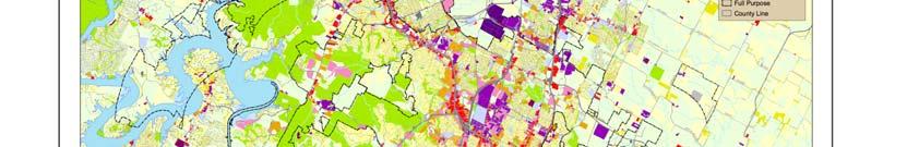
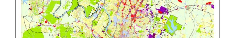
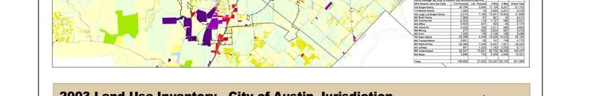
3 Brief History of Land Use Planning Policy in Austin, Texas Austin Comprehensive Plan of 1929: -Racially segregated the city, with most of the African American population on the east side of IH-35 -Located hazardous and noxious uses (such as the Holly Power Plant) on the east side of IH-35, where property values were relatively low Austin Comprehensive Plan of 1975: -Assure that the development of the urban environment is compatible with the unique natural and constructed features of the Austin area -Protect and improve the desirable image and character of neighborhoods and districts -Encouraged low-density single family residential building New 10 Year Comprehensive Plan: -Encourage more extensive city-wide public transportation system -Promote higher density, especially in urban core -Continue protection of valuable environmental assets -Direct growth towards the east of Austin


4
5 Focus Topic: Gentrification - Change in East Austin East Austin - location of study settlement Has recently increased in property value due to close proximity to Downtown Austin in combination with former low land price But, as a result of past land use planning in Austin, also where the Hispanic and African-American population are concentrated, especially low income population Rising property values has led to increase in property taxes, which has created difficulties for existing low-income families and a reduction in affordable housing for the city overall
6 Policy Suggestion: Community Land Trust A Community Land Trust is land that is owned by a public or non-profit entity and that is meant to be conserved for affordable housing A low-income family buys and owns the structure that is on the land, but the city or non-profit entity owns the land, so they can control the type of housing that is built on it, and the amount that is charged. Pros: Maintains a stock of land that is available for affordable housing in convenient and accessible locations in the city Low-income family still takes away equity and appreciation of the structure, while not having to pay for the increase in property value and taxes Cons: Politically difficult to bring about due to loss in property tax revenues for the city and loss of high-value land from the private housing market Low-income family does not gain from the appreciation in land value, which is a significant part of the appreciation in general housing values
7 INFILL- Policy Suggestion: Urban Infill the use of land within a built-up area for further construction, especially as part of a community redevelopment of growth management program ( Developers and city planners work together either to construct new buildings in place of vacated and dilapidated ones or to remodel usable structures, the end result of which is to reclaim and reuse areas within the city and thereby reducing expansion. Pros: Can promote densification of urban areas Avoids scorched earth phenomenon of vacated city centers and surroundings. Infill can bring better services to blighted spaces as well as revitalize the communities of those areas. Coupled with more flexible zoning regulations, infill can repurpose or augment the purpose of sections of cities to better integrate residents and services. Cons: Historically blockaded by rigid zoning practices. Difficult to incentivize developers to invest in more expensive infill projects.
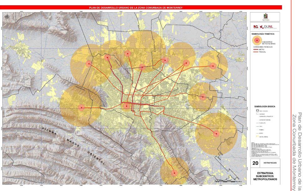
8 Planeación y Usos del Suelo Pasado: Plan Director de la Subregion Monterrey Plan Estatal de Desarrollo Urbano de Nuevo Leon Plan de Desarrollo Urbano de Monterrey Metropolitano y su área de influencia Plan Director de Desarrollo Urbano del área Metropolitana de Monterrey Presente: Plan Metropolitano Planes Municipales de Urbanización y Desarrollo. Futuro: Plan de Desarrollo Urbano de la Zona Conurbada de Monterrey. Planes Municipales (Parciales )de Urbanización.

9
10

11 Zoning of Monterrey

12 Zoning of Study Areas
13 Policy Recommendations Coordination between municipalities should be increased in the writing of plans and in determining zoning Businesses should be concentrated along major roadways Commercial uses should be limited along smaller streets Industrial uses should be avoided in areas near residential uses Where possible, green space should be increased within neighborhoods Connections or view corridors between neighborhoods and green spaces should be increased
14 Community and Economic Development in Austin Rosewood Neighborhood Plan (2001): Promote commercial users that serve the needs of neighborhood residents. Build destination businesses to employ people from East Austin and attract customers from all parts of the city Promote infill development on vacant commercial lots Increase business opportunities for the Rosewood neighborhood s residents Where zoning permits, promote small, neighborhood-oriented businesses services such as coffee shops, bookstores, restaurants and corner stores Where appropriate in the neighborhood, promote neighborhood-friendly industrial uses that will enhance the quality of life of Rosewood s residents. Example: Arts and Crafts studio In a Brookings study, from 2000 to 2005, commercial property rose about 60% on 11 th street and 53% on 12 th street, which are major business development areas
15 East Austin Austin MSA Poverty Rate 45.6% 11.1% Percent Non-Hispanic White 4.5% 60.7% Percentage of Adults w/o HS Diploma 54.4% 15.2% Unemployment Rate 12.5% 4.0% Percentage of Rental Units Subsidized by the Department of Housing and Urban Development 50.4% 4.6%
16
17 Perspectives of Residents In the survey findings, residents hope that the metro rail will bring new business and commercial development to the neighborhood Residents defined their neighborhood as geographically smaller than the larger Rosewood area Most residents are not active in their neighborhood associations Four neighborhood associations in Rosewood: Glen Oaks/Rosewood Village, McKinley Heights, Clifford/Sanchez, Boggy Creek Many informal neighborhood associations: Greater East Austin Neighborhood Association, Save our Neighborhood, Inc., El Concilio Coalition of Mexican-American Neighborhood Association
18 Recommendations The area bounded by Boggy Creek, Alexander, Manor Rd., and Martin Luther King Jr. Blvd. is the largest undeveloped property in the neighborhood. The Rosewood Neighborhood Planning Team supports the development of this site as a mixed-use, pedestrian/bike-friendly center that includes housing for a variety of income levels. Increase communication between businesses and residents Increase in local cafes and shops Increase in grocery stores Brookings study found that two neighborhoods in the east side share one grocery store which limits access to fresh food, yet plenty of access to fast food and convenient store food Increase medical facilities and access U.S. Department of Health and Human Services designated East Austin as a medically underserved area, without enough primary care physicians to meet the needs of local population.
19


20
Bunker Hill Part II Urban Design. Specific Plan. Case No. CPC SP TABLE OF CONTENTS
 Bunker Hill Part II Urban Design Specific Plan Case No. CPC-2011-684-SP TABLE OF CONTENTS Section 1. Section 2. Section 3. Section 4. Section 5. Section 6. Section 7. Section 8. Section 9. Section 10.
TOD and Equity. TOD Working Group. James Carras Carras Community Investment, Inc. August 7, 2015
 TOD and Equity TOD Working Group James Carras Carras Community Investment, Inc. August 7, 2015 What is Equitable TOD? Equity is fair and just inclusion. Equitable TOD is the precept that investments in
GENERAL PLAN UPDATE SPECIFIC AREAS OF THE CITY
 GENERAL PLAN UPDATE SPECIFIC AREAS OF THE CITY Background There are a total of 14 specific areas that are being reviewed as part of the update of the General Plan. Requests to review these areas came from
Public Transportation
 Urbanization Public Transit Public Transportation Public Transportation: also known as public transit or mass transit, is a shared passenger transport service which is available for use by the general
Downtown Development Focus Area: I. Existing Conditions
 Downtown Development Focus Area: I. Existing Conditions The Downtown Development Focus Area is situated along Route 1, south of the train tracks, except for the existing Unilever property. It extends west
G. HRA Member Area Surveys a. Area 1 Survey Sample b. Area 1-10 descriptions for surveys
 G. HRA Member Area Surveys a. Area 1 Survey Sample b. Area 1-10 descriptions for surveys CENTER CITY URBAN REVITALIZATION PLAN RANKING OF URBAN RENEWAL ACTIONS Area 1 Dwight Street Gateway This area includes
Generic Environmental Impact Statement. Build-Out Analysis. City of Buffalo, New York. Prepared by:
 Generic Environmental Impact Statement Build-Out Analysis City of Buffalo, New York 2015 Prepared by: TABLE OF CONTENTS 1.0 INTRODUCTION 1 2.0 METHODOLOGY 2 3.0 EXISTING LAND USE 3 4.0 EXISTING ZONING
Appendix A: Guide to Zoning Categories Prince George's County, Maryland
 Appendix A: Guide to Zoning Categories Prince George's County, Maryland RESIDENTIAL ZONES 1 Updated November 2010 R-O-S: Reserved Open Space - Provides for permanent maintenance of certain areas of land
HOUSING ELEMENT I. GOALS, OBJECTIVES AND POLICIES
 HOUSING ELEMENT I. GOALS, OBJECTIVES AND POLICIES GOAL 1: IN ORDER TO ACHIEVE A BALANCED HOUSING SUPPLY (AND A BALANCED POPULATION AND ECONOMIC BASE), EVERY EFFORT SHOULD BE MADE TO PROVIDE A BROAD RANGE
Bylaw No , being "Official Community Plan Bylaw, 2016" Schedule "A" DRAFT
 Bylaw No. 2600-2016, being "Official Community Plan Bylaw, 2016" Schedule "A" Urban Structure + Growth Plan Urban Structure Land use and growth management are among the most powerful policy tools at the
PLANNING COMMISSION WILLIAMSBURG, VIRGINIA WORK SESSION AGENDA Wednesday, May 23, 2012
 PLANNING COMMISSION WILLIAMSBURG, VIRGINIA WORK SESSION AGENDA Wednesday, May 23, 2012 The meeting will be called to order in the third floor Conference Room (Room 310), Williamsburg Municipal Building,
1SUPPORT TRANSPORTATION POLICY TO BUILD DIVERSE, SUSTAINABLE COMMUNITIES
 1SUPPORT TRANSPORTATION POLICY TO BUILD DIVERSE, SUSTAINABLE COMMUNITIES Prepared for the Transportation Equity Network Conference March 10, 2009 Washington, DC For 40 years, transportation and infrastructure
PUBLIC NOTICE* Studies Requested: Parking analysis. Other Required Permits: Building Permit, Site Development Permit
 C I T Y O F T A C O M A Planning & Development Services Department 747 Market St, Rm 345 Tacoma, WA 98402 PUBLIC NOTICE* Date of Notification: 1/15/2019 Application Received: 12/03/2018 Application Complete:12/07/2018
PBV Request Ramsey Apartments Ramsey
 Committee Report Business Item No. 2015-241 Community Development Committee For the Metropolitan Council meeting of December 14, 2016 Subject: Project Based Voucher Award Recommendations Proposed Action
ARTICLE B ZONING DISTRICTS
 ARTICLE B ZONING DISTRICTS Sec. 8-3021 Established. In order to protect the character of existing neighborhoods; to prevent excessive density of population in areas which are not adequately served with
2016 Census Bulletin Changing Composition of the Housing Stock
 Metro Vancouver s Role Every five years, the Census of Canada provides benchmark data that is instrumental in analyzing and evaluating local government planning policies and services. Representing member
ARTICLE 3: Zone Districts
 ARTICLE 3: Zone Districts... 3-1 17.3.1: General...3-1 17.3.1.1: Purpose and Intent... 3-1 17.3.2: Districts and Maps...3-1 17.3.2.1: Applicability... 3-1 17.3.2.2: Creation of Districts... 3-1 17.3.2.3:
Summary Report on the Economic Impact of the State Center Project Baltimore, MD
 Summary Report on the Economic Impact of the State Center Project Baltimore, MD Prepared for: Maryland Department of Transportation Prepared by: BAE Urban Economics March 2011 Summary of Key Findings Phase
Missing Middle Housing Types Showcasing examples in Springfield, Oregon
 Missing Middle Housing Types Showcasing examples in Springfield, Oregon MissingMiddleHousing.com is powered by Opticos Design Illustration 2015 Opticos Design, Inc. Missing Middle Housing Study Prepared
Arch-Laclede s Landing Station
 Arch-Laclede s Landing Station This station profile describes existing conditions around the Arch-Laclede s Landing MetroLink Station. This is one of a set of profiles for each of the MetroLink System
SCOPE OF WORK DEVELOPMENT OF A SOCIO-ECONOMIC IMPACT ANALYSIS FOR THE PRELIMINARY REGIONAL HOUSING PLAN FOR THE SOUTHEASTERN WISCONSIN REGION
 RHP SEI SCOPE OF WORK (00203617-4).DOC KRY/NMA/BRM 5/24/12; 5/4/12 SCOPE OF WORK DEVELOPMENT OF A SOCIO-ECONOMIC IMPACT ANALYSIS FOR THE PRELIMINARY REGIONAL HOUSING PLAN FOR THE SOUTHEASTERN WISCONSIN
Place Type Descriptions Vision 2037 Comprehensive Plan
 Place Type Descriptions Vision 2037 Comprehensive Plan The Vision 2037 Comprehensive Plan establishes a range of place types for Oxford, ranging from low intensity (limited development) Rural and Natural
Integrating Housing into Regional Planning
 Integrating Housing into Regional Planning Background SCI provides resources to more fully integrate housing and economic vitality into Metro Vision Housing and economic vitality identifies as areas of
A. Land Use Relationships
 Chapter 9 Land Use Plan A. Land Use Relationships Development patterns in Colleyville have evolved from basic agricultural and residential land uses, predominate during the early stages of Colleyville
Goals, Objectives and Policies
 Goals, Objectives and Policies 1. GOAL SUPPORT THE PROVISION OF DECENT, SAFE AND SOUND HOUSING IN A VARIETY OF TYPES, SIZES, LOCATIONS AND COSTS TO MEET THE NEEDS OF CURRENT AND FUTURE RESIDENTS OF UNINCORPORATED
Town of Yucca Valley GENERAL PLAN 1
 Town of Yucca Valley GENERAL PLAN 1 This page intentionally left blank. 3 HOUSING ELEMENT The Housing Element is intended to guide residential development and preservation consistent with the overall values
Poughkeepsie City Center Revitalization Plan
 Purpose and Need Purpose Increase job and educational opportunities for all residents Maximize fiscal productivity of downtown land uses Diversify retail mix Eliminate surface and building vacancies Create
Rule of corner may need to be flexible i.e. context school, park. With a clustered approach. Should row housing go where fourplexes are?
 Fourplex Privacy Traffic issues by school (don t locate next to school) Highest density is furthest from park and school. Is this best? Family friendly (i.e. private green space, nicely designed, etc.)
Marcel Williams, MPC Project Planner
 TO: FROM: The Planning Commission MPC Staff DATE: SUBJECT: Petition to Rezone Property Heath Shelton, Owner Jay Maupin, Agent 2026 Habersham Street Aldermanic District: 2, Bill Durrence County Commission
Community Not Commodity September 27, 2017
 CodeNEXT Round2 Community Not Commodity September 27, 2017 Transect Areas Transects are gone, but the core still has higher density zoning, primarily R3 and some R4 in SF2 and SF3 (single family and duplex
From Policy to Reality
 From Policy to Reality Updated ^ Model Ordinances for Sustainable Development 2000 Environmental Quality Board 2008 Minnesota Pollution Control Agency Funded by a Minnesota Pollution Control Agency Sustainable
State: ILLINOIS Illinois Housing Development Authority
 State: ILLINOIS Illinois Housing Development Authority (QAP 2013) Measure Evidence HOUSING LOCATION: Site and Neighborhood Standards A1. Mandatory restrictions prohibiting increases in racial and economic
Demographic Change: The Changing Character of Toronto s Inner City, 1961 to 2001
 Demographic Change: The Changing Character of Toronto s Inner City, 1961 to 2001 SERIES 2 Maps based on the Canadian Census, using Census Tract level data The CURA Study Area: Bathurst St, Bloor St., Roncesvales
Wisconsin downtown action council Downtown project case study profile
 Wisconsin downtown action council Downtown project case study profile Date: January, 2007 Project Name Kolve Salon and Day Spa Project Location City of Onalaska Project Type (check all that apply) g Residential
See more at CitylineAustin.com. MIXED-USE DEVELOPMENT ON THE RED LINE 134,000 SF of Creative Office Located on Austin s MetroRail CONNECTION
 See more at CitylineAustin.com MIXED-USE DEVELOPMENT ON THE RED LINE 134,000 SF of Creative Office Located on Austin s MetroRail CONNECTION Mixed-use development providing: 134,000 SF of office space 11,000
Redevelopment Opportunity in Albuquerque s Development friendly Downtown 2025 District
 Redevelopment Opportunity in Albuquerque s Development friendly Downtown 2025 District Rare opportunity to own cash flowing property with redevelopment potential (fast track zoning allows quick approval
City of Spokane Infill Development. June 30, 2016
 City of Spokane Infill Development June 30, 2016 Today s Agenda Introductions Background and Adopted Policy Infill Forms: Facilitated Group Discussion Small-Group Discussions Groups Report Out Next Steps
ORDINANCE NO. 15- Regulations (LDR) which would further the codification of TOD regulations that
 which would further the codification of TOD regulations that") 1 1 1 1 1 1 1 0 1 0 1 ORDINANCE NO. 1- AN ORDINANCE OF THE CITY OF BOYNTON BEACH, FLORIDA AMENDING THE LAND DEVELOPMENT REGULATIONS, CHAPTER 1, ARTICLE II, DEFINITIONS; CHAPTER, ARTICLE III, SECTION 1,
1 1 1 1 1 1 1 0 1 0 1 ORDINANCE NO. 1- AN ORDINANCE OF THE CITY OF BOYNTON BEACH, FLORIDA AMENDING THE LAND DEVELOPMENT REGULATIONS, CHAPTER 1, ARTICLE II, DEFINITIONS; CHAPTER, ARTICLE III, SECTION 1,
OFFICIAL COMMUNITY PLAN. PART B.1 Northeast Area Neighbourhood Plan
 OFFICIAL COMMUNITY PLAN PART B.1 Northeast Area Neighbourhood Plan 1) Context The Design Regina Plan, under the authority of The Planning and Development Act, 2007 (as amended), provides for the adoption
Equitable Development Principles and Strategies
 Equitable Development Principles and Strategies Mayors Innovation Project Madison, WI August 1, 2008 PolicyLink: Who We Are National research and action institute that works collaboratively to develop
2014 Charleston Tri-County Region
 2014 Tri-County Region OUR REGION + DENSITY + COST + TRANSPORTATION + CONSTRUCTION Produced for the community by: Trident Association of REALTORS South Carolina Community Loan Fund Research and analysis
COMMISSION ACTION FORM SUBJECT: ZONING TEXT AMENDMENT FOR LINCOLN WAY CORRIDOR PLAN DOWNTOWN GATEWAY COMMERCIAL ZONING DISTRICT STANDARDS
 ITEM #: 7 DATE: _02-07-18 COMMISSION ACTION FORM SUBJECT: ZONING TEXT AMENDMENT FOR LINCOLN WAY CORRIDOR PLAN DOWNTOWN GATEWAY COMMERCIAL ZONING DISTRICT STANDARDS BACKGROUND: The Downtown Gateway area
CPC CA 3 SUMMARY
 CPC-2009-3955-CA 2 CONTENTS Summary Staff Report Conclusion 3 4 7 Appendix A: Draft Ordinance A-1 Attachments: 1. Land Use Findings 2. Environmental Clearance 1-1 2-1 CPC-2009-3955-CA 3 SUMMARY Since its
Planning Justification Report
 Planning Justification Report Kellogg s Lands City of London E&E McLaughlin Ltd. June 14, 2017 Zelinka Priamo Ltd. Page i TABLE OF CONTENTS Page No. 1.0 2.0 2.1 2.2 3.0 4.0 5.0 5.1 5.2 5.3 5.4 5.5 5.6
9. C-S-C to R-R. Approved SMA/ZAPS/SE 200' Scale Change Number Zoning Change Area of Change. 9 C-S-C to R-R 0.80± acres SMA 7/24/84 210SE04
 9 C-S-C to R-R 0.80± acres SMA 7/24/84 210SE04 Use and Location: Undeveloped land on the southeast side of Allentown Road, approximately three-quarters of a mile southwest of its intersection with Temple
College Avenue. Sowers Street. Calder Way. Beaver Avenue
 K L M Illustrative Master Plan: Collegiate District Calder Way Beaver Avenue High Street ner 16 Sowers Street Stre et 17 Hetzel Street 18 Gar Heister Street 15 Collegiate District 183 4-C: East End Collegiate
Tools to Provide Long-Term Affordability Near Transit and Other Location-Efficient Areas. June 16, 2011
 WEB BINA AR Tools to Provide Long-Term Affordability Near Transit and Other Location-Efficient Areas 1 June 16, 2011 Tools to Provide Long-Term Affordability Near Transit and Other Location-Efficient Areas
PINELLAS COUNTY COMPREHENSIVE PLAN
 PINELLAS COUNTY COMPREHENSIVE PLAN Future Land Use Map (FLUM) Category Descriptions and Rules Amended March 17, 2009 (Ordinance 09-17) Amended March 16, 2010 (Ordinance 10-18) Amended October 26, 2010
410 Land Use Trends Comprehensive Plan Section 410
 411 410 Comprehensive Plan Section 410 In order to plan future land use, we must know how the land is used today. This section includes the following: Definition of analyzed land-use categories Summary
Chapter 5: Testing the Vision. Where is residential growth most likely to occur in the District? Chapter 5: Testing the Vision
 Chapter 5: Testing the Vision The East Anchorage Vision, and the subsequent strategies and actions set forth by the Plan are not merely conceptual. They are based on critical analyses that considered how
MONTGOMERY COUNTY RENTAL HOUSING STUDY. NEIGHBORHOOD ASSESSMENT June 2016
 MONTGOMERY COUNTY RENTAL HOUSING STUDY NEIGHBORHOOD ASSESSMENT June 2016 AGENDA Model Neighborhood Presentation Neighborhood Discussion Timeline Discussion Next Steps 2 WORK COMPLETED Socioeconomic Analysis
Salem HNA and EOA Advisory Committee Meeting #6
 Salem HNA and EOA Advisory Committee Meeting #6 Residential Land Policies Employment Land Policies Policy Discussions with the Committee Outcome of today s meeting Direction from this Committee on proposed
Tuesday, December 27, E 6 ST
 Brooks Wolff bwolff@independencetitle.com Prepared For: Date Prepared: Subject Address: Subject Property ID: 192002 Tuesday, December 27, 2016 1705 E 6 ST Do not use this report to make final decisions.
PLANNED UNIT DEVELOPMENT & SUBDIVISION STAFF REPORT Date: April 18, 2019
 PLANNED UNIT DEVELOPMENT & SUBDIVISION STAFF REPORT Date: April 18, 2019 DEVELOPMENT NAME SUBDIVISION NAME Springhill Village Subdivision Springhill Village Subdivision LOCATION 4350, 4354, 4356, 4358,
Tacoma Community Redevelopment Authority. Request for Proposals: Construction and Permanent Debt. Valhalla Hall
 Request for Proposals: Construction and Permanent Debt Valhalla Hall The (TCRA) is requesting debt (construction and permanent) proposals for its redevelopment of Valhalla Hall, a mixed-use project located
Central Bank of Kansas City New Markets Tax Credit Program Transaction Intake Form & Community Impact Questionnaire
 CBKC and CBKC CDC, L.L.C., are equal opportunity providers CBKC CDC, L.L.C. 2301 Independence Boulevard Kansas City, MO 64124 Phone (816)-483-1210 Fax (816)-483-2586 Central Bank of Kansas City New Markets
Chapter 13. Urban Patterns
 Chapter 13 Urban Patterns Key Issue 1: Why do services cluster downtown? 3 traditional types of services clustered in the CBD - Retailers with a high threshold, such as department stores - Retailers with
Technical Report 7.1 MODEL REPORT AND PARKING SCENARIOS. May 2016 PARKING MATTERS. Savannah GA Parking Concepts PARKING MATTERS
 Savannah GA Parking Concepts PARKING MATTERS A Strategic Plan for Parking + Mobility in Savannah PARKING MATTERS Technical Report 7.1 MODEL REPORT AND PARKING SCENARIOS Prepared for the Chatham County-Savannah
PUBLIC REVIEW DRAFT OF OFF-STREET PARKING PROPOSAL CITY OF OAKLAND PLANNING DEPARTMENT OCTOBER 2015
 PUBLIC REVIEW DRAFT OF OFF-STREET PARKING PROPOSAL CITY OF OAKLAND PLANNING DEPARTMENT OCTOBER 2015 1. Downtown Parking Minimums Problem: The current regulations do not prescribe a minimum amount of required
WRT. October 16, Arthur Collins President Collins Enterprises, LLC 2001 West Main Street, Suite 175 Stamford, CT 06902
 Planning & Design October 16, 2010 Arthur Collins President Collins Enterprises, LLC 2001 West Main Street, Suite 175 Stamford, CT 06902 Re: Review of The Landmark at Talbot Park Philadelphia Dallas Lake
Frequently Asked Questions
 The City of Brockton recently unveiled three documents aimed at revitalizing our downtown. The Downtown Action Strategy sets a vision for downtown and lays out the actions needed to achieve that vision.
United States Post Office and Multi-Family Residential; and, Single- Family Residence with an Apartment
 Planning Commission File No.: AME2013 0009 January 9, 2014 Page 2 of 9 Existing Land Use: United States Post Office and Multi-Family Residential; and, Single- Family Residence with an Apartment Surrounding
DOWNTOWN SPECIFIC PLAN
 DOWNTOWN SPECIFIC PLAN AGENDA OVERVIEW Goals & Objectives Opportunity Sites Market Analysis Next Steps GOALS & OBJECTIVES Create a Specific Plan that paves the way for at least 10,000 places to live in
To achieve growth, property development, redevelopment and an improved tax base in the cities and boroughs in the Lehigh Valley.
 Most growth in property valuation is in townships. Between 1991 and 2004, the assessed valuation of the townships in the Lehigh Valley increased by more than $2.8 billion, an increase of 41%. At the same
MEMORANDUM Planning Commission Travis Parker, Planning Director DATE: April 4, 2018 Lakewood Zoning Amendments Housing and Mixed Use
 MEMORANDUM TO: FROM: Travis Parker, Planning Director DATE: April 4, 2018 SUBJECT: Lakewood Zoning Amendments Housing and Mixed Use In August 2017, the Lakewood Development Dialogue process began with
PUBLIC. Public Notification. June. 11, 2013, about. invitation. 25, 2013 Community. Open House. approximately 89. Public Responsee. or unspecified).
.") PLANNING AND DEVELOPMENT SERVICES Planning Current Planning - Rezoning 333 East 11th Avenue (275 Kingsway) PUBLIC CONSULTATION SUMMARY DRAFT NOTE: Includes all comments received up until November 1, 2013
PLANNING AND DEVELOPMENT SERVICES Planning Current Planning - Rezoning 333 East 11th Avenue (275 Kingsway) PUBLIC CONSULTATION SUMMARY DRAFT NOTE: Includes all comments received up until November 1, 2013
Residences at Grove Park 425 Hillsborough St. Chapel Hill, NC
 9 ATTACHMENT 1 Residences at Grove Park 425 Hillsborough St. Chapel Hill, NC Zoning Atlas Amendment Application Statement of Justification December 12 th, 2008 Introduction This is a request for a Zoning
UNDERSTANDING THE TAX BASE CONSEQUENCES OF LOCAL ECONOMIC DEVELOPMENT PROGRAMS
 UNDERSTANDING THE TAX BASE CONSEQUENCES OF LOCAL ECONOMIC DEVELOPMENT PROGRAMS Richard K. Gsottschneider, CRE President RKG Associates, Inc. 277 Mast Rd. Durham, NH 03824 603-868-5513 It is generally accepted
8Land Use. The Land Use Plan consists of the following elements:
 8Land Use 1. Introduction The Land Use Plan consists of the following elements: 1. Introduction 2. Existing Conditions 3. Opportunities for Redevelopment 4. Land Use Projections 5. Future Land Use Policies
PLANNING COMMISSION REPORT Regular Agenda Public Hearing Item
 PC Staff Report 6/20/16 Item No. 4-1 PLANNING COMMISSION REPORT Regular Agenda Public Hearing Item PC Staff Report 06/20/16 ITEM NO. 4: IG to CS 1.56 ACRES; 706 E 23 RD STREET (MKM) : Consider a request
The Partnership for Building Reuse: Learning from Los Angeles
 The Partnership for Building Reuse: Learning from Los Angeles 1 Partnership for Building Reuse Why Los Angeles? Strong local partners Track record of building reuse Transit system expansion Opportunities
Chapter 6 Future Land Use and Housing Plan
 Chapter 6 Future Land Use and Housing Plan The Future Land Use Plan is one of the most important elements of the Comprehensive Plan. It graphically brings together all of the chapters of the plan and evaluates
AUSTIN, TEXAS MUELLER ROSE INVESTMENT SUMMARY 181 UNIT APARTMENT COMMUNITY
 AUSTIN, TEXAS MUELLER ROSE INVESTMENT SUMMARY 181 UNIT APARTMENT COMMUNITY EXECUTIVE SUMMARY HFF has been exclusively retained to offer qualified investors the opportunity to purchase the fee simple interest
Development Impact & Capacity Fees
 City of Petaluma, CA Development Impact & Capacity Fees October 2018 City of Petaluma City Manager s Office 11 English Street Petaluma, CA 94952 Web Page http://www.ci.petaluma.ca.us Revision Date : October
Rapid City Planning Commission Rezoning Project Report
 Rapid City Planning Commission Rezoning Project Report April 21, 2016 Item #9 Applicant Request(s) Case # 16RZ011; a request to rezone property from Central Business District to General Commercial District
Managing Neighborhood Change: Building Stronger Markets. Alan Mallach, Senior Fellow National Housing Institute
 Managing Neighborhood Change: Building Stronger Markets Alan Mallach, Senior Fellow National Housing Institute A neighborhood s health is powerfully driven by the extent to which it has a competitive housing
A project of Neighborhood Projects for Community Revitalization At the Center for Urban and Regional Affairs (CURA) University of Minnesota
 University of Minnesota") Affordable Housing Siting Opportunities in Minneapolis October 2008 Rachel C. Robinson, Author With assistance from Joel Larson A project of Neighborhood Projects for Community Revitalization At the Center
Affordable Housing Siting Opportunities in Minneapolis October 2008 Rachel C. Robinson, Author With assistance from Joel Larson A project of Neighborhood Projects for Community Revitalization At the Center
FUTURE LAND USE ELEMENT
 FUTURE LAND USE ELEMENT GOAL: 2.1 A distribution of land uses throughout unincorporated Manatee County which limit urban sprawl, providing a predictable and functional urban form, encouraging development
REZONING GUIDE. Zone Map Amendment (Rezoning) - Application. Rezoning Application Page 1 of 3. Return completed form to
 - Application. Rezoning Application Page 1 of 3. Return completed form to") COMMUNITY PLANNING & DEVELOPMENT REZONING GUIDE Rezoning Application Page 1 of 3 Zone Map Amendment (Rezoning) - Application PROPERTY OWNER INFORMATION* PROPERTY OWNER(S) REPRESENTATIVE** CHECK IF POINT
COMMUNITY PLANNING & DEVELOPMENT REZONING GUIDE Rezoning Application Page 1 of 3 Zone Map Amendment (Rezoning) - Application PROPERTY OWNER INFORMATION* PROPERTY OWNER(S) REPRESENTATIVE** CHECK IF POINT
Shopping Center Occupancy Study of the Greater Hagerstown Area
 Shopping Occupancy Study of the Greater Hagerstown 2015 Prepared By City of Hagerstown Planning & Code Administration Department November 2015 Shopping Occupancy Study of the Greater Hagerstown - 2015
EXECUTIVE SUMMARY. Executive Summary Donald L Tucker Civic Center District Economic Development Study
 EXECUTIVE SUMMARY The overall Tallahassee/Leon County economy was not as negatively impacted by the Great Recession as was the State of Florida as a whole, because its economy is largely driven by State
Annual (2013) Review of the Surrey Official Community Plan
 Review of the Surrey Official Community Plan") CORPORATE REPORT NO: R118 COUNCIL DATE: JUNE 23, 2014 REGULAR COUNCIL TO: Mayor & Council DATE: June 23, 2014 FROM: General Manager, Planning and Development FILE: 6440-01 SUBJECT: Annual (2013) Review
CORPORATE REPORT NO: R118 COUNCIL DATE: JUNE 23, 2014 REGULAR COUNCIL TO: Mayor & Council DATE: June 23, 2014 FROM: General Manager, Planning and Development FILE: 6440-01 SUBJECT: Annual (2013) Review
Conditional Use Permit case no. CU 14-06: Bristol Village Partners, LLC
 PLANNING AND ZONING COMMISSION STAFF REPORT August 7, 2014 Conditional Use Permit case no. CU 14-06: Bristol Village Partners, LLC CASE DESCRIPTION: LOCATION: LEGAL DESCRIPTION: EXISTING LAND USE: ZONING:
Koochiching County Summary. January 2019
 Koochiching County Summary January 2019 Koochiching County Summary Introduction The Koochiching County Comprehensive Study was conducted in 2018. The study can be utilized by housing and economic development
SECTION 3. Housing. Appendix A LAND USE DEFINITIONS
 SECTION 3 Housing A Appendix A LAND USE DEFINITIONS A-2 Housing Commission Attachment B Appendix A Land Use Definitions INTRODUCTION The Land Use Map (Figure A-1) of Community Vision 2040 illustrates the
3. FISCAL IMPACT ANALYSIS FISCAL IMPACT ANALYSIS 29
 3. FISCAL IMPACT ANALYSIS FISCAL IMPACT ANALYSIS 29 The purpose of fiscal impact analysis is to estimate the impact of a development or a land use change on the budgets of governmental units serving the
Downtown Stations: 8 th & Pine and Convention Center
 Downtown Stations: 8 th & Pine and Convention Center This station profile describes existing conditions around two MetroLink Stations in Downtown St. Louis, the 8 th & Pine and Convention Center Stations.
APPENDIX B RESIDENTIAL DENSITY
 APPENDIX B RESIDENTIAL DENSITY RESIDENTIAL DENSITY - SPECIFIC AREAS OF THE CITY Policy Issue Examine specific areas of the City to determine appropriate residential densities. Public comments have expressed
FEASIBILITY REPORT. 1486, 1490 and 1494 Clementine. Prepared by: Lloyd Phillips & Associates Ltd. For: Ottawa Salus
 DRAFT FEASIBILITY REPORT 1486, 1490 and 1494 Clementine Prepared by: Lloyd Phillips & Associates Ltd. For: Ottawa Salus LPA File No. 1008 Lloyd Phillips & Associates June 9, 2010 Feasibility Report Page
Dan Immergluck 1. October 12, 2015
 Examining Recent Declines in Low-Cost Rental Housing in Atlanta, Using American Community Survey Data from 2006-2010 to 2009-2013: Implications for Local Affordable Housing Policy Dan Immergluck 1 October
Preserving Affordable Apartments in Austin
 Preserving Affordable Apartments in Austin Case Study Analysis of the East Riverside/Oltorf Combined Neighborhood Planning Area Michelle Ng, Chris Grant, Rosa E. Donoso, and Sharlene Eaton CRP388 Affordable
WALNUT CREEK DESIGN REVIEW COMMISSION STUDY SESSION STAFF REPORT
 WALNUT CREEK DESIGN REVIEW COMMISSION STUDY SESSION STAFF REPORT AGENDA: December 3, 2014 ORIGINATED BY: Community and Ecomic Development Department ITEM: 4d Day/Date/Time Place Project Name Application
Glendale Housing Development Project Plan
 Glendale Housing Development Project Plan Draft for Public Review May 29, 2015 Table of Contents I. Introduction... 1 II. Description of Project... 1 A. Boundary of Housing Development Project... 1 B.
VOLUME 27 NUMBER 2 JANUARY-MARCH 1997 RESIDENTIAL NEW YORK CITY, NEW YORK PROJECT TYPE
 VOLUME 27 NUMBER 2 JANUARY-MARCH 1997 RESIDENTIAL MAPLE COURT NEW YORK CITY, NEW YORK PROJECT TYPE Maple Court is a 135-unit elevator building surrounding a landscaped courtyard in the East Harlem section
Summary. Houston. Dallas. The Take Away
 Page Summary The Take Away The first quarter of 2017 was marked by continued optimism through multiple Texas metros as job growth remained positive and any negatives associated with declining oil prices
Downtown & Midtown Density Study
 Downtown & Midtown Density Study LaRue Planning & Management Services, Inc. 1 1/10/2017 Smart Growth America leads the only national coalition of state and local organizations engaged in smart growth,
CITY OF COLD SPRING ORDINANCE NO. 304
 CITY OF COLD SPRING ORDINANCE NO. 304 AN ORDINANCE AMENDING THE CITY CODE OF COLD SPRING BY ADDING SECTIONS 555 AND 510 PERTAINING TO PAYMENT-IN-LIEU-OF-PARKING THE CITY COUNCIL OF THE CITY OF COLD SPRING,
Attachment A First Submittal JAZB Safety Zones A and B
 Attachment A First Submittal JAZB Safety Zones A and B Attachment B Second Submittal JAZB Safety Zones A and B Attachment C Flying Cloud Airport (FCM) Draft Airport Zoning Ordinance Social and Economic
Village of Port Jefferson Urban Renewal Plan
 Urban Renewal Plan Village of Port Jefferson Urban Renewal Plan Port Jefferson, New York PREPARED FOR Village of Port Jefferson Village Board 121 West Broadway Port Jefferson, NY 11777 631.473.4724 PREPARED
Attachment I is an updated memo from Pat Comarell, providing the updated balancing tests to reflect the Council s October 10 th briefing.
 COUNCIL STAFF REPORT CITY COUNCIL of SALT LAKE CITY TO: City Council Members FROM: Ben Luedtke & Nick Tarbet Policy Analysts DATE: October 17, 2017 RE: Housing Plan: Growing Salt Lake PLNPCM2017-00168