Anne Arundel County General Development Plan Background Report on Land Use
|
|
|
- Constance Knight
- 5 years ago
- Views:
Transcription

1 Anne Arundel County General Development Plan 2008 Background Report on Land Use June 2008
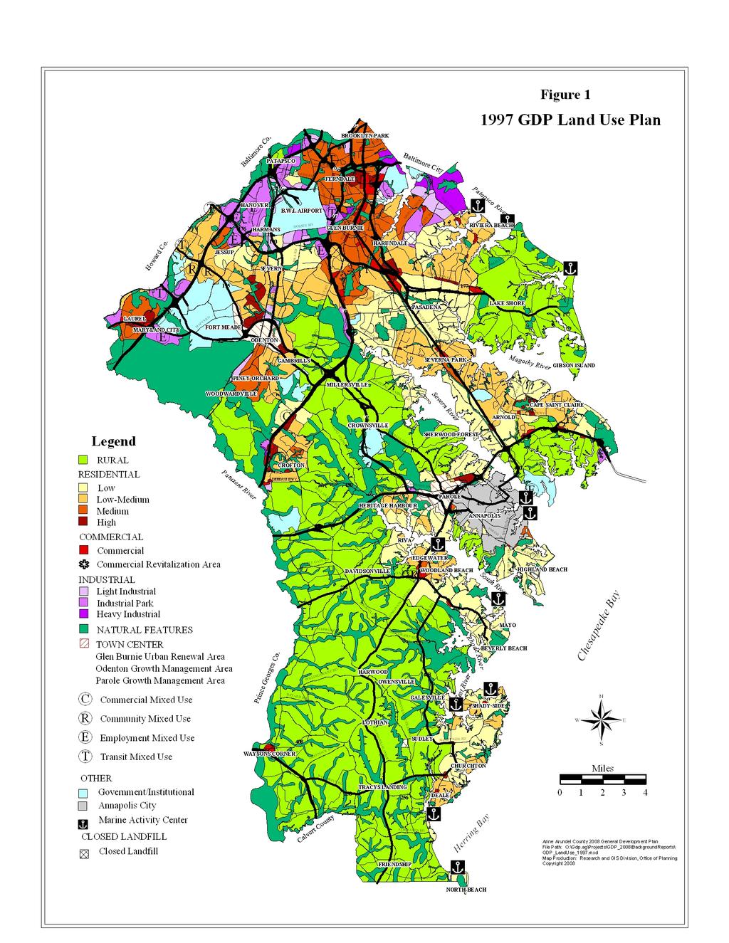
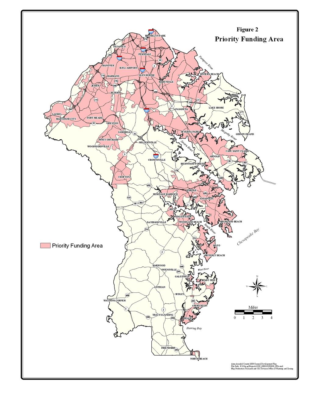
2 I. Introduction Decisions and policies regarding land use are one of the most important components of a local comprehensive plan. The location, amount and type of development to be permitted will ultimately impact everything from public services and adequate infrastructure to water resources and sensitive areas, from community character to fiscal stability, and most importantly will impact the quality of life for local citizens. Recognizing the importance of land use planning, the State of Maryland delegated basic planning and land use regulatory powers to its municipalities and non-charter counties in Article 66B of the Code of Maryland, and granted planning and zoning powers to its charter counties including Anne Arundel County in Article 25A. Several but not all of the provisions in Article 66B apply to charter counties; nevertheless, Anne Arundel County has prepared its earlier comprehensive plans in consistency with the provisions of that Article and, more recently, to fully address the seven visions of the Economic Growth, Resource Protection, and Planning Act of 1992 that guides comprehensive planning in Maryland. Among the provisions contained in Article 66B, the code states that a comprehensive plan shall contain a Land Use Plan element, which: 1) shall propose the most appropriate and desirable patterns for the general location, character, extent, and interrelationship of the uses of public and private land, on a schedule that extends as far into the future as is reasonable, and 2) may include public and private, residential, commercial, industrial, agricultural, and recreational land uses. Anne Arundel County addressed these requirements in its most recent 1997 General Development Plan with the inclusion of a Land Use Plan as well as related policies and recommendations to guide growth and development. The 1997 GDP Land Use Plan is shown in Figure 1. The following section will describe some of the actions taken since that time to implement that plan. II. Key Land Use Planning Initiatives Since 1997 The 1997 Land Use Plan complied with the smart growth visions of the 1992 Planning Act by locating planned growth in suitable areas, where public infrastructure and services are available, and by preserving the County s rural areas for primarily low density development or agricultural uses. The County then followed up this effort by designating a Priority Funding Area (PFA) that is consistent with State guidelines and criteria and with the 1997 Land Use Plan. The Smart Growth Areas Act of 1997 required the State to target funding for growth-related projects (e.g. highways, sewer and water construction, economic development assistance, etc.) to Priority Funding Areas in each local jurisdiction. This furthers the goal of directing new growth to the most suitable areas, in consistency with the County s comprehensive land use plan. The County s current Priority Funding Area is shown in Figure 2. The PFA is generally concentrated in the northern and western parts of the county, along the MD 2 corridor, and around Annapolis. GDP Background Report: Land Use Page 1
3
4
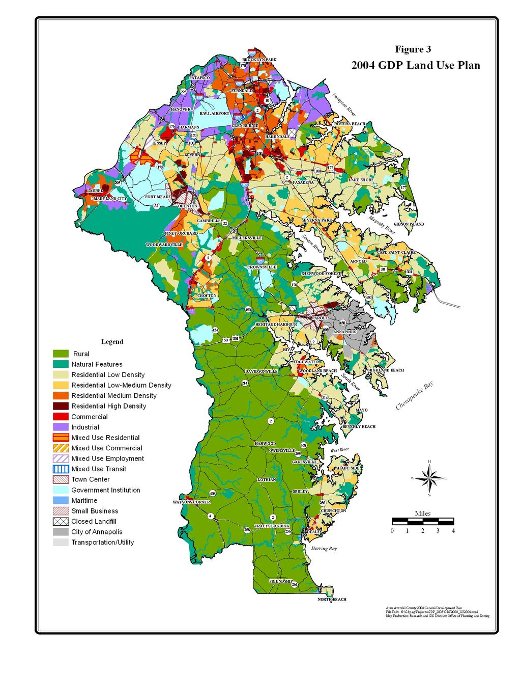
5 At the same time, to further the goal of preserving the County s rural areas, in 1998 the County designated a Rural Legacy Area in order to help focus land conservation efforts. This allowed the County to participate in the State s Rural Legacy grant program through which development rights can be purchased from landowners in the area and properties can be protected under conservation easements. The County s Rural Legacy Area (RLA) is approximately 32,400 acres in size and is located in South County. The Rural Legacy Program works in conjunction with the County s Agricultural and Woodland Preservation Program as well as the State Agricultural Land Preservation program to preserve rural areas and promote agricultural uses. In 1998 the County also embarked on its Small Area Plan (SAP) program. These sixteen community-based plans were prepared with an extensive amount of public outreach between 1998 and The plans serve to guide how individual properties should be used and what facilities may be needed to serve the County s communities. The plans also served as a vehicle for refining the 1997 Land Use Plan, and the individual land use plans contained in each SAP have been consolidated to form the County s current 2004 Land Use Plan. Each Small Area Plan was followed with comprehensive zoning legislation to rezone properties according to the adopted Land Use Plan. The County will continue to implement the many Small Area Plan recommendations over the coming years. The 1997 GDP and subsequent Small Area Plans also identified areas where mixed use development should be encouraged, incorporating a variety of residential, office and retail uses in close proximity. Four new Mixed Use Zoning categories were added to the Zoning Ordinance in 2001, and since that time several properties have been rezoned and some mixed use developments are in the planning and/or construction stages. Following on the GDP goal of enhancing existing communities, legislation was adopted in establishing sixteen Commercial Revitalization Districts along many of the County s older commercial highway corridors and within older neighborhood centers. The Commercial Revitalization Program provides greater redevelopment opportunities by allowing property tax credits and a greater mix of uses in the designated districts. In response to another GDP recommendation and to help protect important natural resources, the County prepared a master plan to develop a countywide greenways network. The Greenways Master Plan was adopted in 2002 with the goal of establishing an interconnected network of protected corridors of woodlands and open space that will protect ecologically valuable lands, provide open space and recreational benefits, and preserve wildlife habitats. The proposed greenways network covers nearly 72,000 acres of land and approximately 50 percent of the network is protected either under State, Federal, or local government ownership, under agricultural or environmental easements, as private conservation land, or under Open Space zoning regulations. The County also prepared an updated master plan to guide development in the Odenton Growth Management Area. The Odenton Town Center Master Plan was adopted in 2003 and establishes development and zoning regulations and guidelines to promote an attractive, viable and pedestrian friendly Transit Oriented Development center near the Odenton MARC rail station. GDP Background Report: Land Use Page 4
6 The County also established an Urban Design Study work program in 2007 that will explore alternatives for revitalizing and improving several targeted commercial hubs or corridors around the County. The program will develop urban design concept plans for these areas to help implement some of the recommendations in the General Development Plan and Small Area Plans. The design concepts may include redevelopment, façade improvements, streetscape improvements, public spaces, or other features as well as funding or revitalization strategies. Finally, the County undertook a multi-year project of developing a more refined property geodatabase of all recorded properties in the County. This analytical tool has been extremely useful in land use planning efforts, both in terms of conducting analysis as well as enabling the County to prepare and adopt more accurate land use and zoning maps. The process of refining the County s various data layers and products using this tool will continue on for several years. Through these efforts and others, the majority of the 1997 GDP land use recommendations have been implemented. Many of these programs are multi-year or ongoing programs and will continue into the future as needed. III. The 2004 Land Use Plan As mentioned above, sixteen individual Land Use Plans were adopted as part of the County s Small Area Plan program between 2000 and These plans have been consolidated to form the current 2004 Land Use Plan, shown in Figure 3. The overall land use pattern did not change significantly between the 1997 and 2004 Land Use Plans. Instead, changes were mostly site-specific and focused on targeted areas such as mixed use sites. Higher density residential uses and most of the County s industrial and commercial land base is still concentrated in the northern parts of the County and in Odenton, Severn, Maryland City, Crofton, and Parole. The rural land base still covers much of the Crownsville area and virtually all of South County with the exception of the Deale, Churchton, Shady Side, and Galesville communities. Low to medium density residential uses are spread throughout but are most predominant on the peninsulas (Lake Shore, Broadneck, Annapolis Neck, Edgewater and Mayo) and in Severna Park, Pasadena, Severn and Jessup. The process of analyzing the Land Use Plan at a community level as opposed to a countywide level allowed for much better refinement of the plan on a parcel basis instead of the very generalized basis used in the 1997 plan, and consistency between the Land Use Plan, existing uses on the ground, and zoning was much improved. There is still some room for improvement and the County will continue to make adjustments using its new aerial photography and property geodatabase to improve accuracy. As stated previously, the Land Use Plan is used to guide development patterns and to establish the location, type and character of future development. The Land Use Plan is implemented using a variety of mechanisms including regulatory ones such as zoning. Per Article 18 of the County Code, consistency with the GDP Land Use Plan is a required finding that must be affirmed by the Administrative Hearing Officer in order to grant an administrative rezoning of a property. Although the code does not mandate the same consistency with the Land Use Plan with regard to GDP Background Report: Land Use Page 5
7
8 comprehensive zoning changes, which are approved by the County Council, the Land Use Plan must be used as a guide in making those decisions. In general, the County does not recommend comprehensive zoning changes that are not consistent with the adopted Land Use Plan unless there are exceptional or unusual circumstances. Table 1 describes the types of uses typically found in each of the Land Use Plan categories and also lists the zoning districts that are generally applied in each land use category. Table 1 - Description of 2004 Land Use Plan Categories Land Use Plan Categories Typical Uses Corresponding Zoning Categories Rural Agricultural uses and single RA, RLD family detached homes. Residential Low Density Single family detached homes. R1, R2 Residential Low-Medium Single family detached homes. R2, R5 Density (Townhouse and duplex units may be allowed as Special Exception or Conditional uses.) Residential Medium Density Generally single family detached, R5, R10 duplex and townhouse dwellings. Residential High Density Generally multifamily dwellings. R15, R22 Commercial Community retail, commercial C1, C2, C3, C4 office, general retail, and highway commercial uses. Small Business Community commercial uses, SB home occupations, and single family detached homes. Industrial Industrial park, light industrial, W1, W2, W3 and heavy industrial uses. Maritime Community marinas, yacht clubs, MA1, MA2, MA3, MB, MC commercial marinas. Mixed Use Categories A mix of residential, commercial, MXD-R, MXD-C, MXD-E, Town Center Natural Features Government/Institutional Transportation/Utility employment, and public uses. A mix of general commercial and multifamily residential uses. Also includes Odenton Growth Management Area. Parks, floodplains and other environmental preservation areas. Land owned and used by Federal, State, or local governments, such as public schools and BWI Airport. Road and public utility rights-ofway. MXD-T TC, Odenton Growth Management Area districts OS R1 typically, but any zoning may apply. Any zoning may apply. Table 2 provides a breakdown of the County s total land area by Land Use Plan category. The total area is 265,774 acres including the City of Annapolis, or 261,240 acres in the County. The largest land use categories by acreage are the Rural (34% of total County land), Low Density GDP Background Report: Land Use Page 7
9 Residential (18%), and Natural Features (17%) categories. Combined, 51% of the County s land area is planned for Rural or Natural Features uses. Low-medium to high density residential uses are planned for 13% of the land area. Areas planned for commercial and industrial uses combined including maritime uses account for 6% of the land area, and the mixed use and town center categories combined account for less than 2 percent. Government and institutional areas account for another 6% of the land area, which is a fairly significant amount. As seen in Figure 4, both the Federal government and the State of Maryland have some large land holdings in the County including the Patuxent Wildlife Refuge, Fort Meade, BWI Airport, and the Smithsonian Environmental Research Center. The remaining 4% of the County s land area is used or planned for transportation and utility uses. Table Land Use Plan Categories by Acres Land Use Plan Category Number of Number of Land Use Plan Category Acres Acres Residential Categories Mixed Use Categories Rural 88,958 Residential Mixed Use 507 Low Density 47,770 Commercial Mixed Use 178 Low-Medium Density 20,430 Employment Mixed Use 245 Medium Density 10,967 Transit Mixed Use 140 High Density 2,704 Town Center 2,515 Commercial Categories Other Categories Commercial 5,023 Natural Features 44,951 Small Business 60 Government/Institutional 16,104 Industrial 10,525 Transportation/Utility 9,699 Maritime 464 City of Annapolis 4,534 Land Use Plan Category by Acreage Share 6.2% 3.7% Rural Residential Low Density Residential Low-Medium Density Residential 17.2% 34.1% Medium Density Residential High Density Residential Industrial 0.4% Commercial, Small Business, and Maritime 1.0% Town Center 2.1% Mixed Use 4.0% Natural Features 1.0% Government/ Institutional 4.2% 7.8% 18.3% Transportation/ Utility GDP Background Report: Land Use Page 8
10 MD House of Corrections Howard Co. DC Childrens Center 295 Patuxent Wildlife Refuge Fort Meade Patapsco Valley State Park 176 Patuxent River Baltimore Co USNA Dairy Farm BWI Airport 3 USAF Transmitter Crownsville State Hospital Severn Run Natural Environment Area 97 US Army Ordnance Depot Baltimore City 2 Severn River 178 Patapsco River Severn River Patapsco River Magothy River 450 US Naval Academy Anne Arundel County Major Federal and State Lands Magothy River US Naval Station Figure 4 Sandy Point State Park Legend Federal/State Properties Prince Georges Co Smithsonian Environmental Research Center Rhode River West River West River South River South River Chesapeake Bay Patuxent Wildlife Refuge Calvert County Herring Bay Franklin Point Park Miles Herring Bay File Path: N:\Gdp.ag\Projects\GDP2008_Fed_State.mxd
11 IV. Future Development Capacity In 2008 the County completed a land use analysis to estimate the remaining development capacity in the County. The purpose of the study is to provide public officials, planners, and the public with the best possible estimate of the amount of development capacity available in the County under current conditions, taking into consideration current development practices and regulatory and physical constraints. The study will serve as a baseline for measuring the need for, and impact of, changes to current plans, practices, and regulations. It will also be used to help prepare forecasts for future development, which in turn will be used for public facilities planning. Residential Holding Capacity Residential capacity was broken down into three categories for the purposes of this analysis. Vacant properties were defined as properties that have an improvement value of $10,000 or less. This category includes platted lots as well as parcels or lots that have subdivision potential. The analysis included substandard lots, known as Antiquated Lots, in subdivisions platted prior to 1987 and takes into consideration Article 18, Title 4, Subtitle 2 and rights to develop under Article 17. Redevelopable properties were defined as those properties with an improvement value greater than $10,000 and with enough land area to permit at least 3 residential units. Development capacity was determined based on land area and current zoning for each property with a tax account. The assumed yields on these properties are theoretical as it is more difficult, if not impossible, to anticipate how and if these properties would actually redevelop without parcel-specific analysis. Other criteria that factored into the analysis include the following: 1) the presence of environmental features (e.g. wetlands, bogs, steep slopes, or floodplain) on the property; 2) whether any portions of the property are under an agricultural preservation or land trust easement; 3) whether the property lies within the Critical Area overlay zone, and 4) whether the property is served or can be served by public sewer. Residential capacity results are presented in Table 3 by zoning category. It should be noted that the intent of the holding capacity study was to produce a realistic and conservative estimate. This means that the planners did not assume that every conceivable parcel or lot would be developed. The analysis also reflects demonstrated, rather than theoretical, development yields for properties in the same zone. Mixed Use zoning categories are not included in the residential results because there is a very wide range in the number of potential units that can be developed and therefore, capacity cannot be predicted with any certainty. However, it should be noted that properties zoned as Mixed Use will provide some additional capacity for residential uses. Acreage for the mixed use zones is included in the commercial and industrial analysis (discussed below) to determine potential for additional development. Residential units allowed in commercial zones are also not included in this analysis, as the potential number of units cannot be predicted with any certainty. GDP Background Report: Land Use Page 10
12 Table 3 - Residential Development Capacity (Units) Zoning Category Potential Residential Units Available from Total Units Vacant Lots Antiquated Lots Redevelopment RA 1, ,317 RLD R1 2, ,720 4,190 R2 4, ,490 7,290 R5 4, ,730 9,740 R10 1, ,080 R15 1, ,442 Additional Potential Units* N/A 1,110 N/A 1,110 Totals 15,660 2,579 9,730 27,969 * Development potential could not be estimated for all antiquated lot records due to incomplete database fields. Development potential was estimated for a sample of 28% of the incomplete records and was extrapolated to the entire set of records. As the results show, the County has capacity for approximately 28,000 additional residential units under the current zoning. Most of this additional capacity exists in the low to medium density residential zones (R2 and R5, and to a lesser extent R1). In addition, most of the available capacity can be attributed to vacant lots, although there is a significant amount of redevelopment capacity in the residential zones, particularly in the R5 zone. Much of the development capacity in the R5 zone is located in Brooklyn Park, Glen Burnie, Pasadena, and Arnold, while much of the capacity in the R2 zone is located in Severn and Pasadena. It should be noted that for the purposes of this analysis, active development projects (projects under review) and projects in the pipeline (approved and plated, but not yet constructed) are considered as developed land and do not count towards available development capacity. There are approximately 3,800 residential units currently in the development pipeline. Of these, roughly 1,300 units already have building permits or are under construction, and approximately 2,500 units do not show building permit activity (as of April 2008). There are approximately 8,800 units in development plans under current review. Commercial and Industrial Holding Capacity Commercial and industrial development capacity was estimated for all properties in the commercial, maritime, mixed use, small business, town center, and industrial zoning categories as well as those in the Odenton Growth Management Area. Because these zoning categories regulate density by floor area and impervious area limits instead of by the number of allowable units, this capacity analysis presents available development capacity in acres rather than in developable units. As with the residential analysis, development capacity for the commercial and industrial properties was based on land area and current zoning for all recorded properties. Properties were separated into three categories for this analysis. Vacant and developable properties are those that show no improvement value in the tax assessment records and have the potential for future development. Properties that have improvement value less than the land value and have the GDP Background Report: Land Use Page 11
13 potential for future development are considered underdeveloped. Finally, properties that have improvement values equal to or greater than the land value are considered developed. Table 4 shows the number of acres in each of the three categories in each zoning district. The Vacant and Developable and the Underdeveloped categories combined represent acreage with available capacity for development or redevelopment. The Developed/Undevelopable category contains the acreage that does not contribute to development capacity because it has existing viable development and/or cannot be considered for future development due to other constraints. Table 4 - Commercial and Industrial Development Capacity (Acres) Zoning Category Vacant and Developed / Underdeveloped Developable Undevelopable Total C C C ,750 2,090 C ,050 1,560 MA MA MB MC MXD-C MXD-E MXD-R MXD-T O-COR O-EOD O-IND O-NOD O-TRA O-VIL SB TC W1 1,830 1,110 4,340 7,280 W ,000 1,490 W ,550 2,330 Total 3,397 2,766 12,420 18,583 There are approximately 18,600 acres of land in recorded properties within the commercial and industrial zoning categories, and over 12,400 acres or 67% are developed or undevelopable. The total amount available for either development or redevelopment is roughly 6,200 acres, of which approximately 3,400 acres are vacant and developable and 2,800 acres are underdeveloped. GDP Background Report: Land Use Page 12
14 Development Potential (Vacant and Developable Acreage Share) 74.8% 16.7% 0.2% 2.3% 6.0% 0.1% Commercial Total Maritime Total Mixed Use Total Odenton GMA Total Town Center Total Industrial Total Development Potential (Underdeveloped Acreage Share) 60.5% 26.8% 1.4% 2.8% 8.4% 0.1% Commercial Total Maritime Total Mixed Use Total Odenton GMA Total Town Center Total Industrial Total Most of the existing industrial development is located in the northern parts of the County or along the BW Parkway corridor, while the existing commercial development is scattered throughout the County primarily along major highway corridors. In terms of remaining capacity, the industrial districts have the most available capacity, primarily in the W1 district followed by the W3 and W2 districts. The industrial capacity is located primarily around the BWI Airport, in Hanover, Glen Burnie, and near Fort Meade. GDP Background Report: Land Use Page 13
15 The majority of available commercial land is in the C3 and C4 zoning districts, which allow large-scale commercial uses. However, most of the land consists of relatively small properties that are less than 2 acres in size. There is a potential for consolidation of some of these properties to facilitate commercial development that serves a broader market. Approximately 55% of the land in the Odenton Growth Management Area is developed. The remaining 45% is available for development and is one of the County s priority target areas for new growth given its public transit opportunities and its proximity to Fort Meade. The mixed use, maritime, and town center districts have very little land available for new development. Implications of Development Capacity Analysis In 1997 the GDP projected an increase of an additional 55,000 new households to the county by Between 1995 and 2005 an estimated 28,560 households were completed. This is a 52 % increase since the 1997 GDP. The 1997 GDP also projected the number of jobs to grow by 54,700 new jobs between 1995 and As of 2005 there has been an increase of approximately 60,000 jobs in the County since The 1997 GDP anticipated that household growth would slow in the out years and that most of the new jobs would be in the service, retail, finance, insurance and real estate sectors. Even assuming that development continues to slow, the capacity results indicate that by 2020 the County will reach maturity and will need to consider the need for additional capacity. Many important factors must be taken into consideration when making these decisions, including infrastructure constraints (e.g. wastewater treatment plants, school capacities), environmental constraints (e.g. pollutant loads and impacts on natural resources), the ability to provide public services (e.g. fire protection, recreation), potential impacts on community character, and other fiscal impacts. Because of the limiting nature of these constraints and the fact that some of them have State mandates for compliance, it is uncertain if the County will be able to upzone a significant amount of land area in the future. The implications physically and fiscally to the County are complex and require detailed analysis and discussion by the policy makers. The results of a comprehensive Fiscal Impact Analysis, to be completed in 2008, will help to answer some of these questions and guide future land use policies. V. Targeted Growth Areas In addition to the question of how much additional growth can be accommodated, the question of where it should be located is an equally important one. The County s General Development Plan, Small Area Plans, Town Center Plans and other functional plans work collectively to direct new growth to targeted areas in accordance with the visions contained in these plans. There are five principal targeted growth areas identified in the County. All are located in the northern and western parts of the County with the exception of the Parole Town Center, and are described below. These target areas are also discussed further in the GDP Background Report on Economic Development (March 2008). GDP Background Report: Land Use Page 14
16 Odenton Town Center: The vision for the Odenton Town Center is to serve as a key transitoriented activity center due to its central location along the MARC commuter line between Baltimore and Washington. All land within the Odenton Town Center is zoned to allow a mix of residential, office, and retail uses. Over the past several years the County has directed much of its economic development efforts toward attracting high quality development to the Odenton Town Center. The Town Center is not only a prime location for residents who wish to live near the commuter rail station and utilize the public transit service to Baltimore or Washington. It is also a prime location for employees working at the nearby Fort Meade military base. When new employees transferred to Fort Meade under the Federal Base Realignment and Closure (BRAC) initiative begin to relocate to Anne Arundel County over the next five years, the County s goal is to have attractive housing opportunities in the Odenton Town Center for those employees who wish to live near their workplace. BWI Airport Vicinity: While most of the residential land surrounding the BWI Airport consists of long-established communities that have been primarily built out for some time (Linthicum, Ferndale, Glen Burnie), a significant amount of acreage to the north and west of the airport is planned for industrial land uses, primarily industrial park or office technology park uses. Some of this land was rezoned in the past from residential districts to its current industrial designation due to its location within the Airport Noise Zone (ANZ) established by the Maryland Aviation Administration (MAA), which discourages residential uses within the ANZ due to noise impacts. This is where a fairly large portion of the remaining industrial land capacity in the County is located. The vision for this area is to serve as an attractive employment center with high quality Class A office space that will attract top-ranked employers to the area, while maintaining the desirable character of the surrounding residential communities. A consortium of land developers has recently formed with an interest in developing a BWI Town Center, also referred to as the Aerotropolis, in the area west of the airport that would provide a mix of office and retail commercial uses as well as some residential uses in a cohesive planned development that could also take advantage of the nearby Amtrak/MARC commuter rail station as well as the surrounding employment opportunities. The vision is an attractive one although some of the area under consideration falls within the ANZ and therefore may not be suitable for residential uses. As mentioned previously, the County must also consider carefully any shifts in its planned land uses, as there will be future infrastructure and other constraints to increasing development densities in some parts of the County. The County plans to study the potential creation of a new mixed-use zoning district that would be applicable to the BWI Airport vicinity and would allow a mix and scale of uses appropriate to that area. Fort Meade Vicinity and the BW Parkway Corridor: The BRAC initiative is estimated to bring 22,000 new jobs to Anne Arundel County: 5,695 new defense positions; 4,000 new jobs due to expansion of the National Security Agency; 10,000 new jobs to be located at a planned secured office complex to be developed under an Enhanced Use Lease (EUL) on the Fort Meade base; and 2,000 additional jobs attributed to government contractors or other service providers who will locate in the County as a result of the base realignment. In addition to the anticipated job growth, it is projected that approximately 4,500 new households will locate in the County as a result of BRAC and that many of these households will choose to live near their place of GDP Background Report: Land Use Page 15
17 employment. It is expected that much of the new job and household growth related to BRAC will occur by the year 2020, and this new growth is included in the County s current forecasts. In addition to the nearby Odenton Town Center that will be able to accommodate some of this growth, three large mixed-use development projects have been planned near Fort Meade near the BW Parkway interchange at MD 175, known as the Parkside, Arundel Preserve, and Clarks 100 developments. Each of these will provide additional housing capacity as well as retail services and employment space. Additional undeveloped property along MD 198 south of Fort Meade is planned for industrial uses but will be studied to determine its suitability for mixed-use development. There will be a demand for both employment space as well as housing opportunities near the military base in the future. Parole Town Center: The Parole Town Center is the County s activity center serving central and southern Anne Arundel County. The Parole Growth Management Area (PGMA) encompasses 1,500 acres just west of the City of Annapolis and includes the Westfield Annapolis Mall and the Anne Arundel Medical Center; several business parks along Bestgate Road and Jennifer Road; the Annapolis Harbor Center, Festival at Riva, and Forest Plaza shopping centers; and several office complexes along Riva Road. The Parole Urban Design Concept Plan has guided development in the Parole Town Center since Although much of the town center is already developed, the area continues to grow, adding new businesses, hotels and residential uses. Redevelopment projects are planned as well including the recent expansion of the Westfield Annapolis Mall. The most significant project underway is the Annapolis Towne Centre at Parole, a first class mixed-use redevelopment project at the site of the former Parole Plaza. When completed it will include 675,000 SF of retail space, 92,000 SF of office space, and 900 residential units as well as a 200-room hotel. Commercial Revitalization Districts: There are sixteen County-designated Commercial Revitalization Areas generally located in the northern and western parts of the County. The County s Commercial Revitalization Program provides property tax credits for improvements to these areas including revitalization of existing structures as well as redevelopment of properties. In addition, the County passed legislation to expand the types of uses permitted in these areas to give more flexibility in redevelopment. The County s goal is to market the program more extensively to increase interest in these targeted opportunity areas. The new Urban Design Study Program discussed previously will be used to develop revitalization alternatives for many of these areas in order to generate more interest and participation in the program. VI. Status of Land Preservation Although keeping track of remaining development capacity and targeting growth to the appropriate areas are essential steps in sound land use planning, it is equally important to promote and plan for an adequate level of land preservation and to have strong policies in place to protect preservation areas from development pressures that will increase as the available development capacity is drawn down. GDP Background Report: Land Use Page 16
18 According to analysis completed in 2006 for the County s updated Land Preservation, Parks and Recreation Plan, at that time there were 61,673 acres of protected land in the County as summarized in Table 5. Protected land includes State, County and Municipal recreation land; land in agricultural easements and managed forest land; and natural resources land that is protected under public ownership, under State land trust easements, or under Open Space zoning regulations. This total represents approximately 23% of the total land area in the County. In actuality, the number is somewhat higher because land under forest conservation easements was not included in the analysis. The County does not have a complete inventory of all forest conservation easements at this time. Table 5 Protected Land Summary Category Acres Park Land Local 7,985 State 862 Total 8,847 Agricultural Land 11,475 Natural Resources Land 41,352 Total Protected Land 61,673 Source: Anne Arundel County 2006 Land Preservation, Parks and Recreation Plan The Land Preservation, Parks and Recreation Plan established a goal of acquiring an additional 2,850 acres of recreation land and an additional 8,500 acres of land under agricultural easements over the 15-year planning horizon. If this goal is achieved, the total amount of protected land in the County will increase to 73,023 acres, or 28% of total land area. This would be a significant achievement for a jurisdiction located between two major metropolitan areas in one of the fastest growing regions in the nation. It is also an achievement that, to be realized, will likely require that stronger land preservation policies be established, stronger incentives be developed for private property owners to preserve land, and new funding sources or revenue strategies be created to allow additional land acquisition for preservation. The County currently has mechanisms in place to help prioritize where these preservation efforts should be targeted. The Greenways Master Plan proposes a network of protected corridors of woodland and open space, and to date approximately 49 percent of the proposed network is not yet permanently protected. In addition, the County s Rural Legacy Area as well as the proposed Priority Preservation Area (see GDP Background Report on Agricultural Preservation, February 2008) are targeted areas for preservation. The 2008 GDP should include strategies to increase and enhance preservation efforts in these areas in order to achieve the 28 percent protected land goal. VII. City of Annapolis Municipal Growth Boundary In 2006 the State passed new planning legislation (House Bill 1141) that amended Article 66B of the State Code to strengthen land use planning requirements with regard to municipal annexations. The new law requires all municipal comprehensive plans to include a Municipal Growth Element by October The new element must include population projections and future land needs, available development capacity and future demand, public services and GDP Background Report: Land Use Page 17
19 infrastructure needed to accommodate growth within proposed municipal growth areas, anticipated financial mechanisms to support the necessary public services and infrastructure, and an assessment of how long-term development policies will achieve the municipality s vision and desired character. The City s current jurisdictional boundary is shown in Figure 5 along with the surrounding land uses per the County s 2004 Land Use Plan. With the exception of the Parole Town Center and Bestgate Road corridor, the surrounding County land is primarily developed with low-density residential uses. Since 1998 the City has granted approximately 10 annexation requests totaling approximately 300 acres, the majority along Forest Drive. The City of Annapolis began preparing an update to its comprehensive plan in 2006 and is expected to complete the update in As part of this effort, the City will address the Municipal Growth Element requirements. The element requires a fairly detailed level of quantitative analysis, and it is possible that the City will require a comprehensive fiscal impact analysis in order to fully meet the State s requirements. If this is the case, the City may request an extension to the 2009 deadline in order to complete the necessary analysis and incorporate the full Municipal Growth Element into its comprehensive plan. Although the new law places the responsibility for preparing this element on the local municipalities, it also contains provisions requiring in-person meetings and coordination between municipal and county representatives before the municipality can adopt the growth element. The County will be participating in discussions with the City during 2008, and beyond if needed, as it moves to complete this requirement. Once the City has developed a recommended municipal growth boundary in agreement with the County, the County will incorporate this recommendation into its General Development Plan so that the two jurisdictions comprehensive plans will be consistent. VIII. Key Issues for the 2008 GDP This report has discussed the primary components that must be addressed in the land use element of the 2008 General Development Plan, including the appropriate mix of land uses, the available development capacity, where growth should be targeted, and where land should be preserved. The key issues are summarized below. The GDP should consider what changes if any should be made to the Land Use Plan in order to best meet the goals of adhering to smart growth principles, preserving community character, ensuring fiscal stability, and providing a high quality of life. The GDP should incorporate the results of the comprehensive fiscal impact analysis in order to adjust current land use policies and strategies as needed and to determine what fiscal policies need to be in place to plan ahead as development capacity decreases in the future. The GDP should explore the need and feasibility of a new BWI Airport mixed-use zone. GDP Background Report: Land Use Page 18
20 Figure 5 Annapolis and Vicinity Land Use Classification City of Annapolis Rural Natural Features Residential Low Density Residential Low-Medium Density Residential Medium Density Residential High Density Commercial Town Center Government Institution Miles Anne Arundel County 2008 General Development Plan File Path: N:\Gdp.ag\Projects\GDP_2008\GDP2008_ANNAPLU2004.mxd Map Production: Research and GIS Division Office of Planning and Zoning 214
21 The GDP should identify potential locations for new County facilities if needed. The GDP should provide coordination and consistency with water resource planning policies, pollutant reduction strategies, and infrastructure capacity constraints in order to lay out a strategic plan for compliance with new water quality standards. It is likely that this requirement will limit the County s ability to increase development densities in the future. The GDP should address future needs for transportation services and community services such as public safety as they relate to the Land Use Plan. The GDP should address land preservation needs through enhanced preservation policies and incentives. The GDP should incorporate the City of Annapolis s proposed Municipal Growth Boundary based on a joint agreement with the City. GDP Background Report: Land Use Page 20
General Development Plan Background Report on Agricultural Land Preservation
 General Development Plan 2008 Background Report on Agricultural Land Preservation February 2008 I. Introduction Anne Arundel County has been an agricultural community for over 350 years, beginning with
Residential Capacity Estimate
 Residential Capacity Estimate Montgomery County Department of Park & Planning Research & Technology Center January 2005 Current plans allow 75,000 more housing units. by Matthew Greene, Research Planner
13 Sectional Map Amendment
 13 Sectional Map Amendment Introduction This chapter reviews land use and zoning policies and practices in Prince George s County and presents the proposed zoning in the sectional map amendment (SMA) to
Comprehensive Plan Amendment #PLN , Reserve at Cannon Branch (Coles Magisterial District)
") COUNTY OF PRINCE WILLIAM 5 County Complex Court, Prince William, Virginia 22192-9201 PLANNING (703) 792-7615 FAX (703) 792-4758 OFFICE Internet www.pwcgov.org Christopher M. Price, AICP Director of Planning
COUNTY OF PRINCE WILLIAM 5 County Complex Court, Prince William, Virginia 22192-9201 PLANNING (703) 792-7615 FAX (703) 792-4758 OFFICE Internet www.pwcgov.org Christopher M. Price, AICP Director of Planning
Implementation. Approved Master Plan and SMA for Henson Creek-South Potomac 103
 Implementation Approved Master Plan and SMA for Henson Creek-South Potomac 103 104 Approved Master Plan and SMA for Henson Creek-South Potomac Sectional Map Amendment The land use recommendations in the
Bylaw No , being "Official Community Plan Bylaw, 2016" Schedule "A" DRAFT
 Bylaw No. 2600-2016, being "Official Community Plan Bylaw, 2016" Schedule "A" Urban Structure + Growth Plan Urban Structure Land use and growth management are among the most powerful policy tools at the
Comprehensive Plan /24/01
 IV The is a central component of the Comprehensive Plan. It is an extension of the general goals and policies of the community, as well as a reflection of previous development decisions and the physical
Appendix A: Guide to Zoning Categories Prince George's County, Maryland
 Appendix A: Guide to Zoning Categories Prince George's County, Maryland RESIDENTIAL ZONES 1 Updated November 2010 R-O-S: Reserved Open Space - Provides for permanent maintenance of certain areas of land
BUILD-OUT ANALYSIS GRANTHAM, NEW HAMPSHIRE
 BUILD-OUT ANALYSIS GRANTHAM, NEW HAMPSHIRE A Determination of the Maximum Amount of Future Residential Development Possible Under Current Land Use Regulations Prepared for the Town of Grantham by Upper
Barbara County Housing Element. Table 5.1 Proposed Draft Housing Element Goals, Policies and Programs
 Table 5.1 Proposed Draft Housing Element Goals, Policies and Programs Goal 1: Enhance the Diversity, Quantity, and Quality of the Housing Supply Policy 1.1: Promote new housing opportunities adjacent to
Town of Yucca Valley GENERAL PLAN 1
 Town of Yucca Valley GENERAL PLAN 1 This page intentionally left blank. 3 HOUSING ELEMENT The Housing Element is intended to guide residential development and preservation consistent with the overall values
Chapter VI: Implementation
 Chapter VI: Implementation Introduction This chapter reviews land use and zoning policies and practices in Prince George s County and presents the sectional map amendment (SMA) to implement the vision
Charlottesville Planning Commission, Neighborhood Associations & News Media
 CITY OF CHARLOTTESVILLE A World Class City Department of Neighborhood Development Services City Hall Post Office Box 911 Charlottesville, Virginia 22902 Telephone 434-970-3182 Fax 434-970-3359 www.charlottesville.org
ARLINGTON COUNTY, VIRGINIA. County Board Agenda Item Meeting of June 17, 2017
 ARLINGTON COUNTY, VIRGINIA County Board Agenda Item Meeting of June 17, 2017 DATE: June 9, 2017 SUBJECT: Request to authorize advertisement of public hearings by the Planning Commission and County Board
TRANSFER OF DEVELOPMENT RIGHTS
 STEPS IN ESTABLISHING A TDR PROGRAM Adopting TDR legislation is but one small piece of the effort required to put an effective TDR program in place. The success of a TDR program depends ultimately on the
Generic Environmental Impact Statement. Build-Out Analysis. City of Buffalo, New York. Prepared by:
 Generic Environmental Impact Statement Build-Out Analysis City of Buffalo, New York 2015 Prepared by: TABLE OF CONTENTS 1.0 INTRODUCTION 1 2.0 METHODOLOGY 2 3.0 EXISTING LAND USE 3 4.0 EXISTING ZONING
Chapter 10: Implementation
 Chapter 10: Introduction Once the Comprehensive Plan has been adopted by the City of Oakdale, the City can begin to implement the goals and strategies to make this vision a reality. This chapter will set
STAFF REPORT. Permit Number: Unlimited. Kitsap County Board of Commissioners; Kitsap County Planning Commission
 STAFF REPORT Permit Number: 15 00550 Unlimited DATE: March 2, 2016 TO: FROM: Kitsap County Board of Commissioners; Kitsap County Planning Commission Katrina Knutson, AICP, Senior Planner, DCD and Jeff
CHAPTER 2 VACANT AND REDEVELOPABLE LAND INVENTORY
 CHAPTER 2 VACANT AND REDEVELOPABLE LAND INVENTORY CHAPTER 2: VACANT AND REDEVELOPABLE LAND INVENTORY INTRODUCTION One of the initial tasks of the Regional Land Use Study was to evaluate whether there is
Staff Report. Planning Commission Public Hearing: October 17, 2007 Staff Recommendation: Denial
 COUNTY OF PRINCE WILLIAM 5 County Complex Court, Prince William, Virginia 22192-9201 PLANNING (703) 792-6830 Metro 631-1703, Ext. 6830 FAX (703) 792-4401 OFFICE Internet www.pwcgov.org Stephen K. Griffin,
MIDWAY CITY Municipal Code
 MIDWAY CITY Municipal Code TITLE 9 ANNEXATION CHAPTER 9.01 PURPOSE CHAPTER 9.02 GENERAL REQUIREMENTS CHAPTER 9.03 PROPERTY OWNER INITIATION OF ANNEXATION CHAPTER 9.04 PROCEDURES FOR CONSIDERATION OF PETITION
Community & Infrastructure Services Committee
 REPORT TO: DATE OF MEETING: September 12, 2016 Community & Infrastructure Services Committee SUBMITTED BY: Alain Pinard, Director of Planning, 519-741-2200 ext. 7319 PREPARED BY: Natalie Goss, Senior Planner,
Provide a diversity of housing types, responsive to household size, income and age needs.
 8 The City of San Mateo is a highly desirable place to live. Housing costs are comparably high. For these reasons, there is a strong and growing need for affordable housing. This chapter addresses the
Zoning Code Amendments Completed and Proposed As of September 2014
 Zoning Code Amendments Completed and Proposed As of September 2014 PROPOSED CODE AMENDMENTS High Priority Amendment/Issue Comments Exterior Lighting Standards Section 26-503 establishes states that exterior
2030 General Plan. December 6, 7 pm
 2030 General Plan GPAC Meeting #9 GPAC Meeting #9 December 6, 7 pm City Council Input on Working Draft Land Use Map Council discussed GPAC & PC versions of the working draft land use map 11/28 Council
Downtown Development Focus Area: I. Existing Conditions
 Downtown Development Focus Area: I. Existing Conditions The Downtown Development Focus Area is situated along Route 1, south of the train tracks, except for the existing Unilever property. It extends west
Approval of Takoma Amended Joint Development Agreement
 Planning, Program Development and Real Estate Committee Item IV- A October 10, 2013 Approval of Takoma Amended Joint Development Agreement Washington Metropolitan Area Transit Authority Board Action/Information
STAFF REPORT. Permit Number: Porter. Kitsap County Board of Commissioners; Kitsap County Planning Commission
 STAFF REPORT Permit Number: 15 00461 Porter DATE: November 9, 2015 TO: FROM: Kitsap County Board of Commissioners; Kitsap County Planning Commission Katrina Knutson, AICP, Senior Planner, DCD and Jeff
LAND USE ELEMENT PLAN
 LAND USE ELEMENT PLAN INTRODUCTION: LAND USE ELEMENT PLAN The 2012 Land Use Element Plan guides the direction of the County s planning efforts. It provides the primary direction for achieving the Master
TASK 2 INITIAL REVIEW AND ANALYSIS U.S. 301/GALL BOULEVARD CORRIDOR FORM-BASED CODE
 TASK 2 INITIAL REVIEW AND ANALYSIS U.S. 301/GALL BOULEVARD CORRIDOR FORM-BASED CODE INTRODUCTION Using the framework established by the U.S. 301/Gall Boulevard Corridor Regulating Plan (Regulating Plan),
4.2 LAND USE INTRODUCTION
 4.2 LAND USE INTRODUCTION This section of the EIR addresses potential impacts from the Fresno County General Plan Update on land use in two general areas: land use compatibility and plan consistency. Under
The Maryland-National Capital Park and Planning Commission Prince George s County Planning Department Development Review Division
 The Maryland-National Capital Park and Planning Commission Prince George s County Planning Department Development Review Division 301-952-3530 Note: Staff reports can be accessed at www.mncppc.org/pgco/planning/plan.htm.
Zoning Code Amendments Completed and Proposed. November 2009 COMPLETED CODE AMENDMENTS. Parking Regulations Effective Sept 28, 2009 Ordinance No.
 Zoning Code Amendments Completed and Proposed COMPLETED CODE AMENDMENTS Amendment/Issue Parking Regulations Effective Sept 28, 2009 Ordinance No. 1454 Residential Density in Planned Developments Effective
Transfer of Development Rights (TDR) in Practice
 in Practice") Transfer of Development Rights (TDR) in Practice Transfer of Development Rights (TDR) programs use market forces to simultaneously promote conservation in high value natural, agricultural, and open space
Transfer of Development Rights (TDR) in Practice Transfer of Development Rights (TDR) programs use market forces to simultaneously promote conservation in high value natural, agricultural, and open space
forwarddallas! Development Code Amendments Approach Quality of Life Committee Briefing June 11, 2007
 1 forwarddallas! Development Code Amendments Approach Quality of Life Committee Briefing June 11, 2007 2 Project Background The forwarddallas! Comprehensive Plan provides the foundation and launching pad
CHAPTER Committee Substitute for Committee Substitute for Senate Bill No. 2188
 CHAPTER 2004-372 Committee Substitute for Committee Substitute for Senate Bill No. 2188 An act relating to land development; amending s. 197.502, F.S.; providing for the issuance of an escheatment tax
HOUSING ELEMENT GOALS, OBJECTIVES, AND POLICIES
 HOUSING ELEMENT GOALS, OBJECTIVES, AND POLICIES GOAL 1: To promote the preservation and development of high-quality, balanced, and diverse housing options for persons of all income levels throughout the
Salem HNA and EOA Advisory Committee Meeting #6
 Salem HNA and EOA Advisory Committee Meeting #6 Residential Land Policies Employment Land Policies Policy Discussions with the Committee Outcome of today s meeting Direction from this Committee on proposed
7. IMPLEMENTATION STRATEGIES
 7. IMPLEMENTATION STRATEGIES A. GENERAL APPROACH FOR IMPLEMENTATION Implementing the plan will engage many players, including the Municipality of Anchorage (MOA), the Government Hill Community Council,
LAND USE Inventory and Analysis
 LAND USE Inventory and Analysis The land use section is one of the most important components of the comprehensive plan as it identifies the location and amount of land available and suitable for particular
LAND USE. As such, the Township has estasblished the following statement of objectives for future development within its borders:
 LAND USE When creating a land use plan, a municipality should consider a process which firsts determines future population figures, whether growth or decline, and its targeted areas within the municipal
8Land Use. The Land Use Plan consists of the following elements:
 8Land Use 1. Introduction The Land Use Plan consists of the following elements: 1. Introduction 2. Existing Conditions 3. Opportunities for Redevelopment 4. Land Use Projections 5. Future Land Use Policies
2014 Plan of Conservation and Development. Development Plan & Policies
 The Town of Hebron Section 3 2014 Plan of Conservation and Development Development Plan & Policies C. Residential Districts I. Residential Land Analysis This section of the plan uses the land use and vacant
PROPOSED FINDINGS OF FACT BENDER URBAN GROWTH BOUNDARY EXPANSION AND ANNEXATION REQUEST April 3, Background
 PROPOSED FINDINGS OF FACT BENDER URBAN GROWTH BOUNDARY EXPANSION AND ANNEXATION REQUEST April 3, 2016 Background The owners of TL300, 301, 302, 303, and 304, 3N1027BD - properties abutting the City Limits
Implementation Guidance for The Sustainable Growth and Agricultural Preservation Act of 2012 Senate Bill 236
 Implementation Guidance for The Sustainable Growth and Agricultural Preservation Act of 2012 Senate Bill 236 May 22, 2012 Version 1.0 Table of Contents 1. Executive Summary... 1 1.1 Bill Highlights...
Urban Fringe Development Area Project Update And Staff Recommendation
 Urban Fringe Development Area Project Update And Staff Recommendation July 30, 2008 July 30, 2008 Urban Fringe Development Area Project Table of Contents Introduction, Background, and Next Steps 3 Constraints:
GENERAL DESCRIPTION STAFF RECOMMENDATION IMPLEMENTATION REQUIREMENTS
 Application No.: 891418 Applicant: AREA-WIDE MAP AMENDMENT Rezone two parcels from Moderate Density Single Family (MSF) to Neighborhood Center (NC) and Employment Center (EC). Charles Bitton GENERAL DESCRIPTION
A. Land Use Relationships
 Chapter 9 Land Use Plan A. Land Use Relationships Development patterns in Colleyville have evolved from basic agricultural and residential land uses, predominate during the early stages of Colleyville
Business Item Community Development Committee Item:
 Business Item Community Development Committee Item: 2008-124 C Meeting date: July 21, 2008 ADVISORY INFORMATION Date: May 21, 2008 Subject: Flexible Residential Development Ordinance Guidelines District(s),
Build-Out Analysis. Methodology
 Build-Out Analysis Methodology PRINCE WILLIAM COUNTY PLANNING OFFICE 5 County Complex Court Prince William, Virginia 22192-9201 (703) 792-7615 www.pwcgov.org/planning Christopher M. Price, AICP Director
B. Subarea Provisions, including the Design Elements and Area of Special Concern and Potential Park/Open Space/Recreation Requirements;
 ARTICLE III: LAND USE DISTRICTS III-1 300 INTRODUCTION Article III of the Washington County Community Development Code consists of the primary and overlay districts which apply to the unincorporated areas
density framework ILLUSTRATION 3: DENSITY (4:1 FSR) EXPRESSED THROUGH BUILT FORM Example 1
 EXPRESSED THROUGH BUILT FORM Example 1") density framework 4 ILLUSTRATION 3: DENSITY (4:1 FSR) EXPRESSED THROUGH BUILT FORM INTRODUCTION The Downtown Core Area contains a broad range of building forms within its relatively compact area. These
density framework 4 ILLUSTRATION 3: DENSITY (4:1 FSR) EXPRESSED THROUGH BUILT FORM INTRODUCTION The Downtown Core Area contains a broad range of building forms within its relatively compact area. These
HOUSING ELEMENT OF THE CITY OF PEMBROKE PINES COMPREHENSIVE PLAN ADOPTION DOCUMENT
 HOUSING ELEMENT OF THE CITY OF PEMBROKE PINES COMPREHENSIVE PLAN RULES 9J-5.010, FAC City of Pembroke Pines, Florida ADOPTION DOCUMENT HOUSING ELEMENT HOUSING ELEMENT ADOPTION DOCUMENT VI. GOALS, OBJECTIVES
Land Use. Land Use Categories. Chart 5.1. Nepeuskun Existing Land Use Inventory. Overview
 Land Use State Comprehensive Planning Requirements for this Chapter A compilation of objectives, policies, goals, maps and programs to guide the future development and redevelopment of public and private
DEPARTMENT OF COMMUNITY PLANNING, HOUSING AND DEVELOPMENT Planning Division
 DEPARTMENT OF COMMUNITY PLANNING, HOUSING AND DEVELOPMENT Planning Division #1 Courthouse Plaza, 2100 Clarendon Boulevard, Suite 700 Arlington, VA 22201 TEL 703.228.3525 FAX 703.228.3543 www.arlingtonva.us
ADMINISTRATIVE REPORT
 ADMINISTRATIVE REPORT TO: FROM: Advisory Planning Commission B. Newell, Chief Administrative Officer DATE: February 14, 2017 RE: OCP & Zoning Bylaw Amendment Electoral Area D Purpose: To facilitate a residential
4.0 Implementation & Phasing Strategies
 VISION MANDATE: To ensure that the City Centre Area Plan (CCAP) develops in an orderly, sustainable and fi nancially sound manner: Build Community : Ensure that the necessary infrastructure and community
HOUSING & RESIDENTIAL AREAS
 CHAPTER 10: HOUSING & RESIDENTIAL AREAS OVERVIEW With almost 90% of Ridgefield zoned for residential uses, the patterns and form of residential development can greatly affect Ridgefield s character. This
Comprehensive Plan 2030
 Introduction Land use, both existing and future, is the central element of a Comprehensive Plan. Previous chapters have discussed: Projected population growth. The quality housing available in the Township
Planning Department Oconee County, Georgia
 Planning Department Oconee County, Georgia STAFF REPORT REZONE CASE #: 6985 DATE: October 31, 2016 STAFF REPORT BY: Andrew C. Stern, Planner APPLICANT NAME: Williams & Associates, Land Planners PC PROPERTY
Approval of Takoma Amended Joint Development Agreement and Compact Public Hearing
 Planning, Program Development and Real Estate Committee Item IV - B March 13, 2014 Approval of Takoma Amended Joint Development Agreement and Compact Public Hearing Washington Metropolitan Area Transit
MEMORANDUM. City Council. David J. Deutsch City Manager. Resolution R TLBT, LLC Annapolis Road Annexation Plan. DATE: September 3, 2015
 MEMORANDUM TO: FROM: RE: City Council David J. Deutsch City Manager Resolution R-66-15 TLBT, LLC 13401 Annapolis Road Annexation Plan DATE: September 3, 2015 In accordance with the Annotated Code of Maryland,
H-POLICY 1: Preserve and improve existing neighborhoods. Ensure that Prince William County achieves new neighborhoods with a high quality of life.
 HOUSING Intent The intent of the Housing Plan is to provide a framework for providing for the housing needs of all residents of Prince William County. These needs are expressed in terms of quality, affordability,
Final. Chapter Four: Land Use
 Chapter Four: Land Use Purpose and Intent Goals and Policies Existing Land Use Patterns AICUZ Airport Overlay Zone Zoning Existing Land Use Land Use Designations Land Use Demand and Forecast Existing Population
2016 Census Bulletin Changing Composition of the Housing Stock
 Metro Vancouver s Role Every five years, the Census of Canada provides benchmark data that is instrumental in analyzing and evaluating local government planning policies and services. Representing member
Pueblo Regional Development Plan, Addendum
 Pueblo Regional Development Plan, Addendum August 2014 Table of Contents Factual Foundation.1 Land Demand Analysis....1 Population Trends 2 Housing Trends..3 Employment Trends 4 Future Land Demand Summary.5
Public Information Meeting: Mattapany Rural Legacy Area - Proposed Expansion
 Public Information Meeting: Mattapany Rural Legacy Area - Proposed Expansion What is the Rural Legacy Program? Maryland s Rural Legacy Program provides funding to: preserve large, contiguous tracts of
Annual Report Worksheet Reporting (Calendar) Year Section I: Amendments and Growth Related Changes in Development Patterns
 Year Section I: Amendments and Growth Related Changes in Development Patterns") Jurisdiction Name: Anne Arundel County Planning Contact Name: Margaret Kaii-Ziegler. Planning Administrator, OPZ: Research/GIS Division Planning Contact Phone Number: 410-222-7462 Planning Contact Email:
Jurisdiction Name: Anne Arundel County Planning Contact Name: Margaret Kaii-Ziegler. Planning Administrator, OPZ: Research/GIS Division Planning Contact Phone Number: 410-222-7462 Planning Contact Email:
ORDINANCE City of DeBary Comprehensive Plan Amendments Page 1 of 3
 ORDINANCE 01-15 AN ORDINANCE OF THE CITY COUNCIL OF DEBARY, FLORIDA, AMENDING THE CITY S COMPREHENSIVE PLAN FUTURE LAND USE ELEMENT TEXT AMENDING COMPREHENSIVE PLAN POLICY 5.406 CONCERNING THE SOUTHEAST
METHODOLOGY GUIDE VALUING LANDS IN TRANSITION IN ONTARIO. Valuation Date: January 1, 2016
 METHODOLOGY GUIDE VALUING LANDS IN TRANSITION IN ONTARIO Valuation Date: January 1, 2016 August 2017 August 22, 2017 The Municipal Property Assessment Corporation (MPAC) is responsible for accurately assessing
To achieve growth, property development, redevelopment and an improved tax base in the cities and boroughs in the Lehigh Valley.
 Most growth in property valuation is in townships. Between 1991 and 2004, the assessed valuation of the townships in the Lehigh Valley increased by more than $2.8 billion, an increase of 41%. At the same
RESEARCH BRIEF. Oct. 31, 2012 Volume 2, Issue 3
 RESEARCH BRIEF Oct. 31, 2012 Volume 2, Issue 3 PDR programs affect landowners conversion decision in Maryland PDR programs pay farmers to give up their right to convert their farmland to residential and
REZONING GUIDE. Zone Map Amendment (Rezoning) - Application. Rezoning Application Page 1 of 3. Return completed form to
 - Application. Rezoning Application Page 1 of 3. Return completed form to") COMMUNITY PLANNING & DEVELOPMENT REZONING GUIDE Rezoning Application Page 1 of 3 Zone Map Amendment (Rezoning) - Application PROPERTY OWNER INFORMATION* PROPERTY OWNER(S) REPRESENTATIVE** CHECK IF POINT
COMMUNITY PLANNING & DEVELOPMENT REZONING GUIDE Rezoning Application Page 1 of 3 Zone Map Amendment (Rezoning) - Application PROPERTY OWNER INFORMATION* PROPERTY OWNER(S) REPRESENTATIVE** CHECK IF POINT
City of Brandon Brownfield Strategy
 City of Brandon Brownfield Strategy 2017 Executive Summary A brownfield is a property, the expansion, redevelopment, or reuse of which may be complicated by the presence or potential presence of a hazardous
Implementation Guidance. for. The Sustainable Growth and Agricultural Preservation Act of Senate Bill 236
 Implementation Guidance for The Sustainable Growth and Agricultural Preservation Act of 2012 Senate Bill 236 August 1, 2012 Version 2.0 Table of Contents 1. Executive Summary... 1 1.1 Bill Highlights...
TITLE 7. WATERSHED PROTECTION AND RESTORATION PROGRAM
 Print Anne Arundel County Code, 2005 TITLE 7. WATERSHED PROTECTION AND RESTORATION PROGRAM Section 13 7 101. Definitions. 13 7 102. Watershed Protection and Restoration Program. 13 7 103. Stormwater remediation
Table of Contents. Appendix...22
 Table Contents 1. Background 3 1.1 Purpose.3 1.2 Data Sources 3 1.3 Data Aggregation...4 1.4 Principles Methodology.. 5 2. Existing Population, Dwelling Units and Employment 6 2.1 Population.6 2.1.1 Distribution
ZONING CLASSIFICATION SUMMARY SHEET
 Growth and Resource Management Planning and Development Services 123 West Indiana Avenue Room 202 DeLand, Florida 32720-4253 Telephone (386) 943-7059 Fax (386) 626-6570 www.volusia.org ZONING CLASSIFICATION
Chapter 4: Housing and Neighborhoods
 Chapter 4: Housing and Neighborhoods Introduction Medina is a growing community that provides a variety of housing types and neighborhood styles while protecting and enhancing the City s open spaces and
Town of. River Falls. Land Use Element Vierbicher Associates, Inc
 Town of River Falls 2005 Vierbicher Associates, Inc Contents Contents s. 66.1001(2)(h) Wis. Stats................................................. ii Introduction................................................................
Instructions: Script:
 Before the course, select four of the 11 tool topics to insert into the presentation, including at least one tool from each of the three goal categories. Replace each tool placeholder slide with the slides
PC Staff Report 11/18/2013 Z Item No. 1-1
 Z-13-00401 Item No. 1-1 PLANNING COMMISSION REPORT Regular Agenda - Public Hearing Item PC Staff Report 11/18/2013 ITEM NO. 1: Z-13-00401 IG (General Industrial) District TO CS (Strip Commercial) District;
1. Future Land Use FLU6.6.8 Land uses within the Rural Service Area portion of the Wekiva Study Area shall be limited to very low and low intensity
 1. Future Land Use FLU6.6.8 Land uses within the Rural Service Area portion of the Wekiva Study Area shall be limited to very low and low intensity uses to the greatest extent possible. Existing land uses
Bowie Marketplace Residential Detailed Site Plan Statement of Justification January 13, 2017 Revised February 2, 1017
 Bowie Marketplace Residential Detailed Site Plan Statement of Justification January 13, 2017 Revised February 2, 1017 Submitted on behalf of: BE Bowie LLC 5410 Edson Lane, Suite 220 Rockville, MD 20852
Attachment 4. Planning Commission Staff Report. June 26, 2017
 Planning Commission Staff Report June 26, 2017 Agenda #: Regular Agenda - 2 Title: Applicant: Request: Location: Existing Zoning: Proposed Use: Staff Planner: The Brands and The Brands West Eagle Crossing
Implementation TOWN OF LEON COMPREHENSIVE PLAN 9-1
 9 Implementation 9.1 Implementation Chapter Purpose and Contents This element includes a compilation of regulatory and non-regulatory measures to implement the objectives of this comprehensive plan. The
Highland Green Estates Neighbourhood Area Structure Plan
 Highland Green Estates Neighbourhood Area Structure Plan Original Outline Plan approved by Council: March 10, 1997 Outline Plan amended by Council: March 24, 1997 Converted to a Neighbourhood Area Structure
RESOLUTION NO ( R)
") RESOLUTION NO. 2013-06- 088 ( R) A RESOLUTION OF THE CITY COUNCIL OF THE CITY OF McKINNEY, TEXAS, APPROVING THE LAND USE ASSUMPTIONS FOR THE 2012-2013 ROADWAY IMPACT FEE UPDATE WHEREAS, per Texas Local
RESOLUTION NO. 2013-06- 088 ( R) A RESOLUTION OF THE CITY COUNCIL OF THE CITY OF McKINNEY, TEXAS, APPROVING THE LAND USE ASSUMPTIONS FOR THE 2012-2013 ROADWAY IMPACT FEE UPDATE WHEREAS, per Texas Local
Existing Land Use. Typical densities for single-family detached residential development in Cumberland County: 1
 Existing Land Use A description of existing land use in Cumberland County is fundamental to understanding the character of the County and its development related issues. Economic factors, development trends,
STAFF REPORT. Community Development Director PO Box 4755 Beaverton, OR 97076
 STAFF REPORT HEARING DATE: July 7, 2010 TO: Planning Commission STAFF: Jana Fox, Assistant Planner PROPOSAL: Southeast Beaverton Office Commercial Zoning Map Amendment (ZMA2010-0006) LOCATION: The subject
During the time devoted to this course, we will talk about the following matters.
 Exhibit A Course Outline During the time devoted to this course, we will talk about the following matters. To get started, we will address some background matters. We will: Present a short history of joint
STAFF REPORT. Permit Number: Lee. Kitsap County Board of Commissioners; Kitsap County Planning Commission
 STAFF REPORT Permit Number: 15 00689 Lee DATE: March 2, 2016 TO: FROM: Kitsap County Board of Commissioners; Kitsap County Planning Commission Katrina Knutson, AICP, Senior Planner, DCD and Jeff Arango,
Annual (2013) Review of the Surrey Official Community Plan
 Review of the Surrey Official Community Plan") CORPORATE REPORT NO: R118 COUNCIL DATE: JUNE 23, 2014 REGULAR COUNCIL TO: Mayor & Council DATE: June 23, 2014 FROM: General Manager, Planning and Development FILE: 6440-01 SUBJECT: Annual (2013) Review
CORPORATE REPORT NO: R118 COUNCIL DATE: JUNE 23, 2014 REGULAR COUNCIL TO: Mayor & Council DATE: June 23, 2014 FROM: General Manager, Planning and Development FILE: 6440-01 SUBJECT: Annual (2013) Review
ARTICLE 3: Zone Districts
 ARTICLE 3: Zone Districts... 3-1 17.3.1: General...3-1 17.3.1.1: Purpose and Intent... 3-1 17.3.2: Districts and Maps...3-1 17.3.2.1: Applicability... 3-1 17.3.2.2: Creation of Districts... 3-1 17.3.2.3:
LONG-RANGE LAND USE PLAN
 LONG-RANGE LAND USE PLAN INTENT Completion of the I-66/Route 29 interchange and future expansion of improved telecommunication networks will substantially improve the desirability of the Gainesville area
Real Estate Strategic Plan: Port Commission Final Presentation
 Item No. 7a_supp Date of Meeting October 25 th, 2016 Real Estate Strategic Plan: Port Commission Final Presentation October 25 th, 2016 1 Overview I. Real Estate Plan Objectives II. Real Estate Development
IRS FORM 8283 SUPPLEMENTAL STATEMENT DONATION OF CONSERVATION EASEMENT
 Name(s) shown on income tax return Identifying Number Robert T. Landowner 021-34-1234 Susan B. Landowner 083-23-5555 IRS FORM 8283 SUPPLEMENTAL STATEMENT DONATION OF CONSERVATION EASEMENT On November 12,
Crediting Conservation: Frequently Asked Questions
 Crediting Conservation: Frequently Asked Questions 1) How and who developed the Conservation Plus family of land use scenarios, also known as Land Policy Best Management Practices (BMPs)? The Conservation
Fiscal Impact Analysis Evergreen Community
 Evergreen Community July 16, 2015 Evergreen Community Prepared for: Evergreen Community (Burlington) Ltd. Prepared by: 33 Yonge Street Toronto Ontario M5E 1G4 Phone: (416) 641-9500 Fax: (416) 641-9501
Conservation Easement Stewardship
 Conservation Easements are effective tools to preserve significant natural, historical or cultural resources. Conservation Easement Stewardship Level of Service Standards March 2013 The mission of the