forwarddallas! Development Code Amendments Approach Quality of Life Committee Briefing June 11, 2007
|
|
|
- Melvyn Morrison
- 5 years ago
- Views:
Transcription


1 1 forwarddallas! Development Code Amendments Approach Quality of Life Committee Briefing June 11, 2007
2 2 Project Background The forwarddallas! Comprehensive Plan provides the foundation and launching pad The forwarddallas! Vision places strong emphasis on encouraging mixed use, walkable neighborhoods

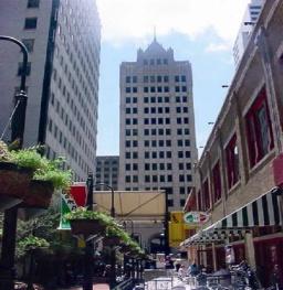
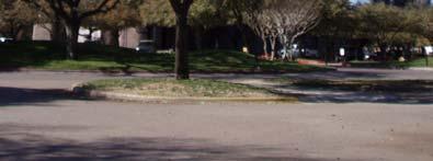
3 3 Sam s Greenville & Park Lane The Dallas Code is much more friendly to developments like this..

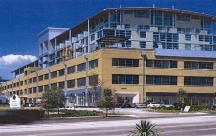
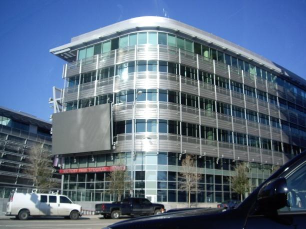
4 4 West Village..and unfriendly to developments like this


5 5 Existing Zoning MU-3 Zoning: Not predictable enough Not sufficiently pedestrian friendly
6 forwarddallas! Vision: New Development Patterns Impressionist painting of future development patterns using a palette of Building Blocks Two groups of Vision Building Blocks: Walkable Mixed Use Conventional Separate Use 6
7 7 Walkable Mixed Use Building Blocks Transit Centers Urban Mixed Use Campus Districts Multimodal Corridors Main Streets Urban Neighborhoods
8 8 Walkable Mixed Use Building Blocks Option to live, work, shop and recreate within the same general area Automobile dependency is reduced over time through transit, bicycle and pedestrian accessibility Diversity of building scale and density New development is sensitive to the character of adjacent stable residential neighborhoods

9 9 Context Sensitive Streets Steve Price, Urban Advantage The Public-Private Realm A major focus on the area around the public right-of-way line

10 Implementation Two-pronged implementation approach: New Tools or Programs Area Planning 10 10
11 forwarddallas! Implementation 11 Tools / Programs Development Code Amendments Ailing Multifamily Stabilization Program Neighborhood Based Organizations Program Context Sensitive Design Manual Tree Canopy Enhancement Program Targeted Economic Development Programs for Downtown, Southern Sector and Core Industries Non-Traditional Home Ownership Program Dallas Preservation Plan Update
12 forwarddallas! Implementation 12 Area Planning Systematic way to refine the forwarddallas! Vision and focus resources strategically on key areas of growth and change Provides a public process city authorization of zoning changes to apply new zoning options in specific locations

13 Area Planning Underway Southwestern Medical District UNT Campus Area Westmoreland DART Station Area Downtown Streetcar Agile Port Area South Dallas/Fair Park Vickery Meadow Asian Trade District Cedars/Farmer s Market Lancaster Corridor Skillman Street Garland Road Coit / McCallum Spring Valley / Coit 13
14 14 Development Code Amendments Project Mission Encourage desirable mixed use urban environments consistent with the forwarddallas! Vision
15 Development Code Amendments 15 Project Goals Craft new zoning districts that are: suitable for a variety of desirable developments in a range of mixed use environments market-tested easy to understand and predictable
16 16 Project Emphasis Enabling Ordinance vs. Location Specific Zoning Changes Code amendments establish new zoning tools and parameters for their intended use - no existing zoning on the ground will be changed Separate public hearing processes are mandated for any new zoning to be activated in specific locations
17 Development Code Amendments 17 Primary Objectives Urban design standards that promote walkable environments Parking standards that support pedestrian friendly environments and financially feasible projects Zoning districts that emphasize form and performance rather than use


18 Testing & Analysis Prototyping Based on Regulations What Would Be Allowed OR Based on Existing Projects What Would We Like To See as an End Result? Small Mixed Use 18

19 19 Testing & Analysis ROI Spreadsheet Model

20 Return On Investment (ROI) 20
21 Development Code Amendments 21 Proposed Process Regular (monthly) Advisory Committee meetings/ workshops (Three completed to date) Extensive stakeholder interviews (underway) Briefings to Zoning Ordinance Advisory Committee and Quality of Life Council Committee at key milestones One round of meetings/open houses in coordination with Budget Town Hall meetings to receive comments at the preliminary draft ordinance stage City Plan Commission and full City Council briefings and hearings at the final draft ordinance stage
22 Code Amendments 22 Schedule Project Initiation Mar 2007 Research and Analysis May 2007 Proposed Regulatory Approach Jun 2007 Preliminary Draft Ordinance Sept 2007 Final Draft Ordinance Nov 2007 Adoption Dec 2007 Illustrated Ordinance Guide Jan 2008
23 Appendix 23
24 REGULATORY APPROACH Based on: Critique of Existing Code Best Practices Research and Analysis 24
25 REGULATORY APPROACH Form-based Zoning Use/Density Form Performance Form Use/Density Less emphasis on regulating what happens inside buildings Greater emphasis on the street experience and on regulating what happens outside buildings 25
26 REGULATORY APPROACH New Districts Designed as Base Zoning Options Consider Alternative Form-Based Codification Format: Chapter 51F Consider Interim TOD Overlay Focus on preventing undesirable new development Consider modifications to PD Enabling Ordinance in Chapter 51A Focus on better guidance for appropriate application of PDs 26
27 REGULATORY APPROACH Hierarchy of Zoning Tools: ZONING DISTRICTS: Districts Applied Based on forwarddallas! Policy Guidance BUILDING TYPES: Building Types Allowed in Specified Districts PERMITTED USES: Uses Allowed in Specified Building Types 27
28 REGULATORY COMPONENTS PRIMARY: Zoning Districts, Building Types, Permitted Uses SECONDARY: Streets, Streetscape, Parking, Edge Transitions OTHER: Signs, Outdoor Storage & Display, Site Lighting, Access Management, Landscaping, Platting, Open Space 28
29 29 PRIMARY COMPONENTS Zoning Districts Building Types Permitted Uses
30 30 PRIMARY COMPONENT Zoning Districts Zoning Districts are the Puzzle Pieces for Creating Areas Envisioned by forwarddallas! Building Blocks Mixed Use - Vertical (MU-V) Mixed Use - Horizontal (MU-H) Mixed Use - Residential (MU-R) Residential - Mixed (R-MX) Residential - Transition (R-TN) forwarddallas! Policy Guidance for Applying Zoning Districts Walkable Mixed Use Building Blocks Area Plans Existing land use and infrastructure
31 District Intensity Range of intensity options for each district except Residential Transition (R-TN) LOW 2-3 story context MEDIUM Minimum 2-story Maximum?? HIGH Minimum 4-story Maximum? 31
32 Mixed Use - Vertical (MU-V) Mandates mixed use with shopfront along street Requires minimum number of stories Ground floor storefronts required on all buildings Ground floor residential allowed but must be in storefront 32
33 Mixed Use - Horizontal (MU-H) Allows the broadest variety of building types, including single use buildings Encourages mixed use through other standards such as parking Most flexible district One-story building must be expressed as two stories 33
34 Residential - Mixed Use (R-MU) Mostly residential, allows nonresidential only in a mixed use building Requires minimum number of stories Ground floor storefronts required for all mixed use buildings Maximum non-residential cap Ground floor residential allowed - apartments, townhouses 34
35 Residential Urban (R-U) Focused on a mix of residential housing types May allow limited set of nonresidential uses serving the residential May allow taller buildings than typical residential districts 35
36 Residential - Transition (R-TN) Focused on residential adjacent to stable neighborhoods Creates a land use transition Limits height adjacent to stable neighborhoods Least (or no) parking reduction 36
37 37 PRIMARY COMPONENT Building Types Building Types are the Puzzle Pieces for implementing Zoning Districts and are essentially form-based Mixed Use Building Types Mixed Use Shopfront Nonresidential Building Types Single Use Shopfront Single Use General Residential Building Types Apartment Stacked Townhouse Townhouse Home Apartment Civic Building Types Civic Building Open Lot


38 Building Types Mixed Use Building Types Mixed Use Shopfront Shopfront required All Floors: Residential, Civic, Commercial, Parking Parking Must be Wrapped on Ground Floor by Active Uses Height: 2+ stories 38
39 Building Types Form Controls for Each Building Type Sample: Shopfront Controls 39


40 40 Building Types Nonresidential Building Types Single Use Shopfront Commercial shopfront Civic, Commercial, Parking Parking Must be Wrapped on Ground Floor by Active Uses Height: 1+ Single Use General Civic, Commercial, Parking Parking Must be Wrapped on Ground Floor by Active Uses Height: 1+


41 Building Types Residential Building Types Apartment All Floors: Residential Height: 2+ Stacked Townhouse All Floors: Residential Height: 2-4 stories 41


42 Building Types Townhouse All Floors: Residential Height: 2-3 stories Home Apartment All Floors: Residential Height: 2-3 stories 42


43 Building Types Civic Building Types Civic Building Places of Worship, Schools, Public Buildings Open Lot Parks, Open Space, Squares, Plazas 43
44 44 Building Types by District Mixed Use - Vertical (MU-V) Mixed Use - Horizontal (MU-H) Residential - Mixed Use (R-MU) MIXED USE BUILDING TYPES Mixed Use Shopfront P P P NONRESIDENTIAL BUILDING TYPES Single Use Shopfront P P Single Use General P P Urban Residential (R-U) Residential - Transition (R-TN) RESIDENTIAL BUILDING TYPES Apartment P P P Stacked Townhouse P P P Townhouse P P P P Mansion House P CIVIC BUILDING TYPES Civic Building P P P P P Open Lot P P P P P P = Permitted Blank Cell = Not Permitted
45 PRIMARY COMPONENT Permitted Uses (SAMPLE) Residential Use Categories Household Living Group Living Civic Use Categories Community Service Day Care Educational Facility Medical Facility Park/Open Area Passenger Terminal Social Service Utilities Commercial Use Categories Indoor Recreation Office Outdoor Recreation Overnight Lodging Parking, Commercial Restaurant Retail Sales and Service Self-Storage Vehicle Sales and Service Industrial Use Categories Wholesale Trade Light Industrial Warehouse & Distribution Heavy Industrial Waste-Related 45

46 Uses by Building Type SAMPLE Table illustrates how a specific use can be singled out for special treatment By Building Type or Floor By Applying a Specific Use Standard Doggie Day Car 46
47 47 SECONDARY COMPONENTS Streetscape Plates Street Plates Parking Provisions Edge Transition Provisions


48 48 Streetscape Palette of Streetscape Plates (specified on a regulating plan)


49 49 Streets Palette of Minor Streets (specified on a regulating plan)


50 50 Streets and Streetscape Variety of streetscape plates can be matched to a variety of street types
51 51 Parking and Zoning Districts Mixed Use - Vertical (MU-V) Mixed Use - Horizontal (MU-H) Mixed Use - Residential (MU-R) Residential - Mixed (R-MX) Residential - Transition (R-TN) Highest Reduction Parking Reduction Lowest Reduction
52 Parking Two Pronged Approach Allow as much reduction for mixed use as appropriate without a parking district; and Additional options become available with a parking district TOD Areas Allow for greatest reductions May require most intense management Transition Areas Most sensitive to parking spillover, least (or no) reduction available 52
53 Parking - no parking district Revised Ratios (based on sample efficiency surveys) Updated Shared Parking Model Reductions for: Proximity to Transit Specific Uses (e.g.: senior housing) Employer TDM (ride-share, carpool, telecommuting) Car Sharing Program Off-Site Spaces That Count: On-street parking adjacent to property Valet parking Remote parking Maximum Parking Caps in TOD areas Exemption for wrapped parking structure or underground parking 53
54 Parking - with parking district Fee in-lieu of parking on-site User fees Parking available for a fee (daily, monthly) Variable pricing programs Most expensive spaces generate highest turnover Unbundling in low impact areas No parking required, but may be provided 54
55 Edge Transitions Compatible Building Types Required Next to Existing Development Townhouse, Home Apartment Residential Proximity Slope Retain 1:3 Slope Develop possible alternatives or exemptions Alternative slopes, re-consider application (settings) Restriction on active uses Distance separation requirements for impacts such as loading areas, dumpsters Planting/screening combinations Window and balcony restrictions Least (Or No) Parking Reduction Available 55
56 Other Options To Consider: Regulating Plan Used to Designate Streets/Streetscapes Link to Parking Options? Height Map Used to Allocate Additional Height Beyond Base District Height Used to Set Specific Transitions to Stable Neighborhoods 56

57 57 Hypothetical Example: Inwood DART Station Area Denton Maple
58 Existing Land Use 58 Denton Inwood Maple
59 Existing Zoning 59 Denton Inwood Maple

60 forwarddallas! Vision Building Blocks: Campus Urban Mixed Use Single- Family 60
61 61 Hypothetical Example: Mixed Use Zoning Denton Inwood Maple
62 62 NEXT STEPS C O D E D R A F T I N G!
Oak Cliff Gateway District PD 468
 Oak Cliff Gateway District PD 468 August 21, 2014 2013 Authorized Hearing Authorized Hearing September, 2013 September 12, 2013 City Plan Commission expanded boundaries to represent current Oak Cliff Gateway
Parking Challenges and Trade-Offs
 Parking Challenges and Trade-Offs What is the best way to balance competing interests and priorities while updating the City s off street parking regulations? Updating off street parking regulations can
Bylaw No , being "Official Community Plan Bylaw, 2016" Schedule "A" DRAFT
 Bylaw No. 2600-2016, being "Official Community Plan Bylaw, 2016" Schedule "A" Urban Structure + Growth Plan Urban Structure Land use and growth management are among the most powerful policy tools at the
East Side Community Meeting
 East Side Community Meeting November 29, 2017 Pam Thompson, Senior Planner Sustainable Development and Construction City of Dallas Authorized Hearing Process City Plan Commission authorized a hearing to
Generic Environmental Impact Statement. Build-Out Analysis. City of Buffalo, New York. Prepared by:
 Generic Environmental Impact Statement Build-Out Analysis City of Buffalo, New York 2015 Prepared by: TABLE OF CONTENTS 1.0 INTRODUCTION 1 2.0 METHODOLOGY 2 3.0 EXISTING LAND USE 3 4.0 EXISTING ZONING
COMMISSION ACTION FORM SUBJECT: ZONING TEXT AMENDMENT FOR LINCOLN WAY CORRIDOR PLAN DOWNTOWN GATEWAY COMMERCIAL ZONING DISTRICT STANDARDS
 ITEM #: 7 DATE: _02-07-18 COMMISSION ACTION FORM SUBJECT: ZONING TEXT AMENDMENT FOR LINCOLN WAY CORRIDOR PLAN DOWNTOWN GATEWAY COMMERCIAL ZONING DISTRICT STANDARDS BACKGROUND: The Downtown Gateway area
Form Based Zoning. Council Briefing December 3, 2008
 Form Based Zoning Council Briefing December 3, 2008 1 Purpose Review goals and background of forward Dallas! Introduce the new concept of formbased zoning Review progress made on the new formbased zoning
ZONING ORDINANCE PRESENTATION
 July 25, 2012 Village of Mundelein, Illinois ZONING ORDINANCE PRESENTATION Presented by Camiros, Ltd. GOALS FOR ORDINANCE A Zoning Ordinance that: Implements the land use policies of the Village Is understandable
ARTICLE 3: Zone Districts
 ARTICLE 3: Zone Districts... 3-1 17.3.1: General...3-1 17.3.1.1: Purpose and Intent... 3-1 17.3.2: Districts and Maps...3-1 17.3.2.1: Applicability... 3-1 17.3.2.2: Creation of Districts... 3-1 17.3.2.3:
From Policy to Reality
 From Policy to Reality Updated ^ Model Ordinances for Sustainable Development 2000 Environmental Quality Board 2008 Minnesota Pollution Control Agency Funded by a Minnesota Pollution Control Agency Sustainable
Downtown 2025 Sector Development Plan
 Existing Sector / Corridor / Design Overlay Zone Summary Sheet 2025 Sector Web Address: https://www.cabq.gov/planning/documents/copy_of_2025_dec14r.pdf Joint plan with Bernalillo County No Date Adopted/Amended
NC 54/I-40 Corridor Master Plan Draft Land Use Blueprint
 NC 54/I-40 Corridor Master Plan Draft Land Use Blueprint Introduction The following presents a summary of Community Elements as recommended for consideration in the NC 54 study corridor. Images are provided
Appendix A: Guide to Zoning Categories Prince George's County, Maryland
 Appendix A: Guide to Zoning Categories Prince George's County, Maryland RESIDENTIAL ZONES 1 Updated November 2010 R-O-S: Reserved Open Space - Provides for permanent maintenance of certain areas of land
Presentation. Agenda Item # 1. Meeting Date February 3, Erkin Ozberk, Planner. Prepared By. Brian T. Kenner City Manager.
 Agenda Item # 1 Presentation Meeting Date February 3, 2014 Prepared By Approved By Erkin Ozberk, Planner Brian T. Kenner City Manager Discussion Item Background Update on Montgomery County s Zoning Code
PLANNING COMMISSION. Study Session: Beach Boulevard Specific Plan Workshop
 PLANNING COMMISSION Study Session: Beach Boulevard Specific Plan Workshop Project Background Sustainable Communities Grant Funding Phase 1 Outreach: Improve the Boulevard A Specific Plan is a long-term
Zoning Code Amendments Completed and Proposed As of September 2014
 Zoning Code Amendments Completed and Proposed As of September 2014 PROPOSED CODE AMENDMENTS High Priority Amendment/Issue Comments Exterior Lighting Standards Section 26-503 establishes states that exterior
Zoning Code Amendments Completed and Proposed. November 2009 COMPLETED CODE AMENDMENTS. Parking Regulations Effective Sept 28, 2009 Ordinance No.
 Zoning Code Amendments Completed and Proposed COMPLETED CODE AMENDMENTS Amendment/Issue Parking Regulations Effective Sept 28, 2009 Ordinance No. 1454 Residential Density in Planned Developments Effective
CITY OF PORT ORCHARD
 CITY OF PORT ORCHARD ZONING DESIGNATIONS (Adapted from POMC Chapter 20.34 Zoning Districts, as adopted 6/13/2017) 20.34.110 Greenbelt zone (Gb). (1) Purpose. It is the purpose of the greenbelt zone to
TASK 2 INITIAL REVIEW AND ANALYSIS U.S. 301/GALL BOULEVARD CORRIDOR FORM-BASED CODE
 TASK 2 INITIAL REVIEW AND ANALYSIS U.S. 301/GALL BOULEVARD CORRIDOR FORM-BASED CODE INTRODUCTION Using the framework established by the U.S. 301/Gall Boulevard Corridor Regulating Plan (Regulating Plan),
LITTLE MOUNTAIN ADJACENT AREA REZONING POLICY
 LITTLE MOUNTAIN ADJACENT AREA REZONING POLICY JANUARY 2013 CONTENTS 1.0 INTENT & PRINCIPLES...1 2.0 APPLICATION...2 3.0 HOUSING TYPES, HEIGHT & DENSITY POLICIES...3 3.1 LOW TO MID-RISE APARTMENT POLICIES...4
Berry/University Form Based Code and Urban Residential Development
 Berry/University Form Based Code and Urban Residential Development Presented to the City Council by the Planning and Development Department October 11, 2016 Purpose Review proposed Berry/University formbased
Provide a diversity of housing types, responsive to household size, income and age needs.
 8 The City of San Mateo is a highly desirable place to live. Housing costs are comparably high. For these reasons, there is a strong and growing need for affordable housing. This chapter addresses the
Goal 1 - Retain and enhance Cherry Creek North s unique physical character.
 Introduction This document summarizes the proposed new zoning for the area of roughly bordered by University Boulevard, Steele Street, 3rd Avenue, and 1st Avenue. It provides a high-level review of the
CONNECTING ARLINGTON S POLICY FRAMEWORK TO THE RESIDENTIAL PARKING WORKING GROUP
 CONNECTING ARLINGTON S POLICY FRAMEWORK TO THE RESIDENTIAL PARKING WORKING GROUP Contents Arlington County Development and Growth Goals... 1 Master Transportation Plan Policies Related to Multi Family
UPDATE Board of Selectmen June 20, 2017
 MAPLE STREET I-1 AREA DRAFT ZONING BYLAW & DEVELOPMENT STANDARDS Town of Danvers, MA UPDATE Board of Selectmen June 20, 2017 The Danvers Team: Brovitz Community Planning & Design Dodson & Flinker Danvers
CONFIRMATION OF DIRECTION APRIL 2010
 Montgomery County Revised Zoning Code CONFIRMATION OF DIRECTION APRIL 2010 C O D E S T U D I O Rhodeside & Harwell Farr Associates Nelson\Nygaard Today s Presentation Project Update Approach Project Objectives
City of Tacoma Zoning Reference Guide
 City of Tacoma Zoning Reference Guide Planning and Development Services 747 Market Street, Room 345 Tacoma, WA 98402 (253) 591-5577 This document should not be used as a substitute for codes and regulations.
General Plan. Page 44
 VIII. RESIDENTIAL DEVELOPMENT IN NON-RESIDENTIAL LAND USE AREAS POLICY ISSUE Review the City s existing regulations and policies that allow residential land use in non-residential zoning districts. BACKGROUND
Poughkeepsie City Center Revitalization Plan
 Purpose and Need Purpose Increase job and educational opportunities for all residents Maximize fiscal productivity of downtown land uses Diversify retail mix Eliminate surface and building vacancies Create
Poverty Rates by Census Tracts
 The following document is a presentation that was delivered to the Housing Conservation District Advisory Group (HCDAG). The materials contained in this presentation (including several updates) were prepared
A New Zoning Code for a 21st Century Los Angeles
 A New Zoning Code for a 21st Century Los Angeles To create livable communities, encourage sustainable development and foster economic vitality, we need a modern and user-friendly zoning code we need to
LAKE MERRITT STATION AREA PLAN
 LAKE MERRITT STATION AREA PLAN Emerging Plan Open House Summary October 2011 2 1 Introduction The City of Oakland, Bay Area Rapid Transit (BART), and the Peralta Community College District, through a grant
LONG-RANGE LAND USE PLAN
 LONG-RANGE LAND USE PLAN INTENT Completion of the I-66/Route 29 interchange and future expansion of improved telecommunication networks will substantially improve the desirability of the Gainesville area
CITY OF PORTSMOUTH. CITY COUNCIL POLICY No HOUSING POLICY
 CITY OF PORTSMOUTH CITY COUNCIL POLICY No. 2016-03 HOUSING POLICY WHEREAS, the goals of the City of Portsmouth, as expressed in its 2025 Master Plan, include encouraging walkable mixed-use development,
New Zoning Ordinance Update. Presentation to the Mayor and Aldermen City of Savannah August 16, 2018
 New Zoning Ordinance Update Presentation to the Mayor and Aldermen City of Savannah August 16, 2018 Discussion Background Benefits of NewZO Zoning Conversion Inclusion of Parking Matters Study Public Comment
Article 3. SUBURBAN (S-) NEIGHBORHOOD CONTEXT
 NEIGHBORHOOD CONTEXT") Article 3. SUBURBAN (S-) NEIGHBORHOOD CONTEXT this page left intentionally blank Contents ARTICLE 3. SUBURBAN (S-) NEIGHBORHOOD CONTEXT DIVISION 3.1 NEIGHBORHOOD CONTEXT DESCRIPTION...3.1-1 Section 3.1.1
Article 3. SUBURBAN (S-) NEIGHBORHOOD CONTEXT this page left intentionally blank Contents ARTICLE 3. SUBURBAN (S-) NEIGHBORHOOD CONTEXT DIVISION 3.1 NEIGHBORHOOD CONTEXT DESCRIPTION...3.1-1 Section 3.1.1
Composition of traditional residential corridors.
 Page 1 of 7 St. Petersburg, Florida, Code of Ordinances >> PART II - ST. PETERSBURG CITY CODE >> Chapter 16 - LAND DEVELOPMENT REGULATIONS >> SECTION 16.20.060. CORRIDOR RESIDENTIAL TRADITIONAL DISTRICTS
Draft Strategy Plan Concepts. CAC Meeting #9
 Downtown San Leandro Transit-Oriented Development Strategy Draft Strategy Plan Concepts Discussion & Conclusions CAC Meeting #9 23 January 2007 Land Use Plan & Specific Areas New mixed-use districts Context-sensitive
2.0 LAND USE FRAMEWORK
 Land Use Framework 2.0 LAND USE FRAMEWORK FOLSOM BOULEVARD 2.1 LAND USE OVERVIEW The proposed land uses for Easton Place offer local and regional employment, shopping, and entertainment, highlighting the
PLANNING COMMISSION REPORT Regular Agenda -Public Hearing Item
 PDP-13-00518 Item No. 3B- 1 PLANNING COMMISSION REPORT Regular Agenda -Public Hearing Item PC Staff Report 2/24/14 ITEM NO. 3B PRELIMINARY DEVELOPMENT PLAN FOR HERE @ KANSAS; 1101 INDIANA ST (SLD) PDP-13-00518:
Community Advisory Committee (CAC) Meeting #7 West Anaheim Youth Center May 26, 2016
 Meeting #7 West Anaheim Youth Center May 26, 2016") Community Advisory Committee (CAC) Meeting #7 West Anaheim Youth Center May 26, 2016 1 Project Team City: David Belmer Planning and Building Director Jonathan Borrego, AICP Planning Services Manager Gustavo
Community Advisory Committee (CAC) Meeting #7 West Anaheim Youth Center May 26, 2016 1 Project Team City: David Belmer Planning and Building Director Jonathan Borrego, AICP Planning Services Manager Gustavo
Chapter URBAN VILLAGE ZONING DISTRICTS
 Chapter 20.16 Sections: 20.16.010 Purpose of the Urban Village Zoning Districts 20.16.020 Land Use Regulations for the Urban Village Zoning Districts 20.16.030 Development Standards & Guidelines for the
Chapter 10: Implementation
 Chapter 10: Introduction Once the Comprehensive Plan has been adopted by the City of Oakdale, the City can begin to implement the goals and strategies to make this vision a reality. This chapter will set
PLANNING ANALYSIS ZONING CASE 18-TOD-Z-026 NAK S CROSSING PUD AMENDMENT. GC-3-A (General Commercial) GC-3-A (General Commercial)
 GC-3-A (General Commercial)") PLANNING ANALYSIS ZONING CASE 18-TOD-Z-026 NAK S CROSSING PUD AMENDMENT GENERAL INFORMATION Applicant/Owner: Current Zoning: Bruce Nakfoor PUD/TOD (Planned Unit Development/Transit Oriented Development
PLANNING ANALYSIS ZONING CASE 18-TOD-Z-026 NAK S CROSSING PUD AMENDMENT GENERAL INFORMATION Applicant/Owner: Current Zoning: Bruce Nakfoor PUD/TOD (Planned Unit Development/Transit Oriented Development
BROCKVILLE CITY OF BROCKVILLE COMPREHENSIVE ZONING BY-LAW REVIEW DISCUSSION PAPER OCTOBER 2013 FINAL D
 BROCKVILLE CITY OF BROCKVILLE COMPREHENSIVE ZONING REVIEW DISCUSSION PAPER OCTOBER 2013 FINAL D14-13-010 TABLE OF CONTENTS 1. INTRODUCTION... 1 1.1 Purpose and Goals of this Project... 1 1.2 Study Process...
MERIDEN TOD A NEW TRANSIT-ORIENTED DEVELOPMENT DISTRICT ZONING REGULATION FOR MERIDEN. Greater Meriden Chamber & Connecticut Bar Association
 A NEW TRANSIT-ORIENTED DEVELOPMENT DISTRICT ZONING REGULATION FOR MERIDEN PRESENTATION TO Greater Meriden Chamber & Connecticut Bar Association 25 September 2013 Dominick J. Caruso, AICP Director of Planning
Paseo de la Riviera. August 12, 2015
 Paseo de la Riviera August 12, 2015 1 2 3 Existing Future Land Use Map Existing Zoning Map 4 5 6 7 Review Timeline 1 2 3 4 5 Development Review Committee: 10.31.14 Zoning Code Text, Future Land Use Map,
DRAFT FOR DISCUSSION PURPOSES ONLY. Port Credit Local Area Plan Built Form Guidelines and Standards DRAFT For Discussion Purposes
 Port Credit Local Area Plan Built Form Guidelines and Standards DRAFT For Discussion Purposes 1 Local Area Plan - Project Alignment Overview Directions Report, October 2008 (General Summary Of Selected
TOTTENHAM SECONDARY PLAN
 TOTTENHAM SECONDARY PLAN AMENDMENT NO. 11 TO THE OFFICIAL PLAN OF THE TOWN OF NEW TECUMSETH The following text and schedules to the Official Plan of the Town of New Tecumseth constitute Amendment No. 11
SUBJECT: Official Plan and Zoning By-law Amendment Applications for 4853 Thomas Alton Boulevard
 Page 1 of Report PB-100-16 SUBJECT: Official Plan and Zoning By-law Amendment Applications for 4853 Thomas Alton Boulevard TO: FROM: Development and Infrastructure Committee Planning and Building Department
7. IMPLEMENTATION STRATEGIES
 7. IMPLEMENTATION STRATEGIES A. GENERAL APPROACH FOR IMPLEMENTATION Implementing the plan will engage many players, including the Municipality of Anchorage (MOA), the Government Hill Community Council,
Rosslyn Sector Plan Implementation Zoning Ordinance Amendments. NAIOP Meeting April 13, 2016
 Rosslyn Sector Plan Implementation Zoning Ordinance Amendments NAIOP Meeting April 13, 2016 Agenda Background, Process & Schedule Preliminary Amendments to C-O Rosslyn Building Height & Step-backs Density
UrbanFootprint Place Types. Urban Mixed Use. Urban Residential. Urban Commercial. Residential 1% SF Large Lot 0%
 Urban Mixed Use Residential 18% SF Large Lot 0% Employment 16% SF Small Lot 0% Mixed Use 45% Townhome 0% Open Space/Civic 21% MultiFamily 100% Intersections per mi 2 200 Office 80% Average Floors 23 Retail
Charlottesville Planning Commission, Neighborhood Associations & News Media
 CITY OF CHARLOTTESVILLE A World Class City Department of Neighborhood Development Services City Hall Post Office Box 911 Charlottesville, Virginia 22902 Telephone 434-970-3182 Fax 434-970-3359 www.charlottesville.org
Prince George s County Zoning Ordinance and Subdivision Regulations Rewrite March 13, 2017
 Prince George s County Zoning Ordinance and Subdivision Regulations Rewrite March 13, 2017 The Maryland National Capital Park & Planning Commission 1 Worksessions Schedule Topic Date Zone Structure January
REZONING GUIDE. Zone Map Amendment (Rezoning) - Application. Rezoning Application Page 1 of 3. Return completed form to
 - Application. Rezoning Application Page 1 of 3. Return completed form to") Zone Map Amendment (Rezoning) - Application COMMUNITY PLANNING & DEVELOPMENT REZONING GUIDE Rezoning Application Page 1 of 3 PROPERTY OWNER INFORMATION* CHECK IF POINT OF CONTACT FOR APPLICATION Property
Zone Map Amendment (Rezoning) - Application COMMUNITY PLANNING & DEVELOPMENT REZONING GUIDE Rezoning Application Page 1 of 3 PROPERTY OWNER INFORMATION* CHECK IF POINT OF CONTACT FOR APPLICATION Property
Place Type Descriptions Vision 2037 Comprehensive Plan
 Place Type Descriptions Vision 2037 Comprehensive Plan The Vision 2037 Comprehensive Plan establishes a range of place types for Oxford, ranging from low intensity (limited development) Rural and Natural
PINELLAS COUNTY COMPREHENSIVE PLAN
 PINELLAS COUNTY COMPREHENSIVE PLAN Future Land Use Map (FLUM) Category Descriptions and Rules Amended March 17, 2009 (Ordinance 09-17) Amended March 16, 2010 (Ordinance 10-18) Amended October 26, 2010
Community & Infrastructure Services Committee
 REPORT TO: DATE OF MEETING: September 12, 2016 Community & Infrastructure Services Committee SUBMITTED BY: Alain Pinard, Director of Planning, 519-741-2200 ext. 7319 PREPARED BY: Natalie Goss, Senior Planner,
2011 AICP Review Course
 2011 AICP Review Course March 2011 Alex Dambach, AICP, PP Director of Policy, Planning, and Development City of East Orange Exam Content A. Strategic planning/visioning B. Goal setting C. Research methods
Future Land Use Categories & Nodes December 23, Future Land Use Categories
 Future Land Use Categories & Nodes December 23, 2015 A note regarding nodes: Descriptions for nodes are located in the general recommendations handout. Node locations are set in part by the Auburn Interactive
Actual & Projected Population
 Annexation Policy and the Comprehensive Plan Presentation November 9, 2012 1 Annexation Policy Document Overview: Background, history, and strategies Policy: Policy Statements t t to guide and provide
AN ORDINANCE REGULATING AND CONTROLLING SHARED PARKING IN THE CITY OF MADISON, MISSISSIPPI March 22, 2006
 AN ORDINANCE REGULATING AND CONTROLLING SHARED PARKING IN THE CITY OF MADISON, MISSISSIPPI March 22, 2006 Introduction Cumulative parking requirements for mixed-use occupancies or shared facilities may
Division 8 General Urban (T4) Zone: Assessment Criteria and Assessment Tables
 Zone: Assessment Criteria and Assessment Tables") Division 8 General Urban (T4) Zone: Assessment Criteria and Assessment Tables 15.8.1 General Urban (T4) Zone The provisions in this division relate to the General Urban (T4) Zone as follows overall outcomes
Division 8 General Urban (T4) Zone: Assessment Criteria and Assessment Tables 15.8.1 General Urban (T4) Zone The provisions in this division relate to the General Urban (T4) Zone as follows overall outcomes
Voluntary Inclusionary Zoning
 Voluntary Inclusionary Zoning Zoning Ordinance Advisory Committee August 17, 2017 Pam Thompson, Senior Planner, Sustainable Development and Construction Presentation Overview Recap Purpose/Approach Questions
ARTICLE 426. PD 426.
 ARTICLE 426. PD 426. SEC. 51P-426.101. LEGISLATIVE HISTORY. PD 426 was established by Ordinance No. 22741, passed by the Dallas City Council on April 24, 1996. Ordinance No. 22741 amended Ordinance No.
RESIDENTIAL DISTRICTS
 RESIDENTIAL DISTRICTS RESIDENTIAL DISTRICTS The residential district standards have been revised to reflect on-the-ground development conditions, while continuing to respect the use patterns established
Amendments to the Dallas Development Code Creating Regulations for Mixed Income Housing Development Bonuses
 Memorandum DATE November 2, 2018 CITY OF DALLAS TO Honorable Members of the Economic Development and Housing Committee SUBJECT Amendments to the Dallas Development Code Creating Regulations for Mixed Income
City of Reno October 30, 2012 Draft Midtown Zoning Text Amendments 1
 Section 18.08.405 Regional Center and Transit Corridor Overlay Districts (i) SVTC South Virginia Street Transit Corridor Overlay Zoning District. (1) Applicability. This Section 18.08.405(l)'s standards
Housing Conservation District Advisory Group
 Housing Conservation District Advisory Group Inaugural Meeting January 31, 2018 Welcome and Thank You! Purpose of the HCDAG: Help County staff assess and refine proposed Housing Conservation District incentives.
PUBLIC DRAFT May 2017 Zoning Districts Use Regulations Definitions (partial)
") PUBLIC DRAFT May 2017 Zoning Districts Use Regulations Definitions (partial) Table of Contents Subchapter 1: General Provisions... 1 Subchapter 2: Administration & Procedures... 3 Subchapter 3: Zoning
PUBLIC DRAFT May 2017 Zoning Districts Use Regulations Definitions (partial) Table of Contents Subchapter 1: General Provisions... 1 Subchapter 2: Administration & Procedures... 3 Subchapter 3: Zoning
Downtown Development Focus Area: I. Existing Conditions
 Downtown Development Focus Area: I. Existing Conditions The Downtown Development Focus Area is situated along Route 1, south of the train tracks, except for the existing Unilever property. It extends west
PART ONE - GENERAL INFORMATION
 Corrected Date: Page 7 Date of Submittal Changed to Coincide with Submittal Date on Page 5 PART ONE - GENERAL INFORMATION A. INTRODUCTION B. Background Miami Shores Village is soliciting responses to this
DRAFT Plan Incentives. Part A: Basic Discount
 DRAFT 2030 Plan Incentives July 26, 2006 Part A: Basic Discount In order for a development to be eligible for any 2030 Land Resource Management Plan Discounts it must be located in the Urban Corridor and
WELCOME! TO THE UNIVERSITY ENDOWMENT LANDS BLOCK F PUBLIC OPEN HOUSE
 WELCOME! TO THE UNIVERSITY ENDOWMENT LANDS BLOCK F PUBLIC OPEN HOUSE The UEL & Block F What is the UEL? Site Location The University Endowment Lands (UEL) is a separate jurisdiction from the City of Vancouver
LAND USE AMENDMENT SOUTHWOOD (WARD 11) MACLEOD TRAIL S AND ANDERSON ROAD SW BYLAWS 140D2018 AND 141D2018
 MACLEOD TRAIL S AND ANDERSON ROAD SW BYLAWS 140D2018 AND 141D2018") Page 1 of 30 EXECUTIVE SUMMARY This land use amendment application is to redesignate the parcel currently containing the Anderson Light Rail Transit (LRT) Station s Park N Ride surface parking lots from
Page 1 of 30 EXECUTIVE SUMMARY This land use amendment application is to redesignate the parcel currently containing the Anderson Light Rail Transit (LRT) Station s Park N Ride surface parking lots from
Suburban Commercial Center ( CE-S ) Permitted Principal Uses and Structures
 Permitted Principal Uses and Structures") Division 12. Suburban Commercial Center ( CE-S ) 2.9.1 Purpose Suburban commercial centers provide regional commercial destinations with design and site elements compatible with suburban character. Dimensional
Division 12. Suburban Commercial Center ( CE-S ) 2.9.1 Purpose Suburban commercial centers provide regional commercial destinations with design and site elements compatible with suburban character. Dimensional
M E M O R A N D U M. Origin
 PO Box 1749 Halifax, Nova Scotia B3J 3A5 Canada M E M O R A N D U M TO: Community Design Advisory Committee CC: Kelly Denty, Acting Director FROM: Carl Purvis, Acting Manager Urban Design, DATE: February
Chapter 8 Sectional Map Amendment
 Chapter 8 The proposed (SMA) seeks to implement the land use policies reflected in the future land use plan by rezoning properties to the appropriate zoning district to achieve the recommended pattern
Project Team. Community Workshop Draft Specific Plan Review West Anaheim Youth Center September 4, /6/2018.
 Community Workshop Draft Specific Plan Review West Anaheim Youth Center September 4, 2018 Project Team City: David Belmer Planning and Building Director Susan Kim, AICP Principal Planner Gustavo Gonzalez,
Ann Arbor Downtown Zoning Evaluation
 Ann Arbor Downtown Zoning Evaluation Options Workbook ENP & Associates in cooperation with the City of Ann Arbor September, 2013 Photo Courtesy of Andrew Horne, February 9, 2013 Introduction Thank you
Director, Community Planning, Toronto and East York District
 STAFF REPORT September 1, 2005 To: From: Subject: Toronto and East York Community Council Director, Community Planning, Toronto and East York District Further Report Applications to amend Official Plan
Planning & Strategic Initiatives Committee
 REPORT TO: DATE OF MEETING: February 2, 2015 SUBMITTED BY: Planning & Strategic Initiatives Committee Alain Pinard, Director of Planning PREPARED BY: Katie Anderl, Senior Planner, 519-741-2200 ext. 7987
An Introduction to the City of Winnipeg s New Zoning By-Law
 An Introduction to the City of Winnipeg s New Zoning By-Law Presentation To: APEGM PIDIM MAA April 30, 2008 1 The Planning Hierarchy Plan Winnipeg s Primary Purpose: To ensure that the use and development
Bridgeland-Riverside Area Redevelopment Plan (ARP)
") Bridgeland-Riverside Area Redevelopment Plan (ARP) The current Bridgeland-Riverside Area Redevelopment Plan (ARP) was approved in 1980. Since then, a lot of changes have taken place in the city and the
Bridgeland-Riverside Area Redevelopment Plan (ARP) The current Bridgeland-Riverside Area Redevelopment Plan (ARP) was approved in 1980. Since then, a lot of changes have taken place in the city and the
PARRAMORE OAKS FRAMEWORK PLANNED DEVELOPMENT
 PARRAMORE OAKS FRAMEWORK PLANNED DEVELOPMENT Presented by Mark Cechman, AICP Paul S. Lewis, FAICP Review Process Pre- Application meeting August 11, 2016 Attended by representatives of: City Planning Transportation
Washington Boulevard + Kirkwood Road Special General Land Use Plan (GLUP) Study "Plus"
 Study Plus") Washington Boulevard + Kirkwood Road Special General Land Use Plan (GLUP) Study "Plus" Long Range Committee of the Planning Commission Meeting #4 May 18, 2017 Department of Community Planning, Housing
Washington Boulevard + Kirkwood Road Special General Land Use Plan (GLUP) Study "Plus" Long Range Committee of the Planning Commission Meeting #4 May 18, 2017 Department of Community Planning, Housing
Truax Park Apartments
 Truax Park Apartments Master Planning and Site Development Study Prepared by The Community Development Authority of the City of Madison In association with SMITH & SMITH ASSOCIATES, Inc CONSTRUCTION COST
Kinzie Industrial Corridor
 Mayor Emanuel s Industrial Corridor Modernization Kinzie Industrial Corridor Fulton Market Innovation District Plan Implementation September 19, 2017 Rahm Emanuel, Mayor David Reifman, Commissioner Dept.
City of Valdosta Land Development Regulations
 Chapter 206 Section 206-1 Base Zoning Districts Standards for Uses, Structures, and Property Development (B) (C) Principal Uses and Structures. Principal uses and structures permitted in each base zoning
13 Sectional Map Amendment
 13 Sectional Map Amendment Introduction This chapter reviews land use and zoning policies and practices in Prince George s County and presents the proposed zoning in the sectional map amendment (SMA) to
12, 14, 16 and 18 Marquette Avenue and 7 Carhartt Street Zoning By-law Amendment Application - Preliminary Report
 STAFF REPORT ACTION REQUIRED 12, 14, 16 and 18 Marquette Avenue and 7 Carhartt Street Zoning By-law Amendment Application - Preliminary Report Date: July 17, 2014 To: From: Wards: Reference Number: North
ORDINANCE City of DeBary Comprehensive Plan Amendments Page 1 of 3
 ORDINANCE 01-15 AN ORDINANCE OF THE CITY COUNCIL OF DEBARY, FLORIDA, AMENDING THE CITY S COMPREHENSIVE PLAN FUTURE LAND USE ELEMENT TEXT AMENDING COMPREHENSIVE PLAN POLICY 5.406 CONCERNING THE SOUTHEAST
NEW STARTS. Land Use & Economic Development. gbplacemaking.com
 WINNING @ NEW STARTS Land Use & Economic Development arrington.gb@gmail.com gbplacemaking.com OVERVIEW New Starts snapshot The ratings process What FTA wants to see What best practice is transferable?
PLANNING AND IMPLEMENTING TOD: KEY FACTORS FOR SUCCESS. Sujata Srivastava Knowledge Corridor TOD Workshop June 5, 2013
 PLANNING AND IMPLEMENTING TOD: KEY FACTORS FOR SUCCESS Sujata Srivastava Knowledge Corridor TOD Workshop June 5, 2013 6-year old partnership dedicated to improving practice through technical assistance,
Town of Jamestown Planning Board Zoning Staff Report June 14, 2010
 Town of Jamestown Planning Board Zoning Staff Report June 14, 2010 The information provided in this staff report has been included for the purpose of reviewing proposed zoning changes. Since the zoning
Article 6. GENERAL URBAN (G-) NEIGHBORHOOD CONTEXT
 NEIGHBORHOOD CONTEXT") Article 6. GENERAL URBAN (G-) NEIGHBORHOOD CONTEXT this page left intentionally blank Contents ARTICLE 6. GENERAL URBAN (G-) NEIGHBORHOOD CONTEXT DIVISION 6.1 NEIGHBORHOOD CONTEXT DESCRIPTION...6.1-1 Section
Article 6. GENERAL URBAN (G-) NEIGHBORHOOD CONTEXT this page left intentionally blank Contents ARTICLE 6. GENERAL URBAN (G-) NEIGHBORHOOD CONTEXT DIVISION 6.1 NEIGHBORHOOD CONTEXT DESCRIPTION...6.1-1 Section
A Zoning Ordinance Comprehensive Update Zoning Ordinance Study Group Meeting August 20, 2012
 A Zoning Ordinance Comprehensive Update Zoning Ordinance Study Group Meeting August 20, 2012 Sioux Falls Zoning Ordinance Study Group How long will this take? How do I participate? What is the goal of
LAND USE ASSUMPTIONS REPORT POTENTIAL FUTURE DEVELOPMENT WEST WHITELAND TOWNSHIP, CHESTER COUNTY, PA
 LAND USE ASSUMPTIONS REPORT POTENTIAL FUTURE DEVELOPMENT WEST WHITELAND TOWNSHIP, CHESTER COUNTY, PA Adopted June 17, 2015 by Township Resolution No. 2015-30 Prepared by Theurkauf Design & Planning, LLC
Prince George s County Zoning Ordinance and Subdivision Regulations Rewrite January 3, 2018
 Prince George s County Zoning Ordinance and Subdivision Regulations Rewrite January 3, 2018 The Maryland National Capital Park & Planning Commission Agenda Project goals and outreach Review: how the Comprehensive