THE VISION FUTURE DEVELOPMENT OPPORTUNITIES RESIDENTIAL DEVELOPMENT
|
|
|
- Magnus Jackson
- 5 years ago
- Views:
Transcription
1
2 PAGE 20 THE VISION The essence of what the neighborhood is striving to become is represented in the following vision statements: The Seacrest/Del-Ida Park neighborhood has a strong communication link and working relationship with the City of Delray Beach The Seacrest/Del-Ida Park Neighborhood has a strong identity within the City as a clean, safe, attractive environment in which to live and raise children. The Seacrest/Del-Ida Park Neighborhood consists primarily of well-maintained owner-occupied single family homes on attractively landscaped lots. The Seacrest/Del-Ida Park Neighborhood roadway system provides for excellent access and traffic flow while maintaining traffic volume and vehicle speeds at low levels on residential streets. The Seacrest/Del-Ida Park Neighborhood provides for excellent pedestrian access in and around the neighborhood. The Seacrest/Del-Ida Park Neighborhood contains a significant number of preserved historic structures which contribute to the charm and character of the whole neighborhood. The Seacrest/Del-Ida Park Neighborhood provides space for children to play outdoors in a safe, controlled environment. The Seacrest/Del-Ida Park Neighborhood provides the opportunity for compatible business development and redevelopment in select areas. The purpose of this plan is to develop regulations and strategies to guide the neighborhood in the direction prescribed in the above vision statements. This equates to the three main proposals of this Plan: Improvement of the physical appearance of the neighborhood through enhanced police activity, code enforcement and beautification. FUTURE DEVELOPMENT OPPORTUNITIES Given the limited amount of vacant land, future development in the Seacrest/Del-Ida Park Neighborhood will consist primarily of small parcel infill development and redevelopment. RESIDENTIAL DEVELOPMENT Most of the neighborhood contains housing that is at least 40 years old. Given their age, it is unlikely that most buildings meet current life safety regulations with respect to smoke detectors, emergency egress escape windows, hurricane anchorage, electrical wiring, etc. This plan recommends the creation of an incentive program to upgrade these items. Within some parts of the neighborhood, there is an inappropriate mix of small-parcel duplex and multiple family development with single family residences. A major concern of neighborhood residents is the continuation and potential expansion of this development pattern. Over 75% of the residential units in the areas where this development pattern occurs are rentals. Unfortunately, the combination of apathetic landlords and unmotivated tenants has resulted in many deteriorating duplex and multi-family properties. Lack of building maintenance (painting, window and door repair, etc.), inadequate and overgrown landscaping, crowding and overparking are the major problems. Combined, these problems have a blighting influence on adjacent single family homes. As a result, many of these homes have also converted to rentals the problems escalate and the blight spreads. Single-family homes in the neighborhood are generally in good condition with isolated instances of structural decay. However, there are a number of properties with front yards in need of landscape improvements such as installation of sod or other ground cover and planting of decorative shrubbery. Elimination of the problems associated with small lot duplex and multi-family development. Prohibition of new duplex and multi-family development north of George Bush Boulevard. Reduction of the negative impacts associated with through and non-residential vehicular traffic on local residential streets. It is the intent of this plan that all new residential development or redevelopment, not located within the Del-Ida Park Historic District be single-family detached housing. FLUM and zoning will be amended where necessary to support this goal. Within Del-Ida Park s RO and RL zoning districts, low density multifamily and/or duplex development will continue to be permitted under the control of the Historic Preservation Board.
3 PAGE 21 Housing Improvement Programs There are a number of existing City and CRA programs which are available to improve housing in the neighborhood. These include: Bootstrap Program. A City program created to help improve the exterior of owner-occupied single family homes. The program targets certain areas each year so that whole neighborhoods can be improved. Qualification for the program is based on income level. The focus for the Seacrest/Del-Ida Park neighborhood will be on yard clean-up and landscaping work. Subsidized Loan Program. A CRA program available to single and multi-family properties for exterior improvements. The loans are for a five-year period with all interest paid by the CRA. There are no special qualifications except that the property must be located within the CRA district. This includes about one-half of the neighborhood area. The loans themselves are not made by the CRA they are made by private lending institutions with the CRA paying the interest up-front. Therefore, applicants must meet the lending institution s underwriting requirements. The CRA currently commits $100,000 per year for the interest subsidy. Loans are made on a first-come, firstserved basis until the subsidy runs out. There are several banks participating in the program. Applications are available from the CRA office. HOPE-3 Program. This is a federal program in which the City purchases single family homes obtained through HUD foreclosures. These properties are rehabilitated and then resold for owner-occupied housing with a zero interest, no-payment second mortgage that is forgiven after 20 years. The City has already purchased two such properties in the neighborhood. One is located at 239 NE 9 th Street and the other is located at 264 NE 14 th Street. In addition to these existing programs, this plan recommends several new programs or expansion of existing city programs into the neighborhood. They include: Housing Renaissance Program(expanded). This is an existing program which does not currently include the Seacrest/Del-Ida Park neighborhood. The purpose is to provide assistance to potential single-family home owners to construct new affordable housing. This plan recommends that the program be evaluated for potential expansion in the neighborhood. SHIP Program. This is a State program. Although the City currently utilizes all its SHIP money within the CBDG area, the program allows funds to be used to provide grants or loans for rehabilitation of existing homes throughout the city. These funds could be used in the neighborhood to create-home ownership opportunities for very low, low and moderate income households. This issue is addressed in Policy B-1.3 of the Housing Element of the Comprehensive Plan as follows: The City will utilize funds available from state and federal programs such as HOME and SHIP to create home ownership opportunities for very low, low and moderate income households. These funds will be made available citywide in order to avoid a concentration of affordable housing in specific areas of the City. Duplex Conversion Program. The Del-Ida Park and Seacrest Neighborhood Improvement Plan program in the CRA s Community Redevelopment Plan includes a work element to develop and fund a program to convert duplex structures to single family residences within the neighborhood. Since the majority of duplex rentals within the neighborhood are income properties owned by absentee landlords, the number of owners who might take advantage of a program of this nature is probably very low. On the other hand, there are quite a few duplexes in the neighborhood in which the owner lives in one half and rents the other. Generally, these units tend to be better maintained. The program might have a greater impact if it were modified to include incentives to promote this type of home ownership. Additionally, funds from the SHIP Program could also be used for this purpose to create owner-occupied units. Rental Housing Assistance. During the Evaluation and Appraisal of the City s Comprehensive Plan, The Housing Task Team noted that since the discontinuance of the federally funded Rental Rehabilitation Program, there is no assistance available for the rehabilitation of renter-occupied housing. It was suggested that a revolving short-term loan fund be established. Since 42% of the housing units are rentals, this program has the potential to make a significant impact in the neighborhood. Policy A-8.4 of the Housing Element of the Comprehensive Plan states as follows: In FY 97/98, the City will examine the possibility of establishing a revolving loan program to help subsidize the rehabilitation of rental properties. As
4 PAGE 22 envisioned, the program will consist of short term, secured loans that will concentrate primarily on exterior improvements and the correction of code deficiencies. A possible funding source for the program is money received from the repayment of the Auburn Trace UDAG. BUSINESS DEVELOPMENT Opportunities for new commercial development are very limited in the neighborhood. There are only 1.12 acres of vacant land currently zoned for commercial uses, all of which is located primarily in Del-Ida Park within the Residential/Office (RO) zoning district. There are also opportunities for additional commercial uses through redevelopment of existing single family homes or duplexes within this zoning district. However, many of the lots are too small to provide adequate off-street parking, drainage and open space. Demolition of existing buildings to provide these items is expensive. Given these constraints, it is unlikely that many conversions will occur without public intervention. In order to facilitate business development in the RO district, the Del-Ida Park and Seacrest Neighborhood Improvement Plan program in the CRA s Community Redevelopment Plan includes a program element to improve the appearance of selected streets. It has already prepared designs for new sidewalks, lighting and landscape improvements on NE 3 rd Street and George Bush Boulevard. If the residents and businesses on these two streets agree to the proposal, a special assessment district will be formed to pay for the improvements. Although these improvements will provide a major boost to the visual appearance of the area, redevelopment will still be difficult due to inability to provide adequate off-street parking. It is the recommendation of this neighborhood plan that the CRA consider acquisition of one or more parcels within the RO district to provide off-street parking. It is recommended that funding for this parking be provided by the CRA. The parking spaces would then be sold to adjacent properties who wish to redevelop their properties or convert existing homes to nonresidential uses. Business Assistance Programs There are a number of existing programs which are available to businesses in the neighborhood. These include: Small Business Administration 504 Program. The Small Business Administration (SBA) 504 program provides real estate loans for small businesses. These loans are available for property acquisition or construction. The SBA can provide loans of up to 40% of the total cost of a project, with 50% provided through a direct bank mortgage, and 10% owner equity. The 10% equity requirement allows businesses to retain more of their working capital rather than investing it in the business location. Additionally, the interest rate for SBA financing is slightly below the market rate and repayment terms are more favorable than for direct bank financing. Small Business Administration 7a Program. The SBA 7a program provides financing for small businesses to expand or modernize facilities; construct or purchase new facilities; purchase equipment, fixtures, furniture or machinery; make improvements to leased property; finance increased levels of receivable or inventory; or refinance existing debt. The SBA does not provide direct loans, but guarantees loans from commercial lenders. Although loans obtained through the 7a program do not have interest rates below market levels, they do have longer repayment terms than nonprogram loans. The SBA 7a program can also help businesses that lack collateral to obtain financing, if requirements for owner equity, management ability, and cash flow are met. CRA Subsidized Loan Program. This program is available for businesses within the CRA district. The program was originally developed in 1990 as an incentive for property owners to upgrade the appearance of their properties. The program was expanded in 1992 to include loans for the creation of new businesses and interior modifications to existing structures to accommodate new businesses. Historic Facade Easements. The CRA provides financial assistance for owners of historic structures to maintain and improve those structures in the form of Historic Facade Easements. The property owner sells an easement over the facade of the structure to the CRA, giving the agency control of the appearance of the facade. In exchange for that control the CRA provides funding assistance for renovations to the facade. In order to qualify for Historic Facade Easements, property owners must designate their structures to the Local Register of Historic Places. At this time, the program is limited to properties located within the Central Business district. The CRA should consider expanding the program to include commercial conversions of historic properties located within the Del-Ida Park RO zoning district. Site Development Assistance Program. This CRA program provides limited funding in the form of

5 PAGE 23
6 PAGE 24 grants or loans to cover land development costs associated with new development or redevelopment. The program helps subsidize costs of site development such as site design and engineering. HISTORIC DISTRICT EXPANSION Historic districts provide a legal framework and incentive for protecting the historic buildings within the district. Historic designation can give a sense of identify to a neighborhood and instill pride in residents. It can also help to stabilize and improve property values. The City s use of historic designations as a tool to improve neighborhoods is depicted in Policy A-10.2 of the Housing Element of the Comprehensive Plan, stated as follows: The City will promote the use of historic designations as a revitalization tool in its preparation of Neighborhood Plans for those areas which have a significant inventory of historic structures. When historic properties are properly cared for and rehabilitated, they can make important contributions to the quality and variety of the environment. The City of Delray Beach and Palm Beach County have established a property tax abatement program available to owners of historic properties located within historic districts or individually designated. The exemption, which is designed to encourage private investment in historic properties and neighborhoods, is available for 100% of the assessed value of improvements for a period of 10 years. Within the Seacrest/Del-Ida Park neighborhood, there are 60 structures over 50 years of age which are not now located within a historic district. Fifty-five of these structures are located between George Bush Boulevard and NE 13th Street within the Dell Park subdivision. This represents 24% of all structures within that subdivision. Additionally 56% (130) of all structures, within this same area are over 40 years old. Overall, this represents a significant amount of potential historic or soon to be historic buildings which do not have the benefit of protective regulations in place to preserve their historic value. It is the recommendation of this plan that a historic evaluation of the buildings in this area be conducted. If the results of the study indicate that it is warranted, the historic district boundaries should be expanded north of George Bush Boulevard to include the Dell Park subdivision. The proposed expansion of the Historic District is depicted on the Historic District Map (Figure 14, page 23). FUTURE LAND USE Adoption of the Neighborhood Plan will require two amendments to the City's Future Land Use Map and a number of amendments to the Comprehensive Plan. Those amendments will be adopted as a portion of Comprehensive Plan Amendment The Seacrest/Del-Ida Park Neighborhood is currently assigned five Future Land Use Map (FLUM) designations. Although the designations will be unchanged for most parcels in the neighborhood, it is the recommendation of this plan that 35 parcels on NE 3 rd Avenue be changed from Medium Density Residential to Low Density Residential. Additionally 6 parcels, located north of NE 22 nd Street, will be changed from Transitional to Low Density Residential. The Proposed Future Land Use Map for the neighborhood area is attached as Figure 15 (page 25). In addition to the above changes, amendments to the Comprehensive Plan text will also be made to accommodate the provisions of the Neighborhood Plan and provide the means for implementation. Processing of these amendments will be undertaken by the Planning and Zoning Board and City Commission concurrent with consideration of the FLUM amendment. ZONING MAP AMENDMENTS Most parcels within the neighborhood area will retain their current zoning. However, implementation of the neighborhood plan will require rezoning of some parcels in the area. The Proposed Zoning Map for the Neighborhood Area is attached as Figure 16 (page 26). The proposed rezonings include: Rezoning of 34 parcels from RM to R-1-A; Rezoning of 2 parcels from RL to R-1-AA; and Rezoning of 134 parcels from RL to R-1-A The rezonings from RM to R-1-A will be on the east side of NE 3 rd Avenue, north of NE 14th Street. The existing density of the residential development on these parcels is units per acre. Single-family zoning (R-1-AA) exists west of this area and six parcels

7 PAGE 25
8 PAGE 26
9 PAGE 27 to be rezoned are currently developed as single family homes. The 2 parcels to be rezoned from RL to R-1-AA are located on NE 22 Street. These two parcels are the only properties in the area zoned RL. They are surrounded on three sides by single family homes zoned R-1-AA. The existing density of the residential development on these two large parcels is only 1.76 units per acre. The remaining rezonings are located east of NE 2 nd Avenue (Seacrest Boulevard), between George Bush Boulevard and NE 13th Street. The area contains a mix of single-family homes, duplexes and multi-family structures. The areas to the north and west are zoned R-1-AA Single Family. The existing density of the residential development in this area is 9.47 units per acre. For comparative purposes, the density of the single-family area immediately west of NE 2 nd Avenue is 4.54 units per acre. The rezonings will be considered by the Planning and Zoning Board and City Commission concurrent with or shortly after consideration of the FLUM amendment. LAND DEVELOPMENT REGULATIONS Processing of LDR text amendments made necessary by the Neighborhood Plan will be initiated immediately following the adoption of the plan. Non-conforming Uses As discussed in the Existing Conditions Section, there are a considerable number of non-conforming residential structures within the neighborhood. Additionally, many duplexes and multi-family buildings will become non-conforming with respect to use as a result of the recommended rezonings. It is a goal of this Plan that residential properties in the neighborhood be upgraded and improved. Article 1.3 of the LDR s, NONCONFORMING USES, LOTS AND STRUCTURES, places limits on expenditures for repair and maintenance of non-conforming uses and structures. In order to prevent further decay, an amendment to the LDR s will be initiated to increase or eliminate the current expenditure limits within the neighborhood. INFRASTRUCTURE IMPROVEMENTS Overall, the neighborhood has a fully developed infrastructure system. Street surfaces are repaved on a regular basis and repaired as needed. Although there are isolated areas with drainage problems, the area as a whole does not have a serious problem with flooding. Localized flooding on some streets is due to poorly maintained swales which have become built up over the years. Street lighting is provided, but the lighting level is inadequate in many areas. The following section outlines the proposed infrastructure improvements in the area. Traffic Circulation Vehicular Traffic Circulation. Traffic problems within the neighborhood include speeding on NE 2nd and Swinton Avenues as well as on local residential streets, lack of observance at stop signs, and non-residential through traffic to Federal Highway on NE 13 th Street, NE 14 th Street and NE 16 th Street. Policy C-1.1 of the Transportation Element of the Comprehensive Plan addresses this issue as follows: Efforts shall be made to limit excessive throughtraffic and nonresidential traffic on local roads within residential neighborhoods. Where a problem with such traffic is specifically identified, it should be addressed through the utilization of traffic calming measures, such as round-a-bouts, medians and speed humps. The intent of the policy is clear this type of traffic has a negative impact on the quality of life in residential neighborhoods and must be controlled. The following measures are recommended to help alleviate the problems associated with vehicular traffic in the neighborhood: Install traffic calming measures (speed humps), on selected streets. At a minimum, speed humps should be installed on NE 13th Street, NE 14th Street, NE 16 th Street, NE 22 nd Street, Dixie Boulevard (between NE 2 nd Avenue and NE 3 rd Avenue) and NE 3 rd Avenue (between George Bush Boulevard and NE 22 nd Street). Install roundabouts and divided roadways on selected streets. The location of these improvements is indicated on the Traffic Calming Measures Map (Figure 17, page 28). Consideration may also be given to installing a temporary street closure at the NE 14 th Street railroad crossing until these traffic calming devices are installed. Reduce the highway feel on local residential streets by removing additional pavement used for offstreet parking on all single family homes and multi-family structures where possible. Evaluate the possibility of changing the caution signal to a traffic light at Swinton Avenue and George Bush Boulevard.
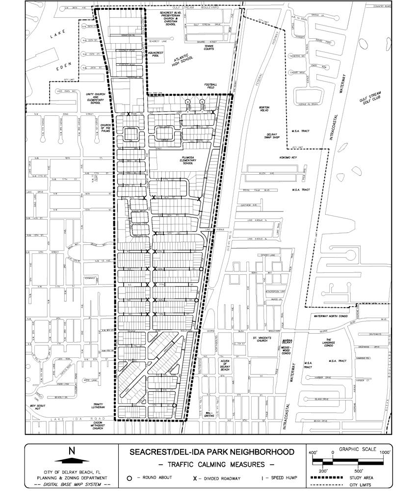
10 PAGE 28
11 PAGE 29 There is a need for stricter enforcement of speed limits on NE 2 nd Avenue (Seacrest Boulevard) and Swinton Avenue as well as on local residential streets. Ban through truck traffic north of NE 4 th Street on Swinton and NE 2 nd Avenue (Seacrest Boulevard). Within this area, these are residential streets. This type of traffic should be using North Federal Highway, Congress Avenue, or I-95. Remove conflicting landscaping at the intersections where visibility is a problem. Require lawn maintenance companies to park in driveways where possible to avoid blocking traffic. Install improved signage to route people around the neighborhood to Federal Highway. Convert Lake Court back to two-way traffic flow. Pedestrian Traffic Circulation. Damaged sidewalks or lack of sidewalks on major roadways discourages walking around the neighborhood. Policy E-3.3 of the Public Facilities Element of the Comprehensive Plan states as follows: The City shall program installation of sidewalks on an annual basis, with the goal of completing a safe and convenient sidewalk system throughout the City by the year In reviewing the need for sidewalks within the Seacrest/Del-Ida Park neighborhood with residents, it was determined that sidewalks are only wanted on the major roadways within the neighborhood. Installation of sidewalks on many of the local residential streets would require the removal of a significant amount of old-growth vegetation, fences and walls. In blocks where a significant number of duplexes exist, the installation of sidewalks is difficult due to the large amount of back-out parking on the roadway. In both of these areas, the installation of traffic calming measures will slow traffic to a point where walking in the roadway will be relatively safe. The sidewalk system should be repaired and completed on the major roadways around the periphery of the neighborhood. Higher traffic volumes and vehicle speeds in these areas make it too dangerous to walk in the roadway. The installation of sidewalks will enable residents to safely walk from one area of the neighborhood to another. The proposed walkway system for the neighborhood is depicted on the Sidewalk System Map (Figure 18, page 30). An inventory of damaged or missing segments should be prepared as soon as possible. The Homeowners Associations have agreed to participate in this task. Repair of existing walks and installation of new walks should be included as part of an overall streetscape program for the neighborhood. Public Transportation. Public Transportation in the area has been greatly enhanced by the recent improvements to Palm Tran service. The increased routes and shortened waiting times for buses has improved the accessibility and convenience of transit service to residents. Palm Tran may be supplemented by the establishment of the City s in-town shuttle service, which has been identified as a potential means of mitigating traffic in the City s Transportation Concurrency Exception Area (TCEA). The shuttle system is currently proposed to serve primarily the downtown area, but additional links to North Federal Highway and adjacent neighborhoods could be considered if warranted. Streetscape It is recommended that streetscape improvements be made to the neighborhood which includes additional street lights, street trees, repair of damaged sidewalks, the addition of new sidewalks, removal of illegal onstreet parking, and the reconstruction of drainage swales. The Homeowners Associations should be involved in the location and design of all new facilities. Funding for the project would be shared by the City, CRA and the property owners. It is recommended that the neighborhood create a property improvement district which, in turn, would be the legal entity with which the City would create a partnership. The formation of a property improvement district would give the owners a collective voice in improving their neighborhood. The district would contribute a portion of the moneys needed to pay for the improvements. The swale areas, which by city code are the maintenance responsibility of the abutting property owners, are in poor condition in a large portion of the neighborhood. Over time these swales have filled up with soil to the point where they have lost the ability to carry stormwater runoff. Additionally, a significant amount of swale area has been paved to provide onstreet parking. This creates a visual highway effect on residential roadways and leads to speeding. Regrading these swales and adding sod and street trees will reduce speeding, discourage on-street parking and improve area drainage.
12 PAGE 30
13 PAGE 31 Once these swales are improved, a program should be developed to ensure that they are adequately maintained. Since this effects the appearance of the neighborhood as a whole, the Homeowners Associations should be given primary responsibility for the program. The program should include the following components: Weekly inspections by the association and annual inspections by the City. facility will undoubtedly exacerbate the problem, it is important to improve the parking layout as soon as possible. The preliminary design in Figure 19 is one example of how this parking lot could be redesigned to address the traffic circulation problems at the intersection. Figure 19 Parking Lot Design Alternative Dominos Pizza/Convenience Store Swale maintenance education for homeowners and tenants conducted by the association. Mowing and clean-up by the association when property owners fail to do so. Code enforcement action by the City when necessary. Public Parking Lots As part of the overall streetscape program for the neighborhood, it is recommended that the CRA acquire one or more lots on each block within the higher density duplex/multi-family areas. These lots will be used for the construction of off-street parking lots for the residents. This will help alleviate many of the problems associated with the large number of back-out parking spaces on the street and provide opportunities to install additional landscaping and drainage. A Preliminary Streetscape & Parking Plan, (Figure 20, page 32) illustrates a possible scheme for two blocks in this area of the neighborhood. As shown on this plan, the provision of new off-street parking on each block significantly reduces the amount of additional pavement adjacent to the roadway. Except for driveway entrances, and allowed back-out parking spaces, all additional pavement in the right-ofway will be eliminated. Duplexes in close proximity to the new parking lot will be required to reduce their back-out parking to 1 space per unit. Duplexes further from the lot will be allowed 2 back-out spaces per unit. The installation of street trees and green areas will enhance the area, reduce speeding and improve drainage. Traffic calming measures and additional lighting are also included in the design. NE 22 nd Street/Seacrest Boulevard Intersection As stated in the Existing Conditions section, the existing parking layout for the Dominos Pizza and Convenience Store at the intersection of NE 22 nd Street and Seacrest Boulevard creates a hazard at the intersection. Since construction of the Seacrest Athletic Water And Sewer Service Water service is provided to properties throughout the study area. While some extensions may be needed to serve vacant properties, no extensions or upgrades are required for existing developments. Sewer service is provided to properties throughout the neighborhood. No upgrades will be required to serve existing development. Extensions may be required with new development of vacant parcels. According to the Comprehensive Plan, the City's water treatment plant and the South Central Wastewater Treatment Facility will both be operating under capacity at build-out. This Neighborhood Plan will not significantly affect the overall demand for water and sewer service in the City. Storm Water Collection Since the neighborhood area currently lacks positive drainage, any new development or redevelopment must control run-off so that existing properties are not

14 PAGE 32
15 PAGE 33 negatively impacted. This impact is addressed with approval of project site plans. The Stormwater Master Plan has identified portions of the neighborhood as problem and flood prone areas. Recommended improvements in the plan include a storm sewer system with main trunk line along NE 3 rd Avenue and George Bush Boulevard and outfall to the Intracoastal Waterway. In order to meet water quality regulations, an appropriate amount of retention or detention is also required for storage of the first 1 of stormwater runoff prior to discharge. The amount of land required for dry detention in the neighborhood is 4.8 acres. When adequate land area is not available, this number can be reduced by utilizing exfiltration trenches. By utilizing dry detention areas without permanent ponding, there is an opportunity to provide for recreational uses between storms. The City has already purchased one parcel, located at the northeast corner of NE 3 rd Avenue and NE 14th Street for this purpose. This parcel which will double as a passive park. It is the first parcel to be acquired in the multi-family area along the railroad. The overall project improvements proposed by the Stormwater Master Plan are not currently programmed in the City s 5-Year Capital Improvements Plan. However, the City has budgeted $275,000 in FY 1998/99 for drainage improvements in the area. Electrical Distribution And Street Lighting Electrical service is provided throughout the neighborhood area. No upgrades are required at this time. Street lighting improvements are recommended for the entire neighborhood. The installation of additional street lighting can be accomplished by Florida Power and Light at no cost to the City. The City would, however, assume responsibility for the costs of operating the lights. Requests for improved lighting can also be handled on a case-by-case basis as problems are reported to the Environmental Services Department. This Plan also recommends development of a program to provide additional exterior lighting on private property. Under this program, the City and CRA would share the cost with individual property owners to install a decorative pole light in the front yard. Photo cells would be installed in each fixture to ensure that the lights are activated each night. These lights would improve security in the neighborhood by filling in the dark spots between street lights. It is estimated that the fixture and installation would cost between $400 and $500 per light. The program should be bid on a per light basis and installed in quantities of 5 to 10 at a time to reduce costs. The cost to each resident who wishes to participate in the program would be the same. It is recommended that the homeowners pay one-half the cost and that the CRA and the City each pay one-quarter. F.E.C. Railroad Buffer The appearance of the adjacent railroad right-of-way and Dixie Highway has a serious impact on the neighborhood. The CRA will use a portion of the tax increment generated by new development and redevelopment of the North Federal Highway corridor for landscape buffers along the railroad. The project would include landscaping and irrigation along the Railroad, between George Bush Boulevard and NE 14 th Street. Existing trees and other landscaping will be accommodated within the design. FIRE PROTECTION The Delray Beach Fire Department indicates that existing fire stations are sufficient to provide adequate response times and service to existing development. The City will monitor the need for fire protection as new development or redevelopment is proposed. CODE ENFORCEMENT ACTIVITIES Deteriorating structures, peeling paint, litter and overgrown and unkempt vegetation can have a devastating effect on a neighborhood. Neglect can lead to blight, decay, decreased property values and loss of neighborhood pride. Code enforcement compels the care and upkeep of private property, including the exterior structure and surrounding yard. It is recommended that the code enforcement efforts be concentrated in the areas of the neighborhood with the worst physical conditions. This includes the area east of NE 2 nd Avenue (Seacrest Boulevard), between George Bush Boulevard and NE 13 th Street and the area along the railroad tracks, north of NE 14 th Street. The City will continue to implement special outreach programs to help new residents understand applicable codes and ordinances regarding lawn maintenance, trash disposal, parking, etc. It is recommended that the homeowners associations work with the City to help educate neighborhood residents. Information included in newsletters or flyers as well as a door-to-door canvassing of the neighborhood to explain these
16 PAGE 34 programs would help the City to reduce violations and improve the neighborhood. CRIME MANAGEMENT AND PUBLIC SAFETY The Police Department has initiated a number of programs intended to reduce crime problems in the neighborhood. The following programs are included in the overall crime reduction strategy. Community Policing The cornerstone of Police Department efforts to reduce crime in Delray Beach is the Community Policing program. Community Policing emphasizes a cooperative effort between the police and the community to find long term solutions to the community s problems. Community Policing is intended to both increase the police presence in the neighborhood and improve relations between the department and residents. This is a departure from past police methods which emphasized officers in patrol cars reporting to emergency radio calls. In addition to routine patrol activity, the Community Officers help to organize community improvement activities, such as trash pick-ups, paint-up projects and organization of neighborhood watches. Citizens on Patrol (COPS) As a supplement to the police patrols, this program utilizes citizens in marked vehicles to patrol their own neighborhood. This fills in the voids left by the police patrols and greatly improves security. The COPS program is currently in effect in the area of the neighborhood north of George Bush Boulevard. It is run by the Seacrest Homeowners Association. The area south of George Bush Boulevard is within the Del-Ida Park Homeowners Association and does not participate in the program. Since the effect of crime on an area does not respect these boundaries, it is recommended that the two groups combine and participate jointly. DILAPIDATED STRUCTURES AND BLIGHTED PROPERTIES Dilapidated structures can give an area a blighted appearance, which discourages investment in adjacent properties. Therefore, the City will continue to evaluate poorly maintained and abandoned structures to determine if they should be demolished. This issue is addressed in Objective A-9 of the Housing Element of the Comprehensive Plan: In order to eliminate blighting and unsafe conditions in its neighborhoods, the City will ensure that housing units which cannot be effectively rehabilitated will be demolished. The CRA Community Redevelopment Plan includes a recommendation for acquisition of deteriorated properties within the neighborhood, subject to available funds. These properties impede the revitalization effort by creating an image of blight. The plan would target those properties which have a severe blighting influence on the entire area. For example, the four multi-family apartment buildings on NE 3 rd Avenue are a priority acquisition. The intent of this neighborhood plan is to use eminent domain sparingly, however, due of the serious impediment to revitalization imposed by dilapidated properties, the CRA may pursue acquisition of selected properties if private sector initiatives do not eliminate them within a reasonable time. As stated earlier, it is also recommended that the CRA acquire one or more properties on each block in the duplex/multi-family areas in order to provide offstreet parking for the residents on the block. PARKS AND RECREATION As described in the Existing Conditions section, the nearest public parks to the study area are the public beach and Veteran s Park, both approximately 2 miles from the neighborhood. As a long-term goal, the CRA is exploring the possibility of creating a linear park along the railroad tracks adjacent to NE 3 rd Avenue. This park would provide opportunities for passive recreation in the area and create a buffer between the railroad and the single-family neighborhood to the west. The park would also enable the City to provide additional stormwater retention in the area. Construction of the park could be financed in part by the parks and recreation impact fees and tax increment revenues generated by new development and redevelopment in the area and along the North Federal Highway corridor. In moving toward this long-term goal, the CRA should be prepared to purchase any properties in this area that become available in the short-term. FIRST STEPS Immediately following the adoption of this plan, processing of the Comprehensive Plan amendments, Future Land Use Map amendments, Land Development Regulations text amendments and rezonings required to implement the plan will begin. The CRA s Community Redevelopment Plan will also
17 PAGE 35 need to be revised to include the projects and programs included in the Neighborhood Plan. Members of the Homeowners Associations who have participated in the development of this Plan should begin to meet with other neighborhood residents to discuss the provisions of the Plan and gather support for the Special Assessment District. Since the capital improvements included in the Plan are not yet included in the 5-Year Capital Improvement programs for either the City or the CRA, these budgets will need to be amended and dollars allocated for the various projects. Implementation of the capital improvements included in the Plan will first require the preparation of land surveys. This work element should be scheduled as soon as possible. When the surveys are completed, the engineering, design and detailed cost estimates of individual projects can begin as time and funding becomes available. Other new programs contained in the plan will be developed and implemented as opportunities arise and funding becomes available. FUNDING SOURCES The City and CRA will provide whatever support is available to assist in the implementation of this Neighborhood Plan. Funding for some public improvements may be available from the City or through the CRA s tax increment generated by new development and redevelopment in the neighborhood and in the N. Federal Highway corridor. Other improvements may be financed in part through the establishment of one or more special assessment districts created pursuant to the neighborhood plan. The CRA will expend funds on behalf of the neighborhood in order to create the required Special Assessment Districts. Preliminary cost estimates for improvements included in this plan are provided in Table 7, page 36.
18 PAGE 36 Table 7 Seacrest/Del-Ida Park Neighborhood Plan Preliminary Cost Estimates ITEM UNITS QUANTITY UNIT COST TOTAL COST I. F.E.C. Rail Corridor Beautification (Between George Bush Boulevard and NE 14th Street) Trees (30' O.C.) each 58 $ $ 11, Hedge (3' O.C.) each 583 $ 8.00 $ 4, Irrigation L.F. 1,750 $ $ 17, Survey & Design (10%) $ 3, TOTAL $ 37, II. Del-Ida Park Parking Lot for RO District Land Cost (70' x 120' Lot) lot 1 $ 50, $ 50, Parking Lot Construction space 20 $ 2, $ 40, Survey & Design (10%) $ 9, TOTAL $ 99, III. Parking Lots for Duplexes Land Cost lots 7 $ 95, $ 665, Parking Lot Construction space 91 $ 2, $ 182, Survey & Design (10%) $ 18, TOTAL $ 865, IV. Streetscape - Dell Park East (9th -13th street) & NE 3rd Avenue(North of 14th Street) 13,500 Linear Feet Roadway (Both Sides) Reconstruct Driveway Aprons/Parking Sq. Ft. 40,000 $ 3.50 $ 140, Curbs for Landscape islands L.F. 3,000 $ $ 30, Trees (30' O.C. Average) each 450 $ $ 90, Remove Asphalt & Regrade 14' Swales Sq. Ft. 189,000 $ 1.00 $ 189, Survey, Design, Engineering (10%) $ 44, TOTAL $ 493, V. Streetscape (remaining neighborhood roadways) 28,000 Linear Feet Roadway (Both Sides) Trees (30' O.C.) each 933 $ $ 186, Sod/Regrade14' Swales Sq. Ft. 392,000 $ 0.50 $ 196, Survey, Design, Engineering (10%) $ 38, TOTAL $ 420, VI. Traffic Calming Speed Humps each 57 $ 1, $ 85, Round-abouts each 2 $ 5, $ 10, Divided roadway medians each 15 $ 5, $ 75, TOTAL $ 170, VII. VIII. Sidewalks 18,000 Linear Feet, 5 feet wide Sq. Ft. 90,000 $ 2.00 $ 180, TOTAL $ 180, Decorative Post Light Program (50% incentive contribution) (10% of Single Family & Duplex Bldgs) each 67 $ $ 16, TOTAL $ 16, GRAND TOTAL $ 2,283,350.00
THE REDEVELOPMENT PLAN
 PAGE 37 THE REDEVELOPMENT PLAN FUTURE LAND USE The Silver Terrace Redevelopment Area is currently designated as Redevelopment Area #4 on the City of Delray Beach Future Land Use Map (FLUM). This designation
H-POLICY 1: Preserve and improve existing neighborhoods. Ensure that Prince William County achieves new neighborhoods with a high quality of life.
 HOUSING Intent The intent of the Housing Plan is to provide a framework for providing for the housing needs of all residents of Prince William County. These needs are expressed in terms of quality, affordability,
Village of Port Jefferson Urban Renewal Plan
 Urban Renewal Plan Village of Port Jefferson Urban Renewal Plan Port Jefferson, New York PREPARED FOR Village of Port Jefferson Village Board 121 West Broadway Port Jefferson, NY 11777 631.473.4724 PREPARED
CHAPTER V: IMPLEMENTING THE PLAN
 CHAPTER V: IMPLEMENTING THE PLAN A range of resources is available to fund the improvements included in the Action Plan. These resources include existing commitments of County funding, redevelopment-related
Chapter 10: Implementation
 Chapter 10: Introduction Once the Comprehensive Plan has been adopted by the City of Oakdale, the City can begin to implement the goals and strategies to make this vision a reality. This chapter will set
Town of Yucca Valley GENERAL PLAN 1
 Town of Yucca Valley GENERAL PLAN 1 This page intentionally left blank. 3 HOUSING ELEMENT The Housing Element is intended to guide residential development and preservation consistent with the overall values
HOUSING ELEMENT I. GOALS, OBJECTIVES AND POLICIES
 HOUSING ELEMENT I. GOALS, OBJECTIVES AND POLICIES GOAL 1: IN ORDER TO ACHIEVE A BALANCED HOUSING SUPPLY (AND A BALANCED POPULATION AND ECONOMIC BASE), EVERY EFFORT SHOULD BE MADE TO PROVIDE A BROAD RANGE
City of St. Petersburg, Florida Consolidated Plan. Priority Needs
 City of St. Petersburg, Florida 2000-2005 Consolidated Plan Priority Needs Permanent supportive housing and services for homeless and special needs populations. The Pinellas County Continuum of Care 2000
FUTURE LAND USE. City of St. Augustine Comprehensive Plan EAR-Based Amendments
 FUTURE LAND USE City of St. Augustine Comprehensive Plan EAR-Based Amendments Future Land Use Element FLU Goal To create an environment within the City and adjacent areas in which its residents have the
GUIDELINES AND CRITERIA. For Granting Tax Abatement in the North Killeen Revitalization Area. Designated by the City of Killeen, Texas
 GUIDELINES AND CRITERIA For Granting Tax Abatement in the North Killeen Revitalization Area Designated by the City of Killeen, Texas Under Tax Code, Chapter 312 I. PURPOSE The designation of a Tax Abatement
PROPOSED AMENDMENTS TO THE DERBY ZONING REGULATIONS AUGUST 12, 2008
 ARTICLE II Definitions and word usage 195-7. Definitions and word usage. Modify the following: HOUSING FOR THE ELDERLY OLDER PERSONS Housing in accordance with and as defined in the United States Fair
Section 1: US 19 Overlay District
 Section 1: US 19 Overlay District Section 1.1 Intent and Purpose The purpose of the US Highway 19 Overlay District is to manage access to land development along US Highway 19 in a manner that preserves
ANNUAL ELEMENT PROGRESS REPORT Housing Element Implementation (CCR Title ) Table A
 Table A") ANNUAL ELEMENT PROGRESS REPORT Housing Element Implementation (CCR Title 25 622 ) Jurisdiction City of Escondido Reporting Period 1/1/217-12/31/217 Table A Annual Building Activity Report Summary - New
ANNUAL ELEMENT PROGRESS REPORT Housing Element Implementation (CCR Title 25 622 ) Jurisdiction City of Escondido Reporting Period 1/1/217-12/31/217 Table A Annual Building Activity Report Summary - New
Downtown Development Focus Area: I. Existing Conditions
 Downtown Development Focus Area: I. Existing Conditions The Downtown Development Focus Area is situated along Route 1, south of the train tracks, except for the existing Unilever property. It extends west
HOUSING ELEMENT OF THE CITY OF PEMBROKE PINES COMPREHENSIVE PLAN ADOPTION DOCUMENT
 HOUSING ELEMENT OF THE CITY OF PEMBROKE PINES COMPREHENSIVE PLAN RULES 9J-5.010, FAC City of Pembroke Pines, Florida ADOPTION DOCUMENT HOUSING ELEMENT HOUSING ELEMENT ADOPTION DOCUMENT VI. GOALS, OBJECTIVES
HOUSING OVERVIEW. Housing & Economic Development Strategic Plan for Takoma Park Presented by Mullin & Lonergan Associates February 26,2018
 HOUSING OVERVIEW Housing & Economic Development Strategic Plan for Takoma Park Presented by Mullin & Lonergan Associates February 26,2018 Overarching Themes & Underlying Bases Takoma Park strives to be
Draft Model Access Management Overlay Ordinance
 Draft Model Access Management Overlay Ordinance This model was developed using the City of Hutchinson and the Trunk Highway 7 corridor. The basic provisions of this model may be adopted by any jurisdiction
CITY PLANNING COMMISSION COMPREHENSIVE PLAN AND REVIEW CRITERIA
 Page 3 CITY PLANNING COMMISSION COMPREHENSIVE PLAN AND REVIEW CRITERIA COMPREHENSIVE PLAN: The City Planning Commission uses the Comprehensive Plan as a guide in all land use matters. The Plan is available
HOUSING ELEMENT GOALS, OBJECTIVES, AND POLICIES
 HOUSING ELEMENT GOALS, OBJECTIVES, AND POLICIES GOAL 1: To promote the preservation and development of high-quality, balanced, and diverse housing options for persons of all income levels throughout the
Short Title: Performance Guarantees/Subdivision Streets. (Public) April 28, 2016
 April 28, 2016") GENERAL ASSEMBLY OF NORTH CAROLINA SESSION S SENATE BILL Transportation Committee Substitute Adopted // House Committee Substitute Favorable // Fourth Edition Engrossed // Short Title: Performance Guarantees/Subdivision
GENERAL ASSEMBLY OF NORTH CAROLINA SESSION S SENATE BILL Transportation Committee Substitute Adopted // House Committee Substitute Favorable // Fourth Edition Engrossed // Short Title: Performance Guarantees/Subdivision
Downtown Meridian Urban Renewal Area URBAN RENEWAL ELIGIBILITY REPORT. Prepared for The City of Meridian and The Meridian Development Corporation
 Downtown Meridian Urban Renewal Area URBAN RENEWAL ELIGIBILITY REPORT Prepared for The City of Meridian and The Meridian Development Corporation by McKibben + Cooper Architects June 19, 2002 Authorization
1. Cuyler-Brownsville planned neighborhood conservation (P-N-C) districtphase I (section ). (2) Single-family semiattached dwellings;
 districtphase I (section ). (2) Single-family semiattached dwellings;") Sec. 8-3035. Planned unit development multifamily (PUD-M). A. Purpose. The PUD-M district is intended to allow a variety of residential development including single-family residential, two-family residential,
Sec. 8-3035. Planned unit development multifamily (PUD-M). A. Purpose. The PUD-M district is intended to allow a variety of residential development including single-family residential, two-family residential,
TOOELE COUNTY LAND USE ORDINANCE CHAPTER 31 Page 1
 CHAPTER 31 PLANNED COMMUNITY ZONE (P-C) Section 31-1 Definitions. 31-2 Purpose. 31-3 Land use districts. 31-4 P-C zone area minimum requirements. 31-5 Permitted uses. 31-6 Conditional uses. 31-7 Planning
SECTION 7000 LAND DEVELOPMENT REQUIREMENTS
 SECTION 7000 LAND DEVELOPMENT REQUIREMENTS 7000 LAND DEVELOPMENT REQUIREMENTS... 1 7001 LEGISLATIVE AUTHORITY... 1 7001.1 LAND DEVELOPMENT... 1 7001.1.1 Title 40, Idaho Code... 1 7001.1.2 Idaho Code 40-1415
HOMESTEAD PLAN. City of Buffalo
 HOMESTEAD PLAN City of Buffalo CITY OF BUFFALO Byron W. Brown, Mayor Elizabeth A. Ball, Deputy Mayor BUFFALO URBAN RENEWAL AGENCY Brendan R. Mehaffy, Vice Chairman Jennifer L. Beltre, Community Planner
Goals, Objectives and Policies
 Goals, Objectives and Policies 1. GOAL SUPPORT THE PROVISION OF DECENT, SAFE AND SOUND HOUSING IN A VARIETY OF TYPES, SIZES, LOCATIONS AND COSTS TO MEET THE NEEDS OF CURRENT AND FUTURE RESIDENTS OF UNINCORPORATED
Community Development Block Grant (CDBG)
") Community Development Block Grant (CDBG) Following is a summary of regulations at 24 CFR 570, which may be found at http://www.access.gpo.gov/nara/cfr/waisidx_08/24cfr570_08.html The primary objective
Community Development Block Grant (CDBG) Following is a summary of regulations at 24 CFR 570, which may be found at http://www.access.gpo.gov/nara/cfr/waisidx_08/24cfr570_08.html The primary objective
City of Oakland Programs, Policies and New Initiatives for Housing
 City of Oakland Programs, Policies and New Initiatives for Housing Land Use Policies General Plan Update In the late 1990s, the City revised its general plan land use and transportation element. This included
ARTICLE 14 PLANNED UNIT DEVELOPMENT (PUD) DISTRICT
 DISTRICT") ARTICLE 14 PLANNED UNIT DEVELOPMENT (PUD) DISTRICT Section 14.01 Intent. It is the intent of this Article to allow the use of the planned unit development (PUD) process, as authorized by the Michigan Zoning
ARTICLE 14 PLANNED UNIT DEVELOPMENT (PUD) DISTRICT Section 14.01 Intent. It is the intent of this Article to allow the use of the planned unit development (PUD) process, as authorized by the Michigan Zoning
NORTHWEST QUADRANT NEIGHBORHOOD STUDY
 City of Novato General Plan 2035 Focus Area NORTHWEST QUADRANT NEIGHBORHOOD STUDY May, 2015 Why a Neighborhood Study? The Northwest Quadrant Neighborhood, north of the Grant Avenue business district,
13 Sectional Map Amendment
 13 Sectional Map Amendment Introduction This chapter reviews land use and zoning policies and practices in Prince George s County and presents the proposed zoning in the sectional map amendment (SMA) to
DESCRIPTION OF THE DISTRICT
 DESCRIPTION OF THE DISTRICT The project plan for City of Wausau, Tax Increment District #11 has been prepared in compliance with Wisconsin Statutes Chapter 66.1105(4). The plan establishes the need for
Salem HNA and EOA Advisory Committee Meeting #6
 Salem HNA and EOA Advisory Committee Meeting #6 Residential Land Policies Employment Land Policies Policy Discussions with the Committee Outcome of today s meeting Direction from this Committee on proposed
Salem Township Zoning Ordinance Page 50-1 ARTICLE 50.0: PUD PLANNED UNIT DEVELOPMENT
 Salem Township Zoning Ordinance Page 50-1 ARTICLE 50.0 PLANNED UNIT DEVELOPMENT Section 50.01 Purpose The provisions of this Article provide enabling authority and standards for the submission, review,
Affordable Housing Plan
 Affordable Housing Plan CORDOVA HILLS SPECIAL PLANNING AREA 1 Proposed Project Conwy LLC is the master developer ( Master Developer ) of that certain real property in the County of Sacramento ( County
Housing and Economic Development Strategic Plan for Takoma Park OCTOBER 18, 2017
 Housing and Economic Development Strategic Plan for Takoma Park OCTOBER 18, 2017 1 Three Part Process Housing and Economic Data Analysis SWOT Analysis: Strengths, Weaknesses, Opportunities and Threats
TOTTENHAM SECONDARY PLAN
 TOTTENHAM SECONDARY PLAN AMENDMENT NO. 11 TO THE OFFICIAL PLAN OF THE TOWN OF NEW TECUMSETH The following text and schedules to the Official Plan of the Town of New Tecumseth constitute Amendment No. 11
HOUSING ELEMENT. 3. group and foster home construction. 1. increase the supply of new affordable housing with: a regional housing trust fund;
 Goal 8.0. Facilitate an adequate supply of decent, safe, and sanitary housing in suitable neighborhoods, including housing for special needs populations; available in a range of housing types, architectural
CHAPTER XVIII SITE PLAN REVIEW
 CHAPTER XVIII SITE PLAN REVIEW Section 18.1 Section 18.2 Description and Purpose. The purpose of this chapter is to provide standards and procedures under which applicants would submit, and the Township
EVALUATION AND APPRAISAL REPORT OF THE CITY OF FELLSMERE COMPREHENSIVE PLAN APPENDIX D HOUSING ELEMENT
 OBJECTIVE H-A-1: ALLOW AFFORDABLE HOUSING AND ADEQUATE SITES FOR VERY LOW, LOW, AND MODERATE INCOME HOUSING. The City projects the total need for very low, low, and moderate income-housing units for the
1.0 Introduction. November 9, 2017
 November 9, 2017 Andrew Bone, Planner III Regional Planning Policy and Strategic Initiatives Halifax Regional Municipality 40 Alderney Drive Dartmouth, NS, B2Y 2N5 Subject: Application to amend the Bedford
PALM BEACH COUNTY PLANNING, ZONING AND BUILDING DEPARTMENT ZONING DIVISION ZONING COMMISSION VARIANCE STAFF REPORT 06/07/2012
 PALM BEACH COUNTY PLANNING, ZONING AND BUILDING DEPARTMENT ZONING DIVISION ZONING COMMISSION VARIANCE STAFF REPORT 06/07/2012 APPLICATION NO. CODE SECTION REQUIRED PROPOSED VARIANCE ZV-2009-03300 Variance
EXCERPTS FROM HALIFAX REGIONAL MUNICIPALITY CHARTER
 EXCERPTS FROM HALIFAX REGIONAL MUNICIPALITY CHARTER Municipal planning strategy 227 The Council may adopt a municipal planning strategy for all, or part, of the Municipality and there may be separate strategies
Composition of traditional residential corridors.
 Page 1 of 7 St. Petersburg, Florida, Code of Ordinances >> PART II - ST. PETERSBURG CITY CODE >> Chapter 16 - LAND DEVELOPMENT REGULATIONS >> SECTION 16.20.060. CORRIDOR RESIDENTIAL TRADITIONAL DISTRICTS
ARTICLE 887. PD 887. Valley View - Galleria Area Special Purpose District
 ARTICLE 887. PD 887. Valley View - Galleria Area Special Purpose District SEC. 51P-887.101. LEGISLATIVE HISTORY. PD 887 was established by Ordinance No. 29032, passed by the Dallas City Council on June
Public Facilities and Finance Element
 This Element of the General Plan addresses the following public facilities issues: Water Service, including both potable (drinkable) and non-potable water delivery. Sewer Service, and Financing and construction
CITY OF COLD SPRING ORDINANCE NO. 304
 CITY OF COLD SPRING ORDINANCE NO. 304 AN ORDINANCE AMENDING THE CITY CODE OF COLD SPRING BY ADDING SECTIONS 555 AND 510 PERTAINING TO PAYMENT-IN-LIEU-OF-PARKING THE CITY COUNCIL OF THE CITY OF COLD SPRING,
Housing. Approved and Adopted by City Council November 13, City Council Resolution City Council Resolution
 5 Housing Approved and Adopted by City Council November 13, 2018 Chapter 5 Housing 5.1 City Council Resolution 2018-096 5.2 Fontana General Plan CHAPTER 5 Housing This chapter of the General Plan Update
PLANNING COMMISSION REPORT Regular Agenda -Public Hearing Item
 PDP-13-00518 Item No. 3B- 1 PLANNING COMMISSION REPORT Regular Agenda -Public Hearing Item PC Staff Report 2/24/14 ITEM NO. 3B PRELIMINARY DEVELOPMENT PLAN FOR HERE @ KANSAS; 1101 INDIANA ST (SLD) PDP-13-00518:
Request Conditional Rezoning (B-2 Community Business to Conditional A-24 Apartment) Staff Recommendation Approval. Staff Planner Ashby Moss
 Staff Recommendation Approval. Staff Planner Ashby Moss") Applicant Management & Development, LLC Property Owner School Board of the City of Virginia Beach Public Hearing January 10, 2018 City Council Election District Kempsville Agenda Item 5 Request Conditional
Applicant Management & Development, LLC Property Owner School Board of the City of Virginia Beach Public Hearing January 10, 2018 City Council Election District Kempsville Agenda Item 5 Request Conditional
Bowie Marketplace Residential Detailed Site Plan Statement of Justification January 13, 2017 Revised February 2, 1017
 Bowie Marketplace Residential Detailed Site Plan Statement of Justification January 13, 2017 Revised February 2, 1017 Submitted on behalf of: BE Bowie LLC 5410 Edson Lane, Suite 220 Rockville, MD 20852
City of Grande Prairie Development Services Department
 City of Grande Prairie Development Services Department COUNTRYSIDE SOUTH OUTLINE PLAN Prepared by: GPEC Consulting Ltd. #202, 10712-100th Street Grande Prairie, AB Council Resolution of August 20, 2001
3.1. OBJECTIVES FOR RESIDENTIAL LAND USE DESIGNATIONS GENERAL OBJECTIVES FOR ALL RESIDENTIAL DESIGNATIONS
 3. RESIDENTIAL LAND USE DESIGNATIONS INTRODUCTION The Residential land use designations provide for housing and other land uses that are integral to, and supportive of, a residential environment. Housing
Indicates Council-recommended changes Introduced by: Mr. Tackett Date of introduction: June 14, 2016 SUBSTITUTE NO. 1 TO ORDINANCE NO.
 Indicates Council-recommended changes Introduced by: Mr. Tackett Date of introduction: June 14, 2016 SUBSTITUTE NO. 1 TO ORDINANCE NO. 16-067 TO AMEND NEW CASTLE COUNTY CODE CHAPTER 40 (ALSO KNOWN AS THE
EXECUTIVE SUMMARY. The following are the key recommendations of the neighborhood revitalization strategy:
 EXECUTIVE SUMMARY The primary goal of the neighborhood strategic plan is to create a diverse, pedestrian friendly, safe, and closely-knit neighborhood while maintaining the appropriate scale and design.
The following regulations shall apply in the R-E District:
 "R-E" RESIDENTIAL ESTATE DISTRICT (8/06) The following regulations shall apply in the R-E District: 1. Uses Permitted: The following uses are permitted. A Zoning Certificate may be required as provided
INDIAN RIVER COUNTY, FLORIDA. The Honorable Members of the Planning and Zoning Commission DEPARTMENT HEAD CONCURRENCE
 Public Hearing Legislative INDIAN RIVER COUNTY, FLORIDA M E M O R A N D U M TO: The Honorable Members of the Planning and Zoning Commission DEPARTMENT HEAD CONCURRENCE Robert M. Keating, AICP; Community
7. IMPLEMENTATION STRATEGIES
 7. IMPLEMENTATION STRATEGIES A. GENERAL APPROACH FOR IMPLEMENTATION Implementing the plan will engage many players, including the Municipality of Anchorage (MOA), the Government Hill Community Council,
Summary. Draft Redevelopment Plan Summary Flowery Branch Tax Allocation District # 1:
 Summary Draft Redevelopment Plan Summary Flowery Branch Tax Allocation District # 1: Flowery Branch Tax Allocation District Old Town and Commercial Gateways 1 Public Hearing Presentation November 21, 2007
NC General Statutes - Chapter 153A Article 15 1
 Article 15. Public Enterprises. Part 1. General Provisions. 153A-274. Public enterprise defined. As used in this Article, "public enterprise" includes: (1) Water supply and distribution systems. (2) Wastewater
ADUs and You! Common types of ADUs include mother-in-law suite, garage apartments and finished basements.
 ADUs and You! Accessory Dwelling Units Town of Lyons Accessory Dwelling Units (ADUs) are a form of housing that can be an important tool for diversifying and increasing the local housing stock. Lyons lost
Grantee: Broward County, FL Grant: B-08-UN April 1, 2012 thru June 30, 2012 Performance Report
 Grantee: Broward County, FL Grant: B-08-UN-12-0002 April 1, 2012 thru June 30, 2012 Performance Report 1 Grant Number: Obligation Date: Award Date: B-08-UN-12-0002 Grantee Name: Contract End Date: Review
74af ANTELOPE VALLEY REDEVELOPMENT PLAN
 74af T. Telegraph District Phase 2: Telegraph Flats & Telegraph Lofts East 1. Project Area Description Phase 2 will include two building subphase areas with connecting streetscape enhancements: The Telegraph
July 1, 2014 thru September 30, 2014 Performance Report
 Grantee: Grant: Broward County FL B-11-UN-12-0002 July 1 2014 thru September 30 2014 Performance Report 1 Grant Number: B-11-UN-12-0002 Grantee Name: Broward County FL Grant Award Amount: $5457553.00 LOCCS
Moore Township Planning Commission 2491 Community Drive, Bath, Pennsylvania Telephone: FAX: Rev:12/23/2013
 2491 Community Drive, Bath, Pennsylvania Telephone: 610-759-9449 FAX: 610-759-9448 Rev:12/23/2013 APPLICATION FORM FOR A SITE PLAN PER MOORE TOWNSHIP ZONING ORDINANCE SECTION 200-58.1 NORTHAMPTON COUNTY,
Planning Justification Report
 Planning Justification Report 101 Kozlov Street, Barrie, Ont. Destaron Property Management Ltd. November 2015 Revised February 2017 TABLE OF CONTENTS Page 1.0 INTRODUCTION... 1 2.0 DESCRIPTION OF SUBJECT
STAFF REPORT. Guttman Development Group, LLC. PUD-R (Residential Planned Unit Development Plan)
") P a g e 1 STAFF REPORT CASE: APPLICANT: LOCATION: ZONED: REQUEST: ZC09-2017 Guttman Development Group, LLC 4990 Wilmington Pike PUD-R (Residential Planned Unit Development Plan) A Major Change to an Approved
P a g e 1 STAFF REPORT CASE: APPLICANT: LOCATION: ZONED: REQUEST: ZC09-2017 Guttman Development Group, LLC 4990 Wilmington Pike PUD-R (Residential Planned Unit Development Plan) A Major Change to an Approved
GENERAL PLAN UPDATE SPECIFIC AREAS OF THE CITY
 GENERAL PLAN UPDATE SPECIFIC AREAS OF THE CITY Background There are a total of 14 specific areas that are being reviewed as part of the update of the General Plan. Requests to review these areas came from
b. providing adequate sites for new residential development
 DIVISION 2.200 SECTION 2.201 INTRODUCTION A. Purpose The purpose of the Housing Element is to establish the goal, objectives, and policies to guide housing development within Polk County over the next
January 1, 2013 thru March 31, 2013 Performance Report
 Grantee: Pinellas County, FL Grant: B-11-UN-12-0015 January 1, 2013 thru March 31, 2013 Performance Report 1 Grant Number: B-11-UN-12-0015 Grantee Name: Pinellas County, FL Grant Amount: $4,697,519.00
DATE: February 28, Marilynn Lewis, Principal Planner
 DATE: February 28, 2007 TO: FROM: RE: Salt Lake City Planning Commission Marilynn Lewis, Principal Planner Planning Commission Hearing for Petition 400-06-41 Zoning Map Amendment to Rezone 6 Properties,
Appendix A. Definitions
 Definitions 1. Terms Defined. Words contained in this are those having a special meaning relative to the purposes of this Ordinance. Words not listed in this section shall be defined by reference to: (1)
ARTICLE VII. NONCONFORMITIES. Section 700. Purpose.
 ARTICLE VII. NONCONFORMITIES. Section 700. Purpose. The purpose of this chapter is to regulate and limit the development and continued existence of legal uses, structures, lots, and signs established either
October 1, 2012 thru December 31, 2012 Performance Report
 Grantee: Pinellas County, FL Grant: B-11-UN-12-0015 October 1, 2012 thru December 31, 2012 Performance Report 1 Grant Number: B-11-UN-12-0015 Grantee Name: Pinellas County, FL Grant Amount: $4,697,519.00
2. Our community wants to demolish some blighted properties. How can we meet a CDBG national objective with this activity?
 ENTITLEMENT CDBG PROGRAM FAQs ON MEETING A NATIONAL OBJECTIVE WITH ACQUISITION, DEMOLITION, AND DISPOSITION 1. What are the basic principles to meet eligibility and national objective requirements? As
Development Impact & Capacity Fees
 City of Petaluma, CA Development Impact & Capacity Fees October 2018 City of Petaluma City Manager s Office 11 English Street Petaluma, CA 94952 Web Page http://www.ci.petaluma.ca.us Revision Date : October
4.2 RESIDENTIAL ZONING DISTRICTS
 4.2 RESIDENTIAL ZONING DISTRICTS A. Purpose: To define regulations and standards for each residential zoning district in the City. The following sections identify uses, regulations, and performance standards
The Sadowski Act Local Housing Trust Fund
 The Sadowski Act SHIP Program: What s Happening Now The Sadowski Act Local Housing Trust Fund monies fund the local SHIP program in all 67 counties and 50 entitlement cities in Florida. Having a dedicated
PALM BEACH COUNTY PLANNING, ZONING AND BUILDING DEPARTMENT ZONING DIVISION
 PALM BEACH COUNTY PLANNING, ZONING AND BUILDING DEPARTMENT ZONING DIVISION Application No.: CA-2012-00688 Control No.: 2011-00552 Applicant: Garry Bernardo Owners: Garry Bernardo Agent: Frogner Consulting,
Administration and Calculation of Servicing Agreement Fees and Development Levies
 Administration and Calculation of Servicing Agreement Fees and Development Levies Policy Title: Applies to: Reference # Administration and Calculation of Servicing Agreement Fees and City of Regina ###-XXX-##
CITY CLERK. Consolidated Clause in Policy and Finance Committee Report 7, which was considered by City Council on July 19, 20, 21 and 26, 2005.
 CITY CLERK Consolidated Clause in Report 7, which was considered by City Council on July 19, 20, 21 and 26, 2005. 3 Regent Park Revitalization - Financial Strategy (Ward 28) City Council on July 19, 20,
July 1, 2017 thru September 30, 2017 Performance Report
 Grantee: Grant: Pinellas County, FL B-11-UN-12-0015 July 1, 2017 thru September 30, 2017 Performance Report 1 Grant Number: B-11-UN-12-0015 Grantee Name: Pinellas County, FL Grant Award Amount: $4,697,519.00
Affordable Housing Advisory Committee Review of Recommendations. Planning and Development Department Community Development Division March 10, 2015
 Affordable Housing Advisory Committee Review of Recommendations Planning and Development Department Community Development Division March 10, 2015 History of the State Housing Initiatives Partnership Program
PLANNING COMMISSION STAFF REPORT. Merrimac PLNSUB Planned Development 38 West Merrimac November 9, Request. Staff Recommendation
 PLANNING COMMISSION STAFF REPORT Merrimac PLNSUB2011-00374 Planned Development 38 West Merrimac November 9, 2011 Planning and Zoning Division Department of Community and Economic Development Applicant:
CITY OF EAU CLAIRE, WISCONSIN. SPECIAL ASSESSMENT POLICY (Dated: November 8, 2016)
") CITY OF EAU CLAIRE, WISCONSIN SPECIAL ASSESSMENT POLICY (Dated: November 8, 2016) (Adopted by reference by Ordinance No. 7207 adopted November 8, 2016) PURPOSE The purpose of this Policy is to assure fair
CITY OF EAU CLAIRE, WISCONSIN SPECIAL ASSESSMENT POLICY (Dated: November 8, 2016) (Adopted by reference by Ordinance No. 7207 adopted November 8, 2016) PURPOSE The purpose of this Policy is to assure fair
CHAPTER 5 RULES, RATES AND CHARGES FOR THE STORMWATER UTILITY SERVICE 1
 Change 8, April 1, 2008 19-47 CHAPTER 5 RULES, RATES AND CHARGES FOR THE STORMWATER UTILITY SERVICE 1 SECTION 19-501. Rules, rates, and charges adopted. 19-502. Findings. 19-503. Definitions. 19-504. Determination
HOUSING ELEMENT GOALS, OBJECTIVES, & POLICIES
 HOUSING ELEMENT GOALS, OBJECTIVES, & POLICIES GOAL H-1: ENSURE THE PROVISION OF SAFE, AFFORDABLE, AND ADEQUATE HOUSING FOR ALL CURRENT AND FUTURE RESIDENTS OF WALTON COUNTY. Objective H-1.1: Develop a
Route 6 Corridor Study Bristol Planning Commission Meeting #1. May 25, 2016 FITZGERALD & HALLIDAY, INC. Innovative Planning, Better Communities
 Route 6 Corridor Study Bristol Planning Commission Meeting #1 May 25, 2016 FITZGERALD & HALLIDAY, INC. Innovative Planning, Better Communities Today s Agenda 1. Introductions 2. Study overview Scope Schedule
LAND USE AND ZONING OVERVIEW
 OVERVIEW OF PLANNING POLICIES LAND USE AND ZONING OVERVIEW The Minneapolis Plan for Sustainable Growth and Other Adopted Plans Community Planning and Economic Development Development Services Division
PLANNED UNIT DEVELOPMENT & SUBDIVISION STAFF REPORT Date: April 18, 2019
 PLANNED UNIT DEVELOPMENT & SUBDIVISION STAFF REPORT Date: April 18, 2019 DEVELOPMENT NAME SUBDIVISION NAME Springhill Village Subdivision Springhill Village Subdivision LOCATION 4350, 4354, 4356, 4358,
Chapter 100 Planned Unit Development in Corvallis Urban Fringe
 100.100 Scope and Purpose. Chapter 100 Planned Unit Development in Corvallis Urban Fringe (1) All applications for land divisions in the Urban Residential (UR) and Flood Plain Agriculture (FPA) zones within
ARLINGTON COUNTY, VIRGINIA
 ARLINGTON COUNTY, VIRGINIA County Board Agenda Item Meeting of January 21, 2006 DATE: January 5, 2006 SUBJECT: Action on Proposed Amendments to provide for the achievement of affordable housing objectives
Proposed Development at Ajax Plaza Windcorp Grand Harwood Place Ltd.
 Proposed Development at Ajax Plaza Windcorp Grand Harwood Place Ltd. Presentation to Ajax Council July 4, 2013 Introduction 1. Background 2. Planning Policies and Regulations 3. Downtown Community Improvement
COMMERCIAL ELEMENT AND CODE ENFORCEMENT
 COMMERCIAL ELEMENT AND CODE ENFORCEMENT The Commercial Element identifies and describes the existing characteristics that are desired by the neighborhood. The existing conditions will determine appropriate
Cover Letter with Narrative Statement
 Cover Letter with Narrative Statement March 31, 2017 rev July 27, 2017 RE: Rushton Pointe Residential Planned Unit Development Application for Public Hearing for RPUD Rezone PL2015 000 0306 Mr. Eric Johnson,
CLASS 8-C: LAND USE CONTROLS AND PROPERTY DEVELOPMENT
 CLASS 8-C: LAND USE CONTROLS AND PROPERTY DEVELOPMENT LEARNING OBJECTIVES When you have finished reading this chapter in the text, you should be able to: Identify the various types of public and private
PLANNING AND ZONING COMMISSION AGENDA MEMORANDUM
 City and County of Broomfield, Colorado PLANNING AND ZONING COMMISSION AGENDA MEMORANDUM To: Planning and Zoning Commission From: John Hilgers, Planning Director Anna Bertanzetti, Principal Planner Meeting
4 LAND USE 4.1 OBJECTIVES
 4 LAND USE The Land Use Element of the Specific Plan establishes objectives, policies, and standards for the distribution, location and extent of land uses to be permitted in the Central Larkspur Specific
Administration and Calculation of Servicing Agreement Fees and Development Levies
 Administration and Calculation of Servicing Agreement Fees and Development Levies Policy Title: Applies to: Administration and Calculation of Servicing Agreement Fees and City of Regina City Planning and
PALM BEACH COUNTY PLANNING, ZONING AND BUILDING DEPARTMENT ZONING DIVISION
 PALM BEACH COUNTY PLANNING, ZONING AND BUILDING DEPARTMENT ZONING DIVISION Application No.: Z/CA-2013-00493 Application Name: Trails Charter School Control No.: 2013-00085 Applicant: MG3 ALF Military LLC