NOTICE OF MEETING OF THE PLANNING AND ZONING COMMISSION OF BUDA, TX 7:00 PM - Tuesday, February 28, S. Main Street Buda, TX 78610
|
|
|
- Roland Preston
- 5 years ago
- Views:
Transcription

1 NOTICE OF MEETING OF THE PLANNING AND ZONING COMMISSION OF BUDA, TX 7:00 PM - Tuesday, February 28, S. Main Street Buda, TX This notice is posted pursuant to the Texas Open Meetings Act. Notice is hereby given that a Regular P&Z Meeting Meeting of the City of Buda, TX, will be held at which time the following subjects will be discussed and may be acted upon. A. CALL TO ORDER A.1. Signed Agenda B. INVOCATION PZ Agenda signed.pdf C. PLEDGE OF ALLEGIANCE TO THE FLAGS OF THE UNITED STATES AND TEXAS PLEDGE OF ALLEGIANCE TO THE TEXAS FLAG: Honor the Texas flag; I pledge allegiance to thee, Texas, one state under God, one and indivisible. D. ROLL CALL E. PUBLIC COMMENTS At this time, comments will be take from the audience on non-agenda related topics, for a length of time not to exceed three minutes per person. To address the Planning and Zoning Commission (P&Z), please submit a Citizen's Comment Form to the City Liaison prior to the start of the meeting. No action may be taken by the P&Z during Public Comments. F. CONSENT AGENDA F.1. Approval of the regular Planning and Zoning Commission meeting minutes dated February 14, G. PUBLIC HEARINGS F1 Minutes from pdf G.1. Hold a public hearing regarding a replat of lot 1A of the amended plat of Lot 1A and 1E of the Final Plat of Lots 1A-1F, Block C of Cabela s Section 1, to establish Rylander Subdivision, being /- acres and generally located along the southbound Interstate 35 Frontage Road at the Cabela s retail store. (RP 16-28) H. REGULAR AGENDA 1 Planning and Zoning Commission Agenda Page 1 February 28, 2017
2 H.1. Deliberation and possible action regarding a replat of lot 1A of the amended plat of Lot 1A and 1E of the Final Plat of Lots 1A-1F, Block C of Cabela s Section 1, to establish Rylander Subdivision, being /- acres and generally located along the southbound Interstate 35 Frontage Road at the Cabela s retail store. (RP 16-28) H1 SR Rylander RePlat.pdf H1 Rylander Replat Plat.pdf H.2. Deliberation and possible action regarding a final plat of Sunfield Phase 2 Section 9 Subdivision, being /- acres out of the William Corben Survey Abstract No. 150, generally located near the intersection of Sunwheat Blvd. & Nectar Drive. (FP 16-23) H2 SR Sunfield Ph 2 Section 9 Final Plat.pdf H2 FP sunfield 2-9 plat.pdf H2 FP 16-23_Sunfield Ph 2 Sec 9_U2_BBI Recommend.pdf H.3. Deliberation and possible action regarding a final plat of Sunfield Phase 2 Section 8 Subdivision, being /- acres out of the William Corben Survey Abstract No. 150, generally located near the intersections of Sunwheat Blvd. & Campo Del Sol Drive, and Campo Del Sol Drive & Firethorn Drive. (FP 16-25) H3 SR Sunfield Ph 2 Section 8 Final Plat.pdf H3 FP sunfield 2-8 sheet 1 through 3.pdf H.4. Workshop regarding the draft Unified Development Code provisions for Zoning Districts (pages 19-22), Residential Zoning Districts (pages 23-29), Nonresidential Zoning Districts (pages 30-34), Special and Form Based Zoning Districts (pages 35-39), Zoning Use Regulations (pages 40-58), and Zoning Dimensional Regulations (pages 59-63). I. STAFF REPORTS H new UDC workshop part 2.pdf H4 UDC Workshop Rolling Comments.pdf J. COMMISSION REQUEST FOR FUTURE AGENDA ITEMS K. ADJOURNMENT City Hall is wheelchair accessible and accessible parking spaces are available. Requests for accommodations must be made 48 hours prior to the meeting. Please contact City Hall at (512) , or FAX (512) for information or assistance. I, the undersigned authority, do hereby certify that the above Notice of Meeting of the Planning and Zoning Commission of the City of Buda, was posted on the bulletin board in front of Buda City Hall, which is readily accessible to the public at all times, by 5:00 pm on DATE, Planning and Zoning Commission Agenda Page 2 February 28, 2017

3 Council Chambers are set up to publicly broadcast meetings. You may be audio and video recorded while in this facility. In accordance with Article III, Section 3.10, of the Official Code of the City of Buda, the minutes of this meeting consist of the preceding Minute Record and the Supplemental Minute Record. Details on meetings may be obtained from the Board Liaison, or video of the entire meeting may be downloaded from the website. (Portions of the Supplemental Minute Record video tape recording may be distorted due to equipment malfunction or other uncontrollable factors.) Attendance by Other Elected or Appointed Officials: It is anticipated that members of other governmental bodies, and/or city boards, commissions and/or committees may attend the meeting in numbers that may constitute a quorum of the body, board, commission and/or committee. Notice is hereby given that the meeting, to the extent required by law, is also noticed as a possible meeting of the other body, board, commission and/or committee, whose members may be in attendance, if such numbers constitute a quorum. The members of the boards, commissions and/or committees may be permitted to participate in discussions on the same items listed on the agenda, which occur at the meeting, but no action will be taken by such in attendance unless such item and action is specifically provided for on an agenda for that body, board, commission or committee subject to the Texas Open Meetings Act. 3 Planning and Zoning Commission Agenda Page 3 February 28, 2017
4 4
5 5
6 6
7 A. CALL TO ORDER CITY OF BUDA PLANNING AND ZONING COMMISSION MEETING MINUTES FEBRUARY 14, :00 P.M. Chair Strother called the meeting to order at 7:02 p.m. B. INVOCATION C. PLEDGE OF ALLEGIANCE TO THE FLAGS OF THE UNITED STATES AND TEXAS PLEDGE OF ALLEGIANCE TO THE TEXAS FLAG: Honor the Texas flag; I pledge allegiance to thee, Texas, one state under God, one and indivisible. D. ROLL CALL Commissioner Henry Altmiller Commissioner Angela Britain Commissioner Michael Britton Vice-Chair Meghan McCarthy Commissioner Clark Beach Commissioner John Ellis Chair Colin Strother Present Present Absent excused Present Absent excused Present Present E. PUBLIC COMMENTS At this time, comments will be taken from the audience on non-agenda related topics, for a length of time not to exceed three minutes per person. To address the Planning and Zoning Commission, please submit a Citizen Comment Form to the City Liaison prior to the start of the meeting. No action may be taken by the Planning and Zoning Commission during Public Comments No comments were made. F. CONSENT AGENDA 1. Approval of the regular Planning and Zoning Commission meeting minutes dated January 24, Commissioner Altmiller made the motion to approve with an edit, seconded by Commissioner McCarthy. The motion passed with Commissioner Strother abstaining. G. REGULAR AGENDA ITEMS 1. Deliberation possible action regarding a 4 th revision to the Sunfield Phase 2 Preliminary Plan, being 360 acres out of the William Corben Survey Abstract No. 150, generally bound by Firecracker Drive, Main Street, a Plum Creek Tributary, and White Wing Trail (Future F.M. 2001). (PP 16-19) Commissioner Strother made the motion to approve the final plat, seconded by Commissioner McCarthy. The motion passed
8 2. Deliberation and possible action regarding a final plat of Meadows at Buda Section 4C, being acres out of the Jacob G. Lents Survey No. 32 Abstract No. 284, generally located along Blossom Valley Stream near its intersection with Crystal City Creek. (FP 16-16) Commissioner Altmiller made the motion to approve the final plat, seconded by Commissioner Ellis. The motion passed Workshop regarding the draft Unified Development Code provisions for Signage Regulations (pages ), Provisions & Procedures (pages 1-17), Zoning Procedures (pages ) and Zoning Relief Procedures (pages ). Staff gave a presentation to the commission. H. STAFF REPORTS The Planning & Zoning Commission may discuss any of the items under Staff Reports, but no formal action will be taken. Update regarding the Unified Development Code Re-Write Update regarding the activities of other city Boards and Commissions, including the Economic Development Corporation Board. Update regarding recent and ongoing Capital Improvements Projects I. COMMISSION REQUESTS FOR FUTURE AGENDA ITEMS No deliberation or discussion may take place by the Commission during this agenda item. J. ADJOURNMENT Commissioner Altmiller made a motion to adjourn the meeting, and a second was made by Commissioner McCarthy. Upon a unanimous vote and having no further business to consider, Commissioner Strother adjourned the meeting at 9:07 p.m. ATTEST: Recording Secretary 8
9 Planning and Zoning Commission Agenda Item Report February 28, 2017 Contact Chance Sparks, AICP, CNUa, Director of Planning / csparks@ci.buda.tx.us SUBJECT: DELIBERATION AND POSSIBLE ACTION REGARDING A REPLAT OF LOT 1A OF THE AMENDED PLAT OF LOT 1A AND 1E OF THE FINAL PLAT OF LOTS 1A-1F, BLOCK C OF CABELA S SECTION 1, TO ESTABLISH RYLANDER SUBDIVISION, BEING /- ACRES AND GENERALLY LOCATED ALONG THE SOUTHBOUND INTERSTATE 35 FRONTAGE ROAD AT THE CABELA S RETAIL STORE. (RP 16-28) 1. BACKGROUND/HISTORY This is the action item for considering approval of a re-plat for Cabela s Section One. Water and sewer service is provided through the City of Buda. 2. FINDINGS/CURRENT ACTIVITY This re-plat establishes Lots A-D along the IH 35 frontage road. There will be a total of six commercial lots in this section. Lot E is essentially the remaining lot containing the Cabela s retail store. Lot F also maintains frontage, though staff is unsure if it will ever have structural development or will serve as an open space lot with a common sign. Staff s understanding is that at least a portion of lots A-D have end users identified, though no site development plans have been submitted. No new roads are proposed. The applicant will be constructing wastewater & water lines to serve the project via cross easements (by separate easement instrument). The property is part of the Cabela s Regional Pond for stormwater detention and water quality. Each project within the pond s service area is evaluated for consistency with design assumptions used for the pond design. Stormwater flows through underground pipes. 3. FINANCIAL IMPACT N/A 4. ACTION OPTIONS/RECOMMENDATION Staff recommends approval of this final plat because the lots comply with the requirements of the Unified Development Code. 5. ATTACHMENTS Rylander Subdivision Replat 9
10 10 CABELA'S DRIVE (60' R.O.W.) [A] FINAL PLAT, LOTS 1A-1F, BLOCK "C" CABELA'S SECTION ONE BEING A REPLAT OF LOT 1, BLOCK "C" CABELA'S SECTION ONE BOOK 15, PG P.R.H.C.T. LOT 1F OLD SAN ANTONIO ROAD (60' R.O.W.) LOT 1B LOT 6, BLOCK "B" CABELA'S SECTION THREE FINAL PLAT VOL. 14, PG P.R.H.C.T. LOT 1C [A] LOT 7A, BLOCK "B" AMENDED PLAT OF LOTS 5 AND 7 ESTABLISHING LOTS 5A AND 7A OF CABELA'S SECTION THREE VOL. 14, PG P.R.H.C.T. LOT 4A AMENDED PLAT OF LOTS 3 AND 4, BLOCK B ESTABLISHING LOTS 3A AND 4A OF CABELA'S, SECTION THREE VOL. 17, PG P.R.H.C.T. LOT 1D-A [C] LOT 1D-B LOT 1 BLOCK "B" CABELA'S SECTION TWO VOL. 12, PG P.R.H.C.T. [D] OLD SAN ANTONIO ROAD (AKA C.R. 117) (R.O.W. VARIES) [C] FINAL PLAT OF LOTS 1D-A & 1D-B, BLOCK "C" CABELA'S SECTION ONE VOL. 18, PG. 268 P.R.H.C.T. [D] LOT 1E AMENDED PLAT OF LOT 1A AND LOT 1E OF THE FINAL PLAT, LOTS 1A-1F, BLOCK "C" CABELA'S SECTION ONE BEING A REPLAT OF LOT 1, BLOCK "C", CABELA'S SECTION ONE BOOK 15, PAGE P.R.H.C.T. (R.O.W. VARIES) INTERSTATE HIGHWAY 35 LOT 1 BLOCK "D" CABELA'S SECTION ONE VOL. 12, PG P.R.H.C.T. LOT 3 [E] [E] BLOCK "C" CABELA'S SECTION ONE VOL. 12, PG P.R.H.C.T. LOT 2 [E] LOT 1, BLOCK A CRESTVIEW SUBDIVISION VOL. 14, PG P.R.H.C.T. LOT 1D-B OLD SAN ANTONIO ROAD RYLANDER SUBDIVISION City of Buda, Hays County, Texas A Limited Liability Company PO Box 90876, Austin Texas (512) TBPLS FIRM #
11 11 RYLANDER SUBDIVISION City of Buda, Hays County, Texas A Limited Liability Company PO Box 90876, Austin Texas (512) TBPLS FIRM #
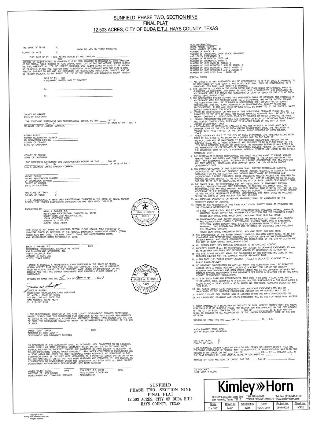
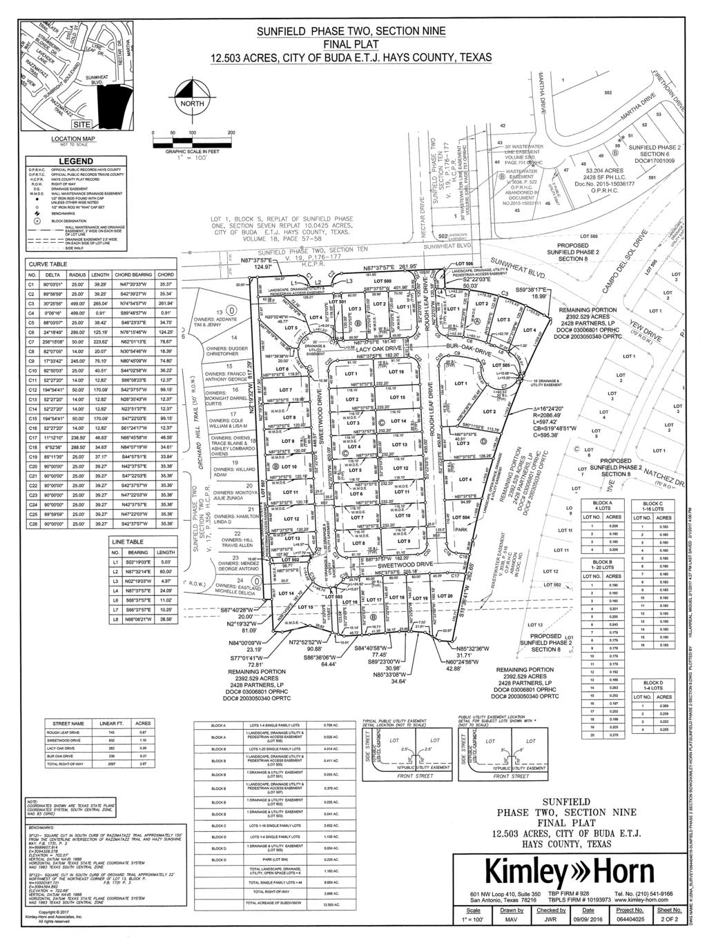
12 Planning and Zoning Commission Agenda Item Report February 28, 2017 Contact Chance Sparks, AICP, CNUa, Director of Planning / csparks@ci.buda.tx.us SUBJECT: DELIBERATION AND POSSIBLE ACTION REGARDING A FINAL PLAT OF SUNFIELD PHASE 2 SECTION 9 SUBDIVISION, BEING /- ACRES OUT OF THE WILLIAM CORBEN SURVEY ABSTRACT NO. 150, GENERALLY LOCATED NEAR THE INTERSECTION OF SUNWHEAT BLVD. & NECTAR DRIVE. (FP 16-23) 1. BACKGROUND/HISTORY This is the action item for considering approval of a final plat of Sunfield Phase 2 Section 9. This is the eith section of Phase 2 to be platted (they are not platted in section numerical order). Water and sewer service is provided through the Sunfield Municipal Utility District. Hays County is responsible for road maintenance, though the City reviews and approves infrastructure plans. 2. FINDINGS/CURRENT ACTIVITY This plat encompasses 44 lots, all of which are reserved for single family residential use. This section includes 8 lots combining Drainage/Landscape/Open Space lots and totals acres. This section is bound by Sunwheat Boulevard on the north, Campo Del Sol Drive (70 wide ROW) east, open space to the south, and Phase 2 section 2 to the west. Within this plat, Sweetwood Drive (50 wide ROW) will connect from Campo Del Sol and wraps around the interior of the section. Sweetwood then connects to Bur Oak Drive (50 wide ROW) and Rought Leaf Drive (50 wide ROW). The Land Plan in the Sunfield Development Agreement places a maximum density of 4.4 units per acre, calculated across all areas on the Land Plan. It remains below 4.4 units per acre to date. Water service will be provided by the Sunfield MUD through Goforth SUD. Waste water service will be provided by the Sunfield MUD. The Traffic Impact Analysis Worksheet for Sunfield is updated for each plat or preliminary plan revision. This section did not trigger any additional traffic network improvements as a result of this section. 12
13 3. FINANCIAL IMPACT N/A 4. ACTION OPTIONS/RECOMMENDATION Staff recommends approval of this final plat as it is consistent with the associated preliminary plan, the requirements of the Unified Development Code, and the Development Agreement. 5. ATTACHMENTS Final Plat of Sunfield Phase 2 Section 9 Binkley Barfield Recommendation Letter 13
14
15
 Dear Mr. Parker: Binkley & Barfield, Inc.")

16 February 16, 2017 Mr. Brian Parker, P.E. Kimley-Horn & Associates Jollyville Rd, Avallon IV, Suite 300 Austin, Texas RE: Recommendation Letter: Sunfield Phase 2 Section 9 Update 2 Buda, Texas (FP 16-23) Dear Mr. Parker: Binkley & Barfield, Inc. (BBI) has reviewed the resubmittal for engineering compliance on behalf of the City of Buda. BBI has determined that the resubmittal sufficiently addressed the previous comment letter. BBI recommends the plans be approved by the City of Buda for engineering compliance, contingent upon approvals by all other departments and applicable agencies. Once all approvals have been obtained, please provide one (1) original and two (2) copies of the plan set directly to Chance Sparks, Director of Planning. If you have any questions, please contact Mr. Sparks directly. Thank you. Sincerely, BINKLEY & BARFIELD, INC. Consulting Engineers Rey Gonzalez, P.E. cc: Chance Sparks (City of Buda) Meredith Johnson (City of Buda) John Nett, P.E. (City of Buda) Brian Rice, P.E. (BBI) Project file: /Plan Review/2.08/2016 Binkley & Barfield, Inc. Registration No. F South Lamar Boulevard, Suite Austin, Texas Tel: Fax:
17 Planning and Zoning Commission Agenda Item Report February 28, 2017 Contact Chance Sparks, AICP, CNUa, Director of Planning / csparks@ci.buda.tx.us SUBJECT: DELIBERATION AND POSSIBLE ACTION REGARDING A FINAL PLAT OF SUNFIELD PHASE 2 SECTION 8 SUBDIVISION, BEING /- ACRES OUT OF THE WILLIAM CORBEN SURVEY ABSTRACT NO. 150, GENERALLY LOCATED NEAR THE INTERSECTIONS OF SUNWHEAT BLVD. & CAMPO DEL SOL DRIVE, AND CAMPO DEL SOL DRIVE & FIRETHORN DRIVE. (FP 16-25) 1. BACKGROUND/HISTORY This is the action item for considering approval of a final plat of Sunfield Phase 2 Section 8. This is the seventh section of Phase 2 to be platted (they are not platted in section numerical order). Water and sewer service is provided through the Sunfield Municipal Utility District. Hays County is responsible for road maintenance, though the City reviews and approves infrastructure plans. 2. FINDINGS/CURRENT ACTIVITY This plat encompasses 109 lots, all of which are reserved for single family residential use. This section includes 8 lots combining Drainage/Landscape/Open Space lots and totals acres. This section is bound by Campo Del Sol Drive (70 wide ROW) on the west and north, Natchez Drive (50 wide ROW) on the east, and Phase 3 to the south. Within this plat, Pistache Drive (60 wide ROW) will connect from Campo Del Sol to Paloverde Drive (50 wide ROW). Paloverde connect to Natchez, which wraps the southern portion of the lots. Juniper Drive (50 wide ROW) connects to Natchez on both sides. The drainage and utility easement lots, 503 and 504 in Blocks I and H, open out to Juniper Drive and Paloverde Drive. The Land Plan in the Sunfield Development Agreement places a maximum density of 4.4 units per acre, calculated across all areas on the Land Plan. It remains below 4.4 units per acre to date. Water service will be provided by the Sunfield MUD through Goforth SUD. Waste water service will be provided by the Sunfield MUD. 17
18 The Traffic Impact Analysis Worksheet for Sunfield is updated for each plat or preliminary plan revision. This section did not trigger any additional traffic network improvements as a result of this section. 3. FINANCIAL IMPACT N/A 4. ACTION OPTIONS/RECOMMENDATION Staff recommends approval of this final plat as it is consistent with the associated preliminary plan, the requirements of the Unified Development Code, and the Development Agreement. 5. ATTACHMENTS Final Plat of Sunfield Phase 2 Section 8 18
19 Copyright 2016 Kimley-Horn and Associates, Inc. 601 NW Loop 410, Suite 350 TBP FIRM # 928 Tel. No. (210) San Antonio, Texas TBPLS FIRM # Scale Drawn by Checked by Date Project No. Sheet No. 1" = 100' MAV JWR 10/03/ OF 3 DWG NAME: K:\SNA_SURVEY\ SUNFIELD PHASE 2 SECTION 8\DWG\KIMLEY-HORN PLAT\SUNFIELD 2-8.DWG PLOTTED BY VILLARREAL, MIGUEL 12/7/ :17 AM LAST SAVED 12/5/2016 1:59 PM 19
20 L24 ' ESPERANZA DRIVE (50' R.O.W.) 1 * * ' 70.00' NORTH C72 5 * * ACRES 2428 SF PH LLC. VOLUME 5373, PAGE 127 O.P.R.H.C. 3 LOT 507 * * E 603 S87 45'57"E ' N87 45'57"W ' LOCATION MAP SITE PROPOSED SUNFIELD PHASE 2 SECTION ' REMAINING PORTION ACRES 2428 PARTNERS, LP DOC# OPRHC DOC# OPRTC ESPERANZA DRIVE (50' R.O.W.) 20 APPROXIMATE LOCATION OF SURVEY LINE APPROXIMATE LOCATION OF SURVEY LINE D.C. BURLESON SURVEY L ' L ' L21 LOT 19 F PARK A 15' DRAINAGE & UTILITY EASEMENT PE, DRAINAGE Y EASEMENT LANDSCAPE, OPEN SPACE, DRAINAGE & UTILITY EASEMENT LOT 506 LANDSCAPE EASEMENT SUNWHEAT BLVD. NECTAR DRIVE * 502 LOT LOT 1 LOT 1 LOT 504 LOT 3 LOT 4 LOT 2 30' WASTEWATER LINE EASEMENT VOLUME 5360, PAGE 751 OPRHC WASTEWATER B EASEMENT V. 3038, P. 522 O.P.R.H.C. ABANDONED IN DOCUMENT NO LOT 3 LOT 2 LOT 505 LOT 4 30' WASTEWATER LINE EASEMENT VOLUME 5360, PAGE 751 OPRHC 5' PUBLIC UTILITY ESM'T FIRETHORN DRIVE ** B * * LOT 12 LOT 502 LOT 7 LOT 8 LOT 9 LOT 10 LOT 11 LOT 14 N11 36'30"E ' L11 LOT 6 LOT 5 LOT 4 52 MARTHA DRIVE 2 LOT 3 LOT 2 LOT 19 LOT 18 LOT 17 LOT 16 L10 LOT 21 LOT LOT 1 LOT 1 LOT 2 LOT 2 LOT 1 LOT 3 LOT 3 LOT 2 LOT 4 LOT 4 B LOT 5 LOT 5 LOT 6 LOT 34 LOT 3 1 LOT 6 LOT 7 LOT 33 LOT 8 LOT 32 LOT 31 LOT 4 LOT 7 LOT 9 LOT 29 LOT 30 LOT 5 LOT 10 H LOT 28 LOT 1 LOT 6 LOT 1 LOT 11 LOT 27 LOT 2 LOT 12 LOT 26 LOT 3 LOT 7 LOT 4 LOT 2 LOT 8 LOT 3 LOT 503 LOT 13 LOT 25 LOT 5 LOT 6 LOT 21 LOT 9 L9 LOT 14 LOT 24 LOT 504 LOT 20 LOT 7 LOT 19 LOT 4 LOT 23 LOT 8 LOT 18 LOT 15 LOT 17 LOT 22 LOT 9 LOT 10 L6 LOT 5 LOT 16 LOT 16 LOT 21 LOT 10 LOT 15 LOT 12 LOT 11 L7 L8 S74 50'31"W 96.28' L12 L19 L13 L14 L18 L15 L17 L16 LOT 6 LOT 17 LOT 13 LOT 20 LOT 11 LOT 14 LOT 14 LOT 7 LOT 12 LOT 15 LOT 18 LOT 19 LOT 13 L3 L4 L5 LOT 16 LOT 8 LOT 17 LOT 500 L2 L1 LOT 18 S4 35'59"W ' C4 S37 08'28"W ' C5 =25 55'15" R=275.00' L=124.41' CB=S8 21'38"E C=123.35' S21 19'15"E 12.22' C6 S36 53'20"W ' =144 04'55" R=50.00' L=125.74' CB=S14 59'08"E C=95.13' C7 S88 18'29"E 20.00' S21 37'12"E ' S11 43'42"E 86.15' S5 10'23"E 53.89' S84 52'41"W 66.27' S44 18'31"W 66.19' C8 =30 52'25" R=545.00' L=293.67' CB=N75 00'57"W C=290.13' LOT 13 N61 25'24"W 98.00' GEORGE HERDER SURVEY NO. 537, ABSTRACT NO. 239 WM. PORTER SURVEY NO. 6 ABSTRACT NO. 359 L25 N2 24'10"W 70.00' N87 37'57"E 94.49' N87 37'57"E 75.14' LOT 508 LOT 1 LOT 15 C31 C32 C30 S65 01'06"E ' N65 01'06"W ' 58.64' C26 C27 C ' 90.62' 89.37' 90.76' N69 43'36"W ' N69 43'36"W ' N69 43'36"W ' 89.47' 53.87' 50.00' 50.00' 50.00' 50.00' 50.00' 50.00' 28.61' C64 C25 C65 C51 C28 C24 C33 C52 C63 C53 G F C23 C50 C62 C22 C21 C43 C60 C34 N59 38'17"W ' 90.67' C54 C41 C49 C59 C ' N59 38'17"W ' 10.13' 12.91' S51 09'10"W ' C3 C2 C42 C40 C10 C35 C48 C44 C ' C39 C9 N59 38'17"W 29.08' N21 35'59"W ' S21 35'59"E ' S60 22'35"E ' ' 15.19' N87 28'47"W ' N87 28'47"W ' N77 57'42"W ' S77 57'42"E ' 43.73' 65.26' N78 34'39"W ' ' 37.59' 6.22' L=18.01' L=40.88' L=38.32' L=19.03' L=15.23' L=46.98' N76 59'10"W ' L=53.19' N75 23'40"W ' L=50. 0' L=53.19' N73 48'10"W ' L=53.19' N72 12'41"W ' L=53.19' N70 37'11"W ' L=53.19' N69 01'42"W ' L=53.19' N67 26'12"W ' L=50. 0' N65 50'43"W ' L=53.19' N64 15'13"W ' L=53.19' L=50. 0' C11 C38 C36 C17 S36 28'02"E ' S36 28'02"E ' C12 N53 31'58"E ' 67.36' 90.00' C16 C13 L26 L27 L28 N53 31'58"E ' 40.75' 53.00' N53 31'58"E ' L30 C55 C56 S4 35'59"W ' C45 C37 C46 C18 C20 C19 C15 LOT 506 L31 L=53.19' S62 39'43"E ' L=35.81' L=66.07' 10.39' L=15.55' L=33.53 ' L=46.76' L=28.37' 7.71' L=35.81' L=66.07' L=48.97' L=46.04' L=46.03' 10.39' 7.81' 64.52' 69.47' 86.37' L ' 15' DRAINAGE & UTILITY EASEMENT 15' DRAINAGE & UTILITY EASEMENT WASTEWATER EASEMENT V. 3038, P. 516 O.P.R.H.C. ABANDON IN DOC. NO. LEGEND LOT ' N11 18'50"W ' 5.50' 50.00' 31.26' L=8.61' 11.49' 49.77' 50.91' 50.91' L=53.52' L=53.5 2' L=53.52' N76 12'35"W ' C68 N74 27'27"W ' N20 16'24"E ' N20 16'24"E ' N20 16'24"E ' N20 16'24"E ' N20 16'24"E ' N20 16'24"E ' N20 16'24"E ' N20 16'24"E ' L=41.91' S72 42'19"E ' L=60.00' L=40.25' L=43.27' C66 L=58.21' L=58.21' L=58.21' L=63.67' L=7.83' L=6.73' L=35.68' C67 L=57.03' L32 L=7.62' L=6.30' L=9.83' L=43.73' 72.02' L=23.52' L=34.39' L=15.08' N65 11'39"W ' 49.99' L= 43.04' L=55.00' L=55.00' L=55.00' L=51.78' L=55.07' N62 26'15"W ' L=63.83' L=57.26' L=57.48' N59 40'11"W ' 49.92' 49.87' S30 44'02"W ' N65 58'14"W ' L=45.49' L=5 4.24' L=54.24' L=54.24' L=54.24' L=75.60' L=60.11' L=60. 1' L=60.11' L=56.58' LANDSCAPE, OPEN SPACE, DRAINAGE & UTILITY EASEMENT REMAINING PORTION ACRES 2428 PARTNERS, LP DOC# OPRHC DOC# OPRTC L=41.59' N56 54'10"W ' 44.18' S63 51'22"E ' L=57.47' N46 58'19"W ' 40.64' S61 44'31"E ' L=30.06' N30 03'48"W ' 50.00' 73.81' N68 00'59"E ' L=52.61' L=5 4.59' L=54.59' L=71.55' L=51.00' L=51. 0 L=40.72' N21 19'15"W ' L=3.22' L=81.16' N35 48'40"W ' N29 52'14"W ' L=57.03' L29 N23 55'48"W ' L=57.03' L=68.95' L=57.03' L=57.03' L= L=68.95' L=68.95' L=68.95' L=57.03' N17 59'21"W ' N12 02'55"W ' N6 06'29"W ' L=68.95' N0 10'03"W ' L=68.95' L=27.88' L=20.20' L=22.76' L=55.07' L=55.07 L=32.79' L=67.17 ' L=54.24' L=41.76' ' L=16.70' L=1.32' C69 N59 37'40"W ' N57 30'49"W ' L=48.68' L=25.20' L=93.97' L=72.55 ' L=22.50' L=4.36' S55 23'57"E ' L=49.96' L=74.55' C70 L=54.59' L=54.59' L=54.59' L=72.64' L=53.79' L=53.79' L=53.79' L=53.79' L=53.79' L=53.79' ' L=51.00' L=51.00' L=51.00' L=51.00' C58 S51 11'09"E ' L=49.59' L=66.90' 5.65' S39 57'05"E ' L=44.94' 5.02' S53 31'58"W ' 22.59' 34.49' 50.00' 36.52' 50.00' 76.85' N36 28'02"W ' N36 28'02"W ' L=50.03' 50.07' S78 22'02"W 64.11' L=54.59' L=54.59' S29 06'48"E ' L=42.65' L=1.85' 40.75' 50.00' S53 31'58"W ' L=59.89' L=101.17' L=34.78' L=61.99' L=50.07' L=50.07' L=61.99' L=50.03' L=12.45' L=17.54' L=32.47' L=51.00' L=22.34' L=34.90' L=49.29' L=63.73' 91.06' 15.00' L=9.25' L=51.02' 12.26' 15.00' L=63.73' L=51.02' L=10.25' C61 L=11.78' 40.75' 53.00' 40.75' 50.00' 15.00' 12.26' 15.26' S53 31'58"W ' 15.26' L=35.69' L=40.77 L=49.60' L=71.40' ' L=53.04' L=53.04' C57 L=71.40' L=83.55' C71 15' DRAINAGE & UTILITY EASEMENT L=53.04' L=76.06' L=52.95' L=68.89' 89.34' L=68.89' 62.58' L=68.89' L=72.45' 20.00' REMAINING PORTION ACRES 2428 PARTNERS, LP DOC# OPRHC DOC# OPRTC 25.0' 25.0' 50.0' REMAINING PORTION ACRES 2428 PARTNERS, LP DOC# OPRHC DOC# OPRTC REMAINING PORTION ACRES 2428 PARTNERS, LP DOC# OPRHC DOC# OPRTC N65 28'21"W ' N62 55'52"W ' PROPOSED SUNFIELD PHASE 2 SECTION 6 N66 20'35"W ' N66 18'16"W ' N60 23'22"W ' N64 25'10"W ' N57 50'53"W ' N64 33'21"W ' N62 32'05"W ' N54 53'14"W ' N60 39'00"W ' N62 46'07"W ' N45 10'46"W ' N58 45'54"W ' N60 58'52"W ' N56 52'49"W ' N59 11'38"W ' N54 59'44"W ' N57 24'24"W ' N55 37'10"W ' N51 22'43"W ' N44 33'13"W ' N53 49'56"W ' S56 36'51"E ' N37 43'44"W ' ACRES 2428 SF PH LLC. VOLUME 5373, PAGE 127 O.P.R.H.C. PROPOSED SUNFIELD PHASE 2 SECTION 6 D WASTEWATEREASEMENT V. 3038, P. 522 O.P.R.H.C. ABANDON IN DOC. NO. PALOVERDE DRIVE 50.0' NATCHEZ DRIVE (70' R.O.W.) 25.0' 25.0' C JUNIPER DRIVE NATCHEZ DRIVE 25.0' 25.0' 25.0' 25.0' 50.0' 50.0' L=1.73' L=28.24' N48 29'33"W ' N55 08'56"W ' N43 01'43"W ' 15' DRAINAGE & UTILITY EASEMENT N53 13'15"W ' N37 33'53"W ' N49 07'42"W ' S36 28'02"E ' N45 02'09"W ' N36 28'02"W ' S36 28'02"E ' S36 28'02"E ' N36 28'02"W ' S36 28'02"E ' N36 28'02"W ' S26 04'19"E ' YEW DRIVE (70' R.O.W.) 70.0' 35.0' 35.0' SUNWHEAT BLVD. CAMPO DEL SOL DRIVE PALOVERDE DRIVE I JUNIPER DRIVE 25.0' 25.0' 50.0' 25.0' 25.0' 50.0' N29 05'10"W ' N18 27'38"W ' 49.0' N30 24'00"W ' S40 56'36"E ' N22 30'23"W ' N7 50'06"W ' 49.0' 98.0' N14 36'45"W ' PISTACHEDRIVE (60' R.O.W.) NATCHEZ DRIVE 98.0' N6 43'08"W ' 25.0'25.0' 50.0' PALOVERDE DRIVE 70.0' A E WASTEWATER EASEMENT V. 3038, P. 522 O.P.R.H.C. ABANDON IN DOC. NO. WASTEWATER EASEMENT V. 3038, P. 516 O.P.R.H.C. ABANDON IN DOC. NO. 601 NW Loop 410, Suite 350 San Antonio, Texas TBPLS FIRM # TBP FIRM # Tel. No. (210) Copyright 2016 Kimley-Horn and Associates, Inc. All rights reserved Scale Drawn by 1" = 100' MAV Checked by Date Project No. Sheet No. JWR 10/03/ OF 3 LOT 505 LANDSCAPE, DRAINAGE & UTILITY EASEMENT LANDSCAPE, DRAINAGE & UTILITY EASEMENT ' CAMPO DEL SOL DRIVE C14 S87 45'57"E ' N87 45'57"W ' 0 O.P.R.H.C. O.P.R.T.C. H.C.P.R. R.O.W. D.E. W.M.D.E GRAPHIC SCALE IN FEET OFFICIAL PUBLIC RECORDS HAYS COUNTY OFFICIAL PUBLIC RECORDS TRAVIS COUNTY HAYS COUNTY PLAT RECORD RIGHT OF WAY DRAINAGE EASEMENT WALL MAINTENANCE DRAINAGE EASEMENT 1/2" IRON ROD FOUND WITH CAP UNLESS OTHER WISE NOTED 1/2" IRON ROD W/ "KHA" CAP SET BENCHMARKS X BLOCK DESIGNATION WALL MAINTENANCE AND DRAINAGE EASEMENT, 3' WIDE ON EACH SIDE OF LOT LINE DRAINAGE EASEMENT 2.5' WIDE ON EACH SIDE OF LOT LINE 35.0' 50.00' S2 14'03"W ' 70.0' DWG NAME: K:\SNA_SURVEY\ SUNFIELD PHASE 2 SECTION 8\DWG\KIMLEY-HORN PLAT\SUNFIELD 2-8.DWG PLOTTED BY VILLARREAL, MIGUEL 12/7/ :41 AM LAST SAVED 12/7/ :31 AM
21 21 NORTH SITE LOCATION MAP GRAPHIC SCALE IN FEET STREET NAME Copyright 2016 Kimley-Horn and Associates, Inc. All rights reserved LINEAR FT. SUNWHEAT BLVD CAMPO DEL SOL DRIVE PALOVERDE DRIVE JUNIPER DRIVE NATCHEZ DRIVE PISTACHE DRIVE YEW DRIVE TOTAL RIGHT-OF-WAY 5, CURVE TABLE NO. C1 C2 C3 C4 C5 C6 C7 C8 C9 C10 C11 C12 C13 C14 C15 C16 C17 C18 C19 C20 C21 C22 C23 C24 C25 C26 C27 C28 C29 C30 C31 C32 C33 C34 C35 C36 C37 C38 C39 C40 DELTA 91 47'07" 0 07'39" 88 20'32" '46" 52 27'20" 20 44'49" 43 45'36" 17 42'18" 22 13'55" 88 20'32" 4 12'31" 12 02'31" 53 07'48" 38 42'06" 38 42'06" 90 00'00" 90 00'00" 38 24'25" 38 42'09" 50 28'38" '33" 51 33'42" 30 08'05" 10 52'16" 49 33'00" '14" 29 55'35" 91 39'40" 6 51'23" 62 19'30" '52" 30 55'48" 17 37'43" 88 06'57" 4 04'52" 15 56'20" 91 21'56" 88 26'39" 15 44'58" 3 58'57" RADIUS ' 50.00' 14.00' 50.00' ' ' ' ' ' ' ' ' 14.00' 50.00' ' ' 50.00' ' 50.00' ' ' ' ' ' LENGTH 40.05' 4.56' 38.55' ' 12.82' 9.05' 38.19' ' ' 38.55' ' ' 23.18' ' ' 39.27' 39.27' ' ' 12.33' ' 22.50' ' ' 21.62' ' 13.06' 39.99' ' 27.19' ' 13.50' ' 38.45' ' ' 39.87' 38.59' ' ' CHORD BEARING S74 28'10"W N28 38'26"E N15 28'01"W S40 44'33"E S30 49'39"W S31 41'40"E S20 11'17"E N20 27'39"E N70 42'04"W N76 11'27"E S34 07'27"W S42 14'58"W N80 05'52"E S72 53'01"W S72 53'01"W S08 31'58"W S81 28'02"E S72 43'59"W S72 52'59"W N66 41'53"E N37 05'12"E N89 32'23"W S49 36'44"W S29 06'31"W S01 06'07"E N57 09'19"E N54 45'45"W S64 26'35"W S15 11'05"W S19 24'22"E N85 36'19"E N26 18'51"E S19 39'49"W N15 34'48"W S34 11'16"W S44 11'52"W N82 09'00"W N07 45'17"E S44 06'11"W S34 14'14"W CHORD 35.90' 4.56' 34.84' 99.08' 12.37' 9.00' 37.27' ' ' 34.84' ' ' 22.36' ' ' 35.36' 35.36' ' ' 11.94' 98.21' 21.75' ' ' 20.95' 99.26' 12.91' 35.86' ' 25.87' 69.25' 13.33' ' 34.77' ' ' 35.77' 34.87' ' ' CURVE TABLE NO. C41 C42 C43 C44 C45 C46 C47 C48 C49 C50 C51 C52 C53 C54 C55 C56 C57 C58 C59 C60 C61 C62 C63 C64 C65 C66 C67 C68 C69 C70 C71 C72 BLOCK A LOTS 1-8 SINGLE FAMILY LOTS AC. BLOCK A 1 LANDSCAPE, DRAINAGE & UTILITY EASEMENT (LOT 506) AC. BLOCK B LOTS 1-7 SINGLE FAMILY LOTS AC. BLOCK B 1 LANDSCAPE, DRAINAGE & UTILITY EASEMENT (LOT 505) AC. BLOCK C LOTS 1-21 SINGLE FAMILY LOTS AC. BLOCK C BLOCK C 1 DRAINAGE & UTILITY EASEMENT (LOT 502) 1 DRAINAGE & UTILITY EASEMENT (LOT 501) AC AC. BLOCK D LOTS 1-10 SINGLE FAMILY LOTS AC. BLOCK E LOTS SINGLE FAMILY LOTS AC. BLOCK E 1 LANDSCAPE, OPEN SPACE, DRAINAGE & UTILITY EASEMENT (LOT 500) AC. BLOCK F LOTS SINGLE FAMILY LOTS AC. BLOCK G LOT 1-12 SINGLE FAMILY LOTS AC. BLOCK H LOT SINGLE FAMILY LOTS AC. BLOCK H 1 DRAINAGE & UTILITY EASEMENT (LOT 504) AC. BLOCK I LOT 1-18 SINGLE FAMILY LOTS AC. BLOCK I 1 DRAINAGE & UTILITY EASEMENT (LOT 503) 1 LANDSCAPE, DRAINAGE & UTILITY EASEMENT (LOT 508) 1 LANDSCAPE, DRAINAGE & UTILITY EASEMENT (LOT 507) TOTAL LANDSCAPE, DRAINAGE, UTILITY, OPEN SPACE LOTS = 8 TOTAL SINGLE FAMILY LOTS = 109 TOTAL RIGHT-OF-WAY TOTAL ACREAGE OF SUBDIVISION AC AC AC AC AC AC AC. DELTA 88 06'57" 91 47'07" 14 17'39" 17 18'19" 38 03'09" 93 01'01" 85 08'19" 36 12'13" 17 18'16" 14 06'00" 88 08'44" 91 39'40" 13 58'16" 17 18'16" 33 42'14" 97 21'57" 41 04'01" 15 04'42" 24 05'10" 88 09'50" 17 18'16" 34 08'10" 12 00'18" 87 44'05" 91 58'59" 4 49'10" 17 18'13" 7 21'33" 13 12'52" 18 59'12" 33 12'52" 38 42'06" RADIUS ' ' ' ' ' ' ' ' ' ' ' ' ' ' ' ' ' ' ' ' LENGTH 38.45' 40.05' ' ' ' 40.59' 37.15' ' ' ' 38.46' 39.99' ' ' ' 42.48' ' ' ' 38.47' ' ' ' 38.28' 40.14' ' ' ' ' ' ' ' CHORD BEARING N76 18'14"E S13 44'44"E S29 04'52"W S44 52'52"W S72 33'32"W N41 54'31"W N47 10'09"E S71 38'04"W S44 52'50"W S29 10'42"W N66 12'03"E S23 53'46"E S29 14'31"W S44 52'50"W S70 22'55"W S44 04'59"E S74 03'59"W S28 41'20"W S07 26'30"E S24 35'50"W S44 52'50"W S51 36'40"W S28 32'29"W S66 24'22"W N23 44'06"W S33 49'08"W S44 52'51"W S15 43'04"W S27 56'15"W S44 02'17"W N70 00'51"E N72 53'01"E CHORD 34.77' 35.90' ' ' ' 36.27' 33.82' ' ' ' 34.78' 35.86' ' ' ' 37.55' ' ' ' 34.78' ' ' ' 34.65' 35.96' ' ' ' ' ' ' ' LINE TABLE NO. L1 L2 L3 L4 L5 L6 L7 L8 L9 L10 L11 L12 L13 L14 L15 L16 L17 L18 L19 L20 L21 L22 L23 L24 L25 L26 L27 L28 L29 L30 L31 L32 Scale 1" = 100' BEARING S32 58'29"W S78 55'53"W N76 40'15"W N66 52'02"W S29 35'03"W N65 01'06"W S49 28'01"W S08 47'29"W S05 28'17"E S06 25'30"W N49 32'18"W N76 38'06"W N64 18'04"W N54 58'13"W N69 43'36"W N80 34'27"W S73 45'46"W S56 03'12"W S26 55'46"W S29 35'20"W S54 58'24"W S84 28'28"W N60 54'36"W S89 14'29"W N59 38'17"W S53 31'58"W S53 31'58"W N53 31'58"E S53 31'58"W S04 35'59"W S68 40'45"W N53 31'58"E Drawn by MAV LENGTH 32.55' 33.21' 37.71' 8.31' 40.31' 72.51' 6.11' 38.52' 37.21' 23.34' 32.25' 41.61' 50.26' 19.38' 81.26' ' 26.01' 66.76' 47.65' ' 64.52' 55.00' 45.92' ' 29.15' 30.70' 30.70' 30.70' 55.70' 44.88' 8.23' 5.32' LOT NO. BLOCK A 8 LOTS ACRES NW Loop 410, Suite 350 TBP FIRM # 928 Tel. No. (210) San Antonio, Texas TBPLS FIRM # LOT NO. LOT NO. BLOCK C 21 LOTS ACRES LOT NO. BLOCK B 7 LOTS BLOCK D 10 LOTS ACRES ACRES LOT NO. BLOCK E 8 LOTS ACRES LOT NO. BLOCK F 9 LOTS ACRES LOT NO. BLOCK G 12 LOTS ACRES Checked by Date Project No. Sheet No. JWR 10/03/ OF LOT NO. BLOCK H 16 LOTS ACRES LOT NO. BLOCK I 18 LOTS ACRES DWG NAME: K:\SNA_SURVEY\ SUNFIELD PHASE 2 SECTION 8\DWG\KIMLEY-HORN PLAT\SUNFIELD 2-8.DWG PLOTTED BY VILLARREAL, MIGUEL 12/7/ :31 AM LAST SAVED 12/7/ :23 AM
, RESIDENTIAL ZONING DISTRICTS (PAGES 23-29), NONRESIDENTIAL ZONING DISTRICTS (PAGES")
22 Planning & Zoning Commission Agenda Item Report February 28, 2017 Contact Chance Sparks, AICP, CNU-A, Assistant City Manager SUBJECT: WORKSHOP REGARDING THE DRAFT UNIFIED DEVELOPMENT CODE PROVISIONS FOR ZONING DISTRICTS (PAGES 19-22), RESIDENTIAL ZONING DISTRICTS (PAGES 23-29), NONRESIDENTIAL ZONING DISTRICTS (PAGES 30-34), SPECIAL AND FORM BASED ZONING DISTRICTS (PAGES 35-39), ZONING USE REGULATIONS (PAGES 40-58), ZONING DIMENSIONAL REGULATIONS (PAGES 59-63). 1. EXECUTIVE SUMMARY Staff will be systematically bringing workshops to the Commission and City Council over the next two months pertaining to the draft Unified Development Code. The intent is to allow both bodies to review the document in smaller portions as it is prepared for adoption. A secondary purpose is to help staff familiarize themselves with the new Code for implementation. Rather than include code excerpts behind this staff report, staff has provided page references to the draft, which has been provided in hard & electronic copy to the Commission and City Council and posted online (viewable at The anticipated schedule is as follows. Some of these groups have more pages to review, but staff attempted to break them up by topical areas and based on the level of discussion likely involved. 2/14 Planning & Zoning Commission & 2/21 City Council Signage (pages ) Provisions & Procedures, including Authorities (pages 1-17) Zoning Procedures (pages ) Zoning Relief Procedures (pages ) 2/28 Planning & Zoning Commission & 3/7 City Council 22
23 Zoning Districts (pages 19-22) Residential Zoning Districts (pages 23-29) Nonresidential Zoning Districts (pages 30-34) Special and Form Based Zoning Districts (pages 35-39) just the descriptions on the form-based, not the specific regulations Zoning Use Regulations (pages 40-58) Zoning Dimensional Regulations (pages 59-63) 3/14 Planning & Zoning Commission & 3/21 City Council Zoning Development Regulations & Compatibility (pages ) Form Based Code (pages pages ) City Council passes resolution to call joint public hearing for 4/11/17 3/16 Historic Preservation Commission Form Based Code (pages ) Historic District (pages ) 3/28 Planning & Zoning Commission & 4/4 City Council Subdivision Regulations (pages ) Sight Visibility Triangle (pages ) Wireless Transmission Facilities (pages ) Tree Preservation & Park Land (pages ) Environmental Protection & Water Quality (pages ) Flood Protection (pages ) Well Drilling (pages ) 4/11 Special Called Meeting for Joint Public Hearing, followed by Planning & Zoning Commission regular meeting Joint Public Hearing PZ action to recommend the UDC 4/18 City Council City Council action 2. BACKGROUND/HISTORY Staff has prepared a draft matrix of comments from the last Commission meeting as well as the City Council meeting for tracking purposes. 3. STAFF S REVIEW AND ANALYSIS Zoning Districts (pages 19-22) This section is fairly straight-forward and provide a simple overview. A new provision provides more detail as to how to interpret the zoning map. The current UDC provides no interpretive guidance, leaving it exceptionally broad for administrative interpretation. This creates opportunity for arbitrary interpretation. The new UDC includes a series of seven interpretive elements to guide interpretation. These interpretive guidelines are useful for those instances involving mapping accuracy, such as a zoning boundary that by 23
24 map appears to be 1-2 off a property line due to a map projection issue or digitizing error. A zoning equivalency table is created, which assists with district conversion. This is a required element when a UDC is being adopted to replace an existing UDC in order to show continuance of zoning and allow enforcement of violations. The most notable items include consolidation and changed nomenclature for the non-residential zoning districts to less wordy district names and more commonly understood district abbreviations. As you may recall, the C3/R3, C2/R2 and C1/R1 abbreviations are cumbersome & duplicative. Additionally, DR and HR in the current UDC is consolidated into R-3. Under the current UDC, HR provides for an increase to 12 units per acre when configured as single family attached residential based on Section 5.8(3), which actually matches the DR zoning district. Also, duplexes were already listed as a permitted use in HR in the current UDC. The net result is that the current UDC had two zoning districts that were virtually identical. As a result, those district types are being merged as the R-3 zoning district in the new UDC. R-1 Estate Residential, similar to Oxbow Trails and Sequoyah R-2 Suburban Residential, similar to most neighborhoods (Garlic Creek, Whispering Hollow, Cullen Country, Creekside Park, etc.) R-3 Medium Density Residential, similar to Bradfield Park (technically a PUD), Meadow Park, Stone Ridge, Green Meadows, and Bella Vita (technically a PUD) R-4 High Density Residential Note: will discuss density & development standards later R-5 Urban Residential Note: will discuss density & development standards later The industrial districts transition from I1 & I2 to LI and HI. These are more conventional abbreviations and less susceptible to misunderstanding in sans serif fonts. Finally, parks and public facilities are reclassified as R-2. These facilities were allowed in all zoning districts anyway, and R-2 results in the parks & public facilities being protected in similar fashion to residentially zoned property. Cities vary in their approach, but many growing cities that are frequently acquiring new parkland & facilities are choosing this route so that they are not constantly administering city-initiated rezonings. This is already visible in the Garlic Creek West, Whispering Hollow, Green Meadows, Stone Ridge & Cullen Country areas, where dedicated parkland is zoned MR or HR like the rest of the neighborhood. Residential Zoning Districts (pages 23-29) This section contains the narrative descriptions of each zoning district. These narratives, while not regulatory in nature, serve an important use in rezoning cases as they can provide perspective on where such zoning is appropriate. This is particularly useful when the 2030 Comprehensive Plan provides multiple zonings as appropriate to discern cases where some zonings are more appropriate than others. Also notable is the links to various 24
25 applicable regulations, allowing this section to serve as a wayfinding point when somebody has identified their zoning and wants to know what regulations are relevant. Nonresidential Zoning Districts (pages 30-34) This section serves an identical role to the Residential Zoning Districts section, except that it focuses on the business districts and industrial districts. Like the other section, the narratives can help inform on zoning change cases and serve as a wayfinding point for applicable regulations. Special and Form Based Zoning Districts (pages 35-39) As discussed previously, a Rural Heritage Overlay District is created in this new Code. Staff currently has two comments based on feedback at previous meetings or observations during staff review: The boundary description needs to include shallow lot language similar to the Gateway Overlay District, which staff is separately recommending be increased from 200 to 400. The map accompanying the district description cuts off the area of FM 967 west of Buda Sportsplex Drive. The written boundary description includes it, but the map does not provide the complete picture. The Gateway Corridor Overlay District continues in this new UDC, although it is reconfigured as a result of the Rural Heritage Overlay and the changing role of certain transportation corridors. As discussed, W. Goforth is added to the Gateway Corridor Overlay. Staff currently has two comments based on feedback at previous meetings or observations during staff review: The shallow lot language in the boundary description is recommended for increase from 200 to 400. This is due to the overlay district playing a more significant role in sign regulations and some altered lot configurations. It will also include interpretative language to clarify that if any portion of the property is touched by the overlay, the entire property is subject. This has always been the case, but it is not as clear as it could be. The W. Goforth segment of the Gateway Overlay needs to extend to the edge of the Historic District (between S. Cedar Street and Mandan Street). The Historic Overlay District is largely unchanged. The only modification was a map correction to show the boundary running along the rear property line of the properties on the east side of Cedar Street. This was a long-standing map error that is being corrected. The Planned Development (PD) is a renamed version of the Planned Unit Development (PUD). A reason for the changing name is that the acronym PUD is commonly used for Public Utility District, causing some confusion. It emphasizes that projects under this designation must provide a higher level of development quality. Past PDs in Buda include Bradfield Village, Creekside Park, and the Garlic Creek West neighborhoods essentially function as PDs due to the nature of the Development Agreement. 25
26 Form Districts are new in this Code. While regulatory aspects will be discussed at a separate meeting, these narratives give some indication of their appropriate use. Form districts are derived from the rural-to-urban transect, and are now being used extensively in cities throughout the country. Zoning Use Regulations (pages 40-58) As the Commission is already familiar, the Use table received a comprehensive revision. The use list is more complete & detailed, with each use defined. For review purposes, staff recommends reviewing the hard copy with the definitions pulled-up separately on an electronic device. Staff also recommends reviewing pages regarding residential adjacency, as certain uses are additionally restricted based on proximity to residential zoning. This aspect is in direct response to a workshop with the Commission previously, in which compatibility issues between C2/R2 and adjacent residential zoning were discussed. This section will be further discussed in a future workshop. There are several notable changes from the current UDC, including: Inclusion of the parking ratio on the use table this avoids duplication, creates clarity and allows the frequent next question of parking after a customer asks whether a use is allowed. This also assists the Building Official when evaluating Certificates of Occupancy. Every use has a corresponding definition Increased use of Specific Use Permits (SUPs) for uses that may have unique issues based on context o Note: the SUP criteria are more detailed as well Identification of different housing types Elimination of catch-all uses (i.e. all other retail ) that were susceptible to unfriendly & arbitrary interpretation Certain highly land consumptive uses are more restricted, such as auto sales & automotive uses, in response to development trends and recognition of limited prime business frontage opportunities in Buda Hotel types are categorized and zoning applied differently based on their characteristics. This is in response to increased development of limited service hotels to the point staff and the existing hotels have become concerned about cannibalism & lack of diversity in lodging types. This differentiation allows for the encouragement of new service level hotels. Micro- & Macro- alcohol production facilities are identified, defined and regulated. Several uses are broken down into different scales, such as grocery. Outdoor sales & display and outdoor storage have improved specificity in the regulations Conditional standards are carried over from the prior UDC. In some cases, standards were relocated from elsewhere in the current UDC to their more logical location as zoning conditions. Short-term residential rentals are identified and regulated. The approach is 26
27 not as complex as Austin (Austin is a far different situation), bearing more similarities to the approaches employed in New Braunfels. Comments and anticipated changes already noted include: Staff is reviewing the Agricultural Use conditions on page 51, as there appear to be inconsistencies with the Animal Control Ordinance. This may be revised to simply cross reference those standards. Staff is considering relocation of part or all of the regulations pertaining to Nondepository Financial Institutions like payday lenders into the UDC. They are currently regulated by separate ordinance. At a minimum, staff expects to move the location & zoning-related regulations into the UDC. A Commissioner noted that detention facilities, such as prisons, are not listed in the Use Table. Staff will research and add this use, most likely as a SUP. Zoning Dimensional Regulations (pages 59-63) The dimensional regulations establish development patterns for the residential & nonresidential zoning districts. Form districts are addressed separately. For reference purposes, most of the residential neighborhoods of Buda are zoned R-2 or R-3. Some examples are listed in the earlier section of this staff report for different districts. One new provision introduces a difference between building coverage and impervious cover. One of the challenges we have encountered is builders maximizing the impervious cover with initial home construction, leaving homeowners limited ability to add custom improvements, such as larger patios and swimming pools. Creating this gap between building coverage and impervious cover increases the ability of homeowners to make changes. In addition, it has a side effect of making the home footprints a smaller proportion of the property. AG, R-1 and R-2 regulate based on minimum lot size, as the allowed uses are limited exclusively to single units on a parcel. R-2 separates itself from R-3 due to R-3 introducing other housing types, specifically missing middle housing types like townhouses & duplexes. R-3, R-4 and R-5 see the addition of density, as those districts introduce different housing types (attached residential such as townhouse & duplex) that can result in condo-ized housing developments (including detached single-family in a condo regime) where minimum lot size no longer functions as a means to manage density. Staff is closely examining R-4 and R-5. There is no use differentiation between the two districts they are intended to serve as two different levels of intensity for multifamily, rather than the one size approach in the current UDC. Staff is considering the following: o Reducing permitted density for R-4 to 18 units/acre. o Reducing maximum height in R-4 to 35, consistent with the more singlefamily districts 27
NOTICE OF MEETING OF THE PLANNING AND ZONING COMMISSION OF BUDA, TX 7:00 PM - Tuesday, June 13, S. Main Street Buda, TX 78610
 NOTICE OF MEETING OF THE PLANNING AND ZONING COMMISSION OF BUDA, TX 7:00 PM - Tuesday, June 13, 2017 121 S. Main Street Buda, TX 78610 This notice is posted pursuant to the Texas Open Meetings Act. Notice
City Council Agenda Item Report December 1, 2015
 City Council Agenda Item Report December 1, 2015 Contact Chance Sparks, AICP, CNUa, Director of Planning 512-312-0084 / csparks@ci.buda.tx.us SUBJECT: DELIBERATION AND POSSIBLE ACTION REGARDING APPROVAL
January 22, Contact Chance Sparks, AICP, CNUa, Director of Planning
 Zoning Board of Adjustments Agenda Item Report January 22, 2015 Agenda Item F1 Contact Chance Sparks, AICP, CNUa, Director of Planning 512-312-0084 csparks@ci.buda.tx.us SUBJECT: HOLD A PUBLIC HEARING
NOTICE OF MEETING OF THE PLANNING AND ZONING COMMISSION OF BUDA, TX 7:00 PM - Tuesday, April 11, S. Main Street Buda, TX 78610
 NOTICE OF MEETING OF THE PLANNING AND ZONING COMMISSION OF BUDA, TX 7:00 PM - Tuesday, April 11, 2017 121 S. Main Street Buda, TX 78610 This notice is posted pursuant to the Texas Open Meetings Act. Notice
NOTICE OF MEETING OF THE PLANNING AND ZONING COMMISSION OF BUDA, TX 7:00 PM - Tuesday, September 26, S. Main Street Buda, TX 78610
 NOTICE OF MEETING OF THE PLANNING AND ZONING COMMISSION OF BUDA, TX 7:00 PM - Tuesday, September 26, 2017 121 S. Main Street Buda, TX 78610 This notice is posted pursuant to the Texas Open Meetings Act.
CITY OF BUDA PLANNING AND ZONING COMMISSION REGULAR MEETING MINUTES MARCH 24, :00 P.M.
 A. CALL TO ORDER CITY OF BUDA PLANNING AND ZONING COMMISSION REGULAR MEETING MINUTES MARCH 24, 2015-7:00 P.M. Chairman Strother called the meeting to order at 7:00 p.m. B. INVOCATION C. PLEDGE OF ALLEGIANCE
Cover Letter with Narrative Statement
 Cover Letter with Narrative Statement March 31, 2017 rev July 27, 2017 RE: Rushton Pointe Residential Planned Unit Development Application for Public Hearing for RPUD Rezone PL2015 000 0306 Mr. Eric Johnson,
Planning & Zoning Commission
 Planning & Zoning Commission Planning & Development Department August 14, 01 Zoning Map Amendment MAP-1-0001 (Bay View Section 4) Request Rezone approximately 1.19 acres from OS (Open Space) to RSF- (Residential
Staff Report: Date: Applicant: Property Identification: Acreage of Request: Current Zoning of Requested Area: Requested Action: Attached:
 Staff Report: Completed by Jeff Palmer Director of Planning & Zoning Date: November 7, 2018, Updated November 20, 2018 Applicant: Greg Smith, Oberer Land Developer agent for Ronald Montgomery ET AL Property
Watertown City Council
 City of Watertown Watertown City Council 2/14/2017 Agenda Item: Riverpointe Subdivision 2 nd Replat Request for Action: Sketch Plan Department: Planning Request for Action Request: Paxmar, LLC (Applicant)
LIVINGSTON COUNTY PLANNING COMMISSION APPROVED - MEETING MINUTES. July 17, :30 p.m. 304 E. Grand River Ave.
 LIVINGSTON COUNTY PLANNING COMMISSION APPROVED - MEETING MINUTES July 17, 2013 7:30 p.m. 304 E. Grand River Ave., Howell, Michigan PLANNING COMMISSION COMMISSIONERS PRESENT: COMMISSIONERS ABSENT: JEANNE
REPORT TO THE SHELBY COUNTY PLANNING COMMISSION From the Department of Development Services Planning Services. February 4, 2019
 REPORT TO THE SHELBY COUNTY PLANNING COMMISSION From the Department of Development Services Planning Services February 4, 2019 Case No. Request for Rezoning Approval From E-1 to E-2 SD This is a request
PLANNING AND ZONING COMMISSION FEBRUARY 20, :30 P.M. PLANNING AND ZONING MEMBERS PRESENT MEMBERS ABSENT: STAFF PRESENT:
 PLANNING AND ZONING COMMISSION FEBRUARY 20, 2018 5:30 P.M. PLANNING AND ZONING MEMBERS PRESENT Chair Lester Fettig Omar Crisp Paulino Castillo Lydia Alaniz Bryant Ward Jessica Walker Jeremy Langley MEMBERS
City Council Agenda Item Report October 21, 2014
 City Council Agenda Item Report October 21, 2014 Contact Chance Sparks, AICP, CNUa, Director of Planning 512-312-0084 / csparks@ci.buda.tx.us SUBJECT: DELIBERATION AND POSSIBLE ACTION IN REGARD TO A REQUEST
Staff Report: Date: Applicant: Property Identification: Acreage of Request: Current Zoning of Requested Area: Requested Action: Attached:
 Staff Report: Completed by Jeff Palmer Director of Planning & Zoning Date: November 7, 2018 Applicant: Greg Smith, Oberer Land Developer agent for Ronald Montgomery ET AL Property Identification: Frontage
Synergy Park Addition (Companion to item 3)
") Synergy Park Addition (Companion to item 3) Attachments: 1. Locator 2. Replat staff report 3. Replat W P G r es rg eo e s Bu hh wy Lot 6A 4.02-acres Lot 4C 13.02-acres Fran k Lots 4C and 6A, Block A Synergy
Synergy Park Addition (Companion to item 3) Attachments: 1. Locator 2. Replat staff report 3. Replat W P G r es rg eo e s Bu hh wy Lot 6A 4.02-acres Lot 4C 13.02-acres Fran k Lots 4C and 6A, Block A Synergy
Honorable Mayor Bill Agan and members of the Richland Hills City Council. Final Plat Richland Hills, Lots 1 & 2, Block 1 Brumlow Addition
 2B - 1 Memorandum To: From: Date: Subject: Honorable Mayor Bill Agan and members of the Richland Hills City Council Jason Moore, Assistant City Manager January 17, 2017 Final Plat Richland Hills, Lots
Rick Keeler Bonney Ramsey Melissa Ballard Jim Phillips Rodney Bell
 A regular meeting of the Planning & Zoning Commission of the City of Waxahachie was held on Tuesday, at 7:00 p.m. in the Council Chamber at 401 S. Rogers, Waxahachie, Texas. Members Present: Member Absent:
LINCOLN COUNTY PLANNING & INSPECTIONS DEPARTMENT
 LINCOLN COUNTY PLANNING & INSPECTIONS DEPARTMENT 30 NORTH ACADEMY STREET, SUITE A, LINCOLNTON, NORTH CAROLINA 809 704-736-8440 OFFICE 704-736-8434 INSPECTION REQUEST LINE 704-73-900 FAX To: Board of Commissioners
PLANNING COMMISSION STAFF REPORT
 PLANNING COMMISSION STAFF REPORT REZONING CASE: RZ-16-001 REPORT DATE: March 8, 2016 CASE NAME: Trailbreak Partners Rezoning PLANNING COMMISSION DATE: March 16, 2016 ADDRESSES OF REZONING PROPOSAL: 5501
NOTICE OF MEETING OF THE PLANNING AND ZONING COMMISSION
 NOTICE OF MEETING OF THE PLANNING AND ZONING COMMISSION OF BUDA, TX 7:00 PM - Wednesday, December 19, 2018 Council Chambers Room 1097 405 E. Loop Street, Building 100 Buda, TX 78610 This notice is posted
Article Optional Method Requirements
 Article 59-6. Optional Method Requirements [DIV. 6.1. MPDU DEVELOPMENT IN RURAL RESIDENTIAL AND RESIDENTIAL ZONES Sec. 6.1.1. General Requirements... 6 2 Sec. 6.1.2. General Site and Building Type Mix...
NOTICE OF THE REGULAR MEETING OF THE PLANNING & ZONING COMMISSION Tuesday, April 4, 2017 REGULAR MEETING AGENDA 6:30 PM
 NOTICE OF THE REGULAR MEETING OF THE PLANNING & ZONING COMMISSION Tuesday, April 4, 2017 Notice is hereby given of the Regular Meeting of the Planning & Zoning Commission beginning at 6:30 p.m. Tuesday,
EDGERTON CITY HALL PLANNING COMMISSION MEETING REGULAR SESSION March 12, 2019
 EDGERTON CITY HALL PLANNING COMMISSION MEETING REGULAR SESSION The met in regular session with Chair John Daley calling the meeting to order at 7:00 p.m. All present participated in the Pledge of Allegiance.
610 LAND DIVISIONS AND PROPERTY LINE ADJUSTMENTS OUTSIDE A UGB
 ARTICLE VI: LAND DIVISIONS AND PROPERTY LINE ADJUSTMENTS VI-21 610 LAND DIVISIONS AND PROPERTY LINE ADJUSTMENTS OUTSIDE A UGB 610-1 Property Line Adjustments (Property Line Relocation) A property line
13 Sectional Map Amendment
 13 Sectional Map Amendment Introduction This chapter reviews land use and zoning policies and practices in Prince George s County and presents the proposed zoning in the sectional map amendment (SMA) to
PUD 42 - Warner Ranch PUD - Amend. 2 Item No. 4B ZONING ZON
 PUD 42 - Warner Ranch PUD - Amend. 2 Item No. 4B ZONING ZON1210-001 CASE PLANNER: Steve Hopkins REQUEST: Approval of PUD 42 - Warner Ranch PUD - Amend. 2 ZONING AT TIME OF APPLICATION: PUD 42 CURRENT USE
PLANNING AND ZONING COMMISSION AGENDA
 PLANNING AND ZONING COMMISSION AGENDA Regular Meeting Tuesday, March 10, 2015 7:00 p.m. City Hall - Council Chamber Daniel P. Moore Community Center Complex 1900 Billy G. Webb Drive Portland, Texas 1.
PLAINFIELD CHARTER TOWNSHIP COMMUNITY DEVELOPMENT DEPARTMENT PLANNING, ZONING & BUILDING SERVICES MEMORANDUM
 PLAINFIELD CHARTER TOWNSHIP COMMUNITY DEVELOPMENT DEPARTMENT PLANNING, ZONING & BUILDING SERVICES 6161 BELMONT AVENUE N.E. BELMONT, MI 49306 PHONE 616-364-1190 FAX: 616-364-1170 www.plainfieldchartertwp.org
City of Buda. Unified Development Code. Adopted October 2, 2017
 City of Buda Unified Development Code Adopted October 2, 2017 Preface This Unified Development Code consolidates the City s land development and use regulations and processes into one document. The benefit
Indicates Council-recommended changes Introduced by: Mr. Tackett Date of introduction: June 14, 2016 SUBSTITUTE NO. 1 TO ORDINANCE NO.
 Indicates Council-recommended changes Introduced by: Mr. Tackett Date of introduction: June 14, 2016 SUBSTITUTE NO. 1 TO ORDINANCE NO. 16-067 TO AMEND NEW CASTLE COUNTY CODE CHAPTER 40 (ALSO KNOWN AS THE
CLAY TOWNSHIP PLANNING COMMISSION MEETING MINUTES September 28, 2015
 CLAY TOWNSHIP PLANNING COMMISSION MEETING MINUTES September 28, 2015 Members present were: Bruce Leisey, Clair Beyer and Annie Reinhart. Jon Price arrived at 7:10 and Adrian Kapp were absent. Also present
ATLANTA ZONING ORDINANCE UPDATE
 CITY OF ATLANTA ZONING ORDINANCE QUICK FIXES In 2015 the City of Atlanta selected a team of consultants to conduct a comprehensive assessment of the City s Zoning Ordinance, including a review of the ability
Minutes from the June 3, 2013 Planning and Zoning Commission Meeting
 NOTICE OF A REGULAR MEETING BRENHAM PLANNING AND ZONING COMMISSION MONDAY, JULY 1, 2013 AT 5:15 P.M. SECOND FLOOR CITY HALL COUNCIL CHAMBERS 200 W. VULCAN BRENHAM, TEXAS 1. Call Meeting to Order CONSENT
Proposed Use(s) Company. Contact. Address. Telephone. Fax. *
 Company. Contact. Address. Telephone. Fax. *") City of Southlake ZONING APPLICATION Department of Planning & Development Services, 1400 Main Street, Suite 310, Southlake, TX 76092 Phone: (817) 748-8069 : (817) 748-8077 Website: www.cityofsouthlake.com
City of Southlake ZONING APPLICATION Department of Planning & Development Services, 1400 Main Street, Suite 310, Southlake, TX 76092 Phone: (817) 748-8069 : (817) 748-8077 Website: www.cityofsouthlake.com
SUBJECT: Application for Planned Unit Development and Rezoning 1725 Winnetka Road
 TO: FROM: CHAIRMAN BILL VASELOPULOS AND MEMBERS OF THE PLAN & ZONING COMMISSION STEVE GUTIERREZ DIRECTOR OF COMMUNITY DEVELOPMENT MEETING DATE: September 5, 2017 SUBJECT: Application for Planned Unit Development
TOWN OF ORO VALLEY PLANNING & ZONING COMMISSION MEETING DATE: December 6, 2011
 PLANNING & ZONING COMMISSION MEETING DATE: December 6, 2011 TO: FROM: SUBJECT: PLANNING & ZONING COMMISSION Matt Michels, Senior Planner mmichels@orovalleyaz.gov; tel. 229-4822 Public Hearing: Rancho de
CITY OF ALBERT LEA PLANNING COMMISSION ADVISORY BOARD
 CITY OF ALBERT LEA PLANNING COMMISSION ADVISORY BOARD 9/1/2015, 5:30 p.m. City Council Chambers AGENDA A. CALL TO ORDER AND ROLL CALL B. APPROVAL OF THE AGENDA C. APPROVAL OF MINUTES 1. PC Minutes from
Affordable Housing Plan
 Affordable Housing Plan CORDOVA HILLS SPECIAL PLANNING AREA 1 Proposed Project Conwy LLC is the master developer ( Master Developer ) of that certain real property in the County of Sacramento ( County
Site Plan Application
 Site Plan Application City of St. Pete Beach Community Development Department 155 Corey Avenue St. Pete Beach, Florida 33706 (727) 367-2735 www.stpetebeach.org Case Number: PROPERTY OWNER: Name: Address:
NOTICE OF A REGULAR MEETING
 NOTICE OF A REGULAR MEETING Pursuant to Section 54954.2 of the Government Code of the State of California, a Regular meeting of the City of Tracy Planning Commission is hereby called for: Date/Time: Wednesday,
Memorandum To: From: CC: Date: Re:
 Memorandum To: Paul Singer From: Craig M. Bonenberger, SEO/ Jason P. Shaner, PE CC: File 090026 Date: 4/20/2009 Re: 1550 Pottstown Pike Feasibility Study The site under investigation is an 18 acre tract
1. Cuyler-Brownsville planned neighborhood conservation (P-N-C) districtphase I (section ). (2) Single-family semiattached dwellings;
 districtphase I (section ). (2) Single-family semiattached dwellings;") Sec. 8-3035. Planned unit development multifamily (PUD-M). A. Purpose. The PUD-M district is intended to allow a variety of residential development including single-family residential, two-family residential,
Sec. 8-3035. Planned unit development multifamily (PUD-M). A. Purpose. The PUD-M district is intended to allow a variety of residential development including single-family residential, two-family residential,
ARTICLE 3: Zone Districts
 ARTICLE 3: Zone Districts... 3-1 17.3.1: General...3-1 17.3.1.1: Purpose and Intent... 3-1 17.3.2: Districts and Maps...3-1 17.3.2.1: Applicability... 3-1 17.3.2.2: Creation of Districts... 3-1 17.3.2.3:
HB-S RM8-S RS9 RM18 HB-S RS9 DOCKET #: W2872. PROPOSED ZONING: RM8-S (Child Day Care Center) EXISTING ZONING: RS9 and RM8-S
 EXISTING ZONING: RS9 and RM8-S") 150' 80' RS9 UNIVERSITY PW STANLEYVILLE DR HB-S LB 123' 70' PROPOSED BELTWAY!( RM8-S S 289' NOEL DR 202' NITA AV MILL CREEK DOCKET #: W2872 PROPOSED ZONING: RM8-S (Child Day Care Center) EXISTING ZONING:
150' 80' RS9 UNIVERSITY PW STANLEYVILLE DR HB-S LB 123' 70' PROPOSED BELTWAY!( RM8-S S 289' NOEL DR 202' NITA AV MILL CREEK DOCKET #: W2872 PROPOSED ZONING: RM8-S (Child Day Care Center) EXISTING ZONING:
PLANNING COMMISSION Thursday, September 5, :00 p.m. Council Chambers, Administration Building 100 Ribaut Road, Beaufort, South Carolina
 PLANNING COMMISSION Thursday, September 5, 2013 6:00 p.m. Council Chambers, Administration Building 100 Ribaut Road, Beaufort, South Carolina In accordance with South Carolina Code of Laws, 1976, Section
City of Corinth. Development Application Handbook. Date: March 12, 2018
 City of Corinth Development Application Handbook Date: March 12, 2018 Contents Universal Application Form... 4 Universal Application Form... 5 Zoning-Related Application Checklists... 8 Reinstate Nonconforming
PLANNING & ZONING COMMISSION. September 8, Minutes. Bruce Bixby Robert Calk Mike Dunnahoo Joy Ellinger Clint Rosenbaum
 PLANNING & ZONING COMMISSION Minutes Members Present: Members Absent: Staff Present: Others Present: Fred Famble Bruce Bixby Robert Calk Mike Dunnahoo Joy Ellinger Clint Rosenbaum Tim McClarty Ben Bryner,
THE AREA PLAN COMMISSION OF ST. JOSEPH COUNTY, IN AGENDA
 THE AREA PLAN COMMISSION OF ST. JOSEPH COUNTY, IN AGENDA Tuesday, June 20, 2017 Fourth-Floor Council Chambers 3:30 p.m. County-City Building, South Bend, IN PUBLIC HEARINGS: 1. Rezonings: A. A combined
PLANNING & ZONING COMMISSION MEETING THURSDAY, NOVEMBER 10, 2016 AT 6:30 P.M. JUSTIN CITY HALL 415 NORTH COLLEGE STREET JUSTIN, TEXAS 76247
 PLANNING & ZONING COMMISSION MEETING THURSDAY, NOVEMBER 10, 2016 AT 6:30 P.M. JUSTIN CITY HALL 415 NORTH COLLEGE STREET JUSTIN, TEXAS 76247 I. Call To Order: Invocation and Pledge of Allegiance. II. Public
NOTICE OF MEETING AND AGENDA FOR THE PLANNING COMMISSION OF SPRINGVILLE, UTAH... JANUARY 23, 2018
 NOTICE OF MEETING AND AGENDA FOR THE PLANNING COMMISSION OF SPRINGVILLE, UTAH............................ JANUARY 23, 2018 Notice is hereby given that the Planning Commission will hold a public meeting
Unified Development Code
 Unified Development Code City of Keller, Texas Prepared by the City of Keller Community Development Department Adopted: July 7, 2015 Article One Introduction UDC Table of Contents Section 1.01 - Title
MINUTES PLANNING AND ZONING COMMISSION Meeting of October 21, 2014
 Page 1 of 5 MINUTES PLANNING AND ZONING COMMISSION Meeting of The of the City of Cedar Hill, Texas met on TUESDAY, October 21, 2014 at 6:00 p.m. in the T.W. Turk Cannady/Cedar Hill Room, 285 Uptown Blvd,
Regular Session. Public Wishing to Address the Board. Consent Agenda
 Notice of Meeting for the Planning and Zoning Commission of the City of Georgetown May 20, 2014 at 6:00 PM at City Council Chambers, 101 East 7th Street, Georgetown, TX The City of Georgetown is committed
WASTEWATER BACKFLOW RELEASE PROCEDURES
 WASTEWATER BACKFLOW RELEASE PROCEDURES PROCEDURE FOR OBTAINING A WASTEWATER RELEASE FOR PRIVATE DEVELOPMENT PROJECTS: PLEASE NOTE THAT THE WASTEWATER BACKFLOW RELEASE DOCUMENT MUST FOLLOW THE CITY S PROCEDURES.
NOTICE OF SPECIAL MEETING. May 3, 2016 SHENANDOAH PLANNING AND ZONING COMMISSION
 NOTICE OF SPECIAL MEETING SHENANDOAH PLANNING AND ZONING COMMISSION STATE OF TEXAS COUNTY OF MONTGOMERY CITY OF SHENANDOAH AGENDA NOTICE IS HEREBY GIVEN that the Special Meeting of the Shenandoah Planning
MAPLE GROVE PLANNING COMMISSION May 26, 2015
 MAPLE GROVE PLANNING COMMISSION CALL TO ORDER A meeting of the Maple Grove Planning Commission was held at 7:00 p.m. on at the Maple Grove City Hall, Hennepin County, Minnesota. Chair Colson called the
STAFF REPORT FOR MAJOR SUBDIVISION
 STAFF REPORT FOR MAJOR SUBDIVISION FINAL PLAT CASE NO. FA-13-001 HEARING DATE: November 6, 2013 CASE NAME: Solterra Subdivision Filing No. 14 PROCEDURE: Planning Commission ADDRESS OF MAJOR SUBDIVISION
PLANNING AND ZONING COMMISSION
 PLANNING AND ZONING COMMISSION There was a meeting of the Indian River County (IRC) Planning and Zoning Commission (P&Z) on Thursday, March 27, 2008 at 7:00 p.m. in the Commission Chambers of the County
CITY OF DECATUR, TEXAS
 CITY OF DECATUR, TEXAS AGENDA CITY COUNCIL MEETING Monday, January 14, 2018 REGULAR MEETING 6:00 p.m. CALL TO ORDER MOMENT OF SILENCE PLEDGE OF ALLEGIANCE Planning and Zoning Report: 1. CONSIDER TAKING
City of Sachse, Texas Page 1
 City of Sachse, Texas Meeting Agenda 3815 Sachse Road, Building B Sachse, TX 75048 Planning & Zoning Commission Monday, September 24, 2018 6:30 PM Council Chambers Conference Room / Council Chambers To
ACTION FORM BRYAN CITY COUNCIL
 ACTION FORM BRYAN CITY COUNCIL DATE OF COUNCIL MEETING: July 8, 2014 DATE SUBMITTED: June 17, 2014 DEPARTMENT OF ORIGIN: Development Services SUBMITTED BY: Maggie Dalton MEETING TYPE: CLASSIFICATION: ORDINANCE:
Zoning Code Amendments Completed and Proposed As of September 2014
 Zoning Code Amendments Completed and Proposed As of September 2014 PROPOSED CODE AMENDMENTS High Priority Amendment/Issue Comments Exterior Lighting Standards Section 26-503 establishes states that exterior
ZRTD , Glenn Drive. M. Tyler Klein, AICP, Project Manager, Planning and Zoning John Merrithew, Acting Director, Planning and Zoning
 DEPARTMENT OF PLANNING Date of Hearing: AND ZONING STAFF REPORT # 4 BOARD OF SUPERVISORS PUBLIC HEARING SUBJECT: ELECTION DISTRICT: ZRTD-2014-0003, 22675 Glenn Drive Broad Run CRITICAL ACTION DATE: September
City of Lake Elmo Planning Commission Meeting Minutes of January 26, 2015
 City of Lake Elmo Planning Commission Meeting Minutes of January 26, 2015 Chairman Williams called to order the meeting of the Lake Elmo Planning Commission at 7:00 p.m. COMMISSIONERS PRESENT: Williams,
River Rock Estates Sketch Plan, a proposed major subdivision in S24, T35N R2W NMPM on County Rd 119 (PLN18-336)
") MEMORANDUM Archuleta County Development Services Planning Department 1122 HWY 84 P. O. Box 1507 Pagosa Springs, Colorado 81147 970-264-1390 Fax 970-264-3338 TO: Archuleta County Planning Commission FROM:
MEMORANDUM Archuleta County Development Services Planning Department 1122 HWY 84 P. O. Box 1507 Pagosa Springs, Colorado 81147 970-264-1390 Fax 970-264-3338 TO: Archuleta County Planning Commission FROM:
RM18 RS9 RM12 RS9 !( S DOCKET #: W3120 PROPOSED ZONING: GB-L EXISTING ZONING: HB-S. PETITIONER: Bank of North Carolina for property owned by Same
 DELANE DR DOCKET #: W3120 RM18 BARRY ST PROPOSED ZONING: GB-L RS9 EXISTING ZONING: HB-S IP OLD GREENSBORO RD WALES ST DENVER ST GEORGE BIG REDD CT LOUISE WILSON LN RM12!(DS MOSES LUCAS CT 585' 627' HB-S
LAND USE PERMIT APPLICATION
 LAND USE PERMIT APPLICATION Date Application No. TYPE OF PERMIT Subdivision Short Plat Conditional Use Binding Site Plan Final Plat Final Short Plat Variance Final Binding Site Plan Plat Amendment Short
SUBJECT PARCEL(S) Property Owner(s) TMS Number Approximate Acreage Carolina Park Development, LLC
 Property Owner(s) TMS Number Approximate Acreage Carolina Park Development, LLC") Staff Report Special Planning Commission Meeting November 19, 2014 For reference, the Zoning Code and Land Development Regulations are available online. AGENDA ITEM 5c. SKETCH PLAN APPROVAL REQUEST: Request
Staff Report Special Planning Commission Meeting November 19, 2014 For reference, the Zoning Code and Land Development Regulations are available online. AGENDA ITEM 5c. SKETCH PLAN APPROVAL REQUEST: Request
Faribault Place 3 rd Addition Preliminary Plat, Final Plat, & PUD
 Faribault Small Town Pride Big City Opportunities! December 5, 2016 Planning Commission Public Hearing Faribault Place 3 rd Addition Preliminary Plat, Final Plat, & PUD Location Maps Faribault 2 Requests
Planning Department Oconee County, Georgia
 Planning Department Oconee County, Georgia STAFF REPORT REZONE CASE #: 6985 DATE: October 31, 2016 STAFF REPORT BY: Andrew C. Stern, Planner APPLICANT NAME: Williams & Associates, Land Planners PC PROPERTY
SKAMANIA COUNTY PLANNING COMMISSION
 SKAMANIA COUNTY PLANNING COMMISSION AGENDA Tuesday, November 13, 2018 @ 6:00 PM SKAMANIA COUNTY COURTHOUSE ANNEX, LOWER MEETING ROOM 170 NW VANCOUVER AVENUE, STEVENSON, WA 98648 I. CALL TO ORDER II. III.
MINUTES OF THE ST. MARY S COUNTY PLANNING COMMISSION MEETING ROOM 14 * GOVERNMENTAL CENTER * LEONARDTOWN, MARYLAND Monday, May 8, 2006
 MINUTES OF THE ST. MARY S COUNTY PLANNING COMMISSION MEETING ROOM 14 * GOVERNMENTAL CENTER * LEONARDTOWN, MARYLAND Monday, May 8, 2006 Members present were Joseph St. Clair, Chair; Steve Reeves, Vice Chair;
AGENDA BURLESON PLANNING AND ZONING COMMISSION February 10, 2015 BURLESON CITY HALL 141 W. RENFRO BURLESON, TX 76028
 AGENDA BURLESON PLANNING AND ZONING COMMISSION BURLESON CITY HALL 141 W. RENFRO BURLESON, TX 76028 REGULAR SESSION 6:00 p.m. Call to Order Invocation Pledge of Allegiance 1. Consent Agenda All items listed
AGENDA COLLETON COUNTY COUNCIL REGULAR MEETING TUESDAY, FEBRUARY 5, :00 P.M. COUNTY COUNCIL CHAMBERS, OLD JAIL BUILDING
 AGENDA COLLETON COUNTY COUNCIL REGULAR MEETING TUESDAY, FEBRUARY 5, 2013 6:00 P.M. COUNTY COUNCIL CHAMBERS, OLD JAIL BUILDING 1. Call to Order 2. Invocation 3. Present Colors and Lead Pledge of Allegiance-
PALM BEACH COUNTY PLANNING, ZONING AND BUILDING DEPARTMENT ZONING DIVISION
 PALM BEACH COUNTY PLANNING, ZONING AND BUILDING DEPARTMENT ZONING DIVISION Application No.: CA-2012-00688 Control No.: 2011-00552 Applicant: Garry Bernardo Owners: Garry Bernardo Agent: Frogner Consulting,
PLANNING AND ZONING COMMISSION MARCH 19, :30 P.M. PLANNING AND ZONING MEMBERS PRESENT Chair Derek Martin COMMISSIONERS:
 PLANNING AND ZONING COMMISSION MARCH 19, 2012 5:30 P.M. PLANNING AND ZONING MEMBERS PRESENT Chair Derek Martin COMMISSIONERS: Chris Magaña Greg Rhoads Mike Pilkington David Jones Will Sears James Staats
Planning Board. Meeting Agenda. January 15, 2019 at 7:00 PM Council Chambers, 201 S Main St
 Planning Board Meeting Agenda January 15, 2019 at 7:00 PM Council Chambers, 201 S Main St Meeting Called to Order, Invocation, and Overview of Board and general meeting rules 1. Approve minutes of the
Ohlone College Mission Blvd Mixed-Use Project OFFERING MEMORANDUM
 Mission Blvd Mixed-Use Project OFFERING MEMORANDUM TABLE OF CONTENTS TABLE OF CONTENTS THE DEVELOPMENT OFFERING THE PROPERTY DEVELOPMENT CONCEPT DEVELOPMENT APPROACH FREMONT OVERVIEW MAPS AND PHOTOS P.
PLANNED UNIT DEVELOPMENT & SUBDIVISION STAFF REPORT Date: April 18, 2019
 PLANNED UNIT DEVELOPMENT & SUBDIVISION STAFF REPORT Date: April 18, 2019 DEVELOPMENT NAME SUBDIVISION NAME Springhill Village Subdivision Springhill Village Subdivision LOCATION 4350, 4354, 4356, 4358,
Township of Collier 2418 Hilltop Road Presto, PA 15142
 Township of Collier 2418 Hilltop Road Presto, PA 15142 Fees: Major: 2 checks $600 + $50 per lot & $1700 Escrow) APPLICATION FOR SUBDIVISION major FINAL only Plans must be folded Rolled plans will not be
UDC Dimensional Standards
 UDC Dimensional Standards This document includes basic information regarding lot dimensions, setback and other lot standards. For full, up-to-date, information, you may wish to refer to the Unified Development
CITY OF LAREDO PLANNING AND ZONING COMMISSION
 CITY OF LAREDO PLANNING AND ZONING COMMISSION MINUTES OF THE PLANNING AND ZONING MEETING OF FEBRUARY 15, 2017 The City of Laredo Planning and Zoning Commission convened in special session open to the public
Project: Address: MAJOR CERTIFICATE OF APPROPRIATENESS FOR THE BOARD OF ARCHITECTURAL REVIEW
 The BAR recommended approval of the major COA with the following 10 conditions at the special meeting on March 28, 2018. Project: Address: Case Number: Applicant: ATTACHMENT 9e Paul VI Redevelopment 10675
FINAL SPUD APPLICATION
 The Planning & Development Services Department is here to assist you with your development application pursuant to the Community Development Code (CDC). This publication outlines the Final SPUD Development
DRAFT ZONING ORDINANCE Plan Commission Hearing. December 2, 2014
 DRAFT ZONING ORDINANCE Plan Commission Hearing December 2, 2014 Agenda Overview Public Process Goals Reformat Reorganize Streamline Contents Staff Recommendation Overview Overview Regulatory Pyramid Laws
Implementation. Approved Master Plan and SMA for Henson Creek-South Potomac 103
 Implementation Approved Master Plan and SMA for Henson Creek-South Potomac 103 104 Approved Master Plan and SMA for Henson Creek-South Potomac Sectional Map Amendment The land use recommendations in the
NOTICE OF REGULAR MEETING. January 17, 2017 SHENANDOAH PLANNING AND ZONING COMMISSION
 NOTICE OF REGULAR MEETING January 17, 2017 SHENANDOAH PLANNING AND ZONING COMMISSION STATE OF TEXAS COUNTY OF MONTGOMERY CITY OF SHENANDOAH AGENDA NOTICE IS HEREBY GIVEN that the Regular Meeting of the
PUD, HPUD, OSC Rezoning & Conceptual Plan Application (Planned Unit Development, Haggerty Road Planned Unit Development, Open Space Community)
") Township Use Only RZ #: Date: Hearing Date: Fee Paid: PUD, HPUD, OSC Rezoning & Conceptual Plan Application (Planned Unit Development, Haggerty Road Planned Unit Development, Open Space Community) Project
Township Use Only RZ #: Date: Hearing Date: Fee Paid: PUD, HPUD, OSC Rezoning & Conceptual Plan Application (Planned Unit Development, Haggerty Road Planned Unit Development, Open Space Community) Project
The Planning and Zoning Commission also recommended a building height of 58 with these added mitigating measures.
 April 27, 2018 Town Council Matt Pielsticker, AICP Planning Director Town of Avon 1 Lake Street Avon, CO 81620 Re: PUD 17001 - Village at Avon Planning Area F Amendment Dear Avon Town Council: This letter
Organized with a "core" curriculum (the first five modules) and "electives" (the remaining modules in the program.
 and electives (the remaining modules in the program.") Introduction Sponsored by The North Carolina Chapter - American Planning Association These materials are the result of an effort by volunteer members of the North Carolina Chapter of the American Planning
Introduction Sponsored by The North Carolina Chapter - American Planning Association These materials are the result of an effort by volunteer members of the North Carolina Chapter of the American Planning
PALM BEACH COUNTY PLANNING, ZONING AND BUILDING DEPARTMENT ZONING DIVISION ZONING COMMISSION VARIANCE STAFF REPORT 8/5/2010
 PALM BEACH COUNTY PLANNING, ZONING AND BUILDING DEPARTMENT ZONING DIVISION ZONING COMMISSION VARIANCE STAFF REPORT 8/5/2010 APPLICATION NO. CODE SECTION REQUIRED PROPOSED VARIANCE ZV-2010-00658 V1 3.E.1.C.2.a.1
Oakland County Michigan Register of Deeds Plat Engineering, GIS, & Remonumentation Dept. Ph: (248) Fax (248)
 Fax (248)") Oakland County Michigan Register of Deeds Plat Engineering, GIS, & Remonumentation Dept. Ph: (248)-858-1447 Fax (248)-858-7466 Requirements Needed for Final Plat Approval No. General Requirements. 1 Routing
Oakland County Michigan Register of Deeds Plat Engineering, GIS, & Remonumentation Dept. Ph: (248)-858-1447 Fax (248)-858-7466 Requirements Needed for Final Plat Approval No. General Requirements. 1 Routing
CITY OF FARMERSVILLE CITIZEN ADVISORY COMMITTEE AGENDA November 17, :30 P.M. 1, COUNCIL CHAMBERS, CITY HALL
 I. PRELIMINARY MATTERS CITY OF FARMERSVILLE CITIZEN ADVISORY COMMITTEE AGENDA November 17, 2014 6:30 P.M. 1, COUNCIL CHAMBERS, CITY HALL Call to Order, Roll Call, Prayer and Pledge of Allegiance Welcome
Comprehensive Plan 2030
 Introduction The purpose of this chapter of the Comprehensive Plan is to accurately describe, in words and images, the goals and visions for the future of Clearfield, as determined by the people who live
Memphis City Council Summary Sheet. S.D Roland Road Street Right-of-Way Dedication
 Memphis City Council Summary Sheet S.D. 16-01 Roland Road Street Right-of-Way Dedication Resolution requesting a Street Dedication south of U.S. Hwy 64 at the southern terminus of Roland Road to extend
INFORMATION & PROCEDURES FOR CHANGE OF ZONING REQUESTS AND CONDITIONAL USE PERMITS
 INFORMATION & PROCEDURES FOR CHANGE OF ZONING REQUESTS AND CONDITIONAL USE PERMITS The applicant is strongly encouraged to attend a pre-application meeting for the project prior to submittal of a zoning
Preliminary report for a mixed beverage late hours alcoholic beverage special use permit. Recommendation
 Shenandoah Planning and Zoning Commission AGENDA REPORT Meeting Date: December 18, 2012 Item Number: Public Works & Community Development Department: Prepared By: Erik Smith Budgeted Amount: Date Prepared:
COLERAIN TOWNSHIP ZONING COMMISSION Regular Meeting Tuesday, September 19, :00 p.m.
 COLERAIN TOWNSHIP ZONING COMMISSION Regular Meeting Tuesday, September 19, 2017-6:00 p.m. Colerain Township Government Complex 4200 Springdale Road - Cincinnati, OH 45251 1. Meeting called to order. Pledge
MEMORANDUM Planning Commission Travis Parker, Planning Director DATE: April 4, 2018 Lakewood Zoning Amendments Housing and Mixed Use
 MEMORANDUM TO: FROM: Travis Parker, Planning Director DATE: April 4, 2018 SUBJECT: Lakewood Zoning Amendments Housing and Mixed Use In August 2017, the Lakewood Development Dialogue process began with