Downtown Phase II Plan
|
|
|
- Jocelin Walsh
- 6 years ago
- Views:
Transcription
1
2 Downtown Phase II Plan The Downtown Phase II Plan establishes a new vision for the underutilized area to the west and northwest of the First and Main development. It envisions a mixture of office uses, condominiums, and single family attached homes within a mixed-use, walkable environment that blends in seamlessly with Downtown Hudson. The development program will: help diversify the housing stock by providing attractive new residences for young professionals, young families, empty nesters, and seniors; add desirable office space for entrepreneurs and businesses seeking a location in the heart of the community; generate density that can support Downtown businesses; increase the vibrancy of the area; and produce new tax revenue. The Downtown Phase II Plan is composed of several pieces: Process, providing a brief overview of the community engagement and consultancy process that resulted in the development of the plan; Role of the Plan, establishing the purpose and role of the Plan; Study Area & Existing Conditions, outlining the study area and providing key data on sites within the study area; Guiding Principles, articulating the key principles that should guide redevelopment of the site; Downtown Phase II Framework Plan, a graphic of the site s redevelopment potential highlighting the flexibility that needs to be maintained as the development program moves forward; and Cost, Benefits, Phasing, & Implementation, detailing and analyzing key concepts relating to implementation of the project. Goal & Recommendations Redevelop the Downtown Phase II study area as an integrated and walkable extension of the existing Downtown, comprised primarily of commercial office and residential uses. Continue to work with the Hudson School District to identify a suitable and cost-effective site for the relocation of their bus operations. Continue to work with Windstream to relocate part of their communications operations to another suitable location, recognizing that the facility at the corner of Morse Road and Owen Brown Road will likely remain due to the housing of costly infrastructure. Continue efforts to relocate the current Hudson Public Power and Public Works facilities to an alternate site. Work with the Western Reserve Land Conservancy to evaluate opportunities for a nature trail or pathway through the City-owned property on the east side of Morse Road between roughly Prospect Street and Owen Brown Street. Facilitate redevelopment of the area north of Owen Brown Street as a mixture of office space, live/work space, and dense residential units. Facilitate redevelopment of the area south of Owen Brown Street as highquality office space complementary to the area proceeding northward. Evaluate opportunities to expand redevelopment eastward onto underutilized properties along the east side of Morse Road. Support and/or facilitate parcel assembly within Downtown Phase II. Support the usage of a planned unit development regulatory process for redevelopment within Downtown Phase II. Ensure that new development is complementary to the existing size, scale, and fabric of the Downtown area. Encourage architectural design that capitalizes on the terminating vista at the intersection of Clinton Street and Morse Road. July 0 Prepared by Houseal Lavigne Associates Downtown Phase II Plan Hudson Comprehensive Plan & Downtown Phase II Plan 4
 3 City of Hudson 0.68 0.0 Public (Public Works) Forest, small wetland 4 City of Hudson 0. 0. Public (Rail ROW) 0.8 0.8 Public / Semi-Public 6 Private 0.93 0.")
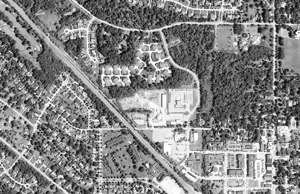
3 Developable Acreage Existing Use # of Parcels Environmental Constraints Undeveloped / Open Space 3 Waterway, forest, floodplain, wetlands, conservation easement Public (Bus Depot) 3 City of Hudson Public (Public Works) Forest, small wetland 4 City of Hudson Public (Rail ROW) Public / Semi-Public 6 Private Industrial 7 Private (Windstream) Industrial (Telecommunications) 3 # Existing Ownership Acreage City of Hudson Hudson City School District Hudson Library & Historical Society 8 Private Commercial 9 Private Office TOTAL Process ROLE OF THE PLAN The Downtown Phase II Plan is the result of a multi-year process that has engaged residents, elected officials, civic stakeholders, and the development community. A Downtown Plan Advisory Committee (DPAC), composed of residents and stakeholders, was selected by the City of Hudson to oversee the project and ensure that it is reflective of the community s wishes and desires. These desires were then aligned by the consultant team with market realities and economic data. The Plan was developed in tandem with the update to the City s Comprehensive Plan, and is considered a vital part of that document. The Downtown Phase II Plan provides an overall vision, with the Land Use Framework Plan depicting a desirable development program for the project study area. However, flexibility should be maintained and the City should remain responsive to the market, but in keeping with the guiding principles. Building sizes and footprints will likely vary between the proposed development program within this plan and what is eventually constructed. The Plan should guide development but not limit or constrict it. The development program is ambitious, but the Hudson community has a track record of undertaking and successfully completing similar projects. The City s initial 99 Comprehensive Plan also dreamed big and identified undesirable areas west of Main Street as an opportunity to expand Downtown and create a walkable mixed-use environment. In 004, the First and Main development opened ( Phase I ), a national model for high-quality small town city core development. The remaining area to the west and northwest, however, remains underutilized. The Downtown Phase II Plan establishes a revitalization and redevelopment vision for that area. 4 Hudson Comprehensive Plan & Downtown Phase II Plan Downtown Phase II Plan Conservation easement Study Area & Existing Conditions The Phase II project is roughly bounded by frontage along the east side of Morse Road, the Villas of Hudson on the north, the Norfolk-Southern rail line on the west, and Village Way Road to the south. In total, the project area contains 6 parcels totaling 6 acres. Private properties are not bound by the Plan but if opportunities arise, they should be considered for redevelopment. The existing public and industrial uses in the Phase II area are considered incompatible with the existing Downtown area and do not provide the connectivity, energy, tax revenue, or critical mass of employees that the neighboring First and Main contributes to the city core Prepared by Houseal Lavigne Associates July 0


4 Guiding Principles While elements of the development program may vary as implementation begins, it is important that what is eventually constructed aligns with key principles established by the community. Housing Diversity Single family detached homes make up approximately 87% of Hudson s housing stock, and this composition can make it difficult to attract young families and young professionals or retain empty nesters and provide for seniors. Phase II represents an opportunity to provide a mixture of housing types and densities within a walkable environment, including both rental and owner-occupied units. Quality Office Space Attraction and retention of well-paying employers is a priority. Phase II s location within a walkable environment with access to restaurants, bars, retail, and civic uses makes it an attractive environment for office development. High quality office space in Downtown Hudson is already in high demand. Phase II presents an opportunity to expand Downtown Hudson s office stock, and generate additional tax revenue. LESS EMPHASIS ON Retail Hudson already has a very sizable retail base for a city of its size and the regional market is relatively saturated. Retail and restaurant uses should be kept to a minimum within Downtown Phase II, and efforts should be directed towards supporting existing retail and dining within the Downtown area. However, a limited volume may be appropriate for ground floor uses within identified mixed-use buildings, if supported by the market. Emphasis on Connectivity Preservation of Hudson s Character The community has expressed an overwhelming desire for increased connectivity, including the addition of new sidewalks, trails, and bikeways. New development should enhance Downtown s walkability and bikeability and encourage multiple modes of transportation. It should also connect easily to the regional trail network. The First and Main development was constructed in a tasteful and attractive style in keeping with Hudson s local character, blending in well with Main Street. Throughout all outreach efforts, residents continually reinforced the need to safeguard Hudson s small town charm and Western Reserve architecture from incompatible development. Whatever is ultimately developed within Phase II, it is integral that its scale and style be compatible with the existing character of the area. July 0 Prepared by Houseal Lavigne Associates Downtown Phase II Plan Hudson Comprehensive Plan & Downtown Phase II Plan 43
5 Library St Land Use Framework The Downtown Phase II Plan provides an overall vision, with the Land Use Framework Plan depicting a desirable development program for the project study area. However, flexibility should be maintained and the City should remain responsive to the market, but in keeping with the guiding principles. Building sizes and footprints will likely vary between the proposed development program within this plan and what is eventually constructed. The Plan should guide development, but not limit or constrict it. The framework includes both public and private properties; private properties should be considered for redevelopment if desired by the private property owners. Morse Rd Prospect St Residential Improvements # Use 3 4 Total Building Footprint (s.f.) Floor(s) Total Building Area (s.f.) Units Parking Required Multi-Family 64, , Multi-Family (upper floors)* 4,000 90, Townhome (w/ garage) -- 3,000/unit Townhome (w/ garage) -- 3,000/unit Parking Provided Totals 44 Units Multi-Family 48 Units Townhome Map Key Phase II Study Area Townhome Multi-Family Office Office with Residential above Flex Use Open Space Landscape Buffer Potential Development Site Potential Connection Potential Parking Area Potential Building Location Overhead Utility (to remain) Proposed Hike Bike Path Existing Wetland 3 A B Owen Brown St C Windstream 6 Morse Rd Owen Brown St Clinton St Non-Residential Improvements # Use Building Footprint (s.f.) Floor(s) Total Building Area (s.f.) Tenants Parking Required Office (ground floor) 38,0 38, Office 6, , Office 6, , Flex,000 0, Flex,70, Flex,000 0, Potential Connections Parking Provided in overflow lot Totals 3,70 s.f. Office Space,70 s.f. Flex Space Overflow Lot 9 Hudson Library & Historical Society # Roadway Segment A Roadway Length (f.) Residential,0 8 Roadway Width (f.) Village Way B C Mixed Use 40 8 Office Scale: 0 = * Mixed-use buildings within # are three stories, with the ground floor as office and the upper two floors as residential. ** The lower end of the range is a minimum space per 400 sq. ft. and the higher end of the range is a maximum space per 0 sq. ft. based on the City parking regulations. 44 Hudson Comprehensive Plan & Downtown Phase II Plan Downtown Phase II Plan Prepared by Houseal Lavigne Associates July 0

6 Downtown Phase II Plan 6 Illustrative Concept - Perspective Rendering 9 The Downtown Phase II Plan provides an overall vision and detailed concept plan depicting a desirable development program for the project study area. However, flexibility should be maintained and the City should remain responsive to the market. Building sizes and footprints will likely vary between the proposed development program within this plan and what is eventually constructed Key Improvements Existing Overhead Power Lines (to remain) New Regional Trail Alignment The proposed regional trail alignment is integrated into the overall redevelopment of the Phase II study area. Construction requires new off-road trails, improvements to existing public sidewalks, and removal of excessive pavement to make way for the new trail alignment. 3 Connected open space and trail network for institutional, residential and commercial development 9 Owen Brown Street Rail Viaduct The narrow right-of-way under the rail culvert inhibits safe and efficient traffic flow along Owen Brown Street. The City should add a traffic signal to limit traffic flow to one direction at any given time. 0 Office (3-story) Windstream Offices Portions of the Windstream offices will remain in the Phase II study area. The existing Windstream parking lot would need to be reconfigured to accommodate the circulation needs of the proposed offices. 6 Coordinated Streetscape Phase II should create an inviting pedestrian environment by installing street trees and pedestrian amenities such as benches, tree gates, trash receptacles and decorative crosswalks. Shared parking with consolidated access points to create a pedestrian friendly environment 7 Flex Use (-story) 8 Landscape screening and berm to buffer adjacent uses July 0 Prepared by Houseal Lavigne Associates Townhomes (-story) Native restoration area Multi-family (3-story) Unified Sidewalk Network Office with residential above (3-story) Key intersection enhancements including decorative pavers, crosswalks, and pedestrian signal features 3 Pedestrian plaza space and outdoor seating area 4 Townhome (-story) 9 Flex Use (-story) 0 Office (3-story) Existing Overhead Power Lines (to remain) Flex Use (-story) 3 Shared parking with consolidated access points to create a pedestrian friendly environment Downtown Phase II Plan Hudson Comprehensive Plan & Downtown Phase II Plan 4

7 Cost, Benefits, Phasing & Implementation This section addresses potential cost considerations associated with redevelopment as well as the corresponding benefits. Phasing and implementation of concept plan components and the preliminary development program are also addressed. The majority of the acreage contained within the Downtown Phase II study area is publicly-owned, including the school bus facility and the sites housing Hudson Power and Hudson Public Works. While there is existing private property on the site, most notably Windstream, the site does not generate any significant revenue for the City or other taxing jurisdictions. Correspondingly, it does not place much demand on City services. Relocation of Existing Uses Nearly all of the existing uses on the site would need to be relocated to accommodate redevelopment. A portion of the Windstream facility would remain due to the associated cost of relocation. That building would be integrated into the larger site redevelopment. Alternate sites for the school bus facility, Hudson Power and Hudson Public Works have been identified by the City and are included in Chapter 9: Community Facilities & Services Plan. There is no cost associated with site acquisition, as they are municipally-owned. The City will reportedly pay the cost of constructing a new school bus facility in exchange for the existing property. Site Acquisition Private property, including the surplus Windstream property, would need to be secured by the City or subject to redevelopment agreements with a developer(s) in order to facilitate development. The value of that property would be subject to appraisal and negotiation based on the size and developable site area. With the exception of the private properties located outside of the original Phase II area, it is not recommended that site redevelopment begin without controlling or securing redevelopment agreements for all properties. The properties defined outside of the original Phase II boundaries provide connectivity and continuity with the existing Downtown but are not integral to the larger site redevelopment. While portions of the outlined development program could be accommodated as land is taken down and secured, complete control would allow for more flexibility and increase the likelihood of realizing the vision for Phase II. The certainty provided by the City controlling the site or working with a developer to ensure control of remaining parcels provides additional confidence to potential investors and buyers and provides the City with leverage in developer negotiations. 46 Hudson Comprehensive Plan & Downtown Phase II Plan Downtown Phase II Plan Prepared by Houseal Lavigne Associates July 0

8 Phasing All segments of development will likely require phasing. While all components are capable of coming online simultaneously, the City should remain flexible in working with developers in determining a construction phasing schedule. Actual phasing will be driven by market conditions at the time of construction, development costs and subject to the terms of the City s redevelopment agreement(s). Construction needs to be sensitive to existing uses and property owners as well as other ongoing development, particularly residential uses. The preliminary concept plan includes a mix of residential, office, and mixed-use development. RESIDENTIAL The residential component of the area includes both multi-family units (rentals and condominiums) and townhomes. This mixture of residences will help diversify the City s housing stock as well as provide units for empty nesters, young professionals, young families, seniors, and more. Unit sizes and amenities will vary. The development should include a diversity and mix of price points. Multifamily: A total of units. Individual unit sizes will vary depending on mix. Townhomes: A total of townhomes averaging 3,000 square feet apiece (with garages). RETAIL The Phase II development program does not directly include any retail uses. Hudson already has a very sizable retail base for a city of its size and the market is relatively saturated. Retail and restaurant uses should be directed to the existing Downtown and First and Main areas, unless market conditions change. OFFICE The office component of Phase II contains approximately 4,00 square feet of space (including common areas) designed to accommodate a variety of users from corporate to medical professionals to livework space. The need for new office space was documented in the market analysis as well as in conversations with brokers, developers and business representatives, and this level of square footage should be able to be absorbed over time given its quality and central location. The office component also creates additional activity to support retail and restaurant uses throughout Downtown. Depending on use, office space typically ranges from 7 to square feet per worker. For approximately 4,00 square feet of space, that would translate to roughly 647 to 83 workers. The International Council of Shopping Centers (ICSC) estimates the average weekly expenditure at stores and restaurants in close proximity to work at $9 per office worker (includes buying grocery items and larger ticket items at retail stores). Even if a more conservative approach is taken and average weekly spending is reduced to $00, it would equate to between $3.4 and $4.3 million per year in additional expenditures in the immediate area. Buildings may be constructed simultaneously for economies of scale. However, it is likely that a developer will phase construction until meeting prelease and/or prelease thresholds for the first building. MIXED USE/FLEX The mixed use component of the development would be located just outside of the Phase II boundaries but also provide connectivity to the existing Downtown environment. This would be designed to be market driven and flexible to accommodate potential retail uses on the ground floor and office or residential above. Civic uses are also acceptable. July 0 Prepared by Houseal Lavigne Associates Downtown Phase II Plan Hudson Comprehensive Plan & Downtown Phase II Plan 47

9 Parking At this time, it is not anticipated that an additional parking structure in the Phase II development is needed. Parking is accommodated on site for each use and additional spillover/shared public parking is also provided within the area designated as flex space in the concept plan. It is envisioned that this space could accommodate additional demand from Phase II development, the library, trail use or special events. However, a parking structure may be supported if the community needs and development perimeters change over time. A Comprehensive Downtown Parking Study should be conducted prior to actual development to determine the best course of action. Morse Road Realignment The realignment of Morse Road was considered as part of the redevelopment plan. At this time, relocation is not considered the best course of action, however, it may be revisited in the future if the development perimeters change. There are several issues associated with realignment that need to be addressed and considered before proceeding or incorporating realignment into a redevelopment plan. Cost. The associated cost for just the road reconfiguration is estimated at $70,000 not including private utilities. In order to provide a larger development site, existing utility lines would need to be relocated or placed underground. The cost of utility relocation and/or burying underground is very expensive and contingent upon agreement and cooperation with providers. Cooperation with Land Conservancy. Development would backup to Land Conservancy property and depending on site layout, a construction easement, at a minimum would need to be secured. Relocating utilities would also require utilizing Land Conservancy property as well. Site Yield. The presence of overhead utility wires and a conservation easement may limit the amount of developable property ease of Morse Road. The total number of units realized relative to cost of construction, road realignment and infrastructure would have a significant impact on development feasibility. If the City wishes to further explore the realignment of Morse Road, discussions should take place with the Land Conservancy to determine what may be agreeable in terms of encroachment. In addition a detailed engineering study should be conducted to determine underlying issues and cost as well as determination of the feasibility of relocating or burying utilities underground. Development Benefits and Impacts As previously mentioned, existing uses do not generate any significant revenue for the City. The daily traversing of school buses through the Downtown has a negative impact on road infrastructure and creates congestion and traffic conflicts during peak hours. In addition the nature of uses including public works is not conducive to the surrounding residential uses and open space. Redevelopment will provide continuity and connectivity to the area and linkage to First and Main. A summary of benefits includes: Increased tax revenue for the City of Hudson and Hudson Schools New residential options for seniors and young professionals Increase in available Downtown office space Alleviation of bus traffic through Downtown New more modern facilities for all existing public uses Potential for new mixed use development Increase in Downtown activity to help existing merchants and business While long-term benefits outweigh potential negatives, any discussion of benefits it is equally important to discuss potential negative impacts as well. Those may include: Traffic to and from the new development Potential increased demand on City and emergency services Impact on surrounding uses during construction Cost associated with acquisition, redevelopment and infrastructure improvements 48 Hudson Comprehensive Plan & Downtown Phase II Plan Downtown Phase II Plan Prepared by Houseal Lavigne Associates July 0

10 Implementation The next step in the process in realizing the vision for Downtown Phase II will be to vacate and secure as much of the property as possible through direct acquisition or options. Engineering studies will need to be conducted to determine site conditions and net developable area. Separately, the City needs to make a policy decision as to whether they wish to further use Tax Increment Financing (TIF) to incentivize development of the site. The City s only TIF, which covered the First & Main area, expired in 04. While a TIF eligibility study would need to be performed, eligibility factors most certainly exist in this area. The importance of establishing the TIF on the front end is that it provides an additional tool in soliciting developer and investor interest. The City should then begin the process of preparing a developer RFQ (request for qualifications) process in which the City first solicits responses from developers or development teams to determine interest. This allows for developers to respond without a significant investment in cost and resources. Depending on the number of responses, the City can then create a short-list of developers from which to request more detailed proposals including preliminary development pro formas. Once a developer or development team has been selected, the City can then begin the process of creating a developer agreement and redevelopment plan including the potential level of assistance that may be required to facilitate the desired program. Again, a benefit of controlling the property is that the City has leverage and flexibility in negotiations. One opportunity would be to assist property owners in the creation of a Special Improvement District (SID), authorized and outlined in Ohio Revised Code (ORC) 70. A SID would allow Phase II properties (or a broader area, depending on the boundaries established) to tax themselves to provide for desired public improvements and services beyond the level currently provided. Depending on the number of property owners and the desired jurisdiction, the SID represents one additional tool to help revitalize the area. Regardless of the incentives utilized, the City should be continuously mindful of the impact on existing Downtown businesses and property owners to ensure that Phase II development complements and does not compete with or negatively impact those individuals. Phasing/Next Steps The following is an overview of steps to realize the vision for Phase II development. Some steps may take place simultaneously and/or overlap and others are contingent on completion or outcome of a preceding step or task. This is not intended to be an exhaustive list, but rather an overview of phasing steps. Phasing/Next Steps Tasks Secure property acquisition or options on all properties Relocate Hudson Public Power and Hudson City Schools bus garage Relocate City Public Works facility Work with Windstream on site needs Conduct Phase One environmental assessments Prepare site remediation if required Complete TIF Eligibility study and subsequent decision on establishment of TIF District and development incentives Prepare developer RFQ to qualify prospective developers Create short-list of developers Prepare developer RFP to solicit development proposals Select developer(s) separate developers may be selected based on plan component Negotiate and secure redevelopment agreement Prepare marketing and promotion of Phase II Additional development incentives and assistance can be evaluated on a case by case basis based on specific uses or businesses. This may or may not include financial incentives and could include such things as assistance with site improvements or waiving of permit fees. Prepare/construct public infrastructure and improvements Begin construction and preleasing/presales Note: These are steps and not timelines. Timing is contingent upon the completion of subsequent tasks and policy decisions. However, initial tasks can begin immediately. July 0 Prepared by Houseal Lavigne Associates Downtown Phase II Plan Hudson Comprehensive Plan & Downtown Phase II Plan 49
7. IMPLEMENTATION STRATEGIES
 7. IMPLEMENTATION STRATEGIES A. GENERAL APPROACH FOR IMPLEMENTATION Implementing the plan will engage many players, including the Municipality of Anchorage (MOA), the Government Hill Community Council,
City of Winnipeg Housing Policy Implementation Plan
 The City of Winnipeg s updated housing policy is aligned around four major priorities. These priorities are highlighted below: 1. Targeted Development - Encourage new housing development that: a. Creates
Bylaw No , being "Official Community Plan Bylaw, 2016" Schedule "A" DRAFT
 Bylaw No. 2600-2016, being "Official Community Plan Bylaw, 2016" Schedule "A" Urban Structure + Growth Plan Urban Structure Land use and growth management are among the most powerful policy tools at the
Chapter URBAN VILLAGE ZONING DISTRICTS
 Chapter 20.16 Sections: 20.16.010 Purpose of the Urban Village Zoning Districts 20.16.020 Land Use Regulations for the Urban Village Zoning Districts 20.16.030 Development Standards & Guidelines for the
12. STAFF REPORT ACTION REQUIRED SUMMARY. Date: September 21, Toronto Public Library Board. To: City Librarian. From:
 STAFF REPORT ACTION REQUIRED 12. Property Redevelopment Feasibility Date: September 21, 2015 To: From: Toronto Public Library Board City Librarian SUMMARY At the meeting on May 25 2015, the Toronto Public
Chapter 10: Implementation
 Chapter 10: Introduction Once the Comprehensive Plan has been adopted by the City of Oakdale, the City can begin to implement the goals and strategies to make this vision a reality. This chapter will set
HOUSING ELEMENT GOALS, OBJECTIVES, AND POLICIES
 HOUSING ELEMENT GOALS, OBJECTIVES, AND POLICIES GOAL 1: To promote the preservation and development of high-quality, balanced, and diverse housing options for persons of all income levels throughout the
PLANNED UNIT DEVELOPMENT & SUBDIVISION STAFF REPORT Date: April 18, 2019
 PLANNED UNIT DEVELOPMENT & SUBDIVISION STAFF REPORT Date: April 18, 2019 DEVELOPMENT NAME SUBDIVISION NAME Springhill Village Subdivision Springhill Village Subdivision LOCATION 4350, 4354, 4356, 4358,
County Lot C Redevelopment
 County Lot C Redevelopment La Crosse County La Crosse, WISCONSIN 03.20.14 Orientation What is the purpose of this process? La Crosse County is exploring ways to maximize the value of Lot C by completing
Housing Commission Report
 Housing Commission Report To: From: Subject: Housing Commission Meeting: July 21, 2016 Agenda Item: 4-B Chair and Housing Commission Barbara Collins, Housing Manager Draft Request for Proposals for Mountain
Charlottesville Planning Commission, Neighborhood Associations & News Media
 CITY OF CHARLOTTESVILLE A World Class City Department of Neighborhood Development Services City Hall Post Office Box 911 Charlottesville, Virginia 22902 Telephone 434-970-3182 Fax 434-970-3359 www.charlottesville.org
City of Grande Prairie Development Services Department
 City of Grande Prairie Development Services Department COUNTRYSIDE SOUTH OUTLINE PLAN Prepared by: GPEC Consulting Ltd. #202, 10712-100th Street Grande Prairie, AB Council Resolution of August 20, 2001
Downtown Development Focus Area: I. Existing Conditions
 Downtown Development Focus Area: I. Existing Conditions The Downtown Development Focus Area is situated along Route 1, south of the train tracks, except for the existing Unilever property. It extends west
PART ONE - GENERAL INFORMATION
 Corrected Date: Page 7 Date of Submittal Changed to Coincide with Submittal Date on Page 5 PART ONE - GENERAL INFORMATION A. INTRODUCTION B. Background Miami Shores Village is soliciting responses to this
LINCOLN CORRIDOR REDEVELOPMENT PROJECT UPDATE FOR DOWNTOWN GATEWAY FOCUS AREA
 ITEM: 51 BACKGROUND: Staff Report LINCOLN CORRIDOR REDEVELOPMENT PROJECT UPDATE FOR DOWNTOWN GATEWAY FOCUS AREA March 27, 2018 The City has been working for two years to develop, adopt, and implement the
74af ANTELOPE VALLEY REDEVELOPMENT PLAN
 74af T. Telegraph District Phase 2: Telegraph Flats & Telegraph Lofts East 1. Project Area Description Phase 2 will include two building subphase areas with connecting streetscape enhancements: The Telegraph
Proposed Development at Ajax Plaza Windcorp Grand Harwood Place Ltd.
 Proposed Development at Ajax Plaza Windcorp Grand Harwood Place Ltd. Presentation to Ajax Council July 4, 2013 Introduction 1. Background 2. Planning Policies and Regulations 3. Downtown Community Improvement
Be linked by an internal circulation system (i.e., walkways, streets, etc.) to other structures within the IPUD;
 to other structures within the IPUD;") 2. HALIFAX ACTIVITY CENTER A. DESCRIPTIONS OF FUTURE LAND USE DESIGNATIONS Each of the future land use designations specified by Phase I of the Halifax Activity Center Plan, and the relationship of these
2. HALIFAX ACTIVITY CENTER A. DESCRIPTIONS OF FUTURE LAND USE DESIGNATIONS Each of the future land use designations specified by Phase I of the Halifax Activity Center Plan, and the relationship of these
Appendix A: Guide to Zoning Categories Prince George's County, Maryland
 Appendix A: Guide to Zoning Categories Prince George's County, Maryland RESIDENTIAL ZONES 1 Updated November 2010 R-O-S: Reserved Open Space - Provides for permanent maintenance of certain areas of land
PLANNED UNIT DEVELOPMENT (PUD)
") SECTION 38.01. ARTICLE 38 PLANNED UNIT DEVELOPMENT (PUD) Purpose The purpose of this Article is to implement the provisions of the Michigan Zoning Enabling Act, Public Act 110 of 2006, as amended, authorizing
SECTION 38.01. ARTICLE 38 PLANNED UNIT DEVELOPMENT (PUD) Purpose The purpose of this Article is to implement the provisions of the Michigan Zoning Enabling Act, Public Act 110 of 2006, as amended, authorizing
PROPOSED METRO JOINT DEVELOPMENT PROGRAM: POLICIES AND PROCESS July 2015 ATTACHMENT B
 PROPOSED METRO JOINT DEVELOPMENT PROGRAM: POLICIES AND PROCESS ATTACHMENT B TABLE OF CONTENTS I. INTRODUCTION / PURPOSE............................ 3 II. OBJECTIVES / GOALS..................................
Downtown & East Town CRA Expansion Plan City of Eustis
 Downtown & East Town CRA Expansion Plan City of Eustis May 2018 Contents 1 Introduction... 1 CRA Overview/History... 1 2 Existing Conditions... 2 Downtown & East Town Community Redevelopment Area Expansion...
LAKE MERRITT STATION AREA PLAN
 LAKE MERRITT STATION AREA PLAN Emerging Plan Open House Summary October 2011 2 1 Introduction The City of Oakland, Bay Area Rapid Transit (BART), and the Peralta Community College District, through a grant
DESCRIPTION OF THE DISTRICT
 DESCRIPTION OF THE DISTRICT The project plan for City of Wausau, Tax Increment District #11 has been prepared in compliance with Wisconsin Statutes Chapter 66.1105(4). The plan establishes the need for
DRAFT FOR DISCUSSION PURPOSES ONLY. Port Credit Local Area Plan Built Form Guidelines and Standards DRAFT For Discussion Purposes
 Port Credit Local Area Plan Built Form Guidelines and Standards DRAFT For Discussion Purposes 1 Local Area Plan - Project Alignment Overview Directions Report, October 2008 (General Summary Of Selected
174 North King Street Workforce Housing Development Downtown Jackson, Wyoming
 174 North King Street Workforce Housing Development Downtown Jackson, Wyoming Request for Proposals Release Date November 7, 2017 Information Session December 4, 2017 Submission Deadline February 9, 2018
MOTION NO. M Capitol Hill Transit-Oriented Development Purchase and Sale Agreement and Ground Lease
 MOTION NO. M2015-34 Capitol Hill Transit-Oriented Development Purchase and Sale Agreement and Ground Lease MEETING: DATE: TYPE OF ACTION: STAFF CONTACT: Board 04/23/2015 Final Action Ric Ilgenfritz, Executive
Montreal Road District Secondary Plan [Amendment #127, October 9, 2013]
![Montreal Road District Secondary Plan [Amendment #127, October 9, 2013]](/thumbs/72/66783104.jpg "Montreal Road District Secondary Plan [Amendment #127, October 9, 2013]") [Amendment #127, October 9, 2013] 1.0 General The following policies are applicable to the Montreal Road District as set out in Schedule 1. 1.1 District Objectives The objective of this Plan is to guide
[Amendment #127, October 9, 2013] 1.0 General The following policies are applicable to the Montreal Road District as set out in Schedule 1. 1.1 District Objectives The objective of this Plan is to guide
Appendix J - Planned Unit Development (PUD)
") Appendix J - Planned Unit Development (PUD) Intent and Purpose The purpose of the PUD is: 1. To provide development that is consistent with the Comprehensive Land Use Plan and promote the goals and objectives
Appendix J - Planned Unit Development (PUD) Intent and Purpose The purpose of the PUD is: 1. To provide development that is consistent with the Comprehensive Land Use Plan and promote the goals and objectives
4.1 Overview. 4.2 Land Use Plan
 4.1 Overview The Sierra Vista Specific Plan provides for a mix of land uses to achieve the desired community form and Plan Area objectives. These land use designations include low-, medium-, and high-density
TOOELE COUNTY LAND USE ORDINANCE CHAPTER 31 Page 1
 CHAPTER 31 PLANNED COMMUNITY ZONE (P-C) Section 31-1 Definitions. 31-2 Purpose. 31-3 Land use districts. 31-4 P-C zone area minimum requirements. 31-5 Permitted uses. 31-6 Conditional uses. 31-7 Planning
Generic Environmental Impact Statement. Build-Out Analysis. City of Buffalo, New York. Prepared by:
 Generic Environmental Impact Statement Build-Out Analysis City of Buffalo, New York 2015 Prepared by: TABLE OF CONTENTS 1.0 INTRODUCTION 1 2.0 METHODOLOGY 2 3.0 EXISTING LAND USE 3 4.0 EXISTING ZONING
Shawnee Landing TIF Project. City of Shawnee, Kansas. Need For Assistance Analysis
 Shawnee Landing TIF Project City of Shawnee, Kansas Need For Assistance Analysis December 17, 2014 Table of Contents 1 EXECUTIVE SUMMARY... 1 2 PURPOSE... 2 3 THE PROJECT... 3 4 ASSISTANCE REQUEST... 7
Chapter 5: Testing the Vision. Where is residential growth most likely to occur in the District? Chapter 5: Testing the Vision
 Chapter 5: Testing the Vision The East Anchorage Vision, and the subsequent strategies and actions set forth by the Plan are not merely conceptual. They are based on critical analyses that considered how
2) COMPREHENSIVE PLAN AMENDMENT
 COMPREHENSIVE PLAN AMENDMENT") The Inwood Road Corridor, (Sector 2) COMPREHENSIVE PLAN AMENDMENT In 2016, the City Council approved a contract with M. Arthur Gensler Jr. And Associates, Inc. (Gensler) to facilitate a special study process
The Inwood Road Corridor, (Sector 2) COMPREHENSIVE PLAN AMENDMENT In 2016, the City Council approved a contract with M. Arthur Gensler Jr. And Associates, Inc. (Gensler) to facilitate a special study process
HOUSING ISSUES REPORT
 HOUSING ISSUES REPORT 8, 12 & 14 HIGH PARK AVENUE AND 1908, 1910, 1914 & 1920 BLOOR STREET WEST CITY OF TORONTO PREPARED FOR: 619595 ONTARI O INC. February 2016 TABLE OF CONTENTS 1.0 INTRODUCTION 1 2.0
TRANSIT-ORIENTED DEVELOPMENT PLAN EXISTING CONDITIONS REPORT LAWRENCE TO BRYN MAWR MODERNIZATION
 TRANSIT-ORIENTED DEVELOPMENT PLAN EXISTING CONDITIONS REPORT LAWRENCE TO BRYN MAWR MODERNIZATION March 2018- FINAL DRAFT SITE SPECIFIC DEVELOPMENT CONCEPTS SITE SPECIFIC DEVELOPMENT CONCEPTS This report
The Miramar Santa Monica
 The Miramar Santa Monica Project Description The Santa Monica Miramar Hotel (the Miramar or the Hotel ) has been an institution in the City of Santa Monica since originally opening on the site in 1920.
CITY OF LEBANON RUSSELL DRIVE AREA MIXED USE NEIGHBORHOOD CENTER FINAL IMPLEMENTATION PLAN
 CITY OF LEBANON RUSSELL DRIVE AREA MIXED USE NEIGHBORHOOD CENTER FINAL IMPLEMENTATION PLAN TGM Contract 2G-01 #22425 Deliverable 15.5 Prepared by: Satre Associates, P.C. Planners, Landscape Architects,
LITTLE MOUNTAIN ADJACENT AREA REZONING POLICY
 LITTLE MOUNTAIN ADJACENT AREA REZONING POLICY JANUARY 2013 CONTENTS 1.0 INTENT & PRINCIPLES...1 2.0 APPLICATION...2 3.0 HOUSING TYPES, HEIGHT & DENSITY POLICIES...3 3.1 LOW TO MID-RISE APARTMENT POLICIES...4
HOUSING ELEMENT GOALS, OBJECTIVES, & POLICIES
 HOUSING ELEMENT GOALS, OBJECTIVES, & POLICIES GOAL H-1: ENSURE THE PROVISION OF SAFE, AFFORDABLE, AND ADEQUATE HOUSING FOR ALL CURRENT AND FUTURE RESIDENTS OF WALTON COUNTY. Objective H-1.1: Develop a
Downtown Plano. Creating a Transit Village
 Downtown Plano Creating a Transit Village Residential Growth Pattern Downtown Plano Plano 1891 Plano 1971 Downtown Plano Downtown Plano Avenue J Avenue J Summary of Problems Eroding economic position Physical
CITY OF FATE, TEXAS UNIFIED DEVELOPMENT ORDINANCE. Article III Zoning Districts
 CITY OF FATE, TEXAS UNIFIED DEVELOPMENT ORDINANCE Article III Zoning Districts 3.1. General to all Zoning Districts and Zoning Map 3.1.1. Zoning Districts Established This article establishes the zoning
Village of Perry Zoning Ordinance Update Draft Diagnostic Report
 Village of Perry Zoning Ordinance Update Draft Diagnostic Report Background The Village of Perry began work on a new comprehensive plan in 2014. After a year of committee meetings and public outreach,
PRELIMINARY PROJECT PLAN AND REINVESTMENT ZONE FINANCING PLAN FOR PROPOSED TAX INCREMENT REINVESTMENT ZONE NO. 1, CITY OF OAK RIDGE NORTH
 PRELIMINARY PROJECT PLAN AND REINVESTMENT ZONE FINANCING PLAN FOR PROPOSED TAX INCREMENT REINVESTMENT ZONE NO. 1, CITY OF OAK RIDGE NORTH DECEMBER 15, 2014 TABLE OF CONTENTS 1. Overview 1.1 Background...
DRAFT Plan Incentives. Part A: Basic Discount
 DRAFT 2030 Plan Incentives July 26, 2006 Part A: Basic Discount In order for a development to be eligible for any 2030 Land Resource Management Plan Discounts it must be located in the Urban Corridor and
Riverside County Transportation Commission Rail Station Joint Development Guidelines June 2005
 Riverside County Transportation Commission Rail Station Joint Development Guidelines June 2005 PURPOSE These guidelines are issued under the authority of the Riverside County Transportation Commission
Appendix1,Page1. Urban Design Guidelines. Back to Back and Stacked Townhouses. DRAFT September 2017
 Appendix1,Page1 Urban Design Guidelines DRAFT September 2017 Back to Back and Stacked Townhouses Appendix1,Page2 Table of Contents 1 Introduction 1 1.1 Purpose 1 1.2 Urban Design Objectives 1 1.3 Building
REGULATING PLAN for the Plaza Saltillo TOD Station Area Plan (SAP)
") REGULATING PLAN for the Plaza Saltillo TOD Station Area Plan (SAP) Adopted: December 11, 2008 Effective: March 1, 2009 REGULATING PLAN for the Plaza Saltillo TOD Station Area Plan (SAP) CONTENTS BACKGROUND...iv
REGULATING PLAN for the Plaza Saltillo TOD Station Area Plan (SAP) Adopted: December 11, 2008 Effective: March 1, 2009 REGULATING PLAN for the Plaza Saltillo TOD Station Area Plan (SAP) CONTENTS BACKGROUND...iv
Technology Park Planned Unit Development Technology Park PUD-IP
 Technology Park Planned Unit Development Technology Park PUD-IP Rob Anderson Community Development Director Planned Unit Development Background 2 Planned Unit Development (PUD) means a mixed use redevelopment
Library Park Apartments Development Request for Proposal CML#
 The Columbus Metropolitan Library ( CML ) and the Columbus Downtown Development Corporation ( CDDC ) are inviting developers to respond to this Request for Proposal ( RFP ) to develop a residential/retail
4 LAND USE 4.1 OBJECTIVES
 4 LAND USE The Land Use Element of the Specific Plan establishes objectives, policies, and standards for the distribution, location and extent of land uses to be permitted in the Central Larkspur Specific
PLANNING COMMISSION WILLIAMSBURG, VIRGINIA WORK SESSION AGENDA Wednesday, May 23, 2012
 PLANNING COMMISSION WILLIAMSBURG, VIRGINIA WORK SESSION AGENDA Wednesday, May 23, 2012 The meeting will be called to order in the third floor Conference Room (Room 310), Williamsburg Municipal Building,
TOTTENHAM SECONDARY PLAN
 TOTTENHAM SECONDARY PLAN AMENDMENT NO. 11 TO THE OFFICIAL PLAN OF THE TOWN OF NEW TECUMSETH The following text and schedules to the Official Plan of the Town of New Tecumseth constitute Amendment No. 11
SUBDIVISION, PLANNED UNIT DEVELOPMENT, & REZONING STAFF REPORT Date: March 23, 2017
 SUBDIVISION, PLANNED UNIT DEVELOPMENT, & REZONING STAFF REPORT Date: March 23, 2017 APPLICANT NAME SUBDIVISION NAME DEVELOPMENT NAME LOCATION Sarah & Michael Stashak Old Shell at Ashland Place Subdivision
UPDATE Board of Selectmen June 20, 2017
 MAPLE STREET I-1 AREA DRAFT ZONING BYLAW & DEVELOPMENT STANDARDS Town of Danvers, MA UPDATE Board of Selectmen June 20, 2017 The Danvers Team: Brovitz Community Planning & Design Dodson & Flinker Danvers
ARTICLE 3: Zone Districts
 ARTICLE 3: Zone Districts... 3-1 17.3.1: General...3-1 17.3.1.1: Purpose and Intent... 3-1 17.3.2: Districts and Maps...3-1 17.3.2.1: Applicability... 3-1 17.3.2.2: Creation of Districts... 3-1 17.3.2.3:
Approval of Takoma Amended Joint Development Agreement and Compact Public Hearing
 Planning, Program Development and Real Estate Committee Item IV - B March 13, 2014 Approval of Takoma Amended Joint Development Agreement and Compact Public Hearing Washington Metropolitan Area Transit
SPECIFIC RESPONSES TO AREA COMMISSION OPPOSITION :
 SPECIFIC RESPONSES TO AREA COMMISSION OPPOSITION 3-14-19: Area Commission reasons for opposition in black APPLICANT S RESPONSE IN RED. The comprehensive planning and design of stream restoration efforts
PLANNED UNIT DEVELOPMENTS (Ordinance No.: 3036, 12/3/07; Repealed & Replaced by Ordinance No.: 4166, 10/15/12)
") 159.62 PLANNED UNIT DEVELOPMENTS (Ordinance No.: 3036, 12/3/07; Repealed & Replaced by Ordinance No.: 4166, 10/15/12) A. PURPOSE 1. General. The Planned Unit Development (PUD) approach provides the flexibility
159.62 PLANNED UNIT DEVELOPMENTS (Ordinance No.: 3036, 12/3/07; Repealed & Replaced by Ordinance No.: 4166, 10/15/12) A. PURPOSE 1. General. The Planned Unit Development (PUD) approach provides the flexibility
Ann Arbor Downtown Zoning Evaluation
 Ann Arbor Downtown Zoning Evaluation Options Workbook ENP & Associates in cooperation with the City of Ann Arbor September, 2013 Photo Courtesy of Andrew Horne, February 9, 2013 Introduction Thank you
Route 6 Corridor Study Bristol Planning Commission Meeting #1. May 25, 2016 FITZGERALD & HALLIDAY, INC. Innovative Planning, Better Communities
 Route 6 Corridor Study Bristol Planning Commission Meeting #1 May 25, 2016 FITZGERALD & HALLIDAY, INC. Innovative Planning, Better Communities Today s Agenda 1. Introductions 2. Study overview Scope Schedule
CITY OF FARMERSVILLE CITIZEN ADVISORY COMMITTEE AGENDA November 17, :30 P.M. 1, COUNCIL CHAMBERS, CITY HALL
 I. PRELIMINARY MATTERS CITY OF FARMERSVILLE CITIZEN ADVISORY COMMITTEE AGENDA November 17, 2014 6:30 P.M. 1, COUNCIL CHAMBERS, CITY HALL Call to Order, Roll Call, Prayer and Pledge of Allegiance Welcome
TASK 2 INITIAL REVIEW AND ANALYSIS U.S. 301/GALL BOULEVARD CORRIDOR FORM-BASED CODE
 TASK 2 INITIAL REVIEW AND ANALYSIS U.S. 301/GALL BOULEVARD CORRIDOR FORM-BASED CODE INTRODUCTION Using the framework established by the U.S. 301/Gall Boulevard Corridor Regulating Plan (Regulating Plan),
Section 4 Master Plan Framework
 Section 4 Master Plan Framework 4.1 PURPOSE The Master Plan, as an implementation tool of the SPC District, establishes the primary framework for the overall development of the Property. Detailed site
Place Type Descriptions Vision 2037 Comprehensive Plan
 Place Type Descriptions Vision 2037 Comprehensive Plan The Vision 2037 Comprehensive Plan establishes a range of place types for Oxford, ranging from low intensity (limited development) Rural and Natural
ARLINGTON COUNTY, VIRGINIA
 ARLINGTON COUNTY, VIRGINIA County Board Agenda Item Meeting of April 19, 2008 DATE: April 2, 2008 SUBJECT: ORDINANCE TO AMEND, REENACT, AND RECODIFY Section 20 CP- FBC, Columbia Pike Form Based Code Districts
1. INTRODUCTION 2. PROJECT BACKGROUND AND DESCRIPTION
 Downtown Burlington Pedestrian Wayfinding Signage Plan Request for Proposals Released Tuesday, July 10, 2012 Proposals Due Tuesday, July 31, 2012, 10a.m. 1. INTRODUCTION The Burlington Downtown Corporation
APPENDIX D: DEFINITIONS
 D APPENDIX D: DEFINITIONS Terms used throughout the 2040 Comprehensive Plan should be interpreted using the definitions provided in this appendix. For interpretation of any term not defined, defer to the
Town of Yucca Valley GENERAL PLAN 1
 Town of Yucca Valley GENERAL PLAN 1 This page intentionally left blank. 3 HOUSING ELEMENT The Housing Element is intended to guide residential development and preservation consistent with the overall values
Development Plan DP13-3 (Arlington Lofts) Planning and Zoning Meeting Date: Document Being Considered: Ordinance
 Planning and Zoning Meeting Date: Document Being Considered: Ordinance") Staff Report Development Plan DP13-3 (Arlington Lofts) Planning and Zoning Meeting Date: 6-19-13 Document Being Considered: Ordinance RECOMMENDATION Following the public hearing, consider Development Plan
Staff Report Development Plan DP13-3 (Arlington Lofts) Planning and Zoning Meeting Date: 6-19-13 Document Being Considered: Ordinance RECOMMENDATION Following the public hearing, consider Development Plan
PIN , Part 1, Plan SR-713 in Lot 2, Concession 5, Township of McKim (1096 Dublin Street, Sudbury)
") STAFF REPORT Applicant: Dalron Construction Limited Location: PIN 02124-0103, Part 1, Plan SR-713 in Lot 2, Concession 5, Township of McKim (1096 Dublin Street, Sudbury) Official Plan and Zoning By-law:
STAFF REPORT Applicant: Dalron Construction Limited Location: PIN 02124-0103, Part 1, Plan SR-713 in Lot 2, Concession 5, Township of McKim (1096 Dublin Street, Sudbury) Official Plan and Zoning By-law:
Land Use Planning Analysis. Phase 2 Drayton Valley Annexation Proposal
 Land Use Planning Analysis Phase 2 Drayton Valley Annexation Proposal Prepared for Town of Drayton Valley Prepared by Mackenzie Associates Consulting Group Limited March, 2011 TABLE OF CONTENTS 1.0 INTRODUCTION...
PLAINFIELD CHARTER TOWNSHIP COMMUNITY DEVELOPMENT DEPARTMENT PLANNING, ZONING & BUILDING SERVICES MEMORANDUM
 PLAINFIELD CHARTER TOWNSHIP COMMUNITY DEVELOPMENT DEPARTMENT PLANNING, ZONING & BUILDING SERVICES 6161 BELMONT AVENUE N.E. BELMONT, MI 49306 PHONE 616-364-1190 FAX: 616-364-1170 www.plainfieldchartertwp.org
MEMORANDUM Planning Commission Travis Parker, Planning Director DATE: April 4, 2018 Lakewood Zoning Amendments Housing and Mixed Use
 MEMORANDUM TO: FROM: Travis Parker, Planning Director DATE: April 4, 2018 SUBJECT: Lakewood Zoning Amendments Housing and Mixed Use In August 2017, the Lakewood Development Dialogue process began with
CITY OF PORTSMOUTH. CITY COUNCIL POLICY No HOUSING POLICY
 CITY OF PORTSMOUTH CITY COUNCIL POLICY No. 2016-03 HOUSING POLICY WHEREAS, the goals of the City of Portsmouth, as expressed in its 2025 Master Plan, include encouraging walkable mixed-use development,
Barbara County Housing Element. Table 5.1 Proposed Draft Housing Element Goals, Policies and Programs
 Table 5.1 Proposed Draft Housing Element Goals, Policies and Programs Goal 1: Enhance the Diversity, Quantity, and Quality of the Housing Supply Policy 1.1: Promote new housing opportunities adjacent to
Cover Letter with Narrative Statement
 Cover Letter with Narrative Statement March 31, 2017 rev July 27, 2017 RE: Rushton Pointe Residential Planned Unit Development Application for Public Hearing for RPUD Rezone PL2015 000 0306 Mr. Eric Johnson,
LILLIAN WEBB PARK DEVELOPMENT PROPOSAL. City of Norcross, Georgia 2034 Comprehensive Plan
 LILLIAN WEBB PARK DEVELOPMENT PROPOSAL City of Norcross, Georgia 2034 Comprehensive Plan AGENDA Overview: Zoning/Process: Market Studies: Design: Benefits: Bucky Johnson, Mayor John Bemis, DDA Chair Matt
Jasper 115 Street DC2 Urban Design Brief
 Jasper 115 Street DC2 Urban Design Brief Greenlong Construction Ltd. Stantec Consulting Ltd. 2017 Overview The proposed rezoning application supports the development of two mixed-use high-rise buildings
Creative Approaches to Land Acquisition
 2007 Legislative Session Review CALIFORNIA TRANSIT ASSOCIATION JANUARY/FEBRUARY 2008 Creative Approaches to Land Acquisition Result From Creative Approaches to Land Acquisition It should not surprise anyone
Introduction. General Development Standards
 Introduction The development standards will set the zoning regulations for the East Park development. This section will illustrate lot standards, approximate open space locations and road standards. The
Reviewing Mixed Use Proposals
 MIXED USE ZONING Citizens Guide Supplement 1 Things to Consider in Reviewing Mixed Use Proposals Using an Overlay District vs. Changing Underlying Zoning To achieve well-planned mixed use development,
DENTON Developer's Handbook
 DENTON Developer's Handbook A guide for land development in the City of Denton Department of Development Services 2017 2 Table of Contents 1. City of Denton Development Process...5 Role of the Development
Chapter 10 Local Protection Measures
 The DPC fully supports the protection of private property rights and the DPC will work to ensure that there will be no negative impacts stemming from NHA activities on private property, should the designation
COMMUNICATION URBAN DESIGN REVIEW BOARD CITY OF DES MOINES, IOWA NOVEMBER 1, 2016, 2016 MEETING
 COMMUNICATION URBAN DESIGN REVIEW BOARD CITY OF DES MOINES, IOWA NOVEMBER 1, 2016, 2016 MEETING Subject: Recommendation Prepared by: PRELIMINARY DESIGN AND FINANCIAL REVIEW 401 SE 6 TH STREET- CONNOLLY
SERVICE & IMPROVEMENT PLAN AND ASSESSMENT PLAN:
 DOWNTOWN MIDLAND MANAGEMENT DISTRICT SERVICE & IMPROVEMENT PLAN AND ASSESSMENT PLAN: 2010-2019 August 25, 2009 Table of Contents 1. Introduction...1 2. Background: The First Five Years...2 3. Service &
PLANNED DEVELOPMENT DISTRICT STANDARDS. Cadence Site
 PLANNED DEVELOPMENT DISTRICT STANDARDS Cadence Site A Planned Development District 1. Statement of General Facts, Conditions and Objectives Property Size: Approximately 57.51 Acres York County Tax Map
PLANNING COMMISSION STAFF REPORT
 PLANNING COMMISSION STAFF REPORT REZONING CASE: RZ-16-001 REPORT DATE: March 8, 2016 CASE NAME: Trailbreak Partners Rezoning PLANNING COMMISSION DATE: March 16, 2016 ADDRESSES OF REZONING PROPOSAL: 5501
Planned Unit Development (PUD). Sections:
. Sections:") Chapter 19.07. Planned Unit Development (PUD). Sections: 19.07.01. Purpose. 19.07.02. PUD Definition and Design Compatibility. 19.07.03. General PUD Standards. 19.07.04. Underlying Zones. 19.07.05. Permitted
Chapter 19.07. Planned Unit Development (PUD). Sections: 19.07.01. Purpose. 19.07.02. PUD Definition and Design Compatibility. 19.07.03. General PUD Standards. 19.07.04. Underlying Zones. 19.07.05. Permitted
Eastern Corridor Planning Area Workshop No April 2016
 Eastern Corridor Planning Area Workshop No. 3 28 April 2016 Agenda 1. Visual Aids 2. Guiding Principles 3. Preferred Alternative Concept Plan 4. Fiscal Impact Analysis 5. Findings 6. Recommendations 7.
10/22/2012. Growing Transit Communities. Growing Transit Communities Partnership. Partnership for Sustainable Communities
 Growing Transit Communities Growing Transit Communities Partnership APA Washington Conference October 11, 01 Three year effort funded by HUD s Partnership for Sustainable Communities Implementation of
Goal 1 - Retain and enhance Cherry Creek North s unique physical character.
 Introduction This document summarizes the proposed new zoning for the area of roughly bordered by University Boulevard, Steele Street, 3rd Avenue, and 1st Avenue. It provides a high-level review of the
8.5.1 R1, Single Detached Residential District
 8.5.1 R1, Single Detached Residential District The purpose of this district is to provide for residential development in the form of single detached dwellings. Dwelling, Single Detached Home Business,
Cherokee Webster Development, LP. City of Webster, Texas Planned Development No. 3. Proposed Revision No. 4
 Cherokee Webster Development, LP. City of Webster, Texas Planned Development No. 3 Proposed Revision No. 4 October 2013 1 Statement of Intent This Revision No. 4 of the Statement of Intent is written in
City of Philadelphia POLICIES FOR THE SALE AND REUSE OF CITY OWNED PROPERTY. Approved By Philadelphia City Council on December 11, 2014
 City of Philadelphia POLICIES FOR THE SALE AND REUSE OF CITY OWNED PROPERTY Approved By Philadelphia City Council on December 11, 2014 City of Philadelphia Disposition Policies December 2014 1 Table of
PLANNING AND REGULATING HOUSING OPTIONS FOR CHANGING DEMOGRAPHICS
 PLANNING AND REGULATING HOUSING OPTIONS FOR CHANGING DEMOGRAPHICS New Partners for Smart Growth Conference February 2017 HOUSING MARKETS Significant increase in rental housing Offset robust single-family
Town of Mooresville, NC Request for Proposals Public/Private Partnership Mixed Use Development Opportunity
 Town of Mooresville, NC Request for Proposals 017-09-0005 RFP: Public/Private Partnership Mixed Use Development Opportunity September 7, 2016 1 INTRODUCTION Town of Mooresville. The Town of Mooresville,
COUNTY OF ALBEMARLE PLANNING STAFF REPORT SUMMARY
 COUNTY OF ALBEMARLE PLANNING STAFF REPORT SUMMARY Project Name: ZMA 2010-00015, Cedar Hill Planning Commission Worksession: February 15, 2011 Public Hearing: Not scheduled Staff: Judith C. Wiegand, AICP
1.0 INTRODUCTION PURPOSE OF THE CIP VISION LEGISLATIVE AUTHORITY Municipal Act Planning Act...
 April 2017 TABLE OF CONTENTS 1.0 INTRODUCTION... 1 2.0 PURPOSE OF THE CIP... 1 3.0 VISION... 1 4.0 COMMUNITY IMPROVEMENT PROJECT AREA..3 5.0 LEGISLATIVE AUTHORITY... 3 5.1 Municipal Act... 3 5.2 Planning