PLANNING COMMISSION WILLIAMSBURG, VIRGINIA WORK SESSION AGENDA Wednesday, May 23, 2012
|
|
|
- Bethany Hancock
- 6 years ago
- Views:
Transcription
1 PLANNING COMMISSION WILLIAMSBURG, VIRGINIA WORK SESSION AGENDA Wednesday, May 23, 2012 The meeting will be called to order in the third floor Conference Room (Room 310), Williamsburg Municipal Building, 401 Lafayette Street, on Wednesday, May 23, 2012 at 4:00 p.m. COMPREHENSIVE PLAN WORK SESSION #15 1. Midtown Planning Area a. Staff presentation - Reed Nester, Planning Director b. Planning Commission discussion 2. Open Forum 3. Planning Commission Discussion 4. Adjourn Scheduled Comprehensive Plan Work Sessions Work Session on Wednesday, June 13, 2012 at 4:00 p.m. in the Williamsburg Municipal Building, 401 Lafayette St., 3 rd Floor Conference Room. The topic will be the Downtown Planning Area. Work Session on Wednesday, June 27, 2012 at 4:00 p.m. in the Williamsburg Municipal Building, 401 Lafayette St., 3 rd Floor Conference Room. The topic will be Chapter 9, Institutions and Chapter 7, Land Use Categories. Work Session on Wednesday, July 11, 2012 at 4:00 p.m. in the Williamsburg Municipal Building, 401 Lafayette St., 3 rd Floor Conference Room. The topic will be Chapter 5, Community Character. Work Session on Wednesday, July 25, 2012 at 4:00 p.m. in the Williamsburg Municipal Building, 401 Lafayette St., 3 rd Floor Conference Room. The topic will be Chapter 8, Neighborhoods and Housing

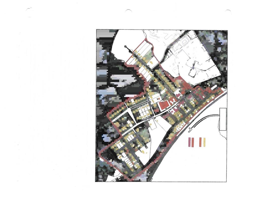
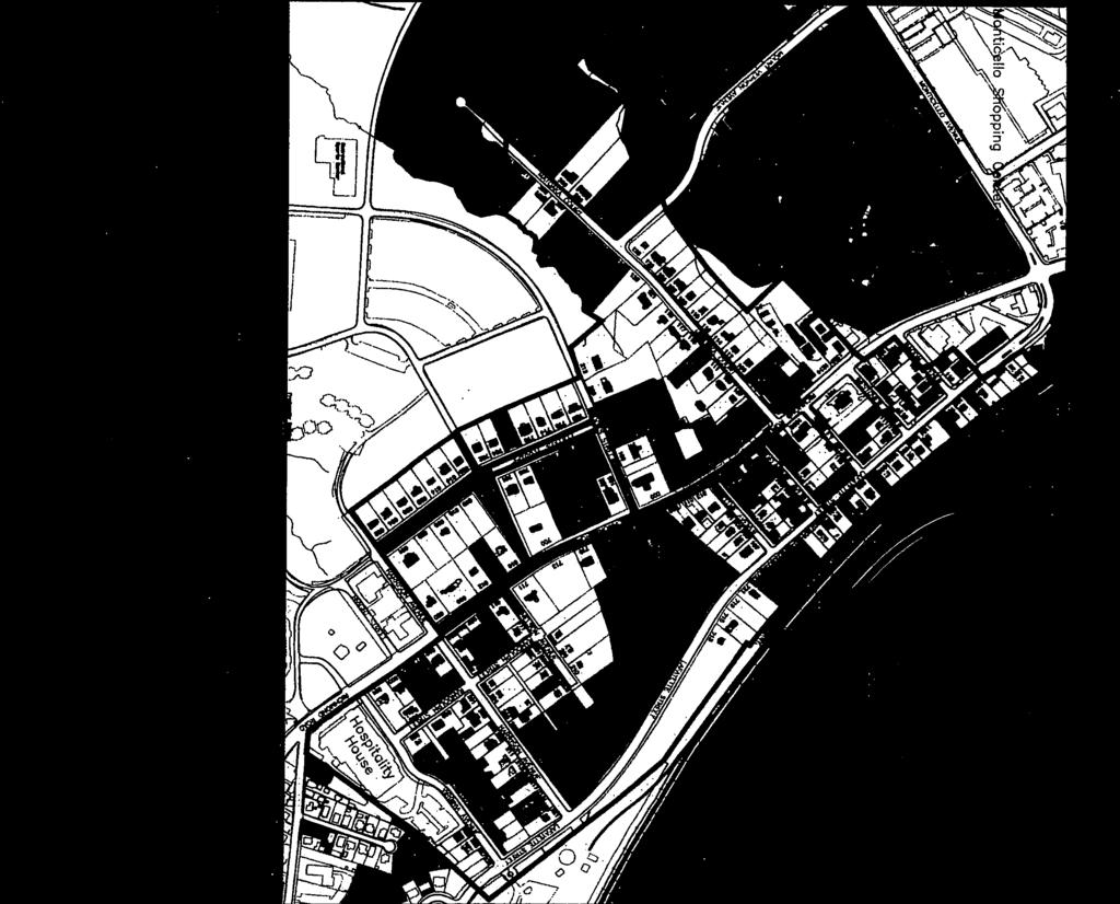
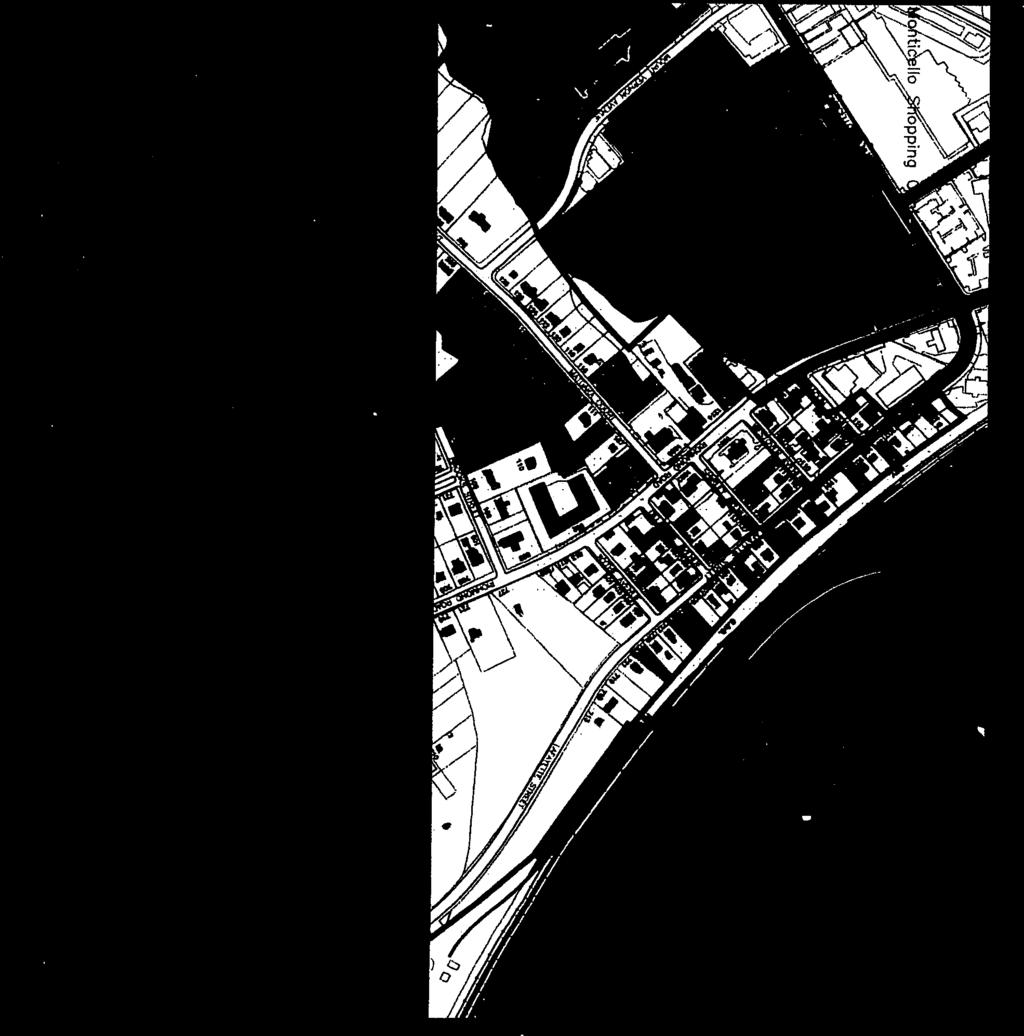
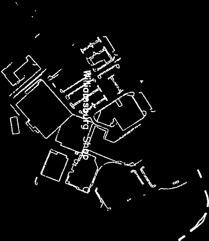
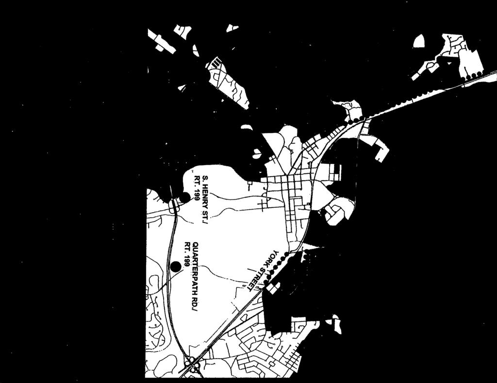
2 MIDTOWN PLANNING AREA The Midtown Planning Area is located at the intersection of two of the City s major entrance corridors Richmond Road and Monticello Avenue. It is made up of five major components: the Arts and Cultural District centered on Richmond Road and Lafayette Street between Brooks Street and the Williamsburg Shopping Center; the Shopping Centers Area that includes the Williamsburg and Monticello Shopping Centers; the Richmond Road Corridor between Monticello Avenue and Bypass Road; the Urban Residential Area along Mount Vernon Avenue and New Hope Road, and the College Area that is centered on William and Mary s School of Education. The Midtown Planning Area abuts the CSX Railroad and York County to the north, the College of William and Mary to the south, the residential neighborhoods of College Terrace and West Williamsburg Heights to the east, and the High Street Mixed Use development and the Richmond Road commercial corridor to the west. The size of the Midtown Planning Area, exclusive of street right-of-way, is acres, of which 26% is residential, 49% commercial, 19% institutional, 3% parks and open space and 3% vacant properties. Residential uses located in the Midtown Planning Area include the largely single family West Williamsburg neighborhood between Richmond Road and Lafayette Street, the Lawson Apartments on Mount Vernon Avenue, and the Sylvia Brown Apartments (Williamsburg Housing and Redevelopment Authority) on New Hope Road. The non-residential uses located throughout the Midtown Planning Area include: seven restaurants, two hotels, fourteen retail establishments, two shopping centers, four banks, 21 offices, two convenience establishments, one timeshare, one nursing home and one community pool. A description and discussion of the major areas in the Northeast Triangle Planning Area follows: The Arts and Cultural District along Richmond Road and Lafayette Street was established by City Council in February 2011 as a way to encourage and enhance the City s creative economy as an economic development initiative. This follows state legislation passed in 2009 that enabled the creation of Arts and Cultural Districts, allowing the City and its Economic Development Authority to provide tax rebates, grants, technical assistance and other incentives to attract and grow the creative economy and the arts. Research shows that having a group of artists and creative professionals live in one area has great economic and culture spinoffs - revitalizing the area and creating demand for additional artists/creative businesses (possibly including coffee shops, galleries, small theaters, music clubs, artist co-ops, other live/work spaces, studios, wine bars, etc.). Since the creation of the District in 2011, seven creative economy businesses have located in the district and created a total of 32 jobs. Midtown Planning Area 1 st Draft Williamsburg Comprehensive Plan
3 The District is composed of two major areas. The first is the Mixed Use area along Richmond Road between Brooks Street and the Williamsburg Shopping Center that was recommended by the 2006 Comprehensive Plan and is implemented by the LB-2 Limited Business Neighborhood District. The LB-2 District allows a mixture of office, commercial and residential uses; and, in keeping with the urban mixed use character of the area, allows studios and workshops for artists and artisans with a special exception permit from the Board of Zoning Appeals. The second area is the Medium Density Single Family Detached Residential area between the LB- 2 area and the CSX Railroad. This is the West Williamsburg neighborhood originally platted in 1928 when this portion of the City was located in York County. The houses are predominantly one to one and one-half stories in height, and the area contains several notable Bungalow-style houses around the Lafayette Street-Wythe Street intersection. Studios and workshops for artists and artisans are allowed in this area with a special exception permit, allowing live/work space in an established single family residential area. There are two vacant parcels in the Arts and Cultural District that have potential for new development: the 0.69 acre Tioga parcel at 906 Richmond Road, and a 0.60 acre parcel on a portion of 727 Richmond Road. The 0.86 acre Super 8 Motel parcel at 1233 Richmond Road has potential for redevelopment. The Shopping Centers Area is anchored by two large neighborhood shopping centers. The Williamsburg Shopping Center fronts on both Richmond Road and Monticello Avenue, and was built by the Colonial Williamsburg Foundation in the 1950s to provide additional space for commercial growth in the area, and has been expanded several times. This 255,968 square foot shopping center contains two department stores, the City s only centrally located grocery store, a hardware store, bookstore, several restaurants and assorted retail and service uses. The 78,396 square foot Monticello Shopping Center, on the opposite side of Monticello Avenue, contains a variety of retail, service and restaurant uses, and a movie theater has been converted to a church. West of the shopping centers along Monticello Avenue are four medical office buildings, a small apartment building, and two retail stores. The 19 acre Williamsburg Shopping Center has potential for a major redevelopment as a mixed use project, but any redevelopment should be accomplished with minimal loss of the existing commercial floor area. The shopping center s neighborhood commercial uses, and particularly the grocery store and the hardware store, help to make Williamsburg s downtown area a viable place to live. An appropriate mix of stores should be maintained with any redevelopment of the property. The close proximity of the Williamsburg Shopping Center to the College and its location on existing bus routes make it a very desirable location for student housing, and the Tribe Square model with commercial use on the first floor and student apartments on the upper floors serves as an example of what could be done with a portion of this property. To help facilitate this, student dwellings should be added to the B-3 District as a special use permit use with a permitted dwelling unit occupancy of four unrelated persons. Senior housing is another possibility for many of the same reasons: close proximity to downtown and the College, nearby shopping including a grocery store, and existing bus routes. Improvements may be needed to Monticello Avenue with redevelopment the Hampton Roads Transportation Planning Organization s Comprehensive Transportation Study (Appendix ) shows that Monticello Avenue adjacent to the Williamsburg Shopping Center currently have moderate congestion (LOS D) and are project to have severe congestion in 2034 (LOS E or F). Special use permits should be required for any major redevelopment so that traffic and other impacts can be properly evaluated Williamsburg Comprehensive Plan Midtown Planning Area 1 st Draft
4 While the Monticello Shopping Center (5.7 acres) is much smaller than the Williamsburg Shopping Center, it also has future potential for redevelopment. As with the Williamsburg Shopping Center, redevelopment should be accomplished with minimal loss of existing commercial floor area. The Richmond Road Corridor extends from Monticello Avenue northwest to Bypass Road. This section of the Richmond Road corridor is a logical extension of the urban character of the Shopping Centers Area buildings are closer together and closer to the street, and the predominant character defining feature of the street is buildings and sidewalks rather than parking lots. There are three vacant parcels in the Richmond Road Corridor that have potential for new development. The old Princess Anne Motel, on a 6.2 acre parcel located at 1350 Richmond Road and now closed, is a prime parcel for redevelopment, and its size makes a mixed use project a possibility. All of these properties have potential for new commercial uses that will add to the vitality of the corridor. The Urban Residential Area contains one of the City s four major concentrations of multifamily housing (the others are the High Street, Patriot Lane and Merrimac Trail areas). The Lawson Apartments, developed between 1963 and 1986 and located on Mount Vernon Avenue, are five apartment complexes: Julia Ann, Spring Road, Spring Road Annex, Spring Garden and Clinton Gardens. There are 292 apartments on approximately 21 net acres, with a density of 14 dwelling units/net acre. Also in this area is the 28 unit Sylvia Brown Apartments on New Hope Road, a subsidized apartment project owned by the Williamsburg Redevelopment and Housing Authority. All of these apartments are located between the College of William and Mary and the High Street Williamsburg development, interconnected by a growing network of sidewalks and bike lanes. The proximity of this area to the College makes these apartments very attractive for helping to meet the need for college student housing. This area has potential for redevelopment at a higher residential density, but traffic and other impacts need to be evaluated before approval of any redevelopment project. The College Area anchors the southwestern edge of the Planning Area, and is centered around the College of William and Mary s School of Education. The College owns vacant land adjacent to the School of Education that can be developed in the future, possibly for additional student housing. Other uses in this area include a nursing home and a small office building on Monticello Avenue. Improvements to pedestrian facilities are needed in this area a new multiuse trail and sidewalk connects the School of Education with the main campus via Compton Drive, but there is not an adequate pedestrian connection between the School and the Monticello Avenue/Treyburn Drive intersection. This intersection, which is controlled by the Virginia Department of Transportation, could provide an important pedestrian connection to High Street and the Lawson Apartment area. In addition, a sidewalk or multiuse trail is needed between the entrance to the School of Education and Compton Drive this could tie in to a future multiuse trail connecting Compton Drive with New Town in James City County. Midtown Planning Area 1 st Draft Williamsburg Comprehensive Plan

5 2012 Williamsburg Comprehensive Plan Midtown Planning Area 1 st Draft
6 Housing Analysis The Midtown Planning Area s residential component is concentrated in the Arts and Cultural District and the Urban Residential Area, and is predominantly renter occupied. In 2012, the Planning Area had a total of 424 dwelling units; 14 were owner-occupied (3%), and 410 were renter-occupied (97%). A dwelling unit is considered renter-occupied if the owner s address is different from the property address, or if it is a unit in a rental apartment complex. This is a much higher rental occupancy than the City as a whole the 2010 Census figure for the entire City is 43.7% owner-occupied and 56.3% renter-occupied. The Arts and Cultural District has 93 dwelling units, 14 owner-occupied (15%) and 79 renter occupied (85%). It is made up of two separate areas Mixed Use land use along Richmond Road, and Medium Density Single Family Detached land use along Lafayette Street and the side streets (the West Williamsburg neighborhood). The Mixed Use area has 32 dwelling units (two single family, one duplex, one multifamily and 24 condominiums); None are owner-occupied, and 32 are renter-occupied (100%). The Medium Density Single Family Detached area has 61 dwelling units (47 single family and seven duplex); 14 are owner-occupied (23%), and 47 are renter-occupied (77%). The Shopping Centers Area has ten dwelling units in a single apartment complex (Monticello Apartments), which is 100% renter-occupied. The Richmond Road Corridor has one multifamily dwelling above a restaurant use, which is renter-occupied. The Urban Residential Area has 320 dwelling units in the two apartment complexes: the Lawson Apartments (Julia Ann, Spring Road, Spring Road Annex, Spring Garden and Clinton Gardens 292 apartments) and the Sylvia Brown Apartments (Williamsburg Housing and Redevelopment Authority 28 apartments). This area is 100% renter-occupied. The College Area has no dwelling units, but a 53 bed nursing home is located in this area. Infrastructure Recommendations The following infrastructure improvements are recommended for the Midtown Planning Area: Sidewalk improvements. To improve pedestrian accessibility, sidewalks should be provided on both sides of all streets in the Arts and Cultural District. Approximately 3,600 linear feet of sidewalk will need to be constructed, so this should be seen as a long term goal for the area. The College of William and Mary needs to extend a sidewalk from the School of Education to the Monticello Avenue/Treyburn Drive intersection. A signalized pedestrian crossing of Monticello Avenue at Treyburn Drive needs to be coordinated with the Virginia Department of Transportation, which has responsibility for this intersection. A sidewalk or multiuse trail needs to be constructed between the entrance to the School of Education and Compton Drive, where it could connect to a future multiuse trail connecting to New Town in James City County. Street improvements. Improvements to Monticello Avenue may be needed if there is a major redevelopment of the Williamsburg Shopping Center, and this should be a part of the redevelopment project. Future Land Use Recommendations 1. Arts and Cultural District The existing Mixed Use land use designation along Richmond Road between Brooks Street and the Williamsburg Shopping Center should be continued, and slightly extended to include the restaurant and hotel in the block west of Bacon Avenue. The mix of commercial uses allowed should be designed to allow the Arts and Cultural District to achieve its potential as a vibrant, mixed use area of the City, within walking distance of downtown and the College. A Midtown Planning Area 1 st Draft Williamsburg Comprehensive Plan
7 variety of residential uses should be allowed with a maximum density of 14 dwelling units/net acre. To ensure compatibility with surrounding neighborhoods, special use permits should be required for uses such as buildings with a floor area exceeding 10,000 square feet, multifamily dwellings, hotels with more than ten rooms, larger restaurants, and other uses of similar intensity. The Mixed Use land use designation should continue to be implemented by the LB-2 Limited Business Neighborhood District. A Midtown Parking District should be created to deal with parking issues in the Mixed Use area. This district should provide a mechanism for reducing off-street parking requirements on a case-by-case basis, primarily through the special exception process administered by the Board of Zoning Appeals. The Medium Density Single Family Detached land use designation for the West Williamsburg neighborhood between the Mixed Use land use along Richmond Road and the CSX Railroad should be continued. This land use mirrors the existing density of the area. The existing provisions allowing studios and workshops for artists and artisans with a special exception should be retained, as this is an important feature of the Arts and Cultural District, and encourages live/work space in the area. Lafayette Street through the Arts and Cultural District (and connecting through to York Street) should be designated as an Entrance Corridor, connecting the existing Richmond Road, Monticello Avenue, Page Street and York Street corridors (see Chapter 5, Community Character). This designation will allow the existing Architectural Preservation AP-3 District that encompasses the West Williamsburg neighborhood to be changed to the Corridor Protection District, matching the Corridor Protection District along Richmond Road. This will allow additional flexibility in architectural design for the entire Arts and Cultural District. The Arts and Cultural District should be specifically reviewed as part of the Architectural Design Guidelines review following the adoption of this Comprehensive Plan. The special nature of this area should be considered, particularly for sign design. 2. Richmond Road Corridor and Shopping Centers Area The existing General Commercial land use designation should be changed to a new Urban Commercial land use, since this is the City s most urban commercial corridor. To implement this change, the existing B-3 General Business District should be renamed B-3 Urban Business District. Automobile oriented uses such as service stations and motor vehicle service establishments should be removed from the new district since they are incompatible with the more urban character of this area. The commercial floor area requirement for a mixed use project should remain at 33% to maximize commercial floor area. Residential density should remain at 14 dwelling units/net acre, multifamily dwellings should continue to be allowed with a special use permit so that impacts to the surrounding commercial areas can be considered, and student dwellings should be added as special use permit use with a permitted dwelling unit occupancy of four unrelated persons. Building height should remain at 45 feet. 4. Urban Residential Area The existing High Density Multifamily Residential land use (14 dwelling units/net acre) should be changed to Urban Residential land use (20 dwelling units/net acre). The existing RM-2 zoning should remain in place until an acceptable development plan is presented for rezoning to a new PDU Planned Development Urban District. The PDU District should be limited to land designated as Urban Residential land use, and an alternate residential density of 40 bedrooms per net acre should be allowed along with the standard density of 20 dwelling units/net acre. Student dwellings should be a permitted use, with a permitted dwelling unit occupancy of four unrelated persons. A building height of 45 feet should be allowed Williamsburg Comprehensive Plan Midtown Planning Area 1 st Draft

8 The Midtown Planning Area Future Land Use Map illustrates these recommendations. Midtown Planning Area 1 st Draft Williamsburg Comprehensive Plan

9


10
11


12

13


14

15

16

17
Chapter 10 Commercial and Economic Development
 Chapter 10 Commercial and Economic Development Through the difficulties of the recession of 2008, the City has continued to maintain its position as a destination market with the premier institutions of
Chapter 8 Neighborhoods and Housing
 Chapter 8 Neighborhoods and Housing Williamsburg is a city of neighborhoods, which range from large lot single family to higher density multifamily. Nevertheless, the overall residential density in Williamsburg
BSV Colonial Owner LLC, the owner of the property plans to redevelop the shopping center into a new mixed-use development project named Midtown Row.
 TO: City Council DATE: SUBJECT: PCR #17-019 Request of BSV Colonial Owner LLC for text amendments to the Urban Business District B-3 to allow redevelopment of the Williamsburg Shopping Center into a new
CITY LOFTS View from High Street Parking Garage
 CITY LOFTS View from High Street Parking Garage 1. Create new PDU zoning district 2. Rezone property from B-3 to PDU 3. Approve Development Plan for City Lofts as part of the PDU rezoning James Blair Middle
PLANNING COMMISSION WILLIAMSBURG, VIRGINIA WORK SESSION AGENDA Wednesday, September 26, 2012
 PLANNING COMMISSION WILLIAMSBURG, VIRGINIA WORK SESSION AGENDA Wednesday, September 26, 2012 The meeting will be called to order in the third floor Conference Room (Room 310), Williamsburg Municipal Building,
Poughkeepsie City Center Revitalization Plan
 Purpose and Need Purpose Increase job and educational opportunities for all residents Maximize fiscal productivity of downtown land uses Diversify retail mix Eliminate surface and building vacancies Create
GENERAL PLAN UPDATE SPECIFIC AREAS OF THE CITY
 GENERAL PLAN UPDATE SPECIFIC AREAS OF THE CITY Background There are a total of 14 specific areas that are being reviewed as part of the update of the General Plan. Requests to review these areas came from
ARTICLE 3: Zone Districts
 ARTICLE 3: Zone Districts... 3-1 17.3.1: General...3-1 17.3.1.1: Purpose and Intent... 3-1 17.3.2: Districts and Maps...3-1 17.3.2.1: Applicability... 3-1 17.3.2.2: Creation of Districts... 3-1 17.3.2.3:
PLANNING COMMISSION REPORT Regular Agenda - Public Hearing Item
 Z-11-25-09; Z-11-26-09; Z-11-28-09 Item No. 2-1 PC Staff Report 3/28/11 PLANNING COMMISSION REPORT Regular Agenda - Public Hearing Item ITEM NO. 2A RM32 TO MU;.19 ACRES; 1340 TENNESSEE ST (MJL) Z-1-1-11:
4 LAND USE 4.1 OBJECTIVES
 4 LAND USE The Land Use Element of the Specific Plan establishes objectives, policies, and standards for the distribution, location and extent of land uses to be permitted in the Central Larkspur Specific
City of Valdosta Land Development Regulations
 Chapter 206 Section 206-1 Base Zoning Districts Standards for Uses, Structures, and Property Development (B) (C) Principal Uses and Structures. Principal uses and structures permitted in each base zoning
Downtown Development Focus Area: I. Existing Conditions
 Downtown Development Focus Area: I. Existing Conditions The Downtown Development Focus Area is situated along Route 1, south of the train tracks, except for the existing Unilever property. It extends west
Master Plan Review SILVER SPRING CBD. Approved and Adopted February Updated January 2013
 Master Plan Review SILVER SPRING CBD Approved and Adopted February 2000 BACKGROUND ZONING CODE REWRITE In 2007, the Montgomery County Council directed the Planning Department to undertake a comprehensive
Bylaw No , being "Official Community Plan Bylaw, 2016" Schedule "A" DRAFT
 Bylaw No. 2600-2016, being "Official Community Plan Bylaw, 2016" Schedule "A" Urban Structure + Growth Plan Urban Structure Land use and growth management are among the most powerful policy tools at the
Staff Report & Recommendation Rezoning Case RZ Date of Report: June 6, 2014 Report by: Doug Stacks
 Staff Report & Recommendation Rezoning Case RZ-2014-02 Date of Report: June 6, 2014 Report by: Doug Stacks Hearing Dates: Planning Commission June 26, 2014 Mayor and Council July 14, 2014 GENERAL INFORMATION
Missing Middle Housing Types Showcasing examples in Springfield, Oregon
 Missing Middle Housing Types Showcasing examples in Springfield, Oregon MissingMiddleHousing.com is powered by Opticos Design Illustration 2015 Opticos Design, Inc. Missing Middle Housing Study Prepared
CITY OF PORTSMOUTH. CITY COUNCIL POLICY No HOUSING POLICY
 CITY OF PORTSMOUTH CITY COUNCIL POLICY No. 2016-03 HOUSING POLICY WHEREAS, the goals of the City of Portsmouth, as expressed in its 2025 Master Plan, include encouraging walkable mixed-use development,
WILLIAMSBURG PLANNING COMMISSION MINUTES
 WILLIAMSBURG PLANNING COMMISSION MINUTES Wednesday, The regular monthly meeting of the Williamsburg Planning Commission was held on Wednesday, at 3:30 p.m. in the Council Chambers at the Stryker Building,
APPENDIX B RESIDENTIAL DENSITY
 APPENDIX B RESIDENTIAL DENSITY RESIDENTIAL DENSITY - SPECIFIC AREAS OF THE CITY Policy Issue Examine specific areas of the City to determine appropriate residential densities. Public comments have expressed
DIVISION 1 PURPOSE OF DISTRICTS
 ARTICLE 2 ZONING DISTRICTS AND MAP DIVISION 1 PURPOSE OF DISTRICTS Section 2.101 Zoning Districts. For the purpose of this Ordinance, the City of Richmond is hereby divided into districts as follows: DISTRICT
MONROE WARD REZONING SUMMARY. October 2018
 MONROE WARD REZONING SUMMARY October 2018 WHY IS THE CITY REZONING MONROE WARD? In July of 2017 Richmond City Council adopted The Pulse Corridor Plan, a corridor-long planning document that outlines steps
United States Post Office and Multi-Family Residential; and, Single- Family Residence with an Apartment
 Planning Commission File No.: AME2013 0009 January 9, 2014 Page 2 of 9 Existing Land Use: United States Post Office and Multi-Family Residential; and, Single- Family Residence with an Apartment Surrounding
Salem HNA and EOA Advisory Committee Meeting #6
 Salem HNA and EOA Advisory Committee Meeting #6 Residential Land Policies Employment Land Policies Policy Discussions with the Committee Outcome of today s meeting Direction from this Committee on proposed
COMMERCIAL AND MIXED USE zones COMMERCIAL AND MIXED USE ZONES. Zoning By-law PLANNING & ECONOMIC DEVELOPMENT PLANNING DEPARTMENT DIVISION
 Zoning By-law 05-200 COMMERCIAL AND MIXED USE zones PLANNING & ECONOMIC DEVELOPMENT PLANNING DEPARTMENT DIVISION CONTENTS CONTEXT... 1 URBAN HAMILTON OFFICIAL PLAN... 2 COMMERCIAL AND MIXED USE ZONES...
CITY OF PORT ORCHARD
 CITY OF PORT ORCHARD ZONING DESIGNATIONS (Adapted from POMC Chapter 20.34 Zoning Districts, as adopted 6/13/2017) 20.34.110 Greenbelt zone (Gb). (1) Purpose. It is the purpose of the greenbelt zone to
Generic Environmental Impact Statement. Build-Out Analysis. City of Buffalo, New York. Prepared by:
 Generic Environmental Impact Statement Build-Out Analysis City of Buffalo, New York 2015 Prepared by: TABLE OF CONTENTS 1.0 INTRODUCTION 1 2.0 METHODOLOGY 2 3.0 EXISTING LAND USE 3 4.0 EXISTING ZONING
STAFF REPORT. Community Development Director PO Box 4755 Beaverton, OR 97076
 STAFF REPORT HEARING DATE: July 7, 2010 TO: Planning Commission STAFF: Jana Fox, Assistant Planner PROPOSAL: Southeast Beaverton Office Commercial Zoning Map Amendment (ZMA2010-0006) LOCATION: The subject
Staff Report to the North Ogden City Council
 Staff Report to the North Ogden City Council SYNOPSIS / APPLICATION INFORMATION Application Request: Public hearing for consideration and action on a legislative application to amend the North Ogden General
Provide a diversity of housing types, responsive to household size, income and age needs.
 8 The City of San Mateo is a highly desirable place to live. Housing costs are comparably high. For these reasons, there is a strong and growing need for affordable housing. This chapter addresses the
From Policy to Reality
 From Policy to Reality Updated ^ Model Ordinances for Sustainable Development 2000 Environmental Quality Board 2008 Minnesota Pollution Control Agency Funded by a Minnesota Pollution Control Agency Sustainable
Town of Holly Springs Town Council Meeting Agenda Cover Sheet
 Town of Holly Springs Town Council Meeting Agenda Cover Sheet Meeting Date: Feb. 19, 2019 Agenda Item #: 8c Agenda Placement: Public Hearing (Recognitions (awards, proclamations), Requests & Communications
GATEWAY DISTRICTS DRAFT ZONING & DEVELOPMENT STANDARDS City of Portsmouth, NH
 GATEWAY DISTRICTS DRAFT ZONING & DEVELOPMENT STANDARDS City of Portsmouth, NH PLANNING BOARD WORKSHOP June 22, 2017 Brovitz Community Planning & Design HOUSING INITIATIVES Portsmouth 2025 Master Plan (2017)
A. Districts Concept
 L A N D U S E 6 This chapter discusses the land use concept and provides land use designations for Downtown, including associated development intensities that will apply in Downtown. In order to support
Sherwood Forest (Trinity) Housing Corporation. Urban Design Brief
 Housing Corporation. Urban Design Brief") Sherwood Forest (Trinity) Housing Corporation Sherwood Place Affordable Housing Apartments Trinity Presbyterian Church Orchard Park Nursery School 590 Gainsborough Road, London Urban Design Brief REVISED
Sherwood Forest (Trinity) Housing Corporation Sherwood Place Affordable Housing Apartments Trinity Presbyterian Church Orchard Park Nursery School 590 Gainsborough Road, London Urban Design Brief REVISED
SECTION I - INTRODUCTION
 - INTRODUCTION 1 2 - INTRODUCTIONION THE MASTER PLAN State law requires every community to have a Master Plan establishing an orderly guide to the use of lands in the community to protect public health
Proposed Future Land Use Plan Open House
 City of Port August Aransas, 30 th, 2006 Texas Proposed Future Plan Open House Wednesday, Background The City of Port Aransas does not have an adopted Future Plan (FLUP). The last Future Plan for the City
Glades County Staff Report and Recommendation Unified Staff Report for Small Scale Plan Amendment and Rezoning
 Glades County Staff Report and Recommendation Unified Staff Report for Small Scale Plan Amendment and Rezoning CASE NUMBERS: COMP17-02 and RZ17-02 DATE of STAFF REPORT: May 1, 2017 CASE TYPE: Application
DRAFT Plan Incentives. Part A: Basic Discount
 DRAFT 2030 Plan Incentives July 26, 2006 Part A: Basic Discount In order for a development to be eligible for any 2030 Land Resource Management Plan Discounts it must be located in the Urban Corridor and
Highland Green Estates Neighbourhood Area Structure Plan
 Highland Green Estates Neighbourhood Area Structure Plan Original Outline Plan approved by Council: March 10, 1997 Outline Plan amended by Council: March 24, 1997 Converted to a Neighbourhood Area Structure
Appendix A: Guide to Zoning Categories Prince George's County, Maryland
 Appendix A: Guide to Zoning Categories Prince George's County, Maryland RESIDENTIAL ZONES 1 Updated November 2010 R-O-S: Reserved Open Space - Provides for permanent maintenance of certain areas of land
Glades County Staff Report and Recommendation REZONING
 Glades County Staff Report and Recommendation REZONING CASE NUMBER: RZ15-01 DATE: October 2, 2015 CASE TYPE: Application for Rezoning REQUEST: J.J. Wiggins Memorial Trust is requesting a rezoning of 22.1±
David J. Gellner, AICP, Principal Planner, ,
 Staff Report PLANNING DIVISION COMMUNITY & ECONOMIC DEVELOPMENT To: From: Salt Lake City Planning Commission David J. Gellner, AICP, Principal Planner, 801-535-6107, david.gellner@slcgov.com Date: March
NOTICE OF MEETING AND AGENDA FOR THE PLANNING COMMISSION OF SPRINGVILLE, UTAH... JANUARY 23, 2018
 NOTICE OF MEETING AND AGENDA FOR THE PLANNING COMMISSION OF SPRINGVILLE, UTAH............................ JANUARY 23, 2018 Notice is hereby given that the Planning Commission will hold a public meeting
PLANNING COMMISSION REPORT Regular Agenda - Public Hearing Item
 Z-14-00056 Item No. 1-1 PLANNING COMMISSION REPORT Regular Agenda - Public Hearing Item PC Staff Report 4/21/2014 ITEM NO. 1: RSO TO CN1;.126 ACRES; 512 & 514 LOCUST ST (DRG) Z-14-00056: Consider a request
ARLINGTON COUNTY, VIRGINIA
 ARLINGTON COUNTY, VIRGINIA County Board Agenda Item Meeting of September 18, 2004 DATE: August 19, 2004 SUBJECTS: A. GP-297-04-1 GENERAL LAND USE PLAN AMENDMENT from Service Commercial (Personal and business
ARLINGTON COUNTY, VIRGINIA. County Board Agenda Item Meeting of September 19, 2015
 ARLINGTON COUNTY, VIRGINIA County Board Agenda Item Meeting of September 19, 2015 DATE: August 28, 2015 SUBJECT: Request to authorize advertisement of public hearings by the Planning Commission and the
Chapter 5: Testing the Vision. Where is residential growth most likely to occur in the District? Chapter 5: Testing the Vision
 Chapter 5: Testing the Vision The East Anchorage Vision, and the subsequent strategies and actions set forth by the Plan are not merely conceptual. They are based on critical analyses that considered how
COMMERCIAL ELEMENT AND CODE ENFORCEMENT
 COMMERCIAL ELEMENT AND CODE ENFORCEMENT The Commercial Element identifies and describes the existing characteristics that are desired by the neighborhood. The existing conditions will determine appropriate
Chapter 10: Implementation
 Chapter 10: Introduction Once the Comprehensive Plan has been adopted by the City of Oakdale, the City can begin to implement the goals and strategies to make this vision a reality. This chapter will set
Comprehensive Plan Amendment #PLN , Reserve at Cannon Branch (Coles Magisterial District)
") COUNTY OF PRINCE WILLIAM 5 County Complex Court, Prince William, Virginia 22192-9201 PLANNING (703) 792-7615 FAX (703) 792-4758 OFFICE Internet www.pwcgov.org Christopher M. Price, AICP Director of Planning
COUNTY OF PRINCE WILLIAM 5 County Complex Court, Prince William, Virginia 22192-9201 PLANNING (703) 792-7615 FAX (703) 792-4758 OFFICE Internet www.pwcgov.org Christopher M. Price, AICP Director of Planning
Chapter URBAN VILLAGE ZONING DISTRICTS
 Chapter 20.16 Sections: 20.16.010 Purpose of the Urban Village Zoning Districts 20.16.020 Land Use Regulations for the Urban Village Zoning Districts 20.16.030 Development Standards & Guidelines for the
HOUSING ELEMENT GOALS, OBJECTIVES, AND POLICIES
 HOUSING ELEMENT GOALS, OBJECTIVES, AND POLICIES GOAL 1: To promote the preservation and development of high-quality, balanced, and diverse housing options for persons of all income levels throughout the
H-POLICY 1: Preserve and improve existing neighborhoods. Ensure that Prince William County achieves new neighborhoods with a high quality of life.
 HOUSING Intent The intent of the Housing Plan is to provide a framework for providing for the housing needs of all residents of Prince William County. These needs are expressed in terms of quality, affordability,
Place Type Descriptions Vision 2037 Comprehensive Plan
 Place Type Descriptions Vision 2037 Comprehensive Plan The Vision 2037 Comprehensive Plan establishes a range of place types for Oxford, ranging from low intensity (limited development) Rural and Natural
DRAFT. Amendment to the Master Plan Land Use Element for Block 5002, Lot Township of Teaneck, Bergen County, New Jersey.
 DRAFT Amendment to the Master Plan Land Use Element for Block 5002, Lot 18.01 Township of Teaneck, Bergen County, New Jersey Prepared for: Township of Teaneck Planning Board Prepared by: Janice Talley,
THE REDEVELOPMENT PLAN
 PAGE 37 THE REDEVELOPMENT PLAN FUTURE LAND USE The Silver Terrace Redevelopment Area is currently designated as Redevelopment Area #4 on the City of Delray Beach Future Land Use Map (FLUM). This designation
City of Tacoma Zoning Reference Guide
 City of Tacoma Zoning Reference Guide Planning and Development Services 747 Market Street, Room 345 Tacoma, WA 98402 (253) 591-5577 This document should not be used as a substitute for codes and regulations.
APPENDIX A PART 1: GENERAL PLAN AMENDMENTS
 APPENDIX A PART 1: GENERAL PLAN AMENDMENTS I. CHANGES TO MAPS Amend the following figures to include the Plan Area boundaries: Chapter 4, Figure 15. Specific Plan Boundaries Chapter 4, Figure 16. Core
Marcel Williams, MPC Project Planner
 TO: FROM: The Planning Commission MPC Staff DATE: SUBJECT: Petition to Rezone Property Heath Shelton, Owner Jay Maupin, Agent 2026 Habersham Street Aldermanic District: 2, Bill Durrence County Commission
8Land Use. The Land Use Plan consists of the following elements:
 8Land Use 1. Introduction The Land Use Plan consists of the following elements: 1. Introduction 2. Existing Conditions 3. Opportunities for Redevelopment 4. Land Use Projections 5. Future Land Use Policies
Planning Justification Report
 Planning Justification Report Kellogg s Lands City of London E&E McLaughlin Ltd. June 14, 2017 Zelinka Priamo Ltd. Page i TABLE OF CONTENTS Page No. 1.0 2.0 2.1 2.2 3.0 4.0 5.0 5.1 5.2 5.3 5.4 5.5 5.6
COUNTY OF ALBEMARLE PLANNING STAFF REPORT SUMMARY
 COUNTY OF ALBEMARLE PLANNING STAFF REPORT SUMMARY Project Name: ZMA 2011-00006, Albemarle Health and Rehab Center and SP 2011-00014, Albemarle Health and Rehab Center Planning Commission Public Hearing:
Implementation. Approved Master Plan and SMA for Henson Creek-South Potomac 103
 Implementation Approved Master Plan and SMA for Henson Creek-South Potomac 103 104 Approved Master Plan and SMA for Henson Creek-South Potomac Sectional Map Amendment The land use recommendations in the
General Plan. Page 44
 VIII. RESIDENTIAL DEVELOPMENT IN NON-RESIDENTIAL LAND USE AREAS POLICY ISSUE Review the City s existing regulations and policies that allow residential land use in non-residential zoning districts. BACKGROUND
ARTICLE 3 ZONING DISTRICTS AND ZONING MAP. Table of Contents
 ARTICLE 3 ZONING DISTRICTS AND ZONING MAP Table of Contents 3-1 Establishment of Zoning Districts... 1 A. General Use Zoning Districts... 1 B. Conditional Zoning Districts... 3 C. Overlay Zoning Districts...
Puyallup Downtown Planned Action & Code Changes. January 10, 2017
 Puyallup Downtown Planned Action & Code Changes January 10, 2017 Purpose & Location Purpose Promote economic development and downtown revitalization Tools: Municipal Code amendments Change development
Upcoming Apartment Projects with No On-Site Parking Frequently Asked Questions June 2012
 Upcoming Apartment Projects with No On-Site Parking Frequently Asked Questions June 2012 Recent proposals to construct apartment buildings with no on-site parking along many of Portland s commercial streets
Town Center South End Development Area District
 175.28 ESTABLISHMENT OF DISTRICTS. In order to carry out the purpose and intent of this chapter, the area of the is hereby divided into eighteen (18) Zoning District Classifications and one overlay zoning
Date: January 9, Strategic Housing Committee. IZ Work Group. Legacy Homes Program
 City of Whitefish 418 E 2 nd Street PO Box 158 Whitefish, MT 59937 Date: January 9, 2019 To: From: Subject: Strategic Housing Committee IZ Work Group Legacy Homes Program At our meeting, we are going to
PIN , Part 1, Plan SR-713 in Lot 2, Concession 5, Township of McKim (1096 Dublin Street, Sudbury)
") STAFF REPORT Applicant: Dalron Construction Limited Location: PIN 02124-0103, Part 1, Plan SR-713 in Lot 2, Concession 5, Township of McKim (1096 Dublin Street, Sudbury) Official Plan and Zoning By-law:
STAFF REPORT Applicant: Dalron Construction Limited Location: PIN 02124-0103, Part 1, Plan SR-713 in Lot 2, Concession 5, Township of McKim (1096 Dublin Street, Sudbury) Official Plan and Zoning By-law:
City of Sacramento Zoning Code - Zoning Descriptions Excerpt from website on April 5, 2010
 City of Sacramento Zoning Code - Zoning Descriptions Excerpt from website on April 5, 2010 RE Rural Estates Zone. This is a very low density residential zone. It is intended to be applied primarily to
3. What is the requested zoning for the property (including intensity designator)? RM1-45 Residential (Multi-Dwelling).
? RM1-45 Residential (Multi-Dwelling).") B. SUBJECT PROPERTY INFORMATION General location of subject property and address (if address has been assigned): Northside- 819 Stoddard St. Missoula, MT 59802 Legal Description - complete and unabbreviated:
B. SUBJECT PROPERTY INFORMATION General location of subject property and address (if address has been assigned): Northside- 819 Stoddard St. Missoula, MT 59802 Legal Description - complete and unabbreviated:
Route 6 Corridor Study Bristol Planning Commission Meeting #1. May 25, 2016 FITZGERALD & HALLIDAY, INC. Innovative Planning, Better Communities
 Route 6 Corridor Study Bristol Planning Commission Meeting #1 May 25, 2016 FITZGERALD & HALLIDAY, INC. Innovative Planning, Better Communities Today s Agenda 1. Introductions 2. Study overview Scope Schedule
Forest Park DeBaliviere Station
 Forest Park DeBaliviere Station This station profile describes existing conditions around the Forest Park-DeBaliviere MetroLink Station. This is one of a set of profiles for each of the MetroLink System
PC Staff Report 11/18/2013 Z Item No. 1-1
 Z-13-00401 Item No. 1-1 PLANNING COMMISSION REPORT Regular Agenda - Public Hearing Item PC Staff Report 11/18/2013 ITEM NO. 1: Z-13-00401 IG (General Industrial) District TO CS (Strip Commercial) District;
Board of Zoning and Planning Members. Justin A. Milam, AICP, Planning Officer. Positive recommendation of a rezoning to City Council.
 To: From: Board of Zoning and Planning Members Justin A. Milam, AICP, Planning Officer Prepared for Meeting Dated: Tuesday, February 19, 2013 Subject: Action Requested: Master Plan Objective: BZAP review
Planning Justification Report
 Planning Justification Report 103 and 105 Toronto Street Town of Markdale, Municipality of Grey Highlands Maverick Developments November 5, 2016 Zelinka Priamo Ltd. Page i TABLE OF CONTENTS Page No. 1.0
TOTTENHAM SECONDARY PLAN
 TOTTENHAM SECONDARY PLAN AMENDMENT NO. 11 TO THE OFFICIAL PLAN OF THE TOWN OF NEW TECUMSETH The following text and schedules to the Official Plan of the Town of New Tecumseth constitute Amendment No. 11
Rural Living (RL) Rural Living
 Rural Living") Place Types Rural Living (RL) Rural Living Rural living areas are characterized by very large lots, abundant open space, pastoral views, and a highdegree of separation between buildings. The lots are typically
Place Types Rural Living (RL) Rural Living Rural living areas are characterized by very large lots, abundant open space, pastoral views, and a highdegree of separation between buildings. The lots are typically
JASPER PLACE NEIGHBOURHOOD HOUSING ASSESSMENT NOVEMBER West Jasper Place. Glenwood. Britannia Youngstown. Canora
 JASPER PLACE NEIGHBOURHOOD HOUSING ASSESSMENT NOVEMBER 2013 West Jasper Place Glenwood Britannia Youngstown Canora TABLE OF CONTENTS A: INTRODUCTION................................... 01 B: PHOTOGRAPHIC
1.0 Introduction. November 9, 2017
 November 9, 2017 Andrew Bone, Planner III Regional Planning Policy and Strategic Initiatives Halifax Regional Municipality 40 Alderney Drive Dartmouth, NS, B2Y 2N5 Subject: Application to amend the Bedford
MEADOWBROOK FLATS SPECIAL USE PERMIT APPLICATION
 MEADOWBROOK FLATS SPECIAL USE PERMIT APPLICATION March 26, 2013 Submitted by: Bluestone Land, L.L.C. William N. Park, Manager 1821 Avon St. Suite 200 Charlottesville VA 22902 434-979-2900 wpark@pinnacleconstructionva.com
Request. Recommendation. Recommended Motion. Planning Division Department of Community and Economic Development
 PLANNING COMMISSION STAFF REPORT Legislative Item 900 South 900 East Rezone Zoning Map Amendment PLNPCM2010-00360 700 East 900 East, 700 South 900 South December 12, 2012 Applicant: City Council Luke Garrott
COUNTY OF ALBEMARLE PLANNING STAFF REPORT SUMMARY
 COUNTY OF ALBEMARLE PLANNING STAFF REPORT SUMMARY Project Name: ZMA 2010-00015, Cedar Hill Planning Commission Worksession: February 15, 2011 Public Hearing: Not scheduled Staff: Judith C. Wiegand, AICP
TOWN OF CARY TOWN CENTER PLAN. Chapter 2. Future Land Use
 TOWN OF CARY TOWN CENTER PLAN Chapter 2 Future Land Use 2.1 The Future Land Use Map and How to Read It Map 1: Future Land Uses depicts the future land uses recommended for the Town Center Area. Different
Policy Issues City of Knoxville Zoning Code Update
 Policy Issues City of Knoxville Zoning Code Update ADU's (Accessory Dwelling Units) The draft zoning ordinance update permits ADU s as an accessory use in all single-family residential zoning districts.
UPDATE Board of Selectmen June 20, 2017
 MAPLE STREET I-1 AREA DRAFT ZONING BYLAW & DEVELOPMENT STANDARDS Town of Danvers, MA UPDATE Board of Selectmen June 20, 2017 The Danvers Team: Brovitz Community Planning & Design Dodson & Flinker Danvers
GOALS, OBJECTIVES, AND STRATEGIES
 GOALS, OBJECTIVES, AND STRATEGIES What follows is a series of goals, recommendations and actions that reflect the themes outlined in the Mineral Springs Vision Plan (incorporated into this document as
SECTION 3. Housing. Appendix A LAND USE DEFINITIONS
 SECTION 3 Housing A Appendix A LAND USE DEFINITIONS A-2 Housing Commission Attachment B Appendix A Land Use Definitions INTRODUCTION The Land Use Map (Figure A-1) of Community Vision 2040 illustrates the
Goal 1 - Retain and enhance Cherry Creek North s unique physical character.
 Introduction This document summarizes the proposed new zoning for the area of roughly bordered by University Boulevard, Steele Street, 3rd Avenue, and 1st Avenue. It provides a high-level review of the
EXHIBIT 1 PROJECT DESCRIPTION AND DESCRIPTION OF REQUESTED AREA VARIANCES REDEVELOPMENT OF 201 ELLICOTT STREET
 EXHIBIT 1 PROJECT DESCRIPTION AND DESCRIPTION OF REQUESTED AREA VARIANCES REDEVELOPMENT OF 201 ELLICOTT STREET I. PROJECT DESCRIPTION: Ciminelli Real Estate Corporation (the Applicant ) is seeking area
CHAPTER 8: HOUSING. Of these units, 2011 Census statistics indicate that 77% are owned and 23% are rental units.
 CHAPTER 8: HOUSING Port Moody has traditionally been a family oriented community. Based on the 2011 Census, 64% of all census families include children. Overall the number of dwelling units in Port Moody
Poverty Rates by Census Tracts
 The following document is a presentation that was delivered to the Housing Conservation District Advisory Group (HCDAG). The materials contained in this presentation (including several updates) were prepared
Charlottesville Planning Commission, Neighborhood Associations & News Media
 CITY OF CHARLOTTESVILLE A World Class City Department of Neighborhood Development Services City Hall Post Office Box 911 Charlottesville, Virginia 22902 Telephone 434-970-3182 Fax 434-970-3359 www.charlottesville.org
Master Plan Review WESTBARD
 Master Plan Review WESTBARD Approved and Adopted 1982 Westbard Page 1 of 15 Updated July 2014 based on Adopted DMA ONING CODE REWRITE BACKGROUND In 2007, the Montgomery County Council directed the Planning
GENERAL DESCRIPTION STAFF RECOMMENDATION IMPLEMENTATION REQUIREMENTS
 Application No.: 891418 Applicant: AREA-WIDE MAP AMENDMENT Rezone two parcels from Moderate Density Single Family (MSF) to Neighborhood Center (NC) and Employment Center (EC). Charles Bitton GENERAL DESCRIPTION
BOARD OF ZONING ADJUSTMENT STAFF REPORT Date: April 1, 2019
 # 3 BOA-000865-2019 BOARD OF ZONING ADJUSTMENT STAFF REPORT Date: April 1, 2019 CASE NUMBER 6244 APPLICANT NAME LOCATION VARIANCE REQUEST Fort Conde Restoration Venture, LLC 113-A Monroe Street (Southeast
Village WASHINGTON TOWNSHIP MASTER PLAN SYNTHESIS. Page 197
 Village P l a n WASHINGTON TOWNSHIP MASTER PLAN SYNTHESIS Page 197 SECTION 11.0 MASTER PLAN SYNTHESIS INTRODUCTION The proposals presented in the various plans result in a graphic synthesis: The Land Use
Table of Contents. Concept Plan Overview. Statement of Compliance with Design Guidelines. Statement of Compliance with Comprehensive Plan
 Table of Contents Concept Plan Overview Statement of Compliance with Design Guidelines Statement of Compliance with Comprehensive Plan Developer s Program Market Objective Benefit to Local Businesses Benefit
Jasper 115 Street DC2 Urban Design Brief
 Jasper 115 Street DC2 Urban Design Brief Greenlong Construction Ltd. Stantec Consulting Ltd. 2017 Overview The proposed rezoning application supports the development of two mixed-use high-rise buildings