ELEVEN ON THORNTON TOWNHOMES PD
|
|
|
- Nigel Phillip Payne
- 6 years ago
- Views:
Transcription

 Applicant s Request: The applicant is requesting PD rezoning to allow for an 11 rear-loaded unit townhome development in the Staff s Recommendation: Approval of the request,")
1 Staff Report to the Municipal Planning Board July 19, 2016 Z O N I TEM # 10 ELEVEN ON THORNTON TOWNHOMES PD Location Map Subject Site S U M M A RY Owner Devi Enterprise LLP Applicant Kevin Kramer, Manager Weekley Homes, LLC Project Planner TeNeika Neasman Property Location: 844 N Thornton Ave. (south of E. Marks St., east of N. Hyer Ave., north of Park Lake St., and west of N. Thornton Ave.) (Parcel ID # ) (±0.56 acres, District 3) Applicant s Request: The applicant is requesting PD rezoning to allow for an 11 rear-loaded unit townhome development in the Staff s Recommendation: Approval of the request, subject to the conditions in this report. Public Comment Courtesy notices were mailed to property owners within 400 ft. of the subject property during the week of July 9, As of the published date of this report, staff has received two letters of opposition for this case. Updated: July 11, 2016


2 Page 2 F U TURE LAND USE MAP Z O N ING MAP
3 Page 3
4 Page 4 P R O JECT ANALYSIS Project Description The acre subject site is located in the Park Lake/ Highland neighborhood, north of Park Lake St., south of E. Marks St., east of N. Hyer Ave. and west of N. Thornton Ave. The subject property currently consists of a Night Lite Pediatrics Center. Proposed is a 11 unit rear-loaded townhome development. The site is zoned O-1/T (Office/Traditional City overlay) and has a Future Land Use designation of Office Low. A rezoning to PD/T (Planned Development/Traditional City overlay) is proposed. The proposal is consistent with the existing Future Land Use and Zoning designations. Previous Actions: 1912 Property platted as part of the Oak Hill Subdivision Property acquired by current owner Project Context As previously stated, the site currently has a doctor s office (Night Lite Pediatrics Center) with surface parking. See Table 1 Project Context for details on surrounding uses. The site is surrounded by residential uses on the adjacent north, south, east, and west. Table 1 Project Context Future Land Use Zoning Surrounding Use North RES-LOW R-2A/T R-1A/T Single Family Residential South COMM-AC AC-1/T Single Family Residential Office Commercial East OFFICE-LOW O-1/T Office Commercial Single Family Residential West RES-LOW R-2A/T Single Family Residential Conformance with the GMP As indicated in Figure LU-1 of the Future Land Use Element, the proposed residential use is allowed under the Office Low and Office Medium Intensity future land use designation. Other permitted uses include office, public, recreational, and institutional. The southern portion of the site has Office Low Intensity future land use (0.28 acres), which has no minimum intensity or density and a maximum density of 21 du/ac and 0.40 FAR. The proposed 11 unit townhome development on a 0.56 ac. site meets the maximum density allowance (21 du/ac). Future Land Use Subarea Policy S addresses the subject site and states that "All development in this area shall be consistent with the recommendations and guidelines of the Mills Ave. and Colonial Drive Special Plan." The proposed project is not inconsistent with the plan. Conformance with the LDC/PD The PD district is intended to provide a process for the evaluation of unique, individually planned developments which are not otherwise permitted in the zoning districts and provide superior design. Section of the LDC identifies the purpose of the PD district as: The PD District is intended to provide a process for the evaluation of unique, individually planned developments which are not otherwise permitted in the zoning districts established by Chapter 58. The PD District is to be a voluntary process commenced by an applicant for such zoning designation. The standards and procedures of this district are intended to promote flexibility of design and permit planned diversification and integration of uses and structures, while at the same time retaining in the City Council the absolute authority to establish such limitations and regulations as it deems necessary to protect the public health, safety and general welfare. The subject site is zoned O-1/T (Office/Traditional City overlay/mills Ave. and Colonial Drive Special Plan overlay) on the Official
5 Page 5 P R O JECT ANALYSIS Acreage Use Sq. Ft./ Dwelling Units Table 2 Development Standards Density (dwelling units per acre) Max. 200 du/ac FAR (floor area ratio) Max FAR Allowed Proposed Allowed Proposed Max Allowed Building Height Proposed Max Allowed ISR* Proposed/ Existing/ Allocated 0.56 Acres Residential 11 du proposed 21 du/ac 21 du/ac N/A N/A 30 ft. 3-stories ±29 ft. 0.85* 0.74 (*impervious surface ratio) Zoning Map, and would maintain a default zoning as such with the proposed PD rezoning. Table 2- Development Standards of this report details the maximum allowable density amongst other development standards. The proposed 11 units results in the maximum permitted 21 du/ac. A building height of 29 ft. is proposed with a parapet and architectural elements extending to approximately 30 ft. in height. The maximum height permitted in the O-1/T is 30 ft. The reduced street side setback is included as part of the PD request. Table 3 Minimum Lot Standards Required Proposed Minimum lot area 1,600 sq. ft. 1,468sq. ft.** Average lot area 1,800 sq. ft. 2,198 sq. ft. Minimum lot width 20 ft. 20 ft. **The minimum lot square footage is does not code requirement Table 4 Setback Requirements Yard Required Proposed Front 20 ft. 20 ft. Side 10 ft. 10 ft. Street-side 15 ft. 9.9 ft.** Rear 20 ft. 15 ft.** **The does not meet code requirement Side yard setback applies to end units only City codes has specific lot standards and setback requirements for attached dwellings (townhomes). Tables 3 & 4 outlines the required and proposed standards, which are being modified as a part of this PD request. The minimum lot area proposed is 1,468 sq. ft. (lots 2 and 5) but all remaining lots meet the minimum lot area. Front setbacks along Marks St., Thornton Ave., and the mews internal to the site are 20 ft. Unit 6 has a street-side yard setback; 9.99 ft., where the minimum allowed by code is 12 ft. The rear yard setback of 15 ft. does not meet code. A Bufferyard A (5-7 ft. in width) is required along the southern and western property lines. The applicant proposes to provide the bufferyard width of 5 ft. with 80% tree coverage and vegetative cover and 6 ft. high PVC fence. Chain link fencing shall be prohibited. If a wall or opaque fencing is not provided as part of the required bufferyard, a hedge shall be provided. The hedge shall be a minimum of 4 ft. in height at the time of installation. Transportation The subject development will have access to the City s roadway network via one, two-directional driveway; one on E Mark St. The proposed 11 townhome units results in a trip generation of approximately average daily trips. The development therefore did not merit a traffic study as a result of less than 1,000 daily trips. due to the. Chapter 61 of the LDC requires 1 parking space for attached dwellings and 2 spaces when these dwelling exceed 2,000 sq. ft. of gross floor area. Six of the proposed unit types exceeds a GFA 2,000 sq. ft. but the applicant proposes a two-car garage for all of the units. There is currently on-street parking along Thornton Avenue, south of the subject site, on both sides of the road. Urban Design Proposed is a 3-story rear loaded townhome development. Appearance Review shall be required at the time of permitting. Pedestrian circulation is accounted for along Thornton Ave. and Marks St. Additional pedestrian connections shall be provided internal to the
 has two school review processes.")
6 Page 6 P R O JECT ANALYSIS site along southern property portion of the site. A sidewalk connection shall be provided from the rear units to Marks St. which can be provided either between units 7 or behind units 6-4. School Impacts Orange County Public Schools (OCPS) has two school review processes. The Capacity Enhancement Process (CEP) applies to land use approvals, including GMP amendments, that increase residential density. The concurrency process applies to all residential development that is not de minimus or previously vested through a DRI Development Order or another agreement. This application is for 11 residential units (11 townhomes). F I N DINGS Subject to the conditions contained herein, the proposal is consistent with the requirements for approval of Planned Development applications contained in Chapter 65 of the Land Development Code (LDC): 1. The proposal is consistent with the City s Growth Management Plan. 2. The proposal is consistent with the purpose and intent of the PD zoning district and all other requirements of the LDC. 3. The proposal is compatible with surrounding land uses and the general character of the area. 4. The necessary public facilities will be adequate to serve the proposed use, or will be provided by the applicant as a condition of this approval. Staff recommends approval of ZON subject to the following conditions: A E R IAL PHOTO Subject site
7 Page 7 S U RV E Y
 Lot sq.")
8 Page 8 DEVELOPMENT PLAN Entrance (curb cut) Lot sq. ft.
9 Page 9 L A N DSCAPE PLAN
10 Page 10 Floor Plan
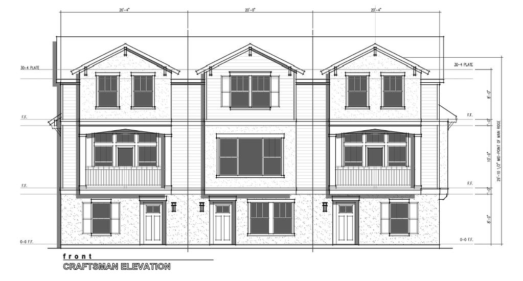
11 Page 11 Elevations Front/ Grant street
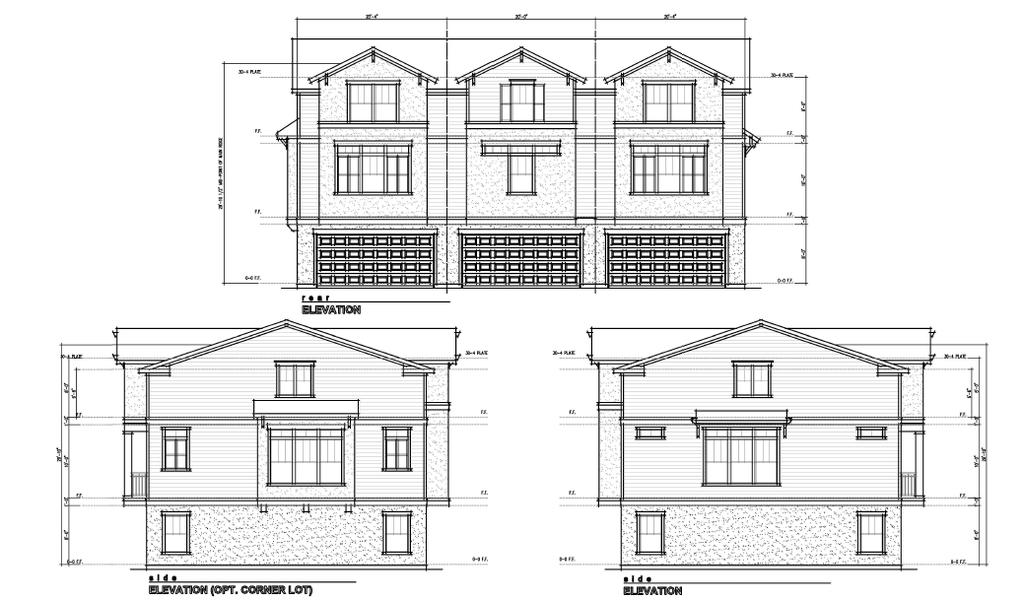
12 Page 12 Elevations


13 Page 13 SITE PHOTOS Corner of N Thornton Avenue and E Marks Street. North view from the subject site. Image of an existing tree on the northeast corner of the site, along E Marks Street Southwest view of the property from E. Marks Street. Corner of N Thornton Avenue and E Marks Street. East of the subject site. View of the existing street scape along N Thornton Avenue (east portion of the subject site)
14 Page 14 Page 14 C O N D ITIONS OF A PPROVAL Land Development 1. Default Zoning. The underlying zoning shall default to the standards of the O-1/T zoning district. 2. General Code Compliance. Development of the proposed project should be consistent with the conditions in this report and all codes and ordinances of the City of Orlando, the State of Florida, and all other applicable regulatory agencies. All other applicable state or federal permits must be obtained before commencing development. 3. As provided by subsection (5), Florida Statutes, issuance of a development permit by a municipality does not in any way create any right on the part of an applicant to obtain a permit from a state or federal agency and does not create any liability on the part of the municipality for issuance of the permit if the applicant fails to obtain requisite approvals or fulfill the obligations imposed by a state or federal agency or undertakes actions that result in a violation of state or federal law. In accordance with subsection (5), Florida Statutes, it is hereby made a condition of this permit that all other applicable state or federal permits be obtained before commencement of the development. 4. Variances and modifications. Zoning variances and modification of standards may be approved pursuant to the procedures set forth in Part 2J and Part 2F, Chapter 65, Orlando City Code, respectively. The planning official may also approve minor modifications and design modifications to fences, walls, landscaping, accessory structures, signs, and bufferyard requirements. Additionally, recognizing that development plans can change in small ways between the planning and permitting stages of development, the planning official may approve up to a 10% modification of any applicable numerical development standard if the planning official finds that the proposed modification is consistent with the applicable goals, objectives, and policies of the GMP, is compatible with nearby existing land uses, would not result in inadequate public facilities, and is otherwise consistent with the public health, safety, and welfare. When approving such a modification of a development standard, the planning official may impose one or more of the conditions of development provided at section , Orlando City Code, but such condition or conditions must be reasonably calculated to mitigate the identifiable land use impacts of the modified standard. 5. Conformance with PD Required. Construction and development shall conform to approved site plans, elevations, and landscaping plans on file with the City Planning Division and all conditions contained in this report, or as modified by the Municipal Planning Board and City Council. When submitting plans to the Permitting Division for permitting, the applicant shall attach to each submittal a copy of this staff report, and the excerpts of the Municipal Planning Board minutes. 6. Review by City Attorney s Office. Municipal Planning Board recommendation of the conditions contained herein is subject to review by the City Attorney s Office for legal sufficiency and drafting of implementing documents. 7. Impervious surface ratio. The impervious surface ratio for the property may not exceed the Height. Maximum height shall not exceed 30 ft. not to include architectural detailing. 9. Lot Width. All lots are required to be a minimum of 20 ft. in width. 10. Lot Area. The minimum lot area permitted is 1,468 sq. ft. with a minimum average lot area of 2,198 sq. ft. 11. Setbacks. The minimum required setbacks for the overall property shall be as follows: 20 ft. on Marks St., 20 ft. on Thornton Ave., 10 ft. along the south and west property line and 9.99 ft. along the E Marks St for unit 6, consistent with the proposed site plan. 12. School Capacity. The project shall be subject to school concurrency and shall coordinate with OCPS. 13. Overhangs. Balconies and other such overhangs shall not encroach into the ROW of the utility/sidewalk easement. 14. Trash pick-up. Collection of trash bins shall occur internal to the site. 15. Bufferyard. If a wall or opaque fencing is not provided as part of the required bufferyard, a hedge shall be provided. Said hedge shall be a minimum of 4 ft. in height at the time of installation. 16. Pedestrian circulation. A pedestrian connection shall be provided from Marks St. to the internal sidewalk along the rear units. 17. Accessory Buildings. Accessory buildings and pools shall be prohibited. Urban Design 1. Porches/Balconies. Constructed porches or balconies must have a minimum 6 ft. depth dimension 2. Roofing. A gable roof shall be provided over second floor balcony 3. Pedestrian Connection. A sidewalk connection from the rear units to Thornton Avenue must be provided Transportation Engineering 1. Driveway Relocation. Marks St is a Major Thoroughfare and as such the driveway must be relocated as far away from the intersection as possible. 2. Roadway. Interior two way roadways shall be a minimum 23 feet wide. 3. Sight Distances. At all project entrances, clear sight distances for drivers and pedestrians shall not be blocked by signs, buildings, building columns, landscaping, or other visual impediments. No structure, fence, wall, or other visual impediment shall obstruct vision between 2 feet and 8 feet in height above street level. The street corner / driveway visibility area shall be shown and noted on construction plans and any future site plan submittals. The applicant shall design the site plan as necessary to com-
15 Page 15 Page 15 C O N D ITIONS OF A PPROVAL ply with the Florida Greenbook and the FDOT Design Standards Index. Sight lines shall be provided on both site plans and landscape plans. 4. Compactor/Dumpster. The final site plan shall show the location and size of the on-site solid waste compactor(s) / dumpster(s) with concrete pads, and enclosures with doors. The solid waste container(s) shall not be located adjacent to any single family houses or directly adjacent to the public street. Dumpsters shall be located to provide a minimum 50 feet of clear backup space and constructed per Orlando Engineering Standards Manual (ESM) requirements, OR documentation shall be provided from the City's Solid Waste Division indicating curb pick-up or other approved arrangement. 5. Pedestrian Walkway. Provide interior pedestrian sidewalk/path connectivity that is ADA accessible. 6. Auto Turn Analysis. Provide an auto turn analysis of how a standard fire apparatus used by the City of Orlando will be able to access the entire site. Approval by City Fire Chief or designee will be required before a permit can be released. 7. City Services Easement. Any portion of the public sidewalk that is within the property boundary will have a City Services Sidewalk easement shown on the face of the plat and on construction plans submitted for permitting. Transportation Planning 1. Handicap. Handicap (HC) ramps shall be constructed at the street intersection(s) and driveway connection(s) to comply with the Americans with Disability Act (ADA). Pedestrian ramps at street corners shall be designed to provide a separate ramp in each direction. 2. Sidewalk. A detailed pavement treatment or delineated pedestrian (sidewalk) connection shall be shown between building entrances, with a connection to be provided to the public sidewalk. Pedestrian connectivity needs to be clarified for Units 10 and 11to the public right-of-way. 3. Solid Waste Management. Written confirmation from the City s Solid Waste Division Manager shall be provided that the proposed driveway and building configuration can be adequately served for regular scheduled garbage pick-up. 4. Construction traffic and parking plan. The Owner/Applicant shall provide documentation as to the steps that will be taken to protect the adjacent residential neighborhoods from construction cut-thru traffic and construction parking. Construction worker/ equipment parking and materials staging shall be shown and noted on the permit plan submittal. MAINTENANCE OF TRAF- FIC (M.O.T.) PLANS ARE REQUIRED. 5. New Construction Plan. For any construction work planned or required within a public right-of-way or City sidewalk easement adjacent to a public right-of-way (including but not limited to: irrigation, drainage, utility, cable, sidewalk, driveway, road construction/reconstruction or landscaping), the Owner/Applicant shall submit the following: 1. Maintenance of traffic plans (M.O.T.) (For more information/detailed requirements contact the Office of Special Events & Permits at ) 2. Roadway plans including paving, grading, pavement markings and signage (Contact the Permitting Transportation Engineering Reviewer at for details) Waste Water 1. Waster Water. Each fee simple unit shall have its own lateral connection to the gravity main. Double wye connections or other means of combined laterals are not allowed. Proposed sanitary sewer shall be privately owned and maintained.
16 Page 16 Page 16 C O N D ITIONS OF A PPROVAL-INFORMATIONAL Transportation Impact Fee 1. Transportation Impact Fee. Any new construction, change in use, addition, or redevelopment of a site or structure shall be subject to a review for Transportation Impact Fees. An estimated Transportation Impact Fee in the amount of $27,797.00, based on the construction of 11 unit multi-family residential units, will be due at the time of building permit issuance, subject to change upon final permit plan review. For a copy of the complete ordinance or impact fee rate chart, you may reference our website at: 2. Impact Fee Exemptions and Credits. Any exemptions or credits against the Transportation Impact Fee must be reviewed prior to permit issuance. All Transportation Impact Fee Credits shall be initiated and processed by the Transportation Impact Fee Coordinator. Credit shall be available for the previous occupied uses located on the subject site, at the time of annexation completion into the City limits. 3. Concurrency Management. The applicant shall comply with all applicable requirements of Chapter 59, the Concurrency Management Ordinance, to ensure that all public facilities and services are available concurrent with the proposed development, and that the potential impacts on public facilities and services are mitigated. 4. Concurrency-New Construction. All new construction, changes in use, additions or redevelopment are required to submit a Concurrency Management application as a part of the building plan review process. A Concurrency Management application is available on the City's website: OUC 1. Water Utility Plan. Submit detailed water utility plans to Orlando Utilities Commission Development Services when they have been developed. See our Website for submittal information Orlando Fire Department 1. OFD Review. There are no objections to this request. TRC fire code review is preliminary in nature, and is intended to expose or prevent evident design deficiencies with State and City Fire Codes. The design will be reviewed in detail for State and City Fire Code compliance at the time of permit application. Be advised that any new construction must adhere to the requirements of the Florida Fire Prevention Code, 2012 Edition, and The City of Orlando Fire Prevention Code. Orlando Police Department 1. CPTED Review. The Orlando Police Department has reviewed the plans for Park Lake Highland townhomes located at 844 N. Thornton Ave, utilizing CPTED (Crime Prevention Through Environmental Design) principles. CPTED emphasizes the proper design and effective use of a created environment to reduce crime and enhance the quality of life. There are four overlapping strategies in CPTED that apply to any development: Natural Surveillance, Natural Access Control, Territorial Reinforcement and Target Hardening.
17 Page 17 Page 17 C O N TACT INFORMAT ION Growth Management For questions regarding Growth Management plan review, please contact Mary-Stewart Droege at (407) or mary-stewart.droege@cityoforlando.net Land Development For questions regarding Land Development review, please contact TeNeika Neasman at (407) or teneika.neasman@cityoforlando.net. Urban Design For questions regarding Urban Design plan review, please contact Terrence Miller at or terrence.miller@cityoforlando.net Transportation Planning For questions regarding Transportation Planning plan review, please contact Nancy Ottini at or nancy.jurus-ottini@cityoforlando.net Transportation Engineering For questions regarding Transportation Engineering plan review, please contact Lauren Torres at or lauren.torres@cityoforlando.net. Engineering/Zoning For questions regarding Engineering or Zoning contact Keith Grayson at (407) or keith.grayson@cityoforlando.net. To obtain plan review status, schedule/cancel an inspection and obtain inspection results, please call PROMPT, our Interactive Voice Response System at Wastewater For questions regarding Wastewater review, please contact Vince Genco at vince.genco@cityoforlando.net Police CPTED conditions will be ed to the client by the Project Manager with the City. For questions regarding the Orlando Police Department plan review, please contact Audra Nordaby at or Audra.Nordaby@cityoforlando.net. Building For questions regarding Building Plan Review issues contact Don Fields at (407) or don.fields@cityoforlando.net. Parks For questions regarding Tree removal issues contact Justin Garber at (407) or justin.garber@cityoforlando.net OUC For questions regarding OUC issues contact Steven M. Lockington at or slockington@ouc.com Transportation Impact Fee For questions and information regarding Transportation Impact Fee rates you may contact Nancy Ottini at (407) or nancy.jurus-ottini@cityoforlando.net R E V I E W/AP P R O VA L PROCESS NEXT STEPS 1. MPB minutes scheduled for review and approval by City Council. 2. City Council review and approval of First reading of ordinance. 3. City Council review and approval of Second reading of ordinance. 4. Applicant submits for building permits.
UPS ACCESS POINT SILVER STAR
 Staff Report to the Municipal Planning Board November 15, 2016 C U P 2 0 1 6-0 0 0 2 6 I TEM # 5 UPS ACCESS POINT SILVER STAR Location Map S U M M A RY Owner 7-Eleven 7-Eleven Inc. Applicant Emily McGowin
L AKE NONA INNOVAT I O N CENTER PLAT
 Staff Report to the Technical Review Committee June 4,2013 S U B 2 0 1 3-0 0 0 2 0 I TEM # S 2 L AKE NONA INNOVAT I O N CENTER PLAT Location Map Subject Site S U M M A RY Owner James L. Zboril Lake Nona
Location Map S U M M A RY A N X G M P Z O N I TEM #2. Subject Site
 Staff Report to the Municipal Planning Board November 17, 2015 A N X 2 0 1 5-0 0 0 2 3 G M P 2 0 1 5-0 0 0 4 4 Z O N 2 0 1 5-0 0 0 3 9 I TEM #2 HOFFNER POINT Location Map Subject Site S U M M A RY Owner/Applicant
RANDAL PARK CELL TOWER
 March 20, 2018 Staff Report to the Municipal Planning Board C U P 2 0 1 7-1 0 0 11 I t e m # 1 0 RANDAL PARK CELL TOWER Location Map S U M M A R Y Owner Mattamy Partnership Applicant Mattaniah S. Jahn,
2923 E. C E N T R A L BLV D. T HE W I L M O T PINES P L AT WITH MODS
 Staff Report to the Municipal Planning Board June 16, 2015 S U B 2 0 1 5-0 0 0 2 5 I TEM 9 2923 E. C E N T R A L BLV D. T HE W I L M O T PINES P L AT WITH MODS Orlando Executive Airport Location Map S
WENDY PERSHING & SR436
 Staff Report to the Municipal Planning Board July 18, 2017 CUP2017-00010 Item #3 WENDY S @ PERSHING & SR436 Lake George S. SEMORAN BLVD. OUC Center PERSHING AVE. Barber Park Walmart Neigh. Store Lake George
Location Map S U M M A RY A N X G M P G M P Z O N I TEM #6.
 Staff Report to the Municipal Planning Board October 20, 2015 A N X 2 0 1 5-0 0 0 1 7 G M P 2 0 1 5-0 0 0 3 3 G M P 2 0 1 5-0 0 0 3 4 Z O N 2 0 1 5-0 0 0 3 0 I TEM #6 BLACKFIN SHOPPES Location Map Subject
APPEL REVERT TO PLAT
 Staff Report to the Municipal Planning Board May 17, 2016 SUB2016-00020 Item #16 APPEL REVERT TO PLAT Location Map S U M M A RY Applicant Jason and Sherreen Appel Owner Sherreen Appel Project Planner Jacques
HIGHLAND HOMES REVERT TO PLAT
 Broadway Ave. Staff Report to the Municipal Planning Board April 19, 2016 SUB2016-00006 Item #10 HIGHLAND HOMES REVERT TO PLAT Lake Highland Preparatory School E Marks St. Park Lake Location Map Subject
EAST PARK PD AMENDME NT
 June 20, 2017 Staff Report to the Municipal Planning Board C A S E # Z O N 2 0 1 7-0 0 0 1 0 I t e m #8 EAST PARK PD AMENDME NT Location Map S U M M A R Y Owner DR Horton, Inc Property Location: Located
L AVINA T R A C T G COMMERCIAL REPLAT
 Staff Report to the Technical Review Committee April 1, 2014 S U B 2 0 1 4-0 0 0 1 0 I TEM # S 1 L AVINA T R A C T G COMMERCIAL REPLAT Location Map S U M M A RY Owner Charles Whittall, Agent Ripleys International
L INGO LANE PRO PERT IES ANNEXAT ION
 Staff Report to the Municipal Planning Board September 16, 2014 A N X 2 0 1 4-0 0 0 1 4 G M P 2 0 1 4-0 0 0 2 0 Z O N 2 0 1 4-0 0 0 2 0 I TEM #1 L INGO LANE PRO PERT IES ANNEXAT ION Location Map S U M
May 23, 2017 Staff Report to the Board of Zoning Ad justment. C AS E # VAR I t e m #1. Location Map. Subject
 May 23, 2017 Staff Report to the Board of Zoning Ad justment C AS E # VAR 2 0 1 7-00031 I t e m #1 U N I T E D R E N TA L S O R L A N D O Location Map S U M M A R Y Owner Herbert R. Matthews, Jr. Applicant
U-HAUL OF ORLANDO AN NEXATION
 September 18, 2018 Staff Report to the Municipal Planning Board A N X 2 0 1 8-10004 G M P 2 0 1 8-1 0 0 1 4, Z O N 2 0 1 8-10007 I T E M # 1 U-HAUL OF ORLANDO AN NEXATION Location Map S U M M A R Y Applicant
E D U CATION V I LLAGE PD A M ENDMENT
 NARCOOSSEE RD Staff Report to the Municipal Planning Board June 17,2014 Z O N 2 0 1 4-0 0 0 1 2 I TEM #7 A D D E N D U M E D U CATION V I LLAGE PD A M ENDMENT Location Map S U M M A RY Owner James L. Zboril
Property Location: The subject property is located at northeast corner of Narcoossee Road and Tyson Road. (±1.377 acres, District 1).
.") Staff Report to the Municipal Planning Board August 19, 2014 A N X 2 0 1 4-0 0 0 0 5 G M P 2 0 1 4-0 0 0 0 9 G M P 2 0 1 4-0 0 0 1 0 Z O N 2 0 1 4-0 0 0 0 8 I TEM #1 TYSON S CORNER ANNEXATION Location
Staff Report to the Municipal Planning Board August 19, 2014 A N X 2 0 1 4-0 0 0 0 5 G M P 2 0 1 4-0 0 0 0 9 G M P 2 0 1 4-0 0 0 1 0 Z O N 2 0 1 4-0 0 0 0 8 I TEM #1 TYSON S CORNER ANNEXATION Location
BLACKFIN SHOPPES GMP ZON I TEM #3. Staff Report to the Municipal Planning Board July 19, Location Map S UMMARY.
 Staff Report to the Municipal Planning Board July 19, 2016 GMP2015-00054 ZON2015-00057 I TEM #3 BLACKFIN SHOPPES Location Map Subject Site S UMMARY Owners Edgar Yates Colleen Yates, Clifton Ackerman &
1-4 ac Across From Medical City
 1-4 ac Across From Medical City 14781 Narcoossee Rd, Orlando, FL 32832 Vacant Land for Sale $3,65 Highlights 1.67-3.65+/-Acres High and Dry Zoned PD Features Electricity/Power, Water, Telephone and Cable
PARRAMORE OAKS FRAMEWORK PLANNED DEVELOPMENT
 PARRAMORE OAKS FRAMEWORK PLANNED DEVELOPMENT Presented by Mark Cechman, AICP Paul S. Lewis, FAICP Review Process Pre- Application meeting August 11, 2016 Attended by representatives of: City Planning Transportation
SONBERG EASTIN FENCE 1586 EASTIN AVE.
 Staff Report to the Board of Zoning Adjustment May 24, 2016 VA R 2 0 1 6-0 0 0 2 1 I TEM#1 SONBERG EASTIN FENCE 1586 EASTIN AVE. College Park Post Office Lake Ivanhoe Location Map Subject Site S U M M
L A U R E AT E PARK NEIGHBORHOOD CENTER
 Updated per conditions of approval at the 5/14/15 SETDRC meeting and to incorporate the addendum provided at the meeting. Staff Report to the Southeast Town Design Review Committee May 14, 2015 M P L 2
O HIO ST., MICHIGAN AVE. & PART OF H ARMON AVE. R-O-W ABANDONMENTS
 Staff Report to the Municipal Planning Board June 16, 2015 ABN2015-00001 Item #1 O HIO ST., MICHIGAN AVE. & PART OF H ARMON AVE. R-O-W ABANDONMENTS Location Map S UMMARY Applicant/Owner Debbie Carey, Administrator
Medical Marijuana Special Exception Use Information
 Medical Marijuana Special Exception Use Information The Special Exception Use information below is a modified version of the Unified Development Code. It clarifies the current section 5:104 Special Exceptions
3675 MIDIRON DR. REVERT TO PLAT
 Staff Report to the Municipal Planning Board January 19, 2016 SUB2015-00068 Item #14 3675 MIDIRON DR. REVERT TO PLAT MINNESOTA AVE. Dubsdread Golf Course N. FORMOSA AVE. Calvary Assembly of God EAGLE DR.
PLANNED DEVELOPMENT DISTRICT STANDARDS. Cadence Site
 PLANNED DEVELOPMENT DISTRICT STANDARDS Cadence Site A Planned Development District 1. Statement of General Facts, Conditions and Objectives Property Size: Approximately 57.51 Acres York County Tax Map
PD No. 15 Authorized Hearing
 PD No. 15 Authorized Hearing Community Meeting No. 2 February 19, 2019 6:30 p.m. Hyer Elementary School Cafetorium 8385 Durham St Andrew Ruegg Senior Planner PD No. 15 Authorized Hearing On September 7,
JARED JEWELRY STORE PARKING 4095 MILLENIA BLVD.
 Staff Report to the Board of Zoning Adjustment February 23, 2016 VAR2016-00004 I TEM #3 JARED JEWELRY STORE PARKING 4095 MILLENIA BLVD. Millenia Target DeVry Institute Best Buys Mall at Millenia Location
St. James Catholic Church USPS. St. Luke Episcopal. O.C. Regional History. Heritage Square
 June 26, 2018 Staff Report to the Board of Zoning Ad justment C AS E # VAR 2 0 1 8-10020 I t e m #2 D E E P LY C O F F E E A L C O H O L S E PA R AT I O N St. James Catholic Church USPS St. Luke Episcopal
Location Map S U M M A RY A N X G M P G M P Z O N I TEM #1.
 Staff Report to the Municipal Planning Board September 15, 2015 A N X 2 0 1 5-0 0 0 0 8 G M P 2 0 1 5-0 0 0 1 5 G M P 2 0 1 5-0 0 0 1 6 Z O N 2 0 1 5-0 0 0 0 8 I TEM #1 TYSON S CORNER II ANNEXATION Subject
L DC A M E N D M E N T F O R SETBACK R E L I E F
 Staff Report to the Municipal Planning Board March 21, 2017 L D C 2 0 1 7-0 0 0 1 4 I TEM # 5 L DC A M E N D M E N T F O R SETBACK R E L I E F TO ENCOURAGE RESIDENTIAL INFILL IN T H E PH O V E R L AY D
AUDI SOUTH ORLANDO REZONING 4709 VINELAND RD.
 Staff Report to the Municipal Planning Board December 20, 2016 ZON2016-00026 Item #9 AUDI SOUTH ORLANDO REZONING 4709 VINELAND RD. 7-11 Super Target Audi S. Orlando vacant Location Map Subject Site S UMMARY
ACCESSORY DWELLING UNITS IN THE SOUTHEAST SECTOR
 February 19, 2019 Staff Report to the Municipal Planning Board LDC2018-10020 Item #11 S U M M A R Y Applicant The City of Orlando ACCESSORY DWELLING UNITS IN THE SOUTHEAST SECTOR Applicant s Request Update
CITY OF OCOEE LAND DEVELOPMENT CODE SUFFICIENCY TABLE WITH NOTES
 CITY OF OCOEE LAND DEVELOPMENT CODE SUFFICIENCY TABLE WITH NOTES The Sufficiency Table is a checklist to help identify the types of information and documentation needed for various types of projects. The
VA R I TEM #3
 Staff Report to the Board of Zoning Adjustment August 26, 2014 VA R 2 0 1 4-0 0 0 8 0 I TEM #3 OPEN PORCH 404 SHERIDAN BLVD Location Map Subject Site S U M M A RY Applicant Edward Valley Owner Scott and
SITE DEVELOPMENT PLAN REQUIREMENTS CHECKLIST
 SITE DEVELOPMENT PLAN REQUIREMENTS CHECKLIST Completed DRC Application for Review Required for Application Process DRC Processing Fee 1 Commercial $2,500.00 Fire Department Review Fee 150.00 Total $2,650.00
LAKE NONA PARCEL 10 & 11
 October 17, 2017 Staff Report to the Municipal Planning Board CASE #DRI2017-10003 GMP2017-10012 GMP2017-10013 ZON2017-10005 Item #2 LAKE NONA PARCEL 10 & 11 Location Map Subject Site SUMMARY Owner James
4.2 RESIDENTIAL ZONING DISTRICTS
 4.2 RESIDENTIAL ZONING DISTRICTS A. Purpose: To define regulations and standards for each residential zoning district in the City. The following sections identify uses, regulations, and performance standards
COMMERCIAL/INDUSTRIAL DEVELOPMENT GUIDELINES
 COMMERCIAL/INDUSTRIAL DEVELOPMENT GUIDELINES Planning Division Sections Chapter 17.16 Commercial, Industrial Development Standards 17.16.010 Lot Size 17.16.020 Setbacks 17.16.030 Fences, Hedges and Walls
PLANNED UNIT DEVELOPMENT & SUBDIVISION STAFF REPORT Date: November 17, 2016
 PLANNED UNIT DEVELOPMENT & SUBDIVISION STAFF REPORT Date: November 17, 2016 DEVELOPMENT NAME SUBDIVISION NAME LOCATION Autonation Ford of Mobile Autonation Ford of Mobile Subdivision 901, 909, and 925
CITY PLAN COMMISSION STAFF REPORT
 CITY PLAN COMMISSION STAFF REPORT SUBJECT: Request for a Change of Zoning and Preliminary Development Plan FROM: Mara Perry, Director of Planning & Development MEETING DATE: November 6, 2017 PETITION:
ARTICLE IV: DEVELOPMENT STANDARDS
 ARTICLE IV: DEVELOPMENT STANDARDS IV-53 409 PRIVATE STREETS A private street means any way that provides ingress to, or egress from, property by means of vehicles or other means, or that provides travel
ARTICLE VII. NONCONFORMITIES. Section 700. Purpose.
 ARTICLE VII. NONCONFORMITIES. Section 700. Purpose. The purpose of this chapter is to regulate and limit the development and continued existence of legal uses, structures, lots, and signs established either
Cover Letter with Narrative Statement
 Cover Letter with Narrative Statement March 31, 2017 rev July 27, 2017 RE: Rushton Pointe Residential Planned Unit Development Application for Public Hearing for RPUD Rezone PL2015 000 0306 Mr. Eric Johnson,
LDC AMENDMENT TOWNHOMES
 Staff Report to the Municipal Planning Board May 15, 2018 L D C 2 0 1 8-10002 I T E M # 11 LDC AMENDMENT TOWNHOMES Applicant City of Orlando Project Planner Elisabeth Dang, AICP Updated: May 3, 2018 Description
PUD Zoning Framework
 PUD Zoning Framework PUD Zoning Framework Purpose Development Review Process Site Plan Review Process Planned Unit Developments (PUD) are tools for dealing with special situations or accomplishing certain
In order to permit maximum applicability of the PUD District, PUD-1 and PUD-2 Districts are hereby created.
 ARTICLE III. PUD ned Unit Development Overlay District 205-128. Purpose. The PUD ned Unit Development Overlay District is intended to provide flexibility in the design of planned projects; to encourage
MEMORANDUM. DATE: November 9, 2016 PC Agenda Item 3.C
 MEMORANDUM DATE: November 9, 2016 PC Agenda Item 3.C TO: FROM: SUBJECT: Planning Commission Eric Zweber, AICP, Interim City Planner Planning Case #16-029 Public Hearing Required Applicant: Bremer Bank,
AN ORDINANCE TO AMEND SECTION OF THE RAPID CITY MUNICIPAL CODE TO ALLOW FOR ADMINISTRATIVE DISSOLUTION OF PLANNED DEVELOPMENTS
 Ordinance No. 6231 AN ORDINANCE TO AMEND SECTION 17.50.050 OF THE RAPID CITY MUNICIPAL CODE TO ALLOW FOR ADMINISTRATIVE DISSOLUTION OF PLANNED DEVELOPMENTS WHEREAS, the City of Rapid City has adopted a
SHOOTER S WORLD 4850 LAWING LN.
 Staff Report to the Board of Zoning Adjustment October 24, 2017 VAR2017-10016 I TEM #1 SHOOTER S WORLD 4850 LAWING LN. Kirkman Shoppes Conservation Area Location Map S UMMARY Applicant Kevin Mineer, AICP
PALM BEACH COUNTY PLANNING, ZONING AND BUILDING DEPARTMENT ZONING DIVISION ZONING COMMISSION VARIANCE STAFF REPORT 06/05/2014
 PALM BEACH COUNTY PLANNING, ZONING AND BUILDING DEPARTMENT ZONING DIVISION ZONING COMMISSION VARIANCE STAFF REPORT 06/05/2014 APPLICATION NO. ZV-2013-03120 CODE SECTION REQUIRED PROPOSED VARIANCE (V1)
Request Subdivision Variance (4.4 (b) of the Subdivision Regulations) Staff Recommendation Approval. Staff Planner Jonathan Sanders
 of the Subdivision Regulations) Staff Recommendation Approval. Staff Planner Jonathan Sanders") Applicant Property Owner Patricia A. Martino, Trustee of the Patricia A. Martino Living Trust Public Hearing August 9, 2017 (Previously Deferred on July 12, 2017) City Council Election District Beach Agenda
Applicant Property Owner Patricia A. Martino, Trustee of the Patricia A. Martino Living Trust Public Hearing August 9, 2017 (Previously Deferred on July 12, 2017) City Council Election District Beach Agenda
1017 S. MILLS AVE. DRIVEWAY
 Staff Report to the Board of Zoning Adjustment January 27, 2015 VAR2014-00119 I TEM #2 1017 S. MILLS AVE. DRIVEWAY S. MILLS AVE. Location Map S UMMARY Applicant/Owner Jack Elkins Project Planner Jim Burnett,
Composition of traditional residential corridors.
 Page 1 of 7 St. Petersburg, Florida, Code of Ordinances >> PART II - ST. PETERSBURG CITY CODE >> Chapter 16 - LAND DEVELOPMENT REGULATIONS >> SECTION 16.20.060. CORRIDOR RESIDENTIAL TRADITIONAL DISTRICTS
CITY OF MERCED SMALL LOT SINGLE-FAMILY HOME DESIGN GUIDELINES
 CITY OF MERCED SMALL LOT SINGLE-FAMILY HOME DESIGN GUIDELINES Development Services Department Planning and Permitting Adopted August 15, 2005 SMALL LOT SINGLE FAMILY HOME GUIDELINES A. Purpose and Applicability.
Site Plan Application
 Site Plan Application City of St. Pete Beach Community Development Department 155 Corey Avenue St. Pete Beach, Florida 33706 (727) 367-2735 www.stpetebeach.org Case Number: PROPERTY OWNER: Name: Address:
ARTICLE 50. PD 50. Unless otherwise stated, the definitions and interpretations in Chapter 51 apply to this
 ARTICLE 50. PD 50. SEC. 51P-50.101. LEGISLATIVE HISTORY. PD 50 was established by Ordinance No. 13428, passed by the Dallas City Council on November 8, 1971. Ordinance No. 13428 amended Ordinance No. 10962,
CASE # LUP Commission District: # 3
 CASE # LUP-15-02-038 Commission District: # 3 GENERAL INFORMATION APPLICANT OWNER PROJECT NAME HEARING TYPE REQUEST Richard Frucci Lingo Lane, LLC Lingo Lane Planned Development / Land Use Plan (PD/LUP)
Appearance Review Board Staff Report
 Appearance Review Board Staff Report November 15, 2018 ARB2018-10038 Applicant Agenda Item 1 336 N. Orange Ave. Orange & Robinson Apartments Courtesy Review Brooks Stickler Kimley-Horn Owner Carol Brinati,
SUBJECT: Application for Planned Unit Development and Rezoning 1725 Winnetka Road
 TO: FROM: CHAIRMAN BILL VASELOPULOS AND MEMBERS OF THE PLAN & ZONING COMMISSION STEVE GUTIERREZ DIRECTOR OF COMMUNITY DEVELOPMENT MEETING DATE: September 5, 2017 SUBJECT: Application for Planned Unit Development
ADDRESS / DESCRIPTION: Northeast corner of Sandbridge Road and Atwoodtown Road ELECTION DISTRICT: PRINCESS ANNE
 10 & 11 March 14, 2012 Public Hearing APPLICANT: MARLYN DEVELOPMENT CORPORATION PROPERTY OWNER: CORAL DEVELOPMENT, LLC STAFF PLANNER: Faith Christie REQUEST: Modification of Conditional Change of Zoning
PALM BEACH COUNTY PLANNING, ZONING AND BUILDING DEPARTMENT ZONING DIVISION ZONING COMMISSION VARIANCE STAFF REPORT 07/05/2012
 PALM BEACH COUNTY PLANNING, ZONING AND BUILDING DEPARTMENT ZONING DIVISION ZONING COMMISSION VARIANCE STAFF REPORT 07/05/2012 APPLICATION NO. CODE SECTION REQUIRED PROPOSED VARIANCE ZV-2012-00690 3.D.1.A
Request Subdivision Variance (4.1 (m)(1) of the Subdivision Regulations) Staff Recommendation Approval. Staff Planner Jonathan Sanders
(1) of the Subdivision Regulations) Staff Recommendation Approval. Staff Planner Jonathan Sanders") Applicant Property Owner Jo Stallard Woolling Hodges Public Hearing December 12, 2018 (Deferred November 14, 2018) City Council Election District Beach Agenda Item D4 Request Subdivision Variance (4.1
Applicant Property Owner Jo Stallard Woolling Hodges Public Hearing December 12, 2018 (Deferred November 14, 2018) City Council Election District Beach Agenda Item D4 Request Subdivision Variance (4.1
DEVELOPMENT DEPARTMENT STAFF REPORT THE PARK AT 5 TH
 DEVELOPMENT DEPARTMENT STAFF REPORT ARB Meeting Date: July 3, 2018 Item #: _PZ2018-293_ THE PARK AT 5 TH Request: Site Address: Project Name: Parcel Number: Applicant: Proposed Development: Current Zoning:
PLANNED UNIT DEVELOPMENT & SUBDIVISION STAFF REPORT Date: April 18, 2019
 PLANNED UNIT DEVELOPMENT & SUBDIVISION STAFF REPORT Date: April 18, 2019 DEVELOPMENT NAME SUBDIVISION NAME Springhill Village Subdivision Springhill Village Subdivision LOCATION 4350, 4354, 4356, 4358,
Staff Report: Date: Applicant: Property Identification: Acreage of Request: Current Zoning of Requested Area: Requested Action: Attached:
 Staff Report: Completed by Jeff Palmer Director of Planning & Zoning Date: November 7, 2018, Updated November 20, 2018 Applicant: Greg Smith, Oberer Land Developer agent for Ronald Montgomery ET AL Property
PLANNED UNIT DEVELOPMENTS (Ordinance No.: 3036, 12/3/07; Repealed & Replaced by Ordinance No.: 4166, 10/15/12)
") 159.62 PLANNED UNIT DEVELOPMENTS (Ordinance No.: 3036, 12/3/07; Repealed & Replaced by Ordinance No.: 4166, 10/15/12) A. PURPOSE 1. General. The Planned Unit Development (PUD) approach provides the flexibility
159.62 PLANNED UNIT DEVELOPMENTS (Ordinance No.: 3036, 12/3/07; Repealed & Replaced by Ordinance No.: 4166, 10/15/12) A. PURPOSE 1. General. The Planned Unit Development (PUD) approach provides the flexibility
Rezoning Petition Final Staff Analysis July 16, 2018
 Rezoning Petition 2018-041 Final Staff Analysis July 16, 2018 REQUEST LOCATION Current Zoning: R-5 (single family residential, and UR-2(CD) (urban residential, conditional) Proposed Zoning: UR-2(CD) (urban
Chapter SPECIAL USE ZONING DISTRICTS
 Chapter 20.20 Sections: 20.20.010 Urban Transition (U-T) Zoning District 20.20.020 Planned Development (P-D) Zoning Districts 20.20.010 Urban Transition (U-T) Zoning District A. Purpose. The purpose of
CITY OF NORTH OAKS COUNTY OF RAMSEY STATE OF MINNESOTA ORDINANCE NO. 109 AN ORDINANCE IMPLEMENTING THE CHARLEY LAKE PRESERVE PLANNED UNIT DEVELOPMENT
 CITY OF NORTH OAKS COUNTY OF RAMSEY STATE OF MINNESOTA ORDINANCE NO. 109 AN ORDINANCE IMPLEMENTING THE CHARLEY LAKE PRESERVE PLANNED UNIT DEVELOPMENT The City of North Oaks hereby ordains as follows: SECTION
ADMINISTRATIVE HEARING STAFF REPORT
 ADMINISTRATIVE HEARING STAFF REPORT Providence Place Apartments Utility Box No. 2 Conditional Use Petition PLNPCM2011-00426 309 East 100 South September 22, 2011 Planning and Zoning Division Department
Exhibit D. Tallow Ridge PUD. Written Description. Date: January 5, E. City Development Number:
 Exhibit D Tallow Ridge PUD Written Description Date: January 5, 2016 I. SUMMARY DESCRIPTION OF THE PROPERTY A. Current Land Use Designation: RR B. Current Zoning District: PUD C. Requested Zoning District:
ARTICLE 23 CONDOMINIUM STANDARDS
 ARTICLE 23 CONDOMINIUM STANDARDS Section 23.01 Intent. The intent of this Article is to provide regulatory standards for condominiums and site condominiums similar to those required for projects developed
CITY OF HOLLYWOOD. Technical Advisory Committee Submittal Checklist. Guide to TAC Submittal Checklist. General Requirements:
 CITY OF HOLLYWOOD Technical Advisory Committee Submittal Checklist Guide to TAC Submittal Checklist This document is an outline of site plan review procedures as listed in the Technical Advisory Committee
PERMITTED USES: Within the MX-1 Mixed Use Neighborhood District the following uses are permitted:
 6.25 MX-1 - MIXED USE NEIGHBORHOOD 6.25.1 INTENT: The purpose of the MX-1 Mixed Use Neighborhood District is to accommodate the development of a wide-range of residential and compatible non-residential
B. The Plan is in conformity with the Comprehensive Plan.
 ARTICLE 17 PLANNING UNIT DEVELOPMENT 17.01 INTENT The purpose of this Section is to permit the creation of new Planned Unit Developments, permitted as Conditional Uses where maximum variations of design
EXHIBIT D. Planned Unit Development Written Description April 13, 2016 Rouen Cove Phase II PUD
 1 EXHIBIT D Planned Unit Development Written Description April 13, 2016 Rouen Cove Phase II PUD Development # 8986.001 Developer: Curtis L. Hart Hart Resources LLC 8051 Tara Lane Jacksonville, Florida
DEVELOPMENT DEPARTMENT STAFF REPORT STAFF REPORT MCDONALD S ZONING MAP AMENDMENT AND CONCURRENT VARIANCES
 DEVELOPMENT DEPARTMENT STAFF REPORT Meeting Date: October 12, 2017 Item #: _PZ2017-172_ STAFF REPORT MCDONALD S ZONING MAP AMENDMENT AND CONCURRENT VARIANCES Request: Rezone property from MU-BC to CC,
ZA and ZA Zoning Change and Concept / Site Plan Preliminary Plat Delta Southlake Center
 ZA16-051 and ZA16-052 Zoning Change and Concept / Site Plan Preliminary Plat Delta Southlake Center ZA16-051 and ZA16-052 Owner: Applicant: Requests: Dominion Southlake Properties, LLC, White Chapel Village
PALM BEACH COUNTY PLANNING, ZONING AND BUILDING DEPARTMENT ZONING DIVISION
 PALM BEACH COUNTY PLANNING, ZONING AND BUILDING DEPARTMENT ZONING DIVISION Application No.: DOA-2014-01111 Application Name: World Class Academy Control No.: 1998-00052 Applicant: World Class Academy Inc
Planning Commission recommends APPROVAL of the amendment to Article 4, Article 7, and Article 14 as presented by Staff on 6/19/17.
 DATE: June 20, 2017 TO: FROM: SUBJECT: Mayor and City Council Planning Director Zoning Ordinance Amendment Article 4, Article 7, and Article 14 related to accessory uses, fences, walls, and administrative
UPPER MOUNT BETHEL TOWNSHIP NORTHAMPTON COUNTY, PENNSYLVANIA
 UPPER MOUNT BETHEL TOWNSHIP NORTHAMPTON COUNTY, PENNSYLVANIA JOINDER DEED / LOT CONSOLIDATION TOWNSHIP REVIEW PROCESS When accepting proposed Joinder Deeds / Lot Consolidations, review the Joinder Deed
Duplex and Tandem Development Community Workshop. Presented by: Elisabeth Dang, AICP
 Duplex and Tandem Development Community Workshop Presented by: Elisabeth Dang, AICP September 21, 2016 Staff presentation Agenda Overview Outreach to date Explanation of proposed code amendments Examples
ARTICLE 5.0 SCHEDULE OF REGULATIONS
 ARTICLE 5.0 SCHEDULE OF REGULATIONS Section 5.101 Table of Dimensional Standards by District. Dimensional Standards AG AG with sewer Districts Rural Residential Business Other SF SF with sewer R-1 R-1
DEPARTMENT OF DEVELOPMENT SERVICES PLANNING BOARD BRIEFING For Meeting Scheduled for January 5, 2009 Agenda Item B2
 DEPARTMENT OF DEVELOPMENT SERVICES PLANNING BOARD BRIEFING For Meeting Scheduled for January 5, 2009 Agenda Item B2 REQUEST: Cocoa Beach Community Church Site Plan/Architectural Review Downtown Overlay
Glades County Staff Report and Recommendation Unified Staff Report for Small Scale Plan Amendment and Rezoning
 Glades County Staff Report and Recommendation Unified Staff Report for Small Scale Plan Amendment and Rezoning CASE NUMBERS: COMP17-02 and RZ17-02 DATE of STAFF REPORT: May 1, 2017 CASE TYPE: Application
Staff Planner Carolyn A.K. Smith
 Applicant Property Owner, Pamela K. & Steven A. Gray Public Hearing April 13, 2016 City Council Election District Princess Anne Agenda Item 8 Request Modification of Proffers (Modification to the proffer
(a) Commercial uses on Laurel Avenue, abutting the TRO District to the
 Commercial uses on Laurel Avenue, abutting the TRO District to the") 32X Zoning Code 150.36 TRANSITIONAL RESIDENTIAL OVERLAY DISTRICT. (A) Intent and purpose. (1) It is the intent of the Transitional Residential Overlay District (hereinafter referred to as the "TRO District")
32X Zoning Code 150.36 TRANSITIONAL RESIDENTIAL OVERLAY DISTRICT. (A) Intent and purpose. (1) It is the intent of the Transitional Residential Overlay District (hereinafter referred to as the "TRO District")
RESOLUTION NO. B. The proposed amendment would not be detrimental to the public interest, health, safety, convenience, or welfare of the City; and
 RESOLUTION NO. RESOLUTION OF THE PLANNING COMMISSION OF THE CITY OF SANTA ROSA RECOMMENDING TO CITY COUNCIL REZONING TO MODIFY THE EXISTING POLICY STATEMENT AND ADOPT THE BAY VILLAGE HOMES DEVELOPMENT
City of Placerville Planning Commission STAFF REPORT
 Placerville, a Unique Historical Past Forging into a Golden Future City of Placerville STAFF REPORT SUBJECT: Consideration of a request to operate the automobile brokerage business in the Highway Commercial
McGowin Park, LLC. B-3, Community Business District
 # 10, 11, 12 SUB2014-00024 ZON2014-00500 ZON2014-00501 SUBDIVISION, PLANNED UNIT DEVELOPMENT (East), PLANNED UNIT DEVELOPMENT (West) STAFF REPORT Date: April 3, 2014 DEVELOPMENT NAME LOCATION McGowin Park,
Hamilton County Regional Planning Commission
 Hamilton County Regional Planning Commission March 1, 2012 Colerain Township Staff Report Zone Map Amendment: Case No.: ZA2012-01 Joseph Toyota Prepared By: Amy Bancroft, Land Use Planner ACTION REQUESTED:
City of Colleyville City Council Agenda Briefing
 City of Colleyville City Council Agenda Briefing City Hall 100 Main Street Colleyville, Texas 76034 www.colleyville.com Agenda Number 5a Agenda Date 01/06/2015 Number Ordinance O-14-1942 Type Ordinance
PLANNING COMMISSION STAFF REPORT
 PLANNING COMMISSION STAFF REPORT REZONING CASE: RZ-15-002 REPORT DATE: January 26, 2016 CASE NAME: Thursday Lunch Club Rezoning PLANNING COMMISSION DATE: February 17, 2016 ADDRESS OF REZONING PROPOSAL:
PLANNING AND ZONING COMMISSION AGENDA MEMORANDUM
 City and County of Broomfield, Colorado PLANNING AND ZONING COMMISSION AGENDA MEMORANDUM To: Planning and Zoning Commission From: John Hilgers, Planning Director Anna Bertanzetti, Principal Planner Meeting
APPLICANT NAME SUBDIVISION NAME DEVELOPMENT NAME LOCATION. CITY COUNCIL DISTRICT Council District 4 PRESENT ZONING PROPOSED ZONING
 SUBDIVISION, PLANNED UNIT DEVELOPMENT, PLANNING APPROVAL, ZONING AMENDMENT, & SIDEWALK WAIVER REQUEST STAFF REPORT Date: February 17, 2010 APPLICANT NAME SUBDIVISION NAME DEVELOPMENT NAME LOCATION David
NIBLICK WAY REVERT TO PLAT S UMMARY. SUB Item #11. Staff Report to the Municipal Planning Board August 18, 2015
 Staff Report to the Municipal Planning Board August 18, 2015 SUB2015-00037 Item #11 319 NIBLICK WAY REVERT TO PLAT DUBSDREAD CIR. NIBLICK WAY PUTTER LN. N. FORMOSA AVE. DUBSDREAD CIR. Location Map S UMMARY
PLANNING AND ZONING DEPARTMENT
 Town of Minturn Development Review Process: Guide To Planned Unit Developments (Concept Plan) This guide describes the Planned Unit Development Process. This guide should be utilized in conjunction with
PLANNED UNIT DEVELOPMENT (East), PLANNED UNIT DEVELOPMENT (West) STAFF REPORT Date: September 18, 2014
, PLANNED UNIT DEVELOPMENT (West) STAFF REPORT Date: September 18, 2014") PLANNED UNIT DEVELOPMENT (East), PLANNED UNIT DEVELOPMENT (West) STAFF REPORT Date: September 18, 2014 DEVELOPMENT NAME LOCATION McGowin Park, LLC PLANNED UNIT DEVELOPMENT (East) 1401 Satchel Paige Drive
PLANNED UNIT DEVELOPMENT (East), PLANNED UNIT DEVELOPMENT (West) STAFF REPORT Date: September 18, 2014 DEVELOPMENT NAME LOCATION McGowin Park, LLC PLANNED UNIT DEVELOPMENT (East) 1401 Satchel Paige Drive
PRIMUS TRACT MOUNT PLEASANT, SOUTH CAROLINA
 DEVELOPMENT GUIDELINES FOR PRIMUS TRACT MOUNT PLEASANT, SOUTH CAROLINA Date February 18, 2015 PLANNING COMMISSION SUBMITTAL Owner/Developer: American Star Development SC, LLC P.O. Box 211 Sullivans Island,
8.5.1 R1, Single Detached Residential District
 8.5.1 R1, Single Detached Residential District The purpose of this district is to provide for residential development in the form of single detached dwellings. Dwelling, Single Detached Home Business,