1-4 ac Across From Medical City
|
|
|
- Rafe Henry
- 5 years ago
- Views:
Transcription


, park/plaza, and/or other uses consistent with")
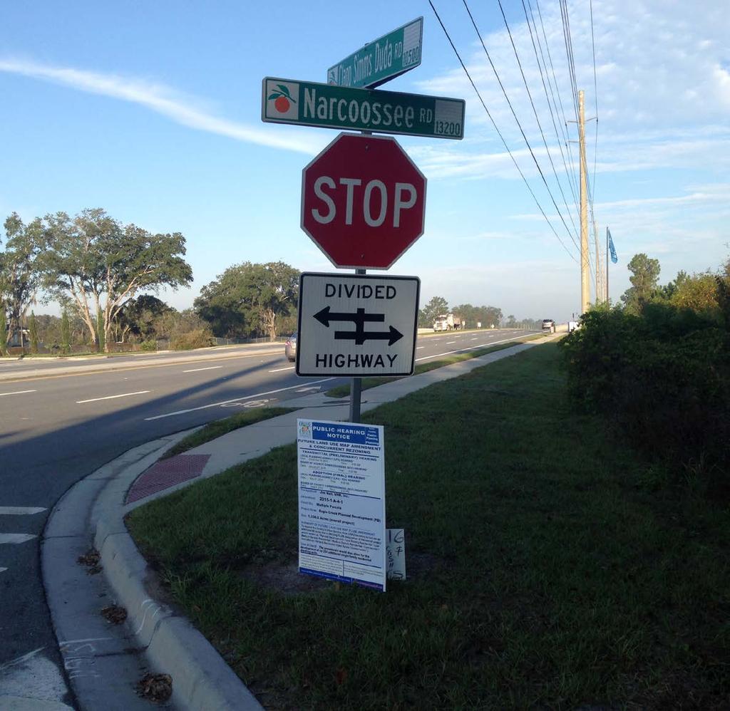
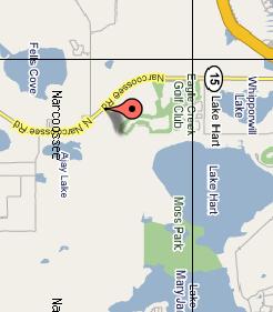
1 1-4 ac Across From Medical City Narcoossee Rd, Orlando, FL Vacant Land for Sale $3,65 Highlights /-Acres High and Dry Zoned PD Features Electricity/Power, Water, Telephone and Cable Located minutes from Lake Nona Medical City SITE 3.65+/- acres - Approved Commercial Village Center in the Lake Nona area; PD allows for up to 50,000 sq.ft. of non-residential use. Hard corner with median cut at Narcoossee Road and Clapp Simms Duda Road. Large-scale residential development coming soon on Clapp Simms Duda; this intersection will be the gateway to hundreds of new residential homes. Allowable uses include; retail, services, grocery, restaurants, cinema, gas stations, offices, hospitals, hotels, civic (including schools & colleges), park/plaza, and/or other uses consistent with the City s AC-1 District. Lake Nona s Medical City is expected to create/stimulate over 30,000 jobs in the coming years; this site is less than 1.5 miles away from the East entrance. Medical City Venues Include: VA Medical Center, Nemours Children s Hospital, Sanford-Burnam Center, UCF College of Medicine, and M.D. Anderson Center. The information contained herein has been given to us by the owner of the property or other sources we deem reliable. We have no reason to doubt its accuracy, but we do not guarantee it. This is subject to errors, ommissions, or change of price and conditions. All information should be verified prior to purchase or lease. Richie Frucci
2 PD Framework Map Narcoossee Rd, Orlando, FL Richie Frucci


3 Additional Photos Narcoossee Rd, Orlando, FL Richie Frucci


4 Medical City Venues Lake Nona, Orlando, FL MD Anderson Nemours Children s Hospital Orlando VA Hospital Sanford-Burnham Institute UCF Health Sciences Valencia College Richie Frucci
5
6

7 Staff Report to the Municipal Planning Board July 15, 2014 ANX GMP ZON ITEM #2 NARCOOSSEE OAKS ANNEXATION Location Map S UMMARY Owner Nazish Masoodi Applicant Andre A. Anderson, AICP President, Planning Design Group, LLC Project Planner Michelle Beamon Updated: July 1, 2014 Property Location: The subject properties are located at Clapp Simms Duda Road, on the southeast corner of Narcoossee Road and Clapp Simms Duda Road. District 1). (±3.657 acres, Applicant s Request: 1. Annex the subject property. 2. Assign the Urban Village future land use designation. 3. Create GMP Subarea Policy S.40.4 to include the property into the Southeast Orlando Sector Plan 4. Initial zoning of PD Village Center to allow for 50,000 sq. ft. of non-residential uses. Subject Site Staff s Recommendation: Approval of the requests, subject to the conditions in this report. Public Comment The petition for annexation was approved by the City Council on June 2, 2014 and this staff report was approved at the June 3, 2014 Technical Review Committee meeting. Courtesy notices were mailed to property owners within 400 ft. of the subject property during the week of June 2, As of the published date of this report, staff has not received any comments from the public concerning this request.
8 Page 2 F UTURE LAND USE MAP
9 Page 3 Z ONING MAP
10 Page 4 P ROJECT ANALYSIS Project Description The subject properties are located at Clapp Simms Duda Road in unincorporated Orange County at the southeast corner of the intersection of Narcoossee Road and Clapp Simms Duda Road, and is approximately acres. The subject property is currently five separate parcels that are all vacant. The applicant desires to annex this property for a future development of up to 50,000 sq ft. of nonresidential use. Upon annexation into the City of Orlando, the property will be in City Council District 1, which is represented by City Commissioner Jim Gray. The Orange County future land use designation for the subject property is Rural/Agriculture (R) and the associated County zoning is A-2. The applicant has requested the Urban Village future land use designation, to be included into the Southeast Orlando Sector Plan and an initial zoning of PD Village Center. Project Context and Land Use Compatibility The surrounding future land uses and zoning districts are depicted in the table below. The proposed Urban Village future land use designation and PD Village Center zoning designation would be compatible with the surrounding uses. Table 1 Project Context Future Land Use Zoning Surrounding Use North PD (within Orange County) Eagle Creek PD Vacant East R (within Orange County) A-2 Vacant South R (within Orange County) A-2 Vacant Grazing West Neighborhood Activity Center AC-N/AN Vacant West Residential Low Intensity R-1/AN Fells Landing Residential Subdivision Consistency with Chapter 171, Florida Statutes The proposed annexation meets the criteria set forth in Subsection , Florida Statutes, character of the area to be annexed. The property s boundaries are contiguous to the City s boundary, the property is reasonably compact, is not part of another incorporated municipality and will be used for urban purposes. The proposed annexation does not create an enclave. Upon annexation, this property will be in City Council District 1, which is represented by City Commissioner Jim Gray. Consistency with 163, Florida Statutes The proposed GMP amendment is being processed as a small scale amendment to the Official Future Land Use Map in accordance with the requirements of Chapter (3), Florida Statutes. As provided in Chapter 163, small scale amendments require one public hearing before City Council (the adoption hearing) and are not subject to review by the Florida Department of Economic Opportunity Division of Community Planning unless challenged by an affected party within 30 days of the adoption hearing. If not challenged, the amendment is effective 31 days after the adoption. Conformance with the GMP Urban Village Future Land Use Designation Objective 2.4 and Policy of the Future Land Use Element provide standards relating to the Urban Village future land use designation. A portion of Policy states: The Urban Village future land use designation provides for a mixture of land uses and intensities within a development site in order to preserve conservation areas, to reduce public investment in provision of services, to encourage flexible and creative site design and to provide sites for schools, recreation and other public facilities which provide an area-wide benefit to the community. The Urban Village future land use designation is specifically intended to provide a means of streamlining the development review process where a DRI, a Sector Plan, and/or Master Plan, have already fully accounted for the impacts of development. The designation shall be structured to ensure that the Urban Village are compatible with existing or projected surrounding land uses, taking into consideration environmental constraints, health and safety issues, and the appropriateness and potential impact of the Urban Village on adjacent existing and future land uses. The applicant is requesting that the subject property be included into the Southeast Orlando Sector Plan. According to Future Land Use Policy 4.1.9, which outlines standards in the Southeast Orlando Sector Plan, and allows the Urban Village future land use designation. Projects that utilize the Urban Village designation shall be developed under the Planned Development (PD) zoning classification, as specified by the City s Land Development Code. The applicant is requesting a PD zoning for the subject site, the overall framework development plan for the Narcoossee Oaks project states the use to be a Village Center.
11 Page 5 Subarea Policy S.40.4 According to Future Land Use Policy 2.4.4, in order to obtain the Urban Village future land use designation, the applicant shall initiate a Growth Management Plan amendment that includes one or more subarea policies which provide structure and detailed development criteria for each individual project. The applicant has requested to create a new subarea policy to encompass the subject property. The proposed Subarea Policy map is shown below. The proposed text for the new Subarea Policy 40.4 is as follows: Subarea Policy S.40.4 The properties within the boundary of this Subarea Policy are located within the Southeast Orlando Sector Plan area and shall be zoned Planned Development (PD). The provisions specified in Future Land Use Policy 2.4.4, Goal 4 and associated objectives and policies shall apply within this area. The maximum development capacity of this area shall be as follows: Village Center Up to 50,000 sq. ft. of non-residential uses allowed by the Village Center designation and shall not exceed 1,000 trips per day. Any increase in development capacity beyond that allowed by this subarea policy shall require a GMP amendment and shall be supported by data and analysis that demonstrates adequate facilities and services are available to accommodate the proposed density and intensity of development. Prior to development, each development site shall be reviewed by the Southeast Town Design Review Committee (SETDRC) as part of a specific parcel master plan that addresses building layout, parking, and other site planning issues as identified in the Land Development Code. Transportation The proposed roadway network within the project shall conform to the City of Orlando s Major Thoroughfare Plan, as may be amended from time to time. Each specific parcel master plan shall include typical street cross sections if new streets are proposed. F UTURE LAND USE SUBAREA POLICY S.40.4

12 Page 6 Environmental The Growth Management Plan Conservation Element Policy states that all projects requiring Municipal Planning Board and City Council review shall provide an Environmental Assessment; however, the City shall determine if the submittal is appropriate on a case by case basis. Developments exempt from this requirement includes those located within the Urbanized Disturbed Lands area, which is shown in Figure C-1 of the Conservation Element. A Level B environmental report was submitted with this application. The entire property is classified as uplands that are dominated by a Mixed Hardwoods (438) community, per the FLUCFCS. There are no structures on site; however, scattered household debris was observed across the site. This property lies within the East Lake Tohopekaliga Hydrologic Basin; however, it does not contain any wetlands or surface waters therefore the Q-WET rating is not required. The site assessment was conducted on April 8, No plant species listed by either The Florida Department of Agriculture (FDA) or U.S. Fish and Wildlife Service (USFWS) was identified on site. None of the identified species are listed on the FFWC s Official Lists, Florida s Endangered Species, Threatened Species and Species of Special Concern (January 2013). The site is within four USFWS Consultation Areas (Crested Caracara, Everglade Snail Kite, Red Cockaded Woodpecker and Florida Scrub-Jay), however none of these species were observed on site and there is no suitable habitat for these species on site. There are no bald eagle nests within one mile of the site, per FFWCC s records. The property is within a Wood Stork Nesting Colony Core Foraging Area; however, there is no record of a Wood Stork rookery on the site or within close proximity. Public Facilities Analysis State law requires the City to perform a public facilities evaluation for GMP amendments that would increase the allowable density or intensity of a property. The proposed GMP amendment to change the future land use designation to Urban Village on ±3.657 acres would permit intensities on the subject property more than that permitted under the existing Orange County Rural/Agriculture (R) designation. This evaluation assumes that the property is developed at the maximum intensity and density allowed by each future land use category. Typically, sites are developed at a lesser intensity, so these impacts represent an upper limit, rather than a true projection of demand. Each year, the City prepares the Capacity Availability Report (CAR) to identify any surpluses or deficiencies in the ability to provide public services. The CAR also accounts for future population and employment growth consistent with the City s adopted future land use categories. Because the growth associated with this GMP amendment was not included in the growth projections, this analysis is performed to ensure capacity is available to serve the development. Projected Demand Evaluation 1 This evaluation considered the impact of developing the site at the maximum density permitted by the existing Orange County Rural/Agriculture future land use designation ( du/10 acres = 0 du). Evaluation 2 This evaluation considered the impact of developing the site at the maximum density/intensity permitted by the Urban Village future land use designation and proposed development program of 50,000 of nonresidential use on the acres. Net Decrease/Increase There is a net increase of non residential development of 50,000 square feet. *This is a generic trip generation rate used for tracking purposes. As shown in the analysis on the next page, actual trip generation may be higher or lower. Potable Water (GPD) Table 2 Project Demand Wastewater (GPD) Comm. Parks (Acres) Neigh. Parks (Acres) Transportation (Trips) Evaluation # Evaluation #2 6,500 4, ,147 Net Increase 6,500 4, ,147
13 Page 7 The amount of development included in the evaluations above translates to a total project demand for public facilities shown in the table below. Details about how the above impacts were calculated are available in the City s Capacity Availability Report. Potable Water, Wastewater and Parks The next table summarizes available capacity, existing demand, projected increases in demand from city-wide growth, projected increases in supply (such as from construction of a new facility) and the maximum demand expected from this GMP amendment. The proposed amendment will not adversely impact the level of service for potable water and wastewater. It is also noted that the property lies within the OUC water area, within the County wastewater area and outside of the OUC electric service area. Table 3 Available Capacity Potable Water (MGPD) Wastewater (MGPD) Comm. Parks (Acres) for CPS 5 Neigh. Parks (Acres) for NPSA 24 Capacity Reported Demand Projected increase in Demand Projected increase in Supply Demand from GMP Net Available Capacity There is sufficient capacity available in both the Community Park and Neighborhood Park category. If this project proposes residential development in the future, it will be required to provide the park acreage for the demand the project creates and a GMP amendment will be required. Conformance with the LDC The property owner is requesting an initial zoning of PD, which is consistent with the proposed Urban Village future land use designation. Section of the LDC requires that all rezonings and/or initial zonings be in conformance with any applicable substantive requirements for Chapters 58 through 66 of the LDC. The subsequent Specific Parcel Master Plans must adhere to chapter 68, the Southeast Orlando Sector Plan, as it pertains to Village Centers. PD Planned Development District Section of the LDC identifies the purpose of the PD district as follows: The PD District is intended to provide a process for the evaluation of unique, individually planned developments which are not otherwise permitted in the zoning districts established by Chapter 58. The PD District is to be a voluntary process commenced by an applicant for such zoning designation. The standards and procedures of this district are intended to promote flexibility of design and permit planned diversification and integration of uses and structures, while at the same time retaining in the City Council the absolute authority to establish such limitations and regulations as it deems necessary to protect the public health, safety and general welfare. Chapter 68 Southeast Orlando Sector Plan The applicant has requested that the subject property be included in the Southeast Orlando Sector Plan. In order to be consistent with the Southeast Orlando Sector Plan, specific parcel master plan applications must be reviewed for compliance with LDC Chapter 68, which lays out the detailed development guidelines and standards for the Southeast Plan area. The proposed development is requesting the Village Center designation. According to LDC Section (a) (2), Village Center/Urban Transit Center (VC/UTC District) is described as such: Village Center districts shall be developed as important destinations for each Residential Neighborhood, providing a variety of shops, services, restaurants, and civic facilities that serve the needs of the surrounding neighborhoods. The properties within this subject area shall be required to submit Specific Parcel Master Plans (SPMPs) to determine if the development is consistent with LDC Chapter 68. Development Standards: The following tables, Tables 4 and 5, describe the development standards for the site. The applicant has requested a framework PD, shown on page 8. Per chapter 68, non-residential development equal or greater than 0.4 FAR and residential development equal to or greater than 25 du/gross acre must adhere to Traditional Design Requirements. For non-residential development less than 0.4 FAR and residential development less than 25 du/acre conventional LDC is allowed.
14 Page 8 PD FRAMEWORK MAP
15 Page 9 Phase Acreage Use Sq. Ft./ Dwelling Units Table 4 Development Standards FAR (floor area ratio) Minimum / Maximum Proposed Minimum / Maximum Building Height Proposed Maximum ISR (impervious surface ratio) Proposed Nonresidential 50,000 sq. ft. 0.3/ no maximum N/A 1 story / 3 stories N/A 0.85 N/A The proposed development is for 50,000 sq. ft. of nonresidential use. The allowed nonresidential uses in Village Centers are; retail, services, grocery, restaurants, cinema, gas stations, offices, hospitals, hotels, civic including schools and colleges, park/plaza, and/or other uses consistent with the City s AC-1 district. Table 5 Setback Requirements Building Setbacks Use or Phase Yard Minimum /Maximum The development must be consistent with the landscaping code in Chapter 60. In addition, Section of the LDC states that in town centers, village centers and neighborhood centers, no supplemental buffers shall be required between office/commercial/ residential uses. Currently the adjacent sites to the north, east and west are within Orange County. The building orientation, entrances and facades must be developed in accordance with Section of the LDC. The proposal does not include a sign package. A sign package must be submitted with the SPMP. Parcel A Village Center, 2.0 acres Front Narcoossee Road Side south property line Street-side Clapp Simms Duda Road Rear east property line Front Clapp Simms Duda Road Side east property line 0 ft. to 25 ft. Parcel B This development must comply with Chapter 68, the Southeast Sector Plan, especially the following sections related to the Village Village Center, 1.66 acres Center design; Sec Projections and Recesses Sec Facades and Roof Form Sec Visual Character Side west property line Rear south property line 0 ft. or 3 ft. 20 ft. Sec Massing * Proposed setbacks will be reviewed as part of the SPMP. Sec Materials Sec Parking Sec Connecting Walkways Sec Landscaping and Furnishings Sec Additional Standards by Non-Residential Building Types Minor modifications may be approved by the SETDRC as park of SPMP review. This project will be developed in two phases, Parcel A is anticipated to develop first. The start date for development is anticipated within 5 to 10 years, based on market demand. Traditional design features will be used in the building design of this proposed framework PD. A Mediterranean style theme is proposed for the village center buildings to be consistent with the already established style of architecture in the adjacent Eagle Creek PD. Stormwater and Solid Waste The City s adopted stormwater level of service standards require new development to provide on-site stormwater retention and/or detention consistent with the requirements of the South Florida River Water Management District. Therefore, each increment of new development, if properly permitted, will meet the stormwater level of service standard. Solid waste collection is funded by user fees, therefore any new customers generate revenues sufficient to fund any capital costs. Therefore, a solid waste capacity analysis was not performed. Transportation The City has adopted a Transportation Concurrency Exception Area (TCEA) citywide. Access to the Orange County roadway network is proposed to be provided with a right in/right out driveway onto Narcoossee Road and a shared, full access driveway onto Clapp Simms Duda Road with cross access provided between the two parcels. Sidewalks and bike paths exist on both sides Nar- 20 ft. 25 ft. minimum 0 ft. or 3 ft. 25 ft. minimum 8 ft
16 Page coossee Road near this property, but no such facilities are currently in place within the subject site. The land is currently divided into 5 parcels, all of which are vacant and not generating roadway trips. The proposed land use is not sufficiently clarified at this time to accurately predict the number of new trips that will be generated once the property is developed. Given the available acreage involved, it is unlikely that the total number of new trips will exceed 1,000 trips per day when fully developed. However, a traffic study and a GMP Subarea Policy Amendment and PD Amendment will be required for this site if the proposed development will produce more than 1,000 trips. The Interlocal Agreement between Orange County, Florida, and the City of Orlando, Florida, Regarding the Southeastern Oaks Area and the Narcoossee Roadway Corridor Study Area (Doc # C22) contains conditions that affect this property in regards to Clapp Simms Duda Road. This agreement was entered into specifically for the Southeastern Oaks Property, which is located to the east on Clapp Simms Duda Road. However, the agreement addresses the cross section of Clapp Simms Duda Road and the intersection with Narcoossee Road. Below is a summary Section 4.A. as it relates to this application. Clapp Simms Duda Road shall be constructed as a rural cross section. A 35 mph rural standard consisting of the following; pavement widening to the south to increase the pavement to 24 in width, 6 wide stabilized shoulders with rural swale on the south side and a 10 wide multi-purpose path shall be constructed in an easement on the south side of Clapp Simms Duda Road. The intersection of Clapp Simms Duda Road and Narcoossee Road shall be reconstructed to add a left and right turn lane. The additional ROW will be taken from the north side of the road due to right of way constraints and an existing power transition line pole located on the southern side on the intersection. Dark skies lighting shall be used to maintain the rural nature of the area. On street parking is prohibited on Clapp Simms Duda Road. A twenty-five foot wide landscape buffer shall be constructed on Clapp Simms Duda Road to provide visual screening and provide a pedestrian walkway, adjacent to the roadway. A variety of native plant materials shall be utilized to minimize the need for irrigation. The buffer shall include a minimum of one shade tree for each forty lineal feet in length. A ten foot wide multi-purpose path shall be provided within the buffer along the entire length of the street frontage. Capital Improvement Program The City has no Capital Improvement Program (CIP) projects in the vicinity of the subject site. School Capacity Orange County Public Schools (OCPS) has two school review processes. The Capacity Enhancement Process (CEP) applies to land use approvals, including GMP amendments, that increase residential density. This application is for a nonresidential project, therefore the project is exempt from the school capacity review process.


17 Page Site Photos Subject Property Subject property is in the center of the frame. View is east on Narcoossee Road, which is in the forefront of the photo and Clapp Simms Duda Road is shown adjacent to the subject property. Subject property is on the left, view is west on Clapp Simms Duda Road.
18 Page 12 F INDINGS Subject to the conditions contained herein, the proposal is consistent with the requirements for approval of the annexation, future land use and zoning applications contained in Chapter 65 of the Land Development Code (LDC): 1. The proposed annexation meets the annexation criteria set forth in section , Florida Statutes. 2. The proposed Future Land Use Map amendment is consistent with State Comprehensive Plan (Chapter 187, Florida Statutes). 3. The proposed Future Land Use Map amendment is consistent with the East Central Florida Strategic Policy Plan. 4. The proposed Future Land Use Map amendment is consistent with the provisions of Chapter 163, Part II, Florida Statutes. 5. The proposed Future Land Use Map amendment is consistent with the objectives and policies of the City s adopted Growth Management Plan (GMP); particularly Figure LU-1 and Policy The proposed annexation, Future Land Use Map amendment and initial zoning are consistent with the purpose and intent of the requirements of the Land Development Code. 7. The proposed Future Land Use Map amendment and initial zoning are compatible with the surrounding development pattern. 8. The proposal will not result in demands on public facilities and services that exceed the capacity of such facilities and services since it is subject to Chapter 59 of the City Code, the Concurrency Management Ordinance. Staff recommends approval of the annexation, GMP Future Land Use amendment, Subarea Policy S.40.4 and initial zoning subject to the conditions below: C ONDITIONS OF A PPROVAL City Planning 1. DENSITY OF DEVELOPMENT Development of the subject property at densities/intensities higher than what is permitted by the Orange County zoning designation shall not be permitted prior to the effective date of this GMP amendment. 2. GENERAL CODE COMPLIANCE Development of the proposed project shall be consistent with the conditions in this report, and all codes and ordinances of the City of Orlando, the State of Florida, and all other applicable regulatory agencies. All other applicable state or federal permits must be obtained before commencing development. 3. MINOR MODIFICATIONS Minor modifications and design changes including but not limited to signs, landscaping, driveway locations, and other minor changes, that are required beyond those previously reviewed by the Municipal Planning Board, may be approved by the Planning Official without further review by the Municipal Planning Board. Major changes shall require additional review by the Municipal Planning Board. 4. CONFORMANCE OF WITH PD REQUIRED Construction and development shall conform to approved site plans, elevations, and landscaping plans on file with the City Planning Division and all conditions contained in this report, or as modified by the Municipal Planning Board and City Council. When submitting plans to the Permitting Division, the applicant shall attach to each submittal a copy of this staff report, and the excerpts of the Municipal Planning board minutes. The following conditions shall be contained in the PD Ordinance; City Planning Conditions #6-20 and Transportation Planning Conditions # REVIEW BY CITY ATTORNEY S OFFICE Municipal Planning Board recommendation of the conditions contained herein is subject to review by the City Attorney s Office for legal sufficiency and drafting of implementing documents. 6. ZONING For any requirements not specifically contained in the PD Ordinance, the AC-1 zoning district shall apply. 7. SPECIFIC PARCEL MASTER PLANS The properties within this subject area shall be required to submit Specific Parcel Master Plans (SPMPs) to the Southeast Town Design Review Committee (SETDRC) prior to the issuance of building permits. The SETDRC may approved minor modifications to the design standards, as described in (e). 8. VILLAGE CENTER STANDARDS To provide flexibility of development, the standard for Village Center composition of mix can be determined at the time of
19 Page 13 SPMP review. The development must adhere to Chapter 68 of the Land Development Code. 9. MAXIMUM INTENSITY The maximum development intensity shall not exceed 1,000 daily trips. Each master plan shall identify the number of trips generated. If a project would cause the PD to exceed 1,000 daily trips, GMP amendment, PD amendment and a traffic analysis shall be required. 10. MAXIMUM IMPERVIOUS SURFACE RATIO The maximum ISR is LIGHTING A lighting plan shall be submitted with permit documents and be consistent with Orange County s lighting ordinance (Ord. No , 1, ) or a Photometric Plan subject to approval by the Planning Official. Dark skies lighting shall be used for Clapp Simms Duda Road as required by the Interlocal Agreement (Doc # C22). 12. SIGNAGE A Master Sign package for each phase or parcel is subject to review and approval by the City Planning Official, or designee, prior to the issuance of any building permit for the respective phase or parcel. The Property must be developed and maintained in accordance with the final approved sign package. Signs on the Property must comply with the City s generally applicable sign code, and the following: a. Offsite signs are prohibited. b. Pole signs are prohibited. 13. PARKING AND CIRCULATION On street parking is prohibited on Clapp Simms Duda Road. Parking is prohibited between Narcoossee Road and the building, however a drive aisle may be approved as part of the SPMP. Parking can be located to the sides or rear of the building. 14. SETBACKS The required setbacks are as follows; Parcel A: 0 to 25 front (Narcoossee Road), 25 minimum street side (Clapp Simms Duda Road), 0 to 3 side and 20 rear yard. Parcel B: 25 minimum front (Clapp Simms Duda Road), 0 to 3 side (west), 8 minimum (east) and 20 rear yard. 15. BUILDING HEIGHT The building height shall be between one and three stories, not to exceed 40 feet. 16. ALLOWED USES The proposed development is for nonresidential uses. Allowed non-residential uses in Village Centers are; retail, services, grocery, restaurants, cinema, gas stations, offices, hospitals, hotels, civic including schools and colleges, park/plaza, and/or other uses consistent with the City s AC-1 district. The maximum size is 50,000 sq. ft. total. 17. PEDESTRIAN CONNECTIONS Minimum 5 wide pedestrian connections shall be provided from the public street to the principal building. 18. CROSS-ACCESS CORRIDOR REQUIREMENTS The subject property is adjacent to a major thoroughfare, Narcoossee Road. Orlando Land Development Code (LDC), Chapter 61 (Sections ), provides the minimum requirements for cross-access corridors. When the property develops in the future the property owner shall provide cross-access easements to the adjacent properties to ensure that the parking, access, and circulation may be easily tied in to create a unified system. 19. BUFFERS a. Clapp Simms Duda Road: a 25 landscape buffer is required; this is within the 25 minimum setback area as required by Condition #14. A twenty-five foot wide landscape buffer shall be constructed on Clapp Simms Duda Road to provide visual screening and provide a pedestrian walkway, adjacent to the roadway. A variety of native plant materials shall be utilized to minimize the need for irrigation. The buffer shall include a minimum of one shade tree for each forty lineal feet in length. The landscape area will be utilized as a transition area, having a more rural composition traveling east on Clapp Simms Duda Road from Narcoossee Road. The landscape composition and amount of visual screening will be determined at the SPMP approval, and will adhere to Crime Prevention Through Environmental Design (CPTED) standards. A ten foot wide multi-purpose path shall be provided within the buffer along the entire length of the street frontage.
20 Page 14 b. South and East PD boundary: Bufferyard B is required, as described in LDC Chapter 60, Part 2E. 20. BUILDING DESIGN Traditional design features will be used in the building design of this proposed framework PD. A Mediterranean style theme is proposed for the village center buildings to be consistent with the already established style of architecture in the adjacent Eagle Creek PD. Transportation Planning 1. CLAPP SIMMS DUDA ROAD The applicant has proposed improvements to this Orange County roadway for the south side of the roadway along portions of the project boundary which do not conform with those planned for other parcels in this area. A 10 ft wide (minimum) pedestrian and bicycle facility shall be installed along the south side of the roadway for the extent of the property under control of the owner/applicant. The work shall be completed and accepted by the City of Orlando Public Works Dept. prior to issuance of Certificates of Occupancy for this development. 2. ROADWAY LIGHTING The applicant shall be responsible for roadway lighting installation in accordance with Orlando Utility Comm., Orange Co., and City of Orlando Public Works specifications and approval. Engineering 1. MAINTENANCE OF EASEMENTS The owner/developer needs to stipulate maintenance responsibility of the private access easement and the utility easement. The easement is to be privately owned and maintained by the property owner's association. A recorded copy must be provided to the City of Orlando prior to issuance of requested building permits. 2. STORM WATER SYSTEM The owner/developer is required to design and construct an on-site storm water system in accordance with the Fourth Edition of the Engineering Standards Manual. Approval from South Florida Water Management District is required. The system is to be privately owned and maintained. 3. LANDSCAPE PLAN The landscape plan needs to be designed in accordance with Chapter 60, Section of the Land Development Code. 4. CONSTRUCTION ACTIVITIES Construction activities including clearing, grading and excavating activities shall obtain an Environmental Protection Agency (EPA) National Pollution Discharge Elimination System (NPDES) permit, except: Operations that result in the disturbance of one acre total land area which are not part of a larger common plan of development or sale. 5. NARCOOSSEE ROAD Any construction within the Narcoossee Road (SR 15) right of-way of will require Florida Department of Transportation (FDOT) approval/permit prior to construction. 6. ON-SITE INSPECTION FEE At the time of development, the owner/developer is required to apply an on-site inspection fee that is a percentage of the cost of the on-site improvements, excluding the building, in accordance with City Land Development Code, Section PLAT This property is required to plat in accordance with Section of the City's Land Development Code prior to the issuance of building permits. 8. ELEVATIONS All future elevation shown on a boundary/topographic survey shall use the North American Vertical Datum of 1988 (NAVD 88). 9. VALID SURVEY A valid survey is required to be submitted with the Final Plat and Engineering Plans that is signed and sealed by a license PSM. The survey provided with this application is invalid.
21 Page TREE REMOVAL Contact the Bureau of Parks (407) for a tree removal permit before removing any 4" caliper or larger trees. I NFORMATIONAL COMMENTS Transportation Planning 1. ORANGE COUNTY APPROVALS Documentation of approval and permitting for any modifications to roadways under the jurisdiction of Orange County, including addition of driveways and modifications of intersections, shall be provided with plans submitted for City Engineering and Construction permits unless annexation of the road right-of-way has been completed prior to submittal. 2. MOBILITY MANAGEMENT REQUIREMENT The proposed project is located within Mobility Area C and will generate more than 40 daily trips. The owner/applicant shall comply with the Mobility Management Requirements of Orlando City Code, Chapter 59, Part 2, Section The owner/ applicant shall submit a completed Request for Mobility Management Determination at the time of building permit application. Transportation Impact Fees 1. TRANSPORTATION IMPACT FEES Any new construction, change in use, addition, or redevelopment of a site or structure shall be subject to a review for Transportation Impact Fees. A Transportation Impact Fee assessment will be done at the time of building permit review. This fee will be calculated based on the proposed building's use and gross square footage, as submitted in the final permit set of plans. Any additional Transportation Impact Fees assessed on this project shall be due prior to building permit issuance. For a copy of the complete ordinance or impact fee rate chart, you may reference our website at: Transportation/ifees.htm. Any exemptions or credits against the Transportation Impact Fee must be reviewed prior to permit issuance. All Transportation Impact Fee Credits shall be initiated and processed by the Transportation Impact Fee Coordinator. Credit shall be available for the previous use located on the subject site. 2. CONCURRENCY MANAGEMENT The applicant shall comply with all applicable requirements of Chapter 59, the Concurrency Management Ordinance, to ensure that all public facilities and services are available concurrent with the proposed development, and that the potential impacts on public facilities and services are mitigated. All new construction, changes in use, additions or redevelopment are required to submit a Concurrency Management application as a part of the building plan review process. A Concurrency Management application is available on the City's website: 3. TRANSPORTATION CONCURRENCY EXCEPTION AREA The City has adopted a Transportation Concurrency Exception Area (TCEA) citywide, substituting transportation concurrency with mobility management strategies; therefore, the City requires all development projects to support a multi-modal transportation system. All development within the City, including new development, redevelopment, changes in use, and expansion of existing uses, shall mitigate their transportation impacts by incorporating Transportation Mitigation Strategies. In addition to the Concurrency Management application, applicants are required to submit a Request for Mobility Management Determination application as part of the development review process. This application is available upon request to gustavo.castro@cityoforlando.net. Approval of these applications shall not be deemed to provide any vested rights. Engineering The project lies outside of the City sewer service area. No Wastewater comments. Building Building Plan Review is not applicable to this case at this time. Fire 1. ACCESSIBILITY Every building constructed shall be accessible to fire department apparatus by way of access roadways with all-weather surface of not less than 20 feet of unobstructed width, adequate roadway turning radius, capable of supporting the imposed loads of fire apparatus, and having a minimum vertical clearance of 13 ft. 6 in. [NFPA 1: ] 2. FIRE HYDRANTS All structures must be protected by fire hydrants in accordance with City Fire Code 24.30(f). A determination will be made at the time plans are submitted for permitting. A Required Fire Flow calculation must be submitted in accordance with the ISO
22 Page 16 method demonstrating the water distribution system and that show new/existing fire hydrant(s) can deliver the demand. 3. GENERAL Be advised that any new construction must adhere to the requirements of the Florida Fire Prevention Code, 2010 Edition, and The City of Orlando Fire Prevention Code. To obtain plan review status, schedule/cancel an inspection and obtain inspection results, please call PROMPT, our Interactive Voice Response System at Police The Orlando Police Department has no objections to the annexation request for Narcoossee Oaks located at Clapp Simms Duda Rd. A full CPTED plan review will be completed when detailed development (expansion) plans for this property are submitted to the City. We encourage developers and property owners to incorporate CPTED strategies in their projects in an effort to reduce the opportunity for crime. For an electronic copy of a document entitled, "Crime Prevention Through Environmental Design, Your Guide to Creating a Safe Environment".
23 Page 17 C ONTACT INFORMATION City Planning For questions regarding City Planning review, please contact Michelle Beamon at or michelle.beamon@cityoforlando.net. Transportation Planning For questions regarding Transportation Planning plan review, please contact John Rhoades at or john.rhoades@cityoforlando.net Transportation Impact Fees For questions regarding Transportation Impact Fee Rates, please contact Nancy Ottini at or nancy.jurusottini@cityoforlando.net Police For questions regarding Orlando Police Department plan review, please contact Audra Nordaby at or Audra.Nordaby@cityoforlando.net. Building For questions regarding Building Plan Review issues contact Don Fields at or don.fields@cityoforlando.net. Fire For any questions regarding fire issues, please contact Jack Richardson at or at jack.richardson@cityoforlando.net. Parks For questions regarding Parks review, please contact Justin Garber at or justin.garber@cityoforlando.net. R EVIEW/APPROVAL PROCESS NEXT STEPS 1. Staff forwards annexation, GMP, initial zoning ordinance requests to City Attorney s Office. 2. City Council approves the MPB minutes. 3. First reading and Second reading of the Annexation and GMP Ordinance. 4. The ordinance becomes effective after 31 days. 5. The First and Second Reading of PD zoning ordinance. 6. Application requests for Specific Parcel Master Plans before the SETDRC.
Location Map S U M M A RY A N X G M P G M P Z O N I TEM #6.
 Staff Report to the Municipal Planning Board October 20, 2015 A N X 2 0 1 5-0 0 0 1 7 G M P 2 0 1 5-0 0 0 3 3 G M P 2 0 1 5-0 0 0 3 4 Z O N 2 0 1 5-0 0 0 3 0 I TEM #6 BLACKFIN SHOPPES Location Map Subject
Location Map S U M M A RY A N X G M P Z O N I TEM #2. Subject Site
 Staff Report to the Municipal Planning Board November 17, 2015 A N X 2 0 1 5-0 0 0 2 3 G M P 2 0 1 5-0 0 0 4 4 Z O N 2 0 1 5-0 0 0 3 9 I TEM #2 HOFFNER POINT Location Map Subject Site S U M M A RY Owner/Applicant
Property Location: The subject property is located at northeast corner of Narcoossee Road and Tyson Road. (±1.377 acres, District 1).
.") Staff Report to the Municipal Planning Board August 19, 2014 A N X 2 0 1 4-0 0 0 0 5 G M P 2 0 1 4-0 0 0 0 9 G M P 2 0 1 4-0 0 0 1 0 Z O N 2 0 1 4-0 0 0 0 8 I TEM #1 TYSON S CORNER ANNEXATION Location
Staff Report to the Municipal Planning Board August 19, 2014 A N X 2 0 1 4-0 0 0 0 5 G M P 2 0 1 4-0 0 0 0 9 G M P 2 0 1 4-0 0 0 1 0 Z O N 2 0 1 4-0 0 0 0 8 I TEM #1 TYSON S CORNER ANNEXATION Location
BLACKFIN SHOPPES GMP ZON I TEM #3. Staff Report to the Municipal Planning Board July 19, Location Map S UMMARY.
 Staff Report to the Municipal Planning Board July 19, 2016 GMP2015-00054 ZON2015-00057 I TEM #3 BLACKFIN SHOPPES Location Map Subject Site S UMMARY Owners Edgar Yates Colleen Yates, Clifton Ackerman &
U-HAUL OF ORLANDO AN NEXATION
 September 18, 2018 Staff Report to the Municipal Planning Board A N X 2 0 1 8-10004 G M P 2 0 1 8-1 0 0 1 4, Z O N 2 0 1 8-10007 I T E M # 1 U-HAUL OF ORLANDO AN NEXATION Location Map S U M M A R Y Applicant
EAST PARK PD AMENDME NT
 June 20, 2017 Staff Report to the Municipal Planning Board C A S E # Z O N 2 0 1 7-0 0 0 1 0 I t e m #8 EAST PARK PD AMENDME NT Location Map S U M M A R Y Owner DR Horton, Inc Property Location: Located
L INGO LANE PRO PERT IES ANNEXAT ION
 Staff Report to the Municipal Planning Board September 16, 2014 A N X 2 0 1 4-0 0 0 1 4 G M P 2 0 1 4-0 0 0 2 0 Z O N 2 0 1 4-0 0 0 2 0 I TEM #1 L INGO LANE PRO PERT IES ANNEXAT ION Location Map S U M
Location Map S U M M A RY A N X G M P G M P Z O N I TEM #1.
 Staff Report to the Municipal Planning Board September 15, 2015 A N X 2 0 1 5-0 0 0 0 8 G M P 2 0 1 5-0 0 0 1 5 G M P 2 0 1 5-0 0 0 1 6 Z O N 2 0 1 5-0 0 0 0 8 I TEM #1 TYSON S CORNER II ANNEXATION Subject
L AKE NONA INNOVAT I O N CENTER PLAT
 Staff Report to the Technical Review Committee June 4,2013 S U B 2 0 1 3-0 0 0 2 0 I TEM # S 2 L AKE NONA INNOVAT I O N CENTER PLAT Location Map Subject Site S U M M A RY Owner James L. Zboril Lake Nona
LAKE NONA PARCEL 10 & 11
 October 17, 2017 Staff Report to the Municipal Planning Board CASE #DRI2017-10003 GMP2017-10012 GMP2017-10013 ZON2017-10005 Item #2 LAKE NONA PARCEL 10 & 11 Location Map Subject Site SUMMARY Owner James
ELEVEN ON THORNTON TOWNHOMES PD
 Staff Report to the Municipal Planning Board July 19, 2016 Z O N 2 0 1 6-0 0 0 1 4 I TEM # 10 ELEVEN ON THORNTON TOWNHOMES PD Location Map Subject Site S U M M A RY Owner Devi Enterprise LLP Applicant
E D U CATION V I LLAGE PD A M ENDMENT
 NARCOOSSEE RD Staff Report to the Municipal Planning Board June 17,2014 Z O N 2 0 1 4-0 0 0 1 2 I TEM #7 A D D E N D U M E D U CATION V I LLAGE PD A M ENDMENT Location Map S U M M A RY Owner James L. Zboril
L AVINA T R A C T G COMMERCIAL REPLAT
 Staff Report to the Technical Review Committee April 1, 2014 S U B 2 0 1 4-0 0 0 1 0 I TEM # S 1 L AVINA T R A C T G COMMERCIAL REPLAT Location Map S U M M A RY Owner Charles Whittall, Agent Ripleys International
HIGHLAND HOMES REVERT TO PLAT
 Broadway Ave. Staff Report to the Municipal Planning Board April 19, 2016 SUB2016-00006 Item #10 HIGHLAND HOMES REVERT TO PLAT Lake Highland Preparatory School E Marks St. Park Lake Location Map Subject
Medical Marijuana Special Exception Use Information
 Medical Marijuana Special Exception Use Information The Special Exception Use information below is a modified version of the Unified Development Code. It clarifies the current section 5:104 Special Exceptions
Cover Letter with Narrative Statement
 Cover Letter with Narrative Statement March 31, 2017 rev July 27, 2017 RE: Rushton Pointe Residential Planned Unit Development Application for Public Hearing for RPUD Rezone PL2015 000 0306 Mr. Eric Johnson,
WENDY PERSHING & SR436
 Staff Report to the Municipal Planning Board July 18, 2017 CUP2017-00010 Item #3 WENDY S @ PERSHING & SR436 Lake George S. SEMORAN BLVD. OUC Center PERSHING AVE. Barber Park Walmart Neigh. Store Lake George
PLANNED UNIT DEVELOPMENT & SUBDIVISION STAFF REPORT Date: April 18, 2019
 PLANNED UNIT DEVELOPMENT & SUBDIVISION STAFF REPORT Date: April 18, 2019 DEVELOPMENT NAME SUBDIVISION NAME Springhill Village Subdivision Springhill Village Subdivision LOCATION 4350, 4354, 4356, 4358,
PLANNED UNIT DEVELOPMENT (PUD) AREA PLAN/REZONING REVIEW PROCEDURE
 AREA PLAN/REZONING REVIEW PROCEDURE") PLANNED UNIT DEVELOPMENT (PUD) AREA PLAN/REZONING REVIEW PROCEDURE Professional inquiries will be made to our Township Planning Consultant, Township Engineer, and Township Attorney to get their opinions
PLANNED UNIT DEVELOPMENT (PUD) AREA PLAN/REZONING REVIEW PROCEDURE Professional inquiries will be made to our Township Planning Consultant, Township Engineer, and Township Attorney to get their opinions
Planning Department Oconee County, Georgia
 Planning Department Oconee County, Georgia STAFF REPORT REZONE CASE #: 6985 DATE: October 31, 2016 STAFF REPORT BY: Andrew C. Stern, Planner APPLICANT NAME: Williams & Associates, Land Planners PC PROPERTY
AUDI SOUTH ORLANDO REZONING 4709 VINELAND RD.
 Staff Report to the Municipal Planning Board December 20, 2016 ZON2016-00026 Item #9 AUDI SOUTH ORLANDO REZONING 4709 VINELAND RD. 7-11 Super Target Audi S. Orlando vacant Location Map Subject Site S UMMARY
UPS ACCESS POINT SILVER STAR
 Staff Report to the Municipal Planning Board November 15, 2016 C U P 2 0 1 6-0 0 0 2 6 I TEM # 5 UPS ACCESS POINT SILVER STAR Location Map S U M M A RY Owner 7-Eleven 7-Eleven Inc. Applicant Emily McGowin
Plans shall be drawn at a readable scale, signed, and sealed by a Florida Registered Engineer. The application package shall include:
 CHAPTER 400. SECTION 403. PERMIT TYPES AND APPLICATIONS SITE DEVELOPMENT 403.3. Preliminary Site Plans (PSP) A. Intent and Purpose PSPs are used to identify existing site conditions and demonstrate general
RANDAL PARK CELL TOWER
 March 20, 2018 Staff Report to the Municipal Planning Board C U P 2 0 1 7-1 0 0 11 I t e m # 1 0 RANDAL PARK CELL TOWER Location Map S U M M A R Y Owner Mattamy Partnership Applicant Mattaniah S. Jahn,
PALM BEACH COUNTY PLANNING, ZONING AND BUILDING DEPARTMENT ZONING DIVISION
 PALM BEACH COUNTY PLANNING, ZONING AND BUILDING DEPARTMENT ZONING DIVISION Application No.: CA-2012-00688 Control No.: 2011-00552 Applicant: Garry Bernardo Owners: Garry Bernardo Agent: Frogner Consulting,
PLANNED DEVELOPMENT DISTRICT STANDARDS. Cadence Site
 PLANNED DEVELOPMENT DISTRICT STANDARDS Cadence Site A Planned Development District 1. Statement of General Facts, Conditions and Objectives Property Size: Approximately 57.51 Acres York County Tax Map
Town of Cary, North Carolina Rezoning Staff Report 12-REZ-27 Morris Branch Town Council Public Hearing January 24, 2013
 Town of Cary, North Carolina Rezoning Staff Report 12-REZ-27 Morris Branch Town Council Public Hearing January 24, 2013 REQUEST To amend the Town of Cary Official Zoning Map to rezone approximately 9.0
ACCESSORY DWELLING UNITS IN THE SOUTHEAST SECTOR
 February 19, 2019 Staff Report to the Municipal Planning Board LDC2018-10020 Item #11 S U M M A R Y Applicant The City of Orlando ACCESSORY DWELLING UNITS IN THE SOUTHEAST SECTOR Applicant s Request Update
ARTICLE VII. NONCONFORMITIES. Section 700. Purpose.
 ARTICLE VII. NONCONFORMITIES. Section 700. Purpose. The purpose of this chapter is to regulate and limit the development and continued existence of legal uses, structures, lots, and signs established either
Section 1: US 19 Overlay District
 Section 1: US 19 Overlay District Section 1.1 Intent and Purpose The purpose of the US Highway 19 Overlay District is to manage access to land development along US Highway 19 in a manner that preserves
O HIO ST., MICHIGAN AVE. & PART OF H ARMON AVE. R-O-W ABANDONMENTS
 Staff Report to the Municipal Planning Board June 16, 2015 ABN2015-00001 Item #1 O HIO ST., MICHIGAN AVE. & PART OF H ARMON AVE. R-O-W ABANDONMENTS Location Map S UMMARY Applicant/Owner Debbie Carey, Administrator
SUBDIVISION, PLANNED UNIT DEVELOPMENT, ZONING AMENDMENT, & SIDEWALK WAIVER STAFF REPORT Date: July 19, 2018
 SUBDIVISION, PLANNED UNIT DEVELOPMENT, ZONING AMENDMENT, & SIDEWALK WAIVER STAFF REPORT Date: July 19, 2018 NAME SUBDIVISION NAME LOCATION West Mobile Properties, LLC U.S. Machine Subdivision 556, 566,
APPEL REVERT TO PLAT
 Staff Report to the Municipal Planning Board May 17, 2016 SUB2016-00020 Item #16 APPEL REVERT TO PLAT Location Map S U M M A RY Applicant Jason and Sherreen Appel Owner Sherreen Appel Project Planner Jacques
1 September 9, 2015 Public Hearing
 1 September 9, 2015 Public Hearing APPLICANT & PROPERTY OWNER: HOLLOMON- BROWN FUNERAL HOME, INC. STAFF PLANNER: Carolyn A.K. Smith REQUEST: Change of Zoning (R-5D Residential District to Conditional O-2
Town of Cary, North Carolina Rezoning Staff Report 14-REZ-31 Cary Park PDD Amendment (Waterford II) Town Council Meeting January 15, 2015
 Town Council Meeting January 15, 2015") Town of Cary, North Carolina Rezoning Staff Report 14-REZ-31 Cary Park PDD Amendment (Waterford II) Town Council Meeting January 15, 2015 REQUEST To amend the Town of Cary Official Zoning Map by amending
Town of Cary, North Carolina Rezoning Staff Report 14-REZ-31 Cary Park PDD Amendment (Waterford II) Town Council Meeting January 15, 2015 REQUEST To amend the Town of Cary Official Zoning Map by amending
L A U R E AT E PARK NEIGHBORHOOD CENTER
 Updated per conditions of approval at the 5/14/15 SETDRC meeting and to incorporate the addendum provided at the meeting. Staff Report to the Southeast Town Design Review Committee May 14, 2015 M P L 2
Town of Cary, North Carolina Rezoning Staff Report 14-REZ-20 Habitat for Humanity Evans Road Town Council Meeting October 16, 2014
 Town of Cary, North Carolina Rezoning Staff Report 14-REZ-20 Habitat for Humanity Evans Road Town Council Meeting October 16, 2014 REQUEST To amend the Town of Cary Official Zoning Map by rezoning 0.53
TOOELE COUNTY LAND USE ORDINANCE CHAPTER 31 Page 1
 CHAPTER 31 PLANNED COMMUNITY ZONE (P-C) Section 31-1 Definitions. 31-2 Purpose. 31-3 Land use districts. 31-4 P-C zone area minimum requirements. 31-5 Permitted uses. 31-6 Conditional uses. 31-7 Planning
File Name: Conditional Use Application_2017
 Office Use Only Recv d: By: App #: #: Meeting Date: Conditional Use Application 2017 FEE: $2,500.00. The fee is payable upon application submittal. *Any additional meeting with mailed & published notice
ADDRESS / DESCRIPTION: Northeast corner of Sandbridge Road and Atwoodtown Road ELECTION DISTRICT: PRINCESS ANNE
 10 & 11 March 14, 2012 Public Hearing APPLICANT: MARLYN DEVELOPMENT CORPORATION PROPERTY OWNER: CORAL DEVELOPMENT, LLC STAFF PLANNER: Faith Christie REQUEST: Modification of Conditional Change of Zoning
Staff Report: Date: Applicant: Property Identification: Acreage of Request: Current Zoning of Requested Area: Requested Action: Attached:
 Staff Report: Completed by Jeff Palmer Director of Planning & Zoning Date: November 7, 2018, Updated November 20, 2018 Applicant: Greg Smith, Oberer Land Developer agent for Ronald Montgomery ET AL Property
Planning Department Oconee County, Georgia STAFF REPORT
 Planning Department Oconee County, Georgia STAFF REPORT REZONE CASE #: 7332 DATE: November 28, 2017 STAFF REPORT BY: Gabriel Quintas, Planner APPLICANT NAME: Smith Planning Group PROPERTY OWNER: John Hadden
INDIAN RIVER COUNTY, FLORIDA. The Honorable Members of the Planning and Zoning Commission DEPARTMENT HEAD CONCURRENCE
 Public Hearing Legislative INDIAN RIVER COUNTY, FLORIDA M E M O R A N D U M TO: The Honorable Members of the Planning and Zoning Commission DEPARTMENT HEAD CONCURRENCE Robert M. Keating, AICP; Community
PARRAMORE OAKS FRAMEWORK PLANNED DEVELOPMENT
 PARRAMORE OAKS FRAMEWORK PLANNED DEVELOPMENT Presented by Mark Cechman, AICP Paul S. Lewis, FAICP Review Process Pre- Application meeting August 11, 2016 Attended by representatives of: City Planning Transportation
Marion County Board of County Commissioners
 Marion County Board of County Commissioners Date: 6/4/217 P&Z: 9/25/217 BCC Transmittal: 1/17/217 BCC Adopt: TBD Amendment No: 217-L6 Type of Application Large-Scale Comp Plan Amendment Request: Change
Town of Cary, North Carolina Rezoning Staff Report. 956 W. Chatham Street. Town Council Meeting January 9, 2014
 Town of Cary, North Carolina Rezoning Staff Report 13-REZ-22 956 W. Chatham Street Town Council Meeting January 9, 2014 REQUEST To amend the Town of Cary Official Zoning Map by rezoning 0.85 acres located
CHECKLIST FOR DEVELOPMENT REVIEW
 CHECKLIST FOR DEVELOPMENT REVIEW Petitions and related documents and plans for land development or other proposals regulated by Title 16 of the Municipal Code (Development Ordinance) and Title 17 of the
CITY OF OCOEE LAND DEVELOPMENT CODE SUFFICIENCY TABLE WITH NOTES
 CITY OF OCOEE LAND DEVELOPMENT CODE SUFFICIENCY TABLE WITH NOTES The Sufficiency Table is a checklist to help identify the types of information and documentation needed for various types of projects. The
DAUPHIN CREEK ESTATES SUBDIVISION
 # 12 SUB-000076-2017 DAUPHIN CREEK ESTATES SUBDIVISION Engineering Comments: FINAL PLAT COMMENTS (should be addressed prior to submitting the FINAL PLAT for review and/or signature by the City Engineer):
APPLICANT NAME SUBDIVISION NAME DEVELOPMENT NAME LOCATION. CITY COUNCIL DISTRICT Council District 4 PRESENT ZONING PROPOSED ZONING
 SUBDIVISION, PLANNED UNIT DEVELOPMENT, PLANNING APPROVAL, ZONING AMENDMENT, & SIDEWALK WAIVER REQUEST STAFF REPORT Date: February 17, 2010 APPLICANT NAME SUBDIVISION NAME DEVELOPMENT NAME LOCATION David
Midwest City, Oklahoma Zoning Ordinance
 2010 Midwest City, Oklahoma Zoning Ordinance 9/2/2010 Table of Contents Section 1. General Provisions... 5 1.1. Citation... 5 1.2. Authority... 5 1.3. Purpose... 5 1.4. Nature and Application... 5 1.5.
City of Peachtree City. Annexation Review Process
 City of Peachtree City Annexation Review Process Page 1 Annexation Review Process Step One: Initial annexation information The following information is to be completed by the property owner and/ or their
Appendix J - Planned Unit Development (PUD)
") Appendix J - Planned Unit Development (PUD) Intent and Purpose The purpose of the PUD is: 1. To provide development that is consistent with the Comprehensive Land Use Plan and promote the goals and objectives
Appendix J - Planned Unit Development (PUD) Intent and Purpose The purpose of the PUD is: 1. To provide development that is consistent with the Comprehensive Land Use Plan and promote the goals and objectives
CITY OF WEST PALM BEACH PLANNING BOARD Meeting Date: July 17, 2018 Planning Board Case No. 1670I
 CITY OF WEST PALM BEACH PLANNING BOARD Meeting Date: July 17, 2018 Planning Board Case No. 1670I Palms Gateway Commercial Planned Development (CPD) Southeast Corner of Belvedere Road and Australian Avenue
ARTICLE 15 - PLANNED UNIT DEVELOPMENT
 Section 15.1 - Intent. ARTICLE 15 - PLANNED UNIT DEVELOPMENT A PUD, or Planned Unit Development, is not a District per se, but rather a set of standards that may be applied to a development type. The Planned
CONCEPT PLAN SUBMISSION REQUIREMENTS:
 STAFF STRONGLY RECOMMENDS A PRE-DEVELOPMENT MEETING BEFORE THE SUBMITTAL OF ANY APPLICATION FOR ZONING, REZONING, CONDITIONAL USE PERMIT (CUP), OR FOR A TEXT AMENDMENT TO A PROVISION(S) OF THE ZONING ORDINANCE.
ZONING AMENDMENT & SUBDIVISION STAFF REPORT Date: March 1, 2018
 #13 SUB-000406-2018 & ZON-000407-2018 ZONING AMENDMENT & SUBDIVISION STAFF REPORT Date: March 1, 2018 NAME SUBDIVISION NAME LOCATION Creekside @ Kooiman Dairy Creekside @ Kooiman Dairy Subdivision (South
ZONING AMENDMENT & SUBDIVISION STAFF REPORT Date: November 3, 2016
 ZONING AMENDMENT & SUBDIVISION STAFF REPORT Date: November 3, 2016 APPLICANT NAME SUBDIVISION NAME David Shumer 5955 Airport Subdivision CITY COUNCIL DISTRICT District 6 5955 Airport Boulevard, 754 Linlen
Appendix A: Guide to Zoning Categories Prince George's County, Maryland
 Appendix A: Guide to Zoning Categories Prince George's County, Maryland RESIDENTIAL ZONES 1 Updated November 2010 R-O-S: Reserved Open Space - Provides for permanent maintenance of certain areas of land
ARTICLE 14 PLANNED UNIT DEVELOPMENT (PUD) DISTRICT
 DISTRICT") ARTICLE 14 PLANNED UNIT DEVELOPMENT (PUD) DISTRICT Section 14.01 Intent. It is the intent of this Article to allow the use of the planned unit development (PUD) process, as authorized by the Michigan Zoning
ARTICLE 14 PLANNED UNIT DEVELOPMENT (PUD) DISTRICT Section 14.01 Intent. It is the intent of this Article to allow the use of the planned unit development (PUD) process, as authorized by the Michigan Zoning
Cobb County Community Development Agency Zoning Division 1150 Powder Springs St. Marietta, Georgia 30064
 Cobb County Community Development Agency Zoning Division 1150 Powder Springs St. Marietta, Georgia 30064 Case # Z-63 Public Hearing Dates: PC: 11-06-18 BOC: 11-20-18 SITE BACKGROUND Applicant: Loyd Development
3675 MIDIRON DR. REVERT TO PLAT
 Staff Report to the Municipal Planning Board January 19, 2016 SUB2015-00068 Item #14 3675 MIDIRON DR. REVERT TO PLAT MINNESOTA AVE. Dubsdread Golf Course N. FORMOSA AVE. Calvary Assembly of God EAGLE DR.
PLANNED UNIT DEVELOPMENTS (Ordinance No.: 3036, 12/3/07; Repealed & Replaced by Ordinance No.: 4166, 10/15/12)
") 159.62 PLANNED UNIT DEVELOPMENTS (Ordinance No.: 3036, 12/3/07; Repealed & Replaced by Ordinance No.: 4166, 10/15/12) A. PURPOSE 1. General. The Planned Unit Development (PUD) approach provides the flexibility
159.62 PLANNED UNIT DEVELOPMENTS (Ordinance No.: 3036, 12/3/07; Repealed & Replaced by Ordinance No.: 4166, 10/15/12) A. PURPOSE 1. General. The Planned Unit Development (PUD) approach provides the flexibility
Lake Pickett North Project / University Area Community District
 Overview: Justification Statement for Lake Pickett North Project / University Area Community District In the last decade several attempts have been made to analyze areas within East Orange County east
Affordable Housing Plan
 Affordable Housing Plan CORDOVA HILLS SPECIAL PLANNING AREA 1 Proposed Project Conwy LLC is the master developer ( Master Developer ) of that certain real property in the County of Sacramento ( County
Salem Township Zoning Ordinance Page 50-1 ARTICLE 50.0: PUD PLANNED UNIT DEVELOPMENT
 Salem Township Zoning Ordinance Page 50-1 ARTICLE 50.0 PLANNED UNIT DEVELOPMENT Section 50.01 Purpose The provisions of this Article provide enabling authority and standards for the submission, review,
NIBLICK WAY REVERT TO PLAT S UMMARY. SUB Item #11. Staff Report to the Municipal Planning Board August 18, 2015
 Staff Report to the Municipal Planning Board August 18, 2015 SUB2015-00037 Item #11 319 NIBLICK WAY REVERT TO PLAT DUBSDREAD CIR. NIBLICK WAY PUTTER LN. N. FORMOSA AVE. DUBSDREAD CIR. Location Map S UMMARY
PALM BEACH COUNTY PLANNING, ZONING AND BUILDING DEPARTMENT ZONING DIVISION
 PALM BEACH COUNTY PLANNING, ZONING AND BUILDING DEPARTMENT ZONING DIVISION Application No.: DOA-2014-01111 Application Name: World Class Academy Control No.: 1998-00052 Applicant: World Class Academy Inc
Be linked by an internal circulation system (i.e., walkways, streets, etc.) to other structures within the IPUD;
 to other structures within the IPUD;") 2. HALIFAX ACTIVITY CENTER A. DESCRIPTIONS OF FUTURE LAND USE DESIGNATIONS Each of the future land use designations specified by Phase I of the Halifax Activity Center Plan, and the relationship of these
2. HALIFAX ACTIVITY CENTER A. DESCRIPTIONS OF FUTURE LAND USE DESIGNATIONS Each of the future land use designations specified by Phase I of the Halifax Activity Center Plan, and the relationship of these
Staff Report: Date: Applicant: Property Identification: Acreage of Request: Current Zoning of Requested Area: Requested Action: Attached:
 Staff Report: Completed by Jeff Palmer Director of Planning & Zoning Date: November 7, 2018 Applicant: Greg Smith, Oberer Land Developer agent for Ronald Montgomery ET AL Property Identification: Frontage
May 23, 2017 Staff Report to the Board of Zoning Ad justment. C AS E # VAR I t e m #1. Location Map. Subject
 May 23, 2017 Staff Report to the Board of Zoning Ad justment C AS E # VAR 2 0 1 7-00031 I t e m #1 U N I T E D R E N TA L S O R L A N D O Location Map S U M M A R Y Owner Herbert R. Matthews, Jr. Applicant
Draft Model Access Management Overlay Ordinance
 Draft Model Access Management Overlay Ordinance This model was developed using the City of Hutchinson and the Trunk Highway 7 corridor. The basic provisions of this model may be adopted by any jurisdiction
PERMITTED USES: Within the MX-1 Mixed Use Neighborhood District the following uses are permitted:
 6.25 MX-1 - MIXED USE NEIGHBORHOOD 6.25.1 INTENT: The purpose of the MX-1 Mixed Use Neighborhood District is to accommodate the development of a wide-range of residential and compatible non-residential
PALM BEACH COUNTY PLANNING, ZONING AND BUILDING DEPARTMENT ZONING DIVISION
 PALM BEACH COUNTY PLANNING, ZONING AND BUILDING DEPARTMENT ZONING DIVISION Application No.: Z-2016-00663 Application Name: Autism School Control No.: 2014-00133 Applicant: Dayna2, LLC Owners: Dayna2, LLC
Section 4 Master Plan Framework
 Section 4 Master Plan Framework 4.1 PURPOSE The Master Plan, as an implementation tool of the SPC District, establishes the primary framework for the overall development of the Property. Detailed site
SECTION 2 - PROJECT DESCRIPTION
 ECTION 2 - PROJECT DECRIPTION 2.0.0 Prior Approvals The property that is the subject of this application is owned by DDR Orlando, LLC and is described as Lot 1, LEE VITA CENTER 436 EAT, PHAE 1, PLAT 38
ARTICLE 9 SPECIFICATIONS FOR DOCUMENTS TO BE SUBMITTED
 ARTICLE 9 SPECIFICATIONS FOR DOCUMENTS TO BE SUBMITTED SECTION 950 GENERALLY All applications shall be properly signed and filed by the owner or, with the owner s specific written consent, a contract purchaser
WESTMINSTER PARK PLACE SUBDIVISION
 WESTMINSTER PARK PLACE SUBDIVISION Engineering Comments: FINAL PLAT COMMENTS (should be addressed prior to submitting the FINAL PLAT for review and/or signature by the City Engineer): A. Provide all of
Division Development Impact Review.
 Division 51-4.800. Development Impact Review. SEC. 51-4.801. PURPOSE. The general objectives of this division are to promote and protect the health, safety, and general welfare of the public through the
O-I (Office-Institutional) and AG-1(Agricultural)
 and AG-1(Agricultural)") PROPERTY INFORMATION ADDRESS 3503 and 3505 Bethany Bend DISTRICT, LAND LOTS 2/1 973 and 974 OVERLAY DISTRICT State Route 9 PETITION NUMBERS EXISTING ZONING O-I (Office-Institutional) and AG-1(Agricultural)
PROPERTY INFORMATION ADDRESS 3503 and 3505 Bethany Bend DISTRICT, LAND LOTS 2/1 973 and 974 OVERLAY DISTRICT State Route 9 PETITION NUMBERS EXISTING ZONING O-I (Office-Institutional) and AG-1(Agricultural)
REPORT TO THE SHELBY COUNTY PLANNING COMMISSION From the Department of Development Services Planning Services. February 4, 2019
 REPORT TO THE SHELBY COUNTY PLANNING COMMISSION From the Department of Development Services Planning Services February 4, 2019 Case No. Request for Rezoning Approval From E-1 to E-2 SD This is a request
SUBDIVISION, PLANNED UNIT DEVELOPMENT, PLANNING APPROVAL, ZONING AMENDMENT, & SIDEWALK WAIVER REQUEST STAFF REPORT Date: February 17, 2010
 SUBDIVISION, PLANNED UNIT DEVELOPMENT, PLANNING APPROVAL, ZONING AMENDMENT, & SIDEWALK WAIVER REQUEST STAFF REPORT Date: February 17, 2010 APPLICANT NAME SUBDIVISION NAME DEVELOPMENT NAME LOCATION David
Conditional Use Permit case no. CU 14-06: Bristol Village Partners, LLC
 PLANNING AND ZONING COMMISSION STAFF REPORT August 7, 2014 Conditional Use Permit case no. CU 14-06: Bristol Village Partners, LLC CASE DESCRIPTION: LOCATION: LEGAL DESCRIPTION: EXISTING LAND USE: ZONING:
Town of Cary, North Carolina Rezoning Staff Report 13-REZ-13 An Zou Property Town Council Meeting November 21, 2013
 Town of Cary, North Carolina Rezoning Staff Report 13-REZ-13 An Zou Property Town Council Meeting November 21, 2013 REQUEST To amend the Town of Cary Official Zoning Map by rezoning 0.63 acres located
PLANNED UNIT DEVELOPMENT & SUBDIVISION STAFF REPORT August 18, 2016
 PLANNED UNIT DEVELOPMENT & SUBDIVISION STAFF REPORT August 18, 2016 DEVELOPMENT NAME SUBDIVISION NAME Mullinax Ford Subdivision Mullinax Ford Subdivision LOCATION CITY COUNCIL DISTRICT District 6 Southeast
SUBJECT PARCEL(S) Property Owner(s) TMS Number Approximate Acreage Carolina Park Development, LLC
 Property Owner(s) TMS Number Approximate Acreage Carolina Park Development, LLC") Staff Report Special Planning Commission Meeting November 19, 2014 For reference, the Zoning Code and Land Development Regulations are available online. AGENDA ITEM 5c. SKETCH PLAN APPROVAL REQUEST: Request
Staff Report Special Planning Commission Meeting November 19, 2014 For reference, the Zoning Code and Land Development Regulations are available online. AGENDA ITEM 5c. SKETCH PLAN APPROVAL REQUEST: Request
Section 7.22: Multifamily Assisted Housing in AA-30 Residential Zone (MAHZ) [Note: an additional line will be added to the Table in Article 3, 3.1.
 [Note: an additional line will be added to the Table in Article 3, 3.1.") Section 7.22: Multifamily Assisted Housing in AA-30 Residential Zone (MAHZ) [Note: an additional line will be added to the Table in Article 3, 3.1.1A] 7.22.1 Purpose The purpose of this Special Regulation
Section 7.22: Multifamily Assisted Housing in AA-30 Residential Zone (MAHZ) [Note: an additional line will be added to the Table in Article 3, 3.1.1A] 7.22.1 Purpose The purpose of this Special Regulation
ZONING AMENDMENT & SUBDIVISION STAFF REPORT Date: March 7, 2013
 # 4 & 5 SUB2012-00141 & ZON2012-03157 HOLDOVER ZONING AMENDMENT & SUBDIVISION STAFF REPORT Date: March 7, 2013 APPLICANT NAME SUBDIVISION NAME LOCATION Garrard Development Services, LLC Michigan & Bay
BY BOARD OF COUNTY COMMISSIONERS AN ACT TO BE ENTITLED
 BY BOARD OF COUNTY COMMISSIONERS ORDINANCE NO. AN ACT TO BE ENTITLED AN ORDINANCE AMENDING THE PASCO COUNTY LAND DEVELOPMENT CODE, ARTICLE 700, BY REPEALING EXISTING SECTION 702, ENVIRONMENTALLY SENSITIVE
ZONING AMENDMENT & SUBDIVISION STAFF REPORT Date: July 3, 2014
 ZONING AMENDMENT & SUBDIVISION STAFF REPORT Date: July 3, 2014 APPLICANT NAME SUBDIVISION NAME LOCATION Georgia Crown Distributing Subdivision Georgia Crown Distributing Subdivision Southwest corner of
Wilson Bridge Corridor Zoning. Department of Planning & Building
 Wilson Bridge Corridor Zoning Department of Planning & Building Background: Wilson Bridge Road Corridor Study The City conducted a strategic study of one of the community s primary economic centers, the
Town of Waxhaw Board of Commissioners. Waxhaw Police Department Community Meeting Room Tuesday January 12, 2016
 Town of Waxhaw Board of Commissioners Waxhaw Police Department Community Meeting Room Tuesday January 12, 2016 Petition RZ-003994-2015 A request by the Town of Waxhaw Planning & Community Development Department,
WESTMINSTER PARK SUBDIVISION
 WESTMINSTER PARK SUBDIVISION Engineering Comments: FINAL PLAT COMMENTS (should be addressed prior to submitting the FINAL PLAT for review and/or signature by the City Engineer): A. Provide all of the required
1. Future Land Use FLU6.6.8 Land uses within the Rural Service Area portion of the Wekiva Study Area shall be limited to very low and low intensity
 1. Future Land Use FLU6.6.8 Land uses within the Rural Service Area portion of the Wekiva Study Area shall be limited to very low and low intensity uses to the greatest extent possible. Existing land uses
Glades County Staff Report and Recommendation REZONING
 Glades County Staff Report and Recommendation REZONING CASE NUMBER: RZ15-01 DATE: October 2, 2015 CASE TYPE: Application for Rezoning REQUEST: J.J. Wiggins Memorial Trust is requesting a rezoning of 22.1±
4. facilitate the construction of streets, utilities and public services in a more economical and efficient manner;
 PVPC MODEL BYLAW BY-RIGHT CLUSTER ZONING BYLAW Prepared by Pioneer Valley Planning Commission Revised: October 2001 1.00 Development 1.01 Development Allowed By Right Development in accordance with this
TOWN OF ORO VALLEY PLANNING & ZONING COMMISSION MEETING DATE: December 6, 2011
 PLANNING & ZONING COMMISSION MEETING DATE: December 6, 2011 TO: FROM: SUBJECT: PLANNING & ZONING COMMISSION Matt Michels, Senior Planner mmichels@orovalleyaz.gov; tel. 229-4822 Public Hearing: Rancho de
ZONING AMENDMENT, PLANNED UNIT DEVELOPMENT & SUBDIVISION STAFF REPORT Date: August 8, 2013
 ZONING AMENDMENT, PLANNED UNIT DEVELOPMENT & SUBDIVISION STAFF REPORT Date: August 8, 2013 NAME SUBDIVISION NAME PV-Magnolia, LLC Twelve Trees Subdivision LOCATION 2860, 2862 and 2866 Pleasant Valley Road
Zoning Regulations of the Town of Redding Connecticut
 Zoning Regulations of the Town of Redding Connecticut Statutory zoning authority was adopted for the Town of Redding, and a Zoning Commission established as provided by law, at a Town Meeting held May
SECTION 7000 LAND DEVELOPMENT REQUIREMENTS
 SECTION 7000 LAND DEVELOPMENT REQUIREMENTS 7000 LAND DEVELOPMENT REQUIREMENTS... 1 7001 LEGISLATIVE AUTHORITY... 1 7001.1 LAND DEVELOPMENT... 1 7001.1.1 Title 40, Idaho Code... 1 7001.1.2 Idaho Code 40-1415