LAKE NONA PARCEL 10 & 11
|
|
|
- Bryce Jennings
- 6 years ago
- Views:
Transcription


: 1. Amend Map H Master Plan 8.5/PD Development Plan to revise land use of several parcels. 2. Amend DRI Section 3.")
, and from Urban Village to Conservation for ±3.044 acres. 4. Amend PD Exhibits to reflect the updated base map from revised Map H.")
1 October 17, 2017 Staff Report to the Municipal Planning Board CASE #DRI GMP GMP ZON Item #2 LAKE NONA PARCEL 10 & 11 Location Map Subject Site SUMMARY Owner James Zboril Lake Nona Land Co., LLC Applicant Heather Isaacs Tavistock Development Co. Project Planner Colandra Jones, AICP Updated: October 9, 2017 Property Location: The subject property is located south of Dowden Road, west of Narcoossee Road, and east of Orlando International Airport (±6,968.7 acres, District 1) Applicant s Request: Approval of the following amendments related to the Lake Nona Development of Regional Impact (DRI), Growth Management Plan (GMP), and the Lake Nona Planned Development (PD): 1. Amend Map H Master Plan 8.5/PD Development Plan to revise land use of several parcels. 2. Amend DRI Section 3.15(B) to revise the mix of uses by acreage. 3. GMP amendments to change the future land use designation from Conservation to Urban Village for two separate parcels (±2.2 acres and ±0.84 acres), and from Urban Village to Conservation for ±3.044 acres. 4. Amend PD Exhibits to reflect the updated base map from revised Map H. Staff s Recommendation: Approval of the request, subject to the conditions in this report. Public Comment Courtesy notices were mailed to property owners within 400 ft. of the subject property on October 6, As of the published date of this report, staff has not received any comments from the public concerning this request.
2 Page 2 Project Analysis Project Background For approximately 30 years, Lake Nona has developed as a large-scale, mixed-use community. Responding to changing development trends and changing market conditions, Lake Nona has evolved from a large golf course community to the cornerstone of quality development within the Southeast Orlando Sector Plan area. The current DRI development order, the Fourth Amended and Restated Development Order for the Lake Nona Development of Regional Impact, was adopted by the City of Orlando on August 6, The First Amendment to the Fourth Amended and Restated Development Order for Lake Nona Development of Regional Impact, was approved by the City Council on March 17, The Second Amendment to the Fourth Amended and Restated Development Order was approved by the City Council on June 4, The Third Amendment to the Fourth Amended and Restated Development Order was approved by the City Council on October 21, The Fourth Amendment to the Fourth Amended and Restated Development Order was approved by the City Council on June 15, The Fifth Amendment to the Fourth Amended and Restated Development Order was approved by the City Council on September 26, The current amended and restated PD ordinance, referenced Document # , was approved on August 20, Amendments to the this PD ordinance was also approved by the City Council on March 17, 2008 (Document # ), June 18, 2012 (Document # ), October 21, 2013 (Document # ), July 13, 2015 (Document # ), September 26, 2016 (Document # ) and current PD Ordinance No which had its first reading on October 9, 2017 and a tentative adoption hearing on October 23, GMP Analysis The proposed GMP amendments subject sites are generally located south of Lake Nona, north of Wellspring Drive, east of USTA Boulevard, and west of the Red Lake. These amendments are requested to facilitate development associated with a larger proposed resort/conference project on Lake Nona Parcel 10. GMP This GMP amendment to change ±2.2 acres from Conservation to Urban Village will accommodate a beach amenity on Lake Nona. The proposed beach amenity is a total of ±3.67 acres. GMP This GMP amendment to also change ±0.84 acres from Conservation to Urban Village will accommodate an access road to the proposed resort. Also, a GMP amendment to change ±3.044 acres from Urban Village to Conservation. This amendment is to exchange the above referenced Conservation acreage that is converting to Urban Village so no Conservation acreage in the DRI is lost. Consistency with 163, Florida Statutes The proposed GMP amendments are being processed as a small scale amendment to the Official Future Land Use Map in accordance with the requirements of Chapter , Florida Statutes. As provided in Chapter 163, small scale amendments require only one public hearing before City Council (the adoption hearing) and are not subject to review by the State Department of Economic Opportunity Division of Community Planning unless challenged by an affected party within 30 days of the adoption hearing. If not challenged, the amendment is effective 31 days after the adoption. Conformance with the GMP Urban Village Future Land Use Designation Objective 2.4 and Policy of the Future Land Use Element provide standards relating to the Urban Village future land use designation. A portion of Policy states: The Urban Village future land use designation provides for a mixture of land uses and intensities within a development site in order to preserve conservation areas, to reduce public investment in provision of services, to encourage flexible and creative site design and to provide sites for schools, recreation and other public facilities which provide an area-wide benefit to the community. The Urban Village future land use designation is specifically intended to provide a means of streamlining the development review process where a DRI, a Sector Plan, and/or Master Plan, have already fully accounted for the impacts of development. The designation shall be structured to ensure that the Urban Village are compatible with existing or projected surrounding land uses, taking into consideration environmental constraints, health and safety issues, and the appropriateness and potential impact of the Urban Village on adjacent existing and future land uses.

 Appropriate topography, soil conditions, and the availability of facilities and")
 Compatibility with existing development in the area; and c) The public services and facilities which exist or are available to the location, based")
3 Page 3 Conformance with the GMP Conservation Future Land Use Designation Objective 2.3 and Policy of the Future Land Use Element provide standards relating to development outside of activity centers and mixed-use corridors. Policy states: Standards for land use categories outside of activity centers and mixed-use corridors shall be shown in Figure LU-1. The densities and intensities established in Figure LU-1 for land use categories outside of activity centers and mixed use corridors shall not be altered except by amendment of this Growth Management Plan. The intensity of use allowed on land outside of activity centers and mixed use corridors shall be based on: a) Appropriate topography, soil conditions, and the availability of facilities and services; redevelopment and renewal of blighted areas; elimination or reduction of uses inconsistent with the community s character and future land uses; protection of natural resources and historic resources; and discouragement of urban sprawl; b) Compatibility with existing development in the area; and c) The public services and facilities which exist or are available to the location, based upon the policies of the Capital Improvement Element and the City s Concurrency Management System. Environmental Analysis Conservation Element Policy states that all projects requiring Municipal Planning Board and City Council review shall provide an Environmental Assessment. The areas designated for the change in future land use designations include Tier One Protected Wetlands as identified under Conservation Element Policy It is intended to restrict development in Protected Wetlands to those activities that have minimum or no post-development impacts upon the functions of the wetland, so that no net loss of wetland functions results from the activity. The beach amenity proposal considers a low impact on the southern bank of Lake Nona with 8 volleyball courts and a boardwalk. To reduce the impact of the wetland, the access road crossing will occur at the narrow point of the wetland which is suggested by Conservation Element Policy Pursuant to Conservation Policy 1.4.4, the City will rely upon the applicable environmental regulatory agencies permitting requirements. The two wetland systems located within the area proposed for the future land use change have been reviewed by the U.S. Army Corps of Engineers and the South Florida Water Management District. The map below depicts the impact to the Primary Conservation Network (PCN) wetland which totals 1.46 acres, and the PCN Upland Buffer impact which totals 0.95 acres. The permit modifications have been issued for the removal and mitigation of the wetlands within the area proposed for the land use change.


4 Page 4 The area originally designated as Conservation subject to the Urban Village future land use change was part of the Primary Conservation Network (PCN) designation in the Southeast Orlando Sector Plan. The PCN was designed to maintain aggregated conservation lands with regional habitat corridor connections. The applicant is proposing to exchange the modified wetland acreage shown above, which is approximately acres, to another location within the Lake Nona DRI. The map on the following page depicts the location above and the new location for PCN acreage. The new location is near the southern border of the Lake Nona DRI just south of the VA Hospital. Proposed Conservation Swap Acreage
5 Page 5 Public Facilities Analysis State law requires the City to perform a public facilities evaluation for GMP amendments that would increase the allowable density or intensity of a property. The proposed GMP amendments to change the future land use designation to Urban Village on ±2.2 acres and ±0.84 acres, respectively, would permit intensities on the subject property more than that permitted under the existing Conservation future land use designation. The proposed GMP amendments to change the future land use designation to Conservation on ±3.044 acres, respectively, would permit intensities on the subject property less than that permitted under the existing Urban Village future land use designation. This evaluation assumes that the property is developed at the maximum intensity and density allowed by each future land use category. Typically, sites are developed at a lesser intensity, so these impacts represent an upper limit, rather than a true projection of demand. The Lake Nona DRI/PD is within the Southeast Orlando Sector Plan, which has provisions within Future Land Use Element Goal 4 and associated objectives and policies within the Growth Management Plan. In terms of the amount of development allowed within the Southeast Orlando Sector Plan, a portion of Policy states the following: The Southeast Orlando Sector Plan area shall accommodate approximately 17,000 residential units, 3 million square feet of retail, 2 million square feet of office, 2,500 hotel rooms, 2 million square feet of hospital space, 10 million square feet of industrial/airport support district space, and 1 million square feet of civic/government space by the year The corresponding Southeast Sector Plan land use designation which will be applied to the subject sites will be Civic. According to Future Land Use Policy 4.1.9, the allowable uses in this designation is Elementary, Middle and High Schools, College Campus; Library; Water Treatment Plant; Public Safety Facilities; Community and Neighborhood Parks, Recreation Centers, Gymnasiums, Neighborhood Greens and Plazas; Golf Courses, Playgrounds, Play Fields, Active and Passive Recreation Areas, Public Buildings, Utility Facilities, Borrow Pits, and all other uses associated with the City s P zoning district. Borrow pits shall be permitted upon receipt of a South Florida Water Management District Permit. The Lake Nona DRI allocates 175 acres of Civic uses throughout the development. With the Southeast Orlando Sector Plan s allocation and the Lake Nona DRI s allocation for Civic uses, the remaining square footage takes into account the demand on public facilities in this area. However, for this recreational amenity, no building structures are proposed for these parcels proposed to be designated as Civic. Therefore, a public facilities analysis is not needed for this proposal.
6 Page 6 Future Land Use Map Beach Volleyball
7 Page 7 Future Land Use Map Access Road
8 Page 8 Future Land Use Map Urban Village to Conservation
9 Page 9 9 DRI/PD Analysis Requested Changes, Modifications and Amendments to the DRI /PD 1. Modify Map H-Master Plan 8.5/PD Development Plan The applicant is proposing to make several changes to the Map H Development Plan. The proposed map changes will change the land use of several parcels and alter the acreage mix of those uses in the DRI Development Order. There will be no increase or decrease in the approved development program. See page 13 of this report for revised Map H/PD Development Plan. The proposed amendments to Map H of the DRI Development Order and the PD Development Plan are as follows: Amend DRI Map H and PD Development Plan in order to reflect the associated GMP amendment future land use designation change from Conservation to Urban Village and from Urban Village to Conservation. The Southeast Orlando Sector Plan land use for Parcel 10c and 10d will change to Civic. This change in use is to facilitate development associated with a larger proposed resort/conference project on Lake Nona Parcel 10. The current DRI Map H- Master Plan depicts Parcel 10 as a acre parcel designated as Airport Support Medium Intensity. With the addition of the beach parcel and access road, it would increase the acreage of Parcel 10 to acres. The proposed Map H depicts Parcel 10 divided into 4 parcels: Parcel 10a (29.2 acres), Parcel 10b (154.9 acres), Parcel 10c (3.7 acres), and Parcel 10d (0.7 acres). Amend DRI Map H and PD Development Plan designation for Parcel 11a from Residential Neighborhood to Village Center. This change in use is to accommodate development of medical office on the site. This will add 8.9 acres to the Village Center land use. Amend DRI Map H and PD Development Plan designation for Parcel 28c by dividing the parcel and creating a separate Parcel 28f. The proposed Map H depicts both Parcel 28c and Parcel 28f as Neighborhood Center. 2. Amend Land Use Summary Consistent with the proposed Map H amendment, the applicant is proposing to update Section 3.15(B) of the Development order to adjust the acreage for the following uses: Schools/Civic: from acres to acres. Village Center: from acres to acres. Residential Neighborhood: from 1,971.1 acres to 1,962.2 acres. The proposed updated Section 3.15(B) can be on the following page. With the conservation area swap, the upland area for SMA-8 and SMA-12 has been added to the conservation acreage. 3. Amend the Height Limitation Table in Section Three, Part E of the PD Consistent with the proposed Map H amendment, the applicant is proposing to update the Height Limitation Table to reflect the land use changes and corresponding height limits for those particular land uses. Parcel 10 proposes a height limit of 10 stories for the entire parcel. Parcel 11a proposes a height limit of 4 stories and Parcel 28f proposes a height limit of 3 stories. Staff is recommending a height limit of 1 story for Parcel 10c and Parcel 10d, as shown in the table on page Update PD Ordinance Exhibit E and Exhibit F The applicant is proposing to amend PD Ordinance Exhibit E (Limits of Residential Development) and Exhibit F (Conceptual Transit Corridor) in order to reflect the updated base map from the revised Map H Master Plan 8.5. These updated exhibits can be found on pages 15 and 16 of this report. 5. Amend PD Section Three Subsection Q During the review of Case #MPL Lake Nona Village Childcare Facility, an alternative standard was requested for relief of the maximum street facing setback requirement. Previously, a 2011 PD amendment for the Panera Bread restaurant lot within Parcel 7 allowed for setback relief. The proposed childcare facility is also part of Parcel 7. The PD allows for amendments to occur from time to time as needed for alternative setback requirements for this particular parcel. Upon review, due to the narrow constraint of the property, the use and safety operation of the proposed childcare facility, staff recommended that this site be included in Subsection Q of the Lake Nona PD for setback requirement relief for both street-facing and west property line.
10 Page The proposed amendments, as described, which changes the previously approved DRI does not create a reasonable likelihood of additional of additional regional impacts (consistent with Section (19) F.S.). The proposal is determined to be non-substantial and will not require a Notice of Proposed Change (NOPC) per FS (19)(e)2(k) and does not require further DRI review. School Impacts It is acknowledged that the Lake Nona DRI/PD is vested for up to 9,000 residential units, and that an agreement exists between the Orange County School Board and Lake Nona Land Company, LLC, pertaining to the provision of schools. The Agreement states that the designation by Lake Nona of two elementary school sites and one middle school site satisfies any and all obligations Lake Nona has to the School Board for school sites with respect to the development of the DRI/PD. The proposed amendments do not change the potential number of residential units approved in the DRI. Any future amendments or conversions requested by the applicant will be reviewed by the City and additional impacts on schools will be addressed as part of that review. Proposed DRI Text Amendments DRI Subsection 3.15(B) Land Use Summary: Residential 9,000 Units Retail 1,187,500 GSF Hotel/Resort Villas 2,250 Units Office 935,000 GSF Airport Support 4,210,277 GSF Development Program Acreage: Residential Neighborhood 1, ,962.2 acres Residential Center 8.8 acres Neighborhood Center 67.1 acres Village Center acres Village Center / Urban Transit acres Airport Support District High Intensity acres Airport Support District Medium Intensity acres Schools/Civic acres Road ROW acres Easements 9.2 acres Open Space * Lakes/Stormwater Management Areas 1,023.2 acres Primary Conservation Network 1,225.2 acres Conservation acres * A minimum of acres of open space will be provided throughout the Project, exclusive of the wildlife corridor addressed in Condition 5.7. The open space acreage is included in and not separated from the acreages shown for various land uses and will be provided in the form of parks, golf courses, perimeter buffers and landscaped areas. The open space acreage within the Lake Nona DRI/PD has not been given special protection status under Subsections (19)16 or (19)(e)5.b, Florida Statutes. Proposed PD Text Amendments Section Three Subsection Q 1.7 Parcel 7. Section Three of the PD Ordinance is hereby amended to add a new subsection Q to read as follows: Neighborhood Center Parcel 7 may include one building that does not meet the setback requirements of Chapter 68 of the City of Orlando LDC, as approved in MPL and MPL , as may be amended from time to time.
11 Page Proposed PD Text Amendments PD Section Three Part E. Maximum Building Height Standards: Parcel Land Use Category Max. Height (Stories) 1 Residential Neighborhood LNGCC Residential Neighborhood Neighborhood Center 3 8 Civic, Residential Center 3 9 Airport Support District High Intensity 2 10A Airport Support District Medium Intensity 10 10B Airport Support District Medium Intensity 10 10C Civic 1 10D Civic 1 11A Residential Neighborhood Village Center B Village Center 4 12 Residential Neighborhood 2 13A Residential Neighborhood 2 13B Residential Center 3 14A Village Center 4 14B Civic - School 3 15A, B Airport Support District - High Intensity 5 15C Civic Airport Support District - High Intensity 5 20A, B Airport Support District - High Intensity 10 21A, B Airport Support District - High Intensity 10 22A Village Center 16 22B Village Center/Urban Transit 10 23A Village Center 10 23B Village Center/Urban Transit 10 23C Village Center 10 24A Village Center/Urban Transit 10 24B Village Center 10 24C Airport Support District High Intensity 10 24D Civic Open Space 4 25A Residential Neighborhood 2 25B Residential Neighborhood 2 26 Residential Neighborhood 2 27A, B Residential Neighborhood 2 27C Residential Neighborhood 2 28A, B Residential Neighborhood 3 28C, D Neighborhood Center 4 28E Village Center 10 28F Neighborhood Center 3 29 Village Center 3 30A Civic School 4 30B Village Center 3 31 Village Center 3 32A, B Airport Support District - High Intensity 2 33 Civic 2 34 SMA 0


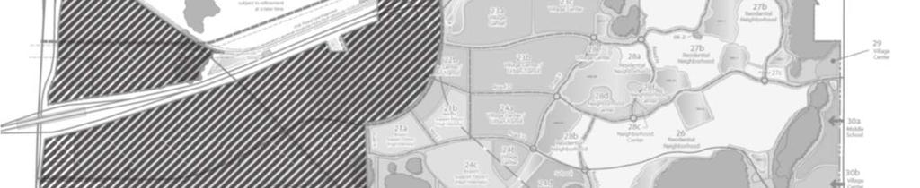
12 Page Existing Map H/PD Development Plan Residential Neighborhood to be changed to Village Center Conservation areas to be changed to Civic Area to be changed to Neighborhood Center


13 Page Proposed Map H/PD Development Plan Parcel 11a Village Center Parcel 10c - Civic Parcel 10d - Civic Parcel 28f Neighborhood Center


14 Page Proposed Map H/PD Development Plan


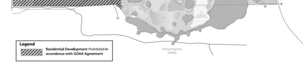
15 Page Proposed PD Exhibit E


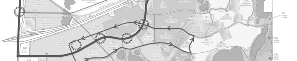
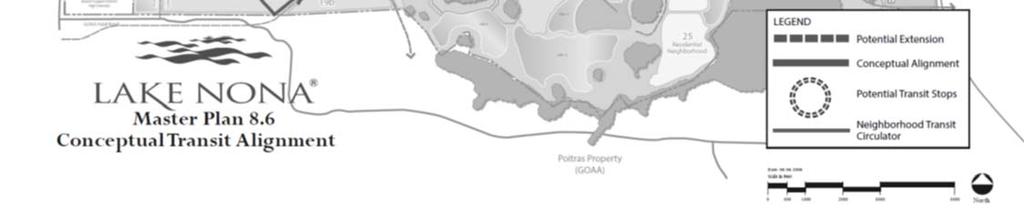
16 Page Proposed PD Exhibit F
17 Page Findings Subject to the conditions contained herein, the proposal is consistent with the requirements for approval of DRI, GMP amendments and rezoning applications contained in Section , and , respectively, of the Land Development Code (LDC): 1. The proposed amendments are consistent with the City s Growth Management Plan including Future Land Use Goal 4 and associated objectives and policies relating to the Southeast Orlando Sector Plan. 2. The proposed amendments are consistent with the purpose, intent and general requirements of the LDC. 3. The proposed amendments are consistent with Chapters 163, 187, and 380, Florida Statutes. 4. The proposed amendments are consistent with the East Central Florida Strategic Regional Policy Plan and the recommendations of the East Central Florida Regional Planning Council. Notice of Proposed Change/Determination of Non-Substantial Amendment The applicant has submitted relevant information to the East Central Florida Regional Planning Council (ECFRPC). Information submitted indicates that the request meets the criteria for consideration as a non-substantial amendment to the DRI. Staff recommends approval of the Lake Nona DRI, GMP & PD amendments subject to the findings and conditions below and further review/revision by the City Attorney s Office. Conditions of Approval City Planning 1. Amended DRI Development Order In consultation with the City Planning Division and the City Attorney s Office, the applicant shall prepare the Sixth Amendment to the Fourth Amended and Restated Development Order for the Lake Nona Development of Regional Impact for consideration by the Orlando City Council, including all necessary exhibits. The amendment to the Development Order shall address the findings and conditions detailed in this staff report, the conditions of the East Central Florida Regional Planning Council and review agencies. The amendment to the Development Order shall be subject to contextual and legal review by the City Attorney s Office. 2. Amended PD Ordinance In consultation with the City Planning Division and the City Attorney s Office, the applicant shall prepare an amended Planned Development Ordinance for consideration by the Orlando City Council, including all necessary exhibits. The amended Planned Development Ordinance shall address the findings and conditions detailed in this staff report. The amended Planned Development Ordinance shall be subject to contextual and legal review by the City Attorney s Office. 3. Specific Parcel Master Plan Required Any new development, including the beach amenity in Parcel 10c, requires a Specific Parcel Master Plan to be reviewed by the Southeast Town Design Review Committee (SETDRC).
18 Page Contact Information City Planning For questions regarding City Planning plan review, please contact Colandra Jones at or Transportation For questions regarding Transportation Planning plan review, please contact John Rhoades at or Police For questions regarding Orlando Police Department plan reviews or to obtain a copy of the brochure, contact Audra Rigby at or audra.rigby@cityoforlando.net. Review/Approval Process Next Steps 1. City Council approves the MPB minutes. 2. Staff forwards DRI, GMP and PD zoning ordinance requests to City Attorney s Office. 3. City Council Hearing of the DRI Development Order. 4. The DRI Development Order is recorded. 5. The First and Second Reading of GMP amendment ordinances. 6. The First and Second Reading of PD zoning ordinance.
BLACKFIN SHOPPES GMP ZON I TEM #3. Staff Report to the Municipal Planning Board July 19, Location Map S UMMARY.
 Staff Report to the Municipal Planning Board July 19, 2016 GMP2015-00054 ZON2015-00057 I TEM #3 BLACKFIN SHOPPES Location Map Subject Site S UMMARY Owners Edgar Yates Colleen Yates, Clifton Ackerman &
Location Map S U M M A RY A N X G M P G M P Z O N I TEM #6.
 Staff Report to the Municipal Planning Board October 20, 2015 A N X 2 0 1 5-0 0 0 1 7 G M P 2 0 1 5-0 0 0 3 3 G M P 2 0 1 5-0 0 0 3 4 Z O N 2 0 1 5-0 0 0 3 0 I TEM #6 BLACKFIN SHOPPES Location Map Subject
Location Map S U M M A RY A N X G M P Z O N I TEM #2. Subject Site
 Staff Report to the Municipal Planning Board November 17, 2015 A N X 2 0 1 5-0 0 0 2 3 G M P 2 0 1 5-0 0 0 4 4 Z O N 2 0 1 5-0 0 0 3 9 I TEM #2 HOFFNER POINT Location Map Subject Site S U M M A RY Owner/Applicant
L AKE NONA INNOVAT I O N CENTER PLAT
 Staff Report to the Technical Review Committee June 4,2013 S U B 2 0 1 3-0 0 0 2 0 I TEM # S 2 L AKE NONA INNOVAT I O N CENTER PLAT Location Map Subject Site S U M M A RY Owner James L. Zboril Lake Nona
EAST PARK PD AMENDME NT
 June 20, 2017 Staff Report to the Municipal Planning Board C A S E # Z O N 2 0 1 7-0 0 0 1 0 I t e m #8 EAST PARK PD AMENDME NT Location Map S U M M A R Y Owner DR Horton, Inc Property Location: Located
E D U CATION V I LLAGE PD A M ENDMENT
 NARCOOSSEE RD Staff Report to the Municipal Planning Board June 17,2014 Z O N 2 0 1 4-0 0 0 1 2 I TEM #7 A D D E N D U M E D U CATION V I LLAGE PD A M ENDMENT Location Map S U M M A RY Owner James L. Zboril
RANDAL PARK CELL TOWER
 March 20, 2018 Staff Report to the Municipal Planning Board C U P 2 0 1 7-1 0 0 11 I t e m # 1 0 RANDAL PARK CELL TOWER Location Map S U M M A R Y Owner Mattamy Partnership Applicant Mattaniah S. Jahn,
U-HAUL OF ORLANDO AN NEXATION
 September 18, 2018 Staff Report to the Municipal Planning Board A N X 2 0 1 8-10004 G M P 2 0 1 8-1 0 0 1 4, Z O N 2 0 1 8-10007 I T E M # 1 U-HAUL OF ORLANDO AN NEXATION Location Map S U M M A R Y Applicant
AUDI SOUTH ORLANDO REZONING 4709 VINELAND RD.
 Staff Report to the Municipal Planning Board December 20, 2016 ZON2016-00026 Item #9 AUDI SOUTH ORLANDO REZONING 4709 VINELAND RD. 7-11 Super Target Audi S. Orlando vacant Location Map Subject Site S UMMARY
Cover Letter with Narrative Statement
 Cover Letter with Narrative Statement March 31, 2017 rev July 27, 2017 RE: Rushton Pointe Residential Planned Unit Development Application for Public Hearing for RPUD Rezone PL2015 000 0306 Mr. Eric Johnson,
TREASURE COAST REGIONAL PLANNING COUNCIL M E M O R A N D U M. To: Regional Planning Council Members AGENDA ITEM 5J
 TREASURE COAST REGIONAL PLANNING COUNCIL M E M O R A N D U M To: Regional Planning Council Members AGENDA ITEM 5J From: Date: Subject: Staff June 19, 2009 Regional Planning Council Meeting Local Government
INDIAN RIVER COUNTY, FLORIDA. The Honorable Members of the Planning and Zoning Commission DEPARTMENT HEAD CONCURRENCE
 Public Hearing Legislative INDIAN RIVER COUNTY, FLORIDA M E M O R A N D U M TO: The Honorable Members of the Planning and Zoning Commission DEPARTMENT HEAD CONCURRENCE Robert M. Keating, AICP; Community
TREASURE COAST REGIONAL PLANNING COUNCIL M E M O R A N D U M
 TREASURE COAST REGIONAL PLANNING COUNCIL M E M O R A N D U M To: Council Members AGENDA ITEM 6A From: Date: Subject: Staff May 20, 2011 Council Meeting Local Government Comprehensive Plan Review Draft
 PROJECT NARRATIVE AVENIR PCD MISCELLANEOUS AMENDMENT November 27, 2018 Urban Planning and Design Landscape Architecture Communication Graphics Request Avenir Development, LLC and Avenir Holdings, LLC,
FUTURE LAND USE. City of St. Augustine Comprehensive Plan EAR-Based Amendments
 FUTURE LAND USE City of St. Augustine Comprehensive Plan EAR-Based Amendments Future Land Use Element FLU Goal To create an environment within the City and adjacent areas in which its residents have the
DRAFT Subject to Modifications
 TREASURE COAST REGIONAL PLANNING COUNCIL M E M O R A N D U M DRAFT Subject to Modifications To: Council Members AGENDA ITEM 5L From: Date: Subject: Staff September 17, 2010 Council Meeting Local Government
1-4 ac Across From Medical City
 1-4 ac Across From Medical City 14781 Narcoossee Rd, Orlando, FL 32832 Vacant Land for Sale $3,65 Highlights 1.67-3.65+/-Acres High and Dry Zoned PD Features Electricity/Power, Water, Telephone and Cable
CASE # LUP Commission District: # 3
 CASE # LUP-15-02-038 Commission District: # 3 GENERAL INFORMATION APPLICANT OWNER PROJECT NAME HEARING TYPE REQUEST Richard Frucci Lingo Lane, LLC Lingo Lane Planned Development / Land Use Plan (PD/LUP)
CONWAY ROAD SPECIAL PLAN OVERLAY DISTRICT
 Staff Report to the Municipal Planning Board June 21, 2016 LDC2016-00161 I TEM #8 CONWAY ROAD SPECIAL PLAN OVERLAY DISTRICT S UMMARY Applicant The City of Orlando Applicant s Request Amend Land Development
Town of Cary, North Carolina Rezoning Staff Report 14-REZ-31 Cary Park PDD Amendment (Waterford II) Town Council Meeting January 15, 2015
 Town Council Meeting January 15, 2015") Town of Cary, North Carolina Rezoning Staff Report 14-REZ-31 Cary Park PDD Amendment (Waterford II) Town Council Meeting January 15, 2015 REQUEST To amend the Town of Cary Official Zoning Map by amending
Town of Cary, North Carolina Rezoning Staff Report 14-REZ-31 Cary Park PDD Amendment (Waterford II) Town Council Meeting January 15, 2015 REQUEST To amend the Town of Cary Official Zoning Map by amending
L INGO LANE PRO PERT IES ANNEXAT ION
 Staff Report to the Municipal Planning Board September 16, 2014 A N X 2 0 1 4-0 0 0 1 4 G M P 2 0 1 4-0 0 0 2 0 Z O N 2 0 1 4-0 0 0 2 0 I TEM #1 L INGO LANE PRO PERT IES ANNEXAT ION Location Map S U M
PINE CANYON PD ZONING REGULATIONS
 Review Notes: Green highlight = blanks to be completed before recording. 1. DEFINITIONS For purposes of the PD Plan and these Zoning Regulations: (1) capitalized terms used but not defined in the PD Plan
NIBLICK WAY REVERT TO PLAT S UMMARY. SUB Item #11. Staff Report to the Municipal Planning Board August 18, 2015
 Staff Report to the Municipal Planning Board August 18, 2015 SUB2015-00037 Item #11 319 NIBLICK WAY REVERT TO PLAT DUBSDREAD CIR. NIBLICK WAY PUTTER LN. N. FORMOSA AVE. DUBSDREAD CIR. Location Map S UMMARY
STAFF REPORT. Permit Number: Porter. Kitsap County Board of Commissioners; Kitsap County Planning Commission
 STAFF REPORT Permit Number: 15 00461 Porter DATE: November 9, 2015 TO: FROM: Kitsap County Board of Commissioners; Kitsap County Planning Commission Katrina Knutson, AICP, Senior Planner, DCD and Jeff
TREASURE COAST REGIONAL PLANNING COUNCIL M E M O R A N D U M. To: Council Members AGENDA ITEM 10A
 TREASURE COAST REGIONAL PLANNING COUNCIL M E M O R A N D U M To: Council Members AGENDA ITEM 10A From: Date: Subject: Staff April 20, 2007 Council Meeting Local Government Comprehensive Plan Review Draft
County of Loudoun. Department of Planning MEMORANDUM
 County of Loudoun Department of Planning MEMORANDUM DATE: September 3, 2013 TO: FROM: Marchant Schneider, Project Manager Land Use Review Marie Genovese, AICP, Planner III, Community Planning SUBJECT:
DRI #260 - WIREGRASS RANCH (NOPC #4) PASCO COUNTY
 PASCO COUNTY") DOAR Development Order Amendment Report 4000 Gateway Centre Boulevard, Suite 100, Pinellas Park, FL 33782 Phone (727) 570-5151 FAX (727) 570-5118 www.tbrpc.org DRI #260 - WIREGRASS RANCH (NOPC #4) PASCO
DOAR Development Order Amendment Report 4000 Gateway Centre Boulevard, Suite 100, Pinellas Park, FL 33782 Phone (727) 570-5151 FAX (727) 570-5118 www.tbrpc.org DRI #260 - WIREGRASS RANCH (NOPC #4) PASCO
Marion County Board of County Commissioners
 Marion County Board of County Commissioners Date: 12/29/2015 P&Z: 12/28/2015 BCC: 1/12/2016 Item Number 160113Z Type of Application Rezoning Request From: A-1 (General Agriculture) To: PUD (Planned Unit
L A U R E AT E PARK NEIGHBORHOOD CENTER
 Updated per conditions of approval at the 5/14/15 SETDRC meeting and to incorporate the addendum provided at the meeting. Staff Report to the Southeast Town Design Review Committee May 14, 2015 M P L 2
CHAPTER Committee Substitute for Committee Substitute for Senate Bill No. 2188
 CHAPTER 2004-372 Committee Substitute for Committee Substitute for Senate Bill No. 2188 An act relating to land development; amending s. 197.502, F.S.; providing for the issuance of an escheatment tax
STAFF REPORT City of Ormond Beach Department of Planning
 STAFF REPORT City of Ormond Beach Department of Planning DATE: February 5, 2014 SUBJECT: 875 Sterthaus Drive, Ormond Renaissance Condominium, Comprehensive Plan Amendment over ten acres APPLICANT: Parker
LDC AMENDMENT BONUSES FOR AFFORDABLE HOUSING
 Staff Report to the Municipal Planning Board May 15, 2018 LDC AMENDMENT BONUSES FOR AFFORDABLE HOUSING L D C 2 0 1 8-10005 I T E M #14 Photo of City View or Lexington Court Amelia Court at Creative Village
TOOELE COUNTY LAND USE ORDINANCE CHAPTER 31 Page 1
 CHAPTER 31 PLANNED COMMUNITY ZONE (P-C) Section 31-1 Definitions. 31-2 Purpose. 31-3 Land use districts. 31-4 P-C zone area minimum requirements. 31-5 Permitted uses. 31-6 Conditional uses. 31-7 Planning
STAFF REPORT. Permit Number: Unlimited. Kitsap County Board of Commissioners; Kitsap County Planning Commission
 STAFF REPORT Permit Number: 15 00550 Unlimited DATE: March 2, 2016 TO: FROM: Kitsap County Board of Commissioners; Kitsap County Planning Commission Katrina Knutson, AICP, Senior Planner, DCD and Jeff
Town of Cary, North Carolina Rezoning Staff Report 12-REZ-27 Morris Branch Town Council Public Hearing January 24, 2013
 Town of Cary, North Carolina Rezoning Staff Report 12-REZ-27 Morris Branch Town Council Public Hearing January 24, 2013 REQUEST To amend the Town of Cary Official Zoning Map to rezone approximately 9.0
TREASURE COAST REGIONAL PLANNING COUNCIL M E M O R A N D U M. February 19, 2010 Regional Planning Council Meeting
 TREASURE COAST REGIONAL PLANNING COUNCIL M E M O R A N D U M To: Council Members AGENDA ITEM 5G From: Date: Subject: Staff February 19, 2010 Regional Planning Council Meeting Local Government Comprehensive
Staff Report: Date: Applicant: Property Identification: Acreage of Request: Current Zoning of Requested Area: Requested Action: Attached:
 Staff Report: Completed by Jeff Palmer Director of Planning & Zoning Date: November 7, 2018, Updated November 20, 2018 Applicant: Greg Smith, Oberer Land Developer agent for Ronald Montgomery ET AL Property
CITY OF PALM BEACH GARDENS CITY COUNCIL Agenda Cover Memorandum Meeting Date: November 1, 2018 Ordinance 24, 2018 / *Ordinance 25, 2018
 CITY OF PALM BEACH GARDENS CITY COUNCIL Agenda Cover Memorandum Meeting Date: November 1, 2018 Subject/Agenda Item: 11940 U.S. Highway One Small-Scale Comprehensive Plan Future Land Use Map Amendment and
REPORT OF THE PLANNING AND DEVELOPMENT DEPARTMENT FOR APPLICATION FOR REZONING ORDINANCE TO PLANNED UNIT DEVELOPMENT APRIL 21, 2016
 BEL REPORT OF THE PLANNING AND DEVELOPMENT DEPARTMENT FOR APPLICATION FOR REZONING ORDINANCE TO PLANNED UNIT DEVELOPMENT APRIL 21, 2016 The Planning and Development Department hereby forwards to the Planning
PALM BEACH COUNTY PLANNING, ZONING AND BUILDING DEPARTMENT ZONING DIVISION ZONING COMMISSION VARIANCE STAFF REPORT 06/05/2014
 PALM BEACH COUNTY PLANNING, ZONING AND BUILDING DEPARTMENT ZONING DIVISION ZONING COMMISSION VARIANCE STAFF REPORT 06/05/2014 APPLICATION NO. ZV-2013-03120 CODE SECTION REQUIRED PROPOSED VARIANCE (V1)
THE PARKLANDS DRI IN COLLIER COUNTY DRI # NOTICE OF PROPOSED CHANGE
 THE PARKLANDS DRI IN COLLIER COUNTY DRI #06-8384-43 NOTICE OF PROPOSED CHANGE Background: The Parklands Development of Regional Impact (DRI) is located in both Lee and Collier Counties. The original development
Be linked by an internal circulation system (i.e., walkways, streets, etc.) to other structures within the IPUD;
 to other structures within the IPUD;") 2. HALIFAX ACTIVITY CENTER A. DESCRIPTIONS OF FUTURE LAND USE DESIGNATIONS Each of the future land use designations specified by Phase I of the Halifax Activity Center Plan, and the relationship of these
2. HALIFAX ACTIVITY CENTER A. DESCRIPTIONS OF FUTURE LAND USE DESIGNATIONS Each of the future land use designations specified by Phase I of the Halifax Activity Center Plan, and the relationship of these
PLANNING COMMISSION PUBLIC HEARING STAFF REPORT ZRTD FAIRFAX MARBLE & GRANITE
 Date of Hearing: PLANNING COMMISSION PUBLIC HEARING STAFF REPORT SUBJECT: ELECTION DISTRICT: ZRTD-2016-0009 FAIRFAX MARBLE & GRANITE Broad Run CRITICAL ACTION DATE: September 27, 2017 STAFF CONTACTS: APPLICANT:
PALM BEACH COUNTY PLANNING, ZONING AND BUILDING DEPARTMENT ZONING DIVISION
 PALM BEACH COUNTY PLANNING, ZONING AND BUILDING DEPARTMENT ZONING DIVISION Application No.: CA-2012-00688 Control No.: 2011-00552 Applicant: Garry Bernardo Owners: Garry Bernardo Agent: Frogner Consulting,
SOUTHWEST FLORIDA REGIONAL PLANNING COUNCIL LOCAL GOVERNMENT COMPREHENSIVE PLAN REVIEW FORM 01 DATE AMENDMENT MAILED TO LOCAL GOVERNMENT AND STATE:
 Attachment II SOUTHWEST FLORIDA REGIONAL PLANNING COUNCIL LOCAL GOVERNMENT COMPREHENSIVE PLAN REVIEW FORM 01 LOCAL GOVERMENT: Sarasota County DATE AMENDMENT RECIEVED: November 27, 2013 DATE AMENDMENT MAILED
Appendix J - Planned Unit Development (PUD)
") Appendix J - Planned Unit Development (PUD) Intent and Purpose The purpose of the PUD is: 1. To provide development that is consistent with the Comprehensive Land Use Plan and promote the goals and objectives
Appendix J - Planned Unit Development (PUD) Intent and Purpose The purpose of the PUD is: 1. To provide development that is consistent with the Comprehensive Land Use Plan and promote the goals and objectives
O HIO ST., MICHIGAN AVE. & PART OF H ARMON AVE. R-O-W ABANDONMENTS
 Staff Report to the Municipal Planning Board June 16, 2015 ABN2015-00001 Item #1 O HIO ST., MICHIGAN AVE. & PART OF H ARMON AVE. R-O-W ABANDONMENTS Location Map S UMMARY Applicant/Owner Debbie Carey, Administrator
Appendix A: Guide to Zoning Categories Prince George's County, Maryland
 Appendix A: Guide to Zoning Categories Prince George's County, Maryland RESIDENTIAL ZONES 1 Updated November 2010 R-O-S: Reserved Open Space - Provides for permanent maintenance of certain areas of land
GENERAL PLAN UPDATE SPECIFIC AREAS OF THE CITY
 GENERAL PLAN UPDATE SPECIFIC AREAS OF THE CITY Background There are a total of 14 specific areas that are being reviewed as part of the update of the General Plan. Requests to review these areas came from
TREASURE COAST REGIONAL PLANNING COUNCIL M E M O R A N D U M
 TREASURE COAST REGIONAL PLANNING COUNCIL M E M O R A N D U M To: Council Members AGENDA ITEM 5F From: Date: Subject: Staff July 16, 2010 Council Meeting Local Government Comprehensive Plan Review Draft
Property Location: The subject property is located at northeast corner of Narcoossee Road and Tyson Road. (±1.377 acres, District 1).
.") Staff Report to the Municipal Planning Board August 19, 2014 A N X 2 0 1 4-0 0 0 0 5 G M P 2 0 1 4-0 0 0 0 9 G M P 2 0 1 4-0 0 0 1 0 Z O N 2 0 1 4-0 0 0 0 8 I TEM #1 TYSON S CORNER ANNEXATION Location
Staff Report to the Municipal Planning Board August 19, 2014 A N X 2 0 1 4-0 0 0 0 5 G M P 2 0 1 4-0 0 0 0 9 G M P 2 0 1 4-0 0 0 1 0 Z O N 2 0 1 4-0 0 0 0 8 I TEM #1 TYSON S CORNER ANNEXATION Location
4 LAND USE 4.1 OBJECTIVES
 4 LAND USE The Land Use Element of the Specific Plan establishes objectives, policies, and standards for the distribution, location and extent of land uses to be permitted in the Central Larkspur Specific
PLANNING AND ZONING COMMISSION AGENDA MEMORANDUM
 City and County of Broomfield, Colorado PLANNING AND ZONING COMMISSION AGENDA MEMORANDUM To: Planning and Zoning Commission From: John Hilgers, Planning Director Anna Bertanzetti, Principal Planner Meeting
APPEL REVERT TO PLAT
 Staff Report to the Municipal Planning Board May 17, 2016 SUB2016-00020 Item #16 APPEL REVERT TO PLAT Location Map S U M M A RY Applicant Jason and Sherreen Appel Owner Sherreen Appel Project Planner Jacques
Sec Planned unit development (PUD) zoning district requirements and procedures.
 zoning district requirements and procedures.") Sec. 10-6.696. Planned unit development (PUD) zoning district requirements and procedures. (a) Purpose and intent of district. The planned unit development (PUD) zoning district is intended to provide
Sec. 10-6.696. Planned unit development (PUD) zoning district requirements and procedures. (a) Purpose and intent of district. The planned unit development (PUD) zoning district is intended to provide
FORT MYERS, FLORIDA GATEWAY 54 ACRES MIXED USE PLANNED DEVELOPMENT OFFERING MEMORANDUM. Index
 FORT MYERS, FLORIDA GATEWAY 54 ACRES MIXED USE PLANNED DEVELOPMENT OFFERING MEMORANDUM Index 1. Executive Summary 2. Location Maps 3. 4. 5. 6. 7. Property Aerial Conceptual Site Plan Zoning Resolution
SAN IPSE CAPITAL OF SILICON VALLEY
 COUNCIL AGENDA: 01/10/17 ITEM: 11.1(b) CITY OF SAN IPSE CAPITAL OF SILICON VALLEY CITY COUNCIL STAFF REPORT File No. C16-048 Applicant: Terry Pries Location 320 Race Street Existing Zoning LI Light Industrial
L AVINA T R A C T G COMMERCIAL REPLAT
 Staff Report to the Technical Review Committee April 1, 2014 S U B 2 0 1 4-0 0 0 1 0 I TEM # S 1 L AVINA T R A C T G COMMERCIAL REPLAT Location Map S U M M A RY Owner Charles Whittall, Agent Ripleys International
PROPOSED AMENDMENTS TO THE DERBY ZONING REGULATIONS AUGUST 12, 2008
 ARTICLE II Definitions and word usage 195-7. Definitions and word usage. Modify the following: HOUSING FOR THE ELDERLY OLDER PERSONS Housing in accordance with and as defined in the United States Fair
PALM BEACH COUNTY PLANNING, ZONING AND BUILDING DEPARTMENT ZONING DIVISION ZONING COMMISSION VARIANCE STAFF REPORT 07/05/2012
 PALM BEACH COUNTY PLANNING, ZONING AND BUILDING DEPARTMENT ZONING DIVISION ZONING COMMISSION VARIANCE STAFF REPORT 07/05/2012 APPLICATION NO. CODE SECTION REQUIRED PROPOSED VARIANCE ZV-2012-00690 3.D.1.A
HIGHLAND HOMES REVERT TO PLAT
 Broadway Ave. Staff Report to the Municipal Planning Board April 19, 2016 SUB2016-00006 Item #10 HIGHLAND HOMES REVERT TO PLAT Lake Highland Preparatory School E Marks St. Park Lake Location Map Subject
BY BOARD OF COUNTY COMMISSIONERS AN ACT TO BE ENTITLED
 BY BOARD OF COUNTY COMMISSIONERS ORDINANCE NO. AN ACT TO BE ENTITLED AN ORDINANCE AMENDING THE PASCO COUNTY LAND DEVELOPMENT CODE, ARTICLE 700, BY REPEALING EXISTING SECTION 702, ENVIRONMENTALLY SENSITIVE
19 June 9, 2010 Public Hearing APPLICANT AND PROPERTY OWNER: KEMP ENTERPRISES, INC.
 19 June 9, 2010 Public Hearing APPLICANT AND PROPERTY OWNER: KEMP ENTERPRISES, INC. STAFF PLANNER: Karen Prochilo REQUEST: Change of Zoning District Classification, Conditional A-24 Apartment District
L DC A M E N D M E N T F O R SETBACK R E L I E F
 Staff Report to the Municipal Planning Board March 21, 2017 L D C 2 0 1 7-0 0 0 1 4 I TEM # 5 L DC A M E N D M E N T F O R SETBACK R E L I E F TO ENCOURAGE RESIDENTIAL INFILL IN T H E PH O V E R L AY D
AN ORDINANCE AMENDING AND SUPPLEMENTING THE REVISED GENERAL ORDINANCES OF THE CITY OF BAYONNE THE, CHAPTER 33 PLANNING AND DEVELOPMENT REGULATIONS
 AN ORDINANCE AMENDING AND SUPPLEMENTING THE REVISED GENERAL ORDINANCES OF THE CITY OF BAYONNE THE, CHAPTER 33 PLANNING AND DEVELOPMENT REGULATIONS WHEREAS, pursuant to N.J.S.A. 40:48-2, the Legislature
PALM BEACH COUNTY PLANNING, ZONING AND BUILDING DEPARTMENT ZONING DIVISION ZONING COMMISSION VARIANCE STAFF REPORT 06/07/2012
 PALM BEACH COUNTY PLANNING, ZONING AND BUILDING DEPARTMENT ZONING DIVISION ZONING COMMISSION VARIANCE STAFF REPORT 06/07/2012 APPLICATION NO. CODE SECTION REQUIRED PROPOSED VARIANCE ZV-2009-03300 Variance
Marion County Board of County Commissioners
 Marion County Board of County Commissioners Date: 6/4/217 P&Z: 9/25/217 BCC Transmittal: 1/17/217 BCC Adopt: TBD Amendment No: 217-L6 Type of Application Large-Scale Comp Plan Amendment Request: Change
TOWN OF ORO VALLEY PLANNING & ZONING COMMISSION MEETING DATE: December 6, 2011
 PLANNING & ZONING COMMISSION MEETING DATE: December 6, 2011 TO: FROM: SUBJECT: PLANNING & ZONING COMMISSION Matt Michels, Senior Planner mmichels@orovalleyaz.gov; tel. 229-4822 Public Hearing: Rancho de
REPORT OF THE PLANNING AND DEVELOPMENT DEPARTMENT FOR APPLICATION FOR REZONING ORDINANCE TO PLANNED UNIT DEVELOPMENT MAY 8, 2014
 BEL REPORT OF THE PLANNING AND DEVELOPMENT DEPARTMENT FOR APPLICATION FOR REZONING ORDINANCE TO PLANNED UNIT DEVELOPMENT MAY 8, 2014 The Planning and Development Department hereby forwards to the Planning
ATTACHMENT #1 SUMMARY CHART
 ATTACHMENT #1 SUMMARY CHART Item # Amendment To: Nature of Proposed Amendment PCM201801 PCM201802 PCM201803 PCM201804 LMA201802 LMA201803 LMA201804 PCT201801 PCT201802 PCT201803 FUTURE LAND USE MAP Parkway
CITY OF BONITA SPRINGS ZONING ORDINANCE NO
 CITY OF BONITA SPRINGS ZONING ORDINANCE NO. 06-05 A ZONING ORDINANCE OF THE CITY OF BONITA SPRINGS, FLORIDA; APPROVING A REQUEST BY NAPITA HOLDINGS, LLC IN REFERENCE TO BONITA ROAD LOCKUP CPD; TO REZONE
ARTICLE 12 PLANNED UNIT DEVELOPMENT DISTRICTS (PUDS) Sec Intent CHARTER TOWNSHIP OF BRIGHTON ZONING ORDINANCE
 Sec Intent CHARTER TOWNSHIP OF BRIGHTON ZONING ORDINANCE") ARTICLE 12 PLANNED UNIT DEVELOPMENT DISTRICTS (PUDS) Sec. 12-01 Intent 1 2 (a) The intent of this Article is to permit the coordinated development on larger sites, protect significant natural features
ARTICLE 12 PLANNED UNIT DEVELOPMENT DISTRICTS (PUDS) Sec. 12-01 Intent 1 2 (a) The intent of this Article is to permit the coordinated development on larger sites, protect significant natural features
ACCESSORY DWELLING UNITS IN THE SOUTHEAST SECTOR
 February 19, 2019 Staff Report to the Municipal Planning Board LDC2018-10020 Item #11 S U M M A R Y Applicant The City of Orlando ACCESSORY DWELLING UNITS IN THE SOUTHEAST SECTOR Applicant s Request Update
General Plan. Page 44
 VIII. RESIDENTIAL DEVELOPMENT IN NON-RESIDENTIAL LAND USE AREAS POLICY ISSUE Review the City s existing regulations and policies that allow residential land use in non-residential zoning districts. BACKGROUND
TREASURE COAST REGIONAL PLANNING COUNCIL M E M O R A N D U M. To: Council Members AGENDA ITEM 4F
 TREASURE COAST REGIONAL PLANNING COUNCIL M E M O R A N D U M To: Council Members AGENDA ITEM 4F From: Date: Subject: Staff September 21, 2007 Council Meeting Local Government Comprehensive Plan Review
PALM BEACH COUNTY PLANNING, ZONING AND BUILDING DEPARTMENT ZONING DIVISION
 PALM BEACH COUNTY PLANNING, ZONING AND BUILDING DEPARTMENT ZONING DIVISION Application No.: Z-2016-00663 Application Name: Autism School Control No.: 2014-00133 Applicant: Dayna2, LLC Owners: Dayna2, LLC
APPENDIX B RESIDENTIAL DENSITY
 APPENDIX B RESIDENTIAL DENSITY RESIDENTIAL DENSITY - SPECIFIC AREAS OF THE CITY Policy Issue Examine specific areas of the City to determine appropriate residential densities. Public comments have expressed
Request Conditional Rezoning (R-5D Residential Duplex District and I-1 Light Industrial District to Conditional A-36 Apartment District)
") Request Conditional Rezoning (R-5D Residential Duplex District and I-1 Light Industrial District to Conditional A-36 Apartment District) Staff Planner Ashby Moss Location 5833 Sandpit Road & Nearby Parcels
Request Conditional Rezoning (R-5D Residential Duplex District and I-1 Light Industrial District to Conditional A-36 Apartment District) Staff Planner Ashby Moss Location 5833 Sandpit Road & Nearby Parcels
ARTICLE 3: Zone Districts
 ARTICLE 3: Zone Districts... 3-1 17.3.1: General...3-1 17.3.1.1: Purpose and Intent... 3-1 17.3.2: Districts and Maps...3-1 17.3.2.1: Applicability... 3-1 17.3.2.2: Creation of Districts... 3-1 17.3.2.3:
ARTICLE C. ZONING TEXT, DISTRICT CLASSIFICATIONS AND BOUNDARIES
 ARTICLE C. ZONING TEXT, DISTRICT CLASSIFICATIONS AND BOUNDARIES Sec. 10-2054. ZONING TEXT, DISTRICT CLASSIFICATIONS AND BOUNDARIES. In order to regulate the location of structures, the height and bulk
City of Coral Gables Planning and Zoning Staff Report
 City of Coral Gables Planning and Zoning Staff Report Applicant: Application: Public Hearing: Date & Time: Location: City of Coral Gables Zoning Code Text Amendment Giralda Plaza Overlay District Planning
REPORT OF THE PLANNING AND DEVELOPMENT DEPARTMENT FOR APPLICATION FOR REZONING ORDINANCE TO PLANNED UNIT DEVELOPMENT SEPTEMBER 22, 2016
 BEL REPORT OF THE PLANNING AND DEVELOPMENT DEPARTMENT FOR APPLICATION FOR REZONING ORDINANCE 2016-576 TO PLANNED UNIT DEVELOPMENT SEPTEMBER 22, 2016 The Planning and Development Department hereby forwards
891941, , : COMPREHENSIVE PLAN AMENDMENT, COMMUNITY PLAN AMENDMENT, AND AREA-WIDE MAP AMENDMENT
 Application Nos. 891941, 891909, 891940: COMPREHENSIVE PLAN AMENDMENT, COMMUNITY PLAN AMENDMENT, AND AREA-WIDE MAP AMENDMENT Amendments to designate five parcels as Rural Industrial Center in the Alderton
PLANNING COMMISSION PUBLIC HEARING STAFF REPORT ZRTD NVA DEVELOPMENT
 Date of Hearing: PLANNING COMMISSION PUBLIC HEARING STAFF REPORT SUBJECT: ELECTION DISTRICT: ZRTD-2016-0005 NVA DEVELOPMENT Broad Run CRITICAL ACTION DATE: July 18, 2017 STAFF CONTACTS: APPLICANT: Jacqueline
ADDRESS / DESCRIPTION: Northeast corner of Sandbridge Road and Atwoodtown Road ELECTION DISTRICT: PRINCESS ANNE
 10 & 11 March 14, 2012 Public Hearing APPLICANT: MARLYN DEVELOPMENT CORPORATION PROPERTY OWNER: CORAL DEVELOPMENT, LLC STAFF PLANNER: Faith Christie REQUEST: Modification of Conditional Change of Zoning
STAFF REPORT. Permit Number: Laurier Enterprises, Inc. Kitsap County Board of Commissioners; Kitsap County Planning Commission
 STAFF REPORT Permit Number: 15 00740 Laurier Enterprises, Inc. DATE: December 18, 2015 TO: FROM: Kitsap County Board of Commissioners; Kitsap County Planning Commission Katrina Knutson, AICP, Senior Planner,
Planning and Development Services Department
 Planning and Development Services Department M E M O R A N D U M TO: Planning and Zoning Commission THROUGH: Mark Satterlee, AICP, Planning & Development Services Director Leslie Olson, AICP, Planning
REPORT OF THE PLANNING AND DEVELOPMENT DEPARTMENT FOR APPLICATION FOR REZONING ORDINANCE TO PLANNED UNIT DEVELOPMENT MAY 18, 2017
 BEL REPORT OF THE PLANNING AND DEVELOPMENT DEPARTMENT FOR APPLICATION FOR REZONING ORDINANCE 2016-805 TO PLANNED UNIT DEVELOPMENT MAY 18, 2017 The Planning and Development Department hereby forwards to
Kitg of North port. The Commission of the City of North Port hereby makes the following findings of fact and conclusions of law:
 Kitg of North port ORDINANCE NO. 2011-33 (Development Order for Heron Creek a Development of Regional Impact) AN ORDINANCE OF THE CITY OF NORTH PORT, FLORIDA, ADOPTING AN AMENDED AND RESTATED DEVELOPMENT
Chapter SPECIAL USE ZONING DISTRICTS
 Chapter 20.20 Sections: 20.20.010 Urban Transition (U-T) Zoning District 20.20.020 Planned Development (P-D) Zoning Districts 20.20.010 Urban Transition (U-T) Zoning District A. Purpose. The purpose of
Policy Issues City of Knoxville Zoning Code Update
 Policy Issues City of Knoxville Zoning Code Update ADU's (Accessory Dwelling Units) The draft zoning ordinance update permits ADU s as an accessory use in all single-family residential zoning districts.
Staff Report: Date: Applicant: Property Identification: Acreage of Request: Current Zoning of Requested Area: Requested Action: Attached:
 Staff Report: Completed by Jeff Palmer Director of Planning & Zoning Date: November 7, 2018 Applicant: Greg Smith, Oberer Land Developer agent for Ronald Montgomery ET AL Property Identification: Frontage
I. Activity Center 2. Activity Center 2
 I. Key Findings Existing Conditions AC 2 is comprised of 599 gross acres. By subtracting the 13% of road and drainage rights-ofway, approximately 520 acres remain as buildable area. Based on property appraiser
ZRTD , Glenn Drive. M. Tyler Klein, AICP, Project Manager, Planning and Zoning John Merrithew, Acting Director, Planning and Zoning
 DEPARTMENT OF PLANNING Date of Hearing: AND ZONING STAFF REPORT # 4 BOARD OF SUPERVISORS PUBLIC HEARING SUBJECT: ELECTION DISTRICT: ZRTD-2014-0003, 22675 Glenn Drive Broad Run CRITICAL ACTION DATE: September
CITY OF PALM BEACH GARDENS PLANNING, ZONING, AND APPEALS BOARD Agenda Cover Memorandum
 CITY OF PALM BEACH GARDENS PLANNING, ZONING, AND APPEALS BOARD Agenda Cover Memorandum Petition: PCDA-14-08-000023 Subject/Agenda Item: Alton Planned Community Development Amendment Public Hearing and
Nassau County 2030 Comprehensive Plan. Housing Element (H) Goals, Objectives and Policies. Goal
 Goals, Objectives and Policies. Goal") (H) Goal Assist the private sector to provide and maintain an adequate inventory of decent, safe and sanitary housing in suitable neighborhoods at affordable costs to meet the need of the present and future
(H) Goal Assist the private sector to provide and maintain an adequate inventory of decent, safe and sanitary housing in suitable neighborhoods at affordable costs to meet the need of the present and future
ORDINANCE NOW THEREFORE, BE IT ENACTED BY THE CITY COMMISSION OF THE CITY OF WINTER GARDEN, FLORIDA, AS FOLLOWS:
 ORDINANCE 12-02 AN ORDINANCE OF THE CITY OF WINTER GARDEN, FLORIDA, AMENDING ARTICLE V OF CHAPTER 118 OF THE WINTER GARDEN CODE OF ORDINANCES ENTITLED PLANNED UNIT DEVELOPMENTS CREATING URBAN VILLAGE PLANNED
WENDY PERSHING & SR436
 Staff Report to the Municipal Planning Board July 18, 2017 CUP2017-00010 Item #3 WENDY S @ PERSHING & SR436 Lake George S. SEMORAN BLVD. OUC Center PERSHING AVE. Barber Park Walmart Neigh. Store Lake George
INFORMATION PACKET City of Tallahassee Application for PUD or UPUD Rezoning Review
 Comprehensive Plan Consistency Prerequisite INFORMATION PACKET City of Tallahassee Application for PUD or UPUD Rezoning Review Any and all amendments to the Official Zoning Map (rezoning) are required
Location Map S U M M A RY A N X G M P G M P Z O N I TEM #1.
 Staff Report to the Municipal Planning Board September 15, 2015 A N X 2 0 1 5-0 0 0 0 8 G M P 2 0 1 5-0 0 0 1 5 G M P 2 0 1 5-0 0 0 1 6 Z O N 2 0 1 5-0 0 0 0 8 I TEM #1 TYSON S CORNER II ANNEXATION Subject