VILLAGE OF GERMANTOWN N112 W17001 MEQUON ROAD GERMANTOWN, WI REGULAR MEETING OF THE VILLAGE BOARD. Germantown Village Hall Board Room
|
|
|
- Curtis Hawkins
- 5 years ago
- Views:
Transcription
1 VILLAGE OF GERMANTOWN N112 W17001 MEQUON ROAD GERMANTOWN, WI MEETING: REGULAR MEETING OF THE VILLAGE BOARD DATE AND TIME: MONDAY, April 1, :00 p.m. LOCATION: Germantown Village Hall Board Room I. CALL TO ORDER: This meeting has been given public notice in accordance with Section and 19.84, Wis. Stats, in such form that will apprise the general public and news media of subject matter that is intended for consideration and action. II. III. ROLL CALL: PLEDGE OF ALLEGIANCE: IV. PRESIDENT S REPORT: V. ANNOUNCEMENTS OF FORTHCOMING EVENTS OF PUBLIC INTEREST COMMITTEE AND DEPARTMENT REPORTS: The following individuals will be given the opportunity to make announcements of future municipal activities: Village President, Village Board Members, Village Administrator, Village Attorney, Village Clerk, And Department Heads. VI. VII. CITIZEN INPUT/PUBLIC APPEARANCE on items not subject to a public hearing: Please be advised per 19.84(2), information will be received from the public. It is the policy of this municipality that there be a three (3) minute time period, per person, with time extension per the Chief Presiding Officer s discretion; be further advised that there may be limited discussion on the information received, however, no action will be taken under public comments. (15 minutes) CONSENT AGENDA: A. Approval of Minutes: March 18, 2019 Regular Village Board Meeting. B. Accounts payable/payroll 1. March 19, 2019 Payroll (Hourly) $ 237, March 25, 2019 Accounts Payable $ 830, March 31, 2019 Payroll (Salary) $ 106, March 31, 2019 Accounts Payable $ 98, C. Operator s Licenses: Ronald Trudell and Bradley Woldt. [Recommended] VIII. OLD BUSINESS: A. None.
2 VILLAGE BOARD AGENDA April 1, 2019 Page 2 IX. PUBLIC HEARING: A. None. X. NEW BUSINESS: A. David Leszczynski, Agent for Germantown Acquisitions LLC, Property Owner, 29.7 acres at W124 N11749 Wasaukee Road (Tax Parcel ID# ); Preliminary Subdivision Plat for a 16-lot single-family residential development (Woodland Ponds Estates) B. Authorization to Submit Data to the Public Service Commission for Water Rate Increase. C. Meridian Germantown LLC / Wal-Mart Stores, Inc claim of excessive real estate tax. The Village Board may convene into closed session per Wis. Stats (1)(g) for the purpose of conferring with Legal Counsel who is rendering advice concerning strategy to be adopted by the Village with respect to litigation in which it is involved or is likely to become involved and then may reconvene into open session to take such action as it deems appropriate; and, D. Administrator Performance Review. The Village Board may convene into closed session per Wis. Stats (1) (c) considering employment, promotion, compensation or performance evaluation data of any public employee over which the governmental body has jurisdiction or exercises responsibility, and may convene into open session to take such action as it deems appropriate. XI. ADJOURNMENT. The next regular meeting of the Village Board will be on Monday, April 15, 2019 at 7:00 p.m. UPON REASONABLE NOTICE, efforts will be made to accommodate the needs of disabled individuals through appropriate aids and services. For Additional information or to request this service please contact the Village Clerk at (262) at least 2 days prior to the meeting.
3 VILLAGE OF GERMANTOWN VILLAGE BOARD MEETING MINUTES March 18, 2019 CALL TO ORDER: The meeting was called to order at 7:00 p.m. by President Wolter. ROLL CALL: Present: President Wolter, Trustees Baum, Hughes, Kaminski, Miller, Myers, and Wing. Absentee Excused Trustee Warren and Zabel. Also present: Administrator Kreklow, Clerk Braunschweig, Attorney Sajdak, Director Schroeder, Director Smith, Director Ratayczak, and Bob Beilfuss. PLEDGE OF ALLEGIANCE: PRESIDENT S REPORT: No Report. ANNOUNCEMENTS OF FORTHCOMING EVENTS OF PUBLIC INTEREST/DEPARTMENT AND COMMITTEE REPORTS: Trustees provided information on upcoming meeting dates and times. President Wolter Read the Proclamation National Surveyors Week, March 17 March 23, Village Land Surveyor Bob Beilfuss was present. APPOINTMENTS: Building Construction Oversight Committee Appointment Member Peter Nilles Present 04/30/2021 MOTION (Myers/Baum) Approve of the Appointment of Peter Nilles to the Building Construction Oversight Committee. Motion Carried Unanimously. CITIZEN INPUT/PUBLIC APPEARANCE on items not subject to a public hearing: None. CONSENT AGENDA: A. Approval of Minutes: March 4, 2019 Regular Village Board Meeting. B. Accounts payable/payroll 1. March 10, 2019 Accounts Payable $ 877, March 6, 2019 Payroll (Hourly) $ 248, March 15, 2019 Payroll (Salary) $ 107, C. Operator s Licenses: Syed Akif, Bradley Daleiden, Lori Doubeck, Emily Lipke. [Recommended] The following items were forwarded from Public Works Committee with a unanimous recommendation. D. Resolution Village Labor and Equipment Rates. E. Germantown High School two Water Main Easements and one Sanitary Sewer Easement. The following items were forwarded from General Government and Finance Committee with a unanimous recommendation. F. Resolution , Budget Amendment Resolution to Carry Over 2018 Capital Fund and General Fund Projects.
4 VILLAGE BOARD MINUTES March 18, 2019 Page 2 G. Resolution , Amendment to Resolution 4-10, Establishing a Special Non-Lapsing and Non-Reverting Operating Fund for Germantown Park and Recreation Department and for its Administration. MOTION (Baum/Myers) to approve Consent Agenda Items A-G. Roll Call Vote Carried Unanimously. OLD BUSINESS: Resolution , Contract with Ayres Associates Phase 1 Professional Services, Firemen s Park Multi-Purpose Shelter Building Project in an amount not to exceed $14,055. Motion (Myers/Miller) to Approve Resolution , Contract with Ayres Associates Phase 1 Professional Services, Firemen s Park Multi-Purpose Shelter Building Project in an amount not to exceed $14,055. The Public Works Department will process the construction administration. Roll Call Vote Carried. Baum voted no. PUBLIC HEARING: None. NEW BUSINESS: Resolution , Schedule of Fees Amendment New Medications and Procedures. Motion (Myers/Hughes) to Approve Resolution , Schedule of Fees Amendment New Medications and Procedures. Motion carried unanimously. Conditional Use Permit application by Diversified Engineering, Agent for Waste Management of Wisconsin, Property Owner, N96 W13840, W13600 & W13640 County Line Road to operate a 35,035 sqft Truck Maintenance Facility and install a 10,000 above-ground fuel storage tank (AST). Director Retzlaff came to the podium. He presented the Conditional Use Permit Application by Diversified Engineering, Agent for Waste Management of Wisconsin, Property Owner, N96 W13840, W13600 & W13640 County Line Road to operate a 35,035 sqft Truck Maintenance Facility and install a 10,000 above-ground fuel storage tank (AST). A Public Hearing was held at the Plan Commission on March 11 th. The item was recommended by the Plan Commission. MOTION by (Baum/Myers) to Approve the Conditional Use Permit Application by Diversified Engineering, Agent for Waste Management of Wisconsin, Property Owner, N96 W13840, W13600 & W13640 County Line Road to operate a 35,035 sqft Truck Maintenance Facility and install a 10,000 above-ground fuel storage tank (AST). This motion includes the revisions condition number three in regards to the noise issue of low impact back up warning devices. Trustee Wing spoke of concern to the noise. The garage doors location was discussed. Lynn Morgan of Waste Management commented that if radios become a concern the radios can be turned off or down. Roll call vote carried unanimously. Resolution , Amendments to the Wrenwood Planned Development District (PDD) General Development Plan (GDP) and Conditions and Restrictions adopted under Resolution No Carity Land Corporation and Neumann Developments, Agents for Briscoe Development & Management Inc., Property Owner of 147 Acres located South of Freistadt Road, East of the Canadian National Railroad, North of Mequon Road and West of Country Aire Drive. Director Retzlaff came to the podium. He presented the Application with Amendments to the Wrenwood Planned Development District (PDD) General Development Plan (GDP) and Conditions and Restrictions adopted under Resolution No Carity Land Corporation
5 VILLAGE BOARD MINUTES March 18, 2019 Page 3 and Neumann Developments, Agents for Briscoe Development & Management Inc., Property Owner of 147 Acres located South of Freistadt Road, East of the Canadian National Railroad, North of Mequon Road and West of Country Aire Drive. A Public Hearing was held at the Plan Commission on March 11 th. The item was recommended by the Plan Commission. MOTION by (Baum/Myers) to Approve Resolution , Amendments to the Wrenwood Planned Development District (PDD) General Development Plan (GDP) and Conditions and Restrictions adopted under Resolution No Carity Land Corporation and Neumann Developments, Agents for Briscoe Development & Management Inc., Property Owner of 147 Acres located South of Freistadt Road, East of the Canadian National Railroad, North of Mequon Road and West of Country Aire Drive. Motion carried unanimously. Library Director Presentation of Staff Restructuring Project & 2018 Annual Report. Director Smith came to the podium. She presented the 2018 Library Annual Report. She presented the Library Staff Restructuring. As part of the restructuring process, neighboring libraries were visited, staff position questionnaires were completed, job descriptions were reviewed and updated, and vacancies were filled. Director Smith presented the 2018 annual report. During 2018, there were 11,125 reference questions, 18,151 registered users, and 6,993 public computer logins. There were 322,378 items checked out in Overall there was a combined increase of 16.2% in Resolution Resolution Authorizing the Borrowing of Not to Exceed $3,075,000; and Providing for the Issuance and Sale of General Obligation Promissory Notes Therefor. Maureen Holsen of Ehlers presented the Pre-Sale Report. Motion (Miller/Kaminski) to approve Resolution Resolution Authorizing the Borrowing of Not to Exceed $3,075,000; and Providing for the Issuance and Sale of General Obligation Promissory Notes Therefor. Roll Call Vote Carried. Baum Voted No. Meridian Germantown LLC / Wal-Mart Stores, Inc claim of excessive real estate tax. The Village Board may convene into closed session per Wis. Stats (1)(g) for the purpose of conferring with Legal Counsel who is rendering advice concerning strategy to be adopted by the Village with respect to litigation in which it is involved or is likely to become involved and then may reconvene into open session to take such action as it deems appropriate. Motion by Baum, second by Myers to go into closed session and include the Village Board, Village Attorney, Administrator Kreklow, Director Rath, and Clerk Braunschweig at 8:00 P.M. Roll Call Vote Carried Unanimously. The Village Board Reconvened in open session at 8:15 P.M. ADJOURNMENT. ADJOURNMENT: There being no further business, the meeting adjourned at 8:15 P.M. p.m. The next regular meeting of the Village Board will be on Monday, April 1, 2019 at 7:00 p.m. Deanna B. Braunschweig Deanna B. Braunschweig, WCMC/CMC Village Clerk
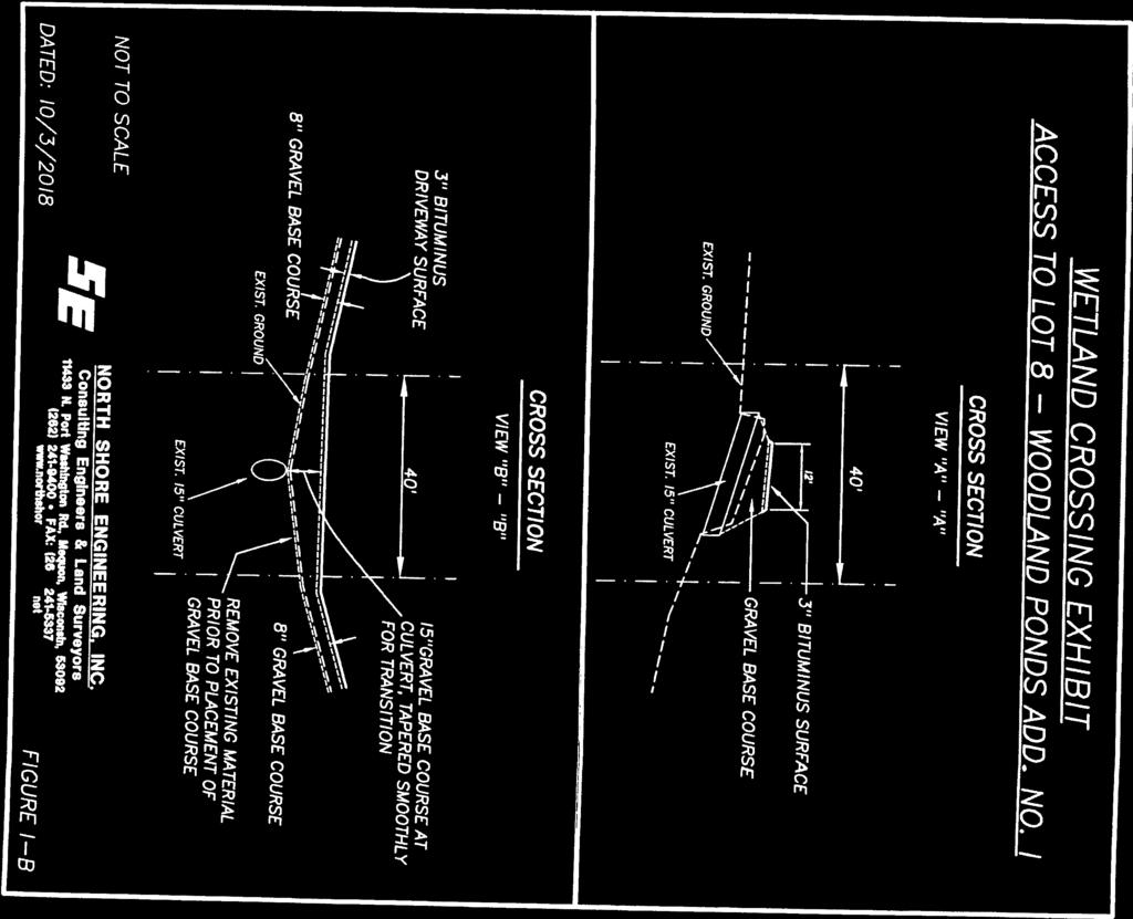
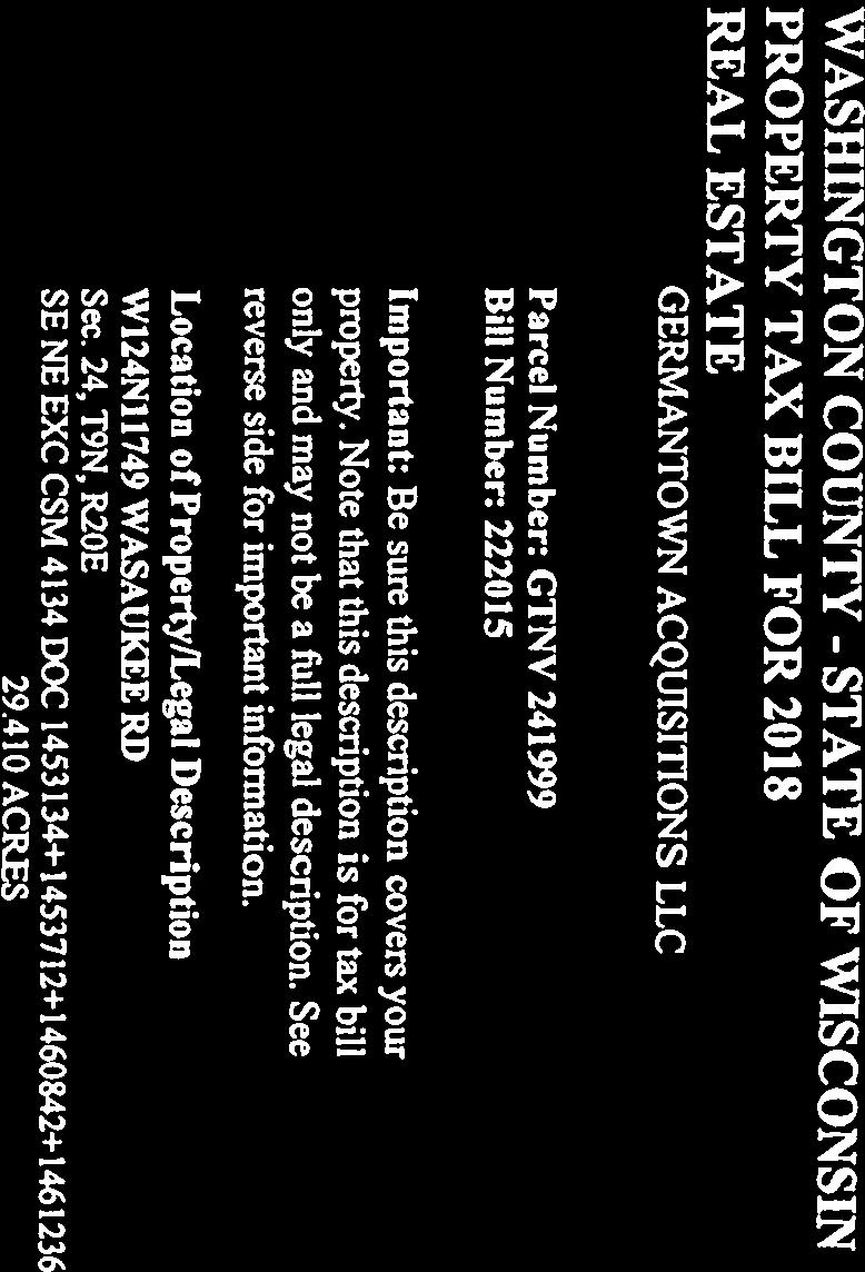
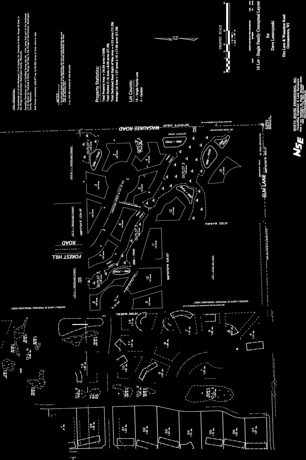
6 BUSINESS OF THE VILLAGE BOARD GERMANTOWN, WI MEETING DATE: April 1, 2019 AGENDA ITEM: New Business [Preliminary Subdivision Plat] ITEM TITLE: SUBMITTED BY: David Leszczynski, Agent for Germantown Acquisitions LLC, Property Owner, 29.7 acres at W124 N11749 Wasaukee Road (Tax Parcel ID# ); Preliminary Subdivision Plat for a 16-lot single-family residential development (Woodland Ponds Estates) Jeffrey W. Retzlaff, Director, Community Development Department SUMMARY EXPLANATION: Germantown Acquisitions LLC has submitted a preliminary subdivision plat for the 29.7 acres south of Woodland Ponds. Woodland Ponds Estates is a 16-lot single-family residential development located north of Elm Lane, west of Wasaukee Road and east of the new Harvest Hills subdivision. The preliminary plat is slightly different than the approved concept plan. In August 2018, the Village Board approved rezoning the property from A-1 to Rs-3 and a 17-lot concept plan. An original proposal to create a Planned Development District (PDD) was abandoned in favor of an Rs-3 District development with 16 or 17 single-family lots, depending on whether or not the WisDNR would approve the filling of two small wetland areas located on the property. In October 2018, the WisDNR denied the developer s application to fill two wetland areas (located in what are now Outlot 2 and a portion of Outlot 3) but granted permission to fill.007 acres in Outlot 3 for a shared driveway to serve proposed Lots #8 and #9. The approved wetland fill will allow the developer to replace an existing 15 culvert located across a narrow gap between the wetlands in Outlot 3. As a result, the development has been reduced to a total of 16 lots; 9 lots with access to/from Forest Hill Road in the Woodland Ponds development to the north. Woodland Ponds Estates will be developed in two phases. Phase I will include the 12 lots shown in the preliminary plat. Phase 2 will include 4 additional lots created from Outlot 4 (consistent with the approved concept plan). All lots will be served by individual wells and private on-site wastewater treatment systems ( POWTS a.k.a. septic systems ). ATTACHMENTS: March 11, 2019 Staff Report March 11, 2019 Plan Commission Meeting Minutes Preliminary Plat
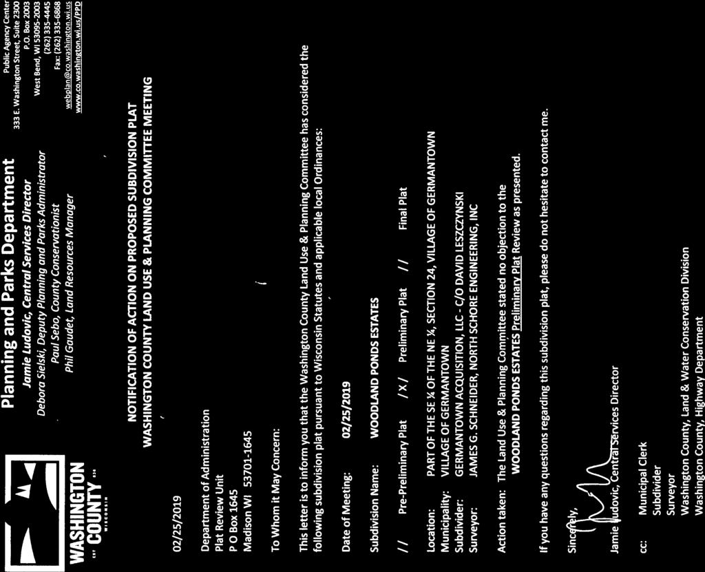
7 Germantown Acquisitions LLC Woodland Ponds Estates Preliminary Subdivision Plat Page 2 PLAN COMMISSION RECOMMENDATION: APPROVE the Woodland Ponds Estates preliminary subdivision plat subject to the following conditions: 1. Developer shall enter into a Development Agreement with the Village pursuant to Section 18 of the Village Code (Subdivision and Platting), as well as, the preparation of detailed plans for the installation of public utilities and improvements including, but not limited to public street improvements (including a proportionate share funding contribution for all costs associated with the re-construction of Elm Lane as determined by the Public Works Director), storm water management facilities, master grading plan and erosion control, trails, landscaping & street trees, open space, lighting and signage. 2. The street tree landscape plan dated October 9, 2018 shall be approved by the Village Forester prior to installation of any street trees within the development. Street trees shall be installed close to the front/street yard property line. The timing of installation of the street trees and common open space landscaping shall be determined as set forth in the Development Agreement. The Developer shall revise the landscape plan to incorporate additional street trees required on the Taylor Trail cul-de-sac and Wasaukee Road. 3. All of the comments, outstanding issues, construction plan details and corrections, and plat preliminary corrections identified by the Village Engineer in the February 25, 2019 review memo, and by the Village Surveyor in a January 23, 2019 review memo, shall be addressed prior to executing the Development agreement and/or commencement of construction as appropriate. 4. The Development Agreement shall include a requirement that subdivision deed restrictions and covenants be submitted to the Village prior to final plat submittal that include a requirement that each individual lot contain the minimum landscaping required under Section 17.43(5). 5. Preliminary plat approval is subject to receipt of a non-objection letter from the WI Department of Administration-Plat Review Agency. 6. If the developer is unable to provide proof that the shared driveway would not be under water in a flood event, the preliminary plat be approved with a notation on the face of the plat that stipulates Lot 8 and Lot 9 cannot be included in a final plat nor allowed to be developed unless and until adequate proof is provided to and approved by the Village Engineer. 7. If additional WisDNR permitting is required in order to replace the existing 15 culvert with a larger diameter culvert for any reason, Lot 8 and Lot 9 cannot be included in a final plat nor allowed to be developed unless and until said WisDNR permitting has been approved. 8. The shared driveway to Lots 8 and 9 shall be constructed within a 30 wide easement and meet the minimum requirements for accessibility under NFPA 1 Chapter 18 which includes a minimum 20 wide hard surface driveway capable of supporting 60,000 lbs. of fire apparatus with a minimum of 13.5 overhead clearance.
8 PLAN COMMISSION MINUTES March 11, 2019 CALL TO ORDER: Chairman Wolter called the meeting to order at 6:30 p.m. ROLL CALL: Chairman Dean Wolter, Trustee Rep David Baum, Commissioners Tony Laszewski, Peter Nilles, Bill Shadid, Matt Kimmler and Bob Williams were present. Also present were Community Development Director/Village Planner Jeff Retzlaff and Planning Assistant Lori Johnson. PUBLIC INPUT: None APPROVAL OF MINUTES: MOTION Baum second Laszewski to Approve the minutes from MOTION carried unanimously. New Business: A. David Leszczynski, applicant and property owner of Germantown Acquisitions LLC, W124 N11749 Wasaukee Road. Preliminary Subdivision Plat for Woodland Ponds Estates, a 16-lot residential subdivision. Planner Retzlaff summarized the proposal. Mr. Leszczynski said he had no problems with any of the conditions and indicated the issues had been worked out already. But he did not agree with adding pathways and sidewalks as was recommended by the Park Commission. He explained that he went with straight zoning in order to eliminate installing pathways as part of the PDD process. Discussion continued. Planner Retzlaff said when the PDD was originally proposed, the path was used an amenity to provide pedestrian accessibility from the north to the south. He said Harvest Hills did not propose any pedestrian paths, but the Village required the developer to provide a pedestrian connection along Elm Lane in the right of way to provide access to the Park. He said the Park Commission has now requested that this developer install a pedestrian path along Elm Lane. However that segment doesn t show up on the Village s sidewalk plan and the public works department said this road reconstruction is for a rural cross section and sidewalks aren t included. He commented that requiring this developer to provide a pedestrian piece wouldn t complete a trail. Mr. Leszczynski said it would be difficult to go back at this point and recreate a pathway. Discussion continued with where a path could be located. Trustee Baum said he wanted a way to get there. MOTION Baum second Shadid to Approve the Woodland Ponds Estates preliminary subdivision plat subject to the following 10 conditions and remove condition #9: 1. Developer shall enter into a Development Agreement with the Village pursuant to Section 18 of the Village Code (Subdivision and Platting), as well as, the preparation of detailed plans for the installation of public utilities and improvements including, but not limited to public street improvements (including a proportionate share funding contribution for all costs associated with the re-construction of Elm Lane as determined by the Public Works Director), storm water management facilities, master grading plan and erosion control, trails, landscaping & street trees, open space, lighting and signage. 2. The street tree landscape plan dated October 9, 2018 shall be approved by the Village Forester prior to installation of any street trees within the development. Street trees shall be installed close to the front/street yard property line. The timing of installation of the street trees and common open space landscaping shall be determined as set forth in the Development Agreement. The Developer shall revise the landscape plan to incorporate additional street trees required on the Taylor Trail cul-de-sac and Wasaukee Road. 3. All of the comments, outstanding issues, construction plan details and corrections, and plat
9 Plan Commission March 11, 2019 Page 2 preliminary corrections identified by the Village Engineer in the February 25, 2019 review memo, and by the Village Surveyor in a January 23, 2019 review memo, shall be addressed prior to executing the Development agreement and/or commencement of construction as appropriate. 4. The Development Agreement shall include a requirement that subdivision deed restrictions and covenants be submitted to the Village prior to final plat submittal that include a requirement that each individual lot contain the minimum landscaping required under Section 17.43(5). 5. Preliminary plat approval is subject to receipt of a non-objection letter from the WI Department of Administration-Plat Review Agency. 6. The Developer shall revise the landscape plan to incorporate additional street trees required on the Taylor Trail cul-de-sac and Wasaukee Road. Final approval of the street tree landscape plan shall be granted by the Village Forester prior to installation of said street trees. 7. If the developer is unable to provide proof that the shared driveway would not be under water in a flood event, the preliminary plat be approved with a notation on the face of the plat that stipulates Lot 8 and Lot 9 cannot be included in a final plat nor allowed to be developed unless and until adequate proof is provided to and approved by the Village Engineer. 8. If additional WisDNR permitting is required in order to replace the existing 15 culvert with a larger diameter culvert for any reason, Lot 8 and Lot 9 cannot be included in a final plat nor allowed to be developed unless and until said WisDNR permitting has been approved. 9. The Developer shall install: (a) a pedestrian trail linking the north and south development areas through Outlot 3 from the Forest Hill Road cul-de-sac to the Harvest Hills cul-de-sac (Taylor Trail); and (b) a paved pedestrian path in or adjacent to the Elm Lane public right-of-way as mutually agreed to with the Village Public Works Director to provide pedestrian accessibility from Woodland Ponds Estates development to a similar pedestrian path provided by the Harvest Hills subdivision to the west. 10. The shared driveway to Lots 8 and 9 shall be constructed within a 30 wide easement and meet the minimum requirements for accessibility under NFPA 1 Chapter 18 which includes a minimum 20 wide hard surface driveway capable of supporting 60,000 lbs. of fire apparatus with a minimum of 13.5 overhead clearance. Mr. Leszczynski confirmed lots 10,11 and 12 would be a part of the Harvest Hills Subdivision and lots 1 through 9 would be a part of the Woodland Ponds Subdivision and their homeowner s association and subject to their covenants and restrictions. He said there would not be a new monument sign for the new subdivision. MOTION carried unanimously. ANNOUNCEMENTS: Commissioner Nilles, Laszewski and Shadid said they would not be available for the March 25 th Plan Commission meeting. ADJOURNMENT: There being no further business, the meeting was adjourned at 8:44 p.m. Respectfully submitted, Lori Johnson Planning Assistant


10 PRELIMINARY SUBDIVISION PLAT 3/11/19 Plan Commission Meeting Woodland Ponds Estates / Germantown Acquisitions LLC Village Planner Report Germantown, Wisconsin Summary David Leszczynski, agent for Germantown Acquisitions LLC, property owner, is requesting approval of a preliminary subdivision plat for a 16-lot, 29.7-acre singlefamily residential development called Woodland Ponds Estates located north of Elm Lane and west of Wasaukee Road. Property Location: Applicant/ Property Owner: Elm Wasaukee Road David Leszczynski, Germantown Acquisitions LLC 3223 Fleur Da Lis Drive Mequon, WI Zoning: Rs-3: Single-Family Adjacent Land Uses Zoning North Residential Rs-3 South Residential/Agricultural Rs-2/A-2 East Residential/Agricultural (Mequon) Ag West Residential (Harvest Hills) Rs-3 Location Map
11 Preliminary Plat Woodland Ponds Estates / Germantown Acquisitions LLC Page 2 of 6 Background/Proposal David Leszczynski, agent for Germantown Acquisitions LLC, property owner, is requesting approval of a preliminary subdivision plat for a 16-lot, 29.7-acre single-family residential development called Woodland Ponds Estates located north of Elm Lane and west of Wasaukee Road. In August 2018, following a positive recommendation from the Plan Commission, the Village Board approved rezoning the property from A-1 to Rs-3 and a 17-lot concept plan. The original proposal to create a Planned Development District (PDD) was abandoned in favor of an Rs-3 District development with 16 or 17 single-family lots, depending on whether or not the WisDNR would approve the filling of two small wetland areas located on the property. In October 2018, the WisDNR denied the developer s application to fill the two wetland areas (located in what are now Outlot 2 and a portion of Outlot 3) but did grant permission to fill.007 acres (304 sqft) in Outlot 3 for driveway access purposes to serve proposed Lots #8 and #9. The approved wetland fill will allow the developer to replace an existing 15 culvert previously used for an agricultural access located across a narrow gap between the wetlands in Outlot 3 (see attached). As a result, the development has been reduced to a total of 16 lots; 9 lots with access to/from Forest Hill Road. As previously proposed, the developer intends to develop the land in two phases. Phase I development will include the 12 lots shown in the preliminary plat with 4 additional lots created in/from Outlot 4 in Phase 2 (consistent with the 16-lot concept plan presented in August 2018; copy attached). All lots will be served by individual wells and private on-site wastewater treatment systems ( POWTS a.k.a. septic systems ). Soil evaluations have been prepared and submitted that show all of the proposed lots (for both phases) can support the proposed POWTS (lot 3 will be served by an existing mound previously used by the existing farm house that will be removed). As summarized below, the proposed development (Phase 1 & Phase 2) has the following characteristics: TABLE 1. Gross Area (Ac) Wetland Area (Ac) 4.2 Right-of-Way (Ac) 4.56 Net Density Area (Ac) # Single-Family Lots/DU's 16 Density (DU/net acre) 0.77 Open Space (Ac) 8.73 Avg Lot Size (ac) 1.02 Lot Size Range (Ac) 1.0 to 1.16
12 Preliminary Plat Woodland Ponds Estates / Germantown Acquisitions LLC Page 3 of 6 Staff Comments Village Planner/Zoning Administrator In accordance with the Village's Subdivision Code, the Plan Commission is responsible for reviewing the preliminary plat application and forwarding a recommendation to the Village Board along with comments received from the official "objecting agencies" (i.e. Department of Administration, WisDOT and Washington County), as well as, all other review agencies to whom the plat has been submitted (e.g. Southeastern Wisconsin Regional Planning Commission/SEWRPC, Germantown School District, all utility companies, etc). The proposed landscaping plan is limited to the installation of street trees along the extension of Forest Hill Road. The plan needs to also include street trees on the cul-desacs and Wasaukee Road. At the time of this writing, the Developer has committed to revising the landscape plan to incorporate the additional street trees around the Taylor Trail cul-de-sac and along Wasaukee Road. Also, the street tree landscape plan needs final approval from the Village Forester. With all of the proposed streets having a rural cross-section (open ditches vs. curb & gutter), the final location of street trees will need to be installed close to the front/street yard property line on each lot. With some of the lots having narrow street frontage, location and installation may need to be coordinated at the time a building permit is issued to avoid the need to re-locate once driveway locations are determined. No subdivision monument sign is proposed. The 17-lot version of the original concept plan reviewed by the Plan Commission in July 2018, had access to what are now Lots 8 and 9 coming from the Taylor Trail cul-de-sac to the west by way of shared driveway within a 20 wide easement. At that time, it was pointed out that the Village s Subdivision Code allowed shared driveways for up to three lots in a 30 wide easement or right-of-way. As a result of further refinements to the storm water management plan and the WisDNR s denial of the developer s request to fill two small wetlands, the layout and configuration of lots around the Taylor Trail culde-sac has changed. As a result, access to Lots 8 and 9 is now proposed to come from a shared driveway in a 20 wide easement across Lot 5 and Outlot 3. However, as was the case before, the shared driveway easement is required to be a minimum 30 wide with a 16 wide travel surface (in this case it will be paved). As discussed above, the WisDNR granted the developer permission to fill.007 acres (304 sqft) in Outlot 3 for this shared driveway serving Lots 8 and 9. The approved wetland fill will allow the developer to replace an existing 15 culvert previously used for an agricultural access across the wetlands in Outlot 3 (see attached). Consequently, the preliminary plat, construction plans and Development Agreement need to be revised to show the requirement for a min. 30 wide easement and 16 paved travel surface. The Developer s Agreement should include a requirement that subdivision deed restrictions and covenants be submitted to the Village prior to final plat submittal that include a requirement that each individual lot contain the minimum landscaping required under Section 17.43(5).
13 Preliminary Plat Woodland Ponds Estates / Germantown Acquisitions LLC Page 4 of 6 Village Engineer/Public Works The developer has submitted construction plans for the road improvements, storm water management facilities, and landscaping (street trees) for the development. In a review memo dated February 25, 2019 (copy attached), the Village Engineer identifies a series of issues and plan corrections in the storm water management, grading and erosion control plans that need to be addressed and/or corrected prior to the Village executing a Development Agreement with the Developer or authorizing construction. The most significant issue is listed under Comment 4.b. The Engineer is requiring the developer to design the shared driveway to a particular design standard that includes a turn-around, sufficient width, base material and pavement thickness to support the load of fire equipment (see Fire Department recommendation below), and, to verify the driveway will not be under water in a flood event. While current FEMA floodplain maps do not show any portion of the property located within the 100-year floodplain, the Village Engineer is concerned that Lots 8 and 9 could be in-accessible during a heavy storm event given the small 15 diameter culvert under the driveway across the wetland. If the 15 culvert creates this problem, replacing the existing 15 culvert with a larger diameter culvert would likely be the solution. However, staff acknowledges that replacing the existing 15 culvert with a larger diameter culvert may trigger the need for additional WisDNR permitting (i.e. an individual fill permit may be required vs. the current general permit approval granted by WisDNR for the 304 sqft fill required just to replace the existing 15 culvert). If the developer is unable to provide proof that the shared driveway would not be under water in a flood event, staff recommends that the preliminary plat be approved with a condition that stipulates Lots 8 and 9 cannot be included as part of a final plat nor allowed to be develop until and unless said proof is provided and, if necessary, additional WisDNR permitting is required in order to replace the existing 15 culvert with a larger diameter culvert. All of the Village Engineer s comments, issues and recommendations in the February 25 review memo shall be addressed in a revised preliminary plat, final detailed construction plans, supplemental information and/or the required Development Agreement prior to authorization being granted for construction or approval of the final plat, as is appropriate. Also, the Village Surveyor identified a series of minor corrections and preliminary plat requirements in a January 23, 2019, review memo that will need to be made prior to approval of the final plat. Finally, as was the case with Harvest Hills, the issue of the condition of Elm Lane and need for its re-construction is further impacted by this development (albeit not until the 4 lots in Phase 2 are platted and developed). As a result of the Harvest Hills development, the Village has tentatively scheduled a complete re-construction of Elm Lane in FY2020. It is expected that the developer of Woodland Ponds Estates will be required to make a proportionate-share financial contribution to the Village as was required of the Harvest Hills developer.
14 Preliminary Plat Woodland Ponds Estates / Germantown Acquisitions LLC Page 5 of 6 Parks & Recreation In a February from Park & Recreation Director Mark Schroeder (copy attached), the Village s Park & Recreation Commission reviewed the preliminary plat at their February 20 meeting. The commission discussed and recommended that the development include: (1) a pedestrian trail linking the north and south development areas through Outlot 3 from the Forest Hill Road cul-de-sac to the Harvest Hills cul-desac (Taylor Trail); and (2) the developer install/improve a paved pedestrian access/connectivity along the Elm Lane public right-of-way to maintain connectivity from the area of planned improvements to the current section of Elm Lane to the west. This pedestrian access will insure public access to Friedenfeld Park by future residents of the Woodland Ponds Estates Subdivision, existing and future residents of the area, and connect to the same/similar pedestrian access provided in the Harvest Hills subdivision development to the west. Fire Department The Fire Department has reviewed the preliminary plat and is recommending approval provided that the shared driveway to Lots 8 and 9 is constructed to meet the minimum requirements for accessibility under NFPA 1 Chapter 18 which includes a minimum 20 wide hard surface roadway able to support 60,000 lbs. of fire apparatus with at least 13.5 of overhead clearance. Washington County On February 25, the Washington County Land Use & Planning Committee met and determined that they have no objections to the preliminary plat. Wisconsin Dept of Administration No comments received to date. Southeastern Wisconsin Regional Planning Commission (SEWRPC) In a February 20, 2019 letter, SWERPC provides a series of comments and recommendations regarding the proposed development. The most significant comment from SEWRPC is that the property lies adjacent to but not within the Village s sanitary sewer service area (SSA) and, as such, recommends that the SSA be expanded to serve this development with public sanitary sewers, or, at a minimum include a requirement that when/if public sanitary sewer becomes available, lot owners are required to hook into said system. Other comments from SEWERPC acknowledge conditions that currently exist, items that are already required or regulated under Village Code (e.g. erosion control plans) and/or recommended actions that will are included as recommended conditions of preliminary plat approval. WisDOT Woodland Ponds Estates does not abut any highway under WisDOT jurisdiction. Therefore, no comments or objections have been filed. Germantown School District No comments or objections have been filed.
15 Preliminary Plat Woodland Ponds Estates / Germantown Acquisitions LLC Page 6 of 6 Village Planner Recommendation APPROVE the Woodland Ponds Estates preliminary subdivision plat subject to the following conditions: 1. Developer shall enter into a Development Agreement with the Village pursuant to Section 18 of the Village Code (Subdivision and Platting), as well as, the preparation of detailed plans for the installation of public utilities and improvements including, but not limited to public street improvements (including a proportionate share funding contribution for all costs associated with the re-construction of Elm Lane as determined by the Public Works Director), storm water management facilities, master grading plan and erosion control, trails, landscaping & street trees, open space, lighting and signage. 2. The street tree landscape plan dated October 9, 2018 shall be approved by the Village Forester prior to installation of any street trees within the development. Street trees shall be installed close to the front/street yard property line. The timing of installation of the street trees and common open space landscaping shall be determined as set forth in the Development Agreement. The Developer shall revise the landscape plan to incorporate additional street trees required on the Taylor Trail cul-de-sac and Wasaukee Road. 3. All of the comments, outstanding issues, construction plan details and corrections, and plat preliminary corrections identified by the Village Engineer in the February 25, 2019 review memo, and by the Village Surveyor in a January 23, 2019 review memo, shall be addressed prior to executing the Development agreement and/or commencement of construction as appropriate. 4. The Development Agreement shall include a requirement that subdivision deed restrictions and covenants be submitted to the Village prior to final plat submittal that include a requirement that each individual lot contain the minimum landscaping required under Section 17.43(5). 5. Preliminary plat approval is subject to receipt of a non-objection letter from the WI Department of Administration-Plat Review Agency. 6. The Developer shall revise the landscape plan to incorporate additional street trees required on the Taylor Trail cul-de-sac and Wasaukee Road. Final approval of the street tree landscape plan shall be granted by the Village Forester prior to installation of said street trees. 7. If the developer is unable to provide proof that the shared driveway would not be under water in a flood event, the preliminary plat be approved with a notation on the face of the plat that stipulates Lot 8 and Lot 9 cannot be included in a final plat nor allowed to be developed unless and until adequate proof is provided to and approved by the Village Engineer. 8. If additional WisDNR permitting is required in order to replace the existing 15 culvert with a larger diameter culvert for any reason, Lot 8 and Lot 9 cannot be included in a final plat nor allowed to be developed unless and until said WisDNR permitting has been approved. 9. The Developer shall install: (a) a pedestrian trail linking the north and south development areas through Outlot 3 from the Forest Hill Road cul-de-sac to the Harvest Hills cul-de-sac (Taylor Trail); and (b) a paved pedestrian path in or adjacent to the Elm Lane public right-of-way as mutually agreed to with the Village Public Works Director to provide pedestrian accessibility from Woodland Ponds Estates development to a similar pedestrian path provided by the Harvest Hills subdivision to the west. 10. The shared driveway to Lots 8 and 9 shall be constructed within a 30 wide easement and meet the minimum requirements for accessibility under NFPA 1 Chapter 18 which includes a minimum 20 wide hard surface driveway capable of supporting 60,000 lbs. of fire apparatus with a minimum of 13.5 overhead clearance.


16
17

18


19


20

21
22

23


24
25


26


27

28 State of Wisconsin DEPARTMENT OF NATURAL RESOURCES 101 S. Webster Street P.O. Box 7921 Madison, WI Scott Walker, Governor Daniel L. Meyer, Secretary Telephone Toll Free TTY Access via relay August 3, 2018 WIC-SE Dave Leszczynski 3223 Fleur De Lis Drive Mequon, WI RE: Wetland Delineation Report for property located in the NE1/4 of the SE1/4 of Section 24, Township 09 North, Range 20 East, Village of Germantown, Washington County Dear Mr. Leszczynski: We have reviewed the wetland delineation report from Stantec Consulting Services, Inc. prepared for the above mentioned site. This letter will serve as confirmation that the wetland boundaries as shown on the attached wetland delineation map are acceptable. This finding is based upon a June 28, 2018 field visit. Any filling or grading within these areas may require DNR approvals. Our wetland confirmation is typically valid for five years. Be sure to send a copy of the report, as well as any approved revisions, to the U.S. Army Corps of Engineers. In order to comply with Chapter , State Statutes, please supply the department with a polygon shapefile of the wetland boundaries delineated within the project area. Please do not include data such as parcel boundaries, project limits, wetland graphic representation symbols, etc. If internal upland polygons are found within a wetland polygon, then please label as UPLAND. The shapefile should utilize a State Plane Projection, and be overlain onto recent aerial photography. If a different projection system is used, please indicate what system the data are projected to. In the correspondence sent with the shapefile, please supply a brief description of each wetland s plant community (eg: wet meadow, floodplain forest, etc.). Please send these data to Calvin Lawrence ( , or calvin.lawrence@wisconsin.gov). There are potentially navigable waterways present on the property. DNR Chapter 30 permits may be needed if earthwork (filling, dredging, etc.) or structures (culverts, bridges, erosion control, etc.) are proposed in or adjacent to navigable waterways. It should be noted that evidence of artificial drainage (drain tiles) was observed within portions of the property. If the drain tiles are not maintained the extent of the wetland boundaries within the project area could change, potentially creating the need for a reevaluation of the wetlands. If you are planning development on the property, you are required to avoid take of endangered and threatened species, or obtain an incidental take authorization, to comply with the state's Endangered Species Law. To insure compliance with the law, you should submit an endangered resources review form (Form ), available at The Endangered Resources Program will provide a review response letter identifying any endangered and threatened species and any conditions that must be followed to address potential incidental take. dnr.wi.gov wisconsin.gov Printed on Recycled Paper
29 In addition to contacting WDNR, be sure to contact your local zoning office and U.S. Army Corps of Engineers to determine if any local or federal permits may be required for your project. If you have any questions, please contact me at (608) or Sincerely, Neil Molstad Wetland Identification Specialist cc: April Marcangeli, Project Manager, U.S. Army Corps of Engineers Village of Germantown Brian Lennie, Stantec Michelle Scott, DNR Water Management Specialist Intake, DNR Stormwater SE Region Chris Jors, SEWRPC Attachments: Project Area Location Map Wetland Delineation Mapping for the Project Area

30 V:\1937\Active\ \03_data\gis_cad\gis\mxds\fig1_topo_ mxd Revised: By: aswaim Approximate Project Boundary NE / NC Supplement Germantown ST 167 ST ST Menomonee Falls Washington Waukesha MW Supplement Mequon Milwaukee ST 181 Ozaukee Milwaukee Notes 1. Coordinate System: NAD 1983 StatePlane Wisconsin South FIPS 4803 Feet 2. Data Sources Include: Stantec, WisDOT, WDNR 3. Background: USGS 7.5' Topographic Quadrangles ST 57 Disclaimer: Stantec assumes no responsibility for data supplied in electronic format. The recipient accepts full responsibility for verifying the accuracy and completeness of the data. The recipient releases Stantec, its officers, employees, consultants and agents, from any and all claims arising in any way from the content or provision of the data. Legend Approximate Project Boundary Figure No. 1 Title Project Location and Topography Client/Project Dave Leszczynski 29 Acre Parcel Wetland Delineation Project Location T9N, R20E, S24, Prepared by AJS on V. of Germantown, Technical Review by DG $ on Washington Co., WI Independent Review by BSL on ,000 2,000 Feet 1:24,000 (at original document size of 8.5x11) ( $ Page 1 of 1

31 V:\1937\Active\ \03_data\gis_cad\gis\mxds\fig5_FCD_ mxd Revised: By: aswaim P6!(!( P Forest Hill Rd W3!( P9!( P8 P11!( W4!( P10 T9N, R21E, S19 T9N, R20E, S W1 P2!( P1!( Wasaukee Rd !( P Elm Ln P4!( W2!( P5 OZAUKEE COUNTY WASHINGTON COUNTY NE / NC Supplement Washington Germantown ST 145 ST 167 MW Supplement Ozaukee Mequon Notes 1. Coordinate System: NAD 1983 StatePlane Wisconsin South FIPS 4803 Feet 2. Data Sources Include: Stantec, WisDOT, WDNR 3. Orthophotography: NAIP 2017 Disclaimer: Stantec assumes no responsibility for data supplied in electronic format. The recipient accepts full responsibility for verifying the accuracy and completeness of the data. The recipient releases Stantec, its officers, employees, consultants and agents, from any and all claims arising in any way from the content or provision of the data. Legend Approximate Project Boundary 5ft Elevation Contour 1ft Elevation Contour!( Sample Point Field Delineated Wetland DNR 24k Hydrography Perennial Stream Intermittent Stream Waterbody Figure No. 5 Title Field Collected Data Client/Project Dave Leszczynski 29 Acre Parcel Wetland Delineation Project Location T9N, R20E, S24, Prepared by AJS on V. of Germantown, Technical Review by DG $ on Washington Co., WI Independent Review by BSL on Feet 1:3,600 (at original document size of 8.5x11) ( $ Page 1 of 1

32 Engineering Department Memorandum To : Larry Ratayczak, Public Works Director From : Eric Nitschke, Village Engineer Date : February 25, 2019 Re : Development Review for Woodland Pond Estates Subdivision Larry, Included you will find the review comments pertaining to the Woodland Pond Estates site review. Woodland Ponds Estates Site Review 1. Sanitary comments a. No comments 2. Water comments a) No comments 3. Highway comments a. No comments 4. Engineering comments a. Storm Water Management Plan Comments i. Please provide ditch and culvert sizing calculations. All ditches and culverts are to be sized at a minimum for a 25-year storm. However, all overland flow routes are to be sized for the 100-year event. ii. The Village believes the swale between lots 10 and 12 should be converted to a drainage pipe. Runoff from the southeast side of Lot 12 should still have access to pipe that runs North-South across Lot 10. The reason for this suggestion is to prevent future drainage issues that have been experienced in similar cases elsewhere in the Village. Overland flow paths still need to be accounted for. iii. The Village would like clarification for Lot 10 regarding elevations of the 15 HDPE drainage pipe and the sanitary sewer lateral running review.docx T:\Engineering\Planning Commission Review\Village Engineer-Eric N\2019\February 2019 PW Comments for Woodland Ponds Estates - Site
33 February 25, 2019 from the house to mound. There are concerns about acceptable cover, as well as the two lines interfering with each other. iv. The Village believes the swale between Lots 4 and 5 should be converted to a buried drainage pipe. The reason for this suggestion is to prevent future drainage issues that have been experienced in similar cases elsewhere in the Village. Overland flow paths still need to be accounted for. v. Pond 2A s outlet structure and emergency overflow need to be redesigned as concentrated flow is proposed to be discharged in to the property to the south. There may be a need to utilize a BMP that focuses on volume control. vi. Pond 1B and the overflow component that discharges to the south east towards the ROW needs to be reviewed for re-positioning the discharge further upstream in relation to the wetland (Outlot 3). vii. The Village would like clarification on Outlot 4 (To Be Developed In Future). The area is included in the Storm Water Management Plan but is not included in the overall grading plan. Please provide further details for the overall plan on Outlot 4. viii. The proposed mound location on Lot 4 compromises the overland flow route from the wetlands. The site layout should be modified as the current proposed mound location stops natural flow of water draining from the north into the wetlands in the south. ix. Staff would like to discuss the proposed Future Ditch Diversion on Elm Lane. x. A signed and recorded Storm Water Maintenance Agreement is required prior to final approvals. b. Grading Plan i. Building pad elevations and walkout elevations should be shown on the grading plans. ii. The proposed private driveway for lots 8 and 9 should be designed to accept loads from fire apparatus. 1. This includes base, pavement thickness and width 2. Provide for a proper turn-around at the end of the driveway 3. Verify 100-year floodplain does not overtop access drive iii. Some lots have very odd shapes. How will the lot lines be marked so as to prevent builders and homeowners from grading in the 25 foot wetland setback? iv. Lot 12 is downslope of a detention pond. The grading plan should take into account a certain level of protection if the upstream pond has a berm failure. v. Recertifications of the ponds, outlet structures and culverts will be required prior final approval. Emergency spillway elevations must be a minimum of 1 foot below top of berm elevations. c. Erosion Control Plan i. A more detailed erosion control plan is required. Sequencing should be a part of the plan. Silt fence, erosion bales, ditch checks and 2
34 February 25, 2019 temporary BMP s are also to be called out on a separate plan sheet. Currently this information is spread out on a variety of plan sheets. ii. There are some significant slopes on the proposed ditches. How will they be reinforced to prevent erosion? iii. If the ponds silt in during site construction, the developer will be required to dredge the ponds and certify all pond elevations prior to approval. d. Sheet C-5 calls for the surface lift of asphalt to be 5LT S. The surface lift is to be specified as 4LT S. e. The village s surveyor has provided a separate list of comments that also are to be addressed prior to final approvals being granted. f. All local and state approvals are required prior to work commencing onsite. It is the developer s responsibility to insure all approvals are obtained prior to start of construction. 3
35 Name: Woodland Ponds Estates Professional Land Surveyor: Jim Schneider, PLS Firm Name: North Shore Engineering Dated: January 23, PRELIMINARY PLAT. PRELIMINARY SUBDIVISION PLAT REVIEW CHECKLIST (1) GENERAL. A preliminary plat shall be required for all subdivisions and shall be based upon a survey by a Professional Land Surveyor and the plat shall be prepared on tracing cloth, reproducible drafting film paper of good quality at a map scale not larger than 100 feet to the inch or an AutoCAD.dwg file of the preliminary subdivision plat and shall show correctly on its face or in the file, the following information: o (a) Title or name under which the proposed subdivision is to be recorded. o (b) Proper location of proposed subdivision by government lot, quarter section, town, range, county and state. o (c) General location sketch showing the location of the subdivision within the U. S. Public Land Survey section. o (d) Date, graphic scale and north point. o (e) Names and addresses of the owner, o (e) subdivider name and address o (e) Name and Address of the Professional Land Surveyor preparing the plat. o (f) The entire area contiguous to the proposed plat owned or controlled by the subdivider shall be included on the preliminary plat even though only a portion of said area is proposed for immediate development. The Plan Commission may waive this requirement where it is unnecessary to fulfill the purposes and intent of this chapter and severe hardship would result from strict application thereof. (2) PLAT DATA. All preliminary plats shall show the following: o (a) Exact length and bearing of the exterior boundaries of the proposed subdivision referenced to a corner established in U. S. Public Land Survey and the total acreage encompassed thereby. o o (b) Existing and proposed contours at vertical intervals of not more than 2 feet where the slope of the ground surface is less than 10% and of not more than 4 feet where the slope of the ground surface is 10% or more. Elevations shall be marked on such contours based on National Geodetic Vertical Datum of 1929 (mean sea level). All horizontal mapping shall be tied to the Wisconsin State Plane Coordinate System, South Zone-Grid and the North American Datum of (NAD27) o (c) Water elevations of adjoining lakes and streams at the date of the survey and approximate high and low water elevations, all referred to National Geodetic Vertical Datum of 1929 mean sea level (1929) datum.
36 o o o o o o o o o o o (d) Limits and elevation of the 100-year recurrence interval flood as shown on the flood land maps supplemental to the Village Zoning District Maps, or where such data is not available, a line 5 feet above the maximum flood of record. (e) Location, right-of-way width and names of all existing streets, alleys or other public ways, easements, railroad right of way and utilities easements and all U. S. Public Land Survey section and quarter section lines within the exterior boundaries of the plat or immediately adjacent thereto. (f) Type, width and elevation of any existing street pavements within the exterior boundaries of the plat or immediately adjacent thereto together with any legally established centerline elevations, all to mean sea level (1929) datum. (g) Location and names of any adjacent subdivision, parks and cemeteries and owners of record of abutting unplatted lands. (h) Location, size and invert elevation of any existing sanitary or storm sewers, culverts, and drain pipes, the location of manholes, catch basins, hydrants, power and telephone poles and the location and size of any existing water and gas mains within the exterior boundaries of the plat or immediately adjacent thereto. If no sanitary or storm sewers or water mains are located on or immediately adjacent to the lands being platted, the nearest such sewers or mains which might be extended to serve such lands shall be indicated by their direction and distance from the nearest exterior boundary of the plat and their size and invert elevations noted on the plat. (i) Locations of all existing property boundary lines, structures, drives, streams, ponds and watercourses, marshes delineated wetlands, rock outcrops, wooded areas, railroad tracks and other similar significant natural or manmade features within the tract being subdivided or immediately adjacent thereto. (j) Location, width and names of all proposed streets and public rights-of-way such as alleys and easements. (k) Approximate dimensions of all proposed building lots together with proposed lot and block numbers. (l) Location and approximate dimensions and size of any sites to be reserved or dedicated for parks, playgrounds, drainage ways, schools or other public use or sites which are to be used for group housing, shopping centers, church sites or other private uses not requiring lotting. (m) Approximate radii of all curves. (n) Existing zoning on and adjacent to the proposed plat.
37 o o o o o (o) Any proposed lake and stream access. (p) Any proposed lake and stream improvement or relocation. (q) Soil type, slope and boundaries as shown on the detailed operational soil survey maps prepared by the U. S. Soil Conservation Service. (move soils map to a sheet in the construction plan set) (r) Location of soil boring tests, where required by Wis. Adm. Code H 65.06(2), made to a depth of 6 feet, unless bedrock is at a lesser depth. The number of such tests shall be adequate to portray the character of the soil and the depths of bedrock and ground water from the natural undisturbed surface. To accommodate this purpose, a minimum of one test per 3 acres shall be made. Two copies of all test results shall accompany the preliminary plat. (s) Location of soil percolation tests, as required by and conducted in accordance with Wis. Adm. Code H 65.06(3), taken at the location and depth in which on-site soil absorption sanitary sewerage disposal systems are to be installed. The number of such tests shall not be less than one test per 3 acres or one test per lot, whichever is greater. Two copies of all test results shall accompany the preliminary plat. (3) STREET PLANS AND PROFILES. The Village Engineer may require that the subdivider provide street plans and profiles showing existing ground surface, proposed and established street grades, including extensions for a reasonable distance beyond the limits of the proposed subdivision when requested. All elevations shall be based upon mean sea level (1929) datum, and plans and profiles shall meet the approval of the Village Engineer. o Compliance o None Applicable (4) TESTING. The Village Engineer may require that borings and soundings be made in specified areas to ascertain subsurface soil, rock and water conditions, including depth to bedrock and depth to ground water table. Where the proposed land division will not be served by public sanitary sewer service, the provisions of Wis. Adm. Code H 65 shall be complied with, and the appropriate data submitted with the preliminary plat. o Compliance o None Applicable (5) SOIL AND WATER CONSERVATION. The Village Engineer, upon determining from a review of the preliminary plat that the soil, slope, vegetation and drainage characteristics of the clearing, grading, filling and other earth moving operations in the development of the land division or otherwise entail a severe erosion and sedimentation hazard, may require the subdivider to provide an erosion control plan as provided in section of this Code. o Compliance
38 o None Applicable (6) COVENANTS. The Plan Commission may require submission of a draft of protective covenants whereby the subdivider intends to regulate land use in the proposed subdivision and otherwise protect the proposed development. o Compliance o None Applicable (7) AFFIDAVIT. The survey (Professional Land Surveyor) preparing the preliminary plat shall certify on the face of the plat that it is a correct representation of all existing land divisions and features and that he has fully complied with the provisions of this chapter. o Compliance o Non Applicable State law reference Preliminary plat, Wis. Stats


39
PLAN COMMISSION MINUTES February 26, 2018
 PLAN COMMISSION MINUTES CALL TO ORDER: Chairman Wolter called the meeting to order at 6:30 p.m. ROLL CALL: Chairman Dean Wolter, Trustee Rep David Baum, Commissioners Bob Williams, Peter Nilles, Tony Laszewski,
PLAN COMMISSION MINUTES January 14, 2019
 PLAN COMMISSION MINUTES CALL TO ORDER: Chairman Wolter called the meeting to order at 6:31 p.m. ROLL CALL: Chairman Dean Wolter, Trustee Rep David Baum, Commissioners Tony Laszewski, Peter Nilles, Bill
VILLAGE OF GERMANTOWN N112 W17001 MEQUON ROAD GERMANTOWN, WI REGULAR MEETING OF THE VILLAGE BOARD. Germantown Village Hall Board Room
 VILLAGE OF GERMANTOWN N112 W17001 MEQUON ROAD GERMANTOWN, WI 53022 MEETING: REGULAR MEETING OF THE VILLAGE BOARD DATE AND TIME: MONDAY, March 5, 2018 7:00 p.m. LOCATION: Germantown Village Hall Board Room
SECTION 4: PRELIMINARY PLAT
 SECTION 4: PRELIMINARY PLAT After the completion of the sketch plan process, if submitted, the owner or developer shall file with the City an application for preliminary plat. The preliminary plat stage
APPLICATION PROCEDURE
 ANTRIM PLANNING BOARD P. O. Box 517 Antrim, New Hampshire 03440 Phone: 603-588-6785 FAX: 603-588-2969 APPLICATION FORM AND CHECKLIST FOR MINOR OR MAJOR SITE PLAN REVIEW File Date Received By APPLICATION
Residential Minor Subdivision Review Checklist
 Residential Minor Subdivision Review Checklist Plan Submittal Requirements: 2 full sets of stamped plans Electric submittal - all plans contained in a single PDF 3 full sets if commercial kitchen or dining
Department of Planning & Development Planning Unit
 Department of Planning & Development Planning Unit Website: www.cityofmadison.com Madison Municipal Building 215 Martin Luther King, Jr. Boulevard P.O. Box 2985 Madison, Wisconsin 53701-2985 TDD 608 266-4747
Residential Major Subdivision Review Checklist
 Residential Major Subdivision Review Checklist Plan Submittal Requirements: 2 full sets of stamped plans Electric submittal - all plans contained in a single PDF 3 full sets if commercial kitchen or dining
BRIDGETON SUBDIVISION APPLICATION CHECKLIST
 APPLICATION NAME AND # CHECKLIST COMPLETED BY: DATE: Signature and printed name BRIDGETON SUBDIVISION APPLICATION CHECKLIST TO SUBDIVISION APPLICANTS: The attached checklist is to assist you in the submission
Lake County Planning, Building and Development Department
 SUBMISSION CHECKLIST FOR SUBDIVISION FINAL PLAT Lake County Planning, Building and Development Department 500 W. Winchester Rd. Unit 101 Libertyville, Illinois 60048-1331 Telephone (847) 377-2600 E-mail:
DeWITT CHARTER TOWNSHIP 1401 W. HERBISON ROAD, DeWITT, MI PLANNING COMMISSION MINUTES MONDAY, MARCH 6, 2006
 DeWITT CHARTER TOWNSHIP 1401 W. HERBISON ROAD, DeWITT, MI PLANNING COMMISSION MINUTES MONDAY, MARCH 6, 2006 The regularly scheduled meeting of the DeWitt Charter Township Planning Commission was called
DRAFT FOR PUBLIC HEARING (rev. March, 2016)
") Chapter 200. ZONING Article VI. Conservation/Cluster Subdivisions 200-45. Intent and Purpose These provisions are intended to: A. Guide the future growth and development of the community consistent with
Chapter 200. ZONING Article VI. Conservation/Cluster Subdivisions 200-45. Intent and Purpose These provisions are intended to: A. Guide the future growth and development of the community consistent with
Instructions to the Applicant
 CONDITIONAL USE PERMIT APPLICATION Lake of the Woods County Land and Water Planning Office 206 8 th Avenue Southeast, Suite #290 Baudette MN 56623-2867 www.co.lake-of-the-woods.mn.us Phone: (218) 634-1945
HERON LANDING SUBDIVISION
 HERON LANDING SUBDIVISION Engineering Comments: Per FEMA guidelines, any development greater than 5 acres in size or subdivision 50 lots in size, requires a flood study. Width of drainage easement to be
CHECKLIST FOR DEVELOPMENT REVIEW
 CHECKLIST FOR DEVELOPMENT REVIEW Petitions and related documents and plans for land development or other proposals regulated by Title 16 of the Municipal Code (Development Ordinance) and Title 17 of the
FINAL SUBDIVISION AND LAND DEVELOPMENT PLAN CHECKLIST. Plan Name. Applicant's Name:
 TOWNSHIP OF UPPER ST. CLAIR FINAL SUBDIVISION AND LAND DEVELOPMENT PLAN CHECKLIST Date Filed Plan Name PLC Applicant's Name: Phone Filing Date for Final Application Final Plat 114.22. FINAL APPLICATION
APPENDIX B. SUBMISSION REQUIREMENTS
 Master Major Site Minor Site Landscape Section B.1 Table of /Plat Requirements Proposed or approved name of development, project, subdivision, and/or phase. Location, including township, county, and state.
Section Preliminary Plat Checklist and Application Forms
 Section 201 - Preliminary Plat Checklist and Application Forms PRELIMINARY SUBDIVISION PLAT REVIEW PROCESS CHART PRELIMINARY SUBDIVISION PLAT APPLICATION PRELIMINARY PLAT REVIEW CHECKLIST CITY OF NAMPA
LABEL PLEASE NOTE: ALL APPLICATIONS AND SITE PLANS MUST BE COMPLETED IN BLACK OR BLUE INK ONLY Intake by:
 STAFF USE ONLY Thurston County Resource Stewardship 2000 Lakeridge Dr. S.W. Olympia, WA 98502 (360)786-5490 / (360)754-2939 (Fax) TDD Line (360) 754-2933 Email: permit@co.thurston.wa.us Supplemental Application
TOWN OF LEWISTON PLANNING BOARD APPLICATION
 TOWN OF LEWISTON PLANNING BOARD APPLICATION DESCRIPTION OF PROPOSED REQUEST: Name of Property Owner: Phone #: Name of Applicant:Phone #: Address or Location of Proposal:_SBL# Size of Parcel or Structure:Existing
I. Requirements for All Applications. C D W
 108-16.1. Application checklists. Checklist for Required Submissions to the Planning Board or Zoning Board of Adjustment of Monroe Township All required submissions are to be made to the Administrative
CHAPTER 3 PRELIMINARY PLAT
 10-3-1 10-3-3 SECTION: CHAPTER 3 PRELIMINARY PLAT 10-3-1: Consultation 10-3-2: Filing 10-3-3: Requirements 10-3-4: Approval 10-3-5: Time Limitation 10-3-6: Grading Limitation 10-3-1: CONSULTATION: Each
Staff Report: Date: Applicant: Property Identification: Acreage of Request: Current Zoning of Requested Area: Requested Action: Attached:
 Staff Report: Completed by Jeff Palmer Director of Planning & Zoning Date: November 7, 2018, Updated November 20, 2018 Applicant: Greg Smith, Oberer Land Developer agent for Ronald Montgomery ET AL Property
Dane County Planning & Development Land Division Review
 Dane County Planning & Development Land Division Review Date: June 26, 2012 To: Zoning & Land Regulation Committee From: Daniel Everson, Land Division Review Re: Revere Trails (preliminary plat) Town of
CERTIFIED SURVEY MAPS
 Chapter 1 - INTRODUCTION CERTIFIED SURVEY MAPS Certified Survey Maps (CSMs) are one of the permitted methods of dividing land in the City of Muskego. CSMs are allowed when it is proposed to create four
ZONING AMENDMENT, PLANNED UNIT DEVELOPMENT & SUBDIVISION STAFF REPORT Date: August 8, 2013
 ZONING AMENDMENT, PLANNED UNIT DEVELOPMENT & SUBDIVISION STAFF REPORT Date: August 8, 2013 NAME SUBDIVISION NAME PV-Magnolia, LLC Twelve Trees Subdivision LOCATION 2860, 2862 and 2866 Pleasant Valley Road
ARTICLE 900 PLAT AND PLAN REQUIREMENTS
 ARTICLE 900 PLAT AND PLAN REQUIREMENTS SEC. 900.1 ITEMS TO BE SHOWN ON PLAT OR PLAN General (1) Property lines of all property owners adjacent to the exterior boundaries of the project shall be located
Waseca County Planning and Zoning Office
 Waseca County Planning and Zoning Office 300 North State Street Waseca, Minnesota 56093 Phone: 507-835-0650 Fax: 507-837-5310 Form no. PZ 081009 Web Site: www.co.waseca.mn.us FEES: 1) CUP FEE- $400.00
MAJOR RESIDENTIAL AND NONRESIDENTIAL SUBDIVISIONS
 Lawrence-Douglas County MAJOR RESIDENTIAL AND NONRESIDENTIAL SUBDIVISIONS Preliminary Plats The applicant shall schedule a Pre-Application meeting with Planning Staff at least seven (7) working days prior
GWINNETT COUNTY CSO CONSERVATION SUBDIVISION OVERLAY DISTRICT REQUIREMENTS
 GWINNETT COUNTY CSO CONSERVATION SUBDIVISION OVERLAY DISTRICT REQUIREMENTS Section 1316. CSO Conservation Subdivision Overlay District. 1. Purposes. The purposes of this overlay district are as follows:
THE COUNTY BOARD OF SUPERVISORS OF THE COUNTY OF DOUGLAS DOES ORDAIN AS FOLLOWS:
 8.1 SUBDIVISION CONTROL ORDINANCE THE COUNTY BOARD OF SUPERVISORS OF THE COUNTY OF DOUGLAS DOES ORDAIN AS FOLLOWS: SECTION I. GENERAL INTERPRETATION This ordinance shall not repeal, impair or modify private
CITY OF GROVER BEACH COMMUNITY DEVELOPMENT DEPARTMENT Tentative Map Checklist
 CITY OF GROVER BEACH COMMUNITY DEVELOPMENT DEPARTMENT Tentative Map Checklist The following list includes all of the items you must submit for a complete application. Some specific types of information
DAUPHIN CREEK ESTATES SUBDIVISION
 # 12 SUB-000076-2017 DAUPHIN CREEK ESTATES SUBDIVISION Engineering Comments: FINAL PLAT COMMENTS (should be addressed prior to submitting the FINAL PLAT for review and/or signature by the City Engineer):
FINAL PLAT SUBMITTAL CHECKLIST
 FINAL PLAT SUBMITTAL CHECKLIST The submission requirements for a Final Plat Review are found beginning in Section 24-4-40 of the Weld County Code. The Weld County Code is available on line at www.co.weld.co.us
REPORT TO THE PLANNING COMMISSION
 Agenda Number: PC14-50 MEETING DATE: February 5, 2015 REPORT TO THE PLANNING COMMISSION SUBJECT: Villas of Tara Oaks Request approval of a Preliminary Subdivision Plat for 29 lots, on 9.14 acres located
ARTICLE 6 PRELIMINARY PLAT
 ARTICLE 6 PRELIMINARY PLAT SECTION: 30-06-01: Preliminary Plat 30-06-02: Information Required for Preliminary Plat 30-06-03: Determination of Requirement for Environmental Review Documents 30-06-04: Additional
Conditional Use Sketch Plan Application Non-Residential Zone
 For Office Use Only Fees received by: Date of submittal: Amount Paid: Receipt #: Initial Review, all of the required supporting materials have been provided: Sketch Plan Meeting Date: Conditional Use Sketch
Staff Report: Date: Applicant: Property Identification: Acreage of Request: Current Zoning of Requested Area: Requested Action: Attached:
 Staff Report: Completed by Jeff Palmer Director of Planning & Zoning Date: November 7, 2018 Applicant: Greg Smith, Oberer Land Developer agent for Ronald Montgomery ET AL Property Identification: Frontage
APPLICATION FOR SUBDIVISION APPROVAL OF A SKETCH PLAN with checklist
 Prior to filing any application for SUBDIVISION approval, the applicant shall request in writing that the zoning administrator schedule a pre-submission conference. APPLICATION TO THE PLANNING BOARD TOWN
TILDEN TOWNSHIP PLANNING COMMISSION
 TILDEN TOWNSHIP PLANNING COMMISSION Tuesday, Regular Meeting The Tilden Township Planning Commission met in the Township Municipal Building on Tuesday, with the following present: Dale Keener, Sharon Enevoldson,
ARTICLE 15 - PLANNED UNIT DEVELOPMENT
 Section 15.1 - Intent. ARTICLE 15 - PLANNED UNIT DEVELOPMENT A PUD, or Planned Unit Development, is not a District per se, but rather a set of standards that may be applied to a development type. The Planned
CHAPTER XVIII SITE PLAN REVIEW
 CHAPTER XVIII SITE PLAN REVIEW Section 18.1 Section 18.2 Description and Purpose. The purpose of this chapter is to provide standards and procedures under which applicants would submit, and the Township
Department of Planning & Development Planning Unit
 Department of Planning & Development Planning Unit Website: www.cityofmadison.com Madison Municipal Building 215 Martin Luther King, Jr. Boulevard P.O. Box 2985 Madison, Wisconsin 53701-2985 TDD 608 266-4747
SEE PAGE 4 FOR 2018 CALENDAR OF MEETINGS CITY OF BROOKFIELD PLAN COMMISSION AND PLAN REVIEW BOARD PROCEDURES AND APPLICATION CHECKLIST
 SEE PAGE 4 FOR 2018 CALENDAR OF MEETINGS CITY OF BROOKFIELD PLAN COMMISSION AND PLAN REVIEW BOARD PROCEDURES AND APPLICATION CHECKLIST Procedures Form PLN-60; Rev. 2-6-18 All individuals requesting to
Level III Preliminary and Final Site Plans Development Review Application Portland, Maine Planning and Urban Development Department Planning Division
 Level III Preliminary and Final Site Plans Development Review Application Portland, Maine Planning and Urban Development Department Planning Division Portland s Planning and Urban Development Department
Initial Subdivision Applications Shall Include the Following:
 Initial Subdivision Applications Shall Include the Following: 1) Subdivision Application Form: completely filled out (12 copies) 2) Plat: The Plat must adhere to the requirements set forth in the Town
MAJOR SUBDIVISION PRELIMINARY PLAT CHECKLIST
 TOWNSHIP OF EGG HARBOR PLANNING BOARD/ZONING BOARD OF ADJUSTMENT 3515 BARGAINTOWN ROAD EGG HARBOR TOWNSHIP, NJ 08234 MAJOR SUBDIVISION PRELIMINARY PLAT CHECKLIST The following checklist is designed to
CONDOMINIUM REGULATIONS
 ARTICLE 37 CONDOMINIUM REGULATIONS SECTION 37.01. Purpose The purpose of this Article is to regulate projects that divide real property under a contractual arrangement known as a condominium. New and conversion
Staff Report to the North Ogden Planning Commission
 Staff Report to the North Ogden Planning Commission SYNOPSIS / APPLICATION INFORMATION Application Request: Consideration and action on an administrative application for final approval for the Legacy North
APPLICATION REVIEW CHECKLISTS
 APPLICATION REVIEW CHECKLISTS The following must be submitted with and are part of each application. No application is complete until all required documentation has been submitted to the Community Development
URBANDALE PLANNING AND ZONING COMMISSION MINUTES. November 2, 2015
 URBANDALE PLANNING AND ZONING COMMISSION MINUTES The Urbandale Planning and Zoning Commission met in regular session on Monday,, at the Urbandale City Hall, 3600 86 th Street. Chairperson Julie Roethler
City of Ferndale CITY COUNCIL STAFF REPORT
 SUBJECT: Final Plat Approval DATE: January 19, 2016 FROM: Haylie Miller, Assistant Planner PRESENTATION BY: Haylie Miller City of Ferndale CITY COUNCIL STAFF REPORT MEETING DATE: January 19, 2016 AGENDA
New Private Way Ordinance Westbrook Planning Board Workshop , Planning Board Public Hearing Definitions
 201 Definitions Private Right of Way; Private way A strip of land at least fifty feet wide, meeting the minimum standards for the construction of a gravel base for a public road, over which abutters may
Time Extension Staff Report
 Time Extension Staff Report Subdivision Name Lunara Subdivision File Number SUB07-00019 Approval Time Extension for Lead Agency Boise City Certification Signature of Boise City Engineer Annexation Date
MAJOR SUBDIVISION APPLICATION
 Revised 2.26.18 The Department is here to assist you with your development application pursuant to the Community Development Code (CDC). This publication outlines the Major Subdivision Development Application
New Electronic Planning Commission Submittal Process
 New Electronic Planning Commission Submittal Process STANDARD OPERATING PROCEDURE Purpose: To outline the electronic submittal process for applications to the Planning Commission. Background: Procedure:
ADA TOWNSHIP PLANNING COMMISSION MINUTES OF THE MARCH 16, 2006 MEETING
 ADA TOWNSHIP PLANNING COMMISSION MINUTES OF THE MARCH 16, 2006 MEETING A regular meeting of the Ada Township Planning Commission was held on Thursday, March 16, 2006, at the Ada Township Offices, 7330
SUBDIVISION, PLANNING APPROVAL, & REZONING STAFF REPORT Date: June 4, 2015
 SUBDIVISION, PLANNING APPROVAL, & REZONING STAFF REPORT Date: June 4, 2015 APPLICANT NAME SUBDIVISION NAME DEVELOPMENT NAME LOCATION Board of Water & Sewer Commissioners of the City of Mobile MAWSS MLK
Staff Report to the North Ogden City Council
 Staff Report to the North Ogden City Council SYNOPSIS / APPLICATION INFORMATION Application Request: Consideration and action on an administrative application to provide comments on the preliminary plan
TOWNSHIP OF BORDENTOWN LAND DEVELOPMENT APPLICATION CHECKLIST. General Requirements for all Applications
 TOWNSHIP OF BORDENTOWN LAND DEVELOPMENT APPLICATION CHECKLIST This CHECKLIST has been adopted in accordance with Section 25:807 of the Land Development Ordinance of the Township of Bordentown and will
VARIANCE PROCESS APPLICATION
 The Department is here to assist you with your development application pursuant to the Community Development Code (CDC). This publication outlines the Variance Process Development Application process of
Gates County Planning and Zoning
 Gates County Planning and Zoning PO Box 411, 200 Court Street, Gatesville, NC 27938 phone: 252-357-2411 fax: 252-357-0073 Application for Technical Review Committee For Staff Use Only: Date: Application
Township of Little Egg Harbor Planning Board 665 Radio Road Little Egg Harbor, New Jersey Phone: ext. 221 Fax:
 BLOCK(S) LOT(S) Township of Little Egg Harbor Planning Board 665 Radio Road Little Egg Harbor, New Jersey 08087 Phone: 609-296-7241 ext. 221 Fax: 609-294-3040 Development Application Amended Development
APPLICATION PROCESSING. CHECK WITH STAFF - Development Services Staff will explain the requirements and procedures to you.
 PLANNED DEVELOPMENT ZONE 1810 E. HAZELTON AVENUE, STOCKTON CA 95205 BUSINESS PHONE: (209) 468-3121 Business Hours: 8:00 a.m. to 5:00 p.m. (Monday through Friday) STEP 1 STEP 2 FEE FORM DEED SERVICES APPLICATION
CITY OF SARALAND FINAL SUBDIVISION PLAT REVIEW
 CITY OF SARALAND FINAL SUBDIVISION PLAT REVIEW Application Number: Date Plat Submitted: Name of Subdivision: Name of Owner: Owner Address: (Street or P.O. Box) Telephone #: (City) (State) (Zip) E-mail:
Appendix A: Submittal Checklists
 Appendix A: Submittal Checklists A.1 Preliminary Plat Checklist A.2 Final Plat Checklist 11 Appendix A.1 DESIGN CHECKLIST FOR PRELIMINARY PLATS AND DEVELOPMENTS Development Name: Location: Date: Reviewed
Larimer County Planning Dept. Procedural Guide for 1041 PERMITS
 - Larimer County Planning Dept. Procedural Guide for 1041 PERMITS PLEASE NOTE: A PRE-APPLICATION CONFERENCE IS REQUIRED PRIOR TO SUBMITTING THIS APPLICATION. PURPOSE: State Statutes allow local governments
R e z o n i n g A p p l i c a t i o n S u b m i s s i o n R e q u i r e m e n t s
 H O R R Y C O U N T Y P L A N N I N G & Z O N I N G 1 3 0 1 2 N D A V E., S U I T E 1 D - 0 9 C O N W A Y, S. C. 2 9 5 2 6 P H O N E : 8 4 3. 9 1 5. 5 3 4 0 F A X : 8 4 3. 9 1 5. 6 3 4 1 R e z o n i n
Preliminary Subdivision Application (Minor) (Three (3) lots or less)
 (Three (3) lots or less)") Gunnison City Offices www.gunnisoncity.org 38 West Center Gunnison, Utah 84634 (435) 528 7969 Date of Application: Preliminary Subdivision Application (Minor) (Three (3) lots or less) APPLICANT INFORMATION
Gunnison City Offices www.gunnisoncity.org 38 West Center Gunnison, Utah 84634 (435) 528 7969 Date of Application: Preliminary Subdivision Application (Minor) (Three (3) lots or less) APPLICANT INFORMATION
ZONING & LAND USE APPLICATION
 City of Maple Plain 5050 Independence St P.O. Box 97 Maple Plain, MN 55359 Office: (763) 479-0515 Fax: (763) 479-0519 ZONING & LAND USE APPLICATION APPLICANT INFORMATION Applicant Name Company, if applicable
Time Extension Staff Report
 Time Extension Staff Report Subdivision Name Therrin Subdivision File Number SUB06-00020 Approval Time Extension for Lead Agency Boise City Certification Signature of Boise City Engineer Annexation Date
ZONING AMENDMENT & SUBDIVISION STAFF REPORT Date: June 18, 2015
 ZONING AMENDMENT & SUBDIVISION STAFF REPORT Date: June 18, 2015 APPLICANT NAME SUBDIVISION NAME EAA LLC / Eryka Rogers Aaiden Place Subdivision LOCATION 2480 Government Boulevard (North side of Government
ARTICLE 13 CONDOMINIUM REGULATIONS
 ARTICLE 13 CONDOMINIUM REGULATIONS Section 13.01 Purpose. The purpose of this Article is to regulate projects that divide real property under a contractual arrangement known as a condominium. New and conversion
Lower Gwynedd Township 1130 N. Bethlehem Pike, P.O. Box 625 Spring House, PA (215) phone (215) fax
 phone (215) fax") Lower Gwynedd Township 1130 N. Bethlehem Pike, P.O. Box 625 Spring House, PA 19477 (215)646-5302- phone (215)646-3357-fax www.lowergwynedd.org Subdivision and Land Development Application Procedures Requests
Lower Gwynedd Township 1130 N. Bethlehem Pike, P.O. Box 625 Spring House, PA 19477 (215)646-5302- phone (215)646-3357-fax www.lowergwynedd.org Subdivision and Land Development Application Procedures Requests
ARTICLE 900 PLAT AND PLAN REQUIREMENTS
 Final SEC. 900.01 ARTICLE 900 PLAT AND PLAN REQUIREMENTS General provisions. (a) Scale. The scale of all plats and plans shall be a minimum of 1 to 100 ft. (b) Size. The minimum page size for all plats
1. Approval of Plans and Specifications/Architectural Review Procedure.
 COMMERCE CROSSING Protective Covenants WHEREAS, the undersigned City of Kaukauna, a Wisconsin Municipal Corporation, hereinafter City, is the owner of the following described lands collectively known as
Attached is a Clinton Township Zoning Permit Application and requirements for issuance of a permit.
 To Whom It May Concern: Attached is a Clinton Township Zoning Permit Application and requirements for issuance of a permit. The fee for the permit application is $75.00, which shall be made payable to
ARTICLE 24 PRIVATE ROAD, SHARED PRIVATE DRIVEWAY AND ACCESS EASEMENT STANDARDS
 ARTICLE 24 PRIVATE ROAD, SHARED PRIVATE DRIVEWAY AND ACCESS EASEMENT STANDARDS SECTION 24.00 INTENT AND PURPOSE The standards of this Article provide for the design, construction and maintenance of private
MINOR PLAT. The following documents are provided as required by the City of Conroe for use in the above titled platting submittals:
 Public Works - Engineering Division CITY OF CONROE MINOR PLAT The following documents are provided as required by the City of Conroe for use in the above titled platting submittals: Submittal Questionnaire
R/W PREQUALIFICATION ODOT, 3/14/2018 PROPERTY MAP SHEET
 R/W PREQUALIFICATION ODOT, 3/14/2018 3A Title Block 3B Sheet Heading 3C Station Limit Flags 3D Revision Block 3E Ownership Name and Number 3F Centerline Stationing 3G Proposed R/W and Pavement 3H Structures
ARTICLE 14 PLANNED UNIT DEVELOPMENT (PUD) DISTRICT
 DISTRICT") ARTICLE 14 PLANNED UNIT DEVELOPMENT (PUD) DISTRICT Section 14.01 Intent. It is the intent of this Article to allow the use of the planned unit development (PUD) process, as authorized by the Michigan Zoning
ARTICLE 14 PLANNED UNIT DEVELOPMENT (PUD) DISTRICT Section 14.01 Intent. It is the intent of this Article to allow the use of the planned unit development (PUD) process, as authorized by the Michigan Zoning
PLANNED UNIT DEVELOPMENT & SUBDIVISION STAFF REPORT Date: April 18, 2019
 PLANNED UNIT DEVELOPMENT & SUBDIVISION STAFF REPORT Date: April 18, 2019 DEVELOPMENT NAME SUBDIVISION NAME Springhill Village Subdivision Springhill Village Subdivision LOCATION 4350, 4354, 4356, 4358,
Condominium Unit Requirements.
 ARTICLE 19 CONDOMINIUM REGULATIONS Section 19.01 Purpose. The purpose of this Article is to regulate projects that divide real property under a contractual arrangement known as a condominium. New and conversion
MINOR SUBDIVISION INFORMATION
 A. POINTS OF CONTACT: MINOR SUBDIVISION INFORMATION Surveyor: Address: Phone #: Fax # E-Mail Address: Representative (If different from applicant): Address: Phone #: Fax # E-Mail Address: B. GENERAL INFORMATION:
TENTATIVE PARCEL MAP APPLICATION GUIDE TENTATIVE PARCEL MAP APPLICATION REQUIREMENTS
 TENTATIVE PARCEL MAP APPLICATION GUIDE SISKIYOU COUNTY PLANNING DIVISION 806 South Main Street, Yreka CA 96097 Phone: (530) 841-2100 / Fax: (530) 841-4076 TENTATIVE PARCEL MAP APPLICATION REQUIREMENTS
MINUTES OF THE LAKE COUNTY PLANNING COMMISSION July 31, 2007
 MINUTES OF THE LAKE COUNTY PLANNING COMMISSION July 31, 2007 The Lake County Planning Commission hereby finds and determines that all formal actions were taken in an open meeting of this Planning Commission
Tentative Map Application Review Procedures
 FOR REFERENCE ONLY This page is not part of the application. Tentative Map Application Review Procedures The tentative map process in Churchill County is designed to provide a mechanism in order to divide
Construction & Earthwork Request Form (CERF)
") ShoreLand Traditions Construction & Earthwork Request Form (CERF) SECTION 1 SECTION 2 SECTION 3 Definitions and Points to Remember Requirements and Process Site Sketch Requirements and Sample If you have
ShoreLand Traditions Construction & Earthwork Request Form (CERF) SECTION 1 SECTION 2 SECTION 3 Definitions and Points to Remember Requirements and Process Site Sketch Requirements and Sample If you have
The City Engineering Division has reviewed the subject development and has the following comments.
 DATE: April 11, 2007 TO: FROM: SUBJECT: Plan Commission Larry D. Nelson, P.E., City Engineer 5756 Portage Road Certified Survey Map The City Engineering Division has reviewed the subject development and
ELK RAPIDS TOWNSHIP ANTRIM COUNTY, MICHIGAN ORDINANCE NO
 ELK RAPIDS TOWNSHIP ANTRIM COUNTY, MICHIGAN ORDINANCE NO. 3-2011 AN ORDINANCE TO REPLACE THE SUBDIVISION CONTROL ORDINANCE WITH A NEW SUBDIVISION DEVELOPMENT ORDINANCE, IN ACCORD WITH THE LAND DIVISION
APPLICATION FOR CONDITIONAL USE PERMIT
 Receipt No. Fee Date Date Permit Issued: Certificate of Compliance: Date DOOR COUNTY LAND USE SERVICES 421 Nebraska Street Door County Government Center Sturgeon Bay, Wisconsin 54235 (920) 746-2323 - FAX
ZONING AMENDMENT & SUBDIVISION STAFF REPORT Date: July 9, 2015
 ZONING AMENDMENT & SUBDIVISION STAFF REPORT Date: July 9, 2015 APPLICANT NAME 2513 Dauphin Street, Inc. SUBDIVISION NAME Audubon Place Extension No. 3, Resubdivision of Lots 1-5 LOCATION 2513 Dauphin Street
CITY OF PAPILLION PLANNING COMMISSION STAFF REPORT MAY 31, 2017 AGENDA SHADOW LAKE 2 FINAL PLAT FP
 I. GENERAL INFORMATION CITY OF PAPILLION PLANNING COMMISSION STAFF REPORT MAY 31, 2017 AGENDA SHADOW LAKE 2 FINAL PLAT FP-17-0006 A. APPLICANT: Shadow Lake 2, LLC 15950 West Dodge Road, Suite 300 Omaha,
THE CITY OF ELM SPRINGS
 THE CITY OF ELM SPRINGS APPLICATION & CHECKLIST FOR A REZONING FOR STAFF USE ONLY FEE: $ Date Application Submitted: PC Meeting Date: Date Accepted as Complete: Zone: Case / Appeal Number: APPLICATION:
SUBDIVISION, PLANNED UNIT DEVELOPMENT, ZONING AMENDMENT, & SIDEWALK WAIVER STAFF REPORT Date: July 19, 2018
 SUBDIVISION, PLANNED UNIT DEVELOPMENT, ZONING AMENDMENT, & SIDEWALK WAIVER STAFF REPORT Date: July 19, 2018 NAME SUBDIVISION NAME LOCATION West Mobile Properties, LLC U.S. Machine Subdivision 556, 566,
Septic Tank / Drainfield / Holding Tank Permit Application
 Septic Tank / Drainfield / Holding Tank Permit Application : Permit # : PID #: Septic Fee $: Soil Verification Fee $: Investigative/Other Fee $: PLEASE PRINT CLEARLY Total Permit Fee $: The Applicant Is:
EAST ALLEN TOWNSHIP PLANNING COMMISSION December 6, **NOTE: The November 6, 2018 meeting was cancelled due to lack of quorum.
 EAST ALLEN TOWNSHIP PLANNING COMMISSION December 6, 2018 **NOTE: The November 6, 2018 meeting was cancelled due to lack of quorum. CALL TO ORDER 7:00 PM The recorded meeting was called to order at 7:00
CITY OF FERNDALE HEARING EXAMINER
 CITY OF FERNDALE HEARING EXAMINER RE: Planned Unit Development ) 16001-PUD Preliminary Plat ) 16018-SE Plat Variance ) 16002-VAR Application by ) ) MD General, L.L.C. ) FINDINGS OF FACT, Malloy Heights
LYON COUNTY COMMUNITY DEVELOPMENT DEPARTMENT
 LYON COUNTY COMMUNITY DEVELOPMENT DEPARTMENT B UILDING D EVELOPMENT E NGINEERING P LANNING 27 S. MAIN S TREET Y ERINGTON, NEVADA 89447 (775) 463-6591 F AX: (775) 463-5305 34 LAKES B OULEVARD D AYTON, NEVADA
SUBDIVISION APPLICATION CHECKLIST SKETCH PLAN PRELIMINARY PLAT FINAL PLAT
 RECEIVED STAMP SUBDIVISION APPLICATION CHECKLIST SKETCH PLAN PRELIMINARY PLAT FINAL PLAT A checklist of background information and submission requirements for processing of a sketch plan, preliminary plat