VILLAGE OF GERMANTOWN N112 W17001 MEQUON ROAD GERMANTOWN, WI REGULAR MEETING OF THE VILLAGE BOARD. Germantown Village Hall Board Room
|
|
|
- Buddy Bruce
- 5 years ago
- Views:
Transcription
1 VILLAGE OF GERMANTOWN N112 W17001 MEQUON ROAD GERMANTOWN, WI MEETING: REGULAR MEETING OF THE VILLAGE BOARD DATE AND TIME: MONDAY, March 5, :00 p.m. LOCATION: Germantown Village Hall Board Room I. CALL TO ORDER: This meeting has been given public notice in accordance with Section and 19.84, Wis. Stats, in such form that will apprise the general public and news media of subject matter that is intended for consideration and action. II. III. IV. ROLL CALL: PLEDGE OF ALLEGIANCE: PRESIDENT S REPORT: V. ANNOUNCEMENTS OF FORTHCOMING EVENTS OF PUBLIC INTEREST COMMITTEE AND DEPARTMENT REPORTS: The following individuals will be given the opportunity to make announcements of future municipal activities: Village President, Village Board Members, Village Administrator, Village Attorney, Village Clerk, And Department Heads. VI. VII. CITIZEN INPUT/PUBLIC APPEARANCE on items not subject to a public hearing: Please be advised per 19.84(2), information will be received from the public. It is the policy of this municipality that there be a three (3) minute time period, per person, with time extension per the Chief Presiding Officer s discretion; be further advised that there may be limited discussion on the information received, however, no action will be taken under public comments. (15 minutes) CONSENT AGENDA: A. Approval of Minutes: February 19, 2018 Regular Village Board Meeting B. Accounts payable/payroll 1. February 20, 2018 Payroll (Hourly) $ 221, February 25, 2018 Accounts Payable $ 142, February 28, 2018 Payroll (Salary) $ 86, February 28, 2018 Accounts Payable $ 203, The following items were forwarded from Public Safety with a unanimous recommendation. Operator s Licenses: Brandon Dykeman, Daniel Edmonds, Sydney Miller, Thomas Moes, Kaitlyn Rabuck [Recommendation Forthcoming] The following items were forwarded from General Government & Finance with a unanimous recommendation.
2 VILLAGE BOARD AGENDA March 5, 2018 Page 2 VIII. IX. C. Resolution , Establishing 2018 Weights & Measures Device Fee Schedule. D. Payment of $10,000 to EDWC Washington County Economic Development. PUBLIC HEARINGS: A. Baudhuin Surveying & Engineering, Agent for Top Leaf Development LLC and Alan & Lynda Luther, Property Owners 107 Acres South of Freistadt Road, North of Elm Lane and West of Wasaukee Road (including N120 W12851 Freistadt Road). Rezoning Application from A-1: Agricultural to Rs-3: Residential Single-Family Zoning District and a Concept Plan for a 42-lot Single-Family Residential Subdivision. (Tax Key: GTNV ; GTNV ; GTNV ) B. Scott & Georgene Sommer, Property Owners, W148 N12696 Pleasant View Drive, Tax Key: GTNV , , & Conditional Use Permit to operate a Farm Market pursuant to Section 17.12(2)(hh) of the Zoning Code including a farm kitchen & café, small batch brewery and sausage production facilities on property located in an A-1; Agricultural Zoning District. C. Greg Nagel, Agent for Virtus Development and Victory Center, LLC, Property Owner, W140 N10393 Fond du Lac Avenue and W140N10385 Fond du Lac Avenue, Tax Key # and # to Create the Kuhburg District B-3: General Business Planned Development District (B-3/PDD) pursuant to Sections and of the Zoning Code; to Adopt conditions & restrictions for the :Kuhburg District B-3/PDD; and to Rezone property from the B-3: General Business District into the newly created B-3/PDD Zoning District. UNFINISHED BUSINESS: A. Ordinance , Rezoning from A-1: Agricultural to Rs-3: Residential Single- Family Zoning District and Concept Plan for a 42-lot Single-Family Residential Subdivision. Baudhuin Surveying & Engineering, Agent for Top Leaf Development LLC and Alan & Lynda Luther, Property Owners 107 Acres South of Freistadt Road, North of Elm Lane and West of Wasaukee Road (including N120 W12851 Freistadt Road). (Tax Key: GTNV ; GTNV ; GTNV ) X. NEW BUSINESS: A. Conditional Use Permit to Operate a Farm Market pursuant to Section 17.12(2)(hh) of the Zoning Code including a farm kitchen & café, small batch brewery and sausage production facilities on property located in an A-1; Agricultural Zoning District. Scott & Georgene Sommer, Property Owners, W148 N12696 Pleasant View Drive, Tax Key: GTNV , , & B. ORDINANCE , to Create the Kuhburg District B-3 General Business Planned Development District (B-3/PDD) and rezone property from the B-3: General Business District to the B-3/PDD Kuhburg District ; Greg Nagel, Agent for Virtus Development and Victory Center, LLC, Property Owner, W140 N10393 Fond du Lac Avenue and W140N10385 Fond du Lac Avenue, Tax Key # and #
3 VILLAGE BOARD AGENDA March 5, 2018 Page 3 C. RESOLUTION , to Adopt Conditions and Restrictions for the B-3/PDD Kuhburg District ; Greg Nagel, Agent for Virtus Development and Victory Center, LLC, Property Owner, W140 N10393 Fond du Lac Avenue and W140N10385 Fond du Lac Avenue, Tax Key # and # D. Certified Survey Map, Zoromski Construction LLC, Agent for M&J Donges Bay LLC, Property Owner, N104 W15825 Donges Bay Road. E. Certified Survey Map, Quarles & Brady LLP, Agent for SMV Germantown LLC, Property Owner, W173 N10915 Bernies Way. XI. XII. CLOSED SESSION: A. Employee Performance Compensation and Equity Adjustments. The Village Board may enter into closed session per Wis. Stats (1) (c) employment, promotion, compensation or performance evaluation data of any public employee over which the governmental body has jurisdiction or exercises responsibility. B. Reconvene into open session with possible action. ADJOURNMENT: The next regular meeting of the Village Board will be on March 19, 2018 at 7:00 p.m. UPON REASONABLE NOTICE, efforts will be made to accommodate the needs of disabled individuals through appropriate aids and services. For Additional information or to request this service please contact the Village Clerk at (262) at least 2 days prior to the meeting.
4 VILLAGE OF GERMANTOWN VILLAGE BOARD MEETING MINUTES February 19, 2018 CALL TO ORDER: The meeting was called to order at 7:00 p.m. by President Wolter ROLL CALL: Present: President Wolter, Trustees Baum, Campbell, Hughes, Kaminski, Miller, Myers, Warren and Zabel. Also present: Administrator Kreklow, Clerk Boldrey, and Attorney Sajdak. PLEDGE OF ALLEGIANCE: PRESIDENT S REPORT: Pres. Wolter reported that he attended the Fourth Annual Germantown Fire Department Awards Banquet and Recognition Ceremony. Awards were presented. Two new firefighters were inducted into the Fire Department, Andrea Mayer and John Wolf. The Fire Department is staffed 24 hours a day, 7 days a week. ANNOUNCEMENTS OF FORTHCOMING EVENTS OF PUBLIC INTEREST/DEPARTMENT AND COMMITTEE REPORTS: Trustees provided information on upcoming meeting dates and times. CITIZEN INPUT/PUBLIC APPEARANCE on items not subject to a public hearing: No One Spoke. CONSENT AGENDA: A. Approval of Minutes: February 5, 2018 Regular Village Board Meeting. B. Accounts Payable / Payroll. 1. January 31, 2018 Accounts Payable $ 25, February 10, 2018 Accounts Payable $ 468, February 6, 2018 Payroll (Hourly) $ 212, February 15, 2018 Payroll (Salary) $ 92, Operator s Licenses: Hannah Jasinski, Dawn Reith, Tyler Tapp, Ronald Trudell [Recommended] The following items were forwarded from Public Safety with a unanimous recommendation. C. Resolution Adoption of Washington County Hazard Mitigation Plan Emergency Government. D. Live Scan Fingerprint Imager Police Department. E. Evidence Locker Purchase Police Department. F. Squad Car Purchases Police Department. The following items were forwarded from Board of Public Works with a unanimous recommendation. G. Authorization for Blanket Purchase Order Replacement of Gate Valves. H. Authorization for Blanket Purchase Order to Purchase Office Equipment Water Department. I. Authorization to Pay Invoices Goschey Mechanical.
5 VILLAGE BOARD MINUTES February 19, 2018 Page 2 J. Authorization to Purchase Traffic Signal Cabinet Replacement. K. Authorization for Blanket Purchase Order Material Processing Recycling Center. L. Authorization to Purchase Adjustable Frequency Drives Main Street & Old Farm Lift Stations. M. Authorization to Approve WPDES (MS4 Annual Report) & MMSD Chapter 13 Annual Reports. MOTION (Baum/Miller) to approve Consent Agenda Items A M. Roll call vote carried. MOTION (Zabel/Baum) to take items out of order and skip to item A under New Business. Motion carried. NEW BUSINESS A. Discussion & Approval to Exceed Budget Line Item Solid Waste Recycling - (Compost Screener). Motion (Zabel/Baum) to amend the budget add $5,000 to budget line item from the capital reserve for the purchase of the screener as discussed in Public Works. Roll call vote carried. UNFINISHED BUSINESS: A. Ordinance , Amendments to the Zoning Code (Chapter 17) of the Village of Germantown Municipal Code: Residential Accessory Use, Building and Structure Restrictions, (3) (Location Requirements) and Modifications (2) (Yards). Planner Retzlaff came to the podium and gave history to the ordinance and reviewed the changes. Previously the Village Board referred the ordinance back to the Plan Commission for changes. The Plan Commission added the language for the architecture and materials to match the primary dwelling. MOTION (Baum/Myers) to approve Ordinance Amendment Motion (Baum/Myers) Add language under (3) b, 2. should the Vegetation or Screening be removed from death or overgrowth, then the screening would need to be installed. Amendment motion Carried. The Original motion as amended carried. NEW BUSINESS: B. Resolution Resolution in Support of Closing Loopholes that Shift a Greater Property Tax Burden from Commercial to Residential Properties. MOTION (Zabel/Baum) to approve Resolution Zabel commented that the resolution is from the League of Municipalities. 82 municipalities have co-signed a similar resolution. The Clerk had drafted a cover letter to be sent to legislature with the resolution. Motion carried.
6 VILLAGE BOARD MINUTES February 19, 2018 Page 3 CLOSED SESSION: MOTION (Baum/Zabel) to convene into closed session per Wis. Stats (1) (c) considering employment, promotion, compensation or performance evaluation data of any public employee over which the governmental body has jurisdiction or exercises responsibility, Administrator Performance Review & Objectives. And per Wis. Stats (1) (f) Considering financial, medical, social or personal histories or disciplinary data of specific persons, preliminary consideration of specific personnel problems or the investigation of charges against specific persons except where par. (b) applies which, if discussed in public, would be likely to have a substantial adverse effect upon the reputation of any person referred to in such histories or data, or involved in such problems or investigations, Discussion of Investigation concerning Fire Department Personnel. The Village Board, Administrator, Village Attorney were included in Closed Session. Roll call vote carried. The Village Board convened into closed session at 7:30 p.m. The Village Board reconvened into open session at 8 p.m. Motion (Baum/Warren) to direct the Village Administrator to move forward on actions as discussed in closed session. Roll call vote carried. ADJOURNMENT: There being no further business, meeting adjourned at 8:01 p.m. Next regular Village Board meeting, Monday, March 5, 2018 at 7:00 p.m. Deanna L. Boldrey, WCMC/CMC Village Clerk
7 VILLAGE OF GERMANTOWN WASHINGTON COUNTY RESOLUTION NO ESTABLISHING A 2018 FEE SCHEDULE FOR WEIGHTS & MEASURES DEVICES REQUIRED UNDER SECTION OF THE MUNICIPAL CODE WHEREAS, The Village of Germantown and the Wisconsin Department of Agriculture, trade and Consumer Protection (DATCP) entered into a self-renewing Memorandum of Agreement (dated July 1, 2010) where both agencies agree that DATCP will furnish the services and perform the duties of sealers of weights and measures on an annual basis from July 1 to June 30 required under Chapter 98.04, and, that the Village will pay DATCP an amount necessary to cover the cost of such services no later than May 1 of the current fiscal year; and WHEREAS, the amount of such services agreed to as set forth in the Memorandum of Agreement for the Year 2018 is $5,600; and WHEREAS, the Village of Germantown charges administrative fees totaling $1,000 per year that are prorated per device to cover costs incurred by the Village s Community Development Department associated with the processing, review and administration of the Village s weights & measures license regulations set forth in Section 12.26; and WHEREAS, it is required under Section 12.26(7) that the Village Board establish a schedule of fees for each type of weighing and measuring device used for the purpose of computing a charge or payment for service rendered on the basis of weight or measure within the Village of Germantown; and WHEREAS, on February 20, 2018, the Village s General Government & Finance Committee did review and recommend approval of the proposed Weights & Measures Fee Table set forth in Exhibit 1 attached hereto; and NOW, THEREFORE, BE IT RESOLVED that the Weights & Measures Device Fee Schedule attached hereto as Exhibit 1 is hereby established for licenses issued in Introduced by: Adopted:
8 Vote: Ayes: Nays: ATTEST: Dean M. Wolter, Village President Deanna L. Boldrey, WCMC/CMC Village Clerk
9 EXHIBIT 1. WEIGHTS & MEASURES DEVICE 2018 LINCENSE FEE SCHEDULE Device Type Inspection Time (hrs) # of Total % of Total Fee ($) Per Time Device Devices (hrs) Time Cost Per Device Vehicle Scales % $ $ Small Capacity Scales 0-30# % $ $ Large Capacity Scales # % $ $ Point of Sale Scanner Combos % $ 1, $ Liquid Measuring Devices (LMDs) % $ 4, $ Totals % $ 6, Late Fee (per license) $100.00
10 BUSINESS OF THE GENERAL GOVERNMENT & FINANCE COMMITTEE GERMANTOWN, WI MEETING DATE: February 20, 2018 AGENDA ITEM: ITEM TITLE: SUBMITTED BY: New Business Item 2018 Weights & Measures Resolution Jeffrey W. Retzlaff, Director, Community Development Department SUMMARY EXPLANATION: Pursuant to a Memorandum of Agreement (MOA) between the Village and the Wisconsin Department of Agriculture, Trade and Consumer Protection (DATCP) regarding DATCP s duties as the "sealer" of weights & measures devices, the Village Board is required to establish an annual fee schedule for all types of weights & measures devices used within the Village. The original July 1, 2010 MOA is an annual, self-renewing agreement wherein DATCP informs the Village what their costs will be for their services. For 2018, DATCP s cost will be $5,600 (no change from 2017). The Village is obligated to pay this cost pursuant to the Agreement. In turn, the Village charges license fees for each device plus a small administrative charge to recover all the DATCP costs and the Village s administrative cost. As in past years, an additional $1,000 in administrative costs are reflected in the 2018 budget. DATCP s total cost of $5,600 plus the Village s administration costs of $1,000 (for a total of $6,600) is then divided by the number and type of devices for which a license was issued last year to determine the specific license fee that will be charged in the coming year. As noted in the license fee schedule attached to the resolution, different devices require a greater amount of inspection time as determined by DATCP and, in turn, are charged a higher fee. Approval of this resolution is required every year. The proposed license fees for 2018 are nearly the same as those charged in 2017 because the number and type of devices used by businesses in the Village changes very little from year to year, and, the Village s total cost has not changed from previous years. A resolution establishing the Weights & Measures Device 2018 Fee Schedule has been prepared and is required to be adopted by the Board. ATTACHMENTS: Draft Resolution w/ the 2018 Weights & Measures Device Fee Schedule

11
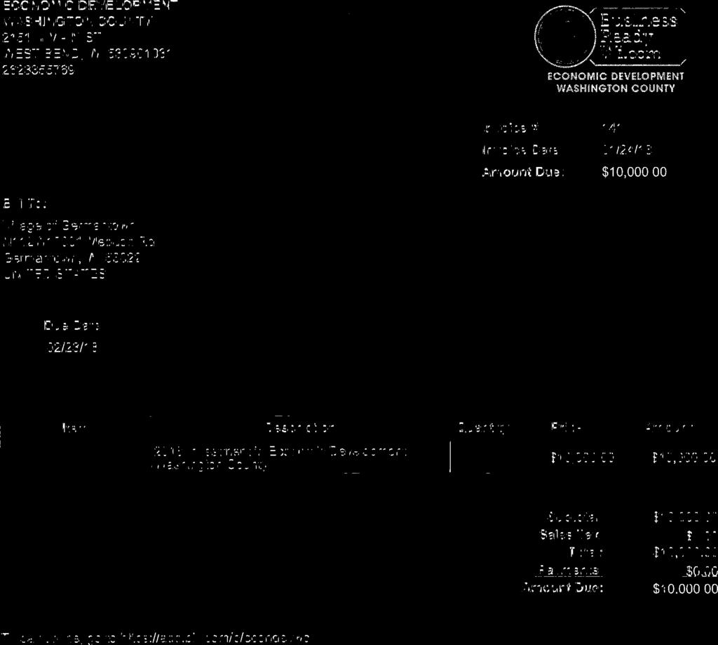
12 Business of the Village of Germantown The Government & Finance Committee & Village Board MEETING DATE: GGF February 20, 2018 Village Board March 5, 2018 PLACEMENT: New Business ITEM TITLE: 2018 Payment to Economic Development Washington County SUBMITTED BY: Kim Rath, Finance Director SUMMARY EXPLANATION: Attached is an invoice from Economic Development Washington County in the amount of $10,000 for the Village s 2018 contribution. Funds have been budgeted in Municipal Development account for this payment ATTACHED : ORDINANCE RESOLUTION OTHER _X_ Copy of invoice for 2018 payment to Economic Development Washington County RECOMMENDATION Approval; forward to Village Board COMMITTEE ACTION
13 BUSINESS OF THE VILLAGE BOARD GERMANTOWN, WI MEETING DATE: March 5, 2018 AGENDA ITEM: Public Hearing & Old Business [ORDINANCE] ITEM TITLE: SUBMITTED BY: Baudhuin Surveying & Engineering, Agent for Top Leaf Development LLC and Alan & Lynda Luther, Property Owners of acres located at N120 W12851 Freistadt Road (Tax Key# GTNV ) and Parcel 1 of CSM 3641 (Tax Key# GTNV & GTNV ); A-1: Agricultural to Rs-3: Single-Family District Rezoning Application Jeffrey W. Retzlaff, Director, Community Development Department SUMMARY EXPLANATION: Pete Hurth, Baudhuin Surveying, and Shari Waggoner, Top Leaf Development LLC, agents for the property owners Alan & Lynda Luther, have submitted a rezoning application to rezone the acres of land from A-1: Agricultural to Rs-3: Single-Family to accommodate the development of a 42-lot residential subdivision. The proposed rezoning is consistent with the Village s 2020 Land Use Plan. On January 15, the VB held a public hearing of the rezoning request but tabled action on the rezoning, sending the concept plan back to the Plan Commission for further review of the concept plan by the Plan Commission. At their February 12 and February 26 meetings, the Plan Commission directed further revisions to the 42-lot concept plan and approved the concept plan dated February 26, 2018 (see attached). ATTACHMENTS: Staff Reports Plan Commission Meeting Minutes Concept Plan Draft Ordinance PLAN COMMISSION RECOMMENDATION: APPROVE rezoning of the acre property from the A-1: Agricultural District to the Rs- 3: Single-Family District as proposed.
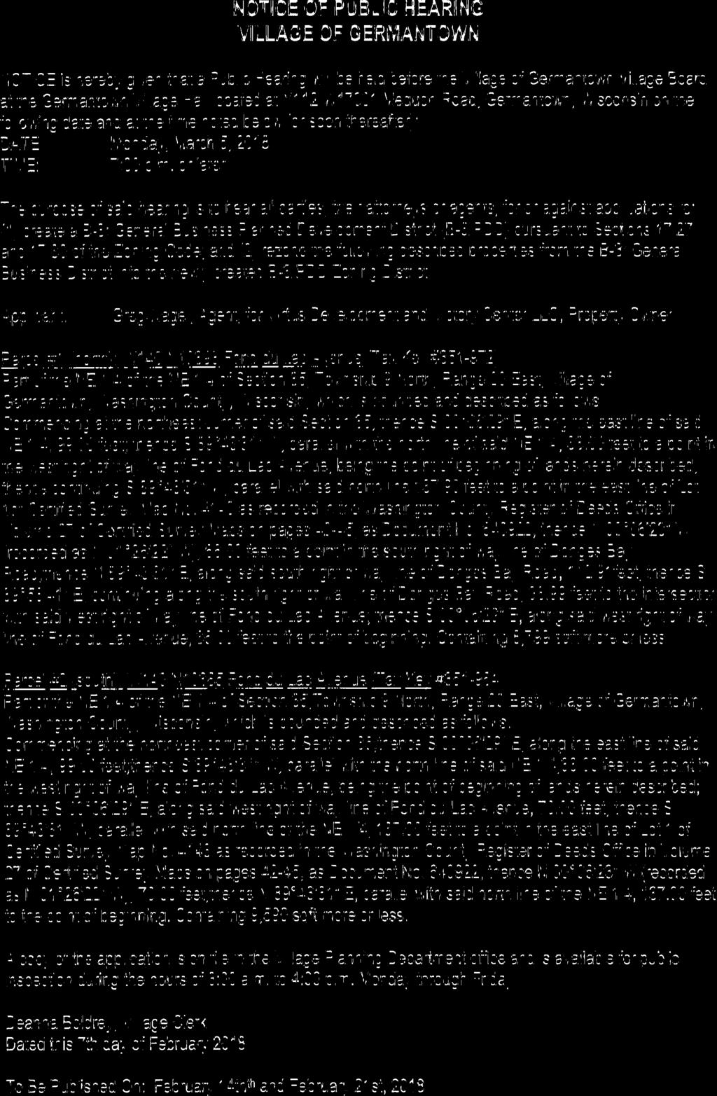
14 NOTICE OF PUBLIC HEARING VILLAGE OF GERMANTOWN NOTICE is hereby given that a Public Hearing will be held before the Village of Germantown Village Board at the Germantown Village Hall located at N112 W17001 Mequon Road, Germantown, Wisconsin on the following date and at the time noted below (or soon thereafter): DATE: Monday, March 5, 2018 TIME: 7:00 p.m. or later The purpose of said hearing is to hear all parties, their attorneys or agents, for or against an application to rezone portions of the following described land from the A-1: Agricultural Zoning District to the Rs-1: Residential Single-Family and/or Rs-3: Residential Single-Family Zoning Districts, or, another suitable zoning district deemed appropriate by the Village Board: Applicant: Baudhuin Surveying & Engineering, Agent for Top Leaf Development LLC and Alan & Lynda Luther, Property Owners Properties: N120 W12851 Freistadt Road (Tax Key: GTNV ) Parcel 1 of CSM 3641 (GTNV ) & (GTNV ) A parcel of land being Parcel1 of C.S.M No. 3641, Washington County Records, and the SW 1/4 of the NE 1/4, and part of the NW 1/4 of the NE 1/4, all in Section 24, Township 9 North, Range 20 East, Village of Germantown, Washington County, Wisconsin. More particularly described as follows: Commencing at the SE corner of said Parcel1 of C.S.M. No. 3641, said corner being at the intersection of the east line of the SE 1/4 of the NW 1/4 of said Section and the northerly right of way line of Elm Lane, and the point of beginning of lands to be described; thence S '17" W., along the southerly line of said Parcel1 (northerly right of way line of Elm Lane) to the SE corner of Parcel 2 of said C.S.M. No. 3641; thence around the perimeter of said Parcel2 as follows: N '37" W., feet to the NE corner of said Parcel 2; thence S '17" W., feet to the NW corner of said Parcel 2; thence S '37" E., feet to the SW corner of said Parcel2; thence leaving said perimeter, S '17" W., feet along the aforementioned southerly line of said Parcel1 to the SW corner of said cel1, said corner being on the west line of the SE 1/4 of the NW 1/4 of said Section ; thence N '59" W., feet along the westerly line of said Parcel 1, said line also being the aforementioned west line of the SE 1/4 of the NW 1/4 of said Section to the NW corner of said Parcel1, said corner also being the NW corner of the SE 1/4 of the NW 1/4 of said Section ; thence N '13" E., feet along the northerly line of said Parcel1, said line also being the north line of the BSE 1/4 of the NW 1/4 of said Section to the NE corner of said Parcel1, said corner also being the NE corner of the SE 1/4 of the NW 1/4 of said Section ; thence N '35" W., feet along the west line of the NW 1/4 of the NE 1/4 of said Section to the SW corner of Parcel1 of C.S.M. No. 386, Washington County Records; thence N '31" E., feet along the southerly line of said C.S.M. No. 386 to the SE corner of Parcel 3 of said C.S.M. No. 386; thence N '39" W., feet along the easterly line of said Parcel3 to the north line of the NW 1/4 of the NE 1/4 of said Section , said line also being the centerline of C.T.H. 'F'; thence N '31" E., feet along said north line (centerline) to the NE corner of the NW 1/4 of the NE 1/4 of said Section ; thence S '58" E., feet along the east line of the West 112 of the NE 1/4 of said Section to the SE corner of the SW 1/4 of the NE 1/4 of said Section , said corner also being on the centerline of Elm Lane; thence S '55" W., feet along the south line of the SW 1/4 of the NE 1/4 of said Section (centerline of Elm Lane) to the Center of said Section ; thence N '35" W., feet along the aforementioned east line of the SE 1/4 of the NW 1/4 of said Section to the point of beginning. Said parcel contains acres and is subject to the rights of the public over those portions previously dedicated for the rights of way of Elm Lane and C.T.H. 'F'. A copy of the application is on file in the Village Planning Department office and is available for public inspection during the hours of 8:00 a.m. to 4:00 p.m. Monday through Friday. Deanna Boldrey, Village Clerk Dated this 7 th day of February 2018 To Be Published On: February 14 and February 21, 2018
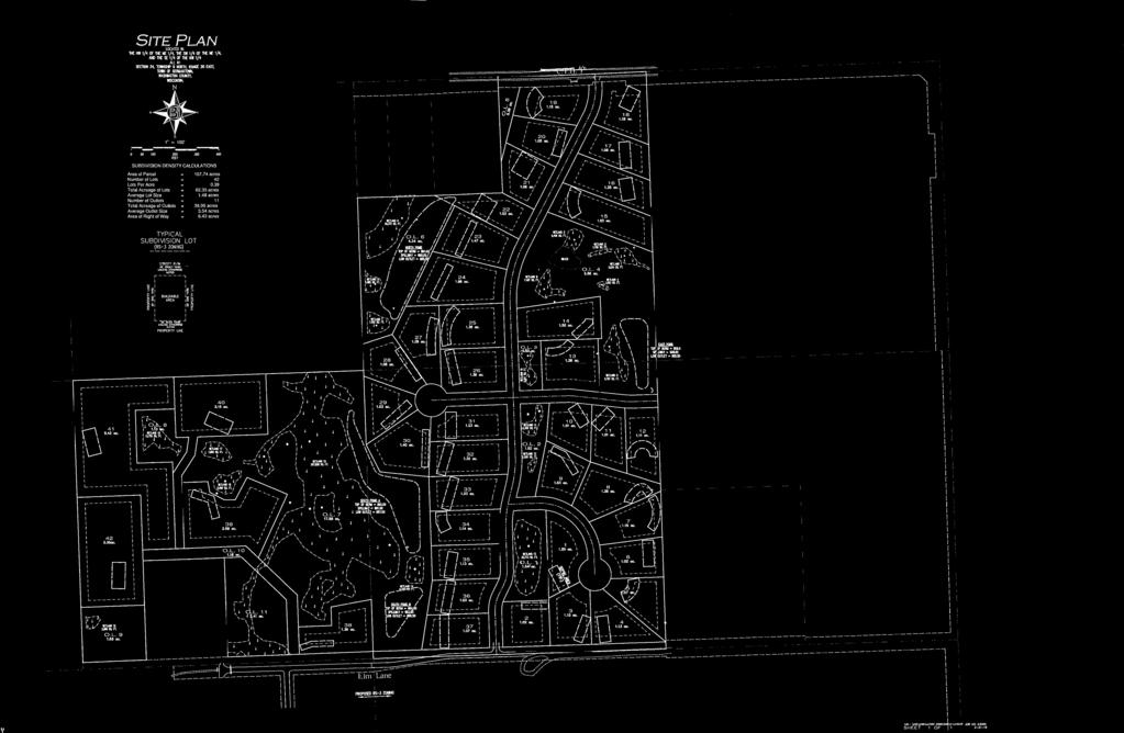
15 REVISED CONCEPT PLAN 2/26/18 Plan Commission Meeting Baudhuin Surveying & Engineering / Top Leaf Development LLC Village Planner Report Germantown, Wisconsin Summary Pete Hurth, Baudhuin Surveying & Engineering, and Top Leaf Development LLC and Alan & Lynda Luther, property owners, are requesting approval of a REVISED rezoning application concept plan for a 107-acre residential subdivision with 42 singlefamily lots south of Freistadt Road, north of Elm Lane and west of Wasaukee Road. Property Location: Freistadt Road, Elm Lane and Wasaukee Road Applicant/ Property Owner: Pete Hurth Shari Waggoner Baudhuin Survey & Eng Alan & Lynda Luther 312 N 5 th Ave Top Leaf Development LLC Sturgeon Bay, WI Colgate, WI Current Zoning: A-1: Agricultural Adjacent Land Uses Zoning North Residential Rs-1 South Residential Rs-1/Rs-2 East Residential/Agricultural A-1/Rs-2/3 West Agricultural A-1/A-2 Location Map
16 Rezoning Concept Plan Luther Property / Top Leaf Development LLC Page 2 of 2 Update At the February 12 Plan Commission meeting, the latest revised concept plan was reviewed and discussed in light of the January 15 public hearing and Village Board comments (see attached plan date stamped February 2, 2018). The Plan Commission discussed the notion of keeping all of the wetlands on the west side of the property in one large outlot that could be preserved either in private (e.g. Homeowner s Association) or public (e.g. MMSD/Greenseams Program) ownership while also being consistent with the Village s subdivision regulations that wetlands should be platted so as to be included in open space or other outlots and not within or part of a developable lot or parcel. To that end, the Plan Commission rejected the February 2 concept plan with the four (4) 5+ acre parcels and directed the Developer to revise the concept plan with all/most of the wetlands on the west side of the property in one large outlot with 4-5 smaller residential lots created from the buildable area adjacent to the wetland outlot and served by a private shared driveway. The Plan Commission also directed the Developer to revise the plan to show and require the extension/connection of Elm Lane to the development road to the east and west to complete the connection so traffic can circulate to both Wasaukee Road and Mequon Road via Forest Drive. The Developer has revised the concept plan as directed (see attached labeled February 26, 2018 ) and is seeking final approval from the Plan Commission.
17 REVISED REZONING CONCEPT PLAN 2/12/18 Plan Commission Meeting Baudhuin Surveying & Engineering / Top Leaf Development LLC Village Planner Report Germantown, Wisconsin Summary Pete Hurth, Baudhuin Surveying & Engineering, and Top Leaf Development LLC and Alan & Lynda Luther, property owners, are requesting approval of a REVISED rezoning application concept plan for a 107-acre residential subdivision with 47 singlefamily lots south of Freistadt Road, north of Elm Lane and west of Wasaukee Road. Property Location: Freistadt Road, Elm Lane and Wasaukee Road Applicant/ Property Owner: Pete Hurth Shari Waggoner Baudhuin Survey & Eng Alan & Lynda Luther 312 N 5 th Ave Top Leaf Development LLC Sturgeon Bay, WI Colgate, WI Current Zoning: A-1: Agricultural Adjacent Land Uses Zoning North Residential Rs-1 South Residential Rs-1/Rs-2 East Residential/Agricultural A-1/Rs-2/3 West Agricultural A-1/A-2 Location Map
18 Rezoning Application Luther Property / Top Leaf Development LLC Page 2 of 5 Update At the January 8, 2018 meeting, the Plan Commission discussed the latest revised concept plan for the 47-lot subdivision proposal. A motion was initially made to approve the requested rezoning (A-1 to Rs-3) and the 47-lot concept plan subject to revising the lot layout so that all wetlands and the 25 wetland setback areas were all contained in outlots (consistent with the Village s subdivision regulations). In response, the Applicant indicated that it would not be feasible to do so and, as a result, they would likely scrap the concept of developing small lots on the west side of the property, not extend Elm Lane to the east to connect with the north-south road, not extend Elm Lane to the west and north of the park, and, come back with a revised concept plan that may not require rezoning to Rs-3 on the west side. It was pointed out that a public hearing of the proposal was scheduled for the January 15 meeting and that it may be beneficial to get feedback from the public and Village Board before the Plan Commission considers any further changes to the concept plan or making a final recommendation on the rezoning or concept plan. The Plan Commission then passed a motion to table discussion and action until the next meeting and after the Village Board public hearing on January 15. At the January 15 meeting, 17 members of the public spoke during the public hearing (see meeting minutes attached), many with concerns about the extension/connection of Elm Lane, wetland protection, larger vs. smaller lots on the west side, existing storm water run-off and high groundwater issues, and a few who are simply opposed to the overall development. The Village Board did not take any action and sent the rezoning request and concept plan back to the Plan Commission for further review and consideration of the public hearing comments. Revised Proposal At the January 15 meeting, the Applicant provided a revised concept plan for discussion (see attached plan date stamped February 2, 2018; hereafter the revised plan ). Like the original concept plan presented last year, the revised plan divides the property into an east and a west development area. The east development area requires rezoning into the Rs-3 District (1-acre min lot size) and contains a total of thirty-seven (37) lots accessible by a north-south public roadway extending from Freistadt Road south to Elm Lane (with a proposed 250 extension from and connection to the existing Elm Lane to Wasaukee Road). The 37 lots would be created by subdivision plat. The west development area requires rezoning into the Rs-1 District (5-acre min lot size) and contains four (4) parcels accessible by a shared, private driveway extending north & west from the existing Elm Lane to Forest Drive. These 4 parcels would be created separately by certified survey map. A total of seven (7) outlots with 21 acres of undeveloped land area are interspersed throughout the property. It should be noted that, under the revised plan, approximately 7.1 acres of the total 10.6 acres (67 percent) of delineated wetland on the property would be included within the boundaries of the four proposed Rs-1 parcels in the west development area, including a 6.8-acre wooded wetland area often referred to as the Schoessow Woods.
19 Rezoning Application Luther Property / Top Leaf Development LLC Page 3 of 5 As we discussed at the January 7 Plan Commission meeting, Staff obtained clarification of the wetland and wetland setback requirements under the Village s Subdivision Code; specifically, Section 18.02(6) as shown below. (6) LAND SUITABILITY. No land shall be subdivided or developed which is determined to be unsuitable for its proposed use by the Plan Commission for reason of flooding, inadequate drainage, adverse soil or rock formation, unfavorable topography or any other feature likely to be harmful to the health, safety or welfare of the future residents of the proposed subdivision or of the Village. In addition: (a) No lot or parcel 2 acres or less in area shall include floodplain or wetlands, and all lots or parcels more than 2 acres in size shall contain not less than one acre of land which is at an elevation at least 2 feet above the elevation of the 100-year floodplain or, where such data is not available, 5 feet above the maximum flood of record. Generally, floodplain and wetlands within a parcel of land subject of a subdivision plat or certified survey map "minor" land division and the area within any required setbacks extending outward from any such floodplain or wetlands should be platted so as to be included in open space or other outlots and not within or part of a developable lot or parcel. (Cr. Ord. #09-08) The Village Attorney agrees that the terms generally and should as used in Section 18.02(6) provide the Plan Commission some latitude in terms of enforcement. By comparison, where shall is typically taken to mean something is compulsory or mandatory, words such as may or should are typically taken to mean something is permissive or recommended, but not necessarily required. Given that the four Rs-1 parcels exceed 2 acres in in area (5, 6.4, 8.6 and 13.9 acres respectively), and, given the Village Attorney s opinion summarized above, it appears that the Plan Commission could allow the latest revised plan to move forward even though a significant number of delineated wetlands and the associated 25 wetland setback is located within the four Rs-1 parcels. The reasoning behind the requirement under 18.02(6)(a) that all wetlands and wetland setbacks should be contained in open space outlots comes down to enforcement issue. The Village determined long ago that the protection of wetlands is important, and, that the standard protections available through DNR regulations are not sufficient. Consequently, the Village adopted its own 25 wetland setback requirement in the Shoreland-Wetland Zoning Code to effectively prohibit any land development activity (e.g. from grading and filling to building construction) within 25 feet of a delineated wetland. While there is a provision in the Shoreland-Wetland Code that allows development within a 25 setback area with a conditional use permit (along with a specific compensation plan), the 25 wetland setback requirement has been an effective no development zone protecting wetlands throughout the Village. However, with respect to enforcement, it is/would be extremely difficult and costprohibitive to monitor all development activity within the multitude of wetlands and wetland setback areas throughout the Village, particularly if those wetland setback areas encroach into or across thousands of parcels in the Village.
20 Rezoning Application Luther Property / Top Leaf Development LLC Page 4 of 5 As a result, in an effort to limit the extent or number of parcels subject to the development restrictions associated with a 25 wetland setback, the Village added the provisions in 18.02(6)(a) that prohibit the creation of lots 2 acres or less in area with any wetlands or floodplains within its boundaries, and, to require wetlands, floodplains and any required setback areas to be located within open space outlots and NOT part of a developable lot. With regard to this property, the delineated wetland areas comprise approximately 10.6 acres or 10 percent of the total parcel, and, include a significant part of the Schoessow Woods natural area as designated by SEWRPC. Since the last PC and VB meetings in January, Staff has contacted the local office of the Conservation Fund, agent and program coordinator for the Milwaukee Metropolitan Sewerage District (MMSD) Greenseams Program. As discussed in January, MMSD acquired the 34.5 acre parcel that lies north and west of the Top Leaf Development property (access from Freistadt Road). David Grusznski, Program Director for the Conservation Fund indicated that the Greenseams Program is interested in acquiring all or a portion of the 35 +/- acres that comprises the west development area of the Top Leaf property including the 20-acre area within which the Schoessow Woods and wetland area is located. As discussed, the Greenseams Program is voluntary on the part of the property owner and neither the Village, MMSD nor Conservation Fund has the ability to compel an owner to sell or otherwise transfer ownership of their property. Like all Environmental Corridor/Isolated Natural Areas designated on the Village s 2020 Land Use Plan map, the wetlands on this property are subject to applicable development policies and regulations contained in the Village s 2020 Comprehensive Smart Growth Plan, Shoreland-Wetland Code, Floodplain Zoning Code, General Zoning Code, and the Subdivision Code. Collectively, Village policies and regulations prohibit the development of wetlands and discourage development of adjacent and surrounding land around wetlands that may negatively impact those wetlands. With that said, Staff recommends that the Plan Commission NOT approve the latest revised plan that results in wetlands and the associated 25 setback areas being included in parcels proposed for development. Specifically, Staff recommends that the west development area shown in the revised plan be revised (again) such that all the wetlands and 25 setback areas in the west development area (i.e. Wetland #15 through #19) be included in undeveloped outlots that are NOT part of a larger parcel subject to development. Like Wetlands #1 through #14, ownership of these outlots may be private (e.g. Homeowner s Association) or public (e.g. Greenseams Program, Village). As presented in the January 8 concept plan, it may be possible to create buildable single-family lots under the Rs-3 District that avoid the wetland and 25 setback areas while also protecting those wetlands by including them in an outlot(s). Obviously, doing so also creates the need to provide roadway access to the west development area. If necessary, the Applicant and Village could work together on developing a Planned Development District (PDD) alternative with modified lot size or other standard requirements for the west development area (or entire development if necessary), that
21 Rezoning Application Luther Property / Top Leaf Development LLC Page 5 of 5 enables the Applicant to develop a cost-effective development while simultaneously protecting the wetland features on the property. If that is not possible, then the overall development may need to be revised to reflect rezoning and development under the Rs-3 District for just the east development area in the near term and leave the west development area as is with no rezoning and no development plan until such time as an acceptable development plan (if any) can be presented. At this time, the Plan Commission needs to reconsider their recommendation to APPROVE rezoning the entire property from A-1: Agricultural to the Rs-3: Residential Single-Family District. A second public hearing before the Village Board has been tentatively scheduled for March 5. It is anticipated that the Plan Commission will forward a recommendation regarding the rezoning request (the same or revised) and concept plan to the Village Board for consideration at that time.


22 REZONING APPLICATION 12/11/17 Plan Commission Meeting Baudhuin Surveying & Engineering / Top Leaf Development LLC Village Planner Report Germantown, Wisconsin Summary Pete Hurth, Baudhuin Surveying & Engineering, and Top Leaf Development LLC and Alan & Lynda Luther, property owners, are requesting approval of a rezoning application and concept plan for a 107-acre residential subdivision with 47 singlefamily lots south of Freistadt Road, north of Elm Lane and west of Wasaukee Road. Property Location: Freistadt Road, Elm Lane and Wasaukee Road Applicant/ Property Owner: Pete Hurth Shari Waggoner Baudhuin Survey & Eng Alan & Lynda Luther 312 N 5 th Ave Top Leaf Development LLC Sturgeon Bay, WI Colgate, WI Current Zoning: A-1: Agricultural Adjacent Land Uses Zoning North Residential Rs-1 South Residential Rs-1/Rs-2 East Residential/Agricultural A-1/Rs-2/3 West Agricultural A-1/A-2 Location Map
23 Rezoning Application Luther Property / Top Leaf Development LLC Page 2 of 5 Background/Proposal Baudhuin Engineering and Top Leaf Development presented their initial development proposal to the Plan Commission for discussion on September 11 with two (2) alternative road and lot layouts (see attached Option 1 and Option 2 concept plans dated September 11, 2017). Because of direction given at the September 11 meeting, the concept plan was revised and presented to the Plan Commission on October 9. The October 9 concept plan (see attached Plan Commission Option dated October 9, 2017) included the following revisions: A roadway connection to the west segment of Elm Lane with a direct connection to Forest Drive (and NO connection to the east segment of Elm Lane and Wasaukee Road); The extension of the west segment of Elm Lane further west to serve the southwest portion of the property and possibly the northeast corner of the Village s Friedenfeld Park (for possible future parking and enhanced access to the Village park); Additional lots created in the southwest portion of the property w/ approximately nine (9) 1-acre lots vs. four (4) 5+ acre lots w/ shared driveways); Additional storm water management pond locations; An overall increase in single-family lots from 43 to 49 total lots. At the October 9 meeting, the PC discussed the revised concept plan without recommending any changes, but deferred further comment or action pending the outcome of further discussion of the possibility that the Village may extend sanitary sewer to serve this area on October 23. That discussion concluded with a general sense that future sanitary sewer service extending into this area would be years away, the current 2020 Land Use Plan provides for unsewered single-family development, and that Top Leaf Development should move ahead with the proposal. At this time, Baudhuin Engineering and Top Leaf Development are requesting approval of a rezoning application to change the zoning from A-1: Agricultural to Rs-3: Singlefamily for 107-acres and for a concept plan for a 47-lot, single-family residential subdivision. As summarized in Table 1 and detailed in the project description and concept plan (dated December 11, 2017), development is proposed with the following characteristics: Table 1. Luther Property Concept Plan Gross Area (ac) Wetland Area (ac) Right-of-Way (ac) 8.29 Open Space (ac) Net Density Area (ac) Single-Family Lots/Dwelling Units (DU) 47 Density (DU/net acre) 0.53 Avg Lot Size (ac) 1.28
24 Rezoning Application Luther Property / Top Leaf Development LLC Page 3 of 5 When comparing the currently proposed concept plan to the most recently reviewed Plan Commission Option plan dated October 9, there are a few notable differences, including: 1. The number of lots has been reduced from 49 to 47 lots; 2. Wetland boundaries are now included on the plan and shown relative to the proposed lot lines and streets; 3. Lot dimensions have been removed; 4. The nine (9) lots proposed on the west side of the site have been reconfigured and the road slightly curved at the north end; 5. The main north-south roadway has been shifted to the east approximately feet from a point south of Lot 21 the entire length south to the intersection with Elm Lane (with the intersection approximately 650 feet further east); 6. Because of the road shifting, a new cul-de-sac has been added in the middle portion of the site to serve Lots 27-30, and, the cul-de-sac in the southeast has been reduced in length; 7. Because of the wetlands being delineated and located within the site, as well as the road realignments, lot sizes and shapes have been adjusted accordingly. Staff Comments The entire property lies north of and adjacent (but outside) of the Village s Sanitary Sewer Area (SSA) and in an area designated on the 2020 Land Use Plan as Rural Residential. For those currently undeveloped areas designated as Rural Residential, the Village intended such areas to develop at a density of one (1) dwelling unit per acre with a minimum 1-acre lot size. The land is currently zoned A-1: Agricultural and is proposed to be rezoned into the Rs-3: Single-family District. The proposed rezoning is consistent with the 2020 Land Use Plan map. Soil evaluation reports for all lots will be required prior to or concurrent with the submittal of a preliminary plat to ensure all proposed lots are deemed suitable for installation of an on-site sanitary system. As presented on the December 11 concept plan, a significant amount of wetland (10.56 acres or approximately 10% of the site) in numerous isolated areas lie across the property. As noted above, the lot and road layout has changed in part due to the wetlands on the property. Despite the amount of wetland, the required net area density calculation (gross area less wetlands and right-of-way) does not increase the proposed development density (.53 DU s per net acre) above the maximum density allowed in the Rs-3 District (not to exceed 1.0 DU s per net acre).
25 Rezoning Application Luther Property / Top Leaf Development LLC Page 4 of 5 Although the road and lot layouts are similar to that which was proposed in the October 9 Plan Commission Option plan, the changes summarized above are significant enough to consider further before approving as discussed below: As a result of the wetlands being delineated and presented on the concept plan, it s clear that not all of the wetland areas and the Village-enforced 25 wetland setback area will be located entirely within an open space outlot as required under Section of the Subdivision Code. Further revisions to lot lines (albeit slight) will need to be made and reflected in the preliminary subdivision plat. The reconfigured road on the west side of the site includes a reverse or S-curve that is not code-compliant. Moreover, as staff commented about at previous meetings, the location of this road is based strictly on the concept of maximizing the number of developable lots that can be created in this portion of the site and does not consider the topography and/or existing wooded, environmental corridor that lies immediately north into which this roadway would be required to extend into in order to serve future development to the north (vs. taking such factors into account first before establishing the alignment). As discussed in the Applicant s Rezoning Plan project description, realignment of the main north-south roadway feet to the east shifts the Elm Lane intersection 650 feet to the east from the previously proposed point. In so doing, Elm Lane will be improved in both directions from the proposed intersection, i.e. toward Forest Drive to the west and toward Wasaukee Road to the east. If Elm Lane is improved in both directions and, as a result, provides a continuous means of access from Wasaukee Road all the way to Friedenfeld Park, the type and amount of traffic that may eventually travel on Elm Lane may justify requiring the entire length of Elm Lane to be improved to current Village road standards. This raises a number of issues, including: o How much of Elm Lane will need to be constructed and who will pay for the improvements? o Is the existing right-of-way and existing geometric and road surface conditions adequate along the entire length of Elm Lane? o Who will be responsible for making any required off-site improvements? o The relocated road and intersection will cut through a wooded area and be positioned such that all southbound traffic will be effectively pointed directly at one of the relatively few existing homes along Elm Lane. o Is the PC receptive to the idea of now allowing a southerly access connection to both the east and the west after having directed the Applicant to only provide southerly access to the west segment of Elm Lane?
26 Rezoning Application Luther Property / Top Leaf Development LLC Page 5 of 5 The main roadway realignment also creates a straighter and, as a result, relatively less appealing soldiers row configuration of lots on the west side of the roadway. Some of the revised lot lines create multi-sided and/or less than ideal lot shapes (e.g. Lot 2, Lot 3, Lot 28, Lot 47), and, front yard-to-back yard conflicts (e.g. Lot 27 front yard up against back yards for Lots 25 & 26; Lot 30 front yard up against back yards for Lots 31 & 32. While staff generally supports a subdivision lot and road layout that provides multiple means of access to/from the development to enhance accessibility, there are several issues that need to be addressed before accepting the currently proposed road alignment and traffic circulation patterns that will result. Staff supports the proposed rezoning; however, for the reasons discussed above, Staff recommends that action to approve the concept plan be tabled pending further discussion of and possible changes to the December 11 concept plan. Village Planner Recommendation APPROVE the proposed rezoning of approximately 107 acres from the A-1: Agricultural District to the Rs-3: Residential Single-Family district subject to the following condition: 1. The rezoning application and Plan Commission recommendation should not be forwarded to the Village Board for review and consideration until the Plan Commission can recommend approval of a development concept plan. TABLE the review and action on the proposed concept plan dated December 11, 2017 pending revisions necessary to address the issues raised in the December 11 Staff Report and Recommendation to the satisfaction of the Plan Commission.
27

28

29

30
31 ORDINANCE NO AN ORDINANCE TO AMEND THE OFFICIAL ZONING MAP OF THE VILLAGE OF GERMANTOWN ZONING CODE (Alan & Lynda Luther, Property Owners) THE VILLAGE BOARD OF THE VILLAGE OF GERMANTOWN, WASHINGTON COUNTY, WISCONSIN, ORDAINS AS FOLLOWS: SECTION 1. That the zoning map of the Village of Germantown is amended by rezoning from the A-1: Agricultural District to the Rs-3: Single-family Residential District the following described property: A parcel of land being Parcel 1 of CSM No. 3641, Washington County Records, and the SW 1/4 of the NE 1/4, and part of the NW 1/4 of the NE 1/4, all in Section 24, Township 9 North, Range 20 East, Village of Germantown, Washington County, Wisconsin. More particularly described as follows: Commencing at the SE corner of said Parcel1 of CSM No. 3641, said corner being at the intersection of the east line of the SE 1/4 of the NW 1/4 of said Section and the northerly right of way line of Elm Lane, and the point of beginning of lands to be described; thence S '17" W., along the southerly line of said Parcel1 (northerly right of way line of Elm Lane) to the SE corner of Parcel 2 of said CSM No. 3641; thence around the perimeter of said Parcel 2 as follows: N '37" W., feet to the NE corner of said Parcel 2; thence S '17" W., feet to the NW corner of said Parcel 2; thence S '37" E., feet to the SW corner of said Parcel 2; thence leaving said perimeter, S '17" W., feet along the aforementioned southerly line of said Parcel 1 to the SW corner of said Parcel 1, said corner being on the west line of the SE 1/4 of the NW 1/4 of said Section ; thence N '59" W., feet along the westerly line of said Parcel 1, said line also being the aforementioned west line of the SE 1/4 of the NW 1/4 of said Section to the NW corner of said Parcel 1, said corner also being the NW corner of the SE 1/4 of the NW 1/4 of said Section ; thence N '13" E., feet along the northerly line of said Parcel 1, said line also being the north line of the SE 1/4 of the NW 1/4 of said Section to the NE corner of said Parcel 1, said corner also being the NE corner of the SE 1/4 of the NW 1/4 of said Section ; thence N '35" W., feet along the west line of the NW 1/4 of the NE 1/4 of said Section to the SW corner of Parcel 1 of CSM No. 386, Washington County Records; thence N '31" E., feet along the southerly line of said CSM No. 386 to the SE corner of Parcel 3 of said CSM No. 386; thence N '39" W., feet along the easterly line of said Parcel 3 to the north line of the NW 1/4 of the NE 1/4 of said Section , said line also being the centerline of CTH F ; thence N '31" E., feet along said north line (centerline) to the NE corner of the NW 1/4 of the NE 1/4 of said Section ; thence S '58" E., feet along the east line of the West 112 of the NE 1/4 of said Section to the SE corner of the SW 1/4 of the NE 1/4 of said Section , said corner also being on the centerline of Elm Lane; thence S '55" W., feet along the south line of the SW 1/4 of the NE 1/4 of said Section (centerline of Elm Lane) to the Center of said Section ; thence N '35" W., feet along the aforementioned
32 east line of the SE 1/4 of the NW 1/4 of said Section to the point of beginning. Said parcel contains acres and is subject to the rights of the public over those portions previously dedicated for the rights of way of Elm Lane and CTH F. SECTION 2. This ordinance shall take effect and be in full force the day after its passage and publication, as provided by law. Introduced by Trustee: Adopted:, 2018 Vote: Ayes: Nays: ATTEST: Deanna Boldrey, Village Clerk APPROVED AS TO FORM: Dean Wolter, Village President Brian Sajdak, Attorney Published:
33 PLAN COMMISSION MINUTES February 26, 2018 CALL TO ORDER: Chairman Wolter called the meeting to order at 6:30 p.m. ROLL CALL: Chairman Dean Wolter, Trustee Rep David Baum, Commissioners Bob Williams, Peter Nilles, Tony Laszewski, Bill Shadid and Mary Ellen Gray were present. Also present were Community Development Director/Village Planner Jeff Retzlaff and Planning Assistant Lori Johnson. PUBLIC INPUT: The following residents spoke against extending Elm Lane to the west: Richard Boehlke- N116 W13321 Elm Lane, Todd Johnson-N116 W13444 Elm Lane, Ron Peterson-W132 N11267 Forest Drive, Steve Zainer-W132 N11290 Forest Drive, Vicki Worth-N116 W12711 Elm Lane, John Simerlein-N113 W12930 Crestview Drive, Dave Brobert-W132 N11533 Forest Drive, Garrett Bradley-W132 N11239 Forest Drive, Bruce Bernarde-N120 W13645 Freistadt Road (wetland concern). APPROVAL OF MINUTES: MOTION Baum second Gray to Approve the minutes from February 12, MOTION carried unanimously. Top Leaf Development LLC & Alan & Lynda Luther 107-Acres south of Freistadt Road, North of Elm Lane and West of Wasaukee Road. The property owners are requesting approval of a revised rezoning application concept plan for a residential subdivision with 42 single-family lots. Planner Retzlaff summarized the proposal. He said the zoning can be developed in the Rs-3 zoning district. Chairman Wolter explained a new public hearing has been posted, but because the zoning will be in the Rs-3 zoning district, a new public hearing will not be required but it will appear on the Village Board agenda and the public will be able to give their comments. MOTION Baum second Gray to Approve the revised concept plan as presented. Discussion followed. Trustee Baum said the only thing in question at the last meeting was the 700- foot connection of Elm Lane. He said in general planning terms you don t want a lot of dead end streets. There will be additional development coming to the area that will add more congestion and traffic. Commissioner Shadid asked if it would be a problem for the west end of the subdivision if the 700 feet didn t connect. Chairman Wolter said he was in favor of the road extension when there were smaller lots on the west side, but now that the plan was changed to keep the wetlands out of the parcels and in out lot areas, the lots are now larger. He doesn t see the need to connect Elm at this time but wants to keep the right of way and easements on the property so when we are ready to connect we don t need to buy additional land. MOTION to Amend Shadid second Baum to amend the concept plan by removing the 700 feet of connectivity of Elm Lane. Commissioner Laszewski asked when Elm Lane would be connected. Planner Retzlaff said there is no specific development that would trigger the connection of Elm. It s a matter of practice to have developers build their roads to the end of their property to aid in traffic circulation and accessibility to the property. When the opportunity presents itself, the roads should be connected. He said there are
34 Plan Commission February 26, 2018 Page 2 property owners interested in developing land to the east and to west that could benefit from an improved circulation system through the entire section of this area of the Village. Commissioner Williams asked if the road is developed in the future who is responsible for payment. Will the burden be on the taxpayers? Planner Retzlaff said the Village would ultimately be responsible for the cost. He said if the road is not required to be connected, the Village should at least require some paved pedestrian accessway to make the connection for accessibility to the lands north, south and west. Chairman Wolter explained some Village Board members will be in support of the road connecting because they feel this is the time to connect because the developer is responsible for the cost. Commissioner Gray said it makes sense to connect the road. MOTION to Amend Failed 3-4 (Gray, Laszewski, Nilles, Williams). MOTION to Approve carried unanimously.
35
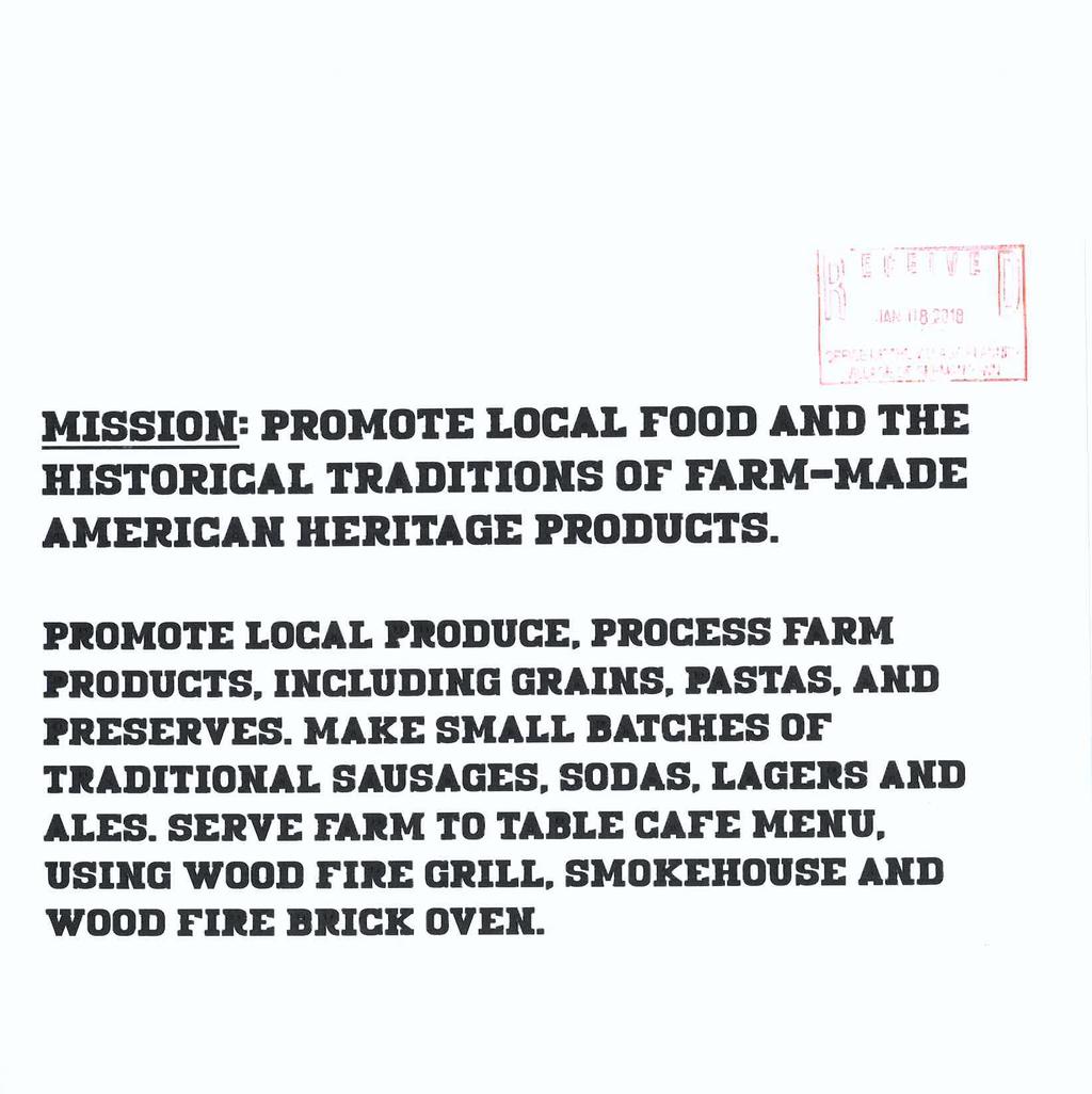
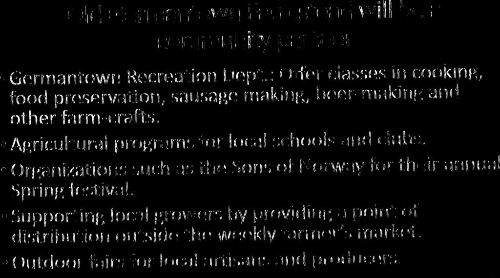
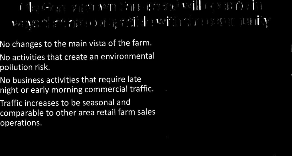
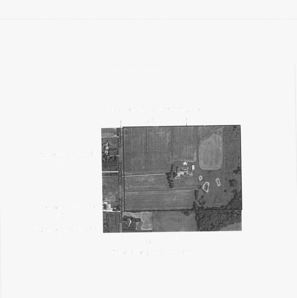
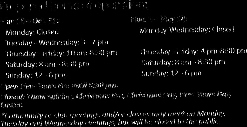
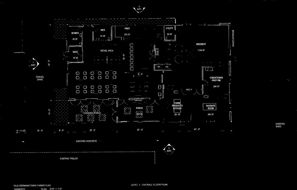
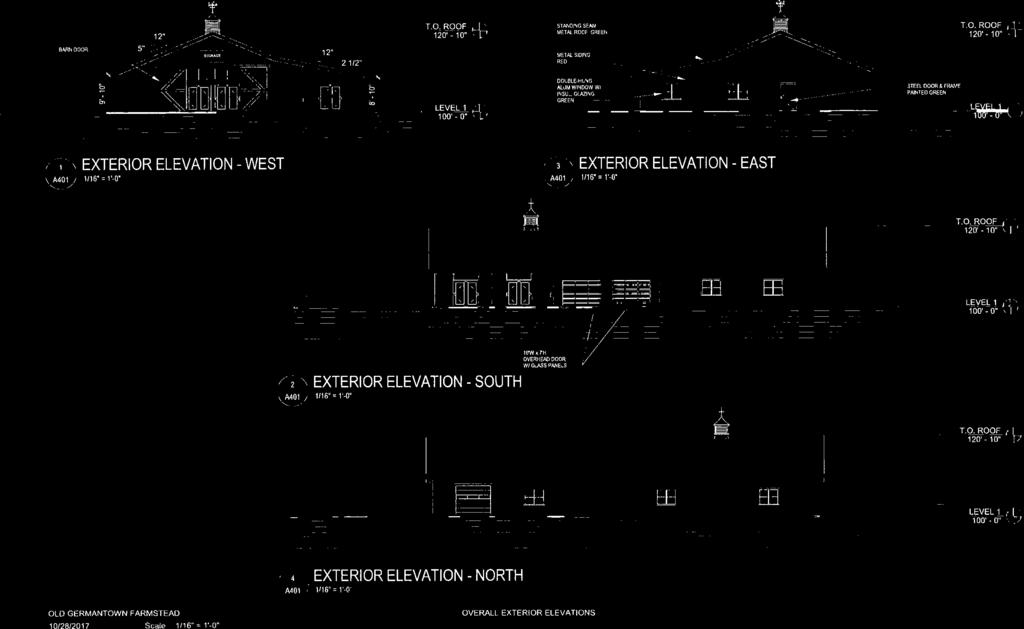
36 BUSINESS OF THE VILLAGE BOARD GERMANTOWN, WI MEETING DATE: March 5, 2018 AGENDA ITEM: ITEM TITLE: SUBMITTED BY: Public Hearing & New Business (CONDITIONAL USE PERMIT) Scott & Georgene Sommer, Property Owners; Conditional Use Permit Application to operate a Farm Market on the property located at W148 N12696 Pleasant View Drive (Parcel GTNV# , & ) Jeffrey W. Retzlaff, Director, Community Development Department SUMMARY EXPLANATION: Scott & Georgene Sommer, property owners of a 120-acre farm located at W148 N12696 Pleasant View Drive are requesting approval of a Conditional Use Permit (CUP) to operate a farm kitchen, brewery and sausage production facilities on their property in an A-1: Agricultural Zoning District. the Sommer s intend to create a unique agri-tourism destination on their 120-acre Old Germantown farm that will include: 1. Construction of a new 6,000 sqft commercial-grade, metal-sided/roof barn-style building for use as a farm kitchen w/ sit-down restaurant, small retail shop, sausage production, micro-brewery; 2. Year-round operation w/ variable days & hours of operation depending on the season: May 15 to Oct 31 (Summer) Tuesday through Sunday, and Nov 1 to May 14 (Fall-Winter-Spring) Thursday through Sunday The overall operation is intended to educate, display and promote local food production and historical traditions with locally produced grains, pastas, preserves, sausages, small-batch beer and sodas, wood-fire grill, oven and a smokehouse that will be available for sale and consumption on the premises. ATTACHMENTS: 1/8/18 Staff Report 1/8/18 Plan Commission Meeting Minutes Draft CUP PLAN COMMISSION RECOMMENDATION: APPROVE a conditional use permit for Scott & Georgene Sommer to operate a farm kitchen, brewery and sausage production facilities from their 120-acre property located at W148 N12696 Pleasant View Drive subject to (14) conditions. {see Draft CUP for all conditions recommended by the Plan Commission}


37
 to allow the operation of a farm kitchen, brewery and sausage production facilities on their")

38 CONDITIONAL USE PERMIT APPLICATION 2/12/18 Plan Commission Meeting Village Planner Report Scott & Georgene Sommer Germantown, Wisconsin Summary Scott & Georgene Sommer, property owners of a 120-acre farm located at W148 N12696 Pleasant View Drive are requesting approval of a Conditional Use Permit (CUP) to allow the operation of a farm kitchen, brewery and sausage production facilities on their property in an A-1: Agricultural Zoning District. Location: W148 N12696 Pleasant View Drive Applicant/ Property Owner: Scott & Georgene Sommer W148 N12696 Pleasant View Drive Germantown, WI Current Zoning: A-1: Agricultural Adjacent Land Uses Zoning North Agricultural A-1 South Agricultural/Residential A-2/Rs-2 East Agricultural A-2 West Agricultural/Residential A-1/Rs-1 Location Map
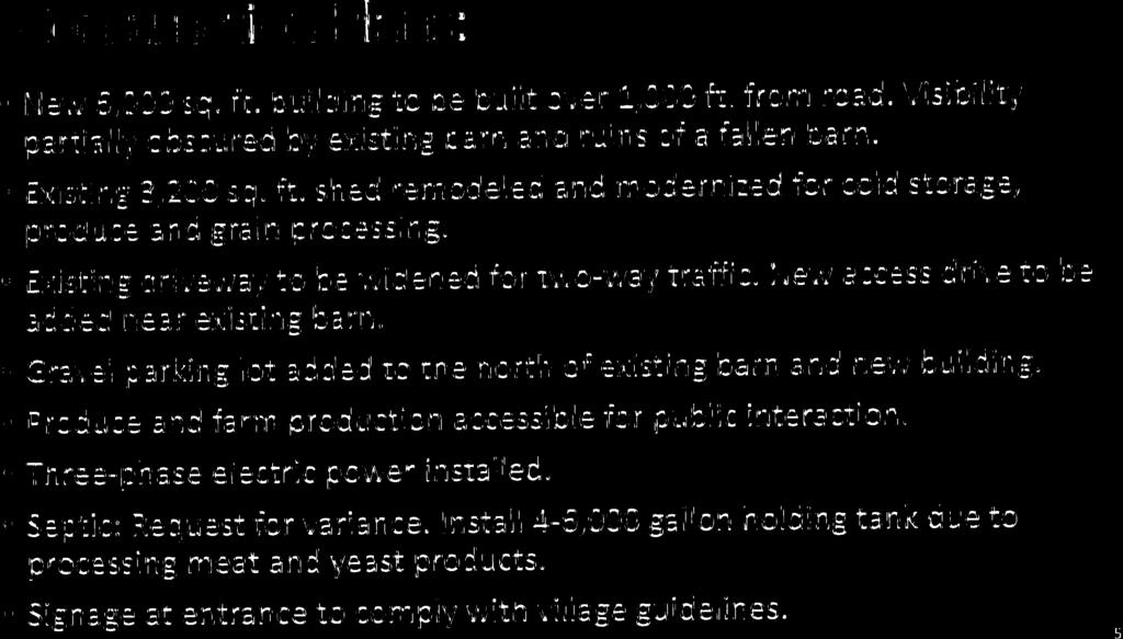
39 CUP Scott & Georgene Sommer / Farm Kitchen Page 2 of 4 Proposal Scott & Georgene Sommer, property owners of a 120-acre farm located at W148 N12696 Pleasant View Drive are requesting approval of a Conditional Use Permit (CUP) to allow the operation of a farm kitchen, brewery and sausage production facilities on their property in an A-1: Agricultural Zoning District. As presented to the Plan Commission in December 2017, the Sommer s intend to create a unique agri-tourism destination on their 120-acre farm. Highlights of the proposed Old Germantown include: Construction of a new 6,000 sqft commercial-grade, metal-sided/roof barn-style building for use as a farm kitchen w/ sit-down restaurant, small retail shop, sausage production, micro-brewery; Renovation of an existing 3,200 sqft shed for cold storage, produce and grain processing uses; Year-round operation w/ variable days & hours of operation depending on the season: o May 15 to Oct 31 (Summer) Tuesday through Sunday o Nov 1 to May 14 (Fall-Winter-Spring) Thursday through Sunday The overall operation is intended to educate, display and promote local food production and historical traditions with locally produced grains, pastas, preserves, sausages, small-batch beer and sodas, wood-fire grill, oven and a smokehouse. Staff Comments The 120-acre Sommer property lies outside of the Village s Sanitary Sewer Area (SSA) and in an area designated on the 2020 Land Use Plan as Agricultural/Conservation Residential. The land is currently zoned A-1: Agricultural. The land surrounding the Rivera property is currently used for agricultural and/or hobby farm-type uses. The surrounding zoning is either A-1: Agricultural, A-2: Agricultural or Rs-1: Single-Family. While components of the Sommer s proposal are specifically identified as being permitted uses in the Village s A-1 Zoning District, e.g. retail sales of farm products, the café, small-batch brewery and sausage production components could be allowed under a conditional use permit as part of a farm market. Without question, this type of agri-tourism operation is the type of agricultural use that is more likely to be proposed in the future vs. traditional family or corporate farm operations and uses specifically called out in the A-1 District list of uses. However, as a relatively new use for Germantown, Staff is recommending specific conditions of approval intended to ensure compatibility with the surrounding agricultural area.
40 CUP Scott & Georgene Sommer / Farm Kitchen Page 3 of 4 Fire Department Approval recommended with following conditions/requirements: 1. Building shall be designed to meet all fire protection requirements under applicable IBC for A-3 occupancy and use classification. 2. Access driveway and new parking area shall meet NFPA 1 Chapter 18 access requirements. 3. Septic holding tank shall not be installed in a location where fire vehicles might need to drive over for emergency access purposes unless said tank is designed, constructed and approved for heavy vehicle loads. 4. Bi-annual fire safety inspections will be conducted by Germantown Fire Department. Village Planner Recommendation APPROVE a conditional use permit for Scott & Georgene Sommer to operate a farm kitchen, brewery and sausage production facilities from their 120-acre property located at W148 N12696 Pleasant View Drive subject to the following conditions: 1. The uses and activities allowed on the property shall be limited to those uses and activities and relative locations specified in the conditional use permit application (CUP) and supporting materials dated January 8, The physical facilities from which said uses and activities are permitted include the existing and proposed buildings specified in the CUP application and supporting materials. Days and hours of operation shall be limited to those specified in the CUP application and supporting materials dated January 8, The brewery operation has been described as and is intended to be a small batch operation with production occurring within an approximate 1,100 sqft area located in the proposed farm market building. This CUP is granted with the understanding that the brewery will operate as a nano brewery and brewpub with production not to exceed 1,000 barrels/year with at least 25 percent of the beer produced sold in/from the farm market. The purpose for these limitations is to address concerns regarding water consumption and to ensure the brewery remains an accessory use and integral component to the overall farm market concept. In the event the owner/operator seeks to expand brewery production and/or add or eliminate other uses and activities to the overall farm market business plan for which this CUP has been issued, the owner/operator shall submit an amended plan of operation to the Village for review and consideration as part of an amendment to this CUP to be reviewed and processed following the typical CUP procedures. 3. Site Plan review and approval is required prior to construction of the new 60 x 100 (6,000 sqft) building in accordance with Village Zoning Code requirements. 4. A temporary use permit may be required for special events involving attendance by the public depending on the type and extent of activities, days, hours and duration of the event. The owner/operator is responsible for contacting the Community Development Department for information and permitting requirements (if any) prior to scheduling any special events involving special or extraordinary advertising or promotion, events occurring for 2 or more consecutive days, or when the number of visitors for an event is expected to exceed three-hundred (300) persons per day.
41 CUP Scott & Georgene Sommer / Farm Kitchen Page 4 of 4 Village Planner Recommendation (cont.) 5. Building permits are required for all internal and external building renovation and improvements. 6. The No vehicle parking shall be permitted on or along Pleasant View Drive; all parking associated with the operation shall be accommodated on the property. 7. All permanent and temporary exterior signage along or facing Pleasant View Drive requires a sign permit and shall comply with all current sign regulations. Off-premise advertising and directional signage is regulated by the Village and requires a permit if/when allowed. 8. The owner/operator is required to obtain all applicable permits, approvals, licenses, etc. from the Village of Germantown, Washington County, State of Wisconsin and any federal agencies prior to commencing operations of the café/restaurant, meat production, and brewery, including, but not limited to: liquor licenses for the sale and consumption of alcohol; brewery/brewpub licenses for the production and distribution of alcohol; restaurant and food licensing for the production, sale and consumption of retail food products, sausage and other meat production; septic/holding tank and other waste processing permits for the storage, transportation and/or processing of wastewater and other by-products associated with the production of sausage, beer, soda, etc. The owner/operator shall provide copies of all required permits to the Community Development Department. 9. The processing and ultimate disposal of all wastewater and other by-products associated with the production, processing and packaging of meat, beer and other products should occur offsite and in a licensed facility. In the event the processing and/or disposal of wastewater and other by-products associated with meat and beer production is handled on-site, e.g. composting, the owner/operator shall prepare and submit a detailed plan addressing the processes and procedures that will be used, and, that specifies how concerns such as odor control, soil and groundwater contamination will be addressed and mitigated. Said plan shall be submitted to the Village of Germantown and any county and state agencies regulating said waste processing and disposal. 10. All new and renovated buildings shall be designed to meet all fire protection requirements under applicable IBC for A-3 (or applicable) occupancy and use classification. 11. The access driveway and new parking area shall meet NFPA 1 Chapter 18 access requirements. 12. The septic holding tank shall not be installed in a location where fire vehicles might need to drive over for emergency access purposes unless said tank is designed, constructed and approved for heavy vehicle loads. 13. Bi-annual fire safety inspections will be conducted by Germantown Fire Department. 14. If the use, activities and/or operation subject of this permit falls out of conformity with the conditions herein, or where there is a change in the nature, character, intensity or extent of the permitted conditional uses and activities which cause special problems or harmful effects associated with the permitted uses and activities that were not revealed or anticipated at the time this CUP was granted, or, where conditions imposed by this CUP that were anticipated to mitigate or eliminate harmful effects associated with the uses and activities but are subsequently insufficient to do so, or, for similar cause based upon consideration for the public comfort, safety, and welfare, this conditional use permit may be terminated or modified by the Village Board by the amendment to or addition of conditions after public hearing thereon.


42

43


44

45

46

47

48

49

50


51
52
53

54

55

56

57


58


59

60

61

62

63


64


65

66
67


68


69
70
71 MEETING DATE: March 5, 2018 BUSINESS OF THE VILLAGE BOARD GERMANTOWN, WI AGENDA ITEM: ITEM TITLE: SUBMITTED BY: Public Hearing & New Business [ORDINANCE & RESOLUTION] Greg Nagel, Agent for Victory Center LLC, Property Owners; W140 N10385 & W10393 Fond du Lac Avenue (Parcels GTNV# & ); Creation of the Kuhburg District a B-3 Planned Development District (PDD) & Rezoning Application Jeffrey W. Retzlaff, Director, Community Development Department SUMMARY EXPLANATION: Greg Nagel, President of Virtus Development and agent for Victory Center LLC, property owner, is requesting approval of a rezoning application to create a B-3: General Business Planned Development District (PDD), to be called the Kuhburg District to facilitate redevelopment of the existing vacant school house and 2-story tavern into a 4,220 sqft restaurant & coffee shop located in the southwest corner of the Donges Bay Fond du Lac Ave/STH145 intersection. The Developer is proposing to create a new B-3/PDD zoning district called the Kuhburg District, to modify some of the underlying B-3: General Business Zoning District requirements that would ordinarily apply and otherwise likely prohibit re-development of the site. The proposed Kuhburg District is based on the standard B-3: General Business District requirements with modifications to the following: Lot, Yard and Building Requirements o Reduce minimum Lot Area from 5,000 sqft to no minimum; Parking and Loading Requirements o Reduce the minimum parking lot setback in all yards from 8 feet to 0 feet; o Eliminate the 50 setback requirement between commercial parking lots and residential property; o Allow loading zone to be in the parking isles; o Specify that the number of parking stalls is at the discretion of the developer based on actual capacity; allow for additional parking off-site; and that additional parking may be created by the purchase of additional property; Signage o Allow for two (2) monument signs to be installed on the property along Fond du Lac Avenue; o Reduce the minimum sign setback from 5 feet to 0 feet. Along with their recommendation to the Village Board to approve the proposed PDD and General Development Plan, the Plan Commission approved detailed site development & building plans subject to (14) conditions including being VB approval of the B-3/PDD rezoning).
72 Greg Nagel, Virtus Development, Agent Victory Center LLC, Property Owner Kuhberg District B-3/PDD Page 2 ATTACHMENTS: 2/26/18 Staff Report 2/26/18 Plan Commission Meeting Minutes Draft B-3/PDD Zoning Ordinance Draft Kuhberg District Conditions & Restrictions Resolution PLAN COMMISSION RECOMMENDATIONS: APPROVE creating a B-3/PDD (the Kuhberg District ) and rezoning proposed by Victory Center LLC for their.43-acre area located on Donges Bay Road subject to (5) conditions: 1. The B-3: General Business Zoning District regulations shall constitute the specific conditions and restrictions for the PDD as amended in the Developer s PDD Application (dated January 8, 2018) and summarized herein; 2. Subject to revision required by the Plan Commission, plan sheet GD100 dated February 23, 2018 shall constitute the General Development Plan required under Section of the Zoning Code; 3. The Developer shall provide one complete and accurate legal description for all the land to be included in the PDD boundary prior to review of the PDD application by the Village Board. 4. The PDD conditions & restrictions resolution shall contain a requirement that a certified survey map (CSM) land combination shall be completed and approved to combine the two subject parcels and adjust the property line along the west boundary prior to issuance of any building permit(s) for building renovation. The CSM will need to include all the parcels affected, including the residential parcel to the west. 5. The PDD boundary for the Kuhberg District shall be expanded in the future if the Developer acquires additional land to accommodate an expanded parking area. Said PDD boundary expansion shall be processed as a separate PDD application in accordance with all requirements and procedures at that time.

73
 and a Site Plan for")
74 PLANNED DEVELOPMENT DISTRICT (PDD) & SITE PLAN REVIEW 2/26/18 Plan Commission Meeting Virtus Development / Victory Center LLC Village Planner Report Germantown, Wisconsin Summary Greg Nagel, President of Virtus Development, and agent for Victory Center LLC, property owner, is requesting approval of a rezoning application to create a Planned Development District (PDD) and a Site Plan for a 4,220 sqft restaurant & coffee shop located in the southwest corner of the Donges Bay Fond du Lac Ave/STH145 intersection. Property Location: W140 N10385 Fond du Lac Ave (.21 acres) W140 N10393 Fond du Lac Ave (.22 acres) Applicant/ Property Owner: Greg Nagel Catherine Jahn, Member Virtus Development Victory Center LLC Watertown Plnk Rd W222 N7364 Willowview Dr Elm Grove, WI Sussex, WI Current Zoning: B-3: General Business Adjacent Land Uses Zoning North Business B-3 South Residential Rs-6 East Industrial M-1 West Residential Rs-6 Location Map
75 PDD & Site Plan Virtus Development / Victory Center LLC Page 2 of 10 Background As presented and discussed in November 2017, the Developer proposes to redevelop and renovate the two parcels and existing buildings (single-story school house and 2- story tavern) into a coffee shop and restaurant. Improvements include the construction of a covered portico between and serving both buildings with seasonal seating, interior and exterior building renovations, and reconstruction/expansion of the existing parking lot west of the buildings. The development area is comprised of two (2) parcels totaling approximately.43 acres lying south of Donges Bay Road southwest of the new Fond du Lace Ave/STH145 roundabout. Current use of the properties includes the vacant, one-story school house and a 2-story tavern. Proposal Greg Nagel, President of Virtus Development, and agent for Victory Center LLC, property owner, is requesting approval of a rezoning application to create a Planned Development District (PDD) and a Site Plan for a 4,220 sqft restaurant & coffee shop located in the southwest corner of the Donges Bay Fond du Lac Ave/STH145 intersection. Planned Development District (PDD) To facilitate the planned redevelopment, the Developer is proposing to create a new B- 3/Planned Development District ( i.e. Kuhberg District ) in order to flex some of the underlying B-3: General Business Zoning District requirements that would ordinarily apply, e.g. parking lot setback, building setback, parking stall size, landscaping, percent of lot coverage/impervious area, etc. Attached to the PDD application is a set of proposed zoning district regulations for the Kuhberg District. These regulations use the B-3: General Business District as a starting point or base set of regulations with modifications to the following: Lot, Yard and Building Requirements: o Reduce minimum Lot Area from 5,000 sqft to no minimum; Parking and Loading Requirements: o Reduce the minimum parking lot setback in all yards from 8 feet to 0 feet; o Eliminate the 50 setback requirement between commercial parking lots and residential property; o Allow loading zone to be in the parking isles; o Specify that the number of parking stalls is at the discretion of the developer based on actual capacity; allow for additional parking off-site; and that additional parking may be created by the purchase of additional property; Signage: o Allow for two (2) monument signs to be installed on the property along Fond du Lac Avenue; o Reduce the minimum sign setback from 5 feet to 0 feet.
76 PDD & Site Plan Virtus Development / Victory Center LLC Page 3 of 10 [NOTE: A separate PDD Conditions & Restrictions resolution containing these development-specific allowances, references to the detailed general development plan, and any other conditions of approval deemed appropriate by the Village, will be prepared by Village staff at the time the PDD is considered by the Village Board]. Site Plan The applicant has submitted site development and building plans for redevelopment of the.43-acre site and two buildings that are to be renovated. As presented in the plan set, the Developer proposes the following improvements: Renovate the existing one-story 784 sqft school house into a coffee shop with a pervious pavement open-air patio for outdoor seating & service; Renovate the existing 2,177 sqft two-story tavern into a two-story restaurant with 1 st and 2 nd floor dining areas and a 1,256 sqft covered & screen patio for outdoor seating & service (seating also available for the coffee shop; Expand and pave the parking lot to include a total of 25 parking stalls; two existing access driveways to Donges Bay Road (north access) and to Fond du Lac Ave/STH 145 (south access) will be reconstructed and paved; Relocate the west property line with the adjoining residential lot to accommodate a 6 wood privacy fence. The two businesses will be operated as separate businesses within a shared venue. The coffee shop will provide indoor and outdoor seating (no drive-thru service) with indoor dining and carry-out service. Hours will be 7:00 am to 7:00 pm, Sunday through Saturday. The coffee shop is expected to have 2-3 employees and the restaurant 5-8 employees. The two existing buildings will be renovated both inside and out as presented in the elevation and floor plans (see attached). As discussed in the application, the intent is to renovate and remodel the two buildings in a manner that respects their original condition without necessarily trying to be a true historic renovation. For the existing school house, the exterior limestone walls will be cleaned and repaired; the exterior wood trim and roof replaced (metal); and new windows and doors installed. For the restaurant, the 4 exterior wood siding and trim will be repaired or replaced; a new metal roof will be installed; and new windows and doors installed. A new front porch matching the original design will be installed on the east side of the restaurant. The two existing buildings will be connected by way of a screened porch or portico consisting of a concrete floor, steel beams and columns, and wood decking. The portico will be enclosed with an anodized aluminum screen system around the perimeter. See elevation plans. Parking, Access and Traffic Circulation As previously discussed, the existing gravel parking area will be reconstructed and paved with 25 parking stalls to be shared by both businesses. Under the Village s Zoning Code parking guidelines, approximately 33 parking stalls should be provided.
77 PDD & Site Plan Virtus Development / Victory Center LLC Page 4 of 10 The developer has developed two alternative plans for additional parking along the south side of the property (see enclosed plan sheets). One alternative (Option 1) provides an additional 9 parking stalls. The second alternative (Expanded Parking Plan) provides an additional 35 stalls. Both alternatives require the acquisition of addition land, either all or some of the property to the south (which is also currently zoned B-3: General Business). Access to the property will be by way of two (2) access driveways to/from Donges Bay Road (two-way traffic) and Fond du Lac Ave/STH145 (one-way enter-only). Utilities Public water and sanitary sewer lateral lines will be extended to/within the site from existing mains in Donges Bay Road (water) and Fond du Lac Ave/STH 145 (sanitary sewer). All other essential utility services are existing, including gas, electric, phone, will be replaced and installed underground. Water and sewer will be extended to the restaurant building with connections to the coffee shop. Storm Water Management Impervious area on the.43 acre area (after combination of the two parcels) will be 15,545 sqft (85%) leaving 15% open space (maximum allowed is 90% under B-3 District). Under both of the alternative plans for additional parking, both the parcel size and total impervious surface will increase: 84% impervious under Option 1 and 89% under the full expanded parking plan. As shown on the Grading & Erosion Control plan (Sheet C102), the parking area will be will be graded to re-route storm water run-off from the site to proposed inlets and storm sewer located within the Donges Bay Road and Fond du Lac Ave/STH145 rights-of-way (connecting to existing storm sewer). Landscaping A detailed landscaping plan shows landscape items comprised of ornamental trees, shrubs, perennials, and grasses installed around the north and east perimeter of the two buildings. A 6 high wood privacy fence will be installed along the west property line running the length of the property. Lighting External lighting is provided for the parking area and on the buildings: Two (2) 49W LED pole-mounted fixtures (with back light control) mounted at 23 on steel light poles (20 pole height on 3 concrete base) located along the west property line of the parking lot; Four (4) 49W LED wall-mounted fixtures located on the west side of the coffee shop (1) and the west and south side of the restaurant (3); Trash/Recycling A single dumpster pad is proposed with a wood, cedar-sided enclosure to be located in the southwest corner of the parking lot.
78 PDD & Site Plan Virtus Development / Victory Center LLC Page 5 of 10 Signage Three (3) two-sided monument signs are proposed. Three different alternative designs (shapes) are presented, each with sign area not exceeding 80 sqft per side and mounted on a base per code requirements. All three signs are proposed to be located at the property line; one on the north side of the coffee shop along Donges Bay Road east of the driveway entrance, the second along the east property line along Fond du Lac Ave/STH 145 in front of the coffee shop and portico, and the third along the property line along Fond du Lac Ave/STH 145 south of the driveway entrance. Staff Comments Planning & Zoning Both parcels are designated on the 2020 Land Use Plan as Commercial and currently zoned B-3: General Business. The proposed coffee shop and restaurant uses are permitted uses in the B-3 District, however, given the small size of the parcels (.43 acres combined) and current development regulations, the creation of a PDD zoning district for this small area is likely the only way to facilitate redevelopment. Although there is an apparent agreement between the Developer and the neighbor to the west, the only way the code-required 50 setback can be modified (eliminated in this case) is by the granting of a variance by the Board of Zoning Appeals (BOZA) or the creation of a planned development district (PDD) overlay for the property. Consequently, the proposed PDD does just that would enable the owner to work with the Village (and adjacent owners as necessary) to flex one or more of the zoning code requirements that would ordinarily apply to development of these parcels, e.g. parking lot setback, building setback, parking stall size, landscaping, percent of lot coverage/impervious area, etc. Given the small size of the parcels (.44 acres combined) and current development regulations, one might argue that the only way to re-develop these two parcels is through the creation of a unique PDD zoning district. The vacant Victory Center schoolhouse was constructed in 1874 and is listed in the Wisconsin Historical Society s Architecture and History Inventory (AHI). However, the listing is simply that a description of the building and property location as a sample of a historic (which is to say old ) structure located in the State of Wisconsin. Moreover, neither the site nor building are contained in any protected register such as the National or State Register of Historic Places or a part of the Village s own Historic Designation program. As discussed in November, another important approval that is required is a certified survey map (CSM) land division application. A CSM will be required to combine the two parcels into one parcel, and, to adjust the property line along the west. The CSM will need to include all the parcels affected, including the residential parcel to the west. Development (issuance of building permits) should not occur until the CSM is approved and recorded. Although the Developer has plans for additional parking, the Developer does not
79 PDD & Site Plan Virtus Development / Victory Center LLC Page 6 of 10 currently own the land to the south upon which the additional parking could be constructed. For that reason, the PDD boundary and Site Plan subject of these applications are limited to the base Site Plan shown. In the future, if the Developer acquires the additional land needed to expand the parking area, the PDD boundary will need to be expanded and a new Site Plan reviewed and approved by the Village. The Developer has also indicated that off-site parking may be another option for obtaining additional parking for employees and/or patrons. The Zoning Code does allow off-site parking with a conditional use permit provided that it meets the minimum requirements in the Code. The basic parameters for the proposed monument signs has been provided; however, more detail is required before a sign permit can be reviewed and approved by the Plan Commission (e.g. final design, sign cabinet type and materials, lighting, landscaping, base mount materials, address coordinates, etc.). While only two external light poles are proposed, they are located along the common property line with the residence to the west. The LED light fixtures include some type of back light control. However, from experience, residential areas this close to commercial parking lots with pole-mounted fixtures 20+ feet high tend to complain about such lighting not because of the direction of the light as much as having a direct view of the light source itself and glare from it. Even though existing vegetation along the common property line will be removed and a 6 high privacy fence installed, the possibility remains that the pole-mounted lights may not provide sufficient shielding from view by the adjacent residence. Therefore, the Developer should be held responsible for making necessary adjustments to the lights to reduce/eliminate any glare or view of the light source after installation in the event the neighbor is seriously affected. Finally, the landscaping plan proposed is weak. Understandably so, there s not a lot of open spaces to install landscaping other than those where new landscaping is shown. However, what limited vegetation (albeit low quality) that exists on the property is likely to be removed during renovations and reconstruction of the parking area. A previous landscaping plan did show a prominent landscaped entrance on Donges Bay Road; however, to make that plan work the landscaping would have to be installed in the Donges Bay Road right-of-way. Staff s opinion is that some additional landscaping is necessary along the north side of the property. Therefore, staff encourages the Developer to work with the Village Public Works Department and/or WisDOT to investigate the possibility of obtaining an easement for landscaping materials to be located in the right-of-way adjacent to the property and submit a revised plan for staff review and approval (if feasible). As an alternative, if landscaping cannot be installed in the ROW, the Developer should remove the two northernmost parking stalls on either side of the driveway entrance and replace them with landscaping if/when additional parking is constructed along the south side of the property in the future.
80 PDD & Site Plan Virtus Development / Victory Center LLC Page 7 of 10 Fire Department 1. An emergency access Knox Box shall be installed at a location determined in cooperation with and approved by the Germantown Fire Department. 2. Any fire protection equipment to be installed or relocated shall be installed at a location in cooperation with and approved by the Germantown fire Department. 3. Bi-annual fire safety inspections will be conducted by the Germantown Fire Department. Public Works/Engineering The following comments are provided following our latest review of the site plans (see February 23, 2018 memo): 1. The north drive apron is very, very flat and should probably be re-graded to provide a positive flow to prevent icing and ponding situations. 2. In addition, the storm structure (CB#1) at the north apron area is very shallow at about a 1 of cover over the pipe. It may be might be easier to re-grade the ROW area slightly to direct the runoff via a swale to the existing Storm Inlet to eliminate the shallow storm and save money. This would be a topic that needs to be coordinated and permitted directly with WisDOT given that it s located within WisDOT ROW; 3. Removal limits and details for the WisDOT sidewalk are recommended; There are also a few items that were recommended by engineering staff in earlier review comments that the Developer has indicated they will comply with, including: 4. Televising and sharing the sewer lateral to Village to make sure it s appropriate to connect into before subjecting it to flow from a more intense use (this could be accomplished as part of the plumbing permit submittal to ensure code compliance); 5. DSPS permits for site plumbing will be required; 6. WisDOT permit approval for site grading, storm sewer as well as sanitary service will be required. This should be received prior to issuance of a building permit, or at a minimum prior to issuance of a plumbing permit. Village storm structure detail should be inserted into the plans.
81 PDD & Site Plan Virtus Development / Victory Center LLC Page 8 of 10 Village Planner Recommendation: PDD Rezoning APPROVE creating a B-3/PDD (the Kuhberg District ) as proposed by Victory Center LLC for their.43-acre parcels located on Donges Bay Road subject to the following requirements and conditions: 1. The B-3: General Business Zoning District regulations shall constitute the specific conditions and restrictions for the PDD as amended in the Developer s PDD Application (dated January 8, 2018) and summarized herein; 2. Subject to revision required by the Plan Commission, plan sheet GD100 dated February 23, 2018 shall constitute the General Development Plan required under Section of the Zoning Code; 3. The Developer shall provide one complete and accurate legal description for all the land to be included in the PDD boundary prior to review of the PDD application by the Village Board. 4. The PDD conditions & restrictions resolution shall contain a requirement that a certified survey map (CSM) land combination shall be completed and approved to combine the two subject parcels and adjust the property line along the west boundary prior to issuance of any building permit(s) for building renovation. The CSM will need to include all of the parcels affected, including the residential parcel to the west. 5. The PDD boundary for the Kuhberg District shall be expanded in the future if the Developer acquires additional land to accommodate an expanded parking area. Said PDD boundary expansion shall be processed as a separate PDD application in accordance with all requirements and procedures at that time.
82 PDD & Site Plan Virtus Development / Victory Center LLC Page 9 of 10 Village Planner Recommendation: Site Development & Building Plans APPROVE the site development and building plans for the coffee shop and restaurant development proposed by Victory Center LLC on their.43-acre parcels located on Donges Bay Road subject to the following: 1. Subject to further revisions required by the Plan Commission, approval is granted for the site development and building plans dated January 8, 2018 (including Sheets GI001, C101, E001, E002, E003, A101, A102, A103, A300 and A700), February 20, 2018 (including Sheets C102, C103, C104, AS100, AS101, A200, A201), and Sheet L100 (Planting Plan) dated February 16, Separate Site Plan review and approval by the Plan Commission is required for any additional or expanded parking lot improvements. 2. Site Plan approval is subject to creation of the Kuhberg District Planned Development District as proposed by Victory Center LLC. 3. All landscaping, parking lot, screening, and lighting improvements shown on the approved site plans shall be installed as proposed prior to issuance of an occupancy permit unless a cash bond or letter of credit in an amount equal to 120 percent of the estimated installation and material costs reviewed and approved by the Village is submitted to the Village as necessary to ensure that installation of the proposed features and improvements will be completed within one (1) year after issuance of the occupancy permit. 4. An emergency access Knox Box shall be installed at a location determined in cooperation with and approved by the Germantown Fire Department. 5. Any fire protection equipment to be installed or relocated shall be installed at a location in cooperation with and approved by the Germantown fire Department. 6. Bi-annual fire safety inspections will be conducted by the Germantown Fire Department. 7. All exterior doors shall be clearly marked with reflective 5 or larger letters/numbers to aid emergency personnel access as required by the Police Department. 8. State approved plans and a $20,000 occupancy bond are required by the Building Inspection Department prior to the issuance of a building permit application for either of the proposed building renovation projects. 9. A certified survey map (CSM) land combination shall be completed and approved by the Village to combine the two subject parcels and adjust the property line along the west boundary prior to issuance of any building permit(s) for building renovation. The CSM will need to include all of the parcels affected, including the residential parcel to the west. 10. Any off-site parking intended to serve the coffee shop and restaurant development shall be reviewed and approved in accordance with all applicable Zoning Code requirements and procedures. 11. All temporary and permanent exterior signs require a permit. A permit for the three (3) proposed monument signs shall be reviewed and approved by the Plan Commission in accordance with all applicable Zoning Code requirements and procedures.
83 PDD & Site Plan Virtus Development / Victory Center LLC Page 10 of 10 Village Planner Recommendation: Site Development & Building Plans -- continued 12. The Developer shall install additional landscaping along the north side of the property. The Developer should work with the Village Public Works Department and/or WisDOT to investigate the possibility of obtaining an easement for landscaping materials to be located in the right-of-way adjacent to the property and submit a revised plan for staff review and approval (if determined to be feasible). As an alternative, if landscaping cannot be installed in the ROW, the Developer should remove the two northernmost parking stalls on either side of the driveway entrance and replace them with landscaping if/when additional parking is constructed along the south side of the property in the future. A revised or supplemental landscaping plan shall be submitted to the Village Planner for review and approval prior to installation of additional landscaping not already subject of an approved landscape plan. 13. The Developer shall be responsible for making any necessary adjustments to the exterior, pole-mounted light fixtures after installation to eliminate any glare or view of the light source affecting the residential neighbor to the west. The Developer shall contact and coordinate with said neighbor to resolve any complaints or issues with said lights impacting the residential property. 14. All technical corrections and issues raised in the Public Works Department/ Village Engineer s February 23, 2018 memo shall be addressed and, if necessary, reflected in a revised plan set and/or other supporting documents submitted to the Village Engineer for review/approval prior to issuance of a building permit.
84 Engineering Department Memorandum To : Jeffrey W. Retzlaff, AICP, Planning Director/Zoning Administrator From : Lawrence Ratayczak, PE; Director of Public Works Date : January 31, 2018; February 23, 2018 Re : Donges Bay Restaurant Site Plan Review #2 (Virtus Development); REVIEW #3 CURRENT REVIEW COMMENTS IN BLUE Items Reviewed: 1. C101, C102, C103 Dated: 01/08/ AS100 Dated: 01/08/2018 General Comments: 1. Please respond to each item below. A written response addressing each item shall be included in your submittal. 2. The submitted plans have been reviewed for general conformance with State and Village design guidelines. The items listed below will need to be fully resolved before the Engineering Dept. can recommend a formal approval of the plans and permit for construction. 3. This project will likely require DSPS (State site plumbing review and permitting). Please submit a copy of the approved permit prior to final approval. 4. As-builts prepared to Village standards shall be prepared and provided to the Village post-construction (for all applicable items). 5. A professional engineer s original seal is to be affixed, signed and dated on the final set of construction plans. 6. Contact Frank Rosecky, for a utility permit. 7. Contact Bob Beilfuss, for a driveway permit. 8. Provide an existing site survey showing property boundaries, existing utilities, contours & topography, etc for the property and at least 50 past property lines. 9. All final plans are required to be stamped by a professional engineer. 10. It is understood that plans are currently at a very conceptual level, further review of detailed plans will likely generate additional comments. 11. As a guide to the review response: Items in italics are resolved or acknowledged, items in regular font are to be addressed yet, items in Bold are additional feedback to remaining original comment. AS100 Architectural Site Plan 1. This plan is difficult to review as it has no label, notes, or dimensions. Update the plan to include labels for the proposed site features, dimensions, pavement types, etc.
85 February 23, Provide dimensions between the pavement/curb and the property line. Confirm required parking setbacks are met. Dimensions are shown. The south property is not parallel to the building, but the drive is, so this dimension varies Current zoning setback are not met - This is part of the PDD request. 3. Show ADA parking locations. 4. Show trash enclosure location. 5. Site plan doesn t appear to match the site layout shown on the civil plans. Civil plans show steps at the southwest corner of the building. Site plan calls for a retaining wall on the south property line, but the grading plan shows no retaining wall and buildings do not appear to match. Update the plans to be consistent. Plans are now consistent. The retaining wall noted is simple a slightly higher curb as needed to meet adjacent grades. 6 Locations of curbs are not clear and do not appear to match the civil plan. Update the site plan to clearly shown curb types, locations, and details. Plans match. Curb details provided on civil drawings. 7. Provide either curb and gutter or parking stops at all parking spaces. Parking stops now shown 8 Show ADA parking signs and truncated domes. ADA parking signs shown. Truncated domes not needed as grades from paving to sidewalks are less than 2% 9 Provide details for pavement, concrete, ADA signs, truncated domes, curb, etc. appropriate details shown on sheet C-104 C102 Grading and Erosion Control Plan 1. It is understand this is a conceptual plan, but it is difficult to review as it is not to scale and does not have any existing or proposed contours. Please update the grading plan to clarify. 2. Details on the retaining wall are not clear. Clearly show the location and height on the plans. Is water from the parking lot planned to just drain over the top of the wall? 1.5:1 slope shown is too steep, adjust to 3:1 max or provide a retaining wall. Grade has been adjusted 3. The parking lot appears to be draining directly to the roadway. There is storm sewer in this area. The plan should be revised to include on-site storm sewer and have minimal runoff draining directly to the roadway. An inlet was added to the north. If this inlet is to remain in the ROW it will need to be designed to Village standards and be constructed of RCP pipe. Storm sewer also needs to be added to pick up runoff from the site at the south east driveway location. Storm inlet and sewer added to southeast drive. Inlets will be designed to Village standards and constructed of RCP pipe. 4. Show ADA parking locations and detailed grading for the ADA spaces and ADA routes to the building. Shown on plan 5. Show grading for patio area and remainder of the site. Spot elevations and/or contours shown on patio and across site. 6. Portions of the parking lot are at less than 1% slope. Update the grading plan to provide a minimum of 1% slope. Plans are updated and pitches shown. 7 Storm Sewer in this area is owned by WisDOT. Provide WisDOT approval of the storm sewer connections. Will do 2
86 February 23, It s not clear how this area will drain. Provide additional details showing positive drainage in this area. Some additional information added to grading plan showing swale. 9 Add inlet protection to all inlets. Add a detail for inlet protection. Detail shown on C Provide addition details on the three steps shown on the southwest corner of the building and 6 steps on the east side of the building. Show riser heights, tread widths, elevations, and handrails. A landing is required at the bottom of the steps. Concrete step on southwest corner better defined with landing at bottom. There will no longer be concrete steps on the east side just two wood steps leading down from the wood porch deck. 11 Provide ground grades around the building. It appears the south side of the proposed restaurant will be partially exposed. Grades shown. C103 Utility Plan 1. Grease Traps will be required. Provide locations and details of proposed grease traps. Grease trap will be internal to the restaurant operation, most likely located in the basement 2. It appears the restaurant is getting a new water service. Will the Coffee shop be getting a new water service? New 11/2 service should be HDPE pipe w/ tracer wire pursuant to Village Specifications All utility services will enter and leave the restaurant building and then feed the coffee shop building. Service will meet Village requirements. 3. Existing sewer lateral servicing existing Bar shall be televised prior to construction. Provide Village with condition report for review after televising. This will be part of our spec s How is the Coffee Shop to be served by sanitary sewer? See above Sanitary laterals servicing commercial facilities are required to have Sampling Manholes per Village Code. Specifications will meet Village requirements 4. Revise Utility note for separation distance to require a minimum of 12 vertical separation when watermain crosses over sewer per DSPS requirements. Changed A few additional responses to Jeff Retzlaff Comments on dated Feb 7, 2018: 3
87 February 23, Revisions to the landscaping plan have been made. We will only seed the ROW as discussed, since it is unsightly right now. 2. The neighbor to the west currently have evergreens or arborvitaes as a buffer between their home and the property. Further to the north on what is currently the tavern property (close to Donges Bay), there is a clump of box elder trees and overgrown brambles, which will all be removed during site excavation. The neighbors intended to keep their evergreens/arbs along their home, and plant more once the site construction is completed. They were very pleased with the thought of having a wood privacy fence along that edge, and they were not requesting more landscaping, as they intend to landscape as they saw fit. We will work to maintain the landscaping to the north of the lot, along Donges Bay. 3. Since the patio area will be unused in the winter, and there is an existing catch basin in that area, we could store snow there. Right now, we are looking at pervious pavement options for the patio, which could help with snow melt, also. 4. We have adjusted the new property line from the additional 5 to an additional 4 leaving the required 12 set back. 5. Please send the proposed legal description revisions you advertised. 6. CSM s will be completed after the village approval process. Storm Sewer in this area is owned by WisDOT. Provide WisDOT approval of the storm sewer connections. Will do. Current review comments in BLUE: The north apron is very, very flat and should be re-graded to provide a positive flow to prevent icing and ponding situations. In addition, the storm structure (CB #1) at the north apron area is very shallow.about 1 foot of cover over the pipe. It may be easier to re-grade the ROW area slightly to direct the runoff via a swale to the existing Storm inlet 9eliminating the shallow storm and saving the owner some money). This would be a topic that would need to be coordinated and permitted directly with the State DOT as it s in their ROW. (see sketch below) Removal limits and details for the DOT sidewalk are recommended 4

88 February 23, 2018 Common water and Sanitary laterals serving both buildings will require State Plumbing approval WDOT permit approval for site grading, storm sewer as well as sanitary service will be required. Suggestion; this should be received prior to building permit, or at a minimum prior to the plumbing permit. Village storm structure detail should be inserted into the plans. 5
89 LOT COVERAGE - SITE PLAN Name Area % of Total Building 4020 SF 22% Green Space 2749 SF 15% Paving & Concrete SF 63% Total Area SF LOT COVERAGE - ADDITIONAL PARKING OPTION 1 Name Area % of Total Building 4020 SF 18% Green Space 3317 SF 15% Paving & Concrete SF 67% Total Area SF LOT COVERAGE - PROPOSED PARKING EXPANSION Name Area % of Total Building 4020 SF 12% Green Space 3468 SF 11% Paving & Concrete SF 77% Total Area SF architects + engineers

90

91


92
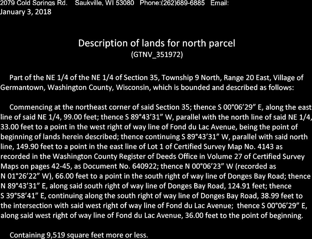

93

94

95


96
97 ORDINANCE NO AN ORDINANCE TO AMEND THE OFFICIAL ZONING MAP OF THE VILLAGE OF GERMANTOWN ZONING CODE ( Kuhburg District, Victory Center LLC, Property Owner) THE VILLAGE BOARD OF THE VILLAGE OF GERMANTOWN, WASHINGTON COUNTY, WISCONSIN, ORDAINS AS FOLLOWS: SECTION 1. That the Zoning Code and zoning map of the Village of Germantown is amended by the creation of a B-3: General Business Planned Development District (B- 3/PDD) to be known as the Kuhburg District which shall include the following described properties: Parcel #1 (north): W140 N10393 Fond du Lac Avenue (Tax Key # ) Part of the NE 1/4 of the NE 1/4 of Section 35, Township 9 North, Range 20 East, Village of Germantown, Washington County, Wisconsin, which is bounded and described as follows: Commencing at the northeast corner of said Section 35; thence S 00 06'29" E, along the east line of said NE 1/4, feet; thence S 89 43'31" W, parallel with the north line of said NE 1/4, feet to a point in the west right of way line of Fond du Lac Avenue, being the point of beginning of lands herein described; thence continuing S 89 43'31" W, parallel with said north line, feet to a point in the east line of Lot 1of Certified Survey Map No as recorded in the Washington County Register of Deeds Office in Volume 27 of Certified Survey Maps on pages 42-45, as Document No ; thence N 00 06'23" W (recorded as N 01 26'22" W), feet to a point in the south right of way line of Donges Bay Road; thence N 89 43'31" E, along said south right of way line of Donges Bay Road, feet; thence S 39 58'41" E, continuing along the south right of way line of Donges Bay Road, feet to the intersection with said west right of way line of Fond du Lac Avenue; thence S 00 06'29" E, along said west right of way line of Fond du Lac Avenue, feet to the point of beginning. Containing 8,799 sqft more or less. Parcel #2 (south): W140 N10385 Fond du Lac Avenue (Tax Key # ) Part of the NE 1/4 of the NE 1/4 of Section 35,Township 9 North, Range 20 East, Village of Germantown, Washington County, Wisconsin, which is bounded and described as follows: Commencing at the northeast corner of said Section 35;thence S 00 06'29" E, along the east line of said NE 1/4, feet; thence S 89 43'31" W, parallel with the north line of said NE 1/4,33.00 feet to a point in the west right of way line of Fond du Lac Avenue, being the point of beginning of lands herein described; thence S 00 06'29" E, along said west right of way line of Fond du Lac Avenue, feet; thence S 89 43'31" W, parallel with said north line of the NE 1/4, feet to a point in the east line of Lot 1 of Certified Survey Map No as recorded in the Washington County Register of Deeds Office in Volume 27 of Certified Survey Maps on pages 42-45, as Document No ; thence N 00 06'23" W (recorded as N 01 26'22" W), feet;thence N 89 43'31" E, parallel with said north line of the NE 1/4, feet to the point of beginning. Containing 9,590 sqft more or less.
98 SECTION 2. This ordinance shall take effect and be in full force the day after its passage and publication, as provided by law. Introduced by Trustee: Adopted:, 2018 Vote: Ayes: Nays: ATTEST: Deanna Boldrey, Village Clerk Dean Wolter, Village President APPROVED AS TO FORM: Brian Sajdak, Attorney Published:
99 RESOLUTION NO. R ADOPTING CONDITIONS AND RESTRICTIONS FOR THE KUHBURG DISTRICT PLANNED DEVELOPMENT DISTRICT ( KUHBURG DISTRICT PDD ) WHEREAS, Victory Center LLC, property owner (hereinafter the Developer ) has applied for a B-3: General Business Planned Development District (B-3/PDD) to be applied to the subject parcels located in the Village of Germantown as generally described in Exhibit A attached hereto; and WHEREAS, Section 17.27(4) of the Village of Germantown Municipal Code allows for the adoption of conditions and restrictions for Planned Development Districts (PDD) that modify the basic allowances, limitations, and bulk regulations of the underlying zoning district, as well as, allow for the establishment of specific uses, bulk regulations, density standards, yard setbacks, etc. to ensure proper development, operation and maintenance of the proposed development in the General Development Plan; and WHEREAS, the Village of Germantown Plan Commission on February 26, 2018, reviewed the B-3/PDD rezoning application and forwarded a positive recommendation regarding both the rezoning and General Development Plan to the Village Board; NOW, THEREFORE BE IT RESOLVED that the Village Bard of the Village of Germantown hereby adopts the following specific conditions and restrictions that shall apply to all development on and the use of property within the PDD: 1. PURPOSE AND INTENT. The Kuhburg District PDD is intended to provide for the orderly and attractive re-development and operation of commercial retail uses where such activities are conducted within the two existing buildings located at the Donges Bay Fond du Lac Ave/STH145 intersection, including a vacant school house and 2-story tavern. The Kuhburg District PDD will be comprised of a 1-story coffee shop building and a 2-story restaurant building connected by a covered/screened portico providing seasonal seating for patrons of the coffee shop and restaurant operations. The re-development is intended to be compatible with adjacent and surrounding residential development and enhance the economic stability and quality of life in the Village of Germantown. 2. GENERAL DEVELOPMENT PLAN (GDP). The General Development Plan (Exhibit B on Sheet GD100 dated February 23, 2018) establishes the basic parameters for development within the Kuhburg District PDD including the approximate size and orientation of buildings, density of development, setbacks, location of access roadways and driveways, and the general location and extent of landscaping and buffering. While all re-development within the PDD shall be generally consistent with the GDP, the GDP does not grant specific site development or building approval. Proposed modifications and/or revisions to the GDP shall be reviewed consistent with Section 17.27(9) of the Zoning Code.
100 Victory Center LLC Kuhburg District Planned Development District (PDD) Resolution No. Rxx-18 Adopted March 5, 2018 Page 2 of 6 3. PERMITTED LAND USES. Permitted Principal, Accessory, Conditional and Temporary Uses allowed within the Kuhburg District PDD shall be as set forth in Section of the Zoning Code. 4. SITE PLAN APPROVAL REQUIRED. a. Consistent with the requirements of Section 17.27(5) through (7), all development within the Kuhburg District PDD shall be subject of detailed site development and building plans submitted for review and approval by the Plan Commission in accordance with the requirements and procedures in Section prior to issuance of a building permit. Unless otherwise amended by the Plan Commission, development shall be consistent with the site development and building plans approved by the Plan Commission on February 26, 2018, including the plans dated January 8, 2018 (including Sheets GI001, C101, E001, E002, E003, A101, A102, A103, A300 and A700), February 20, 2018 (including Sheets C102, C103, C104, AS100, AS101, A200, A201), and Sheet L100 (Planting Plan) dated February 16, b. Separate Site Plan review and approval by the Plan Commission is required for any additional or expanded parking lot improvements. 5. LANDSCAPING & BUFFER PLAN REQUIRED. The Developer shall install additional landscaping along the north side of the property. The Developer should work with the Village Public Works Department and/or WisDOT to investigate the possibility of obtaining an easement for landscaping materials to be located in the right-of-way adjacent to the property and submit a revised plan for staff review and approval (if determined to be feasible). As an alternative, if landscaping cannot be installed in the ROW, the Developer should remove the two northernmost parking stalls on either side of the driveway entrance and replace them with landscaping if/when additional parking is constructed along the south side of the property in the future. A revised or supplemental landscaping plan shall be submitted to the Village Planner for review and approval prior to installation of additional landscaping not already subject of an approved landscape plan. 6. ACCESS. Access to development within the Kuhburg District PDD shall be to/from Donges Bay Road and Fond du Lac Avenue as shown on GDP.
101 Victory Center LLC Kuhburg District Planned Development District (PDD) Resolution No. Rxx-18 Adopted March 5, 2018 Page 3 of 6 7. SITE DEVELOPMENT AND BUILDING REQUIREMENTS. Unless otherwise set forth below, all site development and building shall be in accordance with the lot, building and other applicable bulk requirements set forth in the underlying B-3: General Business Zoning District and other applicable Zoning Code regulations. a. LOT AND BUILDING REQUIREMENTS i. Lot Area (minimum) 0 acres ii. Principal Building Setbacks (minimum) 1. Front/Street yard 0 feet iii. Parking Setbacks (minimum) 1. Front/Street yard 0 feet 2. Side yard 0 feet 3. Rear yard 0 feet 8. PARKING. (see Section 17.45). a. Setback Buffer (minimum) 0 sqft b. Loading zones to be combined with parking lot aisle area c. Stall Number (minimum) to be determined; discretion of developer based on actual stall count achievable; off-site parking can satisfy onsite parking demand subject to requirements under Section 17.45(5) of the Zoning Code. 9. BUILDING MATERIALS. The development sites and buildings will be designed, located and constructed with a consistent architectural theme, high-quality materials, landscaping, and in a manner that protects and preserves the existing environmental features consistent with current buildings located on the same site. 10. WASTE AND RECYCLING FACILITIES & ENCLOSURES. All waste and recycling dumpsters shall be screened from all residential areas, public rights-of-way or adjacent properties. 11. EXTERIOR LIGHTING. The Developer shall be responsible for making any necessary adjustments, including supplemental shielding or fixture replacement, to the exterior polemounted light fixtures after installation to eliminate any glare or view of the light source affecting the residential neighbor to the west. The Developer shall contact and coordinate with said neighbor to resolve any complaints or issues with said lights impacting the residential property. 12. SIGNAGE. a. One (1) monument sign shall be permitted to be installed along Donges Bay Road as shown on the GDP. Two (2) monument signs shall be permitted to be installed along Fond du Lac Avenue/STH145. As shown on the GDP. All signs shall comply and be approved in accordance with the Village s sign regulations and reviewed and
102 Victory Center LLC Kuhburg District Planned Development District (PDD) Resolution No. Rxx-18 Adopted March 5, 2018 Page 4 of 6 approved by the Plan Commission. b. The minimum setback for all signs shall be 0 feet from the nearest point of the sign or sign mounting structure; no part of any sign shall extend into or over a public right-of-way or utility easement. c. Other signage, e.g. temporary signs, wall signs, etc. may be approved for each business operation consistent with the Village s sign regulations. 13. APPLICABILITY OF MUNICIPAL CODE. Unless otherwise set forth herein, all other applicable zoning and development regulations contained in the Germantown Municipal Code (e.g. Shoreland-Wetland Zoning, Floodplain Zoning, Subdivision) shall apply to development and land use within the SC-PDD. In the event a requirement, restriction or limitation set forth herein conflicts with a similar requirement, restriction or limitation found in another section of the Municipal Code, the most stringent requirement, restriction or limitation shall apply. 14. PARCEL COMBINATION REQUIRED. A certified survey map (CSM) land combination shall be completed and approved to combine the two subject parcels and adjust the property line along the west boundary prior to issuance of any building permit(s) for building renovation. The CSM will need to include the parcels affected, including the residential parcel to the west. In the future, a CSM land combination may also be required to add additional land to the Kuhburg District for additional parking. 15. PARKING LOT/PDD BOUNDARY EXPANSION. At the time the Kuhburg District was created, the Developer presented two alternatives for providing additional parking to the south; both alternatives requiring the acquisition of additional land not included in the original Kuhburg District. Consequently, the Kuhburg District PDD boundary will need to be expanded in the future if the Developer acquires additional land to accommodate an expanded parking area. Said PDD boundary expansion shall be processed as a separate PDD application in accordance with all requirements and procedures at that time Introduced by: Adopted:, 2018 Vote: Ayes: Nays: Dean Wolter, Village President ATTEST:, Village Clerk EXHIBIT A
103 Victory Center LLC Kuhburg District Planned Development District (PDD) Resolution No. Rxx-18 Adopted March 5, 2018 Page 5 of 6 Kuhburg District Planned Development District (PDD) Boundary Legal Description Parcel #1 (north): W140 N10393 Fond du Lac Avenue (Tax Key # ) Part of the NE 1/4 of the NE 1/4 of Section 35, Township 9 North, Range 20 East, Village of Germantown, Washington County, Wisconsin, which is bounded and described as follows: Commencing at the northeast corner of said Section 35; thence S 00 06'29" E, along the east line of said NE 1/4, feet; thence S 89 43'31" W, parallel with the north line of said NE 1/4, feet to a point in the west right of way line of Fond du Lac Avenue, being the point of beginning of lands herein described; thence continuing S 89 43'31" W, parallel with said north line, feet to a point in the east line of Lot 1of Certified Survey Map No as recorded in the Washington County Register of Deeds Office in Volume 27 of Certified Survey Maps on pages 42-45, as Document No ; thence N 00 06'23" W (recorded as N 01 26'22" W), feet to a point in the south right of way line of Donges Bay Road; thence N 89 43'31" E, along said south right of way line of Donges Bay Road, feet; thence S 39 58'41" E, continuing along the south right of way line of Donges Bay Road, feet to the intersection with said west right of way line of Fond du Lac Avenue; thence S 00 06'29" E, along said west right of way line of Fond du Lac Avenue, feet to the point of beginning. Containing 8,799 sqft more or less. Parcel #2 (south): W140 N10385 Fond du Lac Avenue (Tax Key # ) Part of the NE 1/4 of the NE 1/4 of Section 35, Township 9 North, Range 20 East, Village of Germantown, Washington County, Wisconsin, which is bounded and described as follows: Commencing at the northeast corner of said Section 35;thence S 00 06'29" E, along the east line of said NE 1/4, feet; thence S 89 43'31" W, parallel with the north line of said NE 1/4,33.00 feet to a point in the west right of way line of Fond du Lac Avenue, being the point of beginning of lands herein described; thence S 00 06'29" E, along said west right of way line of Fond du Lac Avenue, feet; thence S 89 43'31" W, parallel with said north line of the NE 1/4, feet to a point in the east line of Lot 1 of Certified Survey Map No as recorded in the Washington County Register of Deeds Office in Volume 27 of Certified Survey Maps on pages 42-45, as Document No ; thence N 00 06'23" W (recorded as N 01 26'22" W), feet; thence N 89 43'31" E, parallel with said north line of the NE 1/4, feet to the point of beginning. Containing 9,590 sqft more or less.
104 Victory Center LLC Kuhburg District Planned Development District (PDD) Resolution No. Rxx-18 Adopted March 5, 2018 Page 6 of 6 EXHIBIT B Kuhburg District Planned Development District (PDD) General Development Plan {Attach General Development Plan Dated February 23, 2018}

105
106 BUSINESS OF THE VILLAGE BOARD GERMANTOWN, WI MEETING DATE: March 5, 2018 AGENDA ITEM: New Business (CERTIFIED SURVEY MAP) ITEM TITLE: SUBMITTED BY: Zoromski Construction LLC, Agent for M&J Donges Bay LLC, Property Owner, N104 W15825 Donges Bay Road; 2-lot Certified Survey Map (CSM) Jeffrey W. Retzlaff, Director, Community Development Department SUMMARY EXPLANATION: M&J Donges Bay LLC is the owner.73-acre residential parcel located on Donges Bay Road at Mohawk Drive. They are requesting approval of a 2-lot Certified Survey Map (CSM) to divide the property into two equal-sized parcels for purposes of redeveloping one residential property into two. ATTACHMENTS: 2/26/18 Staff Report 2/26/18 Plan Commission Meeting Minutes Preliminary CSM PLAN COMMISSION RECOMMENDATIONS: APPROVE the 2-lot Certified Survey Map (CSM) as proposed with (4) conditions.


107 CERTIFIED SURVEY MAP (CSM) APPLICATION 2/26/18 Plan Commission Meeting M & J Donges Bay LLC / Zoromski Construction LLC Village Planner Report Germantown, Wisconsin Summary Zoromski Construction LLC, agent for M & J Donges Bay LLC, property owner of a.73- acre parcel on Donges Bay Road is seeking approval of a 2-lot Certified Survey Map (CSM) to divide the parcel into two (2) parcels for single-family residential redevelopment. Location: N144 W15825 Donges Bay Road (east of Mohawk Drive) Applicant/ Property Owner: Robert Zoromski M&J Donges Bay LLC Zoromski Const LLC W149 N9977 Still Water Ct 1350 Sunnydale Circle Germantown, WI West Bend, WI Current Zoning District: Rs-5: Single-Family Adjacent Land Uses Zoning North Residential Rs-6 South Residential Rs-4 East Residential Rs-3 West Residential Rs-5 Location Map
108 Certified Survey Map M&J Donges Bay LLC Page 2 of 3 Proposal Zoromski Construction LLC, agent for M & J Donges Bay LLC, property owner of a.73- acre parcel on Donges Bay Road is seeking approval of a 2-lot Certified Survey Map (CSM) to divide the parcel into two (2) parcels for single-family residential redevelopment. As indicated in the Applicants January 29 letter, the owners intend to demolish the existing, vacant dwelling and construct two (2) new dwellings. Staff Comments Consistency with the Rs-4 Zoning District & Village s 2020 Land Use Plan. The Land Use Plan map classifies this property as Low Density Residential (maximum 2 dwellings per acre and minimum 20,000 sqft lots). However, the existing zoning is Rs- 5 (maximum 2.9 dwellings per acre and minimum 15,000 sqft lots). While not necessarily consistent with the Low Density Residential LUP map classification, both proposed parcels are consistent with the existing Rs-5 Zoning District regulations. The Engineering Department has identified issues concerning access and utilities that are significant and, while not necessarily an issue affecting the proposed land division, will affect development on the two parcels being created (see February 22 memo; copy attached). First, the existing access driveway to Donges Bay Road will be allowed to be used for access to Lot 2; however, access to Lot 1 is being restricted to Mohawk Drive. Any access driveway to Lot 1 is also required to be located not less than fifty (50) feet south of the northwest corner of the Lot 1 parcel along Mohawk south of Donges Bay Road. Second, the extension of water and sewer laterals to Lot 2 is somewhat complicated. As indicated in the February 22 memo, the existing water and sewer laterals may be reused to serve Lot 1 (under certain conditions). For Lot 2, a new water lateral could be installed from either Donges Bay Road or Mohawk Drive. If water is extended from Mohawk Drive and across Lot 1, an easement across Lot 1 will be required. A new sewer lateral serving Lot 2 is required from the existing service in Mohawk Drive, but would also require an easement across Lot 1, or, if that s not feasible, the existing sewer in Mohawk Drive would have to be extended further north to the right-of-way for Donges Bay Road with a new sewer lateral extended in the ROW to the east to the frontage of Lot 2. A note should be added to the CSM indicating that the extension of both water and sewer service to Lot 1 and Lot 2 will be at the owner s expense and subject to review and approval by the Public Works Department. The Village Surveyor has also identified a number of technical corrections in a February 6, 2018 memo (copy attached) that will have to be corrected prior to recording of the CSM.
109 Certified Survey Map M&J Donges Bay LLC Page 3 of 3 Village Planner Recommendation APPROVE the 2-lot Certified Survey Map land division for the.73-acre M & J Donges Bay LLC property located on Donges Bay Road subject to the following conditions: 1. All technical corrections identified by the Village Surveyor as summarized in the February 6, 2018 memo shall be made prior to recording the CSM by the Village Board. 2. A note shall be added to the CSM indicating that access to Lot 1 is restricted to Mohawk Drive with the nearest point of a driveway located not less than fifty (50) feet south of the northwest corner of Lot 1 along Mohawk Drive. 3. A note shall be added to the CSM indicating that access to Lot 2 is restricted to the existing access driveway location on Donges Bay Road. 4. A note shall be added to the CSM indicating that the extension of water and sewer service to Lot 1 and Lot 2 will be at the owner s expense and subject to the requirements of and approval by the Public Works Department, and, a plan for extending water and sewer services to both Lot 1 and Lot 2 shall be prepared by the Applicant and submitted for review and approval to the Public Works Department prior to issuance of a building permit for new construction on either lot. If service is extended across Lot 1, an easement shall be granted to Lot 2 prior to issuance of a building permit for new construction on either lot.
110 To: Jeff Retzlaff Village Planner CC: From: Bob Beilfuss, PLS, Village Surveyor Date: February 6, 2018 Engineering Department Memorandum Re: M&J Donges Bay LLC CSM Jeff, Here are my review comments for the Concept CSM received Certified Survey Map-Rezoning-PDD Applicant or Owner: M&J Donges Bay LLC Land Surveyor/Firm: Rick Hillmann, PLS, Continental Surveying Services LLC 1. A driveway permit for the new entrance is required. 2. Proposed Lot 2 not currently served with either sanitary or water main laterals. There is a sanitary sewer main and water and water main located in Mohawk Drive. Extension of these two utilities to serve proposed Lot 2 would have to be by extending the main lines or thru an easement across proposed Lot 1. If the easement method is used, then the location of the easement needs to be shown on the map sheet and terms and conditions need to be included for the use of the easement. 3. No private utility easements on this property have been shown. 4. Grid Bearing basis is incorrect. The bearing of the north line of the NE ¼ of Section 34 is North East. All bearings on Sheet 1 and in the legal description in the Surveyor s Certificate need to be adjusted. 5. Coordinates (NAD 1927 Grid) are missing for the point of commencement monument. 6. Bearings of the exterior boundary lines on Sheet 1 do not coincide with the legal description in the Surveyor s Certificate. 7. Building setback lines for current zoning are missing and need to be mapped, dimensioned and date stamped.. 8. Legend incomplete. Section corner monument symbol missing. 9. Monument type for section corners missing. C:\Users\lori\AppData\Local\Microsoft\Windows\INetCache\Content.Outlook\QKXPICD6\Zoromski-Hillmann CSM.doc02\m&j donge llc-hillmann csm.docx
111 February 6, Owner s name address and telephone number missing. 11. Drive access to proposed Lot 1 is restricted to Mohawk Drive No further review comments. Document Submittals and Data Conversion As of October 2005, the Village of Germantown requires a digital copy of all Certified Survey Maps, Condominium Plats and Subdivision Plats in addition to the documents as required by Wisconsin Statute and Village Ordinances as part of the land division approval. Prior to Recording the Certified Survey Map, the professional land surveyor is responsible for submitting a copy of the AutoCad drawing file (.dwg) of the document in version 2016 on compact disk (CD) or via to the Village Surveyor. All digital professional land surveyor seals and signatures will be purged from the digital copy prior to submittal. The model space of the drawing will be done in Wisconsin State Plane Coordinate System, South Zone (NAD 1927 datum) and the Grid Bearing basis. Prior to Recording the Certified Survey Map, the Village Engineering Department will verify that the boundary markers have been installed as described on the submitted map. All boundary corners are to be clearly marked in the field by the professional land surveyor of record. 2
112 Engineering Department Memorandum To : Jeff Retzlaff From : Larry Ratayczak, P.E. Date : February 22, 2018 Re : Review of Zoromski Construction Submittal-N104 W15825 Donges Bay Rd. The Engineering Department has reviewed the documents submitted for the above referenced location and offers the following comments: 1) Proposed Lot #1 driveway to be onto Mohawk Drive no access onto Donges Bay Rd to be permitted. In addition, said driveway onto Mohawk Dr. shall be a minimum of 50 feet south of the NW property corner 2) Water Service s; Lot #1 shall have access from the water main on Mohawk Dr. If Lot #1 has a new home set to be built in the same year of razing, the existing water lateral should be determined if it can handle the GPM needed to satisfy its demand, if it can the Water Utility would approve using it but the lateral would need to be relayed from and including the curb stop to the proposed home. If the existing curb stop is in working order, then it can be used.; Lot #2 can access water main on Donges Bay Rd. ( no open cut construction allowed across Donges Bay Rd.) or from Mohawk Dr. which would most likely require an easement across Lot #1. 3) Sanitary Lateral s: Lot #1 can utilize the existing lateral; Lot #2 will not be allowed to connect directly into the interceptor sewer on Donges Bay Rd and must connect into the sanitary sewer on Mohawk Dr. This would most likely require an easement across Lot #1 or possibly extension of the sanitary main on Mohawk Dr. Respectfully submitted: Lawrence Ratayczak, P.E. Director of Public Works Rd.docx C:\Users\lori\AppData\Local\Microsoft\Windows\INetCache\Content.Outlook\QKXPICD6\Memo- review of Lot's #1 2_ Mohawk Donges Bay

113
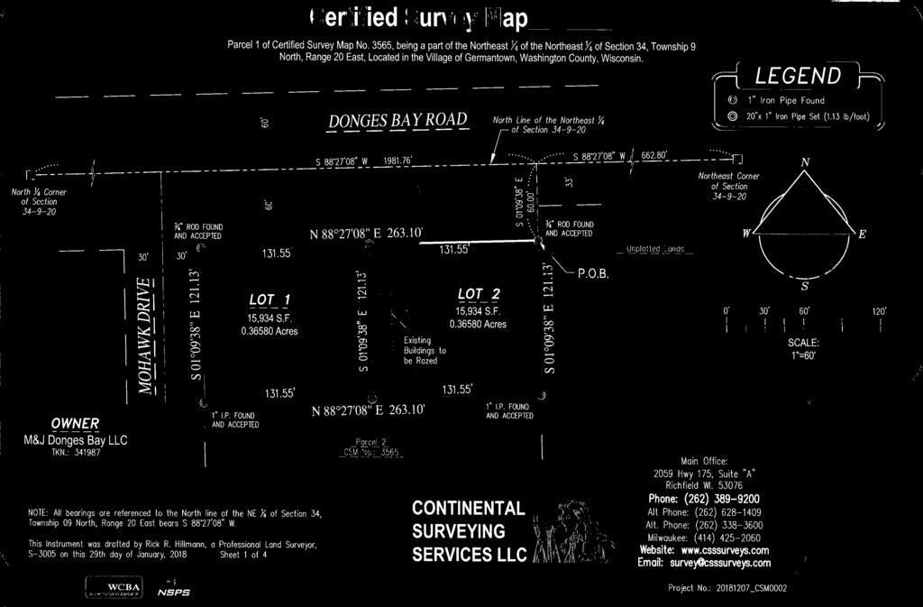
114


115

116

117
118 PLAN COMMISSION MINUTES February 26, 2018 CALL TO ORDER: Chairman Wolter called the meeting to order at 6:30 p.m. ROLL CALL: Chairman Dean Wolter, Trustee Rep David Baum, Commissioners Bob Williams, Peter Nilles, Tony Laszewski, Bill Shadid and Mary Ellen Gray were present. Also present were Community Development Director/Village Planner Jeff Retzlaff and Planning Assistant Lori Johnson. PUBLIC INPUT: Bruce Bernarde, N120 W13645 Freistadt Road, APPROVAL OF MINUTES: MOTION Baum second Gray to Approve the minutes from February 12, MOTION carried unanimously. Zoromski Construction LLC, agent for M&J Donges Bay LLC, property owner N144 W15825 Donges Bay Road. The request is for approval of a 2-lotCertified Survey Map (CSM) to divide the parcel into two (2) lots for single-family residential development. Planner Retzlaff summarized the proposal. MOTION Baum second Laszewski to Approve the 2-lot Certified Survey Map land division for the.73-acre M & J Donges Bay LLC property located on Donges Bay Road subject to the following conditions: 1. All technical corrections identified by the Village Surveyor as summarized in the February 6, 2018 memo shall be made prior to recording the CSM by the Village Board. 2. A note shall be added to the CSM indicating that access to Lot 1 is restricted to Mohawk Drive with the nearest point of a driveway located not less than fifty (50) feet south of the northwest corner of Lot 1 along Mohawk Drive. 3. A note shall be added to the CSM indicating that access to Lot 2 is restricted to the existing access driveway location on Donges Bay Road. 4. A note shall be added to the CSM indicating that the extension of water and sewer service to Lot 1 and Lot 2 will be at the owner s expense and subject to the requirements of and approval by the Public Works Department, and, a plan for extending water and sewer services to both Lot 1 and Lot 2 shall be prepared by the Applicant and submitted for review and approval to the Public Works Department prior to issuance of a building permit for new construction on either lot. If service is extended across Lot 1, an easement shall be granted to Lot 2 prior to issuance of a building permit for new construction on either lot. MOTION carried unanimously.
119 BUSINESS OF THE VILLAGE BOARD GERMANTOWN, WI MEETING DATE: March 5, 2018 AGENDA ITEM: New Business (CERTIFIED SURVEY MAP) ITEM TITLE: SUBMITTED BY: Quarles & Brady LLP, Agent for SMV Germantown LLC, Property Owner, W173 N10915 Bernies Way; 2-lot Certified Survey Map (CSM) Jeffrey W. Retzlaff, Director, Community Development Department SUMMARY EXPLANATION: SMV Germantown LLC is the owner of the Virginia Highlands skilled nursing facility and 15.6-acre property. They are requesting approval of a 2-lot Certified Survey Map (CSM) to divide the 15.6-acre property into two parcels to detach the undeveloped land east of the nursing facility. As discussed before the Plan Commission by the owner s agent, Quarles & Brady LLP, the purpose for dividing the property is to facilitate refinancing of the property. No specific development proposal is being presented at this time. As discussed in the staff report, dividing the land will not affect the requirement that the undeveloped parcel (Lot 2 on the CSM) develop under the current Elderly Housing (EH) District general development plan adopted in 1997 (unless that plan is amended by the Village). ATTACHMENTS: 2/26/18 Staff Report 2/26/18 Plan Commission Meeting Minutes Preliminary CSM PLAN COMMISSION RECOMMENDATIONS: APPROVE the 2-lot Certified Survey Map (CSM) as proposed with (3) conditions.
 land division to divide their 15.")
120 CERTIFIED SURVEY MAP (CSM) APPLICATION 2/26/18 Plan Commission Meeting SMV Germantown LLC / SMV Management Company LLC Village Planner Report Germantown, Wisconsin Summary Quarles & Brady LLP, agent for the SMV Germantown LLC and SMV Management Company LLC, property owner, is requesting approval of a 2-lot Certified Survey Map (CSM) land division to divide their 15.6-acre Virginia Highlands property located on Virginia Division Road. Property Location: Virginia Division Road Owner/Applicant: Quarles & Brady LLP SMV Mgmt Company LLC 411 East Wisconsin Ave 45 Broadway Suite 520 Milwaukee, WI New York, NY Current Zoning: EH: Elderly Housing Adjacent Land Uses Zoning North Residential Rs-2 South Residential Rs-4 East EH EH West EH (Virginia Highlands) EH/Rs-1 Location Map
121 CSM SMV Germantown LLC Page 2 of 4 Background In 1995, Dennis Wilm, agent for the Bernard Wilm Family Trust, and (then) owner of the 15.6-acre parcel located at the Virginia Division Road intersection, approached the Village with a proposal to develop a new senior residential campus on the property. In cooperation with Heartland Retirement Services Inc., the Virginia Highlands Senior Community was proposed with a mix of uses, including a nursing home, Wovenheart community-based residential facilities (CBRF), independent senior apartments and fourplex independent senior condominiums. After considerable discussion about how such a development might fit within the framework of the Village s Zoning Code, an application to rezone the property into a Planned Development District (PDD) with an underlying Rm-3: Multi-family Zoning District was discussed but eventually tabled pending the creation of a new zoning district specifically designed to accommodate this type of senior housing development. In the fall of 1995, the Village developed and adopted the EH: Elderly Housing Zoning District. In November 1995, an amended rezoning application for the 15.6-acre parcel was approved and the property rezoned into the first EH District in the Village. As required under the EH District regulations, at the time of rezoning a general development plan was adopted for the EH District. The code requires that specific, detailed site plans be submitted prior to actual development for Plan Commission review and approval prior to commencing construction and issuing building permits. The code requires the site plans to conform substantially to the general development plan in order to be approved. After rezoning and general development plan approval in 1995, the general development plan was revised as the proposal moved from the original senior community concept to actual development. In 1997, the Village approved conditional use permits for a 121-bed nursing home (the existing Virginia Highlands skilled nursing facility) and a 56-unit CBRF and daycare facility (never constructed). The latest and most current general development plan was also approved in late 1997 (see copy attached dated December 22, 1997). The current general development plan for the Virginia Highlands EH District includes: 121-bed skilled nursing facility (existing) 56-unit CBRF & adult daycare (never constructed) 56-unit independent senior apartments (never constructed) In early 2017, SMV Management Company LLC & Tarantino & Company LLC, proposed revisions to the current EH general development plan that included dividing the 15.6-acre property into a separate 6.25-acre parcel containing the Virginia Highlands skilled nursing facility, and, developing the remaining 9.4 acre parcel with a 128-unit senior care complex comprised of 56 independent senior living apartments, 48 RCAC assisted living units, and a 26-unit memory care CBRF facility. Ultimately, the Village Board denied the conditional use permit (CUP) that was needed for the CBRF component and the applicant withdrew the application EH amendment application.
122 CSM SMV Germantown LLC Page 3 of 4 Proposal At this time, SMV Germantown LLC and SMV Management Company LLC, property owner of the 15.6-acre property, is requesting approval of a 2-lot Certified Survey Map (CSM) land division to divide the 15.6-acre property as was originally proposed (No EH general development plan or other application for any specific development has been submitted at this time). Staff Comments The Village's EH: Elderly Housing Zoning District is intended to function like a "planned development district" in that it provides for a variety of residential, commercial, and institutional uses within an overall district (vs. per parcel). The current general development plan for the 15.6-acre property and entire EH District is the only plan to which development of Lot 2 can be developed unless the property owner(s) submit an application to amend the general development plan to and approved by the Village. The current owner must understand this and reveal that requirement to any prospective purchasers of Lot 2. To that end, staff recommends adding a note to the CSM that indicates the development of Lot 2 must be consistent with the adopted Virginia Highlands EH District General Development Plan and comply with all applicable requirements, allowances and limitations of the EH Zoning District. Another issue that needs to be addressed through the CSM is an existing storm water management basin located on the south side of the property on what will be Lot 2. Currently, the Virginia Highlands skilled nursing facility has storm sewer that collects run-off from what will be Lot 1 and conveys it to the basin on Lot 2. That basin was originally constructed and sized to handle additional run-off from the planned (but never constructed senior housing development on what is proposed as Lot 2. While it remains to be seen if this basin will meet all future storm water management regulations that will apply to future development, or, if future development alters the location and manner in which storm water run-off is collected, treated and released from Lot 1 and Lot 2, the fact remains that some sort of easement agreement between the owners of Lot 1 and Lot 2 is required to address the existing basin and run-off from Lot 1 to Lot 2 (assuming the CSM is approved). Consequently, staff recommends adding a separate note to the CSM that addresses the need for a storm water easement & maintenance agreement. Public Works/Engineering The Village Surveyor has identified a few technical corrections in a February 6, 2018 memo (copy attached) that will have to be addressed and/or corrected prior to recording the CSM.
123 CSM SMV Germantown LLC Page 4 of 4 Village Planner Recommendation APPROVE the 2-lot Certified Survey Map land division for the 15.6-acre property owned by SMV Germantown LLC subject to the following conditions: 1. All technical corrections and issues raised by the Village Surveyor in the February 6, 2018 memo shall be addressed and/or corrected prior to recording the CSM. 2. A note shall be added to the CSM indicating that Development of Lot 2 shall be consistent with the adopted Virginia Highlands EH Zoning District General Development Plan and comply with all applicable requirements, allowances and limitations of the Village s EH Zoning District. 3. A note shall be added to the CSM indicating that a storm water easement & maintenance agreement to be recorded along with the CSM shall be submitted to the Village for review and approval prior to recording the CSM.
124 To: Jeff Retzlaff Village Planner CC: From: Bob Beilfuss, PLS, Village Surveyor Date: February 6, 2018 Engineering Department Memorandum Re: SMV Germantown LLC CSM Jeff, Here are my review comments for the CSM received Certified Survey Map Applicant or Owner: SMV Germantown LLC Land Surveyor/Firm: David Cheney, PLS, Sarko Engineering Inc. 1. Building setback lines for current zoning are missing. Due to the variable uses allowed for the EH district, this requirement is waived. 2. The secretary s name in the Planning Commission certificate is Laura A. Johnson. 3. The Village Clerk s name has changed to Deanna L. Boldrey, WCMC/CMC in the Village of Germantown Board Approval certificate. 4. Prior to the land being split, the current facility was discharging all storm water to the detention pond. The proposed land division separates the contributing stormwater generator (buildings, parking lots and paved drives) on proposed Lot 1 from the detention pond located on proposed Lot 2. The current Stormwater Management plan needs to be revised to reflect the land division and that now the future owners of Lot 2 will need to share in the maintenance and upkeep of the detention pond. 5. The current detention pond is overgrown with brush and mature trees which need to be removed and the pond area restored to its design capacity. 6. The outline of the pond should be shown on Sheet 1 No further review comments. Document Submittals and Data Conversion C:\Users\lori\AppData\Local\Microsoft\Windows\INetCache\Content.Outlook\QKXPICD6\SMV Gtown-Cheney CSM.doc02\smv antown llc-cheney csm.docx
125 February 6, 2018 As of October 2005, the Village of Germantown requires a digital copy of all Certified Survey Maps, Condominium Plats and Subdivision Plats in addition to the documents as required by Wisconsin Statute and Village Ordinances as part of the land division approval. Prior to Recording the Certified Survey Map, the professional land surveyor is responsible for submitting a copy of the AutoCad drawing file (.dwg) of the document in version 2016 on compact disk (CD) or via to the Village Surveyor. All digital professional land surveyor seals and signatures will be purged from the digital copy prior to submittal. The model space of the drawing will be done in Wisconsin State Plane Coordinate System, South Zone (NAD 1927 datum) and the Grid Bearing basis. Prior to Recording the Certified Survey Map, the Village Engineering Department will verify that the boundary markers have been installed as described on the submitted map. All boundary corners are to be clearly marked in the field by the professional land surveyor of record. 2

126


127


128


129


130


131

132
PLAN COMMISSION MINUTES February 26, 2018
 PLAN COMMISSION MINUTES CALL TO ORDER: Chairman Wolter called the meeting to order at 6:30 p.m. ROLL CALL: Chairman Dean Wolter, Trustee Rep David Baum, Commissioners Bob Williams, Peter Nilles, Tony Laszewski,
CERTIFIED SURVEY MAPS
 Chapter 1 - INTRODUCTION CERTIFIED SURVEY MAPS Certified Survey Maps (CSMs) are one of the permitted methods of dividing land in the City of Muskego. CSMs are allowed when it is proposed to create four
Town of Onalaska. A scale map depicting the portion of Pineview Drive to be officially laid out as a Town highway is attached hereto as Exhibit A.
 Town of Onalaska Special Meeting Minutes for March 31, 2011 The Town Board met on site of the Pineview Road and County OT in Onalaska for the purpose of viewing the lay out of the road as required by law.
19.12 CLUSTER RESIDENTIAL DISTRICT
 Chapter 19.12 CLUSTER RESIDENTIAL DISTRICT (Adopted 12/22/2003; Ordinance #0061970). Amended 7/3/17, Ordinance #079100. Section 19.12.010 - Declaration of Intent. The Cluster Residential District provides
ARTICLE 15 - PLANNED UNIT DEVELOPMENT
 Section 15.1 - Intent. ARTICLE 15 - PLANNED UNIT DEVELOPMENT A PUD, or Planned Unit Development, is not a District per se, but rather a set of standards that may be applied to a development type. The Planned
VILLAGE OF GERMANTOWN N112 W17001 MEQUON ROAD GERMANTOWN, WI REGULAR MEETING OF THE VILLAGE BOARD. Germantown Village Hall Board Room
 VILLAGE OF GERMANTOWN N112 W17001 MEQUON ROAD GERMANTOWN, WI 53022 MEETING: REGULAR MEETING OF THE VILLAGE BOARD DATE AND TIME: MONDAY, April 1, 2019 7:00 p.m. LOCATION: Germantown Village Hall Board Room
Chapter 100 Planned Unit Development in Corvallis Urban Fringe
 100.100 Scope and Purpose. Chapter 100 Planned Unit Development in Corvallis Urban Fringe (1) All applications for land divisions in the Urban Residential (UR) and Flood Plain Agriculture (FPA) zones within
THE COUNTY BOARD OF SUPERVISORS OF THE COUNTY OF DOUGLAS DOES ORDAIN AS FOLLOWS:
 8.1 SUBDIVISION CONTROL ORDINANCE THE COUNTY BOARD OF SUPERVISORS OF THE COUNTY OF DOUGLAS DOES ORDAIN AS FOLLOWS: SECTION I. GENERAL INTERPRETATION This ordinance shall not repeal, impair or modify private
-MENDOCINO COUNTY PLANNING AND BUILDING SERVICES- DIVISION OF LAND REGULATIONS TITLE 17
 ARTICLE VI -- GENERAL REGULATIONS AND PROVISIONS Sec. 17-50. Sec. 17-51 General Plan. Sec. 17-52 Lot and Block Design and Configuration. Sec. 17-53 Lot Access. Sec. 17-54 Private Roads. Sec. 17-55 Water
Comprehensive Plan 2030
 Introduction The purpose of this chapter of the Comprehensive Plan is to accurately describe, in words and images, the goals and visions for the future of Clearfield, as determined by the people who live
Town of Prairie du Sac Sauk County, WI. Land Division Ordinance 07-3
 Town of Prairie du Sac Sauk County, WI Land Division Ordinance 07-3 1.01 DISCLAIMER (1) Multiple Jurisdictions. All persons reviewing the provisions of this Ordinance should be aware that the Town of Prairie
AN ORDINANCE TO AMEND SECTION OF THE RAPID CITY MUNICIPAL CODE TO ALLOW FOR ADMINISTRATIVE DISSOLUTION OF PLANNED DEVELOPMENTS
 Ordinance No. 6231 AN ORDINANCE TO AMEND SECTION 17.50.050 OF THE RAPID CITY MUNICIPAL CODE TO ALLOW FOR ADMINISTRATIVE DISSOLUTION OF PLANNED DEVELOPMENTS WHEREAS, the City of Rapid City has adopted a
ELK RAPIDS TOWNSHIP ANTRIM COUNTY, MICHIGAN ORDINANCE NO
 ELK RAPIDS TOWNSHIP ANTRIM COUNTY, MICHIGAN ORDINANCE NO. 3-2011 AN ORDINANCE TO REPLACE THE SUBDIVISION CONTROL ORDINANCE WITH A NEW SUBDIVISION DEVELOPMENT ORDINANCE, IN ACCORD WITH THE LAND DIVISION
I. Requirements for All Applications. C D W
 108-16.1. Application checklists. Checklist for Required Submissions to the Planning Board or Zoning Board of Adjustment of Monroe Township All required submissions are to be made to the Administrative
Staff Report: Date: Applicant: Property Identification: Acreage of Request: Current Zoning of Requested Area: Requested Action: Attached:
 Staff Report: Completed by Jeff Palmer Director of Planning & Zoning Date: November 7, 2018, Updated November 20, 2018 Applicant: Greg Smith, Oberer Land Developer agent for Ronald Montgomery ET AL Property
Chapter CLUSTER RESIDENTIAL DISTRICT (Adopted 12/22/2003; Ordinance # )
") Chapter 19.12 CLUSTER RESIDENTIAL DISTRICT (Adopted 12/22/2003; Ordinance #0061970) Section 19.12.010 - Declaration of Intent. The Cluster Residential District provides minimum standards for specified
Chapter 19.12 CLUSTER RESIDENTIAL DISTRICT (Adopted 12/22/2003; Ordinance #0061970) Section 19.12.010 - Declaration of Intent. The Cluster Residential District provides minimum standards for specified
PUD Ordinance - Cascade Lakes Plat #10 of 1995
 PUD Ordinance - Cascade Lakes Plat #10 of 1995 CASCADE CHARTER TOWNSHIP Ordinance #10 of 1995 AN ORDINANCE TO AMEND THE CASCADE CHARTER TOWNSHIP ZONING ORDINANCE AND ZONING MAP TO ESTABLISH THE CASCADE
Understanding the Conditional Use Process
 Understanding the Conditional Use Process The purpose of this document is to explain the process of applying for and obtaining a conditional use permit in the rural unincorporated towns of Dane County.
CLEARFIELD CITY COUNCIL AGENDA AND SUMMARY REPORT July 31, 2018 SPECIAL POLICY SESSION
 CLEARFIELD CITY COUNCIL AGENDA AND SUMMARY REPORT July 31, 2018 SPECIAL POLICY SESSION Meetings of the City Council of Clearfield City may be conducted via electronic means pursuant to Utah Code Ann. 52-4-207
DeWITT CHARTER TOWNSHIP 1401 W. HERBISON ROAD, DeWITT, MI PLANNING COMMISSION MINUTES MONDAY, MARCH 6, 2006
 DeWITT CHARTER TOWNSHIP 1401 W. HERBISON ROAD, DeWITT, MI PLANNING COMMISSION MINUTES MONDAY, MARCH 6, 2006 The regularly scheduled meeting of the DeWitt Charter Township Planning Commission was called
RESOLUTION NO CITY OF MAPLE GROVE
 RESOLUTION NO. 18-122 CITY OF MAPLE GROVE RESOLUTION GRANTING PLANNED UNIT DEVELOPMENT CONCEPT STAGE PLAN, PLANNED UNIT DEVELOPMENT - DEVELOPMENT STAGE PLAN, AND PRELIMINARY PLAT FOR TERRITORIAL GREENS
ARTICLE 24 PRIVATE ROAD, SHARED PRIVATE DRIVEWAY AND ACCESS EASEMENT STANDARDS
 ARTICLE 24 PRIVATE ROAD, SHARED PRIVATE DRIVEWAY AND ACCESS EASEMENT STANDARDS SECTION 24.00 INTENT AND PURPOSE The standards of this Article provide for the design, construction and maintenance of private
VILLAGE OF GERMANTOWN N112 W17001 MEQUON ROAD GERMANTOWN, WI REGULAR MEETING OF THE VILLAGE BOARD. Germantown Village Hall Board Room
 VILLAGE OF GERMANTOWN N112 W17001 MEQUON ROAD GERMANTOWN, WI 53022 MEETING: REGULAR MEETING OF THE VILLAGE BOARD DATE AND TIME: TUESDAY, January 22, 2019 7:00 p.m. LOCATION: Germantown Village Hall Board
Staff Report: Date: Applicant: Property Identification: Acreage of Request: Current Zoning of Requested Area: Requested Action: Attached:
 Staff Report: Completed by Jeff Palmer Director of Planning & Zoning Date: November 7, 2018 Applicant: Greg Smith, Oberer Land Developer agent for Ronald Montgomery ET AL Property Identification: Frontage
ADA TOWNSHIP PLANNING COMMISSION MINUTES OF THE MARCH 16, 2006 MEETING
 ADA TOWNSHIP PLANNING COMMISSION MINUTES OF THE MARCH 16, 2006 MEETING A regular meeting of the Ada Township Planning Commission was held on Thursday, March 16, 2006, at the Ada Township Offices, 7330
Salem Township Zoning Ordinance Page 50-1 ARTICLE 50.0: PUD PLANNED UNIT DEVELOPMENT
 Salem Township Zoning Ordinance Page 50-1 ARTICLE 50.0 PLANNED UNIT DEVELOPMENT Section 50.01 Purpose The provisions of this Article provide enabling authority and standards for the submission, review,
PLANNED UNIT DEVELOPMENT (PUD) AREA PLAN/REZONING REVIEW PROCEDURE
 AREA PLAN/REZONING REVIEW PROCEDURE") PLANNED UNIT DEVELOPMENT (PUD) AREA PLAN/REZONING REVIEW PROCEDURE Professional inquiries will be made to our Township Planning Consultant, Township Engineer, and Township Attorney to get their opinions
PLANNED UNIT DEVELOPMENT (PUD) AREA PLAN/REZONING REVIEW PROCEDURE Professional inquiries will be made to our Township Planning Consultant, Township Engineer, and Township Attorney to get their opinions
610 LAND DIVISIONS AND PROPERTY LINE ADJUSTMENTS OUTSIDE A UGB
 ARTICLE VI: LAND DIVISIONS AND PROPERTY LINE ADJUSTMENTS VI-21 610 LAND DIVISIONS AND PROPERTY LINE ADJUSTMENTS OUTSIDE A UGB 610-1 Property Line Adjustments (Property Line Relocation) A property line
Memorandum: October 13, 2008 REVISED To: Trowbridge Township Planning Commission From: P. Hudson, AICP Re: Suggested New Ordinance
 1 Memorandum: October 13, 2008 REVISED 2-11-09 To: Trowbridge Township Planning Commission From: P. Hudson, AICP Re: Suggested New Ordinance Because of changes in both the Michigan Planning Enabling Act
ZONING AMENDMENT, PLANNED UNIT DEVELOPMENT & SUBDIVISION STAFF REPORT Date: August 8, 2013
 ZONING AMENDMENT, PLANNED UNIT DEVELOPMENT & SUBDIVISION STAFF REPORT Date: August 8, 2013 NAME SUBDIVISION NAME PV-Magnolia, LLC Twelve Trees Subdivision LOCATION 2860, 2862 and 2866 Pleasant Valley Road
ARTICLE 23 CONDOMINIUM STANDARDS
 ARTICLE 23 CONDOMINIUM STANDARDS Section 23.01 Intent. The intent of this Article is to provide regulatory standards for condominiums and site condominiums similar to those required for projects developed
SUBJECT: Application for Planned Unit Development and Rezoning 1725 Winnetka Road
 TO: FROM: CHAIRMAN BILL VASELOPULOS AND MEMBERS OF THE PLAN & ZONING COMMISSION STEVE GUTIERREZ DIRECTOR OF COMMUNITY DEVELOPMENT MEETING DATE: September 5, 2017 SUBJECT: Application for Planned Unit Development
AGENDA. EDMOND PLANNING COMMISSION 20 S. Littler, Edmond, Oklahoma Tuesday, February 18, :30 p.m. CITY COUNCIL WORKSHOP
 City of Edmond NOTICE OF PUBLIC MEETING The City of Edmond encourages participation from all its citizens. If participation at any Public meeting is not possible due to a disability, notification to the
VILLAGE OF CHENEQUA CHENEQUA VILLAGE BOARD MINUTES OF MONDAY, NOVEMBER 12, 2018.
 VILLAGE OF CHENEQUA CHENEQUA VILLAGE BOARD MINUTES OF MONDAY, NOVEMBER 12, 2018. B) ApprOvUendoaffSicwiarll,utnetnil(7ofroWve,dhbCyortrheeC\liOlln ooanrd,,,,, A meeting of the Board of Trustees for the
APPENDIX C-1 DEVELOPING FINDINGS OF FACT & CONCLUSIONS OF LAW FOR PLANNING AND ZONING
 APPENDIX C-1 DEVELOPING FINDINGS OF FACT & CONCLUSIONS OF LAW FOR PLANNING AND ZONING Amended: 9/2011; 9/2014; Page! i DEVELOPING FINDINGS OF FACT, AND CONCLUSIONS OF LAW 1. Developing the following information
Ordinance Page 1
 ORDINANCE NO. 671 (AS AMENDED THROUGH 671.20) AN ORDINANCE OF THE COUNTY OF RIVERSIDE AMENDING ORDINANCE NO. 671 ESTABLISHING CONSOLIDATED FEES FOR LAND USE AND RELATED FUNCTIONS The Board of Supervisors
CHECKLIST FOR DEVELOPMENT REVIEW
 CHECKLIST FOR DEVELOPMENT REVIEW Petitions and related documents and plans for land development or other proposals regulated by Title 16 of the Municipal Code (Development Ordinance) and Title 17 of the
Planning Commission 16 February 4, 2014 EDMOND PLANNING COMMISSION MEETING. Tuesday, February 4, 2014
 Planning Commission 16 EDMOND PLANNING COMMISSION MEETING Tuesday, 5:30 P.M. The Edmond Planning Commission Meeting was called to order by Chairperson Barry K. Moore at 5:30 p.m., Tuesday,, in the City
PLANNING COMMISSION STAFF REPORT June 18, 2015
 Community Development Department Planning Division 1600 First Street + P.O. Box 660 Napa, CA 94559-0660 (707) 257-9530 PLANNING COMMISSION STAFF REPORT June 18, 2015 AGENDA ITEM 7.B. PL15-0052 PM, GASSER
RESOLUTION TO FORM THE REDSTONE PARKWAY BENEFIT DISTRICT
 Agenda Item No. 8A November 10, 2015 TO: FROM: SUBJECT: Honorable Mayor and City Council Attention: Laura C. Kuhn, City Manager Steven L. Hartwig, Director of Public Works/City Engineer RESOLUTION TO FORM
PLAN COMMISSION APPLICATION CITY OF MIDDLETON 7426 HUBBARD AVE. MIDDLETON, WI (608) FAX (608)
 FAX (608)") PLAN COMMISSION APPLICATION CITY OF MIDDLETON 7426 HUBBARD AVE. MIDDLETON, WI. 53562 (608) 821-8370 FAX (608) 827-1080 Plan Commission usually meets the 2 nd and 4 th Tuesdays of each month at 7 p.m. in
PLAN COMMISSION APPLICATION CITY OF MIDDLETON 7426 HUBBARD AVE. MIDDLETON, WI. 53562 (608) 821-8370 FAX (608) 827-1080 Plan Commission usually meets the 2 nd and 4 th Tuesdays of each month at 7 p.m. in
ORDINANCE N0.18-ll6. WHEREAS, City has prepared a Service Plan for said tract which is attached as Exhibit "A" to this ordinance; &
 c: 0 ORDINANCE N0.18-ll6 AN ORDINANCE ANNEXING THE HEREINAFTER DESCRIBED TERRITORY TO THE CITY OF FORT STOCKTON, PECOS COUNTY, TEXAS, AND EXTENDING THE BOUNDARY LIMITS OF SAID CITY SO AS TO INCLUDE SAID
STATE OF MICHIGAN COUNTY OF BERRIEN ORONOKO CHARTER TOWNSHIP PRIVATE ROAD ORDINANCE ORDINANCE NO. 65
 STATE OF MICHIGAN COUNTY OF BERRIEN ORONOKO CHARTER TOWNSHIP PRIVATE ROAD ORDINANCE ORDINANCE NO. 65 AN ORDINANCE TO REQUIRE THAT ALL LOTS OR PARCELS OF LAND WHICH DO NOT ABUT PUBLIC STREETS ABUT A PRIVATE
Town of Farmington 1000 County Road 8 Farmington, New York 14425
 Page 1 of 21 Town of Farmington Zoning Board of Appeals Meeting Minutes APPROVED December 18, 2017 Town of Farmington 1000 County Road 8 Farmington, New York 14425 ZONING BOARD OF APPEALS Established July
DEWITT CHARTER TOWNSHIP 1401 W. HERBISON ROAD, DeWITT, MI PLANNING COMMISSION MINUTES TUESDAY, SEPTEMBER 5, 2006
 DEWITT CHARTER TOWNSHIP 1401 W. HERBISON ROAD, DeWITT, MI PLANNING COMMISSION MINUTES TUESDAY, SEPTEMBER 5, 2006 The regularly scheduled meeting of the DeWitt Charter Township Planning Commission was called
CHAPTER XIX ANNEXATION ARTICLE 1. ANNEXATION
 CHAPTER XIX ANNEXATION ARTICLE 1. ANNEXATION 19.0101 JABORSKY ADDITION: WHEREAS, The City of Belfield pursuant to Section 40-51.2-07 of the North Dakota Century Code has amended having passed a Resolution
WHEREAS, the Board has reviewed Part 3 of the Full Environmental Assessment Form for the proposed Action.
 FARMINGTON PLANNING BOARD RESOLUTION INDUS HOSPITALITY GROUP PROJECT: PRELIMINARY SUBDIVISION, PRELIMINARY SITE PLAN, SPECIAL USE PERMITS AND AREA VARIANCES ACCEPTING THE FULL ENVIRONMENTAL ASSESSMENT
SARPY COUNTY BOARD OF ADJUSTMENT MINUTES OF MEETING May 14, 2015
 l. CALL MEETING TO ORDER SARPY COUNTY BOARD OF ADJUSTMENT MINUTES OF MEETING May 14, 2015 A meeting of the Board of Adjustment of Sarpy County, Nebraska was convened in open and public session at the call
CHAPTER 18 SUBDIVISION AND PLATTING ORDINANCE OF THE TOWN OF OSCEOLA CODE OF ORDINANCES
 TOWN OF OSCEOLA POLK COUNTY WISCONSIN ORDINANCE # 18-03-03 CHAPTER 18 SUBDIVISION AND PLATTING ORDINANCE OF THE TOWN OF OSCEOLA CODE OF ORDINANCES 18.01 Purpose Adopted 3/08/99, Amended 5/12/03, 7/9/07,
STATE OF ALABAMA SHELBY COUNTY
 STATE OF ALABAMA SHELBY COUNTY Members Present: Members Absent: Staff Present: SHELBY COUNTY PLANNING COMMISSION MINUTES Regular Meeting March 6, 2017 6:00 PM Michael O Kelley, Chairman; Jim Davis, Vice
Planned Residence District (PR) To review a plan to construct 11 single family homes on approximately 4.01 acres.
 To review a plan to construct 11 single family homes on approximately 4.01 acres.") STAFF REPORT PLANNING & ZONING COMMISSION Village Green Municipal Building, Council Chambers 47 Hall Street Wednesday, March 13, 2019 7:00 P.M. 1. FINAL DEVELOPMENT PLAN REVIEW Applicant: Romanelli and
STAFF REPORT PLANNING & ZONING COMMISSION Village Green Municipal Building, Council Chambers 47 Hall Street Wednesday, March 13, 2019 7:00 P.M. 1. FINAL DEVELOPMENT PLAN REVIEW Applicant: Romanelli and
CHAPTER 3 PRELIMINARY PLAT
 10-3-1 10-3-3 SECTION: CHAPTER 3 PRELIMINARY PLAT 10-3-1: Consultation 10-3-2: Filing 10-3-3: Requirements 10-3-4: Approval 10-3-5: Time Limitation 10-3-6: Grading Limitation 10-3-1: CONSULTATION: Each
MINUTES OF A REGULAR MEETING OF THE INDEPENDENCE CITY COUNCIL TUESDAY, FEBRUARY 10, :30 P.M.
 MINUTES OF A REGULAR MEETING OF THE INDEPENDENCE CITY COUNCIL TUESDAY, FEBRUARY 10, 2009 7:30 P.M. 1. CALL TO ORDER. Pursuant to due call and notice thereof, a regular meeting of the Independence City
CHAPTER XVIII SITE PLAN REVIEW
 CHAPTER XVIII SITE PLAN REVIEW Section 18.1 Section 18.2 Description and Purpose. The purpose of this chapter is to provide standards and procedures under which applicants would submit, and the Township
PROPOSED AMENDMENTS TO THE DERBY ZONING REGULATIONS AUGUST 12, 2008
 ARTICLE II Definitions and word usage 195-7. Definitions and word usage. Modify the following: HOUSING FOR THE ELDERLY OLDER PERSONS Housing in accordance with and as defined in the United States Fair
There is no fiscal impact associated with this Individual Development Approval.
 CRP-06-01 R2/13-97500005 Citibank Temporary Drive-Through 700-998 South Federal Highway The Via Mizner property is approximately 6.8 acres in area and is situated on the north side of Camino Real, east
CITY OF FERNDALE HEARING EXAMINER
 CITY OF FERNDALE HEARING EXAMINER RE: Planned Unit Development ) 16001-PUD Preliminary Plat ) 16018-SE Plat Variance ) 16002-VAR Application by ) ) MD General, L.L.C. ) FINDINGS OF FACT, Malloy Heights
City of Ferndale CITY COUNCIL STAFF REPORT
 SUBJECT: Final Plat Approval DATE: January 19, 2016 FROM: Haylie Miller, Assistant Planner PRESENTATION BY: Haylie Miller City of Ferndale CITY COUNCIL STAFF REPORT MEETING DATE: January 19, 2016 AGENDA
AITKIN COUNTY BOARD August 9, 2016
 The Aitkin County Board of Commissioners met this 9 th day of August, 2016 at 9:03 a.m. with the following members present: Board Chair J. Mark Wedel, Commissioners Don Niemi, Brian Napstad, and Anne Marcotte.
LETTER OF APPLICATION
 Description of Proposed Land Division: LETTER OF APPLICATION The proposed land division would split a 1.94 acres rectangular lot into two lots. The general configuration would have one lot in front of
TOWN OF ORO VALLEY PLANNING & ZONING COMMISSION MEETING DATE: December 6, 2011
 PLANNING & ZONING COMMISSION MEETING DATE: December 6, 2011 TO: FROM: SUBJECT: PLANNING & ZONING COMMISSION Matt Michels, Senior Planner mmichels@orovalleyaz.gov; tel. 229-4822 Public Hearing: Rancho de
AGENDA STATEMENT NO BUSINESS OF THE PLANNING COMMISSION City of Victoria, Minnesota STAFF REPORT. Casco Ventures (Developer)
") AGENDA STATEMENT NO. 17-1 BUSINESS OF THE PLANNING COMMISSION City of Victoria, Minnesota STAFF REPORT TO: Planning Commission PREPARED BY: Erin Smith, Senior Planner RE: Waterford Landing Project Rezoning
AGENDA STATEMENT NO. 17-1 BUSINESS OF THE PLANNING COMMISSION City of Victoria, Minnesota STAFF REPORT TO: Planning Commission PREPARED BY: Erin Smith, Senior Planner RE: Waterford Landing Project Rezoning
RESOLUTION NO. RD:EEH:LCP
 RESOLUTION NO. A RESOLUTION OF THE COUNCIL OF THE CITY OF SAN JOSE CONDITIONALLY VACATING A PORTION OF MERIDIAN AVENUE, SOUTH OF FRUITDALE AVENUE, AND RESERVING A PUBLIC SERVICE EASEMENT OVER THE VACATED
M-43 CORRIDOR OVERLAY ZONE
 ARTICLE 26.00 M-43 CORRIDOR OVERLAY ZONE Section 26.01 Findings A primary function of the M-43 state highway is to move traffic through the Township and to points beyond. As the primary east-west arterial
BYRON TOWNSHIP ZONING APPLICATION
 BYRON TOWNSHIP ZONING APPLICATION Phone: (616) 878-9104 * Fax: (616) 878-3980 * Website: www.byrontownship.org This application will not be accepted if incomplete. APPLICATION FOR & REQUIRED COPIES Private
SUBJECT PARCEL(S) Property Owner(s) TMS Number Approximate Acreage Carolina Park Development, LLC
 Property Owner(s) TMS Number Approximate Acreage Carolina Park Development, LLC") Staff Report Special Planning Commission Meeting November 19, 2014 For reference, the Zoning Code and Land Development Regulations are available online. AGENDA ITEM 5c. SKETCH PLAN APPROVAL REQUEST: Request
Staff Report Special Planning Commission Meeting November 19, 2014 For reference, the Zoning Code and Land Development Regulations are available online. AGENDA ITEM 5c. SKETCH PLAN APPROVAL REQUEST: Request
SECTION 1 INTRODUCTION TO THE PANAMA CITY BEACH COMPREHENSIVE GROWTH DEVELOPMENT PLAN
 1. PURPOSE SECTION 1 INTRODUCTION TO THE PANAMA CITY BEACH COMPREHENSIVE GROWTH DEVELOPMENT PLAN The purpose of the City of Panama City Beach's Comprehensive Growth Development Plan is to establish goals,
PLAN COMMISSION MINUTES January 14, 2019
 PLAN COMMISSION MINUTES CALL TO ORDER: Chairman Wolter called the meeting to order at 6:31 p.m. ROLL CALL: Chairman Dean Wolter, Trustee Rep David Baum, Commissioners Tony Laszewski, Peter Nilles, Bill
** If your lot does not meet the requirements above, please read Sec below
 Sec. 13-1-60 Zoning District Dimensional Requirements. For the Zoning Dept To Issue a Land Use Permit The Following Dimensions are Required. Minimum Side and Rear Yards s Lakes Classification Minimum Class
CITY OF ST. FRANCIS ST. FRANCIS, MN PLANNING COMMISSION MINUTES APRIL 19, 2006
 CITY OF ST. FRANCIS ST. FRANCIS, MN PLANNING COMMISSION MINUTES APRIL 19, 2006 1. Call to Order: The Planning Commission meeting was called to order at 7:00 pm by Chairman Rich Skordahl. 2. Roll Call:
ZONING AMENDMENT & SUBDIVISION STAFF REPORT Date: November 3, 2016
 ZONING AMENDMENT & SUBDIVISION STAFF REPORT Date: November 3, 2016 APPLICANT NAME SUBDIVISION NAME David Shumer 5955 Airport Subdivision CITY COUNCIL DISTRICT District 6 5955 Airport Boulevard, 754 Linlen
SEE PAGE 4 FOR 2018 CALENDAR OF MEETINGS CITY OF BROOKFIELD PLAN COMMISSION AND PLAN REVIEW BOARD PROCEDURES AND APPLICATION CHECKLIST
 SEE PAGE 4 FOR 2018 CALENDAR OF MEETINGS CITY OF BROOKFIELD PLAN COMMISSION AND PLAN REVIEW BOARD PROCEDURES AND APPLICATION CHECKLIST Procedures Form PLN-60; Rev. 2-6-18 All individuals requesting to
JOINT ORDINANCE CITY OF WINCHESTER, KENTUCKY ORDINANCE NO CLARK COUNTY, KENTUCKY, ORDINANCE NO SUMMARY
 JOINT ORDINANCE CITY OF WINCHESTER, KENTUCKY ORDINANCE NO. 17-2014 CLARK COUNTY, KENTUCKY, ORDINANCE NO. 2004-18 SUMMARY AN ORDINANCE ENACTED JOINTLY BY CLARK COUNTY/CITY OF WINCHESTER, KENTUCKY AMENDING
PUD Ordinance - Caravelle Village #7 of 1995
 PUD Ordinance - Caravelle Village #7 of 1995 CASCADE CHARTER TOWNSHIP Ordinance #17 of 1995 AN ORDINANCE TO AMEND THE CASCADE CHARTER TOWNSHIP ZONING ORDINANE AND ZONING MAP TO ESTABLISH THE CARAVELLE
CHARTER TOWNSHIP OF CALEDONIA COUNTY OF KENT, MICHIGAN. at the Township and Village Hall, 8196 Broadmoor Avenue, Caledonia, Michigan on the
 First Reading CHARTER TOWNSHIP OF CALEDONIA COUNTY OF KENT, MICHIGAN At a regular meeting of the Township Board of the Charter Township of Caledonia, held at the Township and Village Hall, 8196 Broadmoor
TOWNSHIP OF ALGOMA. County, Michigan, held in the Algoma Township Hall, Algoma Avenue, N.E., within
 TOWNSHIP OF ALGOMA COUNTY OF KENT, MICHIGAN At a special meeting of the Township Board of the Township of Algoma, Kent County, Michigan, held in the Algoma Township Hall, 10531 Algoma Avenue, N.E., within
BY BOARD OF COUNTY COMMISSIONERS AN ACT TO BE ENTITLED
 BY BOARD OF COUNTY COMMISSIONERS ORDINANCE NO. AN ACT TO BE ENTITLED AN ORDINANCE AMENDING THE PASCO COUNTY LAND DEVELOPMENT CODE, ARTICLE 700, BY REPEALING EXISTING SECTION 702, ENVIRONMENTALLY SENSITIVE
Planning and Zoning AGENDA Council Chambers, Fort Dodge Municipal Building 819 1st Avenue South, Fort Dodge, Iowa July 25, 2017, 4:00 PM
 Planning and Zoning AGENDA Council Chambers, Fort Dodge Municipal Building 819 1st Avenue South, Fort Dodge, Iowa July 25, 2017, 4:00 PM I. Roll Call II. Approval of Previous Meeting Minutes a) June 27th
WOODS CROSS CITY PLANNING COMMISSION MEETING MARCH 27, 2018
 WOODS CROSS CITY PLANNING COMMISSION MEETING The minutes of the Woods Cross City Planning Commission meeting held March 27, 2018 at 6:30 P.M. in the Woods Cross City Hall located at 1555 South 800 West,
Dane County Planning & Development Land Division Review
 Dane County Planning & Development Land Division Review Date: June 26, 2012 To: Zoning & Land Regulation Committee From: Daniel Everson, Land Division Review Re: Revere Trails (preliminary plat) Town of
Report to the Plan Commission December 19, 2011
 Report to the Plan Commission Legistar I.D. #24825, Extraterritorial Certified Survey Map Requested Action: Consideration of a two-lot Certified Survey Map (CSM) of the Keryluk-Wee property located at,,
Draft Model Access Management Overlay Ordinance
 Draft Model Access Management Overlay Ordinance This model was developed using the City of Hutchinson and the Trunk Highway 7 corridor. The basic provisions of this model may be adopted by any jurisdiction
INDIAN RIVER COUNTY, FLORIDA. The Honorable Members of the Planning and Zoning Commission DEPARTMENT HEAD CONCURRENCE
 Public Hearing Legislative INDIAN RIVER COUNTY, FLORIDA M E M O R A N D U M TO: The Honorable Members of the Planning and Zoning Commission DEPARTMENT HEAD CONCURRENCE Robert M. Keating, AICP; Community
Village of Cayuga Heights Planning Board Meeting #80 Monday, June 25, 2018 Marcham Hall 7:00 pm Minutes
 Village of Cayuga Heights Planning Board Meeting #80 Monday, June 25, 2018 Marcham Hall 7:00 pm Minutes Present: Planning Board Members Chair F. Cowett, G. Gillespie, J. Leijonhufvud, R. Segelken Code
David L. Brown, Construction Services Manager
 Memorandum Date: 2/02/2013 Order Date: 2/27/2013 TO: DEPARTMENT: PRESENTED BY: AGENDA ITEM TITLE: Board of County s Public Works David L. Brown, Construction Services Manager In the Matter of Authorizing
APPLICATION FOR SUBDIVISION APPROVAL OF A SKETCH PLAN with checklist
 Prior to filing any application for SUBDIVISION approval, the applicant shall request in writing that the zoning administrator schedule a pre-submission conference. APPLICATION TO THE PLANNING BOARD TOWN
Planner Ken Jaworski. Approval of Minutes: A. Approval of the minutes of the Wednesday, July 8 th, 2015 Regular Plan Commission Meeting.
 Approved 09/09/2015 TOWN OF CLAYTON Town Plan Commission Meeting Minutes 7:00 P.M. on Wednesday, August 12 th, 2015 Town Office Meeting Room, 8348 County Road T, Larsen, WI 54947 I. Call to Order: A. Notice
ORDINANCE NO. AN ORDINANCE OF THE CITY COUNCIL OF THE CITY OF DALY CITY REPEALING AND REPLACING CHAPTER RE: INCLUSIONARY HOUSING
 ORDINANCE NO. AN ORDINANCE OF THE CITY COUNCIL OF THE CITY OF DALY CITY REPEALING AND REPLACING CHAPTER 17.47 RE: INCLUSIONARY HOUSING The City Council of the City of Daly City, DOES ORDAIN as follows:
Department of Planning & Development Planning Unit
 Department of Planning & Development Planning Unit Website: www.cityofmadison.com Madison Municipal Building 215 Martin Luther King, Jr. Boulevard P.O. Box 2985 Madison, Wisconsin 53701-2985 TDD 608 266-4747
SECTION 10.7 R-PUD (RESIDENTIAL PLANNED UNIT DEVELOPMENT) ZONE
 ZONE") Article X Zones 10-20 SECTION 10.7 R-PUD (RESIDENTIAL PLANNED UNIT DEVELOPMENT) ZONE A. PURPOSE AND INTENT: The R-PUD Residential PUD Zone is intended to provide alternative, voluntary zoning procedures
Article X Zones 10-20 SECTION 10.7 R-PUD (RESIDENTIAL PLANNED UNIT DEVELOPMENT) ZONE A. PURPOSE AND INTENT: The R-PUD Residential PUD Zone is intended to provide alternative, voluntary zoning procedures
ACTION FORM BRYAN CITY COUNCIL
 ACTION FORM BRYAN CITY COUNCIL DATE OF COUNCIL MEETING: July 8, 2014 DATE SUBMITTED: June 17, 2014 DEPARTMENT OF ORIGIN: Development Services SUBMITTED BY: Maggie Dalton MEETING TYPE: CLASSIFICATION: ORDINANCE:
i. The only permitted uses shall be a maximum of two (2) multiple dwellings and related accessory uses;
 multiple dwellings and related accessory uses;") Presented To: Planning Committee Request for Decision Application for rezoning in order to permit 80 dwelling units, comprising two (2) six-storey multiple dwellings with 40 units, Paris Street, Sudbury
Presented To: Planning Committee Request for Decision Application for rezoning in order to permit 80 dwelling units, comprising two (2) six-storey multiple dwellings with 40 units, Paris Street, Sudbury
SECTION 4: PRELIMINARY PLAT
 SECTION 4: PRELIMINARY PLAT After the completion of the sketch plan process, if submitted, the owner or developer shall file with the City an application for preliminary plat. The preliminary plat stage
Village of Cazenovia Zoning Board of Appeals August 12, 2014
 Village of Cazenovia Zoning Board of Appeals August 12, 2014 FINAL - 1 - Village of Cazenovia Zoning Board of Appeals August 12, 2014 5 10 Members Present: Phil Byrnes, Chair; Sally Ryan; William Keiser;
TOWN OF CLAYTON. Town Plan Commission. Meeting Minutes. 7:00 P.M. 8:12 P.M. on Wednesday, July 10 th, 2013
 TOWN OF CLAYTON Approved 08/14/13 Town Plan Commission Meeting Minutes 7:00 P.M. 8:12 P.M. on Wednesday, July 10 th, 2013 Town Office Meeting Room, 8348 County Road T, Larsen, WI 54947 I. Call to Order:
Guide to Preliminary Plans
 Guide to Preliminary Plans Introduction The Douglas County is committed to providing open, transparent application processes to the public. This Guide is provided to assist anyone interested in the procedures
Walworth County Farmland Preservation Plan Update, Chapter 1 Plan Summary (Cover Document)
") Background Walworth County Farmland Preservation Plan Update, 2012 Chapter 1 Plan Summary (Cover Document) For over 30-years, the Wisconsin Farmland Preservation Program has served to preserve Walworth
Background Walworth County Farmland Preservation Plan Update, 2012 Chapter 1 Plan Summary (Cover Document) For over 30-years, the Wisconsin Farmland Preservation Program has served to preserve Walworth
MIDWAY CITY Municipal Code
 MIDWAY CITY Municipal Code TITLE 9 ANNEXATION CHAPTER 9.01 PURPOSE CHAPTER 9.02 GENERAL REQUIREMENTS CHAPTER 9.03 PROPERTY OWNER INITIATION OF ANNEXATION CHAPTER 9.04 PROCEDURES FOR CONSIDERATION OF PETITION
MINUTES OF THE TOWN OF LADY LAKE REGULAR PLANNING AND ZONING BOARD MEETING LADY LAKE, FLORIDA. May 8, :30 p.m.
 MINUTES OF THE TOWN OF LADY LAKE REGULAR PLANNING AND ZONING BOARD MEETING LADY LAKE, FLORIDA May 8, 2017 5:30 p.m. The Planning and Zoning Board Meeting was held in the Town Hall Commission Chambers at
Clinton County Board of Supervisors Clinton County Administration Building 1900 North Third Street
 Clinton County Board of Supervisors Clinton County Administration Building 1900 North Third Street John F. Staszewski, Chairperson Dan Srp, Vice Chairperson P.O. Box 2957 Shawn Hamerlinck Clinton, Iowa