REZONING GUIDE. Zone Map Amendment (Rezoning) - Application. Rezoning Application Page 1 of 3. Return completed form to
|
|
|
- Francis Lester
- 5 years ago
- Views:
Transcription
 REPRESENTATIVE** CHECK IF POINT OF CONTACT FOR APPLICATION Representative Name Address City, State, Zip Telephone Email *If")
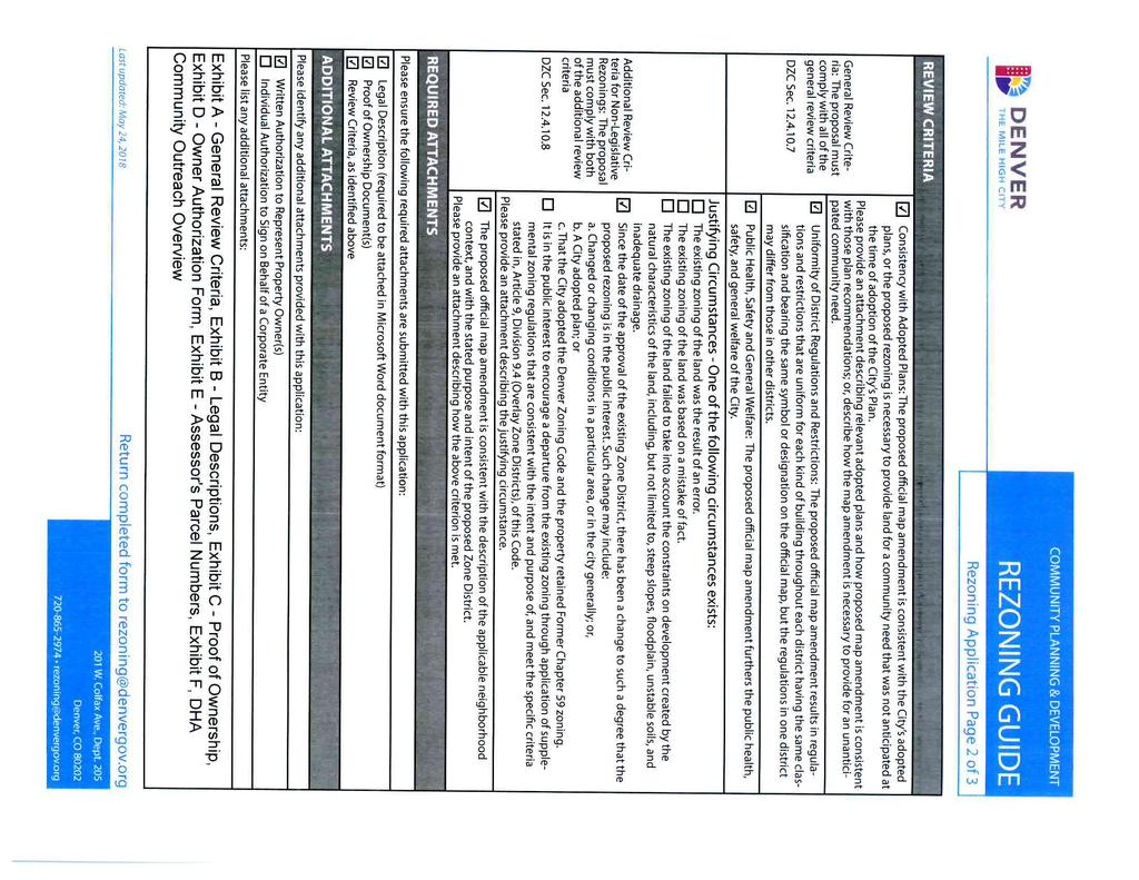
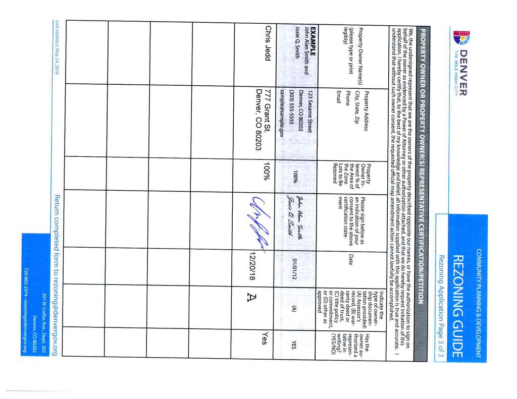
1 Zone Map Amendment (Rezoning) - Application COMMUNITY PLANNING & DEVELOPMENT REZONING GUIDE Rezoning Application Page 1 of 3 PROPERTY OWNER INFORMATION* CHECK IF POINT OF CONTACT FOR APPLICATION Property Owner Name Address City, State, Zip Telephone PROPERTY OWNER(S) REPRESENTATIVE** CHECK IF POINT OF CONTACT FOR APPLICATION Representative Name Address City, State, Zip Telephone *If More Than One Property Owner: All standard zone map amendment applications shall be initiated by all the owners of at least 51% of the total area of the zone lots subject to the rezoning application, or their representatives authorized in writing to do so. See page 3. **Property owner shall provide a written letter authorizing the representative to act on his/her behalf. Please attach Proof of Ownership acceptable to the Manager for each property owner signing the application, such as (a) Assessor s Record, (b) Warranty deed or deed of trust, or (c) Title policy or commitment dated no earlier than 60 days prior to application date. If the owner is a corporate entity, proof of authorization for an individual to sign on behalf of the organization is required. This can include board resolutions authorizing the signer, bylaws, a Statement of Authority, or other legal documents as approved by the City Attorney s Office. SUBJECT PROPERTY INFORMATION Location (address and/or boundary description): Assessor s Parcel Numbers: Area in Acres or Square Feet: Current Zone District(s): PROPOSAL Proposed Zone District: Last updated: May 24, 2018 Return completed form to rezoning@denvergov.org 201 W. Colfax Ave., Dept. 205 Denver, CO rezoning@denvergov.org
2
3
4 Table of Contents PROPOSED MAP AMENDMENT SUMMARY 2 EXHIBIT A: GENERAL REVIEW CRITERIA 3 General Review Criteria DZC Sec Consistency with Adopted Plans: 3 Denver Comprehensive Plan Blueprint Denver 4 Additional City Guidance 7 Housing an Inclusive Denver plan 7 City and County of Denver and the Housing Authority of the City and County of Denver Agreement 8 Uniformity of District Regulations and Restrictions 9 Public Health, Safety and General Welfare 10 ADDITIONAL REVIEW CRITERIA DZC Sec Justifying Circumstances 11 The proposed official map amendment is consistent with the description of the applicable neighborhood context, and with the stated purpose and intent of the proposed Zone District. 12 Urban Neighborhood Context DZC Article 5 12 General Purpose and Intent of Residential Mixed Use Districts DZC EXHIBIT B: LEGAL DESCRIPTIONS 14 EXHIBIT C: PROOF OF OWNERSHIP 15 EXHIBIT D: OWNER AUTHORIZATION DOCUMENTS 16 EXHIBIT E: ASSESSOR S PARCEL NUMBERS 17 EXHIBIT F: DHA COMMUNITY & STAKEHOLDER OUTREACH PROGRAM 17 Page 1 of 17
5 PROPOSED MAP AMENDMENT SUMMARY ( DHA ) is a quasi-municipal corporation with a portfolio of over 5,441units and provides affordable housing to more than 26,000 very low, low and middle income individuals representing over 10,000 families. DHA has transformed public housing in Denver creating vibrant, revitalized, sustainable, transit oriented, and mixed-income communities of choice. DHA requests a map amendment to rezone the property located at 3220 N. Shoshone St. Denver, CO ( Property or Parcel 1 ) from U-RH-2.5 to U-RX-3. In addition, DHA wishes to incorporate a parcel on the south west corner, adjacent to 3220 N. Shoshone Street, currently owned by the City and County of Denver ( Parcel #2 ), into the map amendment request to improve the intersection at 32nd and Shoshone. The Property consists of approximately ½ acre of land at the North East Corner of West 32nd Avenue and Shoshone Street within the quickly gentrifying Lower Highlands ( LOHI ) Neighborhood on the West side of Denver. Currently there are 10 public housing homes on the site (built in 1974) which interface with a non-efficient 6 point intersection. DHA is requesting to rezone and redevelop the property to meet the following goals: Increase the amount of affordable housing opportunities within the LOHI neighborhood Create and opportunity for a multifamily development which more closely reflects the surrounding neighborhood and building typology Re-align the 6 point intersection in partnership with the City and County of Denver Advance and develop in accordance with Blueprint Denver s goals within a designated Area of Change Advance and develop in accordance with Denver s Housing Advisory Committee s goals Advance and develop to the Housing an Inclusive Denver plan recently adopted by Denver City Council For the reasons set forth in Exhibit A, the proposed rezoning is consistent with the criteria set forth in Section of the Denver Zoning Code, which authorizes Denver City Council to approve an official map amendment. Page 2 of I December 27, 2018 fees waived per DZC
6 EXHIBIT A: GENERAL REVIEW CRITERIA General Review Criteria DZC Sec Consistency with Adopted Plans: The proposed map amendment is consistent with the City s adopted plans as outlined below: Denver Comprehensive Plan 2000 The proposed rezoning of the site from U-RH-2.5 to U-RX-3 is consistent with the Denver Comprehensive Plan The italicized text signals an excerpt from the Plan. The language that follows is used to detail how the proposed map amendment is consistent with the goals of the Plan. One goal of Denver Comprehensive Plan 2000 is to Expand housing options for Denver s changing population. (Comprehensive Plan p. 108) Key elements of the Plan 2000 housing options visions for success include: Coordinated City Efforts - City agencies communicate and coordinate on housing issues. Regulatory costs of housing development are being reviewed and removed when possible. The City works to preserve and expand its housing stock, and housing efforts support economic development strategies. Denver Comprehensive Plan 2000, page 112 Expanded resources-- Support for housing programs and services enable the community to meet basic needs for decent, safe and affordable housing, including that needed by families, low-income households and special needs populations. Denver Comprehensive Plan 2000, page 112 Mixed-use, mixed-income neighborhoods -- Several neighborhoods provide opportunities for a stimulating urban lifestyle in walkable communities offering a variety of uses, multiple housing options and diverse residents. Denver Comprehensive Plan 2000, page 112 City living - Living in Denver is an attractive choice. The city attracts and retains a large number of middle-income families and households. Denver Comprehensive Plan 2000, page 112 Encourage development of housing that meets the increasingly diverse needs of Denver s present and future residents in the Citywide Land Use and Transportation Plan. Denver Comprehensive Plan 2000, page 58 The increasing need for a broader array of housing options requires a more diverse mix of residential types that are both affordable and complementary to neighborhood character. Denver Comprehensive Plan 2000, page 92 DHA s proposed project of replacing 10 affordable housing units with a higher density affordable housing development aligns with Plan 2000 s above key elements in that it will preserve and expand opportunities for safe, affordable, diverse living for low income families within the City and County of Denver. In addition, DHA intends to communicate and partner with city agencies such as Public Works, Office of Economic Development, Community Planning and Development, and others to leverage funding sources, improve the intersection at 32nd & Shoshone, and enhance the safety of the neighborhood. For these reasons, the proposed rezoning of the site from U-RH-2.5 to U-RX-3 is consistent with the Denver Comprehensive Plan 2000 and will facilitate Denver s need for affordable units. Page 3 of I December 27, 2018 fees waived per DZC
7 In addition, Plan 2000 addresses a goal of a Need for Greater Connectivity, Access to Transit, and Multi-Modal Communities Key elements of Plan 2000 s connectivity, access, and transit goals include: Increasingly, transportation must support land-use strategies and vice versa to provide a greater range of living and mobility options. Denver Comprehensive Plan 2000, page 8 In addition to reducing vehicular traffic, existing bus corridors and new regional transit corridors offer opportunities to shape transit-oriented, mixed-use developments, which encourage neighborhood selfsufficiency. Denver Comprehensive Plan 2000, page 33 Achieve environmental sustainability in all aspects of planning, community and building design, and transportation by promot(ing) the development of sustainable communities and centers of activity where shopping, jobs, recreation and schools are accessible by multiple forms of transportation, providing opportunities for people to live where they work. Denver Comprehensive Plan 2000, page 41 Ensure that land-use policies and decisions support a variety of mobility choices, including light rail, buses, paratransit, walking and bicycling, as well as convenient access for people with disabilities. Denver Comprehensive Plan 2000, page 60 Create more convenient connections between different modes of transportation, as in pedestrian to transit, bus to light rail, or bike to transit. Denver Comprehensive Plan 2000, page 76 Promote convenient public transit for the community, including buses, light rail and other alternatives to single-occupancy vehicles. Denver Comprehensive Plan 2000, page 41 The Denver Comprehensive Plan 2000 created strong directives around transit and articulated that land use policies should support those objectives. The proposed rezoning of the site from U-RH-2.5 to U-RX-3 will allow additional low income families to live near their work and play, promoting a more sustainable healthy lifestyle and City, and reducing the amount of vehicular transportation. The property is a pedestrian friendly, mass transit friendly site that is within walking distance to multiple RTD transit stops, parks, businesses and restaurants and a short bus ride away to Denver s central business district. For these reasons, the proposed rezoning of the site from U-RH-2.5 to U-RX-3 is consistent with the Denver Comprehensive Plan 2000 and will facilitate increased availability of housing stock near transit and will provide greater connectivity and multimodal communities. Blueprint Denver The proposed rezoning of the site from U-RH-2.5 to U-RX-3 is consistent with Blueprint Denver. Specifically, the rezoning is consistent with Blueprint s Overarching Plan Recommendations, as well as the recommendations for Mixed Use, Areas of Change, Concept Land Use, Street Classifications, and Enhanced Transit Corridors. The italicized text signals an excerpt from Blueprint. The language that follows is used to detail how the proposed map amendment is consistent with the goals of Blueprint. Overarching Plan Recommendations Blueprint Denver anticipates several key outcomes of this integrated approach to planning for the future: Enhanced transportation system connectivity strong links between and among transit, bicycle and pedestrian routes promotes the use of multiple modes of transportation. Page 4 of I December 27, 2018 fees waived per DZC
8 Appropriately located and attractive density stimulates positive change and development in areas with strong links to transit. A diversity of housing in terms of size, type and cost provides a range of housing options and prices throughout the community. Residential areas are located near employment centers, thus creating more job opportunities across the city. Blueprint Denver, page The proposed rezoning of the site from U-RH-2.5 to U-RX-3 is consistent with the overarching plan recommendations in Blueprint Denver. Furthermore, the proposed rezoning will enable DHA to redevelop the site, increase density, and offer additional affordable housing options to low income families near employment centers and multi modal transit stations. Blueprint Denver Concept Plan Strategy: Direct Growth to Areas of Change Blueprint Denver calls out areas of change to serve as a basis for the Denver Concept. Most of the Areas of Change already are developed to varying degrees. In most cases, there is enough capacity of public facilities such as streets, sewers and schools so that additional development will be able to take advantage of existing infrastructure in the area. However, these areas have not realized their full development potential. (Blueprint Denver, page 19). The proposed rezoning supports the Blueprint Denver Concept in that it will help the area meet its full development potential. Concept Land Use and Street Classifications Blueprint Denver identifies the property (3220 Shoshone St.) in its conceptual land use map as Mixed-use and in an Area of Change. Mixed-use areas are defined by Blueprint as: These areas have a sizable employment base as well as housing. Intensity is higher in mixed-use areas than in other residential areas. Land uses are not necessarily mixed in each building or development or even within each block. But within the neighborhood, residential and non-residential uses are within walking distance of one another. The proportion of residential to commercial uses varies considerably from one mixed-use district to another. The Golden Triangle, Uptown and the Jefferson Park Highland Area of Change are examples of mixeduse districts. Blueprint Denver, p. 41 Areas of Change are defined by Blueprint: The purpose of Areas of Change is to channel growth where it will be beneficial and can best improve access to jobs, housing and services with fewer and shorter auto trips. Areas of Change are parts of the city where most people agree that development or redevelopment would be beneficial. Blueprint Denver, page 127 Areas of Change Strategies: Page 5 of 17
9 Address edges between Areas of Stability and Areas of Change Compatibility between existing and new development Reuse of older buildings, including industrial buildings Historic preservation Pedestrian and transit supportive design and development standards Eliminate auto-oriented zoning standards Mixed land uses Infill and redevelop vacant and underused properties Reduce land used for parking with shared parking and structured parking Multi-modal streets Transit service and transit access Adequate parks and open space, especially where density is increased Diversity of housing type, size, and cost Retain low and moderate income residents Economic activity business retention, expansion and creation Blueprint Denver, page 23 The proposed rezoning is consistent with Blueprint Denver s recommendations for Areas of Change and Mixed Use and will facilitate the redevelopment of the property offering a higher density 3 story affordable housing development within a mixed use area of change aligning and fulfilling the area of change strategy as outlined below: Address edges between Areas of Stability and Areas of Change: This property is currently on the boundary of an area of change and stability. Through community engagement, the improvement of the intersection (32 nd & Shoshone), and other design features, DHA will respect and enhance the boundary between stability and area of change. Compatibility between existing and new development: With the rezoning application at 3 stories, the zoning and project enhances the compatibility between existing and new development. Pedestrian and transit supportive design and development standards: The property is located in the middle of the Lower Highlands neighborhood that consists of pedestrian oriented features such as small blocks, small streets, curb side parking, continuous sidewalks and urban architecture with small street setbacks. The property is well served by multi-nodal transit services and biking. Eliminate auto-oriented zoning standards: The property currently is a suburban auto oriented low density land use with two curb cuts and parking lots fronting the streets with the housing well set back from the street. The proposal is for an urban and pedestrian oriented development with structured parking away from the public domain. Mixed land uses: The property currently has all 3 bedroom units with surface parking. The proposal is for a mix of one bedroom, two bedroom and three bedroom units with structured parking. Infill and redevelop vacant and underused properties: The proposed use under the requested zoning would be an infill redevelopment at an underutilized parcel that is in concert with the infill redevelopments across both adjacent streets. Page 6 of 17
10 Reduce land used for parking with shared parking and structured parking: The proposed development will eliminate the current surface parking lots and incorporate structured parking lots Multi-modal streets: The redevelopment supports multi-modal streets by reconfiguring the current inefficient street intersection into a coherent urbanized condition improving safety for pedestrians, bicyclists and automobiles. Transit service and transit access: The property is within a short walk of high capacity transit service. Adequate parks and open space, especially where density is increased: The property is within 500 of Hirshorn Park and 600 of the Lower Gateway Park, in the Lower Highlands Neighborhood. Diversity of housing type, size, and cost: The proposed infill redevelopment is planned for 1, 2, and 3, bedroom units of affordable housing. Retain low and moderate income residents: The very nature of the proposed redevelopment will ensure that site will both preserve and add additional affordable housing units to the area therefore retaining low and moderate income residents. Additional City Guidance In addition to this application being in full conformance with Denver s Comprehensive Plan 2000 and Blueprint Denver, we are including some references to key goals in the Denver Housing Inclusive Plan and the agreement signed between DHA and the City and County of Denver. Housing an Inclusive Denver plan Inclusive Plan Outlined below are the plan s core goals (page 7 of plan) Goal # 1 Create Affordable Housing in vulnerable AND in areas of opportunity DHA s map amendment request aligns with Core Goal # 1 in that additional affordable housing opportunities will be created in an area of opportunity allowing affordable housing options to low income families in area of growth, employment, transportation and opportunity. Goal # 2 Preserve affordability and Housing Quality DHA s map amendment request aligns with Core Goal # 2 in that the proposed redevelopment will offer additional affordable housing options with unit diversity, modern amenities, efficient layouts, and healthier and safer designs. Goal # 3 Promote equitable and accessible Housing The map amendment request supports core goal # 3 in that the increased density permitted under new zoning offers additional opportunity to low income families who otherwise, due to the high cost of living in the area, would not be able to live in the neighborhood. In addition, DHA s development will comply with fair housing and ADA standards offering accessible housing to those in need. Goal # 4 Stabilize residents at risk of involuntary displacement The subject property in the map amendment request is in the center of Denver s Highland Neighborhood, a quickly gentrifying neighborhood with rising rents, increased density, and significant Page 7 of I December 27, 2018 fees waived per DZC
11 changes in the dynamics of the area. Through the map amendment request, DHA will increase the amount of affordable housing options in the area and stabilize residents at risk of involuntary displacement through offering quality housing. City and County of Denver and the Housing Authority of the City and County of Denver Agreement In August 2018, Denver City Council voted to approve an intergovernmental agreement (IGA) between the City and County of Denver and the Housing Authority of the City and County of Denver. The partnership brings more funding in the form of bonds to accelerate building and preserving much-needed affordable housing. It also increases the land available for future affordable housing for Denver s lowest-income residents and those experiencing homelessness. By leveraging DHA s expertise in serving those most in need of housing, the agreement expands the city s ability to deliver on additional areas of housing need identified in the five-year plan. Funding made available through this IGA has prioritized 3220 N. Shoshone St. as an area of interest for developing higher density affordable housing on the property. Page 8 of I December 27, 2018 fees waived per DZC
12 Uniformity of District Regulations and Restrictions The proposed rezoning will result in uniformity of district regulations and restrictions in accordance with Section (B) of the Zoning Code. The proposed rezoning is consistent with the existing zoning adjacent to the west of the property. Page 9 of 17
13 Public Health, Safety and General Welfare The proposed official map amendment is an implementation of Denver Comprehensive Plan 2000 and Blueprint Denver and therefore furthers the public health, safety and general welfare of the City. In addition, the map amendment proposes to redevelop the inefficient 5 point intersection into a more vehicular and pedestrian safe street. The proposed infill redevelopment will also put significant eyes back onto the street and create a development parcel that is secured. Page 10 of 17
14 ADDITIONAL REVIEW CRITERIA DZC Sec Justifying Circumstances Since the date of the approval of the existing Zone District, there has been a change to such a degree that the proposed rezoning is in the public interest. Such change may include: A. Changed or changing conditions in a particular area, or in the city generally; Over the past ten years the Highlands Neighborhood has seen drastic increases in rent, gentrification, increased traffic, new businesses, new development, new building typologies, increased density and a general change in the pace of the neighborhood. Due to all the changes, there is a shortfall of affordable housing in the area. This map amendment request is in the public interest in that it achieves the following goals: Preserves and introduces affordable housing into the area Updates and beautifies the property to more closely match the building typology of adjacent properties. Creates a safer public realm by the redevelopment of the street intersection B. A City adopted plan Since the date of the approval of the existing Zone District multiple City Plans have been approved or adopted which necessitates a map amendment to achieve to outcome of the City Plans. Details of such plans are outlined in the General Review Criteria of this map amendment request Page 11 of 17
15 The proposed official map amendment is consistent with the description of the applicable neighborhood context, and with the stated purpose and intent of the proposed Zone District. Urban Neighborhood Context DZC Article 5 The U-RX-3 Zone District is part of the Urban Neighborhood Context. Article 5 of the Denver Zoning Code describes the Urban Neighborhood context as follows. GENERAL CHARACTER DZC The Urban Neighborhood Context is primarily characterized by single-unit and two-unit residential uses. Smallscale multi-unit residential uses and commercial areas are typically embedded in residential areas. Single-unit residential structures are typically the Urban House building form. Multi-unit building forms typically include the Row House building form embedded with other residential form types. Commercial buildings are typically the Shop front and General building forms that may contain a mixture of uses within the same building. Single- and two-unit residential uses are primarily located along local and residential arterial streets. Multi-unit residential uses are located along local streets, residential and mixed use arterials, and main streets. Commercial uses are primarily located along mixed-use arterial or main streets but may be located at or between intersections of local streets. The proposed U-RX-3 Zone District allows for, and DHA s proposed development is consistent with, Section in that it supports a multi-story, multi-unit residential development along a local street. STREET, BLOCK AND ACCESS PATTERNS - DZC The Urban Neighborhood Context consists of a regular pattern of block shapes surrounded by an orthogonal street grid. Orthogonal streets provide a regular pattern of pedestrian and vehicular connections through this context and there is a consistent presence of alleys. Block sizes and shapes are consistent and primarily include detached sidewalks (though attached sidewalks are also found), tree lawns where provided for by detached sidewalks, street and surface parking, and landscaping in the front setback. The proposed U-RX-3 Zone District, DHA s Right-of-Way Improvements, and intersection improvements at 32nd & Shoshone will support the goals of a regular pattern of pedestrian and vehicular connections as well include detached sidewalks, tree lawns, street parking and landscaping. BUILDING PLACEMENT AND LOCATION - DZC Residential buildings typically have consistent, moderate front setbacks, shallow side setbacks and consistent orientation. Commercial buildings typically have consistent orientation and shallow front setbacks with parking at the rear and/or side of the building. The proposed U-RX-3 Zone District allows for a development that meets placement and location. BUILDING HEIGHT DZC The Urban Neighborhood Context is characterized by low scale buildings except for some mid- rise commercial and mixed use structures, particularly at nodes or along arterial streets. The proposed U-RX-3 Zone District meets the height standard and is consistent with adjacent buildings Page 12 of I December 27, 2018 fees waived per DZC
16 MOBILITY DZC There is a balance of pedestrian, bicycle and vehicle reliance with greater access to the multi-modal transportation system. The proposed U-RX-3 Zone District will be consistent with mobility goals in achieving a balance of pedestrian, bicycle, and vehicular mobility and increasing the amount of homes near multi-modal transportation systems. General Purpose and Intent of Residential Mixed Use Districts DZC General Purpose - DZC A. The Residential Mixed Use zone districts are intended to promote safe, active, and pedestrian-scaled, diverse areas through the use of building forms that clearly define and activate the public realm. B. The Residential Mixed Use zone districts are intended to enhance the convenience, ease and enjoyment of transit, walking, shopping and public gathering within and around the city s residential neighborhoods. C. The Residential Mixed Use zone district standards are also intended to ensure new development contributes positively to established residential neighborhoods and character, and improves the transition between commercial development and adjacent residential neighborhoods. D. Compared to the Mixed Use districts, the Residential Mixed Use districts are primarily intended to accommodate residential uses. Commercial uses are secondary to the primary residential use of the district, and provide neighborhood-scaled shops and offices for residents to conveniently access goods and services within walking distance. Buildings in a Residential Mixed Use district can have commercial uses, but upper stories are reserved exclusively for housing or lodging accommodation uses. A building can be solely residential or solely commercial; however, buildings containing only commercial uses are limited in total gross floor area to 10,000 square feet consistent with the district purpose. The proposed U-RX-3 Zone District supports the general purpose in that it will allow for safe active pedestrian-scaled areas through improved right of ways and street intersections. In addition, it will positively add to residential neighborhoods and character by allowing for quality affordable housing with a height limit consistent to adjacent properties. Specific Intent - DZC Residential Mixed use 3 (U-RX-3) U-RX-3 applies to residentially-dominated areas served primarily by local or collector streets where a building scale of 1 to 3 stories is desired. The proposed U-RX-3 Zone District is consistent with this specific intent as the site is located in an area served by both local or collector streets and is consistent with surrounding development patterns or 1 to 3 stories. Page 13 of I December 27, 2018 fees waived per DZC
17 EXHIBIT B: LEGAL DESCRIPTIONS 3220 N SHOSHONE STREET Parcel 1 THAT PART OF LOT 2, BLOCK2, H. WITTER S ORTH DENVER ADDITION, CITY AND COUNTY OF DENVER, COLORADO, LYING NORTHEAST OF THE NORTHEAST LINE OF 18TH STREET PROJECTED NORTHWESTERLY, AS SAID STREEET NOW EXIST BETEWEEN BLOCKS 17 AD 18 OF KASSERMAN S ADDITION TO DENVER, CITY AND COUNTY OF DENVER, COLORADO, EXCEPT THE NORTH 10 FEET OF THE EAST 95 FEET THEREOF AND EXCEPT THE EAST 5 FEET OF THE SOUTH FEET THEREOF. Street / Intersection Owned by the City and County of Denver Parcel 2 LEGAL DESCRIPTION THAT PORTION OF LOT 2, BLOCK 2, H. WITTER'S NORTH DENVER ADDITION LYING SOUTHWEST OF THE NORTHEAST LINE OF 18TH STREET PROJECTED NORTHWESTERLY, AS SAID STREET NOW EXISTS BETWEEN BLOCKS 17 AND 18 OF KASSERMAN'S ADDITION TO DENVER AND DESCRIBED IN THE WARRANTY DEED RECORDED JULY 15, 1887 IN BOOK 344 AT PAGE 135 IN THE RECORDS OF THE CLERK AND RECORDER'S OFFICE OF THE COUNTY OF ARAPAHOE, STATE OF COLORADO, SITUATED IN THE NORTHWEST 1/4 OF SECTION 28, TOWNSHIP 3 SOUTH, RANGE 68 WEST OF THE 6TH P.M., CITY & COUNTY OF DENVER, STATE OF COLORADO BEING MORE PARTICULARLY DESCRIBED AS FOLLOWS: COMMENCING AT THE NORTHWEST CORNER OF SAID LOT 2, BLOCK 2; THENCE SOUTH 00 04'23" EAST, ALONG THE WEST LINE OF SAID LOT 2 AND ALONG THE EAST RIGHT-OF-WAY LINE OF SHOSHONE STREET, A DISTANCE OF FEET TO THE POINT OF BEGINNING, SAID POINT ALSO LIES ON THE NORTHWESTERLY EXTENSION OF SAID NORTHEAST LINE OF 18TH STREET; THENCE SOUTH 45 06'59" EAST, DEPARTING SAID WEST LINE OF LOT 2 AND ALONG THE NORTHWEST EXTENSION OF THE NORTHEAST LINE OF 18TH STREET, A DISTANCE OF FEET TO A POINT ON THE SOUTH LINE OF SAID LOT 2, BLOCK 2 AND A POINT ON THE NORTH RIGHT-OF-WAY LINE OF WEST 32ND AVENUE ; THENCE SOUTH 89 59'58" WEST, DEPARTING SAID NORTHWEST PROJECTION OF THE NORTHEAST LINE OF 18TH STREET AND ALONG THE NORTH RIGHT-OF-WAY LINE OF WEST 32ND AVENUE, A DISTANCE OF FEET TO THE SOUTHWEST CORNER OF SAID LOT 2, BLOCK 2 AND A POINT ON THE EAST RIGHT-OF WAY LINE OF SHOSHONE STREET; THENCE NORTH 00 04'23" WEST, DEPARTING SAID NORTH RIGHT-OF-WAY LINE AND ALONG THE EAST RIGHT-OF-WAY LINE FOR SHOSHONE STREET, A DISTANCE OF FEET TO THE POINT OF BEGINNING. CONTAINING 3,780 SQUARE FEET OR 0.09 ACRES, MORE OR LESS FOR THE PURPOSE OF THIS DESCRIPTION THE BEARINGS ARE BASED ON THE WEST LINE OF SAID LOT 2, BLOCK 2, H. WITTER'S NORTH DENVER ADDIITON AS MONUMENTED BY A NAIL WITH A 1" BRASS TAG LS AT A 18.5' OFFSET TO THE NORTHWEST CORNER OF SAID LOT 2 AND BY A #5 REBAR W/ 1-1/4" ORANGE PLASTIC CAP STAMPED LS AT THE SOUTH END AND BEARS SOUTH 0 04'23" EAST. Page 14 of I December 27, 2018 fees waived per DZC

18 EXHIBIT C: PROOF OF OWNERSHIP See proof of ownership on the following pages. Parcel # N Shoshone proof of ownership is based off of Denver Assessor s Record Parcel # 2 32nd & Shoshone Street Intersection Owned by the City and County of Denver Right of way owned by the City and County of Denver which is to be vacated and deeded to DHA Page 15 of I December 27, 2018 fees waived per DZC
19 EXHIBIT D: OWNER AUTHORIZATION DOCUMENTS Page 16 of 17
20
21 EXHIBIT E: ASSESSOR S PARCEL NUMBERS Parcel # N. Shoshone Parcel # 2 32nd & Shoshone Street Intersection Owned by the City and County of Denver No parcel # was available for right of way area EXHIBIT F: DHA Community & Stakeholder Outreach Program To capture community and stakeholder input into the redevelopment of the Property, DHA has participated in an extensive community outreach initiatives over the past one and a half years. DHA has met with the Highlands United Neighbors Inc. ( HUNI ) Planning and Community Development Committee (PCD), District 1 Councilman Rafael Espinoza, other City Council members, The City and County of Denver s Community Planning and Development Department, Office of Economic Development, and Public works Department. Through the outreach program, DHA gathered feedback from stakeholders and revised their massing studies and renderings 7 times to reflect changes requested by stakeholders including changes such as less units, lower density, setbacks, streetscapes, and fewer stories. Below is a summary to date of community outreach meetings DHA as participated in: Date Description Contacts Agenda 2/9/2017 Meeting City Council District 1 CM Espinoza & Staff Preliminary discussions about DHA plans and rezoning 2/21/2017 Rezoning Pre Application Meeting CPD Eugene Howard Reviewed CPD's take on site and rezoning 3/14/2017 HUNI PCD Meeting Tim Boers and attendees Preliminary discussions about DHA plans and rezoning 4/17/2017 Meeting at CCD Public Works Brittany Price Preliminary discussions regarding the improvements to the intersection at 32nd and Shoshone 1/3/2018 Meeting at CCD Public Works Brittany Price Reengage discussions around improvements to the intersection at 32nd and Shoshone 3/29/2018 Meeting City Council District 1 CM Espinoza & Staff Update CM on DHA's plans 5/8/2018 HUNI PCD Meeting Tim Boers and attendees Update HUNI PCD on plans and presented a 5 story building 6/12/2018 HUNI PCD Meeting Tim Boers and attendees Updated HUNI PCD revised building to address concerns 6/27/2018 DHA met with CPD CPD Eugene Howard Re introduce DHA's plans for the property 7/10/2018 HUNI PCD Meeting Tim Boers and attendees Updated HUNI PCD revised building to address concerns 7/18/2018 Rezoning Pre Application Meeting CPD Eugene Howard Standard rezoning pre application meeting 8/22/2018 Design Charrette HUNI PCD Members Engaged with HUNI PCD members to discuss and explore potential solutions 9/7/2018 DHA send another iteration to PCD Tim Boers and attendees Updated drawings and zoning waivers to HUNI PCD 12/6/2018 DHA Meeting with City Council District 1 CM Espinoza DHA staff, architects and CM Espinoza worked on fitting unit mix into a 3.5 story building 12/11/2018 HUNI PCD Meeting HUNI PCD, CM Espinoza CM Espinoza presented a building to HUNI PCD with 1/2 3 story, 1/2 4 story 12/17/2018 Meeting City Council District 1 CM Espinoza, Ryan Tobin (DHA Staff) Discussions of possibly fitting building into 3 stories Page 17 of I December 27, 2018 fees waived per DZC
Official Zoning Map Amendment Application #2018I-00095
 Community Planning and Development Planning Services 201 W. Colfax Ave., Dept. 205 Denver, CO 80202 p: 720.865.2915 f: 720.865.3052 www.denvergov.org/cpd TO: Denver Planning Board FROM: Ella Stueve, Senior
REZONING GUIDE. Zone Map Amendment (Rezoning) - Application. Rezoning Application Page 1 of 3. Return completed form to
 - Application. Rezoning Application Page 1 of 3. Return completed form to") Zone Map Amendment (Rezoning) - Application COMMUNITY PLANNING & DEVELOPMENT REZONING GUIDE Rezoning Application Page 1 of 3 PROPERTY OWNER INFORMATION* CHECK IF POINT OF CONTACT FOR APPLICATION Property
Zone Map Amendment (Rezoning) - Application COMMUNITY PLANNING & DEVELOPMENT REZONING GUIDE Rezoning Application Page 1 of 3 PROPERTY OWNER INFORMATION* CHECK IF POINT OF CONTACT FOR APPLICATION Property
Representative Name. Address. City, State, Zip. Telephone.
 COMMUNITY PLANNING & DEVELOPMENT ~~DENVER... THE MILE HIGH CITY REZONING GUIDE Zone Map Amendment (Rezoning)- Application Rezoning Application Page 1 of 3 Property Owner Name Philip M. Falco Address 730
REZONING GUIDE. Zone Map Amendment (Rezoning) - Application. Rezoning Application Page 1 of 3. Return completed form to
 - Application. Rezoning Application Page 1 of 3. Return completed form to") Zone Map Amendment (Rezoning) - Application COMMUNITY PLANNING & DEVELOPMENT REZONING GUIDE Rezoning Application Page 1 of 3 PROPERTY OWNER INFORMATION* CHECK IF POINT OF CONTACT FOR APPLICATION Property
Zone Map Amendment (Rezoning) - Application COMMUNITY PLANNING & DEVELOPMENT REZONING GUIDE Rezoning Application Page 1 of 3 PROPERTY OWNER INFORMATION* CHECK IF POINT OF CONTACT FOR APPLICATION Property
Official Zoning Map Amendment Application #2017I Gaylord Street and York Street Rezoning from U-RH-2.5 to U-RX-3 and U-RX-5
 Community Planning and Development Planning Services 201 W. Colfax Ave., Dept. 205 Denver, CO 80202 p: 720.865.2915 f: 720.865.3052 www.denvergov.org/cpd TO: Denver Planning Board FROM: Elizabeth Weigle,
REZONING GUIDE. Zone Map Amendment (Rezoning) - Application. Rezoning Application Page 1 of 3. Return completed form to
 - Application. Rezoning Application Page 1 of 3. Return completed form to") COMMUNITY PLANNING & DEVELOPMENT REZONING GUIDE Rezoning Application Page 1 of 3 Zone Map Amendment (Rezoning) - Application PROPERTY OWNER INFORMATION* PROPERTY OWNER(S) REPRESENTATIVE** CHECK IF POINT
COMMUNITY PLANNING & DEVELOPMENT REZONING GUIDE Rezoning Application Page 1 of 3 Zone Map Amendment (Rezoning) - Application PROPERTY OWNER INFORMATION* PROPERTY OWNER(S) REPRESENTATIVE** CHECK IF POINT
Land Use, Transportation, and Infrastructure Committee of Denver City Council FROM: Scott Robinson, Senior City Planner DATE: December 6, 2018 RE:
 Community Planning and Development Planning Services 201 W. Colfax Ave., Dept. 205 Denver, CO 80202 p: 720.865.2915 f: 720.865.3052 www.denvergov.org/cpd TO: Land Use, Transportation, and Infrastructure
REZONING GUIDE. Zone Map Amendment (Rezoning) - Application. Rezoning Application Page 1 of 3. Return completed form to
 - Application. Rezoning Application Page 1 of 3. Return completed form to") Zone Map Amendment (Rezoning) - Application COMMUNITY PLANNING & DEVELOPMENT REZONING GUIDE Rezoning Application Page 1 of 3 PROPERTY OWNER INFORMATION* CHECK IF POINT OF CONTACT FOR APPLICATION Property
Zone Map Amendment (Rezoning) - Application COMMUNITY PLANNING & DEVELOPMENT REZONING GUIDE Rezoning Application Page 1 of 3 PROPERTY OWNER INFORMATION* CHECK IF POINT OF CONTACT FOR APPLICATION Property
REZONING GUIDE. Zone Map Amendment (Rezoning) - Application. Rezoning Application Page 1 of 3. Return completed form to
 - Application. Rezoning Application Page 1 of 3. Return completed form to") COMMUNITY PLANNING & DEVELOPMENT REZONING GUIDE Rezoning Application Page 1 of 3 Zone Map Amendment (Rezoning) - Application PROPERTY OWNER INFORMATION* PROPERTY OWNER(S) REPRESENTATIVE** CHECK IF POINT
COMMUNITY PLANNING & DEVELOPMENT REZONING GUIDE Rezoning Application Page 1 of 3 Zone Map Amendment (Rezoning) - Application PROPERTY OWNER INFORMATION* PROPERTY OWNER(S) REPRESENTATIVE** CHECK IF POINT
Official Zoning Map Amendment Application #2017I and 4889 South Quebec Street Rezoning from B-4 with waivers, UO-1, UO-2 to C-MX-20
 Community Planning and Development Planning Services 201 W. Colfax Ave., Dept. 205 Denver, CO 80202 p: 720.865.2915 f: 720.865.3052 www.denvergov.org/cpd TO: Denver Planning Board FROM: Jeff Hirt, Senior
Block bounded by Newton St., 17 th Ave., Lowell Blvd., and 16 th Ave.; plus Meade Street (evens only)
") Community Planning and Development Planning Services 201 W. Colfax Ave., Dept. 205 Denver, CO 80202 p: 720.865.2915 f: 720.865.3052 www.denvergov.org/cpd TO: Denver Planning Board FROM: Sara White, AICP,
Community Planning and Development Planning Services 201 W. Colfax Ave., Dept. 205 Denver, CO 80202 p: 720.865.2915 f: 720.865.3052 www.denvergov.org/cpd TO: Denver Planning Board FROM: Sara White, AICP,
Article 3. SUBURBAN (S-) NEIGHBORHOOD CONTEXT
 NEIGHBORHOOD CONTEXT") Article 3. SUBURBAN (S-) NEIGHBORHOOD CONTEXT this page left intentionally blank Contents ARTICLE 3. SUBURBAN (S-) NEIGHBORHOOD CONTEXT DIVISION 3.1 NEIGHBORHOOD CONTEXT DESCRIPTION...3.1-1 Section 3.1.1
Article 3. SUBURBAN (S-) NEIGHBORHOOD CONTEXT this page left intentionally blank Contents ARTICLE 3. SUBURBAN (S-) NEIGHBORHOOD CONTEXT DIVISION 3.1 NEIGHBORHOOD CONTEXT DESCRIPTION...3.1-1 Section 3.1.1
Article 6. GENERAL URBAN (G-) NEIGHBORHOOD CONTEXT
 NEIGHBORHOOD CONTEXT") Article 6. GENERAL URBAN (G-) NEIGHBORHOOD CONTEXT this page left intentionally blank Contents ARTICLE 6. GENERAL URBAN (G-) NEIGHBORHOOD CONTEXT DIVISION 6.1 NEIGHBORHOOD CONTEXT DESCRIPTION...6.1-1 Section
Article 6. GENERAL URBAN (G-) NEIGHBORHOOD CONTEXT this page left intentionally blank Contents ARTICLE 6. GENERAL URBAN (G-) NEIGHBORHOOD CONTEXT DIVISION 6.1 NEIGHBORHOOD CONTEXT DESCRIPTION...6.1-1 Section
Land Use, Transportation, and Infrastructure Committee of the Denver City Council FROM: Scott Robinson, Senior City Planner DATE: March 22, 2018 RE:
 Community Planning and Development Planning Services 201 W. Colfax Ave., Dept. 205 Denver, CO 80202 p: 720.865.2915 f: 720.865.3052 www.denvergov.org/cpd TO: Land Use, Transportation, and Infrastructure
REZONING GUIDE. Zone Map Amendment (Rezoning) - Application. Rezoning Application Page 1 of 3. Return completed form to
 - Application. Rezoning Application Page 1 of 3. Return completed form to") Zone Map Amendment (Rezoning) - Application COMMUNITY PLANNING & DEVELOPMENT REZONING GUIDE Rezoning Application Page 1 of 3 PROPERTY OWNER INFORMATION* CHECK IF POINT OF CONTACT FOR APPLICATION Property
Zone Map Amendment (Rezoning) - Application COMMUNITY PLANNING & DEVELOPMENT REZONING GUIDE Rezoning Application Page 1 of 3 PROPERTY OWNER INFORMATION* CHECK IF POINT OF CONTACT FOR APPLICATION Property
Staff Report and Recommendation Based on the criteria for review in the Denver Zoning Code, Staff recommends approval for Application #2017I
 TO: Denver Planning Board, Joel Noble, Chair FROM: Theresa Lucero, Senior City Planner DATE: RE: Official Zoning Map Amendment Application #2017I-00163 Staff Report and Recommendation Based on the criteria
Public Review of the Slot Home Text Amendment
 Public Review of the Slot Home Text Amendment The proposed amendments to the Denver Zoning Code have been informed by the Slot Home Strategy Report. This document has been developed out of a robust process
Staff Report and Recommendation Based on the criteria for review in the Denver Zoning Code, Staff recommends approval for application #2017I
 TO: Denver City Council, Land Use, Transportation and Infrastructure Committee FROM: Theresa Lucero, Senior City Planner DATE: RE: Official Zoning Map Amendment Application #2017I-00153 Staff Report and
Telephone AC / 21,960 SF G-MU-3 G-MX-3
 Zone Map Amendment (Rezoning) - Application PROPERTY OWNER INFORMATION* CHECK IF POINT OF CONTACT FOR APPLICATION Property Owner Name Siddhartha Rathod Address City, State, Zip Telephone Email COMMUNITY
E-SU-A. Zone Map Amendment (Rezoning) -Application E-SU-B. Rf tum cornpleted form to rezoning(i:})denvergov.org. *If More Than One Property Owner;
 -Application E-SU-B. Rf tum cornpleted form to rezoning(i:})denvergov.org. *If More Than One Property Owner;") Zone Map Amendment (Rezoning) -Application Property Owner Name Philip M. Falco Representative Name Address 730 17th Street, Suite 900 Address City, State, Zip Denver, CO 80202 City, State, Zip Telephone
Zone Map Amendment (Rezoning) -Application Property Owner Name Philip M. Falco Representative Name Address 730 17th Street, Suite 900 Address City, State, Zip Denver, CO 80202 City, State, Zip Telephone
AGENDA SLOT HOME EVALUATION & TEXT AMENDMENT. 5:30 - Welcome
 AGENDA 5:30 - Welcome Please sign-in, put a sticker on the map, grab snacks, materials and a seat 5:45 - Staff Presentation 6:15 - Open House Stations Background Information Mixed Use Districts Multi Unit
Official Zoning Map Amendment Application #2015I Marion St. Rezoning from U-SU-A1 to U-MX-2x
 Community Planning and Development Planning Services 201 W. Colfax Ave., Dept. 205 Denver, CO 80202 p: 720.865.2915 f: 720.865.3052 www.denvergov.org/cpd TO: Denver City Council FROM: Courtland Hyser,
Official Zoning Map Amendment Application #2017I-00094
 Community Planning and Development Planning Services 201 W. Colfax Ave., Dept. 205 Denver, CO 80202 p: 720.865.2915 f: 720.865.3052 www.denvergov.org/cpd TO: Denver Planning Board FROM: Scott Robinson,
PLANNING COMMISSION STAFF REPORT
 PLANNING COMMISSION STAFF REPORT REZONING CASE: RZ-16-001 REPORT DATE: March 8, 2016 CASE NAME: Trailbreak Partners Rezoning PLANNING COMMISSION DATE: March 16, 2016 ADDRESSES OF REZONING PROPOSAL: 5501
To: S-MX-8 AIO, S-MX-8A AIO, S-MX-12 AIO, C-MX-8 AIO, C-MX-12 AIO, and S-CC-5 AIO
 Community Planning and Development Planning Services 201 W. Colfax Ave., Dept. 205 Denver, CO 80202 p: 720.865.2915 f: 720.865.3052 www.denvergov.org/cpd TO: Denver City Council FROM: Curt Upton, Senior
Request for Rezoning. Current Zoning: Proposed Zoning:
 TO: Denver City Council, Neighborhoods and Planning Committee FROM: Theresa Lucero, Senior City Planner DATE: March 31, 2016 RE: Zoning Map Amendment #2015I-00150 Rezoning from M-RX-5 to I-MX-3 Community
Article 7. URBAN CENTER (C-) NEIGHBORHOOD CONTEXT
 NEIGHBORHOOD CONTEXT") Article 7. URBAN CENTER (C-) NEIGHBORHOOD CONTEXT this page left intentionally blank Contents ARTICLE 7. URBAN CENTER (C-) NEIGHBORHOOD CONTEXT DIVISION 7.1 NEIGHBORHOOD CONTEXT DESCRIPTION.........................
Article 7. URBAN CENTER (C-) NEIGHBORHOOD CONTEXT this page left intentionally blank Contents ARTICLE 7. URBAN CENTER (C-) NEIGHBORHOOD CONTEXT DIVISION 7.1 NEIGHBORHOOD CONTEXT DESCRIPTION.........................
TRANSIT-ORIENTED DEVELOPMENT PLAN EXISTING CONDITIONS REPORT LAWRENCE TO BRYN MAWR MODERNIZATION
 TRANSIT-ORIENTED DEVELOPMENT PLAN EXISTING CONDITIONS REPORT LAWRENCE TO BRYN MAWR MODERNIZATION March 2018- FINAL DRAFT SITE SPECIFIC DEVELOPMENT CONCEPTS SITE SPECIFIC DEVELOPMENT CONCEPTS This report
Official Zoning Map Amendment Application #2018I-00067
 Community Planning and Development Planning Services 201 W. Colfax Ave., Dept. 205 Denver, CO 80202 p: 720.865.2915 f: 720.865.3052 www.denvergov.org/cpd TO: Denver Planning Board FROM: Courtney Levingston,
Land Use, Transportation, & Infrastructure Committee of the Denver City Council FROM: Chandler Van Schaack, Senior City Planner DATE: July 3, 2018 RE:
 Community Planning and Development Planning Services TO: Land Use, Transportation, & Infrastructure Committee of the Denver City Council FROM: Chandler Van Schaack, Senior City Planner DATE: July 3, 2018
PLANNING COMMISSION STAFF REPORT
 PLANNING COMMISSION STAFF REPORT REZONING CASE: RZ-15-002 REPORT DATE: January 26, 2016 CASE NAME: Thursday Lunch Club Rezoning PLANNING COMMISSION DATE: February 17, 2016 ADDRESS OF REZONING PROPOSAL:
REZONING GUIDE. Zone Map Amendment (Rezoning) - Application. Applicant: Albus Brooks, Councilman District 9
 - Application. Applicant: Albus Brooks, Councilman District 9") Zone Map Amendment (Rezoning) - Application COMMUNITY PLANNING & DEVELOPMENT REZONING GUIDE Rezoning Application Page 1 of 3 PROPERTY OWNER INFORMATION* CHECK IF POINT OF CONTACT FOR APPLICATION Property
Zone Map Amendment (Rezoning) - Application COMMUNITY PLANNING & DEVELOPMENT REZONING GUIDE Rezoning Application Page 1 of 3 PROPERTY OWNER INFORMATION* CHECK IF POINT OF CONTACT FOR APPLICATION Property
Denver City Council Land Use, Transportation, and Infrastructure Committee FROM: Courtney Levingston, Senior City Planner DATE: July 26, 2018 RE:
 TO: Denver City Council Land Use, Transportation, and Infrastructure Committee FROM: Courtney Levingston, Senior City Planner DATE: RE: Official Zoning Map Amendment Application #2017I-00151 Staff Report
ARTICLE 3: Zone Districts
 ARTICLE 3: Zone Districts... 3-1 17.3.1: General...3-1 17.3.1.1: Purpose and Intent... 3-1 17.3.2: Districts and Maps...3-1 17.3.2.1: Applicability... 3-1 17.3.2.2: Creation of Districts... 3-1 17.3.2.3:
DIVISION 1.3 OFFICIAL ZONING MAP
 Article 1. General Provisions Division 1.3 Official Zone Map DIVISION 1.3 OFFICIAL ZONING MAP SECTION 1.3.1 ADOPTION OF OFFICIAL MAP The digital maps created and maintained by the Department of Community
PARRAMORE OAKS FRAMEWORK PLANNED DEVELOPMENT
 PARRAMORE OAKS FRAMEWORK PLANNED DEVELOPMENT Presented by Mark Cechman, AICP Paul S. Lewis, FAICP Review Process Pre- Application meeting August 11, 2016 Attended by representatives of: City Planning Transportation
Staff Report and Recommendation
 Community Planning and Development Planning Services 201 W. Colfax Ave., Dept. 205 Denver, CO 80202 p: 720.865.2915 f: 720.865.3052 www.denvergov.org/cpd TO: Denver Planning Board FROM: Andrew Webb, Senior
Official Zoning Map Amendment Application #2018I-00120
 Community Planning and Development Planning Services 201 W. Colfax Ave., Dept. 205 Denver, CO 80202 p: 720.865.2915 f: 720.865.3052 www.denvergov.org/cpd TO: Denver Planning Board FROM: Scott Robinson,
PLANNED UNIT DEVELOPMENT & SUBDIVISION STAFF REPORT Date: April 18, 2019
 PLANNED UNIT DEVELOPMENT & SUBDIVISION STAFF REPORT Date: April 18, 2019 DEVELOPMENT NAME SUBDIVISION NAME Springhill Village Subdivision Springhill Village Subdivision LOCATION 4350, 4354, 4356, 4358,
2017I September 7, 2018 fees waived per
 Review Criteria for 3610 and 3612 North Clay Street from PUD #504 to U-TU-B. 1. Consistency with Adopted Plans: The following adopted plans apply to this property: Denver Comprehensive Plan 2000 Blueprint
STAFF SUMMARY OF Z17-10 CONDITIONAL ZONING DISTRICT APPLICATION
 STAFF SUMMARY OF Z17-10 CONDITIONAL ZONING DISTRICT APPLICATION APPLICATION SUMMARY Case Number: Z17-10 Request: Conditional B-2 Zoning District in order to expand an existing retail and warehousing business
Salem HNA and EOA Advisory Committee Meeting #6
 Salem HNA and EOA Advisory Committee Meeting #6 Residential Land Policies Employment Land Policies Policy Discussions with the Committee Outcome of today s meeting Direction from this Committee on proposed
Official Zoning Map Amendment Application #2017I-00090
 Community Planning and Development Planning Services 201 W. Colfax Ave., Dept. 205 Denver, CO 80202 p: 720.865.2915 f: 720.865.3052 www.denvergov.org/cpd TO: Land Use, Transportation, & Infrastructure
HOUSING ELEMENT GOALS, OBJECTIVES, AND POLICIES
 HOUSING ELEMENT GOALS, OBJECTIVES, AND POLICIES GOAL 1: To promote the preservation and development of high-quality, balanced, and diverse housing options for persons of all income levels throughout the
Brad Buchanan, Executive Director, Department of Community Planning and Development
 TO: City Council FROM: Jeff Hirt, Senior City Planner DATE: RE: Official Zoning Map Amendment Application #2017I-00076 3400 Arkins Ct., 3460 Arkins Ct., 1900 35 th St, 1930 35th St., 1950 35 th St Rezoning
Bylaw No , being "Official Community Plan Bylaw, 2016" Schedule "A" DRAFT
 Bylaw No. 2600-2016, being "Official Community Plan Bylaw, 2016" Schedule "A" Urban Structure + Growth Plan Urban Structure Land use and growth management are among the most powerful policy tools at the
Community Open House March 8, 2017
 Community Open House March 8, 2017 MEETING OBJECTIVE Provide an overview of the project Gain public insight and feedback on problems associated with slot home development Continue public engagement 03.08.17
Task Force Kickoff Meeting January 10, 2016
 Task Force Kickoff Meeting January 10, 2016 AGENDA Welcome (2:45pm) Introductions (2:50pm) How the Group Will Operate (3:25pm) Staff Presentation (3:40pm) Project Scope Project Schedule Urban Design and
Rapid City Planning Commission Rezoning Project Report
 Rapid City Planning Commission Rezoning Project Report April 21, 2016 Item #9 Applicant Request(s) Case # 16RZ011; a request to rezone property from Central Business District to General Commercial District
Bridgeland-Riverside Area Redevelopment Plan (ARP)
") Bridgeland-Riverside Area Redevelopment Plan (ARP) The current Bridgeland-Riverside Area Redevelopment Plan (ARP) was approved in 1980. Since then, a lot of changes have taken place in the city and the
Bridgeland-Riverside Area Redevelopment Plan (ARP) The current Bridgeland-Riverside Area Redevelopment Plan (ARP) was approved in 1980. Since then, a lot of changes have taken place in the city and the
CITY OF FARMERSVILLE CITIZEN ADVISORY COMMITTEE AGENDA November 17, :30 P.M. 1, COUNCIL CHAMBERS, CITY HALL
 I. PRELIMINARY MATTERS CITY OF FARMERSVILLE CITIZEN ADVISORY COMMITTEE AGENDA November 17, 2014 6:30 P.M. 1, COUNCIL CHAMBERS, CITY HALL Call to Order, Roll Call, Prayer and Pledge of Allegiance Welcome
DRAFT. Amendment to the Master Plan Land Use Element for Block 5002, Lot Township of Teaneck, Bergen County, New Jersey.
 DRAFT Amendment to the Master Plan Land Use Element for Block 5002, Lot 18.01 Township of Teaneck, Bergen County, New Jersey Prepared for: Township of Teaneck Planning Board Prepared by: Janice Talley,
6 NE 130TH STREET STATION TOD POTENTIAL
 6 NE 130TH STREET STATION TOD POTENTIAL Key Findings TOD potential for the NE 130th Street Station is limited, primarily because of the predominant single-family development pattern in this area. The two
PLANNING RATIONALE 680 BRONSON AVENUE OTTAWA, ONTARIO PROPOSED ZONING BY-LAW AMENDMENT
 PLANNING RATIONALE 680 BRONSON AVENUE OTTAWA, ONTARIO PROPOSED ZONING BY-LAW AMENDMENT FRANK PARAVAN APRIL 2014 Planning Rationale Introduction FOTENN Consultants Inc. has been engaged by Frank and Michael
Appendix A: Guide to Zoning Categories Prince George's County, Maryland
 Appendix A: Guide to Zoning Categories Prince George's County, Maryland RESIDENTIAL ZONES 1 Updated November 2010 R-O-S: Reserved Open Space - Provides for permanent maintenance of certain areas of land
Hennepin County Department of. Housing, Community Works and Transit. Transit Oriented Development (TOD) Guidelines
 Guidelines") Hennepin County Department of Housing, Community Works and Transit 2007 Transit Oriented Development (TOD) Guidelines Hennepin County Transit Oriented Development (TOD) Bond Funds Hennepin County Housing,
Hennepin County Department of Housing, Community Works and Transit 2007 Transit Oriented Development (TOD) Guidelines Hennepin County Transit Oriented Development (TOD) Bond Funds Hennepin County Housing,
THE WHEELER BUILDING SUBDIVISION
 THE WHEELER BUILDING SUBDIVISION Engineering Comments: FINAL PLAT COMMENTS (should be addressed prior to submitting the FINAL PLAT for review and/or signature by the City Engineer): A. Provide all of the
CHAPTER 8: HOUSING. Of these units, 2011 Census statistics indicate that 77% are owned and 23% are rental units.
 CHAPTER 8: HOUSING Port Moody has traditionally been a family oriented community. Based on the 2011 Census, 64% of all census families include children. Overall the number of dwelling units in Port Moody
Infrastructure, Development and Enterprise Services
 Staff Report To Service Area City Council Infrastructure, Development and Enterprise Services Date Monday, April 9, 2018 Subject Report Number Statutory Public Meeting 671 Victoria Road North Proposed
Zone Map Amendment (Rezoning) for PUD - Application York St. U-MX-3, B-2 with Waivers. General PUD. Yes. See Attachment C U-MX-3, I-MX-3
 for PUD - Application York St. U-MX-3, B-2 with Waivers. General PUD. Yes. See Attachment C U-MX-3, I-MX-3") COMMUNITY PLANNING & DEVELOPMENT REZONING GUIDE Rezoning Application for PUD Page 1 of 3 Zone Map Amendment (Rezoning) for PUD - Application PROPERTY OWNER INFORMATION* CHECK IF POINT OF CONTACT FOR APPLICATION
COMMUNITY PLANNING & DEVELOPMENT REZONING GUIDE Rezoning Application for PUD Page 1 of 3 Zone Map Amendment (Rezoning) for PUD - Application PROPERTY OWNER INFORMATION* CHECK IF POINT OF CONTACT FOR APPLICATION
SUBJECT: Application for Planned Unit Development and Rezoning 1725 Winnetka Road
 TO: FROM: CHAIRMAN BILL VASELOPULOS AND MEMBERS OF THE PLAN & ZONING COMMISSION STEVE GUTIERREZ DIRECTOR OF COMMUNITY DEVELOPMENT MEETING DATE: September 5, 2017 SUBJECT: Application for Planned Unit Development
2018I June 25, 2018 $1000 fee pd chk
 2018I-00050 June 25, 2018 $1000 fee pd chk 2018I-00050 June 25, 2018 $1000 fee pd chk 2018I-00050 June 25, 2018 $1000 fee pd chk 2018I-00050 June 25, 2018 $1000 fee pd chk Legal Description of Property
7. IMPLEMENTATION STRATEGIES
 7. IMPLEMENTATION STRATEGIES A. GENERAL APPROACH FOR IMPLEMENTATION Implementing the plan will engage many players, including the Municipality of Anchorage (MOA), the Government Hill Community Council,
Jasper 115 Street DC2 Urban Design Brief
 Jasper 115 Street DC2 Urban Design Brief Greenlong Construction Ltd. Stantec Consulting Ltd. 2017 Overview The proposed rezoning application supports the development of two mixed-use high-rise buildings
CPC CA 3 SUMMARY
 CPC-2009-3955-CA 2 CONTENTS Summary Staff Report Conclusion 3 4 7 Appendix A: Draft Ordinance A-1 Attachments: 1. Land Use Findings 2. Environmental Clearance 1-1 2-1 CPC-2009-3955-CA 3 SUMMARY Since its
Ashcroft Homes Trim Road Development Planning Rationale
 18 Antares Drive Ottawa, ON K2E 1A9 Ashcroft Homes Trim Road Development Planning Rationale Proposed Site Plan & Zoning Amendment Applications File No: D02-02-17-0129 & D07-12-17-0175 August 2018 Planning
NC 54/I-40 Corridor Master Plan Draft Land Use Blueprint
 NC 54/I-40 Corridor Master Plan Draft Land Use Blueprint Introduction The following presents a summary of Community Elements as recommended for consideration in the NC 54 study corridor. Images are provided
CITY OF PORTSMOUTH. CITY COUNCIL POLICY No HOUSING POLICY
 CITY OF PORTSMOUTH CITY COUNCIL POLICY No. 2016-03 HOUSING POLICY WHEREAS, the goals of the City of Portsmouth, as expressed in its 2025 Master Plan, include encouraging walkable mixed-use development,
COUNTY OF ALBEMARLE PLANNING STAFF REPORT SUMMARY
 COUNTY OF ALBEMARLE PLANNING STAFF REPORT SUMMARY Project Name: ZMA 2010-00015, Cedar Hill Planning Commission Worksession: February 15, 2011 Public Hearing: Not scheduled Staff: Judith C. Wiegand, AICP
HOUSING ELEMENT GOALS, OBJECTIVES, & POLICIES
 HOUSING ELEMENT GOALS, OBJECTIVES, & POLICIES GOAL H-1: ENSURE THE PROVISION OF SAFE, AFFORDABLE, AND ADEQUATE HOUSING FOR ALL CURRENT AND FUTURE RESIDENTS OF WALTON COUNTY. Objective H-1.1: Develop a
Staff Report PLANNING DIVISION COMMUNITY & ECONOMIC DEVELOPMENT. Alley Closure
 Staff Report PLANNING DIVISION COMMUNITY & ECONOMIC DEVELOPMENT To: From: Salt Lake City Planning Commission Doug Dansie, 801-535-6182, doug.dansie@slcgov.com Date: March 23, 2016 Re: PLNPCM2015-00941
3.1. OBJECTIVES FOR RESIDENTIAL LAND USE DESIGNATIONS GENERAL OBJECTIVES FOR ALL RESIDENTIAL DESIGNATIONS
 3. RESIDENTIAL LAND USE DESIGNATIONS INTRODUCTION The Residential land use designations provide for housing and other land uses that are integral to, and supportive of, a residential environment. Housing
Inwood NYC Update. CB 12 Land Use Committee May 3, 2017
 Inwood NYC Update CB 12 Land Use Committee May 3, 2017 Overview 1. Inwood NYC Recap 2. Community Engagement 3. Early City Investments - Investing in the people of Inwood - Improving neighborhood infrastructure
SUBDIVISION, PLANNED UNIT DEVELOPMENT, ZONING AMENDMENT, & SIDEWALK WAIVER STAFF REPORT Date: July 19, 2018
 SUBDIVISION, PLANNED UNIT DEVELOPMENT, ZONING AMENDMENT, & SIDEWALK WAIVER STAFF REPORT Date: July 19, 2018 NAME SUBDIVISION NAME LOCATION West Mobile Properties, LLC U.S. Machine Subdivision 556, 566,
PLANNING REPORT Gordon Street City of Guelph. Prepared on behalf of Ontario Inc. March 17, Project No. 1507
 PLANNING REPORT 1131 Gordon Street City of Guelph Prepared on behalf of 1876698 Ontario Inc. March 17, 2016 Project No. 1507 423 Woolwich Street, Suite 201, Guelph, Ontario, N1H 3X3 Phone (519) 836-7526
Fountain District Urban Village
 Fountain District Urban Village Planning Commission Work Session June 3, 2010 City of Bellingham, Washington Planning & Community Development Department 1 Fountain District Urban Village Planning City
VARIANCE APPLICATION INFORMATION PACKET CITY OF BILLINGS
 VARIANCE 2018-2019 APPLICATION INFORMATION PACKET CITY OF BILLINGS VARIANCE APPLICATION CITY OF BILLINGS Planning & Community Services Department 2825 3 rd Ave North, 4 th Floor Billings, MT 59101 Phone:
307 Sherbourne Street - Zoning Amendment Application - Preliminary Report
 STAFF REPORT ACTION REQUIRED 307 Sherbourne Street - Zoning Amendment Application - Preliminary Report Date: August 14, 2015 To: From: Wards: Reference Number: Toronto and East York Community Council Director,
DZC and DRMC Amendments to Implement 38th and Blake Station Area Height Amendments
 DZC and DRMC Amendments to Implement 38th and Blake Station Area Height Amendments DZC Text Amendment #2 to establish River North Design Overlay (DO-7) / 38 th and Blake Incentive Overlay (IO-1) (CB18-0016)
PROPOSED METRO JOINT DEVELOPMENT PROGRAM: POLICIES AND PROCESS July 2015 ATTACHMENT B
 PROPOSED METRO JOINT DEVELOPMENT PROGRAM: POLICIES AND PROCESS ATTACHMENT B TABLE OF CONTENTS I. INTRODUCTION / PURPOSE............................ 3 II. OBJECTIVES / GOALS..................................
CONNECTING ARLINGTON S POLICY FRAMEWORK TO THE RESIDENTIAL PARKING WORKING GROUP
 CONNECTING ARLINGTON S POLICY FRAMEWORK TO THE RESIDENTIAL PARKING WORKING GROUP Contents Arlington County Development and Growth Goals... 1 Master Transportation Plan Policies Related to Multi Family
Sherwood Forest (Trinity) Housing Corporation. Urban Design Brief
 Housing Corporation. Urban Design Brief") Sherwood Forest (Trinity) Housing Corporation Sherwood Place Affordable Housing Apartments Trinity Presbyterian Church Orchard Park Nursery School 590 Gainsborough Road, London Urban Design Brief REVISED
Sherwood Forest (Trinity) Housing Corporation Sherwood Place Affordable Housing Apartments Trinity Presbyterian Church Orchard Park Nursery School 590 Gainsborough Road, London Urban Design Brief REVISED
MEADOWBROOK FLATS SPECIAL USE PERMIT APPLICATION
 MEADOWBROOK FLATS SPECIAL USE PERMIT APPLICATION March 26, 2013 Submitted by: Bluestone Land, L.L.C. William N. Park, Manager 1821 Avon St. Suite 200 Charlottesville VA 22902 434-979-2900 wpark@pinnacleconstructionva.com
Rule of corner may need to be flexible i.e. context school, park. With a clustered approach. Should row housing go where fourplexes are?
 Fourplex Privacy Traffic issues by school (don t locate next to school) Highest density is furthest from park and school. Is this best? Family friendly (i.e. private green space, nicely designed, etc.)
CITY OF LOGAN REDEVELOPMENT AGENCY. A Resolution approving the Auto Mall Community Development Project Area Plan
 -~ LOGAN CITY UNITED IN HRVICE fstt,blished 18t6 CITY OF LOGAN REDEVELOPMENT AGENCY Resolution No. IS-03 RDA A Resolution approving the Auto Mall Community Development Project Area Plan WHEREAS, the Redevelopment
6208 Jeanne D Arc Boulevard North. Planning Rationale. Site Plan Control
 Site Plan Control Prepared By: NOVATECH Suite 200, 240 Michael Cowpland Drive Ottawa, Ontario K2M 1P6 November / 24 / 2015 Novatech File: 115100 Ref: R-2015-179 November 24, 2015 City of Ottawa 110 Laurier
Twin Cities Region Equitable Development Principles & Scorecard
 Twin Cities Region Equitable Development Principles & Scorecard a tool for communities and planners June 2014 Created by Community Engagement Steering Committee Equitable Development working group: Asian
REQUEST STAFF RECOMMENDATION. On April 26, 2012, Signature Books Inc., represented by Dave Richards, submitted petitions for the following amendments:
 PLANNING COMMISSION STAFF REPORT Signature Books Zoning Map Amendment and an Amendment to the North Temple Area Plan Petitions PLNPCM2012-00254 PLNPCM2012-00255 July 11, 2012 Planning Division Department
Urban Design Brief Dundas Street. London Affordable Housing Foundation. November Zelinka Priamo Ltd.
 Urban Design Brief 1039-1047 Dundas Street London Affordable Housing Foundation November 2017 Zelinka Priamo Ltd. TABLE OF CONTENTS Page No. INTRODUCTION... 3 SECTION 1 LAND USE PLANNING CONTEXT... 3 1.1
H-POLICY 1: Preserve and improve existing neighborhoods. Ensure that Prince William County achieves new neighborhoods with a high quality of life.
 HOUSING Intent The intent of the Housing Plan is to provide a framework for providing for the housing needs of all residents of Prince William County. These needs are expressed in terms of quality, affordability,
WESTMINSTER PARK PLACE SUBDIVISION
 WESTMINSTER PARK PLACE SUBDIVISION Engineering Comments: FINAL PLAT COMMENTS (should be addressed prior to submitting the FINAL PLAT for review and/or signature by the City Engineer): A. Provide all of
DEVELOPMENT DEPARTMENT STAFF REPORT STAFF REPORT EASTSIDE CHAMBLEE LINK DCI
 DEVELOPMENT DEPARTMENT STAFF REPORT Public Hearing Date: April 12, 2018 Item #: PZ-2018-248 STAFF REPORT EASTSIDE CHAMBLEE LINK DCI Request: Development of Community Compact (DCI), ten concurrent variances,
ATTACHMENT #1 SUMMARY CHART
 ATTACHMENT #1 SUMMARY CHART Item # Amendment To: Nature of Proposed Amendment PCM201801 PCM201802 PCM201803 PCM201804 LMA201802 LMA201803 LMA201804 PCT201801 PCT201802 PCT201803 FUTURE LAND USE MAP Parkway
LITTLE MOUNTAIN ADJACENT AREA REZONING POLICY
 LITTLE MOUNTAIN ADJACENT AREA REZONING POLICY JANUARY 2013 CONTENTS 1.0 INTENT & PRINCIPLES...1 2.0 APPLICATION...2 3.0 HOUSING TYPES, HEIGHT & DENSITY POLICIES...3 3.1 LOW TO MID-RISE APARTMENT POLICIES...4
Chapter URBAN VILLAGE ZONING DISTRICTS
 Chapter 20.16 Sections: 20.16.010 Purpose of the Urban Village Zoning Districts 20.16.020 Land Use Regulations for the Urban Village Zoning Districts 20.16.030 Development Standards & Guidelines for the
Glendale Housing Development Project Plan
 Glendale Housing Development Project Plan Draft for Public Review May 29, 2015 Table of Contents I. Introduction... 1 II. Description of Project... 1 A. Boundary of Housing Development Project... 1 B.
ZONING AMENDMENT & SUBDIVISION STAFF REPORT Date: November 3, 2016
 ZONING AMENDMENT & SUBDIVISION STAFF REPORT Date: November 3, 2016 APPLICANT NAME SUBDIVISION NAME David Shumer 5955 Airport Subdivision CITY COUNCIL DISTRICT District 6 5955 Airport Boulevard, 754 Linlen
ADMINISTRATION RECOMMENDATION(S) 2017 January 26. That Calgary Planning Commission recommends APPROVAL of the proposed Land Use Amendment.
 2017 January 26. That Calgary Planning Commission recommends APPROVAL of the proposed Land Use Amendment.") WEST OF NORTHMOUNT AND CHARLESWOOD Page 1 of 7 EXECUTIVE SUMMARY This land use amendment application seeks to redesignate a single residential parcel located in the community of Brentwood from Residential
WEST OF NORTHMOUNT AND CHARLESWOOD Page 1 of 7 EXECUTIVE SUMMARY This land use amendment application seeks to redesignate a single residential parcel located in the community of Brentwood from Residential
Planning Justification Report
 Planning Justification Report 101 Kozlov Street, Barrie, Ont. Destaron Property Management Ltd. November 2015 Revised February 2017 TABLE OF CONTENTS Page 1.0 INTRODUCTION... 1 2.0 DESCRIPTION OF SUBJECT
PLANNING COMMISSION STAFF REPORT
 PLANNING COMMISSION STAFF REPORT West Capitol Hill Zoning Map Amendment Petition No. PLNPCM2011-00665 Located approximately at 548 W 300 North Street, 543 W 400 North Street, and 375 N 500 West Street