REZONING GUIDE. Zone Map Amendment (Rezoning) - Application. Rezoning Application Page 1 of 3. Return completed form to
|
|
|
- Scott Walker
- 5 years ago
- Views:
Transcription
 REPRESENTATIVE** CHECK IF POINT OF CONTACT FOR APPLICATION Representative Name Address City, State, Zip Telephone Email *If")
1 Zone Map Amendment (Rezoning) - Application COMMUNITY PLANNING & DEVELOPMENT REZONING GUIDE Rezoning Application Page 1 of 3 PROPERTY OWNER INFORMATION* CHECK IF POINT OF CONTACT FOR APPLICATION Property Owner Name Address City, State, Zip Telephone PROPERTY OWNER(S) REPRESENTATIVE** CHECK IF POINT OF CONTACT FOR APPLICATION Representative Name Address City, State, Zip Telephone *If More Than One Property Owner: All standard zone map amendment applications shall be initiated by all the owners of at least 51% of the total area of the zone lots subject to the rezoning application, or their representatives authorized in writing to do so. See page 3. **Property owner shall provide a written letter authorizing the representative to act on his/her behalf. Please attach Proof of Ownership acceptable to the Manager for each property owner signing the application, such as (a) Assessor s Record, (b) Warranty deed or deed of trust, or (c) Title policy or commitment dated no earlier than 60 days prior to application date. If the owner is a corporate entity, proof of authorization for an individual to sign on behalf of the organization is required. This can include board resolutions authorizing the signer, bylaws, a Statement of Authority, or other legal documents as approved by the City Attorney s Office. SUBJECT PROPERTY INFORMATION Location (address and/or boundary description): Assessor s Parcel Numbers: Area in Acres or Square Feet: Current Zone District(s): PROPOSAL Proposed Zone District: Last updated: February 22, 2017 Return completed form to rezoning@denvergov.org 201 W. Colfax Ave., Dept. 205 Denver, CO rezoning@denvergov.org
2 COMMUNITY PLANNING & DEVELOPMENT REZONING GUIDE Rezoning Application Page 2 of 3 REVIEW CRITERIA Consistency with Adopted Plans: The proposed official map amendment is consistent with the City s adopted plans, or the proposed rezoning is necessary to provide land for a community need that was not anticipated at the time of adoption of the City s Plan. General Review Criteria: The proposal must comply with all of the general review criteria DZC Sec Additional Review Criteria for Non-Legislative Rezonings: The proposal must comply with both of the additional review criteria DZC Sec Please provide an attachment describing relevant adopted plans and how proposed map amendment is consistent with those plan recommendations; or, describe how the map amendment is necessary to provide for an unanticipated community need. Uniformity of District Regulations and Restrictions: The proposed official map amendment results in regulations and restrictions that are uniform for each kind of building throughout each district having the same classification and bearing the same symbol or designation on the official map, but the regulations in one district may differ from those in other districts. Public Health, Safety and General Welfare: The proposed official map amendment furthers the public health, safety, and general welfare of the City. Justifying Circumstances - One of the following circumstances exists: The existing zoning of the land was the result of an error. The existing zoning of the land was based on a mistake of fact. The existing zoning of the land failed to take into account the constraints on development created by the natural characteristics of the land, including, but not limited to, steep slopes, floodplain, unstable soils, and inadequate drainage. The land or its surroundings has changed or is changing to such a degree that it is in the public interest to encourage a redevelopment of the area to recognize the changed character of the area. It is in the public interest to encourage a departure from the existing zoning through application of supplemental zoning regulations that are consistent with the intent and purpose of, and meet the specific criteria stated in, Article 9, Division 9.4 (Overlay Zone Districts), of this Code. Please provide an attachment describing the justifying circumstance. The proposed official map amendment is consistent with the description of the applicable neighborhood context, and with the stated purpose and intent of the proposed Zone District. REQUIRED ATTACHMENTS Please provide an attachment describing how the above criterion is met. Please ensure the following required attachments are submitted with this application: Legal Description (required to be attached in Microsoft Word document format) Proof of Ownership Document(s) Review Criteria ADDITIONAL ATTACHMENTS Please identify any additional attachments provided with this application: Written Authorization to Represent Property Owner(s) Individual Authorization to Sign on Behalf of a Corporate Entity Please list any additional attachments: Last updated: February 22, 2017 Return completed form to rezoning@denvergov.org 201 W. Colfax Ave., Dept. 205 Denver, CO rezoning@denvergov.org
3 COMMUNITY PLANNING & DEVELOPMENT REZONING GUIDE Rezoning Application Page 3 of 3 PROPERTY OWNER OR PROPERTY OWNER(S) REPRESENTATIVE CERTIFICATION/PETITION We, the undersigned represent that we are the owners of the property described opposite our names, or have the authorization to sign on behalf of the owner as evidenced by a Power of Attorney or other authorization attached, and that we do hereby request initiation of this application. I hereby certify that, to the best of my knowledge and belief, all information supplied with this application is true and accurate. I understand that without such owner consent, the requested official map amendment action cannot lawfully be accomplished. Property Owner Name(s) (please type or print legibly) EXAMPLE John Alan Smith and Josie Q. Smith Property Address City, State, Zip Phone Property Owner Interest % of the Area of the Zone Lots to Be Rezoned Please sign below as an indication of your consent to the above certification statement Date Indicate the type of ownership documentation provided: (A) Assessor s record, (B) warranty deed or deed of trust, (C) title policy or commitment, or (D) other as approved Has the owner authorized a representative in writing? (YES/NO) (A) YES 123 Sesame Street Denver, CO (303) % John Alan Smith Josie Q. Smith 01/01/12 sample@sample.gov 226 Monroe Street LLC 226 Monroe Street LLC 226 Monroe Street LLC 226 Monroe Street LLC Last updated: February 22, S Grape St. Denver,CO ladams@crlassociat es.com 485 S Grape St. Denver, CO ladams@crlassociat es.com 5231 Leetsdale Dr Denver, CO ladams@crlassociat es.com 5301 Leetsdale Dr Denver, CO ladams@crlassociat es.com 100% Yes (A) 100% Yes (A) 100% Yes (A) 100% Yes (A) Return completed form to rezoning@denvergov.org 201 W. Colfax Ave., Dept. 205 Denver, CO rezoning@denvergov.org 2017I October 29, 2018 Fees waived per DZC

4 5401 Leetsdale Dr. 7/27/18
5 Map Amendment: 5301 Leetsdale Dr, 5231 Leetsdale Dr, 5401 Leetsdale Dr, 5411 Leetsdale Dr, 485 S. Grape St, 400 S. Grape St: Addendum & Exhibits Table of Contents PROPOSED MAP AMENDMENT SUMMARY 2 EXHIBIT A: REVIEW CRITERIA 3 GENERAL REVIEW CRITERIA 3 Consistency with Adopted Plans 3 Uniformity of District Regulations and Restrictions 9 Public Health, Safety and General Welfare 10 ADDITIONAL REVIEW CRITERIA 11 Description of Justifying Circumstances 11 Consistency with Applicable Neighborhood Context and with Stated Purpose and Intent of Proposed Zone District 12 EXHIBIT B: LEGAL DESCRIPTIONS 14 EXHIBIT C: PROOF OF OWNERSHIP 16 EXHIBIT D: AUTHORIZATION DOCUMENTS 17 EXHIBIT E: ASSESSOR S PARCEL NUMBERS 30
6 Map Amendment: Map Amendment: 5301 Leetsdale Dr, 5231 Leetsdale Dr, 5401 Leetsdale Dr, 5411 Leetsdale Dr, 485 S. Grape St, 400 S. Grape St: Addendum & Exhibits PROPOSED MAP AMENDMENT SUMMARY The proposed Map Amendment seeks to rezone the properties from B-3 WVRS and PUD 627 to E-CC-3. Section of the Denver Zoning Code authorizes Denver City Council to approve an official map amendment if the proposed rezoning meets the following criteria: 1. Consistency with Adopted Plans The proposed official map amendment is consistent with the City s adopted plans, or the proposed rezoning is necessary to provide land for a community need that was not anticipated at the time of the adoption of the City's plan. 2. Uniformity of District Regulations and Restrictions The proposed official map amendment results in regulations and restrictions that are uniform for each kind of building throughout each district having the same classification and bearing the same symbol or designation on the official map, but the regulations in one district may differ from those in other districts. 3. Public Health, Safety, and Welfare The proposed official map amendment furthers the public health, safety and general welfare of the City. For the reasons set forth in Exhibit A, the proposed rezoning is consistent with these criteria. 2
7 Map Amendment: 5301 Leetsdale Dr, 5231 Leetsdale Dr, 5401 Leetsdale Dr, 5411 Leetsdale Dr, 485 S. Grape St, 400 S. Grape St: Addendum & Exhibits GENERAL REVIEW CRITERIA EXHIBIT A: REVIEW CRITERIA Consistency with Adopted Plans The proposed map amendment is consistent with the City s five review criteria and all adopted plans. 1. Denver Comprehensive Plan Blueprint Denver Denver Comprehensive Plan 2000 The proposed rezoning of the site from B-3 WVRS and PUD 627 to E-CC-3 is consistent with the Denver Comprehensive Plan The italicized text signals an excerpt from the Plan. The language that follows is used to detail how the proposed map amendment is consistent with the goals of the Plan. Key elements of the Plan 2000 visions for success include: Congruency of land use and zoning: a built environment with greater overall urban design integrity, stronger connections among urban centers, and a richer and more diverse mix of uses within geographically proximate areas. Compact development: Compact urban centers will meet the needs of 21st-century living while reinforcing the valued characteristics of Denver s neighborhoods. Development and redevelopment of urban centers present opportunities to concentrate population and land uses within a limited geographic space. Compact development will improve neighborhood cohesion, reduce urban sprawl and connect residents more directly to services and amenities within their immediate living environment. Mobility: residents will enjoy a greater variety of convenient transportation options and alternative mobility choices. Denver Comprehensive Plan 2000, page 55 The proposed rezoning to E-CC-3 will support all of the Plan s visions for success. The proposed rezoning will support a built environment with greater overall urban design integrity, stronger connections among urban centers, and a richer and more diverse mix of uses within geographically proximate areas. The proposed rezoning will provide for opportunities to concentrate population and land uses within a limited geographic space. The proposed E-CC-3 Zone district will allow for the type of compact development that has the potential improve neighborhood cohesion, reduce urban sprawl and connect residents more directly to services and amenities within their immediate living environment. Given the site s location near public transit on Leetsdale Drive, the proposed E-CC-3 Zone District will provide the opportunity for residents to enjoy a greater variety of convenient transportation options and alternative mobility choices. For these reasons, the proposed rezoning of the site from B-3 WVRS and PUD 627 to E-CC-3 is consistent with the Denver Comprehensive Plan The Plan Calls for Diverse Housing Options Encourage development of housing that meets the increasingly diverse needs of Denver s present and future residents in the Citywide Land Use and Transportation Plan. Denver Comprehensive Plan 2000, page 58 The increasing need for a broader array of housing options requires a more diverse mix of residential types that are both affordable and complementary to neighborhood character. Denver Comprehensive Plan 2000, page 92 The proposed rezoning to E-CC-3 will establish a framework for a unique live-work development. The proposed E-CC-3 Zone District will facilitate increased availability of housing stock near transit and an expanded variety of housing 3
8 Map Amendment: 5301 Leetsdale Dr, 5231 Leetsdale Dr, 5411 Leetsdale Dr, 485 S. Grape St, 400 S. Grape St: Addendum & Exhibits options. The unique mix of allowable uses, both residential and commercial, will encourage development of housing that meets the increasingly diverse need of Denver s present and future residents. The proposed rezoning to E-CC-3 allows for a range of building types and building heights in support of the Denver Comprehensive Plan 2000 s call for diverse housing options. For these reasons, the proposed rezoning is consistent with the Denver Comprehensive Plan The Plan Addresses a Need for Greater Connectivity, Access to Transit, and Multi-Modal Communities Increasingly, transportation must support land-use strategies and vice versa to provide a greater range of living and mobility options. Denver Comprehensive Plan 2000, page 8 In addition to reducing vehicular traffic, existing bus corridors and new regional transit corridors offer opportunities to shape transit-oriented, mixed-use developments, which encourage neighborhood selfsufficiency. Denver Comprehensive Plan 2000, page 33 Achieve environmental sustainability in all aspects of planning, community and building design, and transportation by promot(ing) the development of sustainable communities and centers of activity where shopping, jobs, recreation and schools are accessible by multiple forms of transportation, providing opportunities for people to live where they work. Denver Comprehensive Plan 2000, page 41 Ensure that land-use policies and decisions support a variety of mobility choices, including light rail, buses, paratransit, walking and bicycling, as well as convenient access for people with disabilities. Denver Comprehensive Plan 2000, page 60 Create more convenient connections between different modes of transportation, as in pedestrian to transit, bus to light rail, or bike to transit. Denver Comprehensive Plan 2000, page 76 Promote convenient public transit for the community, including buses, light rail and other alternatives to singleoccupancy vehicles. Denver Comprehensive Plan 2000, page 41 The Denver Comprehensive Plan 2000 created strong directives around transit and articulated that land use policies should support those objectives. The proposed rezoning of the site from B-3 WVRS and PUD 627 to E-CC-3 will allow for residences, office space, and retail along one of Denver s transit corridors. This rezoning will facilitate a more walkable environment along Leetsdale Drive and a mixed-use community next to transit. The rezoning will enable diverse mobility options for potential future residents, and will be one step in the direction of shifting a city overly structured to accommodate automobiles. The rezoning will open the door for a pedestrian-friendly, mass transit-friendly site. The rezoning of this site promotes the reduction of reliance on the automobile and supports safe and convenient access and accommodation of pedestrians and transit riders. It promotes convenient public transit for the community. This rezoning strongly reinforces the Plan s call for pedestrian-friendly communities, and is therefore consistent with this aspect of the Denver Comprehensive Plan The Plan Addresses a Need for Sustainable Development and Conservation of Land To encourage a healthy mix of diversity in Denver, the City must try to ensure housing opportunities in a range of types and prices throughout the city. Housing policies must address the needs of people of diverse incomes, household sizes, ages and lifestyles. Adequacy and variety of housing close to work also protect the environment by reducing driving. Denver Comprehensive Plan 2000, page 13 Conserve land by Promoting infill development within Denver at sites where services and infrastructure are already in place. Denver Comprehensive Plan 2000, page 39 Conserve land by Designing mixed-use communities and reducing sprawl, so that residents can live, work and play within their own neighborhoods. Denver Comprehensive Plan 2000, page 39 Compact urban centers will meet the needs of 21st-century living while reinforcing the valued characteristics of Denver s neighborhoods. Development and redevelopment of urban centers present opportunities to concentrate population and land uses within a limited geographic space. Compact development will improve neighborhood 4
9 Map Amendment: 5301 Leetsdale Dr, 5231 Leetsdale Dr, 5401 Leetsdale Dr, 5411 Leetsdale Dr, 485 S. Grape St, 400 S. Grape St: Addendum & Exhibits cohesion, reduce urban sprawl and connect residents more directly to services and amenities within their immediate living environment. Denver Comprehensive Plan 2000, page 55 Encourage quality infill development that is consistent with the character of the surrounding neighborhood; that offers opportunities for increased density and more amenities; and that broadens the variety of compatible uses. Denver Comprehensive Plan 2000, page 60 The rezoning of this site from B-3 WVRS and PUD 627 to E-CC-3 is consistent with these sections of the Denver Comprehensive Plan The proposed rezoning encourages the redevelopment of vacant and underutilized and environmentally compromised land known as a brownfield. While this site is not environmentally compromised, it is an underutilized site. Redevelopment of this underutilized land, made possible through the proposed rezoning, is consistent with the Plan. Further, this proposed zoning will encourage the conservation of land by promoting infill development within Denver at sites where services and infrastructure are already in place. This proposed rezoning will also encourage the conservation of land through enabling the design of a mixed-use community. It will enable a reduction in sprawl, so that residents can live, work and play within their own neighborhood. The E-CC-3 Zone District will allow for office, grocery, and retail, while also allowing for housing on the site. The type of compact development contemplated by the E-CC-3 Zone District will improve neighborhood cohesion, reduce urban sprawl, and connect residents more directly to services and amenities within their immediate living environment. For all of these reasons, the rezoning of this site to E-CC-3 from B-3 WVRS and PUD 627 is consistent with the Denver Comprehensive Plan Blueprint Denver The proposed rezoning of the site from B-3 WVRS and PUD 627 to E-CC-3 is consistent with Blueprint Denver. Specifically, the rezoning is consistent with Blueprint s Overarching Plan Recommendations, as well as the recommendations for Areas of Stability, Concept Land Use, Street Classifications, and Enhanced Transit Corridors. The italicized text signals an excerpt from Blueprint. The language that follows is used to detail how the proposed map amendment is consistent with the goals of Blueprint. Overarching Plan Recommendations Blueprint Denver anticipates several key outcomes of this integrated approach to planning for the future: Enhanced transportation system connectivity strong links between and among transit, bicycle and pedestrian routes promotes the use of multiple modes of transportation. Appropriately located and attractive density stimulates positive change and development in areas with strong links to transit. A diversity of housing in terms of size, type and cost provides a range of housing options and prices throughout the community. Residential areas are located near employment centers, thus creating more job opportunities across the city. Blueprint Denver, page The proposed rezoning of the site from B-3 WVRS and PUD 627 to E-CC-3 is consistent with the overarching plan recommendations in Blueprint Denver. The proposed rezoning will enable enhanced transportation system connectivity strong links between and among transit and pedestrian routes. The density contemplated by the proposed zoning is appropriately located along Leetsdale Drive, encouraging positive change and development in an area with strong links to transit. The variety of allowable uses under E-CC-3 zoning promotes a diversity of housing in terms of size, type, and cost. The proposed zone district also allows for commercial, in addition to residential, uses on the site, encouraging job opportunities near residential areas. For these reasons, the proposed rezoning is consistent with Blueprint Denver. 5
10 Map Amendment: 5301 Leetsdale Dr, 5231 Leetsdale Dr, 5401 Leetsdale Dr, 5411 Leetsdale Dr, 485 S. Grape St, 400 S. Grape St: Addendum & Exhibits Concept Land Use and Street Classifications Blueprint Denver identifies the area to be rezoned as an Area of Stability. Areas of Stability are defined by Blueprint as primarily the stable residential neighborhoods and their commercial areas, where minimal change is expected during the next 20 years. The ideal for Areas of Stability is to identify and maintain the character of an area while accommodating some new development and redevelopment in appropriate locations. Blueprint Denver, page 24 Areas of Stability Strategies: Address incompatible zoning and land use issues Compatibility between existing and new development, design and development standards Address edges between Areas of Stability and Areas of Change Diversity of housing type, size, and cost Uphold the legacy of walkable neighborhoods Provide neighborhood traffic management programs Revitalize neighborhood centers and provide basic services (grocery) Reinvest in substandard and deteriorating infrastructure Blueprint Denver,page 25 The proposed rezoning is consistent with Blueprint Denver s recommendations for Areas of Stability. It will identify and maintain the character of the area while accommodating some new development and redevelopment in an appropriate location along Leetsdale Drive. The proposed rezoning will bring the site into the updated zoning code and will address compatibility between existing and new development along Leetsdale Drive. It will allow for a diversity of housing type, size, and cost, revitalization of a neighborhood center, and reinvestment in substandard and deteriorating infrastructure while at the same time upholding the legacy of the walkable neighborhood to the north of the site. For these reasons, the proposed rezoning to E-CC-3 is consistent with Blueprint Denver. Areas of Stability are further divided into Committed Areas and Reinvestment Areas. While Blueprint Denver does not specify which parts of Denver are Committed Areas and which are Reinvestment Areas, this site s location along Leetsdale Drive and the current underutilization of the property make it a likely Reinvestment Area within an area of stability. Reinvestment areas are neighborhoods with a character that is desirable to maintain but that would benefit from reinvestment through modest infill and redevelopment or major projects in a small area. These areas would encourage investment but in a more limited and targeted way than in Areas of Change. Blueprint Denver, page 122 The proposed rezoning is consistent with Blueprint Denver s recommendations for Reinvestment Areas. The rezoning of this site from B-3 WVRS and PUD 627 to E-CC-3 will maintain the character of the neighborhood while allowing for the benefit of reinvestment through redevelopment in a small area. For that reason, this rezoning is consistent with Blueprint Denver. Blueprint Denver also addresses Planned Unit Developments (PUDs). A PUD involves a negotiated development plan between a developer and the City and County of Denver. Concerns with PUDs are that their widespread proliferation has increased the complexity of regulating land use, and the conditions they place on development sometimes perform 6

11 Map Amendment: 5301 Leetsdale Dr, 5231 Leetsdale Dr, 5401 Leetsdale Dr, 5411 Leetsdale Dr, 485 S. Grape St, 400 S. Grape St: Addendum & Exhibits poorly and inflexibly once the PUD has been adopted. This issue can be addressed if the city acts on the authority to repeal obsolete PUD zoning and change it to a more appropriate district. Blueprint Denver, page 82 The proposed rezoning from PUD 627 to E-CC-3 will allow the city to repeal an obsolete PUD zoning and change it to a more appropriate district. The conditions the existing PUDs place on development on the site have performed poorly and created inflexibility. For these reasons, the proposed rezoning is consistent with Blueprint Denver. Blueprint Denver further identifies the area to be rezoned as Commercial Corridor. Commercial corridors are linear business districts primarily oriented to heavily used arterial streets. They share similarities with pedestrian shopping corridors but are larger and accommodate more auto traffic. Because of the heavy traffic, special design features are necessary for buildings to be accessible and visible to someone driving by, while also practical for transit, bicycle and pedestrian use. Commercial corridors are favored locations for big-box retail, which can present special design challenges. Many corridors accommodate major bus transit routes and have significant numbers of transit users. Well-designed commercial corridors include street trees, wide sidewalks, on-street parking and attractive bus stops, and, as a result, exhibit a fair amount of pedestrian activity. Blueprint Denver, page 45 The proposed rezoning to E-CC-3 will allow for a linear business district primarily oriented to Leetsdale Drive, a heavily used commercial arterial. The E-CC-3 zone district will allow for big-box retail and a design that could include street trees and wide sidewalks (where none currently exist). For these reasons, the proposed rezoning is consistent with Blueprint Denver. For all the reasons above, the proposed rezoning from B-3 WVRS and PUD 627 to E-CC-3 is consistent with Blueprint Denver. Blueprint Denver Concept Land Use Map 7
12 Map Amendment: 5301 Leetsdale Dr, 5231 Leetsdale Dr, 5401 Leetsdale Dr, 5411 Leetsdale Dr, 485 S. Grape St, 400 S. Grape St: Addendum & Exhibits Street Classifications Leetsdale Drive is classified as a commercial arterial. The proposed E-CC-3 zoning allows for the type of development contemplated by Blueprint Denver along commercial arterials. For all of the reasons discussed above, the proposed rezoning is consistent with Blueprint Denver. 8
13 Map Amendment: 5301 Leetsdale Dr, 5231 Leetsdale Dr, 5401 Leetsdale Dr, 5411 Leetsdale Dr, 485 S. Grape St, 400 S. Grape St Uniformity of District Regulations and Restrictions The proposed rezoning will result in uniformity of district regulations and restrictions in accordance with Section (B) of the Zoning Code. 9
14 Map Amendment: 5301 Leetsdale Dr, 5231 Leetsdale Dr, 5401 Leetsdale Dr, 5411 Leetsdale Dr, 485 S. Grape St, 400 S. Grape St Public Health, Safety and General Welfare The proposed official map amendment is an implementation of Denver Comprehensive Plan 2000 and Blueprint Denver and therefore furthers the public health, safety and general welfare of the City. 10
15 Map Amendment: 5301 Leetsdale Dr, 5231 Leetsdale Dr, 5401 Leetsdale Dr, 5411 Leetsdale Dr, 485 S. Grape St, 400 S. Grape St: Addendum & Exhibits ADDITIONAL REVIEW CRITERIA The proposed map amendment is consistent with both of the City s additional review criteria. 1. Justifying Circumstances 2. Consistency with Applicable Neighborhood Context and with Stated Purpose and Intent of Proposed Zone District Description of Justifying Circumstances The land or its surroundings has changed or is changing to such a degree that it is in the public interest to encourage a redevelopment of the area or to recognize the changed character of the area. The land and its surroundings have changed to such a degree that it is in the public interest to encourage a redevelopment of the area for the following reasons: As development has increased along the commercial corridor of Leetsdale Drive, the inflexibility of existing zoning has resulted in an underutilization of the site. The existing zoning is over 20-years old and from former Chapter 59. The City has a new/current zoning code that better aligns to City goals than the former Chapter 59 zone districts. Plans for this section of East Denver support the City's goals for commercial corridors like the one along Leetsdale. From a commercial, residential and mobility standpoint, coming into the E-CC-3 zone district is in the best interest of the health, safety and general welfare of the neighborhood and city residents. 11
16 Map Amendment: Leetsdale Dr, 5231 Leetsdale Dr, 5401 Leetsdale Dr, 5411 Leetsdale Dr, 485 S. Grape St, 400 S. Grape St: Addendum & Exhibits Consistency with Applicable Neighborhood Context and with Stated Purpose and Intent of Proposed Zone District The proposed official map amendment is consistent with the description of the applicable neighborhood context, and with the stated purpose and intent of the proposed Zone District. a. Urban Edge Neighborhood Context The E-CC-3 Zone District is part of the Urban Edge Neighborhood Context. Section 4.1 of the Denver Zoning Code describes the Urban Edge Neighborhood context as follows. GENERAL CHARACTER The Urban Edge Neighborhood Context is characterized by a mix of elements from both the Urban and Suburban Neighborhood Contexts. The Urban Edge Neighborhood Context is primarily single-unit and two-unit residential uses. Small-scale multi-unit residential uses and commercial areas are typically embedded in residential areas. Single-unit residential structures are typically the Urban House and Suburban House building forms. Multi-unit building forms are typically the Town House, Garden Court, or Apartment building forms embedded with other residential uses. Commercial buildings are typically the Shopfront and General building forms that typically contain a single type of use. Single and two-unit residential uses are primarily located along local and residential arterial streets. Multi-unit residential and commercial uses are located along local streets, arterials, and main streets. The site is intended to support a mix of elements from both the Urban and Suburban Neighborhood Contexts. The E-CC- 3 Zone District will allow for multi-unit residential and commercial uses are to be located along Leetsdale Drive, an arterial street. BUILDING PLACEMENT AND LOCATION Single-, two-unit and multi-unit residential buildings typically have consistent moderate to deep front setbacks. Building orientation along a block face may be inconsistent or consistent. Commercial buildings typically have consistent orientation and front setbacks deep enough to allow for a mix of landscaping and some parking. (DZC Section 4.1.3) The proposed E-CC-3 Zone District allows for a range of setbacks and building orientations. BUILDING HEIGHT The Urban Edge Neighborhood Context is characterized by low scale buildings except for some mid- rise commercial and mixed use structures, particularly at nodes or along arterial streets. (DZC Section 4.1.4) The proposed E-CC-3 Zone District will allow for mixed-use buildings of up to 3 stories. MOBILITY There is reliance on the automobile with some pedestrian and bicycle activity and low to medium level of access to the multi-modal transportation system. (DZC Section 4.1.5) The proposed E-CC-3 Zone District will allow for reliance on the automobile with some pedestrian and bicycle activity and low to medium level of access to the multi-modal transportation system. b. Stated Purpose and Intent of Commercial Corridor Zones DZC General Purpose 12
17 Map Amendment: 5301 Leetsdale Dr, 5231 Leetsdale Dr, 5401 Leetsdale Dr, 5411 Leetsdale Dr, 485 S. Grape St, 400 S. Grape St: Addendum & Exhibits The Commercial Corridor zone districts are intended to balance the need for safe, active, and pedestrian-scaled, diverse areas with the need for convenient automobile access. The proposed E-CC-3 Zone District will balance the need for safe, active, and pedestrian-scaled, diverse areas with the need for convenient automobile access. Commercial Corridor zone districts address development opportunities next to the city s most auto-dominated corridors. The proposed E-CC-3 Zone District will address development opportunities next to the city s most auto-dominated corridors. Commercial Corridor buildings generally have a deep build-to requirement to allow for some measure of parking between the building and the street. Predictable flexibility is provided for building and parking location for larger scale buildings. The proposed E-CC-3 Zone District has deep build-to requirements to allow for some measure of parking between the building and the street. Predictable flexibility is provided for building and parking location for larger scale buildings. The Commercial Corridor district standards are also intended to ensure new development contributes positively to established residential neighborhoods and character, and improves the transition between commercial development and adjacent residential neighborhoods. The proposed E-CC-3 Zone District will ensure new development contributes positively to established residential neighborhoods and character, and improves the transition between commercial development and adjacent residential neighborhoods. DZC Specific Intent E-CC-3 applies primarily to auto-oriented arterial street corridors where a building scale of 1 to 3 stories is desired. The proposed E-CC-3 Zone District is consistent with this specific intent as the site is located an area served by an autooriented arterial street where a building scale of up to 3 stories is desired. 13
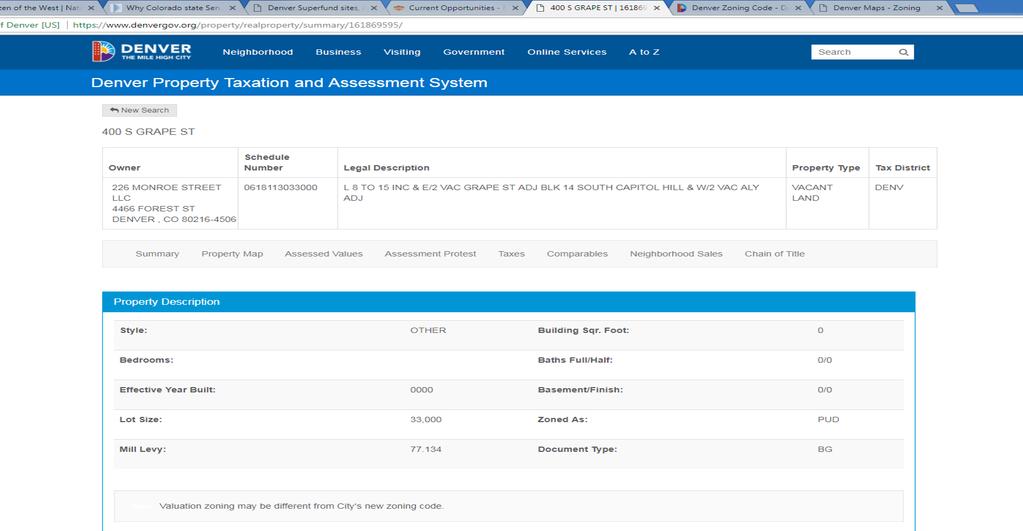
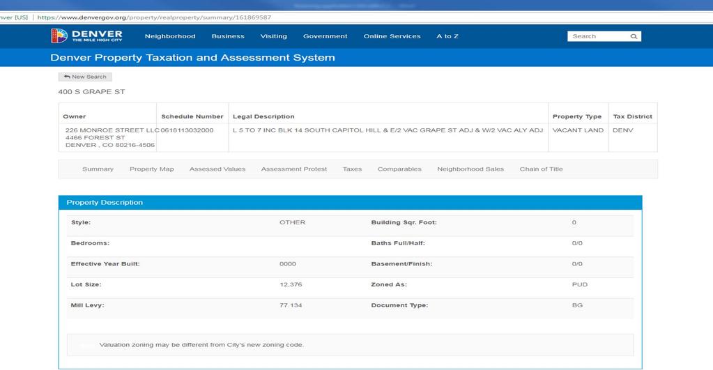
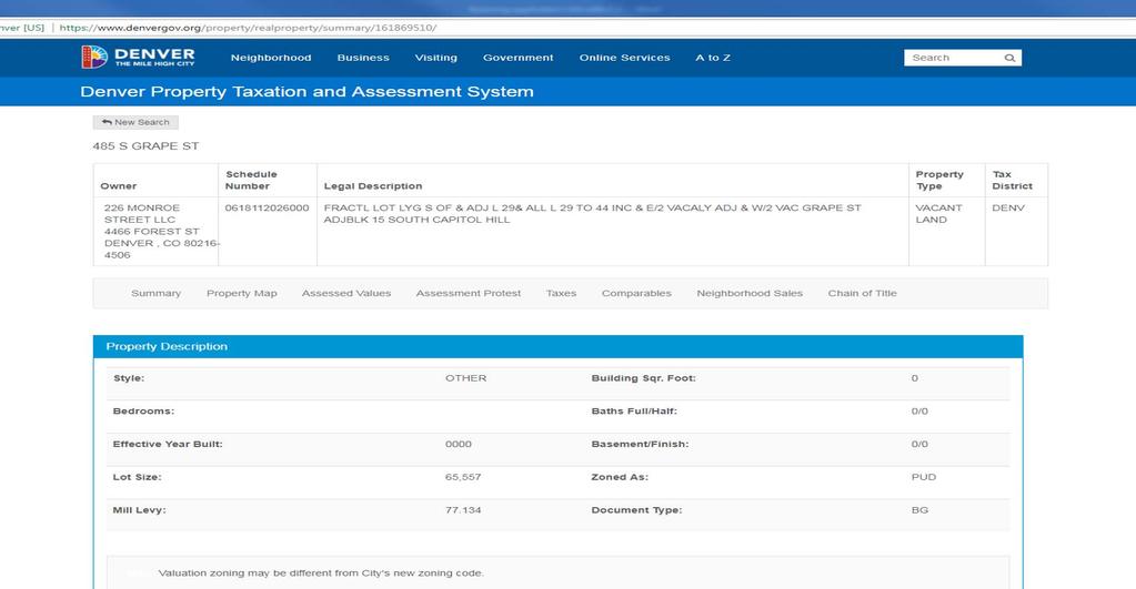
18 Map Amendment: 5301 Leetsdale Dr, 5231 Leetsdale Dr, 5401 Leetsdale Dr, 5411 Leetsdale Dr, 485 S. Grape St, 400 S. Grape St: Addendum & Exhibits EXHIBIT B: LEGAL DESCRIPTIONS 400 S. GRAPE STREET LEGAL DESCRIPTION THE LAND REFERRED TO IN SCHEDULE A IS SITUATED IN THE COUNTY OF DENVER, STATE OF COLORADO AND IS DESCRIBED AS FOLLOWS: PARCEL A-I: LOTS INCLUSIVE, BLOCK 14. SOUTH CAPITOL HILL, TOGETHER WITH THE EAST HALF OF VACATED GRAPE STREET IMMEDIATELY ADJACENT TO SAID LOTS AND WEST HALF OF THE VACATED ALLEY IMMEDIATTELY ADJACENT TO SAID LOTS IN BLOCK 14, CITY AND COUNTY OF DENVER, STATE OF COLORADO. PARCEL A-II: A NONEXCLUSIVE EASEMENT FOR EMERCENY VEHICLE ACCESS AS SET FORTH IN THE GRANT OF EASEMENT RECORDED OCTOBER 23, 1987 AT RECEPTION NUMBER , IN THE RECORDS OF THE OFFICE OF THE CLERK AND RECORDER OF THE CITY AND COUNTY OF DENVER, STATE OF COLORADO. PARCEL A-III: AN EASEMENT FOR ACCESS AS SET FORTH IN THE FINDING OF FACT, CONCLUSION OF LAW AND ORDER RECORDED SEPTMBER 8, 2008 AT RECEPTION NUMBER , AND RE-RECORDED TO INCLUDE THE EXHIBITS ON AT RECEPTION NUMBER, IN THE RECORDS OF THE OFFICE OF THE CLERK AND RECORDER OF THE CITY AND COUNTY OF DENVER, STATE OF COLORADO. 485 S. GRAPE STREET LEGAL DESCRIPTION PARCEL B. FRACTIONAL LOT LYING SOUTH OF AND ADJACENT TO LOT 29, AND ALL OF LOTS 29 THROUGH 44, INCLUSIVE, BLOCK 15, SOUTH CAPITOL HILL, TOGETHER WITH THE EAST HALF OF VACATED ALLEY ADJACENT TO SAID LOTS ON THE WEST AS VACATED BY ORDINANCE NO. 202, SERIES OF 1956, RECORDED JUNE 22, 1956 IN BOOK 7892 AT PAGE 73, AND TOGTHER WITH THE WEST OF HALF VACATED SOUTH GRAPE STREET ADJACENT TO SAID LOTS ON THE EAST AS VACATED BY ORDINANCE NO. 434, SERIES OF 1979, RECORDED OCTOBER 2, 1979 IN BOOK 2019 AT PAGE 206, CITY AND COUNTY OF DENVER, STATE OF COLORADO. 14
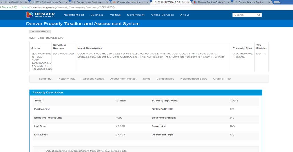
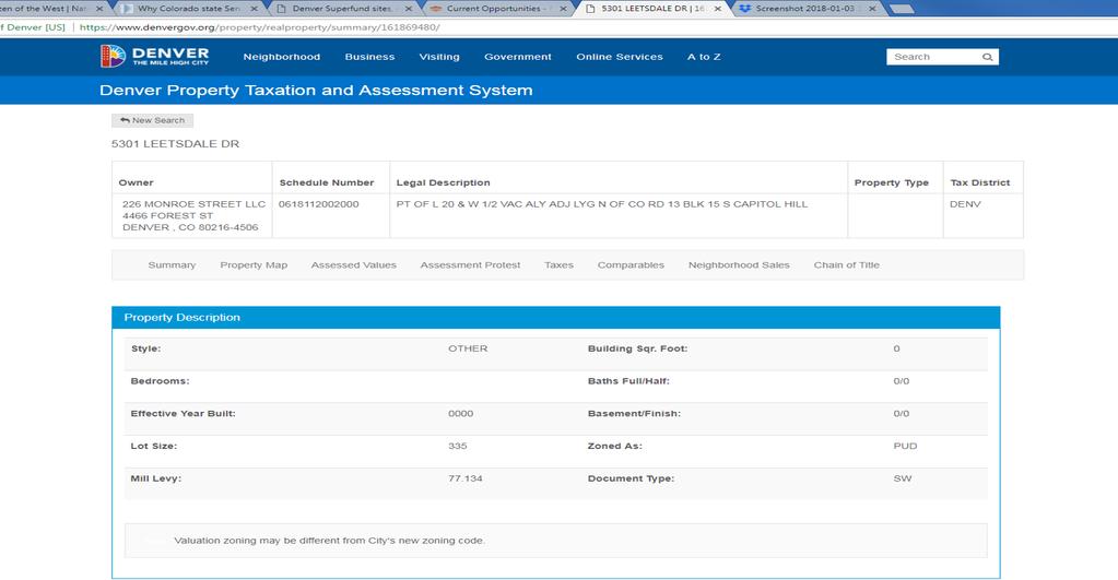
19 Map Amendment: 5301 Leetsdale Dr, 5231 Leetsdale Dr, 5401 Leetsdale Dr, 5411 Leetsdale Dr, 485 S. Grape St, 400 S. Grape St Addendum & Exhibits 5231 LEETSDALE DR PARCEL A: THAT PART OF LOT 31 LYING NORTH OF COUNTRY ROAD NO. 13 AND ALL OF LOTS 32 TO 44, INCLUSIVE, BLOCK 16, SOUTH CAPITOL HILL, (REC.# DATED 3\8\1888) TOGETHER WITH THAT PART OF THE WEST ½ OF VACATED SOUTH GLENCOE STREET ADJOINING SAID LOTS ON THE EAST VESTED IN THE OWNERS OF THE ABOVE LOTS BY VIRTUE OF ORDINANCE NO. 434, SERIES OF 1979 OF THE CITY AND COUNTY OF DENVER, RECORDED OCTOBER 2, 1979 IN BOOK 2019 AT PAGE 206, AND TOGTHER WITH THE E ½ OF VACATED ALLEY ADJOINING SAID LOTS OF THE WEST VESTED IN THE OWNER OF THE ABOVE LOTS BY VIRTUE OF ORDINANCE NO. 359, SERIES 1983 OF THE CITY AND COUNTY OF DENVER, RECOREDED JUNE 29, 1983 IN BOOK 2837 AT PAGE 37O, EXCEPT THAT PORTION AS CONVEYED TO THE CITY AND COUNTY OF DENVER BY INSTUMENT, RECORDED SEPTEMEBR 3, 1999 AT RECEPTION NUMBER , CITY AND COUNTY OF DENVER, STATE OF COLORADO. PARCEL B: NON-EXCLUSIVE EASEMENT FOR INGRESS AND EGRESS OVER THE VACATED ½ OF GLENCOE STREET, AS MORE PARTICULARLY DEFINED IN THE CERTAIN RECIPROCAL ACCESS EASEMENT AGREEMENT, RECORDED MAY 6, 1999 AT RECEPTION NO , CITY AND COUNTY OF DENVER, STATE OF COLORADO LEETSDALE DRIVE LEGAL DESCRIPTION PARCEL A: LOTS 5 THROUGH 19, INCLUSIVE, BLOCK 15, SOUTH CAPITOL HILL, TOGTHER WITH THE WEST ONE HALF OF THE VACATED ALLEY VESTED IN THE OWNER OF SAID LOTS BY VIRTUE OF ORDINANCE NO. 202, SERIES OF 1956, RECORDED JUNE 22, 1956 IN BOOK 7892 AT PAGE 73, AND TOGETHER WITH THE EAST ONE HALF OF VACATED SOUTH GLENCOE STREET VESTED IN THE OWNER OF SAID LOTS BY VIRTUE OF ORDINANCE NO. 434, SERIES 1979, RECORDED OCTOBER 2, 1979 IN BOOK 2019 PAGE 206, CITY AND COUNTY OF DENVER, STATE OF COLORADO. PARCEL B: THAT PART OF LOT 20, AND THE WEST ½ OF VACATED ALLEY ADJACENT, LYING NORTH OF COUNTRY ROAD 13, BLOCK 15, SOUTH CAPITOL HILL, CITY AND COUNTY OF DENVER, STATE OF COLORADO. 15
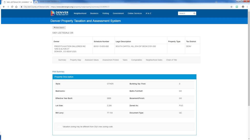
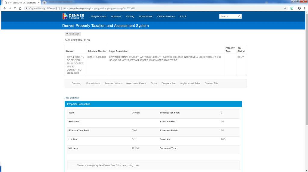
20 Map Amendment: 5301 Leetsdale Dr, 5231 Leetsdale Dr, 5401 Leetsdale Dr, 5411 Leetsdale Dr, 485 S. Grape St, 400 S. Grape St: Addendum & Exhibits 5401 LEETSDALE DRIVE PARCEL A: LEGAL DESCRIPTION E/2 VAC S GRAPE ST ADJ THAT PTBLK 14 SOUTH CAPITOL HILL BEG INTERS NELY LI LEETSDALE & E LI SD VAC ST NLY 20.55FT A/R 103DEG 19MIN 40SEC FT TO PARCEL B: (5409 Leetsdale Drive) LEGAL DESCRIPTION SOUTH CAPITOL HILL B14 DIF BOOK PARCEL C (5413 Leetsdale Drive) LEGAL DESCRIPTION PT BLK 14 SO CAPITOL HILL BEG INTERS NELY LI LEETSDALE DR & E LI VAC S GRAPE TH NLY FT TH A/R 103DEG 19MIN 40SEC FT TO W LI ALY TH SLY 5411 LEETSDALE DRIVE LEGAL DESCRIPTION SOUTH CAPITOL HILL B14 L16 TO 22 DIF BOOK
21 Map Amendment: 5301 Leetsdale Dr, 5231 Leetsdale Dr, 5401 Leetsdale Dr, 5411 Leetsdale Dr, 485 S. Grape St, 400 S. Grape St: Addendum & Exhibits EXHIBIT C: PROOF OF OWNERSHIP See proof of ownership on the following pages. 17
22 18
23 19
24 20
25 21
26 22
27 2017I October 29, 2018 Fees waived per DZC
28 24
29 25
30 26
31 27
32 Map Amendment: 5301 Leetsdale Dr, 5231 Leetsdale Dr, 5401 Leetsdale Dr, 5411 Leetsdale Dr, 485 S. Grape St, 400 S. Grape St Addendum & Exhibits EXHIBIT D: AUTHORIZATION DOCUMENTS See authorization documents on the following pages. 28
33 I October 29, 2018 Fees waived per DZC
34 30
35 31

36 226 MONROE STREET LLC 4466 Forest St. Denver, CO January 23, 2018 City & County of Denver Community Planning and Development Rezoning/Map Amendments 201 W. Colfax Ave., Dept. 201 Denver, CO To Whom It May Concern: This letter is to serve as authorization for Liz Adams and Peter Wall of CRL Associates, Inc. to act on behalf of 226 Monroe Street LLC and submit the Zone Map Amendment for the properties located at: 400 S. Grape St. 485 S. Grape St Leetsdale Dr Leetsdale Dr. Sincerely, Paula Arnold Manager 2017I October 29, 2018 Fees waived per DZC
37 33
38 Map Amendment: 5301 Leetsdale Dr, 5231 Leetsdale Dr, 5401 Leetsdale Dr, 5411 Leetsdale Dr, 485 S. Grape St, 400 S. Grape St: Addendum & Exhibits EXHIBIT E: ASSESSOR S PARCEL NUMBERS 400 S. Grape St S. Grape St Leetsdale Dr Leetsdale Dr Leetsdale Dr Leetsdale Dr Leetsdale Dr I October 29, 2018 Fees waived per DZC

39 Map Amendment: 5301 Leetsdale Dr, 5231 Leetsdale Dr, 5401 Leetsdale Dr, 5411 Leetsdale Dr, 485 S. Grape St, 400 S. Grape St: Addendum & Exhibits Map of Proposed Rezoning 35
REZONING GUIDE. Zone Map Amendment (Rezoning) - Application. Rezoning Application Page 1 of 3. Return completed form to
 - Application. Rezoning Application Page 1 of 3. Return completed form to") Zone Map Amendment (Rezoning) - Application COMMUNITY PLANNING & DEVELOPMENT REZONING GUIDE Rezoning Application Page 1 of 3 PROPERTY OWNER INFORMATION* CHECK IF POINT OF CONTACT FOR APPLICATION Property
Zone Map Amendment (Rezoning) - Application COMMUNITY PLANNING & DEVELOPMENT REZONING GUIDE Rezoning Application Page 1 of 3 PROPERTY OWNER INFORMATION* CHECK IF POINT OF CONTACT FOR APPLICATION Property
Representative Name. Address. City, State, Zip. Telephone.
 COMMUNITY PLANNING & DEVELOPMENT ~~DENVER... THE MILE HIGH CITY REZONING GUIDE Zone Map Amendment (Rezoning)- Application Rezoning Application Page 1 of 3 Property Owner Name Philip M. Falco Address 730
REZONING GUIDE. Zone Map Amendment (Rezoning) - Application. Rezoning Application Page 1 of 3. Return completed form to
 - Application. Rezoning Application Page 1 of 3. Return completed form to") COMMUNITY PLANNING & DEVELOPMENT REZONING GUIDE Rezoning Application Page 1 of 3 Zone Map Amendment (Rezoning) - Application PROPERTY OWNER INFORMATION* PROPERTY OWNER(S) REPRESENTATIVE** CHECK IF POINT
COMMUNITY PLANNING & DEVELOPMENT REZONING GUIDE Rezoning Application Page 1 of 3 Zone Map Amendment (Rezoning) - Application PROPERTY OWNER INFORMATION* PROPERTY OWNER(S) REPRESENTATIVE** CHECK IF POINT
E-SU-A. Zone Map Amendment (Rezoning) -Application E-SU-B. Rf tum cornpleted form to rezoning(i:})denvergov.org. *If More Than One Property Owner;
 -Application E-SU-B. Rf tum cornpleted form to rezoning(i:})denvergov.org. *If More Than One Property Owner;") Zone Map Amendment (Rezoning) -Application Property Owner Name Philip M. Falco Representative Name Address 730 17th Street, Suite 900 Address City, State, Zip Denver, CO 80202 City, State, Zip Telephone
Zone Map Amendment (Rezoning) -Application Property Owner Name Philip M. Falco Representative Name Address 730 17th Street, Suite 900 Address City, State, Zip Denver, CO 80202 City, State, Zip Telephone
REZONING GUIDE. Zone Map Amendment (Rezoning) - Application. Rezoning Application Page 1 of 3. Return completed form to
 - Application. Rezoning Application Page 1 of 3. Return completed form to") COMMUNITY PLANNING & DEVELOPMENT REZONING GUIDE Rezoning Application Page 1 of 3 Zone Map Amendment (Rezoning) - Application PROPERTY OWNER INFORMATION* PROPERTY OWNER(S) REPRESENTATIVE** CHECK IF POINT
COMMUNITY PLANNING & DEVELOPMENT REZONING GUIDE Rezoning Application Page 1 of 3 Zone Map Amendment (Rezoning) - Application PROPERTY OWNER INFORMATION* PROPERTY OWNER(S) REPRESENTATIVE** CHECK IF POINT
REZONING GUIDE. Zone Map Amendment (Rezoning) - Application. Rezoning Application Page 1 of 3. Return completed form to
 - Application. Rezoning Application Page 1 of 3. Return completed form to") Zone Map Amendment (Rezoning) - Application COMMUNITY PLANNING & DEVELOPMENT REZONING GUIDE Rezoning Application Page 1 of 3 PROPERTY OWNER INFORMATION* CHECK IF POINT OF CONTACT FOR APPLICATION Property
Zone Map Amendment (Rezoning) - Application COMMUNITY PLANNING & DEVELOPMENT REZONING GUIDE Rezoning Application Page 1 of 3 PROPERTY OWNER INFORMATION* CHECK IF POINT OF CONTACT FOR APPLICATION Property
E-SU-A. Zone Map Amendment (Rezoning) -Application E-SU-B. Rf tum cornpleted form to rezoning(i:})denvergov.org. *If More Than One Property Owner;
 -Application E-SU-B. Rf tum cornpleted form to rezoning(i:})denvergov.org. *If More Than One Property Owner;") Zone Map Amendment (Rezoning) -Application Property Owner Name Philip M. Falco Representative Name Address 730 17th Street, Suite 900 Address City, State, Zip Denver, CO 80202 City, State, Zip Telephone
Zone Map Amendment (Rezoning) -Application Property Owner Name Philip M. Falco Representative Name Address 730 17th Street, Suite 900 Address City, State, Zip Denver, CO 80202 City, State, Zip Telephone
Telephone AC / 21,960 SF G-MU-3 G-MX-3
 Zone Map Amendment (Rezoning) - Application PROPERTY OWNER INFORMATION* CHECK IF POINT OF CONTACT FOR APPLICATION Property Owner Name Siddhartha Rathod Address City, State, Zip Telephone Email COMMUNITY
REZONING GUIDE. Zone Map Amendment (Rezoning) - Application. Applicant: Albus Brooks, Councilman District 9
 - Application. Applicant: Albus Brooks, Councilman District 9") Zone Map Amendment (Rezoning) - Application COMMUNITY PLANNING & DEVELOPMENT REZONING GUIDE Rezoning Application Page 1 of 3 PROPERTY OWNER INFORMATION* CHECK IF POINT OF CONTACT FOR APPLICATION Property
Zone Map Amendment (Rezoning) - Application COMMUNITY PLANNING & DEVELOPMENT REZONING GUIDE Rezoning Application Page 1 of 3 PROPERTY OWNER INFORMATION* CHECK IF POINT OF CONTACT FOR APPLICATION Property
Official Zoning Map Amendment Application #2017I and 4889 South Quebec Street Rezoning from B-4 with waivers, UO-1, UO-2 to C-MX-20
 Community Planning and Development Planning Services 201 W. Colfax Ave., Dept. 205 Denver, CO 80202 p: 720.865.2915 f: 720.865.3052 www.denvergov.org/cpd TO: Denver Planning Board FROM: Jeff Hirt, Senior
Land Use, Transportation, and Infrastructure Committee of Denver City Council FROM: Scott Robinson, Senior City Planner DATE: December 6, 2018 RE:
 Community Planning and Development Planning Services 201 W. Colfax Ave., Dept. 205 Denver, CO 80202 p: 720.865.2915 f: 720.865.3052 www.denvergov.org/cpd TO: Land Use, Transportation, and Infrastructure
Land Use, Transportation, and Infrastructure Committee of the Denver City Council FROM: Scott Robinson, Senior City Planner DATE: March 22, 2018 RE:
 Community Planning and Development Planning Services 201 W. Colfax Ave., Dept. 205 Denver, CO 80202 p: 720.865.2915 f: 720.865.3052 www.denvergov.org/cpd TO: Land Use, Transportation, and Infrastructure
Zone Map Amendment (Rezoning) for PUD - Application York St. U-MX-3, B-2 with Waivers. General PUD. Yes. See Attachment C U-MX-3, I-MX-3
 for PUD - Application York St. U-MX-3, B-2 with Waivers. General PUD. Yes. See Attachment C U-MX-3, I-MX-3") COMMUNITY PLANNING & DEVELOPMENT REZONING GUIDE Rezoning Application for PUD Page 1 of 3 Zone Map Amendment (Rezoning) for PUD - Application PROPERTY OWNER INFORMATION* CHECK IF POINT OF CONTACT FOR APPLICATION
COMMUNITY PLANNING & DEVELOPMENT REZONING GUIDE Rezoning Application for PUD Page 1 of 3 Zone Map Amendment (Rezoning) for PUD - Application PROPERTY OWNER INFORMATION* CHECK IF POINT OF CONTACT FOR APPLICATION
Block bounded by Newton St., 17 th Ave., Lowell Blvd., and 16 th Ave.; plus Meade Street (evens only)
") Community Planning and Development Planning Services 201 W. Colfax Ave., Dept. 205 Denver, CO 80202 p: 720.865.2915 f: 720.865.3052 www.denvergov.org/cpd TO: Denver Planning Board FROM: Sara White, AICP,
Community Planning and Development Planning Services 201 W. Colfax Ave., Dept. 205 Denver, CO 80202 p: 720.865.2915 f: 720.865.3052 www.denvergov.org/cpd TO: Denver Planning Board FROM: Sara White, AICP,
Staff Report and Recommendation Based on the criteria for review in the Denver Zoning Code, Staff recommends approval for application #2017I
 TO: Denver City Council, Land Use, Transportation and Infrastructure Committee FROM: Theresa Lucero, Senior City Planner DATE: RE: Official Zoning Map Amendment Application #2017I-00153 Staff Report and
Official Zoning Map Amendment Application #2018I-00095
 Community Planning and Development Planning Services 201 W. Colfax Ave., Dept. 205 Denver, CO 80202 p: 720.865.2915 f: 720.865.3052 www.denvergov.org/cpd TO: Denver Planning Board FROM: Ella Stueve, Senior
Staff Report and Recommendation Based on the criteria for review in the Denver Zoning Code, Staff recommends approval for Application #2017I
 TO: Denver Planning Board, Joel Noble, Chair FROM: Theresa Lucero, Senior City Planner DATE: RE: Official Zoning Map Amendment Application #2017I-00163 Staff Report and Recommendation Based on the criteria
Request for Rezoning. Current Zoning: Proposed Zoning:
 TO: Denver City Council, Neighborhoods and Planning Committee FROM: Theresa Lucero, Senior City Planner DATE: March 31, 2016 RE: Zoning Map Amendment #2015I-00150 Rezoning from M-RX-5 to I-MX-3 Community
Article 3. SUBURBAN (S-) NEIGHBORHOOD CONTEXT
 NEIGHBORHOOD CONTEXT") Article 3. SUBURBAN (S-) NEIGHBORHOOD CONTEXT this page left intentionally blank Contents ARTICLE 3. SUBURBAN (S-) NEIGHBORHOOD CONTEXT DIVISION 3.1 NEIGHBORHOOD CONTEXT DESCRIPTION...3.1-1 Section 3.1.1
Article 3. SUBURBAN (S-) NEIGHBORHOOD CONTEXT this page left intentionally blank Contents ARTICLE 3. SUBURBAN (S-) NEIGHBORHOOD CONTEXT DIVISION 3.1 NEIGHBORHOOD CONTEXT DESCRIPTION...3.1-1 Section 3.1.1
To: S-MX-8 AIO, S-MX-8A AIO, S-MX-12 AIO, C-MX-8 AIO, C-MX-12 AIO, and S-CC-5 AIO
 Community Planning and Development Planning Services 201 W. Colfax Ave., Dept. 205 Denver, CO 80202 p: 720.865.2915 f: 720.865.3052 www.denvergov.org/cpd TO: Denver City Council FROM: Curt Upton, Senior
Official Zoning Map Amendment Application #2017I-00094
 Community Planning and Development Planning Services 201 W. Colfax Ave., Dept. 205 Denver, CO 80202 p: 720.865.2915 f: 720.865.3052 www.denvergov.org/cpd TO: Denver Planning Board FROM: Scott Robinson,
2017I September 7, 2018 fees waived per
 Review Criteria for 3610 and 3612 North Clay Street from PUD #504 to U-TU-B. 1. Consistency with Adopted Plans: The following adopted plans apply to this property: Denver Comprehensive Plan 2000 Blueprint
Official Zoning Map Amendment Application #2017I Gaylord Street and York Street Rezoning from U-RH-2.5 to U-RX-3 and U-RX-5
 Community Planning and Development Planning Services 201 W. Colfax Ave., Dept. 205 Denver, CO 80202 p: 720.865.2915 f: 720.865.3052 www.denvergov.org/cpd TO: Denver Planning Board FROM: Elizabeth Weigle,
Public Review of the Slot Home Text Amendment
 Public Review of the Slot Home Text Amendment The proposed amendments to the Denver Zoning Code have been informed by the Slot Home Strategy Report. This document has been developed out of a robust process
REZONING GUIDE. Zone Map Amendment (Rezoning) - Application. Rezoning Application Page 1 of 3. Return completed form to
 - Application. Rezoning Application Page 1 of 3. Return completed form to") COMMUNITY PLANNING & DEVELOPMENT REZONING GUIDE Rezoning Application Page 1 of 3 Zone Map Amendment (Rezoning) - Application PROPERTY OWNER INFORMATION* PROPERTY OWNER(S) REPRESENTATIVE** CHECK IF POINT
COMMUNITY PLANNING & DEVELOPMENT REZONING GUIDE Rezoning Application Page 1 of 3 Zone Map Amendment (Rezoning) - Application PROPERTY OWNER INFORMATION* PROPERTY OWNER(S) REPRESENTATIVE** CHECK IF POINT
ARTICLE 3: Zone Districts
 ARTICLE 3: Zone Districts... 3-1 17.3.1: General...3-1 17.3.1.1: Purpose and Intent... 3-1 17.3.2: Districts and Maps...3-1 17.3.2.1: Applicability... 3-1 17.3.2.2: Creation of Districts... 3-1 17.3.2.3:
Official Zoning Map Amendment Application #2015I N. King Street and 3441 W. 39 th Ave Rezoning from PUD 406 to U-SU-B1
 Community Planning and Development Planning Services 201 W. Colfax Ave., Dept. 205 Denver, CO 80202 p: 720.865.2915 f: 720.865.3052 www.denvergov.org/cpd TO: Neighborhoods and Planning Committee FROM:
Brad Buchanan, Executive Director, Department of Community Planning and Development
 TO: City Council FROM: Jeff Hirt, Senior City Planner DATE: RE: Official Zoning Map Amendment Application #2017I-00076 3400 Arkins Ct., 3460 Arkins Ct., 1900 35 th St, 1930 35th St., 1950 35 th St Rezoning
Official Zoning Map Amendment Application #2017I-00090
 Community Planning and Development Planning Services 201 W. Colfax Ave., Dept. 205 Denver, CO 80202 p: 720.865.2915 f: 720.865.3052 www.denvergov.org/cpd TO: Land Use, Transportation, & Infrastructure
Official Zoning Map Amendment Application #2015I Marion St. Rezoning from U-SU-A1 to U-MX-2x
 Community Planning and Development Planning Services 201 W. Colfax Ave., Dept. 205 Denver, CO 80202 p: 720.865.2915 f: 720.865.3052 www.denvergov.org/cpd TO: Denver City Council FROM: Courtland Hyser,
Land Use, Transportation, & Infrastructure Committee of the Denver City Council FROM: Chandler Van Schaack, Senior City Planner DATE: July 3, 2018 RE:
 Community Planning and Development Planning Services TO: Land Use, Transportation, & Infrastructure Committee of the Denver City Council FROM: Chandler Van Schaack, Senior City Planner DATE: July 3, 2018
Based on the criteria for review in the Denver Zoning Code, Staff recommends approval for Application #2018I
 Community Planning and Development Planning Services 201 W. Colfax Ave., Dept. 205 Denver, CO 80202 p: 720.865.2915 f: 720.865.3052 www.denvergov.org/cpd TO: Denver Planning Board FROM: Chandler Van Schaack,
Article 6. GENERAL URBAN (G-) NEIGHBORHOOD CONTEXT
 NEIGHBORHOOD CONTEXT") Article 6. GENERAL URBAN (G-) NEIGHBORHOOD CONTEXT this page left intentionally blank Contents ARTICLE 6. GENERAL URBAN (G-) NEIGHBORHOOD CONTEXT DIVISION 6.1 NEIGHBORHOOD CONTEXT DESCRIPTION...6.1-1 Section
Article 6. GENERAL URBAN (G-) NEIGHBORHOOD CONTEXT this page left intentionally blank Contents ARTICLE 6. GENERAL URBAN (G-) NEIGHBORHOOD CONTEXT DIVISION 6.1 NEIGHBORHOOD CONTEXT DESCRIPTION...6.1-1 Section
Official Zoning Map Amendment Application #2018I-00067
 Community Planning and Development Planning Services 201 W. Colfax Ave., Dept. 205 Denver, CO 80202 p: 720.865.2915 f: 720.865.3052 www.denvergov.org/cpd TO: Denver Planning Board FROM: Courtney Levingston,
PLANNING COMMISSION STAFF REPORT
 PLANNING COMMISSION STAFF REPORT West Capitol Hill Zoning Map Amendment Petition No. PLNPCM2011-00665 Located approximately at 548 W 300 North Street, 543 W 400 North Street, and 375 N 500 West Street
Appendix A: Guide to Zoning Categories Prince George's County, Maryland
 Appendix A: Guide to Zoning Categories Prince George's County, Maryland RESIDENTIAL ZONES 1 Updated November 2010 R-O-S: Reserved Open Space - Provides for permanent maintenance of certain areas of land
FUTURE LAND USE. City of St. Augustine Comprehensive Plan EAR-Based Amendments
 FUTURE LAND USE City of St. Augustine Comprehensive Plan EAR-Based Amendments Future Land Use Element FLU Goal To create an environment within the City and adjacent areas in which its residents have the
PLANNING COMMISSION STAFF REPORT
 PLANNING COMMISSION STAFF REPORT REZONING CASE: RZ-16-001 REPORT DATE: March 8, 2016 CASE NAME: Trailbreak Partners Rezoning PLANNING COMMISSION DATE: March 16, 2016 ADDRESSES OF REZONING PROPOSAL: 5501
Reviewing Mixed Use Proposals
 MIXED USE ZONING Citizens Guide Supplement 1 Things to Consider in Reviewing Mixed Use Proposals Using an Overlay District vs. Changing Underlying Zoning To achieve well-planned mixed use development,
Official Zoning Map Amendment Application #2018I-00120
 Community Planning and Development Planning Services 201 W. Colfax Ave., Dept. 205 Denver, CO 80202 p: 720.865.2915 f: 720.865.3052 www.denvergov.org/cpd TO: Denver Planning Board FROM: Scott Robinson,
13 Sectional Map Amendment
 13 Sectional Map Amendment Introduction This chapter reviews land use and zoning policies and practices in Prince George s County and presents the proposed zoning in the sectional map amendment (SMA) to
Staff Report and Recommendation
 Community Planning and Development Planning Services 201 W. Colfax Ave., Dept. 205 Denver, CO 80202 p: 720.865.2915 f: 720.865.3052 www.denvergov.org/cpd TO: Denver Planning Board FROM: Andrew Webb, Senior
REZONING GUIDE. Zone Map Amendment (Rezoning) - Application. Rezoning Application Page 1 of 3. Return completed form to
 - Application. Rezoning Application Page 1 of 3. Return completed form to") COMMUNITY PLANNING & DEVELOPMENT REZONING GUIDE Rezoning Application Page 1 of 3 Zone Map Amendment (Rezoning) - Application PROPERTY OWNER INFORMATION* PROPERTY OWNER(S) REPRESENTATIVE** CHECK IF POINT
COMMUNITY PLANNING & DEVELOPMENT REZONING GUIDE Rezoning Application Page 1 of 3 Zone Map Amendment (Rezoning) - Application PROPERTY OWNER INFORMATION* PROPERTY OWNER(S) REPRESENTATIVE** CHECK IF POINT
Bylaw No , being "Official Community Plan Bylaw, 2016" Schedule "A" DRAFT
 Bylaw No. 2600-2016, being "Official Community Plan Bylaw, 2016" Schedule "A" Urban Structure + Growth Plan Urban Structure Land use and growth management are among the most powerful policy tools at the
DIVISION 1.3 OFFICIAL ZONING MAP
 Article 1. General Provisions Division 1.3 Official Zone Map DIVISION 1.3 OFFICIAL ZONING MAP SECTION 1.3.1 ADOPTION OF OFFICIAL MAP The digital maps created and maintained by the Department of Community
PARRAMORE OAKS FRAMEWORK PLANNED DEVELOPMENT
 PARRAMORE OAKS FRAMEWORK PLANNED DEVELOPMENT Presented by Mark Cechman, AICP Paul S. Lewis, FAICP Review Process Pre- Application meeting August 11, 2016 Attended by representatives of: City Planning Transportation
HOUSING ELEMENT GOALS, OBJECTIVES, AND POLICIES
 HOUSING ELEMENT GOALS, OBJECTIVES, AND POLICIES GOAL 1: To promote the preservation and development of high-quality, balanced, and diverse housing options for persons of all income levels throughout the
PLANNED UNIT DEVELOPMENT & SUBDIVISION STAFF REPORT Date: April 18, 2019
 PLANNED UNIT DEVELOPMENT & SUBDIVISION STAFF REPORT Date: April 18, 2019 DEVELOPMENT NAME SUBDIVISION NAME Springhill Village Subdivision Springhill Village Subdivision LOCATION 4350, 4354, 4356, 4358,
8/17/16 PC Meeting 1
 1 GENERAL INFORMATION OWNER/APPLICANT: Thomas Corff & Terry Moberly (1943 13 th St.) 19328 Towercrest Dr. Oregon City, OR 97045 Michael & Jill Parker (1983 13 th St.) 1708 Oak St. Lake Oswego, OR 97034
Hennepin County Department of. Housing, Community Works and Transit. Transit Oriented Development (TOD) Guidelines
 Guidelines") Hennepin County Department of Housing, Community Works and Transit 2007 Transit Oriented Development (TOD) Guidelines Hennepin County Transit Oriented Development (TOD) Bond Funds Hennepin County Housing,
Hennepin County Department of Housing, Community Works and Transit 2007 Transit Oriented Development (TOD) Guidelines Hennepin County Transit Oriented Development (TOD) Bond Funds Hennepin County Housing,
DEVELOPMENT DEPARTMENT STAFF REPORT STAFF REPORT MCDONALD S ZONING MAP AMENDMENT AND CONCURRENT VARIANCES
 DEVELOPMENT DEPARTMENT STAFF REPORT Meeting Date: October 12, 2017 Item #: _PZ2017-172_ STAFF REPORT MCDONALD S ZONING MAP AMENDMENT AND CONCURRENT VARIANCES Request: Rezone property from MU-BC to CC,
GENERAL DESCRIPTION STAFF RECOMMENDATION IMPLEMENTATION REQUIREMENTS
 Application No.: 891418 Applicant: AREA-WIDE MAP AMENDMENT Rezone two parcels from Moderate Density Single Family (MSF) to Neighborhood Center (NC) and Employment Center (EC). Charles Bitton GENERAL DESCRIPTION
An Introduction to the City of Winnipeg s New Zoning By-Law
 An Introduction to the City of Winnipeg s New Zoning By-Law Presentation To: APEGM PIDIM MAA April 30, 2008 1 The Planning Hierarchy Plan Winnipeg s Primary Purpose: To ensure that the use and development
REGULATING PLAN for the Plaza Saltillo TOD Station Area Plan (SAP)
") REGULATING PLAN for the Plaza Saltillo TOD Station Area Plan (SAP) Adopted: December 11, 2008 Effective: March 1, 2009 REGULATING PLAN for the Plaza Saltillo TOD Station Area Plan (SAP) CONTENTS BACKGROUND...iv
REGULATING PLAN for the Plaza Saltillo TOD Station Area Plan (SAP) Adopted: December 11, 2008 Effective: March 1, 2009 REGULATING PLAN for the Plaza Saltillo TOD Station Area Plan (SAP) CONTENTS BACKGROUND...iv
DZC and DRMC Amendments to Implement 38th and Blake Station Area Height Amendments
 DZC and DRMC Amendments to Implement 38th and Blake Station Area Height Amendments DZC Text Amendment #2 to establish River North Design Overlay (DO-7) / 38 th and Blake Incentive Overlay (IO-1) (CB18-0016)
Staff Report PLANNING DIVISION COMMUNITY & ECONOMIC DEVELOPMENT. Alley Closure
 Staff Report PLANNING DIVISION COMMUNITY & ECONOMIC DEVELOPMENT To: From: Salt Lake City Planning Commission Doug Dansie, 801-535-6182, doug.dansie@slcgov.com Date: March 23, 2016 Re: PLNPCM2015-00941
VARIANCE APPLICATION INFORMATION PACKET CITY OF BILLINGS
 VARIANCE 2018-2019 APPLICATION INFORMATION PACKET CITY OF BILLINGS VARIANCE APPLICATION CITY OF BILLINGS Planning & Community Services Department 2825 3 rd Ave North, 4 th Floor Billings, MT 59101 Phone:
Planning Justification Report
 Planning Justification Report 101 Kozlov Street, Barrie, Ont. Destaron Property Management Ltd. November 2015 Revised February 2017 TABLE OF CONTENTS Page 1.0 INTRODUCTION... 1 2.0 DESCRIPTION OF SUBJECT
DRAFT FOR DISCUSSION PURPOSES ONLY. Port Credit Local Area Plan Built Form Guidelines and Standards DRAFT For Discussion Purposes
 Port Credit Local Area Plan Built Form Guidelines and Standards DRAFT For Discussion Purposes 1 Local Area Plan - Project Alignment Overview Directions Report, October 2008 (General Summary Of Selected
Salem HNA and EOA Advisory Committee Meeting #6
 Salem HNA and EOA Advisory Committee Meeting #6 Residential Land Policies Employment Land Policies Policy Discussions with the Committee Outcome of today s meeting Direction from this Committee on proposed
DRAFT. Amendment to the Master Plan Land Use Element for Block 5002, Lot Township of Teaneck, Bergen County, New Jersey.
 DRAFT Amendment to the Master Plan Land Use Element for Block 5002, Lot 18.01 Township of Teaneck, Bergen County, New Jersey Prepared for: Township of Teaneck Planning Board Prepared by: Janice Talley,
Town of Yucca Valley GENERAL PLAN 1
 Town of Yucca Valley GENERAL PLAN 1 This page intentionally left blank. 3 HOUSING ELEMENT The Housing Element is intended to guide residential development and preservation consistent with the overall values
REZONING APPLICATION INSTRUCTIONS
 REZONING APPLICATION INSTRUCTIONS All required information, as stated on the Rezoning Application Checklist, must be included to qualify as a complete application. Upon receipt, staff will review the application
Rapid City Planning Commission Rezoning Project Report
 Rapid City Planning Commission Rezoning Project Report April 21, 2016 Item #9 Applicant Request(s) Case # 16RZ011; a request to rezone property from Central Business District to General Commercial District
Comprehensive Plan Amendment #PLN , Reserve at Cannon Branch (Coles Magisterial District)
") COUNTY OF PRINCE WILLIAM 5 County Complex Court, Prince William, Virginia 22192-9201 PLANNING (703) 792-7615 FAX (703) 792-4758 OFFICE Internet www.pwcgov.org Christopher M. Price, AICP Director of Planning
COUNTY OF PRINCE WILLIAM 5 County Complex Court, Prince William, Virginia 22192-9201 PLANNING (703) 792-7615 FAX (703) 792-4758 OFFICE Internet www.pwcgov.org Christopher M. Price, AICP Director of Planning
Chapter 10: Implementation
 Chapter 10: Introduction Once the Comprehensive Plan has been adopted by the City of Oakdale, the City can begin to implement the goals and strategies to make this vision a reality. This chapter will set
ADMINISTRATION RECOMMENDATION(S) 2017 May 04. That Calgary Planning Commission recommends APPROVAL of the proposed Land Use Amendment.
 2017 May 04. That Calgary Planning Commission recommends APPROVAL of the proposed Land Use Amendment.") Page 1 of 14 EXECUTIVE SUMMARY This proposed Land Use Amendment seeks to redesignate the subject parcel from Residential Contextual One/Two Dwelling (R-C2) District to a DC Direct Control District to accommodate
Page 1 of 14 EXECUTIVE SUMMARY This proposed Land Use Amendment seeks to redesignate the subject parcel from Residential Contextual One/Two Dwelling (R-C2) District to a DC Direct Control District to accommodate
Denver City Council Land Use, Transportation, and Infrastructure Committee FROM: Courtney Levingston, Senior City Planner DATE: July 26, 2018 RE:
 TO: Denver City Council Land Use, Transportation, and Infrastructure Committee FROM: Courtney Levingston, Senior City Planner DATE: RE: Official Zoning Map Amendment Application #2017I-00151 Staff Report
ORDINANCE WHEREAS, the adoption of this Ordinance shall not be construed as an admission that the aforesaid claim has merit or is correct; and
 ORDINANCE 12-24 AN ORDINANCE OF THE CITY OF WINTER GARDEN, FLORIDA, REPEALING ORDINANCE 12-02 AND REPLACING IT WITH THE AMENDMENTS TO ARTICLE V OF CHAPTER 118 OF THE WINTER GARDEN CODE OF ORDINANCES CONTAINED
Planning Justification Report
 Planning Justification Report Kellogg s Lands City of London E&E McLaughlin Ltd. June 14, 2017 Zelinka Priamo Ltd. Page i TABLE OF CONTENTS Page No. 1.0 2.0 2.1 2.2 3.0 4.0 5.0 5.1 5.2 5.3 5.4 5.5 5.6
PC Staff Report 11/18/2013 Z Item No. 1-1
 Z-13-00401 Item No. 1-1 PLANNING COMMISSION REPORT Regular Agenda - Public Hearing Item PC Staff Report 11/18/2013 ITEM NO. 1: Z-13-00401 IG (General Industrial) District TO CS (Strip Commercial) District;
SUBDIVISION, PLANNED UNIT DEVELOPMENT, ZONING AMENDMENT, & SIDEWALK WAIVER STAFF REPORT Date: July 19, 2018
 SUBDIVISION, PLANNED UNIT DEVELOPMENT, ZONING AMENDMENT, & SIDEWALK WAIVER STAFF REPORT Date: July 19, 2018 NAME SUBDIVISION NAME LOCATION West Mobile Properties, LLC U.S. Machine Subdivision 556, 566,
Midwest City, Oklahoma Zoning Ordinance
 2010 Midwest City, Oklahoma Zoning Ordinance 9/2/2010 Table of Contents Section 1. General Provisions... 5 1.1. Citation... 5 1.2. Authority... 5 1.3. Purpose... 5 1.4. Nature and Application... 5 1.5.
Poughkeepsie City Center Revitalization Plan
 Purpose and Need Purpose Increase job and educational opportunities for all residents Maximize fiscal productivity of downtown land uses Diversify retail mix Eliminate surface and building vacancies Create
Generic Environmental Impact Statement. Build-Out Analysis. City of Buffalo, New York. Prepared by:
 Generic Environmental Impact Statement Build-Out Analysis City of Buffalo, New York 2015 Prepared by: TABLE OF CONTENTS 1.0 INTRODUCTION 1 2.0 METHODOLOGY 2 3.0 EXISTING LAND USE 3 4.0 EXISTING ZONING
PLANNING COMMISSION REPORT Regular Agenda -Public Hearing Item
 PDP-13-00518 Item No. 3B- 1 PLANNING COMMISSION REPORT Regular Agenda -Public Hearing Item PC Staff Report 2/24/14 ITEM NO. 3B PRELIMINARY DEVELOPMENT PLAN FOR HERE @ KANSAS; 1101 INDIANA ST (SLD) PDP-13-00518:
Approval of Takoma Amended Joint Development Agreement
 Planning, Program Development and Real Estate Committee Item IV- A October 10, 2013 Approval of Takoma Amended Joint Development Agreement Washington Metropolitan Area Transit Authority Board Action/Information
this page left intentionally blank DENVER ZONING CODE
 Article 1. GENERAL PROVISIONS this page left intentionally blank Contents ARTICLE 1. GENERAL PROVISIONS DIVISION 1.1 GENERAL...1.1-1 Section 1.1.1 Purpose...1.1-1 Section 1.1.2 Intent...1.1-1 Section 1.1.3
H-POLICY 1: Preserve and improve existing neighborhoods. Ensure that Prince William County achieves new neighborhoods with a high quality of life.
 HOUSING Intent The intent of the Housing Plan is to provide a framework for providing for the housing needs of all residents of Prince William County. These needs are expressed in terms of quality, affordability,
DISCUSSION DRAFT 1 INTRODUCTORY PROVISIONS
 1 INTRODUCTORY PROVISIONS 1.1 GENERAL...3 Title 3 Authority 3 Applicability 3 Purpose 3 Regulatory Scope 4 Compliance 4 Fines and Penalties 4 Conflicting Provisions 5 Meaning & Intent 5 Text & Graphics
Article 7. URBAN CENTER (C-) NEIGHBORHOOD CONTEXT
 NEIGHBORHOOD CONTEXT") Article 7. URBAN CENTER (C-) NEIGHBORHOOD CONTEXT this page left intentionally blank Contents ARTICLE 7. URBAN CENTER (C-) NEIGHBORHOOD CONTEXT DIVISION 7.1 NEIGHBORHOOD CONTEXT DESCRIPTION.........................
Article 7. URBAN CENTER (C-) NEIGHBORHOOD CONTEXT this page left intentionally blank Contents ARTICLE 7. URBAN CENTER (C-) NEIGHBORHOOD CONTEXT DIVISION 7.1 NEIGHBORHOOD CONTEXT DESCRIPTION.........................
PLANNING REPORT Gordon Street City of Guelph. Prepared on behalf of Ontario Inc. March 17, Project No. 1507
 PLANNING REPORT 1131 Gordon Street City of Guelph Prepared on behalf of 1876698 Ontario Inc. March 17, 2016 Project No. 1507 423 Woolwich Street, Suite 201, Guelph, Ontario, N1H 3X3 Phone (519) 836-7526
LITTLE MOUNTAIN ADJACENT AREA REZONING POLICY
 LITTLE MOUNTAIN ADJACENT AREA REZONING POLICY JANUARY 2013 CONTENTS 1.0 INTENT & PRINCIPLES...1 2.0 APPLICATION...2 3.0 HOUSING TYPES, HEIGHT & DENSITY POLICIES...3 3.1 LOW TO MID-RISE APARTMENT POLICIES...4
PLANNED UNIT DEVELOPMENTS (Ordinance No.: 3036, 12/3/07; Repealed & Replaced by Ordinance No.: 4166, 10/15/12)
") 159.62 PLANNED UNIT DEVELOPMENTS (Ordinance No.: 3036, 12/3/07; Repealed & Replaced by Ordinance No.: 4166, 10/15/12) A. PURPOSE 1. General. The Planned Unit Development (PUD) approach provides the flexibility
159.62 PLANNED UNIT DEVELOPMENTS (Ordinance No.: 3036, 12/3/07; Repealed & Replaced by Ordinance No.: 4166, 10/15/12) A. PURPOSE 1. General. The Planned Unit Development (PUD) approach provides the flexibility
ARTICLE 1 Development Code Applicability
 CITY OF GRASS VALLEY MUNICIPAL CODE - TITLE 17 - DEVELOPMENT CODE ARTICLE 1 Development Code Applicability Chapter 17.10 - Purpose and Applicability of Development Code... 1-3 17.10.010 - Purposes of the
CONNECTING ARLINGTON S POLICY FRAMEWORK TO THE RESIDENTIAL PARKING WORKING GROUP
 CONNECTING ARLINGTON S POLICY FRAMEWORK TO THE RESIDENTIAL PARKING WORKING GROUP Contents Arlington County Development and Growth Goals... 1 Master Transportation Plan Policies Related to Multi Family
Zoning Code Amendments Completed and Proposed. November 2009 COMPLETED CODE AMENDMENTS. Parking Regulations Effective Sept 28, 2009 Ordinance No.
 Zoning Code Amendments Completed and Proposed COMPLETED CODE AMENDMENTS Amendment/Issue Parking Regulations Effective Sept 28, 2009 Ordinance No. 1454 Residential Density in Planned Developments Effective
Fountain District Urban Village
 Fountain District Urban Village Planning Commission Work Session June 3, 2010 City of Bellingham, Washington Planning & Community Development Department 1 Fountain District Urban Village Planning City
CITY OF FARMERSVILLE CITIZEN ADVISORY COMMITTEE AGENDA November 17, :30 P.M. 1, COUNCIL CHAMBERS, CITY HALL
 I. PRELIMINARY MATTERS CITY OF FARMERSVILLE CITIZEN ADVISORY COMMITTEE AGENDA November 17, 2014 6:30 P.M. 1, COUNCIL CHAMBERS, CITY HALL Call to Order, Roll Call, Prayer and Pledge of Allegiance Welcome
Nassau County Department of Planning & Economic Opportunity Nassau Place Yulee, Florida 32097
 Nassau County Department of Planning & Economic Opportunity 96161 Nassau Place Yulee, Florida 32097 APPLICATION AND INSTRUCTIONS FOR FUTURE LAND USE MAP AMENDMENT (TEN (10) ACRES OR MORE) NOTICE: Florida
ATTACHMENT #1 SUMMARY CHART
 ATTACHMENT #1 SUMMARY CHART Item # Amendment To: Nature of Proposed Amendment PCM201801 PCM201802 PCM201803 PCM201804 LMA201802 LMA201803 LMA201804 PCT201801 PCT201802 PCT201803 FUTURE LAND USE MAP Parkway
ARTICLE OPTIONAL METHOD REGULATIONS
 ARTICLE 59-6. OPTIONAL METHOD REGULATIONS DIV. 6.1. MPDU DEVELOPMENT IN RURAL RESIDENTIAL AND RESIDENTIAL ZONES SEC. 6.1.1. GENERAL REQUIREMENTS... 6 2 SEC. 6.1.2. GENERAL SITE AND BUILDING T PE MIX...
Bridgeland-Riverside Area Redevelopment Plan (ARP)
") Bridgeland-Riverside Area Redevelopment Plan (ARP) The current Bridgeland-Riverside Area Redevelopment Plan (ARP) was approved in 1980. Since then, a lot of changes have taken place in the city and the
Bridgeland-Riverside Area Redevelopment Plan (ARP) The current Bridgeland-Riverside Area Redevelopment Plan (ARP) was approved in 1980. Since then, a lot of changes have taken place in the city and the
DRAFT Plan Incentives. Part A: Basic Discount
 DRAFT 2030 Plan Incentives July 26, 2006 Part A: Basic Discount In order for a development to be eligible for any 2030 Land Resource Management Plan Discounts it must be located in the Urban Corridor and
PIN , Part 1, Plan SR-713 in Lot 2, Concession 5, Township of McKim (1096 Dublin Street, Sudbury)
") STAFF REPORT Applicant: Dalron Construction Limited Location: PIN 02124-0103, Part 1, Plan SR-713 in Lot 2, Concession 5, Township of McKim (1096 Dublin Street, Sudbury) Official Plan and Zoning By-law:
STAFF REPORT Applicant: Dalron Construction Limited Location: PIN 02124-0103, Part 1, Plan SR-713 in Lot 2, Concession 5, Township of McKim (1096 Dublin Street, Sudbury) Official Plan and Zoning By-law:
Title 6 - Local Government Provisions Applicable to Special Purpose Districts and Other Political Subdivisions
 Title 6 - Local Government Provisions Applicable to Special Purpose Districts and Other Political Subdivisions CHAPTER 29. SOUTH CAROLINA LOCAL GOVERNMENT COMPREHENSIVE PLANNING ENABLING ACT OF 1994 1994
Nassau County 2030 Comprehensive Plan. Housing Element (H) Goals, Objectives and Policies. Goal
 Goals, Objectives and Policies. Goal") (H) Goal Assist the private sector to provide and maintain an adequate inventory of decent, safe and sanitary housing in suitable neighborhoods at affordable costs to meet the need of the present and future
(H) Goal Assist the private sector to provide and maintain an adequate inventory of decent, safe and sanitary housing in suitable neighborhoods at affordable costs to meet the need of the present and future
AGENDA SLOT HOME EVALUATION & TEXT AMENDMENT. 5:30 - Welcome
 AGENDA 5:30 - Welcome Please sign-in, put a sticker on the map, grab snacks, materials and a seat 5:45 - Staff Presentation 6:15 - Open House Stations Background Information Mixed Use Districts Multi Unit