LARAMIE COUNTY PLANNING & DEVELOPMENT DEPARTMENT
|
|
|
- Nancy Stevens
- 5 years ago
- Views:
Transcription

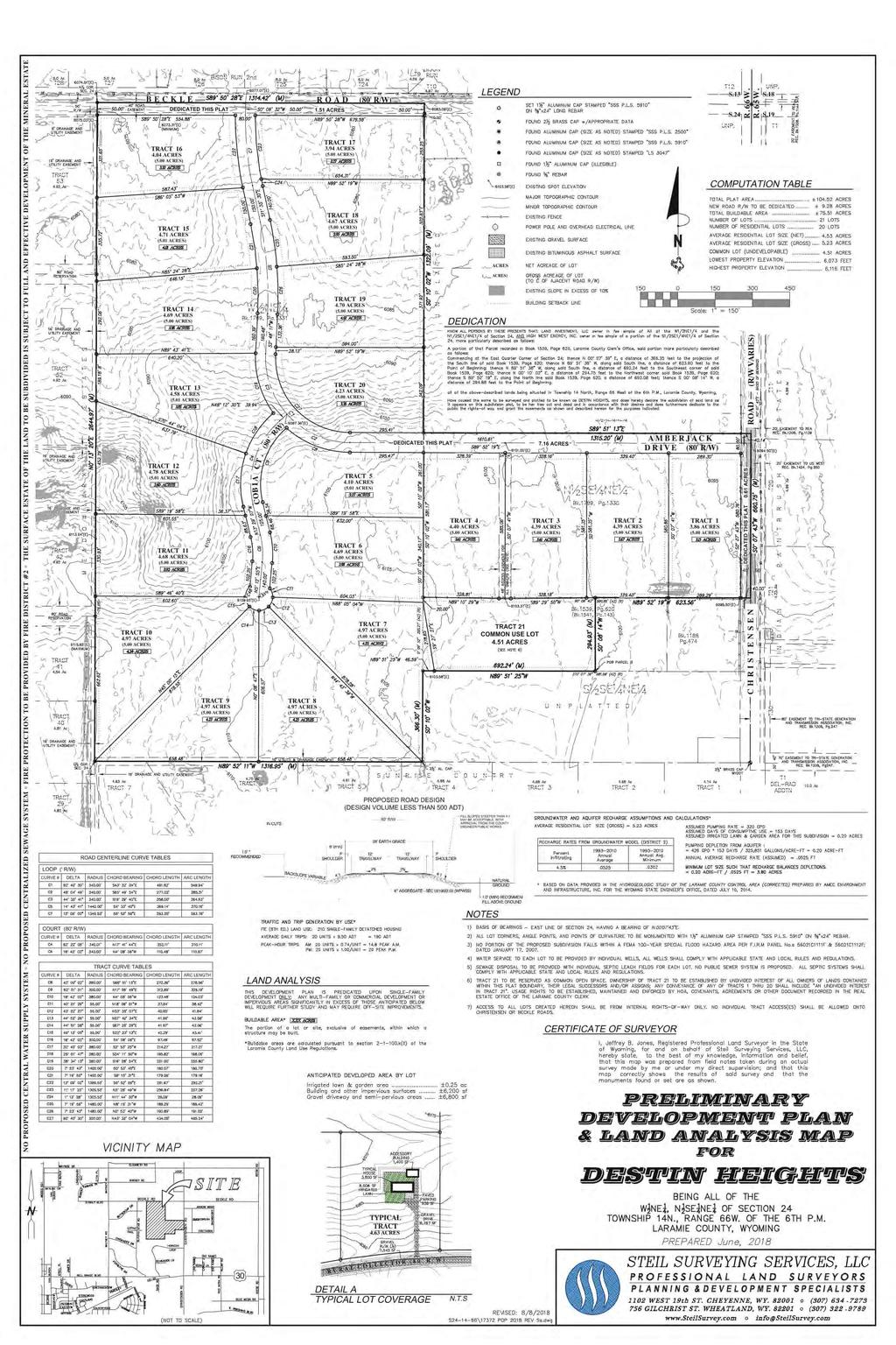
1 LARAMIE COUNTY PLANNING & DEVELOPMENT DEPARTMENT Planning Building MEMORANDUM TO: FROM: Laramie County Planning Commission Seth Frentheway, Associate Planner DATE: August 23, 2018 TITLE: Review and recommendations on the Preliminary Development Plan for Destin Heights, located in a portion of Section 24, T.14N., R.66W., of the 6th P.M. Laramie County, WY. EXECUTIVE SUMMARY Steil Surveying, on behalf of Land Investment, LLC, has submitted a Preliminary Development Plan application for Destin Heights located south & west of the intersection of Christensen Rd & Beckle Rd. The application has been submitted in order to prepare for subdivision of approximately 105 acres into (20) 5-acre single-family residential tracts with open space area. This application is being run concurrently with a zone change application, requesting a change in zone district from A2 - Agricultural to AR Agricultural Residential to allow a reduction in the minimum lot size requirement to 5 acres for the future subdivision. The subdivision permit and plat cannot be approved if the zone change is not approved, given the minimum lot size requirements. BACKGROUND The subject property is un-platted and is surrounded by rural residential and agricultural properties of varying acreage, but predominately 5 acre tracts. Pertinent Regulations Section of the Laramie County Land Use Regulations governing the requirements for submittal of a Preliminary Development Plan Archer Pkwy Cheyenne, WY Phone (307) Fax (307) Page 1 of 3
2 DISCUSSION The Laramie County Comprehensive Plan (2016) designates this area as URI (Urban Rural Interface), intended to accommodate a mix of more intensive land uses than other areas. Large lot, low density residential or intensive agricultural uses are generally less suitable. Water and sewage disposal shall be provided by individual well and septic systems. The 4.51 acres of open space area (Common Use) has been included in lot size calculation, resulting in an average gross lot size of 5.23 acres, which should meet the minimum requirements for septic system permits. This property is NOT located within the 201 Area Facility Management Plan. According to the Order of the State Engineer for the Laramie County Control Area dated April 1, 2015, this property lies outside the Conservation Area. A subdivision of more than 5 lots requires submittal of a Chapter 23 study to the Wyoming Department of Environmental Quality (DEQ). Approval from DEQ, in the form of a Non- Adverse Recommendation, is required prior to recordation of the plat. All developments consisting of more than twelve (12) residential lots are required to have two (2) individual points of access into the subdivision. The plan proposes access from Christensen Rd and Beckle Rd which will be gravel-surfaced and privately maintained. A letter requesting waiver of a traffic impact study was submitted with the application. The County Engineer has concurred with the waiver request. Agency review comments were received regarding open space ownership and maintenance, zoning restrictions, drainage report requirements, road access restrictions for Tracts 1, 16 and 17, and small wastewater system permitting. No public comment was received in response to the neighbor notice mailing. Agency comments shall be addressed per the recommendations of this staff report. RECOMMENDATION and FINDINGS Based on evidence provided, staff recommends the Planning Commission find that: a. This application meets the criteria for a preliminary development plan pursuant to section of the Laramie County Development Regulations. and that the Planning Commission provide the following recommendations concerning the Destin Heights Preliminary Development Plan: 1. Ingress/egress and radius of the cul-de-sac shall meet the requirements of the Laramie County Fire District for adequate fire apparatus access and turnaround Archer Pkwy Cheyenne, WY Phone (307) Fax (307) Page 2 of 3
3 2. A detailed drainage study shall be submitted with the subdivision permit & plat application, and approved by the County Engineer. 3. Evidence of submittal of the Chapter 23 Study to DEQ shall be provided with the subdivision permit & plat application. 4. Road construction standards shall be submitted and approved by the County Engineer and Public Works. 5. A private road maintenance agreement shall be approved by County Public Works and the County Engineer prior to plat recordation. 6. Proof of DEQ approval, in the form of a Non-Adverse Recommendation, shall be provided prior to plat recordation. PROPOSED MOTION I move to approve recommendations 1-6 for the Destin Heights Preliminary Development Plan and adopt the findings of fact a of the staff report. ATTACHMENTS Attachment 1: Location Map Attachment 2: Aerial Map Attachment 3: Comprehensive Plan Map Attachment 4: Agency Comments Report Attachment 5: Preliminary Development Plan - Revised Archer Pkwy Cheyenne, WY Phone (307) Fax (307) Page 3 of 3
4 BRAEHILL RD HAZER CT COWBOY RD OASIS ST COLUMBIA DR BRAEHILL RD SUMMIT DR THOMAS RD COX CT BONNIE BRAE LOOP HIGHLAND RD GLENCOE DR GLENCOE DR DELL RANGE BLVD ETTA PL ELIZABETH RD DORSEY RD E FOUR MILE RD SAYKALLY RD BLAZING STAR RD LARAMIE ST AZT TATE RD E C DR CHRISTENSEN RD HARVEST LOOP CHRISTENSEN RD E PERSHING BLVD ARCHIES RD BONITA PL YARINA WAY AZTEC DR STONE TRL RILLEY RD EMILY DR VERA LN RED MESA RD E FOUR MILE RD REESE RD REESE RD REESE RD ASPEN POINTE LN REESE RD E PERSHING BLVD STAGECOACH RD SURREY RD BUCKBOARD RD ORCHARD DR CHERRY WOOD LN CHOKE CHERRY RD WESTEDT RD WESTEDT RD WESTEDT RD WESTEDT RD I-80 I-80 Cheyenne/Laramie County GIS Cooperative Program Laramie County, Wyoming Destin Heights Pre Dev Plan PZ Location Map Legend Streets Classification Subject Property Interstate Arterial Collector Local Platted, Not Built Private Rail Road Driveway Property Lines Printed on August 14, ,500 3,000 Feet This map is made possible through the Cheyenne and Laramie County Cooperative GIS Program (CLCCGIS). The data contained herein was collected for its use and is for display and planning purposes only. The CLCCGIS will not be held liable as to the validity, correctness, accuracy, completeness, and/or reliability of the data. The CLCCGIS furthermore assumes no liability associated with the use or misuse of this information.
5 LUPINE TRL CHRISTENSEN RD CHRISTENSEN RD SMOKEBRUSH DR SMOKEBRUSH DR Laramie County, Wyoming Destin Heights Preliminary Development Plan PZ Aerial Map Legend Streets Classification Interstate Arterial Collector Local Platted, Not Built Private FIRETHORN LN Rail Road Driveway CHRISTENSEN RD United States Department of Agriculture Property Lines Printed on July 9, This map is made possible through the Cheyenne and Laramie County Cooperative GIS Program (CLCCGIS). The data contained herein was collected for its use and is for display and planning purposes only. The CLCCGIS will not be held liable as to the validity, correctness, accuracy, completeness, and/or reliability of the data. The CLCCGIS furthermore assumes no liability associated with the use or misuse of this information. Feet
6 DORSEY RD BUTTERCUP DR CHICKADEE DR BLAZING STAR RD BLAZING STAR RD LUPINE TRL BLAZING STAR RD Future Land Use Districts OTHER Urban-Rural Interface (URI) Rural Metro (RM) Rural Ag Interface (RAI) Ag & Range Land (AGR) URI HORIZON LOOP CHRISTENSEN RD CHRISTENSEN RD CHRISTENSEN RD RM SMOKEBRUSH DR FIRETHORN LN FIRETHORN LN CRAIGY-J DR Cheyenne/Laramie County GIS Cooperative Program Laramie County, Wyoming Destin Heights Pre Dev Plan PZ Comp Plan Map Legend Streets Classification Subject Property Printed on August 14, Feet Arterial Collector Local Property Lines This map is made possible through the Cheyenne and Laramie County Cooperative GIS Program (CLCCGIS). The data contained herein was collected for its use and is for display and planning purposes only. The CLCCGIS will not be held liable as to the validity, correctness, accuracy, completeness, and/or reliability of the data. The CLCCGIS furthermore assumes no liability associated with the use or misuse of this information.
7 PZ /162 DESTIN-HEIGHTS ZONE CHANGE/PDP Cheyenne MPO: Nancy Olson COMMENTS ATTACHED 08/03/2018 PDP REVIEW: Christensen Road is a future minor arterial and will require 100 ft. This plat will require another 10 for a total of 50 on the west side of Christensen. County Engineer: Scott Larson COMMENTS ATTACHED 08/06/ At this time, I will allow for a waiver of a detailed Traffic Study. With the current number of lots, they are right on the brink of the requirements for a detailed Traffic Study. However, the roads being accessed are well defined and I do not anticipate that a study would show the need for dedicated turn lanes, etc. 2. A detailed Drainage Study shall be submitted with the Subdivision Permit/Plat submittal, but they do not need one for this current application/submittal. 3. More detailed information is needed as to the proposed use for Tract A note should be added to the PDP and ultimately the plat drawing that access to Tracts 1, 16 and 17 shall be from internal roadways and shall not be allowed off of Christensen Road and/or Beckle Road. Environmental Health Department: Roy Kroeger COMMENTS ATTACHED 07/30/2018 Laramie County Small Wastewater System Regulations. A DEQ Subdivision study and USDA Soil Survey shall be submitted to this office prior to the application for any small wastewater system permit. No small wastewater system permit will be issued for installation on property with 15% or greater slope. A copy of the signed plat shall be submitted to this office prior to the issuance of any small wastewater system permit. Each lot shall provide a perc test and 10 site hole prior to the application for any small wastewater system permit. This property is NOT located within the 201 Area Facility Management Plan. Planners: Seth Frentheway COMMENTS ATTACHED 08/07/2018 -The AR zoned district does not permit the described use for Tract 21, outside storage. -Every lot must be 5 acres gross in the AR zone. -It appears that Tract 21 is being utilized as an Open Space buffer to achieve adequate lot size averages for water recharge, however any development that would increase impervious area like RV s and trailers storage the same effect as houses or accessory buildings. While this is permitted, two factors need to be considered. A. Ownership interest of the open space shall be established by undivided interest or dedication, subject to Board approval. The proposed use of the lot suggests the ownership to
8 belong to a single entity. B. Open space shall be left in a natural state except in the case of recreational facilities, or in the case of agriculture activities, such as grazing or the raising of crops (x)(F) Prohibits Open space from being developed or subdivided. The proposed use seems to indicate commercial. -Road Names to be affixed to the final plat. -It is not clear what the triangle shape in the SW corner of Tract 21 is..? Possibly a typo? This needs to be clarified or removed. Agencies with No Comment Black Hills Energy Combined Communications Center County Public Works Department Agencies with No Response Laramie Co School Dist. No. 1 CenturyLink Building Dept Cheyenne Engineering Services High West Energy Sheriff s Office Fire District No. 2 Emergency Management US Post Office Wyoming DEQ County Treasurer Cheyenne Urban Planning Office Cheyenne Development Services County Assessor County Attorney County Real Estate Office
9
LARAMIE COUNTY PLANNING & DEVELOPMENT DEPARTMENT
 LARAMIE COUNTY PLANNING & DEVELOPMENT DEPARTMENT Planning Building MEMORANDUM TO: FROM: Laramie County Planning Commission Marissa Pomerleau, Planning Technician DATE: March 28, 2019 TITLE: Review and
LARAMIE COUNTY PLANNING & DEVELOPMENT DEPARTMENT
 LARAMIE COUNTY PLANNING & DEVELOPMENT DEPARTMENT Planning Building MEMORANDUM TO: FROM: Laramie County Planning Commission Nancy Trimble, Associate Planner DATE: July 13, 2017 TITLE: Review and action
LARAMIE COUNTY PLANNING & DEVELOPMENT DEPARTMENT
 LARAMIE COUNTY PLANNING & DEVELOPMENT DEPARTMENT Planning Building MEMORANDUM TO: FROM: Laramie County Board of Commissioners Brad Emmons, Planning Director DATE: May 15, 2018 TITLE: Review and action
LARAMIE COUNTY PLANNING & DEVELOPMENT DEPARTMENT
 LARAMIE COUNTY PLANNING & DEVELOPMENT DEPARTMENT Planning Building MEMORANDUM TO: FROM: Laramie County Board of Commissioners Bryan Nicholas, Associate Planner DATE: May 15, 2018 TITLE: Review and action
LARAMIE COUNTY PLANNING & DEVELOPMENT DEPARTMENT
 LARAMIE COUNTY PLANNING & DEVELOPMENT DEPARTMENT Planning Building MEMORANDUM TO: FROM: Laramie County Planning Commission Bryan Nicholas, Associate Planner DATE: February 14, 2019 TITLE: Review and action
LARAMIE COUNTY PLANNING & DEVELOPMENT DEPARTMENT
 LARAMIE COUNTY PLANNING & DEVELOPMENT DEPARTMENT Planning Building MEMORANDUM TO: FROM: Laramie County Planning Commission Brad Emmons, Planning Director DATE: March 22, 2018 TITLE: Review and recommendations
LARAMIE COUNTY PLANNING & DEVELOPMENT DEPARTMENT
 LARAMIE COUNTY PLANNING & DEVELOPMENT DEPARTMENT Planning Building MEMORANDUM TO: FROM: Laramie County Board of Commissioners Bryan Nicholas, Associate Planner DATE: October 2, 2018 TITLE: Review and action
LARAMIE COUNTY PLANNING & DEVELOPMENT DEPARTMENT
 LARAMIE COUNTY PLANNING & DEVELOPMENT DEPARTMENT Planning Building MEMORANDUM TO: FROM: Laramie County Planning Commission Jean Vetter, Senior Planner DATE: January 26, 2017 TITLE: Review and action of
LARAMIE COUNTY PLANNING & DEVELOPMENT DEPARTMENT
 LARAMIE COUNTY PLANNING & DEVELOPMENT DEPARTMENT Planning Building MEMORANDUM TO: FROM: Laramie County Planning Commission Seth Frentheway, Associate Planner DATE: November 8, 2018 TITLE: Review and action
LARAMIE COUNTY PLANNING & DEVELOPMENT DEPARTMENT
 LARAMIE COUNTY PLANNING & DEVELOPMENT DEPARTMENT Planning Building MEMORANDUM TO: FROM: Laramie County Planning Commission Bryan Nicholas, Associate Planner DATE: April 11, 2019 TITLE: Review and action
LARAMIE COUNTY PLANNING & DEVELOPMENT DEPARTMENT
 LARAMIE COUNTY PLANNING & DEVELOPMENT DEPARTMENT Planning Building MEMORANDUM TO: FROM: Laramie County Planning Commission Nancy M. Trimble, Associate Planner DATE: July 13, 2017 TITLE: Review and action
LARAMIE COUNTY PLANNING & DEVELOPMENT DEPARTMENT
 LARAMIE COUNTY PLANNING & DEVELOPMENT DEPARTMENT Planning Building MEMORANDUM TO: FROM: Laramie County Board of Commissioners Nancy M. Trimble, Associate Planner DATE: December 5, 2017 TITLE: Review and
LARAMIE COUNTY PLANNING & DEVELOPMENT DEPARTMENT
 LARAMIE COUNTY PLANNING & DEVELOPMENT DEPARTMENT Planning Building MEMORANDUM TO: FROM: Laramie County Planning Commission Nancy M. Trimble, Associate Planner DATE: November 9, 2017 TITLE: Review and action
LARAMIE COUNTY PLANNING & DEVELOPMENT DEPARTMENT
 LARAMIE COUNTY PLANNING & DEVELOPMENT DEPARTMENT Planning Building MEMORANDUM TO: FROM: Laramie County Planning Commission Nancy M. Trimble, Associate Planner DATE: November 9, 2017 TITLE: Review and action
LARAMIE COUNTY PLANNING & DEVELOPMENT DEPARTMENT
 LARAMIE COUNTY PLANNING & DEVELOPMENT DEPARTMENT Planning Building MEMORANDUM TO: FROM: Laramie County Planning Commission Bryan Nicholas, Associate Planner DATE: November 9, 2017 TITLE: Review and action
LARAMIE COUNTY PLANNING & DEVELOPMENT DEPARTMENT
 LARAMIE COUNTY ANNING & DEVELOPMENT DEPARTMENT Planning Building MEMORANDUM TO: FROM: Laramie County Board of Commissioners Seth Frentheway, Associate Planner DATE: June 19 th, 2018 TITLE: Review and action
LARAMIE COUNTY PLANNING & DEVELOPMENT DEPARTMENT
 LARAMIE COUNTY PLANNING & DEVELOPMENT DEPARTMENT Planning Building MEMORANDUM TO: FROM: Laramie County Board of Commissioners Nancy Trimble, Associate Planner DATE: July 18, 2017 TITLE: Review and action
LARAMIE COUNTY PLANNING & DEVELOPMENT DEPARTMENT
 LARAMIE COUNTY PLANNING & DEVELOPMENT DEPARTMENT Planning Building MEMORANDUM TO: FROM: Laramie County Planning Commission Brett Walker, Planner DATE: January 25, 2018 TITLE: Review and action of a Subdivision
LARAMIE COUNTY PLANNING & DEVELOPMENT DEPARTMENT
 LARAMIE COUNTY PLANNING & DEVELOPMENT DEPARTMENT Planning Building MEMORANDUM TO: FROM: Laramie County Planning Commission Brett Walker, Planner DATE: January 25, 2018 TITLE: Review and action of a Variance
LARAMIE COUNTY PLANNING & DEVELOPMENT DEPARTMENT
 LARAMIE COUNTY PLANNING & DEPARTMENT Planning Building MEMORANDUM TO: FROM: Laramie County Planning Commission Nancy M. Trimble, Associate Planner DATE: December 14, 2017 TITLE: Review and action of a
LARAMIE COUNTY PLANNING & DEVELOPMENT DEPARTMENT
 LARAMIE COUNTY PLANNING & DEVELOPMENT DEPARTMENT Planning Building MEMORANDUM TO: FROM: Laramie County Board of Commissioners Bryan Nicholas, Associate Planner DATE: October 16, 2018 TITLE: Review and
LARAMIE COUNTY PLANNING & DEVELOPMENT DEPARTMENT
 LARAMIE COUNTY PLANNING & DEVELOPMENT DEPARTMENT Planning Building MEMORANDUM TO: FROM: Laramie County Planning Commission Bryan Nicholas, Associate Planner DATE: September 27, 2018 TITLE: Review and action
LARAMIE COUNTY PLANNING & DEVELOPMENT DEPARTMENT
 LARAMIE COUNTY PLANNING & DEVELOPMENT DEPARTMENT Planning Building MEMORANDUM TO: FROM: Laramie County Planning Commission Seth Frentheway, Associate Planner DATE: August 23, 2018 TITLE: Review and action
Minutes of the Proceedings Laramie County Planning Commission Prepared by the Laramie County Planning & Development Office Laramie County Wyoming
 Minutes of the Proceedings Laramie County Planning Commission Prepared by the Laramie County Planning & Development Office Laramie County Wyoming Thursday, January 12, 2012 120112 00 The Laramie County
Marion County Board of County Commissioners
 Marion County Board of County Commissioners Date: 12/2/25 P&Z: 11/30/25 BCC: 12/16/25 Amendment No: (20)151209Z Type of Application Rezoning Request P-MH (Mobile Home Park) to B-2 (Community Business)
Marion County Board of County Commissioners
 Marion County Board of County Commissioners Date: 12/29/2015 P&Z: 12/28/2015 BCC: 1/12/2016 Item Number 160113Z Type of Application Rezoning Request From: A-1 (General Agriculture) To: PUD (Planned Unit
Marion County Board of County Commissioners
 Marion County Board of County Commissioners Date: 12/2/2015 P&Z: 11/30/2015 BCC: 12/16/2015 Item Number 151210SU Type of Application Special Use Permit Request To establish a Clay Electric Co-Operative
Plans shall be drawn at a readable scale, signed, and sealed by a Florida Registered Engineer. The application package shall include:
 CHAPTER 400. SECTION 403. PERMIT TYPES AND APPLICATIONS SITE DEVELOPMENT 403.3. Preliminary Site Plans (PSP) A. Intent and Purpose PSPs are used to identify existing site conditions and demonstrate general
MINERAL COUNTY PLANNING STAFF FINDINGS OF FACT Proposed Elk Run at St. Regis. February 12, 2017
 MINERAL COUNTY PLANNING STAFF FINDINGS OF FACT Proposed The proposed is a five-lot subdivision and is located approximately one mile east of St. Regis on Old Highway 10 East. The property is located in
LARAMIE COUNTY PLANNING & DEVELOPMENT DEPARTMENT
 LARAMIE COUNTY PLANNING & DEVELOPMENT DEPARTMENT Planning Building MEMORANDUM TO: FROM: Laramie County Board of Commissioners Brett Walker, Planner DATE: April 3, 2018 TITLE: Review and action of a PUD
Planning & Zoning Commission
 Planning & Zoning Commission Planning & Development Department August 14, 01 Zoning Map Amendment MAP-1-0001 (Bay View Section 4) Request Rezone approximately 1.19 acres from OS (Open Space) to RSF- (Residential
City of Laramie Planning Division P.O. Box C Laramie, WY 82073
 City of Laramie Planning Division PO Box C Laramie, WY 82073 Planning: (307) 721-5207 Fax: (307) 721-5248 LARAMIE PLANNING COMMISSION JULY 11, 2016 STAFF REPORT FILE: REQUEST: LOCATION: PP-16-02 Stagecoach
ORDINANCE NO. BE IT ORDAINED BY THE GOVERNING BODY OF THE CITY OF CHEYENNE, WYOMING: That the City of Cheyenne hereby finds as follows:
 ORDINANCE NO. ENTITLED: AN ORDINANCE ANNEXING TO THE CITY OF CHEYENNE, WYOMING, A PARCEL OF LAND SITUATED IN THE NORTH 102 FEET OF TRACTS 323 AND 324, SUNNYSIDE ADDITION, 7TH FILING, LARAMIE COUNTY, WYOMING
Marion County Planning & Zoning Commission
 Marion County Planning & Zoning Commission Date: /3/24 P&Z: 9/29/24 BCC: /21/24 Item Number 1409Z Type of Application Rezoning Request From: R-3, Multiple Family Residential To: B-4, Regional Business
Instructions for Residential Building Permit Application
 Instructions for Residential Building Permit Application Sublette County, Wyoming Processing Procedure: Paperwork Use this application for residential homes and accessory structures. A Sufficient Building
Staff Report: Date: Applicant: Property Identification: Acreage of Request: Current Zoning of Requested Area: Requested Action: Attached:
 Staff Report: Completed by Jeff Palmer Director of Planning & Zoning Date: November 7, 2018, Updated November 20, 2018 Applicant: Greg Smith, Oberer Land Developer agent for Ronald Montgomery ET AL Property
MAJOR SUBDIVISION PRELIMINARY PLAT CHECKLIST
 TOWNSHIP OF EGG HARBOR PLANNING BOARD/ZONING BOARD OF ADJUSTMENT 3515 BARGAINTOWN ROAD EGG HARBOR TOWNSHIP, NJ 08234 MAJOR SUBDIVISION PRELIMINARY PLAT CHECKLIST The following checklist is designed to
A Affordable Storage CUP Amendment, in Section 20, T35N R2W NMPM, at 4340B US Hwy 160W and 122 Meadows Dr.
 Archuleta County Development Services Planning Department 1122 HWY 84 P. O. Box 1507 Pagosa Springs, Colorado 81147 970-264-1390 Fax 970-264-3338 MEMORANDUM TO: Archuleta County Planning Commission FROM:
STAFF REPORT - SUMMATION. Saddle Ridge, 7 th Filing. Preliminary Plat Process CASE NUMBER: UDC SUBDIVISION CODE: SDRA-P
 STAFF REPORT - SUMMATION Saddle Ridge, 7 th Filing Preliminary Plat Process CASE NUMBER: UDC-15-00351 SUBDIVISION CODE: SDRA-P PREPARED BY: MEETING DATES: Josh Tetzlaff July 6, 2015 Planning Commission
ADDRESSING & STREET NAMING POLICIES
 ADDRESSING & STREET NAMING POLICIES Resolution # 2003-35 Officially adopted on June 3 rd, 2003 by the City of Steamboat Springs Council. TITLE I ADDRESSING POLICIES CHAPTER 1 GENERAL PROVISIONS 1.01 OBJECTIVES
CERTIFICATION OF THE APPROVAL OF WATER AND SEWERAGE SYSTEMS
 ARTICLE 9 FORMS AND CHECK LISTS 9.100 On preliminary layout & final subdivision plat CERTIFICATION OF THE APPROVAL OF WATER AND SEWERAGE SYSTEMS I hereby certify that the (...type: private or pubic...)
April 19, Planning and Land Development Regulation Commission (PLDRC)
") Page 1 of 15 GROWTH AND RESOURCE MANAGEMENT DEPARTMENT PLANNING AND DEVELOPMENT SERVICES DIVISION 123 W. Indiana Avenue, DeLand, FL 32720 (386) 736-5959 PLDRC HEARING: CASE NO: SUBJECT: LOCATION: APPLICANT:
Page 1 of 15 GROWTH AND RESOURCE MANAGEMENT DEPARTMENT PLANNING AND DEVELOPMENT SERVICES DIVISION 123 W. Indiana Avenue, DeLand, FL 32720 (386) 736-5959 PLDRC HEARING: CASE NO: SUBJECT: LOCATION: APPLICANT:
EXTRA TERRITORIAL ZONING AUTHORITY CASE ANALYSIS
 DOÑA ANA COUNTY CASE # V09-007 COMMUNITY PLANNING AND ECONOMIC DEVELOPMENT DEPARTMENT Building Planning GIS 845 North Motel Boulevard Las Cruces, New Mexico 88007 (575) 647-7350 Fax: (575) 525-6131 Toll
Kitsap County Department of Community Development. Staff Report and Administrative Decision
 Kitsap County Department of Community Development Report Date: Staff Report and Administrative Decision Application Complete Date: March 19, 2018 Application Submittal Date: March 19, 2018 To: Seth Hanson,
WESTMINSTER PARK SUBDIVISION
 WESTMINSTER PARK SUBDIVISION Engineering Comments: FINAL PLAT COMMENTS (should be addressed prior to submitting the FINAL PLAT for review and/or signature by the City Engineer): A. Provide all of the required
Marion County Board of County Commissioners
 Marion County Board of County Commissioners Date: 4/26/26 P&Z: 4/25/26 BCC: 5/17/26 Item Number 160509Z Type of Application Request to rezone the property from the Rural Commercial (RC-1) District to the
TOWN OF ELIOT PLANNING BOARD SUBDIVISION APPLICATION
 TOWN OF ELIOT PLANNING BOARD SUBDIVISION APPLICATION This application shall conform in all respects to the Land Subdivision Standards of Chapter 41 of the Planning Board of the Town of Eliot code of ordinances.
Minutes of the Proceedings Laramie County Planning Commission Prepared by the Laramie County Planning & Development Office Laramie County Wyoming
 Minutes of the Proceedings Laramie County Planning Commission Prepared by the Laramie County Planning & Development Office Laramie County Wyoming Thursday, August 23, 2018 180823 00 The Laramie County
REQUEST FOR PLANNING COMMISSION ACTION
 REQUEST FOR PLANNING COMMISSION ACTION DATE: 5/1/2013 ITEM NO: 5b Division Approval Item Description: Agenda Section PUBLIC HEARINGS Request by Landmark 6 of Roseville, LLC for approval of a preliminary
Marion County Board of County Commissioners
 Marion County Board of County Commissioners Date: 10/29/25 P&Z: 10/26/25 BCC: 11/17/25 Item Number 151106SU Type of Application Special Use Permit Request Special Use Permit Modification to: 1. Add a secondary
PARK COUNTY PLANNING COMMISSION PLANNING DEPARTMENT STAFF REPORT
 PARK COUNTY PLANNING COMMISSION PLANNING DEPARTMENT STAFF REPORT Planning Commission Hearing Date: July 14, 2015 To: Planning Commissioners Date: July 8, 2015 Prepared by: Subject: Request: Jill Falchi,
November 9, 2016 Ponderay Planning and Zoning Commission File AX Annexation Request Thomas L. Clark. Preliminary Survey of Subject Parcel
 Ponderay - City Planning Staff Report November 9, 2016 Ponderay Planning and Zoning Commission File AX16-013 Annexation Request Thomas L. Clark Subject Parcels Preliminary Survey of Subject Parcel Project
March 26, Sutter County Planning Commission
 March 26, 2003 To: Re: Sutter County Planning Commission Agenda Item #12: Public hearing on Rezoning #03-04 to change the zoning classification of two parcels totaling 324+ acres from the AG (General Agricultural)
Section Preliminary Plat Checklist and Application Forms
 Section 201 - Preliminary Plat Checklist and Application Forms PRELIMINARY SUBDIVISION PLAT REVIEW PROCESS CHART PRELIMINARY SUBDIVISION PLAT APPLICATION PRELIMINARY PLAT REVIEW CHECKLIST CITY OF NAMPA
STAFF REPORT. To: Planning Commission Meeting date: February 8, 2017 Item: UN Prepared by: Marc Jordan
 # 5 ) UN-08-17 GREAT AMERICAN AUTO SALES SPECIAL USE PERMIT VEHICLE SALES PUBLIC HEARING STAFF REPORT To: Planning Commission Meeting date: February 8, 2017 Item: UN-08-17 Prepared by: Marc Jordan GENERAL
SUBDIVISION REGULATIONS
 CHAPTER 14 SUBDIVISION REGULATIONS 14-100 Provisions 14-200 Preliminary Plat 14-300 Final Plat 14-400 Replat 14-500 Minor Subdivision 14-600 Administrative Replat 14-700 Vacation of Roadways, Public Easements,
TO: Glynn County Islands Planning Commission. Karl W. Bursa, AICP, Planner II. PP3105 Stillwater Phase III. DATE: November 10, 2015
 COMMUNITY DEVELOPMENT DEPARTMENT Planning and Zoning Division 1725 Reynolds Street, Suite 200, Brunswick, GA 31520 Phone: 912-554-7428/Fax: 1-888-252-3726 TO: Glynn County Islands Planning Commission FROM:
Planning Commission Application Summary
 Planning Commission Application Summary Project Name: Lone Peak Business Park Minor Subdivision request Address: 12044 South Lone Peak Pkwy. Current Zoning: CSD-LP (Lone Peak Commercial Special District)
PLANNING AND ZONING COMMISSION VARIANCE
 PLANNING AND ZONING COMMISSION VARIANCE DOÑA ANA COUNTY COMMUNITY DEVELOPMENT DEPARTMENT Doña Ana County Government Center 845 N. Motel Blvd. Las Cruces, New Mexico 88007 Telephone: (575) 647-7350 MEETING
For Office Use Only. Permit No. Fee: $ $ per proposed lot (AN ADDITIONAL 10% CODE COMPLIANCE FEE WILL BE CHARGED)
") For Office Use Only Permit No. Fee: $1600 + $560.00 per proposed lot (AN ADDITIONAL 10% CODE COMPLIANCE FEE WILL BE CHARGED) LAND PARTITION FOREST (Conditional Use) Crook County Planning Department 300
For Office Use Only Permit No. Fee: $1600 + $560.00 per proposed lot (AN ADDITIONAL 10% CODE COMPLIANCE FEE WILL BE CHARGED) LAND PARTITION FOREST (Conditional Use) Crook County Planning Department 300
CHAPTER SUBDIVISION AND PARTITION REQUIREMENTS
 CHAPTER 17.172 SUBDIVISION AND PARTITION REQUIREMENTS Section Title Page 17.172.010 Purpose 2 17.172.020 General Definitions 2 Article I. General Regulations 17.172.040 Considerations for Approval or Denial
BONNER COUNTY PLANNING DEPARTMENT PLANNING & ZONING COMMISION STAFF REPORT APRIL 19, 2018
 BONNER COUNTY PLANNING DEPARTMENT PLANNING & ZONING COMMISION STAFF REPORT APRIL 19, 2018 Project Name: File Number,Type: Request: Legal Description: Location: Parcel Size: Parcel # Applicant: Project
"Department" shall mean the East Point Department of Planning and Zoning, or any successor to that department.
 CHAPTER 8. UNIFORM ROADWAY ADDRESSING SYSTEM ARTICLE A. Sec. 10-8001. PURPOSE AND INTENT The City Council finds that the efficient and prompt provision of emergency services is essential to the health,
STAFF REPORT. To: Planning Commission Meeting date: February 8, 2017 Item: ZN Prepared by: Johanna Murphy
 # 7 ) ZN-04-17 VILLAGES AT TULE SPRINGS, VILLAGE 3 PCD, PLANNED COMMUNITY DISTRICT TO R-CL / PCD; MEDIUM DENSITY RESIDENTIAL / PLANNED COMMUNITY DISTRICT PUBLIC HEARING STAFF REPORT To: Planning Commission
MINOR SUBDIVISION FINAL PLAT APPLICATION Town of Apex, North Carolina
 MINOR SUBDIVISION FINAL PLAT APPLICATION Town of Apex, North Carolina This document is a public record under the North Carolina Public Records Act and may be published on the Town s website or disclosed
Planning Department Oconee County, Georgia
 Planning Department Oconee County, Georgia STAFF REPORT REZONE CASE #: 6985 DATE: October 31, 2016 STAFF REPORT BY: Andrew C. Stern, Planner APPLICANT NAME: Williams & Associates, Land Planners PC PROPERTY
Concept Plan Project Narrative For 852 River Ranch Court
 Concept Plan Project Narrative For 852 River Ranch Court Date: January 5, 2016 Prepared by: Robert W. Jones II, P.E. Vortex Engineering, Inc. 2394 Patterson Rd., Ste 201 Grand Junction, CO 81505 970-245-9051
4. No subdivision shall contain a lot that is less than the minimum dimensions set out in the applicable zoning district regulations.
 Article 8 Subdivisions Part 1 Major and Minor Subdivisions Section 161: Purpose The intent of these regulations is to protect the public health, safety and welfare by providing for the orderly growth and
Initial Project Review
 Pierce County Department of Planning and Land Services, 2401 South 35th Street, Tacoma, WA (253) 798-7037 Initial Project Review Major Amendment to Preliminary Plat: Hawks Ridge Division 1 Application
Staff Report: Date: Applicant: Property Identification: Acreage of Request: Current Zoning of Requested Area: Requested Action: Attached:
 Staff Report: Completed by Jeff Palmer Director of Planning & Zoning Date: November 7, 2018 Applicant: Greg Smith, Oberer Land Developer agent for Ronald Montgomery ET AL Property Identification: Frontage
CASE NO.: PLT CASE NAME: BLACKSTONE RANCH, FILING 3
 Exhibit 1 - Staff Report COMMUNITY AND ECONOMIC DEVELOPMENT DEPARTMENT TABLE OF CONTENTS CASE NO.: PLT2017-00002 CASE NAME: BLACKSTONE RANCH, FILING 3 EXHIBIT 1 PC Staff Report EXHIBIT 2- Maps 2.1 Aerial
APPLICATION FOR SUBDIVISION APPROVAL OF A SKETCH PLAN with checklist
 Prior to filing any application for SUBDIVISION approval, the applicant shall request in writing that the zoning administrator schedule a pre-submission conference. APPLICATION TO THE PLANNING BOARD TOWN
PLANNING & DEVELOPMENT
 PLANNING & DEVELOPMENT STAFF REPORT Rezoning PETITION: APPLICANT: PROPERTY OWNER: TYPE OF REQUEST: SIZE OF TRACT: LOCATION: (#17-22) Rezone from A-PUD (Agri-Business Planned Unit Development) to A-PUD
Umatilla County Department of Land Use Planning
 Umatilla County Department of Land Use Planning 216 SE 4 th ST, Pendleton, OR 97801, (541) 278-6252 Property Line Adjustment, Type V Application & Information Packet PROCESSING THE APPLICATION The application
19.12 CLUSTER RESIDENTIAL DISTRICT
 Chapter 19.12 CLUSTER RESIDENTIAL DISTRICT (Adopted 12/22/2003; Ordinance #0061970). Amended 7/3/17, Ordinance #079100. Section 19.12.010 - Declaration of Intent. The Cluster Residential District provides
M E M O R A N D U M. Planning and Zoning Commission. Daniel Turner, Planner I
 M E M O R A N D U M Meeting Date: Monday, April 10, 2017 Item No. F-4 To: From: Planning and Zoning Commission Daniel Turner, Planner I Subject: Consider a recommendation of a Preliminary Site Evaluation
# 13 ) UN MARAPHARM LV LLC - CULTIVATION SPECIAL USE PERMIT PUBLIC HEARING
 UN MARAPHARM LV LLC - CULTIVATION SPECIAL USE PERMIT PUBLIC HEARING") # 13 ) UN-38-16 MARAPHARM LV LLC - CULTIVATION SPECIAL USE PERMIT PUBLIC HEARING STAFF REPORT To: Planning Commission Meeting date: June 8, 2016 Item: UN-38-16 Prepared by: Marc Jordan GENERAL INFORMATION:
# 13 ) UN-38-16 MARAPHARM LV LLC - CULTIVATION SPECIAL USE PERMIT PUBLIC HEARING STAFF REPORT To: Planning Commission Meeting date: June 8, 2016 Item: UN-38-16 Prepared by: Marc Jordan GENERAL INFORMATION:
CITY OF FAYETTEVILLE, ARKANSAS FINAL PLAT FOR STAFF USE ONLY FINAL PLAT FEE: $ $ Date Application Submitted: Date Accepted as Complete:
 CITY OF FAYETTEVILLE, ARKANSAS FINAL PLAT FOR STAFF USE ONLY FINAL PLAT FEE: $200.00-$800.00 Date Application Submitted: Date Accepted as Complete: Project Number: Public Hearing S-T-R: PP#: Zone: Please
Chapter CLUSTER RESIDENTIAL DISTRICT (Adopted 12/22/2003; Ordinance # )
") Chapter 19.12 CLUSTER RESIDENTIAL DISTRICT (Adopted 12/22/2003; Ordinance #0061970) Section 19.12.010 - Declaration of Intent. The Cluster Residential District provides minimum standards for specified
Chapter 19.12 CLUSTER RESIDENTIAL DISTRICT (Adopted 12/22/2003; Ordinance #0061970) Section 19.12.010 - Declaration of Intent. The Cluster Residential District provides minimum standards for specified
BRIDGETON SUBDIVISION APPLICATION CHECKLIST
 APPLICATION NAME AND # CHECKLIST COMPLETED BY: DATE: Signature and printed name BRIDGETON SUBDIVISION APPLICATION CHECKLIST TO SUBDIVISION APPLICANTS: The attached checklist is to assist you in the submission
TOWN OF NORTHWOOD, NEW HAMPSHIRE
 TOWN OF NORTHWOOD, NEW HAMPSHIRE OFFICE OF THE PLANNING BOARD 818 First New Hampshire Turnpike, Northwood NH 03261 (603)942-5586 Extension 205 Facsimile: (603)942-9107 Major Subdivision Application Form
Planning & Zoning Commission
 Zoning Change Z15-08 (2103 ) Planning & Zoning Commission Planning & Development Department May 18, 2015 Request Applicant /Owner Rezone approximately 2.844 acres of land from OS (Open Space) to RSF-20
LISA ANDERSON-OGILVIE, AICP DEPUTY COMMUNITY DEVELOPMENT DIRECTOR AND PLANNING ADMINISTRATOR
 FOR MEETNG OF: January 9, 2019 CASE NO.: VUL18-03 TO: FROM: HEARNGS OFFCER LSA ANDERSON-OGLVE, ACP DEPUTY COMMUNTY DEVELOPMENT DRECTOR AND PLANNNG ADMNSTRATOR SUBJECT: VALDATON OF UNT OF LAND CASE 18-03
/ Planning and Zoning Commission Staff Report Jay Walker- All Terra Consulting - RZ
 / Planning and Zoning Commission Staff Report Jay Walker- All Terra Consulting - Hearing Date: January 17, 2019 Development Services Department Applicant: Jay Walker All Terra Consulting Staff: Jennifer
Town of Harrisburg, Lewis County, New York Land Use Permit Application Instructions
 Town of Harrisburg, Lewis County, New York Land Use Permit Application Instructions The Town of Harrisburg has laws governing the uses of land within the limits of its boundaries. Additionally, Harrisburg
Marion County Board of County Commissioners
 Marion County Board of County Commissioners Date: 10/27/2015 P&Z: 10/26/2015 BCC: 11/17/2015 Item Number 151104SU Type of Application Special Use Permit Request Parking of a Commercial Truck in the A-1
Board Summary Report
 Board of County Commissioners: Public Hearing Agenda, August 7, 2018 Agenda Item: # Date: July 25, 2018 To: Through: From: Subject: Board of County Commissioners Jan Yeckes, Planning Division Manager Bill
ARTICLE 15. RULES, REGULATIONS AND DEFINITIONS
 ARTICLE 15. RULES, REGULATIONS AND DEFINITIONS Section 1. Interpretation and Construction: The following rules and regulations regarding interpretation and construction of the Ulysses-Grant County, Kansas,
Project File #: SF Project Name: Jackson Ranch Filing No. 4 Parcel Nos.: , and
 COMMISSIONERS: DARRYL GLENN (PRESIDENT) MARK WALLER (PRESIDENT PRO TEMPORE) STAN VANDERWERF LONGINOS GONZALEZ PEGGY LITTLETON PLANNING AND COMMUNITY DEVELOPMENT DEPARTMENT CRAIG DOSSEY, EXECUTIVE DIRECTOR
RECOMMENDATION REPORT
 SARPY COUNTY PLANNING & BUILDING DEPARTMENT RECOMMENDATION REPORT CHANGE OF ZONE (CZ 18-005) PRELIMINARY PLAT (PP 18-007) FINAL PLAT (FP 18-008) SCHOLTING ESTATES APPLICANT: DIANE SCHOLTING PLANNING COMMISSION
TO: Glynn County Mainland Planning Commission. Eric Lee Johnson, Planning Division Manager. PP2944 McKenzie Gardens. DATE: November 20, 2014
 MEMO COMMUNITY DEVELOPMENT DEPARTMENT Planning and Zoning Division 1725 Reynolds Street, Suite 200, Brunswick, GA 31520 Phone: 912-554-7428/Fax: 1-888-252-3726 TO: Glynn County Mainland Planning Commission
Planning & Zoning Commission
 Zoning Change 13-03 (FM 646) Planning & Zoning Commission Planning & Development Department June 3, 2013 Request Permitted Uses Rezone approximately 24.89 acres of undeveloped land from RSF-7 (Residential
PLANNING COMMISSION REPORT Regular Agenda Non Public Hearing Item
 PC Staff Report 3/23/15 FDP-14-00551 Item No. 2-1 PLANNING COMMISSION REPORT Regular Agenda Non Public Hearing Item PC Staff Report 3/23/15 ITEM NO. 2: FINAL DEVELOPMENT PLAN FOR HUTTON FARMS WEST PHASE
CITY PLANNING COMMISSION AGENDA
 Page 77 CITY PLANNING COMMISSION AGENDA ITEM NO: 6 STAFF: LONNA THELEN FILE NO(S): AR PFP 08-00473(AP) QUASI-JUDICIAL PROJECT: DUBLIN BUSINESS PARK SUBDIVISION FILING NO. 1 APPELLANT: OWNER: COLLETTE DIVINE
DAUPHIN CREEK ESTATES SUBDIVISION
 # 12 SUB-000076-2017 DAUPHIN CREEK ESTATES SUBDIVISION Engineering Comments: FINAL PLAT COMMENTS (should be addressed prior to submitting the FINAL PLAT for review and/or signature by the City Engineer):
Marion County Board of County Commissioners
 Marion County Board of County Commissioners Date: 6/28/2017 P&Z: 6/26/2017 BCC: 7/18/2017 Item Number 170701Z Type of Application Rezoning Request B-2, Community Business to R-1, Single Family Residential
Guide to Preliminary Plans
 Guide to Preliminary Plans Introduction The Douglas County is committed to providing open, transparent application processes to the public. This Guide is provided to assist anyone interested in the procedures
CITY OF PAPILLION MAYOR AND CITY COUNCIL REPORT APRIL 3, 2018 AGENDA. Subject: Type: Submitted By: Resolution #R
 CITY OF PAPILLION MAYOR AND CITY COUNCIL REPORT APRIL 3, 2018 AGENDA Subject: Type: Submitted By: A request for a Final Plat for the property legally described as Tax Lot 3 located in the NE 1/4 of the
MINOR SUBDIVISION PLAT CHECKLIST
 MINOR SUBDIVISION PLAT CHECKLIST Project Name: Tax ID #: Project Number: Date: _ Reviewed By: Telephone: NOTES: All lots on septic systems must comply with the Fulton County Health Department requirements
Spirit Lake North, LLC
 BONNER COUNTY PLANNING DEPARTMENT PLANNING AND ZONING COMMISSION STAFF REPORT FOR March 1, 2018 Project Name: Amendment & Zone Change: Spirit Lake North, LLC File Number,Type: AM 162-18/ZC365-18 Request: