LARAMIE COUNTY PLANNING & DEVELOPMENT DEPARTMENT
|
|
|
- Brenda Richard
- 5 years ago
- Views:
Transcription

1 LARAMIE COUNTY PLANNING & DEVELOPMENT DEPARTMENT Planning Building MEMORANDUM TO: FROM: Laramie County Planning Commission Brett Walker, Planner DATE: January 25, 2018 TITLE: Review and action of a Subdivision Permit and Plat for Donnya Enclave Estates, located in a portion of the E½, NE¼, Sec 1, T. 14. N., R. 67 W., of the 6th P.M., Laramie County, WY EXECUTIVE SUMMARY Jones Land Surveying, Inc. on behalf of Mandana Ghodrat of Yellowstone Rd. has submitted an application for a Subdivision Permit & Plat for Donnya Enclave Estates to the Laramie County Planning and Development Office for the following location: A portion of E¼, NE¼, Sec 1, T.14N., R.67W., of the 6th P.M., Laramie County, WY, located at Yellowstone Service Rd., Cheyenne, WY The application has been submitted for the purpose of subdividing the existing 12.7-acre property into two separate tracts of 5 acres and 7.7 acres respectively. BACKGROUND Pre-Application Meetings were held on November 8, 2016, and July 20, The Application was formally submitted on December 11, Notice was published and mailed to adjacent property owners as required per Section As the proposed parcel is over 1-mile from the City Limits, no concurrent review with the City is required. Pertinent Regulations Section (a-d) of the Laramie County Land Use Regulations governing the criteria for a subdivision permit. Section (e) of the Laramie County Land Use Regulations, governing the criteria for a plat. Section of the Laramie County Land Use Regulations, governing the AR- Agricultural Residential zone district 3966 Archer Pkwy Cheyenne, WY Phone (307) Fax (307)
2 AGENCY REVIEW (See attached.) DISCUSSION A Preliminary Development Plan (PDP) was not required as the proposed subdivision and plat meets the criteria for exemption outlined in (b) as follows: The Planning and Development Director may waive the requirement for the preliminary development plan if: i. the purpose of the subsequent development is to bring a property that is in violation of statutory subdivision requirements into conformance with Wyoming statutes and there are no plans to alter existing land use and/or site conditions. ii. iii. the proposed development will not require DEQ/Conservation District review. the proposed development will create five (5) or fewer lots, will require no new public right of way, is in conformance with all requirements of the Laramie County Land Use Regulations and is consistent with the Laramie County Comprehensive Plan. PLANCHEYENNE. PlanCheyenne recommends a Future Land Use Category of Rural Residential for this area. The Rural Residential category, along with the Urban Transition Residential category, provides a gradual transition from the urbanized areas of the Cheyenne Area to the rural areas on the periphery. The Rural Residential category includes a mix of rural and residential uses and is not intended to be an area for intensive future residential development. Primary Uses contemplated are single family residences on individual large lots where some farm animals and horses would be permitted. Significantly, Principle 2.4 found in the Second Foundation of PlanCheyenne states that future rural residential areas beyond the Urban Service Boundary will continue to provide a rural lifestyle choice and thus the policy will be to locate rural residential development in areas designated as such on the Future Land Use Map (See Staff Aerial Map Attached). Primary Uses contemplated are Single family residences on individual large lots; clustering is encouraged. Farm animals and horses are permitted. Policy 1.4.A states the community will support infill in existing neighborhoods, but ensure that infill is compatible with neighborhoods and districts through design standards (e.g., to address scale, height, and character of infill as it relates to existing development). LARAMIE COUNTY COMPREHENSIVE PLAN. The Laramie County Comprehensive Plan (2016) recommends a Future Land Use Category of Urban Rural Interface (URI) for this area. The Urban Rural Interface are intended to accommodate a mix of more intensive land uses than other areas. These areas may have public water and sewer services, a higher level of vehicular access, and a greater overall level of 3966 Archer Pkwy Cheyenne, WY Phone (307) Fax (307)
3 community services. Higher density residential, intensive commercial, employment centers and industrial uses are preferred in these areas. Large lot, low density residential or intensive agricultural uses are generally less suitable. While some of these areas may include existing agricultural uses, it is anticipated they are more service-oriented and may change and develop over time. The community will encourage the incorporation of a mixture of housing types with varied price ranges and densities to attempt to meet the needs of all segments of the community. STANDARDS. Division of land meets the purposes, intent, and all applicable standards COMMUNITY FACILITY FEES. As outlined in Section (c), Community Facility Fees are calculated as follows: Total Plat Area: acres (less exempted land per Section (d)i-iv): 0 (equals) Fee Subject Area: acres Total Community Facility Fees: 12.7 acres x $50/acre = $ (c)ii Land outside of a water and/or sewer district and land not served by any public water and/or sewer utility in Laramie County shall be assessed community facility fees at a rate of fifty dollars ($50.00) per acre. The fee shall be prorated to the nearest one tenth (0.1) of an acre, but the minimum fee shall not be less than twenty-five dollars ($25.00). ACCESS. No new Right-of-Way is being proposed with this application. Access to the existing house on the proposed Tract 1 will continue to be via the established private access easement. Exact access to the proposed Tract 2 will be determined at the time of building permit but will likely come from De Castro Drive or the Yellowstone Frontage Road due to restrictions outlined within the easement. Should the easement go away, the existing house on Tract 1 would have access off of Buck Brush Road STUDIES. Requests for a waiver of the Traffic Study and Drainage Study were granted as the subdivision and anticipated uses are very unlikely to impact either the traffic or drainage in the area. ZONING. All proposed lots would be buildable lots according to the existing AR zoning district standards and will result in development patterns that meet the Intent and Applicability statements of the AR zoning district. SURROUNDING DEVELOPMENT. The application will not create any undue influence on existing or potential development for adjacent property considering the existing zoning and PlanCheyenne policies for this property. The application reflects sound planning and urban design principles with respect to existing and potential future development in the vicinity. Staff finds the proposal to be in general conformance with the plans and policies of Laramie County Archer Pkwy Cheyenne, WY Phone (307) Fax (307)
4 The attached resolution shall serve as the Subdivision Permit upon approval by the Board. RECOMMENDATION and FINDINGS Based on evidence provided, staff recommends the Planning Commission find that: a. This application meets the criteria for a subdivision permit pursuant to section (a-d) of the Laramie County Land Use Regulations. b. This application meets the criteria for a plat pursuant to section (e) of the Laramie County Land Use Regulations. c. This application is in conformance with Section of the Laramie County Land Use Regulations. and the Planning Commission recommend approval of the Subdivision Permit and Plat for Donnya Enclave Estates, Laramie County, Wyoming, to the Laramie County Board of Commissioners, with no conditions. PROPOSED MOTION I move to recommend approval of the Subdivision Permit and Plat for Donnya Enclave Estates to the Laramie County Board of Commissioners, with no conditions, and adopt the findings of fact a, b, and c of the staff report. ATTACHMENTS Attachment 1: Staff Aerial Map Attachment 2: Agency Comment Report Attachment 3: Neighbor Letter of Concern Attachment 4: Plat Map Attachment 5: Draft Resolution 3966 Archer Pkwy Cheyenne, WY Phone (307) Fax (307)
 Cheyenne/Laramie County GIS Cooperative Program This map is made possible through the Cheyenne and")


5 PZ Donnya Subdivision and Plat 1 inch = 400 feet Laramie County, Wyoming CR 136 Date: 1/19/2018 Partial Plat Vacation Request Railroad Rd (CR 215) Cheyenne/Laramie County GIS Cooperative Program This map is made possible through the Cheyenne and Laramie County Cooperative GIS Program (CLCCGIS) The data contained herein was collected for its use and is for display and planning purposes only. The CLCCGIS will not be held liable as to the validity, correctness, accuracy, completeness, and/or reliability of the data. The CLCCGIS furthermore assumes no liability associated with the use or misuse of this information. NB CB Zone District Map L 1 in = 1,000 ft 1 in = 1,000 ft BRW Central Business District Future Land Use Map Public and Quasi-Public AR Rural Residential AR Rural Residential
6 PZ Donnya Enclave Estates Subdivision Permit & Plat County Engineer: Scott Larson COMMENTS ATTACHED 01/02/2018 Engineer Review 1. I concur with the request for a waiver of a detailed Drainage Study and Traffic Study as this development will not have any significant impact on either. Surveyor Review 1. For subdivisions in the County, survey tie(s) by bearing/azimuth and the distance to the nearest public land survey system monument shall be accurately described on the plat. In addition, for the purposes of enhancing the City and County GIS Program framework, all public land survey corners on or within the subdivision boundary shall have field observation coordinates provided on the plat. These coordinates shall reference Wyoming State Plane Coordinate System, East Zone, U.S. Survey foot, NAD 1983(CORS96). The coordinates shall be observed and verified at the time of the plat survey. There are no survey ties to the public land survey system monuments shown on the plat. There are no Wyoming State Plane Coordinate System field observation coordinates provided on the plat. 2. As a final note, I did not see any mention of irrigation water rights of record mentioned on the subdivision so I assume there aren t any water rights relevant to the subdivision. Planner: Brett Walker COMMENTS ATTACHED 01/05/2018 Will be addressed in staff report Building Dept.: Karen Moon COMMENTS ATTACHED 12/22/2017 No comment at this time. Agencies responding with No Comment: Cheyenne MPO, Cheyenne Urban Planning Office, Cheyenne Development Services, County Assessor, County Real Estate Office, County Public Works Dept., Combined Communications Center, Emergency Management, Sheriff s Office. Agencies not responding: County Treasurer, Wyoming Game & Fish, US Post Office, Fire District No. 2.
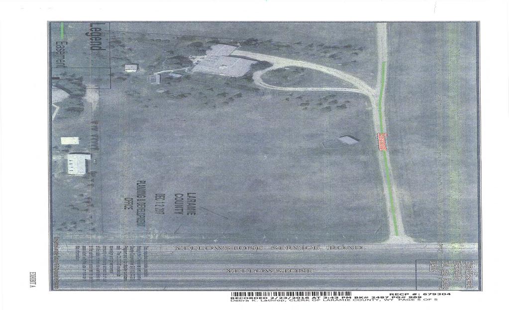
7 Laramie County Planning & Development Dept Archer Pkwy Cheyenne, WY December 31, 2017 Attn: Bryan Nicholas Re: project PZ This memo is a follow-up to our conversation on Tuesday, Dec. 12 th, I have three (3) concerns in regards to the subdivision filing PZ : 1- That the easement pertaining to the shared driveway which begins on my property at Yellowstone Service Rd. be adhered to. The written easement, recorded on 2/23/2016 at 3:43 PM, BK#2487 PG#958, Clerk of Laramie County, was created at the insistence of Mr. Shawn Adjari despite our verbal assurance to him that we would honor the oral gentleman s agreement between the original owners of the two houses, his house at Yellowstone Rd., and mine at Yellowstone Rd. This easement specifies use of the driveway is limited to owner s, guests & visitors of the occupants of the two houses, but there would be not be any easement granted to any persons or entities that reside or conduct business in any other structure built on said Grantee s property. A copy of this easement was left with you during our conversation on Tuesday, Dec.12 th. 2- That the outline of the boundary lines on the aerial map attached to the filing PZ does not reflect the boundary change recorded December 1, 1997, , Book 1466, Laramie County Clerk, Cheyenne, WY, that establishes the property line on the 3- rail wooden fence at the west edge of Yellowstone Rd, not at an angle to the fence as shown on the aerial illustration. This boundary change specifically removed the two narrow angles of land on opposite sides of the fence and established the property line on the path of the fence between the west side of Yellowstone Rd. and the southeast side of Yellowstone Rd. 3- That the Laramie County zoning requirement of 5 acres per house, well and sceptic tank/field be in effect for any subdivision planned of the property at Yellowstone Rd.. Thank you for considering these items as you review the proposed filing PZ , or any other filing involving the property at Yellowstone Rd., Laramie County, Cheyenne, WY. Sandra Dennis Yellowstone Rd. Cheyenne, WY 82009
8
9
10
11
12
13
14 RESOLUTION NO. A RESOLUTION TO APPROVE A SUBDIVISION PERMIT AND PLAT FOR DONNYA ENCLAVE ESTATES, LOCATED IN A PORTION OF THE E½, NE¼, SEC 1, T. 14 N., R. 67 W., OF THE 6TH P.M., LARAMIE COUNTY, WY WHEREAS, Wyoming State Statutes to ; to authorize Laramie County, in promoting the public health, safety, morals and general welfare of the county, to regulate the use of land through zoning in unincorporated Laramie County; and WHEREAS, the Laramie County Board of Commissioners adopted the Laramie County Land Use Regulations; and WHEREAS, the proposed subdivision is in accordance with section (a-d) of the Laramie County Land Use Regulations; and WHEREAS, the proposed plat is in accordance with section (e) of the Laramie County Land Use Regulations; and WHEREAS, the proposed plat is in conformity with section of the Laramie County Land Use Regulations; and WHEREAS, this resolution is the subdivision permit for Donnya Enclave Estates. NOW THEREFORE BE IT RESOLVED BY THE GOVERNING BODY OF LARAMIE COUNTY, WYOMING, as follows: The Laramie County Board of Commissioners finds that: a. This application is in conformance with section (a-d) of the Laramie County Land Use Regulations. b. This application is in conformance with section (e) of the Laramie County Land Use Regulations. c. This application is in conformance with section of the Laramie County Land Use Regulations. And that the Board approves the Subdivision Permit and Plat for Donnya Enclave Estates. PRESENTED, READ AND ADOPTED THIS DAY OF, LARAMIE COUNTY BOARD OF COMMISSIONERS ATTEST: Buck Holmes, Chairman Debra Lee, Laramie County Clerk Reviewed and approved as to form: Mark T. Voss, Laramie County Attorney
LARAMIE COUNTY PLANNING & DEVELOPMENT DEPARTMENT
 LARAMIE COUNTY PLANNING & DEVELOPMENT DEPARTMENT Planning Building MEMORANDUM TO: FROM: Laramie County Planning Commission Bryan Nicholas, Associate Planner DATE: April 11, 2019 TITLE: Review and action
LARAMIE COUNTY PLANNING & DEVELOPMENT DEPARTMENT
 LARAMIE COUNTY PLANNING & DEVELOPMENT DEPARTMENT Planning Building MEMORANDUM TO: FROM: Laramie County Board of Commissioners Brad Emmons, Planning Director DATE: May 15, 2018 TITLE: Review and action
LARAMIE COUNTY PLANNING & DEVELOPMENT DEPARTMENT
 LARAMIE COUNTY PLANNING & DEVELOPMENT DEPARTMENT Planning Building MEMORANDUM TO: FROM: Laramie County Planning Commission Nancy M. Trimble, Associate Planner DATE: November 9, 2017 TITLE: Review and action
LARAMIE COUNTY PLANNING & DEVELOPMENT DEPARTMENT
 LARAMIE COUNTY PLANNING & DEVELOPMENT DEPARTMENT Planning Building MEMORANDUM TO: FROM: Laramie County Planning Commission Nancy M. Trimble, Associate Planner DATE: July 13, 2017 TITLE: Review and action
LARAMIE COUNTY PLANNING & DEVELOPMENT DEPARTMENT
 LARAMIE COUNTY PLANNING & DEVELOPMENT DEPARTMENT Planning Building MEMORANDUM TO: FROM: Laramie County Planning Commission Brad Emmons, Planning Director DATE: March 22, 2018 TITLE: Review and recommendations
LARAMIE COUNTY PLANNING & DEVELOPMENT DEPARTMENT
 LARAMIE COUNTY PLANNING & DEVELOPMENT DEPARTMENT Planning Building MEMORANDUM TO: FROM: Laramie County Planning Commission Bryan Nicholas, Associate Planner DATE: February 14, 2019 TITLE: Review and action
LARAMIE COUNTY PLANNING & DEVELOPMENT DEPARTMENT
 LARAMIE COUNTY PLANNING & DEVELOPMENT DEPARTMENT Planning Building MEMORANDUM TO: FROM: Laramie County Planning Commission Nancy Trimble, Associate Planner DATE: July 13, 2017 TITLE: Review and action
LARAMIE COUNTY PLANNING & DEVELOPMENT DEPARTMENT
 LARAMIE COUNTY PLANNING & DEVELOPMENT DEPARTMENT Planning Building MEMORANDUM TO: FROM: Laramie County Planning Commission Nancy M. Trimble, Associate Planner DATE: November 9, 2017 TITLE: Review and action
LARAMIE COUNTY PLANNING & DEVELOPMENT DEPARTMENT
 LARAMIE COUNTY PLANNING & DEVELOPMENT DEPARTMENT Planning Building MEMORANDUM TO: FROM: Laramie County Planning Commission Brett Walker, Planner DATE: January 25, 2018 TITLE: Review and action of a Variance
LARAMIE COUNTY PLANNING & DEVELOPMENT DEPARTMENT
 LARAMIE COUNTY PLANNING & DEVELOPMENT DEPARTMENT Planning Building MEMORANDUM TO: FROM: Laramie County Planning Commission Bryan Nicholas, Associate Planner DATE: November 9, 2017 TITLE: Review and action
LARAMIE COUNTY PLANNING & DEVELOPMENT DEPARTMENT
 LARAMIE COUNTY PLANNING & DEVELOPMENT DEPARTMENT Planning Building MEMORANDUM TO: FROM: Laramie County Planning Commission Marissa Pomerleau, Planning Technician DATE: March 28, 2019 TITLE: Review and
LARAMIE COUNTY PLANNING & DEVELOPMENT DEPARTMENT
 LARAMIE COUNTY PLANNING & DEVELOPMENT DEPARTMENT Planning Building MEMORANDUM TO: FROM: Laramie County Board of Commissioners Bryan Nicholas, Associate Planner DATE: May 15, 2018 TITLE: Review and action
LARAMIE COUNTY PLANNING & DEVELOPMENT DEPARTMENT
 LARAMIE COUNTY PLANNING & DEVELOPMENT DEPARTMENT Planning Building MEMORANDUM TO: FROM: Laramie County Board of Commissioners Nancy M. Trimble, Associate Planner DATE: December 5, 2017 TITLE: Review and
LARAMIE COUNTY PLANNING & DEVELOPMENT DEPARTMENT
 LARAMIE COUNTY PLANNING & DEVELOPMENT DEPARTMENT Planning Building MEMORANDUM TO: FROM: Laramie County Planning Commission Jean Vetter, Senior Planner DATE: January 26, 2017 TITLE: Review and action of
LARAMIE COUNTY PLANNING & DEVELOPMENT DEPARTMENT
 LARAMIE COUNTY PLANNING & DEVELOPMENT DEPARTMENT Planning Building MEMORANDUM TO: FROM: Laramie County Board of Commissioners Bryan Nicholas, Associate Planner DATE: October 2, 2018 TITLE: Review and action
LARAMIE COUNTY PLANNING & DEVELOPMENT DEPARTMENT
 LARAMIE COUNTY ANNING & DEVELOPMENT DEPARTMENT Planning Building MEMORANDUM TO: FROM: Laramie County Board of Commissioners Seth Frentheway, Associate Planner DATE: June 19 th, 2018 TITLE: Review and action
LARAMIE COUNTY PLANNING & DEVELOPMENT DEPARTMENT
 LARAMIE COUNTY PLANNING & DEVELOPMENT DEPARTMENT Planning Building MEMORANDUM TO: FROM: Laramie County Planning Commission Seth Frentheway, Associate Planner DATE: November 8, 2018 TITLE: Review and action
LARAMIE COUNTY PLANNING & DEVELOPMENT DEPARTMENT
 LARAMIE COUNTY PLANNING & DEPARTMENT Planning Building MEMORANDUM TO: FROM: Laramie County Planning Commission Nancy M. Trimble, Associate Planner DATE: December 14, 2017 TITLE: Review and action of a
LARAMIE COUNTY PLANNING & DEVELOPMENT DEPARTMENT
 LARAMIE COUNTY PLANNING & DEVELOPMENT DEPARTMENT Planning Building MEMORANDUM TO: FROM: Laramie County Board of Commissioners Nancy Trimble, Associate Planner DATE: July 18, 2017 TITLE: Review and action
LARAMIE COUNTY PLANNING & DEVELOPMENT DEPARTMENT
 LARAMIE COUNTY PLANNING & DEVELOPMENT DEPARTMENT Planning Building MEMORANDUM TO: FROM: Laramie County Planning Commission Seth Frentheway, Associate Planner DATE: August 23, 2018 TITLE: Review and recommendations
LARAMIE COUNTY PLANNING & DEVELOPMENT DEPARTMENT
 LARAMIE COUNTY PLANNING & DEVELOPMENT DEPARTMENT Planning Building MEMORANDUM TO: FROM: Laramie County Planning Commission Seth Frentheway, Associate Planner DATE: August 23, 2018 TITLE: Review and action
LARAMIE COUNTY PLANNING & DEVELOPMENT DEPARTMENT
 LARAMIE COUNTY PLANNING & DEVELOPMENT DEPARTMENT Planning Building MEMORANDUM TO: FROM: Laramie County Planning Commission Bryan Nicholas, Associate Planner DATE: September 27, 2018 TITLE: Review and action
LARAMIE COUNTY PLANNING & DEVELOPMENT DEPARTMENT
 LARAMIE COUNTY PLANNING & DEVELOPMENT DEPARTMENT Planning Building MEMORANDUM TO: FROM: Laramie County Board of Commissioners Bryan Nicholas, Associate Planner DATE: October 16, 2018 TITLE: Review and
B. The Plan is in conformity with the Comprehensive Plan.
 ARTICLE 17 PLANNING UNIT DEVELOPMENT 17.01 INTENT The purpose of this Section is to permit the creation of new Planned Unit Developments, permitted as Conditional Uses where maximum variations of design
BE IT ORDAINED BY THE GOVERNING BODY OF THE CITY OF CHEYENNE, WYOMING: FIRST READING: SECOND READING: 3RD AND FINAL READING:
 ORDINANCE NO. ENTITLED: AN ORDINANCE PURSUANT TO SECTION 2.2.1 ZONING MAP AMENDMENTS, SECTION 5.1.2 ZONING DISTRICTS ESTABLISHED, AND SECTION 5.1.3 OFFICIAL ZONING MAP, OF THE UNIFIED DEVELOPMENT CODE,
Minutes of the Proceedings Laramie County Planning Commission Prepared by the Laramie County Planning & Development Office Laramie County Wyoming
 Minutes of the Proceedings Laramie County Planning Commission Prepared by the Laramie County Planning & Development Office Laramie County Wyoming Thursday, January 12, 2012 120112 00 The Laramie County
BOARD OF COUNTY COMMISSIONERS ARCHULETA COUNTY, COLORADO RESOLUTION 2018-
 BOARD OF COUNTY COMMISSIONERS ARCHULETA COUNTY, COLORADO RESOLUTION 2018- ARCHULETA COUNTY IMPROPERLY DIVIDED PARCELS EXEMPTION INTERIM RESOLUTION - A RESOLUTION ADDRESSING PARCELS UNDER THE SIZE OF 35
Innsbruck Val Moritz AFP of Lot 46, Lot 47, & Amended Lot 48 Block 17 Amended Final Plat Adjustment of Interior Lot Lines
 Innsbruck Val Moritz AFP of Lot 46, Lot 47, & Amended Lot 48 Block 17 Amended Final Plat Adjustment of Interior Lot Lines APPLICATION: AMENDED FINAL PLAT HEARING DATES: Planning Commission: 8 November
The Laramie County Land Use Regulations
 LARAMIE COUNTY, WYOMING Formatted The Laramie County Land Use Regulations Title 2 County-Wide Land use Regulations 5/24/2018 pg. Adopted February 15, 2011 Table of Contents Title 2 County Wide Land Use
MINOR LAND DIVISIONS APPLICATION
 APACHE COUNTY Planning and Zoning Department P.O. Box 238 St. Johns, AZ 85936 Phone: (928) 337-7527 Fax: (928) 337-7633 MINOR LAND DIVISIONS APPLICATION APPLICANT Name Mailing Address Contact Person Phone
B. The proposed parcel(s) of land shall be in compliance with the current zoning requirements.
 of land shall be in compliance with the current zoning requirements.") SECTION 14-900 SUBDIVISION EXEMPTION 14-901 INTENT To establish criteria and a review process whereby the Board of County Commissioners may grant Exemptions from the definition of the terms subdivision
SECTION 14-900 SUBDIVISION EXEMPTION 14-901 INTENT To establish criteria and a review process whereby the Board of County Commissioners may grant Exemptions from the definition of the terms subdivision
Bethel Romanian Church - Rezone, RZ
 / Planning and Zoning Staff Report Bethel Romanian Church - Rezone, RZ2018-0023 Hearing Date: November 15, 2018 Development Services Department Owners: Bethel Romanian Church, Corp. Applicant: Viorel Botos
Preliminary Plat/Final Plat Application
 Melissa Municipal Center 3411 Barker Avenue Melissa, Texas 75454 Phone: (972) 838-2036 Applicant: Date: Address: Phone: Contact: Fax: E-mail: Propose Addition Name: Acres: Existing Zoning: Propose Zoning:
Town of Prairie du Sac Sauk County, WI. Land Division Ordinance 07-3
 Town of Prairie du Sac Sauk County, WI Land Division Ordinance 07-3 1.01 DISCLAIMER (1) Multiple Jurisdictions. All persons reviewing the provisions of this Ordinance should be aware that the Town of Prairie
PUD, HPUD, OSC Rezoning & Conceptual Plan Application (Planned Unit Development, Haggerty Road Planned Unit Development, Open Space Community)
") Township Use Only RZ #: Date: Hearing Date: Fee Paid: PUD, HPUD, OSC Rezoning & Conceptual Plan Application (Planned Unit Development, Haggerty Road Planned Unit Development, Open Space Community) Project
Township Use Only RZ #: Date: Hearing Date: Fee Paid: PUD, HPUD, OSC Rezoning & Conceptual Plan Application (Planned Unit Development, Haggerty Road Planned Unit Development, Open Space Community) Project
/ Planning and Zoning Commission Staff Report Jay Walker- All Terra Consulting - RZ
 / Planning and Zoning Commission Staff Report Jay Walker- All Terra Consulting - Hearing Date: January 17, 2019 Development Services Department Applicant: Jay Walker All Terra Consulting Staff: Jennifer
STAFF REPORT - SUMMATION. Saddle Ridge, 7 th Filing. Preliminary Plat Process CASE NUMBER: UDC SUBDIVISION CODE: SDRA-P
 STAFF REPORT - SUMMATION Saddle Ridge, 7 th Filing Preliminary Plat Process CASE NUMBER: UDC-15-00351 SUBDIVISION CODE: SDRA-P PREPARED BY: MEETING DATES: Josh Tetzlaff July 6, 2015 Planning Commission
Guide to Minor Developments
 Guide to Minor Developments Introduction The Douglas County (DCD) is committed to providing open, transparent application processes to the public. This Guide is provided to assist anyone interested in
CHAPTER 3 PRELIMINARY PLAT
 10-3-1 10-3-3 SECTION: CHAPTER 3 PRELIMINARY PLAT 10-3-1: Consultation 10-3-2: Filing 10-3-3: Requirements 10-3-4: Approval 10-3-5: Time Limitation 10-3-6: Grading Limitation 10-3-1: CONSULTATION: Each
RENITA HURDSMAN BEAR RIVER STATE PARK LAND EXCHANGE PROPOSAL
 DETAILED ANALYSIS RENITA HURDSMAN BEAR RIVER STATE PARK LAND EXCHANGE PROPOSAL June 1, 2006 Prepared by the Office of State Lands and Investments Herschler Building, 3W 122 West 25 th Street Cheyenne,
LOCATION MAP: AERIAL PHOTOGRAPH, 2015:
 LOCATION MAP: AERIAL PHOTOGRAPH, 2015: ORDINANCE NO. AN ORDINANCE OF THE CITY OF BRYAN, TEXAS, AMENDING CHAPTER 130, ZONING, OF THE CITY OF BRYAN CODE OF ORDINANCES, BY CHANGING THE ZONING CLASSIFICATION
LARAMIE COUNTY PLANNING & DEVELOPMENT DEPARTMENT
 LARAMIE COUNTY PLANNING & DEVELOPMENT DEPARTMENT Planning Building MEMORANDUM TO: FROM: Laramie County Board of Commissioners Brett Walker, Planner DATE: April 3, 2018 TITLE: Review and action of a PUD
MINOR SUBDIVISION INFORMATION
 A. POINTS OF CONTACT: MINOR SUBDIVISION INFORMATION Surveyor: Address: Phone #: Fax # E-Mail Address: Representative (If different from applicant): Address: Phone #: Fax # E-Mail Address: B. GENERAL INFORMATION:
DIVISION 9. PLANNED URBAN DEVELOPMENT CLASSIFICATION BY SPECIAL USE FOR ALL ZONING DISTRICTS Sec Statement Of Purpose: (a) Planned
 Planned") DIVISION 9. PLANNED URBAN DEVELOPMENT CLASSIFICATION BY SPECIAL USE FOR ALL ZONING DISTRICTS Sec. 12-169. Statement Of Purpose: (a) Planned developments are such substantially different character from
DIVISION 9. PLANNED URBAN DEVELOPMENT CLASSIFICATION BY SPECIAL USE FOR ALL ZONING DISTRICTS Sec. 12-169. Statement Of Purpose: (a) Planned developments are such substantially different character from
Staff Report: Date: Applicant: Property Identification: Acreage of Request: Current Zoning of Requested Area: Requested Action: Attached:
 Staff Report: Completed by Jeff Palmer Director of Planning & Zoning Date: November 7, 2018, Updated November 20, 2018 Applicant: Greg Smith, Oberer Land Developer agent for Ronald Montgomery ET AL Property
ACTION FORM BRYAN CITY COUNCIL
 ACTION FORM BRYAN CITY COUNCIL DATE OF COUNCIL MEETING: July 8, 2014 DATE SUBMITTED: June 17, 2014 DEPARTMENT OF ORIGIN: Development Services SUBMITTED BY: Maggie Dalton MEETING TYPE: CLASSIFICATION: ORDINANCE:
Guide to Replats. Step 1. Step 2. Step 3. Step 4. Step 5. Step 6. Step 7. Step 8. Step 9. Step 10
 Guide to Replats Introduction Douglas County is committed to providing open, transparent application processes to the public. This Guide is provided to assist anyone interested in the procedures and expectations
CHAPTER 22 SUBDIVISION AND LAND DEVELOPMENT
 CHAPTER 22 SUBDIVISION AND LAND DEVELOPMENT 22-101. Title 22-102. Legislative Intent Part 1 General Provisions 22-201. Development Permits Part 2 Administration 22-301. Fee Schedule Part 3 Fee Schedule
ZONING AMENDMENT, SUBDIVISION & SIDEWALK WAIVER REQUEST STAFF REPORT Date: November 16, 2006
 ZONING AMENDMENT, SUBDIVISION & SIDEWALK WAIVER REQUEST STAFF REPORT Date: November 16, 2006 NAME SUBDIVISION NAME Terhaar & Cronley Investment Partnership P & E Subdivision LOCATION 4210 and 4218 Halls
Z-MAX BLVD HARRISBURG, NC OFFERING MEMORANDUM
 Z-MAX BLVD HARRISBURG, NC OFFERING MEMORANDUM INVESTMENT HIGHLIGHTS List Price: $2,445,500 Location: Southeast quadrant of NC Hwy 49 and I-485 at the southern terminus of Z-Max Boulevard extending south
PLANNED UNIT DEVELOPMENT & SUBDIVISION STAFF REPORT Date: April 18, 2019
 PLANNED UNIT DEVELOPMENT & SUBDIVISION STAFF REPORT Date: April 18, 2019 DEVELOPMENT NAME SUBDIVISION NAME Springhill Village Subdivision Springhill Village Subdivision LOCATION 4350, 4354, 4356, 4358,
ZONING ORDINANCE: OPEN SPACE COMMUNITY. Hamburg Township, MI
 ZONING ORDINANCE: OPEN SPACE COMMUNITY Hamburg Township, MI ARTICLE 14.00 OPEN SPACE COMMUNITY (Adopted 1/16/92) Section 14.1. Intent It is the intent of this Article to offer an alternative to traditional
February 2, 2012 BOARD MATTER C - 1 WYOMING LAND AND IMPROVEMENT COMPANY, PROPOSAL TO ACQUIRE REAL PROPERTY IN ALBANY COUNTY, WYOMING
 February 2, 2012 BOARD MATTER C - 1 ACTION: WYOMING LAND AND IMPROVEMENT COMPANY, PROPOSAL TO ACQUIRE REAL PROPERTY IN ALBANY COUNTY, WYOMING AUTHORITY: W.S. 9-4-715(k); Rules Chapter 26, Section 3 ALTERNATIVES:
City of Sanibel. Planning Department STAFF REPORT
 City of Sanibel Planning Department STAFF REPORT Planning Commission Meeting: July 23, 2013 Planning Commission Agenda Item: No 7b. Application Number: 13-7438DP Applicant Name: Attorney Beverly Grady
MINOR PLAT FILING APPLICATION
 FILING APPLICATION Date of PC Meeting: Date of BCC Meeting: Fee Paid: 1. APPLICANT: DAYTIME PHONE: MAILING ADDRESS: LANDOWNER: DAYTIME PHONE: MAILING ADDRESS: AUTHORIZED AGENT: MAILING ADDRESS: RELATIONSHIP
BARROW COUNTY, GEORGIA
 BARROW COUNTY, GEORGIA Application For Rezoning, Special Use, and Change in Conditions BARROW COUNTY DEPARTMENT OF PLANNING AND DEVELOPMENT 30 North Broad Street Winder, Georgia 30680 770-307-3034 APPLICATION
Guide to Combined Preliminary and Final Plats
 Guide to Combined Preliminary and Final Plats Introduction The Douglas County is committed to providing open, transparent application processes to the public. This Guide is provided to assist anyone interested
ZONING AMENDMENT & SUBDIVISION STAFF REPORT Date: July 9, 2015
 ZONING AMENDMENT & SUBDIVISION STAFF REPORT Date: July 9, 2015 APPLICANT NAME 2513 Dauphin Street, Inc. SUBDIVISION NAME Audubon Place Extension No. 3, Resubdivision of Lots 1-5 LOCATION 2513 Dauphin Street
MINNETONKA PLANNING COMMISSION June 2, A conditional use permit for 2,328 square feet of accessory structures at 4915 Highland Road
 MINNETONKA PLANNING COMMISSION June 2, 2016 Brief Description A conditional use permit for 2,328 square feet of accessory structures at Recommendation Recommend the city council adopt the resolution approving
SUBDIVISION APPLICATION
 SUBDIVISION APPLICATION City of Horn Lake Planning Department 3101 Goodman Road, W Horn Lake, MS 38637 662-342-3559 Fax: 662-342-3485 Applications due the 1st working day of the month. Submit application
Instructions for Maps to Accompany Proof of Appropriation and Beneficial Use of Ground Water
 Instructions for Maps to Accompany Proof of Appropriation and Beneficial Use of Ground Water Part II of the Proof of Appropriation (Form U.W. 8) All maps to accompany proof of appropriation and beneficial
MOHAVE VALLEY IRRIGATION & DRAINAGE DISTRICT
 MOHAVE VALLEY IRRIGATION & DRAINAGE DISTRICT APPROVED: MAY 1, 2012 MINUTES OF THE REGULAR BOARD MEETING HELD TUESDAY, APRIL 3, 2012 AT THE OFFICES OF THE MOHAVE VALLEY IRRIGATION & DRAINAGE DISTRICT (
SUBDIVISION, PLANNED UNIT DEVELOPMENT, ZONING AMENDMENT, & SIDEWALK WAIVER STAFF REPORT Date: July 19, 2018
 SUBDIVISION, PLANNED UNIT DEVELOPMENT, ZONING AMENDMENT, & SIDEWALK WAIVER STAFF REPORT Date: July 19, 2018 NAME SUBDIVISION NAME LOCATION West Mobile Properties, LLC U.S. Machine Subdivision 556, 566,
Time Extension Staff Report
 Time Extension Staff Report Subdivision Name Lunara Subdivision File Number SUB07-00019 Approval Time Extension for Lead Agency Boise City Certification Signature of Boise City Engineer Annexation Date
City of Altamonte Springs Developer s Guide
 Section 6 SUBDIVISION PLAN & PLAT REVIEW PROCESS This section contains information, applications, and checklists related to the subdivision development plan and plat review process in Altamonte Springs.
SUBDIVISION APPLICATION (CHECK THE BOX THAT APPLIES)
") GARFIELD COUNTY Building & Planning Department 108 8 th Street, Suite 401 Glenwood Springs, Colorado 81601 Telephone: 970.945.8212 Facsimile: 970.384.3470 www.garfield-county.com SUBDIVISION APPLICATION
GARFIELD COUNTY Building & Planning Department 108 8 th Street, Suite 401 Glenwood Springs, Colorado 81601 Telephone: 970.945.8212 Facsimile: 970.384.3470 www.garfield-county.com SUBDIVISION APPLICATION
Planning Department Oconee County, Georgia
 Planning Department Oconee County, Georgia STAFF REPORT REZONE CASE #: 6985 DATE: October 31, 2016 STAFF REPORT BY: Andrew C. Stern, Planner APPLICANT NAME: Williams & Associates, Land Planners PC PROPERTY
PLANNED UNIT DEVELOPMENT (PUD) AREA PLAN/REZONING REVIEW PROCEDURE
 AREA PLAN/REZONING REVIEW PROCEDURE") PLANNED UNIT DEVELOPMENT (PUD) AREA PLAN/REZONING REVIEW PROCEDURE Professional inquiries will be made to our Township Planning Consultant, Township Engineer, and Township Attorney to get their opinions
PLANNED UNIT DEVELOPMENT (PUD) AREA PLAN/REZONING REVIEW PROCEDURE Professional inquiries will be made to our Township Planning Consultant, Township Engineer, and Township Attorney to get their opinions
MONTGOMERY COUNTY PLANNING DEPARTMENT THE MARYLAND-NATIONAL CAPITAL PARK AND PLANNING COMMISSION
 MONTGOMERY COUNTY PLANNING DEPARTMENT THE MARYLAND-NATIONAL CAPITAL PARK AND PLANNING COMMISSION MCPB Item No. Date: 12/4/14 Preliminary Plan No. 120140200, Northwood Knolls Description Patrick Butler,
PROCEDURE FOR CLOSING STREETS AND ALLEYS UNDER N.C.G.S. 160A-299 CITY OF GASTONIA, LEGAL DEPT., P. O. BOX 1748, GASTONIA, NC ( )
") PROCEDURE FOR CLOSING STREETS AND ALLEYS UNDER N.C.G.S. 160A-299 CITY OF GASTONIA, LEGAL DEPT., P. O. BOX 1748, GASTONIA, NC 28053 (866-6735) 1. Applicant requests closing of street or alley through the
PROCEDURE FOR CLOSING STREETS AND ALLEYS UNDER N.C.G.S. 160A-299 CITY OF GASTONIA, LEGAL DEPT., P. O. BOX 1748, GASTONIA, NC 28053 (866-6735) 1. Applicant requests closing of street or alley through the
INSTRUCTIONS FINAL PLAT APPROVAL APPLICATION
 INSTRUCTIONS FINAL PLAT APPROVAL APPLICATION 1. The applicant/agent shall fill out the attached application. The attached application form must be completely filled in before it can be filed. Portions
SOS / Waiver of Subdivision Standards / John Cashin
 SOS15-00012 / Waiver of Subdivision Standards / John Cashin Summary John Cashin requests a Waiver of Subdivision Standards in the Boise Development Code that requires construction of new sidewalk for approval
FINAL PLAT APPLICATION
 FINAL PLAT APPLICATION (Page 1 of 3) LEGAL OWNER(s): NAME: STREET ADDRESS OWNER(s): CITY, STATE, ZIP CODE: PHONE NUMBER: BILLING ADDRESS: NAME OF ENGINEER/SURVEYOR: Engineer/Surveyor Address, Phone: PROPERTY
Condominium Unit Requirements.
 ARTICLE 19 CONDOMINIUM REGULATIONS Section 19.01 Purpose. The purpose of this Article is to regulate projects that divide real property under a contractual arrangement known as a condominium. New and conversion
EXTRA-TERRITORIAL ZONING AUTHORITY
 EXTRA-TERRITORIAL ZONING AUTHORITY DOÑA ANA COUNTY COMMUNITY DEVELOPMENT DEPARTMENT Doña Ana County Government Complex 845 North Motel Boulevard Las Cruces, New Mexico 88007 Office: (575) 647-7237 MEETING
ORDINANCE NO.: Adopted: August 2, 2005 Amended: March 27, 2007 Amended: September 23, Fillmore County Rural Addressing Ordinance
 ORDINANCE NO.: 2005-01 Adopted: August 2, 2005 Amended: March 27, 2007 Amended: September 23, 2008 Fillmore County Rural Addressing Ordinance Section 1 Purpose, Scope and Statutory Authorization 1-1 Purpose.
Article 2 Application Type and Standards Requirements
 Article 1 Article 2 Division 1 Application Type and Standards Requirements General Provisions Sec. 2.1.1 Division 2 Division 3 Division 4 Division 5 Division 6 Division 7 Division 8 Division 9 Sec. 2.9.1
Marion County Board of County Commissioners
 Marion County Board of County Commissioners Date: 12/29/2015 P&Z: 12/28/2015 BCC: 1/12/2016 Item Number 160113Z Type of Application Rezoning Request From: A-1 (General Agriculture) To: PUD (Planned Unit
TO: Glynn County Islands Planning Commission. Eric Landon, Planner II. PP2754 Stones Throw Cottages. DATE: February 6, 2014
 COMMUNITY DEVELOPMENT DEPARTMENT Planning and Zoning Division 1725 Reynolds Street, Suite 200, Brunswick, GA 31520 Phone: 912-554-7428/Fax: 1-888-252-3726 TO: Glynn County Islands Planning Commission FROM:
Guide to Preliminary Plans
 Guide to Preliminary Plans Introduction The Douglas County is committed to providing open, transparent application processes to the public. This Guide is provided to assist anyone interested in the procedures
TOWN OF LERAY PLANNING BOARD Minor Subdivision Application Packet
 This Packet is designed to assist applicants in providing the forms needed for submission of a 1 to 4 lot subdivision to the Planning Board for approval. The following should be filled out to ensure the
O-I (Office-Institutional) and AG-1(Agricultural)
 and AG-1(Agricultural)") PROPERTY INFORMATION ADDRESS 3503 and 3505 Bethany Bend DISTRICT, LAND LOTS 2/1 973 and 974 OVERLAY DISTRICT State Route 9 PETITION NUMBERS EXISTING ZONING O-I (Office-Institutional) and AG-1(Agricultural)
PROPERTY INFORMATION ADDRESS 3503 and 3505 Bethany Bend DISTRICT, LAND LOTS 2/1 973 and 974 OVERLAY DISTRICT State Route 9 PETITION NUMBERS EXISTING ZONING O-I (Office-Institutional) and AG-1(Agricultural)
BRIDGETON SUBDIVISION APPLICATION CHECKLIST
 APPLICATION NAME AND # CHECKLIST COMPLETED BY: DATE: Signature and printed name BRIDGETON SUBDIVISION APPLICATION CHECKLIST TO SUBDIVISION APPLICANTS: The attached checklist is to assist you in the submission
SECTION 16. "PUD" PLANNED UNIT DEVELOPMENT OVERLAY DISTRICT
 SECTION 6. "PUD" PLANNED UNIT DEVELOPMENT OVERLAY DISTRICT Subsection. Purpose. This district is established to achieve the coordinated integration of land parcels and large commercial and retail establishments
FINAL PLAT GUIDE TO SUBDIVIDING PROPERTY. Background
 FINAL PLAT GUIDE TO SUBDIVIDING PROPERTY Background A final plat is the second step in the process of subdividing land into separate parcels for future sale or lease. Once a preliminary plat has been approved
Sec Planned unit development (PUD) zoning district requirements and procedures.
 zoning district requirements and procedures.") Sec. 10-6.696. Planned unit development (PUD) zoning district requirements and procedures. (a) Purpose and intent of district. The planned unit development (PUD) zoning district is intended to provide
Sec. 10-6.696. Planned unit development (PUD) zoning district requirements and procedures. (a) Purpose and intent of district. The planned unit development (PUD) zoning district is intended to provide
Exhibit "A" have applied for a re-zoning and re-classification of that property from OPEN RURAL (OR) to that of a PLANNED UNIT DEVELOPMENT (PUD); and
 to that of a PLANNED UNIT DEVELOPMENT (PUD); and") I NSTR # 200632845 OR BK 61439 PGS 0728-0750 RECORDED 06/24/2066 12:25:50 PR JOHN Q. CRAWFOKD CLERK OF CIRCUIT COURT NASSAU COUNTY, FLORIDA RECORDING FEES 1.37.80 ORDINANCE NO. 2006-65 AN ORDINANCE AMENDING
I NSTR # 200632845 OR BK 61439 PGS 0728-0750 RECORDED 06/24/2066 12:25:50 PR JOHN Q. CRAWFOKD CLERK OF CIRCUIT COURT NASSAU COUNTY, FLORIDA RECORDING FEES 1.37.80 ORDINANCE NO. 2006-65 AN ORDINANCE AMENDING
ORDINANCE NO. BE IT ORDAINED BY THE GOVERNING BODY OF THE CITY OF CHEYENNE, WYOMING:
 ORDINANCE NO. ENTITLED: AN ORDINANCE PURSUANT TO SECTION 2.2.1, ZONING MAP AMENDMENT, 2.2.2, PLANNED DEVELOPMENT REGULATING PLAN OR DEVELOPMENT MASTER PLAN, SECTION 5.1.2, ZONING DISTRICTS ESTABLISHED,
MONTGOMERY COUNTY PLANNING DEPARTMENT THE MARYLAND-NATIONAL CAPITAL PARK AND PLANNING COMMISSION
 MONTGOMERY COUNTY PLANNING DEPARTMENT THE MARYLAND-NATIONAL CAPITAL PARK AND PLANNING COMMISSION MCPB Item No. 8 Date: 03-07-13 Sonoma, Preliminary Plan, 120130040 Melissa Williams, Senior Planner, Melissa.williams@montgomeryplanning.org,
Nassau County Single Land Split Application
 NASSAU COUNTY DEPARTMENT OF PLANNING AND ECONOMIC OPPORTUNITY FLORIDA Nassau County Single Land Split Application Taco E. Pope, AICP, Director 96161 Nassau Place Yulee, Florida 32097 (904) 530-6300 APPLICATION
Urban Planning and Land Use
 Urban Planning and Land Use 701 North 7 th Street, Room 423 Phone: (913) 573-5750 Kansas City, Kansas 66101 Fax: (913) 573-5796 Email: planninginfo@wycokck.org www.wycokck.org/planning To: From: City Planning
Amendment to the Zoning and Subdivision Ordinances; Consider Repeal Cluster Development Standards
 2 Board of Supervisors Meg Bohmke, Chairman Gary F. Snellings, Vice Chairman Jack R. Cavalier Thomas C. Coen L. Mark Dudenhefer Wendy E. Maurer Cindy C. Shelton February 28, 2018 Thomas C. Foley County
SUBDIVISION, PLANNING APPROVAL, & REZONING STAFF REPORT Date: June 4, 2015
 SUBDIVISION, PLANNING APPROVAL, & REZONING STAFF REPORT Date: June 4, 2015 APPLICANT NAME SUBDIVISION NAME DEVELOPMENT NAME LOCATION Board of Water & Sewer Commissioners of the City of Mobile MAWSS MLK
All roads developed to access four (4) or more parcels shall be constructed to Park County Road and Bridge Standards.
 or more parcels shall be constructed to Park County Road and Bridge Standards.") P a r k C o u n t y P l a n n i n g a n d Z o n i n g 1002 Sheridan Avenue Cody, WY 82414 Phone: 307-527-8540 35-40 ACRE SUBDIVISIONS www.parkcounty.us/planandzone.htm May 2011 This is only intended as
P a r k C o u n t y P l a n n i n g a n d Z o n i n g 1002 Sheridan Avenue Cody, WY 82414 Phone: 307-527-8540 35-40 ACRE SUBDIVISIONS www.parkcounty.us/planandzone.htm May 2011 This is only intended as
MONTGOMERY COUNTY PLANNING BOARD
 MONTGOMERY COUNTY PLANNING BOARD T H E MARYLAND-NATIONAL CAPITAL PARK A N D P L A N N I N G C O M M I S S I O N MCPB NO. 10-144 Hearing Date: September 30, 2010 MONTGOMERY COUNTY PLANNING BOARD RESOLUTION
MINERAL COUNTY PLANNING STAFF FINDINGS OF FACT Proposed Elk Run at St. Regis. February 12, 2017
 MINERAL COUNTY PLANNING STAFF FINDINGS OF FACT Proposed The proposed is a five-lot subdivision and is located approximately one mile east of St. Regis on Old Highway 10 East. The property is located in
City and County of Broomfield, Colorado
 City and County of Broomfield, Colorado CITY COUNCIL AGENDA MEMORANDUM To: From: Mayor and City Council George Di Ciero, City and County Manager Teri Malies, Principal Planner Terrance Ware, Planning Director
Plat Checklist PLAT TYPES AND DESCRIPTIONS
 Master Plan / Revision to Master Plan (For Platting Purposes Only) Preliminary/Final Plat Preliminary Plat Final Plat Minor Plat Replat Amended Plat Plat Checklist So that we may efficiently review your
Subject: Ordinance 1657, Annexation of 3.55 acres of land at 3015 and 3001 Parker Road.
 Agenda Report 2016-12-12-09 Date: December 8, 2016 To: From: Russ Axelrod, Mayor Members, West Linn City Council Jennifer Arnold, Planning Department Through: John Boyd, Interim Community Development Director
2017_10_MIKES_SWEETMAN_OE_PC.PDF
 1. OCTOBER PLANNING COMMISSION AGENDA Documents: OCTOBER 2017.PDF 1.I. MIKES/SWEETMAN OUTRIGHT EXEMPTIONS Documents: 2017_10_MIKES_SWEETMAN_OE_PC.PDF DEPARTMENT OF PLANNING AND ZONING 308 Byers Ave P.O.