a. Minutes of the January 7, 2019 City Council Meeting b Boards and Commissions Appointments
|
|
|
- Katrina Davis
- 5 years ago
- Views:
Transcription
1 CITY COUNCIL MEETING January 22, :00 p.m. Council Chambers Howard L. Brown Public Safety Building 1100 SW Smith Blue Springs, Missouri PLEASE NOTE: Anyone wishing to address the Mayor and Council, either in a Public Hearing or in the Visitors Section of the Agenda, must fill out a Speaker s Appearance Form. Forms are located at the entrance of the Multipurpose Room. After completion, the form is to be given to the City Clerk. 1. Call meeting to order 2. Pledge of Allegiance 3. Consent Agenda All matters under Item 3, Consent Agenda, are considered to be routine by the City Council and will be enacted by one motion of the Council with no separate discussion. If separate discussion is desired, that item may be removed from the Consent Agenda and placed on the Regular Agenda by request of a member of the City Council. a. Minutes of the January 7, 2019 City Council Meeting b Boards and Commissions Appointments 4. Public Hearing Annex two properties located at 1450 SE US 40 Highway (ANNX ) 5. Introduction and readings of Bill No annexing two properties located at 1450 SE US 40 Hwy (ANNX ) 6. Public Hearing Rezone 3421 NW Jefferson Street (RZ ) 7. Introduction and readings of Bill No rezoning 3421 NW Jefferson Street (RZ ) 8. Public Hearing Vacate a ten-foot utility easement located at 2000 NW Ashton Drive (VAC ) 9. Introduction and readings of Bill No vacating a ten-foot utility easement located at 2000 NW Ashton Drive (VAC ) 10. Introduction and readings of Bill No approving the Final Plat for The Estates at Chapman Farms 3 rd Plat, Lots 78 Thru 112 & Tract G (PF ) 11. Presentation CHAT Study 12. Presentation Hero Fund USA
2 13. Mayoral Announcements Thoughts to Ponder 14. Visitors 15. Adjourn Miscellaneous Items Planning Commission Meeting Monday, January 28, 6:30 PM, Council Chambers Public Safety Building, 1100 SW Smith City Council Meeting Monday, February 4 at 6:00 PM - Council Chambers Public Safety Building, 1100 SW Smith Park Commission Meeting Tuesday, February 5, 6:00 PM, Administration Conference Room Blue Springs Fieldhouse, 425 NE Mock Planning Commission Meeting Monday, February 11, 6:30 PM, Council Chambers Public Safety Building, 1100 SW Smith Public Art Commission Meeting Wednesday, February 13, 3:30 PM, Administrative Conference Room Blue Springs Fieldhouse, 425 NE Mock Board of Adjustment Meeting Wednesday, February 13, 6:30 PM, Council Chambers Public Safety Building, 1100 SW Smith City Offices Closed Presidents Day February 18 Land Bank of Blue Springs Tuesday, February 19, 3:00 PM, Council Executive Conference Room Public Safety Building, 1100 SW Smith City Council Meeting Tuesday, February 19 at 6:00 PM - Council Chambers Public Safety Building, 1100 SW Smith Human Relations Commission Meeting - Tuesday, February 19, 6:30 PM - Journagan Family Community Room Public Safety Building, 1100 SW Smith Posted at Blue Springs Public Safety Building and on the City s website on Thursday, January 17, 2019 Julia Porter Deputy City Clerk
3 TO: FROM: Mayor, City Council, Department Directors, and Press Eric Johnson City Administrator DATE: January 17, 2019 SUBJECT: Agenda Explanations Item 3b 2019 Board and Commission Appointments Pursuant to Blue Springs Home Rule Charter Section 4.4.C - Powers and Duties; Appointments, the Mayor appoints all members of committees, boards, and commissions, with the advice and consent of the majority of the Council. The Mayor is making mid-year appointments to fill vacant seats on various boards and commissions. Refer to Council Information Form from City Clerk Sheryl Morgan for additional information. Items 4 & 5 Annexation 1450 SE US 40 Highway (ANNX ) A public hearing is being held at the request of the Applicant, Alan Swearingen for consideration to approve an annexation of two properties (approximately 0.10 and 0.66 acres) located at 1450 SE US 40 Highway into the City limits. (ANNX ) Upon conclusion of the public hearing, a Bill approving the Annexation will be ready for introduction and the first reading. The second reading will be scheduled on February 19, 2019 City Council meeting. Refer to Council Information Form from Tom Cole, Director of Economic and Community Development for additional information. Items 6 & 7 Rezone 3421 NW Jefferson Street (RZ ) A public hearing is being held at the request of the Applicant, Anthony DiPlacito, on behalf of Paul & Tammy Engen, owners for consideration to rezone from LI (Light Industrial) to GB (General Business) for the /- acre development located at 3421 NW Jefferson Street (RZ ). Upon conclusion of the public hearing, a Bill rezoning 3421 NW Jefferson Street will be ready for introduction and readings. Refer to Council Information Form from Tom Cole, Director of Economic and Community Development for additional information. Items 8 & 9 Vacation 2000 NW Ashton Drive (VAC ) A public hearing is being held at the request of the Applicant, Jeffrey Schutzler with Hollis+Miller Architects, representing the owner, Blue Springs R-IV School District, for consideration of the vacation of a ten (10) foot utility easement located generally at 2000 NW Ashton Drive (VAC ). Upon conclusion of the public hearing, a Bill vacating the utility easement will be ready for introduction and readings. Refer to Council Information Form from Tom Cole, Director of Economic and Community Development for additional information. Item 10 Final Plat for The Estates at Chapman Farms 3 Passage of a Bill approving the Final Plat for The Estates at Chapman Farms 3rd Plat, Lots 78 Thru 112 & Tract G (PF ), located directly north of The Estates at Chapman Farms 1st & 2nd Plats, generally located 800 feet north of the intersection of SW Brookside Drive and SW Conch Way. Refer to Council Information Form from Tom Cole, Director of Economic and Community Development for additional information.
4 January 3, 2019 Page 2 Item 11 - Presentation Marty Shukert, of RDG Planning & Design, will present the findings of the Community Housing Assessment Tool study (CHAT Study). Refer to Council Information Form from Tom Cole, Director of Economic and Community Development for additional information. Item 12 Presentation Darrell Smith, the Director of Hero Fund USA, a charitable organization, will present to the City Council. Refer to Council Information Form from Chief Bob Muenz for additional information.
5 CITY OF BLUE SPRINGS, MISSOURI MINUTES OF COUNCIL MEETING JANUARY 7, 2019 A meeting of the City Council of the City of Blue Springs, Missouri, was held on Monday, January 7, 2019, 6:00 p.m. in the Council Chambers of the Howard L. Brown Public Safety Building, 1100 Smith Street with Mayor Carson Ross presiding. COUNCILMEN IN ATTENDANCE Jerry Kaylor Chris Lievsay Ron Fowler Dale Carter Kent Edmondson Susan Culpepper Also present were City Administrator Eric Johnson, Assistant City Administrator Christine Cates, City Attorney Jacqueline Sommer, and City Clerk Sheryl Morgan. CALL MEETING TO ORDER CONSENT AGENDA Mayor Ross called the City Council meeting to order at 6:00 p.m. Councilman Culpepper requested that item 3e Delaying the Acceptance of Applications relating to Medical Marijuana be removed from the Consent Agenda and placed at the end of the Consent Agenda for discussion. Councilman Culpepper moved to approve the following Consent Agenda items and the motion was seconded by Councilman Carter. Minutes of the December 17, 2018 City Council meeting Resolution No approving the disposition of Information Technology and Finance Department records which have met the required retention period Liquor license approved for Wingstop Beverages III, Inc. dba Wingstop #956 located at 481 NE Coronado Drive Blue Springs, MO 64014, to sell intoxicating malt liquors (beer) only for consumption on premises, including Sunday Liquor license for Café by Day III LLC dba Clancy s Café and Pub located at 800 NW South Outer Road, Blue Springs, MO 64015, to sell intoxicating liquors by the drink for consumption on premises, Restaurant bar/lounge bar to include Sunday retail selling of intoxicating liquors by the drink, on the premises, or in original package for consumption on or off premises The Consent Agenda, with the exception of Item 3e, was approved with the following vote: Councilman Kaylor Aye Councilman Lievsay Aye Councilman Fowler Aye Councilman Carter Aye Councilman Edmondson Aye Councilman Culpepper Aye Mayor Ross Aye CONSENT ITEM 3E MEDICAL MARIJUANA Councilman Culpepper explained the purpose for the proposed resolution. Councilman Culpepper moved to approve Resolution No directing staff to suspend and delay the acceptance and processing of development applications, applications for building
6 January 7, 2019 City Council Minutes Page 2 permits, and business licenses or activities related to medical marijuana as described in Article XVI of the Missouri Constitution, an Amendment approved by the voters of the State of Missouri on November 6, 2018 and effective December 6, Motion seconded by Councilman Kaylor and carried with the following vote: Councilman Lievsay Aye Councilman Fowler Aye Councilman Carter Aye Councilman Edmondson Aye Councilman Culpepper Aye Councilman Kaylor Aye Mayor Ross Aye INTRODUCTION AND 1 ST READING BILL NO CALL FOR ELECTION AMENDING CHARTER Councilman Culpepper introduced Bill No calling an election to amend the Charter of the City of Blue Springs and providing for submissions of the Charter amendments to the qualified voters of the City for their approval at the general election called and to be held in the City on April 2, City Clerk Sheryl Morgan made the first reading of Bill No by title; copies of the proposed Bill having previously been made available to the public. Councilman Fowler moved to approve Bill No upon its first reading and proceed with the second reading. Motion seconded by Councilman Culpepper. MOTION TO AMEND BILL NO Councilman Lievsay moved to amend Bill No by changing Charter Amendment Question No. 3 to read as follows (redlined): Shall the Charter of the City of Blue Springs, Article III City Council, Section 3.3, and Article IV Mayor, Section 4.2, be amended (1) to change the minimum age of a CouncilmemberMayor from 251 years of age to 215, and (2) to include requirements that a Councilmember and Mayor not be a registered sex offender? Motion seconded by Councilman Edmondson and failed with the following vote: VOTE ON MOTION TO AMEND BILL NO VOTE ON 1 ST READING BILL NO Councilman Fowler NO Councilman Carter Aye Councilman Edmondson Aye Councilman Edmondson Aye Councilman Culpepper Aye Councilman Kaylor Aye Councilman Culpepper NO Councilman Kaylor NO Councilman Lievsay Aye Mayor Ross NO Councilman Lievsay Aye Councilman Fowler Aye Councilman Carter Aye Mayor Ross Aye 2 ND READING BILL NO Ms. Morgan made the second reading of Bill No by title. Councilman Carter moved to adopt Bill No upon its second reading and give it ORDINANCE NO. 4786, with a copy attached hereto and made a part of the minutes. Motion seconded by Councilman Culpepper and carried with the following vote:
7 January 7, 2019 City Council Minutes Page 3 Councilman Carter Aye Councilman Edmondson Aye Councilman Culpepper Aye Councilman Kaylor Aye Councilman Lievsay Aye Councilman Fowler Aye Mayor Ross Aye MAYORAL ANNOUNCEMENTS Mayor Ross invited the public to attend the reburial and rededication of the Time Capsule at 11:00 on Thursday, January 10, 2019 at City Hall. You have enemies. Good. That means you stood up for something some time in your life*. (Winston Churchill) ADJOURNMENT At 6:13 p.m., there was no further business to come before the Council, Councilman Carter moved the meeting be adjourned. Motion seconded by Councilman Lievsay and carried unanimously. Councilman Carter Aye Councilman Edmondson Aye Councilman Culpepper Aye Councilman Kaylor Aye Councilman Lievsay Aye Councilman Fowler Aye Mayor Ross Aye CITY OF BLUE SPRINGS ATTEST: Sheryl Morgan, City Clerk Carson Ross, Mayor
8 DATE SUBMITTED: January 14, 2019 CITY OF BLUE SPRINGS CITY COUNCIL INFORMATION FORM Council Meeting Date: January 22, 2019 Agenda Item #: 3b Page 1 of 2 SUBMITTED BY: Sheryl Morgan DEPARTMENT: Administration Ordinance Resolution Presentation Public Hearing Contract Discussion Economic Dev. Other ISSUE/REQUEST Pursuant to Blue Springs Home Rule Charter Section 4.4.C - Powers and Duties; Appointments, the Mayor appoints all members of committees, boards, and commissions, with the advice and consent of the majority of the Council. The Mayor is making mid-year appointments to fill vacant seats on various boards and commissions. BACKGROUND/JUSTIFICATION The list of the Mayor s appointments are as follows: Economic Development Council: Becky Nace (term expiring 5/2020) Human Relations Commission: Jane Bowerman (Vice Chair expiring 5/2019) Susan McDaniel-Wiggins (term expiring 5/2020) Leonard Hughes (term expiring 5/2021) Contractor: Estimated Start Date January 23, 2019 FINANCIAL IMPACT N/A PROJECT TIMELINE Estimated End Date Terms as identified above N/A STAFF RECOMMENDATION OTHER BOARDS & COMMISSIONS ASSIGNED Name of Board or Commission: N/A N/A N/A ECONOMIC DEVELOPMENT PROJECT LIST OF REFERENCE DOCUMENTS ATTACHED Rev. 10/17/2018
9 Council Meeting Date: January 22, 2019 Agenda Item #: 3b Page 2 of 2 Requesting Director: Sheryl Morgan, City Clerk Legal: Jacqueline A. Sommer REVIEWED BY Budget: Christine Cates City Administrator: Rev. 10/17/2018
10 CITY OF BLUE SPRINGS, MISSOURI CITY COUNCIL JANUARY 22, 2019 EXHIBITS FOR PUBLIC HEARING ANNEXATION OF \- & /-ACRES LOCATED ON THE SOUTH SIDE OF U.S. 40 HIGHWAY 1,500 FEET EAST OF SE ADAMS DAIRY PARKWAY INTO THE CORPORATE BOUNDARIES OF THE CITY OF BLUE SPRINGS, MISSOURI (ANNX ) EXHIBIT #1 Council Information Form with attachments: Community Development packet: Site location map; Sile aerial map; Affidavit of Publication in The Examiner on January 12, 2019; 185-fl. Notification Map; Names/addresses of property owners within 185-ft. of site; Copy of letter sent to said property owners; the Petition of Voluntary Annexation to the City of Blue Springs, Missouri with attachments.; and Bill No Exhibit 1 CCOUNCIL 01/22/2019 (ANNX )
11 DATE SUBMITTED: January 15, 2019 CITY OF BLUE SPRINGS CITY COUNCIL INFORMATION FORM Council Meeting Date: January 22, 2019 Agenda Item #: 4 & 5 Page 1 of 2 SUBMITTED BY: Tom Cole DEPARTMENT: Community Development Ordinance Resolution Presentation Public Hearing Contract Discussion Economic Dev. Other ISSUE/REQUEST A public hearing is being held at the request of the Applicant, Alan Swearingen for consideration to approve an annexation of two properties (approximately 0.10 and 0.66 acres) located at 1450 SE US 40 Highway into the City limits. (ANNX ) Upon conclusion of the public hearing, a Bill approving the Annexation will be ready for introduction and the first reading. The second reading will be scheduled on February 19, 2019 City Council meeting BACKGROUND/JUSTIFICATION The applicant/owner is requesting to annex two tracts of land (approximately 0.10 and 0.66 acres) into the corporate boundaries of the City of Blue Springs. Both tracts are generally located on the south side of U.S. 40 Highway and 600 +/- feet east of SE Industrial Drive (1450 SE US 40 Highway). The owner is proposing to annex in order to dedicate road as public rightof-way and to allow KC Bobcat to pursue the development of the property for outdoor equipment sales and service land uses. The two properties are contiguous and compact to property that was annexed by the Council on September 24, 2018, Bill number Contractor: FINANCIAL IMPACT N/A Estimated Start Date February 19, 2019 PROJECT TIMELINE Estimated End Date N/A Staff recommends approval. STAFF RECOMMENDATION OTHER BOARDS & COMMISSIONS ASSIGNED Name of Board or Commission: N/A N/A ECONOMIC DEVELOPMENT PROJECT Rev. 08/14/2018
12 Council Meeting Date: January 22, 2019 Agenda Item #: 4 & 5 Page 2 of 2 LIST OF REFERENCE DOCUMENTS ATTACHED 1. Community Development packet: Site location map; Site aerial map; Affidavit of Publication in The Examiner on January 12, 2019; 185-ft. Notification Map; Names/addresses of property owners within 185-ft. of site; Copy of letter sent to said property owners; and the Petition of Voluntary Annexation to the City of Blue Springs, Missouri with attachments. 2. Bill Requesting Director: Tom Cole Legal: Jacqueline A. Sommer REVIEWED BY Budget: Christine Cates City Administrator: Rev. 08/14/2018
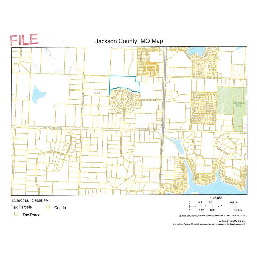
13 d Ct NE Brookwood Pl E Walnut St SE Magellan Dr NE 6th St ADP-O MF-20/ R-O/ ADP-O RE/ ADP-O LI/ ADP-O RE RE/ ADP-O General Zoning District RE SF-12 SF-7 TF MF-10 MF-14 MF-18 MF-20 NB Jackson County SO PLOS GB CB RC LI HI COUNTY AG RE-C GB-C LI-C HI-C Downtown Zoning District CS T3 T4 T5 Overlay Districts ADP-O H-O PR-O R-O Conservation District PUD Concept Plan Planned Development AG I/ P-O SE Central Dr SE Adams Dairy Pkwy LI/ ADP-O 40 SE Industrial Dr HI/ ADP-O SITE Jackson County Timbercreek Dr MF-14/ PR-O/ ADP-O LI/ ADP-O SE SE Timbercreek Ct LI/ ADP-O n County AG AG SE Steeple Dr SE Adams Dairy Pkwy ") AA SE Steeple Ln SE Kenwood Dr SE Steeple Ct SE Fox Run Ct SE Bugle Ct RE Jackson County AG SE Graham Ridge Rd AG E Eastridge Dr SE Ridgewood Dr SE Cardin ANNX KC BOBCAT 1450 SE US 40 HWY ± SITE LOCATION MAP SE Ridgewood Ct SF-7 SE Scenic Dr SE Skyview Dr ,200 Feet
14 SE Industrial Dr SITE Jackson County AA " ) ANNX KC BOBCAT 1450 SE US 40 HWY SITE LOCATION AERIAL MAP SE Graham Ridge Rd SE Adams Dairy Pkwy SE ek ercre Timb r D 40 ± Feet
15 PUBLIC NOTICE Proposed Annexation / ANNX KC Bobcat 1450 SE US 40 Highway Part of Parcels # & # Notice is hereby given that a public hearing will be held by the City Council of the City of Blue Springs on Tuesday, January 22, 2019, at 6:00 p.m. in the Howard L. Brown Public Safety Building located at 1100 SW Smith Street for the purpose of hearing comments from interested parties and citizens on a request by Alan Swearingen, owner, to annex two (2) areas of land a \- acre property and a /- acre property into the corporate boundaries of the City of Blue Springs. The property is addressed near 1450 SE US 40 Highway and generally located on the south side of U.S. 40 Highway and 1,500 feet east of SE Adams Dairy Parkway. Interested parties may view the application materials on file in the Community Development Department located at 1304 W Main Street, Blue Springs, MO. The site is legally described as follows: AREA 1: A TRACT OF LAND LOCATED IN THE SOUTHEAST QUARTER OF SECTION 32, TOWNSHIP 49 NORTH, RANGE 30 WEST, IN JACKSON COUNTY, MISSOURI, AND BEING PART OF THE TRACT DESCRIBED IN THE WARRANTY DEED RECORDED UNDER DOCUMENT NUMBER 1998I OF THE JACKSON COUNTY RECORDS, AND BEING MORE PARTICULARLY DESCRIBED AS FOLLOWS: COMMENCING AT THE SOUTHWEST CORNER OF THE SOUTHEAST QUARTER OF SAID SECTION 32, THENCE NORTH 02 14'25" EAST, ALONG THE WEST LINE OF THE SOUTHEAST QUARTER OF SAID SECTION 32, FEET TO THE POINT OF BEGINNING; THENCE FROM THE POINT OF BEGINNING, CONTINUING ALONG SAID WEST LINE, NORTH 02 14'25" EAST, 8.30 FEET; THENCE SOUTH EAST, FEET; THENCE SOUTH 02 14'25" WEST, 8.30 FEET; THENCE NORTH WEST, FEET TO THE POINT OF BEGINNING. CONTAINING 4,492 SQUARE FEET OR 0.10 ACRES, MORE OR LESS. AREA 2: PART OF THE SOUTHEAST QUARTER OF SECTION 32, TOWNSHIP 49 NORTH, RANGE 30 WEST, IN JACKSON COUNTY, MISSOURI, AND BEING PART OF THE TRACT DESCRIBED IN THE WARRANTY DEED RECORDED UNDER DOCUMENT NUMBER 1998I OF THE JACKSON COUNTY RECORDS, AND BEING MORE PARTICULARLY DESCRIBED AS FOLLOWS:
16 COMMENCING AT THE SOUTHWEST CORNER OF THE SOUTHEAST QUARTER OF SAID SECTION 32, NORTH 02 14'25" EAST, ALONG THE WEST LINE OF THE SOUTHEAST QUARTER OF SAID SECTION 32, FEET, TO A POINT ON THE SOUTH RIGHT-OF-WAY LINE OF U.S. HIGHWAY 40, AS NOW ESTABLISHED; THENCE ALONG SAID RIGHT-OF-WAY LINE, NORTH 86 30'38" EAST, FEET, TO THE POINT OF BEGINNING; THENCE FROM THE POINT OF BEGINNING, CONTINUING ALONG SAID SOUTH RIGHT-OF-WAY LINE, NORTH EAST, FEET, TO THE NORTHWEST CORNER OF LONE PINE ACRES, LOTS 1A AND 2A, A SUBDIVISION IN THE CITY OF BLUE SPRINGS, JACKSON COUNTY, MISSOURI; THENCE LEAVING SAID RIGHT-OF-WAY LINE AND ALONG THE WEST LINE OF SAID LONE PINE ACRES, SOUTH EAST, FEET, TO THE SOUTHWEST CORNER THEREOF; THENCE SOUTH EAST, FEET; THENCE ALONG A CURVE TO THE RIGHT BEING TANGENT TO THE LAST DESCRIBED COURSE, HAVING A RADIUS OF FEET, A DELTA ANGLE OF AND AN ARC LENGTH OF FEET; THENCE NORTH EAST, FEET, TO THE POINT OF BEGINNING AND CONTAINS 0.66 ACRES, MORE OR LESS. CITY OF BLUE SPRINGS City Council PUBLISH: Saturday, January 12, ED TO THE EXAMINER: legals@examiner.net 01/10/2019
17
18
19
20
21
22
23
24

25
26
27
28
29
30 January 10, 2019 Ref: Public Hearing: Proposed Annexation ANNX KC Bobcat 1450 SE US 40 Highway Part of Parcels # & # Dear Property Owner: A Public Hearing will be held by the City Council of the City of Blue Springs, Jackson County, Missouri to receive comments from interested parties and citizens relative to a request by Alan Swearingen, owner, to annex two (2) areas of land a \- acre property and a /- acre property into the corporate boundaries of the City of Blue Springs. The property is addressed near 1450 SE US 40 Highway and generally located on the south side of U.S. 40 Highway and 1,500 feet east of SE Adams Dairy Parkway. You are receiving this notice because County records indicate you own property within 185 feet of the boundary of the site in question. Interested parties may view the application materials on file in the Community Development Department located at 1304 W Main Street, Blue Springs, MO. A general site location map is enclosed for your information. The hearing will be held in the Howard L. Brown Public Safety Building located at 1100 SW Smith Street, Blue Springs on the following date: City Council Tuesday, January 22, :00 p.m. Your attendance and comments are welcome at this meeting. Questions concerning this matter may be directed to the Community Development Department at Very truly yours, CITY OF BLUE SPRINGS COMMUNITY DEVELOPMENT Karen M. Findora Administrative Assistant
31 PARCELID17 owner owneraddre ownercity ownerstate ownerzipco ROBERT C TAYLOR TRUST 506 NW GOLFVIEW DR BLUE SPRINGS MO HENNING RANDALL L & SUSAN C 2605 NE GLEN DR BLUE SPRINGS MO SUPREME PROPERTIES LLC 8001 CONSER STE 200 OVERLAND PARK KS SWEARINGEN ALAN A & BARBARA J 616 SE INDUSTRIAL DR BLUE SPRINGS MO LYON LEWIS F & DEBRA F 1525 US 40 WEST BOUND HWY BLUE SPRINGS MO STANLEY PACK POST 499 AMERICAN LEGION 499 S M 7 HWY BLUE SPRINGS MO D P P R LLC 6330 NW KELLY DR KANSAS CITY MO D P P R LLC 6330 NW KELLY DR KANSAS CITY MO 64152
 AA SE Steepleeple Ct SE Fox Run Ct E Bugle Ct SE")
32 NE 6th St Jackson County SE Timbercreek 40 SE Brizendine Rd Dr SE Industrial Dr SE Timbercreek Ct Jackson County Jackson County ") AA SE Steepleeple Ct SE Fox Run Ct E Bugle Ct SE Adams Dairy Pkwy SE Graham Ridge Rd SE Eastridge Dr SE Kenwood Dr SE Ridgewood Dr SE Scenic Dr ") AA ANNX KC BOBCAT 1450 SE US 40 HWY 185' NOTIFICATION MAP ± ,200 Feet
33 BILL NO Introduced by (ANNX ) ORDINANCE NO. AN ORDINANCE ANNEXING \- & /- ACRES LOCATED ON THE SOUTH SIDE OF U.S. 40 HIGHWAY AND 1,500 FEET EAST OF SE ADAMS DAIRY PARKWAY INTO THE CORPORATE BOUNDARIES OF THE CITY OF BLUE SPRINGS, MISSOURI WHEREAS, pursuant to the Revised Statutes of Missouri and Ordinances of the City of Blue Springs, Missouri, a Voluntary Annexation Petition requesting annexation was filed with the City of Blue Springs by the owners of all fee interests of record, in tracts of real estate described hereafter; and WHEREAS, said real estate described herein is adjacent and contiguous to the present corporate limits of the City of Blue Springs, Missouri; and WHEREAS, on January 22, 2019, a public hearing concerning the matter was held before the City Council of the City of Blue Springs, timely and proper notice of said hearing having been duly published; and WHEREAS, no written objections to the proposed annexation were filed within fourteen days after the public hearing; and WHEREAS, the City Council of the City of Blue Springs has determined that the general criteria for annexation exists as mentioned in the Revised Statutes of Missouri and finds that said annexation is reasonable and necessary to the proper development of the City and that the City is able to furnish normal municipal services to said area within a reasonable time after annexation. NOW, THEREFORE, BE IT ORDAINED BY THE CITY COUNCIL OF THE CITY OF BLUE SPRINGS, MISSOURI, as follows: Section 1. That, pursuant to Section , RSMo, the following described a tract of land of real estate is hereby annexed into the City of Blue Springs, Missouri, to wit: AREA 1: A TRACT OF LAND LOCATED IN THE SOUTHEAST QUARTER OF SECTION 32, TOWNSHIP 49 NORTH, RANGE 30 WEST, IN JACKSON COUNTY, MISSOURI, AND BEING PART OF THE TRACT DESCRIBED IN THE WARRANTY DEED RECORDED UNDER DOCUMENT NUMBER 1998I OF THE JACKSON COUNTY RECORDS, AND BEING MORE PARTICULARLY DESCRIBED AS FOLLOWS: COMMENCING AT THE SOUTHWEST CORNER OF THE SOUTHEAST QUARTER OF SAID SECTION 32, THENCE NORTH 02 14'25" EAST, ALONG THE WEST LINE OF THE SOUTHEAST QUARTER OF SAID SECTION 32, FEET TO THE POINT OF BEGINNING; 1
34 THENCE FROM THE POINT OF BEGINNING, CONTINUING ALONG SAID WEST LINE, NORTH 02 14'25" EAST, 8.30 FEET; THENCE SOUTH EAST, FEET; THENCE SOUTH 02 14'25" WEST, 8.30 FEET; THENCE NORTH WEST, FEET TO THE POINT OF BEGINNING. CONTAINING 4,492 SQUARE FEET OR 0.10 ACRES, MORE OR LESS. AREA 2: PART OF THE SOUTHEAST QUARTER OF SECTION 32, TOWNSHIP 49 NORTH, RANGE 30 WEST, IN JACKSON COUNTY, MISSOURI, AND BEING PART OF THE TRACT DESCRIBED IN THE WARRANTY DEED RECORDED UNDER DOCUMENT NUMBER 1998I OF THE JACKSON COUNTY RECORDS, AND BEING MORE PARTICULARLY DESCRIBED AS FOLLOWS: COMMENCING AT THE SOUTHWEST CORNER OF THE SOUTHEAST QUARTER OF SAID SECTION 32, NORTH 02 14'25" EAST, ALONG THE WEST LINE OF THE SOUTHEAST QUARTER OF SAID SECTION 32, FEET, TO A POINT ON THE SOUTH RIGHT-OF-WAY LINE OF U.S. HIGHWAY 40, AS NOW ESTABLISHED; THENCE ALONG SAID RIGHT-OF-WAY LINE, NORTH 86 30'38" EAST, FEET, TO THE POINT OF BEGINNING; THENCE FROM THE POINT OF BEGINNING, CONTINUING ALONG SAID SOUTH RIGHT-OF-WAY LINE, NORTH EAST, FEET, TO THE NORTHWEST CORNER OF LONE PINE ACRES, LOTS 1A AND 2A, A SUBDIVISION IN THE CITY OF BLUE SPRINGS, JACKSON COUNTY, MISSOURI; THENCE LEAVING SAID RIGHT-OF- WAY LINE AND ALONG THE WEST LINE OF SAID LONE PINE ACRES, SOUTH EAST, FEET, TO THE SOUTHWEST CORNER THEREOF; THENCE SOUTH EAST, FEET; THENCE ALONG A CURVE TO THE RIGHT BEING TANGENT TO THE LAST DESCRIBED COURSE, HAVING A RADIUS OF FEET, A DELTA ANGLE OF AND AN ARC LENGTH OF FEET; THENCE NORTH EAST, FEET, TO THE POINT OF BEGINNING AND CONTAINS 0.66 ACRES, MORE OR LESS. Section 2. The City Clerk is hereby instructed to cause three certified copies of this ordinance to be filed with the Director of County Assessment, the County Clerk of Jackson County, Missouri, and to cause a certified copy of this ordinance to be recorded in the Office of the Director of Records of Jackson County, Missouri, at Independence, and another certified copy with the Jackson County Election Board. Section 3. This ordinance shall be in full force and effect from and after its passage and approval. 2
35 PASSED by the City Council of the City of Blue Springs, Missouri, and approved by the Mayor of Blue Springs, this 19 th of February, CITY OF BLUE SPRINGS ATTEST: Carson Ross, Mayor Sheryl Morgan, City Clerk 1 st Reading: 2 nd Reading: 3
36 CITY OF BLUE SPRINGS, MISSOURI CITY COUNCIL JANUARY 22, 2019 EXHIBITS FOR PUBLIC HEARING REZONING OF /. ACRE PROPERTY LOCATED 3421 NW JEFFERSON STREET FROM "LI" (LIGHT INDUSTRIAL) TO "GB" (GENERAL BUSINESS) (RZ ) EXHIBIT #1 Council Information Form with attachments: Staff Report with attachments; Affidavit of Publication in The Examiner on December 29, 2018; Application with attachments; 185-ft; Notification Map; Names/addresses of property owners within 185-ft. of site; Copy of letter sent to said property owners; Title IV, Land Use Section - Blue Springs Code of Ordinances (by reference); and 2014 Comprehensive Plan (by reference).. ; and Bill No Exhibit 1 CCOUNCIL 01/22/2019 (RZ )
37 DATE SUBMITTED: January 15, 2019 CITY OF BLUE SPRINGS CITY COUNCIL INFORMATION FORM Council Meeting Date: January 22, 2019 Agenda Item #: 6 & 7 Page 1 of 2 SUBMITTED BY: Tom Cole DEPARTMENT: Community & Economic Development Ordinance Resolution Presentation Public Hearing Contract Discussion Economic Dev. Other ISSUE/REQUEST A public hearing is being held at the request of the Applicant, Anthony DiPlacito, on behalf of Paul & Tammy Engen, owners for consideration to rezone from LI (Light Industrial) to GB (General Business) for the /- acre development located at 3421 NW Jefferson Street (RZ ). Upon conclusion of the public hearing, a Bill rezoning 3421 NW Jefferson Street will be ready for introduction and readings. BACKGROUND/JUSTIFICATION The applicant is requesting to rezone the subject property from LI (Light Industrial) to GB (General Business) to accommodate a future bar/tavern use in a portion of the existing building. There is an existing vehicle repair, limited business operating out of a majority of the building, which will remain. The proposed rezoning will allow the bar/tavern use to operate in the building, as well as keep the vehicle repair, limited land use in compliance with the Unified Development Code. Contractor: FINANCIAL IMPACT N/A Estimated Start Date January 22, 2019 PROJECT TIMELINE Estimated End Date N/A Staff recommends approval. STAFF RECOMMENDATION OTHER BOARDS & COMMISSIONS ASSIGNED Name of Board or Commission: Planning Commission Date: January 14, 2019 Action: Recommended approval; 10 Aye, 0 No N/A ECONOMIC DEVELOPMENT PROJECT Rev. 10/17/2018
38 Council Meeting Date: January 22, 2019 Agenda Item #: 6 & 7 Page 2 of 2 LIST OF REFERENCE DOCUMENTS ATTACHED 1. Staff Report with attachments; Affidavit of Publication in The Examiner on December 29, 2018; Application with attachments; 185-ft; Notification Map; Names/addresses of property owners within 185-ft. of site; Copy of letter sent to said property owners; Title IV, Land Use Section Blue Springs Code of Ordinances (by reference); and 2014 Comprehensive Plan (by reference). 2. Bill approving Rezoning Requesting Director: Tom Cole Legal: Jacqueline A. Sommer REVIEWED BY Budget: Christine Cates City Administrator: Rev. 10/17/2018
39 PLANNING COMMISSION STAFF REPORT Meeting Date: January 14, 2019 Agenda Item: 2 Case File Number: RZ Project Name: Type of Application: Request: Wind Shift Brewery Rezoning Rezone from LI (Light Industrial) to GB (General Business) Applicant: Property Owner: Engineer: Architect: Surveyor: Landscape Architect: Attorney: Location (Address): General Location: Area: Lots: Existing Zoning: Proposed Zoning: Existing Land Use: Proposed Land Use: Comprehensive Plan Designation: Attachments: Anthony DiPlacito Paul Engen N/A N/A N/A N/A N/A 3421 NW Jefferson St. North of NW Jefferson St., approx. 260 east of NW Woods Chapel Road /- acres 1 Platted Lot LI (Light Industrial) GB (General Business) Vehicle Repair, Limited & Office Vehicle Repair, Limited & Bar/Tavern Corridor Reinvestment / Neighborhood Retail Site Location Maps Plat of Rezoning Area Application Planning Commission: January 14, 2019 City Council: Planner: January 22, 2019 (Tuesday) Matt Wright, Senior Planner Page 1 of 6
40 Project: Wind Shift Brewery Case: RZ BACKGROUND INFORMATION/SUMMARY: The applicant, Anthony DiPlacito, on behalf of the owner, Paul Engen, is requesting to rezone /- acres from LI (Light Industrial) to GB (General Business) for property addressed as 3421 NW Jefferson Street. The existing 6,225-sf. building is largely comprised of a vehicle repair, limited business (Jefferson Service Center), which includes 8 service bays. Approximately 1,000- sf. in the front right (southeast) corner of the building has been used for office space in the past. The applicant is requesting to rezone the property to GB to accommodate a proposed bar/tavern (Wind Shift Brewery) in the former office space. A rezoning to GB will accommodate both the new bar/tavern land use, as well as keep the vehicle repair, limited land use in compliance with the Unified Development Code. Any existing non-conformities on the site are permitted to remain, as the proposed change of use is less than 25% of the total building area (approx %). PREVIOUS ACTIONS/APPROVALS: On September 11, 1990, the Board of Alderman approved the Final Plat of Duncan Plaza, 1 st Plat, Lots 1 & 2 (Ordinance No. 1980). On November 19, 1990, the Board of Alderman approved the Final Plat of A Replat of Duncan Plaza, 1 st Plat, Lots 1 & 2 (Ordinance No. 2001). On July 28, 2010, the Board of Adjustment approved a Variance (VAR ) to reduce landscape buffer along west property line. On August 9, 2010, the Planning Commission approved a Site Plan Design Review (SPDR ) for Jefferson Service Center. FUTURE APPLICATIONS/REVIEWS ANTICIPATED OR REQUIRED: No additional applications or reviews are anticipated or required at this time. ABUTTING ZONING AND LAND USES: Direction Current Zoning Surrounding Land Uses North: LI (Light Industrial) Industrial/Office South: Right-of-Way NW Jefferson St. (Minor Collector) East: LI (Light Industrial) Undeveloped West: GB (General Business) Undeveloped RECOMMENDATION: Staff recommends approval of this Rezoning request. Page 2 of 6
41 Project: Wind Shift Brewery Case: RZ REZONING APPLICATIONS Zoning and Land Use: Zoning Land Use Existing LI (Light Industrial) Vehicle Repair, Limited & Office Proposed GB (General Business) Vehicle Repair, Limited & Bar/Tavern The table below highlights some commonly permitted land uses in the GB zoning district from UDC Table (Use Table): Key: = Permitted use / general standards = Limited use / specific standards or planned districts = Conditional use / discretionary review Non-Residential Zoning Districts Uses Office General Large Retail (12, ,000) Warehouse Retail (100,000 +) Grocery Store (< 40,000 s.f.) Super Market (40,000 +) Service Station, Large (17 + pumps) Outdoor Sales - General Outdoor Sales and Services Outdoor Sales and Services -Equipment Animal Care -Limited Animal Care - General Bar or Tavern Car Wash Hotel or Motel Medical Service Personal Services Recreation and Entertainment - Indoor Recreation and Entertainment - Outdoor Recreational Vehicle Park Restaurant -Fast-Food Restaurant - General Vehicle Repair, Limited Vehicle Repair, General Manufacturing - Limited Food Production - Limited NB SO GB RC LI HI PLOS Comprehensive Plan: According to the 2014 Comprehensive Plan, the Future Land Use Policy Map reflects planned future land uses at the most generalized and city-wide scale. The intent of the Future Land Use Policy Map is not to predetermine land uses or zoning on a specific parcel or at specific locations. Together with other elements of the Comprehensive Plan, the Future Land Use Policy Map should be used to guide Page 3 of 6
42 Project: Wind Shift Brewery Case: RZ the relationships and physical improvements needed to create the types of places that are part of Blue Springs long-range vision. The Future Land Use Policy Map designates this property as Corridor Reinvestment area. Corridor Reinvestment areas are along primary corridors in Blue Springs, outside of Neighborhood Centers, Business Hubs, or Distinct Destinations that require strategic investments to improve both the immediate area as well as the relationship to other potential places elsewhere in the corridors. Priority land uses in these areas include employment or residential uses that can support the other places, or commercial uses that require format, location, or access needs that are not compatible with more compact or mixed-use places. According to the 2014 Comprehensive Plan, Specific Plans are detailed, areaspecific perspectives of the patterns and coordination of the built and natural environment, and how these details contribute to unique places in Blue Springs. These plans offer a more refined and location-specific application of the Policies, Goals, and Targets of the General Plan to a particular context. The N1 Area s Specific Plan designates this property as a Neighborhood Retail area. Neighborhood Retail is defined as Areas for businesses primarily engaged in selling merchandise to general consumers where the exchange occurs at the location and where lots or buildings are designed for interaction with customers on the premises. Uses are primarily small-scale to increase the concentration and diversity of uses accessible to nearby neighborhoods, although one or two anchor tenants may be incorporated into walkable patterns. Secondary service, employment or residential uses may be incorporated, particularly on upper stories of buildings. Zoning: The intent of the GB zoning district is defined in Section , as follows: REVIEW CRITERIA: The GB, General Business District is intended to accommodate general trades and commercial services at specific points on arterials outside central or neighborhood business districts. The GB District is particularly appropriate adjoining a major highway. Such an area draws highway uses such as restaurants, service stations, and motels, which are not totally compatible with shopping center developments but which may be grouped together advantageously as highway service centers. Section references the land uses and building types permitted in the GB district (see previous Tables). Additionally, Section defines specific performance and design standards. In reviewing any application for an amendment to the Official Zoning Map (zoning change), the Planning Commission and City Council shall review the proposed amendment considering the Page 4 of 6
43 Project: Wind Shift Brewery Case: RZ Comprehensive Plan, the general requirements of the Unified Development Code, and the following considerations: 1. The application is in accordance with the Comprehensive Plan and any official plan of program developed under the guidance of the Comprehensive Plan, and in particular the relationship of land uses within the proposed district and the relationship with uses existing or anticipated in surrounding districts. STAFF RESPONSE: The Future Land Use Policy Map designates this property as both Corridor Reinvestment and Neighborhood Retail. Corridor Reinvestment areas are along primary corridors outside of Neighborhood Centers and are generally reserved for development types that are not compatible with more compact or mixed-use places. Neighborhood Retail areas are generally reserved for smaller-format businesses that serve surrounding neighborhoods. The proposed zoning will allow the existing vehicle repair, limited business to remain, and accommodate the bar/tavern use, which fits well within the Neighborhood Retail designation of the Comprehensive Plan. Properties to the south and west along NW Jefferson Street and NW Woods Chapel Road have the same Future Land Use Policy Map designations and GB (General Business) zoning. 2. The application furthers the intent of the proposed zoning district and supports that of any abutting zoning districts. STAFF RESPONSE: The proposed rezoning matches adjacent zoning districts along NW Jefferson Street and NW Woods Chapel Road. The subject property is the only property currently zoned LI (Light Industrial) along NW Jefferson Street within 1,000-ft. of the NW Woods Chapel Road intersection (all other properties are zoned GB or RC ). Properties to the north and east are zoned LI (Light Industrial) but are accessed from NW Duncan Road, creating a small industrial park area which is reliant on quick access, but less visibility, to Interstate The precedents that might result from approval or denial of the application, and the possible effects of such precedents on the character of the area, and in particular the building form, site design, and other development patterns and urban design aspects that accompany precedents for the proposed district. STAFF RESPONSE: The requested GB zoning district is appropriate for the subject property and is more closely aligned with the Comprehensive Plan designations for the area than the current LI zoning designation. 4. Compliance of any proposed development with the requirements of the UDC. STAFF RESPONSE: The requested rezoning will allow a bar/tavern land use to operate out of a small portion of the building (approx. 1,000-sf., or 16.15% of the total building area). Since the change in use is less than 25% of the total building area the site may maintain any legal non-conformities until further changes in use or additions occur. The only development requirements that must be accommodated are parking for the new use. The applicant has submitted details on the parking requirements for both the existing vehicle repair, limited use and the bar/tavern use, as well as a count of existing parking spaces. Based on the analysis submitted, the site has 26 existing parking spaces and is required 25 spaces. Page 5 of 6
44 Project: Wind Shift Brewery Case: RZ The ability of the City or other government agencies to provide any services, facilities or programs that might be required if the application were approved. STAFF RESPONSE: The requested rezoning covers /- which is not expected to create a significant increase in demand for services, facilities, or other programs. The total building square footage is not being increased as part of the proposed development. 6. The effect of approval on the condition or value of property in the City or in the vicinity, including the likelihood of surrounding areas to be developed in accordance with the Comprehensive Plan. STAFF RESPONSE: Staff believes approval of this rezoning will not reduce property values of adjacent properties or the ability to be developed in accordance with the Comprehensive Plan. 7. The requested zoning change is justified by a change in conditions since the existing zoning was designated or by an error in the current designation. STAFF RESPONSE: The property has been zoned LI (Light Industrial) since at least Street improvements at NW Woods Chapel Road and NW Jefferson Street over the past decade and the development of residential and office further to the east makes the property more suitable to a commercial zoning district. 8. The consistency of the application with other adopted policies of the City. STAFF RESPONSE: Staff believes this proposal is consistent with other adopted City policies. 9. The recommendations of professional staff. STAFF RESPONSE: Staff recommends approval of this rezoning proposal. STAFF RECOMMENDATION: Staff recommends approval of this Rezoning request. Page 6 of 6
45 d Valley Ashland Pl NW Winslow Pl NW Cardiff Dr TF NW Delwood Dr NW Valley Vie NW Delwood Ct NW Hidden Pointe Ct NW RD Mize Rd 70 NW Co NW Hidden Pointe Dr NW Anchor Pointe GB SF-7 NW Anchor Ct NW Light House Ct GB NW Pier Ct Independence NW Harbor Ct SITE NW Carl Felt Dr NW South Outer Rd NW 36th St NW Harbor Pl GB LI NW Woods Chapel Rd RC MF-14 GB Jackson County LI Jackson County GB RC NW Duncan Rd LI LI GB NW Candletree Dr RC NW Jefferson St NW Kingsridge Dr RC NW South Outer Rd MF-14 NW Arling RC/ R-O General Zoning District GB NW Canterbury Rd NW Westbrooke Pl NW Winston Cir SF-7 sridge GB R NW W C NW Westbrooke Dr TF/R-O RC RC R- NW Jefferso RZ WIND SHIFT BREWERY 3421 NW JEFFERSON ST ± SITE LOCATION MAP ,200 Feet RE SF-12 SF-7 TF MF-10 MF-14 MF-18 MF-20 NB SO PLOS GB CB RC LI HI COUNTY AG RE-C GB-C LI-C HI-C Downtown Zoning District CS T3 T4 T5 Overlay Districts ADP-O H-O PR-O R-O Conservation District PUD Concept Plan Planned Development G RC
46 NW er Pi t Ct NW Harbor Pl NW H ht g i L C se u o Jackson County M ize t Rd C or rb Ha RD NW NW NW Duncan Rd SITE Independence NW Je fferson St 70 NW Woods Cha NW Carl Felt Dr NW S o u th Ou te r Rd pel Rd NW t hs 36t RZ WIND SHIFT BREWERY 3421 NW JEFFERSON ST SITE LOCATION AERIAL MAP NW 0 nd a C 200 le e tre Dr ± Feet
47
48
49
50
51
52
53

54
55
56
57

58
59
60

61
62
63
64
65
66
67
68
69
70
71
72 BILL NO Introduced by Councilman (RZ ) ORDINANCE NO. AN ORDINANCE REZONING PROPERTY FROM LI (LIGHT INDUSTRIAL) TO GB (GENERAL BUSINESS) WHEREAS, proper application having been made for rezoning of property hereinafter described; and WHEREAS, in accordance with Title IV, Unified Development Code of the Municipal Code of the City of Blue Springs, Missouri, said application was referred to the Planning Commission for report and recommendation, and a public hearing was held January 14, 2019, which Commission, after said hearing, recommended that the application for rezoning be approved; and and WHEREAS, thereafter a public hearing was held by the City Council January 22, 2019; WHEREAS, in accordance with Title IV, Unified Development Code of the Municipal Code of the City of Blue Springs, Missouri, it was determined that the change of zoning was appropriate at the location herein described; and. NOW, THEREFORE, BE IT ORDAINED BY THE CITY COUNCIL OF THE CITY OF BLUE SPRINGS, MISSOURI, as follows: Section 1: The following described tract of real estate is hereby rezoned from LI (Light Industrial) to GB (General Business). The site is legally described as: DUNCAN PLAZA 1 ST PLAT, A REPLAT OF LOTS 1 & 2, LOT 2, A SUBDIVISION IN BLUE SPRINGS, JACKSON COUNTY, MISSOURI. Section 2: This Ordinance shall be in full force and effect from and after its passage and approval. PASSED by the City Council of the City of Blue Springs, Missouri, and approved by the Mayor of Blue Springs, this 22 nd day of January, CITY OF BLUE SPRINGS ATTEST: Carson Ross, Mayor Julia Porter, Deputy City Clerk 1st Reading: 2nd Reading:
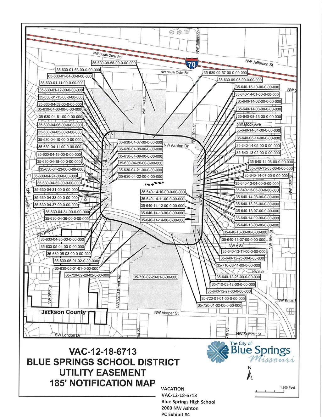
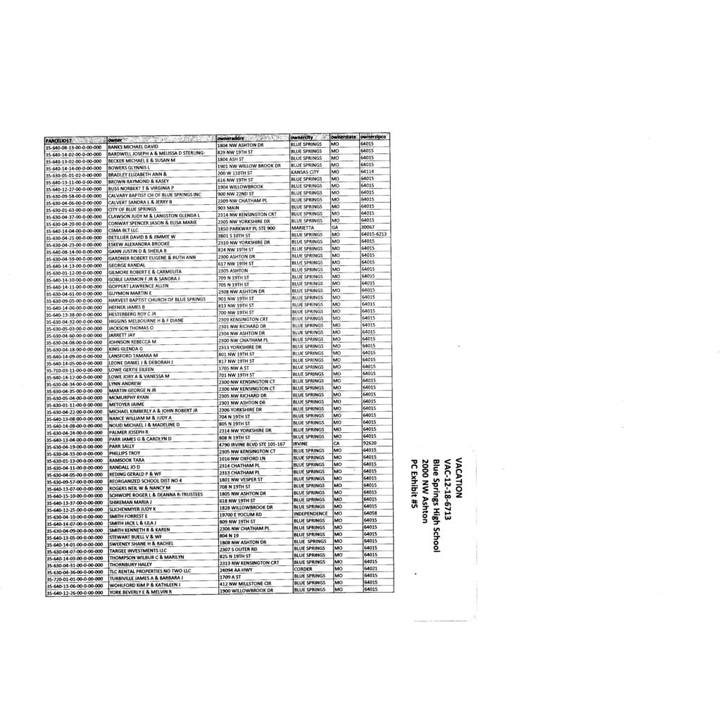
73 CITY OF BLUE SPRINGS, MISSOURI CITY COUNCIL JANUARY 22, 2019 EXHIBITS FOR PUBLIC HEARING VACATION OF 10-FOOT UTILITY EASEMENT LOCATED AT 2000 NW ASHTON DRIVE (VAC ) EXHIBIT #1 Staff Report with attachments; Affidavit of Publication in The Examiner on December 29, 2018; Application with attachments; 185-ft; Notification Map; Names/addresses of property owners within 185-ft. of site; Copy of letter sent to said property owners; Title IV, Land Use Section - Blue Springs Code of Ordinances (by reference); and 2014 Comprehensive Plan (by reference); and Bill No Exhibit 1 CCOUNCIL 01/22/2019 (VAC )
74 DATE SUBMITTED: January 15, 2019 CITY OF BLUE SPRINGS CITY COUNCIL INFORMATION FORM Council Meeting Date: January 22, 2019 Agenda Item #: 8 & 9 Page 1 of 2 SUBMITTED BY: Tom Cole DEPARTMENT: Community & Economic Development Ordinance Resolution Presentation Public Hearing Contract Discussion Economic Dev. Other ISSUE/REQUEST A public hearing is being held at the request of the Applicant, Jeffrey Schutzler with Hollis+Miller Architects, representing the owner, Blue Springs R-IV School District, for consideration of the vacation of a ten (10) foot utility easement located generally at 2000 NW Ashton Drive (VAC ). Upon conclusion of the public hearing, a Bill vacating the utility easement will be ready for introduction and readings. BACKGROUND/JUSTIFICATION The applicant is requesting to vacate a 10-foot utility easement on the Blue Springs High School campus at 2000 NW Ashton Drive. Vacating the utility easement will allow the construction of a new building addition, which is proposed over the current easement. Currently, only underground electric is located within the portion of the easement that is proposed to be vacated. The applicant has already coordinated with the utility company to relocate the electrical line around the proposed addition. Contractor: FINANCIAL IMPACT N/A Estimated Start Date January 22, 2019 PROJECT TIMELINE Estimated End Date N/A Staff recommends approval. STAFF RECOMMENDATION OTHER BOARDS & COMMISSIONS ASSIGNED Name of Board or Commission: Planning Commission Date: January 14, 2019 Action: Recommended approval; 10 Aye, 0 No N/A ECONOMIC DEVELOPMENT PROJECT Rev. 10/17/2018
75 Council Meeting Date: January 22, 2019 Agenda Item #: 8 & 9 Page 2 of 2 LIST OF REFERENCE DOCUMENTS ATTACHED 1. Staff Report with attachments; Affidavit of Publication in The Examiner on December 29, 2018; Application with attachments; 185-ft; Notification Map; Names/addresses of property owners within 185-ft. of site; Copy of letter sent to said property owners; Title IV, Land Use Section Blue Springs Code of Ordinances (by reference); and 2014 Comprehensive Plan (by reference). 2. Bill approving Rezoning Requesting Director: Tom Cole Legal: Jacqueline A. Sommer REVIEWED BY Budget: Christine Cates City Administrator: Rev. 10/17/2018
76 PLANNING COMMISSION STAFF REPORT Meeting Date: January 14, 2019 Agenda Item: 3 Case File Number: VAC Project Name: Type of Application: Request: Blue Springs High School Vacation Request to vacate a portion of a 10-foot utility easement on the Blue Springs High School campus at 2000 NW Ashton Drive. Applicant: Property Owner: Surveyor: Attorney: Location (Address): General Location: Area & Lots: Existing Zoning: Existing Land Use: Comprehensive Plan Designation: Hollis+Miller Architects / Jeffrey Schutzler Blue Springs R-IV School District / Dan Anderson Intertek-PSI / AJ Rahman N/A 2000 NW Ashton Drive South of NW Ashton Drive and west of NW 19 th Street /- acres; 1 lot (campus site) SF-7 (Single-Family) High School Neighborhoods Attachments: Site Location Maps Easement Vacation Exhibit Application Planning Commission: January 14, 2019 City Council: January 22, 2019 (Tuesday) Planner: Matt Wright, Senior Planner Page 1 of 4
77 Project: Blue Springs High School Case: VAC BACKGROUND INFORMATION/SUMMARY: The Final Plat of Blue Springs High School was recorded with a 10-ft. utility easement near the center of the property in The Blue Springs School District is requesting to vacate a portion of the 10-ft. utility easement to allow the construction of a new building addition which will be over the easement. Currently, only underground electric is located within the portion of the easement proposed to be vacated. The applicant has already made plans to relocate the electrical line around the new addition. Staff believes that this request is in accordance with the Comprehensive Plan & the Unified Development Code (UDC) and will not injure any public or private rights. Staff recommends approval of the request to vacate the 10-ft. utility easement. PREVIOUS ACTIONS/APPROVALS: On November 19, 2001, the City Council approved a Final Plat for Blue Springs High School 1 st Plat on /- acres (Ordinance No. 3431). On March 14, 2005, the Planning Commission approved a Site Plan Design Review (SPD ) for a 7,500-sf. commons addition, bleachers, and track field. On June 27, 2005, the Planning Commission approved a Master/Alternative Sign Plan (ASP ) for exterior scoreboard signage. On January 12, 2009, the Planning Commission approved a Preliminary Plat (PP ) for the /- acre site. On January 12, 2009, the Planning Commission approved a Site Plan Design Review (SPDR ) for 72,270-sf. building addition. On February 11, 2009, the Board of Adjustment approved a Variance (VAR ) to allow a building permit to be issued without a Final Plat and to allow the west parking lot to be retained without curbing along the perimeter. On August 24, 2009, the Planning Commission recommended approval of a Final Plat (PF ) for Blue Springs High School. The City Council approved the Final Plat on September 8, 2009 (Ordinance No. 4260). On September 14, 2009, the Planning Commission approved a Master/Alternative Sign Plan (ASP ) for four wall signs and one monument sign. FUTURE APPLICATIONS/REVIEWS ANTICIPATED OR REQUIRED: The applicant has submitted a Site Plan Design Review application that will be reviewed concurrently with the Vacation. Once both the Site Plan Design Review and Vacation applications have been approved, and the Vacation has been recorded at Jackson County, a building permit for the proposed additions and site improvements can be issued. A Master/Alternative Sign Plan may be requested for any signage that does not meet the Sign Code and must be approved by the Planning Commission prior to the issuance of any sign permits. ABUTTING ZONING AND LAND USES: Direction Current Zoning Surrounding Land Uses North: Right-of-Way NW Ashton Drive (Local) South: Right-of-Way Railroad (Kansas City Southern) East: SF-7 Single-Family Residential West: SF-7 Single-Family Residential Page 2 of 4
78 Project: Blue Springs High School Case: VAC RECOMMENDATION: Staff recommends approval of the Vacation request with two (2) conditions. VACATION REVIEW CRITERIA The governing body shall consider a vacation request considering the Comprehensive Plan, and the following applicable review criteria: 1. The application is in accordance with the Comprehensive Plan or any official plan or program developed under the guidance of the Comprehensive Plan. In particular the impact of the vacation on physical patterns, arrangement of streets, blocks, lots and open spaces, and public realm investments reflect the principles and concepts of the plan. Approval of the vacation will not contradict any guidance provided by the Comprehensive Plan. 2. Compliance with the requirements of the Unified Development Code. In particular the vacation is consistent with the intent and design objectives of the subdivision design standards. The applicant is requesting the vacation to allow the construction of a new building addition. The Unified Development Code only permits fences and landscaping within easements. Permanent structures and buildings are not allowed to be constructed over any easements. 3. The vacation reflects sound planning and urban design principles with respect to existing and potential development in the vicinity, including consideration of current and future streets, open spaces, blocks, lots, and public utilities and facilities. This request reflects sound planning and urban design principles. 4. Any impacts identified by specific studies or technical reports are mitigated with generally accepted sound planning, engineering, and urban design solutions, that reflect long-term solutions and sound fiscal investments. Staff believes this will not create any negative impacts. 5. The application does not deter any existing or future development on adjacent property from meeting the goals and policies of the Comprehensive Plan. This vacation will not deter adjacent properties from meeting the goals or policies of the Comprehensive Plan. The utility easement vacation does not impact any adjacent properties. 6. All resulting lots and parcels are capable of meeting the intent and objectives of the applicable zoning districts and development standards. The subject property is still capable of meeting the intent and objectives of the UDC. 7. The application meets the public interest and is not otherwise for the sole benefit of one (1) property owner or project. This request will meet the public interest by allowing the property owner to develop the property as intended by the UDC. 8. No private rights will be injured or endangered by the application. No private rights will be injured or endangered. 9. The street or alley to be vacated no longer serves a public purpose. N/A 10. The recommendations of professional staff. Staff recommends approval. 11. Other information which may come to its attention. None. Page 3 of 4
79 Project: Blue Springs High School Case: VAC VACATION ANALYSIS: Legal Notice: Private Rights: Public Loss: Legal notice has been provided as required. The public notice was provided through publication in a newspaper of general circulation; letters were provided to property owners within 185-ft. of the subject property; and a public notice sign was displayed on the property. No private rights of any adjacent property owners will be impacted. The utility easement being vacated is solely on the Blue Springs High School property. The public will not suffer loss nor inconvenience with the vacation of a portion of the 10-ft. utility easement. The only known public utility within the easement is KCP&L, which has an underground electric line that will be relocated. Other utilities were notified of the request, but not all responded. STAFF RECOMMENDATION: Staff recommends approval of the Vacation application with the following conditions: 1. Approval by the City Council based on the representations of any drawings presented as part of this application does not waive any requirement or development standard contained in the UDC. 2. Prior to building permit issuance for the proposed building addition, the Vacation must be recorded with Jackson County Recorder of Deeds and a recorded copy must be returned to the City of Blue Springs. Page 4 of 4
80 RC/ R-O son St GB C 70 RC RC GB TF RC GB SO NW Oxford Ln NW South Outer Rd RC PLOS LI NW 22nd St SO MF-14 GB GB SO NW 19th St NW Haw GB RC RE SO General Zoning District RE SF-12 SF-7 TF MF-10 MF-14 MF-18 MF-20 NB SO PLOS GB CB RC LI HI HI-C GB NW SO COUNTY AG RE-C GB-C LI-C NW Mock Ave NW Downtown Zoning District CS T3 T4 T5 Overlay Districts ADP-O H-O PR-O R-O 70 RC NW NW Conservation District PUD Concept Plan Planned Development NW Ashton Dr SF-7 NW Devonshire Pl NW Mill Dr NW Castle Dr SF-7 NW Richard Dr NW Panther Dr NW Brielle Ct NW 26th St NW Camelot Pl NW Kings Ct Jackson County NW Chatham Pl NW Yorkshire Dr NW Kensington Ct SF-7 SF-7/ PR-O SF-7 NW 22nd Street Ter SITE NW Vesper St SF-7 NW 19th St NW Ash Ave NW 18th St NW 17th St NW Ashton Dr NW Willow Brook Ct NW 17th St NW Willow Brook Dr NW A St VAC BLUE SPRINGS HIGH SCHOOL UTILITY EASEMENT ± SITE LOCATION MAP SF-7 T3/ H-O h St NW 16th St NW 15th St TF NW B ,200 Feet NW
81 NW 22nd St NW Warwick Ct NW dl for n NW Mock A NW Ashton Dr NW Ashton Dr NW Chatham Pl r kd Br oo NW W illo w NW 19th St NW Kensington Ct NW 17th St NW Ash Ave SITE w t NW illo k C W roo B VAC BLUE SPRINGS HIGH SCHOOL UTILITY EASEMENT SITE LOCATION AERIAL MAP ± NW 17th St NW A St NW 22nd Street Ter NW s g Kin Ct NW Yorkshire Dr NW 18th St NW Camelot Pl Ox Kingsridge Dr Ct NW 19th St NW ire Chesh Pl NW lem Sa NW Copper Oaks Cir 800 Feet
82
83
84
85
86
87
88

89
90
91
92
93
94
95
96
97
98 BILL NO Introduced by Councilman (VAC ) ORDINANCE NO. AN ORDINANCE VACATING AN EXISTING 10-FOOT UTILITY EASEMENT WITH AN ADDRESS OF 2000 NW ASHTON DRIVE, IN BLUE SPRINGS, JACKSON COUNTY, MISSOURI WHEREAS, the applicant has requested the City vacate an existing 10-foot utility easement located at 2000 NW Ashton Drive in Blue Springs, Jackson County, Missouri; and WHEREAS, the applicant is requesting to vacate an existing 10-foot utility easement; and WHEREAS, pursuant to Section of the Blue Springs City Code a public hearing was held on January 14, 2019, before the Planning Commission, which Commission, after said hearing, recommended to the City Council that the existing 10-foot utility easement at 2000 NW Ashton Drive in Blue Springs, Jackson County, Missouri be vacated, and the City Council on January 22, 2019, held a public hearing; and WHEREAS, it is in the best interest of the City to vacate the 10-foot utility easement so that development may proceed. NOW, THEREFORE, BE IT ORDAINED BY THE COUNCIL OF THE CITY OF BLUE SPRINGS, MISSOURI, as follows: Section 1. The 10-foot utility easement is located on the Blue Springs High School campus, with an address of 2000 NW Ashton Drive which is legally described as follows, is hereby vacated: Description for the vacation of a portion of a 10 wide utility easement as described in the FINAL PLAT OF BLUE SPRINGS HIGH SCHOOL a subdivision of record in Jackson County, Missouri, at Book I128, Page 85, lying 5 on each side of the following described center line with prolongation of side lines as required: Commencing at the Northwest corner of Lot 1 of said subdivision; thence along the west line of said plat S W (plat bearing N E) a distance of ; thence continuing along said west line S W a distance of ; thence departing said line S E a distance of ; thence S W a distance of ; thence S E a distance of to the Point of Beginning of the subject vacation; thence continuing S W a distance of ; thence N E a distance of ; thence S E a distance of ; thence N E a distance of to the Point of Terminus of the subject vacation. Section 2. That this Ordinance shall be in full force and effect from and after its passage and approval. Rev. 12/18/2017
99 Section 3. The City Clerk is hereby instructed to cause three certified copies of this Ordinance to be filed with the County Clerk of Jackson County, Missouri, and to cause a certified copy of this Ordinance to be recorded in the Office of the Recorder of Jackson County, Missouri, at Independence. PASSED by the Council of the City of Blue Springs, Missouri, and approved by the Mayor of Blue Springs, this 22 nd day of January CITY OF BLUE SPRINGS ATTEST: Carson Ross, Mayor Julia Porter, Deputy City Clerk 1st Reading: 2nd Reading: 2
100 DATE SUBMITTED: January 15, 2019 CITY OF BLUE SPRINGS CITY COUNCIL INFORMATION FORM Council Meeting Date: January 22, 2019 Agenda Item #: 10 Page 1 of 2 SUBMITTED BY: Tom Cole DEPARTMENT: Community & Economic Development Ordinance Resolution Presentation Public Hearing Contract Discussion Economic Dev. Other ISSUE/REQUEST Passage of a Bill approving the Final Plat for The Estates at Chapman Farms 3rd Plat, Lots 78 Thru 112 & Tract G (PF ), located directly north of The Estates at Chapman Farms 1st & 2nd Plats, generally located 800 feet north of the intersection of SW Brookside Drive and SW Conch Way. BACKGROUND/JUSTIFICATION The applicant is requesting approval of a Final Plat for The Estates at Chapman Farms 3rd Plat a /- acre property, located directly north of The Estates at Chapman Farms 1st & 2nd Plats. The subdivision is being platted as 35 lots and one (1) tract. This is the final phase of development for The Estates at Chapman Farms subdivision. Contractor: FINANCIAL IMPACT N/A Estimated Start Date January 22, 2019 PROJECT TIMELINE Estimated End Date N/A STAFF RECOMMENDATION Staff recommends approval subject to the following five (5) conditions: 1. Approval by the City Council based on the representations of any drawings presented as part of this application does not waive any requirements or development standard contained in the UDC. 2. The Declaration of Restrictions shall address the maintenance of all tracts and the minimum housing classification for the subdivision and be recorded with the Final Plat. 3. Prior to building permit issuance, the Final Plat must be approved by City Council and recorded at Jackson County. 4. Prior to building permit issuance for Lot 112, the remaining portion of unplatted property located between Lots 14 and 112 must be platted, the easements required by Public Works on the unplatted property must be dedicated, and the public sidewalk abutting the unplatted property must be installed as required by Public Works. 5. Prior to occupancy of Lots 42 or 43, the required trail between those two lots must be installed. Rev. 10/17/2018
101 Council Meeting Date: January 22, 2019 Agenda Item #: 10 Page 2 of 2 OTHER BOARDS & COMMISSIONS ASSIGNED Name of Board or Commission: Planning Commission Date: January 14, 2019 Action: Recommended Approval; 10-Aye, 0-No N/A ECONOMIC DEVELOPMENT PROJECT LIST OF REFERENCE DOCUMENTS ATTACHED 1. Planning Commission staff report; Site location & aerial maps; Plat map; Application with attachments; Title IV, Land Use Section Blue Springs Code of Ordinances (by reference); and 2014 Comprehensive Plan (by reference). 2. Bill Requesting Director: Tom Cole Legal: Jacqueline A. Sommer REVIEWED BY Budget: Christine Cates City Administrator: Rev. 10/17/2018
102 PLANNING COMMISSION STAFF REPORT Meeting Date: January 14, 2019 Agenda Item: 1b Case File Number: PF Project Name: Type of Application: Request: The Estates at Chapman Farms, 3 rd Plat Final Plat Approval of a Final Plat for The Estates at Chapman Farms, 3 rd Plat, Lots & Tract G Applicant: Property Owner: Surveyor: Engineer: Landscape Architect: Attorney: General Location: Area & Lots: DAK Realty Devco, LLC / Kevin Enyeart DAK Realty Devco, LLC / Kevin Enyeart Ladwig & Associates, LLC / Brant Ladwig HG Consult / Kevin Sterrett Landworks Studio / Mitch Zeller Kapke & Willerth, LLC / Joe Willerth North of The Estates at Chapman Farms, 1 st & 2 nd Plats /- acres / 35 lots & 1 tract Existing Zoning: SF-7 / R-O / PUD (Single-Family / Restricted Overlay / Planned Unit Development) Existing Land Use: Comprehensive Plan Designation: Undeveloped Mixed Density Neighborhood Attachments: Site Location Maps Final Plat Planning Commission: January 14, 2019 City Council: January 22, 2019 Planner: Nathan Jurey, Associate Planner Page 1 of 5
103 BACKGROUND INFORMATION/SUMMARY: Project: The Estates at Chapman Farms 3 rd Plat Case: PF The applicant is requesting Final Plat approval for The Estates at Chapman Farms 3 rd Plat. The Final Plat is located north of The Estates at Chapman Farms 1 st Plat and consists of 35 single family lots and one (1) tract on approximately /- acres. The proposed Final Plat is in substantial compliance with the Preliminary Plat and PUD Final Plan. PREVIOUS ACTIONS/APPROVALS: On March 17, 2003, City Council approved the annexation (A ) of a portion of the property as part of the larger Chapman Farms development (Ord. 3554). On July 7, 2003, City Council approved the annexation (A ) for the remainder of the property (Ord. 3578). On May 10, 2004, Planning Commission approved the Comprehensive Plan Amendment (CPAM ) for the Chapman Farms development. On June 7, 2004, City Council approved the Planned Unit Development (PUD) Concept Plan (PUDC ) for the Chapman Farms development (Ord. 3789). On June 7, 2004, City Council approved the Rezoning (RZ ) of the Chapman Farms development, rezoning the property from AG (County Agriculture) to SF-7/R- O/PUD (Single Family/Restricted Overlay/Planned Unit Development) (Ord. 3790). On August 23, 2004, Planning Commission approved a For Sale Only Preliminary Plat ( ). On November 15, 2004, City Council approved the For Sale Only Final Plat for Chapman Farms, 1 st Plat, Lots 1-35 (Ord. 3840). On July 17, 2006, City Council approved the PUD Concept Plan (PUD ) for Chapman Farms, Lot 35 (Ord. 3970). On July 10, 2006, Planning Commission approved the Preliminary Plat for The Estates at Chapman Farms. On October 23, 2017, Planning Commission approved the PUD Final Plan for The Estates at Chapman Farms 2 nd and 3 rd Phases. FUTURE APPLICATIONS/REVIEWS ANTICIPATED OR REQUIRED: Prior to building permit issuance, the Final Plat must be approved by City Council and recorded at Jackson County. ABUTTING ZONING AND LAND USES: Direction Current Zoning Surrounding Land Uses North: Unincorporated Jackson County Residential South: SF-7/R-O/PUD (Single Family / Restricted- Single Family Residential Overlay / Planned Unit Development) East: SF-7/R-O/PUD AG (Agriculture) Existing Agricultural Existing Farmstead West: Unincorporated Jackson County Residential RECOMMENDATION: Staff recommends approval of this application with five (5) conditions. Page 2 of 5
104 Project: The Estates at Chapman Farms 3 rd Plat Case: PF FINAL PLAT Lot Layout / Requirements: The proposed Final Plat alters the boundaries of the 3 rd Plat and reduces the total number of lots approved in the Preliminary Plat from 36 to 35 lots. There is a small remaining portion of unplatted property located between Lots 14 and 112. The original approval allows for three (3) lots in this location. However, the developer desires to sell the unplatted portion to the property owner of Lot 14. Thus, prior to building permit issuance for Lot 112, the remaining portion of unplatted property located between Lots 14 and 112 must be platted. This may be accomplished via an Administrative Plat or by a separate Final Plat, depending on the need for any easement or right-of-way dedications or public improvements. There are no changes to the minimum lot sizes, widths, or building setbacks proposed. All proposed single-family lots meet the minimum 65- foot width at the build line and 7,200 square foot lot size. Standard SF- 7 zoning district setbacks are required to be met for each lot. Lot sizes far exceed the minimum, with lot sizes ranging from 12,424 sq. ft. to 27,826 sq. ft. The developer is showing a 30-foot build line to match the previous plats. Street Improvements: Sidewalks & Trail System: All street improvements are installed as required by Public Works. The required sidewalks are shown on the proposed Final Plat. As typically required, each single-family lot is required to install their abutting sidewalk prior to occupancy. However, prior to building permit issuance for Lot 112, the public sidewalk abutting the unplatted property must be installed as required by Public Works. Open Space amenities were previously approved by the PUD Final Plan. This included a loop trail system around the perimeter of the subdivision. The location of the trail has been modified in some areas to preserve existing mature trees. All Open Space amenities are installed, except for the required trail between Lots 42 & 43 in The Estates at Chapman Farms 2 nd Plat. Prior to occupancy of Lots 42 or 43, the required trail must be installed. Landscaping: Street Trees and Open Space landscaping were previously approved by the PUD Final Plan. All Open Space landscaping is installed as previously approved. As required by UDC, each single-family lot is required to install their individually required street trees and landscaping prior to occupancy. Housing Classification: The Estates at Chapman Farms PUD was approved with a minimum livable floor area classification of 1,700 sq. ft. (Class E ) for 3-car garage ranch houses and 2,300 sq. ft. (Class C ) for all other houses, including a requirement that a minimum 1,000 sq. ft. must be on the main level. Page 3 of 5
105 Project: The Estates at Chapman Farms 3 rd Plat Case: PF These classifications are noted on the Final Plat and must be included in the Declaration of Restrictions. Declarations & Restrictions: Easements: Stormwater Management: Public Utilities: Platting: The applicant is proposing to expand the existing Declaration of Restrictions that are currently in effect for the 1 st and 2 nd Plats. The Declaration of Restrictions shall address the maintenance of all tracts and the minimum housing classification for the subdivision and be recorded with the Final Plat. All easements are shown on the Final Plat as required by the City of Blue Springs. However, since the unplatted property between Lots 14 and 112 is not part of the 3 rd Plat, the easements required by Public Works are not being dedicated on that unplatted property. Thus, prior to building permit issuance for Lot 112, the easements required by Public Works on the unplatted property must be dedicated. This may be accomplished via a Final Plat or separate easement document. Stormwater improvements are completed as required by Public Works. Public sanitary sewer is installed as required by Public Works. Water District #13 has provided a letter stating that the water is substantially completed. Prior to building permit issuance, the Final Plat must be approved by City Council and recorded at Jackson County. ACTION BY PLANNING COMMISSION: The Commission is being asked to provide a recommendation on the Final Plat. The plats are reviewed at this time to determine if they conform to the requirements of the City s development codes; and there are appropriate assurances that the proposed improvements will be completed, should the developer fail to perform. The Planning Commission may recommend approval, modify approval or, if the plat does not meet the requirements of the City, recommend denial. Approval of the Final Plat by the City constitutes an acceptance of the easements shown on the plat. Endorsement of the Final Plat by the City confers on the owner the right to record the plat, and to use the plat as an instrument to transfer lot ownership. STAFF RECOMMENDATION: Staff recommends approval of the Final Plat application subject to the following conditions: 1. Approval by the Planning Commission based on the representations of any drawings presented as part of this application does not waive any requirements or development standard contained in the UDC. 2. The Declaration of Restrictions shall address the maintenance of all tracts and the minimum housing classification for the subdivision and be recorded with the Final Plat. Page 4 of 5
106 Project: The Estates at Chapman Farms 3 rd Plat Case: PF Prior to building permit issuance, the Final Plat must be approved by City Council and recorded at Jackson County. 4. Prior to building permit issuance for Lot 112, the remaining portion of unplatted property located between Lots 14 and 112 must be platted, the easements required by Public Works on the unplatted property must be dedicated, and the public sidewalk abutting the unplatted property must be installed as required by Public Works. 5. Prior to occupancy of Lots 42 or 43, the required trail between those two lots must be installed. Page 5 of 5
107 N General Zoning District SW Lake Side Ave Downtown Zoning District Jackson County SITE SW Green Meadow Dr SW 10th St SW 9th Ter MF-14/ R-O SF-7/ R-O SW Peach Tree Ln SW Imperial Ln SW Mason School Rd AG CB/ R-O CB/ R-O CB/ R-O SO/ R-O «7 SW Lake Side Dr SW Lake Side Ct SO/ R-O RE CS SF-12 SF-7 TF MF-10 MF-14 MF-18 MF-20 NB SO SW 5th St SW Chapman Farms Dr PLOS GB CB RC LI HI COUNTY AG RE-C GB-C LI-C HI-C SW 4th St CB/R-O RC/ A R-O GB T3 T4 T5 Overlay Districts ADP-O H-O PR-O R-O Conservation District PUD Concept Plan Planned Development SW 12th St SW Conch Way SF-7/ R-O SW 10th Ter SW Whispy Way SW Tsunami Ct SF-7/ R-O SW Brookside Dr SO/ R-O SO/ R-O Timber Meadows Dr GB-C GB MF-20 GB/ R-O GB/R-O Colbern Rd SW Colbern Rd Dr PF ESTATES AT CHAPMAN FARMS 3RD PLAT ± SITE LOCATION MAP ,200 Feet
108 SW 9th Ter SW 10th St SW Peach Tree Ln SW Imperial Ln Jackson County SW Mason School Rd SW 12th St SITE SW i h Sus Cir SW 0th 1 er T SW Brooks ide Ct SW Le Ct vi at ha n Jackson County SW Conch Way ispy SW Brookside Dr SW Tsu Ct n ami SW a c Or Ct SW Conch Cir Wh SW Way ws Dr SW Timber Meado PF ESTATES AT CHAPMAN FARMS 3RD PLAT SITE LOCATION AERIAL MAP ± Feet
109
110

111
112
113
114
115
116
117
118
119 BILL NO Introduced by Councilman (PF ) ORDINANCE NO. AN ORDINANCE APPROVING FINAL PLAT FOR THE ESTATES AT CHAPMAN FARMS 3 RD PLAT LOTS 78 THRU 112 & TRACT G REPLAT OF PART OF LOT 35 OF CHAPMAN FARMS -1 ST PLAT BE IT ORDAINED BY THE CITY COUNCIL OF THE CITY OF BLUE SPRINGS, MISSOURI, as follows: Section 1. The final plat of The Estates of Chapman Fams-3 rd Plat Lots 78 thru 112 & Tract G, Replat of part of Lot 35 of Chapman Farms- 1 st Plat, within the City of Blue Springs, Missouri, hereinbefore presented to the City Council and having been found to be in compliance with the Unified Development Code (UDC), its amendments, and other ordinances of the City of Blue Springs, is hereby approved subject to the following conditions and those set out in the Planning Commission Staff Report for Case File Number PF submitted to the Planning and Zoning Commission at its January 14, 2019, meeting: Conditions: 1. Approval by the City Council based on the representations of any drawings presented as part of this application does not waive any requirements or development standard contained in the UDC. 2. The Declaration of Restrictions shall address the maintenance of all tracts and the minimum housing classification for the subdivision and be recorded with the Final Plat. 3. Prior to building permit issuance, the Final Plat must be approved by City Council and recorded at Jackson County. 4. Prior to building permit issuance for Lot 112, the remaining portion of unplatted property located between Lots 14 and 112 must be platted, the easements required by Public Works on the unplatted property must be dedicated, and the public sidewalk abutting the unplatted property must be installed as required by Public Works. 5. Prior to occupancy of Lots 42 or 43, the required trail between those two lots must be installed. Section 2. This ordinance shall be in full force and effect from and after its passage and approval.
120 PASSED by the City Council of the City of Blue Springs, Missouri, and approved by the Mayor of Blue Springs, this 22 nd of January CITY OF BLUE SPRINGS ATTEST: Carson Ross, Mayor Julia Porter, Deputy City Clerk 1st reading 2nd reading
121 DATE SUBMITTED: January 4, 2019 CITY OF BLUE SPRINGS CITY COUNCIL INFORMATION FORM Council Meeting Date: January 22, 2019 Agenda Item #: 11 Page 1 of 2 SUBMITTED BY: Thomas Cole DEPARTMENT: Community & Economic Development Ordinance Resolution Presentation Public Hearing Contract Discussion Economic Dev. Other ISSUE/REQUEST Marty Shukert, of RDG Planning & Design, will present the findings of the Community Housing Assessment Tool study (CHAT Study). BACKGROUND/JUSTIFICATION In 2006, the City of Blue Springs conducted a housing study to identify current housing stock, availability and affordability as well as suggestions and trends beneficial to future residential planning within the City. As it had been over a decade since the previous study was conducted and recognizing that housing styles and types have been evolving since the recession of , staff believed an updated objective renewal of the study would be beneficial. This is especially timely as the Community and Economic Development Department has been approached by numerous developers with plans and housing types not historically seen in the City. Representatives from RDG will be making the presentation to share their findings and research. Of note, this study was made possible by grant funds from both KCP&L (Evergy Energy) and Spire Energy. Contractor: FINANCIAL IMPACT N/A Estimated Start Date N/A PROJECT TIMELINE Estimated End Date N/A Staff recommends approval. STAFF RECOMMENDATION OTHER BOARDS & COMMISSIONS ASSIGNED Name of Board or Commission: N/A N/A ECONOMIC DEVELOPMENT PROJECT Rev. 10/17/2018
122 LIST OF REFERENCE DOCUMENTS ATTACHED 1. CHAT Study Power Point Council Meeting Date: January 22, 2019 Agenda Item #: 11 Page 2 of 2 Requesting Director: Thomas A. Cole Legal: Jacqueline A. Sommer REVIEWED BY Budget: Christine Cates City Administrator: Rev. 10/17/2018

123 !':.~~ ~j! : --~;(.,~..., ~ ~:, Population and Housing Demand ~ -.,. '=

 53,641 1,066 2.0% 0.29% Since 1960, Blue Springs' population has risen by 51,086 residents, an overall average annual rate of 5.5%.")
124 ,~~~- Population Change by Decade ~~.., ~~ 2010 Population Change by Decade ,000 Blue Springs Historic Population Change 50,000 C 40,000 0.:::;.!!1 ;;:, a. 0 Cl. 30,000 20,000 10, I J,... - ' " L - --~ - - _-.,. 1,- Ji,, 'I tr-; I ~:.;, J._ 4-c-..._ ~ i: I - - ~._..,. ~ 1..-,. 3.;c-....:_~- I_!. =:.:I,. _,- ~_'"-=...: - ~J,,-=s~~-.c?~ ~~ - - I :!f :l"~-: ~ , ,779 4, % 10.25% ,936 19, % 14.36% ,153 14, % 4.47% ,080 7, % 1.82% ,575 4, % 0.90% 2017 (ACS est) 53,641 1, % 0.29% Since 1960, Blue Springs' population has risen by 51,086 residents, an overall average annual rate of 5.5%. Overall growth has been steady, with gains in all decades. Growth rates have been declining starting in 1990 with average change during the period almost halving each decade. While some reduction in growth rate is expected.as the population base increases, the absolute population gains have also decreased since %


125 !~~[~~- I~ Population Change by Age Cohort ~ ~ ~~~\. Population by Age Cohort ~-. ;;..!:'...,. 1 1 Zero migration forecast based on 2010 Census compared wit~-- ~ ~ ACS estimates,,-,.,. -> I - II I I t 11, % 12, % ,158 10,950 13,352 2, % 3, % 3, % -55 3,872 4,267 3, % 2, % 3, % 356 3,129 3,855 2,568-1, % 7, % 7, % 253 7,352 6,863 7,917 1, % 8, % 7, % ,262 7,286 7, % 7, % 7, % ,661 7,292 6, % 3, % 6, % 2,509 6,201 6,777 6, % 1, % 3, % 1,156 3,023 4,311 4, % 1, % 1, % 216 1,380 1,524 1, % % % % 48, % 52, % 4,495 52,575 53,768 54, %

126 ,~~~-. Population by Age Cohort - ;;.~. '\'I I l Zero ~igratlon forecast based on 2010 Census compared with ~ t: 2017 ACS estimates '.. ~ ' fl~i~ ~ Comparative Population Models ~;.. '. IL. Zero migration forecast based on 2010 Ce~sus compared_ with~ ~ ll' ACS estimates - -- ~ -- " - ~ - I (} otal ,267 3,509 3,129 3,855 2, ,863 7,917 7, , , ,380 1,524 1, ,575 53,768 54, ,287 1, % -17.8% -33.4% 15.4% -1.1% -9.0% -8.6% -7.2% 30.4% 3.0% 0.5% Based on ACS estimates, Blue Springs is successfully attracting and retaining family formation age households Growth Rate (0.29%} Natural Growth Growth Rate (1.36%) 52,575 52,575 52,575 54,036 54,036 54,036 54,816 55,608 56,411 54,798 55,399 56,038 56,505 59,088 61, , :: " ff ~ I _.- ~ -,....J"o. - _ = 1 ~,-=Z- :4..ilL - ~',.;!- ~:-r~o :- --, I - -o o.-. _ _,._, _..,_

127 :J.< J.'f.,,t,tl.~_. '.,.. '.. ~ ~If'-,.... ~ ~! H~u~ing Construction ? ~-... Housing Occupancy Changes '17: : --' -,.,. - '",. ~ ' I Historic Building Permits,,.. I I I -1 l!1' Owner-Occupied 12, % 13, % 897 Renter-Occupied 4, % 5, % 1,229 Total Vacant 447 1, Vacancy rate 2.5% 5.0% Total 17,733 20,436 2,703 Source : 2000 Census and Yror American Communl t)i Survey Blue Springs' hou,1ng inventory I!. :;till predominantly owner-occup,ed, but the percentages have changed s.ome:what since Most development in Blue Springs has been single family homes (84%) Between 2005 and 2018, Blue Springs saw 1,838 new dwelling units constructed at an average rate of just over 131 homes per year -~- 33 homes were demolished during t his period!lit ~ ::=J,r. ~.~-ns.,, = ;_ --=,n1~: - - -'-=- :.--r~_ "1c~"' tilli;.,=-.a.~..,=-1.1.a... ~ i-~...,_.(l.. _ --- ;,,,.~ Since 2000, the growth In rent~r-occup1ed units outpaced growth 1n owner-occupied 1.1nits Rent1I units accounted for S8% of the growth in housing inventory during this period. Because or the lack of new rental construcuon, t his chance!iuggests some conversion of existing housing stock to rental OCCUPiJnc:v Blue Sprmss va~ncv rnte increased from 11n e;,tremely low 2.51)(, i n 2000 to a more optimal S% In Generally 1s the amount of rental units inuease ma city, vacancy r1te-s nlso increase bi!awe of greater turnover of tenants

128 !lf~;$~ 11. Corri_paratave Regional Afford~b~l_fty _. ~. _2017,...!..,_ ~~ -.lo- ~ -,r_. - _,- - -:.. I t. J..= -. Blue Springs $68,258 Lee's Summit $83,601 Independence $46,268 Liberty $70,066 Raytown $51,089 Gladstone $55,119 Shawnee, KS $81,964 Leavenworth, KS $58,989. Median House Value $149,000 $200,300 $102,800 $169,100 $97,600 $134,700 $214,900 $116,100 Value/Income Ratio Source: U.S. Censui: BurHu, 2017 An affordable, self-sustaining housing market, with adequate value or revenues to support market rate new construction, typically has a V/1 value between 2.5 and 3. Ratios below 2.0 are significantly undervalued relative to income Ratios above 3.0 exhibit significant affordability issues ~ I 1_.,._ - :,._.L_--:: I: Median Contract Rent $734 $833 $606 $652 $718 $649 $768 $717 - ~-_J._. = = :..-. _,._ -) - -=.~~... =--~-: ~ ~~-- ~~~~ ~ Income Qi.stri~utions ~~-d Housing -_ > l Affordability Ranges : ' $0-24,999 Under 38% 11.9% 2,304 $0-49, $ ,102 1, $25,000- $50, % 21.9% 4,255 49, ,000 3,886 $500-1,000 3,286 7,172 2,917 $50,000- $125, % $1, % 74,999 3,998 6, ,000 1,500 1,161 7,205 3,207 $75, $200,000- $1, % 3,310 99,999 1, % 275,000 2, ,984-1,326 $100, $275,000- $2, % 3, ,999 1, % 350,000 3, ,052-2,634 $150,000+ Over 220% 9.6% 1,859 $350, $3, ,427 Median Income: $68,258 $149,000 $734


129 ,.~ 1'~.. ~-;'-" '. """ -.r":,. 4,: J,.. ~ ~ Projecting Housing Ne~cis.,.. ;,,.-. _... _ --- _ _... _- Total Housing Unit Needs-=Populatlon Demand + Replacement Use population scenarios, recent construction activity and assumptions about people per household to generate ten years of overall housing demand. Consider the distribution of household income in a community. Match income ranges with affordability price points, based on housing costs equal to 25-30% of adjusted gross income. Define price breakouts for new housing demand, based on the assumption that new construction should ideally be affordable to the existing household income distribution. Estlmotr:s do r,ot (live 0,1 c.l(oct rurrent demand for ftou~/ng, but ptollldr 9u1danct Jot ocrnpon,1(fj ond coh ronrjth of hous,ng ni!eded co,~orh ~pecl}ic torger,: ~~~~~ I~ Development Targets ~ 1.~8%~ t-- Growth ~ -...;. -~ '.,,1,,wa ;f:'[1"..,,,.. 1, :fl 'fflti) Population at End of Period 54,036 59,526 63,469 HH Population at End of Period 53,812 59,279 63,206 Average PPH HH Demand at End of Period 19,412 21,384 22,801 Projected vacancy Rate 5.0% 5.0% 5.0% Unit Needs at End of Period 20,436 22,512 24,003 Replacement Need Cumulative Need During Period 1,647 1,509 3,156 Average Annual Need Sour,~: ROG Plann(ng & Design Housing demand calculation is based on: An estimated loss of 3 homes annually No change in the number of people per household A constant vacancy rate,_ ~ _-
 --------------------------------------------- Population at End of Period 54,036 61,043 66,173 H H Population at End of Period 53,812 60,790 65,899 Average PPH 2.")
130 ;' ~ 11. DevelopmE!nt Targets \ 3~%: ~, _ Growth _. _ l ~ '.1- _., -1_.:, = ' - ;,.._ T -\' : r.u11. :.1.!:.1..., _'r,jjj.(.l'ji1 1:741t.l1 mi1i,,. Annual rental need-110 units (35%) Population at End of Period 54,036 61,043 66,173 H H Population at End of Period 53,812 60,790 65,899 Average PPH HH Demand at End of Period 19,412 21,929 23,772 Projected Vacancy Rate 5.0% 5.0% 5.0% Unit Needs at End of Period 20,436 23,086 25,026 Replacement Need Cumulative Need During Period 2,100 1,958 4,058 Average Annual Need Sourc~: ROG Planning & Dtslgn Housing demand calculation ts based on: An estimated loss of 3 homes annually No change in the number of people per household A constant vacancy rate 210 2, JO 20 Annual owner need -205 units ~ ~ so.. "'... " 119 T "',., 192, Muttltamny o.molltlon.j Projected housing unit demand exceeded actual average construction, especially during the -. recession years of 2008 to 2012.Actual average construction since 2016 appears to be approaching projected need, but still remained about 70 units short in 2018 Multi-family need assessment is substantially below average production since 2007 (including_both multi-family and duplexes) =-"""... ~...,_,._ ~ :.t~,..,,=--=~~-::..,z::.,,:_._~ ~ ~~ ~.,,_ L~~ us

131 ~W'.. 11 l);v~l~i>m~nt_tari:ets 201s-2ci~~ _ : ~. l.08%:pr0ject1on - _ ~.. ~ Cl ,.~" - - = ' ~- rr. - ~?.'!.!!!:.. _._.1 1 -JI I 'iz:ml Total Need 1,641 1,515 3,156 Total Owner Occupied 1, ,051 Affordable Low: $50-125, Affordable Moderate: $ , Moderate Market: $ , Market: $ , High Market: Over $350, Total Renter Occupied ,105 low: Less than Affordable: 500-1, Market: $1000-1, High Market: $1, Dev elopmentla;gets :io s~ % Pro}e_ction = :_;. - I 11 -;C,JIJ'.l t",u.,,. -J"ft ~ Total Need 2,110 1,948 4,058 Total Owner Occupied 1,372 1,266 2,638 Affordable Low: $50-125, Affordable Moderate: $ , Moderate Market: $ , Market: $ , High Market: Over $350, Total Renter Occupied ,420 Low: Less than Affordable: 500-1, Market: $1000-1, High Market: $1, ).~.-: _!'.:. ( -.. This analysis assumes a split of 65% owner-occupied and 35% ren!al units, meeting an increased d_emand'., for quality rental un_its.....:... _. - > Most new construction will probably cost more than $130,000, causing demand for lower-cost units to be met by existing housin.g. - -,or:- - --: =,- r -.~ ~-r-;-"--= L - a-- This analysis assumes a split of 65% owner-occupied and 35% rental units, meeting the - demand for quality rental units. _ '. Most new construction will probably cost more t han $130,000, causing demand for lower-cost, u_nitsto be met by existing housing.

132 - < ' " ~- ' "' r l ~.. ~,~. f :.,. Housing Resources '3..:. :,' ~!":. Housing Resources ~~..:. '.,... - Steady Growth New High-End Development Schools Open Sp~ce Resources Active Development Community Downtown Interest and Activity "Old Town" Reinvestment Demographic Op Or\Unity Community Services, Local Financing Capability 1 ] Expanded Retailing (Adams Dai y I.MI y Steady Growth New High-End Development Schools Open Space Resources Active Dewlopment Community Downtown Interest and Activity *Old Town" Reinvestment Demographic Opportunity Community Services Local FlnanclngCapablllty Expanded Retailing (Adams Dairy Pkwy) Blue Springs has maintained steady growth since 2000, with an average annual growth rate of about 1.1%. This is consistent with the growth profile of a mature community rather than a rapidly growing outer suburb and does tend to put some emphasis on the conservation of existing neighborhoods and housing stock. However, community growth fell considerably short of the expectations of the 2006 CHAT, largely the result of the housing depression of 2008 and subsequent years ~..,, - -,.,. ' ;t I -,.. - ~ ;. f -- :,~..-<;.,.:._.,c.._:,.-1/!j~-1 ;,,,"i-;~.- -,1,;r,J,,...P. -~ ~-,.. -~.,'r~ '.;-,_,.,,_,LJ~ '. -. :;;.>:'I,,. Lr=". ;,!- j ; ~ u.,,.:i _a.., I " -.,. ~-- I....":,._. -.,. ji.,.,,,t.:.:.~---- ~.ol l,jii,_,_~- ---,,~._.-..:.,I 1-l;;... :i, w._, -~L.,,_",t11,;-.-..-J.. 'f1.=...j1...,j
 The 2006 study noted a need for housing across income and cost ranges, but suggested perception and Image issues in relation to")
133 . Steady Growth New High-End Development Srhoul~ Open S1>ace Resoun:es Active Development Community Downtown Interest and Activity "Old Town Reinvestment Demographic Opportunity Community Services local Financing Capability Expanded Retalllng (Adams Dairy Pkwy) The 2006 study noted a need for housing across income and cost ranges, but suggested perception and Image issues in relation to competitive KC metro cities such as Lee's Summit and Overland Park. Some of that perception continues, but development in Chapman Farms In the southern part of the city has had a beneficial impact. The quality and relative affordability of established neighborhoods also contributes to the overall Image of the city. Steady Growth New High-End Development Schools Open Space Resource~ Active Development Community Downtown lnteresr ~nd Activity "Old Town" Reinvestment Demographic Opportunity Community Services Local Financing Capability Expanded Retniling (Adams Dairy Pkwy) Blue Springs School District continues to be a major community asset. For example, the New Town in Harmony project, a new urbanist community, markets Blue Springs schools in the masthead of its website. School quality continues to be a significant attractor of younger households to the city..=-~ -... ~ - _ - -._..r~

134 _,,,,;_~ ~ Housil'lg ~esources _. ',_'~._ ''!: '4-1. ~. ~ 1lilii ;,, "... - '. -_,.., ' I _ -= = : I, ;,\ r Housing.~~- --:.:, " - ' ~ " ,,: Resources _ _ 1 :_ Steady Growth New Higll End Develo1,men1 Schools Open Space Resources Active Oevelopmt!nt Community -Downtown Interest and Activity "Old'Town" Reinv~tment Demographic Opportunity Community Services Local Financing Capab11ity Expanded Retailing (Adams Dairy Pkwy In a period when even urban family populations are increasingly interested in outdoor recreation, walkability, and bikeabilily, the dramatic open space features In and around the city are important assets. These include Fleming Park with its two large lakes, Grounds Park and Lake Remembrance, and the unique Burr Oak Woods State Forest. However, linkages between the city's residential neighborhoods and these facilities could be improved, possibly using the excellent Adams Dairy Parkway path as a connecting spine. Steady Growth New High-End D0>velopment Schools Opell Space Resources Active Development Community Downtown Interest dod Activity ' Old Town" Reitwestm~nt Demographic Opportunity Community Servlc~s I oc:.,i Financing capability Expanded Retailing (Adams O~lry Pkwy) Blue Springs has a community of active builders and developers that include both local and regional enterprises. These builders are attuned to changing market preferences and understand the increasing demand for such products as small-lot, attainable single-family development geared to the needs of young families. There is a significant body of experience in this development community in higher density and traditional neighborhood development and a sense that as one builder put it, "some people are holding on to outdated concepts" of housing development.

135 :-_.1~- - :.'..., _: ~; '\. ilf jlll Housing Resources. -..-:. :...~-- ' ; ::---,, "11111_.:. -; ;- I - -~ - -_,- --~-. ~.:...:.. ~, ~l Housing Reso~rces. _ ~ r.;.,,. ~ ', : Steady Growth New High-End Developmeni Schools Open Space Resource\ Active Development Community Downtown Interest and Activity "Old Town" Reinvestment Demogra1>hlc Opportunity Community Services local Financing Capability Expanded Retailing {Adams Dairy Pkwy) The results of downtown planning, begun during the last decade, is showing significant results that include substantial public investments, most notably the new government center and adjacent public parking lot. In addition to encouraging new business development, the downtown initiative is also producing new small-lot single family housing on infill sites around the Main Street district. Significant opportunities for additional housing development on underused sites also exist in the district. Participants have described the primary market for this new infill development as millennial households. Steady Growth New High-End Development Schools Open Space Resources Active Development Community Downtow11 Interest and Activity "Old Town" Reinvestment Demographic Opportunity Community Services Local Financi,ig Capability Expandijd Retailing (Adams Dairy Pkwy) With increased interest in downtown and residential infill on surrounding sites, reinvestment in existing houses in the Old Town area has visibly accelerated since the 2006 study. Much of this work has occurred west of the railroad and has created an attractive neighborhood context for the traditional town center. It also focuses increased potential attention to the railroad corridor between SW ' and ls'h Streets, including the city annex property. ~ -..

136 -,,~ 111 Housing Resources ~:- -~ ' Steady Gl'owth New High-End Development Schools Open Space Resources Active Development Community Downtown lnlerest and Activity "Old Town" Relnvestm~nt Demographic Opportunity Community Services local Financing Capability Expanded Retailing (Adams Dairy Pkwy) -~- ',.. Blue Springs is strong in essential features that can attract younger households - great schools, an emerging downtown, relatively affordable {if not always available) housing, and unusual recreational assets. While some participants believed that Blue Springs was not successfully attracting these younger families, the age cohort from 25 to 34 overperformed projections - suggesting in-migration, but the next age cohort underperformed, suggesting an inability at times to retain maturing households. However, the relatively late onset of family formation for many millennial generation adults presents a significant area of opportunity for the development of Blue Springs. ~- - _,.; - -_.._. --., -.;~. : "-., : i = _r:,_-...;:;. ~=-,=-~ w- :~-_J..._ :J-.::r'"'. - '"";-~ ~ ,- :«~l-: _-r._~-="'-oo!!.._ ~ ~~~~~~--=. -,,-,,- -r --- -~ I - ~"'."~-..1"!......, ;~=--_ : -r.-=.._:,, Steady Growth New Hlgh End Development Schools Open Space Resources Active Development Community Downtown Interest and ActiVlty "Old Town" Reinvestment Demographic Opportunity Community Services Local Financing Capabilitv Expanded Retailing (Adams Dairy Pkwy While one does not necessarily associate suburban cities with families and individuals at risk or in need, these issues exist and are highly relevant to housing planning. In the Community Services League, Hillcrest, Hope House, Truman Heritage Habitat and others, Blue Springs as a community has brought an array of resources to human service needs. Housing homeless or marginally homeless people has been a significant Issue, particularly because of the group of older motels along 1-70 and their use for semi-permanent housing. The city and its police department have developed an innovative "tier" system for regulating these facilities, with enforcement and requirement levels graded to the number of incidents and other factors at these buildings.

137 ..,.:,~ Housing Resources ~'E~-~ ~~... '...'. -.:1JI!. Retailing and Adams Dairy Pkwy ~::..:.. ~,. ' ' ~teady Growth New High-End Development Schools Open Space Resources Active Development Community Downtown Interest and Activity "Old Town" Relnve5tm~nt Demographic Opportunity Community Servites local Financing Capablllty Expanded Retailing (Adams Dairy Pkwy) Blue Springs' financial community appears engaged in the city and Includes both local branches of regional banks and a local community bank. All of these facilities appear open to financing partnerships, exhibit a level of agreement on local needs (including starter homes and independent senior housing with services provided), and have a willingness to help with the process of community investment. Steady Growth New High-End Development Schools Open Space Resources Active Dellelopment Community Downtown Interest and Activity "Old Town" Reinvestment Oemographlc Opportunity Community Services Local Financing Capability E,cpanded Retalllng (Adams Dairy Pkwy) Even in the era of on-line retailing, a city's retail market can be a significant resource in its efforts to attract new residents and residential development. Retail, hospitality, and food and drink offerings at the Adams Dairy Parkway interchange at 1-70 have grown considerably during the last twelve years. In addition, the design standards and shared use sidepath along the street itself have made it a significant residential development corridor with the potential to be a multi-modal spine that helps link the community together. Similarly, the city has invested in creating an attractive "complete street" corridor along Highway 7 south of Moreland School Road, which can also become an incentive for higher density mixed use development. -~.',,.. :t.. ' ~. II I I - ' :.,.._ 'LI.-. = =" h I~.._,;.. ;11.,;,.::.:..,._ ~i,:~.:. I Li-.. ~.Jl"..L_ ~C.~... ~. _., \' ~, Jfo:1~.:.:: ~.5!,... - ;- ~..
138 ,,., ~..,,. Housing Challenges. ;~~k.:i ~111.1>1111y ~la_c~ of-mu~1~,a_m1iy 'Prod.uctlO_n ; The. D_erislt{Q"ebate,:ar,d -~-~IMBYs" Piodui:el' RiSkAVerslon - -:...,;~1rir,i-astru~~re_.' ;. -> _ --. ;,-._.-_-.;. :. _.c. : ~~,ri_mun_l_ty.. De_veloprnentE,ntltleS, ;---} ~Bu_l_atoiy ls~ues-~_ '. _,:;;- _/-' = '- -,,. : Downtown i!nd Corrldo rs~:. ;j Pe ople litniied- -_---,

139 ' ;~ -,,-, ;. 1 _ Housing Challenges,.-j?,,. i":b; 1... Housing Challenges Lack of Availability Lack of Multi-family Production The Density Debate and Resident Opposition Producer Risk Aversion Infrastructure Community Development Entitles Regulatory lssloes Downtown and Corridors People in Need Many eventual homeowners are delaying home purchases and other residents may never choose to buy a house. Although markets have mostly recovered, the memory of 2008 remains and, combined with greater mobility and generational preferences, has changed the nature of the renter/owner split. Other people who come to a city for employment or residence want to try it out before becoming invested in it. This has resulted in a major expansion in the rental market nationwide and in the metropolitan area. Blue Springs has generally not been part of this process and, despite relatively healthy rental production in 2018 (photograph at left), has not kept up with demand. Therefore, much of the city's rental stock is old and often not in good condition..-.;:- J'-' a-~... =T,,il-'I,,:{ ~ :-;_: j _,_-~ _,,,_~ / ~ - -_ ~ c::::"~. :,~ ~-- -' 1 ~ --! '.-.f :-=-j E..IL~~ _...,,,,_.. ii/.,.... _- -,;i_,, ~-.;;;;-.:~~....! - -. ; I I -. ' ' : - '_ : -_ ~-- '_;~
140 ~ 7 Housing Challenges ~ 7 Housing Challenges ' "Produc er Risk Aversion liifi-astructure O:;ffif'Ylu nit\f 'DeVefopme nt Entil:les - Regol'a~ory Issues DownfoWn ilnd CorridtirS: RPl,1tc d to tlw l<1ck of rnulti fr1mily production i.., tlw d1 bd!p ov1 r n",idpnti,il dpn..,ity th,h Wd'> ill'>o Pvidr nt durinj; lhp 2006 >tudy. M,rny r!'\idf'n\ '> twlir vp lh;1t hi1;hr r rp\idpnti;il d1 t1',ilic", ):C'lll't.illy li,1d to highc r trirnt, un<1c.n ptdblr tr,1/fic, poorer propc'rty mainl('n,rnu,.ind otfwr irnp,ict<, on th1 ir own propc!ly. SPvf'ral multi family propo..,,11s wr'rp di'>t1pprov( d on th(' b,1,i, of '>Ub>l<rnti;il oppo,ition from rp',icknt<, in 1urrounding ;Jf(',l',. ThP UllCPrldinty of IIH' ;ipprov;il procp'i) cif't.r'r'> dc'vplop<>r, of \h(''>p proj(-'ct> who drp likply to h,iw ;i /~ood dp,11 of titnf',ind monpy inw,\( d with no,1,,,ur,1nc<' thclt thf y will ',11cU'('d. OtH' c.innot bl,1m1 n ',idf'n\, for prot,,ftinr; th1 ir in1pp",t, nor di wlop('r', for w,1nt.in1: prr d1cl,1bil1ty. But lf11 r(",ultin1; -r~:i'.j;~ii1'i'~ -ii-iit' : ;~ la(:kof fv!_ultiiah1:il)'.:pto"dti_dion_... :,,: :' _.:...,- :..:~e_,~en_sl~y: Debat_e.-and, R~sident' a PP_~sitlo~- - Producer Risk.Aversion :~C o mrn~ ~1ty.'.De'V_eiop~~ni: Erititt~S - ;-R~gl11a_tot)'.)s~u'eS_..-_i _. - Downtown arnicorridors -~~-~01)1~,-/n_N~_ed Buildr r~,ind df>vf'loppr~ MP often rn1,.1ii bu\inp~~p~ who put tht>ir rf.'\ourn ~ c1t ri\k,rnd oftr,n do not likp to r,xplorp unldmili,ir m,irkr'h ;ind projpc.t type", SomP PxamplP> of proj,.ch th,1\ h,ivp dpmomtrc1ti'd mmk< h in BluP Spring~ but loc,!i dc wlopn\ c1pps'ih to avoid include indpppndent livingh,ervicps providpd,1ffordablt >f'nior living, \miill lot or ~emi ;1tt;ich0d ~inglp f;imily, l'quity townhomps,,rnd downtown n sidpntinl. Compounding thpsp h\uf'\ is thf' fc1cl that th0 rult>s of risk,rnd rewmd do not work in housing dpvplopm('nt - thp l<.rr,i' custom built houv, for ;in idmtifir>d buyr'r i\ mon profitc1bl!' th,in d small ''<,t;irter" hou'>p built \Pl'Culatiwly imp,1,,1 (fr,<.rnh.jf'_p', hou',ill/\ produc!ion 1n 1111 r.ily
141 I.. ~ ' 1 t 1 _ Housing Challenges J -~/F. ' t~,b,-'r _ Housing Challenges Lack of Availability Lack of Multi-family Production The Density Debate and Resident Opposition Producer Risk Aversion Infrastructure Community Oevelopm;,nt Entities Regulatory Issues Downtown und Corridor~ P~ople In N!!ed Except on infill sites where municipal services already exist, development costs like streets, sewers, and water lines can present significant barriers to developers when they are entirely privately financed. Depending on lot size, infrastructure can easily range from $25,000 to $35,000 per unit, making it very difficult to deliver workforce housing. Also, the developer must carry these costs while lots are sold and homes are built. In addition, growth areas such as the south side of Blue Springs require interceptor sewer extensions. If these costs are front-ended by the first developer, that business is at considerable risk while awaiting reimbursement from other developers for connection to the line. As a result, various types of private/public partnerships are ohen necessary to meet overall city goals. Lack of Availabillty lack or Multi-family Production The l;lenslty Debate and Resident Oppqsition Producer Risk Aversion lnfr;,structure Community Development Entitles Regulatory lssue<j Downtown and Corridors People ln Need Nonprofit community development corporations (CDC) that garner community support and cooperative financing are often able to complete necessary projects that are outside the scope of private builders and developers, although they ohen team with the private sector. They do not have profit expectations, can do their work as 501(c)(3)s, and do not entail personal risk. Creation of a neighborhood reinvestment corporation was a key recommendation of the 2006 CHAT study. To date, Habitat is the only nonprofit corporation actively involved in housing, and most of its volume is in rehabilitation. An effective CDC remains a significant priority for Blue Springs.


142 i.. ~, I' a 1' 1 - Housing Challenges J _. :f?',. y,:;~,-~i' Housing Challenges Lack of Availability Lack of Multi-family Production The Density Debate and Resident Opposition Producer Risk Aversion Infrastructure Community Development Entitles Regulatory Issues Downtown and co,.ridors People in Need Blue Springs has developed and implemented an innovative Unified Development Code that accommodated new development needs like smalllot single family, innovative subdivision design such as traditional neighborhood developments (TNDs), and accessory housing units. But builders and developers still express concerns with both these ordinances and other policies. Some suggest that the higher residential densities permitted are obviated by TND requirements such as alleys; landscaping requirements are too costly and sometimes inappropriate in context; permit and utility connection costs are unnecessarily high or cause them to pay to connect to utilities that they built, among others. It is not the intention of this document to take sides, but rather to call attention to issues and provide a recommendation that can help lead to solutions. Lack of Availability Lack of Multi-famlly Production The Density Debate and Resident Opposition Producer Risk Aversion Infrastructure Community Development Entities Regulatory Issues Downtown and Corridors People in Need Downtown Blue Springs has been a major area of growth for the city and continues to present many opportunities. This process was initiated by the 2007 Downtown Master Plan and continued with the adoption of the Downtown Development Code and creation of Downtown Alive. Now, in 2019, considerable progress has been made, the status quo has changed, and other opportunities exist to continue downtown's development as a neighborhood and an important housing resource. The 2014 comprehensive plan called attention to older corridors that remain image centers. Of these, Adams Dairy Parkway presents a highly positive character, but the older corridors like Highway 7 and Woods Chapel, present many of the same problems experienced by other urban strips - poor walkability, extensive hard surfaces, inefficient or underused development forms. They also provide significant opportunities.
ion Infrastructure Community Development")
143 _. [P ' (..:~ ;-1- _ Housing Challenges A Look Back Lack of Availability Lack of Multi-family Production The Density Debate and Resident Opposition Producer Risk Ave1 )ion Infrastructure Community Development Entitles Regulatory lssues Downtown and Corl"idors People In Need Blue Springs, in common with many other communities, reports an increase in the number of homeless or nearly homeless people and families, often the result of a lack of housing that they can afford or qualify for. The city's service organizations have tried to meet this need with facilities like Hillcrest, but some people use long-stay motels for housing. These buildings are usually not well-suited to this type of occupancy or to helping people transition to more appropriate housing. The issues leading to homelessness are complex and no city can solve them all. But creative solutions are necessary and precedents exist that can help lead people and families to greater self-sufficiency Recommendation Develop a Community Future/Comprehensive Plan Complete downtown plan with housing as a major component Consider areas surrounding Main Street district for housing development Implement commercial corridor redevelopment program Action 2014 adoption of comprehensive plan 2007 adoption of downtown plan Special zoning district Substantial infill development on sites around downtown Addressed in general terms in comprehensive plan Update of strip center at Highway 7 and RD Mize Hy-Vee development at US 40 and Highway 7 Continued Relevance or Action Continue with plan implementation Consider special area plans for older corridors, downtown update, designation and prezonlng of areas for multi-family development Downtown plan update for current conditions Identify new sites for housing development, including railroad corridor and Smith St site between 11 th and 12th Develop detailed plans incorporating housing development on Highway 7 and Woods Chapel

144 2006 Recommendation Develop a business/research park, possibly northeast of 1-70 and Adams Dairy Pkwy intersection Create a neighborhood reinvestment corporation Complete a comprehensive review and update of development ordinances. Include modified lot size requirements, TND standards, alternative housing forms A Look Back A W - - Action Business park developed north of 1-70 east of Eagle Ridge Primary suggested site Is still undeveloped Not implemented Habitat is the only nonprofit involved in housing development; other nonprofits provide shelters or transitional services Implemented with adoption of new Unified Development Code e Implemented Partially Implemented Not Implemented Continued Relevance or Action Support mixed use development on ADP site, but not necessarily limited to business park or research center Highly relevant and remains a main direction, but with different project focuses Some Issues with regulation continue. Development roundtable should continue and could be a valuable forum for resolving issues ~ ;,~~----;;~~,, ( :,-.... ~ ;;: ~.. ;,r'1iii l.. -., ~.... -'.. = ' ~. -,... :..... ~ :. _~.-:, \1c1ILlrm.. C~mmunity Ho~sing for,the Life Cycle. I i - ' -, :;; =-:..;,.;. - I Growing Up~'~] Starting '. )l'- t. ~I.I~ I j,1_ '. -.~:ft=: Safe, nurturing homes for growing as a person Secure neighborhoods Placesto try out and experiment Housing within one's means Economic opportunity Places to put down roots and gain equity Places to grow and establish a household Housing within one's changing means Room to grow Prospering l Agii:,g -_-, _-.... t-.i 11 I-...;:I. ~ -. Options Settings that adapt to stages of life. Options Settings that adapt to stages of life Places for active retirement Places for growing old with dignity

, which provide special access to some financing, Including Low Income Housing Tax Credits (LIHTC).")
145 .,,;: -;::-~ u, _, ,- ~.. _... a A ~. I. U~fin)sh~d._Business :..... _.- '.=ii 1l1Ilf:TITJ (.:. C_o~:n,unity, ~.evelop!":'ent Corpora~i C?n _, ~ ~ ;I-~:~,;~:-=. -==-;t_:~ -:; ~,;. -_,;l' -=1. :. l - ~~I ~ -:-:. ':, Unfinished Business.. Community Development Corporation Blue Springs should create a Community Development Corporation (CDC) to carry out highly focused project types that the private sector by itself does not deliver. Some CDCs are organized as Community Housing Development Organizations (CHDOs), which provide special access to some financing, Including Low Income Housing Tax Credits (LIHTC). (Note: Missouri is not presently approving LIHTC projects). CDC will have a close relationship with local lenders, who will provide construction financing and are likely to participate in mortgage lending. An CDC should work across income ranges and housing types as needed. A CDC will determine its own course but may focus on: Development of "affordable" Independent Hvlng for seniors An innovative environment for homeless and near homeless families, designed to provide a transition to self sufficiency A new workforce housing development using various tools to put new urbcin single-family housing within the reach of a range of Incomes.

146

147 ,,1'~ New Directions.. _ :~1 ; ~:.- ~.... ~.. '....,,i i. : 1,I t~ - -.' _ ~u~t_i-~a~ily_ E_n~~~-~agem~n!:...._._:_{~,._~, '"""'- I '", -, J, 1. ~ - t.'\.:i:,11.,_ ---=..-or ~ >- -. -, I - -~--.i. Land Use and Zoning Establish specific standards for siting multi-family housing: nearby services, transportation infrastructure, reasonable separation from SF outside of planned, mixed density developments. Through amendments to land use plan, identify qualified areas and pre-zone them as reserved multi-family with property owner agreement Create design standards guiding multi-family development. If projects comply under site plan review, they will be permitted wlthout further review Continue to encourage planned projects that incorporate a mix of densities Market the possibilities of multi-family development to potential KC metro developers ;_!}!~t-to_,!)_w~(;_!3:!!,_e1! q,uftt,!:.'!.~fi_i}p~.o"!~~o _, ~,, ~, _.-~,

148 Planning Develop detailed corridor plans for the Highway 7 Corridor between Pink Hill Rd (North) and Moreland School Road (South); and Woods Chapel from 1-70 to Briarwood, envisioning these once purely commercial corridors as mixed use environments Establishment of an incentive program, Including posslble modification of zoning districts, to permit fully integrated residential and commercial development Include multi-modal public improvements, including shared use paths and linkages between housing and commercial environments

149

150 -Ii.. - ' ~ ii I I_. Ne;,,, Directions ;. -.., _.,' 0,tr;::'.. ~ ' , Downtown.. ' ~ ~,: =-=-, : _... L--==--- - ~ --~. --j..:._:_.j: ~~-.:f~~ Planning and Project Development \ Update Downtown Master Plan to build from current conditions and identify/conceptualize key projects: the Smith Street site, rail corridor between 12 th and 1s 1h and possible opportunities between Main and R.D. Mize Continue cooperative efforts between City and Downtown Alive to recruit potential metropolltan area developers, with emphasis on mixed use development incorporating residential use Continue successfvl infill new construction program
151 Infrastructure Establ[sh a program to extend interceptor sewers as necessary, providing public front end financing reimbursed as lots are final platted by individual developers. Establish a fee calculation methodology by calculating the development yield generated by a specific extension, resulting in a per lot calculation for single-family development and a per unit fee for multi-family. Development Roundtable Establish a periodic development roundtable, where city staff and builders/developers meet regularly and informally to discuss issues and communications. This type of regular contact can lead to much greater mutual understanding, smoother processrng, and negotiation 9n fees and permit costs. Small Lot Residential and TND's Through the Development Roundtable, create flexibility in small lot or high-density single family development without necessarily requiring all of the specific requirements oftnds. The overarching principles of TN D's (civic life, walkabillty, connectedness, scale) can be accomplished in other ways. There are many approaches to great environments. Do not let the perfect be the enemy of the good. Incentive Structure Consider Implementing an Incentive structure that encourages specific desirable housing types such as workforce housing, affordable multl-famlly development, and senior settings.
152

153

 1-ull ~J.lL r!,1l :w;, -.,ror.n11f lunll(jll(iu') Full '>f)l'l ldl i.")
154 t _[{._iii;;t~~~ttu~i ~ncl R<igulaiion c ',: I ".._ ; '.r r., J ' --...,'t_, ,?, - - 1iiill I - I :"'.,. ~~ : ic_ d TABLE 3.2: Dovolopm nl Policies M~rket Onvcn Puce Range Pnu Point Alone Contlqully 1Jc ns11y/tnnov,ulon Rt>I nves I mcnt H1yh 1,s,so,0001 ~r/v.1lt;1 r111i:t111!rhj l'rhh,d (fipcl,tl 1\-;,,,,i;n11 n1 jl Ohtl[Ju,111. tlio "vi Ue-vclupmt lll ru~11 l-1111 f,jlf't l,11,)\\ '.\m+ nl I! mu,.. LJwllh olht'r ltou\tn~ IJlllC point\.lnd/or UW5, ~till dl'iv"'let!"l'1\f nt IIH.t:lltll/t! JJJC.. nqe \r1 re1m1i.:. ~1nw11t Jr~a.., Ml:'dlum CS ,000 &,ent!'. Pt1YJlP fi11jndm1 "bove S700) 1-ull ~J.lL r!,1l :w;, -.,ror.n11f lunll(jll(iu') Full '>f)l'l ldl i.t\~t.'~!iorntnl 11 rn1ic >d with ufhll( hull',lnfj prit.~ pc,mis ;mdior u\e-. r11u d v - fop1nem 1nccnhvl! packihlt.: m ff'iovp4tmt'nl iljpd', full ~IH'fi.il full )l,)~llji.,.,c.-~,-nk11t J!.W~)m,.,.,u 1) 1"'-'CI r,uhhr 1nrr3s1ructure Modcralc t Ot)<.ldrrr1rinn 01 fm1rnc 1ng. ls S 000 & 1..I Oe'lil<"lopnn rh 111c,:.-ntlVt, 11 tf rents S' } r>hn,c mrr,l\llllculff:' 01 RHIDi No 1.: qu1n ment n fhi.i ling dep r,dlu9 011t"Cl duvelnpment,wmnnce, Ull lvllh XI Fllll dev-:lnpmr>nt IO(i'llt!Vt' 1)3Ck.:tge m remv",rmrnt <HPiH Low tund~r 112S,000 and bplow 111i1rke1 rate rt.!ntalsj ftill sp-:d.. J full ~Pt'(.1dl d'->:io~s:iment.t!>\i:i,<,ml!nl [)irrn ~ Ublk 1n1r.-,... 1nu:.1un C.-:in~lrler,i11un or l h1owrn19 publ11. 11llrtl'->lrut.ture Oevl'lop111cn1 tnlcllljvl') ~TIF Nu r.-=,qu1r(>tnt:'n1 rin mrlng rt,"p' nrtlngo, RHIDJ vn t.0111~.xt Direct d~ve.>loµinl"'nl,osl!.tdll(.t- ~ult cl \"v~lopmi>m 111~~nt1v1. µdcitctye 111 r, 1 t11vt:hm,:111 areas Public Improvement Incentive Structure, Solina, KS
Planning Commission AGENDA. Monday May 14, :30 p.m. HOWARD L. BROWN PUBLIC SAFETY BUILDING 1100 SW SMITH STREET. City of Blue Springs
 Planning Commission AGENDA Monday May 14, 2018 6:30 p.m. HOWARD L. BROWN PUBLIC SAFETY BUILDING 1100 SW SMITH STREET City of Blue Springs PROCEDURE FOR PUBLIC HEARING TESTIMONY If you will require special
CITY COUNCIL MEETING June 4, :00 p.m. Council Chambers Howard L. Brown Public Safety Building 1100 SW Smith Blue Springs, Missouri
 CITY COUNCIL MEETING June 4, 2018 6:00 p.m. Council Chambers Howard L. Brown Public Safety Building 1100 SW Smith Blue Springs, Missouri PLEASE NOTE: Anyone wishing to address the Mayor and Council, either
Planning Commission AGENDA. Monday November 26, :30 p.m. HOWARD L. BROWN PUBLIC SAFETY BUILDING 1100 SW SMITH STREET. City of Blue Springs
 Planning Commission AGENDA Monday November 26, 2018 6:30 p.m. HOWARD L. BROWN PUBLIC SAFETY BUILDING 1100 SW SMITH STREET City of Blue Springs PROCEDURE FOR PUBLIC HEARING TESTIMONY If you will require
WHEREAS, the Planning and Zoning Commission, at its meeting on July 9, 2018, recommended the approval of the zoning request by the City Council; and
 BILL NO. ORDINANCE NO. AN ORDINANCE ESTABLISHING A LI: LIGHT INDUSTRIAL DISTRICT FOR PROPERTY RECENTLY ANNEXED INTO THE CITY OF WARRENSBURG, MISSOURI, LOCATED AT THE NORTHEAST CORNER OF THE INTERSECTION
RESOLUTION NO. RD:EEH:LCP
 RESOLUTION NO. A RESOLUTION OF THE COUNCIL OF THE CITY OF SAN JOSE CONDITIONALLY VACATING A PORTION OF MERIDIAN AVENUE, SOUTH OF FRUITDALE AVENUE, AND RESERVING A PUBLIC SERVICE EASEMENT OVER THE VACATED
HOWARD L. BROWN PUBLIC SAFETY BUILDING 1100 SW
 Board of Adjustment Agenda Wednesday March 8, 2017 6:30 p.m. HOWARD L. BROWN PUBLIC SAFETY BUILDING 1100 Smith Street City of Blue Springs, Missouri BOARD OF ADJUSTMENT MEMBERS Term of Office is 5 years
FINAL PLAT GUIDE TO SUBDIVIDING PROPERTY. Background
 FINAL PLAT GUIDE TO SUBDIVIDING PROPERTY Background A final plat is the second step in the process of subdividing land into separate parcels for future sale or lease. Once a preliminary plat has been approved
ORDINANCE NO. CID-3087
 ORDINANCE NO. CID-3087 AN ORDINANCE MAKING FINDINGS AS TO THE NATURE AND ADVISABILITY OF CREATING A COMMUNITY IMPROVEMENT DISTRICT AT THE NORTHEAST CORNER OF 91 ST STREET AND METCALF AVENUE; CREATING SAID
AGENDA UPDATE ECONOMIC DEVELOPMENT & FINANCE STANDING COMMITTEE MEETING MONDAY, AUGUST 10, 2015 III. COMMITTEE AGENDA
 AGENDA UPDATE ECONOMIC DEVELOPMENT & FINANCE STANDING COMMITTEE MEETING MONDAY, AUGUST 10, 2015 III. COMMITTEE AGENDA REVISED ITEM NO. 4 150217.ORDINANCE: VACATION VILLAGE AREAS 1 AND 2A Synopsis: A revised
City Council Information Form
 City Council Information Form DATE: 08/13/2014 ASSIGNED STAFF: Robert McKay DEPARTMENT: Planning&Development TYPE OF FORM: Ordinances Form No.: 4490 APPROVALS: None ISSUE/REQUEST: AN ORDINANCE VACATING
1. Call meeting to order. 2. Pledge of Allegiance. 3. Consent Agenda
 BLUE SPRINGS CITY COUNCIL MEETING July 15, 2013 6:30 p.m. Multipurpose Room of Howard L. Brown Public Safety Facility 1100 SW Smith Street Blue Springs, Missouri PLEASE NOTE: Anyone wishing to address
ACTION FORM BRYAN CITY COUNCIL
 ACTION FORM BRYAN CITY COUNCIL DATE OF COUNCIL MEETING: July 8, 2014 DATE SUBMITTED: June 17, 2014 DEPARTMENT OF ORIGIN: Development Services SUBMITTED BY: Maggie Dalton MEETING TYPE: CLASSIFICATION: ORDINANCE:
City Council Information Form
 City Council Information Form DATE: 06/12/2015 ASSIGNED STAFF: Christina Stanton DEPARTMENT: Planning&Development TYPE OF FORM: Ordinances Form No.: 4898 APPROVALS: None ISSUE/REQUEST: AN ORDINANCE ACCEPTING
Planning Commission AGENDA. Monday August 14, :30 p.m. HOWARD L. BROWN PUBLIC SAFETY BUILDING 1100 SW SMITH STREET. City of Blue Springs
 Planning Commission AGENDA Monday August 14, 2017 6:30 p.m. HOWARD L. BROWN PUBLIC SAFETY BUILDING 1100 SW SMITH STREET City of Blue Springs PROCEDURE FOR PUBLIC HEARING TESTIMONY If you will require
CITY OF WAUPACA CITY PLAN COMMISSION MEETING WEDNESDAY, FEBRUARY 14, :15 P.M. COUNCIL CHAMBERS, CITY HALL AGENDA: 1.
 CITY OF WAUPACA CITY PLAN COMMISSION MEETING WEDNESDAY, FEBRUARY 4, 208 5:5 P.M. COUNCIL CHAMBERS, CITY HALL CITY OF WAUPACA MISSION STATEMENT: The city of Waupaca s mission is to lead creatively, plan
MINUTES OF THE LINCOLN COUNTY PLANNING COMMISSION June 18, 2018 COUNTY PLANNING COMMISSION MEMBERS PRESENT: Tyler Klatt, Ron Albers, Darrel Sogn,
 MINUTES OF THE LINCOLN COUNTY PLANNING COMMISSION June 18, 2018 COUNTY PLANNING COMMISSION MEMBERS PRESENT: Tyler Klatt, Ron Albers, Darrel Sogn, Monty Derousseau, Stacey Namminga, Jim Schmidt STAFF PRESENT:
The City Council of the City of Sulphur, Louisiana, met in special session at its
 July 12, 2018 The City Council of the City of Sulphur, Louisiana, met in special session at its regular meeting place in the Council Chambers, Sulphur, Louisiana, on July 12, 2018 at 5:00 p.m., after full
CITY OF RAYTOWN Request for Board Action
 CITY OF RAYTOWN Request for Board Action Date: April 23, 2013 Bill No. 6316-13 To: Mayor and Board of Aldermen Section No: XIII From: John Benson, Director of Development and Public Affairs Department
CITY OF PAPILLION MAYOR AND CITY COUNCIL REPORT MAY 16, 2018 AGENDA
 CITY OF PAPILLION MAYOR AND CITY COUNCIL REPORT MAY 16, 2018 AGENDA Subject: Type: Submitted By: A request to vacate the Final Plat for Prairie Queen First Subdivision, a subdivision legally described
the property is zoned A, Agricultural District; and
 Bill No. Requested by: Wayne Anthony Sponsored by: Joe Brazil Ordinance No. AN ORDINANCE GRANTING CONDITIONAL USE PERMIT CUP15-000006 FOR A NURSERY AND LAWN CARE SERVICE TO HOOPS LAWN & LANDSCAPING L.L.C.
STAFF REPORT. Planning and Zoning Case 16-20FP Staff: Michael Peterman, City Planner Date: May 23, 2016
 STAFF REPORT Planning and Zoning Case 16-20FP Staff: Michael Peterman, City Planner Date: May 23, 2016 GENERAL INFORMATION Application: Applicant: Location: Existing Land Use/Zoning: Future Land Use Designation:
The North 140 Feet of Lot 4, Block 6, Metcalf View Second Plat, a subdivision of land in the City of Overland Park, Johnson County, Kansas.
 NOTICE OF PUBLIC HEARING CITY PLANNING COMMISSION CITY OF OVERLAND PARK, KANSAS Notice is hereby given that the City Planning Commission of Overland Park, Kansas, will hold a public hearing Monday, June
Cape Coral Planning & Zoning Commission/Local Planning. Agency AGENDA. Wednesday, October 5, :00 AM Council Chambers
 Cape Coral Planning & Zoning Commission/Local Planning Agency 1. CALL TO ORDER A. Chair Read 2. MOMENT OF SILENCE AGENDA Wednesday, October 5, 2016 9:00 AM Council Chambers 3. PLEDGE OF ALLEGIANCE TO THE
ORDINANCE NO. Z REZONING NO
 ORDINANCE NO. Z- 3960 REZONING NO. 2018-00014 AN ORDINANCE RELATING TO ZONING: AMENDING CERTAIN ZONING REGULATIONS SHOWN ON SHEET NO. 15 OF THE ZONING DISTRICT MAP INCORPORATED BY REFERENCE BY OVERLAND
PLANNING AND REGULATING HOUSING OPTIONS FOR CHANGING DEMOGRAPHICS
 PLANNING AND REGULATING HOUSING OPTIONS FOR CHANGING DEMOGRAPHICS New Partners for Smart Growth Conference February 2017 HOUSING MARKETS Significant increase in rental housing Offset robust single-family
Agenda Information Sheet
 Page 90 Agenda Information Sheet December 13, 2018 Agenda Item Z-18-10 - Conduct a public hearing and consider approval of an ordinance rezoning a 33.4 tract of land out of the H. Teal Survey Abstract
CITY OF OCALA CITY COUNCIL REPORT Council Meeting Date: 06/06/17
 CITY OF OCALA CITY COUNCIL REPORT Council Meeting Date: 06/06/17 Subject: Large Scale Land Use Map Amendment Submitted By: David Boston Department: Growth Management STAFF RECOMMENDATION (Motion Ready):
ORDINANCE NO. NOW, THEREFORE, BE IT ORDAINED BY THE CITY COUNCIL OF THE CITY OF BRYAN, TEXAS:
 LOCATION MAPS: ORDINANCE NO. AN ORDINANCE OF THE CITY OF BRYAN, TEXAS, AMENDING CHAPTER 130, ZONING, OF THE CITY OF BRYAN CODE OF ORDINANCES, BY CHANGING THE ZONING CLASSIFICATION FROM AGRICULTURAL - OPEN
BILL NO (Emergency Measure) ORDINANCE NO. 5072
 ORDINANCE NO. 5072") BILL NO. 5210 (Emergency Measure) ORDINANCE NO. 5072 AN ORDINANCE AUTHORIZING THE MAYOR TO EXECUTE WITH MICHELSON-HADLEY HEIGHTS DEVELOPMENT, LLC, A CONTRACT AND QUIT CLAIM DEED CONVEYING CERTAIN PROPERTIES
BILL NO. 5210 (Emergency Measure) ORDINANCE NO. 5072 AN ORDINANCE AUTHORIZING THE MAYOR TO EXECUTE WITH MICHELSON-HADLEY HEIGHTS DEVELOPMENT, LLC, A CONTRACT AND QUIT CLAIM DEED CONVEYING CERTAIN PROPERTIES
City of Fayetteville, Arkansas Page 1 of 1
 City of Fayetteville, Arkansas 113 West Mountain Street Fayetteville, AR 72701 (479) 575-8323 Legislation Text File #: 2018-0399, Version: 1 VAC 18-6148 (1901 S. HARDING PL./THOMPSON): AN ORDINANCE TO
Planning Commission Work Meeting Minutes Thursday, October 18, 2018 City Council Chambers 220 East Morris Avenue Time 6:45 p.m.
 Planning Commission Work Meeting Minutes Thursday, October 18, 2018 City Council Chambers 220 East Morris Avenue Time 6:45 p.m. Commission Members Present: Jeremy Carter Susan Dickstein Chad Ewell Beth
PLANNING COMMISSION REPORT Regular Agenda Public Hearing Item PRD TO RM15; ACRES; 2101 EXCHANGE CT (KES)
") PC Staff Report 7/22/15 Z-14-00515 Item No. 3-1 PLANNING COMMISSION REPORT Regular Agenda Public Hearing Item PC Staff Report 7/22/15 ITEM NO. 3 PRD TO RM15; 9.818 ACRES; 2101 EXCHANGE CT (KES) Z-14-00515:
PC Staff Report 7/22/15 Z-14-00515 Item No. 3-1 PLANNING COMMISSION REPORT Regular Agenda Public Hearing Item PC Staff Report 7/22/15 ITEM NO. 3 PRD TO RM15; 9.818 ACRES; 2101 EXCHANGE CT (KES) Z-14-00515:
LEMOORE PLANNING COMMISSION Regular Meeting AGENDA Lemoore Council Chamber 429 C Street. May 14, :00 p.m.
 LEMOORE PLANNING COMMISSION Regular Meeting AGENDA Lemoore Council Chamber 429 C Street May 14, 2018 7:00 p.m. 1. Pledge of Allegiance 2. Call to Order and Roll Call 3. Public Comment This time is reserved
MINUTES OF THE TOWN OF LADY LAKE REGULAR PLANNING AND ZONING BOARD MEETING LADY LAKE, FLORIDA. May 8, :30 p.m.
 MINUTES OF THE TOWN OF LADY LAKE REGULAR PLANNING AND ZONING BOARD MEETING LADY LAKE, FLORIDA May 8, 2017 5:30 p.m. The Planning and Zoning Board Meeting was held in the Town Hall Commission Chambers at
AGENDA PLANNING COMMISSION Tuesday, April 18, :00 PM City Council Chambers 125 East Avenue B, Hutchinson, Kansas
 AGENDA PLANNING COMMISSION Tuesday, April 18, 2017 5:00 PM City Council Chambers 125 East Avenue B, Hutchinson, Kansas 1. ROLL CALL Macklin Woleslagel Bisbee (Chair) Hamilton Peirce Vacant Carr Hornbeck
TOWN OF LYONS, COLORADO ORDINANCE NO. 1017
 TOWN OF LYONS, COLORADO ORDINANCE NO. 1017 AN ORDINANCE OF THE BOARD OF TRUSTEES OF THE TOWN OF LYONS ANNEXING TO THE TOWN OF LYONS CERTAIN REAL PROPERTY OWNED BY THE TOWN OF LYONS WHEREAS, the Town of
VICINITY MAP SCALE 1'' = 2000'
 CITY CREEK ANNEXATION TO THE CITY OF THORNTON LOCATED IN THE SOUTHWEST QUARTER OF SECTION 11 AND THE WEST HALF OF SECTION 14, TOWNSHIP 1 SOUTH, RANGE 68 WEST OF THE 6TH PRINCIPAL MERIDIAN, COUNTY OF ADAMS,
City of Blue Springs 903 Main Blue Springs, Missouri 64015
 City of Blue Springs 903 Main Blue Springs, Missouri 64015 Planning Commission MINUTES Wednesday, May 30, 2007 A regular meeting of the Planning Commission of the City of Blue Springs was held in the Multi-Purpose
ADMINISTRATIVE HEARING STAFF REPORT Country Club Acres Second Amended Subdivision Amendment PLNSUB E Parkway Avenue December 12, 2013
 ADMINISTRATIVE HEARING STAFF REPORT Country Club Acres Second Amended Subdivision Amendment PLNSUB2013-00925 2167 E Parkway Avenue December 12, 2013 Planning Division Department of Community & Economic
LOCATION MAP: AERIAL PHOTOGRAPH, 2015:
 LOCATION MAP: AERIAL PHOTOGRAPH, 2015: ORDINANCE NO. AN ORDINANCE OF THE CITY OF BRYAN, TEXAS, AMENDING CHAPTER 130, ZONING, OF THE CITY OF BRYAN CODE OF ORDINANCES, BY CHANGING THE ZONING CLASSIFICATION
STAFF REPORT. Community Development Director PO Box 4755 Beaverton, OR 97076
 STAFF REPORT HEARING DATE: July 7, 2010 TO: Planning Commission STAFF: Jana Fox, Assistant Planner PROPOSAL: Southeast Beaverton Office Commercial Zoning Map Amendment (ZMA2010-0006) LOCATION: The subject
ORDINANCE NO AN ORDINANCE AMENDING THE URBANA ZONING MAP. (Rezoning Multiple Properties to B-4 / Plan Case No.
 Passed: March 05, 2018 Signed: March 06, 2018 ORDINANCE NO. 2018-03-019 AN ORDINANCE AMENDING THE URBANA ZONING MAP (Rezoning Multiple Properties to B-4 / Plan Case No. 2329-M-18) WHEREAS, the Urbana Zoning
EDMOND PLANNING COMMISSION 20 S. Littler, Edmond, Oklahoma Tuesday, May 6, :30 p.m.
 City of Edmond NOTICE OF PUBLIC MEETING The City of Edmond encourages participation from all its citizens. If participation at any Public meeting is not possible due to a disability, notification to the
WHEREAS, the Petition was filed by PATRICK AND KIMBERLY SHULER for the vacation of plat on property described herein; and
 VP 15-0003 RESOLUTION 2-16 A RESOLUTION PROVIDING FOR THE VACATION OF PLAT FOR A PUBLIC UTILITY AND DRAINAGE EASEMENT UNDERLYING A PREVIOUSLY VACATED RIGHT-OF-WAY BEING A PART OF SW 28 PLACE ADJACENT TO
Chair Mark Seifert Presiding. 1. Roll Call. 2. Approval of Agenda. 3. Recognition by Planning Commission of Interested Citizens.
 If Commissioners have any comments, concerns or questions, they should contact the staff Project Manager prior to the scheduled meeting date. Also, if you are for any reason unable to attend the meeting,
City of Apache Junction, Arizona Page 1
 Monday, November 16, 2015 City of Apache Junction, Arizona Agenda City Council Work Session 7:00 PM Meeting location: City Council Chambers at City Hall 300 E Superstition Blvd Apache Junction, AZ 85119
Action Recommendation: Budget Impact:
 City of Fayetteville Staff Review Form 2016-0555 Legistar File ID 12/6/2016 City Council Meeting Date - Agenda Item Only N/A for Non-Agenda Item Jeremy Pate Submitted By 11/18/2016 Submitted Date Action
ORDINANCE N0.18-ll6. WHEREAS, City has prepared a Service Plan for said tract which is attached as Exhibit "A" to this ordinance; &
 c: 0 ORDINANCE N0.18-ll6 AN ORDINANCE ANNEXING THE HEREINAFTER DESCRIBED TERRITORY TO THE CITY OF FORT STOCKTON, PECOS COUNTY, TEXAS, AND EXTENDING THE BOUNDARY LIMITS OF SAID CITY SO AS TO INCLUDE SAID
1~1~ 1i i11mmi ~m
 1~1~ 1i1111111111i11mmi111111111~m 20180521-0006702 5/ 21/ 2018 Pages: 10 F : $0. 00 2 : 11 PM Register of Deeds T20180026529 COVER SHEET TITLE OF DOCUMENT: Ordinance No. 18-17 (Creation of The Olathe
CITY OF TYLER CITY COUNCIL COMMUNICATION
 CITY OF TYLER CITY COUNCIL COMMUNICATION Agenda Number: Z-2 Date: January 23, 2019 Subject: PD18-035 FAIR NANCY WOOD (2801 AND 2835 SOUTH BROADWAY AVENUE) Request that the City Council consider approving
COUNCIL COMMUNICATION Work Plan #
 Meeting Date: March 15, 2016 COUNCIL COMMUNICATION Agenda Item: Agenda Location: Work Plan # Consent Calendar 162 Legal Review: _X_ 1 st Reading 2 nd Reading Subject: Three ordinances approving the annexation
EDGERTON CITY HALL PLANNING COMMISSION MEETING REGULAR SESSION March 12, 2019
 EDGERTON CITY HALL PLANNING COMMISSION MEETING REGULAR SESSION The met in regular session with Chair John Daley calling the meeting to order at 7:00 p.m. All present participated in the Pledge of Allegiance.
to St. Louis County by deed recorded in Book 7954, Page 235 in the St. Louis County, Missouri
 Recommendation of Planning Commission BILL NO. 4032 ORDINANCE NO. 2015-3971 AN ORDINANCE ENACTING A CONDITIONAL USE PERMIT FOR AN ELECTRICAL SUBSTATION AT 11520 DORSETT ROAD Petition of Ameren Missouri)
LARAMIE COUNTY PLANNING & DEVELOPMENT DEPARTMENT
 LARAMIE COUNTY PLANNING & DEVELOPMENT DEPARTMENT Planning Building MEMORANDUM TO: FROM: Laramie County Board of Commissioners Nancy Trimble, Associate Planner DATE: July 18, 2017 TITLE: Review and action
AGENDA COLLETON COUNTY COUNCIL REGULAR MEETING TUESDAY, FEBRUARY 5, :00 P.M. COUNTY COUNCIL CHAMBERS, OLD JAIL BUILDING
 AGENDA COLLETON COUNTY COUNCIL REGULAR MEETING TUESDAY, FEBRUARY 5, 2013 6:00 P.M. COUNTY COUNCIL CHAMBERS, OLD JAIL BUILDING 1. Call to Order 2. Invocation 3. Present Colors and Lead Pledge of Allegiance-
AGENDA. EDMOND PLANNING COMMISSION 20 S. Littler, Edmond, Oklahoma Tuesday, February 18, :30 p.m. CITY COUNCIL WORKSHOP
 City of Edmond NOTICE OF PUBLIC MEETING The City of Edmond encourages participation from all its citizens. If participation at any Public meeting is not possible due to a disability, notification to the
NO: R172 COUNCIL DATE: SEPTEMBER 9, Locational Guidelines for Private Liquor Stores (Licensee Retail Stores)
") CORPORATE REPORT NO: R172 COUNCIL DATE: SEPTEMBER 9, 2013 REGULAR COUNCIL TO: Mayor & Council DATE: September 9, 2013 FROM: General Manager, Planning and Development FILE: 0340-01 SUBJECT: Locational Guidelines
CORPORATE REPORT NO: R172 COUNCIL DATE: SEPTEMBER 9, 2013 REGULAR COUNCIL TO: Mayor & Council DATE: September 9, 2013 FROM: General Manager, Planning and Development FILE: 0340-01 SUBJECT: Locational Guidelines
(*The September meeting is changed from September 5, 2016 to September 12, 2016 due to the Holiday.)
") For More Information, Contact: Kathy Rathel Customer Service Technician City of Winter Garden 300 West Plant Street Winter Garden, FL 34787 407.656.4111 ext. 5149 krathel@cwgdn.com PLANNING & ZONING BOARD
For More Information, Contact: Kathy Rathel Customer Service Technician City of Winter Garden 300 West Plant Street Winter Garden, FL 34787 407.656.4111 ext. 5149 krathel@cwgdn.com PLANNING & ZONING BOARD
PC Staff Report 11/18/2013 Z Item No. 1-1
 Z-13-00401 Item No. 1-1 PLANNING COMMISSION REPORT Regular Agenda - Public Hearing Item PC Staff Report 11/18/2013 ITEM NO. 1: Z-13-00401 IG (General Industrial) District TO CS (Strip Commercial) District;
City Council Agenda Item #13_ Meeting of March 6, 2017
 City Council Agenda Item #13_ Meeting of March 6, 2017 Description Recommendation Resolution vacating a sump easement and drainage and utility easements located at 1555 Linner Road. Hold the public hearing
Memorandum. To: Mayor and Board of Aldermen. From: Benjamin Requet, Senior Planner. Date: July 07, Re:
 Memorandum To: From: Mayor and Board of Aldermen Benjamin Requet, Senior Planner Date: July 07, 2016 Re: Second Reading and Public Hearing for a Request to Rezone +/- 1.8 acres from (RC) Multi-Unit Residential
CITY OF PAPILLION MAYOR AND CITY COUNCIL REPORT JUNE 19, 2018 AGENDA. Subject: Type: Submitted By: Resolution #R (Public Hearing)
") CITY OF PAPILLION MAYOR AND CITY COUNCIL REPORT JUNE 19, 2018 AGENDA Subject: Type: Submitted By: A request for a Special Use Permit to allow Automotive Rental and Sales as an accessory use on the property
CITY OF PAPILLION MAYOR AND CITY COUNCIL REPORT JUNE 19, 2018 AGENDA Subject: Type: Submitted By: A request for a Special Use Permit to allow Automotive Rental and Sales as an accessory use on the property
There is no fiscal impact associated with this Individual Development Approval.
 CRP-06-01 R2/13-97500005 Citibank Temporary Drive-Through 700-998 South Federal Highway The Via Mizner property is approximately 6.8 acres in area and is situated on the north side of Camino Real, east
1. Roll Call. 2. Minutes a. September 26, 2016 Regular Meeting. 3. Adoption of the Agenda. 4. Visitors to Be Heard
 1. Roll Call City of Vermillion Planning Commission Agenda 5:30 p.m. Regular Meeting Tuesday, October 11, 2016 Large Conference Room 2 nd Floor City Hall 25 Center Street Vermillion, SD 57069 2. Minutes
THE AREA PLAN COMMISSION OF ST. JOSEPH COUNTY, IN AGENDA
 THE AREA PLAN COMMISSION OF ST. JOSEPH COUNTY, IN AGENDA Tuesday, June 20, 2017 Fourth-Floor Council Chambers 3:30 p.m. County-City Building, South Bend, IN PUBLIC HEARINGS: 1. Rezonings: A. A combined
Borough of Roselle Planning Board and Board of Adjustment Notice to Applicant
 Borough of Roselle Planning Board and Board of Adjustment Notice to Applicant Schedule of Meetings The Planning Board s and Zoning Board of Adjustment s regular and special meetings are posted in the Office
City of Fayetteville, Arkansas Page 1 of 1
 City of Fayetteville, Arkansas 113 West Mountain Street Fayetteville, AR 72701 (479) 575-8323 Legislation Text File #: 2018-0148, Version: 1 VAC 18-6097 (W. OF BEECHWOOD AVE. & 15TH ST./BARRETT DEV. GROUP):
AGENDA HAYDEN PLANNING COMMISSION
 AGENDA HAYDEN PLANNING COMMISSION THURSDAY, DECEMBER 14, 2017 7:00 P.M. HAYDEN TOWN HALL 178 WEST JEFFERSON AVENUE REGULAR MEETING 1. CALL TO ORDER, MOMENT OF SILENCE & PLEDGE OF ALLEGIANCE 2. ROLL CALL
COUNCIL COMMUNICATION
 Meeting Date: October 24, 2017 COUNCIL COMMUNICATION Agenda Item: Agenda Location: Public Hearings Work Plan # Legal Review: X 1 st Reading 2 nd Reading Subject: A public hearing regarding Zoning and a
CITY OF DECATUR, TEXAS
 CITY OF DECATUR, TEXAS AGENDA CITY COUNCIL MEETING Monday, January 14, 2018 REGULAR MEETING 6:00 p.m. CALL TO ORDER MOMENT OF SILENCE PLEDGE OF ALLEGIANCE Planning and Zoning Report: 1. CONSIDER TAKING
STAFF REPORT. Lee County School Board APPLICANT/PROPERTY OWNER DOCKET/CASE/APPLICATION NUMBER
 STAFF REPORT ZA17-0012 DOCKET/CASE/APPLICATION NUMBER Wyatt Daltry, AICP, Planning Team Coordinator (239) 573-3160, wdaltry@capecoral.net STAFF PLANNER Lee County School Board APPLICANT/PROPERTY OWNER
PUD Zoning Framework
 PUD Zoning Framework PUD Zoning Framework Purpose Development Review Process Site Plan Review Process Planned Unit Developments (PUD) are tools for dealing with special situations or accomplishing certain
CHAPTER XIX ANNEXATION ARTICLE 1. ANNEXATION
 CHAPTER XIX ANNEXATION ARTICLE 1. ANNEXATION 19.0101 JABORSKY ADDITION: WHEREAS, The City of Belfield pursuant to Section 40-51.2-07 of the North Dakota Century Code has amended having passed a Resolution
Planning Commission Application Summary
 Planning Commission Application Summary Project Name: Academy Office Park Plat Amendment Request Address: 339 West 13490 South Current Zoning: CSD-DPMU Hearing Date: August 11, 2016 Summary of Request
COUNCIL AGENDA MEMO ITEM NO. III - #1
 COUNCIL AGENDA MEMO ITEM NO. III - #1 FROM: Anton Jelinek, Director of Utilities MEETING: October 24, 2017 SUBJECT: PRESENTER: Permanent Utility and Right-of-Way Easement Anton Jelinek Discussion: At the
Page # 1 of 2 Posted: March 4, 2016
 For More Information, Contact: Kathy Rathel Customer Service Technician City of Winter Garden 300 West Plant Street Winter Garden, FL 34787 407.656.4111 ext. 5149 krathel@cwgdn.com PLANNING & ZONING BOARD
MUNICIPAL BUILDING 2101 O Neil Avenue Cheyenne, WY
 MUNICIPAL BUILDING 2101 O Neil Avenue Cheyenne, WY 82001 http://www.cheyennecity.org To view agenda backup items select the following link: http://cheyenne.granicus.com/generatedagendaviewer.php?view_id=5&event_id=687
ORDINANCE NO. 15,060
 ORDINANCE NO. 15,060 AN ORDINANCE to amend the Municipal Code of the City of Des Moines, Iowa, 2000, adopted by Ordinance No. 13,827, passed June 5, 2000, as heretofore amended, is hereby amended by adding
City Council Agenda Item #13_ Meeting of October 10, 2016
 City Council Agenda Item #13_ Meeting of October 10, 2016 Brief Description Recommendation Resolution approving vacation of existing drainage and utility easements located at 4301 Highview Place and an
RESOLUTION NO. ZR
 RESOLUTION NO. ZR-2018-018 RESOLUTION APPROVING ZONING APPLICATION ZV/ABN/DOA/CA-2017-00354 (CONTROL NO. 1984-00058) TYPE II VARIANCE (CONCURRENT) APPLICATION OF Regions Bank BY Gunster, Yoakley & Stewart,
ORDINANCE NO. O-5-10
 ORDINANCE NO. O-5-10 AN ORDINANCE OF THE TOWN COMMISSION OF THE TOWN OF PALM BEACH SHORES, FLORIDA, AMENDING THE TOWN CODE OF ORDINANCES AT APPENDIX A. ZONING. SECTION VI. DISTRICT B REGULATIONS BY AMENDING
RESOLUTION NO. R
 RESOLUTION NO. R-2009-0485 RESOLUTION APPROVING ZONING APPLICATION Z-2008-01745 (CONTROL NO. 2003-00062) OFFICIAL ZONING MAP AMENDMENT (REZONING) WITH A CONDITIONAL OVERLAY ZONE (COZ) APPLICATION OF Habitat
AGENDA ITEM SUMMARY GLADES COUNTY BOARD OF COUNTY COMMISSIONERS
 AGENDA ITEM SUMMARY GLADES COUNTY BOARD OF COUNTY COMMISSIONERS SUBJECT: Case Number COMP17-02, RFYC, LLC This is a Legislative Hearing. DEPARTMENT REQUEST: The Community Development Department requests
CITY OF PALMDALE COUNTY OF LOS ANGELES, CALIFORNIA RESOLUTION NO. CC
 CITY OF PALMDALE COUNTY OF LOS ANGELES, CALIFORNIA RESOLUTION NO. CC 2011-118 A RESOLUTION OF THE CITY COUNCIL OF THE CITY OF PALMDALE, CALIFORNIA, UPHOLDING THE PLANNING COMMISSION APPROVAL OF CONDITIONAL
Mayor Leon Skip Beeler and Members of the City Commission. Anthony Caravella, AICP, Director of Development Services
 CITY COMMISSION BRIEFING & Planning Board Report For Meeting Scheduled for November 4, 2010 Thousand Island Conservation Area Rezoning Ordinance 1519 FINAL ACTION TO: FROM: THRU: RE: Mayor Leon Skip Beeler
CITY COUNCIL SPECIAL MEETING THURSDAY, SEPTEMBER 1, :00 P.M. CITY COUNCIL CHAMBER, CITY HALL 2401 MARKET STREET BAYTOWN, TEXAS AGENDA
 CITY OF BAYTOWN NOTICE OF MEETING CITY COUNCIL SPECIAL MEETING THURSDAY, SEPTEMBER 1, 2016 5:00 P.M. CITY COUNCIL CHAMBER, CITY HALL 2401 MARKET STREET BAYTOWN, TEXAS 77520 AGENDA CALL TO ORDER AND ANNOUNCEMENT
Requested by: Wayne Anthony Sponsored by: Joe Cronin
 Bill No. Requested by: Wayne Anthony Sponsored by: Joe Cronin Ordinance No. AN ORDINANCE AMENDING THE ZONING DISTRICT MAP OF THE COUNTY OF ST. CHARLES, MISSOURI, BY REZONING LAND FROM C1/PUD, NEIGHBORHOOD
Magna Metro Township Council Meeting Public Meeting Agenda. Tuesday, July 18, :00 P.M.
 Planning and Development Services 2001 S. State Street N3-600 Salt Lake City, UT 84190-4050 Phone: (385) 468-6700 Fax: (385) 468-6674 www.pwpds.slco.org Magna Metro Township Council Meeting Public Meeting
Village of Glenview Plan Commission
 Village of Glenview Plan Commission STAFF REPORT March 24, 2015 TO: Chairman and Plan Commissioners CASE #: P2015-012 FROM: Community Development Department CASE MANAGER: Michelle House, Planner SUBJECT:
AGENDA. CITY OF CENTRALIA, MISSOURI Planning and Zoning Commission Thursday, April 21, :00 P.M. City Hall Council Chambers
 AGENDA CITY OF CENTRALIA, MISSOURI Planning and Zoning Commission Thursday, April 21, 2016 6:00 P.M. City Hall Council Chambers I. ROLL CALL II. III. IV. Pledge of Allegiance Approval of Minutes of Previous
City of Blue Springs 903 Main Blue Springs, Missouri 64015
 APPROVED City of Blue Springs 903 Main Blue Springs, Missouri 64015 Planning Commission MINUTES Monday, October 28, 2013 A regular meeting of the Planning Commission of the City of Blue Springs was held
PLANNING AND ZONING COMMISSION / BOARD OF ADJUSTMENT AGENDA
 PLANNING AND ZONING COMMISSION / BOARD OF ADJUSTMENT AGENDA CITY HALL, COUNCIL CHAMBERS, 5TH FLOOR, 405 6TH STREET, SIOUX CITY, IA May 22, 2018-4:00 P.M. (Said items are on file in Room 308, City Hall,
PLANNING AND ZONING COMMISSION MARCH 28, 2018 CITY HALL S COUNCIL 5:00 P.M.
 PLANNING AND ZONING COMMISSION MARCH 28, 2018 CITY HALL S COUNCIL CHAMBERS @ 5:00 P.M. P&Z PRESENT P&Z ABSENT STAFF PRESENT GUESTS PRESENT Ned Sheats Julio Cerda Jaime Acevedo Carlos Chapa John R. Guerra
CERTIFICATE OF RECOMMENDATION
 DEPARTMENT OF PLANNING AND ZONING 308 Byers Ave P.O. Box 239 Hot Sulphur Springs Colorado 80451 970-725-3347 Ext 129 or Fax 970-725-3303 CERTIFICATE OF RECOMMENDATION TO: FROM: Grand County Board of Commissioners
Marion County Planning & Zoning Commission
 Marion County Planning & Zoning Commission Date: 10/1/2013 P&Z: 10/28/2013 BCC: 11/19/2013 Item Number 131103SU Type of Application Special Use Permit Request Special Use Permit to allow package liquor
Oakland County Michigan Register of Deeds Plat Engineering, GIS, & Remonumentation Dept. Ph: (248) Fax (248)
 Fax (248)") Oakland County Michigan Register of Deeds Plat Engineering, GIS, & Remonumentation Dept. Ph: (248)-858-1447 Fax (248)-858-7466 Requirements Needed for Final Plat Approval No. General Requirements. 1 Routing
Oakland County Michigan Register of Deeds Plat Engineering, GIS, & Remonumentation Dept. Ph: (248)-858-1447 Fax (248)-858-7466 Requirements Needed for Final Plat Approval No. General Requirements. 1 Routing
STAFF REPORT FOR ANNEXATION AND ZONING. CASE NAME: Taylor Annexation and Zoning PC DATE: August 7, 2013
 STAFF REPORT FOR ANNEATION AND ZONING ANNEATION CASE NO: A-13-001 ZONING CASE NO: RZ-13-002 REPORT DATE: July 30, 2013 CASE NAME: Taylor Annexation and Zoning PC DATE: August 7, 2013 ADDRESS OF PROPOSAL:
APPLICATION PACKET SUBDIVISION PLAT REVIEW TENTATIVE PRELIMINARY PLAT
 APPLICATION PACKET SUBDIVISION PLAT REVIEW TENTATIVE PRELIMINARY PLAT COMMUNITY DEVELOPMENT DEPARTMENT CHARTER TOWNSHIP OF PLYMOUTH 9955 N. Haggerty Road Plymouth, MI 48170 Fees Revised 7/01/2012 APPLICATION
PLANNING COMMISSION REPORT Regular Agenda - Public Hearing Item
 Z-11-25-09; Z-11-26-09; Z-11-28-09 Item No. 2-1 PC Staff Report 3/28/11 PLANNING COMMISSION REPORT Regular Agenda - Public Hearing Item ITEM NO. 2A RM32 TO MU;.19 ACRES; 1340 TENNESSEE ST (MJL) Z-1-1-11:
Town of Holly Springs
 Meeting Date: 7/17/2018 Agenda Topic Cover Sheet / last modified June 13, 2018 Town of Holly Springs Town Council Meeting Agenda Form Agenda Placement: Public Hearing (Special Recognitions (awards, proclamations),