|
|
|
- Lora Gibson
- 6 years ago
- Views:
Transcription

1
2

3
4


5

6


7

8

9
10
11
12


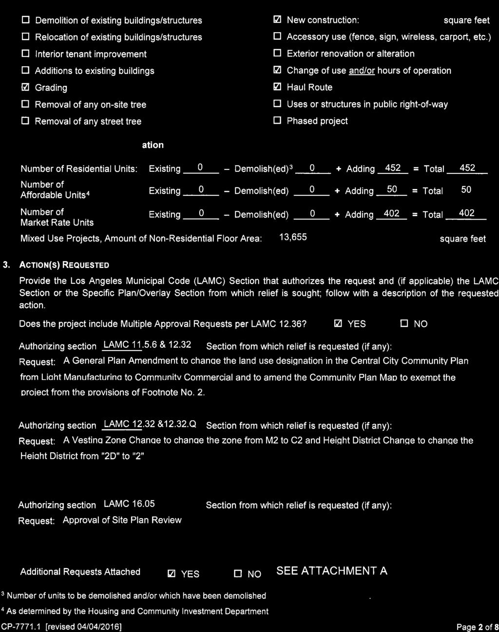
13 E. 6TH ST. Planning Case #: S. LOS ANGELES ST. E. 8TH ST. E. 7TH ST. MAPLE AVE WALL ST. Applicant: FASHION DISTRICT RESIDENCES LLC S. SAN JULIAN ST. S. SAN PEDRO ST. VICINITY MAP Table of Contents 01. Cover Sheet 02. Plot Plan - Project Information 03.Overall View - 7th & Maple 04. Contextual Site Photos 05. View Corridors 06. View Corridors 07. Floor Plan - Level B1 08. Floor Plan - Level Floor Plan - Level Floor Plan - Level Floor Plan - Level Floor Plan - Level Floor Plan - Level Floor Plan - Level Roof Plan ( Sky Deck) 16. Building Section Building Section South East Elevation 19. North East Elevation 20. North West Elevation 21. South West Elevation 22. View of Podium - 7th & Maple 23. Overall Perspective View 24. Perspective 25. Perspective 26. Open Space Diagram & Calculation 27. FAR Diagram (1 of 2) 28. FAR Diagram (2 of 2)1 29. Retail Frontage 30. Landscape Cover Sheet 31. Landscape Plan - Ground Floor 32. Landscape Plan - Level Landscape Plan - Roof 34. Landscape Tabulations 7TH AND MAPLE LOS ANGELES, CA HPA # September embe 21, 2016 SITE PLAN REVIEW SUBMITTAL HUMPHREYS & PARTNERS URBAN ARCHITECTURE, L.P. DALLAS NEW YORK CHICAGO NEW ORLEANS ORLANDO EDMONTON SAN RAMON NEWPORT BEACH SCOTTSDALE TORONTO CHENNAI DUBAI HANOI MONTEVIDEO 2014 by HUMPHREYS & PARTNERS URBAN ARCHITECTURE, LP 5339 Alpha Road, Suite 300 Dallas, TX The arrangements depicted herein are the sole property of Humphreys & Partners Urban Architecture, LP and may not be reproduced in any form without its written permission.


 51'-4\" 26' 26' 16' PROPOSED MIXED-USE RESIDENTIAL / COMMERCIAL 28-STORY")
 3' 26'-5\" PARKING ENTRY MAPLE AVE.")


14 CONNECTING PATH ACROSS STREET 20' 16' S. LOS ANGELES ST. PEDESTRIAN ENTRY SANTEE COURT 20' 80'-5" 40' 40' PARKING (N.A.P) 51'-4" 26' 26' 16' PROPOSED MIXED-USE RESIDENTIAL / COMMERCIAL 28-STORY RESIDENTIAL OVER 5-STORY PARKING / COMMERCIAL 12'-2 " PEDESTRIAN ENTRY E. 7TH STREET PARKING (N.A.P) 3' 26'-5" PARKING ENTRY MAPLE AVE. 18' 30' PARKING 75' ENTRY 18' 20' 38' EXISTING PARKING (N.A.P) N NOT TO 11X17 SCALE 1" = 24X36 0' 40' 80' 120' 7TH AND MAPLE REALM HPA # September 21, 2016 LOS ANGELES, CA PLOT PLAN - PROJECT INFORMATION HUMPHREYS & PARTNERS URBAN ARCHITECTURE, L.P. DALLAS NEW YORK CHICAGO NEW ORLEANS ORLANDO EDMONTON SAN RAMON NEWPORT BEACH SCOTTSDALE TORONTO CHENNAI DUBAI HANOI MONTEVIDEO 2014 by HUMPHREYS & PARTNERS URBAN ARCHITECTURE, LP 5339 Alpha Road, Suite 300 Dallas, TX The arrangements depicted herein are the sole property of Humphreys & Partners Urban Architecture, LP and may not be reproduced in any form without its written permission.

15 7TH AND MAPLE REALM HPA # September 21, 2016 LOS ANGELES, CA OVERALL VIEW - 7th & Maple HUMPHREYS & PARTNERS URBAN ARCHITECTURE, L.P. DALLAS NEW YORK CHICAGO NEW ORLEANS ORLANDO EDMONTON SAN RAMON NEWPORT BEACH SCOTTSDALE TORONTO CHENNAI DUBAI HANOI MONTEVIDEO 2014 by HUMPHREYS & PARTNERS URBAN ARCHITECTURE, LP 5339 Alpha Road, Suite 300 Dallas, TX The arrangements depicted herein are the sole property of Humphreys & Partners Urban Architecture, LP and may not be reproduced in any form without its written permission.


16 TH AND MAPLE REALM HPA # September 21, 2016 LOS ANGELES, CA CONTEXTUAL SITE PHOTOS 1 2 HUMPHREYS & PARTNERS URBAN ARCHITECTURE, L.P. DALLAS NEW YORK CHICAGO NEW ORLEANS ORLANDO EDMONTON SAN RAMON NEWPORT BEACH SCOTTSDALE TORONTO CHENNAI DUBAI HANOI MONTEVIDEO 2014 by HUMPHREYS & PARTNERS URBAN ARCHITECTURE, LP 5339 Alpha Road, Suite 300 Dallas, TX The arrangements depicted herein are the sole property of Humphreys & Partners Urban Architecture, LP and may not be reproduced in any form without its written permission


17 VIEW 3: VIEW 2: VIEW 1: West View VIEW 2: Northwest View VIEW 3: North View North View Northwest View VIEW 1: West View 7TH AND MAPLE REALM HPA # September 21, 2016 LOS ANGELES, CA VIEW CORRIDOR HUMPHREYS & PARTNERS URBAN ARCHITECTURE, L.P. DALLAS NEW YORK CHICAGO NEW ORLEANS ORLANDO EDMONTON SAN RAMON NEWPORT BEACH SCOTTSDALE TORONTO CHENNAI DUBAI HANOI MONTEVIDEO 2014 by HUMPHREYS & PARTNERS URBAN ARCHITECTURE, LP 5339 Alpha Road, Suite 300 Dallas, TX The arrangements depicted herein are the sole property of Humphreys & Partners Urban Architecture, LP and may not be reproduced in any form without its written permission.


18 VIEW 4: Northeast View VIEW 5: Southeast View VIEW 6: South View VIEW 4: Northeast View VIEW 5: Southeast view VIEW 6: South View 7TH AND MAPLE REALM HPA # September 21, 2016 LOS ANGELES, CA VIEW CORRIDOR HUMPHREYS & PARTNERS URBAN ARCHITECTURE, L.P. DALLAS NEW YORK CHICAGO NEW ORLEANS ORLANDO EDMONTON SAN RAMON NEWPORT BEACH SCOTTSDALE TORONTO CHENNAI DUBAI HANOI MONTEVIDEO 2014 by HUMPHREYS & PARTNERS URBAN ARCHITECTURE, LP 5339 Alpha Road, Suite 300 Dallas, TX The arrangements depicted herein are the sole property of Humphreys & Partners Urban Architecture, LP and may not be reproduced in any form without its written permission.
19 VESTIBULE 25'-4" STORAGE 432 SF UP 6% 25'-4" TOWER ABOVE C C 25'-4" 29'-11" TR. PRESSURE MEP 89 SF PRESS 25'-4" 117 SPACES STORAGE 1,634 SF BIKE STOR. (256) 2,880 SF N SCALE: 1" = 40' - 0" (11"x17" SHEET) 7TH AND MAPLE REALM HPA # September 21, 2016 LOS ANGELES, CA FLOOR PLAN - BASEMENT 0' 20' 40' 80' 120' HUMPHREYS & PARTNERS URBAN ARCHITECTURE, L.P. DALLAS NEW YORK CHICAGO NEW ORLEANS ORLANDO EDMONTON SAN RAMON NEWPORT BEACH SCOTTSDALE TORONTO CHENNAI DUBAI HANOI MONTEVIDEO 2014 by HUMPHREYS & PARTNERS URBAN ARCHITECTURE, LP 5339 Alpha Road, Suite 300 Dallas, TX The arrangements depicted herein are the sole property of Humphreys & Partners Urban Architecture, LP and may not be reproduced in any form without its written permission.

20 7TH AND MAPLE REALM HPA # September 21, 2016 LOS ANGELES, CA FLOOR PLAN - GROUND FLOOR HUMPHREYS & PARTNERS URBAN ARCHITECTURE, L.P. DALLAS NEW YORK CHICAGO NEW ORLEANS ORLANDO EDMONTON SAN RAMON NEWPORT BEACH SCOTTSDALE TORONTO CHENNAI DUBAI HANOI MONTEVIDEO 2014 by HUMPHREYS & PARTNERS URBAN ARCHITECTURE, LP 5339 Alpha Road, Suite 300 Dallas, TX The arrangements depicted herein are the sole property of Humphreys & Partners Urban Architecture, LP and may not be reproduced in any form without its written permission.
21 TERRACE B1 1,096 SF B1 1,096 SF STORAGE 136 SF A6 973 SF CORRIDOR A6 973 SF TERRACE 30'-9" 6' 30'-9" TERRACE A6 973 SF A6 973 SF MEP 432 SF A6 973 SF 25'-4" UP 6% 25'-4" DN 6% C C C C C C TOWER ABOVE MEP 463 SF A6 973 SF ADJACENT BUILDING TR. PRESSURE 25'-4" MEP 89 SF PRESS LOBBY VESTIBULE A6 973 SF 26'-1" 67 SPACES B4 1,412 SF CORRIDOR 4'-3" MEP 161 SF A1 557 SF A1 557 SF A1 557 SF A1 557 SF A1 557 SF A1 557 SF A1 557 SF A1 557 SF A5 938 SF N SCALE: 1" = 40' - 0" (11"x17" SHEET) 7TH AND MAPLE REALM HPA # September 21, 2016 LOS ANGELES, CA FLOOR PLAN - LEVEL 2 0' 20' 40' 80' 120' HUMPHREYS & PARTNERS URBAN ARCHITECTURE, L.P. DALLAS NEW YORK CHICAGO NEW ORLEANS ORLANDO EDMONTON SAN RAMON NEWPORT BEACH SCOTTSDALE TORONTO CHENNAI DUBAI HANOI MONTEVIDEO 2014 by HUMPHREYS & PARTNERS URBAN ARCHITECTURE, LP 5339 Alpha Road, Suite 300 Dallas, TX The arrangements depicted herein are the sole property of Humphreys & Partners Urban Architecture, LP and may not be reproduced in any form without its written permission.
22 VESTIBULE 25'-4" MEP 432 SF Two-Way P/ZC UP 6% One-Way 25'-4" DN 6% TOWER ABOVE C C C C C C C ADJACENT BUILDING 25'-4" TR. PRESSURE MEP 89 SF PRESS C 25'-4" 117 SPACES STO. 1,023 SF N SCALE: 1" = 40' - 0" (11"x17" SHEET) 7TH AND MAPLE REALM HPA # September 21, 2016 LOS ANGELES, CA FLOOR PLAN - LEVEL 3-5 (3 LEVELS) 0' 20' 40' 80' 120' HUMPHREYS & PARTNERS URBAN ARCHITECTURE, L.P. DALLAS NEW YORK CHICAGO NEW ORLEANS ORLANDO EDMONTON SAN RAMON NEWPORT BEACH SCOTTSDALE TORONTO CHENNAI DUBAI HANOI MONTEVIDEO 2014 by HUMPHREYS & PARTNERS URBAN ARCHITECTURE, LP 5339 Alpha Road, Suite 300 Dallas, TX The arrangements depicted herein are the sole property of Humphreys & Partners Urban Architecture, LP and may not be reproduced in any form without its written permission.


 0' 20' 40' 80' 120' 09.26.")


23 VESTIBULE TERRACE TERRACE TERRACE ADJACENT BUILDING ROOF TERRACE REFER TO LANDSCAPE DRAWINGS AMENITIES 6,092 SF TR. A4 676 SF PRESSURE A4 676 SF A4 676 SF A3 670 SF MEP 89 SF S2 539 SF PRESS A3 670 SF A7 695 SF B2 1,160 SF B3 1,130 SF TERRACE TERRACE TERRACE TERRACE N SCALE: 1" = 40' - 0" (11"x17" SHEET) 7TH AND MAPLE REALM HPA # September 21, 2016 LOS ANGELES, CA FLOOR PLAN - LEVEL 6 (Amenities) 0' 20' 40' 80' 120' HUMPHREYS & PARTNERS URBAN ARCHITECTURE, L.P. DALLAS NEW YORK CHICAGO NEW ORLEANS ORLANDO EDMONTON SAN RAMON NEWPORT BEACH SCOTTSDALE TORONTO CHENNAI DUBAI HANOI MONTEVIDEO 2014 by HUMPHREYS & PARTNERS URBAN ARCHITECTURE, LP 5339 Alpha Road, Suite 300 Dallas, TX The arrangements depicted herein are the sole property of Humphreys & Partners Urban Architecture, LP and may not be reproduced in any form without its written permission.
24 PRESS BAL. ADJACENT BUILDING TR. PRESSURE A3 670 SF MEP 89 SF A3 670 SF VESTIBULE B2 1,160 SF AMENITY BELOW A4 676 SF A4 676 SF A4 676 SF S2 539 SF A7 695 SF B3 1,130 SF BAL. N SCALE: 1" = 40' - 0" (11"x17" SHEET) 7TH AND MAPLE REALM HPA # September 21, 2016 LOS ANGELES, CA FLOOR PLAN - LEVEL 7 0' 20' 40' 80' 120' HUMPHREYS & PARTNERS URBAN ARCHITECTURE, L.P. DALLAS NEW YORK CHICAGO NEW ORLEANS ORLANDO EDMONTON SAN RAMON NEWPORT BEACH SCOTTSDALE TORONTO CHENNAI DUBAI HANOI MONTEVIDEO 2014 by HUMPHREYS & PARTNERS URBAN ARCHITECTURE, LP 5339 Alpha Road, Suite 300 Dallas, TX The arrangements depicted herein are the sole property of Humphreys & Partners Urban Architecture, LP and may not be reproduced in any form without its written permission.
25 VESTIBULE 224'-10" 6'-2" 30'-8" 30'-8" 30'-8" 34'-2" 26'-1" 18' 30'-8" 17'-9" 6' BAL. BAL. ADJACENT BUILDING 34'-3" B2 1,160 SF TR. A2 650 SF A2 650 SF PRESSURE S1 528 SF S1 528 SF A3 670 SF MEP 89 SF PRESS A3 670 SF B2 1,160 SF 22' 3'-8" 7'-1" 72'-11" BAL. B3 1,126 SF A4 676 SF A4 676 SF A4 676 SF A4 676 SF A4 676 SF S2 539 SF A7 695 SF B3 1,130 SF BAL. N SCALE: 1" = 40' - 0" (11"x17" SHEET) 7TH AND MAPLE REALM HPA # September 21, 2016 LOS ANGELES, CA FLOOR PLAN - LEVEL ' 20' 40' 80' 120' HUMPHREYS & PARTNERS URBAN ARCHITECTURE, L.P. DALLAS NEW YORK CHICAGO NEW ORLEANS ORLANDO EDMONTON SAN RAMON NEWPORT BEACH SCOTTSDALE TORONTO CHENNAI DUBAI HANOI MONTEVIDEO 2014 by HUMPHREYS & PARTNERS URBAN ARCHITECTURE, LP 5339 Alpha Road, Suite 300 Dallas, TX The arrangements depicted herein are the sole property of Humphreys & Partners Urban Architecture, LP and may not be reproduced in any form without its written permission.
26 VESTIBULE 224'-10" 6'-2" 30'-8" 30'-8" 30'-8" 34'-2" 26'-1" 18' 30'-8" 17'-9" 6' BAL. BAL. PH3 1,626 SF PH2 1,366 SF PH2 1,366 SF PH3 1,626 SF ADJACENT BUILDING 34'-3" TR. PRESSURE STO. 67 SF MEP 89 SF PRESS 72'-11" 22' PH6 2,080 SF PH5 1,778 SF PH1 1,330 SF PH4 1,726 SF 3'-8" 7'-1" BAL. BAL. N SCALE: 1" = 40' - 0" (11"x17" SHEET) 7TH AND MAPLE REALM HPA # September 21, 2016 LOS ANGELES, CA FLOOR PLAN - LEVEL ' 20' 40' 80' 120' HUMPHREYS & PARTNERS URBAN ARCHITECTURE, L.P. DALLAS NEW YORK CHICAGO NEW ORLEANS ORLANDO EDMONTON SAN RAMON NEWPORT BEACH SCOTTSDALE TORONTO CHENNAI DUBAI HANOI MONTEVIDEO 2014 by HUMPHREYS & PARTNERS URBAN ARCHITECTURE, LP 5339 Alpha Road, Suite 300 Dallas, TX The arrangements depicted herein are the sole property of Humphreys & Partners Urban Architecture, LP and may not be reproduced in any form without its written permission.
 7TH AND MAPLE REALM HPA #15711 15 September 21, 2016 LOS")
 0' 20' 40' 80' 120' 09.26.2016 HUMPH")
27 VESTIBULE ADJACENT BUILDING TR. PRESSURE WOMEN MEN MEP PRESS 89 SF ROOF DECK REFER TO LANDSCAPE DRAWINGS MEP EQUIPMENT N SCALE: 1" = 40' - 0" (11"x17" SHEET) 7TH AND MAPLE REALM HPA # September 21, 2016 LOS ANGELES, CA ROOF PLAN (SKYDECK) 0' 20' 40' 80' 120' HUMPHREYS & PARTNERS URBAN ARCHITECTURE, L.P. DALLAS NEW YORK CHICAGO NEW ORLEANS ORLANDO EDMONTON SAN RAMON NEWPORT BEACH SCOTTSDALE TORONTO CHENNAI DUBAI HANOI MONTEVIDEO 2014 by HUMPHREYS & PARTNERS URBAN ARCHITECTURE, LP 5339 Alpha Road, Suite 300 Dallas, TX The arrangements depicted herein are the sole property of Humphreys & Partners Urban Architecture, LP and may not be reproduced in any form without its written permission.
28 PROPERTY LINE ELEV. MACHINE RM. MECHANICAL PENTHOUSE PENTHOUSE ROOF L33 L32 12' 12' 22' PENTHOUSE L31 12' RESIDENTIAL L30 10' RESIDENTIAL RESIDENTIAL RESIDENTIAL RESIDENTIAL RESIDENTIAL RESIDENTIAL L29 L28 L27 L26 L25 L24 10' 10' 10' 10' 10' 10' RESIDENTIAL RESIDENTIAL RESIDENTIAL RESIDENTIAL RESIDENTIAL RESIDENTIAL L23 L22 L21 L20 L19 L18 10' 10' 10' 10' 10' 10' 370' RESIDENTIAL RESIDENTIAL RESIDENTIAL RESIDENTIAL RESIDENTIAL RESIDENTIAL L17 L16 L15 L14 L13 L12 10' 10' 10' 10' 10' 10' RESIDENTIAL L11 10' RESIDENTIAL L10 10' ADJACENT BUILDING 26'-7" PROPERTY LINE SETBACK POOL DECK 7'-1" POOL SLOPE 6% AMENITY PARKING PARKING RESIDENTIAL RESIDENTIAL RESIDENTIAL RESIDENTIAL STO. STO. L9 L8 L7 L6 L5 L4 10' 10' 10' 10' 11'-6" 10' 16' STORAGE GARAGE ENTRY TRANSFORMER SLOPE 20% SLOPE 6% COMMERCIAL PARKING RESIDENTIAL FIRE EXIT CORRIDOR LEASING PARKING GARAGE ENTRY WALK WAY LEASING STO. LOBBY L3 L2 L1 10' 10' 20'-6" E. 7TH ST. COMMERCIAL PARKING B 10' SCALE: 1" = 50' - 0" (11"x17" SHEET) 7TH AND MAPLE REALM HPA # September 21, 2016 LOS ANGELES, CA BUILDING SECTION 1 0' 25' 50' 100' 150' HUMPHREYS & PARTNERS URBAN ARCHITECTURE, L.P. DALLAS NEW YORK CHICAGO NEW ORLEANS ORLANDO EDMONTON SAN RAMON NEWPORT BEACH SCOTTSDALE TORONTO CHENNAI DUBAI HANOI MONTEVIDEO 2014 by HUMPHREYS & PARTNERS URBAN ARCHITECTURE, LP 5339 Alpha Road, Suite 300 Dallas, TX The arrangements depicted herein are the sole property of Humphreys & Partners Urban Architecture, LP and may not be reproduced in any form without its written permission.
29 ELEV. MACHINE RM. MECHANICAL RES. CORE RES. RES. CORE RES. ROOF L33 L32 12' 12' 22' RES. CORE RES. L31 12' RES. CORE RES. L30 10' RES. CORE RES. RES. CORE RES. RES. CORE RES. RES. CORE RES. RES. CORE RES. RES. CORE RES. L29 L28 L27 L26 L25 L24 10' 10' 10' 10' 10' 10' RES. CORE RES. RES. CORE RES. RES. CORE RES. RES. CORE RES. RES. CORE RES. RES. CORE RES. L23 L22 L21 L20 L19 L18 10' 10' 10' 10' 10' 10' 370' RES. CORE RES. RES. CORE RES. RES. CORE RES. RES. CORE RES. RES. CORE RES. RES. CORE RES. L17 L16 L15 L14 L13 L12 10' 10' 10' 10' 10' 10' RES. CORE RES. L11 10' RES. CORE RES. L10 10' PROPERTY LINE RES. CORE RES. RES. CORE RES. RES. CORE RES. RES. CORE RES. STORAGE CORE PARKING PROPERTY LINE L9 L8 L7 L6 L5 10' 10' 10' 10' 11'-6" STORAGE CORE PARKING L4 10' STORAGE CORE PARKING L3 10' LIVE-WORK CORE PARKING L2 10' MAPLE AVE. COMMERCIAL CORE LOBBY/ LEASING BIKE STO. L1 20'-6" PARKING CORE PARKING B 10' SCALE: 1" = 50' - 0" (11"x17" SHEET) 7TH AND MAPLE REALM HPA # September 21, 2016 LOS ANGELES, CA BUILDING SECTION 2 0' 25' 50' 100' 150' HUMPHREYS & PARTNERS URBAN ARCHITECTURE, L.P. DALLAS NEW YORK CHICAGO NEW ORLEANS ORLANDO EDMONTON SAN RAMON NEWPORT BEACH SCOTTSDALE TORONTO CHENNAI DUBAI HANOI MONTEVIDEO 2014 by HUMPHREYS & PARTNERS URBAN ARCHITECTURE, LP 5339 Alpha Road, Suite 300 Dallas, TX The arrangements depicted herein are the sole property of Humphreys & Partners Urban Architecture, LP and may not be reproduced in any form without its written permission.

30 3 ELEV. MACHINE RM. ROOF L33 L32 12' 12' 22' 1 Aluminium Panel #1 5 Aluminium Panel #2 L31 12' L30 10' 6 L29 L28 L27 L26 L25 L24 10' 10' 10' 10' 10' 10' 7 L23 L22 L21 L20 L19 L18 10' 10' 10' 10' 10' 10' 370' 2 Perforated Metal Panel - graphic pattern 6 Perforated Metal Panel - Uniform pattern (Balcony) 3 L17 L16 L15 L14 L13 L12 10' 10' 10' 10' 10' 10' L11 10' 2 L10 L9 L8 L7 10' 10' 10' 10' 3 Precast Concrete Panel 7 Window Wall System L6 10' L5 11'-6" L4 10' 25' STREET WALL MINIMUM 25' L3 L2 E. 7TH STREET L1 20'-6" 10' 10' 7TH AND MAPLE REALM HPA # SCALE: 1" = 50' - 0" 0' 25' 50' 100' 150' September 21, 2016 (11"x17" SHEET) LOS ANGELES, CA SOUTH EAST ELEVATION 4 4 Aluminium Storefront Steel Channel & Beams HUMPHREYS & PARTNERS URBAN ARCHITECTURE, L.P. DALLAS NEW YORK CHICAGO NEW ORLEANS ORLANDO EDMONTON SAN RAMON NEWPORT BEACH SCOTTSDALE TORONTO CHENNAI DUBAI HANOI MONTEVIDEO 2014 by HUMPHREYS & PARTNERS URBAN ARCHITECTURE, LP 5339 Alpha Road, Suite 300 Dallas, TX The arrangements depicted herein are the sole property of Humphreys & Partners Urban Architecture, LP and may not be reproduced in any form without its written permission. 8

31 ELEV. MACHINE RM. 3 ROOF L33 L32 12' 12' 22' 1 Aluminium Panel #1 5 Aluminium Panel #2 L31 12' L30 10' 6 L29 L28 L27 L26 L25 L24 10' 10' 10' 10' 10' 10' 7 L23 L22 L21 L20 L19 L18 10' 10' 10' 10' 10' 10' 370' 2 Perforated Metal Panel - graphic pattern 6 Perforated Metal Panel - Uniform pattern (Balcony) L17 L16 L15 L14 L13 L12 10' 10' 10' 10' 10' 10' L11 10' 2 L10 L9 L8 L7 10' 10' 10' 10' 3 Precast Concrete Panel 7 Window Wall System L6 10' L5 11'-6" L4 10' MAPLE AVE. 25' STREET WALL MINIMUM 25' L3 L2 L1 10' 10' 20'-6" 7TH AND MAPLE REALM HPA # SCALE: 1" = 50' - 0" September 21, 2016 (11"x17" SHEET) 0' 25' 50' 100' 150' LOS ANGELES, CA NORTH EAST ELEVATION 4 Aluminium Storefront Steel Channel & Beams HUMPHREYS & PARTNERS URBAN ARCHITECTURE, L.P. DALLAS NEW YORK CHICAGO NEW ORLEANS ORLANDO EDMONTON SAN RAMON NEWPORT BEACH SCOTTSDALE TORONTO CHENNAI DUBAI HANOI MONTEVIDEO 2014 by HUMPHREYS & PARTNERS URBAN ARCHITECTURE, LP 5339 Alpha Road, Suite 300 Dallas, TX The arrangements depicted herein are the sole property of Humphreys & Partners Urban Architecture, LP and may not be reproduced in any form without its written permission. 8

32 3 ELEV. MACHINE RM. ROOF L33 L32 12' 12' 22' 1 Aluminium Panel #1 5 Aluminium Panel #2 L31 12' L30 10' 6 L29 L28 L27 L26 L25 L24 10' 10' 10' 10' 10' 10' 7 3 L23 L22 L21 L20 L19 L18 10' 10' 10' 10' 10' 10' 370' 2 Perforated Metal Panel - graphic pattern 6 Perforated Metal Panel - Uniform pattern (Balcony) L17 L16 L15 L14 L13 L12 10' 10' 10' 10' 10' 10' L11 10' 2 L10 L9 L8 L7 10' 10' 10' 10' 3 Precast Concrete Panel 7 Window Wall System L6 10' L5 11'-6" L4 10' L3 10' E. 7TH STREET L2 L1 10' 20'-6" SCALE: 1" = 50' - 0" (11"x17" SHEET) 0' 25' 50' 100' 150' Aluminium Storefront 8 Steel Channel & Beams 7TH AND MAPLE REALM HPA # September 21, 2016 LOS ANGELES, CA NORTH WEST ELEVATION HUMPHREYS & PARTNERS URBAN ARCHITECTURE, L.P. DALLAS NEW YORK CHICAGO NEW ORLEANS ORLANDO EDMONTON SAN RAMON NEWPORT BEACH SCOTTSDALE TORONTO CHENNAI DUBAI HANOI MONTEVIDEO 2014 by HUMPHREYS & PARTNERS URBAN ARCHITECTURE, LP 5339 Alpha Road, Suite 300 Dallas, TX The arrangements depicted herein are the sole property of Humphreys & Partners Urban Architecture, LP and may not be reproduced in any form without its written permission.

33 ELEV. MACHINE RM. 3 ROOF L33 L32 12' 12' 22' 1 Aluminium Panel #1 5 Aluminium Panel #2 L31 12' L30 10' 6 L29 L28 L27 L26 L25 L24 10' 10' 10' 10' 10' 10' 7 L23 L22 L21 L20 L19 L18 10' 10' 10' 10' 10' 10' 370' 2 Perforated Metal Panel - graphic pattern 6 Perforated Metal Panel - Uniform pattern (Balcony) L17 L16 L15 L14 L13 L12 10' 10' 10' 10' 10' 10' L11 10' 2 L10 L9 L8 L7 10' 10' 10' 10' 3 Precast Concrete Panel 7 Window Wall System L6 10' L5 11'-6" L4 10' L3 10' L2 L1 10' 20'-6" MAPLE AVE. SCALE: 1" = 50' - 0" (11"x17" SHEET) 0' 25' 50' 100' 150' Aluminium Storefront 8 Steel Channel & Beams 7TH AND MAPLE REALM HPA # September 21, 2016 LOS ANGELES, CA SOUTH WEST ELEVATION HUMPHREYS & PARTNERS URBAN ARCHITECTURE, L.P. DALLAS NEW YORK CHICAGO NEW ORLEANS ORLANDO EDMONTON SAN RAMON NEWPORT BEACH SCOTTSDALE TORONTO CHENNAI DUBAI HANOI MONTEVIDEO 2014 by HUMPHREYS & PARTNERS URBAN ARCHITECTURE, LP 5339 Alpha Road, Suite 300 Dallas, TX The arrangements depicted herein are the sole property of Humphreys & Partners Urban Architecture, LP and may not be reproduced in any form without its written permission.

34 7TH AND MAPLE REALM HPA # September 21, 2016 LOS ANGELES, CA VIEW OF PODIUM - 7th & Maple HUMPHREYS & PARTNERS URBAN ARCHITECTURE, L.P. DALLAS NEW YORK CHICAGO NEW ORLEANS ORLANDO EDMONTON SAN RAMON NEWPORT BEACH SCOTTSDALE TORONTO CHENNAI DUBAI HANOI MONTEVIDEO 2014 by HUMPHREYS & PARTNERS URBAN ARCHITECTURE, LP 5339 Alpha Road, Suite 300 Dallas, TX The arrangements depicted herein are the sole property of Humphreys & Partners Urban Architecture, LP and may not be reproduced in any form without its written permission.


35 7TH AND MAPLE REALM HPA # September 21, 2016 LOS ANGELES, CA OVERALL PERSPECTIVE VIEW HUMPHREYS & PARTNERS URBAN ARCHITECTURE, L.P. DALLAS NEW YORK CHICAGO NEW ORLEANS ORLANDO EDMONTON SAN RAMON NEWPORT BEACH SCOTTSDALE TORONTO CHENNAI DUBAI HANOI MONTEVIDEO 2014 by HUMPHREYS & PARTNERS URBAN ARCHITECTURE, LP 5339 Alpha Road, Suite 300 Dallas, TX The arrangements depicted herein are the sole property of Humphreys & Partners Urban Architecture, LP and may not be reproduced in any form without its written permission.


36 TH AND MAPLE REALM HPA # September 21, 2016 LOS ANGELES, CA PERSPECTIVE HUMPHREYS & PARTNERS URBAN ARCHITECTURE, L.P. DALLAS NEW YORK CHICAGO NEW ORLEANS ORLANDO EDMONTON SAN RAMON NEWPORT BEACH SCOTTSDALE TORONTO CHENNAI DUBAI HANOI MONTEVIDEO 2014 by HUMPHREYS & PARTNERS URBAN ARCHITECTURE, LP 5339 Alpha Road, Suite 300 Dallas, TX The arrangements depicted herein are the sole property of Humphreys & Partners Urban Architecture, LP and may not be reproduced in any form without its written permission


37 TH AND MAPLE REALM HPA # September 21, 2016 LOS ANGELES, CA PERSPECTIVE HUMPHREYS & PARTNERS URBAN ARCHITECTURE, L.P. DALLAS NEW YORK CHICAGO NEW ORLEANS ORLANDO EDMONTON SAN RAMON NEWPORT BEACH SCOTTSDALE TORONTO CHENNAI DUBAI HANOI MONTEVIDEO 2014 by HUMPHREYS & PARTNERS URBAN ARCHITECTURE, LP 5339 Alpha Road, Suite 300 Dallas, TX The arrangements depicted herein are the sole property of Humphreys & Partners Urban Architecture, LP and may not be reproduced in any form without its written permission.
38 6' 2' 6' 6' VESTIBULE RESIDENTIAL PROPERTY LINE IAL ADS ND MS PROPERTY LINE SETBACK LINE UP 10% 1'-8" 25'-8" MEP 463 SF MEP 482 SF UP UP 10% 20% GARAGE ENTRY GATE GATE 9'-7" 25' 25'-8" UP 6% SANTEE COURT RES. TR. TRASH FIRE PUMP ELECTRICAL MECHANICAL 759 SF ROOM ROOM ROOM COMM. 1,116 SF 1,081 SF 1,434 SF TRASH 775 SF SERVICE CORRIDOR TRANSFORMER ROOM COMMERCIAL 750 SF 3,661 SF 168'-1" 13'-4" 30' 25'-4" RESIDENTIAL REFER TO LANDSCAPE DRAWINGS TOWER ABOVE 10' COMMERCIAL 3042 SF FIRE EXIT CORRIDOR PRESSURE LEASING PARKING 28'-5" MEP 89 SF GARAGE ENTRY GATE 19' 25'-4" 5'-9" 47'-8" FIRE EXIT CORRIDOR COMMERCIAL 659 SF CORRIDOR 21'-7" COMMERCIALCIAL 794 SF BIKE STOR. (272) VESTIBULE PRESS 30' COMMERCIAL 2,805 SF 5,447 SF RISER FCC 242 SF 238 SF VAN DN 6% VAN LOBBY / LEASING 3,322 SF 13' 45'-10" PLAZA 1,570 SF 45'-10" GATE 22'-6" 12'-2" 16'-6" 6 15' 15' 20'-4" 213'-11" 38'-8" DISTANCE FRO PROPERTY LINE BUILDING VARI FROM 0' TO 12' 3'-2" E. 7TH S ADJACENT BUILDING MEP 432 SF MEP 161 SF 25'-4" A1 557 SF UP 6% A1 557 SF 25'-4" 26'-1" A1 557 SF 67 SPACES A1 557 SF CORRIDOR A1 557 SF 4'-3" TR. A1 557 SF DN 6% C C C C C C A1 557 SF PRESSURE 25'-4" A1 557 SF TERRACE TERRACE TERRACE TOWER ABOVE MEP 89 SF PRESS LOBBY A5 938 SF B1 B1 1,096 SF 1,096 SF STORAGE A6 136 SF 973 SF A6 973 SF 30'-9" 6' 30'-9" 973 SF A6 973 SF A6 973 SF A6 973 SF MEP 463 SF VESTIBULE CORRIDOR A6 A6 973 SF B4 1,412 SF ADJACENT BUILDING ROOF TERRACE REFER TO LANDSCAPE DRAWINGS AMENITIES 6,092 SF TR. A4 676 SF PRESSURE TERRACE A4 676 SF TERRACE A4 676 SF TERRACE TERRACE A3 670 SF MEP 89 SF S2 539 SF TERRACE PRESS TERRACE A3 670 SF VESTIBULE A7 695 SF TERRACE B2 1,160 SF B3 1,130 SF Open Space Requirements Sec F 1) Min. area of 400 sf and no horizontal dimension less than 15. 2) Recreation room at least 600 sf 3) Private open space a) 50 sf min. and no horizontal dimension less than 6 b) 8 min. vertical clearance WALK 30' 30' GROUND FLOOR: 62,598 SF (common space exterior) LEVEL 2: 1,902 SF (private) (50 SF max. per balcony) LEVEL 6 (common space): Amenities (interior): 6,095 SF Terraces: 2,122 SF (50 ea. max.) Amenities deck (exterior): 34,468 SF 224'-10" 6'-2" 30'-8" 30'-8" 30'-8" 34'-2" 26'-1" 18' 30'-8" 17'-9" BAL. BAL. BAL. AMENITY BELOW TR. A4 676 SF PRESSURE A4 676 SF A4 676 SF A3 670 SF MEP 89 SF S2 539 SF PRESS A3 670 SF VESTIBULE A7 695 SF B2 1,160 SF B3 1,130 SF BAL. 72'-11" 34'-3" 22' 3'-8" 7'-1" B2 1,160 SF B3 1,126 SF BAL. A2 650 SF TR. A4 A4 676 SF 676 SF A2 650 SF A4 676 SF PRESSURE S1 S1 528 SF 528 SF A4 A4 676 SF 676 SF A3 670 SF MEP 89 SF S2 539 SF PRESS A3 670 SF A7 695 SF B2 1,160 SF B3 1,130 SF BAL. TR. PRESSURE MEP EQUIPMENT PRESS VESTIBULE MEP 89 SF ROOF DECK REFER TO LANDSCAPE DRAWINGS LEVEL 7: 183 SF (private) (50 SF max. per balcony) (balcony less than 50 SF is excluded from FAR) LEVEL 8-33: 9,516 SF (private) (366 SF/LEVEL X 26 = 9516 SF TOTAL) (50 SF max. per balcony) (balcony less than 50 SF is excluded from FAR) ROOF (common space): Amenities (interior): 537 SF Amenities deck (exterior): 7,207 sf OPEN SPACE LEGEND EXTERIOR COMMON SPACE INTERIOR COMMON SPACE INTERIOR PRIVATE SPACE 7TH AND MAPLE REALM HPA # September 21, 2016 LOS ANGELES, CA OPEN SPACE DIAGRAM AND CALCULATION HUMPHREYS & PARTNERS URBAN ARCHITECTURE, L.P. DALLAS NEW YORK CHICAGO NEW ORLEANS ORLANDO EDMONTON SAN RAMON NEWPORT BEACH SCOTTSDALE TORONTO CHENNAI DUBAI HANOI MONTEVIDEO 2014 by HUMPHREYS & PARTNERS URBAN ARCHITECTURE, LP 5339 Alpha Road, Suite 300 Dallas, TX The arrangements depicted herein are the sole property of Humphreys & Partners Urban Architecture, LP and may not be reproduced in any form without its written permission.
39 Two-Way P/ZC One-Way 6' 3 0' T F 6' " 2 VE ES STI TIB BU UL 2' 3" 4' VE ES STI TIB BUL E RESIDENTIAL RESIDENTIAL 20' 11'-6" 82'-11" 2'-1" DENTIAL RESIDENTIAL PROPERTY LINE STORAGE 432 SF 25'-4" UP 6% RESIDENTIAL BEADS AND TRIMS PROPERTY LINE SETBACK LINE GATE 1'-8" MEP 463 SF MEP 482 SF UP 10% 25'-8" FIRE PUMP ELECTRICAL MECHANICAL ROOM ROOM ROOM 1,116 SF 1,081 SF 1,434 SF UP 20% UP 10% UP 6% GARAGE TRANSFORMERR ENTRY ROOM 750 SF GATE 30' 25'-4" SANTEE COURT RESIDENTIAL REFER TO LANDSCAPE DRAWINGS TOWER ABOVE SERVICE E CORRIDOR RID COMMERCIAL MER CIA 3, SF RES. TRASH 759 SF COMM. M. TRASH SF FIRE EXIT CORRIDOR RID R DN 6% PRESSURE LEASING PARKING GARAGE ENTRY GATE 21'-7" VAN VAN FIRE EXIT CORRIDOR RID R COMMERCIAL MER CIA BIKE STOR. (272) COMMERCIAL MER CIA 2,805 SF MEP 89 SF PRESS VESTIBULE LOBBY BY / LEASING 3, SF COMMERCIAL MER CIA 3042 SF 45'-10" PLAZA 1,570 SF GATE COMMERCIAL MER CIA 5, SF RISER FCC 242 SF 238 SF 15' 15' 20'-4" 213'-11" 38'-8" 3'-2" E. 7TH STREET 13'-4" 13' 25'-4" 25'-4" TR. 117 SPACES C PRESSURE C 29'-11" TOWER ABOVE MEP 89 SF VESTIBULE PRESS BIKE STOR. (256) 2,880 SF 25'-4" STORAGE 1,634 SF 22'-6" 12'-2" DISTANCE FROM PROPERTY LINE TO BUILDING VARIES FROM 0' TO 12'-2"' ADJACENT BUILDING MEP 432 SF MEP 161 SF 25'-4" A SF UP 6% A SF 26'-1" 25'-4" A SF 67 SPACES A SF CORRIDOR RID R A SF 28'-5" 4'-3" DN 6% C C C C C C A1 A SF SF PRESSURE 25'-4" A SF TERRACE TERRACE TERRACE TOWER ABOVE MEP 89 SF A5 938 SF PRESS B1 1,096 SF STORAGE 136 SF A6 973 SF 30'-9" A6 973 SF MEP 463 SF VESTIBULE B1 1,096 SF A6 973 SF A SF A6 973 SF B4 14 1, SF CORRIDOR RID R 9'-7" 25' 25'-8" 168'-1" 19' 25'-4" 5'-9" 47'-8" 45'-10" 16'-6" CROSSWALK 30' 30' MAPLE AVE. LEVEL B1 FLOOR AREA: 0,0 SF GROUND FLOOR- FLOOR AREA: 20,397 SF LEVEL 2- FLOOR AREA: 20,552 SF 25'-4" MEP 432 SF UP 6% 25'-4" DN 6% TOWER ABOVE C TERRACE TERRACE TERRACE C C C C C C ACENT DING 25'-4" 25'-4" 117 SPACES PRESSURE MEP 89 SF PRESS C ADJACENT BUILDING ROOF TERRACE REFER TO LANDSCAPE DRAWINGS A SF PRESSURE A SF A SF MEP 89 SF PRESS B3 1, SF ADJACENT BUILDING AMENITY BELOW A SF PRESSURE A SF A SF MEP 89 SF PRESS B3 1, SF S2 539 SF BAL. STO. 1,023 SF TERRACE TERRACE TERRACE TERRACE LEVELS 3-5 ( 3 LEVELS)- FLOOR AREA: 1,487 SF LEVEL 6- FLOOR AREA: 14,546 SF LEVEL 7- FLOOR AREA: 8,432 SF 7TH AND MAPLE REALM HPA # September 21, 2016 LOS ANGELES, CA FAR DIAGRAM (1 of 2) HUMPHREYS & PARTNERS URBAN ARCHITECTURE, L.P. DALLAS NEW YORK CHICAGO NEW ORLEANS ORLANDO EDMONTON SAN RAMON NEWPORT BEACH SCOTTSDALE TORONTO CHENNAI DUBAI HANOI MONTEVIDEO 2014 by HUMPHREYS & PARTNERS URBAN ARCHITECTURE, LP 5339 Alpha Road, Suite 300 Dallas, TX The arrangements depicted herein are the sole property of Humphreys & Partners Urban Architecture, LP and may not be reproduced in any form without its written permission.

40 6' 6' 224'-10" 6'-2" 30'-8" 30'-8" 30'-8" 34'-2" 26'-1" 18' 30'-8" 17'-9" 224'-10" 6'-2" 30'-8" 30'-8" 30'-8" 34'-2" 26'-1" 18' 30'-8" 17'-9" BAL. BAL. BAL. BAL. PH3 1,626 6 SF PH2 1,366 6 SF PH3 1,626 6 SF JACENT ILDING 72'-11" 34'-3" 1, SF PRESSURE MEP 89 SF PRESS 1, SF ADJACENT BUILDING 72'-11" 34'-3" PRESSURE MEP 89 SF PRESS ADJACENT BUILDING PRESSURE MEP 89 SF ROOF DECK REFER TO LANDSCAPE DRAWINGS PRESS 22' 1, SF SF SF SF SF SF 22' PH6 2,080 0 SF PH5 1, SF PH1 1, SF PH4 1,726 SF MEP EQUIPMENT 3'-8" 7'-1" BAL. S2 539 SF A7 695 SF BAL. 3'-8" 7'-1" BAL. BAL. LEVELS 8-30 ( 23 LEVELS) - FLOOR AREA: 14,134 SF LEVELS ( 3 LEVELS) - FLOOR AREA: 14,134 SF ROOF - FLOOR AREA: 2,195 SF PROPERTY LINE SETBACK LINE SITE AREA:73,343 SF (1.683 acre) DEDICATION LINE DEDICATION LINE 7TH AND MAPLE REALM HPA # September 21, 2016 LOS ANGELES, CA FAR DIAGRAM (2 of 2) HUMPHREYS & PARTNERS URBAN ARCHITECTURE, L.P. DALLAS NEW YORK CHICAGO NEW ORLEANS ORLANDO EDMONTON SAN RAMON NEWPORT BEACH SCOTTSDALE TORONTO CHENNAI DUBAI HANOI MONTEVIDEO 2014 by HUMPHREYS & PARTNERS URBAN ARCHITECTURE, LP 5339 Alpha Road, Suite 300 Dallas, TX The arrangements depicted herein are the sole property of Humphreys & Partners Urban Architecture, LP and may not be reproduced in any form without its written permission.
 PROVIDED COMMERCIAL FRONTAGE SETBACK LINE GATE MEP 463 SF MEP 482 SF UP 10% UP 20% UP 10% GARAGE ENTRY GATE FIRE PUMP ELECTRICAL MECHANICAL ROOM ROOM ROOM 1,116 SF")

41 E.7TH STREET MAPLE AVE 75.4% STREET FRONTAGE (STOREFRONT) PROVIDED 80.2% STREET FRONTAGE (STOREFRONT) PROVIDED COMMERCIAL FRONTAGE SETBACK LINE GATE MEP 463 SF MEP 482 SF UP 10% UP 20% UP 10% GARAGE ENTRY GATE FIRE PUMP ELECTRICAL MECHANICAL ROOM ROOM ROOM 1,116 SF 1,081 SF 1,434 SF TRANSFORMER ROOM 750 SF SERVICE CORRIDOR RES. TRASH 759 SF COMMERCIAL 3,661 SF TR. COMM. TRASH 775 SF FIRE EXIT CORRIDOR PRESSURE LEASING PARKING GARAGE ENTRY GATE VAN MEP 89 SF PRESS VESTIBULE LOBBY / LEASING 3,322 SF COMMERCIAL 3042 SF PLAZA 1,570 SF PLAZA 1,570 SF COMMERCIAL 3042 SF MEP 89 SF PRESS VESTIBULE LOBBY / LEASING 3,322 SF RISER FCC 242 SF 238 SF BIKE STOR. (272) COMMERCIAL OMMERCIAL 2,805 SF 5,447 SF 794 SF CORRIDOR OMMERCIAL 659 SF FIRE EXIT CORRIDOR GATE MAPLE AVE E. 7TH STREET 132'-2" 93'-6" 85'-8" 102'-2" 18'-8" COMMERCIAL FRONTAGE 187'-1" COMMERCIAL FRONTAGE 93'-6" COMMERCIAL/LOBBY/LEASING FRONTAGE 234'-3" COMMERCIAL FRONTAGE N FLOOR PLAN ALONG MAPLE AVE - RETAIL FRONTAGE N FLOOR PLAN ALONG E.7TH STREET - RETAIL FRONTAGE 7TH AND MAPLE REALM HPA # September 21, 2016 LOS ANGELES, CA RETAIL FRONTAGE HUMPHREYS & PARTNERS URBAN ARCHITECTURE, L.P. DALLAS NEW YORK CHICAGO NEW ORLEANS ORLANDO EDMONTON SAN RAMON NEWPORT BEACH SCOTTSDALE TORONTO CHENNAI DUBAI HANOI MONTEVIDEO 2014 by HUMPHREYS & PARTNERS URBAN ARCHITECTURE, LP 5339 Alpha Road, Suite 300 Dallas, TX The arrangements depicted herein are the sole property of Humphreys & Partners Urban Architecture, LP and may not be reproduced in any form without its written permission.
42 LANDSCAPE PLANS
 CONTAINED HEREIN ARE CONCEPTUAL ONLY AND BASED UPON A PRELIMINARY REVIEW OF ENTITLEMENT")

 SHORT-TERM BICYCLE PARKING SPACES VAN UP 10% GARAGE TRANSFORMER ENTRY ROOM COMMERCIAL 3,661 SF")

 SHORT-TERM BICYCLE PARKING SPACES 9 UMBELLULARIA CALIFORNICA CALIFORNIA LAUREL")
43 RESIDENTIAL SLIDING GATE. OPEN DURING BUSINESS HOURS THE IMAGES, ILLUSTRATIONS, DRAWINGS, AND STATEMENTSRESIDENTIAL ("INFORMATION") CONTAINED HEREIN ARE CONCEPTUAL ONLY AND BASED UPON A PRELIMINARY REVIEW OF ENTITLEMENT REQUIREMENTS; THUS ARE SUBJECT TO CHANGE DURING THE DESIGN REVIEW PROCESS. THE INFORMATION IS PROVIDED MERELY TO ASSIST IN EXPLORING DENTIAL HOW THE SITE MAY EVENTUALLY BE DEVELOPED. CONSEQUENTLY, THERE IS NO GUARANTEE THAT THE IMPROVEMENTS DEPICTED WILL BE BUILT, OR IF BUILT, WILL BE OF THE SAME TYPE, MATERIAL, SIZE, DENSITY, APPEARANCE, OR USE AS PRESENTED. (4) SHORT-TERM BICYCLE PARKING SPACES WATER FEATURE RESIDENTIAL 31'-8" PODOCARPUS GRACILIOR FERN PINE PEDESTRIAN CONNECTION TO SANTEE COURT SANTEE COURT 31'-8" FRAXINUS OXYCARPA RAYWOOD RAYWOOD ASH 31'-8" CORRIDOR RISER FCC 242 SF 238 SF ACCENT PAVING LANDSCAPE PLANTER AREAS VAN DN 6% TOWER ABOVE (8) SHORT-TERM BICYCLE PARKING SPACES VAN UP 10% GARAGE TRANSFORMER ENTRY ROOM COMMERCIAL 3,661 SF 750 SF GATE PRESSURE LEASING PARKING FIRE EXIT CORRIDOR UP 20% UP 10% 482 SF COMM. TRASH 775 SF COMMERCIAL 3042 SF CONCRETE PAVING 30'-8" 30'-8" MAPLE AVE. 7TH AND MAPLE REALM HPA # September 21, 2016 LOS ANGELES, CA ALBIZIA JULIBRISSIN SILK TREE 24" BOX 8 24" BOX KOELREUTERIA BIPINNATA CHINESE FLAME TREE MELALEUCA NESOPHILA PINK MELALEUCA CERCIS SPP. REDBUD QUERCUS SPP. OAK REFER TO LANDSCAPE TABULATIONS AND NOTES SHEET FOR CONCEPTUAL SHRUB AND GROUNDCOVER PLANT LIST GATE 30'-8" (12) SHORT-TERM BICYCLE PARKING SPACES 9 UMBELLULARIA CALIFORNICA CALIFORNIA LAUREL GARAGE ENTRY ACCENT PAVING 30'-8" 24" BOX TRISTANIA LAURINA WATER GUM ACACIA SPP. ACACIA 32'-0" MECHANICAL ROOM 1,434 SF MEP 89 SF 32'-0" ELECTRICAL ROOM 1,081 SF TR. VESTIBULE FIRE PUMP ROOM 1,116 SF RES. TRASH 759 SF PRESS MEP 463 SF MYRICA CALIFORNICA PACIFIC WAX MYRTLE LAGERSTROEMIA INDICA CRAPE MYRTLE (4) SHORT-TERM BICYCLE PARKING SPACES LOBBY / LEASING 3,322 SF SERVICE CORRIDOR SLIDING GATE. OPEN DURING BUSINESS HOURS 32'-0" UP 6% 30 MAPLE AVE. STREET TREE SPECIES PER CITY GUIDELINES E. 7TH STREE BIKE STOR. (272) COMMERCIAL 2,805 SF ######## 50'-2" COMMERCIAL 794 SF BEADS AND TRIMS 7TH STREET COMMERCIAL 659 SF (7) COVERED SHORT-TERM BICYCLE PARKING SPACES 24" BOX PODOCARPUS GRACILIOR FERN PINE RESIDENTIAL SEATWALLS 8 7TH ST. STREET TREE SPECIES PER CITY GUIDELINES FIRE EXIT CORRIDOR RESIDENTIAL 24" BOX PYRUS CALLERYANA FLOWERING PEAR COMMON AREA (14) COVERED SHORT-TERM BICYCLE PARKING SPACES 8 30'-8" MAPLE AVENUE LANDSCAPE PLAN - GROUND FLOOR (4) SHORT-TERM BICYCLE PARKING SPACES NO EXISTING TREES ARE PRESENT ON SITE, INCLUDING NO NATIVE TREES AND NO STREET TREES. HUMPHREYS & PARTNERS URBAN ARCHITECTURE, L.P. DALLAS NEW YORK CHICAGO NEW ORLEANS ORLANDO EDMONTON SAN RAMON NEWPORT BEACH SCOTTSDALE TORONTO CHENNAI DUBAI HANOI MONTEVIDEO 2014 by HUMPHREYS & PARTNERS URBAN ARCHITECTURE, LP 5339 Alpha Road, Suite 300 Dallas, TX The arrangements depicted herein are the sole property of Humphreys & Partners Urban Architecture, LP and may not be reproduced in any form without its written permission.


44 THE IMAGES, ILLUSTRATIONS, DRAWINGS, AND STATEMENTS ("INFORMATION") CONTAINED HEREIN ARE CONCEPTUAL ONLY AND BASED UPON A PRELIMINARY REVIEW OF ENTITLEMENT REQUIREMENTS; THUS ARE SUBJECT TO CHANGE DURING THE DESIGN REVIEW PROCESS. THE INFORMATION IS PROVIDED MERELY TO ASSIST IN EXPLORING HOW THE SITE MAY EVENTUALLY BE DEVELOPED. CONSEQUENTLY, THERE IS NO GUARANTEE THAT THE IMPROVEMENTS DEPICTED WILL BE BUILT, OR IF BUILT, WILL BE OF THE SAME TYPE, MATERIAL, SIZE, DENSITY, APPEARANCE, OR USE AS PRESENTED. MYRICA CALIFORNICA PACIFIC WAX MYRTLE 4 24" BOX BENCHES TRISTANIA LAURINA WATER GUM UMBELLULARIA CALIFORNICA CALIFORNIA LAUREL TURF ALBIZIA JULIBRISSIN SILK TREE 11 24" BOX KOELREUTERIA BIPINNATA CHINESE FLAME TREE LAGERSTROEMIA INDICA CRAPE MYRTLE MELALEUCA NESOPHILA PINK MELALEUCA 220 SQFT. SPA FIREPIT LOUNGE SEATING WITH SHADE OVERHEAD DOG PARK WITH 3'-0" H. GATES AND FENCE ACACIA SPP. ACACIA CERCIS SPP. REDBUD 8 24" BOX QUERCUS SPP. OAK BARBECUES ADJACENT BUILDING TURF AMENITIES 6,092 SF POOL ENCLOSURE GATE TR. PRESSURE TERRACE A3 670 SF MEP 89 SF PRESS TERRACE A3 670 SF VESTIBULE TERRACE B2 1,160 SF LAURUS NOBILIS SWEET BAY LEPTOSPERMUM SCOPARIUM NEW ZEALAND TEA TREE YUCCA GLORIOSA SPANISH DAGGER AGONIS FLEXUOSA 'AFTER DARK' DARK PEPPERMINT WILLOW " BOX 24" BOX 2,168 SQFT. POOL CHAISE LOUNGES A4 676 SF A4 676 SF A4 676 SF S2 539 SF A7 695 SF B3 1,130 SF DODONEA VISCOSA HOPSEED BUSH DRACAENA DRACO DRAGON TREE TURF TERRACE TERRACE TERRACE TERRACE REFER TO LANDSCAPE TABULATIONS AND NOTES SHEET FOR CONCEPTUAL SHRUB AND GROUNDCOVER PLANT LIST CABANAS FIREPIT POOL ENCLOSURE GATE RAISED PLANTERS LOUNGE SEATING WITH SHADE OVERHEAD 7TH AND MAPLE REALM HPA # September 21, 2016 LOS ANGELES, CA LANDSCAPE PLAN - LEVEL 6 HUMPHREYS & PARTNERS URBAN ARCHITECTURE, L.P. DALLAS NEW YORK CHICAGO NEW ORLEANS ORLANDO EDMONTON SAN RAMON NEWPORT BEACH SCOTTSDALE TORONTO CHENNAI DUBAI HANOI MONTEVIDEO 2014 by HUMPHREYS & PARTNERS URBAN ARCHITECTURE, LP 5339 Alpha Road, Suite 300 Dallas, TX The arrangements depicted herein are the sole property of Humphreys & Partners Urban Architecture, LP and may not be reproduced in any form without its written permission.

45 THE IMAGES, ILLUSTRATIONS, DRAWINGS, AND STATEMENTS ("INFORMATION") CONTAINED HEREIN ARE CONCEPTUAL ONLY AND BASED UPON A PRELIMINARY REVIEW OF ENTITLEMENT REQUIREMENTS; THUS ARE SUBJECT TO CHANGE DURING THE DESIGN REVIEW PROCESS. THE INFORMATION IS PROVIDED MERELY TO ASSIST IN EXPLORING HOW THE SITE MAY EVENTUALLY BE DEVELOPED. CONSEQUENTLY, THERE IS NO GUARANTEE THAT THE IMPROVEMENTS DEPICTED WILL BE BUILT, OR IF BUILT, WILL BE OF THE SAME TYPE, MATERIAL, SIZE, DENSITY, APPEARANCE, OR USE AS PRESENTED. LAURUS NOBILIS SWEET BAY 6 24" BOX LEPTOSPERMUM SCOPARIUM NEW ZEALAND TEA TREE YUCCA GLORIOSA SPANISH DAGGER AGONIS FLEXUOSA 'AFTER DARK' DARK PEPPERMINT WILLOW 5 24" BOX DODONEA VISCOSA HOPSEED BUSH DRACAENA DRACO DRAGON TREE REFER TO LANDSCAPE TABULATIONS AND NOTES SHEET FOR CONCEPTUAL SHRUB AND GROUNDCOVER PLANT LIST LOUNGE SEATING GAMES RAISED PLANTERS DINING SEATING DINING SEATING ADJACENT BUILDING TR. PRESSURE WOMEN MEN MEP 89 SF PRESS VESTIBULE TURF BARBECUES MEP EQUIPMENT RAISED PLANTERS 7TH AND MAPLE REALM HPA # September 21, 2016 LOS ANGELES, CA LANDSCAPE PLAN - ROOF HUMPHREYS & PARTNERS URBAN ARCHITECTURE, L.P. DALLAS NEW YORK CHICAGO NEW ORLEANS ORLANDO EDMONTON SAN RAMON NEWPORT BEACH SCOTTSDALE TORONTO CHENNAI DUBAI HANOI MONTEVIDEO 2014 by HUMPHREYS & PARTNERS URBAN ARCHITECTURE, LP 5339 Alpha Road, Suite 300 Dallas, TX The arrangements depicted herein are the sole property of Humphreys & Partners Urban Architecture, LP and may not be reproduced in any form without its written permission.
46 1. ALL LANDSCAPE PLANTING IMPROVEMENTS SHALL FOLLOW THE CITY OF LOS ANGELES GUIDELINES, AND COUNTY OF LOS ANGELES GUIDELINES. 2. THE SELECTION OF PLANT MATERIAL IS BASED ON CULTURAL, AESTHETIC, WATER EFFICIENCY, AND MAINTENANCE CONSIDERATIONS. 3. ALL PLANTING AREAS SHALL BE PREPARED WITH APPROPRIATE SOIL AMENDMENTS, FERTILIZERS, AND APPROPRIATE SUPPLEMENTS BASED UPON A SOILS REPORT FROM A SAMPLE TAKEN FROM THE PROJECT SITE. 4. GROUNDCOVERS OR BARK MULCH SHALL FILL IN BETWEEN THE SHRUBS TO SHIELD THE SOIL FROM THE SUN, EVAPOTRANSPIRATION, AND RUNOFF. ALL SHRUB BEDS SHALL BE MULCHED TO A 3" DEPTH TO HELP CONSERVE WATER, LOWER THE SOIL TEMPERATURE, AND REDUCE WEED GROWTH. 5. TREES AND SHRUBS SHALL BE ALLOWED TO GROW TO THEIR NATURAL FORMS. 6. FINAL LANDSCAPE PLANS SHALL ACCURATELY SHOW PLACEMENT OF TREES, SHRUBS, AND GROUNDCOVERS. 7. ALL REQUIRED LANDSCAPE PLANTING AREAS SHALL BE MAINTAINED BY OWNER PER THE CITY'S REQUIREMENTS. 8. THE LANDSCAPE ARCHITECT SHALL BE AWARE OF UTILITY, SEWER, AND STORM DRAIN EASEMENTS AND PLACE PLANTINGS ACCORDINGLY. PLANTED LANDSCAPE AREA IS REQUIRED TO BE GREATER THAN 25% OF EXTERIOR COMMON OPEN SPACE 25% OF ROOF DECK IS REQUIRED TO BE PLANTED (PODIUM LEVEL) 25% OF ROOF DECK IS REQUIRED TO BE PLANTED (ROOF LEVEL) 10% OF PASEO IS REQUIRED TO BE PLANTED PASEO REQUIRES SEATING PROVIDED AT A RATE OF 1 SEAT PER 2,000 SF (2 LINEAR FEET OF BENCH = 1 SEAT) TREES ARE REQUIRED TO BE PROVIDED AT A RATE OF 1 TREE FOR EVERY 4 RESIDENTIAL UNITS SHORT TERM BIKE PARKING IS REQUIRED AT A RATE OF 1 SPACE FOR EVERY 10 RESIDENTIAL UNITS + 1 FOR EVERY 2,000 SF OF COMMERCIAL WITH AT LEAST HALF COVERED BY AN OVERHEAD STRUCTURE/AWNING 15,650 SF 16,367 SF 8,527 SF 8,679 SF 1,773 SF 1,843 SF 1,443 SF 5,686 SF (W/ 21 COVERED) 53 (W/ 21 COVERED) 1. ALL IRRIGATION IMPROVEMENTS SHALL FOLLOW WATER EFFICIENCY ORDINANCE AB 1881, THE CITY OF LOS ANGELES GUIDELINES, AND COUNTY OF LOS ANGELES GUIDELINES. 2. AN AUTOMATIC IRRIGATION SYSTEM SHALL BE INSTALLED TO PROVIDE COVERAGE FOR ALL PLANTING AREAS SHOWN ON THE PLAN. LOW VOLUME EQUIPMENT SHALL PROVIDE SUFFICIENT WATER FOR PLANT GROWTH WITH A MINIMUM WATER LOSS DUE TO WATER RUN-OFF. IRRIGATION SYSTEMS SHALL USE HIGH QUALITY AUTOMATIC CONTROL VALVES, CONTROLLERS, AND OTHER NECESSARY IRRIGATION EQUIPMENT. ALL COMPONENTS SHALL BE OF NON-CORROSIVE MATERIAL. ALL DRIP SYSTEMS SHALL BE ADEQUATELY FILTERED AND REGULATED PER THE MANUFACTURER'S RECOMMENDED DESIGN PARAMETERS. 3. THE IRRIGATION SYSTEM SHALL UTILIZE DRIP IRRIGATION, HIGH EFFICIENCY SPRAY HEADS, AND/OR BUBBLERS. THE SYSTEM CONTROLS SHALL BE SELF ADJUSTING VIA ON SITE WEATHER DATA AND HISTORICAL WEATHER DATA.THE SYSTEM SHALL BE DESIGNED FOR DEDICATED HYDROZONES BASED ON PLANT WATER REQUIREMENTS AND IRRIGATION EFFICIENCY. 4. THE DESIGN OF THE IRRIGATION SYSTEM SHALL INCLUDE A WATER BUDGET, A DEDICATED WATER METER, A WEATHER BASED CONTROLLER, AND BE DESIGNED BY AN EPA WATERSENSE PARTNER. 5. THE IRRIGATION PRODUCTS SELECTED SHALL COME FROM COMMERCIAL GRADE IRRIGATION MANUFACTURING COMPANIES WITH OUTSTANDING TECHNICAL SUPPORT, INCLUDING RAINBIRD AND HUNTER. 6. THE IRRIGATION COMPONENTS TOGETHER SHALL PROVIDE AN IRRIGATION EFFICIENCY RATING EQUAL TO OR GREATER THAN 80%. 7. ESTIMATED WATER USAGE CALCULATIONS, SCHEDULES, AND POINT OF CONNECTION WATER PRESSURE CALCULATIONS SHALL BE MADE AVAILABLE AT THE PERMIT SUBMITTAL PHASE. ALL CALCULATIONS AND FACTORS SHALL BE DERIVED FROM CALIFORNIA ASSEMBLY BILL THE IMAGES, ILLUSTRATIONS, DRAWINGS, AND STATEMENTS ("INFORMATION") CONTAINED HEREIN ARE CONCEPTUAL ONLY AND BASED UPON A PRELIMINARY REVIEW OF ENTITLEMENT REQUIREMENTS; THUS ARE SUBJECT TO CHANGE DURING THE DESIGN REVIEW PROCESS. THE INFORMATION IS PROVIDED MERELY TO ASSIST IN EXPLORING HOW THE SITE MAY EVENTUALLY BE DEVELOPED. CONSEQUENTLY, THERE IS NO GUARANTEE THAT THE IMPROVEMENTS DEPICTED WILL BE BUILT, OR IF BUILT, WILL BE OF THE SAME TYPE, MATERIAL, SIZE, DENSITY, APPEARANCE, OR USE AS PRESENTED. REFER TO PLAN SHEETS FOR TREE LISTS ACACIA REDOLENS LOW BOY PROSTRATE ACACIA AGAVE SPP. AGAVE ALOE SPP. ALOE BACCHARIS PILULARIS COYOTE BUSH BAMBUSA SPP. BAMBOO BOUGAINVILLEA SPP. BOUGAINVILLEA CALAMAGROSTIS 'KARL FOERSTER' FEATHER REED GRASS CALLISTEMON V. 'BETTER JOHN' DWARF BOTTLEBRUSH CARISSA MACROCARPA NATAL PLUM CEANOTHUS YANKEE POINT CALIFORNIA LILAC CORDYLINE AUSTRALIS SPP. CABBAGE PALM DIANELLA SPP. FLAX LILY DRACAENA DRACO DRAGON TREE ECHEVERIA SPP. ECHEVERIA ECHINOCACTUS GRUSONII BARREL CATUS FRAGARIA CALIFORNICA CALIFORNIA STRAWBERRY HEUCHERA SPP. CORAL BELLS HESPERALOE PARIFLORA RED YUCCA JUNCUS PATENS CALIFORNIA GREY RUSH KECKIELLA CORDIFOLIA PENSTEMON 1 GAL. 2'-0" O.C. 15 GAL. 3'-0" O.C. 5 GAL. 2'-0" O.C. 5 GAL. 2'-0" O.C. 15 GAL. 3'-0" O.C. 5 GAL. 3'-0" O.C. 5 GAL. 2'-0" O.C. 5 GAL. 2'-0" O.C. 1 GAL. 2'-0" O.C. 5 GAL. 3'-0" O.C. 15 GAL. 4'-0" O.C. 5 GAL. 2'-0" O.C. 15 GAL. 5'-0" O.C. 1 GAL. 1'-0" O.C. 5 GAL. 1'-0" O.C. 1 GAL. 2'-0" O.C. 1 GAL. 2'-0" O.C. 5 GAL. 2'-0" O.C. 5 GAL. 3'-0" O.C. 1 GAL. 2'-0" O.C. LAVATERA ASSURGENTIFLORA ISLAND TREE MALLOW LEUCADENDRON SPP. WILLOW CONE BUSH LEUCOPHYLLUM SPP. TEXAS RANGER LIGUSTRUM 'TEXANUM' PRIVET LONICERA 'HALLIANA' HALL'S HONEYSUCKLE MACFADYENA UNGUIS-CATI YELLOW TRUMPET VINE MAHONIA SPP. BARBERRY MUHLENBERGIA SPP. DEER GRASS / MUHLY PANICUM SPP. SWITCHGRASS PITTOSPORUM SPP. MOCK ORANGE PODOCARPUS MONMAL ICEE BLUE YELLOWWOOD PRUNUS ILICIFOLIA HOLLY LEAF CHERRY RHAMNUS CALIFORNICA COFFEEBERRY RIBES SPP. CURRANT ROSA GYMNOCARPA WOOD ROSE ROSMARINUS OFFICIANALIS ROSEMARY SALVIA SSP. SAGE SAMBUCUS MEXICANA ELDERBERRY SEDUM SPP. STONECROP SENECIO MANDRALISCAE BLUE CHALK STICKS WESTRINGIA FRUTICOSA COAST ROSEMARY YUCCA SPP. YUCCA ZAUSCHNERIA CALIFORNICA CALIFORNIA FUCHSIA 5 GAL. 3'-0" O.C. 5 GAL. 4'-0" O.C. 15 GAL. 4'-0" O.C. 15 GAL. 3'-0" O.C. 1 GAL. 2'-0" O.C. 1 GAL. 3'-0" O.C. 5 GAL. 2'-0" O.C. 5 GAL. 3'-0" O.C. 1 GAL. 1'-0" O.C. 5 GAL. 2'-0" O.C. 15 GAL. 4'-0" O.C. 15 GAL. 4'-0" O.C. 5 GAL. 2'-0" O.C. 5 GAL. 2'-0" O.C. 5 GAL. 2'-0" O.C. 5 GAL. 2'-0" O.C. 1 GAL. 2'-0" O.C. 15 GAL. 5'-0" O.C. 1 GAL. 1'-0" O.C. 1 GAL. 1'-0" O.C. 5 GAL. 2'-0" O.C. 15 GAL. 4'-0" O.C. 5 GAL. 2'-0" O.C. 7TH AND MAPLE REALM HPA # September 21, 2016 LOS ANGELES, CA LANDSCAPE PLAN - TABULATIONS HUMPHREYS & PARTNERS URBAN ARCHITECTURE, L.P. DALLAS NEW YORK CHICAGO NEW ORLEANS ORLANDO EDMONTON SAN RAMON NEWPORT BEACH SCOTTSDALE TORONTO CHENNAI DUBAI HANOI MONTEVIDEO 2014 by HUMPHREYS & PARTNERS URBAN ARCHITECTURE, LP 5339 Alpha Road, Suite 300 Dallas, TX The arrangements depicted herein are the sole property of Humphreys & Partners Urban Architecture, LP and may not be reproduced in any form without its written permission.
47
48
49
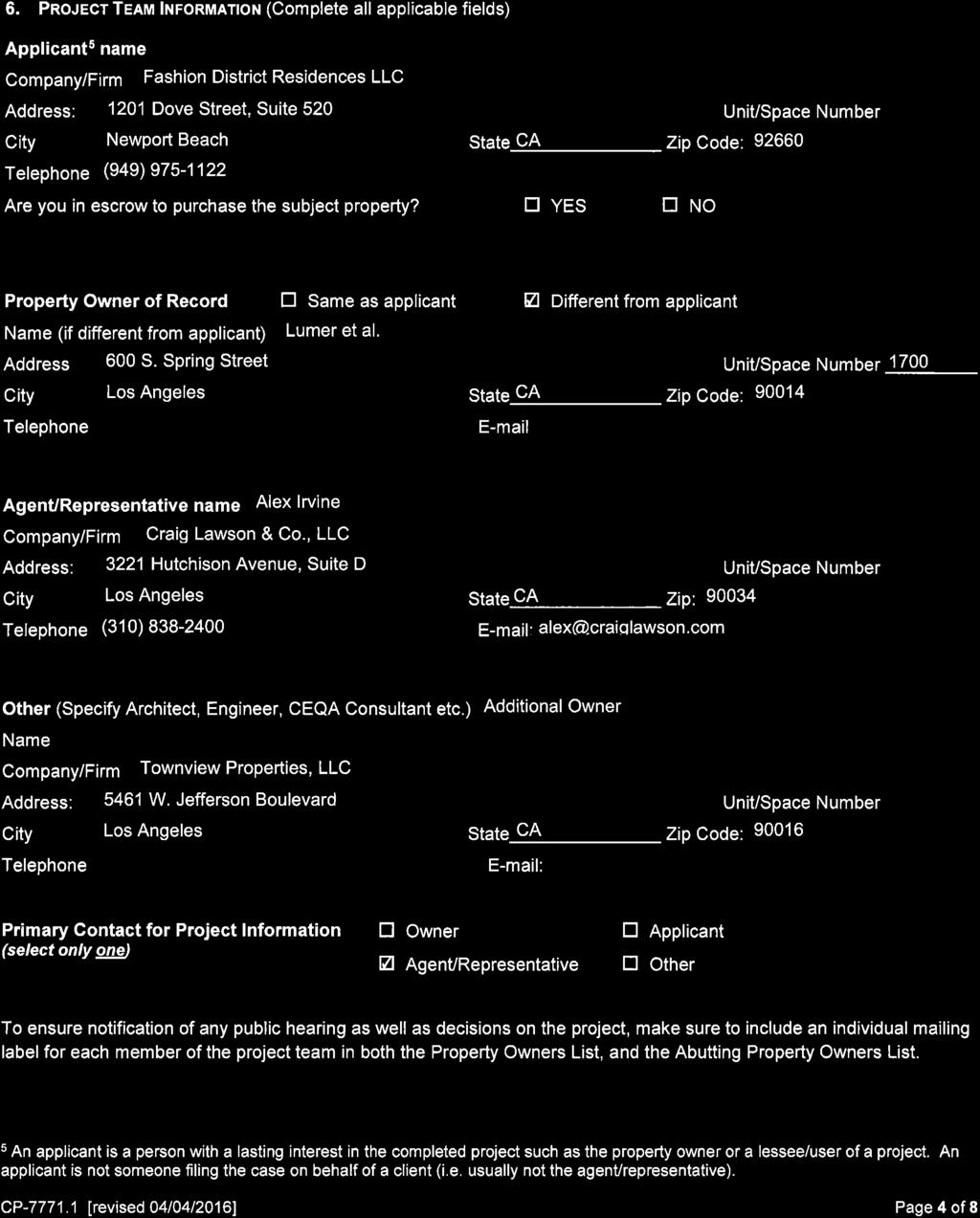
50 ATTACHMENT A Fashion District Residences E. 7th Street and S. Maple Avenue Los Angeles, California Fashion District Residences LLC, a Delaware limited liability company, (the "Applicant ), requests the following discretionary approvals for the site located at E. 7 th Street and S. Maple Avenue, in the City of Los Angeles, California ( Project Site ): 1. Pursuant to Charter Sections 555, 556 and Los Angeles Municipal Code ( LAMC ) Sections and 12.32, a General Plan Amendment to change the land use designation in the Central City Community Plan from Limited Manufacturing to Community Commercial; and to amend the Community Plan Map to exempt the project from the provisions of Footnote Pursuant to Charter Sections 556, 558 and LAMC Section Q, a Vesting Zone Change to change the zone designation from M2 to C2. 3. Pursuant to Charter Sections 556, 558 and LAMC Section F, a Height District Change to change the height district from 2D to 2 to permit a total floor area of 6 times the buildable area of the lot. 4. Pursuant to LAMC Section 16.05, approval of Site Plan Review for a project which creates more than 50 residential units. 5. Pursuant to LAMC Section 17.15, the Applicant requests approval of Vesting Tentative Tract Map No (VTT-74444) for the merger and resubdivision of the site into a single ground lot (Lot 1) and twelve (12) airspace lots, and to merge 12 feet of previously dedicated land, at a length of approximately 132 feet and 70 feet, along Maple Avenue, consistent with the standards identified in the Mobility Plan a. The Applicant also requests that the proposed haul route be approved concurrent with the Vesting Tentative Tract Map. Note: Pursuant to various sections of the LAMC, the Applicant will request administrative approvals and permits from the Los Angeles Department of Building and Safety and other municipal agencies for project construction actions, including but not limited to the following: demolition, excavation, grading, haul route, shoring, foundation, building, and tenant improvements. Prepared by Craig Lawson & Co., LLC Page 1 of 72 September 27, 2016
51 Page Intentionally Blank Prepared by Craig Lawson & Co., LLC Page 2 of 72 September 27, 2016
52 PROJECT DESCRIPTION The Applicant proposes to construct a 33-story mixed-use project on parcels at the southwest corner of Maple Avenue and 7 th Street in the Central City Community Plan area of the City of Los Angeles. The mixed-use project consists of 28 stories of residential units above the 5-story podium. The podium, which rests above one subterranean level of commercial and residential parking and storage areas, includes ground level commercial space fronting on Maple Avenue and 7 th Street, and wrapping around the western boundary of the site with commercial space in the Project s paseo fronting Santee Court and the adjacent residential buildings. The second level of the podium consists of the nineteen Joint Live/Work units that front on the two streets as well as a portion of the paseo and parking spaces. Levels 3 through 5 of the podium consist of residential parking spaces and storage areas. The second level of residential units above the ground level commercial space would consist of 19 Joint Live/Work units that range in size from 557 to 1,412 square feet of floor area. The residential tower consists of 433 residential units. The 313 one-bedroom units would range in size from 528 to 695 square feet of floor area. The 96 two-bedroom units would range in size from 1,126 to 1,160 square feet of floor area. The 24 three-bedroom units would range in size from 1,330 to 2,080 square feet of floor area. The project would provide a total of 5,850 square feet of open space in a total of 116 balconies and terraces, each one providing 50 square feet of open space. On Level 2, three of the joint live/work units would have private terraces, and on Level 6, at the base of the podium, seven units would have terraces. Within the residential tower, 106 residential units would have balconies of 50 square feet in size. The approximately 13,603 square feet of commercial space would front along 7 th Street and Maple Avenue, and wrap around the northwestern edge of the building to activate the outdoor paseo that interfaces with Santee Court and the adjacent residential buildings. The commercial space at the southwest corner of 7 th Street and Maple Avenue would include an outdoor plaza that would enhance the pedestrian experience. Adjacent to this commercial space would be the residential lobby and leasing office. The ground level would also provide bike parking storage, the fire pump room, electrical room, mechanical room, residential and commercial trash rooms and commercial and handicapped parking spaces. The proposed 33-story mixed-use project would comprise approximately 437,886 square feet of net floor area for the 433 residential units and the 19 Joint Live/Work units, including the 13,603 square feet of commercial space located on the ground floor. The Project s proposed Floor Area Ratio ( FAR ) is 5.97 to 1. The Project would be developed in substantial conformance with the plans submitted herewith subject to final program, engineering and Building & Safety compliance. The ground floor with commercial uses and the second level with the Joint Live/Work units, along with the Levels 3 through 5 consisting of parking spaces, would create the podium to support the Project s residential tower. Level 6, the first level for the residential tower, would consist of 34,468 square feet of outdoor amenity space, including a swimming pool and deck, and a terrace with landscaping and seating areas, and indoor amenity space of 6,095 square feet of floor area for recreational use by the residents. The roof would include a roof deck of 7,207 square feet with landscaping and seating areas, along with 537 square feet of indoor amenity space and mechanical equipment within enclosed space. The site is currently improved as a commercial surface asphalt parking lot, and the entire site would be demolished in order to create a mixed-use development with a building footprint of Prepared by Craig Lawson & Co., LLC Page 3 of 72 September 27, 2016
53 54,116 square feet on a post-dedicated lot size of 73,343 square feet (1.68 acres). The proposed Project would result in lot coverage of 74 percent. The Project would provide parking for its residential uses at the ratios required by the Central City Parking Exception (LAMC Section A,4(p)) and the Downtown Design Guide. In sum, the Project would be required to provide 497 parking spaces and proposes to provide 543 spaces for the Project s residential components. The Project would also provide the required number of bicycle parking spaces according to LAMC Section A.16. The Project would provide parking in one level of subterranean parking and within five levels of above ground parking in a podium. Consistent with the Downtown Design Guide requirements, level two would be wrapped with 19 Joint Live Work Quarters units fronting 7 th Street and Maple Avenue with vehicular parking located behind the units, while levels three through five would provide additional parking behind attractive screening. Pursuant to the Exception Downtown Business District, parking spaces are required for commercial uses having a gross floor area of more than 7,500 square feet at the ratio of one parking space for each 1,000 square feet of floor area. The Project proposes 13,603 square feet of commercial floor area on the ground floor, resulting in a requirement of 14 parking spaces. The Project proposes to provide 18 commercial parking spaces. The Project would be consistent with the Downtown Street Standards created by the Urban Design Studio and would enhance the urban appeal and walkability of the Project. The façade of the building would be articulated along all street frontages adding to the pedestrian experience. Ground-level retail space would be provided on both 7 th Street and Maple Avenue, and wrapping around the building to create pedestrian activity on the paseo adjacent to the interior and rear yards and connecting to Santee Court. The Project would also be consistent with the Downtown Design Guide by incorporating articulated features and design elements that would enhance the visual appearance of the neighborhood. In addition to the corner plaza at the intersection of 7 th Street and Maple Avenue, the Project would further add to the pedestrian experience by providing an attractive sidewalk design to activate the streets and encourage the walkability of the surrounding area. ARCHITECTURAL DESIGN FEATURES The proposed Project is a high-rise mixed-use community with 452 rental apartments, including nineteen joint live/work units, three floors of penthouses, and 13,603 square feet of commercial space. Twenty-eight stories of dwelling units rise above a five-level above grade and one level below grade parking structure that is lined at grade with commercial and leasing office uses, and on the second level with the joint live/work units. At grade, a generously landscaped space is provided between the proposed building and the existing residential adaptive re-use structures for use as a pedestrian paseo. Commercial space is located along both Seventh Street and Maple Avenue, and also wraps the base of the building to line a portion of the paseo. The joint live/work units above the ground floor commercial space would offer the possibility of a future connectivity of the live/work units with the commercial spaces. The project s leasing center also fronts Seventh Street, which includes the residential lobby for pedestrian ingress and egress of the tenants and visitors. Back of house functions are mostly internalized, with the exception of the proposed DWP transformer alcove, which is located along Maple Avenue. Dual vehicular entries are located on Maple Avenue, with one serving guests and commercial patrons, and the other for residents only. Prepared by Craig Lawson & Co., LLC Page 4 of 72 September 27, 2016
54 At grade, the heavily landscaped paseo provides more opportunities for resting or mingling as well as activating the pedestrian experience. The ground floor setback along 7 th Street exceeds the required maximum setback permitted by the Downtown Design Guide as a result of the unique off-set angle of 7 th Street as it intersects with Maple Avenue. This off-set creates a design hardship for a building constructed to a 90-degree angle at the intersection of 7 th Street and Maple Avenue. Additionally, as further described below, the relationship of the building to the sidewalk adheres to the intention of the Downtown Design Guide, and the underlying geometries provide the unique opportunity for an enhanced (widened) sidewalk and pedestrian experience. Adhering to the maximum 3-foot setback of the building wall from the sidewalk would reduce the sidewalk to the extent that it would impede pedestrian activity and impair the walkability of 7 th Street. The Project would be designed to activate the street with more pedestrian activity. The Project would also create a corner plaza at the intersection of 7 th Street and Maple Avenue, thereby creating even greater activation of the pedestrian experience. The podium level is extensively landscaped, including a pool, spa, barbecue and seating areas, and a generous dog run on the exterior, augmented by over six thousand square feet of indoor activity and recreation space. Additional outdoor amenities are located on the roof of the tower, 348 feet above the street with dramatic views to the downtown skyline. Architecturally, the tower building references mid-century modern classics, particularly the work of Ludwig Mies Van der Rohe specifically, in this case, the rationality of the tower and podium shapes and the intense saturation of the near-black finishes. Vertical and horizontal bands of pre-cast concrete are woven together to form a variety of frames, which create visual interest on the façades, the remainder of which are composed of window wall. Additional articulation is achieved through the placement of Juliet balconies overlaid on the network of frames. Part of the frame extends past the roof of the building and folds over to form a horizontal trellis over parts of the lounge space. The retail base and one level of joint live/work units are sheathed primarily in glass, to divide the plinth into two bands, with the upper less translucent than the lower. Above the retail, the parking structure is screened with a custom-cut perforated metal that abstracts the texture of traditional fabrics, a nod to the nearby Fashion District. The screening of the parking levels in the podium is consistent with the Downtown Design Guide s requirements to shield parking from public view. Additionally, the visibility of parking has been further minimized by creating a subterranean level of parking. PROJECT DATA TABLE: The project site consists of a pre-dedicated lot area of 75,447 square feet (1.73 acres) on property currently zoned M2-2D. As part of this application, the Applicant is requesting a Vesting Zone Change of the M2-2D zoned parcels to C2-2 in order to develop a mixed-use project consistent with the commercial and residential uses that exist on immediately surrounding properties. The Applicant is requesting a General Plan Amendment to change the land use designation in the Central City Community Plan from Limited Manufacturing to Community Commercial and to amend the Community Plan Map to exempt the project from the provisions of Footnote 2. In conjunction with the General Plan Amendment and Vesting Zone Change requests, the Applicant also requests a Height District Change to change the height district from 2D to 2 to permit a total floor area of 6 times the buildable area of the lot. The Applicant is also requesting Site Plan Review for 452 residential units and approval of a Vesting Tentative Tract Map. In the discretionary application for a Vesting Tentative Tract Map, the Applicant requests the merger and resubdivision of the site into a single ground lot (Lot 1) and Prepared by Craig Lawson & Co., LLC Page 5 of 72 September 27, 2016
55 twelve (12) airspace lots, and to merge 12 feet of previously dedicated land, at a length of approximately 132 feet and 70 feet, along Maple Avenue, consistent with the standards identified in the Mobility Plan The merger would result in a post-dedicated lot area of 73,343 square feet (1.68 acres). The Applicant proposes 11 percent of the 452 residential units to be provided for Very Low Income households, resulting in 50 restricted affordable units set aside. The project is required to provide 49,475 square feet of open space based on the proposed unit configuration. The outdoor open space on the Level 6 podium amenities deck consists of 34,468 square feet, including the swimming pool and deck and landscaped terraces with seating areas. The podium also would include 6,095 square feet of interior amenity space. The ground floor would consist of 20,914 square feet of exterior open space in the landscaped paseo that creates a continuous passageway across the interior rear and side yards. The roof on top of the residential tower would provide 7,207 square feet in a roof deck along with 537 square feet of interior amenity space. Private open space of 5,850 square feet would be provided in balconies and terraces for 116 residential units. The total amount of usable open space provided would be 75,071 square feet. The Project would also provide 114 trees within the project site and its abutting street frontages, consistent with requirement of 113 trees. The project would provide 561 automobile parking spaces and 511 bicycle parking spaces within the development. Access to the mixed-use building would be provided by two driveways located along Maple Avenue. Commercial parking would be provided in the subterranean level and the ground floor level. Residential parking would be provided in the subterranean level and the four levels of parking in the podium above the ground floor. The subterranean and ground levels would include the long-term bike parking for the commercial and residential uses. Pedestrian ingress and egress to the Project s residential component would be provided via the lobby entrance on 7 th Street. PROJECT DATA TABLE Lot Area (Existing pre-dedicated) Square feet Acres M2-2D 75,447 Existing Lot Area 75, Lot Area (Proposed- post-dedicated) Square feet Acres C2-2 73, Density Permitted density (1 per 400 SF) C2-2 Zone Density Unlimited Total Permitted Density Unlimited Proposed Density 452 Prepared by Craig Lawson & Co., LLC Page 6 of 72 September 27, 2016
56 Unit Type by Habitable Room > 3 Habitable rooms 71 3 Habitable rooms 258 Floor Area < 3 habitable rooms C2-2 based on lot area x 6:1 FAR Total Permitted Floor Area 440,058 Proposed Residential Floor Area 424,283 Commercial Floor Area 13,603 Total Proposed 437, to 1 Height Stories/Vertical Height Total Permitted by Existing Zone Unlimited Proposed Project Height LAMC Open Space Required SF per Unit Units Square feet > 3 Habitable rooms ,900 3 Habitable rooms ,375 < 3 habitable rooms ,200 49,475 Max permitted interior Open Space (25% of total) 12,369 Proposed Common 69,221 Outdoor Ground Floor 20,914 Level 6 (amenities deck) 34,468 Roof Deck 7,207 Prepared by Craig Lawson & Co., LLC Page 7 of 72 September 27, 2016
57 Indoor Level 6 Amenities 6,095 Roof Deck 537 Private 116 Balconies and Terraces 5,850 Total Provided 75,071 Trees Required (1 per 4 units) 113 Provided 114 PARKING The Project proposes to provide 561 automobile parking spaces on site. The following outlines the applicable parking standards/policies imposed on the project for the commercial and residential uses: Commercial Uses Pursuant to the LAMC Section A 4 (i), the Project, located in the Exception Downtown Business District, would provide a parking ratio of 1 per 1,000 gross square feet for business, commercial or industrial buildings, having a gross floor area of 7,500 square feet or more. The project proposes approximately 13,603 square feet of floor area, and as a result, the required parking would be 14 parking spaces. Residential Uses Pursuant to the LAMC Section A 4 (p), as permitted by the Central City Parking Exception, the requirement for residential parking is: One (1) space for each dwelling unit, except where there are more than six (6) dwelling units of more than three (3) habitable rooms per unit on any lot, the ratio of parking spaces required for all of such units shall be at least one and one-quarter (1¼) parking spaces for each dwelling unit of more than three (3) habitable rooms. The Project would provide 329 residential units that are below or equal to three habitable rooms, resulting in a requirement for 329 parking spaces. The Project would provide 123 residential units exceeding three habitable rooms, resulting in a requirement of 154 parking spaces. The total required number of residential parking spaces is 497 spaces. Bicycle Parking Pursuant to L.A.M.C Section A 16, the Project proposes to provide 511 bicycle parking spaces. The following outlines the applicable standards/policies imposed on the project for commercial and residential uses: Prepared by Craig Lawson & Co., LLC Page 8 of 72 September 27, 2016
58 Commercial Uses The commercial uses require 1 short-term and 1 long-term bicycle parking space per 2,000 square feet of floor area. This generates a requirement to provide 7 short-term and 7 long-term bicycle parking spaces for 13,603 square feet of commercial floor area, resulting in a total of 14 bicycle parking spaces. Residential Uses The residential uses require 1 short-term bicycle parking space per ten dwelling units or guest rooms and 1 long-term bicycle parking space per dwelling unit or guest room. This generates a requirement to provide 45 short-term bicycle parking spaces and 452 long-term bicycle parking spaces for the 452 dwelling units, resulting in a total of 497 bicycle parking spaces. Parking Data Table Auto Parking Required Spaces/Unit No. of Units No. of Pkg Spaces Residential Per LAMC A 4 (p) Studio One-bedroom Two-bedroom Total Residential required 483 Commercial Parking (LAMC A 4 (i) 14 Total Required 497 Total Residential Proposed 543 Total Retail Proposed 18 Total Parking Proposed 561 Bike Parking Required Short Term Long Term (1 per 10 units) (1 per unit) Total Residential Commercial Total 511 Prepared by Craig Lawson & Co., LLC Page 9 of 72 September 27, 2016
59 PROJECT SITE INFORMATION Proposed Short Term Long Term Total Residential Commercial Total Proposed 511 The site consists of nine Assessor parcel numbers and ten lots. Assessor parcels APN , -004, and -005, consisting of three lots, front on East 7 th Street. Assessor parcel APN , consisting of one lot, fronts on both East 7 th Street and Maple Avenue. Assessor parcels APN , -014, -015, and -016, consisting of six lots, front on Maple Avenue. Together, the Assessor parcels create an existing lot area of 75,447 square feet. The merger of vacated land to the project site along Maple Avenue results in a post-dedicated lot area of 73,343 square feet. The nine Assessor parcels are M2-2D zoned properties and are designated by the Central City Community Plan with a Limited Manufacturing land use designation. The designated height for the site is 2. The total floor area contained in the building on a lot in this zone is limited to six times the buildable area; however, the D limitation limits the floor area to a maximum of 3 to 1 FAR on the project site The subject property is located within the City Center Redevelopment Project Area, which designates the subject site as Industrial. The site is located in the East Los Angeles State Enterprise Zone, which according to the California Association of Enterprises Zones website, targets economically distressed areas throughout California. ZONING ISSUES AND CODE COMPLIANCE Floor Area: With the proposed amendment to Footnote 2 of the Central City Community Plan Map, the project site would be subject to the floor area ratio of 6 to 1 over the site in the proposed Height District No. 2. The proposed zone change and the height district change of the entire site to C2-2 Zone results in a 6 to 1 FAR. The project site s post-dedicated lot area of 73,343 square feet (73,343 x 6 = 440,058) results in a potential floor area of 440,058 square feet. The project proposes an FAR of 5.97 to 1 with a total of 437,886 square feet of floor area. Height: Building height is unlimited, and is determined by the permitted Floor Area Ratio. Per the LAMC, the project will achieve a total building height of 370 feet 0 inches as measured from the low point of the site. Density: Per the Greater Downtown Housing Incentive Area, LAMC Section C.3(c), the maximum number of dwelling units or guest rooms permitted shall not be limited by the lot area provisions of this chapter so long as the total floor area utilized by guest rooms does not exceed the total Prepared by Craig Lawson & Co., LLC Page 10 of 72 September 27, 2016
60 floor area utilized by the dwelling units. The proposed project, developed with 452 residential units and no guest rooms, would be consistent with this requirement. Setbacks: Per the Greater Downtown Housing Incentive Area, LAMC Section C.3 (a), no yard requirements shall apply for lots in the C2 Zone in the Greater Downtown Housing Incentive Area, except as required by the Downtown Design Guide, as approved by the Community Redevelopment Agency and City Planning Commission. The Urban Design Standards for the Downtown area encourages variations in setbacks along street frontages. Per LAMC Section 12.14, front yards are not required in the C2 Zone, and rear and side yards are not required in the C2 Zone for buildings erected and used exclusively for commercial purposes. The Greater Downtown Housing Incentive Area exempts the side and rear yard requirements for buildings erected and used for residential purposes in the C2 Zone. The proposed project would comply with these requirements. The Downtown Design Guide designates 7 th Street and Maple Avenue as Retail Streets that are located in the City Markets district/neighborhood. The adjacent ground floor space on Retail Streets is required to have the building street wall to be located at or within 3 feet of the back required average sidewalk width. The Project Site has a unique configuration of the intersection of 7 th Street and Maple Avenue not being at a 90 degree angle. The curved nature of 7 th Street poses the hardship of not having a straight line when the building design necessitates an even line, and as a result, the setback would be variable for a portion of the building that would exceed the 3-foot maximum range of the street wall setback from the required sidewalk. The following table indicates the required and provided yard setbacks for the mixed-use building to be located in the proposed C2 Zone pursuant to L.A.M.C. Section C 2. Setback Residential Commercial Maple Avenue East 7 th Street (front) Interior Side Yard Interior Rear Yard None 4 8 to 25 6 proposed None 1 0 to 12 2 proposed None 34 3 to proposed None 23 1 to 31 0 proposed 0 to 3 feet Variable proposed 0 to 3 feet Variable proposed None 20 0 proposed None 16 0 to 19 6 proposed Open Space: LAMC Section G requires Open Space for new developments with 6 or more dwelling units; however, the Greater Downtown Housing Incentive Area, LAMC Section C.3.(d), permits any percentage of the required open space that must be provided may be either private or Prepared by Craig Lawson & Co., LLC Page 11 of 72 September 27, 2016
61 common open space. Per LAMC Section G, there shall be 100 square feet of open space provided each residential unit having less than three habitable rooms; 125 square feet of open space provided for each residential unit containing three habitable rooms; and 175 square feet of open space provided for each residential unit containing more than three habitable rooms. The project would consist of 329 units having less than three habitable rooms, 99 units having three habitable rooms, and 24 units having more than three habitable rooms. The 329 units require 32,900 square feet of open space, the 99 units require 12,375 square feet of open space, and the 24 units require 4,200 square feet of open space for a total of 49,475 square feet of open space. The proposed project would comply with the open space requirements in respect to the total amount of open space provided. Additionally, pursuant to LAMC Section C.3 (d) there are no limitations of the required open space that must be provided as either common or private open space. However, the proposed project would provide common open space of 69,221 square feet, exceeding the required amount. Private open space of 5,850 square feet would be provided in 116 units that have balconies and terraces. The Applicant proposes a total of 75,071 square feet of usable open space. The interior open space would consist of square feet for amenity space on Level 6 and the roof, an amount far below the permitted 25% of the total open space requirement. The ground floor would consist of 20,914 square feet of common open space in the paseo. The Level 6 amenities deck, including the swimming pool, would provide 34,468 square feet of common open space, while 7,207 square feet of common outdoor open space would be provided in the roof deck. SURROUNDING ZONES AND USES The site is surrounded by a mix of commercial, residential and industrial zones. [Q]R5-2D zoned properties are located immediately adjacent to the north of the project site and are developed with retail and wholesale uses, as well as a 3-story building that, with ground floor retail and apartment units above, is located to the immediate north across 7 th Street. To the west and the south, adjacent to the project site, are mixed-use buildings with residential units. To the east are industrially zoned properties with flower marts and surface parking lots. North: C2-2D and [Q]R5-2D - 2-story commercial buildings with ground floor retail and office space on second floors. 13-story warehouse building. 1-story restaurant buildings. South: M2-2D 5-story warehouse building with ground floor retail East: M2-2D surface parking lot and Southern California Flower Market building. West: M2-2D Adjoining project site is the 5-story Santee Court lofts building. TRANSIT OPTIONS The project site is located within ½ mile of the Pershing Square Metro Rail transit station, which is served by the Metro Purple and Metro Red Rail lines, with connections to Union Station and the 7 th Street/Metro Center Rail transit station offering connections to the Metro Blue and Metro Expo Rail Lines. Prepared by Craig Lawson & Co., LLC Page 12 of 72 September 27, 2016
62 The project site is in close proximity to the MTA s express bus system, known as Metro Rapid. The most convenient Metro Rapid stop to the project site is Metro Rapid Bus 760, which runs east-west along 7 th Street, with the closest Metro Rapid stop located at Maple Avenue, continuing to the west along 7th Street to its final destination at 4 th Street and Beaudry Avenue. Going east along 7 th Street, Metro Rapid Bus 760 continues to run to the south through the communities of Huntington Park, South Gate and Lynwood to its final destination at the Long Beach Boulevard Metro Green Line rail station.. The Metro Rapid Bus 760, which stops at 7 th Street and Maple Avenue, accesses the Metro rail system at the 7th Street/Metro Center station at 7th and Flower Streets. The 7 th Street/Metro Center rail station provides access to the Metro Red, Purple, Blue and Expo rail lines, which allow connections to Union Station, Culver City, the San Fernando Valley and Long Beach. Metro Rapid Bus line 760, with stops along 7 th Street at Main Street, Broadway, and Olive Street, allows connections, respectively, to Metro Rapid Bus lines 733, 745 and 770 that run north-south. Metro Rapid Bus Line 733 runs north-south on Main Street, with a bus stop at 7 th and Main Streets. Additionally, the project site is served by several local Metro Bus lines throughout downtown Los Angeles. Metro Bus Lines 51, 52, 60 and 352 run east-west on 7 th Street. Metro Bus Lines 10 and 66 run east-west on 8 th Street. Metro Bus Lines 18, 53, 55, 62 and 355 run east-west on 6 th Street. Metro Bus lines 10, 33, 55, 92 and 355 run south on Main Street. DASH bus lines D and E have stops at 7 th Street and Main Street and 7 th Street and Los Angeles Street, respectively. STREETS AND CIRCULATION 7th Street: Adjoining the subject property to the north, this street is a designated Avenue II and requires a total width dedication of approximately 86 feet. The street currently has a half width of 40 feet on the subject parcel side. Maple Avenue: Adjoining the subject property to the east, this street is a designated Collector Street and requires a total width dedication of approximately 66 feet. The street currently has a half width of 30 feet on the subject parcel side. PREVIOUS CASES CPC SP-ZC: City Planning staff proposed the creation of the Fashion District Specific Plan. This Specific Plan has been on hold and will be considered for incorporation into the updated Central City Community Plan. CPC GPA (Council File No ): On January 29, 2009, the City Planning Commission approved a General Plan Amendment to the Central City Community Plan to redesignate selected streets from Major and Secondary Highways to Modified Major and Secondary Highways; revise Chapter V of the Central City Community Plan text to incorporate Downtown Design Guide, Urban Design Standards and Guidelines; adopt a concurrent amendment to the Transportation Element; and adopt Negative Declaration No. ENV ND. CPC CA (Ordinance 179,076 effective 9/23/07): On June 7, 2005, the City Planning Commission approved a Code amendment to update the residential standards and incentives housing in the Central City Area. (Related Case: ENV CE). CPC CA (Ordinance 179,076 effective 9/23/07): On June 7, 2005, the City Planning Commission approved a Code Amendment to require projects in the Central City Community Plan area to comply with design and streetscape guidelines. (Related Case: ENV CE). Prepared by Craig Lawson & Co., LLC Page 13 of 72 September 27, 2016
63 CPC CA (Ordinance 179,076 effective 9/23/07): On June 7, 2005, the City Planning Commission approved a Code Amendment to provide incentives for the production of Affordable and Workforce housing in the Central City Plan Area. (Related Case: ENV CE). CPC GPC: Commission approval of actions approved in Ordinance 164,307. This approval by the CPC was a general plan update for the area that created the current sub-area 1845 and the D limitations for the subject site discussed above. ZA ZV: On September 5, 2002, the Associate Zoning Administrator approved a variance to permit the conversion, use and maintenance of nine loft buildings into affordable and market-rate live/work units in an M2-2D Zone with ground floor retail space with the dwellings observing an average floor area of 700 square feet in lieu of the 750 square-foot average required by the Adaptive Reuse Ordinance. NOTE: This case listed under ZIMAS for subject property but approval relates to property at and 824 Los Angeles Street, 315 E. 8 th Street and 743 Santee Street. ZA ZAD: On December 20, 2001, the Associate Zoning Administrator approved a Zoning Administrator s Determination to permit the conversion, use and maintenance of a nine loft building into affordable and market-rate live/work units in an M2-2D Zone with ground floor retail space as a unified adaptive reuse project. NOTE: This case listed under ZIMAS for subject property but approval relates to property at and 824 Los Angeles Street, 315 E. 8 th Street and 743 Santee Street. ORDINANCES ORD 164,307-SA1845: Effective January 30, 1989, an ordinance (related to CPC GPC) amended the zoning map of the Los Angeles Municipal Code for subarea 1845 (including the project site) to change the zone and height district from M2-4 to M2-2D. The D Limitation is addressed in full above. ORD 137,036: On July 25, 1968, the City Council approved the Downtown Business District Exception for off-street automobile parking spaces. For auditoriums, one space for each 10 fixed seats or one space for 100 square feet of floor area. For hospitals, institutions, government buildings and similar uses, at least one space for each 1,000 square feet of floor area. For business, commercial or industrial buildings, having a gross floor area of 7,500 square feet or more, at least one parking space for each 1,000 square feet of floor area in said building shall be provided. ORD 135,901: On January 12, 1968, the City Council approved a parking requirement in the downtown area for business, commercial or industrial buildings, having a gross floor area of 7,500 square feet or more, to provide at least one parking space for each 1,000 square feet of floor area in said building. ORD 129,944: On April 29, 1965, the City Council approved the creation of the boundaries of Fire District No. 1 to include the downtown area in which the project site is located. AFFIDAVITS AFF-17536: September 5, 1962 Certified that the undersigned knows of his own personal knowledge that the car washing and parking at 711 S. Maple Ave has been in existence since Prepared by Craig Lawson & Co., LLC Page 14 of 72 September 27, 2016
64 AFF-10350: September 18, 1947 Certified that the undersigned knows of his own personal knowledge that the Parking Lot at 727 S. Maple Avenue has been in existence since AFF-8063: January 22, 1947 Certified that the undersigned knows of his own personal knowledge that the auto parking station situated at 216 E. Seventh St has been in existence since Prepared by Craig Lawson & Co., LLC Page 15 of 72 September 27, 2016
65 GENERAL PLAN AMENDMENT, VESTING ZONE CHANGE AND HEIGHT DISTRICT CHANGE FINDINGS Pursuant to Charter Sections 555 and 556 and LAMC Sections and 12.32, the Applicant requests a General Plan Amendment to change the land use designation in the Central City Community Plan from Limited Manufacturing to Community Commercial, and to amend the Community Plan Map to exempt the project from the provisions of Footnote 2. Pursuant to Charter Sections 556 and 558 and LAMC Section Q, the Applicant requests a Vesting Zone Change to change the zone designation from M2 to C2. Pursuant to Charter Sections 556 and 558 and LAMC Section F, the Applicant requests a Height District Change to change the height district from 2D to 2 to permit a total floor area of 6 times the buildable area of the lot. A. The General Plan Amendment, Vesting Zone Change and Height District Change are in substantial conformance with the applicable purposes, intent and provisions of the General Plan. The General Plan Amendment, Vesting Zone Change and Height District Change are in substantial conformance with the applicable purposes, intent and provisions of the General Plan, including, but not limited to, the applicable goals and objectives in the Central City Community Plan (which is part of the Land Use Element) and the proposed update of the Central City Community Plan (DTLA 2040), the proposed Fashion District Specific Plan, the Housing Element , and Mobility Plan 2035 (formerly the Transportation Element), as discussed below. GENERAL PLAN CONFORMANCE The discussion below sets forth applicable goals, objectives, policies and provisions in the General Plan and how the General Plan Amendment, Vesting Zone Change and Height District Change are in substantial conformance with them. GOAL 3A of the General Plan Framework, Chapter 3 (Land Use): A physically balanced distribution of land uses that contributes towards and facilitates the City s long-term fiscal and economic viability; revitalization of economically depressed areas, preservation of existing residential neighborhoods, equitable distribution of public resources, conservation of natural resources, provision of adequate infrastructure and public services, reduction of traffic congestion and improvement of air quality, enhancement of recreation and open space opportunities, assurance of environmental justice and a healthful living environment, and achievement of the vision for a more livable city. The proposed mixed-use development, with ground floor retail/restaurant space and 452 residential units including 11% Very Low Income household units, revitalizes a 1.73 acre property that is currently underutilized with surface parking lots, thereby contributing to the City s long-term fiscal and economic viability. Traffic congestion would be reduced by residents having easy access to multiple transit options, including the Pershing Square Metro Rail Line station within one-half mile of the project site and several Metro Rapid and Local Bus lines. As a result of numerous transit options in the vicinity, less vehicle miles would be traveled, air quality would be improved and a healthful living environment would be created. Reduced traffic congestion, Prepared by Craig Lawson & Co., LLC Page 16 of 72 September 27, 2016
66 improved air quality, and a healthful living environment are created by a residential portion of the mixed-use project where access to jobs in downtown Los Angeles is as readily available as the access to many transit options. A more livable city would be attained by adding more residents to an area that already has a resident population in the adjacent properties to the south and west in buildings that abut Santee Court. The Project s surrounding neighborhood is evolving with a greater mixture of commercial and residential uses. The General Plan Amendment to change the land use designation in the Central City Community Plan from Limited Manufacturing to Community Commercial would be consistent with the existing pattern of development in the surrounding area, which consists of many commercial and residential uses and limited light industrial uses. Footnote 2 on the Community Plan Map limits parcels in commercial zones with the designation of Height District No. 2-D to a limitation of the floor area to 3 to 1, instead of the 6 to 1 permitted in Height District No. 2. The Applicant requests to amend the Community Plan Map to exempt the project from the provisions of Footnote 2. The Community Plan is currently being updated and the Fashion District Specific Plan, contemplated to be a part of the Central City Community Plan update proposes greater floor area ratios for the neighborhood, typically at a minimum of a 6 to 1 FAR. Several objectives and policies of the Central City Community Plan are relevant to the approval of the General Plan Amendment requested by the Applicant. Objective 1-2: To increase the range of housing choices available to Downtown employees and residents. Policy 1-2.1: Promote the development of neighborhood work/live housing. Objective 1-3: To foster residential development which can accommodate a full range of incomes. Policy 1-3.1: Encourage a cluster of neighborhood design comprised of housing and services. The Project would provide a range of housing choices in its mix of studio, one-bedroom and two-bedroom units. The Project would provide joint live/work units in addition to typical apartment units. A neighborhood cluster design would be facilitated as the mixed use building would be located adjacent to other residential buildings that have already formed a cluster in the vicinity of Los Angeles Street and 7 th Street. The project would locate higher residential density in proximity to several mass transit options, including rail stations and several bus routes. The project would include a commercial component consistent with the Community Plan s Policy 2-2.1: Focus on attracting businesses and retail uses that build on existing strengths of the area in terms of both the labor force, and businesses. Program: Actively market Downtown s retail uses to a broad range of shoppers and encourage restaurants and cafes along the street to attract office workers and tourists. Policy 2-2:3: Support the growth of neighborhoods with small, local retail services. Objective 2-4: To encourage a mix of uses which create an active, 24-hour downtown environment for current residents and which would also foster increased tourism. The project would revitalize the economic base with a quality mixed-use development that would offer retail space to attract more commercial businesses to the area. The mix of commercial uses would create an active environment for residents by increasing the walkability of the streets. Objective 3.2 of the General Plan Framework, Chapter 3 (Land Use): Provide for the spatial distribution of development that promotes an improved quality of life by facilitating a reduction of vehicular trips, vehicle miles traveled, and air pollution. The Project would facilitate a reduction of vehicular trips and vehicle miles traveled for residents, visitors and patrons of the commercial space. This improvement in the quality of life would occur as the result of the project site being located within one-half mile of the Pershing Square Metro Prepared by Craig Lawson & Co., LLC Page 17 of 72 September 27, 2016
67 Rail transit station, which is served by the Metro Purple and Metro Red Rail lines, with connections to Union Station and the 7 th Street/Metro Center Rail transit station offering connections to the Metro Blue and Metro Expo Rail Lines. The Project is in a prime location to take advantage of Metro s extensive network of bus service, including major bus routes and several local lines, connecting to downtown Los Angeles and other destinations throughout the region. The Project site s proximity to these transit options provides for optimal multi-family development potential in a mixed-use project. The project site is in close proximity to the MTA s express bus system, known as Metro Rapid. The most convenient Metro Rapid stop to the project site is Metro Rapid Bus 760, which runs east-west along 7 th Street, with the closest Metro Rapid stop located at Maple Avenue, continuing to the west along 7th Street to its final destination at 4 th Street and Beaudry Avenue. Metro Rapid Bus Line 733 runs north-south on Main Street, with a bus stop at 7 th and Main Streets. Additionally, the project site is served by several local Metro Bus lines throughout downtown Los Angeles. Quality of life is improved as residents may forego the use of personal automobiles in favor of the numerous transit options that offer easy access to the jobs-rich environment of Downtown Los Angeles. Objective 3.4 of the General Plan Framework, Chapter 3 (Land Use): Encourage new multi-family residential, retail commercial, and office development in the City s neighborhood districts, community, regional, and downtown centers as well as along primary transit corridors/boulevards, while at the same time conserving existing neighborhoods and related districts. The proposed General Plan Amendment to change the land use designation in the Central City Community Plan from Limited Manufacturing to Community Commercial would be consistent with the existing commercial and residential landscape of the surrounding neighborhood as well as with proposed changes to the Community Plan that are also contemplated by the Fashion District Specific Plan and DTLA As discussed more fully below, the proposed Fashion District Specific Plan contemplates residential uses taking hold on M2 zoned parcels that are underutilized or vacant and that are located in areas where residential clusters have already formed. DTLA 2040, which is part of the update for the Central Community Plan, contemplates growing and supporting the residential base. The proposed Vesting Zone Change from M2 to C2, in conjunction with the Height District Change from 2D to 2, would be consistent with the requested Community Commercial land use designation of the General Plan to be applied to the subject property, and would facilitate the new mixed-use project that would be appropriately located in the Community Commercial area as well as within the vicinity of Metro Rail station at Pershing Square and the close proximity of Metro Rapid and Local Bus Lines. Policy of the General Plan Framework, Chapter 3 (Land Use): Conserve existing stable residential neighborhoods and lower intensity commercial districts and encourage the majority of new commercial and mixed-use (integrated commercial and residential) development to be located (a) in a network of neighborhood districts, community, regional, and downtown centers, (b) in proximity to rail and bus transit stations and corridors, and (c) along the City's major boulevards, referred to as districts, centers, and mixed-use boulevards, in accordance with the Framework Long- Range Land Use Diagram. Prepared by Craig Lawson & Co., LLC Page 18 of 72 September 27, 2016
68 The project site, which is within one-half mile of the Pershing Square Metro Rail transit station and several Metro Rapid and Local bus lines, is located in a neighborhood that is oriented to mass transit. As such, the requests for a General Plan Amendment, Vesting Zone Change and Height District are consistent and compatible with the goals, objectives and policies of the General Plan Framework. The General Plan encourages new commercial and mixed-use development to be located in the project site s neighborhood. The Project would be in a prime location to take advantage of Metro s rail system and extensive network of bus service, including major bus routes and several local lines, connecting to downtown Los Angeles and other destinations throughout the region. The Project site s proximity to these transit options provides for optimal multi-family development potential in a mixed-use project. Goal 3G of the General Plan Framework, Chapter 3 (Land Use): A Downtown Center as the primary economic, governmental, and social focal point of the region with an enhanced residential community. Objective 3.11: Provide for the continuation and expansion of government, business, cultural, entertainment, visitor-serving, housing, industries, transportation, supporting uses, and similar functions at a scale and intensity that distinguishes and uniquely identifies the Downtown Center. The General Plan Framework defines Downtown Center as the area of downtown Los Angeles which is the location for high-rise residential towers and that it is the area where the City can be increasing its resident community In its role as the social focal point of Los Angeles, the Downtown Center, according to the Framework, will continue to accommodate the highest development densities in the City and function as the principal transportation hub for the region. The proposed mixed-use project, adding 452 residential units to the housing stock of downtown, is consistent with the goal of developing an enhanced residential community in the Downtown Center. In the Long Range Land Use Diagram for the Metro area (Figure 3-1) of the General Plan Framework, the Downtown Center is also described as the location for high-rise residential towers, while noting that this area of downtown is generally characterized by a floor area ratio up to 13:1 and high rise buildings. The proposed 33-story mixed use building, with 28 stories of residential units atop a five level podium, is a high density residential project appropriately located in an area that is able to accommodate this type of density. GOAL 4A of the General Plan Framework, Chapter 4 (Housing): An equitable distribution of housing opportunities by type and cost accessible to all residents of the City. Objective 4.1 of the General Plan Framework, Chapter 4 (Housing): Plan the capacity for and develop incentives to encourage production of an adequate supply of housing units of various types within each City subregion to meet the projected housing needs by income level of the future population to the year Objective 4.2 of the General Plan Framework, Chapter 4 (Housing): Encourage the location of new multi-family housing development to occur in proximity to transit stations, along some transit corridors, and within some high activity areas with adequate transitions and buffers between higher-density developments and surrounding lower-density residential neighborhoods. Consistent with Goal 4A of the General Plan Framework s Housing chapter and the related objectives, the proposed development would be a mixed-income project providing 11 percent Prepared by Craig Lawson & Co., LLC Page 19 of 72 September 27, 2016
69 Very Low Income household units. The Project would provide in its mixed-income housing a range of housing opportunities by type and cost. The mix of residential units includes 71 studio units, 258 one-bedroom units and 123 two-bedroom units. As previously discussed, the Project s residential units would be provided in close proximity to several mass transit options with easy access to the jobs-rich environment of downtown Los Angeles. According to the Housing Element (adopted by the City Council on December 3, 2013, and approved by the California Department of Housing and Community Development on April 2, 2014), the population of the City of Los Angeles will grow by over 140,000 persons between 2014 and The Housing Element acknowledges that there is a need to support the development and preservation of more affordable housing and to keep pace with the City s housing needs. Considering the City is expected to need an additional 82,002 new units through 2021, of which 46,590 units (57%) are designated for very low- and low-income households based on the Regional Housing Needs Assessment (RHNA), the Housing Element notes that the City will face significant challenges in meeting its RHNA income distribution if it is not able to secure additional funding for affordable housing production and preservation. The Applicant proposes the addition of 50 Very Low Income units which are secured by private financing. General Plan Housing Element The proposed residential component of the mixed-use project would be consistent with the goals, objectives and policies of the General Plan Housing Element to provide for a variety of housing needs of the City s growing population. The Housing Element affirms in its Executive Summary that the need to accommodate growth results in the need not only for more housing but a broader array of housing types to meet evolving household types and sizes. The development of more housing requires a strategy to accommodate residential development in a sustainable way. The Housing Element estimates that the Central City Community Plan has the capacity to accommodate approximately 17,893 dwelling units 1 of the RHNA required units. The approval of the requested General Plan Amendment, Vesting Zone Change and Height District Change would advance the City towards this goal by permitting the construction of 452 residential units, including 50 Very Low Income affordable units, in an area specifically contemplated by the City to help meet the City s housing shortage and comply with its RHNA requirement. Evidence of this intent is provided in the General Plan Housing Element s conclusion: The City s General Plan lays out the strategy to meet this challenge, by directing growth to transit-rich and job-rich centers and supporting the growth with smart, sustainable infill development and infrastructure investments. By integrating the City s housing strategy with its growth strategy the City supports economic development, reduces housing costs, minimizes environmental impacts and enhances the quality of life. At the core of this strategy are complete mixed-use, mixed-income neighborhoods strategically located across the City that provide opportunities for housing, jobs, transit and basic amenities for all segments of the population. (Housing Element , Executive Summary, Page c-xiii.) 1 Housing Element , Table 3.1 Summary of Sites with Housing Capacity by Community Plan Area, page 3-4. Prepared by Craig Lawson & Co., LLC Page 20 of 72 September 27, 2016
70 Goal 1: A City where housing production and preservation result in an adequate supply of ownership and rental housing that is safe, healthy and affordable to people of all income levels, races, ages, and suitable for their various needs. Objective 1.1: Produce an adequate supply of rental and ownership housing in order to meet current and projected needs. Policy 1.1.3: Facilitate new construction and preservation of a range of different housing types that address the particular needs of the city s households. Policy 1.1.4: Expand opportunities for residential development, particularly in designated Centers, Transit Oriented Districts and along Mixed-Use Boulevards. The proposed development is a mixed-income project that would offer a mix of studio and oneand two-bedroom units that are affordable to people of all income levels, races, and ages. More than half of the units are one-bedroom units that address the needs for young professionals, office workers and couples without children wishing to reside in downtown Los Angeles in close proximity to employment centers and entertainment and cultural venues. As noted above, the City is not meeting its RHNA target goals. The Project would provide 452 new residential units, of which 50 units would be reserved for Very Low Income households. The Housing Element encourages new construction of a range of different housing types that address the needs of the City s households. The proposed project would include housing types ranging from studio to twobedroom units, in order to address these needs. The Project would locate the 452 residential units within close proximity of several Metro Rapid and Local Bus lines and within ½ mile of the Pershing Square Metro Rail transit station, which affords connections to all the major Metro Rail lines. Goal 2: A City in which housing helps to create safe, livable and sustainable neighborhoods. Objective 2.1: Promote safety and health within neighborhoods. Objective 2.2: Promote sustainable neighborhoods that have mixed-income housing, jobs, amenities, service and transit. Policy 2.2.3: Promote and facilitate a jobs/housing balance at a citywide level. Objective 2.4: Promote livable neighborhoods with a mix of housing types, quality design and a scale and character that respects unique residential neighborhoods in the City. Policy 2.4.2: Develop and implement design standards that promote quality residential development. The Project would increase safety in the area by providing more natural surveillance and eyes on the street consistent with the goal of providing a safe, livable and sustainable neighborhood. The Project Site is located in the Downtown Center in the General Plan Framework, which notes that Objective 3.11 seeks to provide for the continuation and expansion of housing, among other key functions. The General Plan Framework s description of the Downtown Center includes the observations that it is the location for high-rise residential towers and that nighttime uses should be encouraged and public safety enhanced to meet the needs of residents and visitors. The ground floor uses would further activate the streets, while the residential apartments, including Prepared by Craig Lawson & Co., LLC Page 21 of 72 September 27, 2016
71 the affordable units, would have views of the streets and surrounding neighborhoods and activate the project during all hours of the day, thereby creating a safer environment. The Project complies with the guidelines for multi-family residential and commercial mixed-use projects under the Downtown Design Guide, which promotes quality development. The design of the complex employs character-defining features to reflect a consistent architectural style, including unobstructed building entrances and architectural variations. The aesthetically pleasing project design employs good urban design principles that improve the appearance and functionality of the area. By locating this mixed-use project with higher residential density near mass transit stations and several bus lines, the Project would promote and facilitate a jobs/housing balance by providing residential units easily accessible by mass transit to the jobs-rich environment of downtown Los Angeles. The Project would promote a livable neighborhood with a mix of housing types, including the affordable units, in a project with quality design. The Project would have the mixed-income housing that promotes a sustainable neighborhood with transit and services. General Plan, Mobility Element (Mobility Plan 2035) Approval of the mixed-use mixed-income project in proximity to mass transit options would be consistent with the purposes of the Mobility Plan Various modes of travel are encouraged by the Mobility Plan 2035, including walking, biking and using public transit. The following policies of the Mobility Plan apply to the proposed project: Policy 2.3: Recognize walking as a component of every trip, and ensure high-quality pedestrian access in all site planning and public right-of-way modifications to provide a safe and comfortable walking environment. The development of a mixed-use project at this location would activate pedestrian activity to connect with the Pershing Square Metro Rail transit station that offers easy access to the jobsrich environment of downtown Los Angeles. Walking would be a component of every trip for residents, visitors and workers accessing either the Metro Rail system or the Metro Rapid Bus on 7 th Street and the several Metro Local Bus lines and DASH buses running on 7 th Street, Main Street and Los Angeles Street. The Project would encourage pedestrian activity as a result of the commercial space to be located on the ground level. The attractive design of the project would enhance the pedestrian experience, resulting in a safe and comfortable walking environment for area residents and visitors. Policy 3.1: Recognize all modes of travel, including pedestrian, bicycle, transit and vehicular modes including goods movement as integral components of the City s transportation system. The project promotes a balanced transportation system by locating a mixed use, mixed-income project in an area that has an existing mix of commercial, residential and light industrial uses and the residents of the development would have easy access to all modes of travel. The project encourages pedestrian activity by locating new residents in close proximity to public transit which offers easy access to jobs-rich environment as well as to the many shopping, dining and entertainment venues of downtown Los Angeles. Project residents would have the option to walk, ride bicycles or use public transit to access jobs and services in the surrounding neighborhood and throughout Downtown Los Angeles. The project site is located within ½ mile of the Pershing Square Metro Rail transit station, which is served by the Metro Purple and Metro Red Rail lines, Prepared by Craig Lawson & Co., LLC Page 22 of 72 September 27, 2016
72 with connections to Union Station and the 7 th Street/Metro Center Rail transit station offering connections to the Metro Blue and Metro Expo Rail Lines. Metro Rapid and Local bus lines are also located in the immediate vicinity. The project is also proximate to the DASH bus lines D and E that have stops at 7 th Street and Main Street and 7 th Street and Los Angeles Street, respectively. Policy 3.3: Promote equitable land use decisions that result in fewer vehicle trips by providing greater proximity and access to jobs, destinations, and other neighborhood services. The Mobility Plan recognizes that neighborhoods with frequent, reliable transit service are the ideal place to cluster uses and services so that area residents can complete a number of errands within a single walk or bike trip. Likewise, the Mobility Plan observes that it makes sense for land uses situated near major transit stops to be of the intensity and type that they attract a high number of transit riders. Located in close proximity to the Metro Rapid Bus lines 760 and 733, the Project would be ideally located to satisfy the Mobility Plan s objective to reduce vehicle trips. The proximity of the Pershing Square Metro Rail transit station, which includes stops for Metro Purple and Metro Red Rail lines, offers connections to other Metro Rail lines by way of nearby rail transit stops, including Union Station. Residents would have greater proximity and access by way of public transit, including several Metro Local Bus lines and the DASH shuttles, to the jobs-rich enjoyment and the various services offered in downtown Los Angeles, and would have the easy ability to forego the use of personal automobiles. Policy 3.4: Provide all residents, workers and visitors with affordable, efficient, convenient and attractive transit services. The project site is located in the Downtown Center as identified by the General Plan Framework, and this area is described in the Framework as the principal transportation hub for the region. The transit services available to residents, workers and visitors are affordable, efficient, convenient and attractive. The project is located within less than one-half mile of the Pershing Square Metro Rail transit station, which is served by the Metro Purple and Metro Red Rail lines, with connections to Union Station and the 7 th Street/Metro Center Rail transit station offering connections to the Metro Blue and Metro Expo Rail Lines. The project site is in close proximity to the MTA s express bus system, known as Metro Rapid. The most convenient Metro Rapid stop to the project site is Metro Rapid Bus 760, which runs east-west along 7 th Street, with the closest Metro Rapid stop located at Maple Avenue, continuing to the west along 7th Street to its final destination at 4 th Street and Beaudry Avenue. Going east along 7 th Street, Metro Rapid Bus 760 continues to run to the south through the communities of Huntington Park, South Gate and Lynwood to its final destination at the Long Beach Boulevard Metro Green Line rail station. The Metro Rapid Bus 760, which stops at 7 th Street and Maple Avenue, accesses the Metro rail system at the 7th Street/Metro Center station at 7th and Flower Streets. The 7 th Street/Metro Center rail station provides access to the Metro Red, Purple, Blue and Expo rail lines, which allow connections to Union Station, Culver City, the San Fernando Valley and Long Beach. Metro Rapid Bus line 760, with stops along 7 th Street at Main Street, Broadway, and Olive Street, allows connections, respectively, to Metro Rapid Bus lines 733, 745 and 770 that run north-south. Metro Rapid Bus Line 733 runs north-south on Main Street, with a bus stop at 7 th and Main Streets. Additionally, the project site is served by several local Metro Bus lines throughout downtown Los Angeles. Metro Bus Lines 51, 52, 60 and 352 run east-west on 7 th Street. Metro Bus Lines 10 Prepared by Craig Lawson & Co., LLC Page 23 of 72 September 27, 2016
73 and 66 run east-west on 8 th Street. Metro Bus Lines 18, 53, 55, 62 and 355 run east-west on 6 th Street. Metro Bus lines 10, 33, 55, 92 and 355 run south on Main Street. DASH bus lines D and E have stops at 7 th Street and Main Street and 7 th Street and Los Angeles Street, respectively. The available of the numerous transit options, including the Metro Rail and Metro buses, provides all residents, workers and visitors with affordable, efficient, convenient and attractive transit services that would result in a reduced dependence on the personal automobile for transportation needs. Policy 3.8: Provide bicyclists with convenient, secure and well-maintained bicycle parking facilities. The project would provide bicycle parking for both residential and the commercial purposes, adhering to the Code requirements of the Bicycle Parking Ordinance. As such, the project would provide convenient, secure and well-maintained bicycle parking facilities. Workers at the commercial uses, as well as visitors of the commercial uses and to the residential units, would know that they have a place to safely and conveniently secure their bicycles for the duration of a visit or work engagement. Policy 4.13: Balance on-street and off-street parking supply with other transportation and land use objectives. The Mobility Plan 2035 recognizes that an oversupply of parking can undermine broader regional goals of creating vibrant public spaces and a robust multi-modal mobility system and that parking consumes a vast amount of space in the urban environment, which otherwise could be put to valuable alternative uses. Additionally, the Mobility Plan observes that large parking lots create significant environmental impacts, detract from neighborhoods visual quality, and discourage walking by increasing the distances between services and facilities. The Project would adhere to the Mobility Plan s desire to balance on-street and off-street parking supply by eliminating the large surface parking areas and maintaining vehicle parking within the ground level and in the podium. The Project would eliminate surface parking areas that occupy the entire portion of a 1.73 acre site that fronts on 7 th Street and Maple Avenue. Replacing the surface parking areas with a mixed use project would improve the visual quality of the neighborhood and activate the streets with more pedestrian activity. Policy 5.2: Support ways to reduce vehicle miles traveled (VMT) per capita. The Mobility Plan 2035 promotes a combination of sustainable approaches to reduce vehicle miles. Land use policies should be aimed at shortening the distance between housing, jobs, and services, thereby reducing the need to travel long distances on a daily basis. More attractive nonvehicle alternatives, including transit, walking and bicycling, need to be offered. The Project would promote these sustainable approaches by locating a mixed-use development, with a mix of unit sizes and Very Low Income affordable units, in proximity to several transit options that offer easy access to the jobs-rich environment and the many retail, dining and entertainment options in downtown Los Angeles. Residents of the project would be inclined to walk, bike ride and use transit to access the various retail, restaurant and services in the greater downtown Los Angeles area. The project is located within less than one-half mile of the Pershing Square Metro Rail transit station, which is served by the Metro Purple and Metro Red Rail lines, with connections to Union Prepared by Craig Lawson & Co., LLC Page 24 of 72 September 27, 2016
74 Station and the 7 th Street/Metro Center Rail transit station offering connections to the Metro Blue and Metro Expo Rail Lines. The project site is in close proximity to the MTA s express bus system, known as Metro Rapid. The most convenient Metro Rapid stop to the project site is Metro Rapid Bus 760, which runs east-west along 7 th Street, with the closest Metro Rapid stop located at Maple Avenue, continuing to the west along 7th Street to its final destination at 4 th Street and Beaudry Avenue. Going east along 7 th Street, Metro Rapid Bus 760 continues to run to the south through the communities of Huntington Park, South Gate and Lynwood to its final destination at the Long Beach Boulevard Metro Green Line rail station. The Metro Rapid Bus 760, which stops at 7 th Street and Maple Avenue, accesses the Metro rail system at the 7th Street/Metro Center station at 7th and Flower Streets. The 7 th Street/Metro Center rail station provides access to the Metro Red, Purple, Blue and Expo rail lines, which allow connections to Union Station, Culver City, the San Fernando Valley and Long Beach. Metro Rapid Bus line 760, with stops along 7 th Street at Main Street, Broadway, and Olive Street, allows connections, respectively, to Metro Rapid Bus lines 733, 745 and 770 that run north-south. Metro Rapid Bus Line 733 runs north-south on Main Street, with a bus stop at 7 th and Main Streets. Additionally, the project site is served by several local Metro Bus lines throughout downtown Los Angeles. Metro Bus Lines 51, 52, 60 and 352 run east-west on 7 th Street. Metro Bus Lines 10 and 66 run east-west on 8 th Street. Metro Bus Lines 18, 53, 55, 62 and 355 run east-west on 6 th Street. Metro Bus lines 10, 33, 55, 92 and 355 run south on Main Street. DASH bus lines D and E have stops at 7 th Street and Main Street and 7 th Street and Los Angeles Street, respectively. The project is consistent with the Mobility Plan 2035 because residents would have easy access to work opportunities and essential services, and greater mobility would be assured by the plentiful transit options offered by Metro Rail and MTA Rapid Bus and Local Bus lines. For these reasons outlined above the project demonstrates consistency with the Mobility Plan Central City Community Plan The Project is in substantial conformance with applicable goals, policies, and objectives in the Central City Community Plan (last updated April 29, 2009), as described below: Residential Policies Objective 1-2: To increase the range of housing choices available to Downtown employees and residents. Policy 1-2.1: Promote the development of neighborhood work/live housing. Objective 1-3: To foster residential development which can accommodate a full range of incomes. Policy 1-3.1: Encourage a cluster of neighborhood design comprised of housing and services. Prepared by Craig Lawson & Co., LLC Page 25 of 72 September 27, 2016
75 The Project would provide a range of housing choices in its mix of studio, one-bedroom and twobedroom units. The Project would also provide 19 joint live/work units in addition to typical apartment units. A neighborhood cluster design would be facilitated as the mixed use building would be located adjacent to other residential buildings that have already formed a cluster in the vicinity of Los Angeles Street and 7 th Street. The project would locate higher residential density in proximity to several mass transit options, including rail stations and several bus routes. As noted above in the Housing Element s Executive Summary, the City s General Plan strategy to meet the challenge of providing much needed housing is to direct growth to transit-rich and jobs-rich centers and to support this growth with smart, sustainable infill development. Strategically locating new mixed-use, mixed-income residential developments in areas proximate to jobs, transit and basic amenities is achieved by the General Plan Amendment, the Vesting Zone Change and Height District Change that would permit the proposed mixed-use development in an appropriate location. Though presently zoned M2 with the Limited Manufacturing land use designation, the project site is occupied by surface parking lots and is surrounded by residential and mixed-use projects on land zoned M2 in the immediate area. The proposed project would meet the above objectives and policy providing a range of housing choices available to those wishing to live in the urban environment of downtown Los Angeles in close proximity to the employment centers. The Project would provide mixed-income housing opportunities, supporting the City s desire for more affordable housing options by providing 11% of the units for Very Low Income households. The Project would promote the development of joint live/work housing by providing 19 of these units on the second level above the ground floor commercial space, thereby creating a synergy between the commercial uses and the joint live/work units. The General Plan Amendment would permit the Community Commercial land use designation corresponding to the C2 and other commercial zones, and would exempt the project from the provisions of Footnote 2 on the Community Plan Map, thereby permitting an increased floor area ratio that would permit the development of more housing units that would accommodate a full range of incomes. The proposed Vesting Zone Change to C2-2 would replace the underutilized industrially-zoned site, currently occupied only with surface parking, with the new mix of residential and commercial uses that would revitalize the neighborhood by replacing the underutilized surface parking areas with a well-designed and landscaped project. The Project would include a paseo adjacent to the site s interior side and rear yards that would activate the site with more pedestrian activity as well as connecting to the Santee Court alley adjacent to the paseo. The Height District Change to eliminate the D limitation would, in conjunction with the exemption of Footnote 2 on the Community Plan Map, would permit an increased floor area ratio that would result in the development of more housing units that increases the range of housing choices available to employees and residents of Downtown. Adequate housing would be provided for all persons regardless of income, age or ethnic background, and the affordable units included in the development would accommodate much needed housing for very low income households. Commercial Policies Objective 2-1: To improve Central City s competitiveness as a location for offices, business, retail, and industry. Prepared by Craig Lawson & Co., LLC Page 26 of 72 September 27, 2016
76 Policy 2-1.2: To maintain a safe, clean, attractive, and lively environment. Objective 2-2: To retain the existing retail base in Central City. Policy 2-2.1: Focus on attracting businesses and retail uses that build on existing strengths of the area in terms of both the labor force, and businesses. Program: Actively market Downtown s retail uses to a broad range of shoppers and encourage restaurants and cafes along the street to attract office workers and tourists. Policy 2-2:3: Support the growth of neighborhoods with small, local retail services. Objective 2-4: To encourage a mix of uses which create an active, 24-hour downtown environment for current residents and which would also foster increased tourism. The project would include a commercial component consistent with the Community Plan s objectives and policies. The existing and future residential base in the surrounding area would help to facilitate the area s competitiveness as a location for more retail options that would support the neighborhood with small, local retail services. The Project would be designed to encourage a mix of retail uses that would serve the neighborhood and draw office workers in Downtown and visitors to shop at this new complex. The Project would revitalize the economic base with a quality mixed-use development that would offer retail space to attract more commercial businesses to the area. The mix of commercial uses would create an active environment for residents by increasing the walkability of the streets. The Project would activate the streets with more pedestrian activity, creating an active 24-hour downtown environment that would be appealing, in terms of maintaining a safe, clean, attractive and lively environment, to local residents, workers and visitors. The General Plan Amendment request for a change from Limited Manufacturing to Community Commercial land use designation and a Vesting Zone Change and a concomitant Height District Change from M2-2D to C2-2 would be consistent with the goals, objectives and policies of the Community Plan. The C2 zone would correspond to the Community Commercial land use designation, and as such, the new zone would replace unsightly and underutilized surface parking lots with a mixture of commercial space and housing in close proximity to light rail and bus line options. Eliminating the industrial designation and zoning on this property would also help to bring in more viable uses such as the proposed commercial and residential uses proximate to transit options in an area that is underserved with the type of commercial and retail services that would appeal to the already existing residential population located in several adjacent properties. Draft Fashion District Specific Plan The Department of City Planning has considered the development of a Fashion District Specific Plan including amendments and zone changes in CPC SP-ZC. In conjunction with this effort, the City drafted the Fashion Your District Ideas Exhibition as part of visioning process to effectuate the draft Specific Plan. The Ideas Exhibition notes that the only residential cluster in the Fashion District consists of the M2 zoned parcels on the east side of Los Angeles Street between 7 th and 8 th Streets, located in the exact same block as the Project Site. The Project Site is immediately adjacent to the residential cluster. The Ideas Exhibition observes that this mixed use center of the Fashion Prepared by Craig Lawson & Co., LLC Page 27 of 72 September 27, 2016
77 District accommodates spillover energy from ongoing transformation of the Old Bank District. 2 The Ideas Exhibition also identifies Seven Pedestrian Domains, one of which is labeled Residential on a diagram, and this pedestrian domain encompasses the Project Site, as well as the properties on Los Angeles Street in the vicinity of 7 th Street. In the Land Use section of the Ideas Exhibition the following issues surrounding Land Use, which are relevant to the proposed Project, are noted: 1. The District has evolved, but not the underlying land use. [Page 5] Manufacturing is no longer the predominant activity. The District has a visitor-serving character with needs not supported by the M2 zoning. 2. The M2 Zoning subtracts value from upper levels in the District. [Page 5] Upper level manufacturing has disappeared. This has resulted in under-utilization and vacancy. 4. Don t hold the District back. [Page 5] The District has to reinvent itself cyclically to manage its transition. Provide new amenities and uses that can support the transition. The proposed mixed use development would be located on property that is no longer supported by M2 zoning. In fact, the entire project site (1.73 acres in size) is currently developed with surface parking lots that result in an underutilized property that does not currently support any manufacturing or industrial jobs. The Project would reinvent the District with new amenities and uses. The Ideas Exhibition includes a diagram that identifies the subject property as one of the areas looking for reinvention. The Ideas Exhibition notes that Los Angeles Street, between 7 th and 9 th Streets, was the original hub of garment manufacturing in the Fashion District, but several historic multi-story buildings have in recent years transitioned via adaptive reuse to residential (the adjacent Santee Court, for example). The Project Site is located immediately adjacent to this portion of Los Angeles Street where residential development has occurred on M2 zoned parcels, further indicating the appropriateness of the Project Site for a mixed use development that brings more housing to the area. Supporting the ideas behind the Fashion Your District Ideas Exhibition is the diagram document entitled Fashion District Alternatives. The Land Use Framework #1 Incremental Intensities section entitled Synergy with Old Bank District identifies FD2 as mapped for the area including the Project Site, noting that residential would be one of the permitted uses with an FAR twice as great as currently allowed under the 2D Height District. The same FD2 designation, permitting residential uses and a greater FAR, is applied to the diagrams for Flexibility for Key Redevelopment Opportunities, Existing Mixed-Use, and Intensity Along Transit. Under the heading of Baseline Line Use and Intensity, Land Use Framework #2 Subtractive Intensities identifies the entire Fashion District with the designation of FD1, which identifies residential as one of the permitted uses with an FAR of 10 to 1. Land Use Framework #3 Targeted Surgical Insertions identifies the Los Angeles Street Corridor (between 7 th and 9 th Streets) with the designation of FD2, which identifies residential as one of the permitted uses with an FAR of 12 to 1. The Los Angeles Street Corridor includes parcels that are part of the Project Site. 2 Personalities of the Fashion District, Fashion Your District Ideas Exhibition, page 2. Prepared by Craig Lawson & Co., LLC Page 28 of 72 September 27, 2016
78 The draft Fashion District Specific Plan, as envisioned in the draft documents discussed above, envisions the type of mixed use development proposed for the Project Site as an appropriate use of M2 zoned land that is vacant and underutilized. Central City Community Plan Update (DTLA 2040) The Department of City Planning is partnering with the Downtown community to update Downtown s two community plans, including the Central City Community Plan, as part of the department s New Community Plan Program. The update will build on Downtown s transit rich nature and will apply new zoning tools developed as part of the City s re:code LA project. This planning process is part of the DTLA 2040 initiative to update the two community plans. The DTLA 2040 project recognizes that Downtown is amidst a booming renaissance and one of the most rapidly changing places in Los Angeles and that according to regional projections, Downtown will be adding approximately 125,000 people, 70,000 housing units and 55,000 jobs by the year DTLA 2040 observes that a strong core is important to the health of the City and that it will help shape the future of Downtown Los Angeles, by reinforcing its jobs orientation; supporting a transit and pedestrian environment; growing and supporting its residential community; strengthening the unique character of each neighborhood; and creating linkages between Downtown s many distinct districts. DTLA establishes the following core principles to represent the long-term priorities for the Downtown Community Plans: Accommodate anticipated growth through 2040 Support and sustain Downtown s ongoing revitalization Reinforce Downtown s jobs orientation Grow and support the residential base Promote a transit, bicycle, and pedestrian friendly environment Strengthen neighborhood character Create linkages between districts Downtown is described by DTLA 2040 as a collection of places. Not to be confused with the neighborhoods, Place Types are purely descriptive of the broad common conditions the Downtown Community Plan seeks to create in terms of physical built form and the functional use aspects that differentiate one area from another. These places vary in the height, land use mix, massing, and feel of the buildings along the street. The Project Site is located on the eastern boundary of the Traditional Core Place Type, which proposes that new development responds to this predominant urban form, contributing the pedestrian-oriented environment with active alleys and inviting shopfronts. The Traditional Core also features Residences and offices above entertainment venues, neighborhood-serving stores, and restaurants [that] draw local, regional, and international visitors here, supporting activity around the clock. 3 DTLA 2040 website: Prepared by Craig Lawson & Co., LLC Page 29 of 72 September 27, 2016
79 The proposed Project would be consistent with many of DTLA 2040 s core principles, as it supports revitalization of underutilized property, grows the residential population, promotes a transit, bicycle and pedestrian-friendly environment, creates new jobs and strengthens the neighborhood character. The proposed Project would fit with the Traditional Core s urban form by activating more pedestrian activity on the streets as well as with the site s connection to Santee Court. The Project would provide neighborhood-serving retail uses that front the two streets of 7 th Street and Maple Avenue and the paseo adjacent to the interior side and rear yards that connects with Santee Court. The Project would be consistent with DTLA 2040 s vision to promote a dynamic, healthy and sustainable Downtown Core. Industrial Land Use Policy (ILUP) Project On January 3, 2008, the Director of Planning and the Chief Executive Officer of the Community Redevelopment Agency issued a Memorandum to City Staff entitled Staff Directions Regarding Industrial Land Use and Potential Conversion to Residential or Other Uses (the Memorandum ). The City s adopted policy is to retain industrial land for job producing uses. The direction noted that We expect staff to implement the City s adopted industrial land use policies using the directions and guidance contained therein. [Memorandum, January 3, 2008, Page 1] The Memorandum identified industrial lands categorized into four typologies. The Project Site is located in a Transition District, which is described as areas where the viability of industrial use has been compromised by significant land use conversions or the adoption of Alternate Policies (AP) such as Specific Plans or Transit Oriented Districts (TOD), and where this transition to other uses should be continued. Unlike Industrial Mixed Use Districts. stand-alone housing or mixeduse developments containing housing and commercial uses may be appropriate in Transition Districts. [Memorandum, January 3, 2008, Page 4] The ILUP Geographically Specific Directions (December 2007) has a survey of land use for Analysis Area 2 in Central City Downtown, which identifies the Transition District boundaries. The subject site, located in a Transition District, is identified by the survey as having the land use designation of residential. The Staff Directions for Analysis Area 2 state: Recommend initiation of Central City Community Plan amendment to consider change from industrial to commercial land use designation and zoning to allow residential and mixed-use development consistent with existing and surrounding uses. Residential uses in proximity to freeways should be further evaluated: 4 Downtown Industrial Core Data and Recommendations (December 2008) located the Project Site in Analysis Area 1. The Project Site is identified by the survey of the analysis area as residential. the Preliminary Recommendations for Analysis Area 1 stated the following: Recommend initiation of Community Plan amendment to consider change from industrial to commercial land use designation and zoning to allow commercial and mixed-use development consistent with existing and surrounding uses. Develop strategies and programs to mitigate potential loss of industrial jobs. If residential development is studied and recommended to replace 4 Central City Downtown: Analysis Area 2.. ILUP Geographically Specific Directions, December Prepared by Craig Lawson & Co., LLC Page 30 of 72 September 27, 2016
80 industrial uses, an affordable housing component and/or other public benefits should be incorporated. 5 The Department of City Planning and the Community Redevelopment Agency issued a report entitled Los Angeles Industrial Land: Sustaining a Dynamic City Economy, dated December This report emphasized the importance of maintaining industrially zoned land for the City s economic health. Appendix 1 C (Page 32) lists the principles used to guide the analysis of industrial zoned land, including the following: Provide land that helps meet the business growth and employment needs of current and future Los Angeles residents. Encourage transformation of inappropriate or no longer viable industrial land in nonindustrial areas with housing and other uses. Facilitate mixed-use buildings and districts where appropriate. When zone changes and/or other actions increase land value, ensure that community benefits are appropriately identified and provided. Whenever possible, provide mechanisms to mitigate the business- and jobs-loss impacts when zones are changed. Phase development to allow for absorption. Minimize or prevent unhealthy or incompatible uses by concentrating new housing development in areas planned for residential or mixed use neighborhoods. As the City of Los Angeles developed its Industrial Policy, it considered that areas within the industrial portions of downtown Los Angeles would be more appropriately identified and used for residential or mixed use developments. The Industrial Policy finds that stand-alone housing or mixed-use developments (such as proposed for the Project Site) could be appropriate in a Transition District, within which the Project Site is located. 5 Downtown Industrial Core: Analysis Area 1. ILUP Geographically Specific Directions. December Prepared by Craig Lawson & Co., LLC Page 31 of 72 September 27, 2016
81 ADDITIONAL FINDINGS/JUSTIFICATIONS FOR VESTING ZONE CHANGE. Pursuant to Charter Sections 556 and 558 and LAMC Section 12.32, the Applicant requests a Vesting Zone Change to change the zone designation from M2 to C2. A. That the proposed Zone Change is in conformity with public necessity, convenience, general welfare and good zoning practice. The proposed Vesting Zone Change seeks to create consistency with the emerging land use pattern of an area already developed with commercial and multi-family residential uses. The properties zoned M2-2D to the immediate west and south of the project site are developed with buildings that have been converted to residential and commercial uses, consistent with the pattern of residential and commercial development that has occurred on the Los Angeles Street corridor between 7 th and 9 th Streets. The properties to the immediate north of the project site, across 7 th Street, are zoned C2 and are developed with commercial retail uses. The proposed Vesting Zone Change to C2-2, in conjunction with the proposed Height District Change from 2D to 2, would permit the floor area ratio of up to 6 to 1 that allows for the mixeduse development to provide ground level commercial spaces and 452 residential units, including 19 joint live/work units and 11% Very Low Income affordable units. Multi-family residential developments already exist on M2 zoned parcels in the immediate vicinity, including several 5- and 6-story multi-family residential buildings to the immediate west along Los Angeles Street; and 4-story and 11-story multi-family residential buildings to the west and south along Santee Court. A 5-story commercial building is also adjacent to the immediate south fronting on Maple Avenue. The immediately adjacent properties consist of a mix of commercial and residential buildings located on M2 zoned parcels. The proposed Vesting Zone Change is in conformity with public necessity, convenience, general welfare and good zoning practice. The proposed Vesting Zone Change would be consistent with the General Plan Framework definition of Downtown Center as the area of downtown Los Angeles which is the location for high-rise residential towers and as the area where the City can be increasing its resident community In its role as the social focal point of Los Angeles, the Downtown Center, according to the Framework, will continue to accommodate the highest development densities in the City and function as the principal transportation hub for the region. The proposed mixed-use project, adding 452 residential units to the housing stock of downtown, is consistent with the goal of developing an enhanced residential community in the Downtown Center. In the Long Range Land Use Diagram for the Metro area (Figure 3-1) of the General Plan Framework, the Downtown Center is also described as the location for high-rise residential towers, while noting that this area of downtown is generally characterized by a floor area ratio up to 13:1 and high rise buildings. The proposed 33-story mixed use building, with 28 stories of residential units atop a five level podium, is a high density residential project appropriately located in an area that is able to accommodate this type of density, and this Project may be achieved by the requested approval of the Vesting Zone Change to change the zone designation from M2 to C2 and the Height District Change from 2D to the 2 designation. The Vesting Zone Change would also permit the construction of a mixed-use development which is compatible with its surroundings and consistent with multiple Federal, State and City planning goals. Without this approval, the property would continue to be underutilized as an unsightly large surface parking lot that is contrary to City policy. Long ago, the City Planning Commission adopted Do Real Planning as a set of guiding principles, noting that it is undesirable to apply suburban parking standards where you end up with parking lots that often occupy prime street Prepared by Craig Lawson & Co., LLC Page 32 of 72 September 27, 2016
82 frontage. The Commission s principles also sought to congregate additional density at train and rapid bus stops and discourage new density where we anticipate no mass transit relief valve. The approval of the Vesting Zone Change would enable the Applicant to achieve numerous laudable Planning goals, including providing much needed housing, along with affordable units, proximate to several mass transit options, and establishing high-quality commercial uses that would benefit the project residents as well as the surrounding community. Public Necessity, Convenience and General Welfare As referenced above in the discussion of compatibility with the goals, objectives and policies of the Housing Element, the City of Los Angeles is facing a shortage of residential units in the Central City Community Plan Area. By proposing 452 dwelling units over ground floor commercial space and a parking podium, the Applicant is proposing a modern, visually attractive development in a high-quality architectural style that would provide much needed new housing, including 50 Very Low Income household affordable units. Approval of the Vesting Zone Change would facilitate the redevelopment of an unattractive and underutilized surface parking lot that is proximate to mass transit options and located in the Downtown Center which accommodates greater density and high-rise residential towers. The proposed Vesting Zone Change would permit a vibrant mixed-use development that appropriately locates desperately needed residential density near several transit options that afford easy access to employment centers, creates new commercial uses for the neighborhood, and promotes pedestrian activity in the general area. The Project would also provide a unique paseo adjacent to its interior side and rear yards and connecting to Santee Court, so that it becomes a community gathering point with new recreational amenities open to the residents as well as the public. The Housing Element affirms in its Executive Summary that the need to accommodate growth results in the need not only for more housing but a broader array of housing types to meet evolving household types and sizes. The development of more housing requires a strategy to accommodate residential development in a sustainable way. The Housing Element estimates that the Central City Community Plan has the capacity to accommodate approximately 17,893 dwelling units 6 of the RHNA required units. The approval of the requested General Plan Amendment, Vesting Zone Change and Height District Change would advance the City towards this goal by permitting the construction of 452 residential units, including 50 Very Low Income affordable units, in an area specifically contemplated by the City to help meet the City s housing shortage and comply with its RHNA requirement. Evidence of this intent is provided in the General Plan Housing Element s conclusion: The City s General Plan lays out the strategy to meet this challenge, by directing growth to transit-rich and job-rich centers and supporting the growth with smart, sustainable infill development and infrastructure investments. By integrating the City s housing strategy with its growth strategy the City supports economic development, reduces housing costs, minimizes environmental impacts and enhances the quality of life. At the core of this strategy are complete mixed-use, mixed-income neighborhoods strategically located across the City that provide opportunities for housing, jobs, transit and basic amenities for all segments of the population. (Housing Element , Executive Summary, Page c-xiii.) 6 Housing Element , Table 3.1 Summary of Sites with Housing Capacity by Community Plan Area, page 3-4. Prepared by Craig Lawson & Co., LLC Page 33 of 72 September 27, 2016
83 The approval of the requested Vesting Zone Change would allow a mixed-use development with greater residential density that is within walking distance of several mass transit options that provide easy access to employment centers, to various public and private facilities, to shopping opportunities and other basic services. Without the Vesting Zone Change, the site s existing zoning designation of M2 would not yield the type of mixed-use development that City policies seek to foster in the Downtown Center and in areas near mass transit options, particularly the Metro Rail system. The type of development proposed by the Applicant has a direct relationship to the City s ability to minimize vehicle miles traveled. An inability to develop higher density housing at a prime location adjacent to many transit opportunities would forgo the transportation options that effectively address air quality issues. Residents of the mixed-use project would more likely use the Metro Rail Purple Line and Metro Red Line rail systems and Metro Rapid Bus Line and Metro Local Bus Lines to access employment centers and other everyday activities. The Vesting Zone Change would allow residential development to be located close to major transit and the employment centers of downtown Los Angeles. The proximity of these uses to the site would facilitate residents interaction with the community, bringing more people onto the streets and providing more customers for local businesses. In addition to the proximity of uses, the Applicant proposes to design the Project such that the commercial component fronts on both Maple Avenue and 7 th Street, and wrapping around the northwestern edge of the building to also front on the paseo located near Santee Court, thereby activating more pedestrian activity, which in turn promotes the emerging connection to the commercial sector of downtown Los Angeles as advocated by the objectives and policies of the Central City Community Plan. The Project is also designed so that area residents would have easy access to on-site recreational amenities associated with the paseo during regular business hours, resulting in a community gathering place that further activates pedestrian activity. The surrounding neighborhood has been developed with a mix of commercial and residential uses, and the introduction of new housing and commercial uses, which would be facilitated by the approval of the Vesting Zone Change, would be consistent with public necessity and convenience and would not adversely affect or degrade adjacent properties nor be contrary and inimical to the general welfare. The Project would improve public health, welfare and safety by introducing an increased 24-hour population that activates the streets and creates a safer environment. By providing commercial space fronting on both street frontages as well as a portion of the interior paseo at the ground level, the Project would propose significant features compatible with adjacent properties and the commercial uses in the surrounding area. The incorporation at the second level of joint live/work units fronting the streets and the western boundary of the project site would be another significant feature compatible with and not adversely affecting adjacent properties. The Project would be compatible with the public necessity, convenience and general welfare by providing a mixed-use development that would add much needed new housing and neighborhood-serving retail uses to a surrounding neighborhood that is emerging with increased commercial and residential uses. The project site has been occupied by large surface parking areas. As a result, the site has the appearance of being blighted and unsightly. The proposed project would promote the general welfare by meeting the area needs for more housing, enhancing the sense of community in the area by providing a well-designed, high-quality and attractive development, and by improving walkability and the pedestrian experience in this area through cutting-edge architectural design features, as well as by providing a unique paseo that increases the pedestrian experience on the project site itself. In addition, the project would increase property and sales tax revenue for the City. The project would be compatible with the existing commercial and multi-family residential land uses in the surrounding area, and would enhance the overall quality and character of the Prepared by Craig Lawson & Co., LLC Page 34 of 72 September 27, 2016
84 neighborhood. This project is envisioned as an important catalyst for revitalization efforts in this portion of the Community Plan area, where existing and proposed mixed-use developments would continue to build upon an ongoing synergy for redevelopment. Good Zoning Practices The location of the proposed mixed-use project as it fronts on Maple Avenue and 7 th Street, both of which are identified in the Downtown Design Guide as Retail Streets, supports good zoning principles in that this location would be appropriately rezoned to the C2 Zone. The General Plan Framework, as stated in Objective 3.4, encourages new multi-family residential, retail commercial development in downtown centers, as well as along primary transit corridors/boulevards, while at the same time conserving existing neighborhoods and related districts. The General Plan Framework defines Downtown Center as the area of downtown Los Angeles which is the location for high-rise residential towers and that it is the area where the City can be increasing its resident community. In its role as the social focal point of Los Angeles, the Downtown Center, according to the Framework, will continue to accommodate the highest development densities in the City and function as the principal transportation hub for the region. The proposed Vesting Zone Change to change the zone designation from M2 to C2 would be a good zoning practice in that the General Plan Framework identifies the Downtown Center as the appropriate location for multi-family residential and commercial uses, and the zone change would be consistent with the goals, objectives and policies of the General Plan. The proposed mixed-use project, adding 452 residential units to the housing stock of downtown, is consistent with the goal of developing an enhanced residential community in the Downtown Center. In the Long Range Land Use Diagram for the Metro area (Figure 3-1) of the General Plan Framework, the Downtown Center is also described as the location for high-rise residential towers, while noting that this area of downtown is generally characterized by a floor area ratio up to 13:1 and high rise buildings. The proposed 33-story mixed use building, with 28 stories of residential units atop a five level podium, is a high density residential project appropriately located in an area that is able to accommodate this type of density. The approval of the Vesting Zone Change to change the zone designation from M2 to C2 would result in a good zoning practice to allow uses that have been established on the surrounding properties and that are consistent with the General Plan Framework s Goal 3G, which seeks a Downtown Center as the primary economic, governmental, and social focal point of the region with an enhanced residential community. A basic principle of good zoning practice, and State law as required by Government Code 65455, is consistency between the General Plan land use designation and zoning designations. To create the Downtown Center with an enhanced residential community as envisioned by the General Plan Framework, a good zoning practice would be a Vesting Zone Change to C2 to create a land use designation of Community Commercial that would foster the multi-family residential development as well as the introduction of new commercial uses on the ground level of a high-rise mixed use building. To further the City s vision and policy goals, a consistency between the General Plan and the site s zoning would permit the Vesting Zone Change and the exemption of the site from Footnote 2 on the Community Plan Map that restricts the area s potential for greater density and more residential units needed and desired by the Housing Element. The proposed Project is also compatible with the emerging pattern of residential and commercial development in the area and the existing permitted uses. The City envisions the proposed type of mixed-use development, with high density residential, as the project site is located to a variety of mass transit options, including light rail and rapid and local bus service. Prepared by Craig Lawson & Co., LLC Page 35 of 72 September 27, 2016
85 The good zoning practice of adopting the zone change to the C2 Zone is also supported by the residential objectives and policies of the Central City Community Plan. An increased range of housing choices for employees and residents of Downtown Los Angeles is contemplated by the Community Plan, which also seeks to promote the development of neighborhood work/live housing and to encourage a cluster of neighborhood design comprised of housing and services. The Project would provide a range of housing choices in its mix of studio, one-bedroom and twobedroom units. The Project would also provide 19 joint live/work units in addition to typical apartment units. A neighborhood cluster design would be facilitated as the mixed use building would be located adjacent to other residential buildings that have already formed a cluster in the vicinity of Los Angeles Street and 7 th Street. The project would locate higher residential density in proximity to several mass transit options, including rail stations and several bus routes. The residential component of the Project would be facilitated by the approval of the change of zone to the C2 Zone, which would be a good zoning practice consistent with development that has emerged in the surrounding area. The good zoning practice of adopting the zone change to the C2 Zone is also supported by the commercial objectives and policies of the Central City Community Plan. An encouragement of a mix of uses which create an active, 24-hour downtown environment for current residents is contemplated by the Community Plan, which also seeks to maintain a safe, clean, attractive and lively environment and to support the growth of neighborhoods with small, local retail services. The Project would include a commercial component consistent with the Community Plan s objectives and policies. The Project would be designed to encourage a mix of retail uses that would serve the neighborhood and draw office workers in Downtown and visitors to shop at this new complex. The Project would revitalize the economic base with a quality mixed-use development that would offer retail space to attract more commercial businesses to the area. The mix of commercial uses would create an active environment for residents by increasing the walkability of the streets. The Project would activate the streets with more pedestrian activity, creating an active 24-hour downtown environment that would be appealing, in terms of maintaining a safe, clean, attractive and lively environment, to local residents, workers and visitors. The Project, which would provide ground floor commercial space to activate the streets, would be consistent and compatible with the commercial retail businesses that have been developed along the adjacent commercial corridor of Los Angeles Street between 7 th Street and Pico Boulevard, on properties that are zoned M2. The retail base of the City would be enhanced with the mixed use development adjacent to properties fronting on Los Angeles Street. Above all, the proposed mixed use development would foster and enhance the active 24-hour downtown environment for current residents. The commercial component of the Project would be facilitated by the approval of the change of zone to the C2 Zone, which would be a good zoning practice consistent with development that has emerged in the surrounding area. As part of the ongoing update to the Central City Community Plan, the City proposed the Fashion District Specific Plan, which has created a vision for the future redevelopment of the Fashion District in which the project site is located. As part of the Community Plan update process for this area, the City drafted the Fashion Your District Ideas Exhibition as part of visioning process to effectuate the draft Specific Plan. This document observes that the Fashion District has evolved so that manufacturing is no longer the predominant activity and that the District has a visitor-serving character with needs not supported by the M2 zoning. The Ideas Exhibition also identifies Seven Pedestrian Domains, one of which is labeled Residential on a diagram, and Prepared by Craig Lawson & Co., LLC Page 36 of 72 September 27, 2016
86 this pedestrian domain encompasses the Project Site, as well as the properties on Los Angeles Street in the vicinity of 7 th Street. Supporting the ideas behind the Fashion Your District Ideas Exhibition is the diagram document entitled Fashion District Alternatives. The Land Use Framework #1 Incremental Intensities section entitled Synergy with Old Bank District identifies FD2 as mapped for the area including the Project Site, noting that residential would be one of the permitted uses with an FAR twice as great as currently allowed under the 2D Height District. The same FD2 designation, permitting residential uses and a greater FAR, is applied to the diagrams for Flexibility for Key Redevelopment Opportunities, Existing Mixed-Use, and Intensity Along Transit. Additional Land Use Framework diagrams indicate the possibility of even higher floor area ratios for the residential uses that would be permitted. The draft Fashion District Specific Plan, as envisioned in the draft documents, envisions the type of mixed use development proposed for the Project Site as an appropriate use of M2 zoned land that is vacant and underutilized. With the Fashion District Specific Plan intending to promote residential uses on the project site, a good zoning practice would be the adoption of a change of zone from M2 to C2. An additional aspect of the Central City Community Plan update is the City s DTLA 2040 initiative to revise all community plans incorporating downtown Los Angeles. DTLA 2040 observes that a strong core is important to the health of the City and that it will help shape the future of Downtown Los Angeles, by reinforcing its jobs orientation; supporting a transit and pedestrian environment; growing and supporting its residential community; strengthening the unique character of each neighborhood; and creating linkages between Downtown s many distinct districts. DTLA 2040 establishes the following core principles to represent the long-term priorities for the Downtown Community Plans: Accommodate anticipated growth through 2040 Support and sustain Downtown s ongoing revitalization Reinforce Downtown s jobs orientation Grow and support the residential base Promote a transit, bicycle, and pedestrian friendly environment Strengthen neighborhood character Create linkages between districts The core principles of DTLA 2040, seeking among other things to grow the residential base and support the area s revitalization, reflect an understanding that the change of zone from M2 to C2 would support and encourage these core principles, and that it would be a good zoning practice to rezone the project site to the C2 Zone. As discussed under the Housing Element section above, the C2 Zone Change would allow for the creation of urgently needed housing. The housing is not only needed because the Housing Element highlights an urgent need throughout the City; it is also needed to provide housing density near jobs and transit in an attempt to address future congestion growth. While not all future residents will work in the area or use public transit, there would be realistic opportunities for residents to avoid the single occupancy vehicle by walking to work or taking transit. In addition, allowing commercial uses on the site that are focused on neighborhood services provides an Prepared by Craig Lawson & Co., LLC Page 37 of 72 September 27, 2016
87 additional trip reduction advantage as they provide convenient access to goods and services for both project and area residents. The approval of the C2 Zone Change facilitates the construction of a mixed-use project which the Federal, State and Local Governments believe are critical to addressing greenhouse gas emission by reducing vehicle miles traveled, which in turn has implications on one of Los Angeles pressing issues: traffic congestion. The US Department of Housing and Urban Development s Sustainable Housing and Communities program includes the following policy overview: By ensuring that housing is located near job centers and affordable, accessible transportation, we will nurture healthier, more inclusive communities 7 At the State level, in 2008 California adopted SB 375, legislation that linked transportation planning and funding to land use and housing needs. In 2007, the City adopted GREEN LA: An Action Plan to Lead the Nation in Fighting Global Warming. According to the City Housing Element, this environmental challenge is addressed by, directing growth to transit-rich and job-rich centers and supporting the growth with smart, sustainable infill development and infrastructure investments. 8 This underutilized site is an ideal location to promote these various policy initiatives by locating residential units proximate to high quality transit options. From a residential perspective, the Vesting Zone Change would locate housing in proximity to transit stations as advocated by the General Plan Framework and the Mobility Plan The project site is in a prime location to take advantage of the Metro Rail Purple and Red Lines at the Pershing Square Metro Rail transit station. The Metro Purple and Red Lines connect to the Metro Expo and Metro Blue Lines at the 7 th Street/Metro Center, which also permits connections to the Civic Center and Union Station. The Project s in a prime location to take advantage of Metro s extensive network of bus service, including major bus routes and several local lines, connecting to downtown Los Angeles and other destinations throughout the region. The Project site s proximity to these transit options provides for optimal multi-family development potential in a mixed use development. Approval of the Vesting Zone Change would promote good zoning practices by facilitating the development of a project well-positioned to accommodate the needs of a growing population that is becoming less reliant on driving, as transit options in the Central City Community Plan Area have increased as the result of the connections now afforded to the more recent additions to the Metro Rail system, including the Metro Rail Expo Line. Based on the foregoing, the Vesting Zone Change promotes good zoning practices by allowing a mixed-use development that is consistent with the Transit Oriented Development Subareas of the proposed updates to the Community Plan which seeks to deepen and expand the commercial areas to accommodate the type of mixed use development contemplated by the Applicant. CONCLUSION The requested General Plan Amendment, Vesting Zone Change and Height District Change would allow a development that is consistent with the public necessity, convenience, general welfare and good zoning practices. The City of Los Angeles faces an unprecedented shortage of much needed new housing, including affordable housing for low-income populations, a reality that has been recognized by the Mayor s Office and the City Council. The project directly addresses the need for more housing, including affordable units, in proximity to mass transit options and to 7 Found on United States Government website on July 7, Housing Element , Executive Summary, Page 1. Prepared by Craig Lawson & Co., LLC Page 38 of 72 September 27, 2016
88 create mixed-use developments that are compatible with the neighborhoods in proximity to rail transit stations and major bus routes. Prepared by Craig Lawson & Co., LLC Page 39 of 72 September 27, 2016
89 FINDINGS FOR SITE PLAN REVIEW PURSUANT TO THE LOS ANGELES MUNICIPAL CODE (L.A.M.C.) SECTION That the project is in substantial conformance with the purposes, intent and provisions of the General Plan, applicable community plan; and any applicable specific plan. As discussed in the General Plan Amendment, Vesting Zone Change and Height District findings above, the Project would be in substantial conformance with the purposes, intent and provisions of the General Plan, the Central City Community Plan, the Housing Element , the Mobility Plan 2035 and the updates to the Community Plan, including the Fashion District Specific Plan and DTLA There are no specific plans that are applicable to the Project Site. The Project would be consistent with the character of development in the immediate area and would be in harmony with the applicable elements of the General Plan pursuant to the approval of the requested General Plan Amendment to change the land use designation in the Community Plan from Limited Manufacturing to Community Commercial and to amend the Community Plan Map to exempt the project from the provisions of Footnote 2, the Vesting Zone Change to change the zone designation from M2 to C2, and the Height District Change to change the height district from 2D to 2 to permit a total floor area of 6 times the buildable area of the lot. The City s vision for the site, given its proximity to rail transit stations and a major bus route, is more intense residential density and mixed-use development that would be compatible with the proximity to transit options. The Applicant is committed to creating a dynamic and visually appealing development that improves the conditions of the site, improves the character of the surrounding area and provides critically needed housing. GENERAL PLAN CONFORMANCE As discussed in the General Plan Amendment, Vesting Zone Change and Height District Change findings above, incorporated by reference on pages 16 through 39, the proposed Project conforms to the following Goals, Objectives and Policies and provisions of the General Plan. GOAL 3A of the General Plan Framework, Chapter 3 (Land Use): A physically balanced distribution of land uses that contributes towards and facilitates the City s long-term fiscal and economic viability; revitalization of economically depressed areas, preservation of existing residential neighborhoods, equitable distribution of public resources, conservation of natural resources, provision of adequate infrastructure and public services, reduction of traffic congestion and improvement of air quality, enhancement of recreation and open space opportunities, assurance of environmental justice and a healthful living environment, and achievement of the vision for a more livable city. Objective 3.2 of the General Plan Framework, Chapter 3 (Land Use): Provide for the spatial distribution of development that promotes an improved quality of life by facilitating a reduction of vehicular trips, vehicle miles traveled, and air pollution. Objective 3.4 of the General Plan Framework, Chapter 3 (Land Use): Encourage new multi-family residential, retail commercial, and office development in the City s neighborhood districts, community, regional, and downtown centers as well as along primary transit corridors/boulevards, while at the same time conserving existing neighborhoods and related districts. Prepared by Craig Lawson & Co., LLC Page 40 of 72 September 27, 2016
90 Policy of the General Plan Framework, Chapter 3 (Land Use): Conserve existing stable residential neighborhoods and lower intensity commercial districts and encourage the majority of new commercial and mixed-use (integrated commercial and residential) development to be located (a) in a network of neighborhood districts, community, regional, and downtown centers, (b) in proximity to rail and bus transit stations and corridors, and (c) along the City's major boulevards, referred to as districts, centers, and mixed-use boulevards, in accordance with the Framework Long- Range Land Use Diagram. Goal 3G of the General Plan Framework, Chapter 3 (Land Use): A Downtown Center as the primary economic, governmental, and social focal point of the region with an enhanced residential community. Objective 3.11 of the General Plan Framework, Chapter 3 (Land Use): Provide for the continuation and expansion of government, business, cultural, entertainment, visitorserving, housing, industries, transportation, supporting uses, and similar functions at a scale and intensity that distinguishes and uniquely identifies the Downtown Center. GOAL 4A of the General Plan Framework, Chapter 4 (Housing): An equitable distribution of housing opportunities by type and cost accessible to all residents of the City. Objective 4.1 of the General Plan Framework, Chapter 4 (Housing): Plan the capacity for and develop incentives to encourage production of an adequate supply of housing units of various types within each City subregion to meet the projected housing needs by income level of the future population to the year Objective 4.2 of the General Plan Framework, Chapter 4 (Housing): Encourage the location of new multi-family housing development to occur in proximity to transit stations, along some transit corridors, and within some high activity areas with adequate transitions and buffers between higher-density developments and surrounding lower-density residential neighborhoods. General Plan Housing Element The proposed residential component of the mixed-use project would be consistent with the goals, objectives and policies of the General Plan Housing Element to provide for a variety of housing needs of the City s growing population. The Housing Element affirms in its Executive Summary that the need to accommodate growth results in the need not only for more housing but a broader array of housing types to meet evolving household types and sizes. The development of more housing requires a strategy to accommodate residential development in a sustainable way. The approval of the requested Site Plan Review would advance the City towards this goal by permitting the construction of 452 residential units, including 50 Very Low Income affordable units, in an area specifically contemplated by the City to help meet the City s housing shortage and comply with its RHNA requirement. Goal 1: A City where housing production and preservation result in an adequate supply of ownership and rental housing that is safe, healthy and affordable to people of all income levels, races, ages, and suitable for their various needs. Prepared by Craig Lawson & Co., LLC Page 41 of 72 September 27, 2016
91 Objective 1.1: Produce an adequate supply of rental and ownership housing in order to meet current and projected needs. Policy 1.1.3: Facilitate new construction and preservation of a range of different housing types that address the particular needs of the city s households. Policy 1.1.4: Expand opportunities for residential development, particularly in designated Centers, Transit Oriented Districts and along Mixed-Use Boulevards. Goal 2: A City in which housing helps to create safe, livable and sustainable neighborhoods. Objective 2.1: Promote safety and health within neighborhoods. Objective 2.2: Promote sustainable neighborhoods that have mixed-income housing, jobs, amenities, service and transit. Policy 2.2.3: Promote and facilitate a jobs/housing balance at a citywide level. Objective 2.4: Promote livable neighborhoods with a mix of housing types, quality design and a scale and character that respects unique residential neighborhoods in the City. Policy 2.4.2: Develop and implement design standards that promote quality residential development. The Project would increase safety in the area by providing more natural surveillance and eyes on the street consistent with the goal of providing a safe, livable and sustainable neighborhood. The Project Site is located in the Downtown Center in the General Plan Framework, which notes that Objective 3.11 seeks to provide for the continuation and expansion of housing, among other key functions. The General Plan Framework s description of the Downtown Center includes the observations that it is the location for high-rise residential towers and that nighttime uses should be encouraged and public safety enhanced to meet the needs of residents and visitors. The ground floor uses would further activate the streets, while the residential apartments, including the affordable units, would have views of the streets and surrounding neighborhoods and activate the project during all hours of the day, thereby creating a safer environment. By locating this mixed-use project with higher residential density near mass transit stations and several bus lines, the Project would promote and facilitate a jobs/housing balance by providing residential units easily accessible by mass transit to the jobs-rich environment of downtown Los Angeles. The Project would promote a livable neighborhood with a mix of housing types, including the affordable units, in a project with quality design. The Project would have the mixed-income housing that promotes a sustainable neighborhood with transit and services. General Plan, Mobility Element (Mobility Plan 2035) Approval of the mixed-use mixed-income project in proximity to mass transit options would be consistent with the purposes of the Mobility Plan Various modes of travel are encouraged by the Mobility Plan 2035, including walking, biking and using public transit. The following policies of the Mobility Plan would apply to the proposed project: Prepared by Craig Lawson & Co., LLC Page 42 of 72 September 27, 2016
92 Policy 2.3: Recognize walking as a component of every trip, and ensure high-quality pedestrian access in all site planning and public right-of-way modifications to provide a safe and comfortable walking environment. Policy 3.1: Recognize all modes of travel, including pedestrian, bicycle, transit and vehicular modes including goods movement as integral components of the City s transportation system. Policy 3.3: Promote equitable land use decisions that result in fewer vehicle trips by providing greater proximity and access to jobs, destinations, and other neighborhood services. Policy 3.4: Provide all residents, workers and visitors with affordable, efficient, convenient and attractive transit services. Policy 3.8: Provide bicyclists with convenient, secure and well-maintained bicycle parking facilities. Policy 4.13: Balance on-street and off-street parking supply with other transportation and land use objectives. Policy 5.2: Support ways to reduce vehicle miles traveled (VMT) per capita. Central City Community Plan The Project would be in substantial conformance with the applicable goals, policies, and objectives in the Central City Community Plan (last updated April 29, 2009), which are addressed in full in the General Plan Amendment, Vesting Zone Change and Height District Change findings above. Residential Policies Objective 1-2: To increase the range of housing choices available to Downtown employees and residents. Policy 1-2.1: Promote the development of neighborhood work/live housing. Objective 1-3: To foster residential development which can accommodate a full range of incomes. Policy 1-3.1: Encourage a cluster of neighborhood design comprised of housing and services. Commercial Policies Objective 2-1: To improve Central City s competitiveness as a location for offices, business, retail, and industry. Policy 2-1.2: To maintain a safe, clean, attractive, and lively environment. Prepared by Craig Lawson & Co., LLC Page 43 of 72 September 27, 2016
93 Objective 2-2: To retain the existing retail base in Central City. Policy 2-2.1: Focus on attracting businesses and retail uses that build on existing strengths of the area in terms of both the labor force, and businesses. Program: Actively market Downtown s retail uses to a broad range of shoppers and encourage restaurants and cafes along the street to attract office workers and tourists. Policy 2-2:3: Support the growth of neighborhoods with small, local retail services. Objective 2-4: To encourage a mix of uses which create an active, 24-hour downtown environment for current residents and which would also foster increased tourism. Industrial Policies Policy 3-1.2: Encourage development and public improvements in the Fashion District and South Markets area that enhance the pedestrian environment, improves pedestrian circulation within the area and provides pedestrian linkages to other downtown activity centers, particularly the Broadway retail and theater district. Objective 3-2: To study the possibility of developing artist-in-residence districts, where appropriate and feasible, in industrial areas where the development of joint live/work units would continue to improve the jobs/housing ratio, respond to market demands, complement surrounding uses and maintain and enhance the viability of industrial lands as the space needs of manufacturers evolve. The Project is consistent and compatible with the various objectives and policies of the Central City Community Plan, as it would increase housing choices for Downtown employees and residents, promote joint live/work housing, maintain a safe and clean environment, support the neighborhood with retail services needed by area residents and workers, activate the streets with more pedestrians and bring improvements to the Fashion District. Draft Fashion District Specific Plan The Department of City Planning has considered the development of a Fashion District Specific Plan including amendments and zone changes in CPC SP-ZC. In conjunction with this effort, the City drafted the Fashion Your District Ideas Exhibition as part of visioning process to effectuate the draft Specific Plan, which identifies the project site as Residential and able to accommodate the proposed commercial and residential uses on various diagrams and frameworks (as discussed more fully in the findings for the General Plan Amendment, Vesting Zone Change and Height District Change). Central City Community Plan Update (DTLA 2040) The Department of City Planning is partnering with the Downtown community to update Downtown s two community plans, including the Central City Community Plan, as part of the department s New Community Plan Program. The DTLA 2040 establishes core principles that, among other things, seek to grow and support the residential base and to support and sustain Prepared by Craig Lawson & Co., LLC Page 44 of 72 September 27, 2016
94 Downtown s ongoing revitalization (as discussed more fully in the findings for the General Plan Amendment, Vesting Zone Change and Height District Change). Industrial Land Use Policy (ILUP) Project As discussed more fully in the findings for the General Plan Amendment, Vesting Zone Change and Height District Change, the City s analysis of geographic areas in downtown Los Angeles indicate support for the initiation of a Central City Amendment to consider change from industrial to commercial land use designation and zoning to allow residential and mixed-use development consistent with existing and surrounding uses. City Center Redevelopment Plan The proposed Project is in substantial conformance with the following goals in the Project Objectives in the Redevelopment Project Plan: Objective 1. To eliminate and prevent the spread of blight and deterioration and to rehabilitate and redevelop the Project Area in accordance with this Plan. The Project would eliminate the blight and unsightliness of a large surface parking lot and would redevelop the Project Area in accordance with the City Markets Redevelopment Area (which includes the project site), as it permits community commerce and high and medium density housing where compatible with existing and proposed development. The project site is located in an area developed with mixed use and residential development. Objective 2. To further the development of Downtown as the major center of the Los Angeles metropolitan region, within the context of the Los Angeles General Plan as envisioned by the General Plan Framework, Concept Plan, City-wide Plan portions, the Central City Community Plan, and the Downtown Strategic Plan. As noted in the findings above for the General Plan Amendment, Vesting Zone Change and Height District Change, the project is consistent and compatible with the General Plan Framework and the Community Plan s vision for this type of development located in the Downtown Center and proximate to many transit options. Objective 3. To create an environment that will prepare, and allow, the Central City to accept that share of regional growth and development which is appropriate, and which is economically and functionally attracted to it. The Housing Element proposes that the Central City Community Plan may accommodate more than 17,000 additional new housing units. The Project would provide 452 residential units in an area that is able to accept and accommodate the appropriate share of regional growth and development. Objective 4. To promote the development and rehabilitation of economic enterprises including retail, commercial, service, sports and entertainment, manufacturing, industrial and hospitality uses that are intended to provide employment and improve the Project Area s tax base. Prepared by Craig Lawson & Co., LLC Page 45 of 72 September 27, 2016
95 The Project would include ground floor commercial uses that not only promote the development and rehabilitation of retail enterprises, but would provide employment opportunities and contribute to the City s tax base and revenue. Objective 5. To guide growth and development, reinforce viable functions, and facilitate the redevelopment, revitalization or rehabilitation of deteriorated and underutilized areas. The existing project site is currently developed with large surface parking areas that are underutilized and not desired by City policy to be located in the urban core where street frontage is at a premium. The proposed development would revitalize the streets with ground level commercial spaces that are also desired by the Downtown Design Guide, which identifies both 7 th Street and Maple Avenue as Retail Streets. Objective 6. To create a modern, efficient and balanced urban environment for people, including a full range of around-the-clock activities and uses, such as recreation, sports, entertainment and housing. The proposed Project would consist of ground level commercial uses and 452 residential units which generates a 24-hour population that activates the streets with around-the-clock activities and uses Objective 9. To achieve excellence in design, based on how the Central City is to be used by people, giving emphasis to parks, green spaces, streetscapes, street trees, and places designed for walking and sitting, and to develop an open space infrastructure that will aid in the creation of a cohesive social fabric. The Project proposes a high quality design with open space exceeding the Code requirements and with a landscaped paseo within the interior of the site that is open to the residents and the public and that would activate more pedestrian activity. The paseo would encourage more walking and enjoyment of an outdoor space and would aid in the creation of a gathering place fostering a cohesive social fabric. Objective 13. To provide high and medium density housing close to employment and available to all ethnic, social and economic groups, and to make an appropriate share of the City s low- and moderate-income housing available to residents of the area. The proposed Project would provide high density housing in close proximity to the employment centers of downtown Los Angeles, which would be easily accessible by walking, bicycling or using public transit, of which there are many options. The Project would provide a mix of unit sizes to accommodate diverse ethnic, social and economic groups, and would also provide affordable units for very low income households. 2. That the project consists of an arrangement of buildings and structures (including height, bulk and setbacks), off-street parking facilities, loading areas, lighting, landscaping, trash collections, and other such pertinent improvements, which is or will be compatible with existing and future developments, that is or will be compatible with existing and future development on the neighboring properties. The Project, a 33-story mixed-use building, is designed to be compatible with the existing and future development of neighboring properties. Existing development in the immediate area Prepared by Craig Lawson & Co., LLC Page 46 of 72 September 27, 2016
96 includes several 5- and 6- story residential buildings, as well as an 11-story residential building, along with a 14-story commercial building located to the north across 7 th Street. The project site is located with the General Plan Framework s Downtown Center, which is described as a district able to accommodate high-rise residential towers and developments of up to 13 to 1 FAR. Architecturally, the Project is proposed to be designed with the tower building referencing midcentury modern classics, particularly the work of Ludwig Mies Van der Rohe specifically, in this case, the rationality of the tower and podium shapes and the intense saturation of the near-black finishes. Vertical and horizontal bands of pre-cast concrete are woven together to form a variety of frames, which create visual interest on the façades, the remainder of which are composed of window wall. Additional articulation is achieved through the placement of Juliet balconies overlaid on the network of frames. Part of the frame extends past the roof of the building and folds over to form a horizontal trellis over parts of the lounge space. The retail base and one level of joint live/work units are sheathed primarily in glass, to divide the plinth into two bands, with the upper less translucent than the lower. Above the retail, the parking structure is screened with a customcut perforated metal that abstracts the texture of traditional fabrics, a nod to the nearby Fashion District. The screening of the parking levels in the podium is consistent with the Downtown Design Guide s requirements to shield parking from public view. Additionally, the visibility of parking has been further minimized by creating a subterranean level of parking. The proposed Project consists of the following development standards: Height: 370 feet for Project Height. (Height is unlimited within the Greater Downtown Housing Incentive Area) FAR: 6 to 1 (The existing Height District No. 2D permits the 3 to 1 floor area ratio due to the D limitation). The Applicant proposes an FAR of 5.97 to 1 with the approval of a Height District Change from 2D to the 2 designation. Yards: Per the Greater Downtown Housing Incentive Area, LAMC Section C.3 (a), no yard requirements shall apply for lots in the C2 Zone in the Greater Downtown Housing Incentive Area, except as required by the Downtown Design Guide, as approved by the Community Redevelopment Agency and City Planning Commission. The Urban Design Standards for the Downtown area encourages variations in setbacks along street frontages. Per LAMC Section 12.14, front yards are not required in the C2 Zone, and rear and side yards are not required in the C2 Zone for buildings erected and used exclusively for commercial purposes. The Greater Downtown Housing Incentive Area exempts the side and rear yard requirements for buildings erected and used for residential purposes in the C2 Zone. The proposed project would comply with these requirements. Off-street Parking Facilities: Residential parking is provided on the basis of Central City Parking Exception, pursuant to the LAMC Section A 4 (p). The requirement for residential parking is: One (1) space for each dwelling unit, except where there are more than six (6) dwelling units of more than three (3) habitable rooms per unit on any lot, the ratio of parking spaces required for all of such units shall be at least one and one-quarter (1¼) parking spaces for each dwelling unit of more than three (3) habitable rooms. The Project would provide 329 residential units that are below or equal to three habitable rooms, resulting in a requirement for 329 parking spaces. The Project would provide 123 residential units exceeding three habitable rooms, resulting in a requirement of 154 parking spaces. The total required number of residential parking spaces is 497 spaces. Pursuant to the LAMC Section A 4 (i), the Project, located in the Exception Downtown Business District, would provide a commercial parking Prepared by Craig Lawson & Co., LLC Page 47 of 72 September 27, 2016
97 ratio of 1 per 1,000 gross square feet for business, commercial or industrial buildings, having a gross floor area of 7,500 square feet or more. The project proposes approximately 13,603 square feet of commercial floor area, and as a result, the required commercial parking would be 14 parking spaces. Open Space: 49,475 square feet of usable open is required and the Project would provide 75,071 square feet of open space on the ground level, the amenities deck on the podium s Level 6, and the roof deck. The Project would provide 69,221 square feet of common open space that would include the exterior areas on the ground and on the decks at Level 6 and the roof top, and also including 6,632 square feet of interior open space on Level 6 and the roof deck. The outdoor amenities on Level 6 include a swimming pool and deck. An additional 5,850 square feet of private open space is provided in terraces and balconies for 116 units. Trees: 113 trees are required and 114 trees are proposed to be provided on-site and within the parkway. Height, Bulk and Setbacks The Project is proposed to reach a maximum height of 370 feet inches. The 33-story building would front on Maple Avenue and 7 th Street, with the base of the building being a 5-story on top of which is a 28-story residential tower that is setback to create the necessary tower spacing, thereby establishing a massing and bulk that is off-set by building articulations and architectural design features. Off-street Parking Facilities The project would provide 517 standard parking spaces and 26 compact parking spaces for the residential units, for a total of 543 residential parking spaces. The project would provide 12 standard and 6 compact parking spaces for the commercial uses, for a total of 18 commercial parking spaces. The Bicycle Parking Ordinance, which applies to projects citywide, became effective on March 13, It includes design standards and siting requirements as well as requirements for shortand long-term bicycle parking. Pursuant to the requirements of LAMC A.4, A.4(c), A.16 and A.5 (the Bicycle Parking Ordinance 182,386), the project would be required to provide a total of 511 bicycle parking spaces, consisting of 45 short-term and 452 long-term bike parking spaces for the 452 dwelling units, and 7 short-term and 7 long-term bike parking spaces for the 13,603 square feet of commercial space. The Project proposes to provide a total of 528 bicycle parking spaces. Load areas, Lighting, Landscaping and Trash Collections The proposed Project would include a trash/recycling area located on the ground floor level which would serve the residential and commercial uses. Lighting, landscaping and trash collection areas are provided consistent with Code requirements for a mixed-use building. Lighting and landscaping would be designed in conformance with applicable Codes. The landscaped open spaces would be comprised of a variety of vegetation, paving and outdoor furniture. The decks on the podium level and the roof level would include landscaping, trees and plantings. Security lights are proposed that would be aimed onsite and will not provide glare to the surrounding area. In addition, there would be landscape accent lighting that complements Prepared by Craig Lawson & Co., LLC Page 48 of 72 September 27, 2016
98 the vegetation and provides a warm atmosphere for outdoor activities in the evening on the podium and roof decks. 3. That any residential project provides recreational and service amenities to improve habitability for its residents and minimize impacts on neighboring properties. The project would provide a substantial amount of open space and recreational amenities, exceeding the Code required amount. The Code requires 49,475 square feet of usable open space, while the Project would provide a total amount of usable common open space in 69,221 square feet. In addition, 5,850 square feet of private open space would be provided in terraces and balconies for 116 units. The most significant area of common open space for the enjoyment of the residents is the approximately 34,468 square feet of exterior open space provided on the Level 6 above the podium, which includes a swimming pool and deck, and outdoor areas that are landscaped with trees and plantings and include seating areas for the enjoyment of the outdoors. An additional 7,207 square feet of exterior open space is provided on the roof deck, where residents may congregate and enjoy the spectacular views of downtown Los Angeles. Additional significant common open space would be provided in the 20,914 square feet on the ground floor, which aside from a corner plaza is mostly provided in the outdoor paseo that creates an amenity open to residents and the public, which serves a gathering place to enjoy a pedestrian experience and to connect to Santee Court. Indoor amenity open space is provided in 6,095 square feet on Level 6 and 537 square feet on the roof deck. The 452 dwelling units require 113 trees, and the Project would provide 114 trees within the project site and its abutting street frontages, creating an environment that is hospitable for its residents. The Applicant provides recreational and service amenities that improve the habitability for the residents and minimize impacts on neighboring properties. Prepared by Craig Lawson & Co., LLC Page 49 of 72 September 27, 2016
99 SUBDIVISION MAP ACT FINDINGS Pursuant to LAMC Section 17.15, the Applicant requests approval of Vesting Tentative Tract Map No (VTT-74444) for the merger and re-subdivision of the site into a single ground lot (Lot 1) and twelve (12) airspace lots, and to merge 12 feet of previously dedicated land, at a length of approximately 132 feet and 70 feet, along Maple Avenue, consistent with the standards identified in the Mobility Plan The project site consists of nine Assessor parcel numbers and ten lots. Assessor parcels APN , -004, and -005, consisting of three lots, front on East 7 th Street. Assessor parcel APN , consisting of one lot, fronts on both East 7 th Street and Maple Avenue. Assessor parcels APN , -014, -015, and -016, consisting of six lots, front on Maple Avenue. Together, the Assessor parcels create an existing pre-dedicated lot area of 75,447 square feet (1.73 acres). The merger of vacated land to the project site, along with a dedication for a portion of the site along 7 th Street and Maple Avenue, results in a new lot area of 73,343 square feet. The Applicant requests to merge 12 feet of previously dedicated land, at a length of approximately 132 feet and 70 feet along Maple Avenue, consistent with the standards identified in the Mobility Plan As the result of acquiring approximately 2,424 square feet of vacated land along a portion of Maple Avenue and providing approximately 4,528 square feet of dedicated land along Maple Avenue, 7 th Street and a corner cut at the southeast corner of Maple Avenue and 7 th Street, the project site has a post-dedicated lot area of 73,343 square feet (1.68 acres). The nine Assessor parcels are M2-2D zoned properties and are designated by the Central City Community Plan with a Limited Manufacturing land use designation. The designated height for the site is 2. The total floor area contained in the building on a lot in this zone is limited to six times the buildable area; however, the D limitation limits the floor area to a maximum of 3 to 1 FAR on the project site. As part of the discretionary application, the Applicant is concurrently requesting a General Plan Amendment to change the land use designation from Limited Manufacturing to Community Commercial and to amend the Community Plan Map to exempt the project from the provisions of Footnote 2. The Applicant is also requesting a Vesting Zone Change to change the zone designation from M2 to C2 and a Height District Change to change the height district from 2D to 2 to permit a total floor area of 6 times the buildable area of the lot. (a) The proposed map will be consistent with applicable General and Specific Plans. The site is not governed by a Specific Plan. The adopted Central City Community Plan designates the subject property with a Limited Manufacturing land use designation corresponding to the M2 Zone. The current zoning of the project site is M2-2D. The 1.73 acre project site is underutilized with large surface parking lots. The Applicant is proposing to change the zone to C2 Commercial and amend the General Plan to Community Commercial in order to build a mixed-use residential over commercial project that will assist in providing much needed housing as well as attractive, high quality ground level commercial options to an evolving neighborhood that is already developed with a mix of commercial and residential uses. In particular, with the exception of one 5-story commercial building, the properties immediately adjacent to the project site, to the west and the south within the same block, are developed with a range of multi-story residential buildings, ranging in height from 4 to 11 stories. Prepared by Craig Lawson & Co., LLC Page 50 of 72 September 27, 2016
100 Concurrent with this discretionary application, as noted above, the Applicant has filed a request for a General Plan Amendment, a Vesting Zone Change and a Height District Change of the project site to achieve a land use designation of Community Commercial corresponding to the requested C2 Zone in order to achieve a mixed use development with a maximum of 452 residential apartment units (including 19 joint live/work units) and approximately 13,603 square feet of commercial space. The Applicant is requesting a Height District Change to change the height district from 2D to 2 to permit a total floor area of 6 times the buildable area of the lot. In this discretionary application, the Applicant has requested approval of Site Plan Review findings for a development which creates an increase of 50 or more dwelling units. The Applicant is providing 50 affordable units for very low income households (11% Very Low Income). The Applicant is not requesting any on-menu or off-menu density bonus incentives. Lastly, the Applicant will request approvals and permits from the Building and Safety Department as well as all other applicable municipal agencies for a variety of project construction actions including but not limited to: demolition, excavation, shoring, grading, haul route, foundation, and building and tenant improvements. The proposed project is consistent with many of the goals and policies of the General Plan. The following will discuss the project s consistency with various elements of the General Plan, including the General Plan Framework, the Central City Los Angeles Community Plan, the Housing Element , the Mobility Plan 2035, the City Center Redevelopment Project, the proposed Fashion District Specific Plan and the proposed Central City Community Plan update (DTLA 2040). GENERAL PLAN CONFORMANCE The discussion below sets forth applicable goals, objectives, policies and provisions in the General Plan and how the proposed map would be in substantial conformance with them. GOAL 3A of the General Plan Framework, Chapter 3 (Land Use): A physically balanced distribution of land uses that contributes towards and facilitates the City s long-term fiscal and economic viability; revitalization of economically depressed areas, preservation of existing residential neighborhoods, equitable distribution of public resources, conservation of natural resources, provision of adequate infrastructure and public services, reduction of traffic congestion and improvement of air quality, enhancement of recreation and open space opportunities, assurance of environmental justice and a healthful living environment, and achievement of the vision for a more livable city. The proposed mixed-use development, with ground floor commercial space and 452 residential units including 11% Very Low Income household units, revitalizes a 1.73 acre property that is currently underutilized with surface parking lots, thereby contributing to the City s long-term fiscal and economic viability. Traffic congestion would be reduced by residents having easy access to multiple transit options, including the Pershing Square Metro Rail Line station within one-half mile of the project site and several Metro Rapid and Local Bus lines. As a result of numerous transit options in the vicinity, less vehicle miles would be traveled, air quality would be improved and a healthful living environment would be created. Reduced traffic congestion, improved air quality, and a healthful living environment are created by a residential portion of the mixed-use project where access to jobs in downtown Los Angeles is as readily available as the access to many transit options. A more livable city would be attained by adding more residents to an area that Prepared by Craig Lawson & Co., LLC Page 51 of 72 September 27, 2016
101 already has a resident population in the adjacent properties to the south and west in buildings that abut Santee Court. The Project s surrounding neighborhood is evolving with a greater mixture of commercial and residential uses. In particular, with the exception of one 5-story commercial building, the properties immediately adjacent to the project site, to the west and the south within the same block, are developed with a range of multi-story residential buildings, ranging in height from 4 to 11 stories. The General Plan Amendment to change the land use designation in the Central City Community Plan from Limited Manufacturing to Community Commercial would be consistent with the existing pattern of development in the surrounding area, which consists of many commercial and residential uses and limited light industrial uses. Footnote 2 on the Community Plan Map limits parcels in commercial zones with the designation of Height District No. 2-D to a limitation of the floor area to 3 to 1, instead of the 6 to 1 permitted in Height District No. 2. The Applicant requests to amend the Community Plan Map to exempt the project from the provisions of Footnote 2. The Community Plan is currently being updated and the Fashion District Specific Plan, contemplated to be a part of the Central City Community Plan update proposes greater floor area ratios for the neighborhood, typically at a minimum of a 6 to 1 FAR. Several objectives and policies of the Central City Community Plan are relevant to the approval of the General Plan Amendment requested by the Applicant. Objective 1-2: To increase the range of housing choices available to Downtown employees and residents. Policy 1-2.1: Promote the development of neighborhood work/live housing. Objective 1-3: To foster residential development which can accommodate a full range of incomes. Policy 1-3.1: Encourage a cluster of neighborhood design comprised of housing and services. The Project would provide a range of housing choices in its mix of studio, one-bedroom and two-bedroom units. The Project would provide joint live/work units in addition to typical apartment units. A neighborhood cluster design would be facilitated as the mixed use building would be located adjacent to other residential buildings that have already formed a cluster in the vicinity of Los Angeles Street and 7 th Street. The project would locate higher residential density in proximity to several mass transit options, including rail stations and several bus routes. The project would include a commercial component consistent with the Community Plan s Policy 2-2.1: Focus on attracting businesses and retail uses that build on existing strengths of the area in terms of both the labor force, and businesses. Program: Actively market Downtown s retail uses to a broad range of shoppers and encourage restaurants and cafes along the street to attract office workers and tourists. Policy 2-2:3: Support the growth of neighborhoods with small, local retail services. Objective 2-4: To encourage a mix of uses which create an active, 24-hour downtown environment for current residents and which would also foster increased tourism. The project would revitalize the economic base with a quality mixed-use development that would offer retail space to attract more commercial businesses to the area. The mix of commercial uses would create an active environment for residents by increasing the walkability of the streets. Objective 3.2 of the General Plan Framework, Chapter 3 (Land Use): Provide for the spatial distribution of development that promotes an improved quality of life by facilitating a reduction of vehicular trips, vehicle miles traveled, and air pollution. Prepared by Craig Lawson & Co., LLC Page 52 of 72 September 27, 2016
102 The Project would facilitate a reduction of vehicular trips and vehicle miles traveled for residents, visitors and patrons of the commercial space. This improvement in the quality of life would occur as the result of the project site being located within one-half mile of the Pershing Square Metro Rail transit station, which is served by the Metro Purple and Metro Red Rail lines, with connections to Union Station and the 7 th Street/Metro Center Rail transit station offering connections to the Metro Blue and Metro Expo Rail Lines. The Project is in a prime location to take advantage of Metro s extensive network of bus service, including major bus routes and several local lines, connecting to downtown Los Angeles and other destinations throughout the region. The Project site s proximity to these transit options provides for optimal multi-family development potential in a mixed-use project. The project site is in close proximity to the MTA s express bus system, known as Metro Rapid. The most convenient Metro Rapid stop to the project site is Metro Rapid Bus 760, which runs east-west along 7 th Street, with the closest Metro Rapid stop located at Maple Avenue, continuing to the west along 7th Street to its final destination at 4 th Street and Beaudry Avenue.. Metro Rapid Bus Line 733 runs north-south on Main Street, with a bus stop at 7 th and Main Streets. Additionally, the project site is served by several local Metro Bus lines throughout downtown Los Angeles. Quality of life is improved as residents may forego the use of personal automobiles in favor of the numerous transit options that offer easy access to the jobs-rich environment of Downtown Los Angeles. Objective 3.4 of the General Plan Framework, Chapter 3 (Land Use): Encourage new multi-family residential, retail commercial, and office development in the City s neighborhood districts, community, regional, and downtown centers as well as along primary transit corridors/boulevards, while at the same time conserving existing neighborhoods and related districts. The proposed project, achieved by the merger of the site into a single ground lot along with the merger of previously dedicated land, would be consistent with the existing commercial and residential landscape of the surrounding neighborhood as well as with proposed changes to the Community Plan that are also contemplated by the Fashion District Specific Plan and DTLA As discussed more fully below, the proposed Fashion District Specific Plan contemplates residential uses taking hold on M2 zoned parcels that are underutilized or vacant and that are located in areas where residential clusters have already formed. DTLA 2040, which is part of the update for the Central Community Plan, contemplates growing and supporting the residential base. With the adoption of the proposed zone change and the requested Community Commercial land use designation, the Vesting Tentative Tract Map would facilitate the new mixed-use project that is appropriately located in an area already developed with a mix of commercial and residential uses, in close proximity to Metro Rapid and Local Bus Lines and within one-half mile f the Pershing Square Metro Rail transit station. Policy of the General Plan Framework, Chapter 3 (Land Use): Conserve existing stable residential neighborhoods and lower intensity commercial districts and encourage the majority of new commercial and mixed-use (integrated commercial and residential) development to be located (a) in a network of neighborhood districts, community, regional, and downtown centers, (b) in proximity to rail and bus transit stations and corridors, and (c) along the City's major boulevards, referred to as Prepared by Craig Lawson & Co., LLC Page 53 of 72 September 27, 2016
103 districts, centers, and mixed-use boulevards, in accordance with the Framework Long- Range Land Use Diagram. The project site, which is within one-half mile of the Pershing Square Metro Rail transit station and several Metro Rapid and Local bus lines, is located in a neighborhood that is oriented to mass transit. As such, the request for a Vesting Tentative Map is consistent and compatible with the goals, objectives and policies of the General Plan Framework. The General Plan encourages new commercial and mixed-use development to be located in the project site s neighborhood. The Project would be in a prime location to take advantage of Metro s rail system and extensive network of bus service, including major bus routes and several local lines, connecting to downtown Los Angeles and other destinations throughout the region. The Project site s proximity to these transit options provides for optimal multi-family development potential in a mixed-use project. Goal 3G of the General Plan Framework, Chapter 3 (Land Use): A Downtown Center as the primary economic, governmental, and social focal point of the region with an enhanced residential community. Objective 3.11 of the General Plan Framework, Chapter 3 (Land Use): Provide for the continuation and expansion of government, business, cultural, entertainment, visitorserving, housing, industries, transportation, supporting uses, and similar functions at a scale and intensity that distinguishes and uniquely identifies the Downtown Center. The General Plan Framework defines Downtown Center as the area of downtown Los Angeles which is the location for high-rise residential towers and that it is the area where the City can be increasing its resident community In its role as the social focal point of Los Angeles, the Downtown Center, according to the Framework, will continue to accommodate the highest development densities in the City and function as the principal transportation hub for the region. The proposed mixed-use project, adding 452 residential units to the housing stock of downtown, is consistent with the goal of developing an enhanced residential community in the Downtown Center. In the Long Range Land Use Diagram for the Metro area (Figure 3-1) of the General Plan Framework, the Downtown Center is also described as the location for high-rise residential towers, while noting that this area of downtown is generally characterized by a floor area ratio up to 13:1 and high rise buildings. The proposed 33-story mixed use building, with 28 stories of residential units atop a five level podium, is a high density residential project appropriately located in an area that is able to accommodate this type of density. GOAL 4A of the General Plan Framework, Chapter 4 (Housing): An equitable distribution of housing opportunities by type and cost accessible to all residents of the City. Objective 4.1 of the General Plan Framework, Chapter 4 (Housing): Plan the capacity for and develop incentives to encourage production of an adequate supply of housing units of various types within each City subregion to meet the projected housing needs by income level of the future population to the year Objective 4.2 of the General Plan Framework, Chapter 4 (Housing): Encourage the location of new multi-family housing development to occur in proximity to transit stations, along some transit corridors, and within some high activity areas with adequate transitions and buffers between higher-density developments and surrounding lower-density residential neighborhoods. Prepared by Craig Lawson & Co., LLC Page 54 of 72 September 27, 2016
104 Consistent with Goal 4A of the General Plan Framework s Housing chapter and the related objectives, the proposed development would be a mixed-income project providing 11 percent Very Low Income household units. The Project would provide in its mixed-income housing a range of housing opportunities by type and cost. The mix of residential units includes 71 studio units, 258 one-bedroom units and 123 two-bedroom units. As previously discussed, the Project s residential units would be provided in close proximity to several mass transit options with easy access to the jobs-rich environment of downtown Los Angeles. According to the Housing Element (adopted by the City Council on December 3, 2013, and approved by the California Department of Housing and Community Development on April 2, 2014), the population of the City of Los Angeles will grow by over 140,000 persons between 2014 and The Housing Element acknowledges that there is a need to support the development and preservation of more affordable housing and to keep pace with the City s housing needs. Considering the City is expected to need an additional 82,002 new units through 2021, of which 46,590 units (57%) are designated for very low- and low-income households based on the Regional Housing Needs Assessment (RHNA), the Housing Element notes that the City will face significant challenges in meeting its RHNA income distribution if it is not able to secure additional funding for affordable housing production and preservation. The Applicant proposes the addition of 50 Very Low Income units which are secured by private financing. General Plan Housing Element The proposed residential component of the mixed-use project would be consistent with the goals, objectives and policies of the General Plan Housing Element to provide for a variety of housing needs of the City s growing population. The Housing Element affirms in its Executive Summary that the need to accommodate growth results in the need not only for more housing but a broader array of housing types to meet evolving household types and sizes. The development of more housing requires a strategy to accommodate residential development in a sustainable way. The Housing Element estimates that the Central City Community Plan has the capacity to accommodate approximately 17,893 dwelling units 9 of the RHNA required units. The approval of the requested General Plan Amendment, Vesting Zone Change and Height District Change would advance the City towards this goal by permitting the construction of 452 residential units, including 50 Very Low Income affordable units, in an area specifically contemplated by the City to help meet the City s housing shortage and comply with its RHNA requirement. Evidence of this intent is provided in the General Plan Housing Element s conclusion: The City s General Plan lays out the strategy to meet this challenge, by directing growth to transit-rich and job-rich centers and supporting the growth with smart, sustainable infill development and infrastructure investments. By integrating the City s housing strategy with its growth strategy the City supports economic development, reduces housing costs, minimizes environmental impacts and enhances the quality of life. At the core of this strategy are complete mixed-use, mixed-income neighborhoods strategically located across the City that provide opportunities for housing, jobs, transit and basic amenities for all segments of the population. (Housing Element , Executive Summary, Page c-xiii.) 9 Housing Element , Table 3.1 Summary of Sites with Housing Capacity by Community Plan Area, page 3-4. Prepared by Craig Lawson & Co., LLC Page 55 of 72 September 27, 2016
105 Goal 1: A City where housing production and preservation result in an adequate supply of ownership and rental housing that is safe, healthy and affordable to people of all income levels, races, ages, and suitable for their various needs. Objective 1.1: Produce an adequate supply of rental and ownership housing in order to meet current and projected needs. Policy 1.1.3: Facilitate new construction and preservation of a range of different housing types that address the particular needs of the city s households. Policy 1.1.4: Expand opportunities for residential development, particularly in designated Centers, Transit Oriented Districts and along Mixed-Use Boulevards. The proposed development is a mixed-income project that would offer a mix of studio and oneand two-bedroom units that are affordable to people of all income levels, races, and ages. More than half of the units are one-bedroom units that address the needs for young professionals, office workers and couples without children wishing to reside in downtown Los Angeles in close proximity to employment centers and entertainment and cultural venues. As noted above, the City is not meeting its RHNA target goals. The Project would provide 452 new residential units, of which 50 units would be reserved for Very Low Income households. The Housing Element encourages new construction of a range of different housing types that address the needs of the City s households. The proposed project would include housing types ranging from studio to twobedroom units, in order to address these needs. The Project would locate the 452 residential units within close proximity of several Metro Rapid and Local Bus lines and within ½ mile of the Pershing Square Metro Rail transit station, which affords connections to all the major Metro Rail lines. Goal 2: A City in which housing helps to create safe, livable and sustainable neighborhoods. Objective 2.1: Promote safety and health within neighborhoods. Objective 2.2: Promote sustainable neighborhoods that have mixed-income housing, jobs, amenities, service and transit. Policy 2.2.3: Promote and facilitate a jobs/housing balance at a citywide level. Objective 2.4: Promote livable neighborhoods with a mix of housing types, quality design and a scale and character that respects unique residential neighborhoods in the City. Policy 2.4.2: Develop and implement design standards that promote quality residential development. The Project would increase safety in the area by providing more natural surveillance and eyes on the street consistent with the goal of providing a safe, livable and sustainable neighborhood. The Project Site is located in the Downtown Center in the General Plan Framework, which notes that Objective 3.11 seeks to provide for the continuation and expansion of.housing, among other key functions. The General Plan Framework s description of the Downtown Center includes the observations that it is the location for high-rise residential towers and that nighttime uses should be encouraged and public safety enhanced to meet the needs of residents and visitors. The ground floor uses would further activate the streets, while the residential Prepared by Craig Lawson & Co., LLC Page 56 of 72 September 27, 2016
106 apartments, including the affordable units, would have views of the streets and surrounding neighborhoods and activate the project during all hours of the day, thereby creating a safer environment. The Project complies with the guidelines for multi-family residential and commercial mixed-use projects under the Downtown Design Guide, which promotes quality development. The design of the complex employs character-defining features to reflect a consistent architectural style, including unobstructed building entrances and architectural variations. The aesthetically pleasing project design employs good urban design principles that improve the appearance and functionality of the area. By locating this mixed-use project with higher residential density near mass transit stations and several bus lines, the Project would promote and facilitate a jobs/housing balance by providing residential units easily accessible by mass transit to the jobs-rich environment of downtown Los Angeles. The Project would promote a livable neighborhood with a mix of housing types, including the affordable units, in a project with quality design. The Project would have the mixed-income housing that promotes a sustainable neighborhood with transit and services. General Plan, Mobility Element (Mobility Plan 2035) Approval of the mixed-use mixed-income project in proximity to mass transit options would be consistent with the purposes of the Mobility Plan Various modes of travel are encouraged by the Mobility Plan 2035, including walking, biking and using public transit. The following policies of the Mobility Plan apply to the proposed project: Policy 2.3: Recognize walking as a component of every trip, and ensure high-quality pedestrian access in all site planning and public right-of-way modifications to provide a safe and comfortable walking environment. The development of a mixed-use project at this location would activate pedestrian activity to connect with the Pershing Square Metro Rail transit station that offers easy access to the jobsrich environment of downtown Los Angeles. Walking would be a component of every trip for residents, visitors and workers accessing either the Metro Rail system or the Metro Rapid Bus on 7 th Street and the several Metro Local Bus lines and DASH buses running on 7 th Street, Main Street and Los Angeles Street. The Project would encourage pedestrian activity as a result of the commercial space to be located on the ground level. The attractive design of the project would enhance the pedestrian experience, resulting in a safe and comfortable walking environment for area residents and visitors. Policy 3.1: Recognize all modes of travel, including pedestrian, bicycle, transit and vehicular modes including goods movement as integral components of the City s transportation system. The project promotes a balanced transportation system by locating a mixed use, mixed-income project in an area that has an existing mix of commercial, residential and light industrial uses and the residents of the development would have easy access to all modes of travel. The project encourages pedestrian activity by locating new residents in close proximity to public transit which offers easy access to jobs-rich environment as well as to the many shopping, dining and entertainment venues of downtown Los Angeles. Project residents would have the option to walk, ride bicycles or use public transit to access jobs and services in the surrounding neighborhood and throughout Downtown Los Angeles. The project site is located within ½ mile of the Pershing Prepared by Craig Lawson & Co., LLC Page 57 of 72 September 27, 2016
107 Square Metro Rail transit station, which is served by the Metro Purple and Metro Red Rail lines, with connections to Union Station and the 7 th Street/Metro Center Rail transit station offering connections to the Metro Blue and Metro Expo Rail Lines. Metro Rapid and Local bus lines are also located in the immediate vicinity. The project is also proximate to the DASH bus lines D and E that have stops at 7 th Street and Main Street and 7 th Street and Los Angeles Street, respectively. Policy 3.3: Promote equitable land use decisions that result in fewer vehicle trips by providing greater proximity and access to jobs, destinations, and other neighborhood services. The Mobility Plan recognizes that neighborhoods with frequent, reliable transit service are the ideal place to cluster uses and services so that area residents can complete a number of errands within a single walk or bike trip. Likewise, the Mobility Plan observes that it makes sense for land uses situated near major transit stops to be of the intensity and type that they attract a high number of transit riders. Located in close proximity to the Metro Rapid Bus lines 760 and 733, the Project would be ideally located to satisfy the Mobility Plan s objective to reduce vehicle trips. The proximity of the Pershing Square Metro Rail transit station, which includes stops for Metro Purple and Metro Red Rail lines, offers connections to other Metro Rail lines by way of nearby rail transit stops, including Union Station. Residents would have greater proximity and access by way of public transit, including several Metro Local Bus lines and the DASH shuttles, to the jobs-rich enjoyment and the various services offered in downtown Los Angeles, and would have the easy ability to forego the use of personal automobiles. Policy 3.4: Provide all residents, workers and visitors with affordable, efficient, convenient and attractive transit services. The project site is located in the Downtown Center as identified by the General Plan Framework, and this area is described in the Framework as the principal transportation hub for the region. The transit services available to residents, workers and visitors are affordable, efficient, convenient and attractive. The project is located within less than one-half mile of the Pershing Square Metro Rail transit station, which is served by the Metro Purple and Metro Red Rail lines, with connections to Union Station and the 7 th Street/Metro Center Rail transit station offering connections to the Metro Blue and Metro Expo Rail Lines. The project site is in close proximity to the MTA s express bus system, known as Metro Rapid. The most convenient Metro Rapid stop to the project site is Metro Rapid Bus 760, which runs east-west along 7 th Street, with the closest Metro Rapid stop located at Maple Avenue, continuing to the west along 7th Street to its final destination at 4 th Street and Beaudry Avenue. Going east along 7 th Street, Metro Rapid Bus 760 continues to run to the south through the communities of Huntington Park, South Gate and Lynwood to its final destination at the Long Beach Boulevard Metro Green Line rail station.. The Metro Rapid Bus 760, which stops at 7 th Street and Maple Avenue, accesses the Metro rail system at the 7th Street/Metro Center station at 7th and Flower Streets. The 7 th Street/Metro Center rail station provides access to the Metro Red, Purple, Blue and Expo rail lines, which allow connections to Union Station, Culver City, the San Fernando Valley and Long Beach. Metro Rapid Bus line 760, with stops along 7 th Street at Main Street, Broadway, and Olive Street, allows connections, respectively, to Metro Rapid Bus lines 733, 745 and 770 that run north-south. Metro Rapid Bus Line 733 runs north-south on Main Street, with a bus stop at 7 th and Main Streets. Prepared by Craig Lawson & Co., LLC Page 58 of 72 September 27, 2016
108 Additionally, the project site is served by several local Metro Bus lines throughout downtown Los Angeles. Metro Bus Lines 51, 52, 60 and 352 run east-west on 7 th Street. Metro Bus Lines 10 and 66 run east-west on 8 th Street. Metro Bus Lines 18, 53, 55, 62 and 355 run east-west on 6 th Street. Metro Bus lines 10, 33, 55, 92 and 355 run south on Main Street. DASH bus lines D and E have stops at 7 th Street and Main Street and 7 th Street and Los Angeles Street, respectively. The available of the numerous transit options, including the Metro Rail and Metro buses, provides all residents, workers and visitors with affordable, efficient, convenient and attractive transit services that would result in a reduced dependence on the personal automobile for transportation needs. Policy 3.8: Provide bicyclists with convenient, secure and well-maintained bicycle parking facilities. The project would provide bicycle parking for both residential and the commercial purposes, adhering to the Code requirements of the Bicycle Parking Ordinance. As such, the project would provide convenient, secure and well-maintained bicycle parking facilities. Workers at the commercial uses, as well as visitors of the commercial uses and to the residential units, would know that they have a place to safely and conveniently secure their bicycles for the duration of a visit or work engagement. Policy 4.13: Balance on-street and off-street parking supply with other transportation and land use objectives. The Mobility Plan 2035 recognizes that an oversupply of parking can undermine broader regional goals of creating vibrant public spaces and a robust multi-modal mobility system and that parking consumes a vast amount of space in the urban environment, which otherwise could be put to valuable alternative uses. Additionally, the Mobility Plan observes that large parking lots create significant environmental impacts, detract from neighborhoods visual quality, and discourage walking by increasing the distances between services and facilities. The Project would adhere to the Mobility Plan s desire to balance on-street and off-street parking supply by eliminating the large surface parking areas and maintaining vehicle parking within the ground level and in the podium. The Project would eliminate surface parking areas that occupy the entire portion of a 1.73 acre site that fronts on 7 th Street and Maple Avenue. Replacing the surface parking areas with a mixed use project would improve the visual quality of the neighborhood and activate the streets with more pedestrian activity. Policy 5.2: Support ways to reduce vehicle miles traveled (VMT) per capita. The Mobility Plan 2035 promotes a combination of sustainable approaches to reduce vehicle miles. Land use policies should be aimed at shortening the distance between housing, jobs, and services, thereby reducing the need to travel long distances on a daily basis. More attractive nonvehicle alternatives, including transit, walking and bicycling, need to be offered. The Project would promote these sustainable approaches by locating a mixed-use development, with a mix of unit sizes and Very Low Income affordable units, in proximity to several transit options that offer easy access to the jobs-rich environment and the many retail, dining and entertainment options in downtown Los Angeles. Residents of the project would be inclined to walk, bike ride and use transit to access the various retail, restaurant and services in the greater downtown Los Angeles area. Prepared by Craig Lawson & Co., LLC Page 59 of 72 September 27, 2016
109 The project is located within less than one-half mile of the Pershing Square Metro Rail transit station, which is served by the Metro Purple and Metro Red Rail lines, with connections to Union Station and the 7 th Street/Metro Center Rail transit station offering connections to the Metro Blue and Metro Expo Rail Lines. The project site is in close proximity to the MTA s express bus system, known as Metro Rapid. The most convenient Metro Rapid stop to the project site is Metro Rapid Bus 760, which runs east-west along 7 th Street, with the closest Metro Rapid stop located at Maple Avenue, continuing to the west along 7th Street to its final destination at 4 th Street and Beaudry Avenue. Going east along 7 th Street, Metro Rapid Bus 760 continues to run to the south through the communities of Huntington Park, South Gate and Lynwood to its final destination at the Long Beach Boulevard Metro Green Line rail station.. The Metro Rapid Bus 760, which stops at 7 th Street and Maple Avenue, accesses the Metro rail system at the 7th Street/Metro Center station at 7th and Flower Streets. The 7 th Street/Metro Center rail station provides access to the Metro Red, Purple, Blue and Expo rail lines, which allow connections to Union Station, Culver City, the San Fernando Valley and Long Beach. Metro Rapid Bus line 760, with stops along 7 th Street at Main Street, Broadway, and Olive Street, allows connections, respectively, to Metro Rapid Bus lines 733, 745 and 770 that run north-south. Metro Rapid Bus Line 733 runs north-south on Main Street, with a bus stop at 7 th and Main Streets. Additionally, the project site is served by several local Metro Bus lines throughout downtown Los Angeles. Metro Bus Lines 51, 52, 60 and 352 run east-west on 7 th Street. Metro Bus Lines 10 and 66 run east-west on 8 th Street. Metro Bus Lines 18, 53, 55, 62 and 355 run east-west on 6 th Street. Metro Bus lines 10, 33, 55, 92 and 355 run south on Main Street. DASH bus lines D and E have stops at 7 th Street and Main Street and 7 th Street and Los Angeles Street, respectively. The project is consistent with the Mobility Plan 2035 because residents would have easy access to work opportunities and essential services, and greater mobility would be assured by the plentiful transit options offered by Metro Rail and MTA Rapid Bus and Local Bus lines. For these reasons outlined above the project demonstrates consistency with the Mobility Plan Central City Community Plan The Project is in substantial conformance with applicable goals, policies, and objectives in the Central City Community Plan (last updated April 29, 2009), as described below: Residential Policies Objective 1-2: To increase the range of housing choices available to Downtown employees and residents. Policy 1-2.1: Promote the development of neighborhood work/live housing. Objective 1-3: To foster residential development which can accommodate a full range of incomes. Policy 1-3.1: Encourage a cluster of neighborhood design comprised of housing and services. Prepared by Craig Lawson & Co., LLC Page 60 of 72 September 27, 2016
110 The Project would provide a range of housing choices in its mix of studio, one-bedroom and twobedroom units. The Project would also provide 19 joint live/work units in addition to typical apartment units. A neighborhood cluster design would be facilitated as the mixed use building would be located adjacent to other residential buildings that have already formed a cluster in the vicinity of Los Angeles Street and 7 th Street. The project would locate higher residential density in proximity to several mass transit options, including rail stations and several bus routes. As noted above in the Housing Element s Executive Summary, the City s General Plan strategy to meet the challenge of providing much needed housing is to direct growth to transit-rich and jobs-rich centers and to support this growth with smart, sustainable infill development. Strategically locating new mixed-use, mixed-income residential developments in areas proximate to jobs, transit and basic amenities is achieved by the General Plan Amendment, the Vesting Zone Change and Height District Change that would permit the proposed mixed-use development in an appropriate location. Though presently zoned M2 with the Limited Manufacturing land use designation, the project site is occupied by surface parking lots and is surrounded by residential and mixed-use projects on land zoned M2 in the immediate area. The proposed project would meet the above objectives and policy providing a range of housing choices available to those wishing to live in the urban environment of downtown Los Angeles in close proximity to the employment centers. The Project would provide mixed-income housing opportunities, supporting the City s desire for more affordable housing options by providing 11% of the units for Very Low Income households. The Project would promote the development of joint live/work housing by providing 19 of these units on the second level above the ground floor commercial space, thereby creating a synergy between the commercial uses and the joint live/work units. The General Plan Amendment would permit the Community Commercial land use designation corresponding to the C2 and other commercial zones, and would exempt the project from the provisions of Footnote 2 on the Community Plan Map, thereby permitting an increased floor area ratio that would permit the development of more housing units that would accommodate a full range of incomes. The proposed Vesting Zone Change to C2-2 would replace the underutilized industrially-zoned site, currently occupied only with surface parking, with the new mix of residential and commercial uses that would revitalize the neighborhood by replacing the underutilized surface parking areas with a well-designed and landscaped project. The Project would include a paseo adjacent to the site s interior side and rear yards that would activate the site with more pedestrian activity as well as connecting to the Santee Court alley adjacent to the paseo. The Height District Change to eliminate the D limitation would, in conjunction with the exemption of Footnote 2 on the Community Plan Map, would permit an increased floor area ratio that would result in the development of more housing units that increases the range of housing choices available to employees and residents of Downtown. Adequate housing would be provided for all persons regardless of income, age or ethnic background, and the affordable units included in the development would accommodate much needed housing for very low income households. Commercial Policies Objective 2-1: To improve Central City s competitiveness as a location for offices, business, retail, and industry. Policy 2-1.2: To maintain a safe, clean, attractive, and lively environment. Prepared by Craig Lawson & Co., LLC Page 61 of 72 September 27, 2016
111 Objective 2-2: To retain the existing retail base in Central City. Policy 2-2.1: Focus on attracting businesses and retail uses that build on existing strengths of the area in terms of both the labor force, and businesses. Program: Actively market Downtown s retail uses to a broad range of shoppers and encourage restaurants and cafes along the street to attract office workers and tourists. Policy 2-2:3: Support the growth of neighborhoods with small, local retail services. Objective 2-4: To encourage a mix of uses which create an active, 24-hour downtown environment for current residents and which would also foster increased tourism. The project would include a commercial component consistent with the Community Plan s objectives and policies. The existing and future residential base in the surrounding area would help to facilitate the area s competitiveness as a location for more retail options that would support the neighborhood with small, local retail services. The Project would be designed to encourage a mix of retail uses that would serve the neighborhood and draw office workers in Downtown and visitors to shop at this new complex. The Project would revitalize the economic base with a quality mixed-use development that would offer retail space to attract more commercial businesses to the area. The mix of commercial uses would create an active environment for residents by increasing the walkability of the streets. The Project would activate the streets with more pedestrian activity, creating an active 24-hour downtown environment that would be appealing, in terms of maintaining a safe, clean, attractive and lively environment, to local residents, workers and visitors. As part of this application, the Applicant is requesting a General Plan Amendment for a change from Limited Manufacturing to Community Commercial land use designation and a Vesting Zone Change and a concomitant Height District Change from M2-2D to C2-2 that would be consistent with the goals, objectives and policies of the Community Plan. The C2 zone would correspond to the Community Commercial land use designation, and as such, the new zone would replace unsightly and underutilized surface parking lots with a mixture of commercial space and housing in close proximity to light rail and bus line options. Eliminating the industrial designation and zoning on this property would also help to bring in more viable uses such as the proposed commercial and residential uses proximate to transit options in an area that is underserved with the type of commercial and retail services that would appeal to the already existing residential population located in several adjacent properties. Industrial Policies Policy 3-1.2: Encourage development and public improvements in the Fashion District and South Markets area that enhance the pedestrian environment, improves pedestrian circulation within the area and provides pedestrian linkages to other downtown activity centers, particularly the Broadway retail and theater district. Objective 3-2: To study the possibility of developing artist-in-residence districts, where appropriate and feasible, in industrial areas where the development of joint live/work units would continue to improve the jobs/housing ratio, respond to market demands, complement surrounding uses and maintain and enhance the viability of industrial lands as the space needs of manufacturers evolve. Prepared by Craig Lawson & Co., LLC Page 62 of 72 September 27, 2016
112 The Project is located in the Fashion District and the public improvements to come with this development would enhance the pedestrian environment and circulation, with linkages to other downtown activity centers. Though the mixed use project is not an artist-in-residence development, the Project would provide 19 joint live/work units as part of the overall residential development, and as such, the development would be properly situated to improve the jobs/housing balance and would respond to market demands for more housing on vacant land that has not been utilized for any industrial use. City Center Redevelopment Plan The proposed Project is in substantial conformance with the following goals in the Project Objectives in the Redevelopment Project Plan: Objective 1. To eliminate and prevent the spread of blight and deterioration and to rehabilitate and redevelop the Project Area in accordance with this Plan. The Project would eliminate the blight and unsightliness of a large surface parking lot and would redevelop the Project Area in accordance with the City Markets Redevelopment Area (which includes the project site), as it permits community commerce and high and medium density housing where compatible with existing and proposed development. The project site is located in an area developed with mixed use and residential development. Objective 2. To further the development of Downtown as the major center of the Los Angeles metropolitan region, within the context of the Los Angeles General Plan as envisioned by the General Plan Framework, Concept Plan, City-wide Plan portions, the Central City Community Plan, and the Downtown Strategic Plan. As noted in the findings above for the General Plan Amendment, Vesting Zone Change and Height District Change, the project is consistent and compatible with the General Plan Framework and the Community Plan s vision for this type of development located in the Downtown Center and proximate to many transit options. Objective 3. To create an environment that will prepare, and allow, the Central City to accept that share of regional growth and development which is appropriate, and which is economically and functionally attracted to it. The Housing Element proposes that the Central City Community Plan may accommodate more than 17,000 additional new housing units. The Project would provide 452 residential units in an area that is able to accept and accommodate the appropriate share of regional growth and development. Objective 4. To promote the development and rehabilitation of economic enterprises including retail, commercial, service, sports and entertainment, manufacturing, industrial and hospitality uses that are intended to provide employment and improve the Project Area s tax base. The Project would include ground floor commercial uses that not only promote the development and rehabilitation of retail enterprises, but would provide employment opportunities and contribute to the City s tax base and revenue. Prepared by Craig Lawson & Co., LLC Page 63 of 72 September 27, 2016
113 Objective 5. To guide growth and development, reinforce viable functions, and facilitate the redevelopment, revitalization or rehabilitation of deteriorated and underutilized areas. The existing project site is currently developed with large surface parking areas that are underutilized and not desired by City policy to be located in the urban core where street frontage is at a premium. The proposed development would revitalize the streets with ground level commercial spaces that are also desired by the Downtown Design Guide, which identifies both 7 th Street and Maple Avenue as Retail Streets. Objective 6. To create a modern, efficient and balanced urban environment for people, including a full range of around-the-clock activities and uses, such as recreation, sports, entertainment and housing. The proposed Project would consist of ground level commercial uses and 452 residential units which generates a 24-hour population that activates the streets with around-the-clock activities and uses Objective 9. To achieve excellence in design, based on how the Central City is to be used by people, giving emphasis to parks, green spaces, streetscapes, street trees, and places designed for walking and sitting, and to develop an open space infrastructure that will aid in the creation of a cohesive social fabric. The Project proposes a high quality design with open space exceeding the Code requirements and with a landscaped paseo within the interior of the site that is open to the residents and the public and that would activate more pedestrian activity. The paseo would encourage more walking and enjoyment of an outdoor space and would aid in the creation of a gathering place fostering a cohesive social fabric. Objective 13. To provide high and medium density housing close to employment and available to all ethnic, social and economic groups, and to make an appropriate share of the City s low- and moderate-income housing available to residents of the area. The proposed Project would provide high density housing in close proximity to the employment centers of downtown Los Angeles, which would be easily accessible by walking, bicycling or using public transit, of which there are many options. The Project would provide a mix of unit sizes to accommodate diverse ethnic, social and economic groups, and would also provide affordable units for very low income households. Draft Fashion District Specific Plan The Department of City Planning has considered the development of a Fashion District Specific Plan including amendments and zone changes in CPC SP-ZC. In conjunction with this effort, the City drafted the Fashion Your District Ideas Exhibition as part of visioning process to effectuate the draft Specific Plan. The Ideas Exhibition notes that the only residential cluster in the Fashion District consists of the M2 zoned parcels on the east side of Los Angeles Street between 7 th and 8 th Streets, located in the exact same block as the Project Site. The Project Site is immediately adjacent to the residential cluster. The Ideas Exhibition observes that this mixed use center of the Fashion Prepared by Craig Lawson & Co., LLC Page 64 of 72 September 27, 2016
114 District accommodates spillover energy from ongoing transformation of the Old Bank District. 10 The Ideas Exhibition also identifies Seven Pedestrian Domains, one of which is labeled Residential on a diagram, and this pedestrian domain encompasses the Project Site, as well as the properties on Los Angeles Street in the vicinity of 7 th Street. In the Land Use section of the Ideas Exhibition the following issues surrounding Land Use, which are relevant to the proposed Project, are noted: 1. The District has evolved, but not the underlying land use. [Page 5] Manufacturing is no longer the predominant activity. The District has a visitor-serving character with needs not supported by the M2 zoning. 2. The M2 Zoning subtracts value from upper levels in the District. [Page 5] Upper level manufacturing has disappeared. This has resulted in under-utilization and vacancy. 4. Don t hold the District back. [Page 5] The District has to reinvent itself cyclically to manage its transition. Provide new amenities and uses that can support the transition. The proposed mixed use development would be located on property that is no longer supported by M2 zoning. In fact, the entire project site (1.73 acres in size) is currently developed with surface parking lots that result in an underutilized property that does not currently support any manufacturing or industrial jobs. The Project would reinvent the District with new amenities and uses. The Ideas Exhibition includes a diagram that identifies the subject property as one of the areas looking for reinvention. The Ideas Exhibition notes that Los Angeles Street, between 7 th and 9 th Streets, was the original hub of garment manufacturing in the Fashion District, but several historic multi-story buildings have in recent years transitioned via adaptive reuse to residential (the adjacent Santee Court, for example). The Project Site is located immediately adjacent to this portion of Los Angeles Street where residential development has occurred on M2 zoned parcels, further indicating the appropriateness of the Project Site for a mixed use development that brings more housing to the area. Supporting the ideas behind the Fashion Your District Ideas Exhibition is the diagram document entitled Fashion District Alternatives. The Land Use Framework #1 Incremental Intensities section entitled Synergy with Old Bank District identifies FD2 as mapped for the area including the Project Site, noting that residential would be one of the permitted uses with an FAR twice as great as currently allowed under the 2D Height District. The same FD2 designation, permitting residential uses and a greater FAR, is applied to the diagrams for Flexibility for Key Redevelopment Opportunities, Existing Mixed-Use, and Intensity Along Transit. Under the heading of Baseline Line Use and Intensity, Land Use Framework #2 Subtractive Intensities identifies the entire Fashion District with the designation of FD1, which identifies residential as one of the permitted uses with an FAR of 10 to 1. Land Use Framework #3 Targeted Surgical Insertions identifies the Los Angeles Street Corridor (between 7 th and 9 th Streets) with the designation of FD2, which identifies residential as one of the permitted uses with an FAR of 12 to 1. The Los Angeles Street Corridor includes parcels that are part of the Project Site. 10 Personalities of the Fashion District, Fashion Your District Ideas Exhibition, page 2. Prepared by Craig Lawson & Co., LLC Page 65 of 72 September 27, 2016
115 The draft Fashion District Specific Plan, as envisioned in the draft documents discussed above, envisions the type of mixed use development proposed for the Project Site as an appropriate use of M2 zoned land that is vacant and underutilized. Central City Community Plan Update (DTLA 2040) The Department of City Planning is partnering with the Downtown community to update Downtown s two community plans, including the Central City Community Plan, as part of the department s New Community Plan Program. The update will build on Downtown s transit rich nature and will apply new zoning tools developed as part of the City s re:code LA project. This planning process is part of the DTLA 2040 initiative to update the two community plans. The DTLA 2040 project recognizes that Downtown is amidst a booming renaissance and one of the most rapidly changing places in Los Angeles and that according to regional projections, Downtown will be adding approximately 125,000 people, 70,000 housing units and 55,000 jobs by the year DTLA 2040 observes that a strong core is important to the health of the City and that it will help shape the future of Downtown Los Angeles, by reinforcing its jobs orientation; supporting a transit and pedestrian environment; growing and supporting its residential community; strengthening the unique character of each neighborhood; and creating linkages between Downtown s many distinct districts. DTLA establishes the following core principles to represent the long-term priorities for the Downtown Community Plans: Accommodate anticipated growth through 2040 Support and sustain Downtown s ongoing revitalization Reinforce Downtown s jobs orientation Grow and support the residential base Promote a transit, bicycle, and pedestrian friendly environment Strengthen neighborhood character Create linkages between districts Downtown is described by DTLA 2040 as a collection of places. Not to be confused with the neighborhoods, Place Types are purely descriptive of the broad common conditions the Downtown Community Plan seeks to create in terms of physical built form and the functional use aspects that differentiate one area from another. These places vary in the height, land use mix, massing, and feel of the buildings along the street. The Project Site is located on the eastern boundary of the Traditional Core Place Type, which proposes that new development responds to this predominant urban form, contributing the pedestrian-oriented environment with active alleys and inviting shopfronts. The Traditional Core also features Residences and offices above entertainment venues, neighborhood-serving stores, and restaurants [that] draw local, regional, and international visitors here, supporting activity around the clock. The proposed Project would be consistent with many of DTLA 2040 s core principles, as it supports revitalization of underutilized property, grows the residential population, promotes a 11 DTLA 2040 website: Prepared by Craig Lawson & Co., LLC Page 66 of 72 September 27, 2016
116 transit, bicycle and pedestrian-friendly environment, creates new jobs and strengthens the neighborhood character. The proposed Project would fit with the Traditional Core s urban form by activating more pedestrian activity on the streets as well as with the site s connection to Santee Court. The Project would provide neighborhood-serving retail uses that front the two streets of 7 th Street and Maple Avenue and the paseo adjacent to the interior side and rear yards that connects with Santee Court. The Project would be consistent with DTLA 2040 s vision to promote a dynamic, healthy and sustainable Downtown Core. Industrial Land Use Policy (ILUP) Project On January 3, 2008, the Director of Planning and the Chief Executive Officer of the Community Redevelopment Agency issued a Memorandum to City Staff entitled Staff Directions Regarding Industrial Land Use and Potential Conversion to Residential or Other Uses (the Memorandum ). The City s adopted policy is to retain industrial land for job producing uses. The direction noted that We expect staff to implement the City s adopted industrial land use policies using the directions and guidance contained therein. [Memorandum, January 3, 2008, Page 1] The Memorandum identified industrial lands categorized into four typologies. The Project Site is located in a Transition District, which is described as areas where the viability of industrial use has been compromised by significant land use conversions or the adoption of Alternate Policies (AP) such as Specific Plans or Transit Oriented Districts (TOD), and where this transition to other uses should be continued. Unlike Industrial Mixed Use Districts. stand-alone housing or mixeduse developments containing housing and commercial uses may be appropriate in Transition Districts. [Memorandum, January 3, 2008, Page 4] The ILUP Geographically Specific Directions (December 2007) has a survey of land use for Analysis Area 2 in Central City Downtown, which identifies the Transition District boundaries. The subject site, located in a Transition District, is identified by the survey as having the land use designation of residential. The Staff Directions for Analysis Area 2 state: Recommend initiation of Central City Community Plan amendment to consider change from industrial to commercial land use designation and zoning to allow residential and mixed-use development consistent with existing and surrounding uses. Residential uses in proximity to freeways should be further evaluated: 12 Downtown Industrial Core Data and Recommendations (December 2008) located the Project Site in Analysis Area 1. The Project Site is identified by the survey of the analysis area as residential. the Preliminary Recommendations for Analysis Area 1 stated the following: Recommend initiation of Community Plan amendment to consider change from industrial to commercial land use designation and zoning to allow commercial and mixed-use development consistent with existing and surrounding uses. Develop strategies and programs to mitigate potential loss of industrial jobs. If residential development is studied and recommended to replace 12 Central City Downtown: Analysis Area 2.. ILUP Geographically Specific Directions, December Prepared by Craig Lawson & Co., LLC Page 67 of 72 September 27, 2016
117 industrial uses, an affordable housing component and/or other public benefits should be incorporated. 13 The Department of City Planning and the Community Redevelopment Agency issued a report entitled Los Angeles Industrial Land: Sustaining a Dynamic City Economy, dated December This report emphasized the importance of maintaining industrially zoned land for the City s economic health. Appendix 1 C (Page 32) lists the principles used to guide the analysis of industrial zoned land, including the following: Provide land that helps meet the business growth and employment needs of current and future Los Angeles residents. Encourage transformation of inappropriate or no longer viable industrial land in nonindustrial areas with housing and other uses. Facilitate mixed-use buildings and districts where appropriate. When zone changes and/or other actions increase land value, ensure that community benefits are appropriately identified and provided. Whenever possible, provide mechanisms to mitigate the business- and jobs-loss impacts when zones are changed. Phase development to allow for absorption. Minimize or prevent unhealthy or incompatible uses by concentrating new housing development in areas planned for residential or mixed use neighborhoods. As the City of Los Angeles developed its Industrial Policy, it considered that areas within the industrial portions of downtown Los Angeles would be more appropriately identified and used for residential or mixed use developments. The Industrial Policy finds that stand-alone housing or mixed-use developments (such as proposed for the Project Site) could be appropriate in a Transition District, within which the Project Site is located. (b) The design and improvement of the proposed subdivision are consistent with applicable General and Specific Plans. The adopted Central City Community Plan designates the subject property for Light Manufacturing land use with the corresponding zone of M2. The property contains approximately 1.68 net acres (73,343 net square feet post-dedication) and is presently zoned M2-2D. The proposed development of 452 residential units is currently not allowable under the current adopted zone and land use designation. The subdivider has requested a General Plan Amendment, Vesting Zone Change and Height District Change to permit residential uses on the subject property. As designed, the proposed subdivision map is requested in conjunction with the proposed Community Commercial land use change to the General Plan. The design approach for subdivision and residences evolved from a response to its unique site context and design guidelines, which include diversity, the importance of site context, and sustainability. The availability of the large site, currently developed with underutilized large surface parking lots, provides a unique opportunity to build a mixed use residential/commercial development with few impacts to the local community and at the same time provides much needed housing and new 13 Downtown Industrial Core: Analysis Area 1. ILUP Geographically Specific Directions. December Prepared by Craig Lawson & Co., LLC Page 68 of 72 September 27, 2016
118 high quality commercial space in this area of the City. The development would be compatible with existing commercial and residential developments that are immediately adjacent to the project site on land similarly zoned M2-2D. Section of the Subdivision Map Act (the Map Act ) defines Design to mean: (1) street alignments, grades and widths; (2) drainage and sanitary facilities and utilities, including alignments and grades thereof; (3) location and size of all required easements and rights-of-way; (4) fire roads and firebreaks; (5) lot size and configuration; (6) traffic access; (7) grading; (8) land to be dedicated for park or recreational purposes; and (9) other specific physical requirements in the plan and configuration of the entire subdivision that are necessary to ensure consistency with, or implementation of, the General Plan. LAMC Section 17.05(C) Division of Land enumerates design standards for subdivisions and requires that each Tentative Map be designed in compliance with the applicable zone to the applicant s property. The proposed subdivision demonstrates through its design, compliance with LAMC Section 17.05(C) and Section of the Map Act as follows: The Community Plan covering the Property has a Light Manufacturing General Plan land use designation. The Project site contains approximately 1.73 acres (pre-dedication) and development would consist of one ground level of retail commercial with one level of subterranean parking and five levels of parking and other uses in a podium, with 28 stories of residential units (433 units) above the podium. On the second level of the podium, 19 joint live/work units would front the street frontages and the paseo located within the interior side and rear yards. The Applicant is proposing to change the zone to C2-2 and the corresponding General Plan land use designation to Community Commercial. These proposed designations would be more consistent with the existing and changing land use in the area, and would allow for the mixed use project with ground floor commercial and residential uses above. Therefore, the Project would be consistent with the Community Plan. Los Angeles Building Codes are enforced by the Department of Building and Safety through an administrative permit Plan Check process. Any project that intends to involve a design inconsistent with the LAMC would require an appropriate discretionary action of the Planning Department. The design and improvement of the Project is consistent with the intent and purpose of the General Plan. The proposed subdivision would be subject to numerous conditions involving the design and improvements of the project site as set forth by the Deputy Advisory Agency including such conditions for roadway improvement, driveway access, utilities, fire access and safety, street lighting and other improvements as necessary and other applicable design standards set forth in Section of the Map Act. The zoning of the Project provides for the requirements relating to the design and location of buildings located on legal lots within the jurisdiction of the City. Any applicable design requirements mandated by law in the Los Angeles Building Code are enforced by the Department of Building and Safety through an administrative permit Plan Check process. Any project that intends to involve a design inconsistent with the LAMC would require an appropriate discretionally action of the Planning Department. The design and improvement of the Project is consistent with the intent and purpose of the General Plan. Prepared by Craig Lawson & Co., LLC Page 69 of 72 September 27, 2016
119 Based on the above and prior findings, the proposed design and improvement of the proposed subdivision will be/is consistent the intent and purpose of the applicable General Plan. (c) The site is physically suitable for the proposed type of development. The subject site is currently developed with large surface parking lots. The 1.73 acre site is large enough to accommodate higher density residential use and ground floor commercial space. The surface parking lots would be removed and all off-street parking would be within the proposed new building in the subterranean level and within the five levels of the podium. The 73,343 net square feet of post-dedicated lot area is large enough and physically suitable to accommodate the proposed type of development. Located within one-half mile of a Metro Rail transit station and in close proximity to several Metro Rapid and Metro Local Bus Lines and DASH bus lines, the site is easily accessible by pedestrians, mass transit and vehicular traffic and is well served by the infrastructure required by the proposed development. (d) The site is physically suitable for the proposed density of development. The site is physically suitable for the proposed density due to its large size and its surrounding development. The project is proposed to contain 437,886 square feet of floor area for a Floor Area Ratio of 5.97, which is below the permitted 6 to 1 FAR in Height District No. 2 that is requested by the Applicant in the Height District Change. With 73,343 square feet of postdedicated lot area, the project site generates a significant amount of allowable density as density is unlimited and constrained only the FAR on a project site located in the Greater Downtown Housing Incentive Area.. Consequently, a site of this size is well-suited for a project with a proposed density of 452 dwelling units. The site fronts on 7 th Street, a designated Avenue II, and on Maple Avenue, a designated Collector Street. 7 th Street connects to several mass transit options. Metro Rapid Bus 760 runs east-west along 7 th Street, with the closest Metro Rapid stop located at Maple Avenue, continuing to the west along 7th Street to its final destination at 4 th Street and Beaudry Avenue. Going east along 7 th Street, Metro Rapid Bus 760 continues to run to the south through the communities of Huntington Park, South Gate and Lynwood to its final destination at the Long Beach Boulevard Metro Green Line rail station. The Metro Rapid Bus 760, which stops at 7 th Street and Maple Avenue, accesses the Metro rail system at the 7th Street/Metro Center station at 7th and Flower Streets. The 7 th Street/Metro Center rail station provides access to the Metro Red, Purple, Blue and Expo rail lines, which allow connections to Union Station, Culver City, the San Fernando Valley and Long Beach. Metro Bus Lines 51, 52, 60 and 352 run east-west on 7 th Street. Metro Bus Lines 10 and 66 run east-west on 8 th Street. DASH bus lines D and E have stops at 7 th Street and Main Street and 7 th Street and Los Angeles Street, respectively. The mass transit options in the area provide an opportunity for residents and its commercial employees to reduce their vehicle miles traveled. The proximity to several transit options makes the project site an ideal development site. Based on the foregoing, the site is physically suitable for the proposed density of development. (e) The design of the subdivision and the proposed improvements are not likely to cause substantial environmental damage or substantially and avoidably injure fish or wildlife in their habitat. This site does not contain or support any known species identified as candidate, sensitive or special status, by local and regional plans, policies or regulations, or by the California Department Prepared by Craig Lawson & Co., LLC Page 70 of 72 September 27, 2016
120 of Fish and Game or U.S. Fish and Wildlife Service. The proposed project is located in a densely populated urban area and would have no significant impacts with respect to biological resources or cultural resources. The proposed project would not degrade the quality of the environment, and not reduce or threaten any fish or wildlife species (endangered or otherwise). Impacts upon biological resources would therefore be less than significant with no mitigation measures required. The Project site is relatively flat and located in a dense, urbanized area. The project site is currently developed with large surface parking lots that would be demolished. Surface parking lot improvements do not provide a natural habitat for fish or wildlife or their habitat. As there are apparently no water bodies on the site, runoff would be directed to local storm sewers and would, therefore, not result in any injury to fish or wildlife as a result of the Project. (f) The design of the subdivision and the proposed improvements are not likely to cause serious public health problems. The proposed project would not include industrial uses that would involve emissions or processes that could cause environmental or health problems, or pose health risks to surrounding land uses. The proposed project would not use or generate hazardous substances that could pose a risk to surrounding uses. The design of the project, which would include open space with vegetation, and the proposed improvements of a high quality designed mixed use building would not cause any serious public health problems. (g) The design of the subdivision and the proposed improvements will not conflict with easements acquired by the public at large for access through or use of property within the proposed subdivision. The project site does not adjoin or provide access to a public resource, natural habitat, public park or any officially recognized public recreation area. There are no known easements to exist on the site that provide access to the public or encumber the site for the purpose of providing public access. (h) The design of the proposed subdivision will provide, to the extent feasible, for future passive or natural heating or cooling opportunities in the subdivision. (REF. Section ) 1) In assessing the feasibility of passive or natural cooling opportunities in the proposed subdivision design, the Applicant has researched materials which consider the local climate, contours, configuration of the parcels to be subdivided and other design and improvement requirements. 2) Providing for passive or natural heating or cooling opportunities will not result in reducing allowable densities or the percentage of a lot which may be occupied by a building or structure under applicable planning and zoning in effect at the time the tentative map was filed. 3) The lot layout of the subdivision has taken into consideration the maximizing of the north/south orientation. 4) The topography of the site has been considered in the maximization of passive or natural heating and cooling opportunities. Prepared by Craig Lawson & Co., LLC Page 71 of 72 September 27, 2016
121 5) In addition, prior to obtaining a building permit, the subdivider shall consider building construction techniques, such as overhanging eaves, location of windows, insulation, exhaust fans; and the planting of trees for shade purposes. Prepared by Craig Lawson & Co., LLC Page 72 of 72 September 27, 2016

122 Site Photo Exhibit Applicant: Fashion District Residences, LLC Los Angeles Street 2 North Maple Avenue th Street PROJECT SITE Prepared by Craig Lawson & Co., LLC September 26,


123 Site Photo Exhibit Applicant: Fashion District Residences, LLC 1. The Project Site, facing southwest from across 7 th Street from the Project Site. 2. The Project Site and the northerly adjacent building, facing southeast from the intersection of 7 th Street and Los Angeles Street. Prepared by Craig Lawson & Co., LLC September 26,


124 Site Photo Exhibit Applicant: Fashion District Residences, LLC 3. 7 th Street sidewalk adjacent to the Project Site, facing southeast down 7 th Street th Street sidewalk adjacent to project site and 7 th Street driveway, facing northwest up 7 th Street from the intersection of 7 th Street and Maple Ave. Prepared by Craig Lawson & Co., LLC September 26,


125 Site Photo Exhibit Applicant: Fashion District Residences, LLC 5. The Project Site, facing northwest from the southeastern driveway on Maple Avenue. 6. The Project Site, facing southwest from the southeastern driveway on Maple Avenue. Prepared by Craig Lawson & Co., LLC September 26,


126 Site Photo Exhibit Applicant: Fashion District Residences, LLC 7. Maple Avenue, facing southwest from the street in front of the southeastern driveway on Maple Avenue. 8. The 7 th Street and Maple Avenue intersection. Prepared by Craig Lawson & Co., LLC September 26,


127 Site Photo Exhibit Applicant: Fashion District Residences, LLC 9. 7 th Street sidewalk, across from the Project Site. 10. A property across 7 th Street from the Project Site, facing southeast from the Project Site. Prepared by Craig Lawson & Co., LLC September 26,


128 Site Photo Exhibit Applicant: Fashion District Residences, LLC 11. A property across 7 th Street from the Project Site, facing northeast from the Project Site. 12. The property across Maple Avenue from the Project Site, facing southeast from the Project Site. Prepared by Craig Lawson & Co., LLC September 26,


129 Site Photo Exhibit Applicant: Fashion District Residences, LLC 13. The property across Maple Avenue from the Project Site, facing southeast from the Project Site. 14. The Project Site and the southwesterly adjacent building, facing west from Maple Avenue. Prepared by Craig Lawson & Co., LLC September 26,

130

131
132

133

134


135
136
137
THE SAVOY 5TH & G STREETS, WEST SACRAMENTO, CALIFORNIA A0.1 SHEET INDEX PROJECT DIRECTORY BUILDING SUMMARY VICINITY MAP PROJECT SUMMARY
 , WEST SACRAMENTO, CALIFORNIA 95605 VICINITY MAP BUILDING SUMMARY PROJECT SUMMARY PROJECT DIRECTORY SHEET INDEX TOTAL 13 SHEETS N.T.S. PROJECT DESCRIPTION ADDRESS COUNTY JURISDICTION ASSESSORS PARCEL NUMBER
1237 W. 7 th Street. DLANC: Planning and Land Use Committee Meeting. November 21, 2017 DIR DB-SPP ENV EAF
 1237 W. 7 th Street DIR-2017-11-DB-SPP ENV-2017-3539-EAF DLANC: Planning and Land Use Committee Meeting November 21, 2017 Project Team Developer : Architects: Traffic Engineers: Environmental: Land Use
320 Maple Mixed Use PDR Narrative Fort Collins, CO Project # 1525
 320 Maple Mixed Use PDR Narrative Fort Collins, CO Project # 1525 July 28, 2015 (a) What are you proposing/use? A 47,00 S.F., 3-story, mixed used project with 30 for-sale condo residential units and 2
April 12, 2019 ENVIRONMENTAL CASE NO.: ENV EIR PROJECT NAME: PROJECT APPLICANT:
 April 12, 2019 ENVIRONMENTAL CASE NO.: ENV-2018-2294-EIR PROJECT NAME: PROJECT APPLICANT: The Morrison Project Morrison Hotel, LLC and Morrison Residential, LLC PROJECT ADDRESS: 1220-1246 South Hope Street,
HUDSON COUNTY NEW CONSTRUCTION MULTI-FAMILY RESIDENTIAL: NEWARK AVE JERSEY CITY, NJ BLOCK:11010, LOT:4. Design:
 BLOCK:00, LOT:4 ZONING TABULATION CHART ITEM REQUIRED EXISTING PROPOSED NOTE VARIANCE MIN. LOT SIZE*,500 SF,93.35 SF,93.35 SF CONFORMING NO MAX. STRUCTURE HEIGHT 5 STORIES 3 5 CONFORMING NO MIN. LOT WIDTH
CALIFORNIA [ON THE BOARDS]
![CALIFORNIA [ON THE BOARDS]](/thumbs/74/69636794.jpg "CALIFORNIA [ON THE BOARDS]") trends2014 HUMPHREYS & PARTNERS ARCHITECTS M U L T I F A M I LY S T U D E N T H O U S I N G R E T A I L & M I X E D - U S E A F F O R D A B L E H O U S I N G L A N D P L A N N I N G M A S T E R P L A N
trends2014 HUMPHREYS & PARTNERS ARCHITECTS M U L T I F A M I LY S T U D E N T H O U S I N G R E T A I L & M I X E D - U S E A F F O R D A B L E H O U S I N G L A N D P L A N N I N G M A S T E R P L A N
erie street hotel WEST ERIE STREET CHICAGO, IL PROJECT DATA SITE AREA BUILDING AREA (FAR) LEVELS HEIGHT GUESTROOM COUNT
 LEVELS HEIGHT GUESTROOM COUNT") erie street hotel 12-22 WEST ERIE STREET CHICAGO, IL PROJECT DATA SITE AREA BUILDING AREA (FAR) LEVELS HEIGHT GUESTROOM COUNT PROJECT F.A.R. BASE F.A.R. PROPOSED F.A.R. 13,819 SF 111,933 SF 14 LEVELS+
erie street hotel 12-22 WEST ERIE STREET CHICAGO, IL PROJECT DATA SITE AREA BUILDING AREA (FAR) LEVELS HEIGHT GUESTROOM COUNT PROJECT F.A.R. BASE F.A.R. PROPOSED F.A.R. 13,819 SF 111,933 SF 14 LEVELS+
ATTACHMENT A REQUEST/BACKGROUND INFORMATION VENTURA/TYRONE REDEVELOPMENT PROJECT PROJECT OVERVIEW/REQUEST BACKGROUND Ventura Boulevard
 Revised October 28, 2016 ATTACHMENT A REQUEST/BACKGROUND INFORMATION VENTURA/TYRONE REDEVELOPMENT PROJECT Sherman Oaks, CA 91423 PROJECT OVERVIEW/REQUEST The Applicant, 14311 Ventura Development, LLC,
BACKGROUND INFORMATION/REQUEST
 BACKGROUND INFORMATION/REQUEST PROJECT OVERVIEW / REQUEST 15027 VENTURA MIXED USE 15027-15033 W VENTURA BOULEVARD SHERMAN OAKS, CA 91403 The Applicant, 15027 Ventura LLC, seeks to construct, use and maintain
3.0 Project Description
 3.0 Project Description City of Long Beach Shoreline Gateway Project Environmental Impact Report 3.0 PROJECT DESCRIPTION 3.1 PROJECT LOCATION AND SETTING PROJECT LOCATION The proposed Shoreline Gateway
ONE UPTOWN [ D A L L A S, T X ]
![ONE UPTOWN [ D A L L A S, T X ]](/thumbs/84/89730226.jpg "ONE UPTOWN [ D A L L A S, T X ]") trends017 M U LT I FA M I LY S T U D E N T H O U S I N G R E TA I L & M I X E D - U S E A F F O R D A B L E H O U S I N G URBAN PLANNING LAND PLANNING MASTER PLANNING H O S P I T A L I T Y R E S O R T
trends017 M U LT I FA M I LY S T U D E N T H O U S I N G R E TA I L & M I X E D - U S E A F F O R D A B L E H O U S I N G URBAN PLANNING LAND PLANNING MASTER PLANNING H O S P I T A L I T Y R E S O R T
II. PROJECT DESCRIPTION
 II. PROJECT DESCRIPTION A. PROJECT APPLICANT The project applicant for the project is, LLC, located at P.O. Box 1373, Torrance, California 90505. B. PROJECT LOCATION The Proposed Project would include
MACK URBAN SITE 1 & 1a (VTT-72702) PROJECT DESCRIPTION (REVISED )
 PROJECT DESCRIPTION (REVISED )") MACK URBAN SITE 1 & 1a (VTT-72702) PROJECT DESCRIPTION 1114-1154 S. GRAND AVENUE, 309-321 W. 12 TH STREET, 1147-1155 S. OLIVE STREET (REVISED 2-13-14) Project Location The proposed Mack Urban Site 1 &1a
MACK URBAN SITE 1 & 1a (VTT-72702) PROJECT DESCRIPTION 1114-1154 S. GRAND AVENUE, 309-321 W. 12 TH STREET, 1147-1155 S. OLIVE STREET (REVISED 2-13-14) Project Location The proposed Mack Urban Site 1 &1a
8150 SUNSET BOULEVARD 8150 SUNSET BLVD., LOS ANGELES, CA ALTERNATIVE 9 DRAWING SET MAY 13, 2016
 BOULEVARD BLVD., LOS ANGELES, CA 90046 DRAWING SET MAY 13, 2016 SHEET # SHEET TITLE SCALE ISSUE AND DATE MAY 13, 2016 A000 SERIES GENERAL INFORMATION, SITE INFORMATION A001 DRAWING INDEX NTS A002 VICINITY
MEMORANDUM. C3A District Shoreland Overlay District 32,055 square feet / 0.74 acres. West Calhoun, adjacent to Cedar-Isles-Dean
 Department of Community Planning & Economic Development 250 South 4th Street, Room 300 Minneapolis, MN 55415-1385 MEMORANDUM To: City Planning Commission, Committee of the Whole Prepared By: Peter Crandall,
II. PROJECT DESCRIPTION
 II. PROJECT DESCRIPTION A. PROJECT APPLICANT The project applicant is Wilshire Crescent Heights LLC, 5847 San Felipe, Suite 3600, Houston, TX 77057. B. PROJECT LOCATION The project site is a 1.03-acre
The demolition required for the project came before the Landmark Preservation Commission (LPC) on November 3, 2016, where no action was taken.
 on November 3, 2016, where no action was taken.") D E S I G N R E V I E W C O M M I T T E E S t a f f R e p o r t 2072 ADDISON STREET PRELIMINARY DESIGN REVIEW For Committee Discussion/ Majority Recommendation JULY 20, 2017 Design Review #DRCP2016-0002
D E S I G N R E V I E W C O M M I T T E E S t a f f R e p o r t 2072 ADDISON STREET PRELIMINARY DESIGN REVIEW For Committee Discussion/ Majority Recommendation JULY 20, 2017 Design Review #DRCP2016-0002
Development Plan DP13-3 (Arlington Lofts) Planning and Zoning Meeting Date: Document Being Considered: Ordinance
 Planning and Zoning Meeting Date: Document Being Considered: Ordinance") Staff Report Development Plan DP13-3 (Arlington Lofts) Planning and Zoning Meeting Date: 6-19-13 Document Being Considered: Ordinance RECOMMENDATION Following the public hearing, consider Development Plan
Staff Report Development Plan DP13-3 (Arlington Lofts) Planning and Zoning Meeting Date: 6-19-13 Document Being Considered: Ordinance RECOMMENDATION Following the public hearing, consider Development Plan
223 23rd Street Redevelopment
 223 23rd Street Redevelopment APPLICANT DESIGN ARCHITECT ARCHITECT OF RECORD LANDSCAPE ARCHITECT CIVIL ENGINEER LEED CONSULTANT TRAFFIC CONSULTANT ATTORNEY Vornado/Charles E. Smith Pelli Clarke Pelli Architects,
ORDINANCE NO The Town Council of the Town of Yucca Valley does ordain as follows:
 ORDINANCE NO. 141 AN ORDINANCE OF THE TOWN COUNCIL OF THE TOWN OF YUCCA VALLEY, CALIFORNIA, AMENDING TITLE 8, DIVISION 12, CHAPTER 1 RELATING TO DEFINITIONS AND TITLE 8, DIVISION 8, CHAPTER 3, RELATING
SAFEWAY - OAKLAND, CALIFORNIA PLANNING REVISIONS 1 - JULY 26, 2010
 60 COLLEGE AVENUE OAKLAND, CA 9468 STORE #80 CURRENT OWNER: STORE NUMBER: 80 598 STONERIDGE MALL ROAD PLEASANTON, CA 94588-9 P) 95.46.08 F) 95.46.86 ASSESSOR'S PARCEL NUMBER: 048A00000 NO. DATE ISSUES
353 W. Grand June 18, 2018
 353 W. Grand COMMUNITY MEETING June 18, 2018 Developer / Owner / CG : The Onni Group Architect of Record : Brininstool + Lynch Zoning Counsel : Taft Stettinius & Hollister LLP Traffic Consultant : Eriksson
625 San Anselmo Ave. Planning Submittal A0.00
 LIVE OAK DESIGN COMPANY 855 POLK STREET #0 SAN FRANCISCO, CA 9409 65 SAN ANSELMO AVE. LLC SHEET NUMBER INDEX OF DRAWINGS SHEET NAME 0/09/08 - Planning Submittal 0/5/08 - Planning Submittal Rev 0 A0.00
Advisory Design Panel Report For the Meeting of February 27, 2019
 Advisory Design Panel Report For the Meeting of February 27, 2019 To: Advisory Design Panel Date: February 15, 2019 From: Subject: Moira Wilson, Senior Planner - Urban Design 952 Johnson Street and 1400
Chapter DOWNTOWN ZONING DISTRICTS
 Chapter 20.14 Sections: 20.14.010 Purpose of the Downtown Zoning Districts 20.14.020 Land Use Regulations for Downtown Zoning Districts 20.14.030 Development Standards for Downtown Zoning Districts 20.14.010
Notice of Preparation
 Notice of Preparation OF ENVIRONMENTAL IMPACT REPORT AND PUBLIC SCOPING MEETING June 30, 2017 CASE NO.: ENV-2016-4676-EIR PROJECT NAME: Times Mirror Square PROJECT APPLICANT: Onni Times Square LP PROJECT
September 4, Hollywood Center Project
 September 4, 2018 ENVIRONMENTAL CASE NO.: ENV-2018-2116-EIR PROJECT NAME: PROJECT APPLICANT: MCAF Vine LLC, 1750 North Vine LLC, 1749 North Vine Street LLC, 1770 Ivar LLC, 1733 North Argyle LLC, and 1720
MEMORANDUM. B4S-2 Downtown Service District DP Downtown Parking Overlay District 42,390 square feet / 0.97 acres. DMNA; adjacent to North Loop
 Department of Community Planning & Economic Development 0 South th Street, Room 00 Minneapolis, MN -8 MEMORANDUM To: City Planning Commission, Committee of the Whole Prepared By: Janelle Widmeier, Senior
RODE. Article 80 Small Project Review Application. 232 Old Colony Avenue Mixed Use Development 232 Old Colony Avenue South Boston, MA 02127
 Article 80 Small Project Review Application 232 Old Colony Avenue South Boston, MA 02127 RODE Architects Inc. Contents Project Summary Project Team 05 Project Summary 06 Community Benefi ts 06 Detailed
SPRINGBANK SIX CORNERS, LLC
 SITE ADDRESS: 305 NORTH SOUTHPORT 356 WEST WELLINGTON ZONING DISTRICT: B3-2 (CURRENT) B3-2 (CURRENT) PROPOSED ZONING DISTRICT: B2-3 B2-3 PROPOSED USE: RESIDENTIAL RETAIL / ASSEMBLY / RESIDENTIAL F.A.R.:
SINGPOLI BD DEVELOPMENT, LLC PROPOSED MIXED-USE PROJECT 83 N. LAKE AVE. PASADENA, CA 91101
 ABBREVIATIONS SHEET INDEX SINGPOLI BD DEVELOPMENT, LLC PROPOSED MIXED-USE PROJECT 3 N. LAKE AVE. PASADENA, CA 91101 154 SNG SITE SUMMARY SITE AREA: 0,132 Sq. Ft. BUILDING GROSS AREA: TOTAL : TOTAL S: TOTAL
LANCASTER AVENUE WARREN STREET N. 33RD STREET N. 34TH STREET FILBERT STREET SITE PLAN ACC-DREXEL UNIVERSITY LANCASTER TOWER HALL CALHOUN HALL
 TOWER HALL CALHOUN HALL LANCASTER AVENUE COMMUNITY EDUCATION CENTER N. 36TH STREET 7-ELEVEN ARCH STREET WARREN STREET BUCKLEY GREEN URBN CENTER ANNEX FILBERT STREET N. 34TH STREET RUSH BUILDING N. 33RD
PLANNING COMMISSION STAFF REPORT
 106 William Avenue PC Meeting: 8/26/14 Agenda Item: 3 PLANNING COMMISSION STAFF REPORT DATE: August 26, 2014 RE: DR/FAR 14-26, Geoffrey Butler, Applicant; House Properties 77 LLP, Property Owner; 106 William
 MARRIOTT HQ BETHESDA, MD DESIGN ADVISORY PANEL November 8th, 2017 VICINITY MAP ILLUSTRATIVE SITE PLAN HOTEL ENTRANCE BAR OFFICE LOBBY RESTAURANT LAYBY LANE DIAGRAMS SHARING STEPPING EMBRACING ARTICULATING
4 DEVELOPMENT STANDARDS FOR
 4 DEVELOPMENT STANDARDS FOR RESIDENTIAL MIXED-USE PROJECTS This chapter presents standards for residential mixed-use projects in the Ashland-Cherryland Business District and the Castro Valley Central Business
Notice of Preparation
 Notice of Preparation OF ENVIRONMENTAL IMPACT REPORT AND PUBLIC SCOPING MEETING September 28, 2017 CASE NO.: ENV-2017-2513-EIR PROJECT NAME: 945 W. 8 th Street Project PROJECT APPLICANT: Maguire Properties
201 College Avenue. Zoning Compliance. City of Ithaca, New York Date:
 201 College Avenue City of Ithaca, New York Date: 3.29.2016 Project Description The project involves the construction of a 5 story apartment building at the corner of College Avenue and Bool Street, in
ATTACHMENT A PROJECT NARRATIVE AND FINDINGS VESTING TENTATIVE TRACT MAP NO Sunset Boulevard, Los Angeles
 I. PROJECT PROPOSAL ATTACHMENT A PROJECT NARRATIVE AND FINDINGS VESTING TENTATIVE TRACT MAP NO. 72370 A. Applicant and Property 8150 Sunset Boulevard, Los Angeles AG SCH 8150 Sunset Boulevard Owner L.P.
CAN TRADITIONAL ZONING ACHIEVE OUR GOALS FOR DOWNTOWN ANN ARBOR?
 TRADITIONAL ZONING TRADITIONAL ZONING CAN TRADITIONAL ZONING ACHIEVE OUR GOALS FOR DOWNTOWN ANN ARBOR? A dense, mixed use core with flexible land uses A range of housing types and costs A walkable, pedestrian-oriented
Code Update Process For: Downtown Neighborhood Conservation Buffer (NCB)
") Code Update Process For: Downtown Neighborhood Conservation Buffer (NCB) Code Update Objectives Retain and enhance our sense of place Strengthen compatibility and transition standards Promote individual
Code Update Process For: Downtown Neighborhood Conservation Buffer (NCB) Code Update Objectives Retain and enhance our sense of place Strengthen compatibility and transition standards Promote individual
CONSTRUCTION PLANS for HALCYON A RESIDENTIAL SUBDIVISION 6100 MIDNIGHT PASS ROAD, SARASOTA, FL 34242
 CONSTRUCTION PLANS for HALCYON A RESIDENTIAL SUBDIVISION 6100 MIDNIGHT PASS ROAD, SARASOTA, FL 34242 SECTION 18, TOWNSHIP 37 SOUTH, RANGE 18 EAST SARASOTA COUNTY, FLORIDA PID: 0030001 A DEVELOPMENT BY
A 0.1. Cover Sheet HH RESIDENCES PROJECT DIRECTORY
 PROJECT DESCRIPTION The proposed project at 400 Healdsburg Ave will be a small, design-oriented boutique hotel with 16 guestrooms. The hotel will operate 24 hours a day, 7 days a week, year-round. Along
LINVILL, C P PINK, D A EDWARDS, B P MITCHELL, L P KAHN, C P JENSON, K P CLARKE, T P
 Planning and Development Department Land Use Planning Division ACTION SUMMARY FOR DESIGN REVIEW COMMITTEE MEETING September 21, 2017 7:00 PM LINVILL, C P PINK, D A EDWARDS, B P MITCHELL, L P KAHN, C P
THE PEOPLE OF THE CITY OF LOS ANGELES DO HEREBY ORDAIN AS FOLLOWS:
 ORDINANCE NO. 184271 An ordinance amending Ordinance No. 173,749, the Vermont/Western Transit Oriented District Specific Plan (Station Neighborhood Area Plan) to create a new Subarea F. THE PEOPLE OF THE
P L A N N I N G A P P L I C A T I O N F O R M
 P L A N N I N G A P P L I C A T I O N F O R M Part 1: Applicant Information Part 2: Application Details Part 3: Supporting Information Requirements Part 4: Fees PART 1: APPLICANT INFORMATION Registered
 gary b. coursey & associates architects inc. a.i.a. architecture interior design planning RE: CC: Attiva Malone 5251 Peachtree Boulevard Chamblee, Georgia 30071 Akash Gaur, Cortland Partners Gary Coursey,
III. PROJECT DESCRIPTION
 III. PROJECT DESCRIPTION A. PROJECT APPLICANT The project applicant for the proposed is Palisades Landmark, LLC, 10600 Santa Monica Boulevard, Los Angeles, CA 90025. B. PROJECT LOCATION The project site
1. Request amendment to Subarea C to allow multifamily use area
 Cantera Apartments at Riverview west Warrenville, IL 9 Apr 2018 Amendment request 1. Request amendment to Subarea C to allow multifamily use area Variances requested 1. Commercial center use a. Required
EMERYVILLE PLANNING COMMISSION STAFF REPORT. Study Session II: Marketplace Redevelopment Project, Theater Site (FDP14-003)
") EMERYVILLE PLANNING COMMISSION STAFF REPORT Agenda Date: January 22, 2015 Report Date: January 15, 2015 TO: FROM: SUBJECT: Planning Commission Community Development Department Miroo Desai, Senior Planner
EMERYVILLE PLANNING COMMISSION STAFF REPORT Agenda Date: January 22, 2015 Report Date: January 15, 2015 TO: FROM: SUBJECT: Planning Commission Community Development Department Miroo Desai, Senior Planner
Emma Grand Mixed-use Building 100, 108 & 114 Emma St. South Grand Valley, Ontario
 PROJECT TEAM OWNER: GOLDEN CANADIAN HOMES INC. Tel. 7..00 mohsinsam7@yahoo.ca ARCHITECT: LINE ARCHITECT INC. YONGE ST. SUITE 0 Toronto, Ontario MT Z Tel..0. Loghman@LINEarchitect.com www.linearchitect.com
ONE FLOOR REMAINING! FULL FLOOR AVAILABILITY 10,316 RSF
 BLOCK D ONE FLOOR REMAINING! FULL FLOOR AVAILABILITY 10,316 RSF Penthouse space with San Diego bay views atop Makers Quarter. Indoor/Outdoor space and cross ventilated breezes. BLOCK D. OFFICIALLY DELIVERED!
Rare Downtown Los Angeles Purchase or Lease Opportunity. 741 Maple Avenue, Los Angeles, CA 90014
 Rare Downtown Los Angeles Purchase or Lease Opportunity 741 Maple Avenue, Los Angeles, CA 90014 Rare DTLA Purchase or Lease Opportunity 31,300 Sq.Ft. Building 741 Maple Avenue, Los Angeles, CA 90014 Rare
Hillside R-1 Permit Planning Review Application
 Application Overview: Hillside R-1 Permit Planning Review Application City of Beverly Hills Community Development Department Planning Division 455 N. Rexford Drive Beverly Hills, CA 90210 Tel. (310) 285-1141
Jasper 115 Street DC2 Urban Design Brief
 Jasper 115 Street DC2 Urban Design Brief Greenlong Construction Ltd. Stantec Consulting Ltd. 2017 Overview The proposed rezoning application supports the development of two mixed-use high-rise buildings
February 20, 2019 ENVIRONMENTAL CASE NO.: ENV EIR PROJECT NAME: PROJECT APPLICANT: 3 rd and Fairfax Mixed-Use Project Third Fairfax, LLC
 February 20, 2019 ENVIRONMENTAL CASE NO.: ENV-2018-2771-EIR PROJECT NAME: PROJECT APPLICANT: 3 rd and Fairfax Mixed-Use Project Third Fairfax, LLC PROJECT ADDRESS: 300-370 South Fairfax Avenue, 6300-6370
Penny Flats North 323 N Mason
 Taft Hill Lemay Mason Ct Timberline Mason Ct Penny Flats North 323 N Mason Vicinity Map Aerial Site Map 287 «1 Douglas 25 Mountain Vista UV 14 287 ^_ Vine Mulberry Prospect Shields Drake Horsetooth 25
Trousdale R-1 Permit Planning Review Application
 Application Overview: Trousdale R-1 Permit Planning Review Application City of Beverly Hills Community Development Department Planning Division 455 N. Rexford Drive Beverly Hills, CA 90210 Tel. (310) 285-1141
THE LEMOINE COMPANY. Mixed-Use & Multi-Family Market
 THE LEMOINE COMPANY Mixed-Use & Multi-Family Market I. Baton Rouge Mixed-Use Development/525 Lafayette II. Elk s Place Plaza Apartments III. Tulane University Barbara Greenbaum House IV. UL Student Housing
TOWER 4 PLAZA 88 GREAT PATIO OPPORTUNITY! AREA TENANTS 1,200-3,300 SF. 898 Carnarvon Street New Westminster, BC
 SUMMARY TOWER PLAZA Tower at Plaza is a mixed-use development beside The Shops at New West. The overall project consists of four towers totaling,00 residential units and,00 square feet of retail space
CPC ATTACHMENT A PROJECT NARRATIVE AND FINDINGS DENSITY BONUS, AFFORDABLE HOUSING INCENTIVES AND SITE PLAN REVIEW
 I. PROJECT PROPOSAL CPC-2013-2551 ATTACHMENT A PROJECT NARRATIVE AND FINDINGS DENSITY BONUS, AFFORDABLE HOUSING INCENTIVES AND SITE PLAN REVIEW A. Applicant and Property 8150 Sunset Boulevard, Los Angeles
KENECT DENVER 2136 LAWRENCE OPTIONAL CONCEPT REVIEW ARAPAHOE SQUARE DESIGN ADVISORY BOARD FEBRUARY 20, 2018
 KENECT DENVER 2136 LAWRENCE OPTIONAL CONCEPT REVIEW ARAPAHOE SQUARE DESIGN ADVISORY BOARD FEBRUARY 20, 2018 INDEX 1 2 3 4 5 6 7 8 9 10 12 13 Index Page Project Introduction Summary Building Character Context
900 BURRARD STREET CD-1 GUIDELINES (BY-LAW NO. 6421) (CD-1 NO. 229) CONTENTS. 1 Application and Intent... 1
 (CD-1 NO. 229) CONTENTS. 1 Application and Intent... 1") 50 City of Vancouver Land Use and Development Policies and Guidelines Community Services, 453 W. 12th Ave Vancouver, BC V5Y 1V4 F 604.873.7344 fax 873.7060 planning@city.vancouver.bc.ca 900 BURRARD STREET
50 City of Vancouver Land Use and Development Policies and Guidelines Community Services, 453 W. 12th Ave Vancouver, BC V5Y 1V4 F 604.873.7344 fax 873.7060 planning@city.vancouver.bc.ca 900 BURRARD STREET
Article 19: Southeastern San Diego Planned District ( Southeastern San Diego Planned District added by O N.S.)
") Article 19: Southeastern San Diego Planned District ( Southeastern San Diego Planned District added 3-27-2007 by O-19599 N.S.) Division 3: Zoning ( Zoning added 3-27-2007 by O-19599 N.S.) 1519.0301 Residential
Article 19: Southeastern San Diego Planned District ( Southeastern San Diego Planned District added 3-27-2007 by O-19599 N.S.) Division 3: Zoning ( Zoning added 3-27-2007 by O-19599 N.S.) 1519.0301 Residential
10192 San Pablo Ave. El Cerrito
 SITE ZONING INFORMATION FLOOR AREA (PER 19.03.090): LOT COVERAGE (PER 19.03.110): HEIGHT& STORIES: % OF IMPERVIOUS SURFACE: % OF SITE LANDSCAPE: PARKING SPACES: PROJECT INFORMATION PROJECT SCOPE: THE PROPOSED
III. PROJECT DESCRIPTION
 III. PROJECT DESCRIPTION A. PROJECT APPLICANT The project applicant for the 2055 Avenue of the Stars on the Site of the Former St. Regis Hotel project is Avenue of the Stars Associates, LLC (c/o The Related
Midtown Greenway. W Lake Street. W Lake Street. Lake Calhoun. Excelsior Blvd 3100 WEST LAKE STREET APARTMENTS CONTEXT MAP
 W Lake Street CONTEXT MAP Lake Calhoun N 1 Midtown Greenway Excelsior Blvd W Lake Street Calhoun Beach Club (12 stories) Condominiums (12 stories) Midtown Greenway Lake Calhoun Flats (5 stories) Calhoun
CHAPTER MFR 22 Multi-Family Residential
 CHAPTER 19.28 MFR 22 Multi-Family Residential Sections: 19.28.010 PURPOSE 19.28.020 PERMITTED USES 19.28.030 USES SUBJECT TO A CONDITIONAL USE PERMIT 19.28.040 PERMITTED ACCESSORY USES 19.28.050 PROHIBITED
Appendix1,Page1. Urban Design Guidelines. Back to Back and Stacked Townhouses. DRAFT September 2017
 Appendix1,Page1 Urban Design Guidelines DRAFT September 2017 Back to Back and Stacked Townhouses Appendix1,Page2 Table of Contents 1 Introduction 1 1.1 Purpose 1 1.2 Urban Design Objectives 1 1.3 Building
CITY OF SIGNAL HILL SUBJECT: PUBLIC HEARING THE COURTYARD RESIDENTIAL DEVELOPMENT OF 10 CONDOMINIUMS AND A NEW SPECIFIC PLAN
 CITY OF SIGNAL HILL 2175 Cherry Avenue Signal Hill, CA 90755-3799 AGENDA ITEM TO: FROM: HONORABLE CHAIR AND MEMBERS OF THE PLANNING COMMISSION SELENA ALANIS ASSOCIATE PLANNER SUBJECT: PUBLIC HEARING THE
20 Edward Street Zoning Amendment Application - Preliminary Report
 STAFF REPORT ACTION REQUIRED 20 Edward Street Zoning Amendment Application - Preliminary Report Date: January 20, 2015 To: From: Wards: Reference Number: Toronto and East York Community Council Director,
Memo to the Planning Commission HEARING DATE: JUNE 30, 2016
 Memo to the Planning Commission HEARING DATE: JUNE 30, 2016 Date: June 23, 2016 Case No.: 2014.0519CUAVAR Project Address: 2100 Market Street Zoning: Upper Market Street Neighborhood Commercial Transit
PLANNED UNIT DEVELOPMENT & SUBDIVISION STAFF REPORT Date: November 17, 2016
 PLANNED UNIT DEVELOPMENT & SUBDIVISION STAFF REPORT Date: November 17, 2016 DEVELOPMENT NAME SUBDIVISION NAME LOCATION Autonation Ford of Mobile Autonation Ford of Mobile Subdivision 901, 909, and 925
L L O T DESIGN GUIDELINES. Appendices
 S M AL L L O T DESIGN GUIDELINES Appendices APPENDIX A VENICE SPECIFIC PLAN VERIFICATION The community of Venice has a refined set of small lot guidelines that are based on the Venice Coastal Specific
DEVELOPMENT STANDARDS FOR RESIDENTIAL PROJECTS RESIDENTIAL BUILDING TYPES: APPROPRIATE ZONES AND DENSITIES 2-1
 2 DEVELOPMENT STANDARDS FOR RESIDENTIAL PROJECTS RESIDENTIAL BUILDING TYPES: APPROPRIATE ZONES AND DENSITIES 2-1 This Chapter presents the development standards for residential projects. Section 2.1 discusses
Seacliff Terrace oceanside california
 Seacliff Terrace oceanside california 52 Units PERMIT READY Coastal Development Permit GUNDER CREAGER Senior Executive Vice President +1 858 677 5380 gunder.creager@colliers.com Lic. No. 00864355 table
FOR LEASE / HARBOR BUSINESS CENTER S. VERMONT AVE., TORRANCE SOUTH BAY RENOVATION COMING SOON! 59,695 SF FULL BUILDING OPPORTUNITY
 DYAD SOUTH BAY FOR LEASE / HARBOR BUSINESS CENTER 19700-19750 S. VERMONT AVE., TORRANCE RENOVATION COMING SOON! 59,695 SF FULL BUILDING OPPORTUNITY Dyad South Bay is a low-rise office campus consisting
DESIGN CRITERIA Ridegedale Center-Outparcel Restaurant, Minnetonka, MN
 DESIGN CRITERIA January 26, 2018 DESIGN CRITERIA The Outparcel Design Criteria is established as a reference guide for Multi-tenant Outparcel Development projects at Ridgedale Center located in Minnetonka,
th Avenue NW Early Design Guidance Meeting - SDCI # EDG Meeting
 - Proposed New Residential Construction Project (SDCI #3024352) 1 SEATTLE DESIGN REVIEW Date of EDG Meeting Early Design Guidance Meeting 1 PROJECT SUMMARY The proposed project consists of 74 residential
Presentation Agenda Wilson - Mixed Use Building Presentation Agenda. 16 May 2016 SPRC 1. Pg 2
 4040 Wilson - Mixed Use Building SPRC 1 16 May 2016 Presentation Agenda 1. Project Overview 2. Land Use & Zoning 3. Site Design 4. Building Architecture 5. Transportation 6. Open Space 7. Community Benefits
TABLE OF CONTENTS. Chapters and Sections
 TABLE OF CONTENTS Chapters and Sections Chapter 9.02 Permits and Approvals [Addition]... 1 9.02.090 Administrative variances.... 1 Chapter [New]... 1 9.07.091 Purpose and Intent... 1 9.07.092 Applicability...
2720 SAN PABLO AVENUE BERKELEY, CA 94702
 APPLICANT: RHOADES PLANNING GROUP 6 TELEGRAPH AVE. SUITE 200 OAKLAND, CA 9462 [50] 545-434 PROJECT: 2720 BERKELEY, CA 94702 ATTACHMENT DRC 0-20-206 Page of 5 ARCHITECT: DEVI DUTTA-CHOUDHURY, AIA DEVI DUTTA
Sky Sk l y in l e in e To T w o e w r
 Skyline Tower NE 12th ST 405 NE 10th ST NE 8th ST Bellevue Square Shopping Center BELLEVUE WAY NE 106TH AVE NE Galleria Retail Center 108TH AVE NE Transit Center 110TH AVE NE City Hall 112TH AVE NE To
Central R-1 Permit Planning Review Application
 Application Overview: Central R-1 Permit Planning Review Application City of Beverly Hills Community Development Department Planning Division 455 N. Rexford Drive Beverly Hills, CA 90210 Tel. (310) 285-1141
Open Air Dining Permit Planning Review Application
 Application Overview: Open Air Dining Permit Planning Review Application City of Beverly Hills Community Development Department Planning Division 455 N. Rexford Drive Beverly Hills, CA 90210 Tel. (310)
DURANT AVE. ATTACHMENT 2 DRC Page 1 of ' 80' AGAVA ATTENUATA "BLUE GLOW AND NOVA" LOROPETALUM "PURPLE DIAMIND MEXICAN WEEPING BAMBOO
 Page 1 of 19 130' W W W W 80' DURANT AVE. D D D D AGAVA ATTENUATA "BLUE GLOW AND NOVA" LOROPETALUM "PURPLE DIAMIND 130' MEXICAN WEEPING BAMBOO SITE AND CONCEPTUAL LANDSCAPE PLAN GINKO BILOBIA "PRINCETON
1935 ADDISON STREET PRELIMINARY DESIGN REVIEW
 D E S I G N 1935 ADDISON STREET PRELIMINARY DESIGN REVIEW R E V I E W C O M M I T T E E S t a f f R e p o r t For Committee Discussion/ Majority Recommendation APRIL 18, 2013 Design Review #12-30000064
PLANNED UNIT DEVELOPMENT & SUBDIVISION STAFF REPORT August 18, 2016
 PLANNED UNIT DEVELOPMENT & SUBDIVISION STAFF REPORT August 18, 2016 DEVELOPMENT NAME SUBDIVISION NAME Mullinax Ford Subdivision Mullinax Ford Subdivision LOCATION CITY COUNCIL DISTRICT District 6 Southeast
DOT BLOCK 22 SEP 2015 RODE ARCHITECTS INC
 LOCUS MAP SOUTH BOSTON UMASS JFK/UMASS SAVIN HILL SOUTHEAST EXPRESSWAY FREEPORT ST ANDREW DORCHESTER AVENUE NEWMARKET SOUTH BAY CENTER PLEASANT ST UPHAMS CORNER HANCOCK ST DOT BLOCK FIELDS CORNER UPHAMS
TRENDS. Jefferson Landmark FARMERS BRANCH, TX. Mayfair on Jasper. Aspire San Marcos SAN MARCOS, TX VOL. 28 NO. 1 HUMPHREYS & PARTNERS ARCHITECTS
 TRENDS 2019 VOL. 28 NO. 1 HUMPHREYS & PARTNERS ARCHITECTS 01 Jefferson Landmark FARMERS BRANCH, TX 5-story wrap LEED Green 324 units 79 du/ac Mayfair on Jasper 02 03 EDMONTON, AB 8-story over 2-story podium
FACTS & HIGHLIGHTS. The community will attract young professionals and provide a housing option for empty nesters.
 PROJECT DESCRIPTION The proposed project is located on approximately 34 acres at the south east corner of Moorland Road and Greenfield Avenue in New Berlin, WI, as shown on the enclosed concept site plan.
LAND USE PERMIT INFORMATION PACKET
 DOES YOUR PROJECT NEED A LAND USE PERMIT? Assume the answer to this question is YES! Almost all construction, repair, remodeling or excavation work needs Land Use Permit in Hamburg Township. Please call
714 BRADDOCK VIEW DRIVE LEMONT FURNACE, PA FOR LEASE INDUSTRIAL MARKETING FLYER
 714 BRADDOCK VIEW DRIVE LEMONT FURNACE, PA 15456 FOR LEASE INDUSTRIAL MARKETING FLYER PENN STATE FAYETTE THE EBERLY CAMPUS 714 BRADDOCK VIEW DRIVE YOUR NEW LOCATION GREATER UNIONTOWN BUSINESS PARK PARK
MEMORANDUM. DATE: November 9, 2016 PC Agenda Item 3.C
 MEMORANDUM DATE: November 9, 2016 PC Agenda Item 3.C TO: FROM: SUBJECT: Planning Commission Eric Zweber, AICP, Interim City Planner Planning Case #16-029 Public Hearing Required Applicant: Bremer Bank,
PLANNING AND LAND USE COMMITTEE AGENDA
 PLANNING AND LAND USE COMMITTEE AGENDA Meeting Date: July 18, 2017 Meeting Time: 6:30pm Meeting Location: City National Plaza Underground Food Court 505 S. Flower St. Suite B530 Los Angeles, CA 90071 Contact:
Goal 1 - Retain and enhance Cherry Creek North s unique physical character.
 Introduction This document summarizes the proposed new zoning for the area of roughly bordered by University Boulevard, Steele Street, 3rd Avenue, and 1st Avenue. It provides a high-level review of the
AIRPORT BUILDING 624 SOUTHFIELD TENANT RELOCATION CONTRACT NO
 SOUTHFIELD TENANT RELOCATION CONTRACT NO. 10051.43 Phase 1: Schema c Design June 20, 2016 JOHN IMHOFF ARCHITECTS TUAN AND ROBINSON AGS, INC. A&S ENGINEERS, INC F.W. ASSOCIATES ENVIRONMENTAL BUILDING STRATEGIES
SUBDIVISION, PLANNED UNIT DEVELOPMENT, ZONING AMENDMENT, & SIDEWALK WAIVER STAFF REPORT Date: July 19, 2018
 SUBDIVISION, PLANNED UNIT DEVELOPMENT, ZONING AMENDMENT, & SIDEWALK WAIVER STAFF REPORT Date: July 19, 2018 NAME SUBDIVISION NAME LOCATION West Mobile Properties, LLC U.S. Machine Subdivision 556, 566,
CHAPTER SUBDIVISION MAPS
 CHAPTER 19.66 SUBDIVISION MAPS SUBDIVISION MAPS 19.66 Section Page 19.66.010 Purpose... IV-56 19.66.020 Application... IV-57 19.66.030 Exclusions... IV-57 19.66.040 Effect of Annexation... IV-57 19.66.050
STAFF REPORT. Director Planning, Zoning and Building Department. Longboat Key, Florida
 STAFF REPORT DATE: October 12, 2015 TO: FROM: THROUGH: Planning and Zoning Board Maika Arnold, Planner Planning, Zoning and Building Department Alaina Ray, AICP Director Planning, Zoning and Building Department
WORLD TRADE CENTER GARAGE 1245 Fifth Avenue
 AMENDED AND RESTATED RECOMMENDED ACTION 1. AB 1484 Permissible Use Category Sale of Property If permitted under SB 107, subsequent legislation, and/or DOF direction, Agency reserves right to administratively