Planning & Zoning Tools for Preserving Historic Communities
|
|
|
- Norman Craig
- 5 years ago
- Views:
Transcription


1 Planning & Zoning Tools for Preserving Historic Communities 2018 APA PLANNING WEBCAST SERIES JULY 6, 2018 ANDREA PIETRAS, AICP DEPUTY PLANNING DIRECTOR & SCAPA PRESIDENT ANDREA HARRIS- LONG, AICP PLANNER II & SCAPA SECRETARY/TREASURER
2 Agenda Background - Charleston County History What are African-American Settlement Communities and why are they significant? Planning for the Settlement Communities What planning tools can be implemented to preserve community culture? Historic Preservation How can traditional historic preservation projects complement planning efforts?
3 Charleston County A BRIEF HISTORY LESSON


4 Gullah Geechee Cultural Heritage Corridor Established by Congress in 2006 Recognizes the Gullah Geechee people for maintaining their cultural traditions Helps preserve and interpret the traditional cultural practices, sites, and resources


 The different languages and cultures meshed to form the")
5 Who are the Gullah Geechee? Descendants of Central and West Africans who came from different ethnic and social groups and were enslaved on the isolated sea and barrier islands along the eastern coastline, stretching from southern North Carolina (Pender County) to northern Florida (St. John s County) The different languages and cultures meshed to form the creole Gullah Geechee language and preserved African practices in arts, crafts, and cuisine

6 Settlement Communities During Reconstruction, after the Civil War, African Americans bought and settled on lands near former plantations throughout the County. Segregation and Jim Crow laws resulted in each of the communities establishing their own commercial and civic/institutional uses Most the communities had Masonic Lodges which provided financial support, food supplies, and other necessary resources
7 Charleston County Historic Resources Survey Update Recognized the historic value of the Settlement communities and their cultural value Extensive research into the formation of the communities following the Civil War and Emancipation Three main types of community development Remnant Freedmen communities Land Commission platted communities Planned Land Cooperative communities


8 Remnant Freedmen Communities Development Pattern features: Long, thin, and deep lots that maximize frontage on roads and waterways Inconsistently sized parcels, ranging from 1-40 acres Over time, these parcels have been subdivided for heirs Landlocked parcels and often adjacent to waterways Land uses are typically clustered close to the road with deep, rear setbacks Lots typically have multiple homes, often close together and with familial ties Fences are rare, especially privacy fences Agricultural uses were common in past decades but have diminished in recent years
9 Land Commission Platted Communities South Carolina Land Commission was a program established by the State legislature in Development pattern characteristics include: Rectilinear lots ranging from 7-25 acres in size (usually between 8-10 acres in Charleston County) Lots are usually oriented to a road Most lots have been subdivided into smaller, rectangular parcels over time (often for family members) Most lots contain one or more residential uses, with commercial and civic uses clustered near primary roads Fences are rarely used


10 Planned Land Cooperative Communities Subscription-based land cooperative ventures by African Americans to purchase former plantation lands Development characteristics include: Gridded street plans with consistent lot sizes Large agricultural lots located at the periphery of the community Publicly-defined community spaces and cemeteries Usually only one residence per lot Houses oriented to the main street with consistent setbacks from the rights-ofway
 Snowden (Land Commission platted community) Scanlonville (Planned Land Cooperative community) Sol Legare (Remnant Freedman community) 16 other communities")
11 Charleston County Historic Resources Survey Update Four of the African-American Settlement communities were designated as Eligible for the National Register of Historic Places under Criterion A Phillips (Land Commission platted community) Snowden (Land Commission platted community) Scanlonville (Planned Land Cooperative community) Sol Legare (Remnant Freedman community) 16 other communities could be eligible with further research
12 Heirs Property Family land connects us to each other and reminds us of our past. -Center for Heirs Property Preservation What is it? Property transfers from generation to generation without the benefit of wills or estate plans Why is it an issue? Heirs may not agree with how to deal with the property. Forced partitions might be necessary or lands can be lost due to tax default. Why should it be preserved? Heirs property is part of the history of settlement communities. Organizations such as the Center for Heirs Property Preservation or Heirs Property Retention Coalition provide legal services to families. 3 rd Generation 1 st Generation 2nd Generation


13 Community Action For years, these communities have been active in legislative processes; however, recently the leaders from the different communities have come together to form the African American Settlement Communities Historic Commission to collectively voice opinions and institute change at the local level
14 Planning to preserve the Settlement Communities in Charleston County 1999 Comprehensive Plan and 2001 Unified Development Ordinance Special Management Future Land Use designation and implementation Settlement Area Study 2015 Five-Year Review of the Plan Cultural Community Protection New Future Land Use designation Community Planning projects Parkers Ferry Community Sol Legare Community 2018 Ten-Year Update of the Plan

15 1999 Comprehensive Plan and 2001 Zoning & Land Development Regulations Ordinance (ZLDR)
16
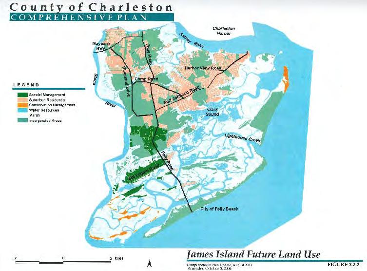
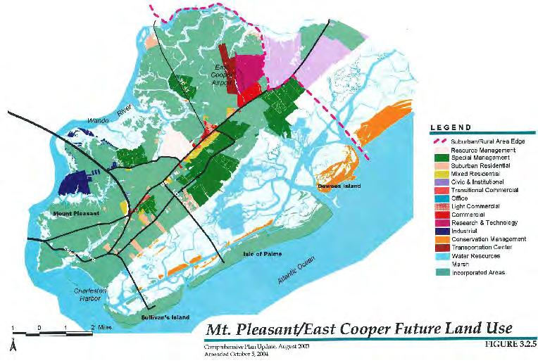
17 Residential/Special Management Future Land Use Designation


18 Residential/Special Management Future Land Use Designation Sweetgrass Basket Stand Special Consideration Area of Mount Pleasant Overlay Zoning District
19 2015 Five-Year Review of Comprehensive Plan Created a new Rural Cultural Community Protection Future Land Use Designation Replaced the Residential/Special Management Future Land Use Designation with the Urban/Suburban Cultural Community Protection Designation Both designations encourage community planning for historic communities to address their individual needs and work with them to identify and attain their community goals. Urban/Suburban Cultural Community Protection Intended to protect and promote the culture and unique development patterns of existing communities and sustain their strong sense of community. The communities in this designation are characterized by low density single-family residential development, limited commercial activity, and some agricultural uses. Many of the roads are paved with connections to county or state maintained roads; however, earthen roads still exist. Future development should be compatible with the existing land uses and development patterns and the residential density should be a maximum of four dwellings per acre. Compatible institutional, office, and low intensity commercial uses should be allowed to offer services and employment opportunities for local residents, provided the building scale and coverage fits with existing structures. Sweetgrass Basket making, including sales, should be recognized and promoted. Zoning and land development regulations in these areas should be customized to meet the needs of the individual communities.

20 2015 Future Land Use Map
21 Plan Implementation Community Planning projects Parkers Ferry Community Sol Legare Community
22 Parkers Ferry Community


23 Community Plan Study Area Pockets of small lots in settlement areas with scattered commercial and civic/institutional uses Large tracts of agricultural and timber lands (which were excluded from study area)

24 Parkers Ferry Community Plan History Starting in 2013, staff worked with community members to define the study area boundary, community name, and complete a community needs survey; Results of the survey and community input were used to identify specific community needs and potential solutions; and Concurrent with these community meetings was the Five-Year Review of the Charleston County Comprehensive Plan, including a new future land use designation (Rural Cultural Community Protection) tailored to the community s needs.

 non-conforming.")


25 Parkers Ferry Community Issues Zoning regulations had zoned out commercial uses, making the small businesses that had historically been in the community (general stores, social clubs, etc.) non-conforming. Land development regulations impeded the subdivision of lands for family members Heirs property issues If heirs failed to coordinate on paying annual tax bills, land could be lost at the annual tax sale Land without clear title cannot be subdivided


26 Community Plan Approx. 250 community members participated in community meetings throughout 2015 and 2016 Community plan includes strategies to address planning & zoning issues, employment and economic development, public works/transportation, and public services
27 The Parkers Ferry Community Overlay Zoning District (PF-O) Addresses primary community needs and issues by: Preserving the unique cultural heritage of the community; Improving potential for retail/public services and employment opportunities; and Increasing flexibility to subdivide and develop property. Creates two PF-O development districts: Residential Areas; and Business Nodes and Commercial Properties
28 Residential Areas The PF-O provides additional flexibility for parcels within the Residential Areas designation, including: An expansion in the number of homes allowed; More flexibility in lot requirements to enable subdivision; Increased ability to develop Accessory Dwelling Units (ADUs); More flexibility regarding home occupations; and Providing additional permitted uses allowed.

29 Business Nodes and Commercial Properties Business Nodes are intended to allow the establishment of the businesses the residents want to see in the community in the future. Six Business Nodes; All commercially zoned parcels retained their commercial zoning either as part of a Business Node or as a Commercial Property (properties that are zoned commercial but not located in a business node; and Accessory Dwelling Units (ADUs) are allowed with the same restrictions as the Residential Areas district.
30 Results of Parkers Ferry Plan & Overlay Encourages community preservation Provides opportunities for residents to subdivide their property for family members wanting to return to the area Offers more opportunities for economic development and employment, contributing to community vitality

31 Sol Legare Community Planning Project
.")
32 Sol Legare Project History Sol Legare is a historically African-American community (freedmen remnant settlement type) that was first settled post- Reconstruction Era. The land was subdivided into long-lot farms with access to both the waterways and the main road (Sol Legare Road). The community was designated as eligible for the National Register of Historic Places in the 2016 Charleston County Historic Resources Survey Update.


33 Sol Legare Community Plan The community thrived throughout the twentieth century, with successful small businesses such as Backman s Seafood and Mosquito Beach. As zoning regulations evolved, many of the commercial businesses in the area became legal non-conforming uses. Modern-day subdivision regulations prohibited further subdivision of properties.


 Relaxes standards for home occupations and accessory dwelling units")
34 Sol Legare Overlay Zoning District Establishes flexible subdivision options for the unique long, narrow lots in the area Decreased setbacks Maximum building sizes for single-family homes Allows for the redevelopment of properties that have historically had commercial uses (e.g. Backman s Seafood, Mosquito Beach, etc.) Relaxes standards for home occupations and accessory dwelling units (ADUs) Commercial Areas Residential Areas
35 Residential Area Similar to the current zoning, Special Management 3 (S-3), with added flexibility S-3 Development Option SL-O Development Option MAXIMUM DENSITY 3 dwelling units per acre 3 dwelling units per acre MINIMUM LOT AREA 14,500 SF; 12,500 SF if public water and/or sewer is available 10,000 SF MINIMUM LOT WIDTH 80 feet; 70 feet with public water and/or sewer is available 50 feet MINIMUM LOT WIDTH:DEPTH RATIO None None MINIMUM SETBACKS Front/Street Side 25 feet 10 feet Interior Side 15 feet 5 feet Rear 25 feet 5 feet OCRM Critical Line 30 feet 30 feet MAXIMUM BUILDING COVER 30% of lot 30% of lot MAXIMUM BUILDING HEIGHT 35 feet 35 feet MAXIMUM BUILDING SIZE None 2,500 SF Note: the SL-O option only applies to lots less than 110 feet in width.
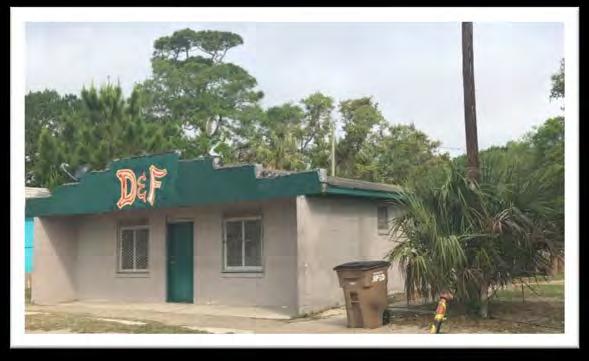
36 Designating the Commercial Areas The community stated that they would like to see former commercial properties have the opportunity to redevelop, but they do not want to see many new commercial uses develop. Working with the community, we identified the following commercial areas: Mosquito Beach Backman s Seafood property(s) Seashore Lodge Vacant snack/convenience stores at 1981 and 1987 Sol Legare Road

37 Mosquito Beach

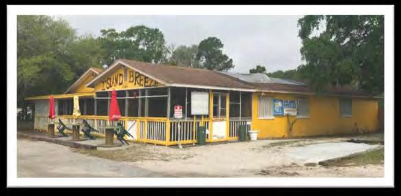
38 Mosquito Beach

39 1981 and 1987 Sol Legare Road


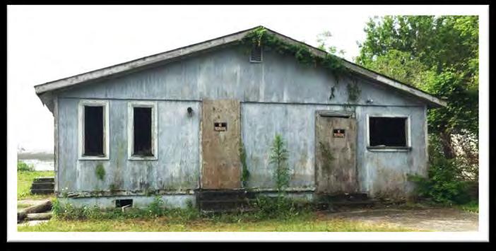
40 1981 and 1987 Sol Legare Road

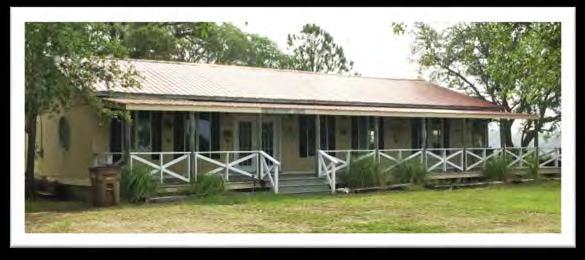
41 Backman s Seafood and Seashore Lodge Area


42 Backman s Seafood and Seashore Lodge Area
43 Examples for future efforts The Sol Legare and Parkers Ferry projects serve as examples for planning in other areas of the County Opportunity for collaboration with the Town of Mount Pleasant Community Engagement Planning Principles County Planning was awarded the Whitelaw award by Historic Charleston Foundation in May 2018 for these unique preservation planning projects Cultural Preservation

44 2018 Ten-Year Update of the Comprehensive Plan Collaboration with the African American Settlement Communities Historic Commission to update the Cultural Resources Element Coordination with the Town of Mount Pleasant as they update their Plan Future Project: Update the Mount Pleasant Overlay Zoning District to be an area plan that recognizes the significance of the settlement communities, keeping preservation and community vitality in mind. Proposed new Cultural Resources Element strategy: Work with communities along the Gullah Geechee corridor to establish ways to preserve the unique settlement patterns and community character.
45 Historic Preservation Planning Historic Preservation Ordinance National Park Service Civil Rights Grant: Oral History Project
46 Historic Preservation Ordinance Establish a local register of historic places African American settlement communities can apply to be listed as historic districts Require a Certificate of Historic Appropriateness for: Demolitions, alterations, new development, etc. of historic properties Subdivisions and site plan review applications for properties within 300 of historic properties or districts


47 National Park Service Civil Rights Grant Project Oral History project interviewing alumni from South Carolina equalization schools, specifically W. Gresham Meggett High School, located in the Grimball Farm settlement community Grimball community leaders are heavily involved in the project and want to use a portion of the High School as a community center/museum
48 Resources Gullah Geechee Heritage Corridor Charleston County Historic Resources Survey Update (2016) Charleston County Parkers Ferry Community Plan + Overlay Zoning District Regulations Charleston County Sol Legare Community Plan + Overlay Zoning District Regulations
49 Contact Information Andrea Pietras, AICP Andrea Harris-Long, AICP Charleston County Zoning & Planning Department
CCC XXX Rural Neighborhood Conservation (NC)
") CCC 33.10.XXX Rural Neighborhood Conservation (NC) Purpose: Maintain low density rural residential areas and associated uses commonly found in rural areas consistent with the local character of the distinctive
CCC 33.10.XXX Rural Neighborhood Conservation (NC) Purpose: Maintain low density rural residential areas and associated uses commonly found in rural areas consistent with the local character of the distinctive
DEPARTMENT OF PLANNING AND COMMUNITY DEVELOPMENT STAFF REPORT
 DEPARTMENT OF PLANNING AND COMMUNITY DEVELOPMENT STAFF REPORT PLANNING COMMISSION AGENDA ITEM # 5: Project Name: Star Dance Zoning Map Amendment, ZMA-13-02 Prepared By: Toby Stauffer, AICP City Planner
Marion County Board of County Commissioners
 Marion County Board of County Commissioners Date: 12/29/2015 P&Z: 12/28/2015 BCC: 1/12/2016 Item Number 160113Z Type of Application Rezoning Request From: A-1 (General Agriculture) To: PUD (Planned Unit
STAFF REPORT VARIANCE FROM LDC CHAPTER 17, SECTION 15(d)(1)(a) CASE NO
(1)(a) CASE NO") STAFF REPORT VARIANCE FROM LDC CHAPTER 17, SECTION 15(d)(1)(a) CASE NO. 16-90000010 REQUEST: OWNER: APPLICANT: LOCATION: RECOMMENDATION: Variance from the Land Development Code (LDC) to allow a minimum
STAFF REPORT VARIANCE FROM LDC CHAPTER 17, SECTION 15(d)(1)(a) CASE NO. 16-90000010 REQUEST: OWNER: APPLICANT: LOCATION: RECOMMENDATION: Variance from the Land Development Code (LDC) to allow a minimum
TREASURE COAST REGIONAL PLANNING COUNCIL M E M O R A N D U M
 TREASURE COAST REGIONAL PLANNING COUNCIL M E M O R A N D U M To: Council Members AGENDA ITEM 6A From: Date: Subject: Staff May 20, 2011 Council Meeting Local Government Comprehensive Plan Review Draft
City of Coral Gables Planning and Zoning Staff Report
 City of Coral Gables Planning and Zoning Staff Report Applicant: Application: Public Hearing: Date & Time: Location: City of Coral Gables Zoning Code Text Amendment Giralda Plaza Overlay District Planning
PLANNING COMMISSION REPORT Regular Agenda - Public Hearing Item
 Z-15-00469 Item No. 6A- 1 PLANNING COMMISSION REPORT Regular Agenda - Public Hearing Item PC Staff Report 11/16/15 ITEM NO. 6A GPI, RM12, & RS40 TO RM12; 14.756 ACRES; 5200 & 5300 CLINTON PKWY (SLD) Z-15-00469:
June 22, 2005/Calendar No. 14
 CITY PLANNING COMMISSION June 22, 2005/Calendar No. 14 C 050400 ZMQ IN THE MATTER OF an application submitted by the Department of City Planning pursuant to Sections 197-c and 201 of the New York City
Town of Jamestown Planning Board Zoning Staff Report June 14, 2010
 Town of Jamestown Planning Board Zoning Staff Report June 14, 2010 The information provided in this staff report has been included for the purpose of reviewing proposed zoning changes. Since the zoning
PRIMUS TRACT MOUNT PLEASANT, SOUTH CAROLINA
 DEVELOPMENT GUIDELINES FOR PRIMUS TRACT MOUNT PLEASANT, SOUTH CAROLINA Date February 18, 2015 PLANNING COMMISSION SUBMITTAL Owner/Developer: American Star Development SC, LLC P.O. Box 211 Sullivans Island,
Town of Clinton, Connecticut Action Plan for the Historic Unilever Property and Area. Steering Committee Meeting #5 Implementation Strategies
 Town of Clinton, Connecticut Action Plan for the Historic Unilever Property and Area Steering Committee Meeting #5 Implementation Strategies Wednesday, March 19, 2014 6:30pm Steering Committee Meeting
City of Spokane Infill Development. June 30, 2016
 City of Spokane Infill Development June 30, 2016 Today s Agenda Introductions Background and Adopted Policy Infill Forms: Facilitated Group Discussion Small-Group Discussions Groups Report Out Next Steps
Place Type Descriptions Vision 2037 Comprehensive Plan
 Place Type Descriptions Vision 2037 Comprehensive Plan The Vision 2037 Comprehensive Plan establishes a range of place types for Oxford, ranging from low intensity (limited development) Rural and Natural
1. Future Land Use FLU6.6.8 Land uses within the Rural Service Area portion of the Wekiva Study Area shall be limited to very low and low intensity
 1. Future Land Use FLU6.6.8 Land uses within the Rural Service Area portion of the Wekiva Study Area shall be limited to very low and low intensity uses to the greatest extent possible. Existing land uses
INDIAN RIVER COUNTY, FLORIDA. The Honorable Members of the Planning and Zoning Commission DEPARTMENT HEAD CONCURRENCE
 Public Hearing Legislative INDIAN RIVER COUNTY, FLORIDA M E M O R A N D U M TO: The Honorable Members of the Planning and Zoning Commission DEPARTMENT HEAD CONCURRENCE Robert M. Keating, AICP; Community
Staff Report PLANNED DEVELOPMENT. Salt Lake City Planning Commission. From: Lauren Parisi, Associate Planner; Date: December 14, 2016
 Staff Report PLANNING DIVISION COMMUNITY & NEIGHBORHOODS To: Salt Lake City Planning Commission From: Lauren Parisi, Associate Planner; 801-535-7932 Date: December 14, 2016 Re: 1611 South 1600 East PLANNED
Allenspark Townsite Planning Initiative Community Meeting July 23, Boulder County Land Use Department
 Allenspark Townsite Planning Initiative Community Meeting July 23, 2018 OBJECTIVES FOR THIS MEETING Update the community on developments, outcomes of recent discussions Recognizing the revised scope (Allenspark
Staff Report for Council Public Meeting
 Agenda Item 3.3 Staff Report for Council Public Meeting Date of Meeting: September 27, 2017 Report Number: SRPRS.17.134 Department: Division: Subject: Planning and Regulatory Services Development Planning
PLANNED UNIT DEVELOPMENT & SUBDIVISION STAFF REPORT Date: April 18, 2019
 PLANNED UNIT DEVELOPMENT & SUBDIVISION STAFF REPORT Date: April 18, 2019 DEVELOPMENT NAME SUBDIVISION NAME Springhill Village Subdivision Springhill Village Subdivision LOCATION 4350, 4354, 4356, 4358,
Better Housing by Design - Proposed Draft Summary
 Better Housing by Design - Proposed Draft Summary How can Portland s multi-dwelling zones be improved to meet the needs of current and future residents? Review the BHD Proposed Draft for potential solutions,
LOT AREA AND FRONTAGE
 LOT AREA AND FRONTAGE Lot Area & Frontage for the R2.1 Zone Lot Area & Frontage for the R2.4 Zone Minimum Lot Minimum Lot Zone Area Width R2.1 700 sq m 18 m R2.4 600 sq m 16 m Lot Area means the total
PALM BEACH COUNTY PLANNING, ZONING AND BUILDING DEPARTMENT ZONING DIVISION
 PALM BEACH COUNTY PLANNING, ZONING AND BUILDING DEPARTMENT ZONING DIVISION Application No.: Z-2016-00663 Application Name: Autism School Control No.: 2014-00133 Applicant: Dayna2, LLC Owners: Dayna2, LLC
PLANNING REPORT Gordon Street City of Guelph. Prepared on behalf of Ontario Inc. March 17, Project No. 1507
 PLANNING REPORT 1131 Gordon Street City of Guelph Prepared on behalf of 1876698 Ontario Inc. March 17, 2016 Project No. 1507 423 Woolwich Street, Suite 201, Guelph, Ontario, N1H 3X3 Phone (519) 836-7526
City of Fayetteville, Arkansas Page 1 of 1
 City of Fayetteville, Arkansas 113 West Mountain Street Fayetteville, AR 72701 (479) 575-8323 Legislation Text File #: 2018-0288, Version: 1 RZN 18-6176 (714 S. COLLEGE AVE./CAMERON): AN ORDINANCE TO REZONE
City of Tacoma Planning and Development Services
 Agenda Item D-3 City of Tacoma Planning and Development Services To: Planning Commission From: Elliott Barnett, Planning Services Division Subject: Affordable Housing Planning Work Program (Phase 3) Meeting
Rule of corner may need to be flexible i.e. context school, park. With a clustered approach. Should row housing go where fourplexes are?
 Fourplex Privacy Traffic issues by school (don t locate next to school) Highest density is furthest from park and school. Is this best? Family friendly (i.e. private green space, nicely designed, etc.)
WHY ARE WE UPDATING THE RURAL AREA LAND DEVELOPMENT REGULATIONS (LDRS)?
?") PROCESS OVERVIEW WHY ARE WE UPDATING THE RURAL AREA LAND DEVELOPMENT REGULATIONS (LDRS)? The Rural Area LDRs are being updated to implement the Comprehensive Plan adopted in May 2012. Current regulations
PROCESS OVERVIEW WHY ARE WE UPDATING THE RURAL AREA LAND DEVELOPMENT REGULATIONS (LDRS)? The Rural Area LDRs are being updated to implement the Comprehensive Plan adopted in May 2012. Current regulations
STAFF REPORT. Permit Number: Porter. Kitsap County Board of Commissioners; Kitsap County Planning Commission
 STAFF REPORT Permit Number: 15 00461 Porter DATE: November 9, 2015 TO: FROM: Kitsap County Board of Commissioners; Kitsap County Planning Commission Katrina Knutson, AICP, Senior Planner, DCD and Jeff
Zoning Code Amendments Completed and Proposed As of September 2014
 Zoning Code Amendments Completed and Proposed As of September 2014 PROPOSED CODE AMENDMENTS High Priority Amendment/Issue Comments Exterior Lighting Standards Section 26-503 establishes states that exterior
Action Recommendation: Budget Impact:
 City of Fayetteville Staff Review Form 2018-0744 Legistar File ID 1/3/2019 City Council Meeting Date - Agenda Item Only N/A for Non-Agenda Item Garner Stoll 12/14/2018 CITY PLANNING (630) Submitted By
Planning Department Oconee County, Georgia STAFF REPORT
 Planning Department Oconee County, Georgia STAFF REPORT REZONE CASE #: 7332 DATE: November 28, 2017 STAFF REPORT BY: Gabriel Quintas, Planner APPLICANT NAME: Smith Planning Group PROPERTY OWNER: John Hadden
City of Coral Gables Planning and Zoning Staff Report
 City of Coral Gables Planning and Zoning Staff Report Applicant: Application: Public Hearing: Date & Time: Location: City of Coral Gables Giralda Restaurant Row Overlay Zoning Code Text Amendment Planning
CHAPTER RESIDENTIAL AND OPEN SPACE ZONING DISTRICTS
 Residential and Open Space Zoning Districts 106.24.010 CHAPTER 106.24 - RESIDENTIAL AND OPEN SPACE ZONING DISTRICTS RESIDENTIAL AND OPEN SPACE ZONING DISTRICTS Sections: 106.24.010 - Purpose 106.24.020
Article XII. R-1 Agricultural-Low Density Residential District
 Article XII R-1 Agricultural-Low Density Residential District Section 1200. Declaration of Legislative Intent In expansion of the Declaration of Legislative Intent and Statement of Community Development
Acting Director, Community Planning, Toronto and East York District
 STAFF REPORT ACTION REQUIRED 620 Avenue Road, 215 & 217 Lonsdale Road OPA & Rezoning Application Preliminary Report Date: March 13, 2008 To: From: Wards: Reference Number: Toronto and East York Community
SPECIAL ZONING DISTRICTS
 SPECIAL ZONING DISTRICTS 5.01 5.99 RESERVED 5.100 PLANNED DEVELOPMENTS: Purpose: This district is intended to accommodate unified design of residential, commercial, office, professional services, retail
PLANNING COMMISSION STAFF REPORT
 PLANNING COMMISSION STAFF REPORT AMENDMENTS TO CHAPTER 21A.40.050: 5 Foot Maximum Rear Setback for Accessory Structures Case # 4 April 2011 Planning and Zoning Division Department of Community and Economic
Planning Department Oconee County, Georgia
 Planning Department Oconee County, Georgia STAFF REPORT REZONE CASE #: 6985 DATE: October 31, 2016 STAFF REPORT BY: Andrew C. Stern, Planner APPLICANT NAME: Williams & Associates, Land Planners PC PROPERTY
EXHIBIT B FINDINGS OF FACT BEND DEVELOPMENT CODE (BDC) UPDATE AMENDMENT PZ
 UPDATE AMENDMENT PZ") EXHIBIT B FINDINGS OF FACT BEND DEVELOPMENT CODE (BDC) UPDATE AMENDMENT PZ 18-0524 Procedural Findings Notice of the proposed amendments was provided to the Department of Land Conservation and Development
EXHIBIT B FINDINGS OF FACT BEND DEVELOPMENT CODE (BDC) UPDATE AMENDMENT PZ 18-0524 Procedural Findings Notice of the proposed amendments was provided to the Department of Land Conservation and Development
AGENDA ITEM SUMMARY GLADES COUNTY BOARD OF COUNTY COMMISSIONERS
 AGENDA ITEM SUMMARY GLADES COUNTY BOARD OF COUNTY COMMISSIONERS SUBJECT: Case Number COMP17-01, Legend Moto LLC This is a Legislative Hearing. DEPARTMENT REQUEST: The Community Development Department requests
RAE EXCLUSIVE RESIDENTIAL ZONE A residential district exclusively for low density single family housing and accessory uses.
 KNOX COUNTY ZONING ORDINANCE DISTRICT SUMMARY REQUIREMENTS 2/11/2009 RAE EXCLUSIVE RESIDENTIAL ZONE A residential district exclusively for low density single family housing and accessory uses. 10,000 sq.
DIVISION 7. R-6 AND R-6A RESIDENTIAL ZONES* The purpose of the R-6 residential zone is:
 Date of Draft: March 6, 2015 DIVISION 7. R-6 AND R-6A RESIDENTIAL ZONES* Sec. 14-135. Purpose. The purpose of the R-6 residential zone is: (a) To set aside areas on the peninsula for housing characterized
Town of Waxhaw Board of Commissioners. Waxhaw Police Department Community Meeting Room Tuesday January 12, 2016
 Town of Waxhaw Board of Commissioners Waxhaw Police Department Community Meeting Room Tuesday January 12, 2016 Petition RZ-003994-2015 A request by the Town of Waxhaw Planning & Community Development Department,
WASHINGTON COUNTY DEVELOPMENT CODE CHAPTER TWO ZONING REGULATIONS PART 2 DENSITY AND LOT REQUIREMENTS. Table of Contents
 WASHINGTON COUNTY DEVELOPMENT CODE CHAPTER TWO ZONING REGULATIONS PART 2 DENSITY AND LOT REQUIREMENTS Table of Contents SECTION 1. DENSITY... 2 1.1 Density in Districts... 2 1.2 Determination of Density
5 May 13, 2015 Public Hearing
 5 May 13, 2015 Public Hearing APPLICANT: CAVALIER VENTURES, LLC PROPERTY OWNER: CAVALIER ASSOCIATES, LLC STAFF PLANNER: Graham Owen REQUEST: Conditional Use Permit (Craft Distillery) ADDRESS / DESCRIPTION:
Rapid City Planning Commission Vacation of Right-of-Way Project Report June 9, 2016
 Rapid City Planning Commission Vacation of Right-of-Way Project Report June 9, 2016 Case #16VR006 Companion Case File #16PL050 Item 5 Applicant Request(s) Vacation of Right-of-Way to vacate a portion of
Proposed Changes to Conservation District Regulations. Quality of Life Committee March 25, 2013
 Proposed Changes to Conservation District Regulations Quality of Life Committee March 25, 2013 Purpose To discuss aspects of the current Conservation District ordinance that need improvement To summarize
CHAPTER Committee Substitute for Committee Substitute for Senate Bill No. 2188
 CHAPTER 2004-372 Committee Substitute for Committee Substitute for Senate Bill No. 2188 An act relating to land development; amending s. 197.502, F.S.; providing for the issuance of an escheatment tax
Flatbush Rezoning and Text Amendments LR Item 3: Description of Proposal
 Project Description The New York City Department of City Planning (DCP), at the request of Community Board 14, elected officials and civic groups, proposes zoning map changes and zoning text amendments
Article 3. SUBURBAN (S-) NEIGHBORHOOD CONTEXT
 NEIGHBORHOOD CONTEXT") Article 3. SUBURBAN (S-) NEIGHBORHOOD CONTEXT this page left intentionally blank Contents ARTICLE 3. SUBURBAN (S-) NEIGHBORHOOD CONTEXT DIVISION 3.1 NEIGHBORHOOD CONTEXT DESCRIPTION...3.1-1 Section 3.1.1
Article 3. SUBURBAN (S-) NEIGHBORHOOD CONTEXT this page left intentionally blank Contents ARTICLE 3. SUBURBAN (S-) NEIGHBORHOOD CONTEXT DIVISION 3.1 NEIGHBORHOOD CONTEXT DESCRIPTION...3.1-1 Section 3.1.1
Memorandum. Kenneth Johnstone, Community Development Director. November 25, 2015 (for December 3 Study Session)
") Memorandum TO: THROUGH: FROM: DATE: SUBJECT: Planning Commission Kenneth Johnstone, Community Development Director Lisa Ritchie, Planner II November 25, 2015 (for December 3 Study Session) Accessory Dwelling
Memorandum TO: THROUGH: FROM: DATE: SUBJECT: Planning Commission Kenneth Johnstone, Community Development Director Lisa Ritchie, Planner II November 25, 2015 (for December 3 Study Session) Accessory Dwelling
Request Subdivision Variance (Section 4.4(c)(1) of the Subdivision Regulations) Staff Recommendation Approval. Staff Planner Jonathan Sanders
(1) of the Subdivision Regulations) Staff Recommendation Approval. Staff Planner Jonathan Sanders") Applicant & Owner Public Hearing February 14, 2018 City Council Election District Bayside Agenda Item 4 Request Subdivision Variance (Section 4.4(c)(1) of the Subdivision Regulations) Staff Recommendation
Applicant & Owner Public Hearing February 14, 2018 City Council Election District Bayside Agenda Item 4 Request Subdivision Variance (Section 4.4(c)(1) of the Subdivision Regulations) Staff Recommendation
ANCHORAGE, ALASKA AO No (S)
") Submitted by: Chair of the Assembly at the Request of the Mayor Prepared by: Planning Department For reading: May, 0 ANCHORAGE, ALASKA AO No. 0- (S) 0 0 0 AN ORDINANCE AMENDING ANCHORAGE MUNICIPAL CODE
Submitted by: Chair of the Assembly at the Request of the Mayor Prepared by: Planning Department For reading: May, 0 ANCHORAGE, ALASKA AO No. 0- (S) 0 0 0 AN ORDINANCE AMENDING ANCHORAGE MUNICIPAL CODE
Presentation to the Real Estate Institute of New Zealand 28 October 2016
 Presentation to the Real Estate Institute of New Zealand 28 October 2016 Disclaimer This presentation provides a high level overview of specific parts of the Proposed Auckland Unitary Plan Decisions Version
Glades County Staff Report and Recommendation Unified Staff Report for Small Scale Plan Amendment and Rezoning
 Glades County Staff Report and Recommendation Unified Staff Report for Small Scale Plan Amendment and Rezoning CASE NUMBERS: COMP17-02 and RZ17-02 DATE of STAFF REPORT: May 1, 2017 CASE TYPE: Application
Salem HNA and EOA Advisory Committee Meeting #6
 Salem HNA and EOA Advisory Committee Meeting #6 Residential Land Policies Employment Land Policies Policy Discussions with the Committee Outcome of today s meeting Direction from this Committee on proposed
Policy Issues City of Knoxville Zoning Code Update
 Policy Issues City of Knoxville Zoning Code Update ADU's (Accessory Dwelling Units) The draft zoning ordinance update permits ADU s as an accessory use in all single-family residential zoning districts.
Village of Perry Zoning Ordinance Update Draft Diagnostic Report
 Village of Perry Zoning Ordinance Update Draft Diagnostic Report Background The Village of Perry began work on a new comprehensive plan in 2014. After a year of committee meetings and public outreach,
Flinders Avenue, Lara Planning Scheme Amendment Combined Application for Rezoning and Multi-Lot Subdivision Reference : Decembe
 143-179 Flinders Avenue, Lara Planning Scheme Amendment Combined Application for Rezoning and Multi-Lot Subdivision Reference: 14134-03 TGM Group Geelong Melbourne Ballarat 1/27-31 Myers Street (PO Box
Draft for Public Review. The Market and Octavia Neighborhood Plan
 Draft for Public Review The Market and Octavia Neighborhood Plan San Francisco Planning Department As Part of the Better Neighborhoods Program December 00 . Housing People OBJECTIVE.1 MIXED-USE RESIDENTIAL
PALM BEACH COUNTY PLANNING, ZONING AND BUILDING DEPARTMENT ZONING DIVISION
 PALM BEACH COUNTY PLANNING, ZONING AND BUILDING DEPARTMENT ZONING DIVISION Application No.: W-2014-00288 Application Name: O Reilly Auto Parts Control No.: 2013-00286 Applicant: Hutton Growth Blue Sky
Marion County Planning & Zoning Commission
 Marion County Planning & Zoning Commission Date: 10/1/2013 P&Z: 10/28/2013 BCC: 11/19/2013 Item Number 131106Z Type of Application Rezoning Request Zoning change from R- 1 Single-Family Dwelling to R-4
50+54 BELL STREET NORTH
 50+54 BELL STREET NORTH SITE PLAN CONTROL APPLICATION OCTOBER 2014 PREPARED BY: FOTENN Consultants Inc. 223 Mcleod Street Ottawa, ON K2P OZ8 (613) 730-5709 PREPARED FOR: Ottawa Chinese Alliance Church
The summary of zoning regulations for each site is provided in the same order (and using the same names for each site) as the RFEI.
 as the RFEI.") Lincoln City Zoning/regulatory Overview This paper provides a summary of zoning regulations for the eight properties included in Lincoln City s Request for Expressions of Interest (RFEI). The complete
Lincoln City Zoning/regulatory Overview This paper provides a summary of zoning regulations for the eight properties included in Lincoln City s Request for Expressions of Interest (RFEI). The complete
Jason Smith, Manager of Development Services Infill Development Draft Official Community Plan Amendment and Policy
 Council Agenda Information Regular Council March 06, 2018 VILLAGE OF ANMORE REPORT TO COUNCIL Date: Submitted by: Subject: Jason Smith, Manager of Development Services Infill Development Draft Official
DEPARTMENT OF DEVELOPMENT SERVICES PLANNING BOARD BRIEFING For Meeting Scheduled for January 5, 2009 Agenda Item B2
 DEPARTMENT OF DEVELOPMENT SERVICES PLANNING BOARD BRIEFING For Meeting Scheduled for January 5, 2009 Agenda Item B2 REQUEST: Cocoa Beach Community Church Site Plan/Architectural Review Downtown Overlay
RESIDENTIAL DISTRICTS SINGLE FAMILY DWELLING DEVELOPMENT STANDARDS
 RESIDENTIAL DISTRICTS SINGLE FAMILY DWELLING DEVELOPMENT STANDARDS READ FIRST - NOTE TO DEVELOPERS & DISCLAIMER: Residential zoning districts require minimum yard distances from property lines for building
TOWN OF ORO VALLEY PLANNING & ZONING COMMISSION MEETING DATE: December 6, 2011
 PLANNING & ZONING COMMISSION MEETING DATE: December 6, 2011 TO: FROM: SUBJECT: PLANNING & ZONING COMMISSION Matt Michels, Senior Planner mmichels@orovalleyaz.gov; tel. 229-4822 Public Hearing: Rancho de
BROCKVILLE CITY OF BROCKVILLE COMPREHENSIVE ZONING BY-LAW REVIEW DISCUSSION PAPER OCTOBER 2013 FINAL D
 BROCKVILLE CITY OF BROCKVILLE COMPREHENSIVE ZONING REVIEW DISCUSSION PAPER OCTOBER 2013 FINAL D14-13-010 TABLE OF CONTENTS 1. INTRODUCTION... 1 1.1 Purpose and Goals of this Project... 1 1.2 Study Process...
KANKAKEE COUNTY PLANNING DEPARTMENT APPLICATION FOR FARMSTEAD EXEMPTION IN THE A1 DISTRICT
 KANKAKEE COUNTY PLANNING DEPARTMENT APPLICATION FOR FARMSTEAD EXEMPTION IN THE A1 DISTRICT Michael J. Van Mill, AICP Planning Director 189 East Court Street Kankakee, IL 60901 Telephone (815) 937-2940
August 8, 2017 Planning and Land Development Regulation Commission (PLDRC)
") Page 1 of 25 GROWTH AND RESOURCE MANAGEMENT DEPARTMENT PLANNING AND DEVELOPMENT SERVICES DIVISION 123 West Indiana Avenue, DeLand, FL 32720 (386) 736-5959 PUBLIC HEARING: CASE NO: SUBJECT: LOCATION: APPLICANT:
Page 1 of 25 GROWTH AND RESOURCE MANAGEMENT DEPARTMENT PLANNING AND DEVELOPMENT SERVICES DIVISION 123 West Indiana Avenue, DeLand, FL 32720 (386) 736-5959 PUBLIC HEARING: CASE NO: SUBJECT: LOCATION: APPLICANT:
Staff Report: Date: Applicant: Property Identification: Acreage of Request: Current Zoning of Requested Area: Requested Action: Attached:
 Staff Report: Completed by Jeff Palmer Director of Planning & Zoning Date: November 7, 2018, Updated November 20, 2018 Applicant: Greg Smith, Oberer Land Developer agent for Ronald Montgomery ET AL Property
Planning Rationale in Support of an Application for Plan of Subdivision and Zoning By-Law Amendment
 Planning Rationale in Support of an Application for Plan of Subdivision and Zoning By-Law Amendment The Kilmorie Development 21 Withrow Avenue City of Ottawa Prepared by: Holzman Consultants Inc. Land
July 19, 2018 Planning and Land Development Regulation Commission (PLDRC)
") Page 1 of 15 GROWTH AND RESOURCE MANAGEMENT DEPARTMENT PLANNING AND DEVELOPMENT SERVICES DIVISION 123 West Indiana Avenue, DeLand, Florida 32720 (386) 736-5959 PUBLIC HEARING: CASE NO: SUBJECT: LOCATION:
Page 1 of 15 GROWTH AND RESOURCE MANAGEMENT DEPARTMENT PLANNING AND DEVELOPMENT SERVICES DIVISION 123 West Indiana Avenue, DeLand, Florida 32720 (386) 736-5959 PUBLIC HEARING: CASE NO: SUBJECT: LOCATION:
Metropolitan Planning Commission. DATE: April 5, 2016
 TO: FROM: Metropolitan Planning Commission MPC Staff DATE: April 5, 2016 SUBJECT: Petition of Nine Line Inc. Robert McCorkle, Agent PIN: 2-1034-01-002 380.5 Acres Aldermanic District: 5 (Shabazz) County
this page left intentionally blank DENVER ZONING CODE
 Article 1. GENERAL PROVISIONS this page left intentionally blank Contents ARTICLE 1. GENERAL PROVISIONS DIVISION 1.1 GENERAL...1.1-1 Section 1.1.1 Purpose...1.1-1 Section 1.1.2 Intent...1.1-1 Section 1.1.3
Kassner Goodspeed Architects Ltd.
 Kassner Goodspeed Architects Ltd. 29 & State Street Developments Ltd. The Promenade at Robie South Case 20761: Application for Development Agreement Design Rationale The land assembly is a 1.3 Acre parcel
CLEARFIELD CITY COUNCIL AGENDA AND SUMMARY REPORT July 31, 2018 SPECIAL POLICY SESSION
 CLEARFIELD CITY COUNCIL AGENDA AND SUMMARY REPORT July 31, 2018 SPECIAL POLICY SESSION Meetings of the City Council of Clearfield City may be conducted via electronic means pursuant to Utah Code Ann. 52-4-207
Rapid City Planning Commission Rezoning Project Report
 Rapid City Planning Commission Rezoning Project Report April 7, 2016 Item #3 Applicant Request(s) Case # 16RZ010 Rezoning from Office Commercial District to General Commercial District Companion Case(s)
Town of Siler City - Unified Development Ordinance ARTICLE XII - Density and Dimensional Regulations
 ARTICLE XII - Density and Dimensional Regulations 167 Minimum Lot Size Subject to the provisions of 173 (Cluster Subdivisions) and all lots in the following zones shall have at least the amount of square
Application: DVP Owner: Pillar West Developments Inc. Address: 4646 McClure Rd Applicant: Integrity Services Inc.
 REPORT TO COUNCIL Date: August 29, 2017 RIM No. 0940-00 To: From: City Manager Community Planning Department (MS) Application: DVP16-0241 Owner: Pillar West Developments Inc. Address: 4646 McClure Rd Applicant:
ADMINISTRATIVE HEARING STAFF REPORT
 ADMINISTRATIVE HEARING STAFF REPORT Epic Brewing Center Subdivision Minor Subdivision Preliminary Plat PLNSUB2013-00846 825 S. State St., 834 and 836 S. Edison St. Hearing date: December 12, 2013 Applicant:
Appendix A: Guide to Zoning Categories Prince George's County, Maryland
 Appendix A: Guide to Zoning Categories Prince George's County, Maryland RESIDENTIAL ZONES 1 Updated November 2010 R-O-S: Reserved Open Space - Provides for permanent maintenance of certain areas of land
COMMUNITY DEVELOPMENT. Staff Report. Site Plan Review. SP June 19, 2018
 COMMUNITY DEVELOPMENT 333 Broadalbin Street SW, PO Box 490, Albany, Oregon 97321-0144 BUILDING 541-917-7553 PLANNING 541-917-7550 Staff Report Site Plan Review SP-18-18 June 19, 2018 Summary On May 1,
MONTGOMERY COUNTY PLANNING DEPARTMENT THE MARYLAND-NATIONAL CAPITAL PARK AND PLANNING COMMISSION
 MONTGOMERY COUNTY PLANNING DEPARTMENT THE MARYLAND-NATIONAL CAPITAL PARK AND PLANNING COMMISSION MCPB Item No. Date: 12/4/14 Preliminary Plan No. 120140200, Northwood Knolls Description Patrick Butler,
STAFF REPORT. Permit Number: Laurier Enterprises, Inc. Kitsap County Board of Commissioners; Kitsap County Planning Commission
 STAFF REPORT Permit Number: 15 00740 Laurier Enterprises, Inc. DATE: November 9, 2015 TO: FROM: Kitsap County Board of Commissioners; Kitsap County Planning Commission Katrina Knutson, AICP, Senior Planner,
Marion County Board of County Commissioners
 Marion County Board of County Commissioners Date: 12/2/25 P&Z: 11/30/25 BCC: 12/16/25 Amendment No: (20)151209Z Type of Application Rezoning Request P-MH (Mobile Home Park) to B-2 (Community Business)
DEPARTMENT OF PLANNING JEFFERSON PARISH, LOUISIANA
 DEPARTMENT OF PLANNING JEFFERSON PARISH, LOUISIANA SUBDIVISION REPORT DOCKET NO: ES-89-15-PF SUMMARY NO: COUNCIL DISTRICT 2 Paul D. Johnston COUNCIL AT LARGE: A Chris Roberts B Elton M. Lagasse ADVERTISING
THE REDEVELOPMENT PLAN
 PAGE 37 THE REDEVELOPMENT PLAN FUTURE LAND USE The Silver Terrace Redevelopment Area is currently designated as Redevelopment Area #4 on the City of Delray Beach Future Land Use Map (FLUM). This designation
PD No. 15 Authorized Hearing
 PD No. 15 Authorized Hearing Community Meeting No. 2 February 19, 2019 6:30 p.m. Hyer Elementary School Cafetorium 8385 Durham St Andrew Ruegg Senior Planner PD No. 15 Authorized Hearing On September 7,
Article 04 Single Family Residential Districts
 Article 04 Article 04 Section 04.01 Intent (a) R1A Residence District. The R1A Single Family Residential District is established to include areas of low density single-family residences and limited agricultural
PLANNING COMMISSION REPORT Regular Agenda - Public Hearing Item
 Z-14-00056 Item No. 1-1 PLANNING COMMISSION REPORT Regular Agenda - Public Hearing Item PC Staff Report 4/21/2014 ITEM NO. 1: RSO TO CN1;.126 ACRES; 512 & 514 LOCUST ST (DRG) Z-14-00056: Consider a request
Town of Qualicum Beach M E M O R A N D U M
 Town of Qualicum Beach M E M O R A N D U M TO: Advisory Planning Commission FOR: APC Meeting April 18, 2012 FROM: Luke Sales, Director of Planning RE: Land Use Bylaw and Official Community Plan Bylaw Amendments
INTRODUCTION TO HOUSING LDC AMENDMENTS
 INTRODUCTION TO HOUSING LDC AMENDMENTS August 6, 2018 BACKGROUND The City is participating in a regional affordable housing initiative Staff presented the City s overall strategy at the March 2018 MPB
Indicates Council-recommended changes Introduced by: Mr. Tackett Date of introduction: June 14, 2016 SUBSTITUTE NO. 1 TO ORDINANCE NO.
 Indicates Council-recommended changes Introduced by: Mr. Tackett Date of introduction: June 14, 2016 SUBSTITUTE NO. 1 TO ORDINANCE NO. 16-067 TO AMEND NEW CASTLE COUNTY CODE CHAPTER 40 (ALSO KNOWN AS THE
PALM BEACH COUNTY PLANNING, ZONING AND BUILDING DEPARTMENT ZONING DIVISION ZONING COMMISSION VARIANCE STAFF REPORT 03/03/2011
 PALM BEACH COUNTY PLANNING, ZONING AND BUILDING DEPARTMENT ZONING DIVISION ZONING COMMISSION VARIANCE STAFF REPORT 03/03/2011 APPLICATION NO. CODE SECTION REQUIRED PROPOSED VARIANCE ZV-2010-02817 3.D.1.C
TO: Glynn County Islands Planning Commission. Eric Landon, Planner II. PP2754 Stones Throw Cottages. DATE: February 6, 2014
 COMMUNITY DEVELOPMENT DEPARTMENT Planning and Zoning Division 1725 Reynolds Street, Suite 200, Brunswick, GA 31520 Phone: 912-554-7428/Fax: 1-888-252-3726 TO: Glynn County Islands Planning Commission FROM:
4.2 RESIDENTIAL ZONING DISTRICTS
 4.2 RESIDENTIAL ZONING DISTRICTS A. Purpose: To define regulations and standards for each residential zoning district in the City. The following sections identify uses, regulations, and performance standards
Nassau County Single Land Split Application
 NASSAU COUNTY DEPARTMENT OF PLANNING AND ECONOMIC OPPORTUNITY FLORIDA Nassau County Single Land Split Application Taco E. Pope, AICP, Director 96161 Nassau Place Yulee, Florida 32097 (904) 530-6300 APPLICATION
STAFF REPORT. Permit Number: Laurier Enterprises, Inc. Kitsap County Board of Commissioners; Kitsap County Planning Commission
 STAFF REPORT Permit Number: 15 00740 Laurier Enterprises, Inc. DATE: December 18, 2015 TO: FROM: Kitsap County Board of Commissioners; Kitsap County Planning Commission Katrina Knutson, AICP, Senior Planner,