North Hanley Station. o Flower Valley Shopping Center o Cross Keys Shopping Cente #49 North Lindbergh MetroBus
|
|
|
- Melanie Henry
- 6 years ago
- Views:
Transcription


1 North Hanley Station This station profile describes existing conditions around the North Hanley MetroLink Station. This is one of a set of profiles for each of the MetroLink System s 37 light rail stations. These profiles present demographic and employment data from within a half-mile of the station, and describe the land uses and building types within a quarter-mile of the station. They also identify Metro-owned parcels that may offer opportunity to encourage new development around the station; other vacant and underutilized sites that may offer opportunity for infill development; and the physical, policy, and zoning barriers to TOD that currently exist. These profiles serve as a basis for conversation and planning with the community, elected officials, developers, financial institutions, and other stakeholders. The North Hanley Station serves a diverse population living in an area with a mixed suburban development pattern. Interstate 70 runs east-west through the heart of the station area, and North Hanley Road serves as its major northsouth thoroughfare. The residential neighborhood consists of single-family detached homes south of the MetroLink station, and two-story apartment buildings west of North Hanley Road. The station is in close proximity to the University of Missouri St. Louis campus, and is surrounded to the north and east by large corporate campuses, most notably Express Scripts and the NorthPark business park. The quarter-mile station area covers 122 lots on 10 blocks, with a total assessed value of $12,471,330. The MetroLink Station and Park-Ride Lot is a 20-acre site containing 1,705 surface parking spaces and a three-story garage containing approximately 780 spaces. Regional Accessibility by Transit From the North Hanley Station, MetroBus and MetroLink offer timely travel and direct connections to a wide range of housing, shopping, jobs, and other high-demand destinations: #04 Natural Bridge MetroBus o Downtown St. Louis o University of Missouri-St. Louis #34 Earth City MetroBus o Verizon Riverport Amphitheater #35 Rock Road MetroBus o DePaul Medical Center o Northwest Plaza o St. Louis Mills #36 Spanish Lake MetroBus o Vatterott College o St. Louis Community College-Florissant Valley o Christian Hospital Northeast #44 Hazelwood MetroBus 1 o NorthPark o Village Square #45 Ferguson-Florissant MetroBus o Cross Keys Shopping Center o Clocktower Place #47 North Hanley MetroBus o Downtown Clayton o Flower Valley Shopping Center o Cross Keys Shopping Cente #49 North Lindbergh MetroBus o Plaza Frontenac o Monsanto Headquarters o Lambert MetroBus Port #61 Chambers Road MetroBus o NorthPark o Federal Center
2 #75 Lilac Hanley MetroBus o St. Louis Community College-Florissant Valley o Christian Hospital Northeast #98 Chesterfield Hanley MetroBus o Westport Plaza o St. Luke s Hospital MetroLink (RED LINE) o Lambert International Airport (5 minutes) o Delmar Loop (10 minutes) o Central West End (15 minutes) o Downtown St. Louis (22 minutes) o Scott Air Force Base (67 minutes) As can be seen in Table 1 below, the North Hanley Station is one of the Metro System s most active nodes. It generates roughly twice the average daily and monthly boardings for a MetroLink Station in Missouri, and considerably more than twice the system-wide average. Table 1: Average MetroLink Boardings Estimates* Total Monthly Average Daily Boardings Boardings Weekday Weekend METROLINK STATION AVERAGE 36,500 1, MISSOURI STATION AVERAGE 42,000 1, NORTH HANLEY METROLINK STATION 88,000 3,350 1,830 *M etro Fiscal Year July June 2011 Demographics, Housing, and Employment As shown in Table 2 below, the residential population appears to consist mostly of family units, with 40% of the population between the ages of 25 and 64, and a third under age 17. Nearly one-quarter of residents do not possess a high school diploma, and only 13.1% have a college or graduate degree. Half of the households within a half-mile of the North Hanley Station make less than $50,000 per year, and a third of individual residents live below the federal poverty line. Table 2: Demographics Population Population Income Acres Age Persons in poverty 30.7% Population % Density (persons/acre) % Household income % $0-9, % Sex % $10,000-14, % Male 49% % $15,000-24, % Female 52% $25,000-49, % Source: American Community Survey, US Census Bureau *Education statistics apply to persons age 25 or older. Education* $50,000-74, % No diploma 20.3% $75,000-99, % High school 66.6% $100, % College degree 7.6% Graduate degree 5.5% 2 Household size % % 3 8.7% % %
3 As shown in Table 3 below, the half-mile station area has an average residential density of 1.4 housing units per acre. The housing stock was built almost entirely between the 1940s and 1990s, but only 1.6% has been built since Most of the occupied housing stock (69%) is rental units, and the overall vacancy rate is relatively low (8%). Twothirds of the owner-occupied homes are valued less than $100,000, and two-thirds of rental units are priced below $500 per month. It is a fairly transit-supportive neighborhood, where one-quarter of households don t own a car, 21.5% use transit for their daily commute, and 2% walk to work. Table 3: Housing and Transportation Housing Housing Transportation Housing Units Owner-occupied housing values Vehicle Availability Total units 1,508 < $100, % Zero-vehicle households 25.4% Density (DUs/acre) 1.37 $100, , % Owner-occupied 0.0% Occupied % $200, , % Renter-occupied 37.0% Owner-occupied % $300, , % Renter-occupied % $500, % Workers* 1,500 Vacant % Rental prices Means of commute* Housing Age No cash rent 0 0.0% Drive alone (SOV) 59.8% Pre-1940s % $ % Carpool 13.5% 1940s-1990s % $ % Transit 21.5% 2000s % $ % Motorcycle 0.2% Source: American Community Survey, US Census Bureau * Workers refers to persons age 16 or over who selfidentified as being employed. $ % Walk 2.0% $ % Other 0.5% $ % Work at Home 2.5% Table 4 provides data on employment within the station area. Within a half-mile of the North Hanley MetroLink Station there are 15 firms and agencies employing 2,122 people. About 85% of those jobs are in the retail trade industry, most of which is attributable t. Other sectors providing a considerable number of jobs include educational services and accommodation and food services. Table 4: Employment, Half-Mile Radius NAICS Industry Firms Jobs NAICS Industry Firms Jobs 23 Construction Educational Services Wholesale Trade Health Care & Social Assistance Retail Trade* 3 1, Accommodation and Food Services Real Estate, Rental & Leasing Other Services Administrative & Support, Waste Mngmt & Remediation Services *Includes Express Scripts headquarters. Original employment for Express Scripts was listed as 750. An additional 1,200 employees were added to that total to reflect the recent opening of Express Scripts high-volume filling facility. An additional 1,500 employees are planned for their new office and research center, slated to open in 2011, but that number has not been added to the Express Scripts total. Source: ReferenceUSA, as accessed via the St. Louis County Library database. 1 3 Total: 15 2,122 3

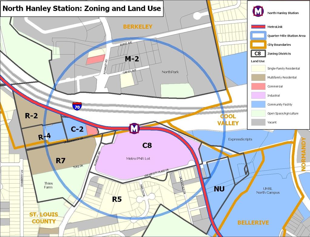
4 Neighborhood Context: Summary The North Hanley MetroLink station is located directly south of Interstate 70, and Hanley Road runs north-south through the western portion of the station area. A 20-acre, 1,700-space, Metro-owned parking lot and garage are located directly south of the station. South of the Park-Ride Lot, across University Place, is a neighborhood of one- to two-story single-family homes. Low-density, two-story apartments are located west of Hanley Road. The Express Scripts headquarters is located east of the station, and just east of that sits the University of Missouri St. Louis campus. North of I-70 is a vast amount of vacant land, a hotel, and a newly-constructed corporate office (another Express Scripts location). Most of the land in this area is slated for development as a corporate/research park known as NorthPark, though it is unclear if and how the current recession has impacted those plans. The map on this page illustrates the general station location and quarter-mile station area. The map on the following page provides a more detailed description of existing land uses and development patterns within that quarter-mile area. 4

5 5

6 6
7 Zoning, Land Use Policies, and Community Plans The quarter-mile station area is divided between two jurisdictions, St. Louis County and the City of Berkeley. The block containing the ExpressScripts headquarters is within the City of Cool Valley, but that city s zoning is not discussed in this section because the block is already fully occupied by a large corporate campus. The map and table on the following pages illustrate and explain current zoning regulations. Lots within the quarter-mile station area are covered by one of the following zoning districts: St. Louis County R5, Single-Family Residential R7, Multi-Family Residential C8, Planned Commercial District NU, Non-Urban Area City of Berkeley R-2, Single-Family Residential R-4, Multiple-Family Residential C-2, General Commercial M-2, Planned Research and Industrial Potential Development Opportunities and Issues Availability of land: There is a very substantial amount of vacant land within the quarter-mile station area. Metro owns and operates a 20-acre Park-Ride Lot containing 1,705 parking spaces, directly south of the MetroLink Station. Metro may have an interest in joint development on this property. There are also two large concentrations of vacant land south of University Place and one north of I-70, together totaling another 20 acres of vacant land. These large parcels may offer some potential for new and infill TOD. Zoning: Some of the existing zoning regulations within the quarter-mile station area may support new transitoriented development, while other zoning districts may inhibit or limit it. One area where the current regulations may support new TOD is the large parcel containing the North Hanley Station and Metro s Park-Ride Lot. That lot is within St. Louis County and is zoned C8: Planned Commercial District. The C8 District allows considerable flexibility under broad development parameters, in return for a more thorough public review and site plan approval process. There is an approved site plan for the North Hanley Station on file; however, the County has an established process for amending existing C8 site plans. In addition to the C8 District which encompasses Metro s 20-acre Park-Ride Lot, there are other zoning districts that may allow certain types of new TOD: NorthPark, north of I-70, is within the City of Berkeley s M-2 District. The M-2 District could support an industrial and business-centered form of TOD. The M-2 District allows a very wide range of industrial, office, and research facilities, as well as supportive retail and personal services by special permit. It also establishes a liberal building envelope of 90, though buildings may reach heights of 700 by special permit. *Note: maximum building height within the North Hanley station area may be impacted by FAA and local zoning regulations for airport flight paths. However, the M-2 District does require 40 front yards and side yards, which may inhibit a more compact, pedestrian-oriented business district. Residential and mixed-use buildings are not allowed. Medium- to high-density apartment buildings and mixed-use development are permitted in a limited portion of the station area, south of Dragonwyck Drive and west of Hanley Road. These blocks are within St. Louis County and are zoned R7: Multi-Family Residential. The R7 District allows all housing types, as well as mixed-use buildings so long as the retail portion is limited to 5% of floor area. The R7 allows buildings up to 200, though that building envelope may be impacted by Lambert Airport s flight paths. Apartment buildings do require a 20 front yard, 10 side yards, and a minimum lot area of 1,750 sq. ft. per dwelling unit, which would result in a considerable amount of open space surrounding each apartment building. These lots are already occupied by a two-story garden apartment complex and Thies Farm. 7
8 Other zoning districts within the quarter-mile station area may prove more problematic for new TOD: South and east of the Metro Park-Ride Lot, multi-family housing and mixed-use development is not permitted. All of the blocks south of the Metro Park-Ride Lot are within St. Louis County s R5 District, which allows only single-family homes and limited community facilities. However, the R5 District does allow singlefamily row houses, which may support a lower-density, single-family type of TOD. The block east of the MetroLink rail line is within the County s NU: Non-Urban District, which limits development to very lowintensity uses such as agriculture, schools, and single-family homes, all requiring a minimum lot area of three acres. Large public institutions may be allowed by special permit. West of Hanley Road and north of Dragonwyck Drive, mixed-use development is not allowed, and multifamily housing is limited. These blocks are all within the City of Berkeley, and covered by one of three zoning districts. The R-2 District in the westernmost part of the station area is limited to single-family homes and community facilities. The R-4 District allows apartments up to two-and-a-half stories, but does not allow any commercial uses. The C-2 District at the intersection of Dragonwyck Drive and Hanley Road allows a wide range of retail, services, and offices, but does not allow residential uses. Low-scale building heights: Aside from the C8 and R7 Districts described above, buildings in the southern portion of the station area are limited to heights of two to three stories. Minimum lot and yard sizes: The R-2 and R5 residential districts require lots ranging from 6,000 7,500 sq. ft. in size; though these districts do not establish a minimum lot width, those lot sizes will often require of lot frontage. The R-4 and R7 Districts require a minimum lot area of 1,750 3,000 sq. ft. per dwelling unit, which will require a considerable amount of open space surrounding each apartment building. All of these districts require front yards ranging from and two side yards. These requirements may limit the potential for a suburban model of transit-supportive density and compact, walkable TOD. Minimum parking requirements: St. Louis County s R5 District requires only one parking space per singlefamily home, but all other residential districts require one-and-a-half to two parking spaces per dwelling unit. Retail and office uses generally require one parking space for every sq. ft. of floor area. These parking thresholds may not reflect close proximity to a rail and bus transit center, and requires lot or floor area that could be dedicated to more active, remunerative uses. 8
9 9
10 Table 5: North Hanley Station, Existing Zoning St. Louis County City of Berkeley District Type R5 R7 C8 NU R-2 R-4 C-2 M-2 Single-family residential Multifamily Residential Planned Commercial District Non-Urban District Single-Family Residential Multifamily Residential General Commercial District Planned Research & Industrial Uses Permitted 1-family detached homes/rowhouses; community facilities; churches All residential; mixeduse (retail up to 5% floor area); churches; day care; community facilities As per approved development/site plan 1-family homes; agriculture; parks; schools; churches; community facilities 1-family homes All residential types Range of retail, services, and office uses Light industrial; offices; research labs; limited food/ beverage; wholesale; warehousing By Special Permit Hospitals; group homes; day care; nursing homes; utilities; parking lot Hospitals; group homes; day care; nursing homes; utilities N/A Range of healthcare; large institutions; lumber & ore processing; other Churches; community facilities; schools; nursing and group homes; hospitals Same as R-2, plus frontyard parking All residential; community facilities; restaurants; bars; gas stations; public garages/lots; others Hotels; general retail; financial institutions; churches; day care Minimum Lot Area Res: 6,000 sq.ft. 1-fam: 4,500 sq.ft./du; 2-fam: 2,500 sq.ft./du: 3-fam: 2,000 sq.ft./du; 4-fam+: 1,750 sq.ft./du As per site plan 3+ acres (includes 1- family homes) 7,500 sq.ft. 1-fam: 7,500 sq.ft./du; 2-fam: 3,750 sq.ft./du; Other: 3,000 sq.ft./du N/A N/A Maximum Building Height Res: 3 stories / 45'; other: 60' 200' As per development/site plan As per flight path regs; nursing homes = 3 stories/45' 2.5 stories / 35' 2.5 stories / 35' 3 stories / 45' 90'; up to 700' by special permit Minimum Front Yard 20' 20' 50' 30' 25' 25' 40' Minimum Side Yard 6' for detached structures As per site plan, but minimum requirement = 10' + additional depth for buildings over 30' in height. 1-family: 5'; other: 10' 20' 7' 7' 5' Minimum Rear Yard 15' 15' 20' 20% of lot depth or 30' min, 45' max 20% of lot depth or 30' min, 45' max Res: 25'; Other: 10' 30', 50' adjacent to R- District 30', 50' adjacent to R- District Parking 1 per DU 1-family = 1 per DU, Other = 1.5 per DU By use, generally ranges 3-5 spaces per 1,000 sq.ft. 2 per DU 2 per DU 2 per DU Residential = 2 per DU; Retail = 1 per 200 sq.ft.; Med clinic = 1 per 200 sq.ft.; Office = per 400 sq.ft. over 3,000sq.ft. Research = 1 per employee; Office = 1 per 300 sq.ft.; Retail = 1 per 200 sq.ft. Miscellaneous Residential districts generally allow front yard line-up to match average front yard depth on each street. The R7 District requires a minimum distance between buildings on adjacent lots of 50' or more. In general, front yard parking for residential uses only allowed by special permit. Height limit for public buildings = 60', for churches = 75'. In R7, apartment complexes with more than 2 buildings have additional site planning requirements. 10
Arch-Laclede s Landing Station
 Arch-Laclede s Landing Station This station profile describes existing conditions around the Arch-Laclede s Landing MetroLink Station. This is one of a set of profiles for each of the MetroLink System
NOVEMBER 2016 AARP IN ST. LOUIS & CITIZENS FOR MODERN TRANSIT PLACEMAKING STRATEGIES FOR ST. LOUIS TRANSIT DRAFT
 NOVEMBER 2016 AARP IN ST. LOUIS & CITIZENS FOR MODERN TRANSIT PLACEMAKING STRATEGIES FOR ST. LOUIS TRANSIT DRAFT APPENDIX AARP IN ST. LOUIS + CMT + ARCTURIS + THE INNIS GROUP 51 APPENDIX APPENDIX A - RIDERSHIP
Downtown Stations: 8 th & Pine and Convention Center
 Downtown Stations: 8 th & Pine and Convention Center This station profile describes existing conditions around two MetroLink Stations in Downtown St. Louis, the 8 th & Pine and Convention Center Stations.
Forest Park DeBaliviere Station
 Forest Park DeBaliviere Station This station profile describes existing conditions around the Forest Park-DeBaliviere MetroLink Station. This is one of a set of profiles for each of the MetroLink System
MONTGOMERY COUNTY RENTAL HOUSING STUDY. NEIGHBORHOOD ASSESSMENT June 2016
 MONTGOMERY COUNTY RENTAL HOUSING STUDY NEIGHBORHOOD ASSESSMENT June 2016 AGENDA Model Neighborhood Presentation Neighborhood Discussion Timeline Discussion Next Steps 2 WORK COMPLETED Socioeconomic Analysis
From Policy to Reality
 From Policy to Reality Updated ^ Model Ordinances for Sustainable Development 2000 Environmental Quality Board 2008 Minnesota Pollution Control Agency Funded by a Minnesota Pollution Control Agency Sustainable
UrbanFootprint Place Types. Urban Mixed Use. Urban Residential. Urban Commercial. Residential 1% SF Large Lot 0%
 Urban Mixed Use Residential 18% SF Large Lot 0% Employment 16% SF Small Lot 0% Mixed Use 45% Townhome 0% Open Space/Civic 21% MultiFamily 100% Intersections per mi 2 200 Office 80% Average Floors 23 Retail
MPN. S broad street corner development site. 701 s broad street, philadelphia, pa 19147
 S broad street corner development site 701 s broad street, philadelphia, pa 19147 1601 Walnut St, Philadelphia, PA 19102 215.413.4900 www.mpnrealty.com corner development site FOR SALE 701 s broad street
DIVISION 7. R-6 AND R-6A RESIDENTIAL ZONES* The purpose of the R-6 residential zone is:
 Date of Draft: March 6, 2015 DIVISION 7. R-6 AND R-6A RESIDENTIAL ZONES* Sec. 14-135. Purpose. The purpose of the R-6 residential zone is: (a) To set aside areas on the peninsula for housing characterized
III. Housing Profile and Analysis
 III. Housing Profile and Analysis 3-1 III. Housing Profile and Analysis A. Housing Types Information on the type of housing available is important to have a clear picture of what Lacey has in its housing
Affordability. Housing that is Affordable, Not Affordable Housing. Neighborhoods NOW Conference November 10, 2016
 Housing that is Affordable, Not Affordable Housing Neighborhoods NOW Conference November 10, 2016 Prepared by Greenstreet Ltd. Greenstreet Ltd. All rights reserved 2016. At some point during the 2000s,
Rural Living (RL) Rural Living
 Rural Living") Place Types Rural Living (RL) Rural Living Rural living areas are characterized by very large lots, abundant open space, pastoral views, and a highdegree of separation between buildings. The lots are typically
Place Types Rural Living (RL) Rural Living Rural living areas are characterized by very large lots, abundant open space, pastoral views, and a highdegree of separation between buildings. The lots are typically
LONG-RANGE LAND USE PLAN
 LONG-RANGE LAND USE PLAN INTENT Completion of the I-66/Route 29 interchange and future expansion of improved telecommunication networks will substantially improve the desirability of the Gainesville area
PLANNING AND IMPLEMENTING TOD: KEY FACTORS FOR SUCCESS. Sujata Srivastava Knowledge Corridor TOD Workshop June 5, 2013
 PLANNING AND IMPLEMENTING TOD: KEY FACTORS FOR SUCCESS Sujata Srivastava Knowledge Corridor TOD Workshop June 5, 2013 6-year old partnership dedicated to improving practice through technical assistance,
PLANNING ANALYSIS ZONING CASE 18-TOD-Z-026 NAK S CROSSING PUD AMENDMENT. GC-3-A (General Commercial) GC-3-A (General Commercial)
 GC-3-A (General Commercial)") PLANNING ANALYSIS ZONING CASE 18-TOD-Z-026 NAK S CROSSING PUD AMENDMENT GENERAL INFORMATION Applicant/Owner: Current Zoning: Bruce Nakfoor PUD/TOD (Planned Unit Development/Transit Oriented Development
PLANNING ANALYSIS ZONING CASE 18-TOD-Z-026 NAK S CROSSING PUD AMENDMENT GENERAL INFORMATION Applicant/Owner: Current Zoning: Bruce Nakfoor PUD/TOD (Planned Unit Development/Transit Oriented Development
Generic Environmental Impact Statement. Build-Out Analysis. City of Buffalo, New York. Prepared by:
 Generic Environmental Impact Statement Build-Out Analysis City of Buffalo, New York 2015 Prepared by: TABLE OF CONTENTS 1.0 INTRODUCTION 1 2.0 METHODOLOGY 2 3.0 EXISTING LAND USE 3 4.0 EXISTING ZONING
2401 Wilson Boulevard General Land Use Plan Amendment Study
 2401 Wilson Boulevard General Land Use Plan Amendment Study Long Range Planning Committee Meeting Presentation Compendium March 29, 2011 Department of Community Planning, Housing and Development GLUP Amendment
Existing Land Use. Typical densities for single-family detached residential development in Cumberland County: 1
 Existing Land Use A description of existing land use in Cumberland County is fundamental to understanding the character of the County and its development related issues. Economic factors, development trends,
Appendix A: Guide to Zoning Categories Prince George's County, Maryland
 Appendix A: Guide to Zoning Categories Prince George's County, Maryland RESIDENTIAL ZONES 1 Updated November 2010 R-O-S: Reserved Open Space - Provides for permanent maintenance of certain areas of land
FOR SALE 140 N. BRENTWOOD CLAYTON, MO FOR SALE DOWNTOWN CLAYTON OPPORTUNITY LAND AVAILABLE FOR REDEVELOPMENT
 FOR SALE 140 N. BRENTWOOD CLAYTON, MO FOR SALE DOWNTOWN CLAYTON OPPORTUNITY LAND AVAILABLE FOR REDEVELOPMENT TABLE OF CONTENTS Section1 Section 2 Section 3 Section 4 Offering Summary Development Opportunity
COMMERCIAL AND MIXED USE zones COMMERCIAL AND MIXED USE ZONES. Zoning By-law PLANNING & ECONOMIC DEVELOPMENT PLANNING DEPARTMENT DIVISION
 Zoning By-law 05-200 COMMERCIAL AND MIXED USE zones PLANNING & ECONOMIC DEVELOPMENT PLANNING DEPARTMENT DIVISION CONTENTS CONTEXT... 1 URBAN HAMILTON OFFICIAL PLAN... 2 COMMERCIAL AND MIXED USE ZONES...
APPENDIX C CHARACTERISTICS OF THE ENERGIZE PHOENIX CORRIDOR
 APPENDIX C CHARACTERISTICS OF THE ENERGIZE PHOENIX CORRIDOR BACKGROUND ON RESIDENTIAL AND COMMERCIAL BUILDINGS IN THE EP CORRIDOR The 10-mile EP corridor (Figure G1) is a highly diverse, mixed-use L-shaped
DRAFT. Amendment to the Master Plan Land Use Element for Block 5002, Lot Township of Teaneck, Bergen County, New Jersey.
 DRAFT Amendment to the Master Plan Land Use Element for Block 5002, Lot 18.01 Township of Teaneck, Bergen County, New Jersey Prepared for: Township of Teaneck Planning Board Prepared by: Janice Talley,
1057 Canton RD Marietta, GA 30066
 1057 Canton RD Marietta, GA 30066 +/- 1.49 Acres Presently Zoned LI $350,000 With all utilities available. Very little lot prep necessary for most uses. Two Level steppes descending from the street level.
POPULATION FORECASTS
 POPULATION FORECASTS Between 2015 and 2045, the total population is projected to increase by 373,125 residents to reach 2.2 million. Some areas will see major increases, while other areas will see very
Missing Middle Housing Types Showcasing examples in Springfield, Oregon
 Missing Middle Housing Types Showcasing examples in Springfield, Oregon MissingMiddleHousing.com is powered by Opticos Design Illustration 2015 Opticos Design, Inc. Missing Middle Housing Study Prepared
Route 6 Corridor Study Bristol Planning Commission Meeting #1. May 25, 2016 FITZGERALD & HALLIDAY, INC. Innovative Planning, Better Communities
 Route 6 Corridor Study Bristol Planning Commission Meeting #1 May 25, 2016 FITZGERALD & HALLIDAY, INC. Innovative Planning, Better Communities Today s Agenda 1. Introductions 2. Study overview Scope Schedule
Transit Oriented Development - Trip Generation & Mode Split in the Portland Metropolitan Region
 Transit Oriented Development - Trip Generation & Mode Split in the Portland Metropolitan Region Michael Lapham Portland State University March 2001 Table of Contents Introduction... 3 T.O.D. Definition..3
1265 Montecito Avenue Mountain View, California
 OFFERING MEMORANDUM Mountain View Redevelopment Site 1265 Montecito Avenue Mountain View, California NON-ENDORSEMENT & DISCLAIMER NOTICE NON-ENDORSEMENTS Marcus & Millichap is not affiliated with, sponsored
January Salem Housing Needs Analysis and Economic Opportunities Analysis. Draft Summary Report. ECONorthwest
 January 2015 Salem Housing Needs Analysis and Economic Opportunities Analysis Draft Summary Report ECONorthwest SUMMARY OF FINDINGS Summary of Findings Salem is Oregon s capital city and the regional economic
HOUSING ELEMENT TABLE OF CONTENTS INTRODUCTION...HO- 1 BAINBRIDGE ISLAND SNAPSHOT: PEOPLE AND HOUSING.. HO-1
 HOUSING ELEMENT TABLE OF CONTENTS PAGE INTRODUCTION...HO- 1 BAINBRIDGE ISLAND SNAPSHOT: PEOPLE AND HOUSING.. HO-1 GMA GOAL AND REQUIREMENTS FOR HOUSING. HO-1 HOUSING NEEDS..HO-2 HOUSING ELEMENT VISION...HO-3
Town of Prescott Valley 2013 Land Use Assumptions
 Town of Prescott Valley 2013 Land Use Assumptions Raftelis Financial Consultants, Inc. November 22, 2013 Table of Contents Purpose of this Report... 1 The Town of Prescott Valley... 2 Summary of Land Use
Housing Study & Needs Assessment
 Housing Study & Needs Assessment Phase II Public Engagement Presentation #2 Winston-Salem, North Carolina January 25, 2018 MEETING OVERVIEW Welcome & Introductions Purpose & Goals Community Discussions
Article 04 Single Family Residential Districts
 Article 04 Article 04 Section 04.01 Intent (a) R1A Residence District. The R1A Single Family Residential District is established to include areas of low density single-family residences and limited agricultural
Real Estate Market Analysis
 One of the challenges facing the West Berkeley shuttle is to consider whether to expand the service beyond the current operations serving major employers, to a system that provides access to a more diverse
ARTICLE 3: Zone Districts
 ARTICLE 3: Zone Districts... 3-1 17.3.1: General...3-1 17.3.1.1: Purpose and Intent... 3-1 17.3.2: Districts and Maps...3-1 17.3.2.1: Applicability... 3-1 17.3.2.2: Creation of Districts... 3-1 17.3.2.3:
Bylaw No , being "Official Community Plan Bylaw, 2016" Schedule "A" DRAFT
 Bylaw No. 2600-2016, being "Official Community Plan Bylaw, 2016" Schedule "A" Urban Structure + Growth Plan Urban Structure Land use and growth management are among the most powerful policy tools at the
Appendix B: Housing Element Sites Inventory and Detailed Analysis
 Appendix B: 2015-2023 Housing Element Sites Inventory and Detailed Analysis Redwood City General This page intentionally left blank. Redwood City General Site Identifier Assessor Parcel Number General
REQUEST STAFF RECOMMENDATION. On April 26, 2012, Signature Books Inc., represented by Dave Richards, submitted petitions for the following amendments:
 PLANNING COMMISSION STAFF REPORT Signature Books Zoning Map Amendment and an Amendment to the North Temple Area Plan Petitions PLNPCM2012-00254 PLNPCM2012-00255 July 11, 2012 Planning Division Department
PART 3 RESIDENTIAL ZONING DISTRICTS. Designation of Residential Zoning Districts and Purpose Statements.
 PART 3 S Section 301. Designation of and Purpose Statements. See Table 3-1 herein this Section for the designations and purpose statements of the respective Residential Zoning Districts which are shown
UPDATE Board of Selectmen June 20, 2017
 MAPLE STREET I-1 AREA DRAFT ZONING BYLAW & DEVELOPMENT STANDARDS Town of Danvers, MA UPDATE Board of Selectmen June 20, 2017 The Danvers Team: Brovitz Community Planning & Design Dodson & Flinker Danvers
Attachment 3. Guelph s Housing Statistical Profile
 Attachment 3 Guelph s Housing Statistical Profile Table of Contents 1. Population...1 1.1 Current Population (26)...1 1.2 Comparative Growth, Guelph and Ontario (21-26)...1 1.3 Total Household Growth (21
Chapter 5: Testing the Vision. Where is residential growth most likely to occur in the District? Chapter 5: Testing the Vision
 Chapter 5: Testing the Vision The East Anchorage Vision, and the subsequent strategies and actions set forth by the Plan are not merely conceptual. They are based on critical analyses that considered how
ATTACHMENT C. Development Requirements
 ATTACHMENT C Development Requirements Development Codes, also known as Municipal Codes, were reviewed for each station and compiled by jurisdiction. Only those zoning designations located within 0.5 mile
Aspen Dental & Good Feet
 Aspen Dental & Good Feet [ subject property ] INFILL KANSAS CITy MSA MEDICAL USE TENANTS 1680 NW Chipman Road, Lee s Summit, MO 64081 investment highlights THE SUBJECT PROPERTY IS THE HARD CORNER PAD ENTRANCE
PIN , Part 1, Plan SR-713 in Lot 2, Concession 5, Township of McKim (1096 Dublin Street, Sudbury)
") STAFF REPORT Applicant: Dalron Construction Limited Location: PIN 02124-0103, Part 1, Plan SR-713 in Lot 2, Concession 5, Township of McKim (1096 Dublin Street, Sudbury) Official Plan and Zoning By-law:
STAFF REPORT Applicant: Dalron Construction Limited Location: PIN 02124-0103, Part 1, Plan SR-713 in Lot 2, Concession 5, Township of McKim (1096 Dublin Street, Sudbury) Official Plan and Zoning By-law:
forwarddallas! Development Code Amendments Approach Quality of Life Committee Briefing June 11, 2007
 1 forwarddallas! Development Code Amendments Approach Quality of Life Committee Briefing June 11, 2007 2 Project Background The forwarddallas! Comprehensive Plan provides the foundation and launching pad
4 LAND USE 4.1 OBJECTIVES
 4 LAND USE The Land Use Element of the Specific Plan establishes objectives, policies, and standards for the distribution, location and extent of land uses to be permitted in the Central Larkspur Specific
RAE EXCLUSIVE RESIDENTIAL ZONE A residential district exclusively for low density single family housing and accessory uses.
 KNOX COUNTY ZONING ORDINANCE DISTRICT SUMMARY REQUIREMENTS 2/11/2009 RAE EXCLUSIVE RESIDENTIAL ZONE A residential district exclusively for low density single family housing and accessory uses. 10,000 sq.
Future Land Use Categories & Nodes December 23, Future Land Use Categories
 Future Land Use Categories & Nodes December 23, 2015 A note regarding nodes: Descriptions for nodes are located in the general recommendations handout. Node locations are set in part by the Auburn Interactive
Addressing the Impact of Housing for Virginia s Economy
 Addressing the Impact of Housing for Virginia s Economy A REPORT FOR VIRGINIA S HOUSING POLICY ADVISORY COUNCIL NOVEMBER 2017 Appendix Report 2: Housing the Commonwealth's Future Workforce 2014-2024 Jeannette
MONROE WARD REZONING SUMMARY. October 2018
 MONROE WARD REZONING SUMMARY October 2018 WHY IS THE CITY REZONING MONROE WARD? In July of 2017 Richmond City Council adopted The Pulse Corridor Plan, a corridor-long planning document that outlines steps
Southwest Corner of Chesterfield Airport Road & Public Works Drive Chesterfield (Suburban St. Louis), MO
, MO") Southwest Corner of Chesterfield Airport Road & Public Works Drive Chesterfield (Suburban St. Louis), MO INVESTMENT HIGHLIGHTS S U B J E C T O F F E R I N G Mid-America Real Estate Corporation and Pace
Southwest Corner of Chesterfield Airport Road & Public Works Drive Chesterfield (Suburban St. Louis), MO INVESTMENT HIGHLIGHTS S U B J E C T O F F E R I N G Mid-America Real Estate Corporation and Pace
Implementation. Approved Master Plan and SMA for Henson Creek-South Potomac 103
 Implementation Approved Master Plan and SMA for Henson Creek-South Potomac 103 104 Approved Master Plan and SMA for Henson Creek-South Potomac Sectional Map Amendment The land use recommendations in the
DRAFT Plan Incentives. Part A: Basic Discount
 DRAFT 2030 Plan Incentives July 26, 2006 Part A: Basic Discount In order for a development to be eligible for any 2030 Land Resource Management Plan Discounts it must be located in the Urban Corridor and
Market Analysis and TOD Locations
 Market Analysis and TOD Locations June 5, 2017 FINAL DRAFT Ogdenonboard.com Strong Connections, Strong Neighborhoods TABLE OF CONTENTS Executive Summary 3 Market Strength 3 Market Demand 4 Market Supply
Report by Planning, Program Development and Real Estate Committee (B)
") Report by Planning, Program Development and Real Estate Committee (B) 03-26-2015 Washington Metropolitan Area Transit Authority Board Action/Information Summary Action Information MEAD Number: 201316 Resolution:
Report by Planning, Program Development and Real Estate Committee (B) 03-26-2015 Washington Metropolitan Area Transit Authority Board Action/Information Summary Action Information MEAD Number: 201316 Resolution:
Flatbush Rezoning and Text Amendments LR Item 3: Description of Proposal
 Project Description The New York City Department of City Planning (DCP), at the request of Community Board 14, elected officials and civic groups, proposes zoning map changes and zoning text amendments
6 NE 130TH STREET STATION TOD POTENTIAL
 6 NE 130TH STREET STATION TOD POTENTIAL Key Findings TOD potential for the NE 130th Street Station is limited, primarily because of the predominant single-family development pattern in this area. The two
Transit Oriented Communities Affordable Housing Incentive Program Guidelines (TOC Guidelines)
") Transit Oriented Communities Affordable Housing Incentive Program Guidelines (TOC Guidelines) Implementing Section 6 of Measure JJJ, approved by the voters in November 2016, and added to Los Angeles Municipal
Transit Oriented Communities Affordable Housing Incentive Program Guidelines (TOC Guidelines) Implementing Section 6 of Measure JJJ, approved by the voters in November 2016, and added to Los Angeles Municipal
Demographics Review Multi-family Housing Data & Characteristics. Triplexes, quadplexes, and apartments. Development Potential Future Considerations
 Horizon Discussion: Arlington 2012 Multi-Family Housing Profile City Council Meeting September 17, 2013 6 Overview Demographics Review Multi-family Housing Data & Characteristics Triplexes, quadplexes,
AUBURN BANKSTOWN BLACKTOWN HOLROYD PARRAMATTA THE HILLS. West Central District Demographic & Economic Characteristics
 AUBURN BANKSTOWN BLACKTOWN HOLROYD PARRAMATTA THE HILLS West Central District Demographic & Economic Characteristics Contents The West Central District 3 People 4 Population 4 Age Profile 6 Households
A TRIBECA AREA FACT FILE
 03 A TRIBECA AREA FACT FILE SOUTH WEST MELBOURNE FOCUS AREA: TARNEIT AREA PROFILE AREA PROFILE: This report encompasses the South West Melbourne growth precinct of Wyndham. Specifically, the demographic
CHAPTER 1272 R-3-B (MULTI FAMILY RESIDENTIAL- SENIOR CITIZEN-2)
") CHAPTER 1272 R-3-B (MULTI FAMILY RESIDENTIAL- SENIOR CITIZEN-2) 1272.01 PURPOSE: The R-3-B (Multi Family Residential Senior Citizen-2) zoning district has been established to provide a broad range of residential
CHAPTER 1272 R-3-B (MULTI FAMILY RESIDENTIAL- SENIOR CITIZEN-2) 1272.01 PURPOSE: The R-3-B (Multi Family Residential Senior Citizen-2) zoning district has been established to provide a broad range of residential
Puyallup Downtown Planned Action & Code Changes. January 10, 2017
 Puyallup Downtown Planned Action & Code Changes January 10, 2017 Purpose & Location Purpose Promote economic development and downtown revitalization Tools: Municipal Code amendments Change development
Comprehensive Plan Amendment #PLN , Reserve at Cannon Branch (Coles Magisterial District)
") COUNTY OF PRINCE WILLIAM 5 County Complex Court, Prince William, Virginia 22192-9201 PLANNING (703) 792-7615 FAX (703) 792-4758 OFFICE Internet www.pwcgov.org Christopher M. Price, AICP Director of Planning
COUNTY OF PRINCE WILLIAM 5 County Complex Court, Prince William, Virginia 22192-9201 PLANNING (703) 792-7615 FAX (703) 792-4758 OFFICE Internet www.pwcgov.org Christopher M. Price, AICP Director of Planning
8Land Use. The Land Use Plan consists of the following elements:
 8Land Use 1. Introduction The Land Use Plan consists of the following elements: 1. Introduction 2. Existing Conditions 3. Opportunities for Redevelopment 4. Land Use Projections 5. Future Land Use Policies
Missing Middle Housing in Practice
 Missing Middle Housing in Practice Daniel Parolek Principal, Opticos Design, Inc. dan@opticosdesign.com New Partners for Smart Growth Kansas City, MO 2013 1 Bungalow Courts Missing MIddle Housing 2012
PLANNING FOR PARKING AROUND MARTA STATIONS. Lindbergh Transit Oriented Development. Lessons Learned & Best Practices
 PLANNING FOR PARKING AROUND MARTA STATIONS Lindbergh Transit Oriented Development Lessons Learned & Best Practices Lindbergh Yesterday Lindbergh Background Lindbergh Station - Built in 1984 - Serves as
Summary Report on the Economic Impact of the State Center Project Baltimore, MD
 Summary Report on the Economic Impact of the State Center Project Baltimore, MD Prepared for: Maryland Department of Transportation Prepared by: BAE Urban Economics March 2011 Summary of Key Findings Phase
Staff Report Zoning Amendment Case Number R #1/18
 Staff Report Zoning Amendment Case Number R #1/18 L o c at i o n m a p/a e r i a l P h o t o g r a p h NCPIN 2840747741 Right: Subject Property N Below: Street View of property Summary Public Comment:
KARMAR REALT Y GROUP, INC. C O M M E R C I A L & I N V E S T M E N T R E A L E S T A T E S E R V I C E S S A L E
 KARMAR REALT Y GROUP, INC. C O M M E R C I A L & I N V E S T M E N T R E A L E S T A T E S E R V I C E S S A L E 99 ALDAN AVENUE, CONCORDVILLE, PA 19331 DESCRIPTION: 30,000 +/- SQ. FT. OF BUILDING FULLY
4.2.8 Westwood/VA Hospital Station Area
 4.2.8 Westwood/VA Hospital Station Area The Westwood/VA Hospital Station area is north of the VA Hospital and surrounded by large, open landscaped areas and several parking lots. I-405 is a prominent visual
DIVISION 1.3 OFFICIAL ZONING MAP
 Article 1. General Provisions Division 1.3 Official Zone Map DIVISION 1.3 OFFICIAL ZONING MAP SECTION 1.3.1 ADOPTION OF OFFICIAL MAP The digital maps created and maintained by the Department of Community
COLINAS DEL ORO ACRES MIXED-USE LAND AVAILABLE FOR SALE
 125.86 ACRES MIXED-USE LAND AVAILABLE FOR SALE 1. EXECUTIVE SUMMARY 2. PROPERTY INFORMATION TABLE OF CONTENTS 3. LOCATION INFORMATION 4. CONTACT INFORMATION 1EXECUTIVE SUMMARY 2 HIGHWAY 74 PERRIS CALIFORNIA
Provide a diversity of housing types, responsive to household size, income and age needs.
 8 The City of San Mateo is a highly desirable place to live. Housing costs are comparably high. For these reasons, there is a strong and growing need for affordable housing. This chapter addresses the
Midwest City, Oklahoma Zoning Ordinance
 2010 Midwest City, Oklahoma Zoning Ordinance 9/2/2010 Table of Contents Section 1. General Provisions... 5 1.1. Citation... 5 1.2. Authority... 5 1.3. Purpose... 5 1.4. Nature and Application... 5 1.5.
PUBLIC NOTICE* Studies Requested: Parking analysis. Other Required Permits: Building Permit, Site Development Permit
 C I T Y O F T A C O M A Planning & Development Services Department 747 Market St, Rm 345 Tacoma, WA 98402 PUBLIC NOTICE* Date of Notification: 1/15/2019 Application Received: 12/03/2018 Application Complete:12/07/2018
739 South Clark Street
 CHICAGO SOUTH LOOP Offering Memorandum For Sale > 30,559 SF (0.70 ACRE) MIXED-USE DEVELOPMENT SITE 739 South Clark Street Chicago, IL NORTH PREPARED BY: Brian Pohl Executive Vice President DIRECT +1 312
DRAFT. Transit Oriented Development Design Guidelines. Introduction. Path Forward
 Transit Oriented Development Design Guidelines Introduction Transit Oriented Development (TOD) Design Guidelines are being developed by the Florida Department of Transportation (FDOT) to provide general
Housing Indicators in Tennessee
 Housing Indicators in l l l By Joe Speer, Megan Morgeson, Bettie Teasley and Ceagus Clark Introduction Looking at general housing-related indicators across the state of, substantial variation emerges but
For Lease Buncombe Road Greenville, South Carolina For More Information, Contact:
 For Lease 1505 Buncombe Road Greenville, South Carolina 29609 Rip Major Associate Industrial & Investment Services O 864.334.4145 F 843.725.7201 C 864.430.5206 rip.major@avisonyoung.com For More Information,
MEARS STREET 4 - PLEX
 AVAILABLE MEARS STREET 4 - PLEX 6210 North Mears Street, Portland, Oregon 97203 PROPERTY HIGHLIGHTS Fully occupied Close proximity to University of Portland Easy Commute to Downtown Portland & St Johns
CHENAL VALLEY LAND Little Rock, AR 21.3+/- Acres Multifamily
 CHENAL VALLEY LAND Little Rock, AR 21.3+/- Acres Multifamily CUSHMAN & WAKEFIELD COMMERCIAL ADVISORS 5101 Wheelis Drive, Suite 300, Memphis, TN 38117 Phone: 901.366.6070 Fax: 901.366.4617 www.commadv.com
Oak Cliff Gateway District PD 468
 Oak Cliff Gateway District PD 468 August 21, 2014 2013 Authorized Hearing Authorized Hearing September, 2013 September 12, 2013 City Plan Commission expanded boundaries to represent current Oak Cliff Gateway
Chapter 1: Community & Planning Context
 Chapter 1: Community & Planning Context Yesterday, Today & Tomorrow Comprehensive Plan 2040 2 INTRODUCTION The City of Lauderdale is a small town with a long history. Nestled between Saint Paul and Minneapolis,
Fundamentals. New ordinance takes effect April 1, 2016
 Fundamentals New ordinance takes effect April 1, 2016 Overall Concept More sustainable, more livable Update and modernize the code Also, make the code easier to read and understand by: Consolidating and
RECOMMENDED ACTION: Council may vote to make specific changes to the draft. Staff will be available to help in guiding specific motions.
 CITY COUNCIL Agenda Item #16-164. Date: June 8, 2016 Consent Discussion _x_ SUBJECT: Presentation of Part 2 Unified Development Bylaws SUBMITTING DEPARTMENT: Planning RECOMMENDED ACTION: Council may vote
Gold Beach Buildable Lands Analysis
 Gold Beach Buildable Lands Analysis Final Report Submitted to: City of Gold Beach Prepared by: Community Planning Workshop Community Service Center 1209 University of Oregon Eugene, OR 97403-1209 http://darkwing.uoregon.edu/~cpw
A project of Neighborhood Projects for Community Revitalization At the Center for Urban and Regional Affairs (CURA) University of Minnesota
 University of Minnesota") Affordable Housing Siting Opportunities in Minneapolis October 2008 Rachel C. Robinson, Author With assistance from Joel Larson A project of Neighborhood Projects for Community Revitalization At the Center
Affordable Housing Siting Opportunities in Minneapolis October 2008 Rachel C. Robinson, Author With assistance from Joel Larson A project of Neighborhood Projects for Community Revitalization At the Center
ARTIST WALK LOCKEHOUSE. CONSTRUCTION ALMOST COMPLETE October 2017 Delivery RETAIL TOWN CENTER FREMONT BOULEVARD FREMONT
 MIXED-USE URBANISTIC RETAIL & RESIDENTIAL COMMUNITY CONSTRUCTION ALMOST COMPLETE October 2017 Delivery FREMONT, California RETAIL TOWN CENTER ±30,300 RETAIL, 185 APARTMENT UNITS Artist Walk is a highly
FOR LEASE IN MEDFORD, OREGON CARDINAL AVE. Cardinal Ave & Crater Lake Hwy, Medford, Oregon
 CRATER LAKE HWY FORMER RETAIL PADS FOR LEASE IN MEDFORD, OREGON ANCHORS OPENING SUMMER 2018! CARDINAL AVE available 10,000 SF available 10,000 SF available 8,490 SF LEAR WAY available 7,000 SF Location
HOUSING TYPES AND CHARACTERISTICS
 HOUSING TYPES AND CHARACTERISTICS Market Study Housing Type Classification Single-Family Detached Townhouse Projected Dwelling Unit Demand 2010-2040 65.7 percent of total 9.1 percent of total Housing Variants
Offered for Sale. Bradfield Creek Townhomes. Presented By:
 Presented By: Multi-Family Investments Mishan Ice, Broker 10000 North Central Expressway, Suite 400 Dallas TX 75231 214-394-0818 mishan@prop-co.com Offered for Sale Bradfield Creek Townhomes 832 Courtenay
EXHIBIT 1 PROJECT DESCRIPTION AND DESCRIPTION OF REQUESTED AREA VARIANCES REDEVELOPMENT OF 201 ELLICOTT STREET
 EXHIBIT 1 PROJECT DESCRIPTION AND DESCRIPTION OF REQUESTED AREA VARIANCES REDEVELOPMENT OF 201 ELLICOTT STREET I. PROJECT DESCRIPTION: Ciminelli Real Estate Corporation (the Applicant ) is seeking area
PLANNING COMMISSION REPORT Regular Agenda - Public Hearing Item
 Z-11-25-09; Z-11-26-09; Z-11-28-09 Item No. 2-1 PC Staff Report 3/28/11 PLANNING COMMISSION REPORT Regular Agenda - Public Hearing Item ITEM NO. 2A RM32 TO MU;.19 ACRES; 1340 TENNESSEE ST (MJL) Z-1-1-11:
ARTICLE III District Regulations. A map entitled "Franklin Zoning Map" is hereby adopted as part of this chapter 1.
 ARTICLE III District Regulations ~ 305-8. Adoption of Zoning Map. A map entitled "Franklin Zoning Map" is hereby adopted as part of this chapter 1. ~ 305-9. Official Zoning Map; amendments. Regardless
ARTIST WALK. NOW UNDER CONSTRUCTION July 2017 Delivery RETAIL TOWN CENTER. FREMONT, California MIXED-USE URBANISTIC RETAIL & RESIDENTIAL COMMUNITY
 MIXED-USE URBANISTIC RETAIL & RESIDENTIAL COMMUNITY NOW UNDER CONSTRUCTION July 2017 Delivery FREMONT, California RETAIL TOWN CENTER ±29,300 RETAIL, 185 APARTMENT UNITS 37100-37140 37070-37222 FREMONT
2015 Downtown Parking Study
 2015 Downtown Parking Study City of Linden Genesee County, Michigan November 2015 Prepared by: City of Linden Downtown Development Authority 132 E. Broad Street Linden, MI 48451 www.lindenmi.us Table of
RETAIL PAD FOR SALE OR LAND LEASE
 Retail Pad for Sale or Land Lease 215 E. Sunshine, Springfield, MO 65807 Retail Pad site available for sale or land lease on East Sunshine just east of Campbell Located half a block from Bass Pro Shops