A project of Neighborhood Projects for Community Revitalization At the Center for Urban and Regional Affairs (CURA) University of Minnesota
|
|
|
- Gary Harrison
- 5 years ago
- Views:
Transcription
1 Affordable Housing Siting Opportunities in Minneapolis October 2008 Rachel C. Robinson, Author With assistance from Joel Larson A project of Neighborhood Projects for Community Revitalization At the Center for Urban and Regional Affairs (CURA) University of Minnesota
, which connects the resources of the University of Minnesota with the interests and needs of urban communities and the region")
2 NPCR is coordinated by the Center for Urban and Regional Affairs (CURA) at the University of Minnesota. NPCR is supported by the McKnight Foundation. This is a publication of the Center for Urban and Regional Affairs (CURA), which connects the resources of the University of Minnesota with the interests and needs of urban communities and the region for the benefit of all. CURA pursues its urban and regional mission by facilitating and supporting connections between state and local governments, neighborhoods, and nonprofit organizations, and relevant resources at the University, including faculty and students from appropriate campuses, colleges, centers or departments. The content of this report is the responsibility of the author and is not necessarily endorsed by NPCR, CURA or the University of Minnesota. 200 by The Regents of the University of Minnesota. This work is licensed under the Creative Commons Attribution- NonCommercial- ShareAlike 3.0 Unported License. To view a copy of this license, visit nc- sa/3.0/ or send a letter to Creative Commons, 444 Castro Street, Suite 900, Mountain View, California, 94041, USA. Any reproduction or distribution of this work under this license must be accompanied by the following attribution: The Regents of the University of Minnesota. Reproduced with permission of the University of Minnesota s Center for Urban and Regional Affairs (CURA). Any derivative use of this work must be licensed under the same terms and accompanied by the following attribution: Adapted with permission of the University of Minnesota s Center for Urban and Regional Affairs (CURA) from [the complete bibliographic citation for this report, including author, title, place of publication, publisher, and date]. For permissions beyond the scope of this license, contact the CURA editor. This publication may be available in alternate formats upon request. Center for Urban and Regional Affairs (CURA) University of Minnesota 330 HHH Center th Avenue South Minneapolis, Minnesota Phone: (612) Fax: (612) E- mail: cura@umn.edu Web site: The University of Minnesota is committed to the policy that all persons shall have equal access to its programs, facilities, and employment without regard to race, color, creed, religion, national origin, sex, age, marital status, disability, public assistance status, veteran status, or sexual orientation.
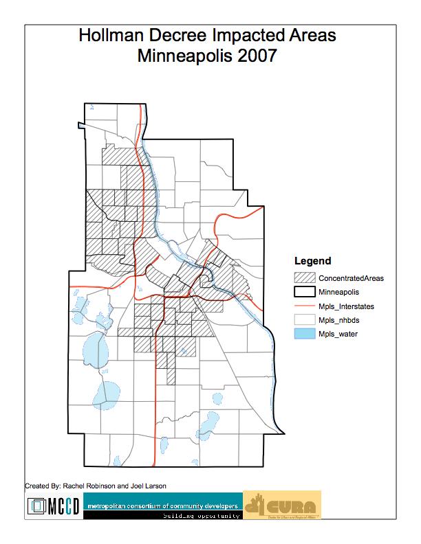
3 This project was supported by the Neighborhood Project for Community Revitalization (NPCR), a program of the Center for Urban and Regional Affairs (CURA) at the University of Minnesota. The content of this report is solely the responsibility of the authors and is not necessarily endorsed by NPCR, CURA or the University of Minnesota. Background: The City of Minneapolis has policies related to concentration of poverty in terms of allocation of Low-Income Housing Tax Credits (LIHTC). While federal policies provide LIHTC favorability for projects to be located in Qualified Census Tracts (QCT), the City policies encourage development outside of areas of concentrated poverty. The City refers to census tracts that meet its definition of concentrated poverty as Impacted Areas. In terms of City policies, proposed affordable housing projects seeking City funds must meet the test of their location in or out of the impacted areas. Projects outside of the impacted areas receive preference in the allocation of public funds. This policy is facially intended to deconcentrate poverty in the central city by encouraging development of affordable housing outside of concentrated areas. (The impacted area policy can be found in Minneapolis City Council Resolution 99R-312). The common understanding of the City policy is that the census tracts considered impacted are those that meet the definition of concentrated poverty and race under the Hollman Decree. The lawsuit gives two definitions of Impacted Areas as such: - Tracts with a minority population greater than 28.69% - Tracts with a population at or below poverty wages of at least 33.5% When the census tracts meeting the definitions above as of the 2000 Census were mapped, the census tracts that would be impacted included tracts mostly in the central city, but also in the far north of the city and scattered throughout the southern portion of the City. To simplify this analysis, we created a map to mimic the impacted area map provided by the City in its Affordable Housing Trust Fund (AHTF) application materials. Project Purpose: The Metropolitan Consortium of Community Developers (MCCD) is based in Minneapolis and follows the mission to work collectively to build strong stable communities by leveraging resources for the development of people and places. MCCD identified an interest among its members to analyze property level data in the context of the City of Minneapolis policy to identify opportunities for affordable housing
4 development in non-impacted areas. MCCD therefore commissioned this study through the Center for Urban and Regional Affairs (CURA). Purpose of the Project: The three main goals of this project are as follows: - To identify land for potential development or redevelopment of affordable housing in non-impacted areas - To develop scoring criteria for multi-family development and use GIS to map opportunities spatially - To analyze the intersection of policies related to development and availability of potential sites Methodology: In order to create graphic representations of potential land development opportunities for multi-family housing in Minneapolis, the following steps were undertaken to determine a scoring system for individual parcels of land in Minneapolis: 1. A working group of affordable housing professionals, who are members of MCCD, worked with the researcher to determine potential scoring criteria for the parcels. 2. The parcel data was cut and overlaid with additional data in database format in order to assign scores to each parcel. 3. Parcels were mapped in GIS by their scores to show a representation of potential areas of redevelopment opportunities based on the project results. Parcel Data: The building block of this project is parcel level data obtained from the Hennepin County Assessor for tax parcels in the county, applicable as of January 1, The data was broken out by city to include only those parcels in Minneapolis, of which there are over 122,000. For each parcel, the county collects and estimates the property market value by land and buildings, the lot sizes and dimensions, and the current land use (by category). The city then collects information on the zoning and planning designations applicable to the parcel and the building condition, which is based on a sight evaluation and is a rating system. Many tax parcels in Minneapolis are undevelopable parcels such as small, irregular lots bounded by public uses (roads) or right-of-ways for roads and utilities. In order to try to capture and remove some of these parcels, we cut all parcels with either lot dimension less than 40 feet. We chose this arbitrary 40-foot minimum for lot width and length because 40 feet is a typical width of a single-family home lot and multi-family affordable housing cannot be achieved on any lot smaller than what would be appropriate for a
5 single-family development. We also cut all properties that fell within a flood zone, as affordable housing developers would not be interested in building in a flood zone area. In addition to parcel data, CURA had developed files showing the location of transit stops, the location of elementary schools and overlays of Minneapolis neighborhoods. We overlaid these files with the parcel data to increase the potential factors of review. Beyond the baseline data availability, it is also possible to review each parcel using combinations of factors and overlay files to determine ratios, proximities, limits and relationships of factors. The parcel data baseline is very limited and presents a multitude of problems for scoring property for its value in the affordable housing development field. First of all, the assessor data has no relationship to the market for land. The properties used in this study are not necessarily available for sale and assessor values may not reflect the market sale price of a property for redevelopment purposes. The parcel data also misses the possibility of potential areas of redevelopment because it does not capture adjacency. Therefore, there may be multiple properties of smaller size that individually do not represent good opportunities for affordable housing development but that as a whole would be development opportunities. The building condition data provided by the city is known to be unreliable in that it is taken by windshield survey and scores are updated within the previous 8 years with no indication of the validity date for each score. We also have no information on whether parcels being rated are already being used as affordable apartments. It follows common sense that a property that is used for affordable housing is likely to score well in terms of rating factors for the potential for affordable housing and will not be counted out. Finally, we have no information on whether property is in an overall undesirable location in terms of market, amenities or aesthetics. MCCD Working Group Criteria Scoring In order to meet the primary goal of identifying opportunities for affordable housing development, MCCD established a working group of affordable housing development professionals to identify quantitative measures derivable from parcel data and available GIS files. The hope is that with the criteria, the measures of developability can be scored and ranked. The working group identified 9 measures of developability and assigned a maximum score of 5 points for each criterion. The maximum total points a parcel can receive are therefore 45 points. Following are the criteria as identified and their weighted scores. Zoning:
6 The zoning of a particular property is an important consideration for affordable housing developers. If appropriate zoning is in place, developers will face fewer obstacles in siting and permitting a property for development. Zoning also is intended to follow comprehensive planning, which should be based on forward-thinking planning for the future of an area s development. If zoning and planning indicate the desire for higher density housing, the area is likely to have the amenities and infrastructure in place or planned to support that type of development. Wherever a zoning change is necessary to permit the development of affordable housing, developers may face more stringent review and potential NIMBY behavior from the surrounding community. For the zoning category scoring, the working group determined that the least likely zoning category for affordable housing development would be single family zones, where neighborhoods are resistant to increased density. The next most possible is industrial zones, where resistance from neighboring properties will be less because there are fewer residents nearby to be concerned. Industrial structure re-use has also been a trend lately in development and the City of Minneapolis zoning code allows residential uses in some industrial zones. Minneapolis also has numerous zones for business and mixed business uses that receive higher scores because they envision incorporating housing as an element of the zone. Finally, higher-density residential zones are already prepared for multi-family development and received the highest score because no zoning change would be required and the site is likely to be prepared in infrastructure and amenities for multi-family uses. Zoning Category Score Single Family Zones 0 Industrial Zones 3 Low-Density Mixed Zones, Business and 4 Community Zones Medium to High Density Residential and 5 High-Density Mixed Zones Land Use The current use of a parcel is instructive in its potential for redevelopment. Certain property uses are low uses of real estate and certain uses are high ordered uses that would be prohibitive to redevelopment. Facilities and infrastructure are difficult to displace and are unlikely to be reused while parking lots, existing residential buildings and vacant land are highly likely to be sought after by affordable housing developers. Land Use Score Utilities, Common Areas and Sports/Rec 0
7 Facilities Bars, Offices, Retail, Institutions, Public 2 Accommodations, Misc. Commercial Single Family Attached, Single Family 3 Detached Mixed Use, Industrial 4 Vehicle-Related Use, General Residential, 5 Multi-family and Vacant Assessor s Building Criteria Parcel Size For affordable housing developers seeking sites for multi-family development, the larger a parcel, the greater flexibility and economy can be achieved in a new development opportunity. The MCCD working group set the following breaks for scoring parcels in Minneapolis Parcel Size Score Less than 5,000 sq. ft. 0 5,001 to 8,000 sq. ft. 1 8,001 to 15,000 sq. ft. 2 15,001 to 28,000 sq. ft. 3 28,001 to 43,559 sq. ft. 4 1 acre or greater 5 Proximity to Existing Multifamily The proximity measure to other existing multifamily is intended to sort parcels by areas of land use. Multifamily housing developers are less likely to achieve approvals to build an apartment complex if no other higher-density housing exists in the neighborhood. Proximity to other Existing Multifamily Score 1 mile or more 0 1,321 feet to 1 mile to 1,320 feet (1 or 2 average city 2 blocks) 101 to 660 feet (same block) 3 31 to 100 feet (within a few parcels) 4 0 to 30 feet (adjacent of across alley) 5 Proximity to High-Frequency Transit
8 The MCCD working group also indicated a preference for housing sites where transit is readily available. Metro Transit designates some bus and rail lines as high-frequency, meaning they run every ten minutes or less. The scoring for transit reflects proximity to a transit stop on one of these lines. Twin Cities based Transit for Livable Communities uses the benchmark of ¼ mile as a walkable distance to transit. Proximity to High-Frequency Transit Stop Score Greater than 2 miles 0 1 mile to 2 miles 1 ¾ to 1 mile 2 ½ to ¾ mile 3 ¼ to ½ mile 4 Less than ¼ mile 5 Proximity to Elementary Schools The working group also identified the availability of an elementary school as a factor in affordable housing siting. We used the same walkability benchmark for elementary school proximity as for transit. Proximity to Elementary School Score Greater than 2 miles 0 1 mile to 2 miles 1 ¾ to 1 mile 2 ½ to ¾ mile 3 ¼ to ½ mile 4 Less than ¼ mile 5 Land Value Ratio The MCCD working group was interested in finding a scoring method to indicate whether existing structures were in good condition. The point being to find properties that are relatively low in value and would be easier to acquire for redevelopment or renovation. To accomplish this, we took the assessed value of the building as a ratio to the assessed value of the building on a parcel. The ratios were divided into quintiles and assigned scores based on their ranking in quintiles. High ratios received low scores because the property is relatively high value in comparison to the land cost. Low ratios received high scores. This category assigned additional points to vacant land because vacant parcels would have a ratio of building to land of 0 and would therefore earn 5 points. Land Value Per Square Foot
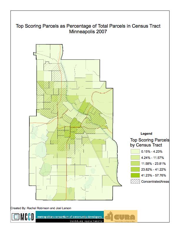
9 As affordability of land is an important siting factor for affordable housing developers, we also analyzed the relative value of land in Minneapolis by square foot. For this scoring criterion, we measured the square foot value of all parcels in Minneapolis and assigned scores based on quintiles with the least expensive land per square foot receiving 5 points. The lowest quintile of land values were those that were $26 or less per square foot while the highest cost $57 per square foot or more. Scoring Results With the scores completed, we found that no properties received a score of 45, but some were very high with scores of 42 and 43. The top 10% of parcels in terms of scores had scores of 38 points or more. The top 20% of parcel scores were scores of 28 points or more. Simply mapping the parcels by their total score as points yields an illegible map, so we determined multiple ways to sort and review the data as a concentration and as a sampling of scores. The attached exhibits show the geographic distribution of high scoring parcels in Minneapolis. As impacted areas are measured by census tract, where scores are represented as a concentration, the denominator is the total number of parcels in the census tract. The overall spatial pattern for the total parcel scores shows a higher concentration of opportunities within the impacted areas than outside of the impacted areas. However, opportunities also exist along the southern end of the I 35W corridor and in areas of North and Northeast Minneapolis that are non-impacted. Following the mapping by score, we also narrowed the project field to isolate potential factors. For instance, if a developer is seeking only vacant land, the opportunities for development are much more limited than for all parcels in Minneapolis. Many of the spatial patterns of the property scores are representative of overall patterns of land value and urban planning in the City of Minneapolis. Exhibit shows the location of parcels that are zoned for multifamily housing. If the property zoning follows comprehensive planning, then the City can be seen as directing development of multifamily housing to those areas. The properly zoned parcels mostly fall within the impacted areas, so there may be an inherent contradiction of City policy in terms of multifamily housing development in that zoning policies encourage development within the impacted areas while impacted area policies discourage it. Opportunities for development are lacking outside of the impacted areas party because city policies do not support multifamily housing. Conclusions
10 The attached maps show a strong relationship between parcels with a high possibility of development and the impacted areas. There are relatively few opportunities outside of the impacted areas. Those factors that make an area impacted under the Minneapolis policy correlate to factors that are desirable in terms of affordable housing development. The impacted areas fall within the central city, where zoning is generally in favor of higher uses, land is less expensive, and transit is more readily available. One possible conclusion to the siting analysis is that the types of opportunities developers are looking for are those that inherently fall within the impacted areas where services and infrastructure are already in place to serve low-income and minority families. The attached maps regarding the zoning of land within Minneapolis help to identify one potential policy solution to the lack of opportunities within the impacted areas. The zoning policies could be aligned better with the impacted area policy to create more opportunities for multi-family growth outside of the central city. Finally, this project offers the opportunity for further investigation of real estate development by affordable housing groups using quantitative measures. Each of the parcels scored corresponds to an address in the City of Minneapolis and it would be possible to take the highest scoring or those meeting certain criteria and review the sites for affordable housing developability. The GIS database and corresponding maps and analysis are held at CURA and could act as a guide for additional research and review of this topic.
11
12
13
14
15
16
17
18
19
20
21
22
23
24
25
26
27
Comparative Housing Market Analysis: Minnetonka and Surrounding Communities
 Comparative Housing Market Analysis: Minnetonka and Surrounding Communities Prepared by Mark Huonder, Eric King, Katie Knoblauch, and Xiaoxu Tang Students in HSG 5464: Understanding Housing Assessment
Homeowner Association Collaboration in Rosemount
 Homeowner Association Collaboration in Rosemount Prepared by Jacob Lundborg Student in LAW 7750: Community Law Practice and Policy Development University of Minnesota Law School Instructor: Nancy Cook
Preventing Foreclosures in North Minneapolis
 Preventing Foreclosures in North Minneapolis An Evaluative Study of the Northside Community Reinvestment Coalition s Foreclosure Prevention Outreach Project Casie Moen, Research Assistant Spring 2010 0
EQUITABLE DEVELOPMENT CITY OF BROOKLYN PARK. Elizabeth Dressel, Elizabeth Showalter, Jared Staley, Mustafa Omar, and Sarah Strain
 EQUITABLE DEVELOPMENT CITY OF BROOKLYN PARK Elizabeth Dressel, Elizabeth Showalter, Jared Staley, Mustafa Omar, and Sarah Strain This work is licensed under a Creative Commons Attribution-NonCommercial
Town of Yucca Valley GENERAL PLAN 1
 Town of Yucca Valley GENERAL PLAN 1 This page intentionally left blank. 3 HOUSING ELEMENT The Housing Element is intended to guide residential development and preservation consistent with the overall values
HOUSING ELEMENT GOALS, OBJECTIVES, & POLICIES
 HOUSING ELEMENT GOALS, OBJECTIVES, & POLICIES GOAL H-1: ENSURE THE PROVISION OF SAFE, AFFORDABLE, AND ADEQUATE HOUSING FOR ALL CURRENT AND FUTURE RESIDENTS OF WALTON COUNTY. Objective H-1.1: Develop a
THDA s Low Income Housing Tax Credit Program Report
 THDA s Low Income Housing Tax Credit Program Report 1987-2013 QAP Priorities, Market & Financial Influences Outcomes of the LIHTC program closely mirror the QAP priorities (set asides, caps and points):
MONTGOMERY COUNTY RENTAL HOUSING STUDY. NEIGHBORHOOD ASSESSMENT June 2016
 MONTGOMERY COUNTY RENTAL HOUSING STUDY NEIGHBORHOOD ASSESSMENT June 2016 AGENDA Model Neighborhood Presentation Neighborhood Discussion Timeline Discussion Next Steps 2 WORK COMPLETED Socioeconomic Analysis
Staff Report & Recommendation Rezoning Case RZ Date of Report: June 6, 2014 Report by: Doug Stacks
 Staff Report & Recommendation Rezoning Case RZ-2014-02 Date of Report: June 6, 2014 Report by: Doug Stacks Hearing Dates: Planning Commission June 26, 2014 Mayor and Council July 14, 2014 GENERAL INFORMATION
RESOLUTION NO ( R)
") RESOLUTION NO. 2013-06- 088 ( R) A RESOLUTION OF THE CITY COUNCIL OF THE CITY OF McKINNEY, TEXAS, APPROVING THE LAND USE ASSUMPTIONS FOR THE 2012-2013 ROADWAY IMPACT FEE UPDATE WHEREAS, per Texas Local
RESOLUTION NO. 2013-06- 088 ( R) A RESOLUTION OF THE CITY COUNCIL OF THE CITY OF McKINNEY, TEXAS, APPROVING THE LAND USE ASSUMPTIONS FOR THE 2012-2013 ROADWAY IMPACT FEE UPDATE WHEREAS, per Texas Local
Appendix A: Guide to Zoning Categories Prince George's County, Maryland
 Appendix A: Guide to Zoning Categories Prince George's County, Maryland RESIDENTIAL ZONES 1 Updated November 2010 R-O-S: Reserved Open Space - Provides for permanent maintenance of certain areas of land
The New Starts Grant and Affordable Housing A Roadmap for Austin s Project Connect
 The New Starts Grant and Affordable Housing A Roadmap for Austin s Project Connect Created for Housing Works by the Entrepreneurship and Community Development Clinic at the University of Texas School of
Housing and Equity Presentation
 Housing and Equity Presentation School of Urban and Regional Planning Class Led by Dr. Chuck Connerly, Dr. John Fuller, and Dr. Phuong Nguyen Eric Hawkinson Kevin Garza This project was supported by the
TASK 2 INITIAL REVIEW AND ANALYSIS U.S. 301/GALL BOULEVARD CORRIDOR FORM-BASED CODE
 TASK 2 INITIAL REVIEW AND ANALYSIS U.S. 301/GALL BOULEVARD CORRIDOR FORM-BASED CODE INTRODUCTION Using the framework established by the U.S. 301/Gall Boulevard Corridor Regulating Plan (Regulating Plan),
Portland Historic Resources Zoning Regulations
 Summary of Portland Historic Resources Zoning Regulations This document summarizes important historic resources-related provisions of Portland s Zoning Code (Title 33: Planning and Zoning). Relevant sections
sliding scale using a project's Walk Score.] No.
![sliding scale using a project's Walk Score.] No.](/thumbs/76/73352026.jpg "sliding scale using a project's Walk Score.] No.") State: MICHIGAN (QAP Michigan State Housing Development Authority (MSHDA) 2013-14) Measure Evidence HOUSING LOCATION: Site and Neighborhood Standards A1. Mandatory restrictions prohibiting increases in
State: MICHIGAN (QAP Michigan State Housing Development Authority (MSHDA) 2013-14) Measure Evidence HOUSING LOCATION: Site and Neighborhood Standards A1. Mandatory restrictions prohibiting increases in
Analysis of Infill Development Potential Under the Green Line TOD Ordinance
 Analysis of Infill Development Potential Under the Green Line TOD Ordinance Prepared for the Los Angeles County Second Supervisorial District Office and the Department of Regional Planning Solimar Research
From Policy to Reality
 From Policy to Reality Updated ^ Model Ordinances for Sustainable Development 2000 Environmental Quality Board 2008 Minnesota Pollution Control Agency Funded by a Minnesota Pollution Control Agency Sustainable
CHAPTER 2 VACANT AND REDEVELOPABLE LAND INVENTORY
 CHAPTER 2 VACANT AND REDEVELOPABLE LAND INVENTORY CHAPTER 2: VACANT AND REDEVELOPABLE LAND INVENTORY INTRODUCTION One of the initial tasks of the Regional Land Use Study was to evaluate whether there is
Place Type Descriptions Vision 2037 Comprehensive Plan
 Place Type Descriptions Vision 2037 Comprehensive Plan The Vision 2037 Comprehensive Plan establishes a range of place types for Oxford, ranging from low intensity (limited development) Rural and Natural
METROPOLITAN COUNCIL S FORECASTS METHODOLOGY
 METROPOLITAN COUNCIL S FORECASTS METHODOLOGY FEBRUARY 28, 2014 Metropolitan Council s Forecasts Methodology Long-range forecasts at Metropolitan Council are updated at least once per decade. Population,
North Saint Paul A Live/Work Development Proposal
 5/9/2014 The Artisan Lofts of North Saint Paul A Live/Work Development Proposal Created by Pierce Conway, Vuthy Taing, and Calway McCormick RESILIENT COMMUNITIES PROJECT This project was supported by the
Mass Appraisal of Income-Producing Properties
 Chapter 10 Mass Appraisal of Income-Producing Properties Whether valuing income-producing property or residential property, you can use similar information and methods for collecting and analyzing data
Generic Environmental Impact Statement. Build-Out Analysis. City of Buffalo, New York. Prepared by:
 Generic Environmental Impact Statement Build-Out Analysis City of Buffalo, New York 2015 Prepared by: TABLE OF CONTENTS 1.0 INTRODUCTION 1 2.0 METHODOLOGY 2 3.0 EXISTING LAND USE 3 4.0 EXISTING ZONING
Build-Out Analysis. Methodology
 Build-Out Analysis Methodology PRINCE WILLIAM COUNTY PLANNING OFFICE 5 County Complex Court Prince William, Virginia 22192-9201 (703) 792-7615 www.pwcgov.org/planning Christopher M. Price, AICP Director
Minnesota s National Housing Trust Fund Draft Allocation Plan
 Minnesota s National Housing Trust Fund Draft Allocation Plan Substantial Amendments to Minnesota s 2016 Annual Action Plan and 2012 2016 Consolidated Plan May 20, 2016 1 The Minnesota Housing Finance
HOUSING ELEMENT GOALS, OBJECTIVES, AND POLICIES
 HOUSING ELEMENT GOALS, OBJECTIVES, AND POLICIES GOAL 1: To promote the preservation and development of high-quality, balanced, and diverse housing options for persons of all income levels throughout the
Housing. Approved and Adopted by City Council November 13, City Council Resolution City Council Resolution
 5 Housing Approved and Adopted by City Council November 13, 2018 Chapter 5 Housing 5.1 City Council Resolution 2018-096 5.2 Fontana General Plan CHAPTER 5 Housing This chapter of the General Plan Update
APPENDIX C CHARACTERISTICS OF THE ENERGIZE PHOENIX CORRIDOR
 APPENDIX C CHARACTERISTICS OF THE ENERGIZE PHOENIX CORRIDOR BACKGROUND ON RESIDENTIAL AND COMMERCIAL BUILDINGS IN THE EP CORRIDOR The 10-mile EP corridor (Figure G1) is a highly diverse, mixed-use L-shaped
Orange Avenue Corridor Study
 Focusing on Orange Avenue in Winter Park, this study identifies its composition, existing conditions, and examines highest and best use opportunities from a zoning and development perspective. Its aim
Ministry of Health and Long Term Care Community Health Capital Program Operational Framework-Training Narration Module 4
 Ministry of Health and Long Term Care Community Health Capital Program Operational Framework-Training Narration Module 4 Health Capital Investment Branch Ministry of Health and Long Term Care July 2016
Article Optional Method Requirements
 Article 59-6. Optional Method Requirements [DIV. 6.1. MPDU DEVELOPMENT IN RURAL RESIDENTIAL AND RESIDENTIAL ZONES Sec. 6.1.1. General Requirements... 6 2 Sec. 6.1.2. General Site and Building Type Mix...
Town of Cary, North Carolina Rezoning Staff Report 12-REZ-27 Morris Branch Town Council Public Hearing January 24, 2013
 Town of Cary, North Carolina Rezoning Staff Report 12-REZ-27 Morris Branch Town Council Public Hearing January 24, 2013 REQUEST To amend the Town of Cary Official Zoning Map to rezone approximately 9.0
Table of Contents. Appendix...22
 Table Contents 1. Background 3 1.1 Purpose.3 1.2 Data Sources 3 1.3 Data Aggregation...4 1.4 Principles Methodology.. 5 2. Existing Population, Dwelling Units and Employment 6 2.1 Population.6 2.1.1 Distribution
D DAVID PUBLISHING. Mass Valuation and the Implementation Necessity of GIS (Geographic Information System) in Albania
 in Albania") Journal of Civil Engineering and Architecture 9 (2015) 1506-1512 doi: 10.17265/1934-7359/2015.12.012 D DAVID PUBLISHING Mass Valuation and the Implementation Necessity of GIS (Geographic Elfrida Shehu
Journal of Civil Engineering and Architecture 9 (2015) 1506-1512 doi: 10.17265/1934-7359/2015.12.012 D DAVID PUBLISHING Mass Valuation and the Implementation Necessity of GIS (Geographic Elfrida Shehu
Metro Boston Perfect Fit Parking Initiative
 Metro Boston Perfect Fit Parking Initiative Phase 1 Technical Memo Report by the Metropolitan Area Planning Council February 2017 1 About MAPC The Metropolitan Area Planning Council (MAPC) is the regional
TOD and Equity. TOD Working Group. James Carras Carras Community Investment, Inc. August 7, 2015
 TOD and Equity TOD Working Group James Carras Carras Community Investment, Inc. August 7, 2015 What is Equitable TOD? Equity is fair and just inclusion. Equitable TOD is the precept that investments in
Truax Park Apartments
 Truax Park Apartments Master Planning and Site Development Study Prepared by The Community Development Authority of the City of Madison In association with SMITH & SMITH ASSOCIATES, Inc CONSTRUCTION COST
Detroit Neighborhood Housing Markets
 Detroit Neighborhood Housing Markets Market Study 2016 In 2016, Capital Impact s Detroit Program worked with local and national experts to determine the residential market demand across income levels for
PART ONE - GENERAL INFORMATION
 Corrected Date: Page 7 Date of Submittal Changed to Coincide with Submittal Date on Page 5 PART ONE - GENERAL INFORMATION A. INTRODUCTION B. Background Miami Shores Village is soliciting responses to this
2014 Charleston Tri-County Region
 2014 Tri-County Region OUR REGION + DENSITY + COST + TRANSPORTATION + CONSTRUCTION Produced for the community by: Trident Association of REALTORS South Carolina Community Loan Fund Research and analysis
2016 REQUEST FOR QUALIFICATIONS (RFQ) PRESERVATION PARTNERS AND PRESERVATION FOR REAL PROPERTY LOCATED AT TH STREET PROPOSAL GUIDELINES
 PRESERVATION PARTNERS AND PRESERVATION FOR REAL PROPERTY LOCATED AT TH STREET PROPOSAL GUIDELINES") 2016 REQUEST FOR QUALIFICATIONS (RFQ) PRESERVATION PARTNERS AND PRESERVATION FOR REAL PROPERTY LOCATED AT 605 26 TH STREET PROPOSAL GUIDELINES SECTION A. GENERAL INFORMATION A.1 INTRODUCTION The City and
2016 REQUEST FOR QUALIFICATIONS (RFQ) PRESERVATION PARTNERS AND PRESERVATION FOR REAL PROPERTY LOCATED AT 605 26 TH STREET PROPOSAL GUIDELINES SECTION A. GENERAL INFORMATION A.1 INTRODUCTION The City and
Comprehensive Plan /24/01
 IV The is a central component of the Comprehensive Plan. It is an extension of the general goals and policies of the community, as well as a reflection of previous development decisions and the physical
Introduction. Sidney Ainkorn, Peter Mathison, and David Tomporowski. General History and Context. Geographic Context
 Sidney Ainkorn, Peter Mathison, and David Tomporowski Introduction General History and Context Geographic Context Richfield is a first-ring suburb, located just outside the city of Minneapolis (Map 1).
PBV Request Ramsey Apartments Ramsey
 Committee Report Business Item No. 2015-241 Community Development Committee For the Metropolitan Council meeting of December 14, 2016 Subject: Project Based Voucher Award Recommendations Proposed Action
Route 6 Corridor Study Bristol Planning Commission Meeting #1. May 25, 2016 FITZGERALD & HALLIDAY, INC. Innovative Planning, Better Communities
 Route 6 Corridor Study Bristol Planning Commission Meeting #1 May 25, 2016 FITZGERALD & HALLIDAY, INC. Innovative Planning, Better Communities Today s Agenda 1. Introductions 2. Study overview Scope Schedule
CHAPTER Committee Substitute for Committee Substitute for Senate Bill No. 2188
 CHAPTER 2004-372 Committee Substitute for Committee Substitute for Senate Bill No. 2188 An act relating to land development; amending s. 197.502, F.S.; providing for the issuance of an escheatment tax
Community Revitalization Efforts 2016 Thresholds and Scoring Criteria
 s 2016 Thresholds and Scoring Criteria Definitions: a deliberate, concerted, and locally approved plan or documented interconnected series of local approvals and events intended to improve and enhance
R E S O L U T I O N. 1. Request: A Departure from Parking and Loading Standards (DPLS-449) for 32 parking spaces.
 for 32 parking spaces.") R E S O L U T I O N WHEREAS, the Prince George s County Planning Board has reviewed Departure from Parking and Loading Standards No. DPLS-449 requesting a departure to allow a reduction of 32 parking spaces
R E S O L U T I O N WHEREAS, the Prince George s County Planning Board has reviewed Departure from Parking and Loading Standards No. DPLS-449 requesting a departure to allow a reduction of 32 parking spaces
13 Sectional Map Amendment
 13 Sectional Map Amendment Introduction This chapter reviews land use and zoning policies and practices in Prince George s County and presents the proposed zoning in the sectional map amendment (SMA) to
Multifamily Housing Development Notice of Funding Availability
 Multifamily Housing Development Notice of Funding Availability A Briefing to the Housing Committee Housing/Community Services Department December 5, 2016 Purpose Discuss the Notice of Funding Availability
City of St. Petersburg, Florida Consolidated Plan. Priority Needs
 City of St. Petersburg, Florida 2000-2005 Consolidated Plan Priority Needs Permanent supportive housing and services for homeless and special needs populations. The Pinellas County Continuum of Care 2000
Logan Park Neighborhood Association. Problem Properties
 Logan Park Neighborhood Association Problem Properties Christine Stark University of Minnesota August 28, 1999 September, 1999 Neighborhood Planning for Community Revitalization (NPCR) supported the work
Chapter 4: Housing and Neighborhoods
 Chapter 4: Housing and Neighborhoods Introduction Medina is a growing community that provides a variety of housing types and neighborhood styles while protecting and enhancing the City s open spaces and
TOPEKA HOUSING AUTHORITY 2010 SE CALIFORNIA TOPEKA, KANSAS AFFORDABLE RENTAL HOUSING PARTNERSHIP OPPORTUNITIES
 TOPEKA HOUSING AUTHORITY 2010 SE CALIFORNIA TOPEKA, KANSAS 66607 AFFORDABLE RENTAL HOUSING PARTNERSHIP OPPORTUNITIES REQUEST FOR PROPOSALS (RFP) DUE OCTOBER 12, 2011 RFP OBJECTIVES (1) The Topeka Housing
RESEARCH ON PROPERTY VALUES AND RAIL TRANSIT
 RESEARCH ON PROPERTY VALUES AND RAIL TRANSIT Included below are a citations and abstracts of a number of research papers focusing on the impact of rail transit on property values. Some of these papers
MARKET WATCH: Twin Cities Trends in the unsubsidized multifamily rental market
 MARKET WATCH: Twin Cities Trends in the unsubsidized multifamily rental market Issue #3 NOV 2018 Naturally occurring affordable housing (NOAH) appears in distinctly different forms throughout the 7-county
Low Income Housing Tax Credits 101 (and a little beyond 101) James Lehnhoff, Municipal Advisor
 James Lehnhoff, Municipal Advisor") Low Income Housing Tax Credits 101 (and a little beyond 101) James Lehnhoff, Municipal Advisor 9/29/2017 1 Affordable Housing Need What is Affordable? Overview Why do affordable housing projects need financial
Low Income Housing Tax Credits 101 (and a little beyond 101) James Lehnhoff, Municipal Advisor 9/29/2017 1 Affordable Housing Need What is Affordable? Overview Why do affordable housing projects need financial
Planning Justification Report
 Planning Justification Report Kellogg s Lands City of London E&E McLaughlin Ltd. June 14, 2017 Zelinka Priamo Ltd. Page i TABLE OF CONTENTS Page No. 1.0 2.0 2.1 2.2 3.0 4.0 5.0 5.1 5.2 5.3 5.4 5.5 5.6
2014 Plan of Conservation and Development
 The Town of Hebron Section 1 2014 Plan of Conservation and Development Community Profile Introduction (Final: 8/29/13) The Community Profile section of the Plan of Conservation and Development is intended
Transit Oriented Communities Affordable Housing Incentive Program Guidelines (TOC Guidelines)
") Transit Oriented Communities Affordable Housing Incentive Program Guidelines (TOC Guidelines) Implementing Section 6 of Measure JJJ, approved by the voters in November 2016, and added to Los Angeles Municipal
Transit Oriented Communities Affordable Housing Incentive Program Guidelines (TOC Guidelines) Implementing Section 6 of Measure JJJ, approved by the voters in November 2016, and added to Los Angeles Municipal
Item # 9 September 13, 2006
 Item # 9 September 13, 2006 Planning and Development Department Land Use Planning Division To: From: Planning Commission Allan Gatzke Principal Planner Memorandum Date: September 13, 2006 Subject: Housing
Provide a diversity of housing types, responsive to household size, income and age needs.
 8 The City of San Mateo is a highly desirable place to live. Housing costs are comparably high. For these reasons, there is a strong and growing need for affordable housing. This chapter addresses the
Census Tract Data Analysis
 Data Analysis Study Area: s within the City of Evansville, Indiana Prepared For Mr. Kelley Coures City of Evansville Department of Metropolitan Development 1 NW MLK Jr. Boulevard Evansville, Indiana 47708
DRAFT. Amendment to the Master Plan Land Use Element for Block 5002, Lot Township of Teaneck, Bergen County, New Jersey.
 DRAFT Amendment to the Master Plan Land Use Element for Block 5002, Lot 18.01 Township of Teaneck, Bergen County, New Jersey Prepared for: Township of Teaneck Planning Board Prepared by: Janice Talley,
City of Tacoma Zoning Reference Guide
 City of Tacoma Zoning Reference Guide Planning and Development Services 747 Market Street, Room 345 Tacoma, WA 98402 (253) 591-5577 This document should not be used as a substitute for codes and regulations.
Missing Middle Housing Types Showcasing examples in Springfield, Oregon
 Missing Middle Housing Types Showcasing examples in Springfield, Oregon MissingMiddleHousing.com is powered by Opticos Design Illustration 2015 Opticos Design, Inc. Missing Middle Housing Study Prepared
National Parcel Layer Primer for Improving Commercial Real Estate Due Diligence
 National Parcel Layer Primer for Improving Commercial Real Estate Due Diligence - Property Assessment validation - - $/SF subject parcel vs. nearby parcels. - Optimizing same Owner parcels when assembling
Land Use. Land Use Categories. Chart 5.1. Nepeuskun Existing Land Use Inventory. Overview
 Land Use State Comprehensive Planning Requirements for this Chapter A compilation of objectives, policies, goals, maps and programs to guide the future development and redevelopment of public and private
School Quality and Property Values. In Greenville, South Carolina
 Department of Agricultural and Applied Economics Working Paper WP 423 April 23 School Quality and Property Values In Greenville, South Carolina Kwame Owusu-Edusei and Molly Espey Clemson University Public
The Affordable Housing Credit Improvement Act of 2017
 The Affordable Housing Credit Improvement Act of 2017 Sponsored by Representatives Pat Tiberi (R-OH) and Richard Neal (D-MA), the Affordable Housing Credit Improvement Act of 2017 would enact numerous
Scenario Planning with Envision Tomorrow
 Scenario Planning with Envision Tomorrow w w w. f r e g o. c o m What is Envision Tomorrow? Suite of planning tools: Analysis Tools Prototype Builder Return on Investment (ROI) model Scenario Builder Extension
Bottineau Neighborhood Housing Inventory and Analysis
 Bottineau Neighborhood Housing Inventory and Analysis Prepared by Greg Corradini Research Assistant, University of Minnesota Conducted on behalf of the Bottineau Neighborhood Association July, 2007 This
1. General Civil Rights Obligations Applicable to the Capital Magnet Fund
 May 5, 2009 Deputy Director of Policy and Programs Community Development Financial Institutions Fund U.S. Department of Treasury 601 13th Street, NW, Suite 200 South Washington, DC 20005 Re: Capital Magnet
HOUSING ELEMENT I. GOALS, OBJECTIVES AND POLICIES
 HOUSING ELEMENT I. GOALS, OBJECTIVES AND POLICIES GOAL 1: IN ORDER TO ACHIEVE A BALANCED HOUSING SUPPLY (AND A BALANCED POPULATION AND ECONOMIC BASE), EVERY EFFORT SHOULD BE MADE TO PROVIDE A BROAD RANGE
STAFF REPORT. Permit Number: Lee. Kitsap County Board of Commissioners; Kitsap County Planning Commission
 STAFF REPORT Permit Number: 15 00689 Lee DATE: March 2, 2016 TO: FROM: Kitsap County Board of Commissioners; Kitsap County Planning Commission Katrina Knutson, AICP, Senior Planner, DCD and Jeff Arango,
Fundamentals. New ordinance takes effect April 1, 2016
 Fundamentals New ordinance takes effect April 1, 2016 Overall Concept More sustainable, more livable Update and modernize the code Also, make the code easier to read and understand by: Consolidating and
PLANNING COMMISSION WILLIAMSBURG, VIRGINIA WORK SESSION AGENDA Wednesday, May 23, 2012
 PLANNING COMMISSION WILLIAMSBURG, VIRGINIA WORK SESSION AGENDA Wednesday, May 23, 2012 The meeting will be called to order in the third floor Conference Room (Room 310), Williamsburg Municipal Building,
8Land Use. The Land Use Plan consists of the following elements:
 8Land Use 1. Introduction The Land Use Plan consists of the following elements: 1. Introduction 2. Existing Conditions 3. Opportunities for Redevelopment 4. Land Use Projections 5. Future Land Use Policies
METROPOLITAN COUNCIL S FORECASTS METHODOLOGY JUNE 14, 2017
 METROPOLITAN COUNCIL S FORECASTS METHODOLOGY JUNE 14, 2017 Metropolitan Council s Forecasts Methodology Long-range forecasts at Metropolitan Council are updated at least once per decade. Population, households
Kent Land Trust Strategic Reassessment Project Final Report
 Kent Land Trust Strategic Reassessment Project Final Report Prepared For: Connecticut Institute for Resilience and Climate Adaptation (CIRCA) Prepared by: Michael A. Benjamin, Land Steward, Kent Land Trust
TOWN OF PALM BEACH. Utility Undergrounding Assessment Methodology Update. June 2, 2017
 TOWN OF PALM BEACH Utility Undergrounding Assessment Methodology Update June 2, 2017 TABLE OF CONTENTS 1. EXECUTIVE SUMMARY... 4 BACKGROUND... 4 2. PROPOSED PUBLIC FACILITIES... 5 FACILITIES... 5 3. BENEFIT
Glendale Housing Development Project Plan
 Glendale Housing Development Project Plan Draft for Public Review May 29, 2015 Table of Contents I. Introduction... 1 II. Description of Project... 1 A. Boundary of Housing Development Project... 1 B.
Highland Green Estates Neighbourhood Area Structure Plan
 Highland Green Estates Neighbourhood Area Structure Plan Original Outline Plan approved by Council: March 10, 1997 Outline Plan amended by Council: March 24, 1997 Converted to a Neighbourhood Area Structure
Project-Based Voucher Program CHAPTER 16 PROJECT-BASED VOUCHER PROGRAM
 CHAPTER 16 PROJECT-BASED VOUCHER PROGRAM 16.0 INTRODUCTION The Project Based Voucher (PBV) program attaches rental assistance to a particular unit rather than to a family. This chapter outlines the HA
Demonstration Properties for the TAUREAN Residential Valuation System
 Demonstration Properties for the TAUREAN Residential Valuation System Taurean has provided a set of four sample subject properties to demonstrate many of the valuation system s features and capabilities.
Chapter 100 Planned Unit Development in Corvallis Urban Fringe
 100.100 Scope and Purpose. Chapter 100 Planned Unit Development in Corvallis Urban Fringe (1) All applications for land divisions in the Urban Residential (UR) and Flood Plain Agriculture (FPA) zones within
BUILD-OUT ANALYSIS GRANTHAM, NEW HAMPSHIRE
 BUILD-OUT ANALYSIS GRANTHAM, NEW HAMPSHIRE A Determination of the Maximum Amount of Future Residential Development Possible Under Current Land Use Regulations Prepared for the Town of Grantham by Upper
Residential Neighborhoods and Housing
 Residential Neighborhoods and Housing 3 GOAL - To protect Greenwich as a predominantly residential community and provide for a variety of housing options The migration of businesses and jobs from New York
BROWNFIELDS MARKETABILITY SCORING TOOL
 BROWNFIELDS MARKETABILITY SCORING TOOL Prioritize brownfield sites for redevelopment using this scoring tool that takes into account the following site and community characteristics: 1 2 3 4 5 6 7 8 9
HOUSING ELEMENT GOALS, OBJECTIVES, & POLICIES
 HOUSING ELEMENT GOALS, OBJECTIVES, & POLICIES GOAL H-1: ENHANCE WALTON COUNTY S SUSTAINABILITY AS A COMMUNITY BY ENCOURAGING THE DEVELOPMENT OF AFFORDABLE, SAFE, AND SANITARY HOUSING WITH VARIETY IN TYPE,
Minnesota s National Housing Trust Fund Allocation Plan
 Minnesota s National Housing Trust Fund Allocation Plan Substantial Amendments to Minnesota s 2017 Annual Action Plan and 2017-2021 Consolidated Plan Draft for Public Comment: June 20, 2017 1 Minnesota
Existing Land Use. Typical densities for single-family detached residential development in Cumberland County: 1
 Existing Land Use A description of existing land use in Cumberland County is fundamental to understanding the character of the County and its development related issues. Economic factors, development trends,
COMMUNICATION URBAN DESIGN REVIEW BOARD CITY OF DES MOINES, IOWA NOVEMBER 1, 2016, 2016 MEETING
 COMMUNICATION URBAN DESIGN REVIEW BOARD CITY OF DES MOINES, IOWA NOVEMBER 1, 2016, 2016 MEETING Subject: Recommendation Prepared by: PRELIMINARY DESIGN AND FINANCIAL REVIEW 401 SE 6 TH STREET- CONNOLLY
ARTICLE 3: Zone Districts
 ARTICLE 3: Zone Districts... 3-1 17.3.1: General...3-1 17.3.1.1: Purpose and Intent... 3-1 17.3.2: Districts and Maps...3-1 17.3.2.1: Applicability... 3-1 17.3.2.2: Creation of Districts... 3-1 17.3.2.3:
The Affordable Housing Credit Improvement Act of 2016
 The Affordable Improvement Act of 2016 S. 3237 Sponsored by Senator Maria Cantwell (D-WA) and co-sponsored by Senate Finance Committee Chairman Orrin Hatch (R-UT) and Ranking Member Ron Wyden (D-OR), the
DEPARTMENT OF COMMUNITY PLANNING, HOUSING AND DEVELOPMENT Planning Division
 DEPARTMENT OF COMMUNITY PLANNING, HOUSING AND DEVELOPMENT Planning Division #1 Courthouse Plaza, 2100 Clarendon Boulevard, Suite 700 Arlington, VA 22201 TEL 703.228.3525 FAX 703.228.3543 www.arlingtonva.us
PLANNED UNIT DEVELOPMENT & SUBDIVISION STAFF REPORT Date: April 18, 2019
 PLANNED UNIT DEVELOPMENT & SUBDIVISION STAFF REPORT Date: April 18, 2019 DEVELOPMENT NAME SUBDIVISION NAME Springhill Village Subdivision Springhill Village Subdivision LOCATION 4350, 4354, 4356, 4358,
MARKET WATCH: Dakota County
 MARKET WATCH: Dakota County Trends in the unsubsidized multifamily rental market Minnesota Housing Partnership OCTOBER 2018 Across the Twin Cities, the growing ranks of renter households are facing an
Balancing Affordable Housing Needs and Opportunities
 Balancing Affordable Housing Needs and Opportunities Alan Quick Director of Strategic Planning and Research April 23, 2014 Market Review Expansion HUD s Proposed Fair Housing Rule, court cases in other