ARLINGTON COUNTY, VIRGINIA. County Board Agenda Item Meeting of November 18, 2017
|
|
|
- Cameron Neal
- 5 years ago
- Views:
Transcription
 to indicate the zoning district and to remove Line A")
1 ARLINGTON COUNTY, VIRGINIA County Board Agenda Item Meeting of November 18, 2017 DATE: November 9, 2017 SUBJECTS: A. Z REZONING from "C-O" Mixed Use District to "RA8-18" Multiple-Family Dwelling District; and related update to ACZO Map 13-1 (sign map) to indicate the zoning district and to remove Line A around the property boundary for the property known as (RPC# ). Applicant: NVR, Inc Plaza America Drive Reston, VA B. SP# 3 SITE PLAN AMENDMENT for NVR Inc. to permit construction of 27 townhouse dwelling units, with modifications for reduced street, side, and rear yard setbacks, increased lot coverage, increased building height, and other modifications as necessary to achieve the proposed development plan; located at (RPC# ). By: Matthew G. Roberts Bean, Kinney & Korman, P.C Wilson Blvd., 7 th Fl. Arlington, VA C.M. RECOMMENDATIONS: 1. Adopt the attached resolution to approve the subject request for rezoning from "C-O" Mixed Use District to "RA8-18" Multiple-Family Dwelling District; and to update County Manager: ##### County Attorney: ***** Staff: Matthew Ladd, DCPHD, Planning Division Jane S. Kim, DES, Transportation Division 45.
2 ACZO Map 13-1 (sign map) to indicate the zoning district and to remove Line A around the property boundary for the property known as. 2. Adopt the attached ordinance to approve an amendment to Site Plan #3 to permit development of 27 townhouse dwelling units, with modifications of Zoning Ordinance requirements for reduced street, side, and rear yard setbacks, increased lot coverage, increased building height, and other modifications as necessary to achieve the proposed development plan, subject to the conditions of the ordinance. ISSUES: The proposal to redevelop the SunTrust Bank site in East Falls Church consists of a rezoning of the site from the C-O zoning district to the RA8-18 zoning district and a site plan amendment to permit construction of 27 townhouses. Through the Site Plan Review Committee process, representatives from the East Falls Church community expressed concern that a pedestrian crossing at Lee Highway is not being provided with this project and that the redevelopment of the SunTrust Bank parking lot will increase demand for on-street parking from Stewart Park users. SUMMARY: NVR, Inc., (the applicant ) seeks approval to redevelop the SunTrust Bank site, at the northwest corner of Lee Highway and North Underwood Street. The proposal includes 27 townhouse units that are three stories in height with an optional fourth-story loft and balcony for each unit. Each unit is proposed to include a two-car garage on the ground level, and 10 surface parking spaces for visitors are provided. In 2011, the County Board adopted the East Falls Church Area Plan, which provides guidance for the redevelopment of sites in the East Falls Church Neighborhood Center District. The Area Plan recommends redevelopment of the SunTrust Bank site with townhouse or low-rise multifamily development, with a maximum height of three to four stories. The Area Plan also recommends design guidelines for townhouse developments, such as locating front entrances along public streets. This is the first site plan in East Falls Church to be considered by the County Board since the adoption of the Area Plan. The applicant s proposal to redevelop the site with 27 townhouses is in conformance with the requirements of the RA8-18 zoning district, with the requested modifications, and is generally consistent with the recommendations of the East Falls Church Area Plan. Therefore, staff recommends that the County Board adopt: 1) the attached ordinance to approve the rezoning (Z ) of the site from the C-O to the RA8-18 zoning district and 2) the attached ordinance to approve an amendment to SP #3 to permit the construction of 27 townhouse dwelling units, subject to the conditions of the ordinance. BACKGROUND: The applicant proposes a rezoning from C-O to RA8-18 and an amendment to Site Plan #3 to redevelop the SunTrust Bank site at in the Arlington-East Falls Church neighborhood. The original site plan to construct the existing bank building was approved in The East Falls Church Area Plan, adopted in 2011, recommended redevelopment of the site with townhouses or low-rise multi-family development. Concurrent with the adoption of the Area Plan, the County Board amended the General Land Use Rezoning and SP #3 Site Plan Amendment - 2 -
3 Plan (GLUP) designation for this site from Service Commercial to Low-Medium Residential. The following provides additional information about the site and location: Site: The site is located at, at the northwest corner of Lee Highway and North Underwood Street. The site is approximately 73,730 sq. ft. (1.69 acres) and is surrounded by the following uses: To the north: To the east: To the west: To the south: Charles A. Stewart Park, zoned S-3A and designated Public on the General Land Use Plan (GLUP). Across North Underwood Street are single-family detached houses, zoned R-6 and designated Low Residential (1-10 units per acre) on the GLUP. The Fenwick Court townhouses, constructed in 1995, and the Eastman- Fenwick House, a Victorian style home built in The Eastman- Fenwick House was designated a local historic district in 1980, and the western portion of the Fenwick Court townhouse community is within the boundary of this district. These properties are all zoned RA8-18 and designated Low-Medium Residential (16-36 units per acre) on the GLUP. Across Lee Highway are the Laurel Mews townhouses, zoned RA8-18, and a Verizon switching station, zoned R-6. Both of these properties are designated Low-Medium Residential (16-36 units per acre) on the GLUP. Existing Zoning: C-O Mixed Use District Proposed Zoning: RA8-18 Multiple-Family Dwelling District General Land Use Plan Designation: Low-Medium Residential (16-36 units per acre) Neighborhood: The site is located within the Arlington-East Falls Church neighborhood. Representatives of the Arlington-East Falls Church Civic Association, Fenwick Court Home Owners Association, and the Lee Highway Alliance participated in the Site Plan Review Committee meetings on this project. Comments received from these organizations on the proposed site plan are summarized in the Public Engagement section of this report. Existing Development: The site is currently occupied by the SunTrust Bank Building, a threestory brick building with a bank on the ground floor and office uses above, which was originally approved by site plan (SP #3) in 1963 and constructed in Rezoning and SP #3 Site Plan Amendment - 3 -
 Existing Zoning C-O by-right Density Allowed/Typical Use Maximum Development One family dwelling: 6,000 sq. ft. per unit All other uses (e.g., office, retail): 0.")
4 Source: Image from Bing Maps Development Potential: Site Plan Area: 73,730 sq. ft. (1.69 acres) Existing Zoning C-O by-right Density Allowed/Typical Use Maximum Development One family dwelling: 6,000 sq. ft. per unit All other uses (e.g., office, retail): 0.60 FAR C-O Site Plan Office, commercial, hotel: 3.8 FAR Multiple-family dwellings: 4.8 FAR One family dwelling: 12 units All other uses (e.g., office, retail): 44,238 sq. ft Office, commercial, hotel: 280,174 sq. ft. Multiple-family dwellings: 353,904 sq. ft. Proposed Zoning RA8-18 By-Right RA8-18 Site Plan One family dwelling: 6,000 sq. ft. per unit Semi-detached or duplex: 3,500 sq. ft. per unit Multiple-family or townhouse: 1,200 sq. ft. per unit; All other uses: 5,000 sq. ft. per unit Semi-detached or duplex: 3,500 sq. ft. per unit Low or moderate income housing: 36 units per acre Townhouse, semi-detached and existing onefamily: 22 units per acre Rezoning and SP #3 Site Plan Amendment -4- One family dwelling: 12 units Semi-detached or duplex: 21 units Multiple-family or townhouse: 61 units All other uses: 14 units Semi-detached or duplex: 21 units Low or moderate income housing: 60 units Townhouse, semi-detached and existing one-family: 37 units
5 Proposed Development: Requirement Proposed Site Area Minimum 7,500 sq. ft. 73,730 sq. ft. (1.69 acres) Density Residential Units/GFA Maximum 37 units (Site Plan) 27 units / 101,181sq. ft. Residential Density Max. 22 units per acre (Site Plan) 16 units per acre Building Height Average Site Elevation Building 1 (5 units) Main Roof Height 43.0 Main Roof Elevation Number of Stories 4 Building 2 (4 units) Main Roof Height 41.0 Main Roof Elevation Number of Stories 4 Building 3 (5 units) Main Roof Height 43.9 Main Roof Elevation Number of Stories 4 Building 4 (4 units) Main Roof Height 45.2 Main Roof Elevation Number of Stories 4 Building 5 (4 units) Main Roof Height 46.6 Main Roof Elevation Number of Stories 4 Building 6 (5 units) Main Roof Height 44.4 Main Roof Elevation Number of Stories 4 RA8-18 Max. Permitted Height 40 feet By-Right (Townhouses) 40 (4 Stories) Site Plan 75 (8 Stories) Lot Coverage Maximum 56% 68.3% Setbacks Lee Highway Min. 50 from street centerline Min. 25 from street right-of-way 51.1 from street centerline 23.6 from street right-of-way North Underwood Street Min. 50 from street centerline 34.5 from street centerline Min. 25 from street right-of-way Side Yard Building 2: Min. 17 Building 3: Min. 18 Building 6: Min. 18 Rear Yard Building 5: Min. 19 Building 6: Min from street right-of-way Building 2: 13.5 Building 3: 12.1 Building 6: 13.9 Building 5: 16.0 Building 6: 18.6 Rezoning and SP #3 Site Plan Amendment - 5 -
6 Parking Residential Spaces Minimum Visitor Spaces Minimum 6 10 Total Parking Spaces Minimum RA8-18 Required Parking Spaces Townhouses Green Building 2 spaces per dwelling unit + 1/5 additional parking spaces per dwelling unit for visitors Green Home Choice Silver Level Density and Uses: The applicant is proposing to rezone the site to RA8-18, which allows townhouse development at a maximum density of 22 units per acre with site plan approval. The site s existing C-O zoning does not permit townhouse uses. The applicant proposes to redevelop the 1.69 acre site with 27 townhouses, for a proposed density of 16 dwelling units per acre. The proposed zoning is consistent with the site s Low-Medium Residential GLUP designation. Site and Design: The applicant proposes to construct 27 townhouses in six buildings on the site. Each unit includes a three-story facade with a pitched roof. As an option for homebuyers, the developer proposes to build a fourth story loft with an additional (fourth) bedroom and a balcony. This option would not affect the building height. The units will be built at-grade, and the height of each unit, measured from the slab to the mid-point of the roof is approximately 37.5 feet. The units fronting on Lee Highway are raised approximately 4-5 feet above grade with front entrances accessed via stairs. Because heights are measured from the average elevation of the site and the applicant proposes to regrade the site, the measured building heights vary from approximately 41 feet to 46.6 feet. Vehicular access to the site is provided by three internal, private streets, accessed via two curb cuts on North Underwood Street. Each unit includes an at-grade, two-car garage that fronts on the internal streets. In addition, 10 surface parking spaces for visitors are located along the internal streets. Rezoning and SP #3 Site Plan Amendment - 6 -
 are proposed along the Lee Highway frontage of the site.")
7 Proposed site plan (with building numbers added for identification). Buildings 1, 2, and 4 are rear-loaded. Buildings 3, 5, and 6 are front loaded. Nine of the townhouses (Buildings 1 and 2) are proposed along the Lee Highway frontage of the site. These units are designed with the garage at the rear of the buildings and front entrances on Lee Highway. The Lee Highway units are also elevated approximately 4 to 5 feet above grade with stairs leading to the front door. Four of the townhouses (Building 4) are proposed along the North Underwood Street frontage of the site. These units also have the garage at the rear and front entrances facing the street. Rezoning and SP #3 Site Plan Amendment - 7 -


8 Proposed view along Lee Highway, looking west. The remainder of townhouse units face the internal streets. The front façade of each of these units includes a two-car garage door and a front door. Building 3 consists of five units at the western boundary of the site, oriented perpendicular to the adjacent Fenwick Court townhouses. Buildings 5 and 6 include nine units total, located along the northern boundary of the site, along the shared property line with Stewart Park. Proposed elevation of rear-loaded units A set of stairs and pedestrian path providing access to Stewart Park is proposed at the northwest corner of the site, along the property line with Fenwick Court. Residents of the proposed Rezoning and SP #3 Site Plan Amendment -8-

9 development would go down the stairs to access the park, and Fenwick Court residents would have direct, at-grade access to the park through the pedestrian path. Access to Stewart Park Proposed retaining wall and stairs between Building 6 and the Fenwick Court property line. Sustainable Design: The applicant proposes to achieve Silver certification under the Green Home Choice program. This program is administered by Arlington County and is a point-based system for green building practices in the areas of site and stormwater protection, energy efficiency, resource efficient design, sustainable and durable building materials, indoor air quality, water efficiency, and waste reduction. Transportation: The Master Transportation Plan (MTP) classifies the portion of Lee Highway adjacent to the subject site as Type C Primarily Commercial Center arterial, and North Underwood Street is classified as a Residential or Commercial Local Neighborhood Street. Transportation Analysis and Trip Generation A Traffic Impact Analysis (TIA) dated May 4, 2017 and prepared by Wells + Associates Transportation Consultants was submitted by the applicant. The analysis assessed the impact of the proposed development on the adjacent street network and found that the redevelopment would have a negligible impact on the adjacent street network. The analysis concluded that the project would generate 14 AM peak hour vehicle trips, 16 PM peak hour vehicle, and 154 daily vehicle trips upon project completion and full occupancy in This equates to 64 fewer AM peak hour vehicle-trips, 97 fewer PM peak hour vehicle trips, and 385 fewer daily trips compared to the existing site bank and office uses. The TIA analyzed five intersections within the vicinity of the site. The analysis found that, in the future with the proposed redevelopment of the site, the study intersections would continue to operate at acceptable overall Level of Service (LOS) A during both the AM and PM peak hours. The southbound North Underwood Street approach at Lee Highway will continue to Rezoning and SP #3 Site Plan Amendment - 9 -
10 operate at LOS F during the AM peak hour and at LOS E during the PM peak hour. All of the other approaches would operate at LOS A during peak periods. Two signalized intersections on Lee Highway are approximately 850 feet to the east and approximately 700 feet to the west of North Underwood Street and introduce gaps in the through traffic streams, allowing the southbound vehicles on North Underwood Street to execute left and right turns and access Lee Highway. This condition exists today and will remain with the future redevelopment of the project site. Streets Access to the proposed project site will be from two curb-cuts on North Underwood Street. The proposed project removes the two existing curb-cuts on Lee Highway, which eliminates conflict points along this arterial. The project proposes to maintain the existing North Underwood Street and Lee Highway curb alignments and to maintain a curb-to-curb cross-section of approximately 29 feet on North Underwood Street and a curb-to-median cross-section of approximately 27.5 feet for the north side (westbound) of Lee Highway. The majority of the existing on-street parking spaces will remain available on the North Underwood Street frontage within the site vicinity. Parking and Loading Access and Site Circulation Parking and Loading access to the existing site is via four curb cuts: two on Lee Highway and two on North Underwood Street. The proposed development eliminates the two curb cuts on Lee Highway and shifts the two curb cuts on North Underwood Street to the south. All vehicular access to the proposed development will be from North Underwood Street via the two proposed 33-foot wide driveway entrances. The proposed development includes 27 townhouse units with two vehicle parking spaces provided for each dwelling unit. These spaces will be provided in two-car garages for each of the units, for a total of 54 garage spaces. Ten (10) surface lot visitor parking spaces are also proposed to serve the development. Existing non-permit, 4-hour on-street parking on North Underwood Street will be shifted around the new driveway entrances, but will remain. Sidewalks and Pedestrian Connections Sidewalks currently exist on the Lee Highway and North Underwood Street frontages. The project proposes widening the Lee Highway sidewalk width from 5 feet to 8 feet and the North Underwood Street sidewalk width from 4.5 feet to 6 feet. Also proposed is a 5 to 6-foot wide landscape area (tree/furniture zone) between the proposed sidewalk and curb and a minimum 5- foot wide shy zone between the back of sidewalk and proposed buildings for both of the site frontages. Crosswalks are provided on Lee Highway at Washington Boulevard and N. Sycamore Street. Public Transit The existing site is served by numerous public transit options. The site is located approximately 2,100 feet from the East Falls Church Metro Station which serves the Orange and Silver Lines. The site is well served by both Metrobus and ART bus service, including a bus stop located Rezoning and SP #3 Site Plan Amendment
11 adjacent to the site along Lee Highway serving Metrobus route 3A. Additional bus routes are accessible from the East Falls Church Metro Station and along North Sycamore Street to the east. Bicycle Access There is one Capital Bikeshare station within the site vicinity at the East Falls Church Metro Station. Bicycle connectivity is provided via on-street bicycle lanes on North Sycamore Street and Williamsburg Boulevard. Additionally, several streets surrounding the project site are classified as on-street bicycle routes, including: North Underwood Street, Little Falls Road, 26 th Street North, and Westmoreland Street. The Washington and Old Dominion (W&OD) Trail is easily accessible from the site at the East Falls Church Metro Station as well as from Lee Highway. Utilities The applicant is proposing water connections from North Underwood Street and sanitary sewer connections from North Underwood Street and Lee Highway. A public storm sewer is proposed on a small portion of North Underwood Street and to the east on Lee Highway. APS Student Generation Estimates 1 : Based on analysis prepared by Arlington Public Schools, the proposed development is estimated to generate the following number of students: Proposed Market-Rate Townhouse Units: 27 Number of Elementary School Students (K-5) generated: 7; Number of Middle School Students (6-8) generated: 1; and Number of High School Students (9-12) generated: 2. This development project is zoned for the following school districts: Tuckahoe Elementary School, Swanson Middle School, and Yorktown High School. The above estimates are generated using the housing characteristics presented prior to County Board approval and using student generation factors. DISCUSSION: The applicant proposes a rezoning and site plan amendment for redevelopment of the SunTrust Bank site at the northwest corner of Lee Highway and North Underwood Street. 1 Student generation estimates are developed using recent historical student generation factors. Should these housing unit characteristics or the student generation factors change, then the student generation estimates would also change. The completion and occupancy of an approved residential development may occur within a variable timeframe depending on developer interest, market conditions, and construction timelines. Some projects, like Phased Development Site Plans, may yield completed buildings over decades rather than years. The County does not regulate the bedroom distribution of market rate residential projects. Given the relevant zoning district within the site plan and use permit process, the County regulates residential density according to the Gross Floor Area or the Units per Acre of the project. Bedroom distribution is a market driven decision within the constraints of the relevant zoning district. Housing Unit characteristics of all types of projects may change after County Board approval through either site plan amendments or administrative changes. Information provided by CPHD is the best available within these constraints. APS provides no guarantee that any residential proposed development will continually be served by the same elementary, middle and high school (s). Rezoning and SP #3 Site Plan Amendment
12 If approved, this would be the first site plan to be developed under the East Falls Church Area Plan, adopted in The following discussion and analysis is based on the 4.1 Resubmission dated October 11, Adopted Plans and Policies: The following regulations, plans, and guiding documents are applicable to development on this site: General Land Use Plan (GLUP) East Falls Church Area Plan General Land Use Plan: The GLUP designation for this site is Low-Medium Residential, which recommends densities ranging from 16 to 36 units per acre. Zoning districts that typically correspond to this category are R15-30T, RA14-26, and RA8-18. The proposed density for the site is 16 units per acre. The subject site is also located within the East Falls Church Neighborhood Center District, which corresponds to the boundary of the East Falls Church Area Plan. East Falls Church Area Plan: The East Falls Church (EFC) Area Plan was adopted in 2011 and provides detailed guidance for transit-oriented development near the East Falls Church Metrorail Station. The subject site is designated as Site F within the plan s Neighborhood Transition Area. EFC Area Plan recommendations that are relevant to the subject application include the following: Land use and building form: The EFC Area Plan recommends townhouse or low-rise multifamily development, with a maximum height of three to four stories for the SunTrust Bank site. The proposed use of three-story townhouses with an optional fourth floor are consistent with this recommendation. The Area Plan further recommends appropriate transitions to the single family development areas north and east of the site. The proposed buildings on North Underwood Street are approximately 75 feet from the single family homes located across the street are about one story taller. Stewart Park separates the proposed townhouses and the single family homes to the north. Build-to Lines: The EFC Area Plan includes a map of recommended build-to lines. On the SunTrust Bank site, build-to lines are indicated along the Lee Highway, North Underwood Street, and Stewart Park edges of the site. The plan further recommends that townhouses should be built along the build-to line with continuous frontage of at least 75% and that townhouses should be oriented along public streets. The applicant s proposed site plan is consistent with these recommendations along Lee Highway. Along, North Underwood Street, continuous frontage of approximately 67% is proposed. This is the highest percentage that could reasonably be achieved given the two entrances and internal street widths required to accommodate emergency vehicles. This is also a significant improvement from the initial site plan submission for this project, in which Building 4 was oriented perpendicular to North Underwood Street. The plan recommendation for building frontage along Stewart Park was discussed during the public review process. The Site Plan Review Committee (SPRC) members had differing perspectives on whether the townhouses should face Stewart Park or the internal street. The Rezoning and SP #3 Site Plan Amendment
13 townhouses along the park will be approximately 3 to 6 feet above the park, behind a stone retaining wall. At the recommendation of the SPRC, the applicant proposed a decorative fence above the retaining wall that will allow for a degree of transparency between the park and the site. The applicant has also agreed to a condition that will prohibit privacy fences from being built along the property line with the park, though privacy fences will be allowed between townhouse units. Staff believes this solution strikes an appropriate balance. Design Guidelines: The EFC Area Plan includes the following design guidelines for townhouse development: Façade treatments should be varied to maintain visual interest. Design treatments, such as a variety of building heights and rooflines, are encouraged. Townhouses should be oriented along streets to define the public realm and foster a sense of enclosure. Building entrances should be located along existing major streets, and in no case should the rear of a townhouse face the street. Provide a 5-foot landscaped setback from the back of the sidewalk along Lee Highway. Townhouse buildings should be built along the build-to line with no sawtooth pattern. Front-loading garage entrances should not be allowed along public streets. Brick should be the primary material for new development. Other materials should be considered when they are appropriately designed and compatible with the selected bricks. Synthetic materials should be avoided on facades that are visible from public streets and spaces, especially at or near the ground level. A change in materials which provides depth and/or texture is encouraged. The design and architecture of the proposed townhouses was a significant area of discussion during the public review process. The SPRC and staff made numerous suggestions to improve the design to more closely adhere to the EFC Area Plan recommendations. The applicant revised the proposed design to address these comments, including re-orienting buildings to face the street, removing the sawtooth pattern, extending the brick façade to the roofline along public streets, replacing the proposed vinyl siding on less visible facades with HardiePlank, and simplifying the brick color palette. Streetscapes: The EFC Area Plan places a strong emphasis on enhancing the pedestrian experience throughout the neighborhood, and particularly along Lee Highway. The plan recommends the following streetscape dimensions for the proposed development s Lee Highway and North Underwood Street frontages: Lee Highway: o 6-foot wide tree/furniture zone o 8-foot minimum clear sidewalk o 5-foot planting zone between sidewalk and building North Underwood Street: o 5-foot wide tree/furniture zone o 6-foot minimum clear sidewalk Rezoning and SP #3 Site Plan Amendment
14 o 5-foot planting zone between sidewalk and building The applicant s proposal meets the recommended dimensions for both streetscape sections. Along Lee Highway, the proposed site plan is exceeding the minimum dimension, providing a 9.6-foot planting zone between the sidewalk and buildings to provide additional separation from the street and to accommodate the proposed steps for each front entrance. Rezoning Request: The proposed rezoning from C-O (Mixed Use District) to RA8-18 (Multiple-Family Dwelling District) is consistent with the site s GLUP designation of Low- Medium Residential (16 to 36 units per acre). The RA8-18 district allows townhouse development by site plan approval at a maximum density of 22 units per acre. Maximum heights for townhouses under RA8-18 are 40 feet and 4 stories, which may be increased to 75 feet or 8 stories by site plan approval. Required parking for townhouses is two spaces per unit plus 1/5 (or 0.2) spaces per unit for visitors. Tree Preservation: During the site plan review process, staff and the applicant worked together to identify a solution to preserve two mature pin oak trees located near the subject site s property line with Stewart Park, on County-owned property. The proposed site plan will regrade the site up to the park boundary, including adding fill above the critical root zone for both trees. The applicant has agreed to a condition requiring the use of a root protection matting system that staff believes will allow the trees to be preserved. Pedestrian Access to Metro Station: The current pedestrian path from the project site to the East Falls Church Metro station is approximately 0.5 miles, utilizing existing marked crosswalks on N. Sycamore Street to cross Lee Highway and Washington Boulevard at signalized intersections. There is an informal path through the Verizon property, 6700 Lee Highway, to the south of the proposed site. Recommendation 24 of the EFC Area Plan states: Require connecting paths as a condition of site plan approval for new developments. Collaborate with Verizon and adjacent property owners to design and construct an accessway with appropriate lighting that safely facilitates pedestrian and bicycle use through its property between Lee Highway and Washington Boulevard. The following map highlights the potential signaled pedestrian crossings identified in the EFC Area Plan with the subject site area labeled F and the Verizon property labeled G : Rezoning and SP #3 Site Plan Amendment

15 Potential Connecting Paths and Pedestrian Crossings Map (EFC Area Plan) The proposed redevelopment of will not generate the amount of pedestrian traffic that would warrant a protected crossing of Lee Highway. A crossing at the Lee Highway/North Underwood Street intersection will also have to consider the entire pedestrian pathway through the Verizon site and an additional crossing at Washington Boulevard in order to provide safe pedestrian access from north of Lee Highway to the East Falls Church Metro station. At the time of redevelopment of the Verizon site, analysis should be done to determine the feasibility of such a safe pedestrian path. The proposed site plan does not include any pedestrian infrastructure improvements at the Lee Highway/North Underwood Street intersection and does not preclude future improvements from being installed. Staff does not support installing a crosswalk at this location until a complete pedestrian path can be provided between this intersection and the Metro station, including a connection through the Verizon site and a new crossing at Washington Boulevard, between the Verizon site and the Metro station, as recommended in the East Falls Church Area Plan. Parking for Stewart Park: During the public review process, many East Falls Church residents noted that the Stewart Park users park their cars in the SunTrust Bank parking lot on evenings and weekends, particularly for scheduled practices and games on the rectangular athletic field. This is an informal shared arrangement between the neighborhood and the bank. Community members expressed concern about the anticipated demand for on-street parking if this parking lot is redeveloped. The parking provided by the subject site will not be available to the general public. Rezoning and SP #3 Site Plan Amendment
16 Stewart Park, like many County parks, does not provide off-street parking. Approximately seven on-street parking spaces, including one accessible space, are located next to the park and are unrestricted at all times. On-street parking on nearby streets is restricted to residential permit holders during daytime hours on weekdays but is available for general public parking on evenings and weekends, when the rectangular field is typically scheduled. Demand for field parking could be reduced by providing buffer times between scheduled practices and games. However, this option was not supported by SPRC members because it would reduce the number of field hours available for use. Modification of Use Regulations: The Zoning Ordinance s Residential Use Standards for townhouse, semi-detached, and existing dwellings state, The County Board may, in its discretion, approve variations in setback, yard, lot size, coverage, and parking requirements to achieve a design appropriate for the site and project ( C). The applicant requests the County Board modify the following use regulations: Building Height: The maximum permitted building height for townhouses in the RA8-18 zoning district is 40 feet and 4 stories. With site plan approval, the County Board may approve heights up to 75 feet. The applicant is proposing three-story townhouses, each of which has the option to add a fourth story with a balcony without affecting the building height. All of the units are the same relative height (approximately 37.5 feet), measured from each individual unit s grade, with the exception of the units on Lee Highway, which are raised 4 to 5 feet to provide additional privacy and separation from the sidewalk. Due to the proposed regrading of the site, which raises the existing grade by as much as 6 feet in some locations, the building heights when measured from the average elevation of the site range from 41 feet to 46.6 feet. Staff supports this modification because the proposed four stories in height are consistent with the EFC Area Plan recommendations and because the project is exceeding the Zoning Ordinance standards primarily due to regrading. Setbacks: Minimum required setbacks along Lee Highway and North Underwood Street are the larger of either 50 feet from the street centerline or 25 feet from the street right-of-way. The EFC Area Plan recommends placing buildings at the edge of the streetscape with recommended streetscape dimensions of 19 feet for Lee Highway and 16 feet on North Underwood Street. The applicant is proposing streetscapes that are generally consistent with these recommendations. Staff supports these street setback modifications as they are necessary to implement the Area Plan s streetscape and build-to line recommendations. The required rear yard setback from the shared property line with Stewart Park is 10 feet plus one additional foot for each 2.5 feet of building height above 25 feet. Building 6 meets this standard, but Building 5 does not. The minimum required setback for Building 5 is 19 feet, and 16 feet is proposed. Staff believes that this modification is appropriate given that these townhouses will be built on a retaining wall which will provide additional separation from Stewart Park. The required side yard setback from the western property line (Fenwick Court) is 10 feet plus one additional foot for each 2.5 feet of building height above 25 feet. As the building heights Rezoning and SP #3 Site Plan Amendment
17 vary, the required setbacks range from 17 to 18 feet. The applicant is proposing side yard setbacks ranging from 12 feet to 14 feet. As a response to comments received during the Site Plan Review Committee process, the applicant rotated the orientation of Building 3 to be perpendicular to the abutting Fenwick Court townhouses on N. Van Buren Court. This redesign greatly reduced the impact of the proposed massing on the neighboring units. Further, the proposed side yard setback is slightly greater than Fenwick Court s existing setback to the shared property line, which is less than 12 feet. Lot Coverage: The maximum lot coverage for townhouses required in RA zoning districts is 56%. The applicant is proposing 68.3% lot coverage. The most recently approved site plan for townhouses, Ballston Oak Townhomes (SP #436), similarly exceeded the required lot coverage. As part of that staff report, staff provided an analysis showing that the proposed lot coverage for that project (69.7%) was not inconsistent with past site plan approvals for townhouses in the Ballston neighborhood. That analysis also found that increased requirements for parking spaces and emergency vehicle access can make it challenging for townhouse projects to meet the lot coverage standard. During the public review process, SPRC members requested a similar analysis of lot coverage for townhouse developments in the East Falls Church neighborhood. As the majority of these projects were developed by-right, and the data for older site plan projects is often incomplete, staff used County Geographic Information System (GIS) data to estimate lot coverage. Based on these estimates, all of the townhouse projects in East Falls Church provide at most 60% lot coverage, as shown in the following table. Project Name By-Right/ Site Plan Lot Area (Sq. Ft.) Estimated Lot Coverage (Sq. Ft.) Estimated Percent Lot Coverage Fenwick Court By-Right 95,747 53,085 55% Laurel Mews Phase 1 By-Right 49,446 28,463 58% Laurel Mews Phase 2 By-Right 72,281 39,309 54% Madison Mews Site Plan #363 69,431 37,936 55% Sheridan Square By-Right 16,116 9,735 60% Sycamore Heights Site Plan #97 238,341 99,324 42% Tuckahoe Park Site Plan #138 59,792 20,112 34% Washington Courts By-Right 32,279 16,436 51% Staff supports the requested modification for lot coverage. The applicant s proposed density (16 units per acre) is at the low end of the GLUP s recommended density range for the area s designation of Low-Medium Residential, 16 to 36 units per acre, and the proposed use and form are consistent with the recommendations in the EFC Area Plan. The applicant could reduce lot coverage by reducing the number of visitor parking spaces or by reducing the footprint of the proposed buildings. During the public review process, residents of Fenwick Court noted that their visitor parking spaces are highly utilized and encouraged the applicant not to reduce visitor parking. Rezoning and SP #3 Site Plan Amendment
18 Site Plan Features and Amenities: The applicant has committed to providing the following improvements and amenities, typical of townhouse site plan projects: Utility Underground Fund Contribution; Completion of on-site streetscape improvements per the EFC Area Plan; Transportation Demand Management program; and Green Home Choice certification at the Silver Level. The Applicant will meet the affordable housing requirements of the Zoning Ordinance The applicant shall have the choice of a $211, 885 cash contribution or approximately one affordable on-site unit. The amount of the cash contribution may vary based on the gross floor area that is ultimately built. PUBLIC ENGAGEMENT: Site Plan Review Committee (SPRC): The SPRC reviewed this redevelopment proposal at three meetings on the following dates: July 24, 2017, September 18, 2017, and October 2, The September 18 meeting was preceded by a walking tour of the site. Representatives of the Arlington-East Falls Church Civic Association, Fenwick Court Home Owners Association, and Lee Highway Alliance participated in the Site Plan Review Committee meetings on this project. The major issues discussed at these meetings included: Site design and building orientation Proposed development s interface with Stewart Park and Fenwick Court Building architecture Stewart Park tree preservation Loss of informal parking for Stewart Park provided by existing SunTrust parking lot Pedestrians crossing Lee Highway at North Underwood as a shortcut to the Metro station Community Organizations: In addition to participating in the Site Plan Review Committee meetings, staff invited the Arlington-East Falls Church Civic Association, Fenwick Court Home Owners Association, and Lee Highway Alliance to submit comments on the proposed site plan. The Lee Highway Alliance (LHA) submitted a letter indicating its appreciation of the changes made to the project during the public review process. This letter noted concern about the proposed setback width along Lee Highway, as compared to the Fenwick Court setback, and encouraged the applicant to work with staff to plant street trees to maximize shade and promote walkability. LHA also expressed concern about the proposed architecture for the townhouses and the lack of consideration for a mixed use development. The Fenwick Court Home Owners Association (FCHOA) submitted a letter raising two issues with the proposed site plan. FCHOA is concerned with the distance between the proposed townhouses and the existing Fenwick Court units abutting the SunTrust Bank site and the amount of lot coverage proposed. One of the proposed townhouses would be approximately 24 feet from two Fenwick Court units, and another of the proposed townhouses will be approximately 25 feet from two Fenwick Court units. FCHOA also raised concern about the townhouse buildings that would face Lee Highway and the likelihood that delivery vehicles would stop in the travel lane on Lee Highway rather than accessing these units via the internal streets. Rezoning and SP #3 Site Plan Amendment
19 As of the date of this report, no written comments have been received from the Arlington-East Falls Church Civic Association. Transportation Commission: The Transportation Commission held a public hearing on the proposed development on November 2. The Commission voted 6-0 to recommend approval of the rezoning and site plan. Planning Commission: The Planning Commission will hold a public hearing on this item at its November 9 meeting. CONCLUSION: The development proposal consists of a rezoning from C-O to RA8-18 and an amendment to Site Plan #3. This proposal would allow for the construction of 27 townhouse units on the SunTrust Bank site. The applicant s rezoning request is supported by the GLUP and the East Falls Church Area Plan, and the site plan amendment is consistent with the provisions of the Zoning Ordinance, with modifications as requested, and is generally in conformance with the recommendations of the Area Plan. Therefore, staff recommends that the County Board adopt: 1) the attached ordinance to approve the rezoning (Z ) of the site from the C-O to the RA8-18 zoning district and 2) the attached ordinance to approve an amendment to SP #3 to permit the construction of 27 townhouse dwelling units, subject to the conditions of the ordinance. Rezoning and SP #3 Site Plan Amendment
20 REZONING ORDINANCE WHEREAS, the County Board of Arlington County ( County Board ) finds that NVR, Inc., has requested a rezoning from "C-O" (Mixed Use District) to "RA8-18" (Multiple-Family Dwelling District) for property located at (RPC# ) ( Property ); and WHEREAS, the County Board finds that the rezoning to RA8-18 (Multiple-Family Dwelling District) will be consistent with the General Land Use Plan designation for the Property; and WHEREAS, the County Board finds that the rezoning to RA8-18 (Multiple-Family Dwelling District) will achieve goals and objectives set forth in the East Falls Church Area Plan; and WHEREAS, the County Board finds that the rezoning to RA8-18 (Multiple-Family Dwelling District) is required by public necessity, convenience, general welfare, and good zoning practice; and WHEREAS, Line A on Map 13-1 of Article 13 of the Zoning Ordinance regulates signs in Commercial, Mixed Use, and Industrial districts that face Residential zoning districts, and the rezoning from "C-O" (Mixed Use District) to "RA8-18" (Multiple-Family Dwelling District) requires the removal of Line A around the proposed "RA8-18" (Multiple-Family Dwelling District) as shown in the attached map (Proposed Amendment to Zoning Ordinance Article 13, Map 13-1 associated with Z ); and WHEREAS, the Planning Commission recommended [recommendation] of the rezoning to "RA8-18" (Multiple-Family Dwelling District) at their meeting on November 9, 2017; and WHEREAS, the County Manager recommends approval of the rezoning to RA8-18" (Multiple-Family Dwelling District); and WHEREAS, the County Board of Arlington County held a duly advertised public hearing on the proposed rezoning on November 18, NOW THEREFORE, be it ordained, that the Property located at (RPC# ) is hereby rezoned from "C-O" (Mixed Use District) to "RA8-18" (Multiple- Family Dwelling District), as shown on the attached plat (Z ); and THEREFORE, be it further ordained, that Map 13-1 of Article 13 of the Zoning Ordinance is hereby amended to remove Line A as shown on the attached map (Proposed Amendment to Zoning Ordinance Article 13, Map 13-1 associated with Z ). Rezoning and SP #3 Site Plan Amendment
21 SITE PLAN AMENDMENT ORDINANCE WHEREAS, an application for a Site Plan Amendment dated June 23, 2017, for Site Plan #3, was filed with the Office of the Zoning Administrator; and WHEREAS, the Planning Commission held a duly advertised public hearing on that Site Plan on November 9, 2017 and recommended that the County Board [recommendation] it, subject to numerous conditions and has provided a letter dated [date]; and WHEREAS, as indicated in Staff Report[s] provided to the County Board for its November 18, 2017 meeting, and through comments made at the public hearing before the County Board, the County Manager recommends that the County Board approve the Site Plan subject numerous conditions as set forth in the Staff Report[s]; and WHEREAS, the County Board held a duly-advertised public hearing on that Site Plan on November 18, 2017 and finds, based on thorough consideration of the public testimony and all materials presented to it and/or on file in the Office of the Zoning Administrator, that the improvements and/or development proposed by the Site Plan: Substantially complies with the character of master plans, officially approved neighborhood or area development plans, and with the uses permitted and use regulations of the district as set forth in the Zoning Ordinance and modified as follows: o o o o o o o Reduce setback from Lee Highway to approximately 23 feet from the street right-of-way line ( A.1); Reduce setback from North Underwood Street to approximately 17 feet from the street right-of-way line ( A.1); Reduce side yard setback to approximately 12 feet ( A.2); Reduce rear yard setback to approximately 16 feet ( A.2); Increase lot coverage to 68.3% ( A) Increase building height to 46.6 feet ( 6.3.4); and Other modifications as necessary to achieve the proposed development plan; and Functionally relates to other structures permitted in the district and will not be injurious or detrimental to the property or improvements in the neighborhood; and Is so designed and located that the public health, safety and welfare will be promoted and protected. NOW THEREFORE, BE IT ORDAINED that, as originally requested by an application dated June 23, 2017, for Site Plan #445, and as such application has been modified, revised, or amended to include the drawings, documents, conditions and other elements designated in Condition 2 (which drawings, etc are hereafter collectively referred to as Revised Site Plan Application ), for a Site Plan to permit construction of 27 townhouse dwelling units for the Rezoning and SP #3 Site Plan Amendment
22 parcel of real property known as RPC# and, approval is granted and the parcel so described shall be used according to the Site Plan Amendment Application, subject to all conditions numbers 1 through 54 below: Note: Where a particular County office is specified in these conditions, the specified office includes any functional successor to that office. Where the County Manager is specified in these conditions, County Manager includes the County Manager or his/her designee. As used in these conditions, the term Developer shall mean the owner, the applicant, and all successors and assigns. The general sequence of permits is as follows: Demolition Permit; Land Disturbance Permit; Excavation, Sheeting and Shoring Permit; Footing to Grade Permit; and Final Building Permit. In the event that the Developer does not obtain all permits separately, the Developer agrees that the requirements for all permits as set forth or as otherwise may be modified in the conditions below will be included in the permit that is applied for up to and including those requirements set forth to be met before the permit that is being applied for has been issued. In the event that the Developer only applies for and receives a Final Building Permit, the requirements for the Demolition Permit; Land Disturbance Permit; Excavation, Sheeting and Shoring Permit; and Footing to Grade Permit must also be met prior to issuance of the Final Building Permit. 1. Overall Compliance Requirements The Developer agrees that nothing in these conditions relieves the Developer from complying with all Federal, State and/or local laws and regulations. The Developer agrees that these conditions are valid for the life of the Site Plan. The Developer agrees to paste to all site development and building permit application drawings (not including interior alteration building permits i.e. electrical and plumbing), the site plan conditions as referenced in the approved minutes of the County Board meeting at which the Site Plan or any amendment to the Site Plan was approved. The Developer also agrees that no changes to the approved post-4.1 plans shall be made in the field. Unless otherwise stated in the conditions below, all required submissions shall be filed with the Zoning Office. 2. Site Plan Compliance and Expiration A. Compliance (Life of the Site Plan) The Developer agrees to comply with the standard conditions set forth below and as referenced in Administrative Regulation 4.1, and the revised plans dated October 11, 2017 and reviewed and approved by the County Board as part of the Site Plan approval (as used in these conditions, the term Site Plan shall refer to the approved special exception SP #3) and made a part of the public record on November 18, 2017, including all renderings, drawings, and presentation boards presented during public hearings, together with any modifications proposed by the Developer and accepted by the County Board or vice versa, except as specified in the conditions below. B. Expiration (Footing to Grade Land Disturbance Permit) If a Footing to Grade Land Disturbance Permit has not been issued for the first building to be constructed Rezoning and SP #3 Site Plan Amendment
23 pursuant to the approved Site Plan, then this Site Plan approval expires on November 18, 2020 unless otherwise extended by the County Board. Extension of this approval shall be at the sole discretion of the County Board. The Developer agrees that this discretion shall include a review of this Site Plan and its conditions for their compliance with then current County policies for land use, zoning and special exception uses. Extension of the Site Plan is subject to, among other things, inclusion of amended or additional Site Plan conditions necessary to bring the plan into compliance with then current County policies and standards together with any modifications proposed by the owner and accepted by the County Board or vice versa. 3. Post-County Board 4.1 Filing (Demolition and Land Disturbance Permits) A. (Demolition and Land Disturbance Permits) The Developer agrees to file four copies of a Site Plan and the Site Plan Specification Form called for in Administrative Regulation 4.1 within 90 days of the County Board approval, and before issuance of the Land Disturbance Permit or Demolition Permit. The Developer also agrees to submit four digital copies on thumb drive or another comparable electronic format as approved by the Zoning Administrator, including final Site Plan drawings (JPEG, PDF, DWF, and DXF formats), color images of all renderings and photos of presentation boards (JPEG and PDF formats), and PowerPoint presentations (PPT format) shown to the County Board, including any changes made during the County Board meeting, of the approved 4.1 plans. The submittal shall comply with the final approval of the County Board and with Administrative Regulation 4.1. No permits shall be issued for this Site Plan until the post-county Board 4.1 filings have been approved by the County Manager. B. The Developer agrees that no changes to the approved post-4.1 plans shall take place in the field. The Developer agrees to obtain the Zoning Administrator s review and approval of all post-4.1 plan changes, who will determine whether the changes are acceptable, need an administrative change, or require site plan amendment approval. 4. Site Plan Conditions Review Meeting (Demolition and Land Disturbance Permits) The Developer agrees to request and attend, along with its construction team, a Site Plan Conditions Review Meeting coordinated by the Zoning Office prior to the issuance of any permits for the Site Plan. The meeting is intended to inform the Developer of the following: 1) requirements of each of the Site Plan conditions that apply to the approved Site Plan; 2) the general process and contacts for obtaining permits, including plan review and approval and overview of associated Site Plan compliance requirements; and 3) the potential need to attend additional pre-permit and pre-construction meetings coordinated by the Inspection Services Division (ISD) and the Department of Environmental Services (DES). 5. Multi-Building Phasing Plan (Demolition and Land Disturbance Permits) For multi-building Site Plans, the Developer agrees to obtain approval of the County Manager of a phasing plan ( Phasing Plan ), setting forth each defined phase ( Phase ) of the Site Plan, prior to the issuance of any Demolition and Land Disturbance Permits, Rezoning and SP #3 Site Plan Amendment
24 and to implement the approved Phasing Plan. Improvements required by this Site Plan condition shall be constructed in phases, consistent with the approved Phasing Plan. Any changes in the project phasing shall require a new Phasing Plan approved by the County Manager prior to the issuance of any subsequent permits for the project. 6. Vacations and Encroachments (Demolition and Land Disturbance Permits) A. Approval of Ordinance (Demolition and Land Disturbance Permits) The Developer agrees to obtain approval of, and fulfill all required conditions of, all ordinances of vacation and/or ordinances of encroachment associated with and/or required to build the project, or any portion thereof, as shown on the plans referenced in Condition #2, prior to the issuance of Demolition and Land Disturbance Permits or for a pertinent phase approved by the County Manager as part of the Phasing Plan required in Condition #5, with the exception of demolition or land disturbance permits solely for buildings and structures not owned by the County and not located on property within which the County has an interest. B. Obtain Ordinance (Excavation, Sheeting and Shoring Demolition and Land Disturbance Permit) Further, the Developer agrees that no building, structure or utility of any type shall encroach upon, or interfere with, the use of any County property or the exercise by the County of any property right or interest, unless the Developer has first, before any Excavation, Sheeting and Shoring Demolition and Land Disturbance Permit is issued: a) obtained an ordinance of vacation or an ordinance of encroachment, enacted by the County Board, permitting such use, encroachment or interference; and, b) met all of the conditions of such ordinance(s). The satisfaction of the requirements of this condition may be phased provided such phasing is consistent with the Phasing Plan per Condition #5. 7. Tree Survey, Tree Protection Plan, and Tree Protection Bond (Demolition and Land Disturbance Permits) A. (Demolition and Land Disturbance Permits) The Developer agrees to do the following prior to the issuance of the Demolition and Land Disturbance Permits: 1) Tree Survey. Complete a tree survey which meets the standards set forth below in subparagraph C, and consistent with the Chesapeake Bay Preservation Ordinance (County Code 61). 2) Tree Protection Plan. Submit to, and obtain the County Manager s review and approval of a tree protection plan for those trees identified on the tree protection plan to be saved according to the standards set forth below in paragraph C, and consistent with the Chesapeake Bay Preservation Ordinance (County Code 61). The developer agrees that the preservation will include, at a minimum, the two pin oak trees located in Charles A. Stewart Park, shown and labeled as Numbers T00 and T03 on the Tree Removal Plan (Sheet L-1) dated October 11, 2017, and reviewed and approved by the County Board and made a part of the public record on November 18, Rezoning and SP #3 Site Plan Amendment
25 3) Bond Estimate. Upon approval of the tree protection plan, the Developer agrees to submit to and obtain the Department of Parks and Recreation s (DPR) review and approval of, a bond estimate for the trees to be saved based upon Arlington County s Tree Replacement Formula or an amount approved by the County Manager. A bond shall not be required for the two off-site pin oak trees located in Charles A. Stewart Park. The Developer agrees to protect all trees designated to be saved on the tree protection plan, and those specified to be saved by the approved Site Plan and shown on any filing in connection with this Site Plan. 4) Bond. Upon approval of the bond estimate by the County Urban Forester, the Developer agrees to submit to DPR a bond, in the form of cash or letter of credit in the approved amount of the estimate, and the approved tree protection plan. B. Tree Replacement and Tree Replacement Bond for Preservation of Trees on Developed or Adjacent Property (Post Master Final Certificate of Occupancy Permit) 1) Tree Replacement. Unless otherwise specified, any tree required to be saved pursuant to this condition, including the two off-site pin oak trees located in Charles A. Stewart Park, which dies, as determined by the County s Urban Forester, prior to or within three (3) years of the issuance of the Master Final Certificate of Occupancy, shall be removed and replaced by the Developer at his expense with the number of major deciduous and evergreen trees consistent with the Tree Replacement Guidelines. Failure to provide the required number of replacement trees on site shall cause default of the Tree Protection Bond. The County shall draw from the Tree Protection Bond the bonded amount for each dead or removed tree not adequately replaced. All funds drawn from the bond shall be placed in the County s Tree Canopy Fund. 2) Final Inspection & Bond Release. The Developer agrees to request a final inspection of all trees required to be preserved, consistent with the approved Tree Protection Plan, three (3) years after the issuance of the Master Final Certificate of Occupancy. The bond will be released upon satisfaction of all tree protection requirements, including preservation of protected trees. C. Tree Protection and Tree Protection Plan Standards 1) The tree survey shall show existing conditions of the site and locate and identify all trees which are three (3) inches in diameter or greater. The survey shall include any tree on adjacent sites whose critical root zone extends onto the subject site. 2) The tree protection plan will designate any trees proposed to be saved by the Developer. This plan shall include any tree on adjacent sites whose critical root zone extends onto the subject site. The tree protection plan shall be developed by a certified arborist or other horticultural professional with a demonstrated expertise in tree protection techniques on urban sites. At a minimum, this plan shall include: Rezoning and SP #3 Site Plan Amendment
26 a. Detailed specifications for any tree walls or wells proposed. b. A description of how and where building materials and equipment will be stored, and a description and map of construction travel routes, during construction to ensure that no compaction occurs within the critical root zone of the trees to be saved. c. The location of all construction trailers, which may not be located within any tree protection area. d. Any root protection matting, to be installed before site grading. 8. Location of Construction Trailers (Demolition and Land Disturbance Permits) The Developer agrees to submit a construction trailer plan, which shall show the location of construction trailers, prior to the issuance of the Demolition and Land Disturbance Permits, and prior to locating any trailers on the site. The plan may show construction trailers located within the setback area as long as they are not located in the vision obstruction area or tree protection area. The plan shall show the location of construction staging and include the Construction Hauling Route Plan. The Developer may submit the construction trailer plan for review by both Zoning and DES prior to approval of the plan by Administrative Change by the Zoning Administrator. If all construction trailers for the project are shown on the Tree Protection Plan (Condition #7.A) above), then that Plan can be used to satisfy this condition s submittal requirements, provided it has been reviewed and approved as set forth herein. 9. Photographic Record of Development (Demolition and Land Disturbance Permits) A. The Developer agrees to produce and submit to the Zoning Administrator a photographic record of development, starting with a record of the site as it appears before demolition is begun, including photographic records during construction, and ending with a photographic record of the development as it appears after completion of construction, for placement in the Arlington County Library Community Archives. These submissions shall comply with the standards provided in subparagraph B below. The photographic record shall include photos taken at the following points in construction, and photos shall be submitted before issuance of the permit specified in each sub-paragraph below: 1) (Demolition and Land Disturbance Permits) Before issuance of the Demolition and Land Disturbance Permits for the site Views of north, south, east and west facades, as location permits, of buildings to be demolished, as well as at least one photo of the site before any clearing or grading including the existing physical relationship with adjacent buildings and streets. The photographic record shall also include all historic aspects of the facades of the building to be demolished, consistent with the requirements described in Condition #34 below. Rezoning and SP #3 Site Plan Amendment
27 2) (Footing to Grade Any Building Permit) Before issuance of the Footing to Grade any Building Permit Photos of Site Clearance: Views of cleared site facing north, south, east and west, as location permits, with adjacent buildings and streets included. 3) (Shell and Core Certificate of Occupancy First Certificate of Occupancy for the first completed townhouse, hereafter throughout these conditions First Certificate of Occupancy for a pertinent phase approved as part of the Phasing Plan required in Condition #5) Before issuance of the Shell and Core First Certificate of Occupancy Photos of Construction Phase: At a minimum, views of the site during excavation, upon construction of the first floor above grade, at topping out, and during the exterior cladding phase. 4) (Master Certificate of Occupancy Final Certificate of Occupancy for the last completed townhouse, hereafter throughout these conditions, Final Certificate of Occupancy ) Before issuance of the Master Final Certificate of Occupancy Photos of Site Completion: north, south, east and west facades of completed building or buildings, as well as at least one view of completed project in context of adjacent buildings and streets. Photographs on compact disc must be submitted in addition to print copies of photographs and the photo contact sheet. B. Photographic Record of Development Submittal Standards All photographic records shall be submitted as either 8 x 10 prints on photographic paper, on thumb drive, or another comparable electronic format as approved by the Zoning Administrator, and must be date stamped. The photographs shall be either color or black and white. 10. Construction Related Measures (Demolition and Land Disturbance Permits) A. Maintenance of Traffic Plans 1) All Maintenance of Traffic Plans (MOT) for this site plan shall include the hours permitted for construction activities in the public right-of-way. Construction activity within the public right-of-way may occur between 9:00 a.m. and 3:30 p.m., Monday through Friday and/or between 10:00 a.m. and 6:00 p.m. on weekends and holidays. Construction activity within the public right-of-way shall not occur between 6:00 a.m. and 9:00 a.m. or between 3:30 p.m. and 6:30 p.m., Monday through Friday. The foregoing construction hours may be modified by the County Manager if he/she finds that, 1) for right-of-way improvements required by the site plan, construction activity must be conducted outside the hours stated above in order to avoid disruption of traffic or other transportation systems; or 2) the construction activity requires certain utility work and/or street closures outside the hours stated above. Holidays are defined as New Year s Day, Martin Luther King Day, President s Day, Memorial Day, Independence Day, Labor Day, Veteran s Day, Thanksgiving Day and Christmas Day. The Developer agrees to place a minimum of one sign per street front around the construction trailer indicating the permissible hours of construction, to provide a written copy of the permissible hours of construction to all subcontractors, and to Rezoning and SP #3 Site Plan Amendment
28 require its subcontractors to observe such hours. 2) The Developer agrees to maintain a 5-foot minimum clear width pedestrian access along Lee Highway and North Underwood Street adjacent to the site throughout construction. Exceptions may be made during an emergency as defined in condition #13.C, when the County Manager has determined that pedestrian access adjacent to the site should be limited for safety reasons, and/or for such limited periods as are unavoidable for utility upgrades or construction of the sidewalk along Lee Highway and North Underwood Street. 3) The Developer agrees to: a) submit one (1) copy of each approved Construction Hauling Route Plan to the Zoning Administrator and; b) document to the Zoning Administrator that the Developer has provided one (1) copy of each approved Construction Hauling Route Plan to the Arlington-East Falls Church Civic Association and the Fenwick Court Homeowners Association and one (1) copy to the Arlington County Police Department. Copies of plans or maps shall also be posted in the construction trailer and given to each subcontractor and construction vehicle operator before they commence work on the project. B. Maintenance of Street Surfaces. The Developer agrees to maintain street surfaces adjacent to the site in a clean, smooth condition devoid of potholes at all times during the construction period. Whenever a significant portion of an adjacent road surface is disturbed for reasons relating to the construction, including utility work, the Developer agrees to repair promptly the disturbed portion(s) of pavement with hot patching to return the road surface to a clean, smooth condition. The Developer agrees to ensure that the road surface is promptly repaired regardless of whether the excavation work or other damage to the road surface was done by the Developer, the Developer s contractors, or private utility companies for work associated with this Site Plan. The Developer agrees to make reasonable efforts to schedule construction work so that digging in the street surfaces will not occur during the winter months. The term significant portion of a road is understood to include, but not be limited to, a cut in the road surface that exceeds 10 feet in length or 100 square feet in size. This condition is in addition to any other conditions in this Site Plan and any County requirements relating to reconstruction and repaving of streets at the completion of construction. All temporary street patching shall be performed per Arlington County Construction Standards and Specifications C. Temporary Lighting Plan. During construction the Developer agrees to provide adequate temporary lighting for roadway users, including pedestrian and vehicular traffic, along all frontages of the site, including the interiors of covered pedestrian walkways. Lighting levels shall conform to minimum luminance levels approved by the County, based on the Arlington County Traffic Signal and Streetlight Specifications. The Developer agrees to submit and obtain approval of, a temporary lighting plan prior to issuance of the Demolition and Land Disturbance Permits. Lighting shall be turned on between dusk and dawn 7 days a week. Any highintensity overhead lighting, such as lighting placed on construction cranes, shall be Rezoning and SP #3 Site Plan Amendment
29 used only during construction hours (except lower levels after hours for safety and security reasons), and shall be placed so as not to directly illuminate residential dwellings or be a nuisance to neighboring property owners. The approved temporary lighting plan shall be implemented prior to issuance of the Excavation Sheeting and Shoring First Building Permit and prior to the shut-down or removal of any existing lighting and operated from implementation until lighting fixtures as approved in Condition #19 are in place and operational around the perimeter of the site. D. Off-Street Parking for Construction Workers (Demolition and Land Disturbance Permits). The Developer agrees to develop and submit to the Zoning Administrator a plan for off-street parking for construction workers prior to the issuance of the Demolition and Land Disturbance Permits. The Developer agrees to obtain the review and approval by the Zoning Administrator of such plan prior to the issuance of the Excavation, Sheeting and Shoring Permit Land Disturbance Permit. The Developer agrees that the plan shall provide for off-street parking and shall be provided for all construction workers, including sub-contractors, without charge to the workers. In lieu of providing parking, the Developer may provide a subsidy for the construction workers in order that they may use Metro, provide a van for van pooling, or use another established method of transportation to provide for construction workers to arrive at the site. The Developer agrees to implement the approved plan throughout all phases of construction on the project. If the plan is found to be either not implemented or violated during the course of construction, a notice to correct the violation will be issued to the Developer. If the violation is not corrected within ten (10) days, appropriate enforcement actions will be taken in accordance with Article 17 of the Zoning Ordinance. The Developer agrees that the plan shall include the following: 1) The location of the parking to be provided at various stages of construction. 2) The number of parking spaces that will be provided at various stages of construction. 3) The number of construction workers that will be assigned to the work site at various stages of construction. 4) Mechanisms which will be used to encourage the use of Metro, carpooling, vanpooling, and other similar efforts. 5) The location on the construction site at which information will be posted regarding Metro schedules and routes, bus schedules and routes, and carpooling and vanpooling information. 6) The contact person responsible for communicating parking and transportation options to workers. Rezoning and SP #3 Site Plan Amendment
30 E. On-Site Construction Activity Hours (Demolition and Land Disturbance Permits to Throughout Construction of the Site Plan) On-site construction activity, including, by way of illustration and not limitation, delivery of materials and equipment, except for construction worker arrival to the construction site and indoor construction activity, shall commence no earlier than 7:00 a.m. and end by 9:00 8:00 p.m. on weekdays, and shall commence no earlier than 9:00 a.m. and end by 9:00 8:00 p.m. on weekends and holidays. Indoor construction activity defined as activity occurring entirely within a structure fully enclosed on all sides by installed exterior walls, windows, and/or doors shall end at midnight each day. The Developer may submit to the Zoning Administrator, through the 4.1 administrative change process, a request to permit construction activity during hours other than those identified above. The Zoning Administrator may approve such request only if the Developer can show that the construction activity requires certain utility work and/or street closures outside the hours stated above. Holidays are defined as New Year s Day, Martin Luther King Day, Presidents Day, Memorial Day, Independence Day, Labor Day, Veterans Day, Thanksgiving Day, and Christmas Day. The Developer agrees to place a minimum of one sign per street front around the construction site, indicating the permissible hours of construction, to place one additional sign within the construction trailer, if any, containing the same information, to provide a written copy of the permissible hours of construction to all subcontractors, and to require its subcontractors to observe such hours. 11. Residential Relocation (Demolition and Land Disturbance Permits) Intentionally Omitted. 12. Retail Tenant Relocation (Demolition and Land Disturbance Permits) The Developer agrees to submit to and obtain review and approval from the Zoning Administrator evidence of compliance with the terms of this condition prior to the issuance of the Demolition and Land Disturbance Permits. The Developer agrees that such evidence of compliance shall first be reviewed and approved by Arlington Economic Development (AED) prior to submission to the Zoning Administrator. The Developer agrees to provide the following relocation assistance to retail commercial or non-profit tenants under lease as of the date of the approval of the proposed Site Plan: A. The Developer agrees to keep all retail tenants informed of the redevelopment schedule by providing periodic updates with regard to material changes in the development program for the site, including the phasing of the project, anticipated schedules for eviction, construction and occupancy, and any anticipated material impacts on the tenants while they remain on the site, such as test borings, construction signs and fencing, asbestos removal, disruptions to customer parking and pedestrian paths, and the like. B. The Developer agrees to refer, in writing, the following retail tenants identified during the public review process to AED for information on available commercial space in the County, business counseling services, appropriate business workshops, and assistance in leasing: Terra Company, Kilday CPAs, and The Orchard Church. A Rezoning and SP #3 Site Plan Amendment
31 copy of the correspondence shall be provided to AED as part of the evidence of compliance with this condition, prior to submission to the Zoning Administrator. C. Except for provisions in any lease to the contrary, the Developer agrees to maintain the site, structures and systems in good repair and in a businesslike appearance until the last retail tenant vacates or until the notice to vacate expires, whichever comes first. 13. Community Outreach During Construction (Demolition and Land Disturbance Permits) The Developer agrees to comply with the requirements of this condition prior to the issuance of the Demolition and Land Disturbance Permits, and to remain in compliance with this condition until the Master Certificate of Occupancy is issued. A. Community Liaison. The Developer agrees to identify a person(s) who will serve as liaison to the community throughout the duration of construction. This individual shall be on the construction site or readily accessible throughout the hours of construction, including weekends. The name, address and telephone number of the individual(s) shall be provided in writing to residents, property managers and business owners whose property abuts the site (including the Arlington-East Falls Church Civic Association and Fenwick Court Homeowners Association), and to the Zoning Administrator, and shall be posted at the entrance of the project. B. Community Meeting. Before commencing any clearing or grading of the site, the Developer agrees to hold a community meeting with those whose property abuts the project to review the Construction Hauling Route Plan, location of construction worker parking, plan for temporary pedestrian and vehicular circulation, temporary lighting plan, and hours and overall schedule for construction. The Zoning Administrator and the Arlington County Police representative shall be notified in advance of the meeting date once the community meeting dates/times are established. The Developer agrees to provide documentation to the Zoning Administrator of the date, location and attendance of the meeting. C. Temporary Closures of Any Traffic Lanes (Demolition and Land Disturbance Permits 7 days in advance of street closures) The Developer agrees to notify the appropriate civic associations and all abutting property owners in writing (or, by mutual agreement, ) at least seven calendar days in advance of any street closure, except in the case of an emergency, of more than one hour duration on any street. Emergency street closures may include, but not be limited to, those relating to rupture or potential rupture of a water or gas main, unsecured building façade, or similar unforeseeable public danger. Emergency street closures shall not include closures for setting up or dismantling of a crane, exterior building construction, materials deliveries, utilities work, or similar situations. Rezoning and SP #3 Site Plan Amendment
32 D. Throughout construction of the project, the Developer agrees to advise abutting property owners in writing of the general timing of utility work in abutting streets or on-site that may affect their services or access to their property. 14. Construction Site Maintenance Requirements (Demolition and Land Disturbance Permits to Throughout Construction of the Site Plan) A. The Developer agrees to the following site maintenance requirements during construction of the site plan: 1) That the site and any buildings located within it are secured and kept in a wellmaintained condition throughout construction, consistent with the requirements outlined below in this condition. This shall include, but not be limited to, maintaining landscaping, keeping the grass mowed, removing litter and debris from the site, and properly disposing of recyclable materials. 2) Maintain access on the site for fire emergency vehicles including access to existing fire hydrants and fire department connections. 3) Maintain in a secure, safe and clean manner the site or portions of the site that have been cleared, but for which construction has either ceased for a period of six (6) consecutive months or is not anticipated to begin within six (6) months of issuance of the Demolition and Land Disturbance Permits. In the event that construction activity on the site or portions of the site ceases for a period of ten (10) consecutive months, then the Developer shall prepare, and receive the approval of the County Manager, of an interim condition plan for site improvements only in the event that such improvements are intended to include more than permitted landscaping, fencing, and publicly accessible pathways, and that such interim condition plan will be implemented within twelve (12) months of the dates that construction activities on the site or portions of the site have ceased or not yet begun. 4) At the end of each work day during construction of the project, any streets used for hauling construction materials and entrance to the construction site shall be free of mud, dirt, trash, allaying dust, and debris, and all streets and sidewalks adjacent to the construction site shall be free of trash and debris. B. Storage of Construction Materials (Throughout Construction of the Site Plan) The Developer agrees that storage of construction materials, equipment and vehicles shall occur only on the site. The Developer may submit a request for the County Manager s review and approval of an off-site location, which the County Manager may approve provided that he/she finds that the storage of construction materials equipment and vehicles do not adversely impact the public health or safety of the offsite location. 15. Historic Sites (Demolition and Land Disturbance Permits) In the event the site contains a building that is identified and/or surveyed by Arlington County s Historic Preservation Program, the Developer agrees to the following: Rezoning and SP #3 Site Plan Amendment
33 A. Develop, submit, and obtain review and approval by the County Manager of a plan for the salvage and re-use or recycling of building elements and materials from the existing building(s) proposed to be demolished, prior to the issuance of the Land Disturbance or Demolition Permits. B. Implement such plan throughout the respective phases of construction. C. Contact by written notice and permit the staff of the Historic Preservation Program to inspect the property and the existing building(s) to identify those historic building elements and materials to be salvaged and/or re-used. Provisions for such salvage and/or re-use shall be incorporated into the plan. D. Contact local firms/organizations that may be interested in removing these materials without expense to the Developer prior to demolition of the buildings, and submit evidence of compliance with the terms of this condition to the County s Historic Preservation Program staff before any demolition is initiated. If, as a result of the Developer s efforts, there is little or no interest by local firms/organizations to remove these materials, then the Developer agrees to pay for a recycling contractor or other licensed contractor to have the identified building elements and materials that are marked for salvage and/or re-use to be removed from the building and the site. Further, the Developer agrees that if historic buildings, as identified and/or surveyed by Arlington County s Historic Preservation Program, are located on the site, then photographic documentation shall be provided consistent with Historic American Building Survey (HABS) standards. 16. Green Building Fund Contribution (Demolition and Land Disturbance Permits) Intentionally Omitted. 17. Public Art (Demolition and Land Disturbance Permits) Intentionally Omitted. 18. LEED Credits and Sustainable Design Elements (Demolition and Land Disturbance Permits) The Developer agrees to obtain LEED credits and implement sustainable design elements as described and required below: A. For Development without Bonus Density: Intentionally Omitted. B. For Townhouse Development or Single-Family Dwellings: Green Home Choice (Final Building Permit) For all townhouse residential projects: 1) Green Home Choice Certification (Final Building Permit) The Developer agrees to incorporate at least credits per townhouse or single-family dwelling in the project in order to receive Green Home Choice (GHC) certification at the Silver level. The Developer agrees to schedule and complete Rezoning and SP #3 Site Plan Amendment
34 all inspections and other requirements of the GHC program, including the development of a Home Energy Rating System (HERS) Index Score that is equal to sixty (60) or less. 2) Green Home Choice Application (Final Building Permit). The Developer agrees to meet with the GHC Program manager during the design phase of the project to discuss green building strategies that will be incorporated into the project. The Developer will provide documentation substantiating that a certified Home Energy Rater has been retained as a member of the project. A final version of the GHC scorecard and the GHC application, signed by the GHC Program Manager shall be submitted to the Arlington County Inspection Services Division with the required building permit application. 3) Homeowner s Manual (First Certificate of Occupancy for Tenant Occupancy) As required by the Green Home Choice Program, a Homeowner s Manual and final HERS Home Energy Rating Certification documenting compliance with the program shall be submitted to the GHC Program Manager for review and approval prior to issuance of the first Certificate of Occupancy for each single family dwelling or townhouse. C. For Development with Bonus Density for LEED Design and Construction: Intentionally Omitted. D. For Development with Bonus Density for LEED Design and Construction, and Energy Star Post-Occupancy Building Certification Intentionally Omitted. 19. Civil Engineering Plan (Land Disturbance Permits First Building Permit) A. Submission and Approval (Land Disturbance Permits First Building Permit) 1) Submission (Land Disturbance Permits First Building Permit) The Developer agrees to submit a complete set, as determined by the Department of Environmental Services, of Civil Engineering Plan for each applicable phase of the project consistent with the approved Phasing Plan for the development, pursuant to Condition #5 above, based on the Minimum Acceptance Criteria and Guidelines dated June 15, 2016 or subsequent amended acceptance criteria document, prior to the issuance of the Land Disturbance First Building Permit for that phase. 2) (Excavation, Sheeting and Shoring Permit) The Developer agrees that in the event it seeks an Excavation Sheeting and Shoring Permit prior to approval of the Civil Engineering Plan, such permit may only be issued if the following requirements have been met for the applicable phase pursuant to Condition #5: a. Finding of no substantial risk to County. A minimum of one complete County staff review of the Civil Engineering Plan has been completed that results in a finding by the County Manager that the limits of Excavation, Rezoning and SP #3 Site Plan Amendment
35 Sheeting and Shoring proposed on the plan will not interfere with, limit, damage, or pose a substantial risk of damage, to existing and proposed public infrastructure and adjacent public or private property; and b. Maintenance of Traffic Plan. Approval by the County Manager of a Maintenance of Traffic Plan for, at a minimum, the Excavation, Sheeting and Shoring phase of work. 3) Approval of Plan (Footing to Grade First Building Permit) The Developer agrees to obtain approval of the Civil Engineering Plan by the County Manager prior to the issuance of the Footing to Grade First Building Permit, for any phase of the project (approved pursuant to Condition #5). The Developer further agrees that the approved Civil Engineering Plan shall conform to this Site Plan approval, the approved Final Landscape Plan, and the sequence of construction, and shall be consistent with all site plan approval requirements and all County codes, standards and specifications, and policies. B. Infrastructure Improvements. The Developer agrees to design and incorporate, at a minimum, the following elements in addition to other information required to be provided on the Civil Engineering Plan: 1) Structure Free Zone a. In order to accommodate the subsurface requirements of utilities and streetscape elements (including street trees), the Civil Engineering Plan shall provide a structure-free zone under the public sidewalk along all street frontages. i. This zone shall be a minimum of five (5) feet in depth, as measured from the approved finished sidewalk elevation, and shall extend from the back of the final location of the street curb, to the far edge of the public sidewalk. ii. iii. No subterranean structures (such as parking garages or storm water detention facilities) shall intrude into this five (5) foot deep zone, unless otherwise approved by the County Board and as shown on the Civil Engineering Plan. Within the structure-free zone, underground utilities and/or utility vaults shall not be located in a manner that interferes with the appropriate spacing of street trees shown on the approved Final Landscape Plan nor shall utility lines be located beneath street trees. 2) Water Mains and Services a. Water services and public water main improvements, as listed below. i. The Developer agrees to construct approximately 225 feet of 4-inch water main within the proposed drive aisles to serve the proposed development. Rezoning and SP #3 Site Plan Amendment
36 ii. Any existing water service to the existing site is to be abandoned or removed as applicable. The Developer agrees to construct approximately 375 feet of 8-inch water main within the proposed drive aisles to serve the proposed development and connecting to the existing water main in North Underwood Street. Any existing water service to the existing site is to be abandoned or removed as applicable. Their exact sizes, lengths, and locations shall be determined as part of the Civil Engineering Plan review based on final engineering design and on reevaluation of existing conditions and capacity needs adjacent to, or in the vicinity of, the site. These improvements shall be constructed in accordance with the standards set out in the DES Construction Standards and Specifications Manual. 3) Sanitary Sewer a. Public sanitary sewer main improvements, as listed below. i. The Developer agrees to construct approximately 750 feet of 8-inch sanitary sewer within the drive aisles of the proposed development as well in North Underwood Street connecting to the existing sanitary sewer line in Lee Highway Street. Any existing sanitary sewer service to the existing site is to be abandoned or removed as applicable. The exact location shall be determined as part of the Civil Engineering Plan review based on final engineering design. These improvements shall be constructed in accordance with the standards set out in the DES Construction Standards and Specifications Manual. b. The Developer agrees that the County may TV-Inspect the sanitary sewer lines serving, or along the frontages of the site and shall identify any improvements that are necessary to adequately provide sanitary sewer service to the development. The Developer shall repair or replace any sections or appurtenances of the sanitary sewer serving, or along the frontages of the development that are found to be deficient or as shown on the Civil Engineering Plan. 4) Storm Sewer a. Public storm sewer improvements and public storm water management facilities as listed below. i. The Developer agrees to construct approximately 450 feet of 24-inch storm sewer to connect the proposed private storm sewer to the existing public network on Lee Highway. Any storm sewer to the existing site is to be abandoned or removed as applicable. Rezoning and SP #3 Site Plan Amendment
37 The exact location shall be determined as part of the Civil Engineering Plan review based on final engineering design. These improvements shall be constructed in accordance with the standards set out in the DES Construction Standards and Specifications Manual. 5) Electric Service and Appurtenances a. All new electric transformers, and all associated appurtenances shall be installed in underground utility vaults or in locations at grade so as not to be clearly visible from the street and shall be otherwise screened. 6) Undergrounding of Aerial Utilities a. Removal and/or undergrounding of all existing aerial utilities located within or along the periphery of the entire site plan to a distance of approximately five (5) feet beyond the site boundaries or the limits of disturbance/clearance, whichever is greater. b. All utility improvements necessary to provide adequate utility services to the development, or utility work necessary to provide terminus facilities associated with the undergrounding of utility lines shall not result in the installation of any new or additional permanent utility poles, push braces, or aerial utility lines or devices. 7) Underground Utility Vaults a. The location of all underground utility vaults, ventilation grates, and associated appurtenances, which shall meet the following standards: i. Installation of all underground utility vaults shall be in conformance with the County design and construction standards and specifications, and all applicable construction standards and specifications of the owner of the utilities. Underground utility vaults for electric transformers and all associated appurtenances, shall meet both Dominion Virginia Power and County design and construction standards and specifications. ii. Underground private utility vaults may not be placed, in whole or in part, within the County right-of-way or public easement unless the Developer obtains County Board approval of an encroachment ordinance or other County approval, as appropriate, permitting use of the County right-ofway or public easement for such purpose. Upon enactment of an ordinance or approval, the Developer agrees to comply with all the conditions of such ordinance and any other conditions prescribed in the site plan addressing vacations and encroachments, including, but not limited to, recordation of any deeds, plats, or ordinances, the payment of compensation, and required fees. Rezoning and SP #3 Site Plan Amendment
38 iii. The location and placement of underground utility vaults shall not conflict with the physical operation or placement of other existing or proposed public or private utility facilities. iv. Underground utility vaults shall have a minimum horizontal clearance of five (5) feet to conduits, manholes, public water mains and public sanitary sewers, unless a lesser clearance is specifically approved by the County Manager. v. Ventilation grates for underground utility vaults, or for garage air intake and exhaust vents, shall not be located within public sidewalks, streets, or within any portion of the County right-of-way or public easement area for sidewalks or public streets, or within any areas that provide pedestrian access to any buildings, street, and public or private open spaces. 8) Streetscape a. The final streetscape design shall include sidewalks, street trees, tree pits, bicycle racks, and sidewalk pattern/design along with the final selection of materials and colors to be used, and the limits of the clear pedestrian zone of all public sidewalks and pedestrian access. Along with street lighting per subparagraph B.11 below, the final streetscape design shall include, but not be limited, to the following elements: Lee Highway: Minimum streetscape width measured from the back of curb: 19-feet Minimum clear sidewalk width: 8-feet Tree/furniture zone dimensions: minimum 6-feet wide from back of curb to front of sidewalk and distance from back of curb: minimum eight (8) inches Planting strip dimensions: minimum 5-feet wide from back of sidewalk to face of building Tree spacing: feet apart on center, or as approved by the County Manager per the Arlington County Landscape Standards and the Standards for Planting and Preservation of Trees in Site Plan Projects North Underwood Street: Minimum streetscape width measured from the back of curb: 16-feet Minimum clear sidewalk width: 6-feet Tree/furniture zone dimensions: minimum 5-feet wide from back of curb to front of sidewalk and distance from back of curb: minimum eight (8) inches Planting strip dimensions: minimum 5-feet wide from back of sidewalk to face of building Tree spacing: feet apart on center, or as approved by the County Manager per the Arlington County Landscape Standards and the Standards for Planting and Preservation of Trees in Site Plan Projects Rezoning and SP #3 Site Plan Amendment
39 b. Public sidewalks designed in conformance with the Department of Environmental Services Construction Standards and Specifications Manual or subsequent standards as amended and as required to be shown on the Final Landscape Plan per Condition #20.B.8. c. The clear sidewalk along all street frontages of the site shall be in compliance with applicable streetscape guidelines or standards, and shall be not less than six (6) feet wide at any point, including across all driveways, with no obstructions to impede the passage or flow of pedestrian traffic (clear sidewalk). However, pinch points may be permitted in conformance with the Master Transportation Plan and/or other applicable plans. d. The location and planting details for street trees shall be in compliance with the Arlington County Landscape Standards; the Standards for Planting and Preservation of Trees on Site Plan Projects; and other applicable streetscape guidelines or standards, or urban design standards approved by the County Board. 9) Visitor Bicycle Parking Visitor bicycle parking spaces in the following amounts: a. Office uses: Intentionally Omitted. b. Residential uses: one (1) visitor space for every 50 residential units, or portion thereof. c. Retail uses: Intentionally Omitted. d. Hotel uses: Intentionally Omitted. Visitor bicycle parking shall conform to Class III Arlington County bicycle parking standards in effect on the date of site plan approval, or as approved in the Civil Engineering Plan as substantially equal to, that shown in the standards. Such facilities shall be installed at exterior locations that are highly visible to, and within 50 feet of, the primary building entrances, unless there are physical obstructions that cannot be changed or moved to accommodate the bicycle parking within the 50 foot distance, in which case they shall be sited as close to the 50 foot distance as physically possible. Such facilities shall not encroach on any area in the public right-of-way intended for use by pedestrians or any required fire egress. 10) Pavement, Curb and Gutter a. Pavement, curb and gutter along all site frontages, as listed below, and as shown on the approved Civil Engineering Plan. Rezoning and SP #3 Site Plan Amendment
40 i. Lee Highway- street cross-section of approximately 56-feet. The developer agrees to maintain or construct curb and gutter as shown on the civil engineering plan approved by the County Manager. ii. North Underwood Street- street cross-section of approximately 29-feet. The developer agrees to construct curb and gutter as shown on the civil engineering plan approved by the County Manager. b. Pavement, curb, and gutter, including all improvements for pedestrian and/or vehicular access or circulation along all frontages shall be designed and constructed in compliance with the Department of Environmental Services Construction Standards and Specifications Manual or subsequent standards as amended. 11) Street Lighting a. Arlington County standard street lights along all frontages of the site in accordance with the then current Arlington County Traffic Signal and Streetlighting Specifications and VDOT Traffic Engineering design manuals, as applicable. This shall include installation of a street lighting system including, but not limited to, poles, meters, service cabinets, conduit, junction boxes and power connection appurtenances along all frontages of the site, in locations as determined at the time of review of the Civil Engineering Plan. b. Removal of all mastarm mounted streetlights (typically cobrahead lights mounted at 25' to 35' above grade) from all street frontages of the site. If the County decides that such streetlights are required to provide adequate lighting for street safety purposes at intersections or when the lights are part of a traffic signal mastarm system, they shall be called out on the Civil Engineering Plan. 12) Traffic Signal Equipment a. Relocation of existing traffic signal poles, traffic signal cabinets, and any other existing traffic-related items and appurtenances in the public right-ofway along all frontages of the site, and installation of new traffic signal poles, traffic signal cabinets, and any other traffic-related items and appurtenances in the public right-of-way as listed below, in locations as determined by the County Manager at the time of the review of the Civil Engineering Plan: i. None. 13) Communication Conduit a. Four (4), 2-inch communication conduits (HDPE or equivalent County standard for communication conduits) and related equipment along all site frontages, and two (2), 2-inch conduits from a County handhole into the communications room, all for the sole and exclusive use by Arlington County, unless the County Manager determines that less conduit is required for the purpose of providing necessary public safety and communication network access and connectivity. Rezoning and SP #3 Site Plan Amendment
41 C. Implementation Timing. The Developer agrees to implement the approved Civil Engineering Plan as follows: 1) (Shell and Core First Certificate of Occupancy) The Developer agrees to construct and/or install the following improvements as shown and approved on the Civil Engineering Plan, as applicable, for each respective phase of construction, prior to the issuance of the Shell and Core First Certificate of Occupancy for each respective phase of construction: a. Undergrounding of aerial utilities, including removal of all permanent and temporary poles, lines, and other devices. b. Public water main and appurtenances, including fire hydrants and fire department connections. c. Public sanitary sewer main and appurtenances. d. Public storm sewer improvements. e. Communication conduit. The Zoning Administrator may, through the 4.1 administrative change process, allow reasonable modifications to the timing of Condition #19.C.1) a. above if the Zoning Administrator determines that: 1) the Developer has installed all necessary conduit and other infrastructure required to implement the utility undergrounding; 2) the Developer can demonstrate that it has made all reasonable efforts to implement the required undergrounding; 3) the only remaining work is the responsibility of private utility companies and related completion of streetscape; 4) the timing of these elements will unnecessarily impede progress of the project; and 5) the Developer agrees that completion of this work will occur by the time approved by the Zoning Administrator but no later than prior to issuance of the Master Final Certificate of Occupancy for the building townhouse(s) adjacent to the utility pole(s) and/or utility line(s). 2) (First Partial Certificate of Occupancy for Tenant Occupancy) The Developer agrees that the following public improvements shall be constructed or installed as shown and approved on the Civil Engineering Plan prior to the issuance of the First Partial Certificate of Occupancy for Tenant Occupancy for the respective phases of construction: a. Public street pavement, sidewalk, curb and gutter improvements. b. Fire Apparatus Access Roads (Fire Lanes) Rezoning and SP #3 Site Plan Amendment
42 c. Street lighting elements including but not limited to: poles, meters, service cabinets and power connection appurtenances, and all conduit and junction boxes necessary for the lighting system. d. Traffic signal improvements and the relocation of existing traffic signal equipment. e. Stormwater management facilities. f. All other elements shown in the approved Civil Engineering Plan. The Developer agrees to remove and replace, in accordance with the Arlington County Department of Environmental Services Construction Standards and Specifications Manual, any existing curb, gutter and sidewalk along the street frontages of this site which is in poor condition or damaged by the Developer, prior to the issuance of the First Partial Certificate of Occupancy for Tenant Occupancy for each building. The Zoning Administrator may, through the 4.1 administrative change process, allow reasonable modifications to the timing of Condition #19.C.2) above, requiring construction or installation of public improvements, if the Zoning Administrator determines that: 1) the Developer is diligently pursuing the work; 2) timing of conditions as originally approved will unnecessarily impede progress of the project; 3) the installation of the public improvements during extreme weather conditions will not meet County Standards and Specifications; and 4) the Developer has provided reasonable assurances that the work will be completed in accordance with the Site Plan s approved design. D. As-Built Civil Engineering Plan (Master Final Certificate of Occupancy) The Developer agrees to submit to, and obtain approval from, the County Manager of an as-built Civil Engineering Plan for each phase of the site plan pursuant to Condition #5, certified by a professional engineer or surveyor registered in the state of Virginia, prior to issuance of the Master Final Certificate of Occupancy. The Developer agrees that the as-built Civil Engineering Plan shall show the sanitary sewers, storm sewers and storm water management facilities, water mains, street lights, traffic signalization, curb and gutter, sidewalks, street paving, pavement markings, and all appurtenant facilities related to these items. The as-built Civil Engineering Plan shall include a separate schematic drawing showing all storm sewer structures; all sanitary sewer structures; and water meters, valves, blow-offs, and hydrants. Each of these items shall be labeled with horizontal coordinates and with vertical rim elevations and inverts of incoming and outgoing pipes. E. Maintenance of Public Infrastructure. The Developer agrees to maintain, repair and replace all sidewalks and street trees shown on the approved Civil Engineering Plan and approved Final Landscape Plan, which are installed within the public rightof-way or public easement for the life of the Site Plan. Rezoning and SP #3 Site Plan Amendment
43 F. Stormwater Management. Any modifications to stormwater management facilities that require modification of the site layout or landscaping as shown in the approved plans per Condition #2 may require a Site Plan amendment or an administrative change. 20. Utility Company Notification (Land Disturbance Permit) In order to coordinate timing of utility work during construction of the project, the Developer agrees to notify all utility companies and County agencies that provide dry utility services in Arlington County of the limits of development and general timing of construction prior to issuance of the Land Disturbance Permit. By way of illustration and not limitation, these utility services include electric, telephone, cable television, telecommunications, gas. Utility companies consist of those providing existing utility services within the limits of development and others that regularly provide these services in Arlington County. The Developer also agrees to offer utility companies site access, as well as site coordination for their work within the public rights-of-way or easements that permit utilities, whether existing or that will be dedicated by the development, so that utility companies may install their utilities at the time the Developer will be disturbing or paving in the areas described above. The Developer further agrees to submit to the Zoning Administrator copies of communication from the Developer to the utility companies providing such notifications. 21. Final Landscape Plan (Excavation, Sheeting and Shoring Final Building Permit) A. Submission and Approval (Excavation, Sheeting and Shoring Final Building Permit) 1) Submission (Excavation, Sheeting and Shoring Final Building Permit). The Developer agrees to submit to the Zoning Administrator a detailed Final Landscape Plan prior to issuance of the Excavation Sheeting and Shoring Final Building Permit. The plan shall conform to, where applicable: a. The landscaping requirements contained herein; b. Rosslyn-Ballston Corridor Streetscape Standards; c. Sector Plans East Falls Church Area Plan; d. The landscaping, planting, and sidewalk and driveway construction specifications and standards; e. Arlington County Landscape Standards, including the Standards for Planting and Preservation of Trees on Site Plan Projects; f. Master Transportation Plan; g. Other applicable streetscape guidelines or standards or urban design standards approved by the County Board and in effect at the time of the Final Landscape Plan approval. 2) The Developer agrees that the Final Landscape Plan shall, at a minimum, contain the following information, in accordance with the checklist in the Arlington County Landscape Standards: a. Tree Replacement Plan and Calculations (Footing to Grade Final Building Permit) Rezoning and SP #3 Site Plan Amendment
44 (1) In addition to saving identified trees, consistent with Condition #7 above, the Developer also agrees to replace all trees shown on the Tree Survey that are removed as a result of the new construction. Such replacement shall be completed in accordance with the Arlington County Tree Replacement Guidelines. The Developer agrees to submit and obtain the review and approval of a Tree Replacement Plan, and Tree Replacement Calculations, as part of the Final Landscape Plan. (2) Tree Canopy Fund (Excavation, Sheeting and Shoring Final Building Permit) The Developer agrees that any replacement trees that cannot be accommodated on site shall be provided in a monetary amount to the Tree Canopy Fund prior to the issuance of the Excavation, Sheeting and Shoring Final Building Permit. The Developer agrees to make a contribution to the County s Tree Canopy Fund of at least $2, per tree, or a greater amount specified by the County Board, for every tree that cannot be planted on site. The contribution shall be required when tree planting requirements cannot be met on the property. The Developer agrees to deliver the payment to the Department of Parks and Recreation, and provide evidence of compliance with this condition, which shall be provided to the Zoning Administrator in the form of a letter at the time of payment. b. Drawings from the Civil Engineering Plan showing the location of utilities, lighting, equipment, and other elements which may impact landscape elements on the site. c. Exterior building security measures for office developments only, if applicable. (1) The Developer agrees to coordinate with County staff on the design of exterior office building security measures in order to limit or mitigate any adverse impacts that these measures may have on the project's urban design (including street and retail base) and streetscape. All exterior office building security measures shown on and approved as part of the landscape plan shall also be shown on and approved as part of the façade elevation drawings, consistent with Condition #26. (2) The Developer agrees that the design of exterior office building security measures shall not adversely impact the base of the office buildings, as shown in the drawings dated, and that have been designed to accommodate retail uses and provide interest and activate the streetscape. d. A street tree plan and street tree survey, which shall show the location of street trees and that there are no conflicts between the street trees and utilities. Rezoning and SP #3 Site Plan Amendment
45 e. The location and depth of all existing and proposed utility meters, underground utility vaults and boxes, utility lines, transformers, and at-grade mechanical equipment. f. The location of all existing, proposed and relocated traffic signal poles, traffic signal cabinets, and any other traffic-related items and equipment located on or in the public sidewalk contiguous to the site. g. The location of all existing and proposed fire hydrants and standpipes, storm sewers and storm water management facilities, and sanitary sewers and appurtenances. h. The location of all on-street parking spaces, bus stops, bicycle rack locations, bike share stations, and other facilities as identified during the review of the plans. i. The location and dimensions of intake and exhaust garage ventilation grates and screening for ventilation grates, which shall meet the requirements of the conditions contained herein. j. The location of all street light fixtures, poles, meters, service cabinets and power connection appurtenances along the frontages of the site. k. The location, dimensions, materials, and pavement pattern for driveways and access drives, automobile drop-off areas, curb ramps, driveway aprons, service drives, crosswalks, parking areas, interior walkways and roadways, plaza areas and sidewalks, as well as for address indicator signs. Interior walkways shall have a minimum width of four (4) feet. l. The final streetscape design, including sidewalks, street trees, tree pits, bicycle racks, and sidewalk pattern/design and final selection of materials and colors to be used. m. The limits of clear pedestrian zones of all public sidewalks and pedestrian access. n. Landscaping for open space areas, plaza areas, courtyards, raised planters (including cross-sections of raised planters), surface parking areas, and service drives, including a listing of plant materials; details of planting, irrigation and drainage; and details of proposed furnishings for all areas, including, but not limited to, dimensions, size, style(s), materials(s), finish(s), and manufacturer(s) of seating, bollards, trash receptacles, lighting, arbors, trellises, water features, and other landscape elements or structures. o. The location and planting details for street trees. Rezoning and SP #3 Site Plan Amendment
46 p. The location, design and details of the retail visitor/customer bicycle spaces, pursuant to Condition #19 above. q. The location of public art, pursuant to Condition #17 above. r. The location of public use and access easement areas, including final landscape design and installations in these areas. s. Further, the Developer agrees to submit a maintenance agreement which shall ensure that all plaza areas and other landscaped areas located on private property are kept in a clean and well-maintained condition for the life of the Site Plan and to follow the terms of that maintenance agreement approved for that purpose by the Zoning Administrator, as required in Section 14.2 of the Zoning Ordinance. 3) Approval of Plan (Footing to Grade Final Building Permit). The Developer agrees to obtain approval of the Final Landscape Plan by the County Manager, prior to issuance of the Footing to Grade Final Building Permit. The Developer further agrees that the approved Final Landscape Plan shall conform to the Civil Engineering Plan, and the sequence of construction, and shall be consistent with the conceptual Final Landscape Plan approved by the County Board as a part of the Site Plan approval, all site plan approval requirements, and all County codes, standards and specifications, and policies. B. Standards and Requirements. The Developer agrees that the Final Landscape Plan shall, at a minimum, meet the following standards and requirements: 1) The plans shall be drawn to on sheets 24 inches by 36 inches in size. 2) The plan shall be developed by, and display the professional seal of, a landscape architect certified to practice in the Commonwealth of Virginia. 3) The Tree Replacement Plan, and associated Tree Replacement Calculations, shall be in accordance with the Arlington County Tree Replacement Guidelines. The tree replacement calculations shall be developed by a certified arborist or a landscape architect certified to practice in the Commonwealth of Virginia. Any replacement trees shall conform to the standards and specifications set forth in subparagraph 11 below. 4) All existing and proposed traffic signal poles and traffic signal cabinets, and any other traffic-related items, on and around the perimeter of the site shall not obstruct pedestrian travel and shall not be located in the clear sidewalk, including, but not limited to, access areas to ADA ramps, crosswalks, building entrances, and interior walkways. Rezoning and SP #3 Site Plan Amendment
47 5) Transformers shall not be placed above grade in the setback area between the building and the street. 6) The Developer agrees that the location of intake and exhaust garage ventilation grates shall not be located within public sidewalks or streets, or within areas between the street curb and any building which is used as a walkway. The Developer agrees that ventilation grates shall be located and/or screened so as not to be visible from public rights-of-way. 7) All plaza areas, access drives, automobile drop-off areas, interior walkways and roadways shall contain special treatments that coordinate in design, color and materials with the treatment of the public sidewalk. The materials and colors used are subject to approval by the County Manager for conformity with adopted Sector Plans or other urban design standards approved by the County Board as a part of review and approval of the Final Landscape Plan. 8) The final sidewalk pattern/design and final selection of materials and colors shall comply with the requirements outlined below. To the extent that the County s requirements and policies for sidewalk pattern/design and materials/colors change, subsequent to this Site Plan approval, the County Manager shall review, at the time of construction, for approval, the final treatment for compliance with the then current standards. a. The clear sidewalk along all public street frontages of the site shall be in compliance with the Rosslyn-Ballston Corridor Streetscape Standards or other applicable streetscape guidelines or standards, and shall: (1) Continue across all driveway aprons for loading and garage entrances along all frontages of the Site Plan, and not contain any barriers that would impede the flow of pedestrian traffic. (2) Be not less than six (6) feet wide at any point, including across all driveways, with no obstructions to impede the passage or flow of pedestrian traffic (clear sidewalk). However, pinch points may be permitted only as specifically permitted in conformance with the Master Transportation Plan and/or other applicable plans. (3) Be designed and installed in compliance with Department of Environmental Services Construction Standards and Specifications. (4) Use plain, un-tinted concrete or, subject to approval, an integral tint that harmonizes with its setting. Non-standard materials or surface treatments may be used subject to approval by the County Manager, and under the provisions of the Rosslyn-Ballston Corridor Streetscape Standards or other applicable streetscape guidelines or standards. Rezoning and SP #3 Site Plan Amendment
48 (5) Not contain joints or use patterns that create gaps of ¼-inch in depth or greater at a spacing of less than 30 inches. (6) Any garage entrance adjacent to a sidewalk shall be designed and constructed so that the location of the garage doors are recessed a minimum distance of six (6) inches from the building wall s surface. b. The materials and colors of the public sidewalk pattern/design to be used shall be in compliance with the Rosslyn-Ballston Corridor Streetscape Standards or other applicable streetscape guidelines, plans or standards approved by the County Board and in effect at the time of the Final Landscape Plan approval. c. The Developer agrees to design and construct all elements of the streetscape, including, but not limited to, public sidewalks and street trees within the public right-of-way or public easement as follows: Lee Highway: Minimum streetscape width measured from the back of curb: 19 feet Minimum clear sidewalk width: 8 feet Tree pits /planting strip dimensions: 6 feet from back of curb Tree size: minimum 3½ inches caliper, as approved by the County Manager with the Final Landscape Plan Tree spacing: feet apart on center, or as approved by the County Manager per the Arlington County Landscape Standards and the Standards for Planting and Preservation of Trees in Site Plan Projects North Underwood Street: Minimum streetscape width measured from the back of curb: 16 feet Minimum clear sidewalk width: 6 feet Tree pits /planting strip dimensions: 5 feet from back of curb Tree size: minimum 3½ inches caliper, as approved by the County Manager with the Final Landscape Plan Tree spacing: feet apart on center, or as approved by the County Manager per the Arlington County Landscape Standards and the Standards for Planting and Preservation of Trees in Site Plan Projects 9) The sidewalks shall contain street trees placed in either tree pits with continuous soil panels or planting strips, consistent with the Standards for Planting and Preservation of Trees in Site Plan Projects, and as specified above. The location, soil volume enhancements, and planting details for street trees shall be in compliance with The Rosslyn-Ballston Corridor Streetscape Standards; Sector Plans; the Arlington County Landscape Standards; the Standards for Planting and Preservation of Trees in Site Plan Projects; and other applicable streetscape guidelines or standards, or urban design standards approved by the County Board. Street trees shall not be placed within the vision clearance (corners), as defined in Section A.4 of the Zoning Ordinance. Rezoning and SP #3 Site Plan Amendment
49 10) The plan shall provide a structure free zone per Condition #19.B.1. 11) Plant materials and landscaping shall meet the then-current American Standard for Nursery Stock, and shall also meet the following standards: a. Major deciduous trees (shade or canopy trees) other than street trees a minimum caliper of 2-2 ½ inches. b. Evergreen trees a minimum height of 7 to 8 feet. c. Ornamental deciduous trees a minimum caliper of 2 to 2 ½ inches for single stem trees. Multi-stem trees shall not be less than 8 feet in height. d. Shrubs a minimum spread of 18 to 24 inches. e. Groundcover in 2 inch pots. C. Installation and Maintenance of Landscape Plan Elements (First Partial Certificate of Occupancy for Tenant Occupancy) The Developer agrees to implement the approved sidewalk, landscaping and street tree improvements of the Final Landscape Plan as follows: 1) Installation (First Partial Certificate of Occupancy for Tenant Occupancy). The Developer agrees that all improvements shall be constructed and/or installed prior to the issuance of the First Partial Certificate of Occupancy for Tenant Occupancy of any space above grade for the respective Phase of construction (as Phase is determined pursuant to the approved Phasing Plan required in Condition #5 above). a. The Zoning Administrator may, for good cause shown and through the administrative change process, allow modifications to the timing of installation of all improvements based on the planting season, availability of plant materials, weather, or other construction-related issues, which may not permit installation of hardscape features, plant materials and/or street trees by the required timing and assurances given by the Developer. b. The following standards for Installation apply: (1) The Developer agrees to notify the DPR Urban Forester at least 72 hours in advance of the scheduled planting of any street trees in the public rightof-way and to be available at the time of planting to meet with staff of DPR to inspect the plant material, the tree pit and the technique of planting. Soil used in the tree pit must meet the specifications for street tree planting available from the DPR Urban Forester. Rezoning and SP #3 Site Plan Amendment
50 (2) All new lawn areas shall be sodded; however, if judged appropriate by the County Manager, based on accepted landscaping standards and approved in writing, seeding may be substituted for sod. All sod and seed shall be state certified. (3) Exposed earth not to be sodded or seeded shall be well mulched or planted in ground cover. Areas to be mulched may not exceed the normal limits of a planting bed. (4) Soil depth shall be a minimum of three (3) feet in continuous soil panels plus 12 inches, or a depth to accommodate other drainage material commonly used in the industry as reviewed and approved by the County Manager on the landscape plan, for trees and tall shrubs and two (2) feet for other shrubs. This requirement shall also apply to those trees and tall shrubs in raised planters. Soil depth for raised planters shall be measured from the bottom of the planter to the top of the planter wall. The walls of raised planters shall be no higher than seat-wall height (2 1/2 feet, maximum) above the adjacent finished grade. (5) Finished grades shall not exceed a slope of three to one, unless otherwise shown on the approved plans. (6) The Developer agrees to install approved lighting before the issuance of the First Partial Certificate of Occupancy for Tenant Occupancy, exclusive of the garage, for the applicable Phase of the project pursuant to the approved Phasing Plan required in Condition #5 above. 2) Maintenance and Replacement (Life of Site Plan) The Developer agrees to maintain the site in a clean and well-maintained condition and ensure that all plaza areas, and other landscaped areas located on private property, are kept in a clean and well-maintained condition for the life of the Site Plan in accordance with the Phasing Plan requirements outlined in Condition #5 and the maintenance agreement outlined in Condition #21.A.2. The Developer also agrees to maintain and replace the street trees and sidewalks for the life of the Site Plan. All pruning of street trees must be performed in accordance with the last version of, or revision to, the ANSI A300 Pruning Standards. The Developer agrees to contact the Department of Parks and Recreation to arrange for a site meeting with an Urban Forester to review and approve the scope of work prior to performing any pruning of street trees. An International Society of Arboriculture (ISA) Certified Arborist must be on site during all pruning of street trees. D. Administrative Changes. The County Manager may consider minor revisions to landscape plans based on changes in building, street and driveway locations and other details of design as necessitated by civil engineering and architecture plans as long as Rezoning and SP #3 Site Plan Amendment
51 such changes are consistent with the intent of the Site Plan approval. The Developer agrees that any change to the approved landscape plan requires approval of a revised landscape plan by the County Manager. The Final Landscape Plan shall govern construction and/or installations of elements and features shown thereon, except as amendments may be specifically approved by the County Manager. E. Stormwater Management. Any modifications to stormwater management facilities that require modification of the site layout or landscaping as shown in the approved plans per Condition #2 may require a Site Plan amendment or an administrative change. 22. FAA Documentation (Excavation, Sheeting and Shoring Permit) Intentionally Omitted. 23. Recordation of Deeds of Public Easements and Deeds of Dedications (Footing to Grade Permit First Building Permit) A. The Developer agrees to convey real estate interests called for by this Site Plan approval to the County, for public street or public right-of-way purposes, in fee simple, free and clear of all liens and encumbrances. Real estate interests conveyed by the Developer to the County for Public Improvements or public uses, including, but not limited to, sidewalk, street trees, other streetscape planting, water mains, storm sewers, sanitary sewers, and other public utilities and facilities, which other Public Improvements are not located, or to be located, in the public street or public right-of-way, may be granted to the County by deed(s) of easement, provided, however that, in the deed(s) conveying such real estate interests to the County, all liens and encumbrances shall be subordinated to the easement rights of the County. B. Unless otherwise specifically provided elsewhere in these Site Plan conditions, the Developer agrees that for each Phase of the project, pursuant to the approved Phasing Plan required in Condition #5 above, all required plats, deeds of conveyance, deeds of dedication, and deeds of easement associated with, and/or required by the final approved Civil Engineering Plan, for the construction of any public street, public infrastructure, public utility, public facility or public improvement (jointly Public Improvements ), to: 1) Submission for Review (Footing to Grade Permit First Building Permit) Submit for review by the County Manager all required plats, deeds of conveyance, deeds of dedication, and deeds of easement associated with, and/or required by the final approved Civil Engineering Plan, prior to the issuance of the Footing to Grade First Building Permit for such phase; and 2) Approval and Recordation (First Partial Certificate of Occupancy) Obtain approval and record such plats, deeds of conveyance, deeds of dedication, and deeds of easement associated with, and/or required by the final approved Civil Engineering Plan, among the land records of the Circuit Court of Arlington Rezoning and SP #3 Site Plan Amendment
52 County prior to issuance of the First Partial Certificate of Occupancy for Tenant Occupancy of the building(s) or any portion thereof for such phase. 24. Secure Bicycle Parking, Shower and Locker Facilities (Footing to Grade Permit) Intentionally Omitted. 25. Interior Exercise/Health Facilities (Footing to Grade Permit) Intentionally Omitted. 26. Façade Treatment of Buildings (Footing to Grade First Building Permit) A. The Developer agrees that the design of the facade treatment for the buildings and the materials to be used on the facades shall be consistent, in terms of massing, materials, fenestration, rhythm and overall architectural vocabulary, with the intent of this Site Plan approval and the drawings identified in Condition #2 as presented to the County Board and made a part of the public record on the date of County Board approval of this Site Plan. B. Submission of Facade Elevation Drawings and Material Samples (Footing to Grade First Building Permit) The Developer agrees to submit to the Zoning Office, for review by the County Manager prior to the issuance of the Footing to Grade First Building Permit, three (3) copies of colored elevations and one (1) copy of black and white architectural elevations at 24 x 36, which label the materials and colors for each elevation of the building, including interior façade elevations (e.g. elevations adjacent to interior courtyards, plazas and access drives), and which identify any proposed change from the drawings identified in Condition #2, along with a written summary and explanation of the proposed changes, as well as one (1) sample material board at no larger than 24 x 36. C. Approval of Facade Elevation Drawings and Material Samples (Final Building Permit) The Developer agrees to obtain the approval of the County Manager of the façade elevation drawings and material samples submitted per this Condition 26, as being consistent with the intent of the County Board s approval of the Site Plan, including any changes approved administratively or through site plan amendment, prior to the issuance of the Final Building Permit. D. Mock-up of Approved Elevation (Final Building Permit Before start of above grade construction) Intentionally Omitted. E. Inspection and Approval of Built Façade (Shell and Core First Certificate of Occupancy) The Developer agrees to obtain approval of the County Manager of the built building façades as being consistent with the approved façade elevations and materials prior to the issuance of the Shell and Core First Certificate of Occupancy. Rezoning and SP #3 Site Plan Amendment
53 F. Retail Storefront Facades. Intentionally Omitted. G. Standards for Façade Treatment of Buildings: 1) Mechanical Equipment. The Developer agrees that all mechanical equipment, regardless of location, shall be screened so that the mechanical equipment is not visible from the public right-of-way. The screening shall have an opaque or opaque-like treatment. Screening for the penthouse mechanical equipment shall consist of a solid wall treatment. Any mechanical equipment, including equipment located on the ground or at roof top, and screening for the penthouse mechanical equipment, shall be shown on all elevation drawings. The Developer agrees to obtain the County Manager s review and approval of the details of the screening treatment, including height, material and color, as meeting this standard, as part of the approval for the façade elevations and façade materials. 2) Window Transparency. Intentionally Omitted. 3) Architectural Illumination. The Developer agrees that, with the exception of up-lighting for the model home building between dusk and 8:00 p.m., the illumination, up-lighting, or the like, of any architecture, including buildings, structures, sites and facades, shall not be permitted unless specifically called out on the Site Plan and approved by the County Board. Any architectural illumination shown on the façade elevations that was not specifically shown on the Site Plan approved by the County Board shall require a Site Plan amendment. 27. Plat of Excavated Area (Footing to Grade Permit) Intentionally Omitted. 28. Public Improvements Bond (Footing to Grade Final Building Permit) A. Bond Estimate (Footing to Grade Final Building Permit) The Developer agrees to submit to the Department of Environmental Services (DES) a performance bond estimate for the construction or installation of all facilities (to include street trees and all landscape materials) that will be located within the public rights-of-way or easements, erosion and sediment controls, and storm water management facilities, upon approval of the Civil Engineering Plan for each Phase of the project, consistent with the approved Phasing Plan pursuant to Condition #5 above, and prior to the issuance of the Footing to Grade Final Building permit for such Phase. B. Bond (Final Building Permit) Upon approval of the performance bond estimate by DES, the Developer agrees to submit to DES a performance bond, in the approved amount of the estimate, and an agreement for the construction or installation of all facilities (to include street trees and all landscape materials) within the public rightsof-way or easements, erosion and sediment controls, and storm water management facilities; which bond shall be executed by the Developer in favor of the County before the issuance of the Final Building Permit. Rezoning and SP #3 Site Plan Amendment
54 C. Repair/Replace Infrastructure (Release of Public Improvement Bond) The Developer agrees to repair or replace existing or new infrastructure, at the direction of the County Manager, damaged during construction prior to release of the public improvement bond. 29. Interior Trash Collection and Recycling Areas (Footing to Grade Permit) Intentionally Omitted. 30. Interior Loading Spaces (Footing to Grade Permit) Intentionally Omitted. 31. Emergency Vehicle Access/Support on Surface Parking and Plaza Areas (Footing to Grade Final Building Permit) The Developer agrees that the requirements and standards of this condition shall be incorporated in the construction drawings, which shall be submitted to the Inspection Services Division for the Footing to Grade Final Building Permit. The Footing to Grade Final Building Permit shall not be issued until evidence has been provided to the Zoning Administrator that the terms of this condition have been met. A. The Developer agrees that all plaza private street areas used for vehicular access and all surface parking areas shall be constructed to support the live load of any fire apparatus, and agrees to construct these elements in accordance with the approved drawings. B. Architecturally designed bollards or curbs shall be used on pedestrian plazas to separate the areas intended for emergency vehicle use from areas intended for pedestrian use. C. No above-grade structure shall be allowed to obstruct fire lanes. 32. Parking (Footing to Grade Final Building Permit) A. Site Plan Requirements 1) Site Plan Parking Requirements a. The Developer agrees that, unless specifically identified in this condition, parking shall be provided consistent with Section 14.3 of the Zoning Ordinance. The Developer agrees to submit to, and obtain review and approval from the Zoning Administrator, of drawings showing all parking spaces and drive aisles comply with the requirements of 14.3 of the Zoning Ordinance prior to the issuance of the Footing to Grade Final Building Permit. b. The Developer agrees that the required minimum number of parking spaces for the project, Required Spaces, equals the sum of the project/building s uses times the parking ratio for each use type. The approved parking ratios, by use type, are presented below. Use Type Approved Parking Ratio Rezoning and SP #3 Site Plan Amendment
55 Residential - Office - Commercial/Retail - Hotel - Other spaces per unit (to include residents, residential visitors, accessible spaces & residential building employees) 1 space per square feet of GFA (to include office employees, office visitors, building management employees, and accessible spaces) 1 space per square feet of GFA, after approved exclusion for proximity to Metro Station (to include retail customers, retail employees and accessible spaces) spaces per guest room (to include hotel employees, guests, visitors, and accessible spaces) c. The Developer agrees that the number of compact spaces counted toward the total number of Required Spaces, exclusive of those spaces required for retail, shall not exceed 15% of the total number of Required Spaces. Required Spaces for retail and guest or visitor parking shall not be compact. Spaces provided in excess of the Required Spaces total may be either standard or compact spaces. d. The Developer may use spaces not designated as retail or visitor for carshare, which shall count toward the required parking ratio for the applicable use. e. The Developer agrees that the Required Spaces shall not be converted to storage or other non-parking use without approval of a Site Plan amendment. Parking spaces constructed in excess of the Required Spaces may be converted from automobile parking to parking for other modes of transportation (i.e., motorcycles, scooters, bicycles, etc.) at the discretion of the Developer. B. Operation and Management-Related Requirements 1) Residential Parking a. The Developer agrees that for projects that include rental residential units, the rental agreement shall not require rental of a parking space and the cost of parking shall be shown in such agreement separately from the cost of renting the residential unit. b. For both rental and condominium buildings and fee simple residential units, the Developer agrees that the use of the residential parking spaces shall be limited to parking use by the residents of the building and their guests. c. The Developer agrees to inform all potential tenants and/or purchasers of the County s Residential Permit Parking policy. Rezoning and SP #3 Site Plan Amendment
56 2) Office Parking Intentionally Omitted. 3) Shared Parking Intentionally Omitted. 4) External Signs Intentionally Omitted. 5) Garage and Parking Management Plans (Footing to Grade Permit) Intentionally Omitted. 33. Documentation of Historical Artifacts, Features and Buildings (Footing to Grade Land Disturbance Permit) A. The Developer agrees to submit documentation to Arlington County Historic Preservation Program, Neighborhood Services Division (HPP), regarding any historical artifact or historical natural feature uncovered during construction on the site prior to the issuance of the Footing to Grade Land Disturbance Permit for the building, or each building in a multi-building project. This documentation shall include written notation describing the artifact or natural feature, color photographs, and mapping of the location and/or depth of the site excavation at which the item was found. B. In the event an historical artifact or natural feature is found on the site, and is to be disturbed or removed from the site during construction, the Developer agrees to contact the HPP before removing or disturbing the artifact or natural feature. Arlington County shall be given the opportunity to accept donation of the artifact or natural feature before the item is offered to any other organization or individual. C. Should the project be assessed as a possible archaeological site, the Developer agrees to pursue, at a minimum, a level one and two archaeological study. The Developer agrees to submit to the HPP all written results of the level one and two archaeological study and all artifacts found on the site. 34. Underground Utility Fund Contribution (Final Building Permit) The Developer agrees to contribute to the County underground utility fund in the amount specified by this site plan condition, in addition to funding and constructing the utility undergrounding work required by this Site Plan approval, prior to the issuance of the Final Building Permit. The total utility fund contribution for this site is $47,439 ($1,757 x 27 units). [The Underground Utility Fund Contribution of $1,667 per unit (2011 dollars) has been adjusted by the change in the Consumer Price Index (CPI-U) from 2011 Annual Average to 2015 Annual Average, reflecting a 5.369% increase. The rate shall be fixed from County Board approval until the payment is made by the Developer prior to issuance of the Final Building Permit.] The Developer may request and obtain approval from the County Manager (DES) to prorate the total utility fund contribution for this site consistent with the approved Phasing Plan for the development pursuant to Condition #5 Rezoning and SP #3 Site Plan Amendment
57 above. These funds may, but need not, be used by the County for the purpose of providing for undergrounding of utilities along the properties which are not redeveloping in this undergrounding district. If the area of the Site Plan is subdivided, the contribution to be made by each owner shall be based proportionally on the amount of site area allocated to each subdivided parcel. The contribution, if not obligated by the County to pay for utility undergrounding projects within 10 years from the date of payment, will be refunded upon receipt of written request without any accrued interest to the development owners of record at the time of any refund. 35. Wall Check Survey (Final Building Permit) A. Walls/Elevations at Below Grade Structure (Final Building Permit Upon completion of foundation walls and slab at grade) The Developer agrees to submit one (1) original and three (3) copies of a wall check survey to confirm its consistency with the plans approved by the County Board, as referenced in Conditions #2 and #3 above, prior to the issuance of the Final Building Permit. The Developer further agrees that the wall check survey shall show the location of the walls at the top level of the below-grade structure and the elevation of the highest parking slab. The Developer agrees to submit one (1) original and three (3) copies of a wall check survey to confirm its consistency with the plans approved by the County Board, as referenced in Conditions #2 and #3 above, upon completion of foundation walls and slab at grade and prior to the issuance of a Final Building Permit B. Walls/Elevations of Slab at Grade (Prior to pouring the second floor slab or at completion of the slab on grade) The Developer further agrees to submit to the Zoning Administrator, and obtain the Zoning Administrator s approval as meeting the requirements of this approval, of a wall check survey showing the location of the walls, and the elevation of the slab, at grade, prior to pouring the second floor slab, or at completion of the slab on grade. 36. Use of Penthouse (Final Building Permit) Intentionally Omitted. 37. Review by Crime Prevention Through Environmental Design (CPTED) Practitioner (Final Building Permit). The Developer agrees to submit to the Operations Division of the Arlington County Police Department the approved post-4.1 drawings, which shall be reviewed by the Crime Prevention Through Environmental Design (CPTED) practitioner in the Police Department of CPTED design elements prior to the issuance of the Final Building Permit. The CPTED practitioner will review the post-4.1 drawings and provide comments on such plans for the purpose of ensuring that its design elements do not create a substantial risk of criminal activity at the location of the site plan. 38. County Public Safety / Emergency Communications Systems (Final Building Permit Intentionally Omitted. 39. Retail Elements (Final Building Permit) Rezoning and SP #3 Site Plan Amendment
58 Intentionally Omitted. 40. Safety Measures at Garage Exit Ramps (Final Building Permit) Intentionally Omitted. 41. Transportation Management Plan (First Partial Certificate of Occupancy for Tenant Occupancy) The Developer agrees to obtain approval from the County Manager of, a Transportation Management Plan (TMP) prior to the issuance of the First Partial Certificate of Occupancy for Tenant Occupancy for each respective for the first building or phase of construction per Condition #5. Such approval shall be given if the County Manager finds that the TMP for each building includes a schedule and description of implementation and continued operation, throughout the life of the Site Plan, of all elements outlined below under sub-sections A (Participation and Funding), B (Facilities and Improvements), C (Carpool and Vanpool Parking), D (Promotions, Services, and Policies), and E (Performance and Monitoring). The Developer agrees to ensure consistency between this TMP and the Parking Management Plan, to the extent TMP provisions are applicable to the operation and management of parking facilities. Upon approval of the TMP by the County Manager, the Developer agrees to implement all elements of the plan with assistance, when appropriate, by agencies of the County. Unless otherwise specified, the Developer agrees that all individual elements of this TMP shall be operational prior to issuance of the First Partial Certificate of Occupancy for Tenant Occupancy. Unless otherwise specified, all dollar denominated rates shall be adjusted for inflation by the U.S. Department of Labor, Bureau of Labor Statistics Consumer Price Index (CPI) Inflation Calculator from the date of first approval of this condition. A. Participation and Funding 1) Establish and maintain an active, ongoing relationship with Arlington Transportation Partners (ATP), or successor entity, on behalf of the property owner. 2) Designate and keep current a member of building management or Homeowners Association as Property Transportation Coordinator (PTC) to be primary point of contact with the County and undertake the responsibility for coordinating and completing all Transportation Management Plan (TMP) obligations. The PTC shall be trained, to the satisfaction of ACCS, to provide rideshare, transit, and other information provided by Arlington County intended to assist with transportation to and from the site. 3) Contribute annually to ACCS, or successor, to sustain direct and indirect on-site and off-site services in support of TMP activities. Annual contribution shall be Rezoning and SP #3 Site Plan Amendment
59 calculated based on a rate $0.06 per square foot of GFA for commercial (office, retail, hotel) use and $0.035 per square foot of GFA for residential use, escalated by CPI from the year 2008, per year for 30 years. Payment on this commitment shall begin as a condition of issuance of the First Partial Certificate of Occupancy for Tenant Occupancy for each respective building or phase of construction. Subsequent payments shall be made annually. B. Facilities and Improvements 1) Maintain bus stops and shelters within 50 feet of the property and contiguous to the property free of snow, ice, trash, and debris. Maintain a six (6) foot wide path, or the full width of the sidewalk, clear of snow and ice from these bus stops to the main entrance of the building(s). This requirement only applies to property owned or controlled by the Developer or the County. C. Carpool and Vanpool Parking Carpools and Vanpools (for non-residential uses only) 1) Operate a carpool/vanpool program with required elements including, at minimum: a. Provide reserved, signed, spaces for carpools and vanpools conveniently located with respect to main entrances/elevators serving the building. b. Provide two-person carpools with a parking subsidy equal to one-third the single-occupant vehicle monthly rate. c. Provide three-person (or more) carpools with a parking subsidy equal to twothirds the single-occupant vehicle monthly rate. d. Provide vanpools, as recognized by the Internal Revenue Service (IRS), with free parking. D. Promotions, Services, and Policies 1) Prepare, reproduce and distribute a welcome package, digital or hard copy, consisting of informational materials provided by Arlington County, which includes site-specific ridesharing and transit-related information, to each new residential lessee or purchaser, and office, retail, hotel, property management, or maintenance employee, who moves into or begins employment in the buildings, from throughout initial occupancy through the life of the site plan. 2) Provide one time, per person two per household, to each new residential lessee or purchaser, and each new office, retail, hotel, property management, or maintenance employee, whether employed part-time or full-time, directly Rezoning and SP #3 Site Plan Amendment
60 employed or contracted, who moves into or begins employment in the building throughout initial occupancy, the choice of one of the following: a. $65.00 Metro fare on a SmarTrip card or successor fare medium b. A one year bikeshare membership c. A one year carshare membership Purchase 50% of the anticipated need for such fare medium options prior to the issuance of the First Partial Certificate of Occupancy for Tenant Occupancy for each building, and maintain stock on hand thereafter. The County Manager may approve additions to, or substitution of one or more of these choices with a comparable transportation program incentive, as technology and service options change, if he/she finds that an incentive shall be designed to provide the individual with an option other than driving alone in a personal vehicle, either by removing a barrier to program entry, such as a membership cost, or by providing a similar level of subsidized access to a public or shared transportation system, program or service. 3) Provide, administer, or cause the provision of a sustainable commute benefit program for each on-site property management, maintenance, and hotel employee, whether employed part-time or full-time, directly employed or contracted, which program shall include, at a minimum, a pre-tax transportation benefit, as defined by the IRS, or a subsidized/direct transportation benefit, as defined by the IRS. 4) Provide, under a transportation information heading on the Developer and property manager s, or HOA s websites regarding this development: a. Website hotlinks to the most appropriate Arlington County Commuter Services web page(s). Obtain confirmation of most appropriate links from ACCS. b. A description of key transportation benefits and services provided at the buildings, pursuant to the TMP. E. Performance and Monitoring 1) During the first year of start-up of the TMP and on an annual basis thereafter, the Developer or HOA shall submit an annual report, which may be of an online, or , or paper variety, to the County Manager or designee, describing completely and correctly, the TDM related activities of the site and changes in commercial tenants during each year. 2) The Developer agrees to reimburse the County the full cost up to a maximum of $ ($7,000 per land use type) for, and participate in, a transportation Rezoning and SP #3 Site Plan Amendment
61 and parking performance monitoring study at two years, five years, and each subsequent five years (at the County s option), after issuance of the First Partial Certificate of Occupancy for Tenant Occupancy, for the life of the site plan. The County may conduct the study or ask the owner to conduct the study (in the latter case, no reimbursement payment shall be required). As part of the study, a report shall be produced as specified below by the County. The study may include: a. building occupancy rates, b. average vehicle occupancy, c. average garage occupancy for various day of the week and times of day, d. parking availability by time of day, e. average duration of stay for short term parkers on various days of the week and times of day, f. pedestrian traffic, g. a seven-day count of site-generated vehicle traffic, h. a voluntary mode-split survey, i. Hourly, monthly, and special event parking rates. The building owner and/or operator notify, assist, and encourage building occupants and visitors on site to participate in mode-split surveys which may be of an on-line or variety. Should a Homeowners Association be formed, the officers of the HOA shall notify, assist, and encourage all owners or lessees on site to participate in transportation surveys if requested by the County. 42. Affordable Housing Contribution (Shell and Core First Certificate of Occupancy) A. For Affordable Housing Per the Ordinance (Shell and Core First Certificate of Occupancy) The Developer agrees to submit to and obtain from the County Manager confirmation or approval of the finalized plan for meeting the requirements of the affordable housing ordinance prior to the issuance of the Shell and Core First Certificate of Occupancy. If the Developer fulfills the requirements through a monetary contribution, the Developer shall make the check payable to the Arlington County Treasurer and deliver the check to the Arlington County Housing Division prior to issuance of the Shell and Core First Certificate of Occupancy for the sixth building to be constructed. If the Developer fulfills the requirements through on-site or off-site units, the Developer shall execute all necessary documents to implement the approved or confirmed plan prior to the First Partial Certificate for Tenant Occupancy of Occupancy for the sixth building to be constructed. The finalized plan shall comply with Subsection of the Zoning Ordinance, Affordable Dwelling Units for Increased Density Within General Land Use Plan. B. For Development with Bonus Density for Affordable Housing (First Partial Certificate of Occupancy for Tenant Occupancy) Intentionally Omitted. Rezoning and SP #3 Site Plan Amendment
62 43. Availability of Site Plan Conditions to Residential Condos, Cooperatives and Homeowners Associations (Shell and Core First Certificate of Occupancy) The Developer agrees to submit proof to the County Manager that it has satisfied this condition prior to the issuance of the Shell and Core First Certificate of Occupancy for the building. A. If the project includes a residential condominium or cooperative component, then the Developer agrees that a copy of the conditions of this Site Plan approval shall be made available to all prospective purchasers with the condominium's, cooperative's or homeowners association's bylaws or agreements. B. If the project includes a residential rental component that is converted to a condominium or a cooperative, then the Developer agrees that a copy of the conditions of this Site Plan approval shall be made available to all prospective purchasers with the condominium s, cooperative s, or homeowners association s bylaws or agreements prior to the issuance of the First Partial Certificate of Occupancy for Tenant Occupancy following the conversion. 44. Obtain Master Certificate of Occupancy (Within 12 months of Receipt of the Certificate of Occupancy that permits full occupancy) Intentionally Omitted. 45. Building Height Certification (Master Final Certificate of Occupancy) The Developer agrees to submit to, and obtain review and approval by the Zoning Administrator of one set of drawings certifying the building height as measured from the average site elevation to both the building roof and to the top of the penthouse roof prior to the issuance of the Master Final Certificate of Occupancy. 46. Structural Modifications (Life of Site Plan) A. The Developer agrees that any structural modification or changes to the facades or materials shall be subject to the approval of the County Manager. If the County Manager determines that any proposed changes to the facades or materials have a significant impact on the Site Plan, or otherwise meet Zoning Ordinance requirements for Site Plan amendments that require approval by the County Board, a Site Plan amendment shall be required. B. The Developer agrees that no balconies, other than those identified in the approved Site Plan, shall be enclosed. Enclosure of any additional balconies shall constitute additional gross floor area and shall require a Site Plan amendment. 47. Building Security Measures (Life of Site Plan) Intentionally Omitted. 48. Snow Removal (Life of Site Plan) The Developer agrees to remove snow or ice from all sidewalks within or adjacent to the site, from adjacent bus stops, from all interior streets, and from required Fire Apparatus Rezoning and SP #3 Site Plan Amendment
63 Access Roads (fire lanes) for the purpose of providing safe vehicular and pedestrian access throughout the site. Snow or ice fall less than six (6) inches shall be removed within twenty-four (24) hours, and six (6) inches and greater shall be removed within thirty-six (36) hours of the cessation of such snow fall or freezing. (Snowfall as measured by the National Oceanic and Atmospheric Administration at National Airport). 49. Maintenance of Residential Common Areas (Life of Site Plan) If the project includes a residential component, then the Developer agrees that the maintenance of the common area, walkways, private drives and parking areas which are tied to condominium or fee simple units shall be provided for by the condominium's, cooperative's or homeowners association's bylaws or agreements consistent with Section 14.1 of the Zoning Ordinance. 50. Retention of Approved Parking Ratio over Subdivided Site (Life of Site Plan) The Developer agrees to provide parking for each building according to the approved parking ratio; when parking is not located within the parcel designation of each building but located within the overall project, it shall continue to be committed to the entire project for purposes of administering the Zoning Ordinance. 51. Retention of Approved Density over Subdivided Site (Life of Site Plan) Pursuant to the Site Plan, the total density allocated for any new construction on any subdivided parcels of the Site Plan shall not exceed the total approved density for the entire Site Plan. No additional density shall be allowed on any individual parcel formed by subdivision of the site. 52. Refuse Delivery to County Disposal Facility (Life of Site Plan) The Developer agrees to deliver all refuse, as defined by the Arlington County Code, to an operating refuse disposal facility designated by the County Manager. Any facility designated by the County Manager will have competitive rates at or below other facilities in the region otherwise available to the Developer. The Developer agrees that if it intends to deliver its refuse from this project to a facility other than the disposal facility designated by the County Manager, then the Developer shall submit that decision in writing to the DES Solid Waste Bureau along with a comprehensive cost analysis justifying the Developer s decision. The Developer further agrees to stipulate in any future lease or property sale agreements and deeds that all tenants or property owners shall also comply with this requirement for the life of the Site Plan. 53. Canopies and Awnings (Life of the Site Plan) Intentionally Omitted. 54. Decorative Fence (Life of Site Plan) The Developer agrees to construct and maintain a decorative fence above the proposed retaining wall located along the site s frontage with Charles A. Stewart Park. The decorative fence shall be constructed of high quality material and shall maintain a high degree of visibility between the site and the park. A four-foot (4 ) tall aluminum rail Rezoning and SP #3 Site Plan Amendment
64 fence shall be sufficient to satisfy this condition. The design of the fence shall be subject to review and approval with the Final Landscape Plan. The developer agrees that privacy fences shall not be permitted along this frontage but may be installed between townhouse units, subject to all applicable codes and ordinances. The addition of individual privacy fences between townhouse units shall not require an amendment to the Final Landscape Plan or Site Plan. Rezoning and SP #3 Site Plan Amendment
65 PREVIOUS COUNTY BOARD ACTIONS: May 4, 1963 August 10, 1963 July 9, 1966 February 4, 1967 June 3, 1967 to June 17, 1975 February 7, 1970 October 9, 1971 June 12, 1976 May 7, 1983 April 16, 2011 Rezoned site from R-6 to C-O (Z ). Approved a site plan (SP #3) for the Arlington-Fairfax Savings and Loan Association building. Approved use permit (U ) for a private business school subject to annual renewals. Denied a site plan amendment for a freestanding sign. Continued use permit (U ) for a private business school with annual renewals. Approved a site plan amendment for a freestanding sign. Approved a site plan amendment to provide for an additional 20 parking spaces. Discontinued use permit (U ). Approved a site plan amendment to raise the existing free-standing sign three feet, five inches and insert a new sign panel. Amended the General Land Use Plan Designation for the area located at the southwest corner of Lee Highway and Underwood Street (SunTrust site) from Service Commercial to Low-Medium Residential. Designated site as part of the East Falls Church Neighborhood Center District (GP ). Rezoning and SP #3 Site Plan Amendment
66 Current Zoning 24TH ST N N TUCKAHOE ST S-3A N UNDERWOOD ST R C-O R-10T RA8-18 N VAN BUREN CT LEE HWY INTERSTATE 66 S-3A C-2 WASHINGTON BLVD Feet Pursuant to Section of the Code of Virginia, any determination of topography or contours, or any depiction of physical improvements, property lines or boundaries is for general information only and shall not be used for the design, modification, or construction of improvements to real property or for flood plain determination. Map prepared by Arlington County Department of Community Planning, Housing and Development on 10/23/2017 I
67 Proposed Zoning 24TH ST N N TUCKAHOE ST S-3A N UNDERWOOD ST R-6 RA8-18 N VAN BUREN CT R-10T LEE HWY INTERSTATE 66 S-3A C-2 WASHINGTON BLVD Feet Pursuant to Section of the Code of Virginia, any determination of topography or contours, or any depiction of physical improvements, property lines or boundaries is for general information only and shall not be used for the design, modification, or construction of improvements to real property or for flood plain determination. Map prepared by Arlington County Department of Community Planning, Housing and Development on 10/23/2017 I
68 Current Map 13-1 R-6 24TH ST N S-3A N UNDERWOOD ST N VAN BUREN CT C-O R-6 R-10T RA8-18 LEE HWY WASHINGTON BLVD S-3A Zoning Boundary Legend C-2 County Line Areas Referenced in subsection 13 Line A (facing residential zoning districts) subsection G.7 Line B (facing Federal Lands) subsection A and C Line A and Line B Commercial, MixedUse, and Industrial Zoning where signs may be placed above a height of 40ft. National Park Service Areas Reserve Area Mile Buffer from Reserve, Areas I and II, and Arlington Cemetery I Pursuant to Section of the Code of Virginia, any determination of topography or contours, or any depiction of physical improvements, property lines or boundaries is for general information only and shall not be used for the design, modification, or construction of improvements to real property or for flood plain determination. Map prepared by Arlington County Department of Community Planning, Housing and Development on 10/23/ Feet
69 Proposed Map 13-1 R-6 24TH ST N S-3A N UNDERWOOD ST R-6 RA8-18 N VAN BUREN CT R-10T LEE HWY WASHINGTON BLVD S-3A Zoning Boundary Legend C-2 County Line Areas Referenced in subsection 13 Line A (facing residential zoning districts) subsection G.7 Line B (facing Federal Lands) subsection A and C Line A and Line B Commercial, MixedUse, and Industrial Zoning where signs may be placed above a height of 40ft. National Park Service Areas Reserve Area Mile Buffer from Reserve, Areas I and II, and Arlington Cemetery I Pursuant to Section of the Code of Virginia, any determination of topography or contours, or any depiction of physical improvements, property lines or boundaries is for general information only and shall not be used for the design, modification, or construction of improvements to real property or for flood plain determination. Map prepared by Arlington County Department of Community Planning, Housing and Development on 10/23/ Feet
70 October 25, 2017 Memo To: From: Re: Patrick Donahue, NVR; Matt Ladd, Principal Planner, CPHD; Matt Roberts, BKK (copy to Erik Gutshall, Nancy Iacomini, Elizabeth Gearin, Planning Commission) Lee Highway Alliance (LHA) Board of Directors /Sun Trust Bank Site Plan Amendment & Rezoning (C-O Mixed Use RA8-18 Multiple Family Dwelling; PC Nov. 6, 8) On behalf of the LHA Board, we would like to thank you for your community benefits including your contribution of $250,000 to affordable housing, to public art, and undergrounding of utilities. We also appreciate the significant changes that you made to your site plan for 27 townhouses - 1. Turning the units so that the facades face Underwood; 2. Working with the County Arborist to protect the two, large County owned pin oak trees in Stewart Park, which provide a lot of shade for park users. There are, however, two requests that have not been resolved, and we express continuing concern. Please continue to work with staff and your architect to analyze the following issues - 3. LHA promotes walkability in the Lee corridor, particularly on a transit oriented site where there will be many pedestrians moving towards the EFC Metro. Large shade trees will encourage walkability. Your streetscape section shows a 6 tree zone, 8 sidewalk, and then 9.6 from the edge of the sidewalk to the front face of the townhouses. That equals 23.6 from the curb. Although those dimensions are consistent with the EFC Area Plan, they are not consistent with the neighboring Fenwick Court townhouses (set back 36 from the curb). The County will require that each tree has a minimum of 50 square feet of open soil area to enable growth. Although the County does not mandate particular species, we strongly request that you work with the staff to select species that will thrive along a busy urban street and provide shade for pedestrians. Throughout Arlington shade trees are not thriving, making this an important conversation. 4. The remaining issue is architecture. The Sun Trust site could have been a high value transit oriented, mixed use development producing more Metro users, park users, and less traffic, perhaps including the small urban food market that EFC so desires. The site is visible and should encourage a vibrant complete street and innovative, attractive area to live, work, and play. Your townhouse product, though in keeping with Arlington s colonial traditions, reflects a Loudoun County model. We request that you consider a more urban model similar to the units NVR is developing in Ballston. Thank you for your excellent cooperation during the Site Plan Review Process. We encourage you to continue to talk with AED staff about the location of Public Art as a community benefit. We will continue to advocate a safe crossing of Lee Highway for your buyers. We also hope to work closely with you at an early stage on any of your future projects in the Lee corridor. Sandi Chesrown, President, Lee Highway Alliance

71
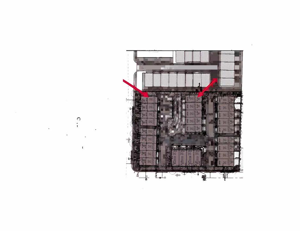
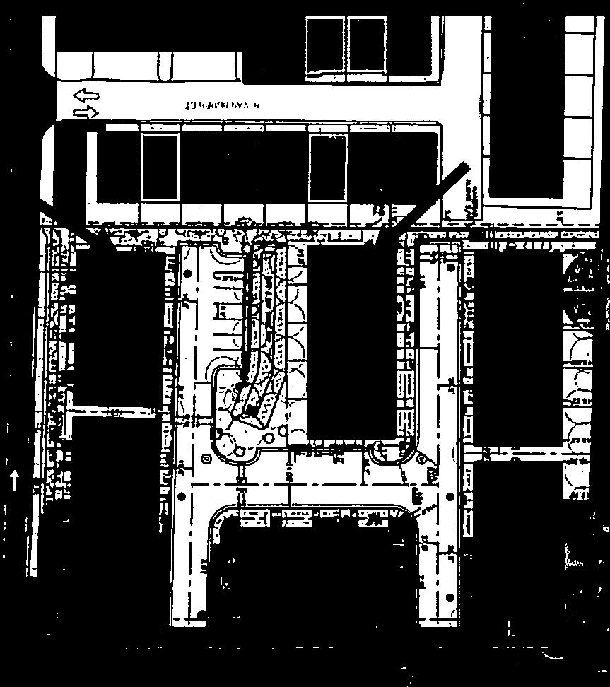
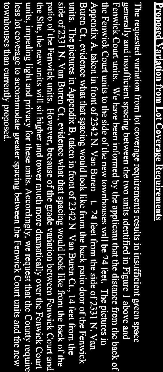


72
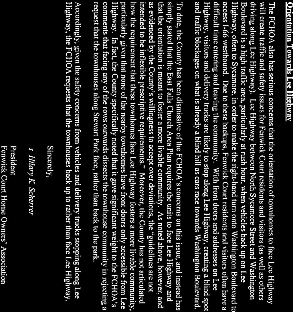
73
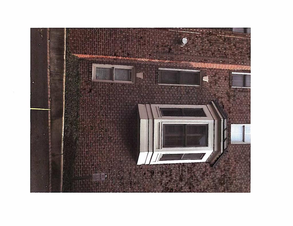


74


75
76
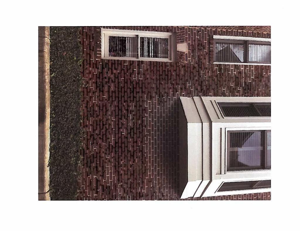


77
SITE PLAN REVIEW COMMITTEE MEETING AGENDA Clarendon Boulevard Conference Rooms C & D Arlington, VA 22201
 SITE PLAN REVIEW COMMITTEE MEETING AGENDA DATE: Monday, October 2, 2017 TIME: 8:30 10:00 p.m. PLACE: 2100 Clarendon Boulevard Conference Rooms C & D Arlington, VA 22201 Item 2. 6711 Lee Highway (SP #3)
SITE PLAN REVIEW COMMITTEE MEETING AGENDA Clarendon Boulevard Conference Rooms C & D Arlington, VA 22201
 SITE PLAN REVIEW COMMITTEE MEETING AGENDA DATE: Monday, July 24, 2017 TIME: 7:00 9:00 p.m. PLACE: 2100 Clarendon Boulevard Conference Rooms C & D Arlington, VA 22201 Item 1. 6711 Lee Highway (SP #3) (RPC#
ARLINGTON COUNTY, VIRGINIA
 ARLINGTON COUNTY, VIRGINIA County Board Agenda Item Meeting of June 16, 2012 DATE: June 7, 2012 SUBJECT: SP #397 SITE PLAN AMENDMENT to revise condition #31 to modify the retail transparency requirement
DEPARTMENT OF COMMUNITY PLANNING, HOUSING AND DEVELOPMENT Planning Division
 DEPARTMENT OF COMMUNITY PLANNING, HOUSING AND DEVELOPMENT Planning Division #1 Courthouse Plaza, 2100 Clarendon Boulevard, Suite 700 Arlington, VA 22201 TEL 703.228.3525 FAX 703.228.3543 www.arlingtonva.us
ARLINGTON COUNTY, VIRGINIA. County Board Agenda Item Meeting of September 19, 2015
 ARLINGTON COUNTY, VIRGINIA County Board Agenda Item Meeting of September 19, 2015 DATE: August 28, 2015 SUBJECT: Request to authorize advertisement of public hearings by the Planning Commission and the
ARLINGTON COUNTY, VIRGINIA. County Board Agenda Item Meeting of May 14, 2016
 ARLINGTON COUNTY, VIRGINIA County Board Agenda Item Meeting of May 14, 2016 DATE: May 11, 2016 SUBJECTS: Applicant: AHC, Inc. A. Z-2589-16-1 REZONING from R-6 to RA-8-18 for an approximately 18,170 square
S IT E PL A N R E V IE W C OM M IT T E E
 S IT E PL A N R E V IE W C OM M IT T E E M E E T I N G A G E N D A DATE: Thursday, January 4, 2018 TIME: 7:00 9:00 p.m. PLACE: Ellen Bozman Government Center/Courthouse Plaza 2100 Clarendon Boulevard Lobby
ARLINGTON COUNTY, VIRGINIA
 ARLINGTON COUNTY, VIRGINIA County Board Agenda Item Meeting December 9, 2006 DATE: November 20, 2006 SUBJECT: GP-302-05-2 Adoption of General Land Use Plan Amendments for the Clarendon Metro Station Area:
ARLINGTON COUNTY, VIRGINIA
 ARLINGTON COUNTY, VIRGINIA County Board Agenda Item Meeting of December 8, 2012 DATE: November 29, 2012 SUBJECT: PDSP #346 SITE PLAN AMENDMENT to convert approximately 1,458 square feet of GFA below-grade
SITE PLAN REVIEW COMMITTEE MEETING AGENDA
 Page 1 SITE PLAN REVIEW COMMITTEE MEETING AGENDA DATE: Monday, July 10, 2017 TIME: 7:00 8:30 p.m. PLACE: 2100 Clarendon Boulevard Ground Floor Conference Rooms Cherry/Dogwood Arlington, VA 22202 SPRC STAFF
ARLINGTON COUNTY, VIRGINIA
 ARLINGTON COUNTY, VIRGINIA County Board Agenda Item Meeting of September 18, 2004 DATE: August 19, 2004 SUBJECTS: A. GP-297-04-1 GENERAL LAND USE PLAN AMENDMENT from Service Commercial (Personal and business
3804 Wilson Boulevard (Staples Site) Special General Land Use Plan Study
 Special General Land Use Plan Study") 1 3804 Wilson Boulevard (Staples Site) Special General Land Use Plan Study Long Range Committee of the Planning Commission Meeting May 16, 2018 Department of Community Planning, Housing and Development
1 3804 Wilson Boulevard (Staples Site) Special General Land Use Plan Study Long Range Committee of the Planning Commission Meeting May 16, 2018 Department of Community Planning, Housing and Development
ARLINGTON COUNTY, VIRGINIA
 ARLINGTON COUNTY, VIRGINIA County Board Agenda Item Meeting of July 21, 2012 DATE: June 26, 2012 SUBJECT: SP #402 SITE PLAN AMENDMENT for a comprehensive sign plan amendment to add a projecting sign for
Town of Cary, North Carolina Rezoning Staff Report 12-REZ-27 Morris Branch Town Council Public Hearing January 24, 2013
 Town of Cary, North Carolina Rezoning Staff Report 12-REZ-27 Morris Branch Town Council Public Hearing January 24, 2013 REQUEST To amend the Town of Cary Official Zoning Map to rezone approximately 9.0
SP #447, 11 th & Vermont
 SP #447, 11 th & Vermont GLUP Amendment, Rezoning, and Site Plan Department of Community Planning, Housing, and Development County Board February 24, 2018 1 NORTH BLOCK (R15-30T) 11 th & Vermont (SP #447)
ARLINGTON COUNTY, VIRGINIA. County Board Agenda Item Meeting of May 14, 2011
 ARLINGTON COUNTY, VIRGINIA County Board Agenda Item Meeting of May 14, 2011 DATE: May 11, 2011 SUBJECT: SP #240 SITE PLAN AMENDMENT for a kiosk for the Department of Environmental Services located at the
28. ARLINGTON COUNTY, VIRGINIA. County Board Agenda Item Meeting of February 25, DATE: February 17, 2017
 ARLINGTON COUNTY, VIRGINIA County Board Agenda Item Meeting of February 25, 2017 DATE: February 17, 2017 SUBJECTS: Items associated with Queen's Court Residences: A. GP 335-16-1 GENERAL LAND USE PLAN AMENDMENT
ARLINGTON COUNTY, VIRGINIA
 ARLINGTON COUNTY, VIRGINIA County Board Agenda Item Meeting of July 16, 2016 DATE: July 5, 2016 SUBJECT: SP #64 SITE PLAN AMENDMENT to allow temporary extension of construction hours for ; located at 1000
ARLINGTON COUNTY, VIRGINIA. County Board Agenda Item Meeting of September 22, 2018
 ARLINGTON COUNTY, VIRGINIA County Board Agenda Item Meeting of September 22, 2018 DATE: September 13, 2018 SUBJECT: SP413-U-18-1 USE PERMIT ASSOCIATED WITH A SITE PLAN for food delivery service for Domino's
24. A., B., C. ARLINGTON COUNTY, VIRGINIA. County Board Agenda Item Meeting of February 23, DATE: February 19, 2019
 ARLINGTON COUNTY, VIRGINIA County Board Agenda Item Meeting of February 23, 2019 DATE: February 19, 2019 SUBJECTS: A. GP-343-17-1 GENERAL LAND USE PLAN AMENDMENT to change the land use designation for
ARLINGTON COUNTY, VIRGINIA
 ARLINGTON COUNTY, VIRGINIA County Board Agenda Item Meeting of July 10, 2004 DATE: June 24, 2004 SUBJECT: A. GP-298-04-1 GENERAL LAND USE PLAN AMENDMENT from Semi- Public (Country Clubs and semi-public
3804 Wilson Boulevard
 3804 Wilson Boulevard SPECIAL GENERAL LAND USE PLAN STUDY DEPARTMENT OF COMMUNITY PLANNING, HOUSING, & DEVELOPMENT Planning Division 3804 Wilson Boulevard Special GLUP Study a2 3804 Wilson Boulevard Special
S I T E P L A N R E V I E W C O M M I T T E E M E E T I N G A G E N D A
 S I T E P L A N R E V I E W C O M M I T T E E M E E T I N G A G E N D A DATE: Thursday, July 23, 2015 TIME: 7:00 10:00 p.m. PLACE: 2100 Clarendon Boulevard Courthouse Plaza, 1st Floor, Cherry and Dogwood
Town of Cary, North Carolina Rezoning Staff Report 14-REZ-20 Habitat for Humanity Evans Road Town Council Meeting October 16, 2014
 Town of Cary, North Carolina Rezoning Staff Report 14-REZ-20 Habitat for Humanity Evans Road Town Council Meeting October 16, 2014 REQUEST To amend the Town of Cary Official Zoning Map by rezoning 0.53
M-43 CORRIDOR OVERLAY ZONE
 ARTICLE 26.00 M-43 CORRIDOR OVERLAY ZONE Section 26.01 Findings A primary function of the M-43 state highway is to move traffic through the Township and to points beyond. As the primary east-west arterial
ARLINGTON COUNTY, VIRGINIA
 ARLINGTON COUNTY, VIRGINIA County Board Agenda Item Meeting of February 20, 2016 DATE: February 17, 2016 SUBJECTS: A. Z-2587-16-1 REZONING from "R-6" One-Family Dwelling District to "CP-FBC" Columbia Pike
Composition of traditional residential corridors.
 Page 1 of 7 St. Petersburg, Florida, Code of Ordinances >> PART II - ST. PETERSBURG CITY CODE >> Chapter 16 - LAND DEVELOPMENT REGULATIONS >> SECTION 16.20.060. CORRIDOR RESIDENTIAL TRADITIONAL DISTRICTS
ARLINGTON COUNTY, VIRGINIA. County Board Agenda Item Meeting of February 23, 2019
 ARLINGTON COUNTY, VIRGINIA County Board Agenda Item Meeting of February 23, 2019 DATE: February 5, 2019 SUBJECTS: A. GP-343-17-1 GENERAL LAND USE PLAN AMENDMENT to change the land use designation for a
October 9, The County Board of Arlington, Virginia. Ron Carlee, County Manager
 October 9, 2003 TO: FROM: APPLICANT: BY: The County Board of Arlington, Virginia Ron Carlee, County Manager Douglas Schneiderman, Vice President Madison Homes, Inc. 6723 Whittier Avenue, Suite 104 McLean,
Wesley Housing Development Corporation Trenton Street Residential
 Wesley Housing Development Corporation Trenton Street Residential 1 2 Site Location Multimodal Traffic Study Summary Existing Conditions (2017) 13 study intersections. -Scoped with Arlington County DES
ARLINGTON COUNTY, VIRGINIA
 ARLINGTON COUNTY, VIRGINIA County Board Agenda Item Meeting of September 22, 2018 DATE: August 30, 2018 SUBJECTS: A. Z-2606-18-1 REZONING Arlington Health System from "S- 3A" Special District to "S-D"
2401 Wilson Boulevard General Land Use Plan Amendment Study
 2401 Wilson Boulevard General Land Use Plan Amendment Study Long Range Planning Committee Meeting Presentation Compendium March 29, 2011 Department of Community Planning, Housing and Development GLUP Amendment
DEVELOPMENT STANDARDS FOR RESIDENTIAL PROJECTS RESIDENTIAL BUILDING TYPES: APPROPRIATE ZONES AND DENSITIES 2-1
 2 DEVELOPMENT STANDARDS FOR RESIDENTIAL PROJECTS RESIDENTIAL BUILDING TYPES: APPROPRIATE ZONES AND DENSITIES 2-1 This Chapter presents the development standards for residential projects. Section 2.1 discusses
PLANNED DEVELOPMENT DISTRICT STANDARDS. Cadence Site
 PLANNED DEVELOPMENT DISTRICT STANDARDS Cadence Site A Planned Development District 1. Statement of General Facts, Conditions and Objectives Property Size: Approximately 57.51 Acres York County Tax Map
Urban Design Brief. Proposed Medical / Dental Office 1444 Adelaide Street North. Vireo Health Facility Ltd.
 Urban Design Brief Proposed Medical / Dental Office Vireo Health Facility Ltd. November 27, 2013 TABLE OF CONTENTS Page No. INTRODUCTION... 1 SECTION 1 LAND USE PLANNING CONTEXT... 1 1.1 The Subject Lands...
SITE PLAN REVIEW COMMITTEE MEETING AGENDA. DATE: Thursday, April 25, :00 8:30 p.m. PLACE:
 SITE PLAN REVIEW COMMITTEE MEETING AGENDA DATE: Thursday, April 25, 2013 TIME: 7:00 8:30 p.m. PLACE: Courthouse Plaza 2100 Clarendon Boulevard Conference Rooms C&D Arlington, VA 22201 SPRC STAFF COORDINATOR:
SITE PLAN REVIEW COMMITTEE MEETING AGENDA Clarendon Boulevard Courthouse Plaza, Training Center (10 th Floor) Arlington, VA 22202
 Arlington, VA 22202") SITE PLAN REVIEW COMMITTEE MEETING AGENDA DATE: Wednesday, December 5, 2012 TIME: 8:30 10:00 p.m. PLACE: 2100 Clarendon Boulevard Courthouse Plaza, Training Center (10 th Floor) Arlington, VA 22202 SPRC
SITE PLAN REVIEW COMMITTEE MEETING AGENDA DATE: Wednesday, December 5, 2012 TIME: 8:30 10:00 p.m. PLACE: 2100 Clarendon Boulevard Courthouse Plaza, Training Center (10 th Floor) Arlington, VA 22202 SPRC
ARLINGTON COUNTY, VIRGINIA
 ARLINGTON COUNTY, VIRGINIA County Board Agenda Item Meeting of September 21, 2013 DATE: September 10, 2013 SUBJECT: SP #350 SITE PLAN AMENDMENT for conversion of retail space to a temporary leasing office
ARLINGTON COUNTY, VIRGINIA
 ARLINGTON COUNTY, VIRGINIA County Board Agenda Item Meeting of July 19, 2014 DATE: July 11, 2014 SUBJECT: Adoption of final Urban Design Guidelines Applicant: VNO Pentagon Plaza, LLC By: John G. Milliken,
Urban Design Brief. Italian Seniors Project 1090, 1092, 1096 Hamilton Road City of London
 Urban Design Brief Italian Seniors Project City of London October 1, 2017 TABLE OF CONTENTS Page No. INTRODUCTION... 2 1.0 LAND USE PLANNING CONCEPT... 2 1.1 Subject Lands... 2 1.2 Official Plan and Zoning
60. ARLINGTON COUNTY, VIRGINIA. County Board Agenda Item Meeting of July 14, DATE: July 13, 2018
 ARLINGTON COUNTY, VIRGINIA County Board Agenda Item Meeting of July 14, 2018 DATE: July 13, 2018 SUBJECT: Request to authorize advertisement of public hearings by the Planning Commission and County Board
ARLINGTON COUNTY, VIRGINIA
 ARLINGTON COUNTY, VIRGINIA County Board Agenda Item Meeting of June 10, 2006 DATE: June 9, 2006 SUBJECTS: A. Z-2525-06-1 REZONING for Saul Centers, Inc., from C-3 General Commercial Districts to C-O Commercial
SITE PLAN REVIEW COMMITTEE MEETING AGENDA. DATE: Monday, October 22, Clarendon Boulevard Courthouse Plaza, Room 311 Arlington, VA 22201
 SITE PLAN REVIEW COMMITTEE MEETING AGENDA DATE: Monday, October 22, 2012 TIME: 7:00 9:00 p.m. PLACE: 2100 Clarendon Boulevard Courthouse Plaza, Room 311 Arlington, VA 22201 SPRC STAFF COORDINATOR: Samia
Ron Carlee, County Manager
 June 6, 2003 TO: FROM: APPLICANT: BY: SUBJECTS: The County Board of Arlington, Virginia The Holladay Corporation Nan Terpak, Attorney/Agent Walsh, Colucci, Lubeley, Emrich & Terpak 2200 Clarendon Blvd.,
ARLINGTON COUNTY, VIRGINIA
 ARLINGTON COUNTY, VIRGINIA County Board Agenda Item Meeting of July 19, 2014 DATE: July 8, 2014 SUBJECTS: A. ZOA-14-03 Zoning Ordinance amendments to: 1. Revise Map 34-1 (Sign Map) to update the placement
Urban Design Brief Dundas Street. London Affordable Housing Foundation. November Zelinka Priamo Ltd.
 Urban Design Brief 1039-1047 Dundas Street London Affordable Housing Foundation November 2017 Zelinka Priamo Ltd. TABLE OF CONTENTS Page No. INTRODUCTION... 3 SECTION 1 LAND USE PLANNING CONTEXT... 3 1.1
8.5.1 R1, Single Detached Residential District
 8.5.1 R1, Single Detached Residential District The purpose of this district is to provide for residential development in the form of single detached dwellings. Dwelling, Single Detached Home Business,
November 21, RECOMMENDATION: Deny the site plan request, and accept withdrawal of rezoning request.
 November 21, 2003 TO: FROM: APPLICANT: BY: The County Board of Arlington, Virginia Ron Carlee, County Manager Trammell Crow Residential Tim Sampson, Attorney/Agent Walsh, Colucci, Emrich, Lubeley & Terpak
ARLINGTON COUNTY, VIRGINIA
 ARLINGTON COUNTY, VIRGINIA County Board Agenda Item Meeting of March 27, 2004 DATE: March 19, 2004 SUBJECT: SP # 376 SITE PLAN AMENDMENT, to amend Condition #26 to permit the installation of new utility
SITE PLAN REVIEW COMMITTEE MEETING AGENDA Clarendon Boulevard Lobby Rooms C&D (Cherry & Dogwood) Arlington, VA
 Arlington, VA") SITE PLAN REVIEW COMMITTEE MEETING AGENDA DATE: Monday, January 8, 2018 TIME: 7:30 8:25 p.m. PLACE: 2100 Clarendon Boulevard Lobby Rooms C&D (Cherry & Dogwood) Arlington, VA 22201 SPRC STAFF COORDINATOR:
SITE PLAN REVIEW COMMITTEE MEETING AGENDA DATE: Monday, January 8, 2018 TIME: 7:30 8:25 p.m. PLACE: 2100 Clarendon Boulevard Lobby Rooms C&D (Cherry & Dogwood) Arlington, VA 22201 SPRC STAFF COORDINATOR:
ARLINGTON COUNTY, VIRGINIA
 ARLINGTON COUNTY, VIRGINIA County Board Agenda Item Meeting of July 8, 2006 DATE: June 30, 2006 SUBJECT: U-3156-06-1 USE PERMIT for a, 2 dwelling units located at 4717 24 th Road North (RPC #05-005-092).
1417, , 1427 & 1429 Yonge Street - Official Plan Amendment and Zoning Amendment Applications - Preliminary Report
 STAFF REPORT ACTION REQUIRED 1417, 1421-1425, 1427 & 1429 Yonge Street - Official Plan Amendment and Zoning Amendment Applications - Preliminary Report Date: March 24, 2015 To: From: Wards: Reference Number:
50 and 52 Finch Avenue East - Official Plan and Zoning By-law Amendment Applications - Preliminary Report
 STAFF REPORT ACTION REQUIRED 50 and 52 Finch Avenue East - Official Plan and Zoning By-law Amendment Applications - Preliminary Report Date: August 16, 2016 To: From: Wards: Reference Number: North York
Introduction. General Development Standards
 Introduction The development standards will set the zoning regulations for the East Park development. This section will illustrate lot standards, approximate open space locations and road standards. The
PLANNED UNIT DEVELOPMENT & SUBDIVISION STAFF REPORT Date: April 18, 2019
 PLANNED UNIT DEVELOPMENT & SUBDIVISION STAFF REPORT Date: April 18, 2019 DEVELOPMENT NAME SUBDIVISION NAME Springhill Village Subdivision Springhill Village Subdivision LOCATION 4350, 4354, 4356, 4358,
DEVELOPMENT DEPARTMENT STAFF REPORT THE PARK AT 5 TH
 DEVELOPMENT DEPARTMENT STAFF REPORT ARB Meeting Date: July 3, 2018 Item #: _PZ2018-293_ THE PARK AT 5 TH Request: Site Address: Project Name: Parcel Number: Applicant: Proposed Development: Current Zoning:
Courtyards at Kinnamon Park Sketch Plan
 Courtyards at Kinnamon Park Sketch Plan Courtyards at Kinnamon Park Sketch Plan Staff Analysis PART 1: PROJECT SUMMARY Applicant: EPCON Communities Property Owner: Johnsie M. Kinnamon Heirs, Douglas and
REPORT TO PLANNING AND DESIGN COMMISSION City of Sacramento
 REPORT TO PLANNING AND DESIGN COMMISSION City of Sacramento 915 I Street, Sacramento, CA 95814-2671 www.cityofsacramento.org 9 PUBLIC HEARING December 10, 2015 To: Members of the Planning and Design Commission
Plan Dutch Village Road
 Plan Dutch Village Road Objective: The lands around Dutch Village Road are a minor commercial area that services the larger Fairview community. Maintaining the vibrancy of the area by planning for redevelopment
ARLINGTON COUNTY, VIRGINIA
 ARLINGTON COUNTY, VIRGINIA County Board Agenda Item Meeting of January 27, 2007 DATE: January 19, 2007 SUBJECT: A. Z-2532-06-1 REZONING from RA14-26 Apartment Dwelling Districts to R-6 One- Family Dwelling
S I T E P L A N R E V I E W C O M M I T T E E M E E T I N G A G E N D A
 S I T E P L A N R E V I E W C O M M I T T E E M E E T I N G A G E N D A DATE: Thursday, September 14, 2017 TIME: 6:00 6:45 p.m. (optional walking tour) 7:00 8:30 p.m. PLACE: 2801 Clarendon Boulevard Meeting
WALNUT CREEK DESIGN REVIEW COMMISSION STAFF REPORT. AGENDA: July 6, 2016 ITEM 4b.
 WALNUT CREEK DESIGN REVIEW COMMISSION STAFF REPORT Attachment 3 AGENDA: July 6, 2016 ITEM 4b. ORIGINATED BY: COMMUNITY AND ECONOMIC DEVELOPMENT DEPARTMENT PLANNING PROJECT NAME APPLICATION TYPE APPLICATION
1202 & 1204 Avenue Road Zoning By-law Amendment Application - Preliminary Report
 STAFF REPORT ACTION REQUIRED 1202 & 1204 Avenue Road Zoning By-law Amendment Application - Preliminary Report Date: March 17, 2017 To: From: Wards: Reference Number: North York Community Council Director,
Article 3. SUBURBAN (S-) NEIGHBORHOOD CONTEXT
 NEIGHBORHOOD CONTEXT") Article 3. SUBURBAN (S-) NEIGHBORHOOD CONTEXT this page left intentionally blank Contents ARTICLE 3. SUBURBAN (S-) NEIGHBORHOOD CONTEXT DIVISION 3.1 NEIGHBORHOOD CONTEXT DESCRIPTION...3.1-1 Section 3.1.1
Article 3. SUBURBAN (S-) NEIGHBORHOOD CONTEXT this page left intentionally blank Contents ARTICLE 3. SUBURBAN (S-) NEIGHBORHOOD CONTEXT DIVISION 3.1 NEIGHBORHOOD CONTEXT DESCRIPTION...3.1-1 Section 3.1.1
LITTLE MOUNTAIN ADJACENT AREA REZONING POLICY
 LITTLE MOUNTAIN ADJACENT AREA REZONING POLICY JANUARY 2013 CONTENTS 1.0 INTENT & PRINCIPLES...1 2.0 APPLICATION...2 3.0 HOUSING TYPES, HEIGHT & DENSITY POLICIES...3 3.1 LOW TO MID-RISE APARTMENT POLICIES...4
12, 14, 16 and 18 Marquette Avenue and 7 Carhartt Street Zoning By-law Amendment Application - Preliminary Report
 STAFF REPORT ACTION REQUIRED 12, 14, 16 and 18 Marquette Avenue and 7 Carhartt Street Zoning By-law Amendment Application - Preliminary Report Date: July 17, 2014 To: From: Wards: Reference Number: North
S I T E P L A N R E V I E W C O M M I T T E E M E E T I N G A G E N D A
 S I T E P L A N R E V I E W C O M M I T T E E M E E T I N G A G E N D A DATE: Monday, September 21, 2015 TIME: 7:00 10:00 p.m. PLACE: 2100 Clarendon Boulevard Courthouse Plaza, 1st Floor, Cherry and Dogwood
Rezoning Petition Pre-Hearing Staff Analysis April 15, 2019
 Rezoning Petition 2018-132 Pre-Hearing Staff Analysis April 15, 2019 REQUEST Current Zoning: R-3 (single family residential) Proposed Zoning: MUDD-O (mixed use development, optional) with five-year vested
ARLINGTON COUNTY, VIRGINIA
 ARLINGTON COUNTY, VIRGINIA County Board Agenda Item Meeting of January 23, 2016 DATE: January 20, 2016 SUBJECTS: A. SP #211 SITE PLAN AMENDMENT to permit a vehicle rental use and associated modification
Rezoning Petition Final Staff Analysis July 16, 2018
 Rezoning Petition 2018-041 Final Staff Analysis July 16, 2018 REQUEST LOCATION Current Zoning: R-5 (single family residential, and UR-2(CD) (urban residential, conditional) Proposed Zoning: UR-2(CD) (urban
R E S O L U T I O N. Residential 384,918 sq. ft. To be demolished Floor Area Ratio (FAR) 0 0.7
 0 0.7") R E S O L U T I O N WHEREAS, the Prince George s County Planning Board has reviewed DPLS-417, Kiplinger Property, Phase I, Expedited Transit-Oriented Development Project, requesting a reduction in the
R E S O L U T I O N WHEREAS, the Prince George s County Planning Board has reviewed DPLS-417, Kiplinger Property, Phase I, Expedited Transit-Oriented Development Project, requesting a reduction in the
58. A.-C. ARLINGTON COUNTY, VIRGINIA. County Board Agenda Item Meeting of September 22, DATE: September 20, 2018 SUBJECTS:
 ARLINGTON COUNTY, VIRGINIA County Board Agenda Item Meeting of September 22, 2018 DATE: September 20, 2018 SUBJECTS: A. Z-2606-18-1 REZONING Arlington Health System from "S- 3A" Special District to "S-D"
Town of Cary, North Carolina Rezoning Staff Report 14-REZ-31 Cary Park PDD Amendment (Waterford II) Town Council Meeting January 15, 2015
 Town Council Meeting January 15, 2015") Town of Cary, North Carolina Rezoning Staff Report 14-REZ-31 Cary Park PDD Amendment (Waterford II) Town Council Meeting January 15, 2015 REQUEST To amend the Town of Cary Official Zoning Map by amending
Town of Cary, North Carolina Rezoning Staff Report 14-REZ-31 Cary Park PDD Amendment (Waterford II) Town Council Meeting January 15, 2015 REQUEST To amend the Town of Cary Official Zoning Map by amending
Rezoning Petition Pre-Hearing Staff Analysis April 17, 2017
 Rezoning Petition 2017-041 Pre-Hearing Staff Analysis April 17, 2017 REQUEST Current Zoning: R-5 (single family residential), R-22MF (multifamily residential), and I-1 (light industrial) Proposed Zoning:
1. Cuyler-Brownsville planned neighborhood conservation (P-N-C) districtphase I (section ). (2) Single-family semiattached dwellings;
 districtphase I (section ). (2) Single-family semiattached dwellings;") Sec. 8-3035. Planned unit development multifamily (PUD-M). A. Purpose. The PUD-M district is intended to allow a variety of residential development including single-family residential, two-family residential,
Sec. 8-3035. Planned unit development multifamily (PUD-M). A. Purpose. The PUD-M district is intended to allow a variety of residential development including single-family residential, two-family residential,
RC ; Reclassification The Garrison at Stafford Proffer Amendment (formerly Stafford Village Center)
") Board of Supervisors Robert Bob Thomas, Jr., Chairman Laura A. Sellers, Vice Chairman Meg Bohmke Jack R. Cavalier Wendy E. Maurer Paul V. Milde, III Gary F. Snellings Anthony J. Romanello, ICMA CM County
Board of Supervisors Robert Bob Thomas, Jr., Chairman Laura A. Sellers, Vice Chairman Meg Bohmke Jack R. Cavalier Wendy E. Maurer Paul V. Milde, III Gary F. Snellings Anthony J. Romanello, ICMA CM County
SITE PLAN REVIEW COMMITTEE MEETING AGENDA & STAFF REPORT
 SITE PLAN REVIEW COMMITTEE MEETING AGENDA & STAFF REPORT DATE: Thursday, April 21, 2016 TIME: 7:00 8:25 p.m. PLACE: Courthouse Plaza; Cherry/Dogwood Conference Rooms (109/110) SPRC STAFF COORDINATOR: Samia
Table of Contents ARTICLE 5A CHARACTER-BASED ZONING 1
 Table of Contents ARTICLE 5A CHARACTER-BASED ZONING 1 SECTION 10.5A10 GENERAL... 1 10.5A11 Purpose and Intent... 1 10.5A12 Applicability... 1 10.5A13 Compliance with Regulating Plan... 1 10.5A14 Relationship
S I T E P L A N R E V I E W C O M M I T T E E M E E T I N G A G E N D A Clarendon Boulevard Courthouse Plaza, Rooms 109/111 Arlington, VA 22201
 S I T E P L A N R E V I E W C O M M I T T E E M E E T I N G A G E N D A DATE: Thursday, March 27, 2014 TIME: 7:00 8:25 pm PLACE: 2100 Clarendon Boulevard Courthouse Plaza, Rooms 109/111 Arlington, VA 22201
Table of Contents ARTICLE 5A CHARACTER-BASED ZONING 1
 Table of Contents ARTICLE 5A CHARACTER-BASED ZONING 1 SECTION 10.5A10 GENERAL... 1 10.5A11 Purpose and Intent... 1 10.5A12 Applicability... 1 10.5A13 Compliance with Regulating Plan... 1 10.5A14 Relationship
PLANNING COMMISSION REPORT Regular Agenda -Public Hearing Item
 PDP-13-00518 Item No. 3B- 1 PLANNING COMMISSION REPORT Regular Agenda -Public Hearing Item PC Staff Report 2/24/14 ITEM NO. 3B PRELIMINARY DEVELOPMENT PLAN FOR HERE @ KANSAS; 1101 INDIANA ST (SLD) PDP-13-00518:
Planning Commission Report
 cjly City of Beverly Hills Planning Division 455 N. Rexford Drive Beverly Hills, CA 90210 TEL. (310) 285-1141 FAX. (370) 858-5966 Planning Commission Report Meeting Date: April 28, 2016 Subject: Project
Hamilton County Regional Planning Commission
 Hamilton County Regional Planning Commission March 1, 2012 Colerain Township Staff Report Zone Map Amendment: Case No.: ZA2012-01 Joseph Toyota Prepared By: Amy Bancroft, Land Use Planner ACTION REQUESTED:
ARLINGTON COUNTY, VIRGINIA
 ARLINGTON COUNTY, VIRGINIA Board of Zoning Appeals Agenda Item V-11394-18-UP-1: Meeting of October 17, 2018 DATE: October 12, 2018 APPLICANT: LOCATION: ZONING: LOT AREA: GLUP DESIGNATION: Sarah Sunday
Virginia Hospital Center Expansion
 Virginia Hospital Center Expansion Rezoning (Z-2606-18-1) Site Plan Amendment (SP #177) Use Permit Amendment (U-2203-79-3) County Board Public Hearing Department of Community Planning, Housing and Development
SPECIAL ZONING DISTRICTS
 SPECIAL ZONING DISTRICTS 5.01 5.99 RESERVED 5.100 PLANNED DEVELOPMENTS: Purpose: This district is intended to accommodate unified design of residential, commercial, office, professional services, retail
ARLINGTON COUNTY, VIRGINIA
 ARLINGTON COUNTY, VIRGINIA County Board Agenda Item Meeting of February 23, 2013 DATE: February 8, 2013 SUBJECTS: A. Z-2563-12-1 REZONING from "CM" Limited Industrial Districts to "C-O-Crystal City" Commercial
ARLINGTON COUNTY, VIRGINIA
 ARLINGTON COUNTY, VIRGINIA County Board Agenda Item Meeting of January 26, 2019 DATE: January 18, 2019 SUBJECTS: Applicant: A. SP #232 SITE PLAN AMENDMENT to convert 2,809 sf of gross floor area from office
CITY OF MERCED SMALL LOT SINGLE-FAMILY HOME DESIGN GUIDELINES
 CITY OF MERCED SMALL LOT SINGLE-FAMILY HOME DESIGN GUIDELINES Development Services Department Planning and Permitting Adopted August 15, 2005 SMALL LOT SINGLE FAMILY HOME GUIDELINES A. Purpose and Applicability.
ARLINGTON COUNTY, VIRGINIA
 ARLINGTON COUNTY, VIRGINIA County Board Agenda Item Meeting March 17, 2007 DATE: March 8, 2007 SUBJECT: Request to Advertise Public Hearings on Amendments to Section 25B. C-O Rosslyn Commercial Office
Washington Boulevard + Kirkwood Road Special General Land Use Plan (GLUP) Study "Plus"
 Study Plus") Washington Boulevard + Kirkwood Road Special General Land Use Plan (GLUP) Study "Plus" Long Range Committee of the Planning Commission Meeting #4 May 18, 2017 Department of Community Planning, Housing
Washington Boulevard + Kirkwood Road Special General Land Use Plan (GLUP) Study "Plus" Long Range Committee of the Planning Commission Meeting #4 May 18, 2017 Department of Community Planning, Housing
City of Sunny Isles Beach Collins Avenue Sunny Isles Beach, Florida 33160
 City of Sunny Isles Beach 18070 Collins Avenue Sunny Isles Beach, Florida 33160 (305) 947-0606 City Hall (305) 949-3113 Fax MEMORANDUM TO: FROM: The Honorable Mayor and City Commission Hans Ottinot, City
S I T E P L A N R E V I E W C O M M I T T E E M E E T I N G A G E N D A
 S I T E P L A N R E V I E W C O M M I T T E E M E E T I N G A G E N D A DATE: Thursday, November 15, 2018 TIME: SPRC: 7:00 8:30 p.m. PLACE: Ellen M. Bozman Government Center 2100 Clarendon Boulevard Room
From Policy to Reality
 From Policy to Reality Updated ^ Model Ordinances for Sustainable Development 2000 Environmental Quality Board 2008 Minnesota Pollution Control Agency Funded by a Minnesota Pollution Control Agency Sustainable
Community Development Department 333 Broadalbin Street SW, P.O. Box 490 Albany, OR 97321
 SUMMARY Community Development Department 333 Broadalbin Street SW, P.O. Box 490 Albany, OR 97321 STAFF REPORT Application for Tentative Partition Plat Review Planning File PA-06-17 Phone: 541-917-7550
ORDINANCE NO. _ _
 ORDINANCE NO. _2008-08-1385_ AN ORDINANCE OF THE CITY COUNCIL OF THE CITY OF SIGNAL HILL, CALIFORNIA, APPROVING ZONING ORDINANCE AMENDMENT 08-07, A REQUEST TO AMEND CHAPTER 20.41, SP-7, SPECIAL PURPOSE
AGENDA SLOT HOME EVALUATION & TEXT AMENDMENT. 5:30 - Welcome
 AGENDA 5:30 - Welcome Please sign-in, put a sticker on the map, grab snacks, materials and a seat 5:45 - Staff Presentation 6:15 - Open House Stations Background Information Mixed Use Districts Multi Unit
Staff Report: Date: Applicant: Property Identification: Acreage of Request: Current Zoning of Requested Area: Requested Action: Attached:
 Staff Report: Completed by Jeff Palmer Director of Planning & Zoning Date: November 7, 2018, Updated November 20, 2018 Applicant: Greg Smith, Oberer Land Developer agent for Ronald Montgomery ET AL Property
S I T E P L A N R E V I E W C O M M I T T E E M E E T I N G A G E N D A
 S I T E P L A N R E V I E W C O M M I T T E E M E E T I N G A G E N D A DATE: Monday July 27, 2015 TIME: 7:00 8:25 p.m. PLACE: 2100 Clarendon Boulevard Courthouse Plaza, 1st Floor, Cherry and Dogwood Rooms
4 June 11, 2014 Public Hearing
 4 June 11, 2014 Public Hearing APPLICANT: FRANKLIN JOHNSTON MANAGEMENT DEVELOPMENT, L.L.C. PROPERTY OWNER: TRUSTEES OF FIRST LYNNHAVEN BAPTIST CHURCH STAFF PLANNER: Stephen J. White REQUEST: Change of