24. A., B., C. ARLINGTON COUNTY, VIRGINIA. County Board Agenda Item Meeting of February 23, DATE: February 19, 2019
|
|
|
- Darrell Cunningham
- 5 years ago
- Views:
Transcription

1 ARLINGTON COUNTY, VIRGINIA County Board Agenda Item Meeting of February 23, 2019 DATE: February 19, 2019 SUBJECTS: A. GP GENERAL LAND USE PLAN AMENDMENT to change the land use designation for a property known as 3445 Washington Boulevard, which encompasses a portion of the block bounded by Washington Boulevard to the south, North Kirkwood Road to the east, 13th Street North to the north and North Lincoln Street to the west from "Service Commercial" and "Semi-Public" to "Medium" Office-Apartment-Hotel (RPC # ). B. Z REZONING for Arlington Partnership for Affordable Housing for a rezoning from R-5 One-Family and Restricted Two-Family Dwelling District and C-2 Service Commercial-Community Business District to C-O-2.5 Mixed Use District, and related update to ACZO Map 13-1 to amend Line A to encompass the property. The property is approximately 58,250 sq. ft.; located at 3445 Washington Boulevard (RPC # ). C. SP #449 SITE PLAN for Arlington Partnership for Affordable Housing to construct a 160-unit multi-family dwelling with a ground floor membership club/lodge use (American Legion Post); with modifications of use regulations to include: additional density for provision of on-site committed affordable housing, parking ratio, fence height and other modifications as necessary to achieve the proposed development plan. Located at 3445 Washington Boulevard (RPC # ). Applicant: Carmen Romero Arlington Partnership for Affordable Housing 4318 North Carlin Springs Road Arlington, VA County Manager: ##### County Attorney: ***** Staff: Peter Schulz, DCPHD, Planning Division Robert Gibson, DES, Transportation Division Yoomie Ahn, DCPHD, Housing Division Leon Vignes, DCPHD Planning Division 24. A., B., C.
2 C.M. RECOMMENDATIONS: 1. Adopt the attached resolution to amend the General Land Use Plan from "Service Commercial" and "Semi-Public" to "Medium" Office-Apartment-Hotel for the property located at 3445 Washington Boulevard (RPC # ); 2. Adopt the attached ordinance to rezone from R-5 One-Family and Restricted Two- Family Dwelling District and C-2 Service Commercial-Community Business District to C-O-2.5 Mixed Use District, and related update to ACZO Map 13-1 to amend Line A to encompass the property, for the property located at 3445 Washington Boulevard (RPC # ); 3. Adopt the attached ordinance to approve SP #449 to construct a 160-unit multi-family dwelling with a ground floor membership club/lodge use (American Legion Post); with modifications of use regulations including additional density for provision of onsite committed affordable housing, residential and membership club parking ratio, fence height, and other modifications as necessary to achieve the proposed development plan, for the property located at 3445 Washington Boulevard (RPC # ), subject to the conditions of the attached ordinance; and 4. Direct the County Manager to advertise a County Board review of Use Permit U one year after issuance of the Certificate of Occupancy for the American Legion use. ISSUES: This is an application for an amendment to the General Land Use Plan, a Rezoning, and a new Site Plan for a 7-story, 160-unit multifamily building with ground-floor membership club/lodge use (American Legion Post). Outstanding community issues include concerns about the proposed parking ratio, building height, proximity of the building to single-family dwellings, as well as the planned new streets associated with this redevelopment. SUMMARY: The applicant proposes to redevelop the American Legion site at 3445 Washington Boulevard with a seven-story, 160-unit multi-family building that will be 100% committed affordable dwelling units, with additional density for the provision of on-site committed affordable dwelling units. The building will taper to three (3) stories adjacent to a single-family neighborhood. All units will be affordable to income qualified tenants for a period of 75 years. A new American Legion Post will occupy a portion of the proposed building s ground floor. The applicant proposes a minimum of 70 residential parking spaces (.43 spaces per dwelling unit) and 20 parking spaces for the American Legion use. To facilitate the redevelopment, the applicant is requesting a General Land Use Plan Amendment, a Rezoning, and a new Site Plan application. The proposed site is in the area covered by the Washington Boulevard & Kirkwood Road Special GLUP Study Plus and Concept Plan ( Special GLUP Study ), which was adopted by the County Board in November The goals of the Special GLUP Study included encouraging the redevelopment of existing but aging semi-public community facilities such as the American Legion and YMCA in the superblock between Kirkwood Road, 13 th Street North, Washington Boulevard, and North Lincoln Street, with medium density mixed-use development that would be compatible with adjacent single-family GP , Z , SP #
3 dwellings. The Concept Plan also had detailed guidance on the development of a new public vehicular, pedestrian, and bicycle transportation network in the superblock. For the American Legion site, the Special GLUP Study recommended multi-family residential development with ground floor retail or retail equivalent use, for a maximum of seven (7) stories, tapering to three (3) stories towards the adjacent single-family neighborhood to the west. The applicant s proposed GLUP change to Medium Office-apartment-Hotel, and Rezoning to C-O-2.5 is in conformance with the recommendations of the Special GLUP Study for this site. The proposed site plan also furthers the recommendations for the Special GLUP Study: The proposed building permits the retention and modernization of a long-standing civic organization, the American Legion; the proposed building form tapers appropriately to the adjacent single-family neighborhood; provides 160 committed affordable housing dwellings; and the applicant proposes to dedicate, to the public, the beginning segments of the vehicular, pedestrian, and bicycle transportation network, in the locations recommended in the Special GLUP Study. The proposed Zoning Ordinance modification for the residential parking ratio is appropriate, for this particular site, for an affordable housing use, subject to the proposed enhanced Transportation Demand Management Plan as provided in the conditions of approval. Therefore, staff recommends approval of: 1) a General Land Use Plan Amendment from "Service Commercial" and "Semi- Public" to "Medium" Office-Apartment-Hotel; 2) A Rezoning from R-5 One-Family and Restricted Two-Family Dwelling District and C-2 Service Commercial-Community Business District to C-O-2.5 Mixed Use District, and related update to ACZO Map 13-1 to amend Line A to encompass the property; and 3) a Site Plan to construct a 160-unit multi-family dwelling with a ground floor membership club/lodge use (American Legion Post); with modifications of use regulations including additional density for provision of on-site committed affordable housing, residential and membership club parking ratio, fence height, and other modifications as necessary to achieve the proposed development plan, subject to the conditions of the attached ordinance. BACKGROUND: The 1.33-acre site has been owned by the American Legion since the 1930s. The southern half of the site is currently zoned C-2 and the northern half is zoned R-5. The current General Land Use Plan (GLUP) designation for this site is Service Commercial on the southern half of the block and Semi-Public for the northern half. The current American Legion Post building was constructed in In 1983, the County Board approved a use permit (U ) for the Legion to use the property as a private membership club which removed the previous nonconforming status and permitted construction of an addition on the rear of the existing building. In November 2017, the County Board adopted the Washington Boulevard & Kirkwood Road Special GLUP Study Plus and Concept Plan (the Special GLUP Study ), which provides planning guidance for the site by: Providing a set of planning concepts and recommendations to guide future redevelopment across multiple properties in a coordinated fashion; Identifying and outlining guiding principles and other desirable elements that should be incorporated into future site plan applications for redevelopment on this block; and Documenting and memorializing future GLUP amendments that could be considered for properties included within the study area but not yet subject to any GLUP request GP , Z , SP #

4 applications. In addition to land use and urban design recommendations, the adopted Special GLUP Study also included a Circulation and Public Space concept map that recommended a new, block-wide network of public vehicular, pedestrian, and bicycle connections through the study area. In November 2017, based on the recommendation of the Special GLUP Study, the County Board also authorized advertisement of an amendment to the GLUP for the American Legion site from Service Commercial and Semi-Public to Medium Office-Apartment-Hotel (up to 2.5 FAR commercial uses, up to 115 units/acre residential, and up to 180 units/acre hotel), with the request for the GLUP change to be heard concurrent with rezoning and site plan applications for the individual redevelopment sites. Figure 1--Site. Source: Arlington County GIS The following provides additional information about the site and location: Site: The 1.33 acre site is located in the middle of the north side of the 3400 block of Washington Boulevard. To the north: The YMCA property with several low-rise recreational buildings, zoned R-5 and designated Semi-Public on the General Land Use Plan (GLUP). This area is included in the Special GLUP Study area, as shown on Note 27 on the GLUP GP , Z , SP #
5 map. To the east: To the south: The YMCA property zoned R-5 and designated Semi-Public on the GLUP, and an auto repair shop zoned C-2 and designated Service Commercial on the GLUP. These sites are included in the Special GLUP Study area, as shown on Note 27 on the GLUP map. Across Washington Boulevard is the 7-story George Mason Foundation building (SP #349), a 208,773 square-foot office building zoned C-O-2.5 and designated Public and part of the George Mason University-Virginia Square Shopping Center Special Coordinated Mixed-Use District on the GLUP. To the south is also a Giant supermarket driveway from the FDIC site plan (SP #248), zoned C-O-1.5 and designated Low Office-Apartment-Hotel and part of the George Mason University-Virginia Square Shopping Center Special Coordinated Mixed-Use District on the GLUP. To the west: The site abuts, from south to north: A one-story retail building zoned C-2 and designated Service Commercial on the GLUP and located within the Special GLUP Study area (Note 27 on the GLUP); a single-family detached dwelling zoned R-5 and designated Low Residential 1-10 units/acre on the GLUP; the 30-foot wide right of way for 12 th Road North, which does not connect to the site); and another single family detached dwelling zoned R-5 and designated Low Residential 1-10 units/acre on the GLUP. The Low-density residential areas were not included in the Special GLUP Study area. Existing Zoning: The southern half of the American Legion site is currently zoned C-2 Service Commercial-Community Business District. The northern half of the site is zoned R- 5 One-Family and Restricted Two-Family Dwelling District. Proposed Zoning: The applicant proposes rezoning the entire site to C-O-2.5 Mixed Use District. Existing General Land Use Plan (GLUP) Designation: The southern half of the American Legion site is designated Service Commercial (Personal and business services. Generally one to four stories, with special provisions within the Columbia Pike Special Revitalization District.). The northern half of the site is designated Semi-Public (Country clubs and semipublic recreational facilities. Churches, private schools and private cemeteries [predominant use on block]). Note 27: This area is subject to further planning guidance as provided in the "Washington Boulevard and Kirkwood Road Special GLUP Study and Concept Plan," adopted by the County Board on 11/18/17. Proposed General Land Use Plan Designation: The applicant proposes to amend the GLUP for the entire site to Medium Office-Apartment-Hotel. (Up to 2.5 FAR office density; up to 115 units/acre residential density; up to 180 units/acre hotel density). GP , Z , SP #

6 Neighborhood: The subject site is in the Ballston/Virginia Square Civic Association area. Figure 2--Current view of site. Staff Photo. Existing Development: The American Legion site is developed with a one-story club building constructed in 1959 with subsequent additions. The property includes a picnic shelter and surface parking. Proposed Development: The following table provides the development potential and the preliminary statistical summary for the requested site plan: Site Area: 58,250 s.f. ( acres) (30,923 s.f. zoned R-5; 27,327 s.f. zoned C-2) DENSITY ALLOWED/TYPICAL USE MAXIMUM DEVELOPMENT C-2 By-Right One-family dwellings: one unit per 6,000 s.f. of lot area; Commercial: 1.5 FAR One-family dwellings: 5 units Commercial: 40,990 s.f. of g.f.a. GP , Z , SP #
7 Site Area: 58,250 s.f. ( acres) (30,923 s.f. zoned R-5; 27,327 s.f. zoned C-2) DENSITY ALLOWED/TYPICAL USE MAXIMUM DEVELOPMENT R-5 By-Right C-O-2.5 Site Plan One-Family Dwellings: one Unit per 5,000 s.f. of lot area up to 115 units/acre density multi-family residential up to 2.5 FAR commercial/office up to 180 units/acre hotel One-family dwellings: 6 units 153 multi-family units 145,625 s.f. commercial/office 240 hotel units SP #449, 3445 Washington Boulevard SITE AREA 58,250 s.f. ( acres) Area to be dedicated/conveyed to the County in fee 10,189 s.f. simple Site Area after Dedication and Conveyance 48,061 s.f. Site Area Allocations Retail//Office/Membership club (American Legion) 2,700 s.f. Residential 55,550 s.f. Density Proposed Residential GFA 184,929 s.f. Proposed Residential Units/acre 125 units/acre Proposed Residential Dwelling Units 160 Base Maximum Number of units 146 Proposed Bonus Dwelling Units 14 Bonus units percentage of base density 9.5% Proposed Commercial GFA 6,750 s.f. Proposed Commercial FAR 2.5 FAR Proposed Exclusions none Total Proposed Gross GFA 191,679 s.f. Total Combined FAR FAR FAR post-dedication of public streets 4.0 FAR Max. Permitted Base Density Building Height Average Site Elevation Above Sea Level Main Roof Elevation Above Sea Level Main Roof Height (above average grade) Penthouse Roof Elevation above sea level 2.5 FAR Office/Commercial/Retail 115 units/acre Residential feet feet feet 346 feet 1 For reference purposes only. The C-O-2.5 zoning district regulates only commercial density in terms of Floor Area Ratio (FAR). Residential density is regulated in units per acre. GP , Z , SP #
8 SP #449, 3445 Washington Boulevard Penthouse Height 7.75 feet Number of Stories 7 C-O-2.5 Max. Permitted Bldg. Height 16 stories 2 Parking Residential Spaces 70 Retail/ /Office/Membership Club (American Legion) Spaces 20 Total Number of Spaces 90 Standard Spaces 81 Compact Spaces 10 Handicapped spaces 5 Compact Ratio 10% C-O-2.5 Minimum Required Residential Parking Ratio spaces/unit Proposed Residential Ratio.38 sp/unit Proposed residential visitor ratio.05 sp/unit Proposed Retail/Membership Club Parking Ratio 1 sp/338 s.f. C-O-2.5 Minimum Required Retail Parking Ratio (site 1 Sp for every 580 s.f. of GFA (12 spaces) plan standard) Green Building Earthcraft Level Gold Density and Uses: The proposed C-O-2.5 zoning designation permits commercial and retail uses at a density of up to a 2.5 Floor Area Ratio (FAR), and multi-family residential uses at a density up to 115 dwelling units per acre. The applicant proposes a multi-family residential building with 160 units, at a density of 125 dwelling units per acre. The developer is requesting additional density for the provision of on-site committed affordable (CAF) dwelling units under Section A. of the Arlington County Zoning Ordinance. All 160 units are proposed to be CAFs, including at least eight (8) supportive housing units. The site will also incorporate a new 6,750 square foot American Legion Post in a portion of the building s ground floor fronting on Washington Boulevard. The American Legion is considered a membership club by the Arlington County Zoning Ordinance, which falls under the broader Retail, service and commercial use category (Sections A.; ). For the purposes of allocating density on the site, the American Legion is considered a retail or commercial use. The proposed density for the American Legion use is 2.5 FAR. The remainder of the ground floor is proposed to be lobby and amenity space, as well as 11 housing units. The applicant is proposing to dedicate 10,819 square feet of site area for public street purposes to the County in fee simple. The total site area after dedication of the streets will be 48,061 square feet and the total combined site density (residential and commercial) will be 4.0 FAR. 2 The Washington Boulevard & Kirkwood Road Special GLUP Study Plus has additional building height guidance, discussed below. GP , Z , SP #

9 Site and Design: The applicant proposes to demolish and clear the existing site and construct a roughly F -shaped, seven (7) story (82.5 feet in height) multi-family building. The proposed building would front on Washington Boulevard to the south. The lobby, parking, loading, and tenant amenity space will front on a proposed new segment of a public north-south street to the west (tentatively to be called North Kansas Street). Dwelling units are proposed to front on a new public east-west street or alley to the north. The east side of the property would be gated private open space for residents and the American Legion. Parking Loading Figure 3 Ground Floor Site Layout, courtesy applicant. Green: American Legion. Purple: amenity space. Blue: apartment units. White: parking, loading, and utility areas. At the northwest corner of the building, closest to the single-family residences, the proposed building steps back 14 feet at the fourth floor and steps back an additional 13 feet at the fifth floor. The building wall at the fifth through seventh stories is 74 feet from the adjacent property line. In the middle of the western façade of the building, at the lobby entrance and loading docks, a 52-foot wide and 39-feet deep section of the building is only one (1) story in height. GP , Z , SP #

10 The American Legion has a street level entrance at the corner of Washington Boulevard and the proposed new public street to the west (North Kansas Street), and will have internal access to the parking garage. The lobby for the residences will be accessed from the middle of the building from North Kansas Street. Access to and from the parking garage and the two (2) loading docks will be on the west side of the building from North Kansas Street. New parallel parking spaces will be placed on the east side of North Kansas Street, closest to the building. Figure 4-- Aerial Massing from Northwest, Courtesy applicant GP , Z , SP #


11 Figure 5--Aerial Massing from Northeast, Courtesy applicant The building architecture will be mostly multiple shades of gray brick up to the fifth level, and dark gray fiber cement board at the sixth and seventh levels. Figure 6--Washington Boulevard frontage from Southeast Sustainable Design: The applicant proposes to meet Earthcraft Gold certification. GP , Z , SP #
12 Public School Student Generation Estimates 3 : Based on analysis prepared by Arlington Public Schools, the proposed development is estimated to generate the following number of students: Proposed Committed Affordable Apartment (Elevator) Units (160): Number of Elementary School Students (K-5) generated: 54 Number of Middle School Students (6-8) generated: 13 Number of High School Students (9-12) generated: 30 This development project is zoned for the following school districts: Taylor Elementary School, Hamm Middle School, and Washington-Lee High School. The above estimates are generated using the housing characteristics presented prior to County Board approval and using student generation factors. Affordable Housing: The applicant proposes that all 160 dwelling units will be committed affordable units (CAFs). The applicant is requesting additional density of 14 apartment units for the provision of on-site committed affordable housing under Section A. of the Zoning Ordinance (which permits additional density of up to 25% over the base density). The 14 proposed additional units will also be CAFs, and represent a bonus of 9.5% of the base density. Following the recommendations of the Special GLUP Study, the applicant is not requesting bonus height. The developer is also applying for Affordable Housing Investment Fund (AHIF) funding, simultaneously with the site plan application (the subject of a separate Board report). The proposed affordable housing program (unit types and affordability levels) for the site is shown in the table below: 9% LIHTC Project 4% LIHTC Project Total Both Projects Unit Type 30% AMI 50% AMI 60% AMI 80% AMI Total 30% AMI 50% AMI 60% AMI 80% AMI Total Units Percent 1BR % 2BR % 3BR % Total % 3 Student generation estimates are developed using recent historical student generation factors. Should these housing unit characteristics or the student generation factors change, then the student generation estimates would also change. The completion and occupancy of an approved residential development may occur within a variable timeframe depending on developer interest, market conditions, and construction timelines. Some projects, like Phased Development Site Plans, may yield completed buildings over decades rather than years. The County does not regulate the bedroom distribution of market rate residential projects. Given the relevant zoning district within the site plan and use permit process, the County regulates residential density according to the Gross Floor Area or the Units per Acre of the project. Bedroom distribution is a market driven decision within the constraints of the relevant zoning district. Housing Unit characteristics of all types of projects may change after County Board approval through either site plan amendments or administrative changes. Information provided by CPHD is the best available within these constraints. APS provides no guarantee that any residential proposed development will continually be served by the same elementary, middle and high school(s). GP , Z , SP #
13 One-hundred percent of the units (all 160 apartments) will be affordable to households earning up to 80% AMI. The development will also include lower-income units affordable at 30%, 50%, and 60% AMI (5%, 33%, and 39% of the units, respectively). The majority of the development will be comprised of family-sized units (70%), with the remaining 30% being one-bedroom units. The developer has agreed that the units will be committed affordable units for 75 years. Transportation: The site is located approximately 1/4 mile north of the Virginia Square Metrorail station, on the north side of Washington Boulevard at 3445 Washington Boulevard. The Master Transportation Plan (MTP) classifies this segment of Washington Boulevard as a Type B-Primarily Urban Mixed-Use arterial. The MTP also identifies the site within the Washington Boulevard/Kirkwood Road area planned for new streets (area #13). A short distance from the Virginia Square Metrorail station, along Washington Boulevard that is identified in the MTP as part of Arlington s Primary Transit Network, the site is well served by transit and multimodal services. Streets and Sidewalks: The project proposes to make improvements along Washington Boulevard and as recommended in the Special GLUP Study Plus provide new vehicle and pedestrian connections across the site to support the creation of new mid-block connections between Washington Boulevard, Kirkwood Road, and 13th Street North. Washington Boulevard is proposed to be widened to approximately 48 feet from curb to curb, adding a parking lane along the north side of the street. The existing two travel lanes in each direction are proposed to be maintained. The project will significantly improve the sidewalk along the north side of Washington Boulevard widening it to approximately 16-feet 8 inches wide, including a minimum 10-foot clear sidewalk and a 6-foot planting strip with street trees. A portion of the building is proposed to overhang the clear sidewalk with a minimum of feet of vertical clearance. Per condition #19, the applicant has agreed to contribute $18,000 to support future street lighting improvements along Washington Boulevard. The project proposes a new north-south street (recommended to be named North Kansas Street) along the western edge of the site extending from Washington Boulevard to the northern property line. The proposed connection is required to have a minimum 26-foot wide clear section in order to provide the primary fire access to the building. To accommodate this width, the project proposes a 33-foot wide street including a 4-foot concrete paver strip (required for fire access), two (2) 11-foot vehicular travel lanes and a 7-foot wide parking lane. An 11.5-foot sidewalk is proposed along the building with a 6-foot wide clear sidewalk and 5.5-foot wide planting/tree strip. The 26-foot section (including paver strip and travel lanes) will be dedicated to the county in fee as right-of-way and the parking lane, sidewalk and streetscape will be dedicated in easement to the county. The new North Kansas Street is designed to include elements that will allow it to function similar to a Shared Street while providing dedicated space for pedestrians and vehicles. Some of the design elements that contribute to this include keeping the sidewalk and street at the same grade and using a driveway style entrance at Washington Boulevard. This new street is recommended in the Special GLUP Study Plus to be dedicated as public. Staff has worked with the applicant to ensure that the street right-of-way is dedicated in fee, free of any encroachments or private GP , Z , SP #
14 utilities. The applicant has agreed to update the plan following approval by the County Board integrating the project s stormwater management facilities into the garage. In addition to supporting fire access, the new street will provide access to the garage and loading for the project. With future redevelopment of the site to the west, this new street will likely also support garage and loading access for that adjacent site. Until the build out of the east-west connection identified in the Special GLUP Study in association with the development of the YMCA site to the north, North Kansas Street will dead end. Because the street is being designed as a curbless street, bollards will be installed at the end of the street. When the new east-west connection is built the bollards will be removed providing pedestrian and vehicular circulation throughout the block. The project is proposing limiting access to 12th Road North to emergency vehicle egress and pedestrians and bicycles. The design of the new north-south connection is consistent with the recommendations of the Special GLUP Study and Staff supports the design. On the west side of the new North Kansas Street, the applicant also proposes a two (2) foot buffer strip along the western property line abutting the property lines for the Casual Adventure store and two (2) single-family homes. Where this buffer strip abuts the single-family homes, the applicant will construct and maintain a fence and landscaping to mitigate the effect of the new public street on the single-family homes. The buffer will be subdivided into outlots and conveyed to the County in fee-simple. However, the applicant will be responsible for maintaining the fence and the landscaping. The creation of the outlots are intended to prevent the adjacent properties from becoming non-conforming corner lots due to the creation of the new segment of North Kansas Street. The outlot that is adjacent to Casual Adventure is expected to be converted by the County into additional public right-of-way for North Kansas Street when the Casual Adventure site redevelops. To support a future east-west connection, the developer is dedicating a 20-foot wide area (a combination of sidewalk easement and right-of-way dedication) to the County on the north side of the property. The configuration for this connection was not specifically identified in the Special GLUP Study. The final design of the east-west connection will be approved as part of the YMCA development based on the infrastructure and circulation needs to support the YMCA s project. The project will construct an 11-foot streetscape (which includes a 5-foot wide planting strip with street trees and a 6-foot wide sidewalk) to support the future buildout of the connection. These facilities will be provided within a sidewalk and utilities easement. The project will also provide 9-feet of fee dedicated right-of-way north of the sidewalk that would be used for vehicular travel on the future connection. Staff finds that the 20 feet provided by the project is sufficient to meet the connectivity and access goals set out in the Special GLUP Study Plus. Until development occurs on the YMCA site to the north, this area will provide secondary fire access for the project. When the YMCA redevelops, an additional dedication will be required to support the connectivity goals of the plan. Bicycle Access and Facilities: The site is located in close proximity to existing bicycle facilities in the area. The project is located one block from dedicated bike lanes along North Fairfax Drive connecting the Rosslyn-Ballston corridor and dedicated bike lanes along North Kirkwood Road connecting to Arlington s broader network of bicycle facilities and off-street trails. The site is one block from the 13 th Street North bikeway. The closest Capital Bikeshare station is about one block south of the site at the George Mason Virginia Square Campus. GP , Z , SP #
15 The project proposes to provide bicycle parking for residents at a rate of one space for every 2.5 residential units, providing a minimum of 67 class 1 secure bicycle parking spaces; 20 of the spaces with access at grade off of the new north-south street. The project will also provide eight (8) visitor bike parking spaces along the site s frontage. As part of the project s Transportation Demand Management (TDM) plan and to support the proposed parking reduction, car free residents will be offered a Capital Bikeshare membership. Transit Access and Facilities: The site is located in close proximity to a range of transit services. The site is within ¼ mile from the Virginia Square Metrorail station served by the Orange and Silver Metrorail lines. The area is also supported by Metrobus and ART bus routes within a 1/4 mile of the site. Along the site s frontage, Metrobus operates the 38B with service between Ballston and Farragut Square. Along North Kirkwood Road, ART operates the 62 route with service between Courthouse and Ballston. From Ballston, there are connections to numerous local and regional transit routes. Trip Generation: A Traffic Impact Analysis (TIA) was submitted by the applicant, prepared by Gorove/Slade dated October 12, The analysis looked at five (5) driveways and intersections along Washington Boulevard and evaluated them in the existing conditions, future conditions without the proposed development, and future conditions with the proposed development. The analysis showed all the signalized intersections overall operation is at an acceptable Level of Service (LOS) in all three scenarios. The analysis also assessed the impact of the development on the adjacent street, sidewalk, transit, and bicycle network and considered additional traffic generated by approved unbuilt projects within the study area. The analysis concluded that during the AM peak hour approximately 27 auto and 36 non-auto additional trips and during the PM peak hour approximately 32 auto and 44 non-auto additional trips will be generated by this redevelopment. Parking and Loading: The project proposes locating both loading and driveway access off the new north-south connection. The garage and loading dock entrances have been moved so they are roughly mid-block. This should reduce vehicle traffic on the north segment of the proposed north-south connection closer to the adjacent single family dwellings. The applicant is proposing a minimum of 90 parking spaces. The applicant has requested a modification to provide reduced parking for the proposed affordable residential units and for the American Legion use. Transportation Demand Management (TDM): The applicant has agreed to implement a transportation management plan ( TMP ) to provide a program oriented towards decreasing single occupancy vehicle (SOV) trips to and from the site to help promote car free lifestyles for the residents and to support the proposed parking reduction. Staff supports the proposed TMP program and finds it to be consistent with the County s adopted policies. As proposed by Condition #41, the TMP program will be implemented by the developer and include the major elements summarized below: Designation of a Transportation Coordinator to oversee the TMP program. GP , Z , SP #
16 Contribution of approximately $6,900 per year for thirty (30) years to Arlington County Commuter Services (ACCS) in support of the TMP program. Provide to each new tenant, at first lease up of the building, a membership fee subsidy for a car sharing plan or bike share membership or SmarTrip cards preloaded with a $ Provide an annual fee subsidy for a car sharing plan or bike share membership or SmarTrip cards preloaded with a $65.00, for the up to 90 tenant households who do not rent parking spaces. Display and distribution of transit related information. Unbundle parking from the rent of a unit. Submission of an annual report to the County regarding TDM activities of the site. Support ongoing transportation monitoring at the site. Utilities: There is enough utility service to support the proposed development. The applicant is proposing new watermain and sanitary sewer connections in Washington Boulevard. The applicant is proposing new storm sewer improvement along Washington Boulevard to which to connect. Following additional analysis, if approved as part of the Civil Engineering plans, the applicant may switch their storm water connections to an existing storm sewer main located within the YMCA property. However, the American Legion site is not subject to the same stormwater issues affecting other properties within the Special GLUP Study Plus area. The applicant has agreed to relocate their private storm water management facilities out of the proposed right-of-way dedication for the new north-south connection. By doing this, the right-ofway will be available for possible future utility services to support the broader community. The applicant has agreed to underground aerial utilities along Washington Boulevard and within the site. The applicant will also contribute approximately $73,000 to the County s utility undergrounding fund. DISCUSSION: The applicant proposes: 1. A GLUP amendment from Service Commercial and Semi-Public to Medium Office-Apartment-Hotel (the Request to Advertise was approved in November 2017); 2. A rezoning from C-2 and R-5 to C-O-2.5 with a revision to Line A of Zoning Map 13-1 to encompass the property; and 3. A new site plan (SP #449) for a seven-story 160-unit multifamily building and new American Legion Post with a minimum of 90 underground parking spaces. Adopted Plans and Policies: The following regulations, plans, and guiding documents are applicable to development on this site (in order of most general guidance to the most specific): General Land Use Plan (GLUP); C-O-2.5 Zoning Ordinance Regulations; Affordable Housing Master Plan; and Washington Boulevard & Kirkwood Road Special GLUP Study Plus and Concept Plan. GP , Z , SP #
17 GLUP: The southern half of the American Legion site is designated Service Commercial (Personal and business services. Generally one to four stories, with special provisions within the Columbia Pike Special Revitalization District.). The northern half of the site is designated Semi-Public (Country clubs and semi-public recreational facilities. Churches, private schools and private cemeteries [predominant use on block]). On the GLUP map, there is a note on the site that states: Note 27: This area is subject to further planning guidance as provided in the "Washington Boulevard and Kirkwood Road Special GLUP Study and Concept Plan," ( Special GLUP Study ) adopted by the County Board on 11/18/17. Following a recommendation of the Special GLUP Study, the County Board at its November 2017 public hearing authorized an advertisement to amend the GLUP for this site to Medium Office-Apartment-Hotel. Medium Office-Apartment-Hotel is defined in the GLUP as recommending densities of up to 2.5 Floor Area Ratio (FAR) for commercial, retail, and office uses; up to 115 dwelling units per acre for multifamily residential uses; and up to 180 units per acre for hotel units. A detailed discussion of the recommendations of the Special GLUP Study and Concept Plan is below. Zoning: The applicant proposes to rezone the site to C-O-2.5, which is an appropriate zoning category in concert with the proposed Medium Office-Apartment-Hotel GLUP category. The C-O-2.5 zoning category permits density of up to 2.5 FAR for commercial, retail, and office uses; up to 115 dwelling units per acre for multifamily residential uses; and up to 180 units per acre for hotel units. The Special GLUP Study analyzed the impacts of reclassifying this site in anticipation that density at the C-O-2.5 level would be implemented at the subject site. The proposed site plan also implements the building form and transition to the neighborhood that was contemplated in the Special GLUP Study (discussed in detail below). The proposed building would be compliant with the regulations of the C-O-2.5 zoning district, including height, with the requested additional residential density for on-site committed affordable housing that is permitted by the Zoning Ordinance. The applicant is also requesting, as part of the rezoning, a revision to Line A of Map 13-1 of the Arlington County Zoning Ordinance, to encompass the property to the east, west, and north. Extension of this line will prevent signs over 40 feet above grade from being displayed to the adjacent residential neighborhoods. Affordable Housing Master Plan: The proposed site plan and accompanying proposed affordable housing plan advance the following policy goals of the County s Affordable Housing Master Plan, an element of the Arlington County Comprehensive Plan: AHMP Policy # Description Development of 160 net new Committed Affordable Units (CAFs) obtained through the County s Site Plan process and through financial assistance from the County s Affordable Housing Investment Fund. Development of 160 net new CAFs to the inventory of affordable housing in the Rosslyn-Ballston corridor, an area with less than 50% of a projected 5,000 affordable units needed by GP , Z , SP #
18 1.1.5 & Commitment of affordability for 75 years & Commitment of 8 units affordable to households earning up to 30% AMI and 52 units affordable to households earning up to 50% AMI. Addition of 112 family-sized units to the County s CAF inventory, consisting of 70% 2 and 3-bedroom units. Production of 160 net new CAFs within transit corridors consistent with the County s adopted land use plans and policies & Provision of 8 permanent supportive housing units Addition of 10 Type A accessible units, thereby helping to maintain a sufficient supply of CAF units accessible for persons with physical disabilities. EarthCraft Gold and ENERGY STAR Multifamily High-Rise certifications with ENERGY STAR Portfolio Manager reporting for 10 years, in furtherance of the County s Community Energy Plan goals and AHMP policy of & encouraging water conservation in affordable housing Washington Boulevard & Kirkwood Road Special GLUP Study Plus and Concept Plan ( Special GLUP Study ): In 2008, the County Board adopted the Policy for Consideration for General Land Use Plan (GLUP) Amendments Unanticipated by Previous Planning Efforts, which calls for a community review process where a requested land use change is either lacking or inconsistent with guidance set forth in an adopted plan. A main goal of this policy is to ensure that unanticipated GLUP amendment requests are thoroughly reviewed to evaluate their appropriateness, prior to and independent of the review of a specifically defined site plan application. Located outside of the Virginia Square Metro Station Area, this site is not materially addressed by the 2002 Virginia Square Sector Plan or any other pertinent planning documents. Therefore, staff undertook a Special GLUP Study to evaluate several simultaneous GLUP amendment requests for this general area. For this study, staff from the Department of Community Planning, Housing and Development (DCPHD), Department of Environmental Service (DES) and Department of Parks and Recreation (DPR), initiated a review process. The Long Range Planning Committee (LRPC), a committee of the Planning Commission, was the primary forum for discussion. The Washington Boulevard and Kirkwood Special GLUP Study Plus was discussed by the LRPC at five (5) public meetings between October 2016 and July These meetings involved staff presentations of their analysis, related materials and corresponding discussion by the members of the LRPC. Several of the LRPC meetings also included opportunities for public comment. Based on staff s analysis of relevant planning documents, adopted policies, and input provided by the LRPC, other stakeholders and the broader community, staff recommended the County Board take three (3) actions to adopt elements resulting from this study and a fourth action related to authorizing advertisement of future public hearings (concurrent with those held for associated site plan and/or rezoning applications) on requested GLUP amendments. On November 18, 2017, the County Board took the following actions, among others: Adopted the Washington Boulevard and Kirkwood Road Special GLUP Study Plus and Concept Plan, and established it as an element of the County s planning and policy guidance for the area; GP , Z , SP #

 Plan Element Concept Maps and 15 Guiding Principles to help guide consideration of development applications for the")
19 Adopted General Land Use Plan (GLUP) amendments to amend the GLUP Map to add a note (27) to the study area that references the adopted Study Plus and Concept Plan, and to amend the GLUP designation for the Ball Family Burial Grounds from Service Commercial to Semi-Public ; and Authorized advertisement for an amendment to the GLUP Map for the American Legion Site to coincide with a relevant rezoning and site plan application. The Special GLUP Study that was adopted by the County Board included three (3) Plan Element Concept Maps and 15 Guiding Principles to help guide consideration of development applications for the Washington/Kirkwood area. The three (3) Plan Element Concept Maps graphically depict recommended Circulation and Public Space, Building Height and Form, and Land Use, to provide guidance for the future development of the study area and are discussed below, with staff analysis of how the subject site plan conforms to the Special GLUP Study s recommendations and furthers the Study s goals. Circulation and Public Space Concept Map: Site Figure 7--Special GLUP Study, pg. 51. Orange arrows are public vehicular connections, dotted arrows are public pedestrian and bicycle connections Circulation and Public Space Concept Map The Circulation and Public Space Concept Map (Figure 7) recommends a new network of public vehicular, bicycle, and pedestrian streets or alleys, and recommends new general locations for new or enlarged public open spaces. Notes on the Circulation Concept Map advise that the map GP , Z , SP #
20 is conceptual only and final locations of all elements will be determined with final site plan approval and that the creation of new streets providing vehicular access may need to be phased over time, and segments located along shared property lines may be achieved one-half at a time, concurrent with respective redevelopment projects. For the American Legion site, the Concept Map recommends a new segment of a public street or alley that permits motor vehicles, pedestrians and bicycles to head north from an existing signalized intersection at Washington Boulevard and then turn to the east at the rear of the American Legion-owned property. The Concept Map also recommends that pedestrians and bicycles, but not motor vehicles, be able to access existing 12 th Road North to the west. The plan also recommends intersection improvements at the existing signalized three-way intersection with Founders Way, to strengthen connections to the public pedestrian walkway through the FDIC site to Fairfax Drive. The Concept Map does not recommend a new public open space in the general location of the American Legion. Staff Analysis: The applicant proposes to construct with this site plan a new north-south public street (recommended to be called North Kansas Street) extending north from Washington Boulevard to the current terminus of 12 th Road North at the north end of the site. This segment of new public street fulfills the recommendation of the Special GLUP Study for intersection improvements as it will tie in to the existing signalized intersection at Founders Way and the public walkway across the FDIC site. The proposed new segment of North Kansas Street is located at the westernmost edge of the property, sharing a property line with the Casual Adventure property to the west, which, should the Casual Adventure site redevelop, would permit shared use of the new street for parking and loading without creating a new curb cut on Washington Boulevard. The Special GLUP Study recommends that the typology of the new public street be either an Alley, Shared Street, or Pedestrian Priority Street. Staff recommends that the lower half of the street (up to the garage entrance) be classified as an Urban Center Local street due to the proposed width (required to accommodate two-way traffic and for Fire Department equipped ladder trucks) and the use for garage and loading access to adjacent properties, and the remainder of the new North Kansas Street as a Shared Street. Although the classification of the southern half of the street is different from what is recommended in the Special GLUP Study, the proposed design of North Kansas Street will visually reinforce the shared-use nature, as recommended by the Special GLUP Study, while providing dedicated space for pedestrians and vehicles. To accomplish this the street will have a driveway apron at Washington Boulevard and the sidewalk will have a flush curb with the street. Street tree planting beds will act as bioretention planters to filter stormwater from the site and the street, furthering the Special GLUP Study s goal for incorporation of green infrastructure. This new public street will support bicycles, pedestrians, and vehicles as envisioned in the Special GLUP Study and Concept Map. The new street is critical to supporting fire access to the site and has been designed with these considerations in mind, providing a minimum of 26-feet of clear area for emergency response vehicles. This new street will be the first new street segment envisioned to support the overall GP , Z , SP #

21 development envisioned in the Special GLUP Study, with additional segments delivered with future site plan projects. Along the northern edge of the site, the project proposes to dedicate 9- feet of fee-simple rightof-way and 11 feet of sidewalk and utility easement. The building will be set back an additional five (5) feet from the sidewalk easement to provide a shy zone for plantings and a building entrance. This shy zone will not be dedicated to the public. The new east-west connection is ultimately planned to extend to North Kirkwood Road providing pedestrian, bicycle, and vehicle access. In total, the proposed dedications to the County make up about half of what may be needed for the new east-west street when the YMCA site is built. Although the YMCA development has not yet been designed, the YMCA would be required to provide additional right-of-way and easements to support the circulation goals of the plan. During the SPRC process it was demonstrated that the project could support a wide range of possible street configurations when the YMCA site redevelops. Buildout of the east-west street to its full crosssection (minimum two travel lanes) will happen when redevelopment of the YMCA site occurs. Therefore, staff believes that the development as proposed meets the spirit and intent of the Special GLUP Study with regards to site circulation and new public rights of way. Following concerns that were raised by residents of the neighboring single-family community about the impact of the proposed new public street adjacent to the neighborhood, especially headlights coming from the parking garage exit, the developer has agreed to construct a combination of an opaque fence and wall in a two-foot wide planting strip on the westernmost side of the property, against the single-family dwelling property lines. This two-foot wide strip is not currently needed for public right-of-way or emergency access and the developer will convey the area to the County as an outlot, but the developer agrees to maintain the fence and plantings in this strip against the two (2) single-family houses where the outlot will abut. Figure 8--View from northwest corner of building toward 12th Road from the east-west connection, including new sidewalk and street trees. GP , Z , SP #


22 Figure 9--View from Northwest Corner looking east, showing sidewalk and streetscape wrapping around building to eventually connect with YMCA site to the east and north. Future E/W street 12 th Road Garage Entrance Figure 10--Courtesy Applicant The Special GLUP Study does not recommend a vehicular connection to 12 th Road North. However, the Fire Marshal requires the ability for fire trucks to exit the site, as there is not enough space for the largest trucks to turn around at the end of North Kansas Street. Therefore, fire trucks and emergency vehicles must be able to exit the site onto the existing 12 th Road North. The project proposes to redesign and reconstruct the existing end of 12 th Road North such that it will support emergency vehicle egress from the new north-south street. To prevent general public vehicles from accessing 12 th Road North, the applicant will install a roll curb with a chain between two bollards, in a configuration that will only permit bicycles and pedestrians through. With the full buildout of the development and street network planned in the Special GLUP Study area, emergency vehicle egress to 12 th Road North will no longer be required. When emergency vehicle egress is no longer required, the terminus of 12 th Road North can be redesigned to better support the community. GP , Z , SP #
 to seven (7) stories at this site, at a maximum of 70 to 80 feet respectively.")

23 Building Height and Form Concept Map Site Figure 11--Site as shown on Building Height Concept Map Delimitations of Height Zones are intended to be General The Building Height and Form Concept Map envisions a maximum height of six (6) to seven (7) stories at this site, at a maximum of 70 to 80 feet respectively. The Map also shows required stepbacks above the third (35 feet in height) and fourth (45 feet in height) stories where a building abuts the single-family residential neighborhood to the northwest. The map is intended to be general, and does not prescribe an exact distance and depth for stepbacks or building walls. Any additional density a site plan proposes must be accommodated within the prescribed building heights. Staff Analysis: The proposed building is a maximum of seven (7) stories, and a total height of 82 feet, six inches above average site grade, which exceeds the maximum recommended height of 80 feet. Against the single-family neighborhood to the northwest, the building steps back above the third and fourth stories as recommended on the Concept Map. The building wall steps back 14 feet at the fourth-floor level and steps back an additional 13 feet at the fifth-floor level (see Figures 3 and 4) above. The third-floor height is approximately 40 feet from the immediate ground level at the northwest corner of the building, which exceeds the maximum recommended height of 35 feet. In the middle of the western façade of the building, above the lobby entrance and loading docks, a 52-foot wide and 39-feet deep section of the building is only one (1) story in height against the single-family neighborhood. While the proposed building conforms to the Special GLUP Study s recommended building height in terms of stories, the total height of the building exceeds the recommended maximum height of 80 feet, by two feet, six inches. 4 The excess height is necessary to accommodate the standard required loading dock height, depth and width requirements, as well as to accommodate the necessary clear ceiling height for kitchen venting for the American Legion use. The ground floor floor-to-ceiling height of 17 feet, eight (8) inches is reasonable to accommodate these functions where retail or retail-equivalent uses are envisioned. 4 The proposed building height is under the 16-story Zoning Ordinance height limit for residential buildings in the C-O-2.5 zoning district. GP , Z , SP #


24 Although the adopted recommendations of the Special GLUP Study and Concept Plan do not prescribe property line setbacks or building face-to-building face distances, it should be noted that the three-story part of the proposed building is 47 feet from the closest single-family dwelling property line and at the full building height at the fifth through seventh stories, the wall of the building is 74 feet from the common property line with single-family property. Neighboring single-family property owners have expressed concerns about the proposed building height, the stepbacks, and setbacks from the neighboring single-family properties. Land Use Concept Map Site Figure 12--Land Use Concept Map The Land Use Concept map for the American Legion site recommends residential, office, or hotel uses, and ground floor retail or retail-equivalents facing Washington Boulevard. Retail equivalents may include civic uses, subject to similar urban design and transparency characteristics that are recommended for Gold streets in the Arlington Retail Action Plan. Civic, institutional, or semi-public uses may be considered for any part of the site area, and are especially encouraged to remain as part of redevelopment projects for sites currently home to such uses. The American Legion site was not generally recommended as a location for new public open space, but is adjacent to potential expanded public open space on YMCA-owned property to the east surrounding the Ball Cemetery. Staff Analysis: The applicant proposes a multi-family residential building, with a new American Legion Post on the ground floor of the site fronting on Washington Boulevard. The retention of the American Legion furthers the goal of the Special GLUP Study to retain such civic institutions in the area, and their inclusion in redevelopment proposals for a site. The Special GLUP Study also considers civic uses like the American Legion a retail-equivalent use appropriate for ground floor locations on Washington Boulevard. The exterior design of the GP , Z , SP #
25 American Legion post incorporates retail storefront-style windows, agrees to a minimum external transparency at the street level of 50%, and meets minimum interior clear ceiling height recommendations for viable retail or retail-equivalent space. The proposed use and design of the American Legion space furthers the Special GLUP Study s recommendations for retail equivalents to create an active, attractive streetscape that is viable for retail or retail-equivalent uses. The Special GLUP Study does not require public open space on this site. However, the applicant proposes to place the playground, outdoor barbecues, and other outdoor amenities for both the residential tenants and the American Legion on the east side of the property, facing the planned public open space surrounding the Ball Cemetery. These uses, although private, will help activate the planned public open space. Guiding Principles The Special GLUP Study also developed 15 Guiding Principles, which are essentially aspirational goals for the area that should be achieved through future redevelopment and improvement projects. They can equally be understood as a set of guidelines that should inform and influence future projects in the area, to most effectively advance the vision and recommendations of this Study Plus and Concept Plan. Recognizing that future development proposals and other projects will include details that invariably vary from the form and massing models and illustrative plans and exhibits included herein, these Guiding Principles will play an important role in the evaluation of future projects for consistency with the goals and intent of the Study... (pg. 34). The Guiding Principles are: 1. Evolve the area s automobile oriented development pattern into a pedestrian-oriented mixed-use place through high-quality redevelopment that contributes positively to its surroundings. Staff Analysis: The developer s proposed design creates a pedestrian friendly environment by eliminating surface parking and bringing the building line to the back of a new, wider Washington Boulevard sidewalk with street trees and a parking lane buffering pedestrians from Washington Boulevard. Additionally, the proposed redevelopment will implement the beginnings of a new vehicular, pedestrian and bicycle access network that will eventually extend throughout the Washington/Kirkwood Superblock. Furthermore, the proposed new north-south and east-west public rights of way will also include street trees. 2. Locate, design and sculpt new buildings to achieve deliberate and harmonious transitions between potential mid-rise, mixed-use development and adjoining single family residences, and reinforce these transitions through strategies such as building step GP , Z , SP #

26 backs, green buffers, and rights of way. Staff Analysis: The proposed development, as discussed above, has significant height stepbacks on the western side of the property, adjacent to the single-family dwellings. The stepbacks exceed the recommendations of the Special GLUP Study by including a large area where the building is only one-story in height, 47 feet from the property line. The Special GLUP Study considers public rights of way as a buffer to neighboring residential properties, and the applicant has provided a new public street on the western side of the property, which is the location recommended by the Special GLUP Study. The American Legion use (and building entrance) is placed at the Washington Boulevard frontage, away from the single-family residences. Abutting the single-family property lines to the west, the applicant has proposed a two-foot wide planting strip where a fence or wall (or some combination of both) can buffer the adjacent single-family dwellings, and allow some planting in this area. 3. Preserve and reinforce the primarily residential character of the neighborhood and neighborhood streets west and north of the site. Staff Analysis: The proposed development places the American Legion use fronting on Washington Boulevard, has placed the site s recreational amenities on the east side of the property, and has building stepbacks on the western side of the property that exceed the recommendations of the Special GLUP Study. The proposed new street network will not permit motor vehicles, except fire trucks, from accessing existing 12 th Road North. GP , Z , SP #
27 4. Enhance the pedestrian streetscape and experience along Washington Boulevard with ground floor retail and other activating uses, including potential retention of existing neighborhood businesses, amenities, and civic institutions, without exclusively requiring retail in development projects. Staff Analysis: The proposed development retains an existing civic institution, with storefront like design and transparency fronting on Washington Boulevard. 5. Provide the appropriate amount of on-site parking for the density and programs associated with new development projects (consistent with Master Transportation Plan policies), and strongly encourage any structured parking to be below grade. Staff Analysis: Except for the new on-street parking spaces created which will be available for the general public, all proposed parking for the building residents and the American Legion will be provided in a one-level underground garage. For the American Legion use, the applicant is requesting an amount of parking (20 spaces) that is appropriate for the size and general day-to-day uses of the proposed new American Legion post. The amount of parking allocated to the American Legion use, 20 spaces, exceeds what would be required for a retail space (12 parking spaces at the typical retail parking rate of one space for every 580 square feet of gross floor area) of similar size in this location. For the residential use, the applicant is requesting a minimum parking ratio of.43 parking spaces per dwelling unit, or a minimum of 70 total parking spaces for 160 dwelling units. The applicant is therefore requesting a modification from the Zoning Ordinance minimum requirement of parking spaces per unit. Staff believes that the proposed amount of residential parking is appropriate for the use of the property because the building is 100% committed affordable housing and is in an area of multiple modes of alternative transportation, available seven (7) days a week. The proposed development is also within close proximity to shopping for daily needs.. Staff discusses the proposed parking modification in greater depth below under Modification of Use Regulations. The applicant is also proposing 20 parking spaces for the American Legion use, which the applicant has agreed to share with the residential use for additional visitor parking when not needed for the American Legion s use. 6. Balance the creation of new streets and/or alleys to add connectivity and circulation across the block, mitigate against adverse traffic impacts, respect the area s overall topography, and avoid creating excessive asphalt and impermeable surfaces at grade. Staff Analysis: The applicant proposes to construct and dedicate to the County the beginnings of a new network of public pedestrian, vehicular, and bicycle connections at the minimum width necessary to support the development and assist future redevelopment of adjacent properties. Street trees and planting strips with bioretention planters will soften the impact of new streets on the environment and pedestrians. The proposed configurations and locations of the new rights of way are in the locations recommended by the Circulation Concept Map. GP , Z , SP #
28 7. Incorporate attractive and safe pedestrian circulation across the block, preserve existing stands of mature trees, support and complement indoor recreational activities, and provide opportunities to address public open space needs of the surrounding community. Staff Analysis: The applicant is constructing a new, wider sidewalk with street trees and planters on three sides of the new development, abutting Washington Boulevard and the two new public rights of way. While the applicant will not be able to retain mature trees on the property due to the configuration of the development and the requirement for new streets, the developer agrees to the standard conditions for planting replacement trees on site or in the immediate vicinity of the site. There is no requirement on this site for public open space and the developer is not proposing any. 8. Capitalize on opportunities to achieve a diverse mix of market rate and committed affordable housing units near the Virginia Square and Clarendon areas. Staff Analysis: The proposed development will contain 160 committed affordable dwelling units, which is 100% of the units provided within the project. 9. Support the modernization of important civic and community institution facilities that continue their long-established presence in the area, recognizing that this may include joint-venture redevelopment projects with outside partners. Staff Analysis: The American Legion has been at this location since the 1930s, and the existing Post was constructed in The Post building is not compliant with the Americans With Disabilities Act and is in need of an update to modern standards, with amenities and programs that appeal to the current generation of United States veterans. The American Legion s partnership with APAH to redevelop the site with a new Post with affordable housing will help further the mission of the Legion and the civic activities and veterans assistance programs they sponsor. 10. Preserve, respect and enhance the historic integrity and site conditions of the Ball Family Burial Grounds, while improving public visibility and access to the site. Staff Analysis: The subject site is not located adjacent to the Ball Cemetery. The applicant agrees to abide by the standard site plan condition regarding the discovery of historical resources during construction, and must also comply with state law if human remains are discovered. 11. Design projects that leverage the area s existing topography and organize building height and density to continue a development pattern where density and height transition down towards the low residential neighborhood in a sensible way. Staff Analysis: The applicant meets and exceeds the tapering required by the Special GLUP Study and Height and Building Form Concept Map. However, the building height exceeds the recommended maximum height of 80 feet by two (2) feet, eight (8) inches, GP , Z , SP #
29 but does not exceed the maximum recommended seven (7) stories. The additional height is necessary to provide the proper clear ceiling height for the American Legion use, and in order to accommodate the required ceiling height of the parking and loading. It should be noted that, during the public review process, at the request of the neighboring community, the applicant moved the parking garage entrance from the lowest part of the site to one that is slightly higher in elevation. The existing site does not have significant topographical changes, unlike other sites in the Special GLUP Study area. 12. Explore how vertically mixing residential space above institutional uses can most efficiently use limited available space while providing benefits that come with colocation. Staff Analysis: Similar to principle nine (9) above, the applicant is making efficient use of limited space by vertically integrating the housing and American Legion use. 13. Take effective measures to manage additional transportation demands generated by future redevelopment that do not excessively burden local residential streets. Staff Analysis: As stated above, the applicant is building the beginnings of a new area wide network of public rights of way for vehicles, pedestrians, and bicycles. By limiting access to 12 th Road north to pedestrians and bicyclists, the applicant s proposed development will encourage motor vehicles to access the site from Washington Boulevard, an arterial street. In addition, as discussed below, the applicant agrees to comply with an enhanced Transportation Demand Management program to mitigate the impact of the requested reduced parking ratio. 14. Encourage consolidation of smaller parcels with redevelopment when doing so would more effectively advance desired urban design principles and provide for better coordinated development in the area. Staff Analysis: The American Legion site is not identified in the Special GLUP Study as one where parcel consolidation should be encouraged. 15. Design all sides of buildings thoughtfully so that they enhance the pedestrian experience while still accommodating parking and loading access points where needed. Staff Analysis: The applicant proposes to provide an activating retail-equivalent use on the ground floor of Washington Boulevard, and through the public review process, has revised the design to minimize blank wall space, add dooryard plantings to the north façade of the building, and maximize windows at the ground level. 12 th Road North West of the Site The segment of 12 th Road North, west of the subject site, is an approximately 22 feet wide paved, one-way street with no sidewalks, that supports single family homes adjacent to the site. The Special GLUP Study did not directly analyze or study this road or the homes along it. GP , Z , SP #

30 Throughout the review of the site plan, residents along this street and their neighbors have raised concerns about how the project could impact 12 th Road North and its operation. These issues generally focus around how narrow the street is today, its lack of sidewalks, public pedestrian and bicycle access from the new north-south street recommended in the Special GLUP Study, increased on-street parking demand and utilization by residents of the project, and the impacts to 12 th Road North associated with it needing to be used to support emergency vehicle egress. Residents also expressed concerns that neither the proposed project or the Special GLUP Study identified or delivers improvements to address concerns. Figure th Road looking east towards dead end at American Legion property courtesy Bing Maps Staff Analysis: This segment of 12 th Road North functions as a Shared Street where pedestrians and vehicles mix in a low speed/low traffic volume environment supporting vehicle traffic, pedestrians, and cyclists. The width of the street contributes to some operational challenges, such as limited on-street parking, no dedicated sidewalk space, and one-way traffic flow. However, its width and its extremely low traffic volumes mitigates many of these issues allowing it to function as a Shared Street. The Special GLUP Study recommends limiting access to 12 th Road North to pedestrians and bicycles only, from any of the new streets built with the plan. The proposed site plan is consistent with these recommendations. However, temporary emergency vehicle egress will be required. Pedestrian and bicycle use of 12 th Road North should increase, but not significantly, with the development of the American Legion site. The new pedestrian and bicycle connection should also provide the neighborhood additional access for residents. Staff does not anticipate GP , Z , SP #
31 the increase in pedestrian and bicycle use on 12 th Road North will require additional changes to the street design including the construction of new sidewalks. 12 th Road North is currently a narrow street and residents have expressed concerns that its use for limited emergency vehicle egress would require new parking reductions to accommodate emergency vehicles. Working with the Fire Department, staff has concluded that the emergency vehicle requirements for the street would not change from what are otherwise required to support local residents today. 12 th Road North does not require the same minimum 26-feet of width that will be required along the new north-south street along the building s frontage. Like other narrow streets in the County, the Fire Department regularly responds to complaints and evaluates streets to ensure their vehicles can drive down a street to support the community s emergency response needs. This holds true for 12 th Road North regardless of the approval of the project. The Fire Department has begun a review of the street to ensure their vehicles can respond to emergencies along the street. If this review identifies that their vehicles are unable to navigate the street because of parked vehicles narrowing the street, they will then work with DES to evaluate how to address the issue. The residents of 12 th Road North are within Zone 6 of the Residential Permit Parking (RPP) program. Currently only vehicles with a Zone 6 permit are permitted to park along 12 th Road North between 8AM and 5PM weekdays. With the addition of pedestrian and bicycle access to the new north-south road, residents have expressed concern that parking will increase along 12 th Road North, especially considering the parking ratios proposed as part of the project. Under current RPP policies, residents of site plan projects are unable to qualify for permits within established RPP zones. In the future, if parking increases along 12 th Road North by non-zone 6 permit holders, the hours of the RPP restriction could be evaluated based on the program s guidelines at that time. The RPP program is currently under review by staff at the direction of the County Board. Staff is working with the Water Sewer Streets Division of the Department of Environmental Services to address drainage concerns along the street raised by residents. The project with its implementation of stormwater management elements and best practices should not impact the existing drainage issues experienced along 12 th Road North. Modification of Use Regulations: Additional Density for provision of on-site Affordable Housing: The applicant is requesting additional density in the amount of 14 apartment units for the provision of committed on-site affordable dwelling units, which is a 9.5% increase over the base density of the site. As the Special GLUP Study requires, this additional density is accommodated under the height limitations. All 160 dwelling units (including the 14 additional units) will be committed affordable dwelling units, for a term of 75 years. Staff supports the proposed additional density as it furthers the goals of the Affordable Housing Master Plan element of the County s Comprehensive Plan for production of dwelling units and placement near Metrorail stations, and furthers the goal of a mixed-income community for the Special GLUP Study Area. Residential parking ratio: The applicant is requesting a minimum of 70 and a maximum of 76 GP , Z , SP #
32 residential parking spaces, which results in a residential parking ratio of a minimum of.43 and a maximum of.47 parking spaces per dwelling unit. 5 All spaces will be located on one (1) underground garage level. The applicant is requesting the flexible parking ratio for two (2) reasons: 1) Staff had requested that the site s proposed stormwater vault be moved from the proposed public right-of-way dedication area into the building, and depending on the final engineering, the vault may displace up to three (3) parking spaces; and 2) The applicant is proposing 10 Type-A residential units, however the Building Code currently requires only four (4) handicapped parking spaces. In order to give the applicant the ability to match a tenant who requires a Type-A unit and also has a vehicle, staff recommends that the applicant have the ability to convert regular spaces to handicapped spaces. Since a handicapped parking space is wider than a regular parking space 6, in order to create up to 10 handicapped residential parking spaces, a maximum of three (3) regular parking spaces may be lost. The site is located just across Washington Boulevard from the official boundary of the Virginia Square Metro Station Area, and therefore the site plan is not eligible to take advantage of the Off-Street Residential Parking Guidelines for Metro Corridors. Staff believes that the proposed parking ratio is justifiable for the following reasons: The site is located 0.3 miles from the Virginia Square Metro Station, which is served by the Metrorail Orange and Silver lines. Analysis of data for Arlington demonstrates that parking demand and vehicle ownership are both related to transit proximity such that households close to Metro own fewer vehicles than households further from Metro. From the site, pedestrians currently have, and will continue to have, a dedicated crosswalk with a signal by which the pedestrian may safely cross Washington Boulevard to access Metrorail or the eastbound 38B bus stop. A pedestrian has multiple ways to access the Virginia Square Metro, either through a public path through the FDIC site or by using public sidewalks. All routes are approximately 5 to 6 minutes by foot. A westbound Metrobus stop with a shelter on the 38B line is immediately adjacent to the site. An Eastbound Metrobus stop with a shelter is available across the street in front of the Giant Supermarket. The 38B operates between the Farragut Square Red and Orange/Silver/Blue Line stations and the Ballston Metro Station seven (7) days per week. The 38B provides headways as low as every 10 minutes during weekday rush hours, and provides service at least every 30 minutes on late weekday nights and weekends. ART Bus 62 is also available at North Kirkwood Road. The applicant proposes a secure bicycle storage room at ground level accessible directly from the new North Kansas Street, making bicycle access more convenient than a location in the underground parking garage, as is usual with most site plan development. The site is located immediately across Washington Boulevard from a full-service supermarket with a pharmacy that is open 6 a.m. to midnight Monday through Saturday, and 6 a.m. to 11 p.m. Sundays. The supermarket also has a home delivery service. The proposed site plan will create four (4) new street parking spaces on the proposed new segment of North Kansas Street, and one (1) new street parking space on Washington 5 The proposed ratios include accommodations for residential visitor parking. Typically, in site plans, the ratio of residential spaces and visitor spaces are included together. If visitor spaces are separated out, the ratio is.38 spaces per dwelling unit, with.05 spaces designated for visitors. 6 Generally, three (3) regular sized parking spaces are equivalent in size to two (2) handicapped parking spaces. GP , Z , SP #
33 Boulevard. Currently, there are no street parking spaces at the site. While the County will ultimately decide how these public street spaces will be managed, it is likely that they will be used for short term pick-up and drop off. The site will consist of dwellings that will be 100% committed affordable housing units for a term of 75 years. Evidence from Arlington and other jurisdictions demonstrates that affordable housing residents have a lower demand for parking than higher income residents, both in the Metro Corridors and in locations outside the Corridors. Furthermore, 38% of the units (or 60 units) will be affordable to households earning 50% or less of Area Median Income (AMI). Generally, it has been found that the lower the AMI of a household, the lower the demand is for a parking space. At least eight (8) of the dwelling units will be permanent supportive housing where occupants will not be permitted to own cars. The applicant (APAH) owns and manages numerous properties in Arlington County, and as part of the tenant screening process can match a potential tenant with properties that have parking available. The applicant s statistics on parking usage demonstrate that the requested parking ratio is within the range of observed parking utilization at their other properties in Arlington. The Affordable Housing Master Plan (AHMP) addresses parking through policy and policy The matter of appropriate parking ratios was a topic of discussion in the three-year affordable housing study. While no specific parking policy directives were included in the AHMP, there was a general understanding that reduced parking is a potential tool for greater efficiency in the use of County resources for affordable housing and was included in the accompanying Implementation Framework. The Parking and Curb Space Element of the Master Transportation Plan calls for reduce[ing] or eliminate[ing] parking requirements for specialized projects near transit nodes [to lower] the cost of transit-proximate housing dedicated to those who cannot afford a private vehicle. The applicant agrees in the conditions to a Transportation Demand Management package that: o o o Unbundles the rental of a parking space from the rental of a dwelling unit; Will provide every new resident tenant and on-site employee choice of a Metro SmarTrip Fare card pre-loaded with $65, a one-year car-share membership at no cost, or a one-year bikeshare membership at no cost; and In addition, the applicant agrees that for the life of the building, a minimum of one (1) tenant (who does not have a parking space) for each of 90 7 dwelling units must be offered annually a choice of a Metro SmarTrip Fare card preloaded with $65, a one-year car-share membership at no cost, or a one-year bikeshare membership at no cost. The applicant agrees to a site plan condition wherein some of the 20 parking spaces allocated to the American Legion post use may be shared at times of low demand by the American Legion with the residential use. For the above reasons, and with the required site plan conditions for an enhanced Transportation Demand Management Plan, and for shared parking, staff supports the proposed modification for 7 The difference between the number of dwelling units and the number of residential parking spaces. GP , Z , SP #
34 residential parking ratio. Membership Club Parking: The Zoning Ordinance requires for membership clubs such as the American Legion a parking ratio of one space per each 3 seats or other accommodations for attendants or participants computed on the basis of one accommodation for each attendant or participant. However, the interior design of the Legion Use has not been established yet, so the potential capacity is not known at this time. Since the Special GLUP Study deems civic uses such as the American Legion a retail equivalent use, staff recommends that the Legion parking use be calculated on the basis of square footage, the same as how retail, service commercial uses, and office uses are parked. With site plan projects in or near the Metro corridors, the standard minimum expected parking ratio for commercial uses has been one parking space for every 580 square feet of gross floor area. The American Legion is proposing a parking ratio of one space for every 338 square feet of gross floor area, which staff supports as appropriate for a use such as the Legion. Fence/Wall Height: In order to screen vehicles and headlights of cars exiting the proposed garage from the adjoining residential properties, the applicant is requesting a modification of the Zoning Ordinance fence height limitations to permit a fence height of up to eight (8) feet to be located along the western boundary of the site. Site Plan Features and Improvements: The applicant agrees through the standard site plan conditions to provide certain features, improvements, and amenities to mitigate the impacts of the proposed development on adjacent properties and the neighborhood. This includes but is not limited to: New pavement, sidewalk, curb and gutter on street frontages; Streetscape and landscape improvements on site to current County standard; Public art contribution; Public utility improvements (water, storm sewer, sanitary sewer); Undergrounding of existing on-site overhead utilities; Utility undergrounding fund contribution; Enhanced transportation demand management program; and Installation of an in-building wireless first responders network. In addition, the following site plan features and improvements are being provided to mitigate the impacts of the proposed development, to further the goals of County plans and policies, and, pursuant to ACZO Sections , to allow for the modification of use regulations related to density. 14 additional dwelling units which will be committed affordable dwelling units for 75 years for the provision of on-site affordable housing. All 160 dwelling units will be onsite committed affordable housing, affordable to those households earning between 30% and 80% of Area Median Income (AMI); Construction and dedication to the public of a new north-south street on the west side of the property with sidewalk and street trees, construction and dedication of new public GP , Z , SP #
35 sidewalk and street trees and dedication of a reservation for a new public east-west street on the north of the property; The applicant agrees to construct and maintain a fence and/or wall with plantings on the west side of the property, adjacent to the single-family homes; and Provision of space for a new American Legion Post. PUBLIC ENGAGEMENT: Level of Engagement: Involve This level of engagement is appropriate because the proposed development would change the intensity of use for the subject site and because there has been strong community interest with differing views on the proposal. Outreach Methods: Public notice was given in accordance with the Code of Virginia Notices of the County Board hearing on the GLUP Amendment, rezoning, and site plan were placed in the January 29 and February 5, 2019 issues of the Washington Times for the February 11, 2019 Planning Commission and the February 23, 2019 County Board Meeting. In addition to the above legal requirements: The Site Plan Review Committee (SPRC) reviewed the development proposal at three (3) meetings between November 2018 and January In addition to the standing SPRC membership, one (1) representative from each of the two (2) civic associations surrounding the site, and a representative of the Lynnbrook Townhouses were official members for this SPRC review process. The SPRC project chair provided time at the end of each meeting for public comments. County staff created and maintained a project page for the proposed development on the County website with project information and meeting materials, which is standard practice for site plan projects. Individual letters outlining the project description and public hearing details were mailed to surrounding property owners of the subject property. Placards were placed in various locations surrounding the subject property within seven (7) days of the public hearing. Civic associations and neighboring HOAs were informed of the application via communication. The subject property is located within the Ballston-Virginia Square Civic Association and is adjacent to the Lyon Village Civic Association. GP , Z , SP #
36 Community Feedback: The project has been reviewed by the following advisory groups and review committees: Site Plan Review Committee (SPRC): As described above, the SPRC held three (3) meetings on the proposed site plan. The major topics of discussion at the SPRC meetings included: Massing and placement of the building including height and setbacks/stepbacks; Placement of utilities including a transformer; Vehicle access points into the parking garage; The appropriateness of the proposed parking ratio and its potential impact on the community; The long-term plan for the transportation network in the Special GLUP Study area; Open spaces and landscaping; and Long term plans for the American Legion use. Housing Commission: The Housing Commission consider the application at their public hearing on February 14, 2019 and recommended the County Board approve the project. Transportation Commission: The Transportation Commission (TC) voted 9-1 to recommend approval of the site plan and Master Transportation Plan Map Amendment requests at their February 7, 2019 public hearing. Planning Commission: On separate votes of 10-0 each, the Planning Commission (PC) at their February 11, 2019 public hearing recommended that the County Board approve the requested GLUP Amendment, the rezoning, and the site plan, subject to the conditions of the staff report. CONCLUSION: The applicant s proposed GLUP change to Medium Office-Apartment- Hotel, and Rezoning to C-O-2.5 is in conformance with the recommendations of the Special GLUP Study for this site. Staff also supports the request to extend Line A of Zoning Map 13-1 to encompass the subject property to forbid signs above 40 feet above grade from facing the residential community. The proposed site plan furthers numerous aspects of the County s Comprehensive Plan: It advances the goals of the Affordable Housing Master Plan by adding 160 units of committed affordable housing for 75 years to a transit-rich location adjacent to a Metro Corridor; the proposed transportation improvements further the goals of the Master Transportation Plan by breaking up the superblock with a new street network, and adds wider sidewalk, streetscape, and on-street parking to Washington Boulevard, a major arterial street. The proposed Site Plan also furthers the recommendations for the Special GLUP Study: 1) the proposed building permits the retention and modernization of a long-standing civic organization, the American Legion; 2) the proposed building form tapers appropriately adjacent to the singlefamily neighborhood; 3) provides 100% committed affordable housing; and 4) the applicant proposes to dedicate to the public the beginning segments of the vehicular, pedestrian, and GP , Z , SP #
37 bicycle transportation network, in the locations recommended in the Special GLUP Study. The proposed zoning ordinance modification for the residential parking ratio is appropriate, for this particular site, for an affordable housing use, subject to the proposed enhanced Transportation Demand Management Plan in the conditions of approval. The proposed modification for additional density for committed on-site affordable housing is appropriate, as that additional density will also be committed affordable housing and the additional density is accommodated within the recommended height limitations of the Special GLUP Study. The proposed parking modification for the American Legion use is appropriate to accommodate the use as a civic and social service facility. Finally, the proposed modification for fence height will permit the applicant to adequately screen the property from adjacent single family uses. Therefore, staff recommends approval of: 1) a General Land Use Plan Amendment from "Service Commercial" and "Semi-Public" to "Medium" Office-Apartment-Hotel; 2) a rezoning from R-5 One-family, Restricted Two-family District and C-2 Service Commercial-Community Business District to C- O-2.5 Mixed Use District, and related update to ACZO Map 13-1 to amend Line A to encompass the property; and 3) a Site Plan to construct a 160-unit multi-family dwelling with ground floor membership club/lodge use (American Legion Post); with modifications of use regulations including additional density for provision of on-site committed affordable housing, residential and membership club parking ratio, fence height and other modifications as necessary to achieve the proposed development plan, subject to the conditions of the attached ordinance. GP , Z , SP #
38 RESOLUTION ADOPTING AN AMENDMENT TO THE GENERAL LAND USE PLAN (GLUP) MAP WHEREAS, the County Board of Arlington County has been presented with a proposed amendment of the General Land Use Plan (GLUP) Map, which is part of the County s Comprehensive Plan to amend the General Land Use Plan (GLUP) map from "Service Commercial" and "Semi-Public" to "Medium" Office-Apartment-Hotel (up to 2.5 FAR commercial uses, up to 115 units/acre residential, and up to 180 units/acre hotel) for an area located at as 3445 Washington Boulevard, which encompasses a portion of the block bounded by Washington Boulevard to the south, North Kirkwood Road to the east, 13th Street North to the north and North Lincoln Street to the west. WHEREAS, the County Manager has recommended that the proposed amendment be adopted; and WHEREAS, the Planning Commission recommended adoption of the proposed GLUP amendment at their February 11, 2019 meeting; and WHEREAS, the County Board of Arlington County has considered the foregoing recommendations and the purposes of the GLUP and Comprehensive Plan as set forth in these documents, the Arlington County Zoning Ordinance, and the Code of Virginia; and WHEREAS, the County Board of Arlington County held a duly advertised public hearing on the proposed amendment to the GLUP on February 23, NOW, THEREFORE, be it resolved that, based on the aforementioned considerations, deliberations and all public comments, the County Board of Arlington County hereby adopts the proposed amendment to the GLUP as shown in Attachment A. GP , Z , SP #
39 REZONING ORDINANCE WHEREAS, the County Board of Arlington County ( County Board ) finds that Arlington Partnership for Affordable Housing has requested a rezoning from C-2 Service Commercial-Community Business District and R-5 One-Family and Restricted Two-Family Dwelling District.to "C-O-2.5" (Mixed-Use District) for the property located at 3445 Washington Boulevard, RPC # ( Property ); and WHEREAS, the County Board finds that the rezoning to "C-O-2.5" (Mixed-Use District) will be consistent with the General Land Use Plan designation for the Property; and WHEREAS, the County Board finds that the rezoning to "C-O-2.5" (Mixed-Use District) is required by public necessity, convenience, general welfare, and good zoning practice; and WHEREAS, Line A on Map 13-1 of Article 13 of the Zoning Ordinance regulates signs in Commercial, Mixed Use, and Industrial districts that face Residential zoning districts, and the rezoning from "R-5 and C-2 to "C-O-2.5" (Mixed-Use District) requires the extension of Line A around the proposed "C-O-2.5" (Mixed-Use District) as shown in the attached map (Attachment C, Proposed Sign Map Ordinance associated with Z ); and WHEREAS, the Planning Commission recommended County Board approval of the rezoning "C-O-2.5" (Mixed-Use District) at their meeting on February 11, 2019; and WHEREAS, the County Manager recommends approval of the rezoning to "C-O-2.5" (Mixed-Use District); and WHEREAS, the County Board of Arlington County held a duly advertised public hearing on the proposed rezoning on February 23, NOW THEREFORE, be it ordained that the Property located at 3445 Washington Boulevard, RPC # , shown as attached hereto, as Attachment B, to this Board Report prepared for the February 20, 2019 Arlington County Board meeting. THEREFORE, be it further ordained, that Map 13-1 of Article 13 of the Zoning Ordinance is hereby amended to extend Line A as shown on the attached map (Attachment C, Proposed Sign Map Ordinance associated with Z ). GP , Z , SP #
40 SITE PLAN ORDINANCE WHEREAS, an application for a site plan dated October 12, 2018 for SP #449 was filed with the Office of the Zoning Administrator; and WHEREAS, the Planning Commission held a duly advertised public hearing on that Site Plan on February 11, 2019 and recommended that the County Board [approve/deny/defer] it, subject to numerous conditions and has provided a letter dated, February 20, 2019; and WHEREAS, as indicated in Staff Report(s) prepared for the February 23, 2019 County Board meeting and through comments made at the public hearing before the County Board, the County Manager recommends that the County Board approve the Site Plan amendment subject to numerous conditions as set forth in the Staff Report(s); and WHEREAS, the County Board held a duly-advertised public hearing on that Site Plan on February 23, 2019, and finds, based on thorough consideration of the public testimony and all materials presented to it and/or on file in the Office of the Zoning Administrator, that the improvements and/or development proposed by the Site Plan amendment: Substantially complies with the character of master plans, officially approved neighborhood or area development plans, and with the uses permitted and use regulations of the district as set forth in the Zoning Ordinance and modified as follows: o Modification of required residential parking ratio to a minimum of.43 parking spaces per dwelling unit (ACZO Section A. and A.); o Modification of required parking ratio for membership club or lodge to 1 space per 580 square feet of gross floor area ( A. and A.); o Modification for bonus density for 14 bonus dwelling units for the provision of committed affordable housing; o Modification from maximum permitted fence height and maximum permitted fence height within 25 feet of a right of way to eight (8) feet ( E.); and o Other modifications necessary to achieve the proposed development project. o Functionally relates to other structures permitted in the district and will not be injurious or detrimental to the property or improvements in the neighborhood; and o Is so designed and located that the public health, safety and welfare will be promoted and protected. NOW THEREFORE, BE IT ORDAINED that, as originally requested by an application dated October 12, 2018 for Site Plan #449, and as such application has been modified, revised, or amended to include the drawings, documents, conditions and other elements designated in Condition #3 below (which drawings, etc. are hereafter collectively referred to as Revised Site Plan Application ), for a Site Plan to construct a 160-unit multifamily dwelling with a ground GP , Z , SP #
41 floor membership club (American Legion) for the parcel of real property known as 3445 Washington Boulevard and RPC # , approval is granted and the parcels so described shall be used according to the Site Plan Application, subject to the following conditions: Note: Where a particular County office is specified in these conditions, the specified office includes any functional successor to that office. Where the County Manager is specified in these conditions, County Manager includes the County Manager or his/her designee. As used in these conditions, the term Developer shall mean the owner, the applicant, and all successors and assigns. The general sequence of permits is as follows: Demolition Permit; Land Disturbance Permit; Excavation, Sheeting and Shoring Permit; Footing to Grade Permit; and Final Building Permit. In the event that the Developer does not obtain all permits separately, the Developer agrees that the requirements for all permits as set forth or as otherwise may be modified in the conditions below will be included in the permit that is applied for up to and including those requirements set forth to be met before the permit that is being applied for has been issued. In the event that the Developer only applies for and receives a Final Building Permit, the requirements for the Demolition Permit; Land Disturbance Permit; Excavation, Sheeting and Shoring Permit; and Footing to Grade Permit must also be met prior to issuance of the Final Building Permit. 1. Overall Compliance Requirements The Developer agrees that nothing in these conditions relieves the Developer from complying with all Federal, State and/or local laws and regulations. The Developer agrees that these conditions are valid for the life of the Site Plan. The Developer agrees to paste to all site development and building permit application drawings (not including interior alteration building permits i.e. electrical and plumbing), the site plan conditions as referenced in the approved minutes of the County Board meeting at which the Site Plan or any amendment to the Site Plan was approved. The Developer also agrees that no changes to the approved post-4.1 plans (referred to in Condition #3) shall be made in the field. The Developer agrees to obtain the Zoning Administrator s review and approval of all post-4.1 plan changes, who will determine whether the changes are acceptable, need an administrative change, or require site plan amendment approval. Unless otherwise stated in the conditions below, all required submissions shall be filed with the Zoning Office. 2. Site Plan Compliance and Expiration A. Compliance (Life of the Site Plan) The Developer agrees to comply with the standard conditions set forth below and as referenced in Administrative Regulation 4.1, and the revised plans dated January 11, 2019 and reviewed and approved by the County Board as part of the Site Plan approval (as used in these conditions, the term Site Plan shall refer to the approved special exception SP #449) and made a part of the public record on February 23, 2019, including all renderings, drawings, and presentation boards presented during public hearings, together with any modifications proposed by the Developer and accepted by the County Board or vice versa, except as specified in the conditions below. GP , Z , SP #
42 B. Expiration (Footing to Grade Permit) If a Footing to Grade Permit has not been issued for the first building to be constructed pursuant to the approved Site Plan, then this Site Plan approval expires on February 23, 2022 unless otherwise extended by the County Board. Extension of this approval shall be at the sole discretion of the County Board. The Developer agrees that this discretion shall include a review of this Site Plan and its conditions for their compliance with then current County policies for land use, zoning and special exception uses. Extension of the Site Plan is subject to, among other things, inclusion of amended or additional Site Plan conditions necessary to bring the plan into compliance with then current County policies and standards together with any modifications proposed by the owner and accepted by the County Board or vice versa. C. The Zoning Administrator is authorized to administer and interpret the conditions of this Site Plan in the same manner as she administers and interprets the Arlington County Zoning Ordinance, but in no event shall such administration and interpretation allow the Zoning Administrator to alter, amend, waive, delete, or add any condition(s) to this Site Plan, except to the extent allowed under Section C ( Administrative Change ) of the Arlington County Zoning Ordinance, as amended, or as provided for in the specific conditions of this Site Plan. The Zoning Administrator is authorized to enforce violations of the conditions of this Site Plan in the same manner as violations of the Arlington County Zoning Ordinance. 3. Post-County Board 4.1 Filing (Demolition and Land Disturbance Permits) The Developer agrees to file four copies of a Site Plan and the Site Plan Specification Form called for in Administrative Regulation 4.1 within 90 days of the County Board approval, and before issuance of the Land Disturbance Permit or Demolition Permit. The Developer also agrees to submit four digital copies on thumb drive or another comparable electronic format as approved by the Zoning Administrator, including final Site Plan drawings (JPEG, PDF, DWF, and DXF formats), color images of all renderings and photos of presentation boards (JPEG and PDF formats), and PowerPoint presentations (PPT format) shown to the County Board, including any changes made during the County Board meeting, of the approved 4.1 plans. The submittal shall comply with the final approval of the County Board and with Administrative Regulation 4.1. No permits shall be issued for this Site Plan until the post-county Board 4.1 filings have been approved by the County Manager. 4. Site Plan Conditions Review Meeting (Demolition and Land Disturbance Permits) The Developer agrees to request and attend, along with its construction team, a Site Plan Conditions Review Meeting coordinated by the Zoning Office prior to the issuance of any permits for the Site Plan. The meeting is intended to inform the Developer of the following: 1) requirements of each of the Site Plan conditions that apply to the approved Site Plan; 2) the general process and contacts for obtaining permits, including plan review and approval and overview of associated Site Plan compliance requirements; and 3) the potential need to attend additional pre-permit and pre-construction meetings coordinated GP , Z , SP #
43 by the Inspection Services Division (ISD) and the Department of Environmental Services (DES). 5. Multi-Building Phasing Plan (Demolition and Land Disturbance Permits) The developer agrees that improvements shown on the Civil Engineering Plan and Final Landscape Plan ( Improvements ) shall be provided and operational prior to any tenant occupancy of site plan buildings, unless otherwise stated in these conditions. For purposes of this condition, one stick of townhouses is the equivalent of one building. Prior to the issuance of any Demolition or Land Disturbance Permits, for site plans having more than one building, the developer may submit a phasing plan ( Phasing Plan ) to the County Manager, for his review and approval, that permits phasing of construction of Improvements reasonably associated with one or more buildings (for example streetscape along the frontages of each building and landscape surrounding each building) in separate phases ( Phases ). The developer agrees that the County Manager will require certain Improvements to be constructed in certain phases in order to support the associated buildings and provide or maintain, during construction and between phases, good design and proper functioning of infrastructure (for example water and sewer, streetlight, or stormwater management facilities). The developer further agrees that no Phase of such Phasing Plan may consist of Improvements without an associated building. The developer agrees that installation and construction of such Improvements, and satisfaction of all requirements concerning property vacations and encroachments, in each associated Phase, shall be: a) constructed consistent with the approved Phasing Plan; and b) be completed per the timing for the applicable Phase pursuant to the applicable condition. The developer agrees to obtain approval from the County Manager of any revisions to the approved Phasing Plan prior to the issuance of any subsequent permits for the project. 6. Vacations and Encroachments (Demolition and Land Disturbance Permits) A. Approval of Ordinance (Demolition and Land Disturbance Permits) The Developer agrees to obtain approval of, and fulfill all required conditions of, all ordinances of vacation and/or ordinances of encroachment associated with and/or required to build the site plan project, or any portion thereof, as shown on the plans referenced in Condition #2, prior to the issuance of Demolition and Land Disturbance Permits, with the exception of demolition or land disturbance permits solely for buildings and structures not owned by the County and not located on property within which the County has an interest. B. Obtain Ordinance (Excavation, Sheeting and Shoring Permit) Further, the Developer agrees that no building, structure or utility of any type shall encroach upon, or interfere with, the use of any County property or the exercise by the County of any property right or interest, unless the Developer has first, before any Excavation, Sheeting and Shoring Permit is issued: a) obtained an ordinance of vacation or an ordinance of encroachment, enacted by the County Board, permitting such use, encroachment or interference; and, b) met all of the conditions of such ordinance(s). GP , Z , SP #
44 C. Phasing of Vacation(s) and/or Encroachment(s). Completion of the requirements and conditions of Vacation and/or Encroachment Ordinance(s) associated with and/or required to build the site plan project may be phased pursuant to a Phasing Plan approved per Condition #5, provided that: i. Density from the vacated area is not required to support the density approved by the site plan; ii. Each pertinent phase is limited to construction of a separate structure or facility located on a discrete physical area of the site plan property for which separate building permits can be issued; and iii. The County Board has enacted separate Ordinance(s) of Vacation and/or Encroachment applicable solely to such approved phase; and a. Each such Ordinance has its own separate conditions, including any designated compensation; and b. The conditions of each such Ordinance can be satisfied without negatively affecting the existing utilities or public infrastructure serving the site plan property or any surrounding properties. Any phased completion of the requirements of a Vacation and/or Encroachment Ordinance shall not affect or change the timing of completion of all conditions set forth in the Ordinance, or the timing of completion of all conditions set forth in any other Vacation and/or Encroachment Ordinance required to build the site plan project. 7. Tree Survey, Tree Protection Plan, and Tree Protection Bond (Demolition and Land Disturbance Permits) A. (Demolition and Land Disturbance Permits) The Developer agrees to do the following prior to the issuance of the Demolition and Land Disturbance Permits, as part of the Civil Engineering Plan: 1) Tree Survey. Complete a tree survey which meets the standards set forth below in subparagraph C, and consistent with the Chesapeake Bay Preservation Ordinance (County Code 61). 2) Tree Protection Plan. Submit to, and obtain the County Manager s review and approval of a tree protection plan for those trees identified on the tree protection plan to be saved according to the standards set forth below in paragraph C, and consistent with the Chesapeake Bay Preservation Ordinance (County Code 61). 3) Bond Estimate. Upon approval of the tree protection plan, the Developer agrees to submit to and obtain the Department of Parks and Recreation s (DPR) review and approval of, a bond estimate for the trees to be saved based upon Arlington County s Tree Replacement Formula or an amount approved by the County Manager. The Developer agrees to protect all trees designated to be saved on the tree protection plan, and those specified to be saved by the approved Site Plan and shown on any filing in connection with this Site Plan. 4) Bond. Upon approval of the bond estimate by the County Urban Forester, the Developer agrees to submit to DPR a bond, in the form of cash or letter of credit in the approved amount of the estimate, and the approved tree protection plan. GP , Z , SP #
45 B. Tree Replacement and Tree Replacement Bond for Preservation of Trees on Developed or Adjacent Property (Post Master Certificate of Occupancy Permit) 1) Tree Replacement. Unless otherwise specified, any tree required to be saved pursuant to this condition, which dies, as determined by the County s Urban Forester, prior to or within three (3) years of the issuance of the Master Certificate of Occupancy, shall be removed and replaced by the Developer at his expense with the number of major deciduous and evergreen trees consistent with the Tree Replacement Guidelines. Failure to provide the required number of replacement trees on site shall cause default of the Tree Protection Bond. The County shall draw from the Tree Protection Bond the bonded amount for each dead or removed tree not adequately replaced. All funds drawn from the bond shall be placed in the County s Tree Canopy Fund. 2) Final Inspection & Bond Release. The Developer agrees to request a final inspection of all trees required to be preserved, consistent with the approved Tree Protection Plan, three (3) years after the issuance of the Master Certificate of Occupancy. The bond will be released upon satisfaction of all tree protection requirements, including preservation of protected trees. C. Tree Protection and Tree Protection Plan Standards 1) The tree survey shall show existing conditions of the site and locate and identify all trees which are three (3) inches in diameter or greater. The survey shall include any tree on adjacent sites whose critical root zone extends onto the subject site. 2) The tree protection plan will designate any trees proposed to be saved by the Developer. This plan shall include any tree on adjacent sites whose critical root zone extends onto the subject site. The tree protection plan shall be developed by a certified arborist or other horticultural professional with a demonstrated expertise in tree protection techniques on urban sites. At a minimum, this plan shall include: a. Detailed specifications for any tree walls or wells proposed. b. A description of how and where building materials and equipment will be stored, and a description and map of construction travel routes, during construction to ensure that no compaction occurs within the critical root zone of the trees to be saved. c. The location of all construction trailers, which may not be located within any tree protection area. 8. Construction Trailers Located in Whole or In Part on Private Property (Demolition and Land Disturbance Permits) The Developer agrees, if there are to be construction trailers located on private property GP , Z , SP #
46 either in whole or in part, to submit and obtain the approval of the Zoning Administrator of a construction trailer plan, which shall show the location of construction trailers, prior to the issuance of the Demolition and Land Disturbance Permits, and prior to locating any trailers on the site. The plan may show construction trailers located within the setback area as long as they are not located in the vision obstruction area or tree protection area. 9. Photographic Record of Development (Demolition and Land Disturbance Permits) A. The Developer agrees to produce and submit to the Zoning Administrator a photographic record of development, starting with a record of the site as it appears before demolition is begun, including photographic records during construction, and ending with a photographic record of the development as it appears after completion of construction, for placement in the Arlington County Library Community Archives. These submissions shall comply with the standards provided in subparagraph B below. The photographic record shall include photos taken at the following points in construction, and photos shall be submitted before issuance of the permit specified in each sub-paragraph below: 1) (Demolition and Land Disturbance Permits) Before issuance of the Demolition and Land Disturbance Permits for the site Views of north, south, east and west facades, as location permits, of buildings to be demolished, as well as at least one photo of the site before any clearing or grading including the existing physical relationship with adjacent buildings and streets. The photographic record shall also include all historic aspects of the facades of the building to be demolished, consistent with the requirements described in Condition #34 33 below. 2) (Footing to Grade PermitWithin 90 days after construction commences) Within 90 days after construction commences Before issuance of the Footing to Grade Permit Photos of Site Clearance: Views of cleared site facing north, south, east and west, as location permits, with adjacent buildings and streets included. 3) (Shell and Core Certificate of Occupancy) Before issuance of the Shell and Core Certificate of Occupancy Photos of Construction Phase: At a minimum, views of the site during excavation, upon construction of the first floor above grade, at topping out, and during the exterior cladding phase. 4) (Master Certificate of Occupancy) Before issuance of the Master Certificate of Occupancy Photos of Site Completion: north, south, east and west facades of completed building or buildings, as well as at least one view of completed project in context of adjacent buildings and streets. Photographs on compact disc must be submitted in addition to print copies of photographs and the photo contact sheet. B. Photographic Record of Development Submittal Standards All photographic records shall be submitted as either 8 x 10 prints on photographic paper, on thumb drive, or another comparable electronic format as approved by the GP , Z , SP #
47 Zoning Administrator, and must be date stamped. The photographs shall be either color or black and white. 10. Construction Related Measures (Demolition and Land Disturbance Permits) A. Maintenance of Traffic Plans 1) All Maintenance of Traffic Plans (MOT) for this site plan shall include the hours permitted for construction activities in the public right-of-way. Construction activity within the public right-of-way may occur between 9:00 a.m. 7:00 a.m. and 3:30 p.m., Monday through Friday and/or between 10:00 a.m. and 6:00 p.m. on weekends and holidays. Construction activity within the public right-of-way shall not occur between 6:00 a.m. and 9:00 a.m. or between 3:30 p.m. and 6:30 p.m., Monday through Friday. The foregoing construction hours may be modified by the County Manager if he/she finds that, 1) for right-of-way improvements required by the site plan, construction activity must be conducted outside the hours stated above in order to avoid disruption of traffic or other transportation systems; or 2) the construction activity requires certain utility work and/or street closures outside the hours stated above. Holidays are defined as New Year s Day, Martin Luther King Day, President s Day, Memorial Day, Independence Day, Labor Day, Veteran s Day, Thanksgiving Day and Christmas Day. The Developer agrees to place a minimum of one sign per street front around the site indicating the permissible hours of construction within the right of way, to provide a written copy of such hours of construction to all subcontractors, and to require its subcontractors to observe such hours. 2) The Developer agrees to maintain a 5-foot minimum clear width pedestrian access along Washington Blvd adjacent to the site throughout construction. Exceptions may be made during an emergency as defined in condition #13.C, when the County Manager has determined that pedestrian access adjacent to the site should be limited for safety reasons, and/or for such limited periods as are unavoidable for utility upgrades or construction of the sidewalk along Washington Blvd. 3) The Developer agrees to: a) submit one (1) copy of each approved Construction Hauling Route Plan to the Zoning Administrator and; b) document to the Zoning Administrator that the Developer has provided one (1) copy of each approved Construction Hauling Route Plan to the Ballston-Virginia Square Civic Association and Lynnbrook Townhouses HOA and one (1) copy to the Arlington County Police Department. Copies of plans or maps shall also be posted in the construction trailer and given to each subcontractor and construction vehicle operator before they commence work on the project. B. On-Site Construction Activity Hours (Demolition and Land Disturbance Permits to Throughout Construction of the Site Plan) On-site construction activity, including, by way of illustration and not limitation, delivery of materials and equipment, except for construction worker arrival to the construction site and indoor construction activity, shall commence no earlier than 7:00 a.m. and end by 9:00 6:30 GP , Z , SP #
48 p.m. on weekdays, and shall commence no earlier than 9:00 10:00 a.m. and end by 9:00 6:30 p.m. on weekends and holidays. Indoor construction activity defined as activity occurring entirely within a structure fully enclosed on all sides by installed exterior walls, windows, and/or doors shall end at midnight each day. The Developer may submit to the Zoning Administrator, through the 4.1 administrative change process, a request to permit on-site construction activity during hours other than those identified above. The Zoning Administrator may approve such request only if the Developer can show that the on-site construction activity requires certain utility work and/or street closures outside the hours stated above. Holidays are defined as New Year s Day, Martin Luther King Day, Presidents Day, Memorial Day, Independence Day, Labor Day, Veterans Day, Thanksgiving Day, and Christmas Day. The Developer agrees to place a minimum of one sign per street front around the construction site, indicating the permissible hours of on-site construction, to place one additional sign within the construction trailer containing the same information, to provide a written copy of the permissible hours of on-site construction to all subcontractors, and to require its subcontractors to observe such hours. C. Maintenance of Street Surfaces. The Developer agrees to maintain street surfaces adjacent to the site in a clean, smooth condition devoid of potholes at all times during the construction period. Whenever a significant portion of an adjacent road surface is disturbed for reasons relating to the construction, including utility work, the Developer agrees to repair promptly the disturbed portion(s) of pavement with hot patching to return the road surface to a clean, smooth condition. The Developer agrees to ensure that the road surface is promptly repaired regardless of whether the excavation work or other damage to the road surface was done by the Developer, the Developer s contractors, or private utility companies for work associated with this Site Plan. The Developer agrees to make reasonable efforts to schedule construction work so that digging in the street surfaces will not occur during the winter months. The term significant portion of a road is understood to include, but not be limited to, a cut in the road surface that exceeds 10 feet in length or 100 square feet in size. This condition is in addition to any other conditions in this Site Plan and any County requirements relating to reconstruction and repaving of streets at the completion of construction. All temporary street patching shall be performed per Arlington County Construction Standards and Specifications D. Temporary Lighting Plan. During construction the Developer agrees to provide adequate temporary lighting for roadway users, including pedestrian and vehicular traffic, along all frontages of the site, including the interiors of covered pedestrian walkways. Lighting levels shall conform to minimum luminance levels approved by the County, based on the Arlington County Lighting Specifications. The Developer agrees to submit and obtain approval of, a temporary lighting plan prior to issuance of the Demolition and Land Disturbance Permits. Lighting shall be turned on between dusk and dawn 7 days a week. Any high-intensity overhead lighting, such as lighting placed on construction cranes, shall be used only during construction hours (except lower levels after hours for safety and security reasons), and shall be placed so as not to directly illuminate residential dwellings or be a nuisance to neighboring property owners. The approved temporary lighting plan shall be implemented prior to issuance GP , Z , SP #
49 of the Excavation Sheeting and Shoring Permit and prior to the shut-down or removal of any existing lighting and operated from implementation until lighting fixtures as approved in Condition #19 are in place and operational around the perimeter of the site. E. Off-Street Parking for Construction Workers (Demolition and Land Disturbance Permits). The Developer agrees to develop and submit to the Zoning Administrator a plan for off-street parking for construction workers prior to the issuance of the Demolition and Land Disturbance Permits. The Developer agrees to obtain the review and approval by the Zoning Administrator of such plan prior to the issuance of the Excavation, Sheeting and Shoring Permit. The Developer agrees that the plan shall provide for off-street parking and shall be provided for all construction workers, including sub-contractors, without charge to the workers. In lieu of providing parking, the Developer may provide a subsidy for the construction workers in order that they may use Metro, provide a van for van pooling, or use another established method of transportation to provide for construction workers to arrive at the site. The Developer agrees to implement the approved plan throughout all phases of construction on the project. If the plan is found to be either not implemented or violated during the course of construction, a notice to correct the violation will be issued to the Developer. If the violation is not corrected within ten (10) days, appropriate enforcement actions will be taken in accordance with Article 17 of the Zoning Ordinance. The Developer agrees that the plan shall include the following: 1) The location of the parking to be provided at various stages of construction. 2) The number of parking spaces that will be provided at various stages of construction. 3) The number of construction workers that will be assigned to the work site at various stages of construction. 4) Mechanisms which will be used to encourage the use of Metro, carpooling, vanpooling, and other similar efforts. 5) The location on the construction site at which information will be posted regarding Metro schedules and routes, bus schedules and routes, and carpooling and vanpooling information. 6) The contact person responsible for communicating parking and transportation options to workers. 11. Intentionally Omitted 12. Intentionally Omitted GP , Z , SP #
50 13. Community Outreach During Construction (Demolition and Land Disturbance Permits) The Developer agrees to comply with the requirements of this condition prior to the issuance of the Demolition and Land Disturbance Permits, and to remain in compliance with this condition until the Master Certificate of Occupancy is issued. A. Community Liaison. The Developer agrees to identify a person(s) who will serve as liaison to the community throughout the duration of construction. This individual shall be on the construction site or readily accessible throughout the hours of construction, including weekends. The name, address and telephone number of the individual(s) shall be provided in writing to residents, property managers and business owners whose property abuts the site (including the Ballston-Virginia Square Civic Association and Lynnbrook Townhouses Homeowners Association), and to the Zoning Administrator, and shall be posted at the entrance of the project. B. Community Meeting. Before commencing any clearing or grading of the site, the Developer agrees to hold a community meeting with those whose property abuts the project to review the Construction Hauling Route Plan, location of construction worker parking, plan for temporary pedestrian and vehicular circulation, temporary lighting plan, and hours and overall schedule for construction. The Zoning Administrator and the Arlington County Police representative shall be notified in advance of the meeting date once the community meeting dates/times are established. The Developer agrees to provide documentation to the Zoning Administrator of the date, location and attendance of the meeting. C. Temporary Closures of Any Traffic Lanes (Demolition and Land Disturbance Permits 7 days in advance of street closures) The Developer agrees to notify the appropriate civic associations and all abutting property owners in writing (or, by mutual agreement, ) at least seven calendar days in advance of any street closure, except in the case of an emergency, of more than one hour duration on any street. Emergency street closures may include, but not be limited to, those relating to rupture or potential rupture of a water or gas main, unsecured building façade, or similar unforeseeable public danger. Emergency street closures shall not include closures for setting up or dismantling of a crane, exterior building construction, materials deliveries, utilities work, or similar situations. D. Throughout construction of the project, the Developer agrees to advise abutting property owners in writing (or, by mutual agreement, ) of the general timing of utility work in abutting streets or on-site that may affect their services or access to their property. 14. Construction Site Maintenance Requirements (Demolition and Land Disturbance Permits to Throughout Construction of the Site Plan) A. The Developer agrees to the following site maintenance requirements during construction of the site plan: GP , Z , SP #
51 1) That the site and any buildings located within it are secured and kept in a wellmaintained condition after County Board approval of the site plan and throughout construction, consistent with the requirements outlined below in this condition. This shall include, but not be limited to, maintaining landscaping, keeping the grass mowed, removing litter and debris from the site, and properly disposing of recyclable materials. 2) Maintain access on the site for fire emergency vehicles including access to existing fire hydrants and fire department connections. 3) In the event that construction activity on the site or portions of the site ceases for a period of ten (10) consecutive months, then the Developer shall prepare, and receive the approval of the County Manager, of an interim condition plan for site improvements only in the event that such improvements are intended to include more than permitted landscaping, fencing, and publicly accessible pathways, and that such interim condition plan will be implemented within twelve (12) months of the dates that construction activities on the site or portions of the site have ceased or not yet begun. 4) At the end of each work day during construction of the project, any streets used for hauling construction materials and entrance to the construction site shall be free of mud, dirt, trash, allaying dust, and debris, and all streets and sidewalks adjacent to the construction site shall be free of trash and debris. B. Storage of Construction Materials (Throughout Construction of the Site Plan) The Developer agrees that storage of construction materials, equipment and vehicles shall occur only on the site. The Developer may submit a request for the County Manager s review and approval of an off-site location, which the County Manager may approve provided that he/she finds that the storage of construction materials equipment and vehicles do not adversely impact the public health or safety of the offsite location. 15. Historic Sites (Demolition and Land Disturbance Permits) In the event the site contains a building that is identified and/or surveyed by Arlington County s Historic Preservation Program, the Developer agrees to the following: A. Develop, submit, and obtain review and approval by the County Manager of a plan for the salvage and re-use or recycling of building elements and materials from the existing building(s) proposed to be demolished, prior to the issuance of the Land Disturbance or Demolition Permits. B. Implement such plan throughout the respective phases of construction. C. Contact by written notice and permit the staff of the Historic Preservation Program to inspect the property and the existing building(s) to identify those historic building elements and materials to be salvaged and/or re-used. Provisions for such salvage and/or re-use shall be incorporated into the plan. GP , Z , SP #
52 D. Contact local firms/organizations that may be interested in removing these materials without expense to the Developer prior to demolition of the buildings, and submit evidence of compliance with the terms of this condition to the County s Historic Preservation Program staff before any demolition is initiated. If, as a result of the Developer s efforts, there is little or no interest by local firms/organizations to remove these materials, then the Developer agrees to pay for a recycling contractor or other licensed contractor to have the identified building elements and materials that are marked for salvage and/or re-use to be removed from the building and the site. Further, the Developer agrees that if historic buildings, as identified and/or surveyed by Arlington County s Historic Preservation Program, are located on the site, then photographic documentation shall be provided consistent with Historic American Building Survey (HABS) standards. 16. Intentionally Omitted 17. Public Art (Demolition and Land Disturbance Permits) The Developer agrees to either commission public art or provide a public art fund contribution as set forth below. A. Commissioning Public Art (Demolition and Land Disturbance Permits) Commission Professional Artist. The Developer agrees to follow the Public Art Program Guidelines for Site Plan/Developer Projects for commissioning art on-site. The Developer agrees to commission a professional artist to create public art for a minimum cost of $75,000, inclusive of artist fees, artist travel/expenses, fabrication, transportation, and installation, but exclusive of art consultant fees, fees for coordinating with artist or with other design professionals on the project (architect, landscape architect, engineer, etc.), and other in-house costs or fees. If the commission is made more than 12 months after Site Plan approval, the minimum cost will be increased by the same percentage as the percentage change in the Consumer Price Index (CPI-U) from the date of initial County Board approval of the Site Plan to the first day of the month on which the contribution is made. The public art shall support the themes and priorities discussed in the Public Art Master Plan (adopted December 2004) and the goals of the Public Art Policy (adopted September 2000). The developer retains ownership of the work of art and is responsible for its maintenance in perpetuity. The developer agrees that the artwork cannot be relocated or removed without approval by the County Manager. Should the owner desire to permanently remove the artwork from the site, the removal must go through a formal de-accessioning process, per the Public Art Program Guidelines, as may be amended from time to time. Should an artwork be permanently removed from the site, it should be replaced by (a) a new artwork of equivalent or greater cost increased by the same percentage as the percentage change in the CPI-U since issuance of the Partial Certificate of occupancy for any part of the top floor of the building, and, approved through the standard approval process for site plan negotiated on site public art projects, or; (b) a contribution to the Public Art Fund of $75,000 or the original GP , Z , SP #
53 required contribution amount in Condition #17.B., increased by the same percentage as the percentage change in the CPI-U since issuance of the Partial Certificate of occupancy for any part of the top floor of the building. The Developer agrees to complete the following Public Art Requirements before the issuance of the indicated permit/milestone: 1) Artist Approval (Demolition and Land Disturbance Permits) The Developer agrees to obtain approval of its choice of artist from the Arlington Commission for the Arts/Public Art Committee (ACA/PAC) prior to issuance of the Demolition and Land Disturbance Permits. 2) Art Proposal Approval (Excavation, Sheeting and Shoring) The Developer agrees to obtain approval of the art proposal from the ACA/PAC prior to issuance of the Excavation, Sheeting and Shoring Permit. 3) Re-submit Art Proposal if necessary (Footing to Grade) The Developer agrees to resubmit to the County Manager if necessary, the art proposal, which shall reflect any revisions made in response to recommendations made by ACA/PAC, prior to issuance of the Footing to Grade Permit. 4) Installation (Partial Certificate of Occupancy for top floor of building) The Developer agrees that installation of the public art shall be completed prior to the issuance of the Partial Certificate of Occupancy that permits occupancy of any part of the top floor of the building. In order to promote integration of the public art with other elements of the Site Plan, and to enable the County to review plans for the location of the art, the Developer agrees to represent the public art on the Final Landscape Plan, building elevation or other plan that includes the site of the art, in the normal course of submission of such plans as provided for in these Site Plan conditions. The plan(s) on which the art is represented will be determined based upon the art s chosen location within the Site Plan. B. Public Art Fund Contribution (Final Building Permit) If the Developer chooses to make a contribution of $ 75,000 to the Public Art Fund to fund County-initiated public art projects in the Virginia Square metro/or other specified area in lieu of commissioning public art through the process set forth above, then the Developer agrees to notify the County Manager in writing, and make the total financial contribution, prior to issuance of the Final Building Permit. If the contribution is made more than 12 months after Site Plan approval, the contribution amount shall be increased by the same percentage as the percentage change in the Consumer Price Index (CPI-U), from the date of the initial County Board approval of the Site Plan to the first day of the month on which the contribution is made. 18. LEED Earthcraft Credits and Sustainable Design Elements (Demolition and Land Disturbance Permits) GP , Z , SP #
54 A. The Developer agrees to include an Earthcraft Technical Advisor (Earthcraft TA) as a member of the design and construction team. The Developer agrees that the team will incorporate sustainable design elements and innovative technologies into the project so that numerous project components will earn the Developer points under the Earthcraft Virginia green building rating system. Specifically, the Developer agrees to meet the requirements for all Earthcraft Prerequisites and to achieve at least the number of Earthcraft points necessary to achieve Earthcraft certification at the Gold level using the Earthcraft Virginia version 5 green building rating system or a more recent version as approved by the County Manager according to 18.C. The Developer also agrees to submit all appropriate documentation to Earthcraft Virginia (or their designee) for review and evaluation for Earthcraft certification. The Developer agrees to fulfill the following before issuance of the indicated permit: a. (Shell & Core Certificate of Occupancy) The Developer agrees that for residential development: (1) ENERGY STAR appliances. All of the following types of appliances, fixtures, and/or building components initially installed in the residential units in the project shall have earned the U.S. EPA's ENERGY STAR label (or equivalent as approved by the County Manager): clothes washers, dishwashers, refrigerators, and ceiling fans. Residential units will comply with the EPA s Advanced Lighting Package (or equivalent as approved by the County Manager). The Developer agrees to submit to the County Manager documentation sufficient to confirm that such components are ENERGY STAR qualified (or equivalent as approved by the County Manager) prior to issuance of the Shell and Core Certificate of Occupancy. (2) WaterSense fixtures. All the following fixtures initially installed in the residential units in the project shall have earned the U.S. EPA s WaterSense label (or equivalent as approved by the County Manager): toilets, showerheads, and bathroom sink faucets. The Developer agrees to submit to the County Manager documentation sufficient to confirm that such components are WaterSense qualified (or equivalent as approved by the County Manager) prior to issuance of the Shell and Core Certificate of Occupancy. b. Report Submittals. The Developer further agrees to submit to the Department of Environmental Services (DES) (with notification of submission to the Zoning Office), reports prepared by the Earthcraft TA and documentation upon request to substantiate the report. Such reports will be submitted prior to the issuance of each of the following permits or certificates of occupancy for construction of the project (with appropriate updates as the project progresses) and will summarize the efforts to date of the inclusion of the sustainable elements within the project: GP , Z , SP #
55 (1) Demolition and Land Disturbance Permits (2) Excavation, Sheeting & Shoring Permit (3) Above-Grade Building Permit (4) Shell and Core Certificate of Occupancy (5) Partial Certificate of Occupancy for occupancy of any part of the last floor of space (6) Master Certificate of Occupancy The final Earthcraft Certification will be provided to the County prior to issuance of the Master Certificate of Occupancy. c. Site Visits (First Partial Certificate of Occupancy for Tenant Occupancy) The Developer further agrees to permit and cooperate with site visits as requested by the County Manager to verify that all Earthcraft Virginia components as agreed to as part of this Condition #18 have been included in the project. d. Earthcraft TA Verification (Partial Certificate of Occupancy for space on last floor) The Developer agrees to provide a verification letter by a Earthcraft TA prior to issuance of the Partial Certificate of Occupancy for any space on the last floor of space for which a Certificate of Occupancy is issued. The verification shall state that all the prerequisites and the minimum number of Earthcraft points, as set forth above in the reporting mechanisms, have been incorporated into the building for which the Certificate of Occupancy permit has been issued, and that, in the professional s opinion, the project will qualify for at least an Earthcraft Gold Certification as outlined in Earthcraft Virginia version 5 or a more recent version. B. Energy Reporting (January 31 st of year after issuance of Partial Certificate of Occupancy of last floor) The Developer agrees to provide a complete ENERGY STAR Portfolio Manager report (or equivalent as approved by the County Manager), as outlined in County guidelines entitled Submission Requirements for Site Plans with Portfolio Manager Proffers for the project each year for a period of ten (10) years. The first report shall be due on or before January 31 of the year following issuance of the Partial Certificate of Occupancy of the last floor of space. The Developer agrees to install energy monitoring equipment capable of tracking whole building energy use data. C. The Developer agrees that the Earthcraft points referenced in this condition refer to the Earthcraft version 5 rating system. If the Developer requests to use an updated version of Earthcraft, then any point valuations incorporated into future updates to the Earthcraft Green Building Rating System must be equal to or exceed the requirements outlined in the version 5 of Earthcraft. GP , Z , SP #
56 D. The Developer agrees to permit the County Manager to access the Earthcraft records for the project, and to provide the County Manager with such authorization as may be necessary to allow such access. Should there be a dispute between the County and the Developer as to whether any sustainable element has properly been included in the development so as to qualify for the applicable number of Earthcraft rating system points, the County and the Developer will select a mutually agreeable third-party Earthcraft TA, or other person with substantial experience in the Earthcraft system as approved by the County Manager, and accept the determination of that individual as to whether the project has qualified for those points. If the third-party person determines that the sustainable element has properly been included, the County will issue the permit. Such a determination shall in no way relieve the Developer of the obligation to achieve the level of certification called for in this condition. E. The Developer agrees that all sustainable design elements and innovative technologies incorporated into the project for which the Developer earned points under the Earthcraft Virginia green building rating system shall remain as part of the Site Plan for the life of the Site Plan. Any changes to the Earthcraft-related building elements for which Earthcraft points were earned shall be submitted to and administratively reviewed by the Zoning Administrator as part of an Administrative Change request, which the Zoning Administrator shall approve only if he or she finds that the change will neither reduce the level of sustainable design of the building, nor the total number of Earthcraft points for which the Site Plan project was approved. 19. Civil Engineering Plan (Land Disturbance Permits) A. Submission and Approval (Land Disturbance Permits) 1) Submission (Land Disturbance Permits) The Developer agrees to submit a complete set, as determined by the Department of Environmental Services, of a Civil Engineering Plan for each applicable phase of the project consistent with the approved Phasing Plan for the development, pursuant to Condition #5 above, based on the Minimum Acceptance Criteria and Guidelines dated February 16, 2018 or subsequent amended acceptance criteria document, prior to the issuance of the Land Disturbance Permit for that phase. 2) (Excavation, Sheeting and Shoring Permit) The Developer agrees that in the event it seeks an Excavation Sheeting and Shoring Permit prior to approval of the Civil Engineering Plan, such permit may only be issued if the following requirements have been met for the applicable phase pursuant to Condition #5: a. Finding of no substantial risk to County. A minimum of one complete County staff review of the Civil Engineering Plan has been completed that results in a finding by the County Manager that the limits of Excavation, Sheeting and Shoring proposed on the plan will not interfere with, limit, damage, or pose a substantial risk of damage, to existing and proposed public infrastructure and adjacent public or private property; and GP , Z , SP #
57 b. Maintenance of Traffic Plan. Approval by the County Manager of a Maintenance of Traffic Plan for, at a minimum, the Excavation, Sheeting and Shoring phase of work. 3) Approval of Plan (Footing to Grade Permit) The Developer agrees to obtain approval of the Civil Engineering Plan by the County Manager prior to the issuance of the Footing to Grade Permit, for any phase of the project (approved pursuant to Condition #5). The Developer further agrees that the approved Civil Engineering Plan shall conform to this Site Plan approval, the approved Final Landscape Plan, and the sequence of construction, and shall be consistent with all site plan approval requirements and all County codes, standards and specifications, and policies. The Developer further agrees that any changes to the approved Civil Engineering Plan shall be subject to the same conformance requirements. The Developer agrees to obtain approval from the County Manager of a revised Civil Engineering Plan for such changes, and if such changes are also features shown on the Final Landscape Plan, shall also obtain approval from the County Manager of a revised Final Landscape Plan per Condition #21. B. Infrastructure Improvements. The Developer agrees to design and incorporate, at a minimum, the following elements in addition to other information required to be provided on the Civil Engineering Plan: 1) Structure Free Zone a. In order to accommodate the subsurface requirements of utilities and streetscape elements (including street trees), the Civil Engineering Plan shall provide a structure-free zone under the public sidewalk along all street frontages with the exception of where the underground transformer vault is located at the eastern end of the sidewalk on Washington Boulevard as shown on the approved plans. i. This zone shall be a minimum of five (5) feet in depth, as measured from the approved finished sidewalk elevation, and shall extend from the back of the final location of the street curb, to the far edge of the public sidewalk with the exception of where the underground transformer vault is located at the eastern end of the sidewalk on Washington Boulevard as shown on the approved plans. ii. iii. No subterranean structures (such as parking garages or storm water detention facilities) shall intrude into this five (5) foot deep zone, unless otherwise approved by the County Board and as shown on the Civil Engineering Plan with the exception of where the underground transformer vault is located at the eastern end of the sidewalk on Washington Boulevard as shown on the approved plans. Within the structure-free zone, underground utilities and/or utility vaults shall not be located in a manner that interferes with the appropriate spacing of street trees shown on the approved Final Landscape Plan nor shall utility lines be located beneath street trees. GP , Z , SP #
58 2) Water Mains and Services a. Water services and public water main improvements, as listed below. i. None Their exact sizes, lengths, and locations shall be determined by the County as part of the Civil Engineering Plan review, which will be based on final engineering design and on evaluation of existing conditions and capacity of the water mains to serve the subject site, while maintaining the reliability of the water system. These improvements shall be constructed in accordance with the standards set out in the DES Construction Standards and Specifications Manual. 3) Sanitary Sewer a. Public sanitary sewer main improvements, as listed below. i. None Their exact location shall be determined as part of the Civil Engineering Plan review based on final engineering design. These improvements shall be constructed in accordance with the standards set out in the DES Construction Standards and Specifications Manual. b. The Developer agrees that the County may TV-Inspect the sanitary sewer lines serving or along the frontages of the site and shall identify any improvements that are necessary to adequately provide sanitary sewer service to the development. The Developer shall repair or replace any sections or appurtenances of the sanitary sewer serving or along the frontages of the development that are found to be deficient or as shown on the Civil Engineering Plan. 4) Storm Sewer a. Public storm sewer improvements and public storm water management facilities as listed below. i. The applicant agrees to construct necessary stormwater management facilities as determined as part of the Civil Engineering Plan. Their exact sizes, lengths, and locations shall be determined by the County as part of the Civil Engineering Plan review based on final engineering design. These improvements shall be constructed in accordance with the standards set out in the DES Construction Standards and Specifications Manual. GP , Z , SP #
59 5) Electric Service and Appurtenances a. All new electric transformers and all associated appurtenances shall be installed in underground utility vaults. 6) Undergrounding of Aerial Utilities a. Removal and/or undergrounding of all existing aerial utilities located within or along the periphery of the entire site plan or along the Washington Blvd. frontage to a distance of approximately five (5) feet beyond the site boundaries or the limits of disturbance/clearance, whichever is greater. b. All utility improvements necessary to provide adequate utility services to the development, or utility work necessary to provide terminus facilities associated with the undergrounding of utility lines shall not result in the installation of any net new or additional permanent utility poles, push braces, or aerial utility lines or devices. Offsite aerial utilities on 12 th Street shall be raised if necessary to accommodate a fire truck access. 7) Underground Utility Vaults a. The location of all underground utility vaults, ventilation grates, and associated appurtenances, which shall meet the following standards: i. Installation of all underground utility vaults shall be in conformance with County design and construction standards and specifications, and all applicable construction standards and specifications of the owner of the utilities. Underground utility vaults for electric transformers and all associated appurtenances shall meet both Dominion Virginia Power and County design and construction standards and specifications. ii. Underground private utility vaults may not be placed, in whole or in part, within the County right-of-way or public easement unless the Developer obtains County Board approval of an encroachment ordinance or other County approval, as appropriate, permitting use of the County right-ofway or public easement for such purpose. Upon enactment of an ordinance or approval, the Developer agrees to comply with all the conditions of such ordinance and any other conditions prescribed in the site plan addressing vacations and encroachments, including, but not limited to, recordation of any deeds, plats, or ordinances, the payment of compensation, and required fees. iii. The location and placement of underground utility vaults shall not conflict with the physical operation or placement of other existing or proposed public or private utility facilities. iv. Underground utility vaults shall have a minimum horizontal clearance of five (5) feet to conduits, manholes, public water mains and public sanitary GP , Z , SP #
60 sewers, unless a lesser clearance is specifically approved by the County Manager. v. Ventilation grates for underground utility vaults, or for garage air intake and exhaust vents, shall not be located within public sidewalks, streets, or within any portion of the County right-of-way or public easement area for sidewalks or public streets, or within any areas that provide pedestrian access to any buildings, street, and public or private open spaces. 8) Streetscape a. The final streetscape design including sidewalks, street trees, tree pits, bicycle racks, parking meters, and sidewalk pattern/design along with the final selection of materials and colors to be used, and the limits of the clear pedestrian zone of all public sidewalks and pedestrian access. Along with street lighting per subparagraph B.11 below, the final streetscape design shall include, but not be limited to, the following elements: Washington Boulevard Minimum streetscape width measured from the back of curb: 16 8 Minimum clear sidewalk width: 10 Tree pits/planting strip dimensions:6 x 12 (including brick banding) at a distance from back of curb: minimum eight (8) inches Tree spacing: feet apart on center, or as approved by the County Manager per the Arlington County Landscape Standards and the Standards for Planting and Preservation of Trees in Site Plan Projects North/South Connection on the Western Side of the Site Minimum streetscape width measured from the back of curb: 11 Minimum clear sidewalk width: 6 Minimum Tree pits/planting strip dimensions: 5 x 12 Tree spacing: feet apart on center, or as approved by the County Manager per the Arlington County Landscape Standards and the Standards for Planting and Preservation of Trees in Site Plan Projects Sidewalk along Northside of Building Minimum streetscape width : 11 Minimum clear sidewalk width: 6 GP , Z , SP # Tree pits/planting strip dimensions: 5 wide Tree spacing: feet apart on center, or as approved by the County Manager per the Arlington County Landscape Standards
61 and the Standards for Planting and Preservation of Trees in Site Plan Projects b. Public sidewalks designed in conformance with the Department of Environmental Services Construction Standards and Specifications Manual or subsequent standards as amended and as required to be shown on the Final Landscape Plan per Condition #20.B.8. c. The clear sidewalk along all street frontages of the site shall be in compliance with applicable streetscape guidelines or standards, and shall be not less than six (6) feet wide at any point, including across all driveways, with no obstructions to impede the passage or flow of pedestrian traffic (clear sidewalk). However, pinch points may be permitted in conformance with the Master Transportation Plan and/or other applicable plans. d. Street trees shall be spaced feet apart on center, or as approved by the County Manager. The location and planting details for street trees shall be in compliance with the Arlington County Landscape Standards; the Standards for Planting and Preservation of Trees on Site Plan Projects; and other applicable streetscape guidelines or standards, or urban design standards approved by the County Board. e. Individual or multi-space parking meters per the County Manager s determination shall be located where parking meters are called for along the site frontages, based on County plans and policies and the operation of the street. 9) Visitor Bicycle Parking Provide visitor bicycle parking spaces in the following amounts: a. Office uses: one (1) visitor space for every 20,000 square feet, or portion thereof, of office floor area. b. Residential uses: one (1) visitor space for every 50 residential units, or portion thereof. c. Retail/American Legion uses: two (2) visitor spaces for every 10,000 square feet, or portion thereof, of the first 50,000 square feet of retail floor area; and one (1) additional visitor space for every 12,500 square feet, or portion thereof, of additional retail floor area. d. Hotel uses: one (1) visitor space for every 50 hotel room units, or portion thereof. GP , Z , SP #
62 Visitor bicycle parking shall conform to Class II or Class III Arlington County bicycle parking standards in effect on the date of site plan approval, or as approved in the Civil Engineering Plan as substantially equal to, that shown in the standards. Such facilities shall be installed at exterior locations that are highly visible to, and within 50 feet of, the primary building entrances, unless there are physical obstructions that cannot be changed or moved to accommodate the bicycle parking within the 50 foot distance, in which case they shall be sited as close to the 50 foot distance as physically possible. Such facilities shall not encroach on any area in the public right-of-way intended for use by pedestrians or any required fire egress. 10) Pavement, Curb and Gutter a. Pavement, curb and gutter along all site frontages, as listed below, and as shown on the approved Civil Engineering Plan. i. Washington Boulevard street cross section of approximately 48 feet face-of-curb to face-of-curb as shown on the Civil Engineering Plan approved by the County Manager. The Developer agrees to construct ADA ramps on the north and south sides of Washington Boulevard at the Founders Way North intersection as shown on the Civil Engineering Plan approved by the County Manager. ii. North/South Connection on the Western Side of the Site - street cross section of approximately 29-feet as shown on the Civil Engineering Plan approved by the County Manager. The Developer agrees to construct a two-foot wide planting strip (or 1 wide + fence) and a 4-foot wide, grass ring or concrete, fire access strip between North Kansas Street and the western property line to support fire access. The developer further agrees that the planting strip and grass ring/fire access strip may be removed (subject to approval of an administrative change to the Landscape Plan) when development is approved on properties abutting the western property line. (If a project and associated Civil Engineering Plan is approved for the property to the west of this site that affects the North/South Connection on the Western Side of the Site, at a later date, this requirement may be administratively amended to match the County Board approval for that site.) b. Pavement, curb, and gutter, including all improvements for pedestrian and/or vehicular access or circulation along all frontages shall be designed and constructed in compliance with the Department of Environmental Services Construction Standards and Specifications Manual or subsequent standards as amended. 11) Street Lighting GP , Z , SP #
63 a. Arlington County standard street lights along all North/South Connection on the western side of the site (along the building side of the street only) frontages of the site in accordance with the then current Arlington County Lighting Specifications and VDOT Traffic Engineering design manuals, as applicable. This shall include installation of a street lighting system including, but not limited to, poles, meters, service cabinets, conduit, junction boxes and power connection appurtenances along all frontages of the site, in locations as determined at the time of review of the Civil Engineering Plan. b. Removal of all mastarm mounted streetlights (typically cobrahead lights mounted at 25' to 35' above grade) from all street frontages of the site. If the County decides that such streetlights are required to provide adequate lighting for street safety purposes at intersections or when the lights are part of a traffic signal mastarm system, they shall be called out on the Civil Engineering Plan. c. The applicant agrees to make a contribution of $18,000 to the County to support a future lighting project installing new street lights along the project s frontage of Washington Blvd. The developer agrees to make the contribution prior to the issuance of the First Partial Certificate of Occupancy for Tenant Occupancy. 12) Traffic Signal Equipment a. Relocation of existing traffic signal poles, traffic signal cabinets, and any other existing traffic-related items and appurtenances in the public right-of-way along all frontages of the site, pedestrian signals and installation of new traffic signal poles, traffic signal cabinets, and any other traffic-related items and appurtenances in the public right-of-way as listed below, in locations as determined by the County Manager at the time of the review of the Civil Engineering Plan. b. i. Relocation or reconstruct any of existing pedestrian signal equipment at the intersection of Washington Boulevard and Founders Way North/North Kansas Street as shown on the approved Civil Engineering Plan. 13) Communication Conduit a. Four (4), 2-inch communication conduits (HDPE or equivalent County standard for communication conduits) and related equipment along the Washington Boulevard all site frontages, and two (2), 2-inch conduits from a County handhole into the communications room, all for the sole and exclusive use by Arlington County, unless the County Manager determines that less conduit is required for the purpose of providing necessary public safety and communication network access and connectivity. C. Implementation Timing. The Developer agrees to implement the approved Civil Engineering Plan as follows: GP , Z , SP #
64 1) (Shell and Core Certificate of Occupancy) The Developer agrees to construct and/or install the following improvements as shown and approved on the Civil Engineering Plan, as applicable, prior to the issuance of the Shell and Core Certificate of Occupancy for each respective phase of construction: a. Undergrounding of aerial utilities, including removal of all permanent and temporary poles, lines, and other devices. b. Public water main and appurtenances, including fire hydrants and fire department connections. c. Public sanitary sewer main and appurtenances. d. Public storm sewer improvements. e. Communication conduit. The Zoning Administrator may, through the 4.1 administrative change process, allow reasonable modifications to the timing of Condition #19.C.1) a. above if the Zoning Administrator determines that: 1) the Developer has installed all necessary conduit and other infrastructure required to implement the utility undergrounding; 2) the Developer can demonstrate that it has made all reasonable efforts to implement the required undergrounding; 3) the only remaining work is the responsibility of private utility companies and related completion of streetscape; 4) the timing of these elements will unnecessarily impede progress of the project; and 5) the Developer agrees that completion of this work will occur by the time approved by the Zoning Administrator but in no case later than prior to issuance of the Master Certificate of Occupancy for the building(s) adjacent to the utility pole(s) and/or utility line(s). 2) (First Partial Certificate of Occupancy for Tenant Occupancy) The Developer agrees to construct and/or install the following improvements as shown and approved on the Civil Engineering Plan, as applicable, prior to the issuance of the First Partial Certificate of Occupancy for Tenant Occupancy for the respective phases of construction: a. Public street pavement, sidewalk, curb and gutter improvements. b. Fire Apparatus Access Roads (Fire Lanes) c. Street lighting elements including but not limited to: poles, meters, service cabinets and power connection appurtenances, and all conduit and junction boxes necessary for the lighting system, or, at the County s option, full payment to the County to cover the cost for such improvements and relocation.. GP , Z , SP #
65 d. Traffic signal improvements and the relocation of existing traffic signal equipment or, as determined by the County Manager, pay in full to the County, the cost to cover such improvements and relocation. e. Parking meters, or, as determined by the County Manager, pay in full to the County, the cost to cover such parking meters. f. Stormwater management facilities. g. All other elements shown in the approved Civil Engineering Plan. The Developer agrees to remove and replace, in accordance with the Arlington County Department of Environmental Services Construction Standards and Specifications Manual, any existing curb, gutter and sidewalk along the street frontages of this site plan which is in poor condition or damaged by the Developer, prior to the issuance of the First Partial Certificate of Occupancy for Tenant Occupancy. The Zoning Administrator may, through the 4.1 administrative change process, allow reasonable modifications to the timing of Condition #19.C.2) above, requiring construction or installation of public improvements, if the Zoning Administrator determines that: 1) the Developer is diligently pursuing the work; 2) timing of improvements as approved above will unnecessarily impede progress of the project; 3) the installation of the public improvements during extreme weather conditions will not meet County Standards and Specifications; and 4) the Developer has provided reasonable assurances that the work will be completed in accordance with the Site Plan s approved design. D. As-Built Civil Engineering Plan (Master Certificate of Occupancy) The Developer agrees to submit to, and obtain approval from, the County Manager of an as-built Civil Engineering Plan for each phase of the site plan pursuant to Condition #5, certified by a professional engineer or surveyor registered in the state of Virginia, prior to issuance of the Master Certificate of Occupancy. The Developer agrees that the as-built Civil Engineering Plan shall show all sanitary sewers, storm sewers and storm water management facilities, water mains, street lights, traffic signalization, curb and gutter, sidewalks, street paving, pavement markings, and all appurtenant facilities related to these items. The as-built Civil Engineering Plan shall include a separate schematic drawing showing all storm sewer structures; all sanitary sewer structures; and water meters, valves, blow-offs, and hydrants. Each of these items shall be labeled with horizontal coordinates and with vertical rim elevations and inverts of incoming and outgoing pipes. E. Maintenance of Public Infrastructure. The Developer agrees to maintain, repair and replace all sidewalks and street trees shown on the approved Civil Engineering Plan and approved Final Landscape Plan, which are installed within the public rightof-way or public easement for the life of the Site Plan. GP , Z , SP #
66 20. Utility Company Notification (Land Disturbance Permit) In order to coordinate timing of utility work during construction of the project, the Developer agrees to notify all utility companies and County agencies that provide dry utility services in Arlington County of the limits of development and general timing of construction prior to issuance of the Land Disturbance Permit. By way of illustration and not limitation, these utility services include electric, telephone, cable television, telecommunications, and gas. Utility companies consist of those providing existing utility services within the limits of development and others that regularly provide these services in Arlington County. The Developer also agrees to offer utility companies site access, as well as site coordination for their work within the public rights-of-way or easements that permit utilities, whether existing or that will be dedicated by the development, so that utility companies may install their utilities at the time the Developer will be disturbing or paving in the areas described above. The Developer further agrees to submit to the Zoning Administrator copies of communication from the Developer to the utility companies providing such notifications. 21. Final Landscape Plan (Excavation, Sheeting and Shoring/ Footing to Grade ) A. Submission (Excavation Sheeting and Shoring) 1) The Developer agrees to submit to the Zoning Administrator a detailed Final Landscape Plan prior to issuance of the Excavation Sheeting and Shoring Permit, The plan shall conform to, where applicable: a. The landscaping requirements contained herein; b. Rosslyn-Ballston Corridor Streetscape Standards; c. Sector Plans; Washington Boulevard and Kirkwood Road Special GLUP Study Plus and Concept Plan. d. The landscaping, planting, and sidewalk and driveway construction specifications and standards; e. Arlington County Landscape Standards, including the Standards for Planting and Preservation of Trees on Site Plan Projects; f. Master Transportation Plan; g. Other applicable streetscape guidelines or standards or urban design standards approved by the County Board and in effect at the time of the Final Landscape Plan approval. 2) The Developer agrees that the Final Landscape Plan shall, at a minimum, contain the following information, in accordance with the checklist in the Arlington County Landscape Standards: a. Submission of Tree Replacement Plan and Calculations (Excavation, Sheeting, and Shoring) (1) In addition to saving identified trees, consistent with Condition #7 above, the Developer also agrees to replace all trees shown on the Tree Survey that are removed as a result of the new construction. Such replacement shall be completed in accordance with the Arlington County Tree Replacement Guidelines. The Developer agrees to submit a Tree Replacement Plan, and Tree Replacement Calculations, as part of the Final GP , Z , SP #
67 Landscape Plan. The applicant may accommodate the forgoing requirement on site or off site within the block bounded by North Kansas Street, Kirkwood Road, 13 th Street North, and Washington Boulevard. (2) Approval of Tree Replacement Plan and Calculations, and Tree Canopy Fund Donation (Footing to Grade) The Developer agrees that any replacement trees that cannot be accommodated on site or on an approved off-site location shall be provided in a monetary amount to the Tree Canopy Fund prior to the issuance of the Footing to Grade Permit. The Developer agrees to make a contribution to the County s Tree Canopy Fund of at least $2, per tree, or a greater amount specified by the County Board, for every tree that cannot be planted on site. The contribution shall be required when tree planting requirements cannot be met on the property. If the Developer fulfills the requirements through a monetary contribution, the Developer shall make the check payable to the Arlington County Treasurer, and deliver the check to the Arlington County Urban Forest Manager, accompanied with a letter outlining the tree replacement calculations and referencing the project / site plan number. The Developer shall also provide evidence of compliance with this condition to the Zoning Administrator in the form of a letter at the time of payment. b. Drawings from the Civil Engineering Plan showing the location of utilities, lighting, equipment, and other elements which may impact landscape elements on the site. c. Exterior building security measures for office developments only, if applicable. (1) The Developer agrees to coordinate with County staff on the design of exterior office building security measures in order to limit or mitigate any adverse impacts that these measures may have on the project's urban design (including street and retail base) and streetscape. All exterior office building security measures shown on and approved as part of the landscape plan shall also be shown on and approved as part of the façade elevation drawings, consistent with Condition #26. (2) The Developer agrees that the design of exterior office building security measures shall not adversely impact the base of the office buildings, as shown in the drawings dated, and that have been designed to accommodate retail uses and provide interest and activate the streetscape. d. The locations of all trees, showing that there are no conflicts between trees and existing or proposed utilities. GP , Z , SP #
68 e. The location and depth of all existing and proposed utility meters, underground utility vaults and boxes, utility lines, transformers, and at-grade mechanical equipment. f. The location of all existing, proposed and relocated traffic signal poles, traffic signal cabinets, and any other traffic-related items and equipment located on or in the public sidewalk contiguous to the site. g. The location of all existing and proposed fire hydrants and standpipes, storm sewers and storm water management facilities, and sanitary sewers and appurtenances. h. The location of all on-street parking spaces, bus stops, bicycle rack locations, bike share stations, and other facilities as identified during the review of the plans. i. The location and dimensions of intake and exhaust garage ventilation grates and screening for ventilation grates, which shall meet the requirements of the conditions contained herein. j. The location of all street light fixtures, poles, meters, service cabinets and power connection appurtenances along the frontages of the site. k. The location, dimensions, materials, and pavement pattern for driveways and access drives, automobile drop-off areas, curb ramps, driveway aprons, service drives, crosswalks, parking areas, interior walkways and roadways, plaza areas and sidewalks, as well as for address indicator signs. Interior walkways shall have a minimum width of four (4) feet. l. The final streetscape design, including sidewalks, street trees, tree pits, bicycle racks, and sidewalk pattern/design and final selection of materials and colors to be used. m. The limits of clear pedestrian zones of all public sidewalks and pedestrian access. n. Landscaping for open space areas, plaza areas, courtyards, raised planters (including cross-sections of raised planters), surface parking areas, and service drives, including a listing of plant materials; details of planting, irrigation (if provided) and drainage; and details of proposed furnishings for all areas, including, but not limited to, dimensions, size, style(s), materials(s), finish(s), and manufacturer(s) of seating, bollards, trash receptacles, lighting, arbors, trellises, water features, and other landscape elements or structures. GP , Z , SP #
69 o. The location, design and details of the retail visitor/customer bicycle spaces, pursuant to Condition #19 above. p. The location of public art, pursuant to Condition #17 above. q. The location of public use and access easement areas, including final landscape design and installations in these areas. 3) Approval of Plan (Footing to Grade Permit). The Developer agrees to obtain approval of the Final Landscape Plan by the County Manager, prior to issuance of the Footing to Grade Permit. The Developer further agrees that the approved Final Landscape Plan shall conform to the Civil Engineering Plan, and the sequence of construction, and shall be consistent with the conceptual Final Landscape Plan approved by the County Board as a part of the Site Plan approval, all site plan approval requirements, and all County codes, standards and specifications, and policies. B. Standards and Requirements. The Developer agrees that the Final Landscape Plan shall, at a minimum, meet the following standards and requirements: 1) The plans shall be drawn to on sheets 24 inches by 36 inches in size. 2) The plan shall be developed by, and display the professional seal of, a landscape architect certified to practice in the Commonwealth of Virginia. 3) The Tree Replacement Plan, and associated Tree Replacement Calculations, shall be in accordance with the Arlington County Tree Replacement Guidelines and Chesapeake Bay Ordinance requirements. The tree replacement calculations shall be developed by a certified arborist or a landscape architect certified to practice in the Commonwealth of Virginia. Any replacement trees shall conform to the standards and specifications set forth in subparagraph 11 below. 4) All existing and proposed traffic signal poles and traffic signal cabinets, and any other traffic-related items, on and around the perimeter of the site shall not obstruct pedestrian travel and shall not be located in the clear sidewalk, including, but not limited to, access areas to ADA ramps, crosswalks, building entrances, and interior walkways. 5) Transformers shall not be placed above grade between the building and the street. GP , Z , SP #
70 6) The Developer agrees that the location of intake and exhaust garage ventilation grates shall not be located within public sidewalks or streets, or within areas between the street curb and any building which is used as a walkway. The Developer agrees that ventilation grates shall be located and/or screened so as not to be visible from public rights-of-way. 7) All plaza areas, access drives, automobile drop-off areas, interior walkways and roadways shall contain special treatments that coordinate in design, color and materials with the treatment of the public sidewalk. The materials and colors used are subject to approval by the County Manager for conformity with adopted Sector Plans or other urban design standards approved by the County Board as a part of review and approval of the Final Landscape Plan. 8) The final sidewalk pattern/design and final selection of materials and colors shall comply with the requirements outlined below. To the extent that the County s requirements and policies for sidewalk pattern/design and materials/colors change, subsequent to this Site Plan approval, the County Manager shall review, at the time of construction, for approval, the final treatment for compliance with the then current standards. a. The clear sidewalk along all street frontages of the site shall be in compliance with the Rosslyn-Ballston Corridor Streetscape Standards or other applicable streetscape guidelines or standards and as shown on the landscape plan, and shall: (1) Continue across all driveway aprons for loading and garage entrances along all frontages of the Site Plan, and not contain any barriers that would impede the flow of pedestrian traffic. (2) Be not less than six (6) feet wide at any point, including across all driveways, with no obstructions to impede the passage or flow of pedestrian traffic (clear sidewalk). However, pinch points may be permitted only as specifically permitted in conformance with the Master Transportation Plan and/or other applicable plans. (3) Be designed and installed in compliance with Department of Environmental Services Construction Standards and Specifications. (4) Use plain, un-tinted concrete or, subject to approval, an integral tint that harmonizes with its setting. Non-standard materials or surface treatments may be used subject to approval by the County Manager, and under the provisions of the Rosslyn-Ballston Corridor Streetscape Standards or other GP , Z , SP #
71 applicable streetscape guidelines or standards and as shown on the landscape plan. (5) Not contain joints or use patterns that create gaps of ¼-inch in depth or greater at a spacing of less than 30 inches. (6) Any garage entrance adjacent to a sidewalk shall be designed and constructed so that the location of the garage doors are recessed a minimum distance of six (6) inches from the building wall s surface. b. The Developer agrees to design and construct all elements of the streetscape, including, but not limited to, public sidewalks and street trees within the public right-of-way or public easement as shown in condition 19.B.8.a and as follows: Tree size: minimum 3½ inches caliper Tree spacing: feet apart on center, or as approved by the County Manager per the Arlington County Landscape Standards and the Standards for Planting and Preservation of Trees in Site Plan Projects 9) The sidewalks shall contain street trees placed in either tree pits with continuous soil panels or planting strips, consistent with the Standards for Planting and Preservation of Trees in Site Plan Projects, and as specified above. The location, soil volume enhancements, and planting details for street trees shall be in compliance with The Rosslyn-Ballston Corridor Streetscape Standards; Sector Plans; the Arlington County Landscape Standards; the Standards for Planting and Preservation of Trees in Site Plan Projects; and other applicable streetscape guidelines or standards, or urban design standards approved by the County Board. Street trees shall not be placed within the vision clearance (corners), as defined in Section A.4 of the Zoning Ordinance. 10) The plan shall provide a structure free zone, except for structures used for soil expansion, per Condition #19.B.1. 11) Plant materials and landscaping shall meet the then-current American Standard for Nursery Stock, and shall also meet the following standards: a. Major deciduous trees (shade or canopy trees) other than street trees a minimum caliper of 2-2 ½ inches. b. Evergreen trees a minimum height 7 to 8 feet. c. Ornamental deciduous trees a minimum caliper of 2 to 2 ½ inches for single stem trees. Multi-stem trees shall not be less than 8 feet in height. GP , Z , SP #
72 d. Shrubs a minimum spread of 18 to 24 inches. e. Groundcover in 2 inch pots. C. Installation and Maintenance of Landscape Plan Elements (First Partial Certificate of Occupancy for Tenant Occupancy) The Developer agrees to implement the approved sidewalk, landscaping and street tree improvements of the Final Landscape Plan as follows: 1) Installation (First Partial Certificate of Occupancy for Tenant Occupancy). The Developer agrees that all improvements shall be constructed and/or installed prior to the issuance of the First Partial Certificate of Occupancy for Tenant Occupancy of any space above grade for the respective Phase of construction (as Phase is determined pursuant to the approved Phasing Plan required in Condition #5 above). a. The Zoning Administrator may, for good cause shown and through the administrative change process, allow modifications to the timing of installation of all improvements based on the planting season, availability of plant materials, weather, or other construction-related issues, which may not permit installation of hardscape features, plant materials and/or street trees by the required timing. b. The following standards for Installation apply: (1) The Developer agrees to notify the DPR Urban Forester at least 72 hours in advance of the scheduled planting of any street trees in the public rightof-way and to be available at the time of planting to meet with staff of DPR to inspect the plant material, the tree pit and the technique of planting. Soil used in the tree pit must meet the specifications for street tree planting available from the DPR Urban Forester. (2) All new lawn areas shall be sodded; however, if judged appropriate by the County Manager, based on accepted landscaping standards and approved in writing, seeding may be substituted for sod. All sod and seed shall be state certified. (3) Exposed earth not to be sodded or seeded shall be well mulched or planted in ground cover. Areas to be mulched may not exceed the normal limits of a planting bed. (4) Continuous soil panels shall be used instead of individual street tree pits. Soil and drainage material depth shall be as specified in appropriate Arlington County tree planting standard details, and as approved by the County Manager on the landscape plan. Soil volume, depth, and drainage GP , Z , SP #
73 requirements also apply to trees in raised planters. Continuous soil panels on Washington Boulevard may be covered (bridged) by sidewalks as necessary to provide for pedestrian connections. (5) Finished grades shall not exceed a slope of three to one, unless otherwise shown on the approved plans. (6) The Developer agrees to install approved lighting before the issuance of the First Partial Certificate of Occupancy for Tenant Occupancy, exclusive of the garage, for the applicable Phase of the project pursuant to the approved Phasing Plan required in Condition #5 above. 2) Maintenance and Replacement (Life of Site Plan) The Developer agrees to maintain the site in a clean and well-maintained condition and ensure that the entirety of the site and its landscaping, including all hardscape, site furniture, and plantings (including the fence and plantings that are proposed to be located on Outlots A and B and the plantings on Outlot C as shown on sheet L2-101), are kept in a clean and well-maintained condition for the life of the Site Plan in accordance with the approved Final Landscape Plan and the Landscape Maintenance Management Program per the Arlington County Landscape Standards. The Developer agrees to contact the Department of Parks and Recreation to arrange for a site meeting with an Urban Forester to review and approve the scope of work prior to performing any pruning of street trees. An International Society of Arboriculture (ISA) Certified Arborist must be on site during all pruning of street trees. D. Administrative Changes. The County Manager may consider minor revisions to landscape plans as long as such changes are consistent with the intent of the Site Plan approval. The Developer agrees that any change to the approved landscape plan requires approval of a revised landscape plan by the County Manager. The Final Landscape Plan shall govern construction and/or installations of elements and features shown thereon, except as amendments may be specifically approved by the County Manager. If proposed changes impact the Civil Engineering Plan, then a revision to the Civil Engineering Plan must also be reviewed and approved. 22. FAA Documentation (Excavation, Sheeting and Shoring Permit) The Developer agrees to obtain from the Federal Aviation Administration (FAA) a written statement, based on the highest points (including the penthouse) of the building, that the project is not a hazard to air navigation, or that the project does not require notice to or approval by the FAA, prior to the issuance of the Excavation, Sheeting and Shoring Permit. GP , Z , SP #
74 23. Recordation of Deeds of Public Easements and Deeds of Dedications (Submission - Footing to Grade Permit; Recordation First Partial Certificate of Occupancy for Tenant Occupancy) A. Fee Interests. Unless otherwise specifically provided for elsewhere in these Site Plan conditions, the Developer agrees to convey real estate interests called for by this Site Plan approval to the County for public street or public right-of-way purposes or for the conveyance of parcels or portions thereof (including Outlots A, B and C as shown on the preliminary subdivision plat on Sheet C-0306 prepared by Walter L. Philips, Inc. and dated January 31, 2019), in fee simple ( Fee Interests ), free and clear of all liens and encumbrances. Unless otherwise deemed unnecessary by the County Attorney, for all Fee Interests, the Developer agrees to provide to the County: i) a Phase 1 Environmental Site Assessment; ii) an ALTA Land Title Survey; and iii) a Title Report (collectively, Property Documentation ) acceptable to the County Attorney, demonstrating to the County s satisfaction, in its sole discretion, that the Fee Interests are in a condition suitable for the County s intended uses. B. Easement Interests. Where public improvements or public uses, including, but not limited to, sidewalks, street trees or other streetscape plantings, water mains, storm sewers, sanitary sewers, and other public utilities and facilities (collectively, Public Improvements ) are not located, or to be located, in the public street or public rightof-way, the Developer agrees to convey to the County by deed(s) of easement, all real estate interests for such Public Improvements. The Developer further agrees that all liens and encumbrances shall be subordinated to the easement rights of the County conveyed by such deed(s) of easement. C. General Requirements. Unless otherwise specifically provided elsewhere in these Site Plan conditions, the Developer agrees that for each Phase of the project, pursuant to the approved Phasing Plan required in Condition #5 above, all required plats, deeds of conveyance, deeds of dedication, and deeds of easement associated with, and/or required by the final approved Civil Engineering Plan for the construction of any public street, public infrastructure, public utility, public facility or public improvements, or required by these Site Plan conditions, to: 1) Submission for Review (Footing to Grade Permit) Submit for review by the County Manager all required plats, Property Documentation, deeds of conveyance, deeds of dedication, and deeds of easement associated with, and/or required by the final approved Civil Engineering Plan, prior to the issuance of the Footing to Grade Permit for such phase; and 2) Approval and Recordation (First Partial Certificate of Occupancy) Obtain approval of required Property Documentation, deeds and plats, and record such plats, deeds of conveyance, deeds of dedication, and deeds of easement associated with, and/or required by the final approved Civil Engineering Plan, among the land records of the Circuit Court of Arlington County prior to issuance of the First Partial Certificate of Occupancy for Tenant Occupancy of the building(s) or any portion thereof for such phase. GP , Z , SP #
75 24. Secure Bicycle Parking, Shower and Locker Facilities (Footing to Grade Permit) The Developer agrees to provide, as a part of the project and at no charge to the user, secure bicycle parking, shower and locker facilities for each building as described below: A. Design of Class I Secure Bicycle Parking, Shower and Locker Facilities (Footing to Grade Permit) 1) The Developer agrees to obtain approval by the County Manager of the secure bicycle parking, shower and locker facilities for each building that comply with the standards below as part of the applicable architectural floor plans, prior to issuance of the Footing to Grade Permit for that building. If no secure bicycle facilities for a building are located below grade, then approval shall be obtained prior to the issuance of the Final Building Permit for that building. 2) The Developer agrees that all Class I (secure) bicycle parking shall meet Arlington County Bicycle Parking Standards, 2016 Update, or subsequent revision in effect on the date of site plan approval, or be approved as equal to that shown in the Standards. 3) The Developer agrees to provide the following Class I bicycle parking spaces: a. Office uses: One (1) employee bicycle parking space for every 6,000 square feet, or portion thereof, of office floor area. b. Residential uses: One (1) resident bicycle parking space for every 2.5 residential units, or portion thereof. c. Retail uses: One (1) employee bicycle parking space for every 25,000 square feet, or portion thereof. d. Hotel uses: One (1) space for every 10 hotel room units, or portion thereof. In addition, the hotel shall provide adequate space in a locked luggage storage facility, controlled by the hotel staff, inside the hotel, to accommodate guest s bicycles along with guest s luggage. 4) The Developer agrees to provide the following shower and locker facilities: a. For office/retail/hotel buildings of up to 100,000 square feet of Gross Floor Area (GFA), one (1) shower per gender, for every 50,000 square feet or fraction thereof. b. For office/retail/hotel buildings between 100,001 square feet of GFA and 300,000 square feet of GFA, three (3) showers per gender. GP , Z , SP #
76 c. For office/retail/hotel buildings greater than 300,000 square feet of GFA, three (3) showers per gender, plus one (1) shower per gender for each additional 100,000 square feet of GFA or portion thereof above the first 300,000 square feet of building GFA. d. In residential buildings, for retail uses equal to or greater than 25,000 square feet of GFA and less than 50,000 square feet of GFA, a minimum of one (1) unisex shower; for retail uses equal to or greater than 50,000 square feet of GFA, a minimum of one (1) shower per gender. e. If retail employees will not have access to shower facilities required for office or hotel employees, shower facilities for retail employees shall be provided in accordance with the ratios specified in Condition #24 A.4).d. above. f. For every required employee bicycle parking space, either 1) a minimum of one (1) clothes storage locker per gender shall be installed in gender-specific changing rooms, or 2) a minimum of one (1) clothes locker shall be installed adjacent to, but outside of changing rooms. The lockers shall be a minimum size of 12 inches in width, 18 inches in depth, and 36 inches in height. The showers and lockers shall be located adjacent to one another in a safe and secure area. The showers and lockers may be provided as an element of an exercise/health facility, which facility shall be made available to users of the bicycle parking spaces according to the minimum standards stated above. B. Installation of Secure Bicycle Parking, Shower and Locker Facilities (First Partial Certificate of Occupancy for Tenant Occupancy) The Developer agrees that all secure bicycle parking, shower and locker facilities on the site, as described above, shall be fully installed and operational prior to the issuance of the First Partial Certificate of Occupancy for Tenant Occupancy for the applicable building. 25. Intentionally omitted 26. Façade Treatment of Buildings (Footing to Grade Permit) A. The Developer agrees that the design of the facade treatment for the buildings and the materials to be used on the facades shall be consistent, in terms of massing, materials, fenestration, rhythm and overall architectural vocabulary, with the intent of this Site Plan approval and the drawings identified in Condition #2 as presented to the County Board and made a part of the public record on the date of County Board approval of this Site Plan. GP , Z , SP #
77 B. Submission of Facade Elevation Drawings and Material Samples (Footing to Grade Permit) The Developer agrees to submit to the Zoning Office, for review by the County Manager prior to the issuance of the Footing to Grade Permit, three (3) copies of colored elevations and one (1) copy of black and white architectural elevations at 24 x 36, which label the materials and colors for each elevation of the building, including interior façade elevations (e.g. elevations adjacent to interior courtyards, plazas and access drives), and which identify any proposed change from the drawings identified in Condition #2, along with a written summary and explanation of the proposed changes, as well as one (1) sample material board at no larger than 24 x 36. C. Approval of Facade Elevation Drawings and Material Samples (Final Building Permit) The Developer agrees to obtain the approval of the County Manager of the façade elevation drawings and material samples submitted per this Condition 26, as being consistent with the intent of the County Board s approval of the Site Plan, including any changes approved administratively or through site plan amendment, prior to the issuance of the Final Building Permit. D. Inspection and Approval of Built Façade (Shell and Core Certificate of Occupancy) The Developer agrees to obtain approval of the County Manager of the built building façades as being consistent with the approved façade elevations and materials prior to the issuance of the Shell and Core Certificate of Occupancy. E. Retail Storefront Facades. 1) Minor adjustments to the approved façade for retail storefronts shall be submitted to and reviewed by the Zoning Administrator, who may administratively approve the change(s) upon finding that the change(s) meets the intent of the approved Site Plan and the following guidelines and characteristics: a. Creative design of storefront facades. Storefront facades may vary in color, texture, material, size, scale, and signs. Both the shell building and retail business storefronts shall be designed to maximize transparency into each store consistent with paragraph G.2 below. b. Special architectural treatment. Building materials are predominantly comprised of the following: natural stone (marble, limestone, granite, terrazzo), masonry (brick, arriscraft, stone, CMU), ceramic and quarry tile, precast concrete, metal panels, glass and glazing, and wood. Other materials of similar high quality may be used with approval of the County Manager. For the purposes of this subparagraph F.1), minor adjustments shall include only the following: (i) adjustment in the location of the access points and window or GP , Z , SP #
78 door placements for retail along the street frontage on the ground floor; and (ii) changes to the materials, provided that the proposed materials are in keeping with the general intent of the approved Site Plan design; and (iii) adjustments required due to adjustments of the elements of the retail space as described in Condition #39 below. All other changes to the approved retail will require a Site Plan amendment. 2) Any change to the façade which does not meet the above description of minor adjustment or any structural element that requires an encroachment into County right-of-way shall require a Site Plan amendment. F. Standards for Façade Treatment of Buildings: 1) Mechanical Equipment. The Developer agrees that all mechanical equipment, regardless of location, shall be screened so that the mechanical equipment is not visible from the public right-of-way. The screening shall have an opaque or opaque-like treatment. Screening for the penthouse mechanical equipment shall consist of a solid wall treatment. Any mechanical equipment, including equipment located on the ground or at roof top, and screening for the penthouse mechanical equipment, shall be shown on all elevation drawings. The Developer agrees to obtain the County Manager s review and approval of the details of the screening treatment, including height, material and color, as meeting this standard, as part of the approval for the façade elevations and façade materials. 2) Window Transparency. The Developer agrees that all retail and retailequivalent (as defined in the Arlington Retail Plan adopted July 2015) storefronts along public rights-of-way are required to have an overall minimum transparency of 50% on Washington Boulevard. approximately 65% of the ground floor between 2 and 8 feet above sidewalk grade. The purpose of this condition is to allow pedestrians to view the activity within the retail establishment and to allow patrons and employees of the retail establishments to view the activity on the sidewalk and street. Transparency shall mean using glass or other transparent exterior material offering a view into an area of the retail establishment where human activity normally occurs and does not include views into areas blocked by display cases, the rear of shelving, interior walls, blinds, hallways, or the like. 3) Architectural Illumination. The Developer agrees that the illumination, uplighting, or the like, of any architecture, including buildings, structures, sites and facades, shall not be permitted unless specifically called out on the Site Plan and approved by the County Board. Any architectural illumination shown on the façade elevations that was not specifically shown on the Site Plan approved by the County Board shall require a Site Plan amendment. 27. Plat of Excavated Area (Footing to Grade Permit or Prior to commencement of construction beyond excavation) A. Submission (Footing to grade permit or Prior to commencement of construction beyond excavation) The Developer agrees to submit one (1) plat, drawn at the scale GP , Z , SP #
79 of 1 inch = 25 feet and 24 inches x 36 inches in size, of the excavated area showing spot elevations which confirm that the construction drawings are consistent with the average site elevation, and with the building s ground floor elevation(s) at the building s lowest level(s), as approved by the County Board and as indicated in the plans referenced in Conditions #2 and #3 above. B. Spot Elevations at 50% (Prior to commencement of construction beyond excavation or Footing to Grade Permit) The Developer agrees to provide the Zoning Administrator spot elevations which shall, at a minimum, consist of two corners and spot elevations from 50% of the total area to be excavated, prior to the issuance of the Footing to Grade Permit or commencement of any construction beyond excavation. If the excavated area will be greater than 20,000 square feet, the Zoning Administrator or her designee may agree to reduce the area for which elevations must be provided before issuance of a Footing to Grade Permit or commencement of any construction beyond excavation. C. Elevations Confirming Remainder of Excavation (Prior to commencement of construction above the ground floor or Final Building Permit) The Developer agrees to submit to the Zoning Administrator additional elevations confirming the elevations of the remainder of the excavation prior to the issuance of the Final Building Permit or commencement of construction above the ground floor. 28. Public Improvements Bond (Footing to Grade Permit) A. Bond Estimate (Footing to Grade Permit) The Developer agrees to submit to the Department of Environmental Services (DES) a performance bond estimate for the construction or installation of all facilities (to include street trees and all landscape materials) that will be located within the public rights-of-way or easements, erosion and sediment controls, and storm water management facilities, upon approval of the Civil Engineering Plan for each Phase of the project, consistent with the approved Phasing Plan pursuant to Condition #5 above, and prior to the issuance of the Footing to Grade permit for such Phase. B. Bond (Final Building Permit) Upon approval of the performance bond estimate by DES, the Developer agrees to submit to DES a performance bond, in the approved amount of the estimate, and an agreement for the construction or installation of all facilities (to include street trees and all landscape materials) within the public rightsof-way or easements, erosion and sediment controls, and storm water management facilities; which bond shall be executed by the Developer in favor of the County before the issuance of the Final Building Permit. C. Repair/Replace Infrastructure (Release of Public Improvement Bond) The Developer agrees to replace any curb, gutter and sidewalk in poor condition and/or existing or new infrastructure damaged during construction, at the direction of the County Manager, prior to release of the public improvement bond. 29. Interior Trash Collection and Recycling Areas (Footing to Grade Permit) GP , Z , SP #
80 The Developer agrees to obtain approval from the Zoning Administrator of drawings showing compliance with this condition prior to the issuance of the Footing to Grade Permit. The Developer agrees to provide and use interior space for the collection, storage, compaction, and removal of trash. The space shall not be outside the interior loading space and shall not conflict with the use of a loading berth. The Developer agrees to provide and use appropriate interior facilities for the recycling of reusable materials as defined by the County. 30. Interior Loading Spaces (Footing to Grade Permit) The Developer agrees to obtain approval from the Zoning Administrator of drawings showing compliance with this condition prior to the issuance of the Footing to Grade Permit. The Developer agrees that all loading spaces shall be in the interior of the building and shall also comply with the following requirements: A. Minimum 12-foot clear width, including entrances, and minimum 14-foot clear height, however, any loading dock to be used for trash removal shall have a minimum interior height clearance of feet. B. At least one loading space shall have a minimum 40-foot clear 35 foot clear length plus a 5 foot internal unloading area. C. The loading area shall be kept clear at all times except for the temporary loading/unloading of vehicles. D. All loading docks shall contain closable doors. E. Use of the loading dock for deliveries or trash pick-ups, excluding moving vans, shall be limited to the hours from 8:00 a.m. to 6:00 p.m., seven (7) days a week. F. The loading dock door shall be closed when the loading dock is in use, except when necessary for entry or exit of vehicles, venting of vehicle exhaust, or when required for similar operational or safety measures. 31. Emergency Vehicle Access/Support on Surface Parking and Plaza Areas (Footing to Grade Permit) The Developer agrees that the requirements and standards of this condition shall be incorporated in the construction drawings, which shall be submitted to the Inspection Services Division for the Footing to Grade Final Building Permit. The Footing to Grade Final Building Permit shall not be issued until evidence has been provided to the Zoning Administrator that the terms of this condition have been met. A. The Developer agrees that all plaza areas used for vehicular access and all surface parking areas shall be constructed to support the live load of any fire apparatus, and agrees to construct these elements in accordance with the approved drawings. GP , Z , SP #
81 B. Architecturally designed bollards or curbs shall be used on pedestrian plazas to separate the areas intended for emergency vehicle use from areas intended for pedestrian use. C. No above-grade structure shall be allowed to obstruct fire lanes. 32. Parking (Footing to Grade Permit) A. Site Plan Requirements 1) Site Plan Parking Requirements a. The Developer agrees that, unless specifically identified in this condition, parking shall be provided consistent with Section 14.3 of the Zoning Ordinance. The Developer agrees to submit to, and obtain review and approval from the Zoning Administrator, of drawings showing all parking spaces and drive aisles comply with the requirements of 14.3 of the Zoning Ordinance prior to the issuance of the Footing to Grade Permit. b. The Developer agrees that the required minimum number of parking spaces for the project, Required Spaces, equals the sum of the project/building s uses times the parking ratio for each use type. The approved parking ratios, by use type, are presented below. Use Type Residential - Approved Parking Ratio.38 spaces per unit (to include residents, residential visitors, accessible spaces & residential building employees) Residential Visitor - Office - Commercial/Retail/ membership club (American Legion) - Hotel - Other spaces per unit of designated residential visitor parking. Visitor spaces shall be available for visitor use at all hours of the day. 1 space per square feet of GFA (to include office employees, office visitors, building management employees, and accessible spaces) 1 space per 580 square feet of GFA, after approved exclusion for proximity to Metro Station (to include retail customers, retail employees and accessible spaces) spaces per guest room (to include hotel employees, guests, visitors, and accessible spaces) c. The Developer agrees that the number of compact spaces counted toward the total number of Required Spaces, exclusive of those spaces required for retail, shall not exceed 15% of the total number of Required Spaces. GP , Z , SP #
82 Required Spaces for retail and guest or visitor parking shall not be compact. Spaces provided in excess of the Required Spaces total may be either standard or compact spaces. d. The Developer may use spaces not designated as retail or visitor for carshare, which shall count toward the required parking ratio for the applicable use. e. The Developer agrees that the Required Spaces shall not be converted to storage or other non-parking use without approval of a Site Plan amendment. Parking spaces constructed in excess of the Required Spaces may be converted from automobile parking to parking for other modes of transportation (i.e., motorcycles, scooters, bicycles, etc.) at the discretion of the Developer. f. The Developer may allocate commercial/retail/membership club parking spaces constructed in excess of the Required Spaces for on-site retail/commercial/membership club use (American Legion) or as shared spaces for use by both residential and retail/commercial/membership club use as approved on the Parking Management Plan. g. The Developer agrees that they may provide at the request of a tenant one (1) residential accessible parking space in the garage for each Type A accessible dwelling unit, up to a total of 10 accessible spaces. B. Operation and Management-Related Requirements 1) Residential Parking a. The Developer agrees that for projects that include rental residential units, the rental agreement shall not require rental of a parking space and the cost of parking shall be shown in such agreement separately from the cost of renting the residential unit. b. For both rental and condominium buildings, the Developer agrees that the use of the residential parking spaces shall be limited to parking use by the residents occupants of the building and their guests. c. The Developer agrees to inform all potential tenants and/or purchasers of the County s Residential Permit Parking policy. 2) Office Parking a. The Developer agrees that new office-serving parking garages shall be designed to allow access, parking and use by commuter vanpools. At least % of office use or spaces [choose either % or number of spaces], shall be accessible to vanpool vehicles designed to hold up to 15 passengers. These spaces shall be conveniently located on the level of the garage closest to street level, shall be standard size, and shall have a minimum height clearance of 98 inches. The Developer agrees to demonstrate compliance with GP , Z , SP #
83 this Condition on the garage level of the architectural plans, prior to issuance of the Footing to Grade Permit. 3) Shared Parking a. The Developer agrees to designate and make available a minimum of short-term (two hours maximum) parking spaces on the level of the parking garage for use by customers of the retail establishments or visitors to office establishments during the hours of operation of the retail or office establishments. The designated short-term parking spaces shall be shown on, and approved as a part of, the Garage Plan. Short-term parking spaces shall not be reserved for specific businesses. b. The Developer agrees that in office buildings, no more than 20% of the total parking supply shall be reserved for individual persons. c. In addition, for projects with office space the Developer agrees to make at a minimum (describe number and location of spaces) in the garage available to the public for parking after standard office hours (weekday evenings after 6:00 p.m., weekends, and all legal holidays) until 12:00 midnight or until thirty minutes after the close of business of retail operations, whichever is later. d. The Developer also agrees to make office spaces available to the general public for overnight parking. 4) External Signs a. The Developer agrees to install P parking sign(s) per County standards on the outside of the building in those cases where parking is available for retail or the general public. The P sign(s) shall be visible from every vehicular approach as appropriate except where building design obstructs their visibility. b. In cases where parking is available to the public, the Developer agrees to install rate and hour signs on the interior entrance wall of the garage, visible from the street. 5) Garage and Parking Management Plans (Footing to Grade Permit) a. Garage Plan (Footing to Grade Permit) The Developer agrees to submit to, and obtain approval from, the County Manager of a Garage Plan prior to the issuance of the Footing to Grade Permit. The Garage Plan shall show where parking for the different user groups, including, when applicable, residents, visitors, employees, retail patrons, and the general public, including overnight public parking, will be located. The Garage Plan shall also show the location(s) of any parking control equipment, locations of queueing, and a queuing analysis that demonstrates vehicle queuing will be accommodated entirely within the GP , Z , SP #
84 garage or other privately controlled areas of the site plan. The Garage Plan shall incorporate all elements for such plan listed in the Department of Environmental Services Minimum Acceptance Criteria for Garage Plans dated February 15, 2016 or subsequent version. b. Parking Management Plan (First Partial Certificate of Occupancy for Tenant Occupancy) The Developer agrees to submit to, and obtain approval from the County Manager of a Parking Management Plan prior to the issuance of the First Partial Certificate of Occupancy for Tenant Occupancy. The Parking Management Plan shall follow the Guidelines and Minimum Acceptance Criteria for the Preparation and Submission of Parking Management Plans dated February 15, 2016 or subsequent version. The Developer further agrees that the plan shall be designed to ensure that vehicle queuing for site parking shall not occur in the public right-of-way. The Zoning Administrator may approve a parking count of 98% or more of the required number of spaces, if causes beyond the control of the Developer makes compliance impractical. c. Implementation. The Developer agrees to implement the approved Parking Management Plan for the life of the Site Plan. The Developer agrees to obtain the prior review and approval of any amendments to the approved Parking Management Plan by the County Manager. 33. Documentation of Historical Artifacts, Features and Buildings (Footing to Grade Permit) A. The Developer agrees to submit documentation to Arlington County Historic Preservation Program, Neighborhood Services Division (HPP), regarding any historical artifact or historical natural feature uncovered during construction on the site prior to the issuance of the Footing to Grade Permit for the building, or each building in a multi-building project commencement of construction beyond excavation for the building. This documentation shall include written notation describing the artifact or natural feature of historic significance, color photographs, and mapping of the location and/or depth of the site excavation at which the item was found. B. In the event an historical artifact or natural feature is found on the site, and is to be disturbed or removed from the site during construction, the Developer agrees to contact the HPP before removing or disturbing the artifact or natural feature. Arlington County shall be given the opportunity to accept donation of the artifact or natural feature before the item is offered to any other organization or individual. C. Should the project be assessed as a possible archaeological site, the Developer agrees to pursue, at a minimum, a level one and two archaeological study. The Developer agrees to submit to the HPP all written results of the level one and two archaeological study and all artifacts found on the site. GP , Z , SP #
85 34. Underground Utility Fund Contribution (Final Building Permit) The Developer agrees to contribute to the County underground utility fund in the amount specified by this site plan condition, in addition to funding and constructing the utility undergrounding work required by this Site Plan approval, prior to the issuance of the Final Building Permit. The total utility fund contribution for this site is $72,848 ($54,486 x acres). [The Underground Utility Fund Contribution of $50,000 per acre (2011 dollars) has been adjusted by the change in the Consumer Price Index All Urban Consumers (CPI-U) from 2011 Annual Average to 2017 Annual Average, reflecting a 8.97% increase. The rate shall be fixed from County Board approval until the payment is made by the Developer prior to issuance of the Final Building Permit.] The Developer may request and obtain approval from the County Manager (DES) to prorate the total utility fund contribution for this site consistent with the approved Phasing Plan for the development pursuant to Condition #5 above. These funds may, but need not, be used by the County for the purpose of providing for undergrounding of utilities along the properties which are not redeveloping in this undergrounding district. If the area of the Site Plan is subdivided, the contribution to be made by each owner shall be based proportionally on the amount of site area allocated to each subdivided parcel. The contribution, if not obligated by the County to pay for utility undergrounding projects within 10 years from the date of payment, will be refunded upon receipt of written request without any accrued interest to the development owners of record at the time of any refund. 35. Wall Check Survey (Final Building Permit) A. Walls/Elevations at Below Grade Structure (Final Building Permit)The Developer agrees to submit one (1) original and three (3) copies of a wall check survey to confirm its consistency with the plans approved by the County Board, as referenced in Conditions #2 and #3 above, prior to the issuance of the Final Building Permit. The Developer further agrees that the wall check survey shall show the location of the walls at the top level of the below-grade structure and the elevation of the highest parking slab. B. Walls/Elevations of Slab at Grade (Prior to pouring the second floor slab or at completion of the slab on grade the ground floor) The Developer further agrees to submit to the Zoning Administrator, and obtain the Zoning Administrator s approval as meeting the requirements of this approval, of a wall check survey showing the location of the walls, and the elevation of the slab, at grade, prior to pouring the second floor slab, or at completion of the slab on grade. 36. Use of Penthouse (Final Building Permit) The Developer agrees that requirements of this condition shall be incorporated in project drawings prior to the issuance of the Final Building Permit. The use of any penthouse shall be limited to mechanical equipment and equipment maintenance space and/or telecommunication transmitter and/or receiver equipment as required in Condition #38 below, unless otherwise approved as part of this Site Plan with such uses subject to approval of Inspections Services Division where applicable. GP , Z , SP #
86 37. Review by Crime Prevention Through Environmental Design (CPTED) Practitioner (Final Building Permit). The Developer agrees to submit to the Operations Division of the Arlington County Police Department the approved post-4.1 drawings, which shall be reviewed by the Crime Prevention Through Environmental Design (CPTED) practitioner in the Police Department of CPTED design elements prior to the issuance of the Final Building Permit. The CPTED practitioner will review the post-4.1 drawings and provide comments on such plans for the purpose of ensuring that its design elements do not create a substantial risk of criminal activity at the location of the site plan. 38. Developer Installation of In-Building First Responder Network (Final Building Permit) In order to maintain the effectiveness of the County's public safety systems, the Developer/applicant hereby agrees to design, construct, install, and maintain in an operable condition, an over-the-air radio in-building emergency responder communication and distribution system that will include, as defined in Attachment A: a. a donor antenna in a location and design that is acceptable to the County and the building owner based on a reasonable exercise of judgment by both; b. single mode fiber optic backbone; c. conditioned and secured-access space with dedicated backup power to locate fiber distribution equipment; d. secured head-end equipment to support bi-directional radio transmissions over the air and via internet protocol fiber optic link; e. related hardware in a number and configuration that is appropriate for radio transmission in frequencies established by the County; f. dedicated communications conduits from property line to the head-end equipment room; g. alarm reporting to the County s designated recipient. The Developer agrees to submit to the County Manager for his/her review and approval, engineering drawings indicating that adequate accommodations have been made in the building to meet this requirement prior to issuance of the Final Building Permit. The County Manager will approve the drawings if she finds that the drawings meet the standards of this site plan condition. In addition, the Developer agrees to submit to and obtain the County Manager s review and approval of, reports verifying that the level of radio communications coverage in the building is sufficient to permit emergency responder communication throughout the building, according to the testing procedure outlined in Attachment A. The Developer agrees to submit and obtain review and approval of these reports at the following times: a) prior to the issuance of the first certificate of occupancy for any space in the building; b) every one year after the date of issuance of the first certificate of occupancy for any space in the building. The County Manager may waive this condition in the future if he/she determines that the level of radio communications coverage within the building GP , Z , SP #
87 can be monitored and verified to be at an acceptable level by the County through the County s ConnectArlington fiber optic network or other mutually acceptable means. In addition, the County Manager may waive coverage requirements in secure areas as well as in cases where State and County requirements overlap. 39. Intentionally Omitted 40. Safety Measures at Garage Exit Ramps (Final Building Permit) The Developer agrees to install safety measures, which may include but shall not be limited to speed bumps, at garage exit ramps at locations where ramps abut the pedestrian sidewalk, in order to slow vehicular traffic prior to vehicles crossing the sidewalk. The Developer agrees to show the locations of the safety measures on the ground level final building floor plans and shall obtain review and approval by the Zoning Administrator of the safety measures as meeting this condition prior to the issuance of the Final Building Permit. 41. Transportation Management Plan (First Partial Certificate of Occupancy for Tenant Occupancy) The Developer agrees to obtain approval from the County Manager of a Transportation Management Plan (TMP) prior to the issuance of the First Partial Certificate of Occupancy for Tenant Occupancy for each respective building or phase of construction per Condition #5. Such approval shall be given if the County Manager finds that the TMP for each building includes a schedule and description of implementation and continued operation, throughout the life of the Site Plan, of all elements outlined below under subsections A (Participation and Funding), B (Facilities and Improvements), C (Carpool and Vanpool Parking), D (Promotions, Services, and Policies), and E (Performance and Monitoring). The Developer agrees to ensure consistency between this TMP and the Parking Management Plan, to the extent TMP provisions are applicable to the operation and management of parking facilities. Upon approval of the TMP by the County Manager, the Developer agrees to implement all elements of the plan with assistance, when appropriate, by agencies of the County. Unless otherwise specified, the Developer agrees that all individual elements of this TMP shall be operational prior to issuance of the First Partial Certificate of Occupancy for Tenant Occupancy. Unless otherwise specified, all dollar denominated rates shall be adjusted for inflation by the U.S. Department of Labor, Bureau of Labor Statistics Consumer Price Index (CPI) Inflation Calculator from the date of first approval of this condition. A. Participation and Funding 1) Establish and maintain an active, ongoing relationship with Arlington Transportation Partners (ATP), or successor entity, on behalf of the property GP , Z , SP #
88 owner. 2) Designate and keep current a member of building management as Property Transportation Coordinator (PTC) to be primary point of contact with the County and undertake the responsibility for coordinating and completing all Transportation Management Plan (TMP) obligations. If applicable, designate and keep current a regional manager, or equivalent, as a secondary point of contact. The PTC shall be trained, to the satisfaction of ACCS, to provide, transit, bike, walk, rideshare and other information provided by Arlington County intended to assist with transportation to and from the site. 3) Contribute annually to ACCS, or successor, to sustain direct and indirect on-site and off-site services in support of TMP activities. Annual contribution shall be calculated based on a rate $0.06 per square foot of GFA for commercial (office, retail, hotel) use and $0.035 per square foot of GFA for residential use, escalated by CPI from the year 2008, per year for 30 years. Payment on this commitment shall begin as a condition of issuance of the First Partial Certificate of Occupancy for Tenant Occupancy for each respective building or phase of construction. Subsequent payments shall be made annually. B. Facilities and Improvements 1) Provide in the lobby or lobbies, a transportation information display(s), the number/content/design/location of which will be approved by ACCS. The developer agrees that the required transportation information displays shall meet the Arlington County Neighborhood Transportation Information Display Standards in effect on the date of the site plan approval, or equivalent as approved by the County Manager. 2) Provide an ADA-compliant hotel van (with lift) to provide shuttle service to and from designated Metro station(s) for employees and guests. The van shall be staffed by a full-time employee, with a dedicated van-accessible parking space provided on the ground level of the mixed-use parking garage. The van shall be parked in this space when not in service. A communication device shall be provided with the hotel for on-call service (hotel only). 3) Provide, within the TMP a Bicycle Facilities Management Plan to support the infrastructure provided through Conditions #19 and #24. This plan shall include a description of how the facilities will be managed and operated, including: a. Hours of operation and availability to users. Secure bicycle storage, showers, and lockers for office/hotel/retail uses shall be available to employees during all hours in which employees may access the building. Bicycle commuters shall be permitted to use the lockers for storage 24 hours per day, 7 days per week, to facilitate bicycle commuting. GP , Z , SP #
89 b. Management of registration and access of persons and bicycles to use the facilities. c. Management of locker assignments, and re-assignments, to bicycle commuters. d. Methods to notify building occupants of the amenities, and the frequency of the notifications. e. Policy for abandoned bicycles. C. Carpool and Vanpool Parking Carpools and Vanpools (for buildings with a minimum of 50,000 square feet of gross floor area of non-residential uses) 1) Operate a carpool/vanpool program with required elements including, at minimum: a. Provide reserved, signed, spaces for carpools and vanpools conveniently located with respect to main entrances/elevators serving the building. b. Provide two-person or more carpools with a parking subsidy equal to one-half the single-occupant vehicle monthly rate. c.provide vanpools, as recognized by the Internal Revenue Service (IRS), with free parking. D. Promotions, Services, and Policies 1) Prepare, reproduce and distribute, in digital or hard copy, materials provided by Arlington County, which includes site-specific transit, bike, walk, and ridesharerelated information, to each new residential lessee or purchaser, and office, retail, hotel, property management, or maintenance employee, from initial occupancy through the life of the site plan. These materials shall be distributed as a part of prospective tenant marketing materials, as well as communications associated with lease signing, on-boarding, or similar activities. 2) Provide one time, per person, to each new residential lessee or purchaser, and each new office, retail, hotel, property management, or maintenance employee, whether employed part-time or full-time, directly employed or contracted, who moves into or begins employment in the building throughout initial occupancy, the choice of one of the following: a. $65.00 Metro fare on a SmarTrip card or successor fare medium b. A one year bikeshare membership c. A one year carshare membership GP , Z , SP #
90 Purchase 50% of the anticipated need for such fare medium options prior to the issuance of the First Partial Certificate of Occupancy for Tenant Occupancy, and maintain stock on hand thereafter. In addition, provide a choice of either 1) a SmarTrip card or successor fare medium plus $65.00 Metro fare media, 2) a one-year bikeshare membership or 3) a one-year carshare membership, to a minimum of one tenant for each of 90 units for the life of the site plan. Each year, this benefit shall be offered first to the tenants of who do not contract for a parking space in the garage, after which the balance shall be made available to any tenant. The County Manager may approve additions to, or substitution of one or more of these choices with a comparable transportation program incentive, as technology and service options change, if he/she finds that an incentive shall be designed to provide the individual with an option other than driving alone in a personal vehicle, either by removing a barrier to program entry, such as a membership cost, or by providing a similar level of subsidized access to a public or shared transportation system, program or service. 3) Provide, administer, or cause the provision of a sustainable commute benefit program for each on-site property management, maintenance, and hotel employee, whether employed part-time or full-time, directly employed or contracted. This commute benefit program shall offer, at a minimum, a monthly pre-tax transit and vanpool benefit, as defined by the IRS, or a monthly subsidized/direct transit and vanpool benefit, as defined by the IRS. 4) Provide, under a transportation information heading on the Developer and property manager s websites regarding this development: a. Links to the most appropriate Arlington County Commuter Services and/or external transportation-related web page(s). Obtain confirmation of most appropriate link from ACCS. b. A description of key transportation benefits and services provided at the building, pursuant to the TMP. E. Performance and Monitoring 1) During the first year of start-up of the TMP and on an annual basis thereafter, the Developer shall submit an annual report, which may be of an online, or variety, to the County Manager, describing completely and correctly, the TDMrelated activities of the site and changes in commercial tenants during each year. 2) The Developer agrees to reimburse the County the full cost up to a maximum of $7,000 ($7,000 per land use type) for, and participate in, a transportation and parking performance monitoring study at two years, five years, and each GP , Z , SP #
91 subsequent five years (at the County s option), after issuance of the First Partial Certificate of Occupancy for Tenant Occupancy, for the life of the site plan. The County may conduct the study or ask the owner to conduct the study (in the latter case, no reimbursement payment shall be required). As part of the study, a report shall be produced as specified below by the County. The study may include: a. building occupancy rates, b. average vehicle occupancy, c. average garage occupancy for various day of the week and times of day, d. parking availability by time of day, e. average duration of stay for short term parkers on various days of the week and times of day, f. pedestrian traffic, g. a seven-day count of site-generated vehicle traffic, h. a voluntary mode-split survey, i. Hourly, monthly, and special event parking rates. The building owner and/or operator shall notify, assist, and encourage building occupants and visitors on site to participate in mode-split surveys which may be of an on-line or variety. 42. Affordable Housing Contribution (Shell and Core Certificate of Occupancy) A. For Development with Base Density for Affordable Housing (ACZO Section ). Prior to the issuance of the Shell and Core Certificate of Occupancy, the Developer must submit a written affordable housing plan ( Affordable Housing Plan ) to the County Manager, or his written designee, for approval, in order to meet the requirements of Subsection (C) of the Zoning Ordinance ( ACZO ). Once the Affordable Housing Plan is approved by the County Manager, or his written designee, it will be provided to the Zoning Administrator. If, pursuant to the approved Affordable Housing Plan, the Developer plans to fulfill the requirements of ACZO through a monetary contribution, the Developer shall make the check payable to the Arlington County Treasurer and deliver the check to the Arlington County Housing Division prior to issuance of the Shell and Core Certificate of Occupancy. If, pursuant to the approved Affordable Housing Plan, the Developer plans to fulfill the requirements of ACZO through the provision of on-site or off-site residential units, the Developer shall execute all necessary documents required by the County Attorney, prior to the issuance of the First Partial Certificate for Tenant Occupancy, to implement the approved Affordable Housing Plan. B. For Development with Bonus Density for Affordable Housing (ACZO ) If, pursuant to the approved Affordable Housing Plan, the Developer plans to fulfill the requirements of Subsection (A) of the Zoning Ordinance ( ACZO ) through the provision of on-site or off-site residential units, Developer shall execute all necessary documents required by the County Attorney prior to the issuance of the First Partial Certificate of Occupancy for Tenant Occupancy to implement the GP , Z , SP #
92 approved Affordable Housing Plan, which shall also meet the requirements of ACZO (A), and include the following terms and conditions: 1) Committed Affordable Units: The Developer shall designate and provide a total of one hundred sixty (160) apartment units as Committed Affordable Units (CAFs), consisting of forty-eight (48) one-bedroom units, eighty-seven (87) twobedroom units, and twenty-five (25) three-bedroom units. All of the CAFs shall be both rent-restricted and occupied by individuals whose income does not exceed the imputed income limitation designated by the Developer with respect to the respective CAF. Subject to approval by the County Manager or his written designee, the Developer shall be permitted to change the applicable imputed income limitation of a CAF unit as long as the requirements of this Site Plan Condition remain satisfied. The designated imputed income limitations for any CAF may be 20%, 30%, 40%, 50%, 60%, 70%, or 80% of the Area Median Income ( AMI ), as published by the U.S. Department of Housing and Urban Development ( HUD ) for the Washington-Arlington-Alexandria Metropolitan Statistical Area (the Statistical Area ), adjusted for household size, as long as the average of the imputed income limitations designated for all of the CAFs does not exceed 60% of AMI. 2) Affordable Rents: The Developer agrees that the rent for each CAF, based on household size and the imputed income limitation for such CAF, shall not exceed the maximum rents allowed for affordable rental units in Arlington County, as published by HUD. The Maximum CAF Rents are based on the median income statistics for the Statistical Area issued annually by HUD. 3) Rent Increases: The Developer agrees that rent increases for CAFs will be limited to increases provided by the Housing Division using AMI-based income limits published by HUD. For the first five (5) years of occupancy by each household in a CAF, the Developer agrees to a cap on the increase in rent of 5% per year in years where the AMI-based income limits published by HUD exceed 5%. the Developer agrees to a cap on the increase in rent of 5% per year in years where the increase in AMI-based income limits published by HUD for the Statistical Area exceed 5%. 4) Compliance Period: The Developer agrees that this Site Plan Condition shall require the CAFs to remain affordable as defined in Paragraph 2 Affordable Rents and Paragraph 3 Rent Increases above for a term of 75 years from the date of issuance of the Certificate of Occupancy for the last CAF unit that is able to be occupied for the building in which the CAF units are located. 5) Accessible Units: The Developer agrees to maintain a minimum of 10 CAFs as Type A units ( Accessible Units ) under standards described in the American National Standards Institute Accessible and Usable Buildings and Facilities GP , Z , SP #
93 (ICC/ANSI A117.1) as adopted by the Virginia Uniform Statewide Building Code. The Developer agrees to diligently market the Accessible Units to incomequalified households with persons with physical disabilities for a period of 60 days during the initial marketing and leasing period. If after 60 days the Developer is unable to rent the Accessible Units to income-qualified households with persons with disabilities, the Developer agrees to continue to make best efforts to market and lease the accessible units to income-qualified households with persons with disabilities, but the Developer may market and lease these accessible units to any income-qualified households regardless of disability. The Developer agrees to market accessible these units as part of the Developer's Affirmative Marketing Plan, described below. 6) Permanent Supportive Housing Units: The Developer agrees to execute an agreement with the County Board to provide a minimum of eight (8) (up to a maximum of sixteen (16)) CAFs as permanent supportive housing units. Developer agrees to designate and provide at least six (6) one-bedroom, one (1) two-bedroom, and one (1) three-bedroom permanent supportive housing units. The units shall be designated at either 50% of AMI or 60% of AMI, with at least two-thirds at 50% of AMI. At least one (1) three-bedroom unit will be designated at 50% of AMI. These units may or may not be the same units as the fully accessible Type A units referenced in Section 5 above. 7) Developer Affirmative Marketing Plan: The Developer agrees to prepare and implement an Affirmative Marketing Plan in substantially the form as required by the Housing Division. The Developer agrees that the Affirmative Marketing Plan shall call for the initial advertising and marketing of all the CAFs for a period of at least sixty (60) days prior to the projected occupancy of the complex. In addition, employees of the Owner, Developer, and/or Property Management Company shall not submit applications for the CAFs until the CAFs have been openly marketed for a minimum of four (4) weeks. 8) Condominium Conversion: If at any time prior to the end of the 75-year compliance period for the CAFs the Owner or Developer proposes to convert the property from rental units to a condominium, the CAFs shall continue to be operated as rental units subject to the terms and conditions of this site plan condition for the remainder of the compliance period. C. Required Reduction in Number of Designated Committed Affordable Units (CAFs)[Applicable only if Virginia Housing Development Authority ( VHDA ) is the senior lender]. Notwithstanding the foregoing, in the event of a foreclosure or deed in lieu of foreclosure pursuant to the deed of trust securing the loans made by VHDA to the Developer for the American Legion Development which results in VHDA acquiring the American Legion Development property, the total number of designated CAFs in the American Legion Development shall be reduced from one hundred sixty (160) CAFs to a minimum of thirty-two (32) CAFs. The reduced GP , Z , SP #
94 number of CAFs shall be rent restricted and solely occupied by or, if vacant, available for occupancy by low-income households with annual incomes as set forth in the County loan documents approved by the County Board. The affordability and occupancy restrictions for the remaining one hundred twentyeight (128) residential apartment units in the American Legion Development which were not initially repositioned by VHDA will be determined by an underwriting of the rents and expenses of the American Legion Development so that VHDA will create as many affordable units as the American Legion Development can support at a debt service coverage ratio not to exceed Availability of Site Plan Conditions to Residential Condos, Cooperatives and Homeowners Associations (Shell and Core Certificate of Occupancy) The Developer agrees to submit proof to the County Manager that it has satisfied this condition prior to the issuance of the Shell and Core Certificate of Occupancy for the building. A. If the project includes a residential condominium or cooperative component, then the Developer agrees that a copy of the conditions of this Site Plan approval shall be made available to all prospective purchasers with the condominium's, cooperative's or homeowners association's bylaws or agreements. B. If the project includes a residential rental component that is converted to a condominium or a cooperative, then the Developer agrees that a copy of the conditions of this Site Plan approval shall be made available to all prospective purchasers with the condominium s, cooperative s, or homeowners association s bylaws or agreements prior to the issuance of the First Partial Certificate of Occupancy for Tenant Occupancy following the conversion. 44. Obtain Master Certificate of Occupancy (Within 12 months of Receipt of the Certificate of Occupancy that permits full occupancy) The Developer agrees to obtain a Master Certificate of Occupancy within twelve (12) months of receipt of the Certificate of Occupancy that permits full occupancy. The Developer may request in writing to extend the timeframe for obtaining the Master Certificate of Occupancy. The request shall outline the reasons for the extension and shall be submitted to the Zoning Administrator for review and approval at least one (1) month prior to the end of the twelve-month time frame. The Zoning Administrator may approve such extension upon finding that the Developer is diligently and in good faith pursuing completion of the project, and will apply for and meet all requirements of a Master Certificate of Occupancy within a reasonable amount of time. 45. Building Height Certification (Master Certificate of Occupancy) The Developer agrees to submit to, and obtain review and approval by the Zoning Administrator of one set of drawings certifying the building height as measured from the GP , Z , SP #
95 average site elevation to both the building roof and to the top of the penthouse roof prior to the issuance of the Master Certificate of Occupancy. 46. Structural Modifications (Life of Site Plan) A. The Developer agrees that any structural modification or changes to the facades or materials shall be subject to the approval of the County Manager. If the County Manager determines that any proposed changes to the facades or materials have a significant impact on the Site Plan, or otherwise meet Zoning Ordinance requirements for Site Plan amendments that require approval by the County Board, a Site Plan amendment shall be required. B. The Developer agrees that no balconies, other than those identified in the approved Site Plan, shall be enclosed. Enclosure of any additional balconies shall constitute additional gross floor area and shall require a Site Plan amendment. 47. Building Security Measures (Life of Site Plan) The Developer agrees that the design of exterior office building security measures shall not result in the removal or reduction in the number of on-street parking spaces around the perimeter of a site, whether at the request of the Developer or a tenant or otherwise. The Developer agrees to notify each prospective tenant of the office building, prior to execution of any lease with a tenant, of the above for the life of the site plan. 48. Snow Removal (Life of Site Plan) The Developer agrees to remove snow and ice from all sidewalks within or adjacent to the site, from adjacent bus stops, from all interior streets, and from required Fire Apparatus Access Roads (fire lanes) for the purpose of providing safe vehicular and pedestrian access throughout the site. Snow or ice fall less than six (6) inches shall be removed within twenty-four (24) hours, and six (6) inches and greater shall be removed within thirty-six (36) hours of the cessation of such snow fall or freezing. (Snowfall as measured by the National Oceanic and Atmospheric Administration at National Airport). 49. Maintenance of Residential Common Areas (Life of Site Plan) If the project includes a residential component, then the Developer agrees that the maintenance of the common area, walkways, private drives and parking areas which are tied to condominium units shall be provided for by the condominium's, cooperative's or homeowners association's bylaws or agreements consistent with Section 14.1 of the Zoning Ordinance. 50. Retention of Approved Parking Ratio over Subdivided Site (Life of Site Plan) The Developer agrees to provide parking for each building according to the approved parking ratio; when parking is not located within the parcel designation of each building but located within the overall project, it shall continue to be committed to the entire project for purposes of administering the Zoning Ordinance. 51. Retention of Approved Density over Subdivided Site (Life of Site Plan) GP , Z , SP #
96 Pursuant to the Site Plan, the total density allocated for any new construction on any subdivided parcels of the Site Plan shall not exceed the total approved density for the entire Site Plan. No additional density shall be allowed on any individual parcel formed by subdivision of the site. 52. Refuse Delivery to County Disposal Facility (Life of Site Plan) The Developer agrees to deliver all refuse, as defined by the Arlington County Code, to an operating refuse disposal facility designated by the County Manager, before issuance of the Master Certificate of Occupancy. Any facility designated by the County Manager will have competitive rates at or below other facilities in the region otherwise available to the Developer. The Developer agrees that if it intends to deliver its refuse from this project to a facility other than the disposal facility designated by the County Manager, then the Developer shall submit that decision in writing to the DES Solid Waste Bureau along with a comprehensive cost analysis justifying the Developer s decision. The Developer further agrees to stipulate in any future lease or property sale agreements and deeds that all tenants or property owners shall also comply with this requirement for the life of the Site Plan. 53. Canopies and Awnings (Life of the Site Plan) The Developer agrees that it will not construct or permit to be constructed any structures within areas dedicated, or to be dedicated, as public sidewalk easements and public sidewalk and utilities easements pursuant to the conditions of this site plan, except canopies, awnings and/or other similar architectural details as depicted in the final site plan on the face of the building ( canopies and awnings ), within such easement areas, provided that all such canopies and awnings shall be consistent with the final design and site engineering plans approved by the County Manager. Such canopies and awnings shall also, among other requirements, meet the following minimum standards: each canopy or awning shall (i) be suspended from the face of a building or structure; (ii) have no ground supports; (iii) extend no more than six (6) feet into the adjoining public sidewalk easement or public sidewalk and utility easements; (iv) contain no permanent fixtures, such as, among other things, fans, heaters and sprinklers; (v) extend no more than six feet in any location from the face of the building to the outer edge of the canopy or awning; (vi) extend into the easement area no further than to a point that is five feet behind the back of the curb line; (vii) not be located in the clear space above any utility vault; and, (viii) maintain a clearance of at least eight feet above the public sidewalk to the lowest part of the canopy or awning, provided, that if such canopy or awning incorporates a sign, the canopy or awning and the sign shall meet all applicable zoning ordinance provisions. In the event such canopies and awnings are approved by the County Board as part of the final site plan, the Developer further agrees for itself, its successors in title and interest, and assigns, to indemnify and hold harmless the County Board of Arlington County, Virginia and County officials, officers, employees, and agents from all claims, negligence, damages, costs and expenses arising from the canopies and awnings. The Developer agrees that, in the event of an emergency, the County may remove the canopy or awning and shall not be liable for any loss or damage to the canopy, awning or GP , Z , SP #
97 building that may result from such removal. In such event, the County shall not be responsible for replacing such canopy or awning. The Developer agrees that in the event of need for routine utility work in the area of a canopy or awning, or need for County infrastructure repairs in the regular course of business in the area of the canopy or awning, the County may, by written notice delivered to the Developer, require the Developer, at the Developer s sole cost and expense, to remove the canopy or awning within fourteen (14) days of delivery of said notice. The Developer further agrees that, if the canopy or awning is not removed within fourteen (14) days of delivery of said notice, the County may, at the sole cost and expense of the Developer remove the canopy or awning and the Developer agrees that the County shall not be liable for any loss or damage to the canopy, awning or building that may result from such removal, or for replacing such canopy or awning. The Developer agrees that, if the County Manager determines that any canopy or awning, whether or not approved, interferes with public access or is otherwise inconsistent with the public welfare, zoning ordinance requirements, or future development, the Developer agrees to, at its sole cost and expense, to remove the canopy or awning and fully restore any affected surface areas of the canopy, building or easement. The Developer agrees to complete removal of any canopy or awning upon notice of the County Manager s determination. The Developer agrees that, if the Developer fails to remove the canopy or awning within the time specified, the County may remove the canopy or awning, at the expense of the Developer, and that the County shall not be liable for any loss or damage that may occur as a result of such removal. 54. Power Door Openers (Life of Site Plan) The developer agrees to install power door openers for the main pedestrian entrances to the residential building. In addition, at the secure interior doors, the developer agrees that call boxes, if used, shall be mounted and measured at a height that allows for hands-free remote capability. The entrances to the lobby of the residential elevators from the first level of the parking garage will have automatic door openers. These items shall be installed and functional prior to issuance of any certificate of occupancy for tenancy of the building. 55. Utility Right of Way Work Notwithstanding anything to the contrary herein, the Developer may apply for and obtain from the County Manager or his designee, right of way and land disturbance permits solely for utility work within the right of way ( Right of Way Utility Work ) pursuant to the following: a) The Right of Way Utility Work may include but is not limited to dry utility work, storm sewers and storm structures, traffic signal poles, duct banks and conduits; and. b) Right of Way Utility Work permits may be issued independently of the Demolition and Land Disturbance Permits for the Property; and c) Issuance of these Right of Way Utility Work permits shall not trigger pre-permit requirements in these Site Plan Conditions, other than Condition #9 (Photographic GP , Z , SP #
98 Record of Development), Condition #10 (Construction Related Measures), Condition #13 (Community Outreach), and Condition #14 (Construction Site Maintenance Agreement) and; d) The Civil Engineering Plan must be submitted concurrently with or prior to the plan for Right of Way Utility Work to ensure no conflicts exist with the proposed Right of Way Utility Work and the final utility design for the project. Right of Way Utility Work may be approved prior to approval of the final Civil Engineering Plan. 56. Temporary Construction Easements for East-West Street (Life of Site Plan) The developer agrees to grant any reasonably necessary temporary construction easements over the property in order to facilitate the future construction of the new east-west street. 57. Dry Utility/Undergrounding Work The Developer may apply for and obtain from the County Manager or his designee, right of way and land disturbance permits for undergrounding of overhead utilities and dry utility work ( Dry Utility Work ) pursuant to following: e) Issuance of these Dry Utility Work permits shall not trigger pre-permit requirements in these Site Plan Conditions, other than Condition #9 (Photographic Record of Development), Condition #10 (Construction Related Measures), Condition #13 (Community Outreach), and Condition #14 (Construction Site Maintenance Agreement) and; f) The Civil Engineering Plan must be submitted concurrently with or prior to the plan for Dry Utility Work to ensure no conflicts exist with the proposed Dry Utility Work and the final utility design for the project. Dry Utility Work may be approved prior to approval of the final Civil Engineering Plan. Attachment A In-Building First Responder Network Definitions and Testing Protocol Definitions As used in the standard site plan condition entitled Developer Installation of In-Building First Responder Network, unless the context requires a different meaning: alarm reporting means an SNMP (Simple Network Management Protocol)-based monitoring system that sends notifications of faults or diminished performance. dedicated communications conduit means conduit assigned to contain only the fiber optic cable used for public safety communications; dedicated backup power means a secondary source of power, whether from battery or emergency generator, supplying automatically when the primary power source is lost, continuously operational for no less than 12 hours and, if from a battery, charging itself automatically in the presence of an external power input and contained in a NEMA 4 enclosure; GP , Z , SP #
99 donor antenna means a bi-directional antenna mounted to the roof of a building interconnected to optical signal conversion and distribution equipment; fiber distribution equipment means one or more modules capable of converting optical signals into radio frequency signals for distribution to all interconnected omni-directional antennas; head-end equipment means one or more modules capable of receiving radio frequency signals from a donor antenna, amplifying the radio frequency signals, and converting the radio frequency signals into optical signals for distribution via fiber optic cable to all fiber distribution units throughout the building and are contained in a NEMA 4 enclosure; Testing Protocol When an emergency responder radio coverage system is required, and upon completion of installation, the building owner shall have the radio system the system tested to ensure that two-way coverage on each floor of the building reveals a minimum signal strength of -95 dbm in 95 percent of the building s area. In addition, the quality of radio signal should be no less than Delivered Audio Quality (DAQ) 3.4 as defined by the Telecommunications Industry Association (TIA). The test procedure shall be conducted as follows: 1. Each floor of the building shall be divided into a grid of 20 approximately equal areas. 2. The test shall be conducted using a calibrated portable radio of the latest brand and model used by the County. 3. The test shall be considered failed if more than two nonadjacent grid areas do not meet the signal strength requirements. 4. In the event that three nonadjacent areas fail the test, in order to be more statistically accurate, the floor shall be divided into 40 equal areas. The test shall be considered failed if more than four nonadjacent grid areas do not meet the signal strength requirements. If the system fails the 40-area test, the system shall be modified to meet the 95 percent coverage requirement. 5. A test location approximately in the center of each grid area shall be selected for the test. The radio shall be enabled to verify two-way communications to and from the outside of the building through the public agency's radio communications system. Once the test location has been selected, that location shall represent the entire area. If the test fails in the selected test location, that grid area shall fail. Prospecting for a better location within the grid area shall not be allowed. 6. The gain values of all amplifiers shall be measured and the test measurement results shall be kept on file within the building so that the measurements can be verified during annual tests. In the event that the measurement results become lost, the developer shall be required to rerun the acceptance test to reestablish the gain values. GP , Z , SP #
100 7. As part of the installation a spectrum analyzer or other suitable test equipment shall be utilized to ensure false oscillations are not being generated by the subject signal booster. 8. The antennas, cable, and other passive components of the system shall be rated to operate at least between 400MHz and 5.0 GHz. The minimum qualifications of the system designer, tester and lead installation personnel shall include: 1. A valid FCC-issued General Radio Operators License; and 2. Certification of in-building system training issued by a nationally recognized organization or school or a certificate issued by the manufacturer of the equipment being installed. Personnel may be exempt from these requirements upon successful demonstration of adequate skills and experience satisfactory to the County Manager or designee. GP , Z , SP #
101 PREVIOUS COUNTY BOARD ACTIONS: July 24, 1954 November 17, 1962 June 6, 1978 June 24, 1978 April 9, 1983 The County Board approved a festival on August 16 through August 21, 1954, subject to conditions. Approved a use permit (U ) for majorette classes to June 30, 1963 subject to conditions. Accepted withdrawal of a rezoning application Z to rezone the rear portion of the site from R-5 to C-2. Accepted withdrawal of a use permit application U to construct fraternal club facilities consisting of meeting rooms, a clubroom, kitchen and Post offices, for American Legion Post 139. Approved a use permit (U ) for operation of a private club (remove nonconforming status and permit an addition on the rear). November 18, 2017 Adopted GLUP Amendments to add Note 27 recognizing the adoption of the Study Plus and Concept Plan. Adopted MTP Amendments to identify the area as an Area Planned for New Streets, and to re-designate Washington Boulevard between Kirkwood Road and North Lincoln Street as a Type B (Primarily Urban Mixed Use) arterial street. Adopted a Resolution to Request to Advertise public hearings by the Planning Commission and County Board to consider General Land Use Plan amendments for three general areas located on the block northwest of the Washington Boulevard and Kirkwood Road intersection, concurrent with the consideration of rezoning and final site plan applications with each site, including a GP , Z , SP #
102 GP , Z , SP # General Land Use Plan amendment to change the land use designation for a property known as 3445 Washington Boulevard, which encompasses a portion of the block bounded by Washington Boulevard to the south, North Kirkwood Road to the east, 13th Street North to the north and North Lincoln Street to the west from Service Commercial and Semi- Public to Medium Office-Apartment- Hotel.


103 N. M -RO ST. ST. N. Change from "Semi-Public" and "Service Commercial" to "Medium Office-Apartment-Hotel" LYNN- BROOK DR. SON ST. ACKSON ST. 13TH S T. N. ST. N. LINCOLN 12TH RD. N. N. KANSAS ST. KIRKWOOD WASHINGTON BLVD. RD. N. MONROE N. NELSON 3 GP GLUP Amendment GLUP Legend Low Residential (1-10 units per acre) Low Residential (11-15 units/acre) Low-Medium Residential Service Commercial Public Semi-Public Government and Community Facilities Low Office-Apartment-Hotel Medium Office-Apartment-Hotel High Office-Apartment-Hotel Medium Density Mixed-Use High-Medium Residential Mixed-Use Public Ownership Notes: 3. This area shall be part of a "Special Coordinated Mixed-Use District" (East Clarendon, 7/13/82), (George Mason University/Virginia Square Shopping Center, 8/7/82), (East End of Virginia Square, 6/14/03). The "Special Coordinated Mixed-Use District" designation was established for larger sites where redevelopment may result in significant changes within a Metro Station Area. Development of the East Clarendon district bordered by Wilson Boulevard, North Danville Street, 11th Street North, and North Fillmore Street shall be consistent with the concept plan and design guidelines included in the East Clarendon: Special Coordinated Mixed-Use District Plan adopted by the County Board on 9/20/94. In the George Mason University/Virginia Square Shopping Center district, the area designated "High" Office Apartment Hotel allows a base F.A.R. of allows a base F.A.R. of 3.0 Office/Hotel; and up to a total of 4.3 F.A.R. in consideration of residential development, community services and cultural facilities (7/11/83). The area bordered by N. Monroe Street, N. Lincoln Street, Washington Boulevard, Kirkwood Road, and Fairfax Drive and designated "Public" is intended to accomodate existing facilities and future expansion of the George Mason University Arlington campus (7/28/01). For the East End district of Virginia Square, designated as "Medium Density Mixed-Use" and bordered by Fairfax Drive, Wilson Boulevard, North Lincoln Street, and the intersection of 10th Street N/Wilson Boulevard/Fairfax Dr., shall be developed consistent with the Virginia Square Sector Plan adopted by the County Board on 12/7/02 and any adopted amendments thereto. Allow density up to 3.24 F.A.R. for properties east of North Kansas Street and up to 4.0 F.A.R. for properties west of North Kansas Street. I Map prepared by Arlington County, Va. GIS Mapping Center December 2018 Map Scale 1" = 200'
104
105 R R LYNNBROOK DR 13TH ST N R-10T R N LINCOLN ST R-5 12TH RD N C N KANSAS ST From: R-5 and C-2 To: C-O R C KIRKWOOD RD WASHINGTON BLVD N LINCOLN ST C-O C-O C-O 3330 C-O C ZONING MAP Z RPC # I Area to be rezoned from "R-5" and "C-2" to "C-O-2.5" Map prepared by Arlington County, Va. GIS Mapping Center December 2018 Map Scale 1" = 150'

106 N. LINCOLN ST Washington Blvd. (American Legion / APAH) Proposed Sign Map Ordinance N. MONROE ST. N. LINCOLN ST. 14TH ST. N. 14TH ST. N. R-6 R-10T LYNNBROOK DR. KIRK WOOD RD. N. JOHNSON ST. 13TH ST. N. 13TH ST. N. N. KANSAS ST. R-5 13T R-5 N. JOHNSON ST. 12TH RD. N. C-O-2.5 KIRKWOOD RD. R15-30T C-2 C-2 RA8-18 WASHINGTON BLVD. N. LINCOLN ST. C-O-1.5 C-O-2.5 C-O N. MONROE ST. R-5 ON ST. S-3A RA8-18 C-O C-3 KIRKWOOD RD. I 1 in = 200 ft S C-O-1.5 Legend Proposed Sign Ordinance Boundaries Areas Referenced in subsection 13: Line A (facing residential zoning districts) subsection G.7 Line A and Line B Line B (facing Federal Lands) subsection A and C Commercial, MixedUse, and Industrial Zoning where signs may be placed above a height of 40ft. RPC Proposed Zoning Boundary Parcel Boundaries County Line Map prepared by Arlington County, Va. Department of Community Planning, Housing, and Development 01/07/2019
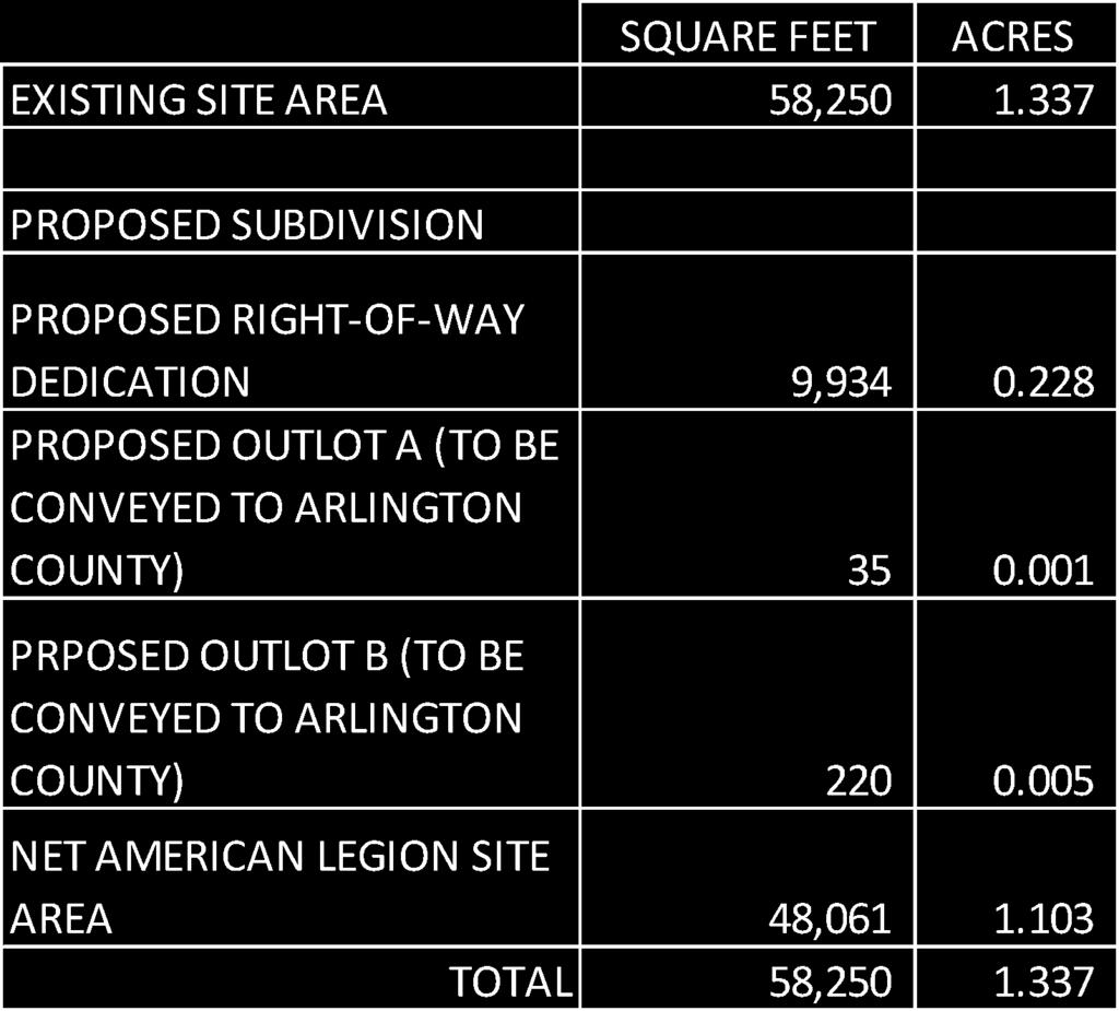
107
ARLINGTON COUNTY, VIRGINIA. County Board Agenda Item Meeting of February 23, 2019
 ARLINGTON COUNTY, VIRGINIA County Board Agenda Item Meeting of February 23, 2019 DATE: February 5, 2019 SUBJECTS: A. GP-343-17-1 GENERAL LAND USE PLAN AMENDMENT to change the land use designation for a
Wesley Housing Development Corporation Trenton Street Residential
 Wesley Housing Development Corporation Trenton Street Residential 1 2 Site Location Multimodal Traffic Study Summary Existing Conditions (2017) 13 study intersections. -Scoped with Arlington County DES
3804 Wilson Boulevard
 3804 Wilson Boulevard SPECIAL GENERAL LAND USE PLAN STUDY DEPARTMENT OF COMMUNITY PLANNING, HOUSING, & DEVELOPMENT Planning Division 3804 Wilson Boulevard Special GLUP Study a2 3804 Wilson Boulevard Special
SITE PLAN REVIEW COMMITTEE MEETING AGENDA
 Page 1 SITE PLAN REVIEW COMMITTEE MEETING AGENDA DATE: Monday, July 10, 2017 TIME: 7:00 8:30 p.m. PLACE: 2100 Clarendon Boulevard Ground Floor Conference Rooms Cherry/Dogwood Arlington, VA 22202 SPRC STAFF
Washington Boulevard + Kirkwood Road Special General Land Use Plan (GLUP) Study "Plus"
 Study Plus") Washington Boulevard + Kirkwood Road Special General Land Use Plan (GLUP) Study "Plus" Long Range Committee of the Planning Commission Meeting #4 May 18, 2017 Department of Community Planning, Housing
Washington Boulevard + Kirkwood Road Special General Land Use Plan (GLUP) Study "Plus" Long Range Committee of the Planning Commission Meeting #4 May 18, 2017 Department of Community Planning, Housing
S IT E PL A N R E V IE W C OM M IT T E E
 S IT E PL A N R E V IE W C OM M IT T E E M E E T I N G A G E N D A DATE: Thursday, January 4, 2018 TIME: 7:00 9:00 p.m. PLACE: Ellen Bozman Government Center/Courthouse Plaza 2100 Clarendon Boulevard Lobby
3804 Wilson Boulevard (Staples Site) Special General Land Use Plan Study
 Special General Land Use Plan Study") 1 3804 Wilson Boulevard (Staples Site) Special General Land Use Plan Study Long Range Committee of the Planning Commission Meeting May 16, 2018 Department of Community Planning, Housing and Development
1 3804 Wilson Boulevard (Staples Site) Special General Land Use Plan Study Long Range Committee of the Planning Commission Meeting May 16, 2018 Department of Community Planning, Housing and Development
28. ARLINGTON COUNTY, VIRGINIA. County Board Agenda Item Meeting of February 25, DATE: February 17, 2017
 ARLINGTON COUNTY, VIRGINIA County Board Agenda Item Meeting of February 25, 2017 DATE: February 17, 2017 SUBJECTS: Items associated with Queen's Court Residences: A. GP 335-16-1 GENERAL LAND USE PLAN AMENDMENT
SITE PLAN REVIEW COMMITTEE MEETING AGENDA Clarendon Boulevard Courthouse Plaza, Training Center (10 th Floor) Arlington, VA 22202
 Arlington, VA 22202") SITE PLAN REVIEW COMMITTEE MEETING AGENDA DATE: Wednesday, December 5, 2012 TIME: 8:30 10:00 p.m. PLACE: 2100 Clarendon Boulevard Courthouse Plaza, Training Center (10 th Floor) Arlington, VA 22202 SPRC
SITE PLAN REVIEW COMMITTEE MEETING AGENDA DATE: Wednesday, December 5, 2012 TIME: 8:30 10:00 p.m. PLACE: 2100 Clarendon Boulevard Courthouse Plaza, Training Center (10 th Floor) Arlington, VA 22202 SPRC
ARLINGTON COUNTY, VIRGINIA
 ARLINGTON COUNTY, VIRGINIA County Board Agenda Item Meeting of July 10, 2004 DATE: June 24, 2004 SUBJECT: A. GP-298-04-1 GENERAL LAND USE PLAN AMENDMENT from Semi- Public (Country Clubs and semi-public
2401 Wilson Boulevard General Land Use Plan Amendment Study
 2401 Wilson Boulevard General Land Use Plan Amendment Study Long Range Planning Committee Meeting Presentation Compendium March 29, 2011 Department of Community Planning, Housing and Development GLUP Amendment
SITE PLAN REVIEW COMMITTEE MEETING AGENDA Clarendon Boulevard Lobby Rooms C&D (Cherry & Dogwood) Arlington, VA
 Arlington, VA") SITE PLAN REVIEW COMMITTEE MEETING AGENDA DATE: Monday, January 8, 2018 TIME: 7:30 8:25 p.m. PLACE: 2100 Clarendon Boulevard Lobby Rooms C&D (Cherry & Dogwood) Arlington, VA 22201 SPRC STAFF COORDINATOR:
SITE PLAN REVIEW COMMITTEE MEETING AGENDA DATE: Monday, January 8, 2018 TIME: 7:30 8:25 p.m. PLACE: 2100 Clarendon Boulevard Lobby Rooms C&D (Cherry & Dogwood) Arlington, VA 22201 SPRC STAFF COORDINATOR:
SITE PLAN REVIEW COMMITTEE MEETING AGENDA Clarendon Boulevard Conference Rooms C & D Arlington, VA 22201
 SITE PLAN REVIEW COMMITTEE MEETING AGENDA DATE: Monday, October 2, 2017 TIME: 8:30 10:00 p.m. PLACE: 2100 Clarendon Boulevard Conference Rooms C & D Arlington, VA 22201 Item 2. 6711 Lee Highway (SP #3)
SITE PLAN REVIEW COMMITTEE MEETING AGENDA. DATE: Monday, October 22, Clarendon Boulevard Courthouse Plaza, Room 311 Arlington, VA 22201
 SITE PLAN REVIEW COMMITTEE MEETING AGENDA DATE: Monday, October 22, 2012 TIME: 7:00 9:00 p.m. PLACE: 2100 Clarendon Boulevard Courthouse Plaza, Room 311 Arlington, VA 22201 SPRC STAFF COORDINATOR: Samia
DEPARTMENT OF COMMUNITY PLANNING, HOUSING AND DEVELOPMENT Planning Division
 DEPARTMENT OF COMMUNITY PLANNING, HOUSING AND DEVELOPMENT Planning Division #1 Courthouse Plaza, 2100 Clarendon Boulevard, Suite 700 Arlington, VA 22201 TEL 703.228.3525 FAX 703.228.3543 www.arlingtonva.us
SITE PLAN REVIEW COMMITTEE MEETING AGENDA Clarendon Boulevard Conference Rooms C & D Arlington, VA 22201
 SITE PLAN REVIEW COMMITTEE MEETING AGENDA DATE: Monday, July 24, 2017 TIME: 7:00 9:00 p.m. PLACE: 2100 Clarendon Boulevard Conference Rooms C & D Arlington, VA 22201 Item 1. 6711 Lee Highway (SP #3) (RPC#
S I T E P L A N R E V I E W C O M M I T T E E M E E T I N G A G E N D A
 S I T E P L A N R E V I E W C O M M I T T E E M E E T I N G A G E N D A DATE: Thursday, September 14, 2017 TIME: 6:00 6:45 p.m. (optional walking tour) 7:00 8:30 p.m. PLACE: 2801 Clarendon Boulevard Meeting
ARLINGTON COUNTY, VIRGINIA. County Board Agenda Item Meeting of November 18, 2017
 ARLINGTON COUNTY, VIRGINIA County Board Agenda Item Meeting of November 18, 2017 DATE: November 9, 2017 SUBJECTS: A. Z-2597-17-1 REZONING from "C-O" Mixed Use District to "RA8-18" Multiple-Family Dwelling
November 21, RECOMMENDATION: Deny the site plan request, and accept withdrawal of rezoning request.
 November 21, 2003 TO: FROM: APPLICANT: BY: The County Board of Arlington, Virginia Ron Carlee, County Manager Trammell Crow Residential Tim Sampson, Attorney/Agent Walsh, Colucci, Emrich, Lubeley & Terpak
ARLINGTON COUNTY, VIRGINIA. County Board Agenda Item Meeting of December 8, 2012
 ARLINGTON COUNTY, VIRGINIA County Board Agenda Item Meeting of December 8, 2012 DATE: November 29, 2012 SUBJECTS: 1. GP-322-11-1 GENERAL LAND USE PLAN AMENDMENT to amend the GLUP designation for the two
ARLINGTON COUNTY, VIRGINIA
 ARLINGTON COUNTY, VIRGINIA County Board Agenda Item Meeting of June 10, 2006 DATE: June 9, 2006 SUBJECTS: A. Z-2525-06-1 REZONING for Saul Centers, Inc., from C-3 General Commercial Districts to C-O Commercial
SITE PLAN REVIEW COMMITTEE MEETING AGENDA. DATE: Wednesday, February 28, Aurora Hills Community Center th Street S. Arlington, VA 22202
 Page 1 SITE PLAN REVIEW COMMITTEE MEETING AGENDA DATE: Wednesday, February 28, 2018 TIME: 7:00 9:00 p.m. PLACE: Aurora Hills Community Center 735 18 th Street S. Arlington, VA 22202 SPRC STAFF COORDINATOR:
ARLINGTON COUNTY, VIRGINIA. County Board Agenda Item Meeting of May 14, 2011
 ARLINGTON COUNTY, VIRGINIA County Board Agenda Item Meeting of May 14, 2011 DATE: May 11, 2011 SUBJECT: SP #240 SITE PLAN AMENDMENT for a kiosk for the Department of Environmental Services located at the
S I T E P L A N R E V I E W C O M M I T T E E M E E T I N G A G E N D A
 S I T E P L A N R E V I E W C O M M I T T E E M E E T I N G A G E N D A DATE: Thursday, July 23, 2015 TIME: 7:00 10:00 p.m. PLACE: 2100 Clarendon Boulevard Courthouse Plaza, 1st Floor, Cherry and Dogwood
ARLINGTON COUNTY, VIRGINIA
 ARLINGTON COUNTY, VIRGINIA County Board Agenda Item Meeting of February 23, 2013 DATE: February 8, 2013 SUBJECTS: A. Z-2563-12-1 REZONING from "CM" Limited Industrial Districts to "C-O-Crystal City" Commercial
SITE PLAN REVIEW COMMITTEE MEETING AGENDA. DATE: Wednesday, April 4, 2018
 Page 1 SITE PLAN REVIEW COMMITTEE MEETING AGENDA DATE: Wednesday, April 4, 2018 TIME: 7:00 9:30 p.m. PLACE: Ellen Bozman Building Room 715, 7 th Floor 2100 Clarendon Boulevard Arlington, VA 22201 SPRC
SITE PLAN REVIEW COMMITTEE MEETING AGENDA Clarendon Boulevard Arlington, VA Conference Rooms 109/110 (C&D)
") SITE PLAN REVIEW COMMITTEE MEETING AGENDA DATE: Thursday, September 19, 2013 TIME: 7:00 10:00 p.m. PLACE: 2100 Clarendon Boulevard Arlington, VA 22201 Conference Rooms 109/110 (C&D) SPRC STAFF COORDINATOR:
SITE PLAN REVIEW COMMITTEE MEETING AGENDA DATE: Thursday, September 19, 2013 TIME: 7:00 10:00 p.m. PLACE: 2100 Clarendon Boulevard Arlington, VA 22201 Conference Rooms 109/110 (C&D) SPRC STAFF COORDINATOR:
SITE PLAN REVIEW COMMITTEE MEETING AGENDA. DATE: Thursday, April 25, :00 8:30 p.m. PLACE:
 SITE PLAN REVIEW COMMITTEE MEETING AGENDA DATE: Thursday, April 25, 2013 TIME: 7:00 8:30 p.m. PLACE: Courthouse Plaza 2100 Clarendon Boulevard Conference Rooms C&D Arlington, VA 22201 SPRC STAFF COORDINATOR:
S I T E P L A N R E V I E W C O M M I T T E E M E E T I N G A G E N D A
 S I T E P L A N R E V I E W C O M M I T T E E M E E T I N G A G E N D A DATE: Thursday, November 15, 2018 TIME: SPRC: 7:00 8:30 p.m. PLACE: Ellen M. Bozman Government Center 2100 Clarendon Boulevard Room
ARLINGTON COUNTY, VIRGINIA. County Board Agenda Item Meeting of September 19, 2015
 ARLINGTON COUNTY, VIRGINIA County Board Agenda Item Meeting of September 19, 2015 DATE: August 28, 2015 SUBJECT: Request to authorize advertisement of public hearings by the Planning Commission and the
October 9, The County Board of Arlington, Virginia. Ron Carlee, County Manager
 October 9, 2003 TO: FROM: APPLICANT: BY: The County Board of Arlington, Virginia Ron Carlee, County Manager Douglas Schneiderman, Vice President Madison Homes, Inc. 6723 Whittier Avenue, Suite 104 McLean,
ARLINGTON COUNTY, VIRGINIA
 ARLINGTON COUNTY, VIRGINIA County Board Agenda Item Meeting of April 21, 2007 DATE: April 13, 2007 SUBJECT: SP #346 PHASED DEVELOPMENT SITE PLAN AMENDMENT (PDSP) AND FINAL SITE PLANS for Potomac Yard:
Ron Carlee, County Manager
 June 6, 2003 TO: FROM: APPLICANT: BY: SUBJECTS: The County Board of Arlington, Virginia The Holladay Corporation Nan Terpak, Attorney/Agent Walsh, Colucci, Lubeley, Emrich & Terpak 2200 Clarendon Blvd.,
ARLINGTON COUNTY, VIRGINIA
 ARLINGTON COUNTY, VIRGINIA County Board Agenda Item Meeting of February 20, 2016 DATE: February 17, 2016 SUBJECTS: A. Z-2587-16-1 REZONING from "R-6" One-Family Dwelling District to "CP-FBC" Columbia Pike
ARLINGTON COUNTY, VIRGINIA
 ARLINGTON COUNTY, VIRGINIA County Board Agenda Item Meeting of November 14, 2015 DATE: November 13, 2015 SUBJECTS: Development A. SP #193 SITE PLAN AMENDMENT Ballston Air Rights Acquisition Company, LLC
ARLINGTON COUNTY, VIRGINIA. County Board Agenda Item Meeting of May 14, 2016
 ARLINGTON COUNTY, VIRGINIA County Board Agenda Item Meeting of May 14, 2016 DATE: May 11, 2016 SUBJECTS: Applicant: AHC, Inc. A. Z-2589-16-1 REZONING from R-6 to RA-8-18 for an approximately 18,170 square
ARLINGTON COUNTY, VIRGINIA
 ARLINGTON COUNTY, VIRGINIA County Board Agenda Item Meeting of December 8, 2012 DATE: November 29, 2012 SUBJECT: PDSP #346 SITE PLAN AMENDMENT to convert approximately 1,458 square feet of GFA below-grade
ARLINGTON COUNTY, VIRGINIA
 ARLINGTON COUNTY, VIRGINIA County Board Agenda Item Meeting December 9, 2006 DATE: November 20, 2006 SUBJECT: GP-302-05-2 Adoption of General Land Use Plan Amendments for the Clarendon Metro Station Area:
S I T E P L A N R E V I E W C O M M I T T E E M E E T I N G A G E N D A
 S I T E P L A N R E V I E W C O M M I T T E E M E E T I N G A G E N D A DATE: Monday July 27, 2015 TIME: 7:00 8:25 p.m. PLACE: 2100 Clarendon Boulevard Courthouse Plaza, 1st Floor, Cherry and Dogwood Rooms
SITE PLAN REVIEW COMMITTEE MEETING AGENDA Clarendon Boulevard Courthouse Plaza, Rooms 109/110 Arlington, VA 22201
 SITE PLAN REVIEW COMMITTEE MEETING AGENDA DATE: Monday, January 6, 2014 TIME: 7:00 8:30 p.m. PLACE: 2100 Clarendon Boulevard Courthouse Plaza, Rooms 109/110 Arlington, VA 22201 SPRC STAFF COORDINATOR:
SITE PLAN REVIEW COMMITTEE MEETING AGENDA. DATE: Monday, January 29, 2018
 Page 1 SITE PLAN REVIEW COMMITTEE MEETING AGENDA DATE: Monday, January 29, 2018 TIME: 8:30 10:00 p.m. PLACE: 2100 Clarendon Boulevard, Rooms Cherry/Dogwood Arlington, VA 22201 SPRC STAFF COORDINATOR: Matt
The American Legion Post 139 Development Project
 The American Legion Post 139 Development Project SPRC 1 3445 Washington Blvd. Arlington, Virginia 22201 November 13, 2018 About APAH 29 year old award-winning, missiondriven nonprofit developer Deeply
CONNECTING ARLINGTON S POLICY FRAMEWORK TO THE RESIDENTIAL PARKING WORKING GROUP
 CONNECTING ARLINGTON S POLICY FRAMEWORK TO THE RESIDENTIAL PARKING WORKING GROUP Contents Arlington County Development and Growth Goals... 1 Master Transportation Plan Policies Related to Multi Family
SITE PLAN REVIEW COMMITTEE MEETING AGENDA. DATE: Wednesday, November 18, 2015
 Page 1 SITE PLAN REVIEW COMMITTEE MEETING AGENDA DATE: Wednesday, November 18, 2015 TIME: 7:00 9:00 p.m. PLACE: First Presbyterian Church of Arlington 601 North Vermont Street Arlington, VA 22203 SPRC
S I T E P L A N R E V I E W C O M M I T T E E M E E T I N G A G E N D A Clarendon Boulevard Courthouse Plaza, Rooms 109/111 Arlington, VA 22201
 S I T E P L A N R E V I E W C O M M I T T E E M E E T I N G A G E N D A DATE: Thursday, March 27, 2014 TIME: 7:00 8:25 pm PLACE: 2100 Clarendon Boulevard Courthouse Plaza, Rooms 109/111 Arlington, VA 22201
SITE PLAN REVIEW COMMITTEE MEETING AGENDA & STAFF REPORT
 SITE PLAN REVIEW COMMITTEE MEETING AGENDA & STAFF REPORT DATE: Thursday, April 21, 2016 TIME: 7:00 8:25 p.m. PLACE: Courthouse Plaza; Cherry/Dogwood Conference Rooms (109/110) SPRC STAFF COORDINATOR: Samia
Pentagon Centre (SP#297) PDSP & Phase I Site Plan Amendments SPRC #1
 PDSP & Phase I Site Plan Amendments SPRC #1") Pentagon Centre (SP#297) PDSP & Phase I Site Plan Amendments SPRC #1 CPHD February 23, 2015 Meeting Agenda Background on relevant planning context, guidance, and County policy Brief update on original
Pentagon Centre (SP#297) PDSP & Phase I Site Plan Amendments SPRC #1 CPHD February 23, 2015 Meeting Agenda Background on relevant planning context, guidance, and County policy Brief update on original
ARLINGTON COUNTY, VIRGINIA
 ARLINGTON COUNTY, VIRGINIA County Board Agenda Item Meeting of June 16, 2012 DATE: June 7, 2012 SUBJECT: SP #397 SITE PLAN AMENDMENT to revise condition #31 to modify the retail transparency requirement
QUEENS COURT APARTMENTS TRANSPORTATION COMMISSION 1801 N. QUINN STREET ARLINGTON, VA 22209
 QUEENS COURT APARTMENTS TRANSPORTATION COMMISSION 1801 N. QUINN STREET ARLINGTON, VA 22209 November 14, 2016 QUEENS COURT APARTMENTS 2 QUEENS COURT APARTMENTS Built 1941 Acquired by APAH in 1997 Site Area
Request Conditional Rezoning (B-2 Community Business to Conditional A-24 Apartment) Staff Recommendation Approval. Staff Planner Ashby Moss
 Staff Recommendation Approval. Staff Planner Ashby Moss") Applicant Management & Development, LLC Property Owner School Board of the City of Virginia Beach Public Hearing January 10, 2018 City Council Election District Kempsville Agenda Item 5 Request Conditional
Applicant Management & Development, LLC Property Owner School Board of the City of Virginia Beach Public Hearing January 10, 2018 City Council Election District Kempsville Agenda Item 5 Request Conditional
S I T E P L A N R E V I E W C O M M I T T E E M E E T I N G A G E N D A
 S I T E P L A N R E V I E W C O M M I T T E E M E E T I N G A G E N D A DATE: Monday, September 21, 2015 TIME: 7:00 10:00 p.m. PLACE: 2100 Clarendon Boulevard Courthouse Plaza, 1st Floor, Cherry and Dogwood
ARLINGTON COUNTY, VIRGINIA
 ARLINGTON COUNTY, VIRGINIA County Board Agenda Item Meeting of September 19, 2015 DATE: September 15, 2015 SUBJECTS: A. SP# 297 PHASED DEVELOPMENT SITE PLAN AMENDMENT of the Pentagon Centre PDSP to permit
SITE PLAN REVIEW COMMITTEE MEETING AGENDA. Navy League 2300 Wilson Boulevard, Large Conference Room Arlington, Virginia 22201
 Page 1 SITE PLAN REVIEW COMMITTEE MEETING AGENDA DATE: Monday, March 7, 2016 TIME: 7:00 9:00 p.m. PLACE: Navy League 2300 Wilson Boulevard, Large Conference Room Arlington, Virginia 22201 SPRC STAFF COORDINATOR:
SITE PLAN REVIEW COMMITTEE MEETING AGENDA. Courthouse Plaza 2100 Clarendon Boulevard, Room North Vermont Street Arlington, VA 22203
 Page 1 SITE PLAN REVIEW COMMITTEE MEETING AGENDA DATE: Monday, October 17, 2016 TIME: 7:00 8:30 p.m. PLACE: Courthouse Plaza 2100 Clarendon Boulevard, Room 715 601 North Vermont Street Arlington, VA 22203
Virginia Hospital Center Expansion
 Virginia Hospital Center Expansion Rezoning (Z-2606-18-1) Site Plan Amendment (SP #177) Use Permit Amendment (U-2203-79-3) County Board Public Hearing Department of Community Planning, Housing and Development
S I T E P L AN R E VI E W C O M M I T T E E M EET I N G A G EN D A. Navy League 2300 Wilson Boulevard, Large Conference Room Arlington, Virginia 22201
 Page 1 S I T E P L AN R E VI E W C O M M I T T E E M EET I N G A G EN D A DATE: Monday, March 21, 2016 TIME: 7:00 9:00 p.m. PLACE: Navy League 2300 Wilson Boulevard, Large Conference Room Arlington, Virginia
PLANNING COMMISSION REPORT Regular Agenda -Public Hearing Item
 PDP-13-00518 Item No. 3B- 1 PLANNING COMMISSION REPORT Regular Agenda -Public Hearing Item PC Staff Report 2/24/14 ITEM NO. 3B PRELIMINARY DEVELOPMENT PLAN FOR HERE @ KANSAS; 1101 INDIANA ST (SLD) PDP-13-00518:
ARLINGTON COUNTY, VIRGINIA
 ARLINGTON COUNTY, VIRGINIA County Board Agenda Item Meeting of July 19, 2008 DATE: July 16, 2008 SUBJECT: SP#297 SITE PLAN: PL Pentagon LLC c/o Kimco Realty Corporation, construct approx. 489,911 sq ft
ARLINGTON COUNTY, VIRGINIA
 ARLINGTON COUNTY, VIRGINIA County Board Agenda Item Meeting of July 10, 2004 DATE: July 1, 2004 SUBJECTS: A. Consideration of consent concerning whether to include Hillside Park within the site plan area
ARLINGTON COUNTY, VIRGINIA
 ARLINGTON COUNTY, VIRGINIA County Board Agenda Item Meeting of March 27, 2004 DATE: March 19, 2004 SUBJECT: SP # 376 SITE PLAN AMENDMENT, to amend Condition #26 to permit the installation of new utility
ARLINGTON COUNTY, VIRGINIA
 ARLINGTON COUNTY, VIRGINIA County Board Agenda Item Meeting of September 18, 2004 DATE: August 19, 2004 SUBJECTS: A. GP-297-04-1 GENERAL LAND USE PLAN AMENDMENT from Service Commercial (Personal and business
S I T E P L A N R E V I E W C O M M I T T E E M E E T I N G A G E N D A Clarendon Boulevard Courthouse Plaza, Rooms 109/110 Arlington, VA 22201
 S I T E P L A N R E V I E W C O M M I T T E E M E E T I N G A G E N D A DATE: Thursday, May 22, 2014 TIME: 7:00 10:00 p.m. PLACE: 2100 Clarendon Boulevard Courthouse Plaza, Rooms 109/110 Arlington, VA
ARLINGTON COUNTY, VIRGINIA. County Board Agenda Item Meeting of September 22, 2018
 ARLINGTON COUNTY, VIRGINIA County Board Agenda Item Meeting of September 22, 2018 DATE: September 13, 2018 SUBJECT: SP413-U-18-1 USE PERMIT ASSOCIATED WITH A SITE PLAN for food delivery service for Domino's
SP #447, 11 th & Vermont
 SP #447, 11 th & Vermont GLUP Amendment, Rezoning, and Site Plan Department of Community Planning, Housing, and Development County Board February 24, 2018 1 NORTH BLOCK (R15-30T) 11 th & Vermont (SP #447)
STAFF REPORT. Community Development Director PO Box 4755 Beaverton, OR 97076
 STAFF REPORT HEARING DATE: July 7, 2010 TO: Planning Commission STAFF: Jana Fox, Assistant Planner PROPOSAL: Southeast Beaverton Office Commercial Zoning Map Amendment (ZMA2010-0006) LOCATION: The subject
ARLINGTON COUNTY, VIRGINIA
 ARLINGTON COUNTY, VIRGINIA County Board Agenda Item Meeting of November 15, 2005 DATE: November 22, 2005 SUBJECT: SP #331 SITE PLAN AMENDMENT to incorporate 4420 N. Fairfax Dr. into site plan, construct
PLANNED UNIT DEVELOPMENT & SUBDIVISION STAFF REPORT Date: April 18, 2019
 PLANNED UNIT DEVELOPMENT & SUBDIVISION STAFF REPORT Date: April 18, 2019 DEVELOPMENT NAME SUBDIVISION NAME Springhill Village Subdivision Springhill Village Subdivision LOCATION 4350, 4354, 4356, 4358,
50 and 52 Finch Avenue East - Official Plan and Zoning By-law Amendment Applications - Preliminary Report
 STAFF REPORT ACTION REQUIRED 50 and 52 Finch Avenue East - Official Plan and Zoning By-law Amendment Applications - Preliminary Report Date: August 16, 2016 To: From: Wards: Reference Number: North York
An implementation document is forthcoming. - A1-1 -
 OFF-STREET PARKING GUIDELINES FOR MULTI-FAMILY RESIDENTIAL PROJECTS APPROVED BY SPECIAL EXCEPTION IN THE ROSSLYN-BALLSTON AND JEFFERSON DAVIS METRO CORRIDORS 12/01/2017 This is a draft of the guidelines
SITE PLAN REVIEW COMMITTEE MEETING AGENDA & STAFF REPORT. DATE: Monday, December 5, :00 10:00 p.m. PLACE:
 SITE PLAN REVIEW COMMITTEE MEETING AGENDA & STAFF REPORT DATE: Monday, December 5, 2016 TIME: 7:00 10:00 p.m. PLACE: 2100 Clarendon Boulevard Courthouse Plaza Room 109/110 (Cherry & Dogwood) Arlington,
Plan Area and Current Facilities
 Plan Area and Current Facilities The Plan Area is bounded by South Delaware Street to the east and Concar Drive to the south (Figure 2.01). Parallel to Concar Drive on the south, SR 92 rises above grade
ARLINGTON COUNTY, VIRGINIA
 ARLINGTON COUNTY, VIRGINIA County Board Agenda Item Meeting of January 21, 2006 DATE: January 5, 2006 SUBJECT: Action on Proposed Amendments to provide for the achievement of affordable housing objectives
S I T E P L A N R E V I E W C O M M I T T E E M E E T I N G A G E N D A Clarendon Boulevard Conference Room 311 Arlington, VA 22201
 S I T E P L A N R E V I E W C O M M I T T E E M E E T I N G A G E N D A DATE: Thursday, May 12, 2016 TIME: 7:00 8:25 p.m. PLACE: 2100 Clarendon Boulevard Conference Room 311 Arlington, VA 22201 SPRC STAFF
PLANNED DEVELOPMENT DISTRICT STANDARDS. Cadence Site
 PLANNED DEVELOPMENT DISTRICT STANDARDS Cadence Site A Planned Development District 1. Statement of General Facts, Conditions and Objectives Property Size: Approximately 57.51 Acres York County Tax Map
The Philadelphia Code. In order to be eligible for any floor area bonuses pursuant to this section:
 1 of 16 2/17/2015 2:47 PM The Philadelphia Code 14-702. Floor Area and Height Bonuses. 225.1 (1) Purpose. The intent of the floor area bonus provisions is to encourage certain types of development and
July 10, The County Board of Arlington, Virginia. Ron Carlee, County Manager. Keating Development Company
 July 10, 2003 TO: FROM: APPLICANT: BY: The County Board of Arlington, Virginia Ron Carlee, County Manager Keating Development Company Timothy S. Sampson, Attorney/Agent Walsh Colucci Lubeley Emrich & Terpak
ARLINGTON COUNTY, VIRGINIA
 ARLINGTON COUNTY, VIRGINIA County Board Agenda Item Meeting of June 12, 2004 DATE: June 3, 2004 SUBJECT: A. Z-2511-03-1 REZONING from R-5 One-Family, Restricted Two-Family Dwelling Districts, C-2 Service
ARLINGTON COUNTY, VIRGINIA
 ARLINGTON COUNTY, VIRGINIA County Board Agenda Item Meeting of December 12, 2015 DATE: November 24, 2015 SUBJECTS: A. Z-2585-15-1 REZONING from "R-5" One-Family, Restricted Two-Family Dwelling Districts
ARLINGTON COUNTY, VIRGINIA
 ARLINGTON COUNTY, VIRGINIA County Board Agenda Item Meeting of July 16, 2016 DATE: July 5, 2016 SUBJECT: SP #64 SITE PLAN AMENDMENT to allow temporary extension of construction hours for ; located at 1000
SITE PLAN REVIEW COMMITTEE MEETING AGENDA. DATE: Monday, December 16, 2013
 SITE PLAN REVIEW COMMITTEE MEETING AGENDA DATE: Monday, December 16, 2013 TIME: 7:00 10:00 p.m. PLACE: 2100 Clarendon Boulevard Courthouse Plaza, Rooms 109/111 Arlington, VA 22201 SPRC STAFF COORDINATOR:
ARLINGTON COUNTY, VIRGINIA
 ARLINGTON COUNTY, VIRGINIA County Board Agenda Item Meeting of July 13, 2013 DATE: July 5, 2013 SUBJECTS: A. Z-2565-13-1 REZONING from "" Service Commercial-Community Business Districts to "" Commercial
1202 & 1204 Avenue Road Zoning By-law Amendment Application - Preliminary Report
 STAFF REPORT ACTION REQUIRED 1202 & 1204 Avenue Road Zoning By-law Amendment Application - Preliminary Report Date: March 17, 2017 To: From: Wards: Reference Number: North York Community Council Director,
ARLINGTON COUNTY, VIRGINIA
 ARLINGTON COUNTY, VIRGINIA County Board Agenda Item Meeting of December 10, 2005 DATE: December 9, 2005 SUBJECT: SP #392 SITE PLAN to develop approximately 153 dwelling units and approximately 17,162 square
SITE PLAN REVIEW COMMITTEE MEETING AGENDA & STAFF REPORT. DATE: Monday, December 12, :00 8:30 p.m. PLACE:
 SITE PLAN REVIEW COMMITTEE MEETING AGENDA & STAFF REPORT DATE: Monday, December 12, 2016 TIME: 7:00 8:30 p.m. PLACE: 2100 Clarendon Boulevard Courthouse Plaza Room 109/110 (Cherry & Dogwood) Arlington,
Staff Report for Council Public Meeting
 Agenda Item 3.3 Staff Report for Council Public Meeting Date of Meeting: September 27, 2017 Report Number: SRPRS.17.134 Department: Division: Subject: Planning and Regulatory Services Development Planning
ARLINGTON COUNTY, VIRGINIA
 ARLINGTON COUNTY, VIRGINIA County Board Agenda Item Meeting of September 22, 2018 DATE: August 30, 2018 SUBJECTS: A. Z-2606-18-1 REZONING Arlington Health System from "S- 3A" Special District to "S-D"
4 DEVELOPMENT STANDARDS FOR
 4 DEVELOPMENT STANDARDS FOR RESIDENTIAL MIXED-USE PROJECTS This chapter presents standards for residential mixed-use projects in the Ashland-Cherryland Business District and the Castro Valley Central Business
60. ARLINGTON COUNTY, VIRGINIA. County Board Agenda Item Meeting of July 14, DATE: July 13, 2018
 ARLINGTON COUNTY, VIRGINIA County Board Agenda Item Meeting of July 14, 2018 DATE: July 13, 2018 SUBJECT: Request to authorize advertisement of public hearings by the Planning Commission and County Board
40-58 Widmer Street - Zoning Amendment Application - Preliminary Report
 STAFF REPORT ACTION REQUIRED 40-58 Widmer Street - Zoning Amendment Application - Preliminary Report Date: April 19, 2013 To: From: Wards: Reference Number: Toronto and East York Community Council Director,
SITE PLAN REVIEW COMMITTEE MEETING AGENDA. NRECA 4301 Wilson Boulevard Conference Rooms CC1 Arlington, VA 22203
 SITE PLAN REVIEW COMMITTEE MEETING AGENDA DATE: Monday, July 20, 2015 TIME: 7:00 10:00 p.m. PLACE: NRECA 4301 Wilson Boulevard Conference Rooms CC1 Arlington, VA 22203 SPRC STAFF COORDINATOR: Samia Byrd,
ARLINGTON COUNTY, VIRGINIA
 ARLINGTON COUNTY, VIRGINIA County Board Agenda Item Meeting of April 16, 2005 DATE: April 13, 2005 SUBJECT: A. SP #76 SITE PLAN AMENDMENT to reduce units in existing hotel from 238 to approximately 187,
City of Grande Prairie Development Services Department
 City of Grande Prairie Development Services Department COUNTRYSIDE SOUTH OUTLINE PLAN Prepared by: GPEC Consulting Ltd. #202, 10712-100th Street Grande Prairie, AB Council Resolution of August 20, 2001
STAFF REPORT PLN September 11, 2017
 Page: 1 TO: SUBJECT: GENERAL COMMITTEE APPLICATIONS FOR OFFICIAL PLAN AMENDMENT AND ZONING BY-LAW AMENDMENT 37 JOHNSON STREET WARD: WARD 1 PREPARED BY AND KEY CONTACT: SUBMITTED BY: GENERAL MANAGER APPROVAL:
PD No. 15 Authorized Hearing
 PD No. 15 Authorized Hearing Community Meeting No. 2 February 19, 2019 6:30 p.m. Hyer Elementary School Cafetorium 8385 Durham St Andrew Ruegg Senior Planner PD No. 15 Authorized Hearing On September 7,
R E S O L U T I O N. 1. Request: A Departure from Parking and Loading Standards (DPLS-449) for 32 parking spaces.
 for 32 parking spaces.") R E S O L U T I O N WHEREAS, the Prince George s County Planning Board has reviewed Departure from Parking and Loading Standards No. DPLS-449 requesting a departure to allow a reduction of 32 parking spaces
R E S O L U T I O N WHEREAS, the Prince George s County Planning Board has reviewed Departure from Parking and Loading Standards No. DPLS-449 requesting a departure to allow a reduction of 32 parking spaces
Director, Community Planning, North York District NNY 10 OZ and NNY 10 RH
 STAFF REPORT ACTION REQUIRED 847 873 Sheppard Avenue West - Official Plan Amendment and Zoning By-law Amendment and Rental Housing Demolition and Conversion Applications - Preliminary Report Date: April
TRANSIT-ORIENTED DEVELOPMENT PLAN EXISTING CONDITIONS REPORT LAWRENCE TO BRYN MAWR MODERNIZATION
 TRANSIT-ORIENTED DEVELOPMENT PLAN EXISTING CONDITIONS REPORT LAWRENCE TO BRYN MAWR MODERNIZATION March 2018- FINAL DRAFT SITE SPECIFIC DEVELOPMENT CONCEPTS SITE SPECIFIC DEVELOPMENT CONCEPTS This report
Planning Justification Report
 Planning Justification Report 101 Kozlov Street, Barrie, Ont. Destaron Property Management Ltd. November 2015 Revised February 2017 TABLE OF CONTENTS Page 1.0 INTRODUCTION... 1 2.0 DESCRIPTION OF SUBJECT
S I T E P L A N R E V I E W C O M M I T T E E M E E T I N G A G E N D A
 S I T E P L A N R E V I E W C O M M I T T E E M E E T I N G A G E N D A DATE: TIME: PLACE: Monday, May 18, 2015 7:00 10:00 p.m. 2100 Clarendon Boulevard Conference Room 311 Arlington, VA 22201 SPRC STAFF
CITY OF CHARLOTTESVILLE DEPARTMENT OF NEIGHBORHOOD DEVELOPMENT SERVICES STAFF REPORT APPLICATION FOR A SPECIAL USE PERMIT
 CITY OF CHARLOTTESVILLE DEPARTMENT OF NEIGHBORHOOD DEVELOPMENT SERVICES STAFF REPORT APPLICATION FOR A SPECIAL USE PERMIT PLANNING COMMISSION AND CITY COUNCIL JOINT PUBLIC HEARING DATE OF HEARING: December