ARLINGTON COUNTY, VIRGINIA
|
|
|
- Marshall Mosley
- 5 years ago
- Views:
Transcription


1 ARLINGTON COUNTY, VIRGINIA County Board Agenda Item Meeting of February 20, 2016 DATE: February 17, 2016 SUBJECTS: A. Z REZONING from "R-6" One-Family Dwelling District to "CP-FBC" Columbia Pike Form Based Code District. Property is approximately 25,539 sq. ft. and located at 940 S. George Mason Drive (Village Center) (RPC# , -019). B. U USE PERMIT for the development of 365 multi-family dwelling units and approximately 81,530 sq. ft. of ground floor retail with modifications for alley design, location of a Required Building Line, and finished floor elevation for ground floor retail under the commercial Form Based Code for property located at 940, 942, 944, 948 and 950 S. George Mason Drive (Village Center) (RPC# , -018, -019). Applicant: Orr Columbia Pike, LLC Sunrise Valley Drive, Suite 300 Reston, Virginia By: M. Catharine Puskar Walsh, Colucci, Lubeley & Walsh, P.C Clarendon Boulevard, 13th Floor Arlington, Virginia C.M. RECOMMENDATIONS: 1. Adopt the attached ordinance to approve the rezoning request from R-6 One-Family Dwelling Districts to CP-FBC Columbia Pike Form Based Code Districts; 940 S. George Mason Drive (RPC# , -019). County Manager: ##### County Attorney: ***** Staff: Matt Mattauszek, DCPHD, Planning Division Dennis Sellin, DES, Development Services 18.
2 2. Approve the subject use permit, in accordance with the Columbia Pike Form Based Code (Article 11.1 of the Zoning Ordinance, Appendix A), to build 365 multi-family dwelling units and approximately 81,530 sq. ft. of retail with modifications for alley design, location of a Required Building Line, and finished floor elevation for ground floor retail, subject to the conditions of the staff report. ISSUES: This is a rezoning and use permit request for a Columbia Pike Form Based Code (FBC) development which will include a new public open space to be developed with the use permit. The developer requests modifications of alley configuration, the location of a Required Building Line and finished floor elevation for ground floor retail regulations, which are allowed under the FBC. SUMMARY: The applicant is requesting use permit approval of a residential project that includes 365 multi-family dwelling units. The subject property, located on 950 S. George Mason Drive, is within the Columbia Pike Special Revitalization District as shown on the General Land Use Plan (GLUP) making the site eligible for development pursuant to the Columbia Pike Form Based Code (FBC). The property is split zoned C-2 and R-6. Use of the FBC is permitted for the C-2 zoned area. For the R-6 portion of the site, a rezoning is required to use the FBC. Therefore, the applicant is requesting a partial rezoning to CP-FBC in order to use the FBC as the development standard on the entire site. The subject site is currently occupied by the Food Star grocer, in-line retail and a surface parking lot. In accordance with the FBC, the applicant is proposing redevelopment of the site including a new 6-story structure with an underground, 3-level parking garage that would replace the existing retail and surface parking. A public square at the corner of Columbia Pike and S. George Mason Drive is also proposed consistent with the FBC. A special exception FBC use permit approval is required since the site area exceeds 40,000 square feet, the building footprint exceeds 30,000 square feet, and the applicant proposes three modifications to the FBC. After several review cycles of preliminary plans, including a review by the Columbia Pike FBC Advisory Working Group (FBC AWG), staff concludes that the final application is compliant with all FBC standards except for the three requested modifications. The public square concept was also thoroughly discussed with the FBC AWG and through a separate public process led by the Department of Community Planning Housing and Development (CPHD). The proposal also conforms to the purposes and intent of the adopted 2005 Columbia Pike Initiative A Revitalization Plan. The FBC AWG concurs with staff and has found the use permit proposal to be in conformance with the FBC. Although a new transit alternative has not been determined to replace the streetcar, this proposal advances the Columbia Pike revitalization vision and does not diminish or negatively impact the transportation system in the corridor. Staff expects that redevelopment projects can be accommodated with the current street network and transit service with minimal impacts with a number of TDM measures recommended in this report. Therefore, staff recommends approval of the rezoning and use permit for 365 multi-family dwelling units and approximately 81,530 square feet of retail for the subject property and subject to the conditions of this staff report. Z & U Use Permit - 2 -

3 BACKGROUND: In the spring of 2015, the applicant filed a preliminary application for redevelopment of the subject property that utilizes the specifications of the Form Based Code (FBC). The applicant proposes to develop a six-story structure containing 365 apartment units and approximately 81,530 square feet of retail on the existing Food Star grocer, in-line retail, and surface parking lot. The subject proposal includes a 3-level, parking garage with access to parking and loading for the new development. This section provides general background on the history of the Columbia Pike Initiative (CPI) plan and FBC and presents general site information and the planning context for this development proposal. Brief History of the CPI plan and FBC: In 2002, the Columbia Pike Initiative, A Revitalization Plan was adopted by the County Board. A major recommendation of this plan was to develop a new administrative review process to evaluate redevelopment proposals on Columbia Pike, which was implemented through the Columbia Pike Special Revitalization District Form Based Code (FBC). In February 2003, the County adopted the FBC which applies to a special revitalization district on the General Land Use Plan (GLUP) encompassing four development nodes along the Pike corridor (also referred to as the commercial centers FBC ). The FBC provides an optional regulatory framework for property owners to follow for redevelopment that is consistent with the walkable and transit-supported main street-type development envisioned by the Columbia Pike Initiative Plan. Site Information/Existing Development and Planning Context: Site Information/Existing Development: The approximate 2.99 acre site (130,429 square feet) is comprised of three parcels and located on the northwest intersection of Columbia Pike and S. George Mason Drive. The property is currently developed as a one-story, commercial shopping area with approximately 35,600 square feet of gross floor area. The Food Star grocery store is located in this shopping center, with other inline retail shops. Exhibits 1 and 2 illustrate the location of the subject site within the Barcroft neighborhood. Exhibit 1: 950 S. George Mason Drive Context Map/Civic Associations Barcroft School and Civic League Subject Site Alcova Heights Civic Association Douglas Park Civic Association North Subject Site: Civic Association Z & U Use Permit - 3 -

4 Exhibit 2: 950 S. George Mason Drive Aerial Map Lutheran Church & School East Barcroft Townhomes Birdwood Condo Wells Fargo Bank Laurel Green Townhomes Subject Site Pan American Bakery Liberty Gas Station Tanglewood Condos Penske Truck Rental The Whitmore Barcroft Apartments 7-Eleven North Subject Site: Adjacent and surrounding land uses are as follows: To the north: A townhouse development immediately to the north; zoned R10-T and designated Low Residential (1-10 units/acre) on the GLUP. Single family residential development to the northwest, along S. Taylor Street; zoned R-6 and designated Low Residential (1-10 units/acre) on the GLUP. To the west: The Tanglewood Condominium, a mid-rise multi-family development, to the west, with Columbia Pike frontage (4241 Columbia Pike); zoned RA8-18 and designated Low-Medium Residential and within the Columbia Pike Special Revitalization District on the GLUP. The Laurel Green Condominium, a townhouse development, to the west, fronting on S. Taylor Street; zoned RA8-18 and designated Low- Medium Residential and within the Columbia Pike Special Revitalization District on the GLUP. To the east: Across S. George Mason Drive, multiple buildings including a small commercial office building; a bank; a gas station, and retail; zoned C-2, C-1, and R-6 and designated as Service Commercial and within the Columbia Pike Special Revitalization District on the GLUP. Z & U Use Permit - 4 -
5 To the south: Across Columbia Pike, the Barcroft Apartments; zoned RA8-18 and designated Low-Medium Residential and within the Columbia Pike Neighborhoods Special Revitalization District on the GLUP. Neighborhood: The site is located within the Barcroft School and Civic League. It is adjacent to the Alcova Heights and Douglas Park civic associations. Zoning: The site is split-zoned: C-2 Service Commercial Community Business District and R- 6 One Family Dwelling District. General Land Use Plan: The site is designated Service Commercial and within the Columbia Pike Special Revitalization District on the GLUP, making the area eligible to redevelop under the FBC. Columbia Pike Initiative A Revitalization Plan (2005 Update): The Plan specifies new development with heights up to 6 stories within 200 feet of Columbia Pike for the subject property with a maximum height of 54 beyond 200 feet from Columbia Pike. The 2005 CPI Update identifies the block corner to be occupied with a new public open space. The existing buildings are not identified on the list of Historic Buildings. Form Based Code: The property is within the Village Center node. The Regulating Plan designates this area with the Main Street Building Envelope Standard along both the Columbia Pike and S. George Mason Drive frontages. In addition, the Regulating Plan designates a public open space, refered to as a town square. Required Building Lines are established along both street frontages and the northern and western edges of the proposed town square, as these are all building edges that face the public realm. For Main Street BES, three to six stories are required. The Regulating Plan, like the CPI Plan, indicates a maximum building height of 54 for the northern portion of the site. The buildings are not designated for Full or Partial Building Preservation. DISCUSSION: This section provides a general overview of the development proposal and staff s analysis pertaining to the rezoning request and the project s compliance with the Form Based Code including the requested modifications. This section also provides additional analysis including transportation, utilities and emergency access. Development Proposal Overview: In July 2015, the applicant submitted a preliminary FBC application pursuant to the FBC Administrative Regulations Beginning in May, the Applicant has also been meeting with staff and community members on the proposed public open space, concurrent with staff s review of the redevelopment project. The redevelopment proposal includes a rezoning request for a portion of the property from R-6 to CP-FBC and a use permit request to develop a six-story structure containing 365 residential units and approximately 83,530 square feet of retail uses, including a new, full-service grocery store. The subject proposal includes a 3-level, parking garage and two alleys providing access to parking and loading. Access to the parking garage will be provided from a northern alley Z & U Use Permit - 5 -
6 connecting from S. George Mason Drive, while additional parking access will be provided through an eastern alley connecting from Columbia Pike. Fire access will be provided via access from the existing S. George Mason Drive, Columbia Pike, and each of the two alleys. The subject proposal will also provide 604 total parking spaces, a 13,900 square foot interior courtyard, additional private open space within a rear terrace, rooftop access and amenities, and streetscape improvements along the S. George Mason Drive and Columbia Pike perimeters of the new building. In addition, the proposal includes a new public square located at the northwest corner of Columbia Pike and S. George Mason Drive as required by the Form Based Code for this site. The approximate 22,150 square foot square was originally identified in the Columbia Pike Initiative Plan as an important element of Village Center node, due to its central location along the Columbia Pike corridor and potential to become a destination space for social and recreational activities. The square would complement existing amenities found in nearby Alcova Heights Park to the north and Doctor s Run Park to the south. The next page provides a summary of the proposed development, proposed site layout and a rendering depicting the facades along Columbia Pike and S. George Mason Drive. Z & U Use Permit - 6 -
7 Site Area Subject proposal comprises RPC # , -018, -019 Permitted/Required Proposed 130,429 Sq. Ft. (2.99 Acres) Columbia Pike Form Based Code Requirements Site Density Residential Limit not prescribed in the FBC 365 Units Retail Limit not prescribed in the FBC 81,530 Sq. Ft. Building Envelope Standard Main Street frontage type Height Main Street frontage type Special Note: 54 height max for structures further than 200 from the Columbia Pike RBL Public Open Space Town Square Private Open Space Main Street frontage type Vehicular Parking Multi-story, mixed-use buildings 3 Story minimum 6 Story maximum 54-foot maximum Town Square area not specifically prescribed 15% of Buildable Area minimum: Buildable Area = 86,887 Sq. Ft. 15% = 13,034 Sq. Ft. Multi-story, mixed-use buildings 6 Stories; as measured along each of the four (4) Required Building Lines 54 feet for structures further than 200 from the Columbia Pike RBL Town Square 22,150 square feet 15% of Buildable Area (13,900 Sq. Ft.) (365 units) Resident Min. 1.0 space / unit (365 spaces) 365 (reserved) spaces (365 units) Visitor Min space / unit (46 spaces) 46 (shared) spaces (81,530 Sq. Ft.) Retail Bicycle Parking Min. 1.0 space / 1,000 GFA (82 shared spaces) Max. 1.0 space / 1,000 GFA (82 reserved spaces) 111 (shared) spaces 82 (reserved) spaces Resident Parking Min. 1 space / 3 units (122 spaces) 122 spaces Visitor Parking Min. 1 space / 50 units (8 spaces) 9 spaces Employee Parking Min. 1 space / 25,000 GFA (4 space) 6 spaces Customer Parking Min. 1 space / 5,000 GFA (1 st 50,000 GFA) + 1 space/12,500 thereafter (13 spaces) 15 spaces Z & U Use Permit - 7 -


8 Exhibit 3: 950 S. George Mason Drive Site Layout North Exhibit 4: Rendering of Proposed FBC Development Z & U Use Permit - 8 -
, Article 11.1 of the Arlington County Zoning Ordinance, Appendix A. The property is split zoned C-2 and R-6. Use of the FBC is permitted for the C-2 zoned area.")
9 Rezoning Request: Located within the Columbia Pike Special Revitalization District, as shown on the General Land Use Plan, the subject site is eligible for redevelopment under the Columbia Pike Form Based Code (FBC), Article 11.1 of the Arlington County Zoning Ordinance, Appendix A. The property is split zoned C-2 and R-6. Use of the FBC is permitted for the C-2 zoned area. For the R-6 zoned area, a rezoning is required to use the FBC. Therefore, the applicant is requesting a rezoning to Article 11.1 CP-FBC for a portion of their site in order to use the FBC as the development standard on the entire site (see Exhibit 5). When the FBC was originally adopted in 2003, the County Board instituted a rezoning process for R zoned properties within the Columbia Pike Special Revitalization District seeking to develop under the FBC. This established additional review by the County and community to ensure that properties seeking development under the FBC can reasonably meet FBC regulations. In this instance, commercial development exists on the R-6 parcel as part of the shopping center. Both the CPI Plan and the FBC Regulating Plan anticipate redevelopment of the entire shopping center, including this parcel. As such, staff finds the proposed zoning appropriate for this parcel and does not consider this to negatively impact the neighborhood. Setbacks and maximum building height limits regulated by the FBC provide a transition to the townhouses to the north and northwest. With the rezoning, redevelopment consistent with the FBC will be possible, including placement of the alley in this area and a building design that is in keeping with the Main Street Building Envelope Standards. Rezoning to the CP-FBC district is preferred as this district was specifically established for the Columbia Pike Revitalization District and requires development to follow FBC regulations. Exhibit 5: Proposed Rezoning Request R - 6 R - 6 North Subject Site Property Lines Zoning District Boundaries Proposed Rezoning Area Existing Buildings Z & U Use Permit - 9 -
10 Use Permit Request and Form Based Code Compliance: The applicant s request for modification to three regulations in the FBC, coupled with the size of the subject site exceeding 40,000 square feet and proposed building footprint exceeding 30,000 square feet, requires a Special Exception Use Permit approval. The requested modifications are associated with the proposed alley design, location of a Required Building Line (RBL) along the western edge of the public square and finished floor elevation for ground floor retail along Columbia Pike. The proposed development advances numerous County goals that are set forth in the Columbia Pike Initiative A Revitalization Plan (2005 Update). The proposed development has been designed in a manner that complies with the FBC and the requested modifications are supported by staff and the Columbia Pike Form Based Code Advisory Working Group. The following discussion highlights the main areas of compliance as required by the FBC (see attached FBC Checklist outlining all areas of compliance). The Regulating Plan (map) and Building Envelope Standards: The Columbia Pike Form Based Code Village Center Regulating Plan specifies which Building Envelope Standard (BES) applies to each property, and specifically establishes the parameters for how the street frontage shall be built. The BES sets forth regulations pertaining to building height, building placement, and permitted uses on parcels within the District. In this case, the subject site is identified by the Main Street BES frontage (see Exhibit 6) which generally calls for a multi-story building, 3-6 stories in height. The Regulating Plan specifies the build-to lines limiting the extent of new development along existing and future public streets and establishes the Buildable Area. Fifteen (15) percent of the Buildable Area shall be maintained as private open space. The Regulating Plan also indicates the subject site is required to provide a public square within a portion of the buildable area along the intersection of Columbia Pike and S. George Mason Drive. Alleys are specified for the northern and western property lines (see parking and loading below for more discussion). Street Sections: The FBC specifies the road alignment, location of on-street parking, and number of travel and turn lanes. The FBC also specifies the Required Building Lines (RBLs) for the building location and streetscape requirements including a minimum 6-foot clear sidewalk, 6- foot furniture zone, and 2-foot shy zone adjacent to the building. This information locates the building and determines the size of the streetscape. Columbia Pike is proposed to maintain the existing road cross section with four travel lanes and a left turn lane on eastbound Columbia Pike at S. George Mason Drive. The proposed streetscape on Columbia Pike includes a 6-foot furniture zone, 6-foot clear sidewalk and a shy zone adjacent to the building face that is a minimum 3 feet. In addition to meeting minimum requirements, the Columbia Pike streetscape includes a raised terrace providing an accessible path to ground floor retail entrances and access into the building. This element of the Columbia Pike streetscape is further discussed in the modifications section of this report. S. George Mason Drive is proposed to remain as is with two travel lanes in the northern direction, a median, and four lanes in the southern direction (two through lanes, a right and a left turn lane). The existing southern right turn lane, to head west on Columbia Pike, is proposed to be extended north to the new alley connecting with S. George Mason Drive. The proposed streetscape on S. George Mason Drive includes a 6-foot furniture zone, 6-foot clear sidewalk and a shy zone adjacent to the building face that is also a minimum 3 feet. Streetscape requirements are also satisfied within the area of the public square. Z & U Use Permit

11 Loading and Alleys: The proposal includes a 3-level, underground parking garage with 600 spaces, and alleys along the western and northern property with parking access to and from Columbia Pike and S. George Mason Drive. Access to the parking garage will be provided from both alleys, while loading access will be provided from only the northern alley with access to S. George Mason Drive. The proposal includes 6 loading docks, two of which will be dedicated to the grocer, while remaining two will be shared by other retail tenants and residents of the building. Exhibit 6: FBC Village Center Regulating Plan North Uses: The subject proposal contains 365 residential (market rate) units and approximately 81,530 square feet of retail including a new grocer, which represent permitted uses for ground floor and upper stories of buildings designated with the Main Street BES. Parking areas on ground stories of each facade have been appropriately set back to comply with the 30 setback prescribed in the FBC. Z & U Use Permit
 from the average elevation of the clear sidewalk directly in front of the building to the top")
12 Exhibit 7: Typical Residential Floor Layout North Height: The FBC Regulating Plan designates the subject property as eligible for up to 6 stories in height. Height, as defined in the FBC, is measured by stories for each façade along Required Building Lines (RBL) from the average elevation of the clear sidewalk directly in front of the building to the top of the wall plate. Along each façade, the average sidewalk elevation was calculated to determine where the Ground Story of the subject proposal could be located and to establish its finished floor elevation. Individual story heights are also prescribed by the FBC. The proposal is consistent with all prescribed height regulations for this site. Due to the significant change in topography on this site, the Columbia Pike ground story represents the second story on the adjacent façade along the western edge of the public square. That façade s ground story is tucked below the Columbia Pike retail. Since the fronting sidewalk elevation is different between those facades, the uppermost (6 th ) story along Columbia Pike does not extend to the adjacent façade, so as to comply with FBC height maximums. In its place, the façade along the western edge of the public square steps down and includes a rooftop terrace. Consistent with the special note included on the Village Center Regulating Plan, portions of the building located beyond the first 200 measured from Columbia Pike are within the prescribed height maximum of 54 feet. Since this height is not measured in stories, the average elevation was established by calculating elevations of all four sides of this northern portion of the site. As none of the adjacent properties include single-family homes, no additional setbacks or tapers are required by the FBC for this proposal. Z & U Use Permit

13 Design: As noted above, four Facades, along Columbia Pike, S. George Mason Drive, and two sides of the public square, are governed by FBC regulations specifying criteria for elements such as fenestration, architecture and façade composition. Building walls facing private interior courts, common lot lines, alleys or pedestrian pathways are not considered Facades as defined by the FBC. The proposed treatments along all four Facades include an appropriate spacing and distribution of entry doors, comply with the maximum average of 60 feet for each discrete vertical façade, and satisfy the fenestration requirements for the amount of window and door transparency. Two main residential entrances are provided with this project: one on the west end of Columbia Pike, and the second along the interior corner of the public square. Mechanical equipment is located on the roof and includes electrical, HVAC and safety systems which are screened from view. Exhibits 8a-d illustrate each of the four Facades. The applicant has complied with the architecture standards specified in the Form Based Code for the entire building. The proposed development intentionally distinguishes the 6-story portion of the building along Columbia Pike from the one that is limited to only 54 feet in height along S. George Mason Drive. The primary wall materials are comprised of various brick colors and cast stone. Metal panels, phenolic panels (wood simulation pattern) and fiber cement siding are used for accent. Fenestration levels are within acceptable levels for both ground and upper stories. Along each of the four RBL frontages, the Discrete Vertical Façade Composition regulation was satisfied through the following elements: Clearly distinct ground-story composition from the upper stories Different bay rhythms along each frontage Change in elevation of roofline Different exterior wall materials Exhibit 8a: South Elevation along Columbia Pike Z & U Use Permit


14 Exhibit 8b: East Elevation along Public Square Exhibit 8c: South Elevation along Public Square Z & U Use Permit

15 Exhibit 8d: East Elevation along S. George Mason Drive Private Open Space: As indicated in the Building Envelope Standards, this Main Street site includes a private open space requirement that represents 15% of the buildable area and is located within a single contiguous area. The subject proposal exceeds the FBC minimum requirements by providing 13,900 square feet of open space within an interior courtyard. In addition to the 15% requirement, an outdoor terrace provides additional private open space that will be accessible to all residents in the northwest corner of the site. The terrace is located above the required alley and is further discussed in the modifications section of this report. Public Open Space: The Form Based Code identifies the northwest corner of Columbia Pike and S. George Mason Drive as a location for a future public square. The square is approximately 22,150 square feet in size and it will be covered by a public access easement. It is located above a portion of the project s underground parking garage. The public square is designed as a public garden and includes a water feature and public art and numerous opportunities for outdoor seating and small-scale events. The public square will provide pedestrian access between parking, various retail and residential entrances, outdoor seating areas, and sidewalks located along Columbia Pike and S. George Mason Drive. The applicant will be responsible for constructing and maintaining this space. Concurrent with the FBC review of the proposed building, the Department of Community Planning, Housing and Development led a master planning process for the proposed public square in coordination with a review committee comprised of members of the FBC Advisory Working Group and representatives of the Planning Commission, Park and Recreation Z & U Use Permit
16 Commission, Urban Forestry Commission and Public Art Committee. The master planning process included the following steps: May 20, 2015: A visioning session took place to establish goals for the public square and obtain preferences on local and national examples of similar public spaces. July 14, 2015: A second review committee meeting occurred to finalize the vision for the square and review initial concepts prepared by the applicant. July : A community open house was held when several concepts were presented along with an analysis of the subject site. Members of the community had various opportunities to provide feedback through interactive boards and by engaging County staff, the applicant, and the review committee. August: An online survey presenting similar content from the open house was posted during the month of August to solicit additional public comment. September 9, 2015: The Public Art Committee (PAC) approved the artist proposed by the applicant to complete the public art component of this public square. The public art project will be considered by the PAC after the County Board consideration of the subject use permit request. November 5, 2015: Following the public input, the applicant presented an updated concept to the review committee. January 19 and January 28, 2016: Using the comments from the community and FBC Advisory Working Group (AWG), the public square was refined and presented to the Park and Recreation Commission and Urban Forestry Commission, respectively, for further input. January 21, 2016: The public square was further discussed at a joint meeting of the Site Plan Review Committee (SPRC) and the FBC AWG. Based on input from the master planning process, the public square concept has met a number of requirements in the Form Based Code while accommodating other goals of accessibility, outdoor seating, and creation of a green oasis that is distinct from other hardscape public areas already in existance along Columbia Pike such as Arlington Mill and Penrose Square. The proposed garden and water feature will help balance an auto-oriented intersection with needs of pedestrians and patrons of new ground floor retail proposed with the new development. The final concept is shown in Exhibit 9. Z & U Use Permit

17 Exhibit 9: Proposed public square concept North Vehicular Parking: Parking for the new units is provided within a 3-level below grade parking garage, which contains 600 spaces of which, 365 spaces are reserved for new tenants, 82 are reserved for the grocery store, and 157 are provided as shared parking. The proposal also includes four new on-street spaces along Columbia Pike. The required residential parking is based on a FBC minimum ratio of spaces per dwelling unit where 1 space accounts for a contribution to reserved (tenant) spaces and a spaces represents a contribution to visitor spaces. The required retail parking is based on a FBC minimum ratio of 1 shared space per 1,000 Gross Floor Area (GFA) for retail uses. The 82 spaces reserved for the grocer represent a maximum permitted in the FBC for non-residential uses. The proposed parking exceeds the minimum required and is supported by staff. Bicycle Parking: The FBC specifies a minimum of 1 residential Class 1 space per 3 residential units and 1 visitor parking space per 50 units. For retail uses, the FBC-specifies a minimum 1 Class 1 employee space per 25,000 square feet and 1 visitor space for every 5,000 square feet, or portion thereof, of the first 50,000 square feet of retail GFA. This results in the requirement of 126 Class 1 spaces and 20 visitor spaces. The applicant is proposing 128 Class 1 spaces and 24 visitor spaces. The number of bicycle spaces provided exceeds the minimum required and is supported by staff. The applicant will also provide shower and locker facilities for retail employees. Z & U Use Permit

18 Signage: The subject proposal includes several residential and directional parking signs along the perimeter of the new structure. Each of the two main entrance lobbies include an address sign near the entry door to distinguish between the different addresses for this project. The building sign is a blade sign along S. George Mason Drive. Additional wall signs will serve the retail uses located within the ground floor storefronts. Way-finding and directional parking signs are considered incidental signs by the Arlington County Sign Ordinance and will comply with those regulations. The visitor parking signs comply with the FBC regulations for such parking identification. Street Lighting: The Department of Environmental Services (DES) has established a set of street lighting guidelines that are in compliance with national and state standards. The Form Based Code is consistent with these standards and requires the submission of a photometric analysis to determine the spacing of streetlight poles throughout the subject site. DES has confirmed that the subject proposal includes a uniform distribution of lighting along the roadway and supports the proposed lighting plan. Modifications to the Form Based Code: The following presents an overview of the three proposed modifications to the Form Based Code for this proposal. Exhibit 10 identifies the locations for each proposed modification as it relates to the FBC Regulating Plan. Exhibit 10: Locations of Proposed Modifications on the Regulating Plan North 1. Configuration of alley 2. Location of Required Building Line (RBL) 3. Height of Finished Floor Elevation Z & U Use Permit
19 Proposed Modification #1: Alley configuration as shown on the Village Center Regulating Plan. The FBC requires alleys to be provided to the rear of all lots. In some cases, such as the subject site, alley locations are included on the Regulating Plan. Alleys are defined in the FBC as the public right of way for vehicles and pedestrians within a Block that provide access to the rear of buildings, vehicle parking, utility meters, and recycling and garbage bins. Due to the topographical constraints on this site, which include a grade change of approximately 40 feet between the southeast and northwest corners, the applicant is proposing to modify the configuration of the alley by not providing a continous connection that runs along the back of the site. Instead, the proposal includes an alley that is split into two segments, each connecting to an existing street and in locations shown on the Regulating Plan with a portion of the alley covered. Since the Regulating Plan envisions a continuous alley connecting to both Columbia Pike and S. George Mason Drive, maintaining a continuous alley connection in the northwest corner of the site would prove inpractical due to the significant difference in elevation at the connection points to Columbia Pike and S. George Mason Drive. The resulting ramping that would be required with a continuous alley connection would prove infeasible in relationship to the purposes of the alley which provide parking access and loading functions for the proposed development. By splitting the alley into two segments, an east/west and north/south segment, the overall design produces a more functional alley. This proposed modification meets the intent of the FBC while still maintaining access to adjacent streets and satisfying fire access requirements. Beyond the subject site, alley connections to adjacent parcels to the west which are also located within the Columbia Pike Revitalization District, would not be feasible due to the significant change in topography even if a continuous alley were to be constructed. Therefore, staff does not consider the proposed alley modification to be detrimental to the development of the adjacent properties if/when FBC development is considered. The proposed design also includes an outdoor terrace located above sections of the alley which will create a better pedestrian experience for residents accessing the rear portion of the site with regard to the scale of the building and retaining wall along the adjacent property lines. Without the covered terrace, the retaining walls along the north and west property lines would need to significantly increase in height, resulting in more shade in the this part of the site and a deep cavernous space, which would prove costly and complex to construct (see Exhibit 11). As an added benefit, the outdoor terrace covers portions of the alley where loading functions will occur, which will help reduce noise for both the residents of the project and those living on adjacent properties. In light of these constraints and with the proposed design, staff supports the requested modification and concludes that the function of the proposed alley meets the intent of the Code and results in a better design than a continuous alley would provide. Z & U Use Permit
 are shown on the Regulating Plan, framing the building edges along Columbia Pike, S. George Mason Drive and the public square.")

20 Exhibit 11: Challenges Associated with Proposed Alley Modification Proposed Modification #2: Location of the Required Building Line (RBL) shown on the Village Center Regulating Plan along the western edge of the public square. The Required Building Lines (RBLs) are shown on the Regulating Plan, framing the building edges along Columbia Pike, S. George Mason Drive and the public square. RBLs may be modified for the locations of new alleys, streets, historic buildings and existing parking garages. The applicant proposes to modify the location of the RBL located along the western edge of the public square which is an extension of the S. George Mason Drive frontage. The proposed adjustment would create an angled façade which would no longer be perpendicular to Columbia Pike as shown on the Regulating Plan (as shown in Exhibit 12). The proposed design will improve visibility of storefronts from the S. George Mason Drive and Columbia Pike intersection, pull the residential entrance forward by opening up the internal corner of the building, and open views into the public square when walking east past this project along Columbia Pike. Improved visibility is considered crucial to the survival of retail on this corner which is directly related to the success of the public square. The overall size of the public square would not be decreased as a result of this adjustment. For the above reasons, staff supports the requested modification. Z & U Use Permit


21 Exhibit 12: Proposed RBL Modification Proposed Modification #3: Height of finished floor elevation for ground floor retail along Columbia Pike. The Building Envelope Standards for Main Street buildings require all ground story floor elevations to be between six inches below and 24 inches above the sidewalk elevation at the front of the building. Ground stories also include minimum clear heights of 15 feet which have to be accommodated for at least 1/3 of the area along the Required Building Line (RBL). These requirements apply to all ground floor retail spaces along each RBL and have been met along each RBL with the exception of an approximately 75-foot segment along Columbia Pike. The challenge on this site involves a 20-foot change in topography along Columbia Pike where the finished floor elevation of the easternmost point of the Columbia Pike is an entire floor above the finished floor elevation of the ground floor of the adjacent façade facing the public square. This grade change also presents several challenges to providing multiple entrances for residents, visitors, and shoppers along this prominent building corner that includes access to retail, the new grocer, parking and public square. Complying with the finished floor elevations along each façade would inhibit the clear height requirements for retail spaces along the façade facing the western edge of the public square. In this case, this would significantly impact the clear heights of the main entrance into the new grocer. Lowering ceiling heights, to as much as 8 feet clear would not be compliant with the FBC height regulations and would be problematic for most retail tenants and a significant concern to a grocer whose typical ceiling heights range from 17 feet to 21 feet. Z & U Use Permit
 includes the grocer while the upper level includes smaller retail spaces along Columbia Pike.")
22 In an effort to create successful retail environments and maintain a high level of accessible routes, the applicant s design includes two levels of retail along the building corner at Columbia Pike and the western edge of the square. The lower level (ground floor along the public square) includes the grocer while the upper level includes smaller retail spaces along Columbia Pike. The upper level retail is served by an elevated walkway (or terrace) which runs immediately along the Columbia Pike building face, providing accessible entrances to those retail spaces (as shown in Exhibit 13). This proposal provides for a consistent finished floor elevation and height for all Columbia Pike retail spaces which will ensure flexibility to attract more tenants and addresses their visibility. A clear sidewalk between the street trees and the proposed raised terrace will also be maintained for pedestrian access to the east and west of this site along with street trees, on-street parking and street furniture that is consistent with the FBC. At its eastern end of the elevated terrace, an accessible path to an interior hallway is provided which leads to elevators with direct access to the grocer, underground parking and public square. The applicant has provided architectural treatment and clerestory windows into the grocery store space in order to maintain a quality pedestrian experience along the Columbia Pike sidewalk and ameliorate the building design in light of the topography. As designed, the grocery store entrance is located at this corner and maintaining taller ceiling heights is necessary to create an open, visible, and successful retail environment. The proposed modification ensures an adequate clear height is maintained for the new grocer, an anchor retail tenant, whose presence will be critical to the success of the surrounding retail and public square. The proposal improves handicap access to the residential and retail uses of the building as well as circulation to and from the public square. Overall, staff considers the proposal is appropriate considering the significant topography challenges on the site. Exhibit 13: Proposed Modification for Height of Finished Floor Elevation Ground Floor Retail Columbia Pike Grocer Overall, the three requested modifications would improve the pedestrian experience throughout the site, increase the viability of the ground floor retail, and result in an improved development that still meets the intent of the FBC for the subject site. Staff has concluded that none of the Z & U Use Permit
23 requested modifications would adversely affect the health or safety of persons in the affected communities, be detrimental to the public welfare in this neighborhood or be in conflict with the purposes of County master plans. The requested modifications are elements that may be considered and modified by the County Board and are supported by staff, the FBC Advisory Working Group and the Site Plan Review Committee (SPRC). Additional Analysis: Form Based Code projects require consistency with other County policies and for larger proposals, such as this one, also require submission of a Traffic Impact Analysis to ensure greater understanding of impacts associated with the proposed redevelopment. The following presents additional analysis in areas of transportation, utilities, emergency access and student generation projections associated with the subject proposal. Transportation: Master Transportation Plan (MTP): The subject site is located at the northwest corner of Columbia Pike and George Mason Drive. Arlington County s Master Transportation Plan classifies Columbia Pike as a Type A-Primarily Retail Oriented Mixed-Use arterial, and calls for 2-4 travel lanes, turning lanes as appropriate, and sidewalk widths of feet (with a 6-foot furniture zone or tree pit). On-street parking is prioritized on this type of arterial. Regarding this portion of George Mason Drive, it is classified by the MTP as Type D Primarily Garden Apartments and Townhouse Neighborhoods, and specifies 2-4 travel lanes plus turning lane, features a median, prioritizes on-street parking, does not restrict driveway access, and features a 6 to 8-feet-wide sidewalk and a 5 to 6-feetwide green strip (with breaks). The applicant s proposal is consistent with the adopted street typologies specified in the Master Transportation Plan. Trip Generation: The FBC requires a traffic impact analysis if the proposed development project consists of 150 or more dwelling units or 100,000 square feet or more of nonresidential uses including hotel. The analysis for this project, prepared by Wells and Associates, Inc., was prepared on July 6, 2015, and finalized on October 30, The analysis assessed the impact of the development on the adjacent street network. The analysis concluded that the proposed building would generate 224 a.m. peak hour vehicle trips and 359 p.m. peak hour trips. Compared to the existing use, the proposed developer will add 150 new a.m. peak hour vehicle trips, and 36 new p.m. peak hour vehicle trips. Nine intersections surrounding the subject property were studied in the TIA: 1. Eighth Street South and South George Mason Drive, 2. Columbia Pike and South Four Mile Run Drive, 3. Columbia Pike and South Thomas Street, 4. Columbia Pike and South George Mason Drive, 5. Columbia Pike and South Quincy Street, 6. Thirteenth Street South and South Monroe Street, 7. South George Mason Drive and South Four Mile Run Drive (east), 8. South George Mason Drive and South Four Mile Run Drive (west). 9. Three (3) existing driveways along Columbia Pike and S. George Mason Drive. Z & U Use Permit
24 Overall, the level of service (LOS) of all of the above intersections is currently at D or better during the peak hours, and traffic would continue to operate at a similar level of service following completion of the proposed development, except as described below: 1. Columbia Pike and South George Mason Drive LOS E at the eastbound and southbound left turn lanes during peak hours. 2. South George Mason Drive and South Four Mile Run Drive LOS E during peak hours. The applicant proposes adjustments to the cycle length at the intersection of South George Mason Drive and South Four Mile Run Drive to reduce overall delay and lane group delay during AM and PM peak periods. The applicant proposes adjustments to the signal phasing at the intersection of Columbia Pike and South George Mason Drive to reduce eastbound and southbound left-turn queuing while maintaining overall LOS D or better during peak periods. Public Transit: Although a new transit alternative has not been determined to replace the streetcar, this proposal advances the Columbia Pike revitalization vision and does not diminish or negatively impact the transportation system in the corridor. Staff expects that redevelopment projects can be accommodated with the current street network and transit service with minimal impacts. This site is served exclusively by bus transit along both George Mason Drive and Columbia Pike. Buses serving the site originate and/or terminate at Metrorail stations. ART bus route 41 and Metrobus routes 16A, B, E, G, H, I, J,K, J, X, and Y service Columbia Pike in this area, while ART bus route 45 and Metrobus routes 22A, B and C service George Mason Drive in this area. The applicant will make improvements to the existing bus stop located on the west side of George Mason Drive, adjacent to the site. In addition, the applicant has also agreed to several TDM strategies, including: Providing an option of a one-time $65 SmarTrip card or one-year Capital Bikeshare or carshare membership to each new residential lessee or employee through the initial occupancy; Agreeing to reimburse Arlington County for the cost of transportation and parking performance monitoring studies at two and five years following construction; Develop a bicycle facilities management plan for the proposed development; Additional standard conditions, such as: maintaining an ongoing relationship with Arlington Transportation Partners (ATP), making an annual contribution to Arlington County Commuter Services, providing information displays in lobbies, maintaining adjacent bus stops, and encouraging the use of carsharing programs and other promotions. Utilities: Adequate water and sanitary sewer capacity is available to serve the proposed development. The proposed utility layout calls for the removal of all the aerial utility poles along the project frontage. Utility poles on the George Mason side of the property will be undergrounded by the applicant as part of its project; those on Columbia Pike will be replaced by Arlington County as part of the Columbia Pike Multi-Modal Improvement project. Transformers are proposed below the private alley which provides access to the parking garage entrance from Z & U Use Permit
25 Columbia Pike and will not be visible from the public right-of-way. The proposed utility layout is acceptable and supported by staff. Emergency Access: Emergency access to the site will be provided through the use of existing S. George Mason Drive, Columbia Pike and two alleys which connect to the existing streets. The subject proposal has been reviewed by the Fire Marshall during the preliminary review process who has found the plans to be acceptable. Student Generation Projections: Arlington Public Schools has reviewed the proposed development and generated the following student projections: Number of Elementary School Students (K-5) generated: 16 Number of Middle School Students (6-8) generated: 6 Number of High School Students (9-12) generated: 6 This development project is zoned for the following school districts: Barcroft Elementary School, Kenmore Middle School and Wakefield High School. The above estimates are generated using the housing characteristics presented at the time of the final FBC use permit application and using student generation factors. Should these housing unit characteristics or the student generation factors change, then the student generation estimates would also change. Community Review Process: During the course of the preliminary review of this proposal, the applicant has continually refined the site, building layout and architectural treatments of the project to better comply with the FBC regulations. Pursuant to the FBC Administrative Regulations 4.1.2, once the applicant s preliminary plans were substantially complete and compliant with the FBC, the subject proposal proceeded to the Community Review phase. Columbia Pike Form Based Code Advisory Working Group (AWG): The applicant and staff met with the Columbia Pike Form Based Code Advisory Working Group (AWG) on November 18, 2015 to review the plans with the FBC Checklist. At this meeting, AWG members asked questions about the project and the FBC regulations including how parking would be accessed throughout the site, building height and façade treatment along S. George Mason Drive and Columbia Pike. The FBC AWG also discussed the public square design, existing bus stop location along S. George Mason Drive and operations of the new grocer such as loading. A member of the FBC AWG asked the applicant to consider revising Columbia Pike streetscape where retail entrances are served by an elevated terrace that addresses the significant change in topography. The proposed design, at the time, included a new retaining wall in front of the retail that was predominantly masonry. The applicant has subsequently revised the streetscape design for this segment of Columbia Pike and presented this update at the joint meeting of the FBC AWG and Site Plan Review Committee (SPRC) which is discussed below. Z & U Use Permit
26 Park & Recreation Commission: The Park & Recreation Commission reviewed the public square concept at its January 19, 2016 meeting and expressed their general support for the design. Site Plan Review Committee (SPRC)/FBC Advisory Working Group (AWG): The subject proposal was reviewed on January 21, 2016 at a joint meeting of the Site Plan Review Committee (SPRC) and the FBC Advisory Working Group (FBC AWG). Consistent with the Administrative Regulations 4.1.2, the purpose of this meeting was to review requested modifications which may impact site or building layout. This provided an opportunity for Planning Commissioners to be introduced to the redevelopment proposal and weigh in on the appropriateness of the requested modifications along with members of the community. Following feedback received at the FBC AWG meeting in November 2015, the applicant s proposal was revised to address concerns regarding the ground floor condition along Columbia Pike and its relationship to the fronting sidewalk. Members of the SPRC and AWG expressed general support for the enhanced streetscape environment, improved building material and increased transparency into the building with the introduction of additional glass. Support was also expressed for the requested modifications associated with the alley design and Required Building Line. Urban Forestry Commission: The Urban Forestry Commission reviewed the public square concept at its January 28, 2016 meeting and expressed their general support for the design. Community Meeting: On Wednesday, February 3, 2016, the applicant presented revised plans at a community meeting pursuant to FBC Administrative Regulations which was attended by members of the Barcroft School and Civic League, Douglas Park, Alcova Heights and other Civic Associations. Staff presented a general overview of the FBC review process while the applicant presented key aspects of their proposed development. Members of the community inquired about the construction schedule anticipated for this development and details of the retaining wall that will be built near the north and west property lines. A discussion of pedestrian access throughout the site and traffic movements also took place. Discussion at this meeting included general support for the proposed project. Planning Commission: The Planning Commission considered this item at its meeting on February 10, 2016 and voted 11-0 in support of a motion to recommend approval of the use permit and associated rezoning with an amendment recommending the County Board direct the County Manager to have Arlington Economic Development (AED) work with the existing retail tenants on the subject site to ensure they can relocate somewhere on Columbia Pike. The Planning Commission discussed the future maintenance of the public square and its relationship with the grocer and adjacent outdoor seating associated with restaurant tenants. In response to questions, staff and the applicant provided information regarding the type of residential units, parking supply and residential amenities proposed with this development. Staff included a copy of the final FBC Checklist with the Planning Commission staff report to assist in demonstrating comliance with the FBC. Z & U Use Permit
27 CONCLUSION: During the course of the preliminary review of this proposal, the applicant has continually refined the site and building layout and architectural treatments of the project to better comply with FBC. The design of the public square was refined through a master planning process with significant input from the community. Staff concludes that the overall proposal is in compliance with the Columbia Pike Form Based Code regulations. The subject proposal and its requested rezoning are in conformance with the purposes and intent of the Columbia Pike Initiative A Revitalization Plan (2005 Update). Therefore, staff recommends that the County Board adopt the ordinance to approve the rezoning request and approve the use permit, subject to the conditions set forth below. Z & U Use Permit
28 PREVIOUS COUNTY BOARD ACTIONS: February 18, 1958 December 2, 1961 October 3, 1961 August 3, 1970 May 18, 2013 June 15, 2013 June 14, 2014 Approved a use permit (U ) to allow operation of public parking area as transitional use on 940 S. George Mason Drive. Approved a use permit (U ) to allow operation of public parking area as transitional use on 940 S. George Mason Drive. Approved rezoning (Z ) from R-6 to C-2 on premises known as 940 S. George Mason Drive. Approved variance (V ) to permit relocation of existing sign to the edge and the roof of the canopy instead of being attached flat against the building as permitted on premises known as 942 S. George Mason Drive. Deferred a use permit (U ) to allow a business that offers martial arts instruction to children (Evolve Training Arts) the June 15, 2013 County Board meeting. Approved a use permit (U ) to allow a business that offers martial arts instruction to children (Evolve Training Arts), subject to the conditions of the staff report and with a County Board review in one (1) year (June 2014). Renewed a use permit (U ) to allow a business that offers martial arts instruction to children (Evolve Training Arts), subject to all previously approved conditions, with Conditions #1 and #2 as modified within this staff report, an administrative review in one (1) year (June 2015) and a three (3) year County Board review (June 2017). Z & U Use Permit
29 REZONING ORDINANCE WHEREAS, the County Board of Arlington County ("County Board") finds that Orr Columbia Pike, LLC has requested a rezoning of the property located at 940 S. George Mason Drive ("property") (RPC# , -019) from R-6 One Family Dwelling Districts to CP- FBC Columbia Pike Form Based Code Districts; and WHEREAS, the County Manager has recommended approval of the rezonings to CP- FBC Columbia Pike Form Based Code Districts; and WHEREAS, the Planning Commission of Arlington County held a duly advertised public hearing on the proposed rezoning on February 10, 2016 and recommended approval; and WHEREAS, the County Board of Arlington County held a duly advertised public hearing on the proposed rezoning on February 20, WHEREAS, the County Board finds that the rezoning to CP-FBC Columbia Pike Form Based Code Districts will be consistent with the General Land Use Plan Designations for the Property; and WHEREAS, the County Board finds that the rezoning to CP-FBC Columbia Pike Form Based Code Districts will achieve goals and objectives set forth in the Columbia Pike Initiative Land Use and Zoning guidelines; and WHEREAS, the County Board finds that the rezoning to CP-FBC Columbia Pike Form Based Code Districts is required by public necessity, convenience, general welfare, and good zoning practice; and NOW, THEREFORE, be itordained, that the Property located at 940 S. George Mason Drive (RPC# , -019), is hereby rezoned FROM R-6 One Family Dwelling Districts TO CP-FBC Columbia Pike Form Based Code Districts, as shown on the attached map (Z ). Z & U Use Permit

30 Z & U Use Permit

31 Z & U Use Permit
32 940, 942, 944, 948 and 950 S. George Mason Drive U Form Based Code Use Permit Conditions Ordinance: (Language from the County Board minutes describing the approved project.) Note: Where a particular County office is specified in these conditions, the specified office includes any functional successor to that office. Where the County Manager is specified in these conditions, County Manager includes the County Manager or his/her designee. As used in these conditions, the term Developer shall mean the owner, the applicant, and all successors and assigns. Where applicable, FBC refers to the commercial center Form Based Code and N-FBC refers to the Neighborhoods Form Based Code. The general sequence of permits is as follows: Demolition Permit; Land Disturbance Permit; Excavation, Sheeting and Shoring Permit; Footing to Grade Permit; and Final Building Permit. In the event that the Developer does not obtain all permits separately, the Developer agrees that the requirements for all permits as set forth in the conditions below will be included in the permit that is applied for up to and including those requirements set forth to be met before the permit that is being applied for has been issued. In the event that the Developer only applies for and receives a Final Building Permit, the requirements for the Demolition Permit; Land Disturbance Permit; Excavation, Sheeting and Shoring Permit; and Footing to Grade Permit must also be met prior to issuance of the Final Building Permit. Citations to individual permits in condition headings reference the first permit to be issued in connection with the respective condition, and do not signify that all condition requirements are to be satisfied prior to issuance of the stated permit. 1. Overall Compliance Requirements The Developer agrees that nothing in these conditions relieves the Developer from complying with all Federal, State and/or local laws and regulations. The Developer agrees that these conditions are valid for the life of the Use Permit. The Developer agrees to paste to all site development and building permit application drawings (not including interior alteration building permits i.e. electrical and plumbing), the approved minutes of the County Board meeting at which the Use Permit or any amendment to the Use Permit was approved. The Developer also agrees that no changes to the approved post plans shall be made in the field. Unless otherwise stated in the conditions below, all required submissions shall be filed with the Zoning Office. 2. Use Permit Compliance and Expiration A. Compliance (Life of the Use Permit) The Developer agrees to comply with the standard conditions set forth below and as referenced in Administrative Regulation 4.1.2, and the revised plans dated February 12, 2016 and reviewed and approved by the County Board as part of the Use Permit approval (as used in these conditions, the term Use Permit shall refer to the approved special exception UP # U ) and made a part of the public record on February 20, 2016, including all renderings, Z & U Use Permit
33 drawings, and presentation boards presented during public hearings, together with any modifications proposed by the Developer and accepted by the County Board or vice versa, except as specified in the conditions below. B. Expiration (Footing to Grade Permit) If a Footing to Grade Permit has not been issued for the first building to be constructed pursuant to the approved Use Permit, then this Use Permit approval expires on February 20, 2019 unless otherwise extended by the County Board. Extension of this approval shall be at the sole discretion of the County Board. The Developer agrees that this discretion shall include a review of this Use Permit and its conditions for their compliance with then current County policies for land use, zoning and special exception uses. Extension of the Use Permit is subject to, among other things, inclusion of amended or additional Use Permit conditions necessary to bring the plan into compliance with then current County policies and standards together with any modifications proposed by the owner and accepted by the County Board or vice versa. 3. Post-County Board FBC/N-FBC Use Permit Filing (Demolition and Land Disturbance Permits) A. (Demolition and Land Disturbance Permits) The Developer agrees to file three copies of a FBC/N-FBC Use Permit within 90 days of the County Board approval, and before issuance of the Land Disturbance Permit or Demolition Permit. The Developer also agrees to submit a digital copy on compact disc, including final Use Permit drawings (JPEG, PDF, DWF, and DXF formats), color images of all renderings and photos of presentation boards (JPEG and PDF formats), and PowerPoint presentations (PPT format) shown to the County Board, including any changes made during the County Board meeting, of the approved plans. The submittal shall comply with the final approval of the County Board and with Administrative Regulation No permits shall be issued for this Use Permit until the post-county Board filings have been approved by the County Manager. B. The Developer agrees to show on the post plans: 1) Existing traffic signal system infrastructure, e.g., poles, meters, controller cabinets, and indicate on the plans if any part of the system will be moved and to where it is proposed to be moved. 2) The location of intake and exhaust garage ventilation grates. C. The Developer agrees that no changes to the approved post plans shall take place in the field. The Developer agrees to obtain the Zoning Administrator s review and approval of all post plan changes, who will determine whether the changes are acceptable, need an administrative change, or require Use Permit amendment approval. Z & U Use Permit
34 4. Use Permit Conditions Review Meeting (Demolition and Land Disturbance Permits) The Developer agrees to request and attend, along with its construction team, a Use Permit Conditions Review Meeting coordinated by the Zoning Office prior to the issuance of any permits for the Use Permit. The meeting is intended to inform the Developer of the following: 1) requirements of each of the Use Permit conditions that apply to the approved Use Permit; 2) the general process and contacts for obtaining permits, including plan review and approval and overview of associated Use Permit compliance requirements; and 3) the potential need to attend additional pre-permit and pre-construction meetings coordinated by the Inspection Services Division (ISD) and the Department of Environmental Services (DES). 5. Multi-Building Phasing Plan (Demolition and Land Disturbance Permits) For multi-building Use Permits, the Developer agrees to obtain approval of the County Manager of a phasing plan ( Phasing Plan ), setting forth each defined phase ( Phase ) of the Use Permit, prior to the issuance of any Demolition and Land Disturbance Permits, and to implement the approved Phasing Plan. The Developer agrees that it shall comply with the site maintenance requirements outlined in Condition #13 below as part of the Phasing Plan. Improvements required by this Use Permit condition shall be constructed in phases, consistent with the approved Phasing Plan. Any changes in the project phasing shall require a new Phasing Plan approved by the County Manager prior to the issuance of any subsequent permits for the project. 6. Tree Survey, Tree Protection Plan, (Demolition and Land Disturbance Permits) A. (Demolition and Land Disturbance Permits) The Developer agrees to do the following prior to the issuance of the Demolition and Land Disturbance Permits: 1) Tree Survey. Complete a tree survey which meets the standards set forth below in subparagraph C, Tree Protection and Tree Protection Plan Standards. 2) Tree Protection Plan. Submit to, and obtain the County Manager s review and approval of a tree protection plan for those trees identified on the tree protection plan to be saved according to the standards set forth below in paragraph C, Tree Protection and Tree Protection Plan Standards. B. Tree Replacement for Preservation of Trees on Developed or Adjacent Property (Post Master Certificate of Occupancy Permit) 1) Tree Replacement. Unless otherwise specified, any tree required to be saved pursuant to this condition, which dies, as determined by the County s Urban Forester, prior to or within three (3) years of the issuance of the Master Certificate of Occupancy, shall be removed and replaced by the Developer at his/her expense with the number of major deciduous and evergreen trees consistent with the Tree Replacement Guidelines. 2) Final Inspection. The Developer agrees to request a final inspection of all trees required to be preserved, consistent with the approved Tree Protection Plan, three (3) years after the issuance of the Master Certificate of Occupancy. Z & U Use Permit
35 C. Tree Protection and Tree Protection Plan Standards 1) The tree survey shall show existing conditions of the site and locate and identify all trees which are three (3) inches in diameter or greater. The survey shall include any tree on adjacent sites whose critical root zone extends onto the subject site. 2) The tree protection plan will designate any trees proposed to be saved by the Developer. This plan shall include any tree on adjacent sites whose critical root zone extends onto the subject site. The tree protection plan shall be developed by a certified arborist or other horticultural professional with a demonstrated expertise in tree protection techniques on urban sites. At a minimum, this plan shall include: a. A site grading plan at two (2) foot intervals, including the location of all proposed improvements and utilities. b. Detailed specifications for any tree walls or wells proposed. c. A description of how and where building materials and equipment will be stored, and a description and map of construction travel routes, during construction to ensure that no compaction occurs within the critical root zone of the trees to be saved. d. Identification of tree protection measures and delineation of placement of tree protection. e. The location of all construction trailers, if any, within any tree protection areas. 7. Location of Construction Trailers (Demolition and Land Disturbance Permits) The Developer agrees to submit a construction trailer plan, which shall show the location of construction trailers in each respective phase of construction, prior to the issuance of the Demolition and Land Disturbance Permits, and prior to locating any trailers on the site. The plan may show construction trailers located within the setback area as long as they are not located in the vision obstruction area or tree protection area. The plan shall show the location of construction staging and include the Construction Hauling Route Plan. The Developer may submit the construction trailer plan for review by both Zoning and DES prior to approval of the plan by Administrative Change by the Zoning Administrator. If all construction trailers for the project are shown on the Tree Protection Plan (Condition #6.A) above), then that Plan can be used to satisfy this condition s submittal requirements, provided it has been reviewed and approved as set forth herein. 8. Photographic Record of Development (Demolition and Land Disturbance Permits) A. The Developer agrees to produce and submit to the Zoning Administrator a photographic record of development, starting with a record of the site as it appears before demolition is begun, including photographic records during construction, and Z & U Use Permit
36 ending with a photographic record of the development as it appears after completion of construction, for placement in the Arlington County Library Community Archives. These submissions shall comply with the standards provided in subparagraph B below. The photographic record shall include photos taken at the following points in construction, and photos shall be submitted before issuance of the permit specified in each sub-paragraph below, unless permits are pulled concurrently: 1) (Demolition and Land Disturbance Permits) Before issuance of the Demolition and Land Disturbance Permits for the site Views of north, south, east and west facades, as location permits, of buildings to be demolished, as well as at least one photo of the site before any clearing or grading including the existing physical relationship with adjacent buildings and streets. The photographic record shall also include all historic aspects of the facades of the building to be demolished, consistent with the requirements described in Condition #30 below. 2) (Footing to Grade Permit) Before issuance of the Footing to Grade Permit Photos of Site Clearance: Views of cleared site facing north, south, east and west, as location permits, with adjacent buildings and streets included. 3) (Shell and Core Certificate of Occupancy) Before issuance of the Shell and Core Certificate of Occupancy Photos of Construction Phase: At a minimum, views of the site during excavation, upon construction of the first floor above grade, at topping out, and during the exterior cladding phase. 4) (Master Certificate of Occupancy) Before issuance of the Master Certificate of Occupancy Photos of Site Completion: north, south, east and west facades of completed building or buildings, as well as at least one view of completed project in context of adjacent buildings and streets. Photographs on compact disc must be submitted in addition to print copies of photographs and the photo contact sheet. B. Photographic Record of Development Submittal Standards All photographic records can be either color or black and white. Submission of a photo contact sheet and 8" x 10" prints on photographic paper shall be the minimum acceptable standard. Photographs on compact disc, print copies of the photographs, and the photo contact sheet, must be date-stamped and submitted at the end of the project prior to the issuance of the Master Certificate of Occupancy. 9. Construction Related Measures (Demolition and Land Disturbance Permits) A. Maintenance of Traffic Plans 1) All Maintenance of Traffic Plans (MOT) for this Use Permit shall include the hours permitted for construction activities in the public right-of-way. Construction activity within the public right-of-way may occur between 9:00 a.m. and 3:30 p.m., Monday through Friday and/or between 10:00 a.m. and 6:00 p.m. on weekends and holidays. Construction activity within the public right-of-way Z & U Use Permit
37 shall not occur between 6:00 a.m. and 9:00 a.m. or between 3:30 p.m. and 6:30 p.m., Monday through Friday. The foregoing construction hours may be modified by the County Manager if he/she finds that, 1) for right-of-way improvements required by the Use Permit, construction activity must be constructed outside the hours stated above in order to avoid disruption of traffic or other transportation systems; or 2) the construction activity requires certain utility work and/or street closures outside the hours stated above. Holidays are defined as New Year s Day, Martin Luther King Day, Presidents Day, Memorial Day, Independence Day, Labor Day, Columbus Day, Veteran s Day, Thanksgiving and Christmas. The Developer agrees to place a minimum of one sign per street front around the construction trailer containing the same information, to provide a written copy of the permissible hours of construction to all subcontractors, and to require its subcontractors to observe such hours. The Developer agrees to maintain a lighted and protected 5-foot minimum clear width pedestrian access along Columbia Pike and S. George Mason Drive adjacent to the site throughout construction. Exceptions may be made only during an emergency, as defined in Condition #12C, during actual demolition when Inspection Services Division has determined that pedestrian access adjacent to the site should be limited for safety reasons, and for such limited periods as are unavoidable for utility upgrades or construction of the sidewalk along Columbia Pike and S. George Mason Drive. 2) The Developer agrees to submit one (1) copy of the Construction Hauling Route Plan to the Zoning Administrator. Copies of plans or maps shall also be posted in the construction trailer and given to each subcontractor and construction vehicle operator before they commence work on the project. 3) The Developer agrees to provide one (1) copy of the Construction Hauling Route Plan to the Barcroft School and Civic League, Douglas Park and Alcova Heights Civic Associations, Columbia Pike Revitalization Organization (CPRO), one (1) copy to and the Arlington County Police Department, and provide documentation of these submissions to the Zoning Administrator. B. Maintenance of Street Surfaces. The Developer agrees to maintain street surfaces adjacent to the site in a clean, smooth condition devoid of potholes at all times during the construction period. Whenever a significant portion of an adjacent road surface is disturbed for reasons relating to the construction of this project, including utility work, the Developer agrees to repair promptly the disturbed portion(s) of pavement with hot patching to return the road surface to a clean, smooth condition. The Developer agrees to ensure that the road surface is promptly repaired regardless of whether the excavation work or other damage to the road surface was done by the Developer, the Developer s contractors, or private utility companies for work associated with this Use Permit (with the exception of work or damage associated with the Columbia Pike Multi-Modal Improvement Project, which may be occurring simultaneously). The Developer agrees to make reasonable efforts to schedule construction work so that digging in the street surfaces will not occur during the winter months. The term significant portion of a road is understood to include, but Z & U Use Permit
38 not be limited to, a cut in the road surface that exceeds 10 feet in length or 100 square feet in size. This condition is in addition to any other conditions in this Use Permit and any County requirements relating to reconstruction and repaving of streets at the completion of construction. All temporary street patching shall be performed per Arlington County Construction Standards and Specifications C. Temporary Lighting Plan. During construction the Developer agrees to provide adequate temporary lighting for roadway users, including pedestrian and vehicular traffic, along all frontages of the site, including the interiors of covered pedestrian walkways. Lighting levels shall conform to minimum luminance levels approved by the County, based on the Arlington County Traffic Signal and Streetlight Specifications. A temporary lighting plan shall be submitted and approved prior to issuance of the Demolition and Land Disturbance Permits. Lighting shall be turned on between dusk and dawn 7 days a week. Any high-intensity overhead lighting, such as lighting placed on construction cranes, shall be used only during construction hours (except lower levels after hours for safety and security reasons), and shall be placed so as not to directly illuminate residential dwellings or be a nuisance to neighboring property owners. The approved temporary lighting plan shall be implemented prior to the shut-down or removal of any existing lighting and operated from implementation until lighting fixtures as approved in Condition #17 are in place and operational around the perimeter of the site. D. Off-Street Parking for Construction Workers (Demolition and Land Disturbance Permits) The Developer agrees to develop and submit to the Zoning Administrator a plan for off-street parking for construction workers prior to the issuance of the Demolition and Land Disturbance Permits. The Developer agrees to obtain the review and approval by the Zoning Administrator of such plan prior to the issuance of the Excavation, Sheeting and Shoring Permit. The Developer agrees that the plan shall provide for off-street parking and shall be provided for all construction workers, including subcontractors, without charge to the workers. In lieu of providing parking, the Developer may provide a subsidy for the construction workers in order that they may use Metro, provide a van for van pooling, or use another established method of transportation to provide for construction workers to arrive at the site. The Developer agrees to implement the approved plan throughout all phases of construction on the project. If the plan is found to be either not implemented or violated during the course of construction, a notice to correct the violation will be issued to the Developer. If the violation is not corrected within ten (10) days, appropriate enforcement actions will be taken in accordance with Article 17 of the Zoning Ordinance. The Developer agrees that the plan shall include the following: 1) The location of the parking to be provided at various stages of construction. 2) The number of parking spaces that will be provided at various stages of construction. Z & U Use Permit
39 3) The number of construction workers that will be assigned to the work site at various stages of construction. 4) Mechanisms which will be used to encourage the use of Metro Public Transit, carpooling, vanpooling, and other similar efforts. 5) The location on the construction site at which information will be posted regarding Metro schedules and routes, bus schedules and routes, and carpooling and vanpooling information. 6) The contact person responsible for communicating parking and transportation options to workers. E. Interim Off-Street Parking for Existing Residents [N-FBC Phased Development only] Intentionally Omitted 10. Residential Relocation (Demolition and Land Disturbance Permits) Intentionally Omitted 11. Retail Relocation (Demolition and Land Disturbance Permits) The Developer agrees to submit to and obtain review and approval from the Zoning Administrator evidence of compliance with the terms of this condition prior to the issuance of the Demolition and Land Disturbance Permits. The Developer agrees that such evidence of compliance shall first be reviewed and approved by Arlington Economic Development (AED) prior to submission to the Zoning Administrator. The Developer agrees to provide the following relocation assistance to retail tenants under lease as of the date of the approval of the proposed Use Permit: A. The Developer agrees to keep all existing retail tenants informed of the redevelopment schedule by providing periodic updates with regard to material changes in the development program for the site, including the phasing of the project, anticipated schedules for eviction, construction and occupancy, and any anticipated material impacts on the tenants while they remain on the site, such as test borings, construction signs and fencing, asbestos removal, disruptions to customer parking and pedestrian paths, and the like. B. The Developer agrees to refer, in writing, all retail tenants identified during the public review process to AED for information on available commercial space in the County, business counseling services, appropriate business workshops, and assistance in leasing. A copy of the correspondence shall be provided to AED as part of the evidence of compliance with this condition, prior to submission to the Zoning Administrator. C. Except for provisions in any lease to the contrary, the Developer agrees to maintain the site, structures and systems in good repair and in a businesslike appearance until Z & U Use Permit
40 the last retail tenant vacates or until the notice to vacate expires, whichever comes first. 12. Community Outreach During Construction (Demolition and Land Disturbance Permits) The Developer agrees to comply with the requirements of this condition prior to the issuance of the Demolition and Land Disturbance Permits, and to remain in compliance with this condition until the Master Certificate of Occupancy is issued. A. Community Liaison. The Developer agrees to identify a person(s) who will serve as liaison to the community throughout the duration of construction. This individual shall be on the construction site or readily accessible throughout the hours of construction, including weekends. The name, address and telephone number of the individual(s) shall be provided in writing to residents, property managers and business owners whose property abuts the site (including the representatives of Barcroft School and Civic League, Douglas Park and Alcova Heights Civic Associations, Columbia Pike Revitalization Organization (CPRO) as well as Tanglewood, East Barcroft and Laurel Glen Homeowners Associations and to the Zoning Administrator, and shall be posted at the entrance of the project. B. Community Meeting. Before commencing any clearing or grading of the site, the Developer agrees to hold a community meeting with those whose property abuts the project to review the Construction Hauling Route Plan, location of construction worker parking, plan for temporary pedestrian and vehicular circulation, and hours and overall schedule for construction. The Zoning Administrator and the Arlington County Police representative must be notified in advance of the meeting date once the community meeting dates/times are established. The Developer agrees to provide documentation to the Zoning Administrator of the date, location and attendance of the meeting. C. Temporary Closures of Any Traffic Lanes (Demolition and Land Disturbance Permits 7 days in advance of street closures) The Developer agrees to notify the Barcroft School and Civic League civic association and Tanglewood, East Barcroft and Laurel Glen Homeowners Associations all abutting property owners in writing (or, by mutual agreement, ) at least seven calendar days in advance of any street closure, except in the case of an emergency, of more than one hour duration on any street. Emergency street closures may include, but not be limited to, those relating to rupture or potential rupture of a water or gas main, unsecured building façade, or similar unforeseeable public danger. Emergency street closures shall not include closures for setting up or dismantling of a crane, exterior building construction, materials deliveries, utilities work, or similar situations. D. Throughout construction of the project, the Developer agrees to advise abutting property owners in writing of the general timing of utility work in abutting streets or Z & U Use Permit
41 on-site that may affect their services or access to their property (not to include Columbia Pike work on the Multi-modal project). 13. Construction Site Maintenance Agreement (Demolition and Land Disturbance Permits) A. Approve Agreement (Demolition and Land Disturbance Permits) The Developer agrees to submit to and obtain the County Manager s approval of a Construction Site Maintenance Agreement prior to the issuance of Demolition and Land Disturbance Permits, which will provide information regarding how the Developer will meet the following requirements: 1) That the site and any buildings located within it are secured and kept in a wellmaintained condition throughout construction, consistent with the requirements outlined below in this condition. This shall include, but not be limited to, maintaining landscaping, keeping the grass mowed, removing litter and debris from the site, and properly disposing of recyclable materials. 2) Maintain access on the site for fire emergency vehicles including access to existing fire hydrants and fire department connections. 3) Address sites that have been cleared, but construction has either ceased for a period of time or not yet begun. The Plan shall include an interim site maintenance plan that provides details on interim landscaping, site screening and site maintenance. 4) At the end of each work day during construction of the project, any streets used for hauling construction materials and entrance to the construction site shall be free of mud, dirt, trash, allaying dust, and debris, and all streets and sidewalks adjacent to the construction site shall be free of trash and debris. 5) On-site construction activity, including, by way of illustration and not limitation, delivery of materials and equipment, except for construction worker arrival to the construction site and indoor construction activity, shall commence no earlier than 7:00 a.m. and end by 6:30 p.m. on weekdays, and shall commence no earlier than 10:00 a.m. and end by 6:30 p.m. on Saturdays, Sundays, and holidays. Indoor construction activity defined as activity occurring entirely within a structure fully enclosed on all sides by installed exterior walls, windows, and/or doors shall end at midnight each day. The Developer may submit to the Zoning Administrator, through the administrative change process, a request to permit construction activity during hours other than those identified above. The Zoning Administrator may approve such request only if the Developer can show that the construction activity requires certain utility work and/or street closures outside the hours stated above. Holidays are defined as New Year s Day, Martin Luther King Day, Presidents Day, Memorial Day, Independence Day, Labor Day, Columbus Day, Veterans Day, Thanksgiving, and Christmas. The Developer agrees to place a minimum of one sign per street front around the construction site, indicating the Z & U Use Permit
42 permissible hours of construction, to place one additional sign within the construction trailer containing the same information, to provide a written copy of the permissible hours of construction to all subcontractors, and to require its subcontractors to observe such hours. B. Storage of Construction Materials (Throughout Construction of the Use Permit) The Developer agrees that storage of construction materials, equipment and vehicles shall occur only on the site. The Developer may submit a request for the County Manager s review and approval of an off-site location, including any portion of the [existing complex name] or [proposed project] properties, which the County Manager may approve provided that he/she finds that the storage of construction materials equipment and vehicles do not adversely impact the public health or safety of the offsite location. C. Implement Agreement (Throughout Construction of Use Permit) The Developer agrees to implement the approved Construction Site Maintenance Agreement throughout construction of the Use Permit. 14. Construction and Demolition Waste (Demolition and Land Disturbance Permits) The developer agrees to submit and obtain the County Manager s review and approval of a plan for diverting from landfill disposal the demolition, construction, and land clearing debris generated by the project. The plan should outline recycling and/or reuse of waste generated during demolition and construction. If separate contractors are used for different phases, a construction waste management plan shall be submitted for each phase. The plan(s) should outline specific waste streams and identify the means by which waste will be managed (reused, reprocessed on site, removed by licensed haulers for reuse/recycling, etc.). The developer agrees to obtain the County Manager s approval of this plan(s) prior to the issuance of the Land Disturbance and Demolition permits and the Final Building permit, and to implement the plan(s) throughout demolition and construction of the project. The Developer agrees to submit and obtain the County Manager s review and approval of at least one plan for diverting from landfill disposal the demolition, construction, and land clearing debris generated by the project prior to the issuance of the permits identified in the sub-paragraphs below. The plan shall outline recycling and/or reuse of waste generated during demolition and/or construction. The plan shall outline specific waste streams and identify the means by which waste will be managed (reused, reprocessed on site, removed by licensed haulers for reuse/recycling, etc.). A. Historic Sites (Demolition and Land Disturbance Permits) Intentionally Omitted B. Construction Waste Management Plan (Demolition and Land Disturbance Permits) Intentionally Omitted C. Updated Construction Waste Management Plan (Final Building Permit) Intentionally Omitted Z & U Use Permit
43 15. Vacations and Encroachments (Demolition and Land Disturbance Permits) A. Approval of Ordinance (Demolition and Land Disturbance Permits) The Developer agrees to obtain approval of, and fulfill all required conditions of, all ordinances of vacation and/or ordinances of encroachment associated with and/or required to build the project, or any portion thereof, as shown on the Use Permit plans referenced in Condition #2, prior to the issuance of Demolition and Land Disturbance Permits associated with this Use Permit, or for a pertinent phase approved by the County Manager as part of the Phasing Plan required in Condition #5, except for demolition permits solely for buildings and structures not owned by the County and not located on property within which the County has an interest. B. Obtain Ordinance (Excavation, Sheeting and Shoring Permit) Further, the Developer agrees that no building, structure or utility of any type shall encroach upon, or interfere with, the use of any County property or the exercise by the County of any property right or interest, unless the Developer has first, before any Excavation, Sheeting and Shoring Permit is issued: a) obtained an ordinance of vacation or an ordinance of encroachment, enacted by the County Board, permitting such use, encroachment or interference; and, b) met all of the conditions of such ordinance(s). The satisfaction of the requirements of this condition may be phased provided such phasing is consistent with the Phasing Plan per Condition # [N-FBC ONLY] LEED Credits and Sustainable Design Elements (Demolition and Land Disturbance Permits) Intentionally Omitted 17. Civil Engineering Plan (Land Disturbance Permits) A. Submission and Approval (Land Disturbance Permits) 1) Submission (Land Disturbance Permits) The Developer agrees to submit a complete set, as determined by the Department of Environmental Services, of Civil Engineering Plan for each applicable phase of the project consistent with the approved Phasing Plan for the development, pursuant to Condition #5 above, based on the Minimum Acceptance Criteria and Guidelines dated November 3, 2014 or subsequent amended acceptance criteria document, prior to the issuance of the Land Disturbance Permit for that phase. 2) (Excavation, Sheeting and Shoring Permit) The Developer agrees that in the event it seeks an Excavation Sheeting and Shoring Permit prior to approval of the Civil Engineering Plan, such permit may only be issued if the following requirements have been met for the applicable phase pursuant to Condition #5: a. Finding of no substantial risk to County. A minimum of one complete County staff review of the Civil Engineering Plan has been completed that results in a finding by the County Manager that the limits of Excavation, Sheeting and Shoring proposed on the plan will not interfere with, limit, damage, or pose a substantial risk of damage, to existing and proposed public infrastructure and adjacent public or private property. Z & U Use Permit
44 b. Maintenance of Traffic Plan. Approval by the County Manager of a Maintenance of Traffic Plan for, at a minimum, the Excavation, Sheeting and Shoring phase of work; and c. Tieback Plan. Approval by the County Manager of a tieback plan, or alternatively, submission of a statement from the Developer confirming that tiebacks will not be placed or extend into the public right of way during construction of the project. 3) Approval of Plan (Footing to Grade Permit) The Developer agrees to obtain approval of the Civil Engineering Plan by the County Manager prior to the issuance of the Footing to Grade Permit, for any phase of the project (approved pursuant to Condition #5). The Developer further agrees that the approved Civil Engineering Plan shall conform to this Use Permit approval, the approved Final Landscape Plan, and the sequence of construction, and shall be consistent with all Use Permit approval requirements and all County codes, standards and specifications, and policies. The Developer agrees that the approved Civil Engineering Plan shall conform to the Columbia Pike edge of pavement for line and grade as shown on the County s plans titled Columbia Pike Multi-Modal Street Improvement: Segment F: South Oakland Street to South Wakefield Street and dated January 14, B. Infrastructure Improvements The Developer agrees to design and incorporate, at a minimum, the following elements in addition to other information required to be provided on the Civil Engineering Plan: 1) Structure Free Zone a. In order to accommodate the subsurface requirements of utilities and streetscape elements (including street trees), the Civil Engineering Plan shall provide a structure-free zone under the public sidewalk along all street frontages. i. This zone shall be a minimum of five (5) feet in depth, as measured from the approved finished sidewalk elevation, and shall extend from the back of the final location of the street curb, to the far edge of the public sidewalk. ii. No subterranean structures (such as parking garages or storm water detention facilities) shall intrude into this five (5) foot deep zone, unless otherwise approved by the County Board and as shown on the Civil Engineering Plan. iii. Within the structure-free zone, underground utilities and/or utility vaults shall not be located in a manner that interferes with the Z & U Use Permit
45 appropriate spacing of street trees shown on the approved Final Landscape Plan nor shall utility lines be located beneath street trees. 2) Water Mains and Services a. Water services and public water main improvements, as listed below. i. None. Their exact location shall be determined as part of the Civil Engineering Plan review based on final engineering design. These improvements shall be constructed in accordance with the standards set out in the DES Construction Standards and Specifications Manual. 3) Sanitary Sewer a. Public sanitary sewer main improvements, as listed below. i. None. Their exact location shall be determined as part of the Civil Engineering Plan review based on final engineering design. These improvements shall be constructed in accordance with the standards set out in the DES Construction Standards and Specifications Manual. b. The Developer agrees that the County may TV-Inspect the sanitary sewer lines serving, or along the frontages of the site and shall identify any improvements that are necessary to adequately provide sanitary sewer service to the development. The Developer shall repair or replace any sections or appurtenances of the sanitary sewer serving, or along the frontages of the development that are found to be deficient or as shown on the Civil Engineering Plan. 4) Storm Sewer a. Public storm sewer improvements and public storm water management facilities as listed below. i. None. Their exact location shall be determined as part of the Civil Engineering Plan review based on final engineering design. These improvements shall be constructed in accordance with the standards set out in the DES Construction Standards and Specifications Manual. 5) Electric Service and Appurtenances a. All new electric transformers, and all associated appurtenances shall be installed, in underground utility vaults. Z & U Use Permit
46 6) Undergrounding of Aerial Utilities a. Removal and/or undergrounding of all existing aerial utilities located within or along the periphery of the entire Use Permit site to a distance of approximately five (5) feet beyond the site boundaries or the limits of disturbance/clearance, whichever is greater, with the exception of Aerial utilities along Columbia Pike that are part of the County Columbia Pike Multimodal Improvement Project as shown on plans dated February 12, 2016, sheet titled Plot and Location Plan, and noted as to be removed by others. b. All utility improvements necessary to provide adequate utility services to the development, or utility work necessary to provide terminus facilities associated with the undergrounding of utility lines shall not result in the installation of any new or additional permanent utility poles, push braces, or aerial utility lines or devices. 7) Underground Utility Vaults a. The location of all underground utility vaults, ventilation grates, and associated appurtenances, which shall meet the following standards: i. Installation of all underground utility vaults shall be in conformance with the County design and construction standards and specifications, and all applicable construction standards and specifications of the owner of the utilities. Underground utility vaults for electric transformers and all associated appurtenances, shall meet both Dominion Virginia Power and County design and construction standards and specifications. ii. Underground private utility vaults may not be placed, in whole or in part, within the County right-of-way or public easement unless the Developer obtains County Board approval of an encroachment ordinance or other County approval, as appropriate, permitting use of the County right-of-way or public easement for such purpose. Upon enactment of an ordinance or approval, the Developer agrees to comply with all the conditions of such ordinance and any other conditions prescribed in the Use Permit addressing vacations and encroachments, including, but not limited to, recordation of any deeds, plats, or ordinances, the payment of compensation, and required fees. iii. The location and placement of underground utility vaults shall not conflict with the physical operation or placement of other existing or proposed public or private utility facilities. iv. Underground utility vaults shall have a minimum horizontal clearance of five (5) feet to conduits, manholes, public water mains and public sanitary sewers, unless a lesser clearance is specifically approved by the County Manager. Z & U Use Permit
47 v. Ventilation grates for underground utility vaults, or for garage air intake and exhaust vents, shall not be located within public sidewalks, streets, or within any portion of the County right-of-way or public easement area for sidewalks or public streets, within any areas that provide pedestrian access to any buildings, street, and public or private open spaces, or along any Required Building Line (RBL) frontage. 8) Streetscape a. The final streetscape design shall include sidewalks, street trees, tree pits/grates, bicycle racks, benches, waste bins, and sidewalk pattern/design along with the final selection of materials and colors to be used, and the limits of the clear pedestrian zone of all public sidewalks and pedestrian access. Along with street lighting per subparagraph B.11 below, the final streetscape design shall include, but not be limited, to the following elements: Columbia Pike: Minimum streetscape width measured from the back of curb: approximately 16 (where no parallel parking is shown) Minimum clear sidewalk width: 6 Tree pits /planting strip dimensions: 6 wide (at varying lengths) with a minimum of 60 square feet of open soil surface per isolated tree [FBC]. Tree pits/planting strip dimensions: with a minimum 110 square feet of open soil surface per isolated tree or 90 square feet per tree for connected situations and distance from back of curb: minimum eight (8) inches [N-FBC] Tree spacing: average spacing of 30 feet on center, or as approved by the County Manager per the FBC/N-FBC. South George Mason Drive: Minimum streetscape width measured from the back of curb: Approximately_22.5 Minimum clear sidewalk width: 6 Tree pits /planting strip dimensions: 5 x 12 tree pits, and 5 wide continuous planting strip, with a minimum of 60 square feet of open soil surface per isolated tree [FBC]. Tree pits/planting strip dimensions: N/A with a minimum 110 square feet of open soil surface per isolated tree or 90 square feet per tree for connected situations and distance from back of curb: minimum eight (8) inches [N-FBC] Tree spacing: average spacing of 30 feet on center, or as approved by the County Manager per the FBC/N-FBC. b. Public sidewalks designed in conformance with the Department of Environmental Services Construction Standards and Specifications Manual or Z & U Use Permit
48 subsequent standards as amended and as required to be shown on the Final Landscape Plan per Condition #18.B.8. c. The clear sidewalk along all street frontages of the site shall be in compliance with FBC/N-FBC, applicable streetscape guidelines or standards, and shall be not less than six (6) feet wide at any point, including across all driveways, with no obstructions to impede the passage or flow of pedestrian traffic (clear sidewalk). However, pinch points may be permitted in conformance with the Master Transportation Plan and/or other applicable plans. d. The location and planting details for street trees shall be in compliance with FBC/N-FBC; the Arlington County Landscape Standards; the Standards for Planting and Preservation of Trees on Use Permit Projects; and other applicable streetscape guidelines or standards, or urban design standards approved by the County Board. e. Benches shall be the Victor Stanley Streetsites model # R-B 28 or equivalent and in compliance with FBC/N-FBC. Waste bins shall be the Victor Stanley Bethesda Series model # S-42 or equivalent and in compliance with FBC/N-FBC. 9) Visitor Bicycle Parking Visitor bicycle parking spaces in the following amounts: a. Office uses: one (1) visitor space for every 20,000 square feet, or portion thereof, of gross floor area. b. Residential uses: one (1) visitor space for every 50 residential units, or portion thereof. c. Retail uses: one (1) visitor spaces for every 5,000 square feet, or portion thereof, of the first 50,000 square feet of retail gross floor area; and one (1) additional visitor space for every 12,500 square feet, or portion thereof, of additional retail gross floor area. d. Hotel uses: one (1) visitor space for every 50 hotel room units, or portion thereof. Visitor bicycle racks (2-space capacity) shall be inverted U in galvanized steel with a baked-on black paint finish. Bike racks (2-space capacity) shall be installed on each side of the street-space being developed, in alignment with the street trees, but not to interfere with the street tree or streetlight locations. At least 50% of the bike racks shall be installed at exterior locations that are highly visible to, and within 50 feet of, the primary building entrances and located in groups of two or more, unless there are physical obstructions that cannot be changed or Z & U Use Permit
49 moved to accommodate the bicycle parking within the 50 foot distance. Such facilities shall not encroach on any area in the public right-of-way intended for use by pedestrians or any required fire egress. In all other locations, bike racks shall be distributed either as a single rack or in groups of two. 10) Pavement, Curb and Gutter a. Pavement, curb and gutter along all site frontages, as listed below, and as shown on the approved Civil Engineering Plan. i. Columbia Pike Street cross section of approximately 56 wide to be constructed by others as part of the Columbia Pike Multi-Modal Improvement Project with curb and gutter revisions to provide onstreet parking, 6 wide sidewalk, street trees as shown on plans dated February 12, 2016 and sheet titled Plot and Location Plan ii. South George Mason Drive Street cross section of approximately 78 feet at the intersection with Columbia Pike, tapering to approximately 66 wide (existing condition) north of the proposed driveway entrance at the north end of the property. iii. Private alley of varying width (minimum width of 25 ) parallel with and adjacent to the west property boundary iv. Private alley with a cross section of approximately 30 parallel with and adjacent to the north property boundary b. Pavement, curb, and gutter, including all improvements for pedestrian and/or vehicular access or circulation along all frontages shall be designed and constructed in compliance with the Department of Environmental Services Construction Standards and Specifications Manual or subsequent standards as amended. 11) Street Lighting a. Street lights, which on principal arterial streets, shall be double-globed Carlyle luminaires on 16 foot poles, on minor arterial streets shall be single-globed Carlyle luminaires on 14 foot poles, and on principal and minor local streets shall be single-globed Carlyle luminaires on 12 foot poles. Light levels, as provided in the photometric analysis, shall fall within recommended levels indicated in Arlington County s 2012 Traffic and Street Lighting Specifications or as amended, for the street type and location. This shall include installation of a street lighting system including, but not limited to, poles, meters, service cabinets, conduit, junction boxes and power connection appurtenances along all frontages of the site, in locations as determined at the time of review of the Civil Engineering Plan. b. Removal of all mastarm mounted streetlights (typically cobrahead lights mounted at 25' to 35' above grade) from all street frontages of the site, if applicable. If the County decides that such streetlights are required to provide adequate lighting for street safety purposes at intersections or when the lights Z & U Use Permit
50 are part of a traffic signal mastarm system, they shall be called out on the Civil Engineering Plan. 12) Traffic Signal Equipment a. Relocation of existing traffic signal poles, traffic signal cabinets, and any other existing traffic-related items and appurtenances in the public right-ofway along all frontages of the site, and installation of new traffic signal poles, traffic signal cabinets, and any other traffic-related items and appurtenances in the public right-of-way as listed below, in locations as determined by the County Manager at the time of the review of the Civil Engineering Plan: i. None 13) Communication Conduit. a. Four (4), 2-inch communication conduits (HDPE or equivalent County standard for communication conduits) and junction boxes along all site frontages, for the sole and exclusive use by Arlington County, unless the County Manager determines that less conduit is required. C. Implementation Timing. The Developer agrees to implement the approved Civil Engineering Plan as follows. 1) (Shell and Core Certificate of Occupancy) The Developer agrees to construct and/or install the following improvements as shown and approved on the Civil Engineering Plan, as applicable, for each respective phase of construction, prior to the issuance of the Shell and Core Certificate of Occupancy for each respective phase of construction: a. Undergrounding of aerial utilities, including removal of all permanent and temporary poles, lines, and other devices. b. Public water main and appurtenances, including fire hydrants and fire department connections. c. Public sanitary sewer main and appurtenances. d. Public storm sewer improvements. e. Communications conduit. 2) (First Partial Certificate of Occupancy for Tenant Occupancy) The Developer agrees that the following public improvements shall be constructed or installed as shown and approved on the Civil Engineering Plan prior to the issuance of the First Partial Certificate of Occupancy for Tenant Occupancy for the respective phases of construction: Z & U Use Permit
51 a. Public street pavement, sidewalk, curb and gutter improvements. b. Fire Apparatus Access Roads (Fire Lanes) c. Street lighting elements including but not limited to: poles, meters, service cabinets and power connection appurtenances, and all conduit and junction boxes necessary for the lighting system. d. Traffic signal improvements and the relocation of existing traffic signal equipment. e. Stormwater management facilities. f. All other elements shown in the approved Civil Engineering Plan. The Developer agrees to remove and replace, in accordance with the Arlington County Department of Environmental Services Construction Standards and Specifications Manual, any existing curb, gutter and sidewalk along the street frontages of this site which is in poor condition or damaged by the Developer, prior to the issuance of the First Partial Certificate of Occupancy for Tenant Occupancy. The Zoning Administrator may, through the administrative change process, allow reasonable modifications to the timing of Condition #17.C.2) above, requiring construction or installation of public improvements, if the Zoning Administrator determines that: 1) the Developer is diligently pursuing the work; 2) timing of conditions as originally approved will unnecessarily impede progress of the project; 3) the installation of the public improvements during extreme weather conditions will not meet County Standards and Specifications; and 4) the Developer has provided reasonable assurances that the work will be completed in accordance with the Use Permit s approved design. D. As-Built Civil Engineering Plan (Master Certificate of Occupancy) The Developer agrees to submit to, and obtain approval from, the County Manager of an as-built Civil Engineering Plan for each phase of the Use Permit pursuant to Condition #5, certified by a professional engineer or surveyor registered in the state of Virginia, prior to issuance of the Master Certificate of Occupancy. The Developer agrees that the as-built Civil Engineering Plan shall show the sanitary sewers, storm sewers and storm water management facilities, water mains, street lights, traffic signalization, curb and gutter, sidewalks, street paving, pavement markings, and all appurtenant facilities related to these items (but not those items included as part of the Columbia Pike Multi-Modal Improvement Project). The as-built Civil Engineering Plan shall include a separate schematic drawing showing all storm sewer structures; Z & U Use Permit
52 all sanitary sewer structures; and water meters, valves, blow-offs, and hydrants. Each of these items shall be labeled with horizontal coordinates and with vertical rim elevations and inverts of incoming and outgoing pipes. E. Maintenance of Public Infrastructure. The Developer agrees to maintain, repair and replace all sidewalks and street trees shown on the approved Civil Engineering Plan and approved Final Landscape Plan, which are installed within the public rightof-way or public easement for the life of the Use Permit. 18. Final Landscape Plan (Excavation, Sheeting and Shoring) A. Submission and Approval (Excavation Sheeting and Shoring) 1) Submission (Excavation Sheeting and Shoring). The Developer agrees to submit to the Zoning Administrator a detailed Final Landscape Plan prior to issuance of the Excavation Sheeting and Shoring Permit, The plan shall conform to, where applicable: a. The landscaping requirements contained herein; b. FBC / N-FBC Streetscape Standards; c. The landscaping, planting, and sidewalk and driveway construction specifications and standards; d. Arlington County Landscape Standards, including the Standards for Planting and Preservation of Trees on Site Plan Projects; e. Master Transportation Plan; f. Other applicable streetscape guidelines or standards or urban design standards approved by the County Board and in effect at the time of the Final Landscape Plan approval. 2) The Developer agrees that the Final Landscape Plan shall, at a minimum, contain the following information, in accordance with the checklist in the Arlington County Landscape Standards: a. Tree Replacement Plan and Calculations (Footing to Grade) In addition to saving identified trees, consistent with Condition #6 above, the Developer also agrees to replace all trees shown on the Tree Survey that are removed as a result of the new construction. Such replacement shall be completed in accordance with the Arlington County Tree Replacement Guidelines. The Developer agrees to submit and obtain the review and approval of a Tree Replacement Plan, and Tree Replacement Calculations, as part of the Final Landscape Plan. b. Drawings from the Civil Engineering Plan showing the location of utilities, lighting, equipment, and other elements which may impact landscape elements on the site. c. A street tree plan and street tree survey, which shall show the location of street trees and that there are no conflicts between the street trees and utilities. Z & U Use Permit
53 d. The location and depth of all existing and proposed utility meters, underground utility vaults and boxes, utility lines, transformers, and at-grade mechanical equipment. e. The location of all existing, proposed and relocated traffic signal poles, traffic signal cabinets, and any other traffic-related items and equipment located on or in the public sidewalk contiguous to the site. f. The location of all existing and proposed fire hydrants and standpipes, storm sewers and storm water management facilities, and sanitary sewers and appurtenances. g. The location of all on-street parking spaces, bus stops, bicycle rack locations, bike share stations, and other facilities as identified during the review of the plans. h. The location and dimensions of intake and exhaust garage ventilation grates and screening for ventilation grates, which shall meet the requirements of the conditions contained herein. i. The location of all street light fixtures, poles, meters, service cabinets and power connection appurtenances along the frontages of the site. j. The location, dimensions, materials, and pavement pattern for driveways and access drives, automobile drop-off areas, curb ramps, driveway aprons, service drives, crosswalks, parking areas, interior walkways and roadways, plaza areas and sidewalks, as well as for address indicator signs. Interior walkways shall have a minimum width of four (4) feet. k. The final streetscape design, including sidewalks, street trees, tree pits, bicycle racks, and sidewalk pattern/design and final selection of materials and colors to be used. l. The limits of clear pedestrian zones of all public sidewalks and pedestrian access. m. Landscaping for open space areas, plaza areas, courtyards, raised planters (including cross-sections of raised planters), surface parking areas, and service drives, including a listing of plant materials; details of planting, irrigation and drainage; and details of proposed furnishings for all areas, including, but not Z & U Use Permit
54 limited to, dimensions, size, style(s), materials(s), finish(s), and manufacturer(s) of seating, bollards, trash receptacles, lighting, arbors, trellises, water features, and other landscape elements or structures. n. The location and planting details for street trees. o. The location, design and details of the retail visitor/customer bicycle spaces, pursuant to Condition #17 above. p. The location of public art, if applicable. q. The location of public use and access easement areas, including final landscape design and installations in these areas. r. Further, the Developer agrees to submit a maintenance agreement which shall ensure that all plaza areas and other landscaped areas located on private property are kept in a clean and well-maintained condition for the life of the Use Permit and to follow the terms of that maintenance agreement approved for that purpose by the Zoning Administrator, as required in Section 14.2 of the Zoning Ordinance. 3) Approval of Plan (Footing to Grade Permit). The Developer agrees to obtain approval of the Final Landscape Plan by the County Manager, prior to issuance of the Footing to Grade Permit. The Developer further agrees that the approved Final Landscape Plan shall conform to the Civil Engineering Plan, and the sequence of construction, and shall be consistent with the conceptual Final Landscape Plan approved by the County Board as a part of the Use Permit approval, all Use Permit approval requirements, and all County codes, standards and specifications, and policies. B. Standards and Requirements. The Developer agrees that the Final Landscape Plan shall, at a minimum, meet the following standards and requirements: 1) The plans shall be drawn to a horizontal scale of 1 inch = 25 feet on sheets 24 inches by 36 inches in size and a vertical size of 1 inch = 5 feet in size. 2) The plan shall be developed by, and display the professional seal of, a landscape architect certified to practice in the Commonwealth of Virginia. 3) The Tree Replacement Plan, and associated Tree Replacement Calculations, shall be in accordance with the Arlington County Tree Replacement Guidelines. The tree replacement calculations shall be developed by a certified arborist or a Z & U Use Permit
55 landscape architect certified to practice in the Commonwealth of Virginia. Any replacement trees shall conform to the standards and specifications set forth in subparagraph 11 below. 4) All existing and proposed traffic signal poles and traffic signal cabinets, and any other traffic-related items, on and around the perimeter of the site shall not obstruct pedestrian travel and shall not be located in the clear sidewalk, including, but not limited to, access areas to ADA ramps, crosswalks, building entrances, and interior walkways. 5) Transformers shall not be placed above grade in the setback area between the building and the street. 6) The Developer agrees that the location of intake and exhaust garage ventilation grates shall not be located within public sidewalks or streets or within surface areas between the street curb and any building which is used as a walkway, or along any Required Building Line (RBL) frontage. The Developer agrees that ventilation grates shall be located and/or screened so as not to minimizebe visabilityible from public rights-of-way. 7) All plaza areas, access drives, automobile drop-off areas, interior walkways and roadways shall contain special treatments that coordinate in design, color and materials with the treatment of the public sidewalk. The materials and colors used are subject to approval by the County Manager for conformity with the FBC/N- FBC or other urban design standards approved by the County Board as a part of review and approval of the Final Landscape Plan. 8) For sidewalks located immediately adjacent to Columbia Pike and S. George Mason Drive,the final sidewalk pattern/design and final selection of materials and colors shall comply with the requirements outlined below. To the extent that the County s requirements and policies for sidewalk pattern/design and materials/colors change, subsequent to this Use Permit approval, the County Manager shall review, at the time of construction, for approval, the final treatment for compliance with the then current standards. Sidewalks located within the Public Square shall be as shown on plans dated February 12, a. The clear sidewalk along all street frontages of the site shall be in compliance with the FBC/N-FBC Streetscape Standards or other applicable streetscape guidelines or standards, and shall: i. Continue across all driveway aprons for loading and garage entrances along all frontages of the Use Permit, and not contain any barriers that would impede the flow of pedestrian traffic. Z & U Use Permit
56 (2) Be not less than six (6) feet wide at any point, including across all driveways, with no obstructions to impede the passage or flow of pedestrian traffic (clear sidewalk). However, pinch points may be permitted only as specifically permitted in conformance with the Master Transportation Plan and/or other applicable plans. (3) Be designed and installed in compliance with Department of Environmental Services Construction Standards and Specifications. (4) Use plain, un-tinted concrete or, subject to approval, an integral tint that harmonizes with its setting. Non-standard materials or surface treatments may be used subject to approval by the County Manager, and under the provisions of the FBC/N-FBC Streetscape Standards or other applicable streetscape guidelines or standards. (5) Not contain joints or use patterns that create gaps of ¼-inch in depth or greater at a spacing of less than 30 inches. (6) Any garage entrance adjacent to a sidewalk shall be designed and constructed so that the location of the garage doors are recessed a minimum distance of six (6) inches from the building wall s surface. b. The materials and colors of the sidewalk pattern/design to be used shall be in compliance with the FBC/N-FBC Streetscape Standards or other applicable streetscape guidelines, plans or standards approved by the County Board and in effect at the time of the Final Landscape Plan approval. c. The Developer agrees to design and construct all elements of the streetscape, including, but not limited to, public sidewalks and street trees within the public right-of-way or public easement as follows: Columbia Pike: Minimum streetscape width measured from the back of curb: approximately_16 (where no parallel parking is shown) Minimum clear sidewalk width: 6 Tree pits /planting strip dimensions: 6 wide (at varying lengths) with a minimum of 60 square feet of open soil surface per isolated tree [FBC]. Tree pits/planting strip dimensions: with a minimum 110 square feet of open soil surface per isolated tree or 90 square feet per tree for connected situations and distance from back of curb: minimum eight (8) inches [N-FBC] Tree size and type: minimum 3½ inches caliper or as approved by the County Manager on the final landscape plan. Z & U Use Permit
57 Tree spacing: average spacing of 30 feet on center, or as approved by the County Manager South George Mason Drive: Minimum streetscape width measured from the back of curb: approximately_22.5 Minimum clear sidewalk width: 6 Tree pits /planting strip dimensions: 5 x 12 tree pits, and 5 wide continuous planting strip, with a minimum of 60 square feet of open soil surface per isolated tree [FBC]. Tree pits/planting strip dimensions: N/A with a minimum 110 square feet of open soil surface per isolated tree or 90 square feet per tree for connected situations and distance from back of curb: minimum eight (8) inches [N-FBC] Tree size and type: minimum 3½ inches caliper, or as approved by the County Manager on the final landscape plan. Tree spacing: average spacing of 30 feet on center, or as approved by the County Manager 9) The sidewalks shall contain street trees placed in either tree pits or planting strips, consistent with the Standards for Planting and Preservation of Trees in Site Plan Projects, and as specified above. The location, root enhancement, and planting details for street trees shall be in compliance with FBC/N-FBC Streetscape Standards; the Arlington County Landscape Standards; the Standards for Planting and Preservation of Trees in Site Plan Projects; and other applicable streetscape guidelines or standards, or urban design standards approved by the County Board. Street trees shall not be placed within the vision clearance (corners), as defined in Section A.4 of the Zoning Ordinance. 10) The plan shall provide a structure-free zone per Condition #17.B. 11) Plant materials and landscaping shall meet the then-current American Standard for Nursery Stock, and shall also meet the following standards: a. Major deciduous trees (shade or canopy trees) other than street trees a minimum caliper of 2-2 ½ inches. b. Evergreen trees a minimum height of 7 to 8 feet. c. Ornamental deciduous trees a minimum caliper of 2 to 2 ½ inches for single stem trees. Multi-stem trees shall not be less than 8 feet in height. d. Shrubs a minimum spread of 18 to 24 inches. e. Groundcover in minimum 2 inch pots. Z & U Use Permit
58 C. Installation and Maintenance of Landscape Plan Elements (First Partial Certificate of Occupancy for Tenant Occupancy) Except for the approved landscaping within the public square, which shall be regulated by Condition 55, the Developer agrees to implement the approved sidewalk, landscaping and street tree improvements of the Final Landscape Plan as follows: 1) Installation (First Partial Certificate of Occupancy for Tenant Occupancy) The Developer agrees that all improvements shall be constructed and/or installed prior to the issuance of the First Partial Certificate of Occupancy for Tenant Occupancy of any space above grade for the respective Phase of construction (as Phase is determined pursuant to the approved Phasing Plan required in Condition #5 above). a. The Zoning Administrator may, for good cause shown and through the administrative change process, allow modifications to the timing of installation of all improvements based on the planting season, availability of plant materials, weather, or other construction-related issues, which may not permit installation of hardscape features, plant materials and/or street trees by the required timing. b. The following standards for Installation apply: i. The Developer agrees to notify the DPR Urban Forester at least 72 hours in advance of the scheduled planting of any street trees in the public right-of-way and to be available at the time of planting to meet with staff of DPR to inspect the plant material, the tree pit and the technique of planting. Soil used in the tree pit must meet the specifications for street tree planting available from the DPR Urban Forester. ii. All new lawn areas shall be sodded; however, if judged appropriate by the County Manager, based on accepted landscaping standards and approved in writing, seeding may be substituted for sod. All sod and seed shall be state certified. iii. Exposed earth not to be sodded or seeded shall be well mulched or planted in ground cover. Areas to be mulched may not exceed the normal limits of a planting bed. iv. Soil depth shall be a minimum of three (3) feet plus 12 inches, or a depth to accommodate other drainage material commonly used in the industry as reviewed and approved by the County Manager on the landscape plan, for trees and tall shrubs and two (2) feet for other shrubs. This requirement shall also apply to those trees and tall shrubs Z & U Use Permit
59 in raised planters. Soil depth for raised planters shall be measured from the bottom of the planter to the top of the planter wall. The walls of raised planters shall be no higher than seat-wall height (2 1/2 feet, maximum) above the adjacent finished grade. v. Finished grades shall not exceed a slope of three to one, unless otherwise shown on the approved plans. vi. The Developer agrees to install approved lighting before the issuance of the First Partial Certificate of Occupancy for Tenant Occupancy, exclusive of the garage, for the applicable Phase of the project pursuant to the approved Phasing Plan required in Condition #5 above. 2) Maintenance and Replacement (Life of Use Permit) The Developer agrees to maintain the site in a clean and well-maintained condition and ensure that all plaza areas, and other landscaped areas located on private property, are kept in a clean and well-maintained condition for the life of the Use Permit in accordance with the Phasing Plan requirements outlined in Condition #5 and the maintenance agreement outlined in Condition #18.A.2. The Developer also agrees to maintain and replace the street trees and sidewalks for the life of the Use Permit. All pruning of street trees must be performed in accordance with the last version of, or revision to, the ANSI A300 Pruning Standards. The Developer agrees to contact the Department of Parks and Recreation to arrange for a site meeting with an Urban Forester to review and approve the scope of work prior to performing any pruning of street trees. An International Society of Arboriculture (ISA) Certified Arborist must be on site during all pruning of street trees. D. Administrative Changes. The County Manager may consider minor revisions to landscape plans based on changes in building, street and driveway locations and other details of design as necessitated by civil engineering and architecture plans as long as such changes are consistent with the intent of the Use Permit approval. The Developer agrees that any change to the approved landscape plan requires approval of a revised landscape plan by the County Manager. The Final Landscape Plan shall govern construction and/or installations of elements and features shown thereon, except as amendments may be specifically approved by the County Manager. 19. Utility Company Contacts (Excavation, Sheeting and Shoring Permit) In order to ensure the timely and efficient coordination of site utility installation, the Developer agrees to contact all utility companies and County agencies that provide utility services in Arlington County prior to the issuance of the Excavation, Sheeting and Shoring Permit. By way of illustration and not limitation, these utility services include electric, telephone, cable television, telecommunications, gas, water, sewer, and storm Z & U Use Permit
60 sewer service, both existing providers and others that regularly provide these services in Arlington County (collectively utility companies ). The Developer agrees to offer the utility companies access to public rights-of-way or easements that permit utilities, whether existing or will be dedicated by the development, so that the utility companies may install their utilities at the time the Developer will be disturbing or paving in the areas described above. The Developer further agrees to submit to the Zoning Administrator copies of letters from the Developer to the utility companies offering them access as stated above. 20. FAA Documentation (Excavation, Sheeting and Shoring Permit) The Developer agrees to obtain from the Federal Aviation Administration (FAA) a written statement that the project is not a hazard to air navigation, or that the project does not require notice to or approval by the FAA, prior to the issuance of the Excavation, Sheeting and Shoring Permit. 21. Recordation of Deeds of Public Easements and Deeds of Dedications (Footing to Grade Permit) A. The Developer agrees to convey real estate interests called for by this Use Permit approval to the County, for public street or public right-of-way purposes, in fee simple, free and clear of all liens and encumbrances. Real estate interests conveyed by the Developer to the County for Public Improvements or public uses, including, but not limited to, sidewalk, street trees, other streetscape planting, water mains, storm sewers, sanitary sewers, and other public utilities and facilities, which other Public Improvements are not located, or to be located, in the public street or public right-of-way, may be granted to the County by deed(s) of easement, provided, however that, in the deed(s) conveying such real estate interests to the County, all liens and encumbrances shall be subordinated to the easement rights of the County. B. Unless otherwise specifically provided elsewhere in these Use Permit conditions, the Developer agrees that for each Phase of the project, pursuant to the approved Phasing Plan required in Condition #5 above, all required plats, deeds of conveyance, deeds of dedication, and deeds of easement associated with, and/or required by the final approved Civil Engineering Plan, for the construction of any public street, public infrastructure, public utility, public facility or public improvement (jointly Public Improvements ), shall be processed as set forth below: 1) Submission for Review (Footing to Grade Permit) Submit for review by the County Manager all required plats, deeds of conveyance, deeds of dedication, and deeds of easement associated with, and/or required by the final approved Civil Engineering Plan, prior to the issuance of the Footing to Grade Permit for such phase; and 2) Approval and Recordation (First Partial Certificate of Occupancy) Obtain approval and record such plats, deeds of conveyance, deeds of dedication, and deeds of easement associated with, and/or required by the final approved Civil Z & U Use Permit
61 Engineering Plan, among the land records of the Circuit Court of Arlington County prior to issuance of the First Partial Certificate of Occupancy for Tenant Occupancy of the building(s) or any portion thereof for such phase. 3) In addition to the requirements of number 2 above, the Developer agrees to obtain approval and record all plats, deeds of conveyance, deeds of dedication and deeds of easement for property interests shown in Attachment C, within 90 days of Developer s fee-simple acquisition of the property that is the subject of this use permit. Such property interests shall not impede the construction of the approved Final Engineering Plans. The property interests shall include: a. Easement for public sidewalk, utilities, and drainage purposes totaling 1,627 square feet; b. Temporary construction easement totaling 6,124 square feet (only if site utilities are still connected to the existing building); and c. Easement for public and private utility purposes totaling 310 square feet (only if site utilities are still connected to the existing buildings). Upon the request of the existing property owner or the County, the Developer further agrees to provide written consent to the existing property owner to immediately convey such property interests to the County. In the event the portions of the Columbia Pike Multi-Modal Improvement Project located on the property is suspended indefinitely, and the Developer has initiated construction of the project that is the subject of this use permit, the Developer agrees to also construct all elements of the Columbia Pike Multi-Modal Improvement Project planned on the property, as part of the construction of this use permit project. In the event that the Developer commences construction prior to or during the County s construction of the Columbia Pike Multi-Modal Improvement Project, the boundaries of the easements discussed in Condition 21.B.3.a c may be adjusted as necessary. 22. Secure Bicycle Parking Facilities (Footing to Grade Permit) The Developer agrees to provide, as a part of the project and at no charge to the user, secure bicycle parking facilities. All secure bicycle parking facilities on the site shall be fully installed and operational prior to the issuance of the Shell and Core Certificate of Occupancy. The Developer further agrees that the following shall apply: A. Design and Installation of Class I Secure Bicycle Parking 1) The Developer agrees that all Class I bicycle parking shall meet Arlington County bicycle parking standards in effect on the date of Use Permit approval, or be approved as equal or superior to that shown in the standards. These facilities are to be highly visible to the intended users and shall be protected from rain and snow and shall not encroach on any area in the public right-of-way intended for use by pedestrians. Where tenant and employee parking cannot be accommodated within structured parking located on site, the design of the independent bicycle parking facility, also to be located on site, shall be screened from view of Z & U Use Permit
62 pedestrians along a street and constructed using the same materials or materials appearing to be the same as those used on the primary building(s). Hotel bicycle parking shall be located in a minimum of two locations; half of the spaces shall be reserved and designated for employee only access and located convenient to the employee changing area, and half for guest access. Spill over bike parking from guests or employees may be accommodated, as space permits, in either location. 2) Secure Bicycle Parking Facility Plan (Footing to Grade Permit). The Developer agrees to submit to and obtain review and approval by the County Manager of a Secure Bicycle Parking Facility Plan as part of architectural plans for relevant building floors. B. Number of Class I Bicycle Parking Spaces: 1) Office uses: One (1) employee bicycle parking space for every 6,000 square feet, or portion thereof, of office floor area. 2) Residential uses: One (1) resident bicycle parking space for every 2.5 residential units, or portion thereof. 3) Retail uses: One (1) employee bicycle parking space for every 25,000 square feet, or portion thereof. 4) Hotel uses: One (1) space for every 10 hotel room units, or portion thereof. In addition, the hotel shall provide adequate space in a locked luggage storage facility, controlled by the hotel staff, inside the hotel, to accommodate guest s bicycles along with guest s luggage. C. Design and Installation of Showers and Lockers (office, retail/civic, and hotel uses) The Developer agrees to provide the following shower and locker facilities: 1) Shower Facilities: a. For office/hotel of up to 100,000 square feet of Gross Floor Area (GFA), one (1) shower per gender, for every 50,000 square feet or fraction thereof; b. For office/hotel between 100,001 square feet of GFA and 300,000 square feet of GFA, three (3) showers per gender; c. For office/hotel greater 300,000 square feet of GFA, three (3) showers per gender, plus one (1) shower per gender for each additional 100,000 square feet of GFA or portion thereof above the first 300,000 square feet of GFA; d. For retail/civic greater than 10,000 square feet of GFA, one (1) shower per gender, for every 50,000 square feet or fraction thereof. e. If employees of retail establishments will not have access to shower facilities required for office or hotel employees, restrooms for retail employees shall be provided, one for each gender, and each restroom shall have at least one Z & U Use Permit
63 shower with a changing area. 3) For every required bicycle parking space, either 1) a minimum of one (1) clothes storage locker per gender shall be installed in gender-specific changing rooms, or 2) a minimum of one (1) clothes locker shall be installed adjacent to, but outside of changing rooms. The lockers shall be a minimum size of 12 inches in width, 18 inches in depth, and 36 inches in height. The showers and lockers shall be located adjacent to one another in a safe and secure area. The showers and lockers may be provided as an element of an exercise/health facility, which shall be made available to users of the bicycle parking spaces according to minimum standards stated above. 23. Façade Treatment of Buildings (Footing to Grade) A. The Developer agrees that the design of the facade treatment for the buildings and the materials to be used on the facades shall be consistent, in terms of massing, materials, fenestration, rhythm and overall architectural vocabulary, with the intent of this Use Permit approval and the drawings identified in Condition #2 as presented to the County Board and made a part of the public record on the date of County Board approval of this Use Permit. B. Submission of Facade Elevation Drawings and Material Samples (Footing to Grade) The Developer agrees to submit to the Zoning Office, and obtain review and approval by the County Manager prior to the issuance of the Footing to Grade Permit, three (3) copies of colored elevations and one (1) copy of black and white architectural elevations at 24 x 36, which label the materials and colors for each elevation of the building, including interior façade elevations (e.g. elevations adjacent to interior courtyards, plazas and access drives), and which identify any proposed change from the drawings identified in Condition #2, along with a written summary and explanation of the proposed changes, as well as one (1) sample material board at no larger than 24 x 36. The County Manager will approve such drawings upon finding that they are consistent with the intent of this Use Permit approval. C. Approval of Facade Elevation Drawings and Material Samples (Final Building Permit) The Developer agrees to obtain the review and approval by the County Manager of the façade elevation drawings and material samples as being consistent with the intent of the County Board s approval of the Use Permit, including any changes approved administratively or through Use Permit amendment, prior to the issuance of the Final Building Permit. D. Mock-up of Approved Elevation (Final Building Permit Before start of above grade construction) Following approval of the façade elevation drawings and material samples, and prior to start of above grade construction, the Developer agrees Z & U Use Permit
64 to provide, on the construction site, a mock-up of an approved building elevation that includes the approved building materials and colors. The mock-up is intended to verify compliance with the approved façade treatment and to inform contractors and citizens of the approved treatment, and therefore will be updated if changes are approved. E. Inspection and Approval of Built Façade (Shell and Core Certificate of Occupancy) The Developer agrees to obtain approval of the County Manager of the built building façades as being consistent with the approved façade elevations and materials prior to the issuance of the Shell and Core Certificate of Occupancy. F. Retail Storefront Facades. 1) Minor adjustments to the approved façade for retail storefronts, as provided in subparagraphs C and D above, shall be submitted to and reviewed by the Zoning Administrator, who may administratively approve the change(s) upon finding that the change(s) meets the intent of the approved Use Permit and the following guidelines and characteristics: a. Creative design of storefront facades. Storefront facades may vary in color, texture, material, size, scale, and signs. Both the shell building and retail business storefronts shall be designed to maximize transparency into each store consistent with paragraph F.2 below. b. Special architectural treatment. Building materials are predominantly comprised of the following: natural stone (marble, limestone, granite, terrazzo), masonry (brick, arriscraft, stone, CMU), ceramic and quarry tile, precast concrete, metal panels, glass and glazing. Other materials may be used for ornamentation purposes, including phenolic panel, Fypon, cementitious siding and wood. Other materials of similar high quality may be used with approval of the County Manager. For the purposes of this subparagraph F.1), minor adjustments shall include only the following: (i) adjustment in the location of the access points and window or door placements for retail along the street frontage on the ground floor; and (ii) changes to the materials, provided that the proposed materials are in keeping with the general intent of the approved Use Permit design and comply with FBC/N- FBC; and (iii) adjustments required due to adjustments of the elements of the retail space or specific to retail brand identification as described in Condition #35 below, provided that the proposed adjustments are in keeping with the general intent of the approved Use Permit design and comply with FBC. All other changes to the approved retail will require a Use Permit amendment. Z & U Use Permit
65 2) Any change to the façade which does not meet the above description of minor adjustment or any structural element that requires an encroachment into County right-of-way shall require a Use Permit amendment. G. Standards for Façade Treatment of Buildings: 1) Mechanical Equipment. The Developer agrees that all mechanical equipment, regardless of location, shall be screened so that the mechanical equipment is not visible. The screening shall have an opaque or opaque-like treatment. Any mechanical equipment, including equipment located on the ground or at roof top, and screening for the penthouse mechanical equipment, shall be shown on all elevation drawings. The Developer agrees to obtain the County Manager s review and approval of the details of the screening treatment, including height, material and color, as meeting this standard, as part of the approval for the façade elevations and façade materials. 2) Window Transparency. The Developer agrees that all retail storefronts along public rights-of-way are required to have an overall minimum transparency as set forth in the FBC/N-FBC as measured from floor to ceiling. The purpose of this condition is to allow pedestrians to view the activity within the retail establishment and to allow patrons and employees of the retail establishments to view the activity on the sidewalk and street. Transparency shall mean using glass or other transparent exterior material offering a view into an area of the retail establishment where human activity normally occurs and does not include views into areas blocked by display cases, the rear of shelving, interior walls, blinds, hallways, or the like unless otherwise allowed by FBC/N-FBC. 3) Architectural Illumination. The Developer agrees that the illumination, uplighting, or the like, of any architecture, including buildings, structures, sites and facades, shall not be permitted unless specifically called out on the Use Permit and approved by the County Board. Any architectural illumination shown on the façade elevations that was not specifically shown on the Use Permit approved by the County Board shall require a Use Permit amendment. 4) Screening for Garage Intake. Developer agrees the design of the garage intake vents located on the Columbia Pike (RBL) will be of high quality material, minimal size and compatible with other building materials on the Columbia Pike façade. The Developer agrees to obtain the County Manager s review and approval of the details of the garage intake vents, as part of the approval for the façade elevations and façade materials. 24. Plat of Excavated Area (Footing to Grade Permit) A. Submission (Footing to Grade Permit) The Developer agrees to submit to the Zoning Administrator one (1) plat, drawn at the scale of 1 inch = 25 feet and 24 inches x 36 inches in size, of the excavated area showing spot elevations which confirm that the construction drawings are consistent with the average site elevation, Z & U Use Permit
66 and with the building s ground floor elevation(s) at the building s lowest level(s), as approved by the County Board and as indicated in the plans referenced in Conditions #2 and #3 above. B. Spot Elevations at 50% (Footing to Grade Permit) The Developer agrees to provide the Zoning Administrator and obtain the Zoning Administrator s approval of spot elevations taken at spots determined at the time of the pre-construction meeting which shall, at a minimum, consist of two corners and spot elevations from 50 % of the total area to be excavated, prior to the issuance of the Footing to Grade Permit, provided however, that when the Zoning Administrator determines that the excavated area will be greater than 20,000 square feet, the Zoning Administrator may reduce the area for which elevations must be provided before issuance of a Footing to Grade Permit. C. Elevations Confirming Remainder of Excavation (Final Building Permit) The Developer agrees to submit to the Zoning Administrator and obtain the Zoning Administrator s approval of additional elevations confirming the elevations of the remainder of the excavation prior to the issuance of the Final Building Permit. 25. Public Improvements Bond (Footing to Grade Permit) A. Bond Estimate (Footing to Grade Permit) The Developer agrees to submit to the Department of Environmental Services (DES) a performance bond estimate for the construction or installation of all facilities (to include street trees and all landscape materials) that will be located within the public rights-of-way or easements, erosion and sediment controls, and storm water management facilities, upon approval of the Civil Engineering Plan for each Phase of the project, consistent with the approved Phasing Plan pursuant to Condition #5 above, and prior to the issuance of the Footing to Grade permit for such Phase. The performance bond estimate shall be limited to the facilities that are to be installed by the Developer and shown on the approved Civil Engineering Plan. B. Bond (Final Building Permit) Upon approval of the performance bond estimate by DES, the Developer agrees to submit to DES a performance bond, in the approved amount of the estimate, and an agreement for the construction or installation of all facilities (to include street trees and all landscape materials) within the public rightsof-way or easements, erosion and sediment controls, and storm water management facilities; which bond shall be executed by the Developer in favor of the County before the issuance of the Final Building Permit. The performance bond estimate shall be limited to the facilities that are to be installed by the Developer and shown on the approved Civil Engineering Plan C. Repair/Replace Infrastructure (Release of Public Improvement Bond) The Developer agrees to repair or replace existing or new infrastructure, at the direction of the County Manager, damaged during construction prior to release of the public improvement bond. Such repair or replacement shall not include infrastructure Z & U Use Permit
67 damage resulting from the work by Arlington County for the Multi-Modal Street Improvement Project that borders the site. 26. Interior Trash Collection and Recycling Areas (Footing to Grade Permit) The Developer agrees to obtain approval from the Zoning Administrator of drawings showing compliance with this condition prior to the issuance of the Footing to Grade Permit. The Developer agrees to provide and use interior space for the collection, storage, compaction, and removal of trash. The space shall not be outside the interior loading space and shall not conflict with the use of a loading berth. The Developer agrees to provide and use appropriate interior facilities for the recycling of reusable materials as defined by the County. 27. Interior Loading Spaces (Footing to Grade Permit) The Developer agrees to obtain approval from the Zoning Administrator of drawings showing compliance with this condition prior to the issuance of the Footing to Grade Permit. The Developer agrees that all loading spaces shall be in the interior of the building and shall also comply with the following requirements: A. Minimum 12-foot clear width, including entrances, and minimum 14-foot clear height, however, any loading dock to be used for trash removal shall have a minimum interior height clearance of 18 feet. B. At least one loading space shall have a minimum 40-foot clear length. C. The loading area shall be kept clear at all times except for the temporary loading/unloading of vehicles. D. All loading docks shall contain closable doors. E. Use of the loading dock for deliveries or trash pick-ups, excluding moving vans, shall be limited to the hours from 8:00 a.m. to 6:00 p.m., seven (7) days a week, except that for the grocery store, these hours may be extended from 7:00 a.m. to 10:00 p.m., seven (7) days a week. The developer agrees that, should the grocery store cease to operate at that location, these extended hours for the loading dock will no longer be permitted. The developer further agrees to provide written notification to each prospective residential tenant of the loading dock hours of operation. In addition, the developer agrees to post the loading dock hours of operation in a publicly noticeable area in the residential building and to install permanent signs in the loading dock displaying the permitted hours of operation of the loading dock in accordance with the requirements of this Condition #27. The developer also agrees to provide the contact information for a loading dock liaison to the Zoning Administrator, Barcroft School and Civic League, Douglas Park and Alcova Heights Civic Associations, Tanglewood, East Barcroft and Laurel Glen Homeowners Associations prior to issuance of the first Certificate of Occupancy for the grocery store. Z & U Use Permit
68 F. The loading dock door shall be closed when the loading dock is in use, except when necessary for entry or exit of vehicles, venting of vehicle exhaust, or when required for similar operational or safety measures. 28. Emergency Vehicle Access/Support on Surface Parking and Plaza Areas (Footing to Grade Permit) The Developer agrees that the requirements and standards of this condition shall be incorporated in the construction drawings, which shall be submitted to the Inspection Services Division for the Footing to Grade Permit. The Footing to Grade Permit shall not be issued until evidence has been provided to the Zoning Administrator that the terms of this condition have been met. A. The Developer agrees that all plaza areas used for vehicular access and all surface parking areas shall be constructed to support the live load of any fire apparatus, and agrees to construct these elements in accordance with the approved drawings. B. Architecturally designed bollards or curbs shall be used on pedestrian plazas to separate the areas intended for emergency vehicle use from areas intended for pedestrian use. C. No above-grade structure shall be allowed to obstruct fire lanes. 29. Parking (Footing to Grade Permit) A. Use Permit Requirements 1) Use Permit Parking Requirements a. The Developer agrees that, unless specifically identified in this condition, parking shall be provided consistent with Section 14.3 of the Zoning Ordinance and ratios specified by FBC/N-FBC. The Developer agrees to submit to, and obtain review and approval from the Zoning Administrator, of drawings showing that all parking spaces and drive aisles comply with the requirements of Section 14.3 of the Zoning Ordinance prior to the issuance of the Footing to Grade Permit. b. The Developer agrees that the required minimum number of parking spaces for the project, Required Spaces, equals the sum of the project/building s uses times the parking ratio for each use type. The approved parking ratios, by use type, are presented below. Use Type Residential - Non-residential - Approved Parking Ratio spaces per unit, of which a minimum of spaces per unit shall be provided as shared parking (minimum) 1 space per 1,000 square feet of non-residential GFA shall be provided as shared parking (minimum) Z & U Use Permit Up to 1 space per 1,000 square feet of non-residential GFA may
69 be provided as reserved parking (maximum) Hotel - Other spaces per guest room shall be provided as reserved parking. If there is a minimum 7,500 square feet of conference room or banquet facility GFA, 1 spaces per 1,000 square feet of conference room/banquet facility GFA shall be provided c. The Developer agrees that the number of compact spaces counted toward the total number of Required Spaces, exclusive of those spaces required for retail, shall not exceed 15% of the total number of Required Spaces. Required Spaces for retail and guest or visitor parking shall not be compact. Spaces provided in excess of the Required Spaces total may be either standard or compact spaces. d. The Developer agrees that the Required Spaces shall not be converted to storage or other non-parking use without approval of a Use Permit amendment. Parking spaces constructed in excess of the Required Spaces may be converted from automobile parking to parking for other modes of transportation (i.e., motorcycles, scooters, bicycles, etc.) at the discretion of the Developer. B. Operation and Management-Related Requirements 1) Residential Parking a. The Developer agrees that for projects that include rental residential units, the rental agreement shall not require rental of a parking space and the cost of parking shall be shown in such agreement separately from the cost of renting the residential unit. b. For both rental and condominium buildings, the Developer agrees that the use of the residential parking spaces shall be limited to parking use by the residents of the building and their guests. c. The Developer agrees to inform all potential tenants and/or purchasers of the County s Residential Permit Parking policy. 2) Shared Parking Intentionally Omitted 3) External Signs a. The Developer agrees to install P parking sign(s) per County standards on the outside of the building in those cases where parking is available for retail or the general public. The P sign(s) shall be visible from every vehicular Z & U Use Permit
70 approach as appropriate except where building design obstructs their visibility. b. In cases where parking is available to the public, the Developer agrees to install rate and hour signs on the interior entrance wall of the garage, visible from the street or driveway into the garage. 4) Garage and Parking Management Plans (Footing to Grade Permit) a. Garage Plan (Footing to Grade Permit) The Developer agrees to submit to, and obtain approval from, the County Manager of a Garage Plan prior to the issuance of the Footing to Grade Permit. The Garage Plan shall show where parking for the different user groups, including, when applicable, residents, visitors, employees, retail patrons, and the general public, including overnight public parking, will be located. The Garage Plan shall incorporate all elements for such plan listed in the Department of Environmental Services Parking Plan Review Minimum Acceptance Criteria dated July 2, 2013 or subsequent version. b. Parking Management Plan (First Partial Certificate of Occupancy for Tenant Occupancy) The Developer agrees to submit to, and obtain approval from the County Manager of a Parking Management Plan prior to the issuance of the First Partial Certificate of Occupancy for Tenant Occupancy. The Parking Management Plan shall follow the General Guidelines for the Preparation and Submission of Parking Management Plans dated February 27, 2013 or subsequent version, and shall incorporate all elements for such plan listed in the Department of Environmental Services Parking Plan Review Minimum Acceptance Criteria dated July 2, 2013 or subsequent version. The Parking Management Plan shall also include the Bicycle Parking Facility Plan described in Condition #23. c. Implementation. The Developer agrees to implement the approved Parking Management Plan for the life of the Use Permit. The Developer agrees to obtain the prior review and approval of any amendments to the approved Parking Management Plan by the County Manager. 30. Documentation of Historical Artifacts, Features and Buildings (Footing to Grade Permit) A. The Developer agrees to submit documentation to Arlington County Historic Preservation Program, Neighborhood Services Division (HPP), regarding any historical artifact or historical natural feature uncovered during construction on the site prior to the issuance of the Footing to Grade Permit for the building, or each building in a multi-building project. This documentation shall include written notation describing the artifact or natural feature, color photographs, and mapping of the location and/or depth of the site excavation at which the item was found. Z & U Use Permit
71 B. In the event an historical artifact or natural feature is found on the site, and is to be disturbed or removed from the site during construction, the Developer agrees to contact the HPP before removing or disturbing the artifact or natural feature. Arlington County shall be given the opportunity to accept donation of the artifact or natural feature before the item is offered to any other organization or individual. C. If historic buildings, as identified and/or surveyed by Arlington County s Historic Preservation Program, are located on the site, then photographic documentation shall be consistent with Historic American Building Survey (HABS) standards. D. Should the project be assessed as a possible archaeological site, the Developer agrees to pursue, at a minimum, a level one and two archaeological study. The Developer agrees to submit to the HPP all written results of the level one and two archaeological study and all artifacts found on the site. 31. Wall Check Survey (Final Building Permit) A. Walls/Elevations at Below Grade Structure (Final Building Permit) The Developer agrees to submit to the Zoning Administrator and to obtain the Zoning Administrator s approval of one (1) original and three (3) copies of a wall check survey to confirm its consistency with the plans approved by the County Board, as referenced in Conditions #2 and #3 above, prior to the issuance of the Final Building Permit. The Developer further agrees that the wall check survey shall show the location of the walls at the top level of the below-grade structure and the elevation of the highest completed parking slab. B. Walls/Elevations of Slab at Grade (Prior to pouring the second floor slab or at completion of the slab on grade) The Developer further agrees to submit to the Zoning Administrator, and obtain the Zoning Administrator s approval as meeting the requirements of this approval, of a wall check survey showing the location of the walls, and the elevation of the slab, at grade, prior to pouring the second floor slab, or at completion of the slab on grade. 32. Use of Penthouse (Final Building Permit) The Developer agrees that requirements of this condition shall be incorporated in project drawings prior to the issuance of the Final Building Permit. The use of any penthouse shall be limited to mechanical equipment and equipment maintenance space and/or telecommunication transmitter and/or receiver equipment as required in Condition #35 below, unless otherwise approved as part of this Use Permit with such uses subject to approval of Inspections Services Division where applicable. 33. Review by Crime Prevention through Environmental Design (CPTED) Practitioner (Final Building Permit). The Developer agrees to submit to the Operations Division of the Arlington County Police Department the approved post drawings, which shall be reviewed by the Crime Prevention through Environmental Design (CPTED) practitioner in the Police Department of CPTED design elements prior to the issuance of the Final Building Permit. Z & U Use Permit
72 The CPTED practitioner will review the post drawings and provide comments on such plans for the purpose of ensuring that its design elements do not create a substantial risk of criminal activity at the location of the Use Permit. 34. Developer Installation of In-Building First Responder Network (Final Building Permit) In order to maintain the effectiveness of the County's public safety systems, the Developer/applicant hereby agrees to design, construct, install, and maintain in an operable condition, an over-the-air radio in-building emergency responder communication and distribution system that will include, as defined in Attachment A: a. a donor antenna in a location and design that is acceptable to the County and the building owner based on a reasonable exercise of judgment by both; b. single mode fiber optic backbone; c. conditioned and secured-access space with dedicated backup power to locate fiber distribution equipment; d. secured head-end equipment to support bi-directional radio transmissions over the air and via internet protocol fiber optic link; e. related hardware in a number and configuration that is appropriate for radio transmission in frequencies established by the County; f. dedicated communications conduits from property line to the head-end equipment room; g. alarm reporting to the County s designated recipient. The Developer agrees to submit to the County Manager for his/her review and approval, engineering drawings indicating that adequate accommodations have been made in the building to meet this requirement prior to issuance of the Final Building Permit. The County Manager will approve the drawings upon finding that the drawings meet the standards of this site plan condition. In addition, the Developer agrees to submit to and obtain the County Manager s review and approval of, reports verifying that the level of radio communications coverage in the building is sufficient to permit emergency responder communication throughout the building, according to the testing procedure outlined in Attachment A. The Developer agrees to submit and obtain review and approval of these reports at the following times: a) prior to the issuance of the first certificate of occupancy for any space in the building; b) every one year after the date of issuance of the first certificate of occupancy for any space in the building. The County Manager may waive this condition in the future if he/she determines that the level of radio communications coverage within the building can be monitored and verified to be at an acceptable level by the County through the County s ConnectArlington fiber optic network or other mutually acceptable means. In addition, the County Manager may waive coverage requirements in secure areas as well Z & U Use Permit
73 as in cases where State and County requirements overlap. 35. Retail Elements (Final Building Permit) The Developer agrees to meet the requirements of this condition prior to the issuance of the Final Building Permit. A. The Developer agrees to the following for retail space, as shown on the plans referenced in Condition #2 above, within the Use Permit: 1) The Developer agrees to market a minimum of 31,120 square feet of retail space located on the ground-floor levels of the building to uses consistent with the FBC/N-FBC. 2) The retail space shall be designed and used in a manner consistent with the FBC/N-FBC. 36. Safety Measures at Garage Exit Ramps (Final Building Permit) The Developer agrees to install safety measures, which may include but shall not be limited to speed bumps, at garage exit ramps at locations where exit ramps abut the pedestrian sidewalk, in order to slow vehicular traffic prior to vehicles crossing the sidewalk. The Developer agrees to show the locations of the safety measures on the ground level final building floor plans and shall obtain review and approval by the Zoning Administrator of the safety measures as meeting this condition prior to the issuance of the Final Building Permit. 37. Public Use and Access Easements (First Partial Certificate of Occupancy) A. Grant Easements to County (First Partial Certificate of Occupancy) The Developer agrees to grant and convey the public use and access easements described below to the County Board of Arlington County. The final location of the easements may change with the preparation of the final building plans., Such easement shall be approved by the County Manager and recorded by the Developer prior to the issuance of the First Partial Certificate of Occupancy for Tenant Occupancy for the building. 1) Columbia Pike Sidewalk a public use and access and utility easement for public sidewalk and utility purposes, as shown on the entitled Proposed Easement Exhibit, dated February 12, ) Public Square Internal Sidewalks a surface easement for public use and access purposes, as shown on the entitled Proposed Easement Exhibit, dated February 12, If approved on the final engineering or landscape plans, the Developer may construct and locate any signage, pavement marking, street trees and other landscaping, benches, trash receptacles, bicycle racks, lighting, sidewalk paving, fire hydrants, and other similar facilities within the boundaries of the easements. Z & U Use Permit
74 B. Construction and Landscaping (Prior to granting public use and access easement) The Developer agrees to construct and landscape these areas, as shown on plans dated February 12, 2016 and made a part of the public record on February 20, Final landscape design and installation shall be approved by the County Manager as part of the Final Landscape Plan. Construction and landscaping of these areas shall be completed prior to the granting of the public use and access easements. C. The public use and access easements shall be granted by deed, in form acceptable to the County Attorney and in substance acceptable to the County Manager, and shall be recorded among the land records of the Clerk of the Circuit Court of Arlington County. The Developer shall be responsible for maintaining the areas and all facilities, hardscape and landscape located within the public use and access easement. 38. Transportation Management Plan (Shell and Core Certificate of Occupancy) The Developer agrees to submit to, and obtain review and approval from, the County Manager a Transportation Management Plan (TMP) prior to the issuance of the Shell and Core Certificate of Occupancy for each respective building or phase of construction per Condition #5. Such approval shall be given if the County Manager finds that the TMP for each building includes a schedule and description of implementation and continued operation, throughout the life of the Use Permit, of all elements outlined below under sub-sections A (Participation and Funding), B (Facilities and Improvements), C (Carpool, Vanpool, and Carshare Parking), D (Promotions, Services, and Policies), and E (Performance and Monitoring). The Developer agrees to ensure consistency between this TMP and the Final Parking Management Plan to the extent TMP provisions are applicable to the operation and management of parking facilities. Unless otherwise specified, the Developer agrees that all individual elements of this TMP shall be operational prior to issuance of the Shell and Core Certificate of Occupancy. All dollar denominated rates shall be adjusted for inflation by the U.S. Department of Labor, Bureau of Labor Statistics Consumer Price Index (CPI) Inflation Calculator from the date of Use Permit approval. A. Maintain Participation and Funding 1) Establish and maintain an active, ongoing relationship with Arlington Transportation Partners (ATP), or successor entity, on behalf of the property owner. 2) Designate a member of building management as Property Transportation Coordinator (PTC) to be a primary point of contact with the county and undertake the responsibility for coordinating and completing all Transportation Management Plan (TMP) obligations. The applicant and /or building management shall provide, and keep current, the name and contact information of the PTC to Z & U Use Permit
75 Arlington County Commuter Services (ACCS) or successor. The PTC shall be trained, to the satisfaction of ACCS, to provide rideshare, transit, and other information provided by Arlington County intended to assist with transportation to and from the site. 3) Contribute annually to ACCS, or successor, to sustain direct and indirect on-site and off-site services in support of TMP activities. Annual contribution shall be calculated based on a rate $0.06 per square foot of GFA for commercial (office, retail, hotel) use and $0.035 per square foot of GFA for residential use, escalated by CPI from the year 2008, per year for 30 years. Payment on this commitment shall begin as a condition of issuance of the Shell and Core Certificate of Occupancy for each respective building or phase of construction. Subsequent payments shall be made annually. B. Facilities and Improvements 1) Provide in the lobby or lobbies, an information display(s), the number/content/design/location of which will be approved by ACCS, to provide transportation-related information to residents and visitors. The PTC shall keep display(s) stocked with approved materials at all times. 2) Maintain bus stops and shelters within 50 feet of the property and contiguous to the property free of snow, ice, trash, and debris. Maintain a six (6) foot wide path, or the full width of the sidewalk (if less than six (6) feet), clear of snow and ice, from these bus stops to the main entrance of the building(s). 3) Provide an ADA-compliant hotel van (with lift) to provide shuttle service to and from designated Metro station(s) for employees and guests. The van shall be staffed by a full-time employee, with a dedicated van-accessible parking space provided on the ground level of the mixed-use parking garage. The van shall be parked in this space when not in service. A communication device shall be provided with the hotel for on-call service (hotel only). 4) Provide a Bicycle Facilities Management Plan. This plan shall include: a. A description of how access will be provided and how building occupants will be notified periodically of the facilities. b. Identification of party(s) (person, agency, organization) responsible for managing the bicycle storage facilities and access to showers and lockers. c. A description of how the bicycle storage facilities will be managed and operated, including: Z & U Use Permit
76 1. Hours of operation or availability to users. Showers and lockers for office/hotel/retail uses shall be available to employees during all hours in which employees may access the building. Bicycle commuters shall be permitted to use the lockers for storage 24 hours per day, 7 days per week, to facilitate bicycle commuting. 2. Management of registration and access of persons and bicycles to use the facilities. 3. Management of locker assignments, and re-assignments, to bicycle commuters. 4. Methods to notify building occupants of the amenities, and the frequency of the notifications. d. Policy for abandoned bicycles. C. Carpool, Vanpool, and Carshare Parking 1) Carpools and Vanpools (for non-residential uses only) Operate a carpool/vanpool program with required elements including, at minimum: a. Provide reserved, signed, spaces for carpools and vanpools conveniently located with respect to main entrances/elevators serving the building. b. Provide two-person carpools with a parking subsidy equal to one-third the single-occupant vehicle monthly rate. c. Provide three-person (or more) carpools with a parking subsidy equal to twothirds the single-occupant vehicle monthly rate. d. Provide registered vanpools with free parking. 2) Carshare (for all uses) Encourage the use of carsharing programs. Options for encouraging carsharing include provision of carsharing services in the building garage, provision of carsharing membership subsidies, and promotion efforts that explain how these services work, where they are found, and their benefits. D. Promotions, Services, and Policies 1) Prepare, reproduce and distribute a hard copy welcome package consisting of informational materials provided by Arlington County, which includes sitespecific ridesharing and transit-related information, to each new residential lessee or purchaser, and office, retail, hotel, property management, or maintenance employee, who moves into or begins employment in the building, from initial occupancy through the life of the Use Permit. Z & U Use Permit
77 2) Provide one time, per person, to each new residential lessee or purchaser, and each new office, retail, hotel, property management, or maintenance employee, directly employed or contracted, who moves into or begins employment in the building throughout initial occupancy, the choice of one of the following: a. $65.00 Metro fare on a SmarTrip card or successor fare medium b. a one year bikeshare membership c. a one year carshare membership Purchase 50% of the anticipated need for such SmarTrip cards or successor fare medium and Metro fare prior to the First Partial Certificate of Occupancy for Tenant Occupancy and maintain stock on hand thereafter. 3) Provide, administer, or cause the provision of a sustainable commute benefit program for each on-site property management, maintenance, and hotel employee, which program shall include, at a minimum, pre-tax employee contributions and/or tax-free transit or vanpool monthly contributions. 4) Provide, under a transportation information heading on the Developer and property manager s websites regarding this development: a. Website hotlinks to the most appropriate Arlington County Commuter Services web page(s). Obtain confirmation of most appropriate link from ACCS. b. A description of key transportation benefits and services provided at the building, pursuant to the TMP. 5) Reference the nearest Metro Station, bus routes, and other transportation services in all promotional materials and advertisements. 6) Assist Arlington County in transit, clean air, and traffic mitigation program promotion by distributing information electronically upon request, up to four times per year, to all residents, tenants, employees, and visitors and posting notice of such promotions in prominent locations within the building(s). E. Performance and Monitoring 1) Upon approval of the TMP by the County, the Developer agrees to implement all elements of the plan with assistance when appropriate by agencies of the County. 2) The Developer agrees to reimburse the County the full cost up to a maximum of $14,000 ($7,000 per land use type) for, and participate in, a transportation and parking performance monitoring study at two years, five years, and each subsequent five years (at the County s option), after issuance of the Shell and Core Certificate of Occupancy, for the life of the Use Permit. The County will specify the timing and scope of the study. The study may include i. building occupancy rates, Z & U Use Permit
78 ii. average vehicle occupancy, iii. average garage occupancy for various day of the week and times of day, iv. daily vehicle-trips to and from the site, v. parking availability by time of day, vi. average duration of stay for short term parkers on various days of the week and times of day, vii. pedestrian traffic, viii. a seven-day count of site-generated vehicle traffic, ix. a voluntary mode-split survey; and x. hourly, monthly, and special event parking rates. The building owner and/or operator shall notify, assist, and encourage building occupants and visitors on site to participate in mode-split surveys which may be of an on-line or variety. The County may conduct the study or ask the owner to conduct the study. As part of the study a report shall be produced as specified by the County. 3) During the first year of start-up of the TMP and on an annual basis thereafter, the Developer shall submit an annual report, which may be of an on-line, or variety, to the County Manager, describing completely and correctly, the TDM related activities of the site and changes in commercial tenants during each year. 39. Affordable Housing Contribution (First Partial Certificate for Tenant Occupancy) Intentionally Omitted 40. Availability of Use Permit Conditions to Residential Condos, Cooperatives and Homeowners Associations (Shell and Core Certificate of Occupancy) The Developer agrees to submit proof to the County Manager that it has satisfied this condition prior to the issuance of the Shell and Core Certificate of Occupancy for the building. A. If the project includes a residential condominium or cooperative component, then the Developer agrees that a copy of the conditions of this Use Permit approval shall be made available to all prospective purchasers with the condominium's, cooperative's or homeowners association's bylaws or agreements. B. If the project includes a residential rental component that is converted to a condominium or a cooperative, then the Developer agrees that a copy of the conditions of this Use Permit approval shall be made available to all prospective purchasers with the condominium s, cooperative s, or homeowners association s bylaws or agreements prior to the issuance of the First Partial Certificate of Occupancy for Tenant Occupancy following the conversion. Z & U Use Permit
79 41. Authorization for Police to Enter Residential Parking Areas (First Partial Certificate of Occupancy for Tenant Occupancy) The Developer agrees to develop, submit to, and obtain approval by the County Manager, of procedures whereby uniformed Arlington County Police will be authorized to enter the parking areas for purposes of enforcing compliance with County ordinances and state laws applicable to resident s motor vehicles prior to the issuance of the First Partial Certificate of Occupancy for Tenant Occupancy. 42. Obtain Master Certificate of Occupancy (Within 6 months of Receipt of the Certificate of Occupancy that permits full occupancy) The Developer agrees to obtain a Master Certificate of Occupancy within six (6) months of receipt of the Certificate of Occupancy that permits full occupancy. The Developer may request in writing to extend the timeframe for obtaining the Master Certificate of Occupancy. The request shall outline the reasons for the extension and shall be submitted to the Zoning Administrator for review and approval at least one (1) month prior to the end of the six-month time frame. The Zoning Administrator may approve such extension upon finding that the Developer is diligently and in good faith pursuing completion of the project, and will apply for and meet all requirements of a Master Certificate of Occupancy within a reasonable amount of time. 43. Building Height Certification (Master Certificate of Occupancy) The Developer agrees to submit to, and obtain review and approval by the Zoning Administrator of one set of drawings certifying the building height as measured from the average site elevation to both the building roof and to the top of the penthouse roof prior to the issuance of the Master Certificate of Occupancy. 44. Structural Modifications (Life of Use Permit) A. The Developer agrees that any structural modification or changes to the facades or materials shall be subject to the approval of the County Manager. If the County Manager determines that any proposed changes to the facades or materials have a significant impact on the Use Permit, or otherwise meet Zoning Ordinance requirements for Use Permit amendments that require approval by the County Board, a Use Permit amendment shall be required. B. The Developer agrees that no balconies, other than those identified in the approved Use Permit, shall be enclosed. Enclosure of any additional amount of balconies shall require review of proposal for FBC/N-FBC compliance and shall require a Use Permit amendment. 45. Building Security Measures (Life of Use Permit) Intentionally Omitted 46. Snow Removal (Life of Use Permit) The Developer agrees to remove snow or ice from all interior streets and sidewalks, and from required Fire Apparatus Access Roads (fire lanes) for the purpose of providing safe vehicular and pedestrian access throughout the site. Snow or ice fall less than six (6) inches shall be removed within twenty-four (24) hours, and six (6) inches and greater Z & U Use Permit
80 shall be removed within thirty-six (36) hours of the cessation of such snow fall or freezing. (Snowfall as measured by the National Oceanic and Atmospheric Administration at National Airport). 47. Maintenance of Residential Common Areas (Life of Use Permit) If the project includes a residential component, then the Developer agrees that the maintenance of the common area, walkways, private drives and parking areas which are tied to condominium units shall be provided for by the condominium's, cooperative's or homeowners association's bylaws or agreements consistent with Section 14.1 of the Zoning Ordinance. 48. Retention of Approved Parking Ratio over Subdivided Site (Life of Use Permit) The Developer agrees to provide parking for each building according to the approved parking ratio; when parking is not located within the parcel designation of each building but located within the overall project, it shall continue to be committed to the entire project for purposes of administering the Zoning Ordinance. 49. Retention of Approved Density over Subdivided Site (Life of Use Permit) Pursuant to the Use Permit, the total density allocated for any new construction on any subdivided parcels of the Use Permit shall not exceed the total approved density for the entire Use Permit. No additional density shall be allowed on any individual parcel formed by subdivision of the site. 50. Refuse Delivery to County Disposal Facility (Life of Use Permit) The Developer agrees to deliver all refuse, as defined by the Arlington County Code, to an operating refuse disposal facility designated by the County Manager. Any facility designated by the County Manager will have competitive rates at or below other facilities in the region otherwise available to the Developer. The Developer agrees that if it intends to deliver its refuse from this project to a facility other than the disposal facility designated by the County Manager, then the Developer shall submit that decision in writing to the DES Solid Waste Bureau along with a comprehensive cost analysis justifying the Developer s decision. The Developer further agrees to stipulate in any future lease or property sale agreements and deeds that all tenants or property owners shall also comply with this requirement for the life of the Use Permit. 51. Power Door Openers The developer agrees to install power door openers for the main pedestrian entrances to the residential building located on Columbia Pike and in the Public Square. In addition, at the secure interior doors, the developer agrees that call boxes, if used, shall be mounted and measured at a height that allows for hands-free remote capability. The entrances to the lobby of the residential elevators from the first level of the parking garage will have automatic door openers. These items shall be installed and functional prior to issuance of any certificate of occupancy for tenancy of the building. Z & U Use Permit
81 52. Rooftop Lighting Plan (Life of Use Permit) The Developer agrees to submit and obtain the County Manager's approval of a plan for lighting of the rooftop amenity areas prior to the issuance of the Master Certificate of Occupancy for each building. The County Manager will approve the lighting components of the plan upon finding that the plans incorporate dark sky lighting principles in accordance with the standards of the International Dark-Sky Association, specifies the hours of illumination, and includes a process and mechanism for adjusting the intensity of light after construction if necessary to ensure that rooftop lighting has no adverse effect on the surrounding area or views of Washington, D.C. s monumental core. This condition shall not apply to the Public Square. 53. Canopies and Awnings (Life of the Use Permit) The Developer agrees that it will not construct or permit to be constructed any structures within areas dedicated, or to be dedicated, as public sidewalk easements and public sidewalk and utilities easements pursuant to the conditions of this Use Permit, except canopies, awnings and/or other similar architectural details as depicted in the final Use Permit on the face of the building ( canopies and awnings ), within such easement areas, provided that all such canopies and awnings shall be consistent with the final design and site engineering plans approved by the County Manager. Such canopies and awnings shall also, among other requirements, meet the following minimum standards: each canopy or awning shall (i) be suspended from the face of a building or structure; (ii) have no ground supports; (iii) extend no more than six (6) feet into the adjoining public sidewalk easement or public sidewalk and utility easements; (iv) contain no permanent fixtures, such as, among other things, fans, heaters and sprinklers; (v) extend no more than six feet in any location from the face of the building to the outer edge of the canopy or awning; (vi) extend into the easement area no further than to a point that is five feet behind the back of the curb line; (vii) not be located in the clear space above any utility vault; and, (viii) maintain a clearance of at least eight feet above the public sidewalk to the lowest part of the canopy or awning, provided, that if such canopy or awning incorporates a sign, the canopy or awning and the sign shall meet all applicable zoning ordinance provisions. In the event such canopies and awnings are approved by the County Manager as part of the final Use Permit, the Developer further agrees for itself, its successors in title and interest, and assigns, to indemnify and hold harmless the County Board of Arlington County, Virginia and County officials, officers, employees, and agents from all claims, negligence, damages, costs and expenses arising from the canopies and awnings. The Developer agrees that, in the event of an emergency, the County may remove the canopy or awning and shall not be liable for any loss or damage to the canopy, awning or building that may result from such removal. In such event, the County shall not be responsible for replacing such canopy or awning. The Developer agrees that in the event of need for routine utility work in the area of a canopy or awning, or need for County infrastructure repairs in the regular course of business in the area of the canopy or awning, the County may, by written notice delivered to the Developer, require the Developer, at the Developer s sole cost and Z & U Use Permit
82 expense, to remove the canopy or awning within fourteen (14) days of delivery of said notice. The Developer further agrees that, if the canopy or awning is not removed within fourteen (14) days of delivery of said notice, the County may, at the sole cost and expense of the Developer remove the canopy or awning and the Developer agrees that the County shall not be liable for any loss or damage to the canopy, awning or building that may result from such removal, or for replacing such canopy or awning. The Developer agrees that, if the County Manager determines that any canopy or awning, whether or not approved, interferes with public access or is otherwise inconsistent with the public welfare, zoning ordinance requirements, or future development, the Developer agrees to, at its sole cost and expense, to remove the canopy or awning and fully restore any affected surface areas of the canopy, building or easement. The Developer agrees to complete removal of any canopy or awning upon notice of the County Manager s determination. The Developer agrees that, if the Developer fails to remove the canopy or awning within the time specified, the County may remove the canopy or awning, at the expense of the Developer, and that the County shall not be liable for any loss or damage that may occur as a result of such removal. 54. Fire and Emergency Use and Access Easements (First Partial Certificate for Tenant Occupancy) The developer agrees that, prior to the issuance of the First Partial Certificate for Tenant Occupancy for any part of the buildings (or any unit in any part of the buildings) of the project that is the subject of this Use Permit, the developer shall grant, convey and record, without payment of monetary compensation by the County, free and clear of all liens and encumbrances, surface easements for fire and emergency use and access, running to the County Board, for pedestrian and vehicle use and access, including but not limited to emergency vehicle, fire, and police vehicle access ( Easements ). The Easements shall provide (i) emergency vehicular use and access to the Columbia Pike alley running parallel to and along the western property line and to the S. George Mason Drive alley running parallel to and along the northern property line and (ii) emergency pedestrian use and access to the raised terrace area running along the western and northern frontages of the building, both as shown in the exhibit entitled Proposed Easement Exhibit, dated February 12, 2016 and included within the plan set for the Use Permit approval presented to the Board on February 20, The location of the Easement may be modified by the County Manager, or designee, upon final building plan approval and shall be at a location and of dimensions acceptable to the Fire Marshal. The Easement shall be acceptable in substance to the County Fire Marshal and the County Manager, and subject to approval as to form by the County Attorney. The developer further agrees that, in addition to the other uses specified in this condition, the Easement shall include, among other items, the following provisions: 1) The County, its employees and agents shall have full and free use, without temporary or permanent obstruction, of the Easement area for the purpose of fire, police, and other emergency vehicle use and access over, across, and through the Easement area Z & U Use Permit
83 twenty-four hours a day, seven days a week. 2) The developer and the grantors of the Easement, their respective successors in title and interest, and their assigns shall be responsible, at their sole cost and expense, to perform and pay for the continued care, cleaning, and maintenance, including snow removal, repair, replacement, installation, and removal of the Easement area. 3) The developer, their respective successors in title and interest, and their assigns shall indemnify and hold harmless the County Board, its elected and appointed officials, officers, employees, and agents from all liability, person injury, death, claims, damages, losses, costs, and expenses of whatsoever nature concerning or arising out of the design, construction, installation, care, cleaning, maintenance, repair, use, access, regulation, repair, and removal of the Easement by the developer, the County, or the property owners. 4) The County may, but is not required to, install any signage and/or pavement markings to indicate the Easement area and to regulate the Easement area. The developer shall not permit parking, or other type of obstruction, that will limit or obstruct the Easement area. 5) Provided it is approved by the Fire Marshall, meets required National Fire Code standards and engineering criteria, does not interfere with the emergency use and access easement purposes of the Easement, and is shown on the final approved engineering or landscape plans, the Developer may construct and locate any roadbed, roadway, pavement, curbs, signage, pavement marking, street trees and other landscaping, benches, trash receptacles, bicycle racks, lighting, sidewalk paving, fire hydrants, parking meters, garage ventilation grates, utility vaults, and other similar facilities within the boundaries of the easements. 55. Public Square A. Design and Construction. The developer agrees to submit to the Zoning Administrator and obtain approval from the County Manager, a detailed final landscape plan for the Public Square ( Public Square ) as part of the final landscape plan required by Condition #18. The final landscape plan for the Public Square shall be consistent with the plaza design shown on the plans dated February 12, The final landscape plan for the Public Square, including all landscape elements contained in the final landscape plan, shall include the same level of detail outlined and required in Condition #18. Furthermore, the developer agrees to include the following information in the Final Landscape Plan: 1) The location, dimensions, and specifications of permanent landscape elements and structures, including, but not limited to, seating, tables, lighting, public art, water features, and signs. Z & U Use Permit
84 2) The design and details of the pathways in the park. The developer agrees that the final selection of materials and colors to be used, as well as construction and installation plan, shall be approved by the County Manager. 3) The design and details of any proposed irrigation system, including mechanical equipment for the irrigation system. 4) The developer agrees to construct the internal Public Square sidewalks consistent with the timing requirements of Condition #18. All other landscaping elements of the Public Square shall be installed prior to the issuance of the First Partial Certificate of Occupancy for the residential portion of the building. B. Public Square Name. The Developer agrees that the name for the Public Square shall be designated in consultation with the Developer and in accordance with the Arlington County Policy for Naming and Renaming of County Facilities and Parks adopted on July 10, 1999 or the Arlington County Park Naming Policy in existence as of February 24, C. Recordation of Deed of Public Use and Access Easement(s). The Developer agrees to grant permanent surface easement for public use and access ( Easement ), in a form acceptable to the County Attorney and County Manager, to the County Board of Arlington County providing for public use, access and public plaza purposes for the Public Square as identified in the Columbia Pike Special Revitalization District Form Based Code. The location of the Easement shall be as shown on the exhibit entitled Proposed Easement Exhibit, dated February 12, The final location and area of the Easement may change with the preparation and approval by the County of the final landscape and site engineering plans. The Developer agrees to construct, landscape and maintain the Public Square. Final landscape design and installation shall be subject to approval by the County Manager as part of the final site engineering and landscape plan. Construction of all elements of the Public Square and landscaping of these areas shall be completed prior to the granting of the Easement. Granting of the Easement shall be completed prior to the issuance of the First Partial Certificate of Occupancy Permit for the uppermost residential floor of the building. The Easement shall be granted by deed, in substance acceptable to the County Manager, and in form acceptable to the County Attorney, and shall be recorded among the land records of the Clerk of the Circuit Court of Arlington County. The Easement shall contain, among other things, the following provisions: 1) All trails, sidewalks, conduits, benches, trash receptacles, bicycle racks, open fields, water features, lighting and all appurtenant facilities ( Facilities ) installed in the Easement shall be and remain the property of the Developer, its successor and assigns, who shall be responsible for properly maintaining the area of the Easement and the Facilities, including, but not limited to, providing snow and ice removal. Z & U Use Permit
85 2) The County and its agents have the right to use and control the Easement area, including the regulation of the stated uses, purposes and permits, all to the same degree as any other public plaza in the County Parks system. The County and its agents shall have full and free use of the Easement for the purposes named herein, and shall have all rights and privileges reasonably necessary to the exercise of the Easement, including the right of access to and from the Easement, and the right, but not the obligation, to perform (if the Developer fails to do so), such repairs and maintenance as the County may deem necessary. The cost of such repairs and maintenance shall be reimbursed to the County by the Developer, its successors and assigns, upon demand. 3) The Developer, its successor and assigns, is obligated to provide and maintain all landscaping in the Easement located on the Property as shown on the approved final site development and landscape plan. 4) The Developer, its respective successors and assigns, hereby agrees to, and shall, indemnify and hold harmless the County, its elected and appointed officials, employees, agents and contractors from any and all liability, personal injury, death, claims, damages, losses, costs and expenses of whatever nature concerning or arising out of the design, construction, installation, repair, maintenance, replacement, removal, care and cleaning of the Easement by the Developer, and the use of the Easement by the general public and the Developer except to the extent said liability, claims, damages, costs and expenses are caused solely by the negligence of the County. 5) The Developer reserves the right to use the Easement area in any manner which is not inconsistent with the easement rights herein conveyed or which interferes with the use of the Easement for the purposes named. 6) The Developer covenants that the Developer is seized of the Easement area and has the right to convey the Easement, and that the Developer shall make no use of the Easement area which is inconsistent with the easement rights hereby granted. The Developer agrees to obtain all necessary subordinations to the Easement of any liens or trusts upon the Easement area. 7) The Developer agrees that the maintenance of the Public Square shall be consistent with the requirements of Attachment B, Public Square Maintenance Standards. The Developer, at its sole cost and expense, shall be responsible for, and the Easement shall require the Developer to clean (including all snow and ice removal), maintain, repair, inspect, construct, reconstruct, replace and improve all of the areas within the Easement and all improvements and Facilities contained therein, including but not limited to, all landscaping, curb, outdoor seating, lighting, trash receptacles, steps, bicycle racks, open fields, water features, concrete, brick work, stone work and paving. The Developer may apply for and the Zoning Administrator may approve an Administrative Change to modify the Public Square Maintenance Z & U Use Permit
86 Standards, provided DPR staff has reviewed the proposal and both the Developer and the County Manager agree to the modification. 8) The Developer may construct and locate any pavement, curbs, signage, pavement marking, street trees and other landscaping, benches, trash receptacles, bicycle racks, lighting, public art, sidewalk paving, fire hydrants, parking meters, underground parking garage, and other similar facilities within the boundaries of the easement. D. Commission of Public Art Commission Professional Artist. The Developer agrees to follow the Public Art Program Guidelines for Site Plan/Developer Projects for commissioning art on-site. The public art shall support the themes and priorities discussed in the Public Art Master Plan (adopted December 2004) and the goals of the Public Art Policy (adopted September 2000). The site owner retains ownership of the work of art and is responsible for its maintenance in perpetuity. The Developer agrees to complete the following Public Art Requirements before the issuance of the indicated permit/milestone: 1) Artist Approval (Demolition and Land Disturbance Permits) The Developer agrees to obtain approval of its choice of artist from the Arlington Commission for the Arts/Public Art Committee (ACA/PAC) prior to issuance of the Demolition and Land Disturbance Permits. 2) Art Proposal Approval (Excavation, Sheeting and Shoring) The Developer agrees to obtain approval of the art proposal from the ACA/PAC prior to issuance of the Excavation, Sheeting and Shoring Permit. 3) Re-submit Art Proposal if necessary (Footing to Grade) The Developer agrees to resubmit to the County Manager if necessary, the art proposal, which shall reflect any revisions made in response to recommendations made by ACA/PAC, prior to issuance of the Footing to Grade Permit. 4) Installation (Partial Certificate of Occupancy for top floor of building) The Developer agrees that installation of the public art shall be completed prior to the issuance of the Partial Certificate of Occupancy that permits occupancy of any part of the top floor of the building. In order to promote integration of the public art with other elements of the Site Plan, and to enable the County to review plans for the location of the art, the Developer agrees to represent the public art on the Final Landscape Plan, building elevation or other plan that includes the site of the art, in the normal course of submission of such plans as provided for in these Use Permit conditions. The plan(s) on which the art is represented will be determined based upon the art s chosen location within the Use Permit project. Z & U Use Permit
87 56. Outdoor Café Seating A. Outdoor cafés shall be permitted as an accessory use to restaurant tenants in the locations shown on the plans dated February 12, 2016, provided that: 1) Outdoor cafes shall not be enclosed; 2) All associated fixtures and furnishings shall be portable and not affixed to the ground; 3) Permanent railings or fences may be permitted only where an to the extent that the building code or other state regulation requires an affixed fence for safety purposes; 4) Outdoor cafes shall have fewer seats than the indoor portion of the main restaurant; 5) The hours of operation for an outdoor café shall note extend past the normal operating hours of the main restaurant; 6) No sound, audio, or video equipment may be piped into or played so as to be visible or audible from the outdoor café area before 9:00 a.m. or after 11 p.m. on Fridays and Saturdays and before 9:00 a.m. or after 10:00 p.m. on Sundays through Thursdays. B. Subsequent requests for outdoor cafes shall be consistent with the Arlington County Guidelines for Outdoor Cafes, updated on May 18, 2013 C. The Developer shall submit to the Zoning Administrator, through the administrative change process, and obtain approval of any subsequent requests for outdoor seating. 57. Construction Related Timing Modifications (Life of Use Permit) The Developer agrees that the County Manager, or his/her designee may, in his/her discretion, authorize revisions to the timing of the issuance of certain construction-related building permits subject to the approval of an Administrative Change application pursuant to the following: b. The Developer demonstrates that the Request will not delay the time for delivery of required public improvements, and other conditions and commitments required by this site plan approval, including but not limited to: a) publicly maintained utilities, road, street, and/or other transit-related items and public open space (the Public Improvements ); and b) any other contributions or commitments required in return for approval of bonus density and/or building height (the Bonus Density Contributions ). c. The Developer agrees that any Request which would alter the timing of construction- related permits must not conflict with the requirements in any other approvals related to the implementation of this site plan, Z & U Use Permit
88 including but not limited to ordinances of vacations and encroachments. d. The Developer agrees that any Request must detail: a) how the timing of permits would be revised; and b) a revised schedule for providing all related Public Improvements and Bonus Density Contributions pursuant to the Request, if approved. Z & U Use Permit
89 Attachment A: In-Building First Responder Network Definitions and Testing Protocol Definitions As used in the standard site plan condition entitled Developer Installation of In-Building First Responder Network, unless the context requires a different meaning: alarm reporting means an SNMP (Simple Network Management Protocol)-based monitoring system that sends notifications of faults or diminished performance. dedicated communications conduit means conduit assigned to contain only the fiber optic cable used for public safety communications; dedicated backup power means a secondary source of power, whether from battery or emergency generator, supplying automatically when the primary power source is lost, continuously operational for no less than 12 hours and, if from a battery, charging itself automatically in the presence of an external power input and contained in a NEMA 4 enclosure; donor antenna means a bi-directional antenna mounted to the roof of a building interconnected to optical signal conversion and distribution equipment; fiber distribution equipment means one or more modules capable of converting optical signals into radio frequency signals for distribution to all interconnected omni-directional antennas; head-end equipment means one or more modules capable of receiving radio frequency signals from a donor antenna, amplifying the radio frequency signals, and converting the radio frequency signals into optical signals for distribution via fiber optic cable to all fiber distribution units throughout the building and are contained in a NEMA 4 enclosure; Testing Protocol When an emergency responder radio coverage system is required, and upon completion of installation, the building owner shall have the radio system the system tested to ensure that two-way coverage on each floor of the building reveals a minimum signal strength of -95 dbm in 95 percent of the building s area. In addition, the quality of radio signal should be no less than Delivered Audio Quality (DAQ) 3.4 as defined by the Telecommunications Industry Association (TIA). The test procedure shall be conducted as follows: 1. Each floor of the building shall be divided into a grid of 20 approximately equal areas. 2. The test shall be conducted using a calibrated portable radio of the latest brand and model used by the County. 3. The test shall be considered failed if more than two nonadjacent grid areas do not meet the signal strength requirements. Z & U Use Permit
90 4. In the event that three nonadjacent areas fail the test, in order to be more statistically accurate, the floor shall be divided into 40 equal areas. The test shall be considered failed if more than four nonadjacent grid areas do not meet the signal strength requirements. If the system fails the 40-area test, the system shall be modified to meet the 95 percent coverage requirement. 5. A test location approximately in the center of each grid area shall be selected for the test. The radio shall be enabled to verify two-way communications to and from the outside of the building through the public agency's radio communications system. Once the test location has been selected, that location shall represent the entire area. If the test fails in the selected test location, that grid area shall fail. Prospecting for a better location within the grid area shall not be allowed. 6. The gain values of all amplifiers shall be measured and the test measurement results shall be kept on file within the building so that the measurements can be verified during annual tests. In the event that the measurement results become lost, the developer shall be required to rerun the acceptance test to reestablish the gain values. 7. As part of the installation a spectrum analyzer or other suitable test equipment shall be utilized to ensure false oscillations are not being generated by the subject signal booster. 8. The antennas, cable, and other passive components of the system shall be rated to operate at least between 400MHz and 5.0 GHz. The minimum qualifications of the system designer, tester and lead installation personnel shall include: 1. A valid FCC-issued General Radio Operators License; and 2. Certification of in-building system training issued by a nationally recognized organization or school or a certificate issued by the manufacturer of the equipment being installed. Personnel may be exempt from these requirements upon successful demonstration of adequate skills and experience satisfactory to the County Manager or designee. Z & U Use Permit
91 Attachment B: Public Square Maintenance Standards Village Center U February 2016 The premises shall be maintained by the developer/property owner according to the following requirements: 1. General Plaza Maintenance a. Developer/property owner shall be responsible for the cost of repair or replacement of any site amenity that is damaged as a result of developer/property owner s failure to maintain such site amenity in accordance with the terms of this Agreement. b. All planting areas, including lawns, and buffers shall be inspected every thirty (30) days during the dormant season (November 17th March 24th) and every two weeks during the growing season (March 25th November 16th) or after each mowing session. c. Leaf removal shall be conducted every two weeks from November 1st through December 15th each year. d. Litter and debris shall be removed daily. Fallen branches and downed woody debris shall be periodically removed without unreasonable delay, as necessary to reasonably prevent the existence of any unsafe conditions. e. A minimum of a 2-inch depth of organic mulch shall be maintained in all planting beds. f. The obligations of the Developer/property owner hereunder are to inspect and maintain the Licensed Premises and the Public Square elements, equipment and improvements. 2. Irrigation a. Automatic sprinklers, if installed, shall be cleaned out and winterized by November 15 of each year and they should be tested and fully operational by April 30 of each year. b. Evaluate effectiveness of irrigation system and modify as necessary. i. Water requirements: 1) New turf: keep moist until all seed germinates and becomes an established stand of turf. 2) Existing turf: during dry periods, water twice a week from May 1st through October 31st for 20 minutes at a time, or set irrigation for coverage of 1-2 inches of water per week. 3) New trees: water once per week during the first two years. After two years, water as needed during dry periods. 4) Existing trees: water as needed during dry periods. Z & U Use Permit
92 5) New perennial plant beds: water once per week and as needed during dry periods. 3. Turf Management a. The developer/property owner shall require that all chemical applications applied within the Public Park including lime, fertilizers, pesticides, and herbicides shall be applied by a certified, licensed, and insured chemical applicator. Notices for chemical treatments shall be posted in the park 48 hours prior to all scheduled chemical applications and remain posted until the treatment is completed and the area is deemed safe for use according to the licensed applicator. b. Lawn areas shall not exceed a height of 4 inches at any time. Fertilizer and soil amendments should be added as necessary and/or on a seasonal basis. Fertilizer shall be applied to lawn and turf areas three times in the spring, summer and fall. Timing, frequency and rate of application shall be adjusted according to weather and to horticultural and soil test conditions for each specific site. Fertilizer shall be applied by accepted methods only, per American National Standards Institute (ANSI) standards A300. Safety shall be highest priority during applications. Care shall be taken not to apply fertilizer when the ground is wet. c. Soil amendments such as lime, gypsum or peat moss shall be used to be added to the soils of the lawns, turf or planting areas periodically. The need for such soil amendments shall be analyzed during the periodic inspections and in conjunction with soil tests. d. Soil amendments shall be applied in accordance with manufacturer s specifications or based upon soil test results. i. Apply a ( , , or 24-4-B) 50% organic fertilizer twice a year between April 1 to May 31 and September 1 to October 31. If the Developer/property owner determines it is necessary, two additional applications may be made in May and November. Fertilizer or soil amendments shall not be applied while turf is either wet or under extreme stress, in windy conditions, or when children are present. 4. Pruning a. Removal of dead, diseased, insect infested or weak wood shall take place in the dormant season from November 30th to February 28th. Excessive shoots and suckers shall be removed. b. Shrub material used as a screen, such as hedges, shall be pruned as a mass to enhance their natural form. c. All plantings, including existing mature trees, shall be periodically inspected for insect or disease infestation. Methods utilized to control insects or disease may range from spraying and pruning to plant removal, excluding the three preserved trees. ANSI A300 standard methods should be utilized, and safety and control shall be highest priority. Z & U Use Permit
93 5. Renovation a. Annually the turf area shall be aerated and then re-seeded. 6. Site Amenities: a. Plaza benches, paths and boardwalk shall be power-washed/hosed down every 90 days, except in winter, or more frequently, if determined needed by the developer/property owner. b. Refuse, recycling and pet waste containers shall be emptied daily. Pet waste bags in pet waste station shall be restocked daily. c. Benches, paths (paved, boardwalk, stepping stone and other), lights, bicycle racks, fencing, drinking fountains, trash, recycling and pet waste receptacles, picnic tables, play equipment and play area surfacing, sculptures, signs, and all other elements, equipment and improvements shall be inspected at least twice a year, once in March and once in September, to determine their condition, repair as needed. d. Drinking Fountain (if applicable) i. Check water flow and drainage daily, repair as needed. ii. Inspect the backflow preventer yearly, repair as needed. e. Paved surfaces and stepping stone paths i. All paved surfaces, concrete sidewalks, asphalt pavement and decorative pavement shall be swept routinely and trash, stains and/or obstructions shall be removed within 48 hours. ii. Pavement shall be inspected at least once every 30 days for damage, cracks, and/or pot holes and repaired within 30 days. f. On-site Plaza lighting (if applicable) i. All plaza lights shall be kept in an operational condition and when they are damaged will be repaired within 30 days of discovery. ii. Light bulbs shall be replaced within 48 hours of an outage. 7. Snow and Ice Removal (As required by County Code Chap. 27, Section 24) a. The areas of the Public Square to which the snow removal requirements shall apply are the sidewalk surrounding the park property and all paved paths in the park area. b. Snow and ice shall be removed from the entire width of the sidewalk up to 3 feet wide (to accommodate wheelchairs, strollers, and adults with children in hand). c. Snow and ice shall be removed within 24 hours after the snow stops falling when accumulations are less than 6 inches, and within 36 hours when 6 or more inches of snow accumulate. (As measured at National Airport, per National Oceanic and Atmospheric Administration). d. All other applicable requirements as stated in the ordinance shall be met. Z & U Use Permit


94 Attachment C: Columbia Pike Street Improvement Project Easement Exhibit Plan Z & U Use Permit
95 Form Based Code Checklist: Village Center (Food Star site) 950 S. George Mason Drive # Outline Id Sub Section Statement Question Comments Compliant 1 All.III.A.1.1 Understanding the Regulating Plan 2 All.III.B.1.1 Rules for the Regulating Plan and New Development Plans - Part 1 3 All.III.B.1.2 Rules for the Regulating Plan and New Development Plans - Part 1 "A Regulating Plan provides standards for the disposition of each property or Lot and how each relates to its adjacent properties and Streets. Following the adoption of the Columbia Pike Initiative-A Revitalization Plan in March 2002 and the Columbia Pike Urban Design Charrette and citizen planning workshops held in September 2002 and any future addenda, Regulating Plans have been produced for the Columbia Pike Special Revitalization District in Arlington County." All lots shall share a frontage line with a street. All lots and/or all contiguous lots shall be considered to be part of a block for this purpose. No block face shall have a length greater than 400 feet without some separation. Lots with less than 75 feet of frontage are exempt; Lots with more than 250 feet of frontage shall meet the requirement within their Lot. No Question for this statement. Does at least 1 lot share a frontage line with a street? "If the block is greater than 400 feet, has the applicant provided for separation?" less than 400' N/A 1
96 # Outline Id Sub Section Statement Question Comments Compliant 4 All.III.B.1.3 Rules for the Regulating Plan and New Development Plans - Part 1 5 All.III.B.1.4 Rules for the Regulating Plan and New Development Plans - Part 1 6 All.III.B.1.5 Rules for the Regulating Plan and New Development Plans - Part 1 7 All.III.B.1.6 Rules for the Regulating Plan and New Development Plans - Part 1 8 All.III.B.2.1 Rules for the Regulating Plan and New Development Plans - Part 2 "Alleys shall provide access to the rear of all Lots. Alley construction is required as part of the redevelopment project within the rear setback, unless an alley already exists." "How has the applicant provided for the separation? (Alley, Street, Pedestrian Pathway, Common Access Easement) with through-access to another Street, Alley or common access easement, or conservation restricted land?" less than 400' N/A Is there an alley already on the rear setback or has the applicant agreed to construct such an alley? "Where an alley does not exist and is "Has the applicant dedicated not constructed at the time of the alley right of way? If so, redevelopment, the developer is has the developer agreed to required to dedicate the alley right of maintain the area as way, and until the County builds the specified?" Alley, maintain the area." Curb cuts shall be limited to no more than 1 per 200 feet of street frontage on Main Street and Avenue sites. "The maximum building floor-plate (footprint) is 30,000 square feet; beyond that limit a special exception is necessary. Large grocery stores may have a maximum ground floor floor-plate of 50,000 square feet." Has the applicant limited the number of curb cuts to no more than 1 per 200 feet of street frontage if he/she is on a Main Street or Avenue site? "Is the maximum building floor-plate less than or equal to 30,000 square feet or 50,000 square feet in the case of large grocery stores?" 2 alleys provided; However, alley design subject of requested modification alleys will be provided 1 curb cut on Col Pike & 1 on George Mason Dr Bldg footprint >30,000 sf; grocer =50,000 sf Trigger for Use Permit N/A No 2
97 # Outline Id Sub Section Statement Question Comments Compliant 9 All.III.B.2.2 Rules for the Regulating Plan and New Development Plans - Part 2 "If the answer above is NO, has a use permit application been submitted?" 10 All.III.B.2.3 Rules for the Regulating Plan and New Development Plans - Part 2 11 All.III.B.2.4 Rules for the Regulating Plan and New Development Plans - Part 2 "For each block, building(s) along the RBL shall represent a complete and discrete vertical facade composition (e.g., a new facade design) at a maximum average street frontage length of at least 60 feet. Each facade composition shall include a functioning primary street entry. Individual in-fill projects on Lots with frontage of less than 100 feet are exempt." "Does the building along the RBL present a complete and discrete vertical facade composition (e.g. a new facade design) at a maximum average street frontage of 60 feet and does each facade composition include a functioning, primary street entry?" "Consistent BES sites shall front one "Are consistent BES sites another across streets. When fronting one another across separated by a square, civic green or streets except when separated park, building types from adjacent by a square, civic green or levels (1 level difference) may face park, in which case building one another, unless otherwise types from adjacent levels (1 indicated on the regulating plan. For level difference) may face one example, Local sites may face another, and unless othewise Neighborhood sites and/or Avenue indicated on the Regulating sites across a civic green - but may Plan?" not face Main Street sites, unless otherwise indicated on the Regulating Plan." 4 facades along the Pike; 4 on east (plaza), 3 on south (plaza); 3 along George Mason Dr 3
98 # Outline Id Sub Section Statement Question Comments Compliant 12 All.III.B.2.5 Rules for the Regulating Plan and New Development Plans - Part 2 "When separated by an alley, common access easement, common lot line and/or when fronting different streets (e.g., a corner lot and its adjacent lot), BES types from any category may sit adjacent or share a common lot line, provided that they do not face across a street, unless otherwise indicated on the Regulating Plan." Does the project conform to the aforementioned conditions? 13 All.III.B.2.6 Rules for the Regulating Plan and New Development Plans - Part 2 "When the Building Envelope Standard designation changes along the Street Frontage or at the Block Corner within a development proposal, the applicant has the option of applying either Building Envelope Standard (BES) for a maximum additional distance of 50 feet along that Street Frontage or around the Block Corner." "In the instance when the Building Envelope Standard (BES) designation changes along a Street Frontage or at the Block Corner within a development proposal, has the applicant applied either BES designation for no more than an additional distance of 50 feet along that Street Frontage or around that Block Corner?" Main St for entire subject site N/A 4
99 # Outline Id Sub Section Statement Question Comments Compliant 14 All.III.B.2.7 Rules for the Regulating Plan and New Development Plans - Part 2 "Publicly-owned Civic Buildings and publicly owned Public Art are not subject to the BES prescriptions of this Code. The County Board may modify all other provisions of this Code for publicly-owned Civic Buildings located on County property which house a significant amount of public Civic Uses if it finds that the subject development has undergone a public review process and that, after the proposed modification(s), the subject development will better accomplish the purposes and intent of Section 20, and its corresponding Appendix A ""CP-FBC,"" Columbia Pike - Form Based Code, of the Arlington County Zoning Ordinance than would the development without those modifications." "Is this a publicly-owned Civic Building? And if so, are modifications proposed?" Private development N/A 15 All.III.B.3.1 Rules for the Regulating Plan and New Development Plans - Part 3 "Street trees shall be planted at the "Have street trees been time of development and spaced 25 planted and spaced 25 to 30 to 30 feet on center. Where feet on center, except where necessary, spacing allowances may spacing allowances have been be made to accommodate curb cuts, made to accomodate curb fire hydrants and other infrastructure cuts, fire hydrants and other elements." infrastrucutre elements?" w/ break for bus stop along George Mason Dr; Alternating on-st parking & street trees along Columbia Pike 5
100 # Outline Id Sub Section Statement Question Comments Compliant 16 All.III.B.3.2 Rules for the Regulating Plan and New Development Plans - Part 3 "Street lights shall be installed on both sides of streets along the Street Tree Alignment Line and unless otherwise designated on the Regulating Plan, at no more than 60 foot intervals measured parallel to the street. At the time of development, the developer is only responsible for the installation of street lights on the side(s) of the street being developed." Have street lights been installed at the appropriate locations on the side(s) of the street being developed? 17 All.III.B.3.3 Rules for the Regulating Plan and New Development Plans - Part 3 18 All.III.B.4.1 Rules for the Regulating Plan and New Development Plans - Part 4 "At the time of development, the Have sidewalks been installed developer is required to install that meet the aforementioned sidewalks. Sidewalks shall not be width and materials constructed entirely of plain poured requirements? concrete. However, a 6-foot wide ôclear zoneö of smooth concrete sidewalk shall be constructed and maintained free of obstruction for pedestrians at all times. A variety of paving materials, textures, and colors are allowed outside of the clear zone. All paving materials shall be compliant with ADA accessibility guidelines. " "Sites under 20,000 square feet in land area have no minimum parking requirements, except that on Local sites of less than 20,000 square feet in land area and with more than two dwelling units per Local Street Building, parking shall be provided for each dwelling unit, as required in Section III.B.4.C." "Is the site under 20,000 Site is over 40,000 square feet in land area? If so, sf is any parking proposed? However, is the site a Local site with less than 20,000 SF with more than 2 dwelling units per Local Street Building? If so, has parking been provided as required in Section III.B.4.C?" N/A 6
101 # Outline Id Sub Section Statement Question Comments Compliant 19 All.III.B.4.10 Rules for the Regulating Plan and New Development Plans - Part 4 20 All.III.B.4.11 Rules for the Regulating Plan and New Development Plans - Part 4 21 All.III.B.4.12 Rules for the Regulating Plan and New Development Plans - Part 4 "Incentives from the Tax Increment Public Infrastructure Fund (TIPIF) may be used, in accordance with approved TIPIF policy, for eligible projects to meet Shared Parking requirements." "For office uses, the developer shall provide 1 employee bicycle parking space per 7,500 square feet of GFA and 1 visitor/customer bicycle parking space per 20,000 square feet of GFA. On-street bicycle parking spaces (as defined in Section VI.G.) may be counted toward the minimum customer/visitor bicycle parking requirement." For residential uses the developer shall provide 1 tenant bicycle parking space per 3 units and 1 visitor bicycle parking space per 50 units. On-street bicycle parking spaces (as defined in Section VI.G.) may be counted toward the minimum customer/visitor bicycle parking requirement. "Is this project eligible for Incentives from the Tax Increment Public Infrastructure Fund (TIPIF)? If so, does the developer intend on using the incentives?" not requested N/A "For office uses, has the developer provided 1 employee bicycle parking space per 7,500 square feet of GFA and 1 visitor/customer bicycle parking space per 20,000 square feet of GFA? Are any required spaces provided as ""on-street"" space (i.e. along streetscape)?" "For residential uses, has the developer provided 1 tenant bicycle parking space per 3 units and 1 visitor bicycle parking space per 50 units? Are any required spaces provided as ""on-street"" space (i.e. along streetscape)?" no office use proposed 122 resident + 7 visitor N/A 7
102 # Outline Id Sub Section Statement Question Comments Compliant 22 All.III.B.4.13 Rules for the Regulating Plan and New Development Plans - Part 4 "For retail uses the developer shall provide 1 employee bicycle parking space per 5,000 square feet of GFA and 1 visitor/customer bicycle parking space per 25,000 square feet of GFA. On-street bicycle parking spaces (as defined in Section VI.G.) may be counted toward the minimum customer/visitor bicycle parking requirement." "For retail uses has the developer provided 1 employee bicycle parking space per 5,000 square feet of GFA and 1 visitor/customer bicycle parking space per 25,000 square feet of GFA? Are any required spaces provided as ""on-street"" space (i.e. along streetscape)?" 6 employee + 15 visitor 23 All.III.B.4.14 Rules for the Regulating Plan and New Development Plans - Part 4 24 All.III.B.4.15 Rules for the Regulating Plan and New Development Plans - Part 4 "For hotel uses, the developer shall provide 1 employee bicycle parking space per 10 guest rooms. On-street bicycle parking spaces (as defined in Section VI.G.) may be counted toward the minimum customer/visitor bicycle parking requirement." "For hotel uses, has the no hotel uses developer provided 1 tenant proposed bicycle parking space per 10 guest rooms? Are any required spaces provided as ""onstreet"" space (i.e. along streetscape)?" "All tenant and employee bicycle "Are the bicycle parking parking facilities are to be highly facilities highly visible to visible to intended users and shall be intended users, protected from protected from rain and snow within the elements within a a structure, meeting Class 1 secure strucutre meeting Class 1 storage standards as contained in the secure storage standards and Arlington County Master located in such a way so as to Transportation Plan's Bicycle Element not encroach on any area in (July 2008) and as may be the public right of way subsequently amended. The bicycle inteneded for use by parking facilities shall not encroach pedestrians or fire egress?" on any area in the public right of way intended for use by pedestrians, nor shall they encroach on any required fire egress." N/A 8
103 # Outline Id Sub Section Statement Question Comments Compliant 25 All.III.B.4.16 Rules for the Regulating Plan and New Development Plans - Part 4 "Where tenant and employee bicycle parking cannot be accommodated within structured parking located on site, the design of the independent bicycle parking facility, also to be located on site, shall be screened from view of pedestrians along a Street and constructed using the same materials or materials appearing to be the same as those used on the primary building(s)." "Does the project include an independent bicycle parking facility? If so, is it properly screened from view of pedestrians along a Street and constructed using the same materials or materials appearing to be the same as those used on the primary building(s)." bicycle parking located in below ground garage N/A 26 All.III.B.4.17 Rules for the Regulating Plan and New Development Plans - Part 4 Shared parking shall be designated by appropriate signage and markings as required by County policy. Is the shared parking designated by appropriate signage and marking as required by County policy? 27 All.III.B.4.18 Rules for the Regulating Plan and New Development Plans - Part 4 Proposed parking shall comply with Section 33 of the Arlington County Zoning Ordinance. "Do the proposed parking spaces comply with Section 33 of the Zoning Ordinance? (i.e. space and dimensions, drive aisle widths, etc)" 28 All.III.B.4.2 Rules for the Regulating Plan and New Development Plans - Part 4 "All other sites not expressly covered by Section III.B.4.B. shall provide a minimum of 1 and 1/8 parking spaces per residential dwelling unit, of which a minimum of 1/8 parking spaces per residential unit shall be provided as Shared Parking. There are no maximum limits on Shared Parking." "Have a minimum of 1 and 1/8 parking spaces per residential unit been provided, with a minimum of 1/8 spaces per residential unit provided as Shared Parking? Has any additional shared parking been proposed?" 365 reserved + 46 shared 9
104 # Outline Id Sub Section Statement Question Comments Compliant 29 All.III.B.4.3 Rules for the Regulating Plan and New Development Plans - Part 4 30 All.III.B.4.4 Rules for the Regulating Plan and New Development Plans - Part 4 31 All.III.B.4.5 Rules for the Regulating Plan and New Development Plans - Part 4 "All other sites not expressly covered by Section III.B.4.B. shall provide a minimum of 1 space per 1,000 square feet of non-residential GFA as shared parking; there are no maximum limits on Shared Parking." "New on-street parking spaces created in conjunction with the development, which did not previously exist, may be counted toward the minimum requirement for Shared Parking." Any limitations on the shared parking (time limits or hours of the day) shall be subject to approval by the Zoning Administrator which shall be given upon a finding that at least 12 hours of public parking are provided in any 24-hour period and that at least 8 of those hours are provided during either business or nighttime hours depending on whether the Zoning Administrator determines that the primary public use will be for commercial or residential uses. "Has a minimum of 1 space per 1,000 square feet of nonresidential GFA been provided as Shared Parking per the aforementioned requirements? Has any additional shared parking been proposed?" 82 required (minimum); 111 provided "Will any new on-street 4 new on-st spaces parking spaces be created? If along Col Pike so, has the developer counted them towards meeting the required shared spaces? These spaces may only count towards Shared Parking and may not be reserved spaces." Do the limits on the Shared Parking conform with the aforementioned requirements? 10
105 # Outline Id Sub Section Statement Question Comments Compliant 32 All.III.B.4.6 Rules for the Regulating Plan and New Development Plans - Part 4 33 All.III.B.4.7 Rules for the Regulating Plan and New Development Plans - Part 4 34 All.III.B.4.8 Rules for the Regulating Plan and New Development Plans - Part 4 35 All.III.B.4.9 Rules for the Regulating Plan and New Development Plans - Part 4 36 All.III.B.5.1 Rules for the Regulating Plan and New Development Plans - Part 5 "A maximum of 1 space per 1,000 square feet of non-residential GFA or two spaces per residential dwelling unit may be made available for Reserved Parking." Reserved Parking above the maximum may be provided upon payment to the County. Parking requirements may be met either on-site or within the parking zone in which the development is located. "In lieu of minimum parking requirements, the County may accept a one-time payment per each space of Shared Parking. The County Manager shall establish the amount of payment annually based on the appropriate cost to build structured parking." "Is no more than 1 space per 1,000 square feet of nonresidential GFA or two spaces per residential unit designated for Reserved Parking?" "If there is reserved parking above the maximum, has payment been provided to the County?" Have the parking requirements been met on-site? "Generally, retail is required on the Has retail been included on the ground story of Main Street Sites and ground story for this site? to a lesser degree, on Local sites. If this is an Avenue site, retail is permitted when the underlying zoning is zoned commercial ""C"" or where properties are zoned ""CP- FBC""." 82 reserved for retail reserved parking meets maximum N/A Has the developer chose to provide payment to the County in lieu of meeting the minimum parking requirements? met on site No N/A 11
106 # Outline Id Sub Section Statement Question Comments Compliant 37 All.III.B.5.2 Rules for the Regulating Plan and New Development Plans - Part 5 38 All.III.B.6.1 Rules for the Regulating Plan and New Development Plans - Part 6 "Unless otherwise noted, retail is an inclusive phrase that encompasses consumer comparison goods (general merchandise, apparel, furnishings and other types of similar merchandise-commonly referred to as GAFO categories in the retail industry-convenience goods, food/delis, gifts, drugstore items, personal care, cards/stationary), personal business services, preofessional offices, restaurants, grocery stores, and hotel, theater, and other uses that provide visual interest and create active street life. Other uses, which in the judgment of the Zoning Administrator are of the same general character as those listed below and will not be detrimental to the district in which it is to be located, may be allowed." Certain Historic Structures and Historic Facades are viewed as integral to the current and future identity of Columbia Pike. Does the proposed retail conform to the primary retail or secondary retail lists? "Does the site contain an Historic Structure or Historic facade, as identified in the Form Based Code?" not historic No No 12
107 # Outline Id Sub Section Statement Question Comments Compliant 39 All.III.B.6.2 Rules for the Regulating Plan and New Development Plans - Part 6 "Note: Histroic Structures and "If the site contains a Historic Historic Facade buildings have no Structure, has the application minimum parking requirements been reviewed by HALRB?" (redevelopment is not required to obtain this exemption). Redevelopment projects incorporating Historic Structures and Historic Facades are exempt from the County's parking requirements for that portion of the project that includes the historic property. Siting and element requirements of the Building Envelope Standards can be modified for that portion of any redevelopment project that includes a Historic Structure or Historic Facade that is preserved. Developers are exempted from constructing certain Streetscape improvements, including: utility undergrounding, provision of street furniture; provision of public; provision of civic greens and squares. Sites containing Historic Structures may be redeveloped under the Form Based Code subject to any special provisions that apply to the site in the Regulating Plan AND administrative review by the Arlington Historical Affairs and Landmark Review Board (HALRB)." not historic N/A 13
108 # Outline Id Sub Section Statement Question Comments Compliant 40 All.III.B.6.3 Rules for the Regulating Plan and New Development Plans - Part 6 41 All.III.B.6.4 Rules for the Regulating Plan and New Development Plans - Part 6 42 All.III.B.6.5 Rules for the Regulating Plan and New Development Plans - Part 6 43 All.III.B.6.6 Rules for the Regulating Plan and New Development Plans - Part 6 "When located on any site that is redeveloped pursuant to the Form Based Code, Historic Structures shall be preserved in their entirety and shall not be subject to the BES prescriptions of this Code." Sites incorporating Historic Facades may be redeveloped under the Form Based Code subject to any special provisions that apply to the site in the Regulating Plan or in this section and administrative review by HALRB. "When located on any site that is redeveloped pursuant to the Form Based Code, Historic Facades shall be preserved and shall not be subject to the BES prescriptions of this Code." "Optional exception: Up to 2 additional stories with appropriate design and tapering, subject to HALRB review and approval, are permitted on the remainder of the site, provided overall building height is within the maximum (in feet) for the site." "If the site contains a Historic Structure, has the Historic Structure been preserved in its entirety?" "If the site contains a Historic facade, has it been redeveloped according to the Code with administrative review by the HALRB?" "If this site contains a Historic facade, has it been preserved?" Have no more than 2 additional stories been added on the remainder of the site if a Historic Structure or facade has been preserved with appropriate design and tapering per review and approval by HALRB? not historic N/A not historic N/A not historic N/A not historic N/A 14
109 # Outline Id Sub Section Statement Question Comments Compliant 44 All.III.B.6.7 Rules for the Regulating Plan and New Development Plans - Part 6 "Developers are required to obtain a Certificate of Appropriateness from the HALRB for projects involving the identified Historic Structures and Historic Facades prior to the application submission. Such Certificates of Appropriateness shall be governed by the processes, standards, and right of appeal as set forth in Section 31A of the Zoning Ordinance." Has the developer obtained a Certificate of Appropriateness from the HALRB if the project involves a Historic Structure or Historic facade? not historic N/A 15
110 # Outline Id Sub Section Statement Question Comments Compliant 45 All.III.B.7 Rules for the Regulating Plan and New Development Plans - Part 7 "Note: Within the Columbia Pike Is the development project Special Revitalization District, the consistent with the public developer/property owner is improvements requirements required to construct and maintain identified in the Regulating all Streetscape improvements Plan? according to the Streetscape Standards in Section V. as part of the redevelopment project Examples of streetscape improvments required as part of redevelopment include: Installing sidewalks, to include curbs and gutters, as indicated by the Regulating Plan and in the Columbia Pike Street Space Planning Task Force Report; Undergrounding utilities, where not already done; Installing street furniture; benches, trash receptacles, bicycle racks, etc; Installing street trees and street lights as prescribed herein; Constructing other public spaces, such as greens and squares or alleys, where indicated on the Regulating Plan; Dedicating public access easements; Providing public art, as indicated in the Public Art Master Plan." 46 All.III.C.1.1 Regulating Plans - Part 1 "Does the project require a rezoning to utilize the FBC (i.e. to ""CP-FBC"")? If no, skip the next question." 16
111 # Outline Id Sub Section Statement Question Comments Compliant 47 All.III.C.1.2 Regulating Plans - Part 1 "If to above, have all necessary documents been submitted to the Zoning office for re-zoning?" Portion of site proposed to be rezoned from R-6 to CP-FBC 48 All.III.C.1.3 Regulating Plans - Part 2 The site will have adequate access for emergency vehicles allowing necessary movement and turning radii. Does the project have appropriate access for emergency vehicles? Col Pike; George Mason Dr; both alleys 49 All.III.C.1.4 Regulating Plans - Part 2 Do the lanes indicated as emergency routes meet the minimum width required for emergency vehicles? 50 All.III.C.1.5 Regulating Plans - Part 2 "Does the project have an adequate amount and placement of fire hydrants and FDC standpipes, if needed?" 17
112 51 All.V.A.1 General Principles and Intent "General Principles and Intent: The Street and building facade shall receive more attention than the rest of the building. Streetscape elements, such as brick pavers, benches and waste-bins, throughout the Columbia Pike Special Revitalization District must be consistent within a project and should be consistent from project to project within an activity node (i.e. Town Center). Street Trees are part of an overall Streetscape plan designed to give special character to each Street and coherence to each area. The desired aesthetic shall be achieved through the use of native/proven, hardy, adapted species where reasonable. Public Art shall be provided in accordance with the Arlington County Public Art policy and the Public Art Master Plan. Building Facades are the public ""face"" or every building. Owners are encouraged to place planters and window boxes with flowering plants and/or climbing vines along the area in front of their buildings within the ""shy zone"", which is the area on the sidewalk within 2 feet of the building face. The private, rear portions of the Lots (toward the Alley) allow commercial operators to utilize these spaces as efficient working environments unseen by the public and allow residents to have private and semi-private (for apartment and condominium buildings) open space." Does the project conform to the above mentioned Principles and Intent? 18
113 # Outline Id Sub Section Statement Question Comments Compliant 52 All.V.B.1.1 Minimum Standards - Part 1 "Each street shall have canopy shade trees (street trees). Wherever the regulating plan does not show specific street tree placement, street trees shall be planted along the Street Tree Alignment Line at an average spacing not greater than 25 to 30 feet on center (measured per block face)." Have street trees been planted in the proper locations? 53 All.V.B.1.2 Minimum Standards - Part 1 54 All.V.B.1.3 Minimum Standards - Part 1 "Required tree planting area widths are specified on the typical street cross sections in the Master Transportation Plan û Part I. However, open soil surface area shall be not less than 60 square feet per isolated tree, and connected (tree strip) planting areas are encouraged. The planting area's minimum dimension shall be 5 feet or as indicated in Arlington County Landscape Standards, Section II.B. Tree Pit Size/Planting Strip Size." "At planting, trees shall be at least 4 to 4.5 inches in diameter (4 feet above grade) and at least 12 feet in overall height" Do the tree planting areas meet the aforementioned size requirements? Are the trees at least 4 to 4.5 inches in diameter (4 feet above grade) and at least 12 feet in overall height? 3/5" diameter = new standard 55 All.V.B.1.4 Minimum Standards - Part 1 Tree species shall be selected from Have the street trees planted the Columbia Pike Special by the developer been Revitalization District Street Tree List. selected from the Columbia Pike Special Revitalization District Street Tree List? 19
114 # Outline Id Sub Section Statement Question Comments Compliant 56 All.V.B.1.5 Minimum Standards - Part 1 57 All.V.B.1.6 Minimum Standards - Part 1 58 All.V.B.1.7 Minimum Standards - Part 2 59 All.V.B.2.1 Minimum Standards - Part 2 Any unpaved ground area fronting the lots (to the curb) shall be planted with groundcover or flowering vegetation. Street trees shall be ôlimbed upö so as to not interfere with pedestrian or auto/truck travel (minimum 7 feet clear over the sidewalk and 14 feet over the travel lanes of the street). Low metal fencing or railing that is attractive and durable shall be installed around street tree pit areas to prevent pedestrian damage to planting materials. Consistency of fencing design is required within a project and within a block face. (Tree fencing shall not be required in locations where the clear sidewalk area is less than 6 feet in width.) Is the unpaved ground area fronting the lots (to the curb) planted with groundcover or flowering vegetation? Are the street trees ôlimbed upö so as not to interfere with pedestrian or auto/truck travel? Has low metal fencing or railing been installed around street tree pits areas? "On Local and Neighborhood Sites "For Local and Neighborhood main st site N/A only, at least 1 canopy shade tree per Sites only, has at least square feet of the required open canopy shade tree, selected (unpaved) area shall be planted in from the Columbia Pike Special the rear lot area and no closer than 5 Revitilization District Street feet to any common lot line. Such trees shall be at least 4 to 4.5 inches caliper (4 feet above grade) and 10 feet in overall height. Species shall be selected from the Columbia Pike Special Revitilization District Street Tree List." Tree list, per 550 square feet of the required open (unpaved) area shall be planted in the rear lot and no closer than 5 feet to any common lot line and are these trees at least 4 to 4.5 inches in caliper adn 10 feet in overall height?" 20
115 # Outline Id Sub Section Statement Question Comments Compliant 60 All.V.B.3.1 Minimum Standards - Part 2 Sidewalks not otherwise designated on the typical street cross sections in the Master Transportation Plan û Part I are a minimum of 5 feet wide and shall be constructed to meet all County specifications.(i.e. sidewalks that are not along streets) Are sidewalks at least 5 feet wide and constructed to meet all County specifications? along rear alley leading toward terrace 61 All.V.B.3.2 Minimum Standards - Part 2 62 All.V.B.3.3 Minimum Standards - Part 2 "Where an area is unpaved, owners may place pavers and/or stepping stone walks between the curb and the sidewalk and between the sidewalk and entry/steps. Within the street the width of such walkways shall not exceed 6 feet and walkways shall not be located less than 8 feet from any street tree." Sidewalks along Columbia Pike are divided into zones. Clear zones (no less than 6 feet in width) are to be plain poured concrete. Are walkways in unpaved areas no greater than 6 feet wide and at least 8 feet from any street line? Are clear zones at least 6 feet wide and constructed of plain poured concrete? 63 All.V.B.3.4 Minimum Standards - Part 2 64 All.V.B.3.5 Minimum Standards - Part 2 "Sidewalks in shy zones (at least 2 feet in width) are encouraged to have a variety of paving materials, textures and colors. Paving designs are to be consistent within a project." "Furniture zones (up to 6 feet in width) are encouraged to have a variety of paving materials, textures and colors. Paving designs are to be consistent within a project." "Are shy zones at least 2 feet in width and varied, yet consistent within a project?" "Are furniture zones at no greater than 6 feet in width and varied, yet consistent within a project?" 21
116 # Outline Id Sub Section Statement Question Comments Compliant 65 All.V.B.4.1 Minimum Standards - Part 2 66 All.V.B.4.2 Minimum Standards - Part 2 67 All.V.B.5.1 Minimum Standards - Part 3 68 All.V.B.5.2 Minimum Standards - Part 3 69 All.V.B.5.3 Minimum Standards - Part 3 "Where visible from the street and along the alley, all turf grass must be solidly sodded at installation. In place of sod, groundcovers may be used." The portion of the street between the owneræs lot lines and the back of curb and the portion of the alley between the lot lines and the edge of pavement are to be maintained by the owner. "On-street parking nubs are to be incorporated into the sidewalk in a pattern consistent with the Master Transportation Plan. The parking space and tree planting pattern may be interrupted by existing or proposed new driveways, streets, alleys, and transit stops or stations." Parking spaces shall be constructed to allow proper drainage toward a valley gutter at the curb line. Parking spaces shall be constructed according to County standards to ensure accessibility for street cleaning vehicles. "Is visible turf sodded, or is groundcover provided?" "Are the portions of the street between the lot lines and back of curb, as well as the portion of the alley between the lot lines and edge of pavement maintained by the owner?" Are nubs incorporated into the sidewalk consistent with the Master Transportation Plan? Are parking spaces constructed to allow proper drainage? Are parking spaces constructed according to County standards to ensure accessibility for street cleaning vehicles? none proposed N/A 22
117 # Outline Id Sub Section Statement Question Comments Compliant 70 All.V.B.6.1 Minimum Standards - Part 4 71 All.V.B.6.2 Minimum Standards - Part 4 72 All.V.B.6.3 Minimum Standards - Part 4 "Benches in the Columbia Pike corridor shall be the Victor Stanley ""Streetsites"" model # R-B 28 or equivalent. Benches will have backs and arm rests. Benches located in the Furniture Zone, and oriented perpendicular to the street, shall be 4 feet in length. Benches located in the Furniture Zone but not perpendicular to the Street may be longer so long as their length does not conflict with the placement of other streetscape elements or obstruct necessary pedestrian movement." "For each Main Street and Avenue site, 1 bench shall be provided for every 50 feet of street frontage. (Use ratio to calculate total # of benches required; bench location/placement may be varied)" "Do the proposed benches meet the aforementioned requirements? If a different model is proposed, do you concur with the selection?" Is 1 bench provided for every 50 feet of street frontage on a Main Street or Avenue site project? benches located near building entrances and throughout the public square "For each Local site that is built to a Live/Work standard, one bench shall be provided for every 100 feet of street frontage. Local sites that are Is 1 bench provided for every 100 feet of street frontage on a Local site project that is built to a Live/Work standard? Do main st site N/A not built to a Live/Work standard and you concur with the proposed Neighborhood sites are exempt from bench location? the bench requirement. (Use ratio to calculate total # of benches required; bench location/placement may be varied)" 23
118 # Outline Id Sub Section Statement Question Comments Compliant 73 All.V.B.6.4 Minimum Standards - Part 4 The standard waste bin is the Victor Stanley ôbethesda Seriesö model #S- 42 or equivalent. "Are the standard waste bins provided the Victor Stanley ôbethesda Seriesö model #S- 42 or equivalent? If a different model is proposed, do you concur with the selection? Do you concur with the proposed trash location?" 74 All.V.B.6.5 Minimum Standards - Part 4 75 All.V.B.6.6 Minimum Standards - Part 5 "At a minimum, one waste bin shall be provided at each block corner or building corner." Bike racks (2-space capacity) for the Columbia Pike corridor shall be an inverted "U" in galvanized steel with a baked-on black paint finish. Is at least 1 waste bin provided at each block corner or building corner? "If bike racks are provided, are they the standard inverted "U" in galvanized steel with a baked-on black paint finish? Do you concur with the proposed bike rack location?" 76 All.V.B.6.7 Minimum Standards - Part 5 "Bike racks (2-space capacity) shall be installed on both sides of the Street, along the Street Tree Alignment Line or within the furniture zone (not to interfere with the placement of Street Trees or Street Lights). At the time of the development, the developer is only responsible for the installation of bicycle racks on the side(s) of the Street being developed." Has the developer installed bicycle racks in the appropriate locations on the side of the street he/she is developing? Do you concur with the proposed bike rack location? 24
119 # Outline Id Sub Section Statement Question Comments Compliant 77 All.V.B.6.8 Minimum Standards - Part 5 "Where feasible and not in conflict with other streetscape elements, at least 50% of visitor/guest bike racks shall be located within 50 feet of the primary residential/office building entrance and shall be located in groups of two or more. In all other locations, bike racks shall be distributed within a project either as a single rack or in groups of two." Is at least 50% of visitor/guest bike racks located within 50 feet of the primary residential/office building entrance and in groups of two? Are the remaining bike racks distributed within a project either as a single rack or in groups of two? Do you concur with the proposed guest bike rack location? 78 All.V.B.7.1 Minimum Standards - Part 6 79 All.V.B.7.2 Minimum Standards - Part 6 All plant material (including trees) shall conform to the standards of the American Association of Nurserymen and shall have passed any inspections required under State regulations. Invasive exotic species found anywhere on the lot shall be removed. Does all plant material (including trees) conform to the standards of the American Association of Nurserymen and has passed any inspections required under State regulations? Has the developer agreed to remove all invasive exotic species found anywhere on the lot? (Will need condition) 80 All.V.B.7.3 Minimum Standards - Part 6 "Mechanic and electrical equipment including, but not limited to, air compressors, pumps, exterior water heaters, water softeners, private garbage cans (not including public sidewalk waste bins), and storage tanks may not be stored or located within any ""street"" (as defined by the FBC), with the exception of water pumps not visible)." Is mechanical and electrical equipment stored or located outside of a street? 25
120 # Outline Id Sub Section Statement Question Comments Compliant 81 All.V.B.7.4 Minimum Standards - Part 7 82 All.V.C.1.1 Squares and Civic Greens 83 All.V.C.1.2 Squares and Civic Greens 84 All.V.C.1.3 Squares and Civic Greens 85 All.V.C.1.4 Squares and Civic Greens 86 All.V.C.2.1 Squares and Civic Greens 87 All.V.C.2.2 Squares and Civic Greens 88 All.V.C.2.3 Squares and Civic Greens Street lighting shall be placed along the Street Tree Alignment Line or within the Furniture Zone as shown in the Master Transportation Plan. "If a square is required, it must have a minimum of 30% pervious surface area (turf, groundcover, soil, or mulch)." The remaining balance may be any paved surface including a maximum 30% impervious paved surface. A public art project (as defined in the Form Based Code or in the Arlington County Public Art policy) is required for squares. "Paved surfaces within squares, including the cartway (where motorized vehicles travel), shall have a coordinated, distinctive pattern that calls attention to the pedestrian nature of the area." "If a civic green is required, it must have a minimum of 60% pervious surface area (turf, groundcover, soil, or mulch)." The remaining balance may be any paved surface including a maximum 30% impervious paved surface. A public art project (as defined in the Form Based Code or in the Arlington County Public Art policy) is required for civic greens. Is street lighting placed along the Street Tree Alignment Line or within the Furniture Zone? Does the square have a minimum of 30% pervious surface? Is the maximum amount of impervious paved surface provided 30%? "For the square, is public art provided?" "Are paved areas designed with a coordinated, distinctive pattern?" Does the civic green have a minimum of 60% pervious surface? Is the maximum amount of impervious paved surface provided 30%? "For the civic green, is public art provided?" 26 square N/A square N/A square N/A
121 # Outline Id Sub Section Statement Question Comments Compliant 89 All.V.C.2.4 Squares and Civic Greens 90 All.V.C.3.1 Squares and Civic Greens 91 All.V.C.3.2 Squares and Civic Greens 92 All.V.C.3.3 Squares and Civic Greens 93 All.V.C.3.4 Squares and Civic Greens 94 All.V.C.3.5 Squares and Civic Greens "Paved surfaces within civic greens, including the cartway, shall have a coordinated, distinctive pattern that calls attention to the pedestrian nature of the area." "Whenever the Regulating Plan does not show specific street tree placement, street trees shall be planted along the Street Tree Alignment Line at an average spacing not greater than 25 to 30 feet on center." The ground surface elevation shall be between 0 and 18 inches above the top of the adjacent curb. "Except for tree trunks, street lights, civic buildings, public art or monuments, there shall be a clear view between 2 and 10 feet above grade. The foliage of newly planted trees may intrude into this area until the tree has sufficient growth to allow such a clear trunk height." Trees shall be selected from the Columbia Pike Special Revitalization District Street Tree List. "Asphalt is prohibited on sidewalks, but may be incorporated in cartway design" "Are paved areas designed with a coordinated, distinctive pattern?" "Are street trees spaced no greater than 25 to 30 feet on center, unless shown otherwise on the Regulating Plan?" Is the ground surface elevation between 0 and 18 inches above the top of the adjacent curb? "Is there a clear view between 2 and 10 feet above grade, except for tree trunks, street lights, civic buildings, public art, or monuments?" Are the trees species selected from the Pike Special Revitalization District Street Tree List? Is asphalt absent from sidewalks? square N/A with the exception of existing topography on this site 27
122 # Outline Id Sub Section Statement Question Comments Compliant 95 All.V.C.3.6 Squares and Civic Greens "The curb return radii on all block corners shall be 15 feet, where possible." 96 All.V.D.1.1 Street Tree List Invasive exotic tree species may not be used anywhere on lots or other areas within the Columbia Pike Special Revitalization District. 97 All.V.D.1.2 Street Tree List "Species in bold type in the Columbia Pike Special Revitalization District Street Tree List are specified (first preference) for placement along the Street Tree Alignment Line, as specified in the Regulating Plan." 98 All.V.D.1.3 Street Tree List "Species marked with an asterisk shall be used in limited areas such as larger open landscaped areas, rather than for street tree use." "Are curb return radii on all block corners 15 feet, where possible?" Has it been confirmed that there are no invasive exotic tree species used anywhere on the lots or other areas within the Columbia Pike Special Revitilization District? Have appropriate tree species been planted along the Street Tree Alignment Line? Have appropriate tree species been planted along the Street Tree Alignment Line? 28
123 # Outline Id Sub Section Statement Question Comments Compliant 99 Ma.IV.A.1 General Guiding Principles 100 Ma.IV.B.1.1 Height Specifications "BES General Guiding Principles - A. Is the project consistent with Buildings should be aligned and close the appropriate BES shown on to the street. Property lines are to be the Regulating Plan? physically defined by buildings or street walls. B. Streetscape must demonstrate coherent building forms and create clear community identity. C. Buildings must have active uses along the street front to promote vitality. D. Sites must have clearly defined public and private spaces. E. Buildings should direct views to the urban streetscape and to courtyards and public spaces. F. Vehicle storage, refuse containers, and mechanical equipment should not be visible and must be kept away from street fronts. G. Retail should be located along the ground floor to promote vitality and active use. H. Off-street parking should be shared by multiple users to maximize resources and alleviate on-street parking. I. Any structures which have historic character must be preserved and the proposed design must complement and incorporate historic structures within the site." "Heights are measured in stories and buildings are to be between 3 and 6 stories, except where noted elsewhere or in the Regulating Plan." "Is the building between 3 and 6 stories, except where noted elsewhere or in the Regulating Plan?" compliant Consiste nt 6 29
124 # Outline Id Sub Section Statement Question Comments Compliant 101 Ma.IV.B.1.10 Height Specifications 102 Ma.IV.B.1.11 Height Specifications 103 Ma.IV.B.1.2 Height Specifications 104 Ma.IV.B.1.3 Height Specifications 105 Ma.IV.B.1.4 Height Specifications 106 Ma.IV.B.1.5 Height Specifications "Any unbuilt alley and/or common "Does any unbuilt alley and/or lot line frontage shall have a street common lot line frontage have wall, 7 feet in height, as measured a street wall, 7 feet in height, from the adjacent sidewalk or the as measured from the adjacent ground elevation when not fronting a sidewalk or the ground sidewalk." elevation when not fronting a sidewalk?" "Where a Main Street site is within 40 feet of a Local Site, Neighborhood Site or a single-family home, the maximum height for that portion is 32 feet to the eaves or parapet." No parking structure within the block shall exceed the eave height of any building (built after 2002) within 50 feet of parking structure. The ground story floor elevation shall be between 6 inches below and 24 inches above the sidewalk elevation at the front of the building. The maximum floor-to-floor story height limit for the ground floor is 24 feet. The ground floor shall have at least 15 feet clear (floor to ceiling) height for at least 1/3 of its area contiguous to RBL frontage. "Where any part of a Main Street Site is within 40 feet of a Local Street, Neighborhood Site, or single family home, is the maximum height for that portion 32 feet to the eaves or parapet?" Are all parking structures within the block no greater in height than the eave of any building (built after 2002) that is within 40 feet? Is the ground story floor elevation between 6 inches below and 24 inches above the sidewalk elevation at the front of the building? Is the maximum floor-to-floor story height for the ground floor 24 feet? Does the ground floor have at least 15 feet clear (floor to ceiling) height for at least 1/3 of its area contiguous to RBL frontage? 2 alleys no single family homes adjacent to the site subject of requested modification No 30
125 # Outline Id Sub Section Statement Question Comments Compliant 107 Ma.IV.B.1.6 Height Specifications 108 Ma.IV.B.1.7 Height Specifications 109 Ma.IV.B.1.8 Height Specifications 110 Ma.IV.B.1.9 Height Specifications 111 Ma.IV.B.2.1 Siting Specifications 112 Ma.IV.B.2.10 Siting Specifications The maximum floor-to-floor story height limit for upper stories is 14 feet. At least 80 percent of the upper stories shall each have at least 9 feet clear (floor to ceiling) height and the uppermost story shall have at least 10 feet clear height. Mezzanines greater than 2/3 of the floor area footprint shall be counted as a full story. "The street facade shall be built to not less than 75 percent of the overall RBL. However, the ground floor portions of the street facade within 7 feet of a block corner are exempt from this requirement in order to allow special corner treatments in these areas." Garage doors shall not face (be at an angle of less than 90 degrees from the RBL or right of way) the RBL. Is the maximum floor-to-floor story height for all upper stories 14 feet? Do the upper stories each have at least 9 feet clear (floor to ceiling) height and does the uppermost story have at least 10 feet clear height for at least 80% of their areas? "Are there any mezzanines greater than 2/3 of the floor area footprint? If no, skip next question." "If yes, have they been counted as an additional story?" Is the street facade built to not less than 75 percent of the overall RBL where exceptions are permitted for the ground floor within 7' of a block corner? Have the garage doors been situated in such a way that they do not face the RBL? compliant No no mezzanines N/A adjustment to RBL along western side of public square is subject of requested modification west alley garage entrance is 150 ft away from RBL 31
126 # Outline Id Sub Section Statement Question Comments Compliant 113 Ma.IV.B.2.11 Siting Specifications 114 Ma.IV.B.2.12 Siting Specifications 115 Ma.IV.B.2.13 Siting Specifications 116 Ma.IV.B.2.14 Siting Specifications 117 Ma.IV.B.2.15 Siting Specifications 118 Ma.IV.B.2.16 Siting Specifications 119 Ma.IV.B.2.17 Siting Specifications Vehicle parking areas (except where a street wall exists or parking is enclosed within an ancillary building) on private property shall not be located within 25 feet of the RBL. These requirements are not applicable to on-street parallel parking. "On sites with no alley access, there shall be a 25-foot setback from the rear lot line." "On sites with no alley access, there shall be a 25-foot setback from the rear lot line." Corner lots shall be treated as having street frontage on both the front and side streets (or RBLs). "Any unbuilt RBL shall have a street wall along it, between 6 feet and 10 feet in height. Street walls may also be constructed along any unbuilt common lot line." "Any unbuilt RBL shall have a street wall along it, between 6 feet and 10 feet in height. Street walls may also be constructed along any unbuilt common lot line." "Are the vehicle parking areas, except where a street wall exists or parking is enclosed within an ancillary building, on privaty property not located within 25 feet of the RBL? " Does this site have alley access? "If no above, has a 25-foot setback from the rear lot line been provided?" alley access provided N/A Is this a corner lot? "If yes above, have the corner lots been treated as having street frontage on both the front and side streets (or RBLs)?" Is there an unbuilt RBL or unbuilt common lot line? "If yes to above, does the unbuilt RBL have a street wall along it, between 6 feet and 10 feet in height?" compliant No all RBLs are built to N/A 32
127 # Outline Id Sub Section Statement Question Comments Compliant 120 Ma.IV.B.2.2 Siting Specifications "That portion of a facade that is required to be built to the RBL shall be composed as a simple plane (limited jogs less than 24 inches are considered a simple plane within this requirement) interrupted only by Porches, Stoops, Bay Windows, shopfronts, and Balconies." "Is that portion of the facade that is required to be built to the RBL shall be composed as a simple plane (as defined above) interrupted only by porches, stoops, bay windows, shopfronts, and balconies?" 121 Ma.IV.B.2.3 Siting Specifications 122 Ma.IV.B.2.4 Siting Specifications Buildings shall occupy only the area of the lot specified in the siting specifications of the BES as Buildable Area. "No part of any building excepting overhanging eaves and BES permitted balconies, bay windows, stoops, and shopfronts shall encroach into the street beyond the RBL." Does the building occupy only the area of the lot specified in the siting specifications of the BES as a buildable area? "Are all parts of the building, with the exception of BES permitted balconies, bay windows, stoops and shopfronts, within the RBL?" 123 Ma.IV.B.2.5 Siting Specifications 124 Ma.IV.B.2.6 Siting Specifications "No part of any building (excepting overhanging eaves, balconies, stoops, and small and unroofed garden structures) shall occupy the remaining Lot area. The minimum open contiguous area shall comprise at least 15% of the total buildable area and can be located anywhere within the buildable area of the site." There are no required side lot line setbacks unless shared with an existing single-family house. Does the building satisfy these requirements and does the minimum open contiguous lot area comprise at least 15% of the total buildable area? Does the property share a side lot line with a single family house? no single-family homes adjacent to site No 33
128 # Outline Id Sub Section Statement Question Comments Compliant 125 Ma.IV.B.2.7 Siting Specifications 126 Ma.IV.B.2.8 Siting Specifications 127 Ma.IV.B.2.9 Siting Specifications 128 Ma.IV.B.3.1 Elements Specifications 129 Ma.IV.B.3.2 Elements Specifications An 8-foot setback is required along a side lot line where shared with an existing single-family house. Garage/parking entrances shall be no closer than 50 feet from any Building Corner or 100 feet from any Block Corner (except where otherwise designated on the Regulating Plan). Designated Garage Entries and Alleys shall be the sole means of automobile access to a site. The ground story facade shall have between 60 percent and 90 percent fenestration (measured as a percentage of the facade that is between 2 and 10 feet above the fronting sidewalk). Awnings and overhangs are encouraged (except where otherwise designated on the Regulating Plan). Upper story facades shall have between 30 percent and 70 percent fenestration (measured for each story as a percentage of the facade that is between 3 and 9 feet above the finished floor). 130 Ma.IV.B.4.1 Use Specification The ground story shall house retail uses as defined in section III. B. 5. Retail as well as lobby and access for upper story uses. "If yes above, is there a minimum setback of 8 feet provided along side lot line (s)?" Is the garage/parking entrance (s) no closer than 50 feet from any Building Corner or 100 feet from any Block Corner (except where designated on the Regulating Plan)? Has the automobile access been provided from designated garage entries and alleys? "Does the ground story facade have between 60 percent and 90 percent fenestration, as measured per these requirements?" "Do the upper story facades have between 30 percent and 70 percent fenestration, as measured per these requirements?" Does the ground story house appropriate retail uses and provide lobby space and access for upper story uses? 34 no sf homes N/A Average is 35%
129 # Outline Id Sub Section Statement Question Comments Compliant 131 Ma.IV.B.4.2 Use Specification There shall be functioning entry door Are there functioning entry (s) along the street facade at intervals door(s) along the street facade not greater than 60 feet within any site. at intervals not greater than 60 feet within any site? 132 Ma.IV.B.4.3 Use Specification Retail uses are not permitted on the upper stories (except those of less than 900 square feet and/or second stories as an extension of the ground story use and with direct Columbia Pike frontage.) Second story restaurants do not violate this rule. 133 Ma.IV.B.4.4 Use Specification "Business and professional offices including medical, legal, insurance, philanthropic, real estate, banking, and other offices which in the judgement of the Zoning Administrator with a recommendation from the Administrative Review Team are of the same general character as those listed above may be located on all floors of Main Street sites." "If there are retail uses on the upper stories, do they conform with the aforementioned standards?" "Are these types of uses proposed? If alternative uses are proposed, does the Zoning Administrator and Administrative Review Team consider the proposed type of office use is of the same general character as others listed?" no retail on upper stories N/A not proposed N/A 35
130 # Outline Id Sub Section Statement Question Comments Compliant 134 Ma.VI.A.1 General Principles and Intent "These standards favor an aesthetic that is traditional in a broad sense. They specify an architecture language of load-bearing walls and regional materials. The standards also specify certain details, such as column and pier spacing, window proportions, roof or cornice configurations, storefronts, and overhangs. The intent behind these standards is to utilize a discipline of form when designing new buildings in order to foster a coherent Columbia Pike aesthetic. All building materials to be used shall express their specific properties. For example, stronger and heavier materials (masonry) support lighter materials (wood)." Does the project generally conform to these principles? 135 Ma.VI.A.2 General Principles and Intent "While only materials, techniques, "Have any new products or and product types prescribed here materials been proposed that are allowed, equivalent or better require review by the practices and products are Administrative Review Team? encouraged. They shall be submitted If so, are they considered to the Administrative Review Team acceptable to the and may be added to the approved Administrative Review Team?" list after proper review by the County." PP-1: Phenolic Panel (Wood Simulation Pattern) is considered acceptable by Admin Review Team 36
131 # Outline Id Sub Section Statement Question Comments Compliant 136 Ma.VI.A.3 General Principles and Intent 137 Ma.VI.A.4 General Principles and Intent 138 Ma.VI.B.2.1 Building Walls (Exterior) "LEED (Leadership in Energy and Environmental Design) standards, or an equivalent standard, should be incorporated into the building design including the submission of a LEED scorecard in the administrative review process." "Many of these standards apply only in conditions Where Clearly Visible From The Street. Note that the definition of Street includes parks, Civic Squares, and Civic Greens. These controls therefore concentrate on the public space/views from the public space and minimize interference in the private realm. For example, an architectural element that is visible only through an opening in a Street Wall is not Clearly Visible From The Street." "Only certain building materials are permitted which include: brick and tile masonry; stucco (cementitious finish); native stone (or synthetic equivalent); pre-cast masonry (for trim and cornice elements only); Gypsum Reinforced Fiber Concrete (for trim elelemts only); metal (for beams, lintels, trim elements and omamentation only); split-faced block (only for piers, foundation walls and chimneys); wood lap siding; Hardie-Plank equivalent or better siding." Has a LEED scorecard been submitted and what is the score? Has it been reviewed by DES (Joan Kelsch)? Does the project generally conform to these standards where clearly visible from the street (i.e. within 30 feet of the street)? Has the developer used only permitted building materials where visible from the street? 37 32
132 # Outline Id Sub Section Statement Question Comments Compliant 139 Ma.VI.B.2.2 Building Walls (Exterior) 140 Ma.VI.B.2.3 Building Walls (Exterior) 141 Ma.VI.B.2.4 Building Walls (Exterior) "Wall openings shall not span vertically more than 1 story, shall correspond to interior space and not span across building structure, shall be consistent horizontally (except for chimneys and piers) and shall be made within a constructional logic." Wood siding/wood simulation materials must be horizontal in configuration and smooth or roughsawn in finish (no faux wood grain). Stucco may have only a smooth or sand finish (no ôcake icingö finish). Do the walls conform to the aforementioned standards? Is the wood siding/simulated wood siding horizontal in configuration and smooth or rough-sawn in finish? Does the stucco have a smooth or sand finish? no stucco N/A 142 Ma.VI.C.2.1 Roofs and Parapets "The following roofing materials are permitted: clay or concrete (faux clay); tile (barrel or flat roman); slate (equivalent synthetic or better); metal (standing seam 5-v crimp, equivalent or better); dimensional asphalt shingles; cornices or soffits may be a combination of wood, vinyl and/or metal." Has the developer used only permitted roofing materials where visible from the street? not visible from the street N/A 143 Ma.VI.C.2.10 Roofs and Parapets "Buildings without visible roof surfaces and overhanging eaves may satisfy the overhang requirement with a cornice projecting horizontally between 6 and 12 inches beyond the building walls. For buildings 3 stories or taller, the cornice projection shall increase an additional 6 to 12 inches per story." Does the building meet the aforementioned cornice requirements? 38
133 # Outline Id Sub Section Statement Question Comments Compliant 144 Ma.VI.C.2.11 Roofs and Parapets Skylights and roof vents are permitted only on the roof plane opposite the primary street or RBL or when shielded from street view by the buildingæs parapet wall. Are the skylights and roof vents located only on the roof plane opposite the primary street or RBL or are they shielded from the street view by a parapet wall? 145 Ma.VI.C.2.12 Roofs and Parapets Green roof technologies are Has the developer employed encouraged. Vegetative cover should green roof technologies and be considered for flat roofs and solar designed vegetative cover or panels should be considered for solar panels? integration into pitched roof structures. 146 Ma.VI.C.2.2 Roofs and Parapets "For pitched roofs, the primary ridge Does the primary ridge beam beam shall run parallel to the street." run parallel to the street? none proposed N/A compliant No flat roof N/A 147 Ma.VI.C.2.3 Roofs and Parapets "The pitch of the roof (exclusive of roofs behind parapet walls) shall be between 6:12 and 12:12 for simple hip and gable roofs and between 4:12 and 7:12 for shed roofs, attached to the main structure." 148 Ma.VI.C.2.4 Roofs and Parapets Eaves must overhang at least 24 inches on the primary structure. 149 Ma.VI.C.2.5 Roofs and Parapets Rakes (gable end) must overhang at least 18 inches. Does the pitch of the roof conform to the aforementioned requirements? Do the eaves overhang at least 24 inches on the primary structure? Do the rakes overhang at least 18 inches? flat roof N/A flat roof N/A flat roof N/A 150 Ma.VI.C.2.6 Roofs and Parapets "Eaves and rakes on accessory buildings, dormers and other smaller structures must overhang at least 8 inches." "Do the eaves and rakes on accessory buildings, dormers and other smaller structures overhang at least 8 inches?" flat roof N/A 39
134 # Outline Id Sub Section Statement Question Comments Compliant 151 Ma.VI.C.2.7 Roofs and Parapets "Soffits shall be placed perpendicular to the building wall, not sloping in plane with the roof (except for gable end rakes)." 152 Ma.VI.C.2.8 Roofs and Parapets Timber eaves and balcony brackets must be a minimum of 5.5 inches in dimension. 153 Ma.VI.C.2.9 Roofs and Parapets "Parapet roofs are allowed for Main Street, Avenue and Live/Work sites where the roof material is not visible from any adjacent street only." 154 Ma.VI.D.2.1 Street Walls "The following materials are permitted for the construction of street walls: native/regional stone or equivalent imitation stone; metal (wrought iron, welded steel and/or aluminum [black] for gates only); brick; stucco on concrete block (or poured) only with brick or stone coping; a combination of materials (eg. stone piers with brick infill panels)." 155 Ma.VI.D.2.2 Street Walls Street walls along any unbuilt RBL shall be built to a height of 7 feet above the adjacent ground. 156 Ma.VI.D.2.3 Street Walls Stucco street walls shall have a hardy species of climbing vine planted along them. 157 Ma.VI.D.2.4 Street Walls Copings on street walls shall project between 1 and 4 inches from the face of the wall. Are the soffits perpendicular to the building wall? flat roof N/A Are the timber eaves and flat roof N/A balcony brackets a minimum of 5.5 inches in dimension? Is the parapet roof material visible from any adjacent street on this site? "If there is a street wall associated with this project, is the street wall comprised only of permitted materials?" Are the street walls along unbuilt RBL 7 feet above the adjacent ground? Has hardy species of climbing vine been planted along any stucco street walls? Do the copings on the street walls project between 1 and 4 inches from the face of the wall? compliant No no street walls proposed N/A no unbuilt RBL N/A no stucco N/A no street walls N/A 40
135 # Outline Id Sub Section Statement Question Comments Compliant 158 Ma.VI.E.2.1 Windows and Doors 159 Ma.VI.E.2.10 Windows and Doors 160 Ma.VI.E.2.11 Windows and Doors 161 Ma.VI.E.2.12 Windows and Doors 162 Ma.VI.E.2.13 Windows and Doors 163 Ma.VI.E.2.14 Windows and Doors 164 Ma.VI.E.2.15 Windows and Doors The following window materials are permitted: anodized aluminum; wood; clad wood; vinyl; steel. Upper story windows: For residential buildings/floors: panes of glass no larger than 36 inches vertical by 30 inches horizontal are permitted. Upper story windows: The maximum pane size for office uses is 48 inches vertical by 40 inches horizontal. Are the windows constructed only of permitted materials? "If the building is residential or has a residential floor, are the panes of glass no larger than 36 inches vertical by 30 inches horizontal?" "If there is an office use, are the panes no greater than 48 inches by 40 inches horizontal?" Egress windows may be installed Are egress windows required according to the appropriate building to meet the building code? code. Shopfront/Ground Floor windows and doors: Single panels of glass may not be larger than 6 feet in heights by 4 feet in width. Ground Floor windows shall not be made opaque by window treatments (excepting operable sunscreen devices within the conditioned space) and shall allow a minimum 60 percent of surface view into the building for a depth of at least 20 feet. Shopfront/Ground Floor windows and doors: Shopfronts may extend up to 24 inches beyond the facade (RBL) into the street. Are all of the shopfront/ground floor single panels of glass less than 6 feet by 4 feet? Do ground floor windows conform to the aforementioned standards? Does the shopfront extend no more than 24 inches beyond the facade (RBL) into the street? no office N/A compliant N/A 41
136 # Outline Id Sub Section Statement Question Comments Compliant 165 Ma.VI.E.2.16 Windows and Doors Double-height entryways (those that span more than 1 story) are not allowed. Do all of the entryways span no more than 1 story? 166 Ma.VI.E.2.17 Windows and Doors 167 Ma.VI.E.2.18 Windows and Doors "Doors shall not be recessed more than 3 feet behind the shopfront windows and, in any case, shall have a clear view and path to a 45 degree angle past the perpendicular from each side of the door." Roll-down security gates and doors are prohibited. Do the doors meet the aforementioned requirements regarding how far they are recessed and the clearance view? Has it been confirmed that there are no roll-down security gates or doors? 168 Ma.VI.E.2.2 Windows and Doors 169 Ma.VI.E.2.3 Windows and Doors "Window glass shall be clear, with light transmission at the ground story at least 90% and for the upper stories 75% (modification as necessary to meet any applicable building code requirements). Specialty windows may utilize stained, opalescent or glass block (1 per facade minimum)." Window screen shall be black or gray and the screen frames shall match the window frame material or be dark anodized. Do the windows conform to the aforementioned standards? Are the window screens black or gray and do the frames either match the window frame or are they black anodized? 170 Ma.VI.E.2.4 Windows and Doors "Doors shall be of wood, clad wood or steel." "Are the doors of wood, clad wood or steel?" 42
137 # Outline Id Sub Section Statement Question Comments Compliant 171 Ma.VI.E.2.5 Windows and Doors 172 Ma.VI.E.2.6 Windows and Doors 173 Ma.VI.E.2.7 Windows and Doors 174 Ma.VI.E.2.8 Windows and Doors 175 Ma.VI.E.2.9 Windows and Doors "Windows may be ganged horizontally (maximum 5 per group) if each grouping is separated by a mullion, column, pier or wall section that is at least 7 inches wide." Windows shall be no closer than 30 inches to building corners (excluding bay windows and where the building corner is also a corner block). "Exterior shutters, if applied shall be sized and mounted appropriately for the window (one-half the width), even if operable." "Upper story windows: Windows shall be double-hung, single-hung, awning or casement windows. Fixed windows are permitted only as a component of a system including operable windows within a single wall opening." Are the windows ganged horizontally? "If the windows are ganged horizontally, are there a maximum of 5 per group and is each group separated by a mullion, column, pier or wall section that is at least 7 inches wide?" Are the windows no closer than 30 inches to the building corners (excluding bay windows and where the building corner is also a corner block)? Are the exterior shutters sized and mounted appropriately for the window (one-half the width)? "Are the windows doublehung, single-hung, awning or casement style or are they fixed windows that are a component of a system including operable windows within a single wall opening? Specify the window type here. " no shutters N/A 43
138 # Outline Id Sub Section Statement Question Comments Compliant 176 Ma.VI.F.2.1 Signage "Wall signs (placed against a wall) are Do the wall signs confom to permitted only within the area above these requirements? the Ground Story windows and below the second Story windows, within a horizontal band not to exceed 2 feet in height. This band shall not be located higher than 18 feet or lower than 12 feet above the adjacent sidewalk." 177 Ma.VI.F.2.10 Signage Only one blade sign shall be permitted per tenant per Street Frontage and only for tenants occupying the Ground Floor or second Story. 178 Ma.VI.F.2.11 Signage "One graphics sign, such as, but not limited to restaurant menus or building directories, may be displayed in a permanently mounted display box of not more than 3 square feet on the surface of the building adjacent to the entry. Graphics signs shall not be exposed to the elements. A graphics sign is a sign designed to be read only from a distance of less than 3 feet away." Are no more than 1 blade sign per tenant per street frontage provided for tenants occupying Ground Floor or Second Story spaces? Is there no more than one graphics sign displayed in a permanently mounted display box of not more than 3 square feet on the surface of the building adjacent to the entry and is it protected from the elements? And is it designed to be read from a distance of not more than 3 feet? 44
139 # Outline Id Sub Section Statement Question Comments Compliant 179 Ma.VI.F.2.12 Signage "The following signs are prohibited unless otherwise permitted by the County Board by Special Exception: canopy signs, marquees, signs located above a height of 35 feet except for masonry or bronze plaques as permitted above, freestanding signs, painted window signs other than those described above, and signs painted on the exterior walls of buildings. " 180 Ma.VI.F.2.14 Signage External lighting directed towards signage that is not internally illuminated is permitted. The energy efficiency of lighting should be considered. 181 Ma.VI.F.2.15 Signage "Awnings must be a minimum 10 feet clear height above the sidewalk and project a minimum 6 feet out from the building facade (maximum to curb or tree-planting strip/furniture zone, whichever is closer)." 182 Ma.VI.F.2.16 Signage "Awnings must be of canvas cloth or equivalent (no shiny or reflective materials), metal or glass." 183 Ma.VI.F.2.17 Signage "In terms of awnings, there will be no internal illumination through the awning/overhang." 184 Ma.VI.F.2.18 Signage Lettering and/or logos on awnings are limited to 5 inches tall on vertically hanging fabric at the curbside of the awning. "Are any of these types of signs proposed? If so, are they reasonable, appropriate and recommended? Has a use permit application been submitted?" "Is external lighting proposed and if so, is it energy efficient?" Are the awnings a minimum of 10 feet clear above the sidewalk and project a minimum 6 feet out from the building facade? "Are the awnings of canvas cloth or the equivalent, metal or glass?" Is the awning/overhang internally illuminated? Is the lettering and/or logo limited to 5 inches tall on the vertically hanging fabric at the curbside of the awning? 45 none proposed N/A no awnings proposed N/A no awnings N/A no awnings No N/A no awnings N/A
140 # Outline Id Sub Section Statement Question Comments Compliant 185 Ma.VI.F.2.19 Signage "In terms of awnings, there will be no one-quarter cylinder configurations." 186 Ma.VI.F.2.2 Signage Letters on wall signs shall not exceed 18 inches in height or width and 3 inches in relief. 187 Ma.VI.F.2.3 Signage Wall signs shall not come closer than 2 feet to an adjacent common lot line or the boundary of the area permitted to be used by the retail or office tenant and shall not exceed 20 feet in length. 188 Ma.VI.F.2.4 Signage Window signs are permitted to be placed or painted within Ground Floor or second Story office and retail windows and the entire window sign shall fit within a rectangle of 8 square feet. 189 Ma.VI.F.2.5 Signage "One masonry or bronze plaque bearing an owneræs or buildingæs name may be placed in the buildingæs cornice/parapet wall or under the eaves, and above the upper story windows. Any such plaque shall be no larger than a rectangle of 8 square feet." Are there no one-quarter cylinder configurations? Is the lettering on the wall signs less than 18 inches in height or width and 3 inches in relief? Are the wall signs no more than 2 feet from an adjacent common lot line or the boundary of the area permitted to be used by the retail or office tenant and are they no more than 20 feet in length? Are the window signs (company logos or names) able to fit in a rectangle of 8 feet square and within the ground floor or second story windows? Is the masonry or bronze plaque bearing the owner's or building's name appropriately located and no larger than a rectangle of 8 square feet? no awnings N/A 46
141 # Outline Id Sub Section Statement Question Comments Compliant 190 Ma.VI.F.2.6 Signage "Street address signs may be placed at street entry doors using 6-8 inch tall, non-cursive type lettering. Such letters shall be located between 6 feet and 10 feet above grade." 191 Ma.VI.F.2.7 Signage "Blade type shop signs are encouraged, and shall be permitted for retail and office tenants. They shall be not more than 6 square feet and shall be located so that there is a minimum of 9 feet clear height above the sidewalk and below the blade type sign. Blade signs may be hung from an overhang or Awning." 192 Ma.VI.F.2.8 Signage Blade signs shall not be internally illuminated. Is the street address sign placed at the street entry doors using 6-8 inch tall noncursive type lettering and is it located between 6 and 10 feet above grade? Are the blade type shop signs not more than 6 feet square and do they provide a minimum 9 foot clearance above sidewalk? Is the blade sign internally illuminated? compliant No No 193 Ma.VI.F.2.9 Signage "For blade signs, the company name or logo may occupy no more than one-half of the square footage within the blade sign. Creative art, graphics or materials is encouraged in the area of the blade sign not containing the company name or logo." 194 Ma.VI.G.2.1 Lighting and Mechanical Equipment 195 Ma.VI.G.2.10 Lighting and Mechanical Equipment "Street lights shall be the single black 16 foot ôcarlyleö luminaire, or other street lights as the County specifies. Light should be directed downward." Lighting for parking garages shall satisfy Crime Prevention Through Environmental Design (CPTED) standards. Does the company name or logo occupy no more than onehalf of the square footage within the blade sign? Are the street lights of the appropriate style and is the light directed downward? Does the parking garage lighting satisfy CPTED standards? 47 photometric analysis reviewed to be reviewed post-approval
142 # Outline Id Sub Section Statement Question Comments Compliant 196 Ma.VI.G.2.11 Lighting and Mechanical Equipment 197 Ma.VI.G.2.12 Lighting and Mechanical Equipment 198 Ma.VI.G.2.13 Lighting and Mechanical Equipment 199 Ma.VI.G.2.14 Lighting and Mechanical Equipment Traffic signal mast arms shall be the black Columbia Pike decorative model with a ôtear dropö light fixture. The bell cover at the base shall not be installed in such a way as to infringe on the required clear zone within the sidewalk. "The following shall be placed away from any RBL, not be sotred or located within any street, and be screened from view from the street; air compressors; mechanical pumps; exterior water heaters; water softeners; utility and telephone company transofrmers; meters or boxes; garabe cans; storage tanks and the like may not be stored or located within any are considered a street under the Form Based Code." Roof mounted equipment shall be placed away from the RBL and be screened from view from the street. "Bicycle racks (2-bike capacity) shall be installed on both sides of the street, along the Street Tree Alignment Line or within the furniture zone at no more than 60 foot intervals (not to interfere with the placement of street trees or street lights) measured parallel to the street." Are the traffic signal mast arms of the appropriate style and have they been installed in such a way so as to not to infringe on the required clear zone within the sidewalk? "Has it been confirmed that none of the aforementioned mechanical equipment, etc is stored or located within any street or within view from any street?" Has all roof mounted equipment been placed away from the RBL and has it been screened from view from the street? Has the developer installed bicycle racks in the appropriate locations on the side of the street he/she is developing? on rooftop 48
143 # Outline Id Sub Section Statement Question Comments Compliant 200 Ma.VI.G.2.2 Lighting and Mechanical Equipment Street lights shall be located 16 feet above grade with a maximum average spacing (per block face) of 60 feet on center located on the Street Tree Alignment Line or within the furniture zone on each side of the street and travel lanes (unless otherwise indicated on the Regulating Plan). Are your street lights 16 feet above grade with a maximum average spacing (per block face) of 60 feet on center located on the Street Tree Alignment Line or within the furniture zone on each side of the street and travel lanes? compliant with current FBC lighting standards 201 Ma.VI.G.2.3 Lighting and Mechanical Equipment 202 Ma.VI.G.2.4 Lighting and Mechanical Equipment "At the front of the building, exterior lights shall be mounted between 6 feet and 14 feet above adjacent grade." "All lots with alleys shall have lighting fixtures within 5 feet of the alley right of way. This fixture shall illuminate the alley, shall be between 9 and 14 feet in height, and shall not cause glare in adjacent lots." Are the exterior lights at the front of the building mounted between 6 feet and 14 feet above adjacent grade? Do the alley lights meet these aforementioned requirements? 203 Ma.VI.G.2.5 Lighting and Mechanical Equipment 204 Ma.VI.G.2.6 Lighting and Mechanical Equipment "Floodlights or directional lights (maximum 75-watt bulbs) may be used to illuminate alleys, parking garages and working (maintenance) areas, but must be shielded or aimed in such a way that they do not shine into other lots, the street, or direct light out of the Columbia Pike Special Revitilization District." Floodlighting shall not be used to illuminate building walls (ie. no uplighting). Do the floodlights or directional lights have no greater than 75-watt bulbs and are they directed in such a way that they do not shine into other areas? Has it been confirmed that there is no floodlighting illuminating the building walls? 49
144 # Outline Id Sub Section Statement Question Comments Compliant 205 Ma.VI.G.2.7 Lighting and Mechanical Equipment 206 Ma.VI.G.2.8 Lighting and Mechanical Equipment 207 Ma.VI.G.2.9 Lighting and Mechanical Equipment Site lighting shall be of a design and height and shall be located so as to illuminate only the lot. An exterior lighting plan must be approved as consistent with these standards by the Administrative Review Team. "No flashing, traveling, animated, or intermittent lighting shall be visible form the exterior of any building whether such lighting is of temporary or long-term duration." Does the site lighting illuminate only the lot? Has the lighting plan been approved by the Administrative Review Team? "Is it confirmed that there is no flashing, traveling, animated or intermittent lighting visible from the exterior of any building?" lighting for public square will be reviewed postapproval not proposed N/A 50
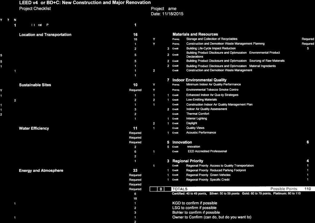


145
ARLINGTON COUNTY, VIRGINIA
 ARLINGTON COUNTY, VIRGINIA County Board Agenda Item Meeting of December 12, 2015 DATE: November 24, 2015 SUBJECTS: A. Z-2585-15-1 REZONING from "R-5" One-Family, Restricted Two-Family Dwelling Districts
SITE PLAN REVIEW COMMITTEE MEETING AGENDA & STAFF REPORT
 SITE PLAN REVIEW COMMITTEE MEETING AGENDA & STAFF REPORT DATE: Thursday, April 21, 2016 TIME: 7:00 8:25 p.m. PLACE: Courthouse Plaza; Cherry/Dogwood Conference Rooms (109/110) SPRC STAFF COORDINATOR: Samia
County Board Meeting Columbia Pike FBC Redevelopment Proposal
 County Board Meeting June 18, 2016 2400 Columbia Pike FBC Redevelopment Proposal A. FBC Use Permit U-3436-16-1 B. Vacations 1 Outline 1. Form Based Code Background & Review Process 2. Subject Site Location
ARLINGTON COUNTY, VIRGINIA
 ARLINGTON COUNTY, VIRGINIA County Board Agenda Item Meeting of April 19, 2008 DATE: April 2, 2008 SUBJECT: ORDINANCE TO AMEND, REENACT, AND RECODIFY Section 20 CP- FBC, Columbia Pike Form Based Code Districts
ARLINGTON COUNTY, VIRGINIA
 ARLINGTON COUNTY, VIRGINIA County Board Agenda Item Meeting of June 16, 2012 DATE: June 7, 2012 SUBJECT: SP #397 SITE PLAN AMENDMENT to revise condition #31 to modify the retail transparency requirement
ARLINGTON COUNTY, VIRGINIA. County Board Agenda Item Meeting of February 21, 2015
 ARLINGTON COUNTY, VIRGINIA County Board Agenda Item Meeting of February 21, 2015 DATE: February 17, 2015 SUBJECT: A. Consideration of adoption of an Amendment to the Arlington County Comprehensive Plan
VILLAGE CENTER ARLINGTON, VIRGINIA ADVISORY WORKING GROUP/ PLANNING COMMISSION FOR ORR PARTNERS 01/
 VILLAGE CENTER ADVISORY WORKING GROUP/ PLANNING COMMISSION FOR ORR PARTNERS 01/21 PROJECT BACKGROUND 01 PAGE 02 01. PROJECT BACKGROUND 1 EXISTING CONDITIONS SITE 1 STREET VIEW 2 2 STREET VIEW PAGE 03 01.
ARLINGTON COUNTY, VIRGINIA
 ARLINGTON COUNTY, VIRGINIA County Board Agenda Item Meeting of July 21, 2012 DATE: June 26, 2012 SUBJECT: SP #402 SITE PLAN AMENDMENT for a comprehensive sign plan amendment to add a projecting sign for
SITE PLAN REVIEW COMMITTEE MEETING AGENDA Clarendon Boulevard Conference Rooms C & D Arlington, VA 22201
 SITE PLAN REVIEW COMMITTEE MEETING AGENDA DATE: Monday, October 2, 2017 TIME: 8:30 10:00 p.m. PLACE: 2100 Clarendon Boulevard Conference Rooms C & D Arlington, VA 22201 Item 2. 6711 Lee Highway (SP #3)
ARLINGTON COUNTY, VIRGINIA
 ARLINGTON COUNTY, VIRGINIA County Board Agenda Item Meeting of November 15, 2005 DATE: November 8, 2005 SUBJECTS: A. Adoption of Proposed Amendments to Section 20 (Appendix A) CP-FBC Columbia Pike - Form
ARLINGTON COUNTY, VIRGINIA
 ARLINGTON COUNTY, VIRGINIA County Board Agenda Item Meeting December 9, 2006 DATE: November 20, 2006 SUBJECT: GP-302-05-2 Adoption of General Land Use Plan Amendments for the Clarendon Metro Station Area:
DEVELOPMENT DEPARTMENT STAFF REPORT THE PARK AT 5 TH
 DEVELOPMENT DEPARTMENT STAFF REPORT ARB Meeting Date: July 3, 2018 Item #: _PZ2018-293_ THE PARK AT 5 TH Request: Site Address: Project Name: Parcel Number: Applicant: Proposed Development: Current Zoning:
SITE PLAN REVIEW COMMITTEE MEETING AGENDA
 Page 1 SITE PLAN REVIEW COMMITTEE MEETING AGENDA DATE: Monday, July 10, 2017 TIME: 7:00 8:30 p.m. PLACE: 2100 Clarendon Boulevard Ground Floor Conference Rooms Cherry/Dogwood Arlington, VA 22202 SPRC STAFF
ARLINGTON COUNTY, VIRGINIA. County Board Agenda Item Meeting of November 18, 2017
 ARLINGTON COUNTY, VIRGINIA County Board Agenda Item Meeting of November 18, 2017 DATE: November 9, 2017 SUBJECTS: A. Z-2597-17-1 REZONING from "C-O" Mixed Use District to "RA8-18" Multiple-Family Dwelling
ARLINGTON COUNTY, VIRGINIA. County Board Agenda Item Meeting of September 19, 2015
 ARLINGTON COUNTY, VIRGINIA County Board Agenda Item Meeting of September 19, 2015 DATE: August 28, 2015 SUBJECT: Request to authorize advertisement of public hearings by the Planning Commission and the
24. A., B., C. ARLINGTON COUNTY, VIRGINIA. County Board Agenda Item Meeting of February 23, DATE: February 19, 2019
 ARLINGTON COUNTY, VIRGINIA County Board Agenda Item Meeting of February 23, 2019 DATE: February 19, 2019 SUBJECTS: A. GP-343-17-1 GENERAL LAND USE PLAN AMENDMENT to change the land use designation for
S I T E P L A N R E V I E W C O M M I T T E E M E E T I N G A G E N D A
 S I T E P L A N R E V I E W C O M M I T T E E M E E T I N G A G E N D A DATE: Thursday, September 14, 2017 TIME: 6:00 6:45 p.m. (optional walking tour) 7:00 8:30 p.m. PLACE: 2801 Clarendon Boulevard Meeting
ARLINGTON COUNTY, VIRGINIA. County Board Agenda Item Meeting of February 23, 2019
 ARLINGTON COUNTY, VIRGINIA County Board Agenda Item Meeting of February 23, 2019 DATE: February 5, 2019 SUBJECTS: A. GP-343-17-1 GENERAL LAND USE PLAN AMENDMENT to change the land use designation for a
3804 Wilson Boulevard (Staples Site) Special General Land Use Plan Study
 Special General Land Use Plan Study") 1 3804 Wilson Boulevard (Staples Site) Special General Land Use Plan Study Long Range Committee of the Planning Commission Meeting May 16, 2018 Department of Community Planning, Housing and Development
1 3804 Wilson Boulevard (Staples Site) Special General Land Use Plan Study Long Range Committee of the Planning Commission Meeting May 16, 2018 Department of Community Planning, Housing and Development
ARLINGTON COUNTY, VIRGINIA. County Board Agenda Item Meeting of November 17, 2018
 ARLINGTON COUNTY, VIRGINIA County Board Agenda Item Meeting of November 17, 2018 DATE: November 7, 2018 SUBJECT: U-3501-17-4 USE PERMIT REVIEW for an Open-Air Market (Arlington Mill Farmer's Market); located
ARLINGTON COUNTY, VIRGINIA
 ARLINGTON COUNTY, VIRGINIA County Board Agenda Item Meeting of December 8, 2012 DATE: November 29, 2012 SUBJECT: PDSP #346 SITE PLAN AMENDMENT to convert approximately 1,458 square feet of GFA below-grade
DEPARTMENT OF COMMUNITY PLANNING, HOUSING AND DEVELOPMENT Planning Division
 DEPARTMENT OF COMMUNITY PLANNING, HOUSING AND DEVELOPMENT Planning Division #1 Courthouse Plaza, 2100 Clarendon Boulevard, Suite 700 Arlington, VA 22201 TEL 703.228.3525 FAX 703.228.3543 www.arlingtonva.us
SITE PLAN REVIEW COMMITTEE MEETING AGENDA. DATE: Thursday, April 25, :00 8:30 p.m. PLACE:
 SITE PLAN REVIEW COMMITTEE MEETING AGENDA DATE: Thursday, April 25, 2013 TIME: 7:00 8:30 p.m. PLACE: Courthouse Plaza 2100 Clarendon Boulevard Conference Rooms C&D Arlington, VA 22201 SPRC STAFF COORDINATOR:
SITE PLAN REVIEW COMMITTEE MEETING AGENDA Clarendon Boulevard Conference Rooms C & D Arlington, VA 22201
 SITE PLAN REVIEW COMMITTEE MEETING AGENDA DATE: Monday, July 24, 2017 TIME: 7:00 9:00 p.m. PLACE: 2100 Clarendon Boulevard Conference Rooms C & D Arlington, VA 22201 Item 1. 6711 Lee Highway (SP #3) (RPC#
SITE PLAN REVIEW COMMITTEE MEETING AGENDA. DATE: Monday, October 22, Clarendon Boulevard Courthouse Plaza, Room 311 Arlington, VA 22201
 SITE PLAN REVIEW COMMITTEE MEETING AGENDA DATE: Monday, October 22, 2012 TIME: 7:00 9:00 p.m. PLACE: 2100 Clarendon Boulevard Courthouse Plaza, Room 311 Arlington, VA 22201 SPRC STAFF COORDINATOR: Samia
Wesley Housing Development Corporation Trenton Street Residential
 Wesley Housing Development Corporation Trenton Street Residential 1 2 Site Location Multimodal Traffic Study Summary Existing Conditions (2017) 13 study intersections. -Scoped with Arlington County DES
SITE PLAN REVIEW COMMITTEE MEETING AGENDA Clarendon Boulevard Lobby Rooms C&D (Cherry & Dogwood) Arlington, VA
 Arlington, VA") SITE PLAN REVIEW COMMITTEE MEETING AGENDA DATE: Monday, January 8, 2018 TIME: 7:30 8:25 p.m. PLACE: 2100 Clarendon Boulevard Lobby Rooms C&D (Cherry & Dogwood) Arlington, VA 22201 SPRC STAFF COORDINATOR:
SITE PLAN REVIEW COMMITTEE MEETING AGENDA DATE: Monday, January 8, 2018 TIME: 7:30 8:25 p.m. PLACE: 2100 Clarendon Boulevard Lobby Rooms C&D (Cherry & Dogwood) Arlington, VA 22201 SPRC STAFF COORDINATOR:
November 21, RECOMMENDATION: Deny the site plan request, and accept withdrawal of rezoning request.
 November 21, 2003 TO: FROM: APPLICANT: BY: The County Board of Arlington, Virginia Ron Carlee, County Manager Trammell Crow Residential Tim Sampson, Attorney/Agent Walsh, Colucci, Emrich, Lubeley & Terpak
ARLINGTON COUNTY, VIRGINIA
 ARLINGTON COUNTY, VIRGINIA County Board Agenda Item Meeting of April 25, 2009 DATE: April 14, 2009 SUBJECTS: A. Amendments to the Arlington County Zoning Ordinance, Section 20. (Appendix A), CP-FBC Columbia
ARLINGTON COUNTY, VIRGINIA
 ARLINGTON COUNTY, VIRGINIA County Board Agenda Item Meeting of July 10, 2004 DATE: June 24, 2004 SUBJECT: A. GP-298-04-1 GENERAL LAND USE PLAN AMENDMENT from Semi- Public (Country Clubs and semi-public
Composition of traditional residential corridors.
 Page 1 of 7 St. Petersburg, Florida, Code of Ordinances >> PART II - ST. PETERSBURG CITY CODE >> Chapter 16 - LAND DEVELOPMENT REGULATIONS >> SECTION 16.20.060. CORRIDOR RESIDENTIAL TRADITIONAL DISTRICTS
SITE PLAN REVIEW COMMITTEE MEETING AGENDA Clarendon Boulevard Courthouse Plaza, Rooms 109/110 Arlington, VA 22201
 SITE PLAN REVIEW COMMITTEE MEETING AGENDA DATE: Monday, January 6, 2014 TIME: 7:00 8:30 p.m. PLACE: 2100 Clarendon Boulevard Courthouse Plaza, Rooms 109/110 Arlington, VA 22201 SPRC STAFF COORDINATOR:
ARLINGTON COUNTY, VIRGINIA. County Board Agenda Item Meeting of May 14, 2011
 ARLINGTON COUNTY, VIRGINIA County Board Agenda Item Meeting of May 14, 2011 DATE: May 11, 2011 SUBJECT: SP #240 SITE PLAN AMENDMENT for a kiosk for the Department of Environmental Services located at the
ARLINGTON COUNTY, VIRGINIA
 ARLINGTON COUNTY, VIRGINIA County Board Agenda Item Meeting of March 27, 2004 DATE: March 19, 2004 SUBJECT: SP # 376 SITE PLAN AMENDMENT, to amend Condition #26 to permit the installation of new utility
S IT E PL A N R E V IE W C OM M IT T E E
 S IT E PL A N R E V IE W C OM M IT T E E M E E T I N G A G E N D A DATE: Thursday, January 4, 2018 TIME: 7:00 9:00 p.m. PLACE: Ellen Bozman Government Center/Courthouse Plaza 2100 Clarendon Boulevard Lobby
LITTLE MOUNTAIN ADJACENT AREA REZONING POLICY
 LITTLE MOUNTAIN ADJACENT AREA REZONING POLICY JANUARY 2013 CONTENTS 1.0 INTENT & PRINCIPLES...1 2.0 APPLICATION...2 3.0 HOUSING TYPES, HEIGHT & DENSITY POLICIES...3 3.1 LOW TO MID-RISE APARTMENT POLICIES...4
3804 Wilson Boulevard
 3804 Wilson Boulevard SPECIAL GENERAL LAND USE PLAN STUDY DEPARTMENT OF COMMUNITY PLANNING, HOUSING, & DEVELOPMENT Planning Division 3804 Wilson Boulevard Special GLUP Study a2 3804 Wilson Boulevard Special
Article 3. SUBURBAN (S-) NEIGHBORHOOD CONTEXT
 NEIGHBORHOOD CONTEXT") Article 3. SUBURBAN (S-) NEIGHBORHOOD CONTEXT this page left intentionally blank Contents ARTICLE 3. SUBURBAN (S-) NEIGHBORHOOD CONTEXT DIVISION 3.1 NEIGHBORHOOD CONTEXT DESCRIPTION...3.1-1 Section 3.1.1
Article 3. SUBURBAN (S-) NEIGHBORHOOD CONTEXT this page left intentionally blank Contents ARTICLE 3. SUBURBAN (S-) NEIGHBORHOOD CONTEXT DIVISION 3.1 NEIGHBORHOOD CONTEXT DESCRIPTION...3.1-1 Section 3.1.1
Sherwood Forest (Trinity) Housing Corporation. Urban Design Brief
 Housing Corporation. Urban Design Brief") Sherwood Forest (Trinity) Housing Corporation Sherwood Place Affordable Housing Apartments Trinity Presbyterian Church Orchard Park Nursery School 590 Gainsborough Road, London Urban Design Brief REVISED
Sherwood Forest (Trinity) Housing Corporation Sherwood Place Affordable Housing Apartments Trinity Presbyterian Church Orchard Park Nursery School 590 Gainsborough Road, London Urban Design Brief REVISED
ARLINGTON COUNTY, VIRGINIA
 ARLINGTON COUNTY, VIRGINIA County Board Agenda Item Meeting of February 23, 2013 DATE: February 8, 2013 SUBJECTS: A. Z-2563-12-1 REZONING from "CM" Limited Industrial Districts to "C-O-Crystal City" Commercial
ARLINGTON COUNTY, VIRGINIA. County Board Agenda Item Meeting of December 8, 2012
 ARLINGTON COUNTY, VIRGINIA County Board Agenda Item Meeting of December 8, 2012 DATE: November 29, 2012 SUBJECTS: 1. GP-322-11-1 GENERAL LAND USE PLAN AMENDMENT to amend the GLUP designation for the two
LeBreton Flats Redevelopment Development Summary Chart (First Subdivision)
") Redevelopment Development Summary Chart (First Subdivision) Development Analysis Chart NOTE: THE FOLLOWING TABLE REPRESENTS THE RESULTS OF THE NCC'S DEMONSTRATION OF DEVELOPMENT CAPACITY. WHILE ACTUAL
Redevelopment Development Summary Chart (First Subdivision) Development Analysis Chart NOTE: THE FOLLOWING TABLE REPRESENTS THE RESULTS OF THE NCC'S DEMONSTRATION OF DEVELOPMENT CAPACITY. WHILE ACTUAL
PLANNING AND DEVELOPMENT DEPARTMENT STAFF REPORT STAFF REPORT PREMIER AUTO SERVICES, INC. VARIANCES
 PLANNING AND DEVELOPMENT DEPARTMENT STAFF REPORT Meeting Date: February 14, 2019 Item #: PZ2019-402 STAFF REPORT PREMIER AUTO SERVICES, INC. VARIANCES Project Name: Premier Auto Services, Inc. Applicant:
S I T E P L A N R E V I E W C O M M I T T E E M E E T I N G A G E N D A Clarendon Boulevard Conference Room 311 Arlington, VA 22201
 S I T E P L A N R E V I E W C O M M I T T E E M E E T I N G A G E N D A DATE: Thursday, May 12, 2016 TIME: 7:00 8:25 p.m. PLACE: 2100 Clarendon Boulevard Conference Room 311 Arlington, VA 22201 SPRC STAFF
Zoning Regulations of the Town of Redding Connecticut
 Zoning Regulations of the Town of Redding Connecticut Statutory zoning authority was adopted for the Town of Redding, and a Zoning Commission established as provided by law, at a Town Meeting held May
66 Isabella Street Rezoning Application - Preliminary Report
 STAFF REPORT ACTION REQUIRED 66 Isabella Street Rezoning Application - Preliminary Report Date: November 15, 2010 To: From: Wards: Reference Number: Toronto and East York Community Council Director, Community
Town of Cary, North Carolina Rezoning Staff Report 14-REZ-31 Cary Park PDD Amendment (Waterford II) Town Council Meeting January 15, 2015
 Town Council Meeting January 15, 2015") Town of Cary, North Carolina Rezoning Staff Report 14-REZ-31 Cary Park PDD Amendment (Waterford II) Town Council Meeting January 15, 2015 REQUEST To amend the Town of Cary Official Zoning Map by amending
Town of Cary, North Carolina Rezoning Staff Report 14-REZ-31 Cary Park PDD Amendment (Waterford II) Town Council Meeting January 15, 2015 REQUEST To amend the Town of Cary Official Zoning Map by amending
8.5.1 R1, Single Detached Residential District
 8.5.1 R1, Single Detached Residential District The purpose of this district is to provide for residential development in the form of single detached dwellings. Dwelling, Single Detached Home Business,
Jasper 115 Street DC2 Urban Design Brief
 Jasper 115 Street DC2 Urban Design Brief Greenlong Construction Ltd. Stantec Consulting Ltd. 2017 Overview The proposed rezoning application supports the development of two mixed-use high-rise buildings
S I T E P L A N R E V I E W C O M M I T T E E M E E T I N G A G E N D A Clarendon Boulevard Courthouse Plaza, Rooms 109/111 Arlington, VA 22201
 S I T E P L A N R E V I E W C O M M I T T E E M E E T I N G A G E N D A DATE: Thursday, March 27, 2014 TIME: 7:00 8:25 pm PLACE: 2100 Clarendon Boulevard Courthouse Plaza, Rooms 109/111 Arlington, VA 22201
4 June 11, 2014 Public Hearing
 4 June 11, 2014 Public Hearing APPLICANT: FRANKLIN JOHNSTON MANAGEMENT DEVELOPMENT, L.L.C. PROPERTY OWNER: TRUSTEES OF FIRST LYNNHAVEN BAPTIST CHURCH STAFF PLANNER: Stephen J. White REQUEST: Change of
Urban Design Brief (Richmond) Corp. 1631, 1635, 1639, 1643 and 1649 Richmond Street City of London
 Corp. 1631, 1635, 1639, 1643 and 1649 Richmond Street City of London") Urban Design Brief 1635 (Richmond) Corp. 1631, 1635, 1639, 1643 and 1649 Richmond Street City of London Site Plan Control Application Holding Provision Application April 1, 2015 Prepared for: Rise Real
Urban Design Brief 1635 (Richmond) Corp. 1631, 1635, 1639, 1643 and 1649 Richmond Street City of London Site Plan Control Application Holding Provision Application April 1, 2015 Prepared for: Rise Real
Ron Carlee, County Manager
 June 6, 2003 TO: FROM: APPLICANT: BY: SUBJECTS: The County Board of Arlington, Virginia The Holladay Corporation Nan Terpak, Attorney/Agent Walsh, Colucci, Lubeley, Emrich & Terpak 2200 Clarendon Blvd.,
Request Subdivision Variance (4.1 (m)(1) of the Subdivision Regulations) Staff Recommendation Approval. Staff Planner Jonathan Sanders
(1) of the Subdivision Regulations) Staff Recommendation Approval. Staff Planner Jonathan Sanders") Applicant Property Owner Jo Stallard Woolling Hodges Public Hearing December 12, 2018 (Deferred November 14, 2018) City Council Election District Beach Agenda Item D4 Request Subdivision Variance (4.1
Applicant Property Owner Jo Stallard Woolling Hodges Public Hearing December 12, 2018 (Deferred November 14, 2018) City Council Election District Beach Agenda Item D4 Request Subdivision Variance (4.1
SITE PLAN REVIEW COMMITTEE MEETING AGENDA Clarendon Boulevard Courthouse Plaza, Training Center (10 th Floor) Arlington, VA 22202
 Arlington, VA 22202") SITE PLAN REVIEW COMMITTEE MEETING AGENDA DATE: Wednesday, December 5, 2012 TIME: 8:30 10:00 p.m. PLACE: 2100 Clarendon Boulevard Courthouse Plaza, Training Center (10 th Floor) Arlington, VA 22202 SPRC
SITE PLAN REVIEW COMMITTEE MEETING AGENDA DATE: Wednesday, December 5, 2012 TIME: 8:30 10:00 p.m. PLACE: 2100 Clarendon Boulevard Courthouse Plaza, Training Center (10 th Floor) Arlington, VA 22202 SPRC
111 Wenderly Drive Official Plan and Zoning By-law Amendment Applications - Preliminary Report
 STAFF REPORT ACTION REQUIRED 111 Wenderly Drive Official Plan and Zoning By-law Amendment Applications - Preliminary Report Date: August 17, 2015 To: From: Wards: Reference Number: North York Community
October 9, The County Board of Arlington, Virginia. Ron Carlee, County Manager
 October 9, 2003 TO: FROM: APPLICANT: BY: The County Board of Arlington, Virginia Ron Carlee, County Manager Douglas Schneiderman, Vice President Madison Homes, Inc. 6723 Whittier Avenue, Suite 104 McLean,
TABLE OF CONTENTS. Chapters and Sections
 TABLE OF CONTENTS Chapters and Sections Chapter 9.02 Permits and Approvals [Addition]... 1 9.02.090 Administrative variances.... 1 Chapter [New]... 1 9.07.091 Purpose and Intent... 1 9.07.092 Applicability...
Washington Boulevard + Kirkwood Road Special General Land Use Plan (GLUP) Study "Plus"
 Study Plus") Washington Boulevard + Kirkwood Road Special General Land Use Plan (GLUP) Study "Plus" Long Range Committee of the Planning Commission Meeting #4 May 18, 2017 Department of Community Planning, Housing
Washington Boulevard + Kirkwood Road Special General Land Use Plan (GLUP) Study "Plus" Long Range Committee of the Planning Commission Meeting #4 May 18, 2017 Department of Community Planning, Housing
ARLINGTON COUNTY, VIRGINIA
 ARLINGTON COUNTY, VIRGINIA County Board Agenda Item Meeting of November 14, 2015 DATE: November 13, 2015 SUBJECTS: Development A. SP #193 SITE PLAN AMENDMENT Ballston Air Rights Acquisition Company, LLC
ARLINGTON COUNTY, VIRGINIA. County Board Agenda Item Meeting of September 22, 2018
 ARLINGTON COUNTY, VIRGINIA County Board Agenda Item Meeting of September 22, 2018 DATE: September 13, 2018 SUBJECT: SP413-U-18-1 USE PERMIT ASSOCIATED WITH A SITE PLAN for food delivery service for Domino's
25 St. Dennis Drive - Zoning By-law Amendment Application - Preliminary Report
 STAFF REPORT ACTION REQUIRED 25 St. Dennis Drive - Zoning By-law Amendment Application - Preliminary Report Date: February 4, 2016 To: From: Wards: Reference Number: North York Community Council Director,
ARLINGTON COUNTY, VIRGINIA
 ARLINGTON COUNTY, VIRGINIA County Board Agenda Item Meeting of June 10, 2006 DATE: June 9, 2006 SUBJECTS: A. Z-2525-06-1 REZONING for Saul Centers, Inc., from C-3 General Commercial Districts to C-O Commercial
3390, 3392, 3394, 3396 and 3398 Bayview Avenue - Official Plan Amendment, Zoning By-law Amendment Application - Preliminary Report
 STAFF REPORT ACTION REQUIRED 3390, 3392, 3394, 3396 and 3398 Bayview Avenue - Official Plan Amendment, Zoning By-law Amendment Application - Preliminary Report Date: March 14, 2016 To: From: Wards: Reference
4 DEVELOPMENT STANDARDS FOR
 4 DEVELOPMENT STANDARDS FOR RESIDENTIAL MIXED-USE PROJECTS This chapter presents standards for residential mixed-use projects in the Ashland-Cherryland Business District and the Castro Valley Central Business
1417, , 1427 & 1429 Yonge Street - Official Plan Amendment and Zoning Amendment Applications - Preliminary Report
 STAFF REPORT ACTION REQUIRED 1417, 1421-1425, 1427 & 1429 Yonge Street - Official Plan Amendment and Zoning Amendment Applications - Preliminary Report Date: March 24, 2015 To: From: Wards: Reference Number:
ARLINGTON COUNTY, VIRGINIA
 ARLINGTON COUNTY, VIRGINIA County Board Agenda Item Meeting of June 18, 2016 DATE: June 7, 2016 SUBJECT: Vacations Concerning a Project Known as 2400 Columbia Pike A. Vacation of a Portion of Columbia
Rezoning Petition Pre-Hearing Staff Analysis April 17, 2017
 Rezoning Petition 2017-041 Pre-Hearing Staff Analysis April 17, 2017 REQUEST Current Zoning: R-5 (single family residential), R-22MF (multifamily residential), and I-1 (light industrial) Proposed Zoning:
6040 Bathurst Street and 5 Fisherville Road Zoning Bylaw Amendment Application Preliminary Report
 STAFF REPORT ACTION REQUIRED 6040 Bathurst Street and 5 Fisherville Road Zoning Bylaw Amendment Application Preliminary Report Date: January 24, 2017 To: From: Wards: Reference Number: North York Community
28. ARLINGTON COUNTY, VIRGINIA. County Board Agenda Item Meeting of February 25, DATE: February 17, 2017
 ARLINGTON COUNTY, VIRGINIA County Board Agenda Item Meeting of February 25, 2017 DATE: February 17, 2017 SUBJECTS: Items associated with Queen's Court Residences: A. GP 335-16-1 GENERAL LAND USE PLAN AMENDMENT
M-43 CORRIDOR OVERLAY ZONE
 ARTICLE 26.00 M-43 CORRIDOR OVERLAY ZONE Section 26.01 Findings A primary function of the M-43 state highway is to move traffic through the Township and to points beyond. As the primary east-west arterial
Director, Community Planning, Etobicoke York District
 STAFF REPORT ACTION REQUIRED 3555 Don Mills Road Zoning By-law Amendment Application Preliminary Report Date: May 22, 2012 To: From: Wards: Reference Number: North York Community Council Director, Community
DEVELOPMENT STANDARDS FOR RESIDENTIAL PROJECTS RESIDENTIAL BUILDING TYPES: APPROPRIATE ZONES AND DENSITIES 2-1
 2 DEVELOPMENT STANDARDS FOR RESIDENTIAL PROJECTS RESIDENTIAL BUILDING TYPES: APPROPRIATE ZONES AND DENSITIES 2-1 This Chapter presents the development standards for residential projects. Section 2.1 discusses
S I T E P L A N R E V I E W C O M M I T T E E M E E T I N G A G E N D A
 S I T E P L A N R E V I E W C O M M I T T E E M E E T I N G A G E N D A DATE: Thursday, November 15, 2018 TIME: SPRC: 7:00 8:30 p.m. PLACE: Ellen M. Bozman Government Center 2100 Clarendon Boulevard Room
250, 252, 254 and 256 Royal York Road and 8 and 10 Drummond Street - Zoning By-law Amendment Application - Preliminary Report
 STAFF REPORT ACTION REQUIRED 250, 252, 254 and 256 Royal York Road and 8 and 10 Drummond Street - Zoning By-law Amendment Application - Preliminary Report Date: May 28, 2013 To: From: Wards: Reference
Goal 1 - Retain and enhance Cherry Creek North s unique physical character.
 Introduction This document summarizes the proposed new zoning for the area of roughly bordered by University Boulevard, Steele Street, 3rd Avenue, and 1st Avenue. It provides a high-level review of the
Director, Community Planning, North York District NNY 23 OZ and NNY 23 RH
 STAFF REPORT ACTION REQUIRED 2 & 50 Sheppard Avenue East 4841 to 4881 Yonge Street and 2 to 6 Forest Laneway Official Plan Amendment, Zoning By-law Amendment and Rental Housing Demolition Applications
PLANNED DEVELOPMENT DISTRICT STANDARDS. Cadence Site
 PLANNED DEVELOPMENT DISTRICT STANDARDS Cadence Site A Planned Development District 1. Statement of General Facts, Conditions and Objectives Property Size: Approximately 57.51 Acres York County Tax Map
Approval of Takoma Amended Joint Development Agreement and Compact Public Hearing
 Planning, Program Development and Real Estate Committee Item IV - B March 13, 2014 Approval of Takoma Amended Joint Development Agreement and Compact Public Hearing Washington Metropolitan Area Transit
Town of Cary, North Carolina Rezoning Staff Report 12-REZ-27 Morris Branch Town Council Public Hearing January 24, 2013
 Town of Cary, North Carolina Rezoning Staff Report 12-REZ-27 Morris Branch Town Council Public Hearing January 24, 2013 REQUEST To amend the Town of Cary Official Zoning Map to rezone approximately 9.0
DEVELOPMENT DEPARTMENT STAFF REPORT STAFF REPORT DRESDEN DRIVE TOWNHOMES DCI
 DEVELOPMENT DEPARTMENT STAFF REPORT Meeting Date: September 13, 2018 Item #: PZ2018-319 STAFF REPORT DRESDEN DRIVE TOWNHOMES DCI Request: Project Name: Development of Community Compact (DCI) and six concurrent
DEVELOPMENT DEPARTMENT STAFF REPORT DRESDEN HEIGHTS PHASE II DCI
 DEVELOPMENT DEPARTMENT Meeting Date: January 10, 2019 Item #: PZ2019-393 Project Name: Applicant and Owner: Proposed Development: Requests: STAFF REPORT DRESDEN HEIGHTS PHASE II DCI Dresden Heights Phase
12, 14, 16 and 18 Marquette Avenue and 7 Carhartt Street Zoning By-law Amendment Application - Preliminary Report
 STAFF REPORT ACTION REQUIRED 12, 14, 16 and 18 Marquette Avenue and 7 Carhartt Street Zoning By-law Amendment Application - Preliminary Report Date: July 17, 2014 To: From: Wards: Reference Number: North
1061 The Queensway - Official Plan and Zoning By-law Amendment Applications - Preliminary Report
 STAFF REPORT ACTION REQUIRED 1061 The Queensway - Official Plan and Zoning By-law Amendment Applications - Preliminary Report Date: January 28, 2015 To: From: Wards: Reference Number: Etobicoke York Community
R E S O L U T I O N. Residential 384,918 sq. ft. To be demolished Floor Area Ratio (FAR) 0 0.7
 0 0.7") R E S O L U T I O N WHEREAS, the Prince George s County Planning Board has reviewed DPLS-417, Kiplinger Property, Phase I, Expedited Transit-Oriented Development Project, requesting a reduction in the
R E S O L U T I O N WHEREAS, the Prince George s County Planning Board has reviewed DPLS-417, Kiplinger Property, Phase I, Expedited Transit-Oriented Development Project, requesting a reduction in the
S I T E P L A N R E V I E W C O M M I T T E E M E E T I N G A G E N D A
 S I T E P L A N R E V I E W C O M M I T T E E M E E T I N G A G E N D A DATE: Thursday, July 23, 2015 TIME: 7:00 10:00 p.m. PLACE: 2100 Clarendon Boulevard Courthouse Plaza, 1st Floor, Cherry and Dogwood
ARLINGTON COUNTY, VIRGINIA
 ARLINGTON COUNTY, VIRGINIA County Board Agenda Item Meeting of April 21, 2007 DATE: April 13, 2007 SUBJECT: SP #346 PHASED DEVELOPMENT SITE PLAN AMENDMENT (PDSP) AND FINAL SITE PLANS for Potomac Yard:
27-37 Yorkville Avenue and 26-32, 50 Cumberland Street Official Plan and Zoning Amendment - Final Report
 STAFF REPORT ACTION REQUIRED 27-37 Yorkville Avenue and 26-32, 50 Cumberland Street Official Plan and Zoning Amendment - Final Report Date: July 24, 2014 To: From: Wards: Reference Number: Toronto and
DEVELOPMENT DEPARTMENT STAFF REPORT STAFF REPORT MCDONALD S ZONING MAP AMENDMENT AND CONCURRENT VARIANCES
 DEVELOPMENT DEPARTMENT STAFF REPORT Meeting Date: October 12, 2017 Item #: _PZ2017-172_ STAFF REPORT MCDONALD S ZONING MAP AMENDMENT AND CONCURRENT VARIANCES Request: Rezone property from MU-BC to CC,
DRAFT FOR DISCUSSION PURPOSES ONLY. Port Credit Local Area Plan Built Form Guidelines and Standards DRAFT For Discussion Purposes
 Port Credit Local Area Plan Built Form Guidelines and Standards DRAFT For Discussion Purposes 1 Local Area Plan - Project Alignment Overview Directions Report, October 2008 (General Summary Of Selected
Director, Community Planning, Toronto and East York District
 STAFF REPORT September 1, 2005 To: From: Subject: Toronto and East York Community Council Director, Community Planning, Toronto and East York District Further Report Applications to amend Official Plan
250 Lawrence Avenue West - Official Plan and Zoning By-law Amendment Applications Preliminary Report
 STAFF REPORT ACTION REQUIRED 250 Lawrence Avenue West - Official Plan and Zoning By-law Amendment Applications Preliminary Report Date: April 22, 2015 To: From: Wards: Reference Number: North York Community
S I T E P L A N R E V I E W C O M M I T T E E M E E T I N G A G E N D A Clarendon Boulevard Courthouse Plaza, Rooms 109/110 Arlington, VA 22201
 S I T E P L A N R E V I E W C O M M I T T E E M E E T I N G A G E N D A DATE: Thursday, May 22, 2014 TIME: 7:00 10:00 p.m. PLACE: 2100 Clarendon Boulevard Courthouse Plaza, Rooms 109/110 Arlington, VA
New Millennium Senior Living Communities, LLC
 Applicant Property Owners Baylake Limited Partnership, W. Heywood Fralin 2012 Revocable Trust, W. Heywood Fralin Irrevocable Children s Trust, & Karen Holly Waldron Trust Public Hearing August 9, 2017
DEVELOPMENT DEPARTMENT STAFF REPORT STAFF REPORT PUD/DCI BAINBRIDGE MIXED-USE DEVELOPMENT
 DEVELOPMENT DEPARTMENT STAFF REPORT Meeting Date: October 12, 2017 Item #: _PZ-2017-170_ STAFF REPORT PUD/DCI BAINBRIDGE MIXED-USE DEVELOPMENT Request: Project Name: Planned Unit Development (PUD)/ Development
STAFF REPORT. September 25, City Council. Chief Planner and Executive Director, City Planning Division
 STAFF REPORT September 25, 2006 To: From: Subject: City Council Chief Planner and Executive Director, City Planning Division Request for Directions Report Toronto & East York Community Council, Report
S I T E P L A N R E V I E W C O M M I T T E E M E E T I N G A G E N D A
 S I T E P L A N R E V I E W C O M M I T T E E M E E T I N G A G E N D A DATE: Monday July 27, 2015 TIME: 7:00 8:25 p.m. PLACE: 2100 Clarendon Boulevard Courthouse Plaza, 1st Floor, Cherry and Dogwood Rooms
Bylaw No , being "Official Community Plan Bylaw, 2016" Schedule "A" DRAFT
 Bylaw No. 2600-2016, being "Official Community Plan Bylaw, 2016" Schedule "A" Urban Structure + Growth Plan Urban Structure Land use and growth management are among the most powerful policy tools at the
Chapter URBAN VILLAGE ZONING DISTRICTS
 Chapter 20.16 Sections: 20.16.010 Purpose of the Urban Village Zoning Districts 20.16.020 Land Use Regulations for the Urban Village Zoning Districts 20.16.030 Development Standards & Guidelines for the
SITE PLAN REVIEW COMMITTEE MEETING AGENDA. DATE: Wednesday, February 28, Aurora Hills Community Center th Street S. Arlington, VA 22202
 Page 1 SITE PLAN REVIEW COMMITTEE MEETING AGENDA DATE: Wednesday, February 28, 2018 TIME: 7:00 9:00 p.m. PLACE: Aurora Hills Community Center 735 18 th Street S. Arlington, VA 22202 SPRC STAFF COORDINATOR: