Proposed Horowhenua District Plan
|
|
|
- Annabel McGee
- 5 years ago
- Views:
Transcription
1 Proposed Horowhenua District Plan Natural Hazards Hearing: 15 April 2013 Officer Right of Reply and Response to Commissioners Questions Officer Right of Reply We have considered the evidence presented by submitters at the hearing on 15 th April In addition, we have considered the questions and comments from the Commissioners raised during the hearing. Below we respond to the evidence presented and questions/comments. In responding to the matters raised, we have ordered them into the following topics to align with the Section 42A Report: Liquefaction Mapping of the Flood Hazard Overlay Area Response to Commissioners Questions: Moutoa Floodway and Flood Hazard Overlay Area Rules Where we heard no evidence questioning or opposing recommendations, we have not further commented on these and our original evaluations and recommendations remain. Liquefaction Liquefaction was addressed by Anne Hunt, Rosalie Huzziff, Pen Tucker (Horizons Regional Council) and Christina Paton at the hearing. Ms Tucker advised that the January 2005 Lifelines Report is the latest and best information Horizons Regional Council has on liquefaction at the regional level and that they do not anticipate providing any finer scale information in the foreseeable future. Ms Tucker further commented that the Civil Defence and Emergency Management (CDEM) Group were scheduled to commence a hazard data literature and status update in , and this review would determine future hazard investigations. Ms Hunt expressed concern about the lack of recognition and provision in the District Plan on the risks from liquefaction. Ms Hunt referred to the current RMA reform, including recently released Discussion Document, and that future changes to the RMA are anticipated in relation to natural hazards. In addition, Ms Hunt commented on other legislation, such as Council s obligations under the Civil Defence and Emergency Management Act to identify and respond to natural hazard risks. Furthermore, Ms Hunt contended there was a lacuna in the Building Act in that it did not recognise tsunami or liquefaction as natural hazards. Ms Hunt also highlighted and queried the wording of the disclaimer in the Planning Maps in relation to natural hazards. In response to questions from Commissioners, Ms Hunt advised she supported including a reference to the natural hazards information and advice note in the District Plan on liquefaction risk. Mrs Huzziff also expressed concern about the lack of recognition and provision in the District Plan on the risks from liquefaction, with particular reference to areas in and around Foxton and Foxton Beach. She contended a hazard was known and had been identified, therefore, Officer Right of Reply and Response to Commissioners Questions Page 1
2 the District Plan should give clear guidelines to Council staff on what is expected in response to this hazard. Mrs Huzziff sought the identified liquefaction hazard area be identified in the District Plan and that development in this area be carefully assessed, with development directed to areas with minimal risk. In response to questions from Commissioners, Mrs Huzziff advised she supported including a reference to the liquefaction map and advice note in the District Plan on liquefaction risk. Mrs Paton expressed concern about the lack of recognition and provision in the District Plan on the risks from liquefaction. Mrs Paton referred to Canterbury were natural hazards information had recently been made available online, and contended Horowhenua District Council should do the same. She contended that as the hazard risk was known, Council should include this information in the District Plan and responded to. In response to questions from Commissioners, Mrs Paton advised she supported including a map and advice note in the District Plan on liquefaction risk. The matter of liquefaction risk was addressed in Section 4.5 and 4.22 of the Section 42A Report. Evidence from submitters confirmed the latest and most relevant information available on liquefaction risks is contained in the Lifelines Report. Having heard and considered the evidence presented, we remain of the view that it is not appropriate to add areas at risk from liquefaction to the Planning Maps due to the broad-scale of the hazard identified and that no specific plan provisions apply for liquefaction risks. In our view, it would be appropriate to add reference to the District Plan on the available natural hazard information (including liquefaction) to assist in the assessment of subdivision and development in known hazard areas. Below we recommend specific Advice Notes be added to alert Plan users to this information to assist with this assessment. Mrs Huzziff contended that in the Section 42A Report the matter of liquefaction risk was put in the too hard basket and we decided to do nothing about it. We refute these statements. As detailed in the Section 42A Report, we consider the current Building Act, NZ Building Code, Section 106 of the RMA, and the current District Plan requirements (e.g. all subdivision applications to consider natural hazards) provide effective mechanisms to consider and respond to natural hazard risks, including liquefaction risk. The available information (e.g. Lifelines Report) could be considered in the above processes, even with no specific reference in the District Plan. Furthermore, as noted in the Section 42A Report, further regulations and guidance from central government is anticipated on seismic hazards. Therefore, Council may need to review the current approach or implement other requirements based on new guidance or statutory requirements. Given the above, we now recommend the submissions from Rosalie Huzziff (107.00, ), Christina Paton (102.00, ) and Anne Hunt (10.00) be accepted in part. Recommended Amendment: Amend 6 th bullet point under the heading District Plan in Methods for Issue 8.1 & Objective as follows: Where there are significant risks from natural hazards (erosion, falling debris, subsidence, slippage, or inundation) that have not yet been identified in the District Plan, control subdivision in these areas through Section 106 of the RMA. The Risks and Responsibilities: Report of the Manawatu-Wanganui Regional Lifelines Project (No. 2005/EXT/622) prepared by the Manawatu-Wanganui CDEM Group is a summary of all natural hazards in the region and could be used for this purpose. Amend 2 nd bullet point under the heading Collection and Provision of Information in Methods for Issue 8.1 & Objective as follows: Officer Right of Reply and Response to Commissioners Questions Page 2
3 Council will make available information for the Public that would help raise awareness and educate people about the risks of natural hazards. The Risks and 2005/EXT/622) prepared by the Manawatu-Wanganui CDEM Group is a summary of all natural hazards in the region and could be used for this purpose. Amend Rule Subdivision of Land (Matters of Control) for the Residential Zone as follows: (viii) Avoidance or mitigation of natural hazards. (Note: Refer to the Risks and 2005/EXT/622) prepared by the Manawatu-Wanganui CDEM Group for information about natural hazards that may be relevant to the subject site). Amend Rule Subdivision of Land (Matters of Control) for the Industrial Zone as follows: (viii) Avoidance or mitigation of natural hazards. (Note: Refer to the Risks and 2005/EXT/622) prepared by the Manawatu-Wanganui CDEM Group for information about natural hazards that may be relevant to the subject site). Amend Rule Subdivision of Land (Matters of Control) for the Commercial Zone as follows: (viii) Avoidance or mitigation of natural hazards. (Note: Refer to the Risks and 2005/EXT/622) prepared by the Manawatu-Wanganui CDEM Group for information about natural hazards that may be relevant to the subject site). Amend Rule Subdivision of Land (Matters of Control) for the Open Space Zone as follows: (viii) Avoidance or mitigation of natural hazards. (Note: Refer to the Risks and 2005/EXT/622) prepared by the Manawatu-Wanganui CDEM Group for information about natural hazards that may be relevant to the subject site). Note: No recommended amendments are made for the Greenbelt Residential Zone or Rural Zone as these matters of control form part of Plan Changes 20 and 21, and therefore do not form part of the Proposed Plan open for submission/amendment. It is anticipated a future plan change would be undertaken to these two Zones to align their rules with other zones following the Proposed Plan being made operative. Amend Assessment Criteria Natural Hazards as follows: The probability and magnitude of the natural hazard event, and the type, scale and distribution of the risks from the natural hazard. Includes consideration of the influence of climate change, adopting a precautionary approach for the frequency and intensity of events. (Note: Refer to the Risks and Responsibilities: Report of the Manawatu-Wanganui Regional Lifelines Project (No. 2005/EXT/622) prepared by the Manawatu-Wanganui CDEM Group for information about natural hazards that may be relevant to the subject site). Officer Right of Reply and Response to Commissioners Questions Page 3
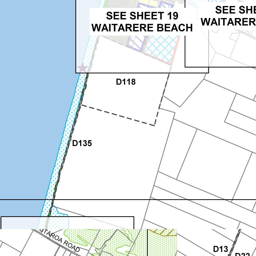
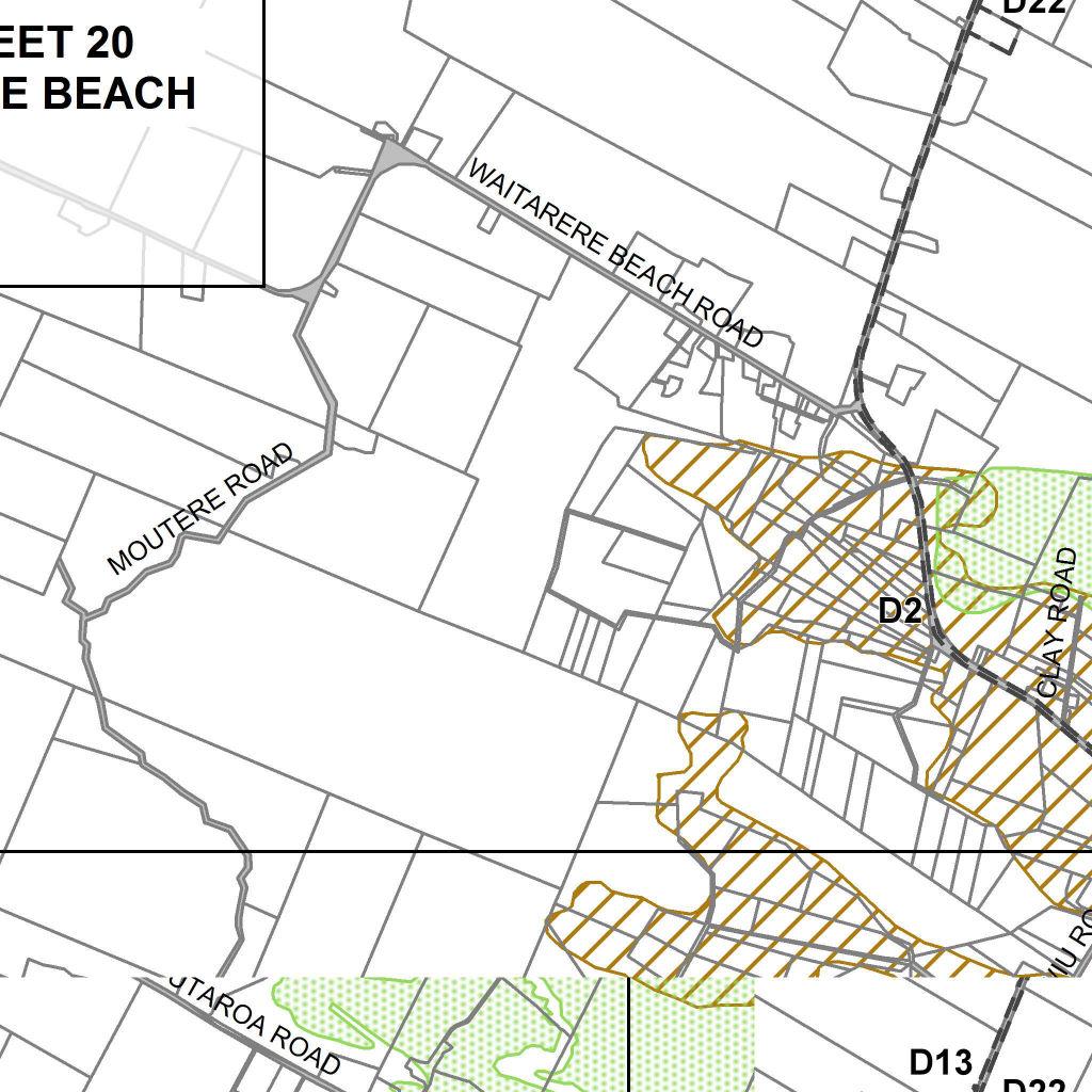
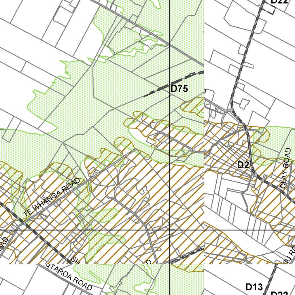
4 Amend Information Requirements 1: General Information as follows: (ii) A statement describing any significant natural hazards affecting, or likely to affect, the proposal including flooding, land instability, coastal hazards and fire. (Note: Refer to the Risks and Responsibilities: Report of the Manawatu-Wanganui Regional Lifelines Project (No. 2005/EXT/622) prepared by the Manawatu-Wanganui CDEM Group for information about natural hazards that may be relevant to the subject site). Amend Information Requirements 3: Subdivision as follows: (j) Natural Hazards: A description of any areas known to be subject to land instability or other significant hazard, together with a statement of any proposals for mitigating, or remedying any adverse effects or the hazard(s). (Note: Refer to the Risks and 2005/EXT/622) prepared by the Manawatu-Wanganui CDEM Group for information about natural hazards that may be relevant to the subject site). Mapping of the Flood Hazard Overlay Area The location and extent of the Flood Hazard Overlay Area was addressed by Malcolm Guy. Mr Guy queried the accuracy of the mapped flood hazard area, noting some sections included tall dune ridges. Mr Guy contended the accuracy of this mapping was important to avoid any resource consents if they applied to construct a dwelling or another building on these tall dune ridges which did not flood. In liaison with the Flood Catchment team at Horizons Regional Council, the location and extent of the Flood Hazard Overlay Area in the area of Mr Guy s property (Koputaroa Road) has been further reviewed. This further review has identified specific locations where the Flood Hazard Overlay Area can be redefined to exclude the tall dune ridges referred to by Mr Guy. In redefining this flood hazard area, the Flood Catchment team at Horizons Regional Council re-iterated this mapping is indicative only. It is recommended the Flood Hazard Overlay Area be amended as shown on the attached map. It is recommended Malcolm Guy s submission (4.00) be accepted in part. Recommended Amendment: Amend Planning Map 4 as shown in Appendix 1 to this report. Response to Commissioners Questions Moutoa Floodway (Rules and ) Q. Can you clarify and confirm the intent of all rules relating to the Moutoa Floodway and review the workings/mechanics (internal consistency) of these rules to ensure they achieve the intent? A. Policy 10-2 of the Horizons Regional Council Proposed One Plan states: The Regional Council and Territorial Authorities must not allow the establishment of any new structure or activity, or any increase in the scale of any existing structure or activity, within a floodway mapped in Schedule I unless: (i) there is a functional necessity to locate the structure or activity within such an area, and Officer Right of Reply and Response to Commissioners Questions Page 4
5 (ii) the structure or activity is designed so that the adverse effects of a 0.5% annual exceedance probability (AEP) (1 in 200 year) flood event on it are avoided or mitigated, and (iii) the structure or activity is designed so that adverse effects on the environment, including the functioning of the floodway, arising from the structure or activity during a flood event are avoided or mitigated, in which case the structure or activity may be allowed. This policy is given effect to in the Proposed District Plan in Policy which specifically relates to the Moutoa Floodway, being the only floodway in the Horowhenua District in Schedule I of the Proposed One Plan. The intent of the rules in the Proposed Plan is to implement these policies. In brief, the rules seek to permit only activities which have a functional necessity in the floodway, provided these permitted activities do not adversely affect the performance of the floodway. All other activities, and permitted activities that would adversely affect the performance of the floodway require a resource consent. In terms of the rule mechanics, the Moutoa Floodway is identified on the Planning Maps. The Flood Hazard Area Overlay also applies to the entire floodway, as well as an underlying Rural Zone. Rule 19.1(m) permits a limited number of activities in the Flood Hazard Area, including the Moutoa Floodway (e.g. primary production activities, flood protection works and maintenance and upgrading of network utilities). In the Section 42A Report it is recommended additional works associated with network utilities be permitted (e.g. underground utilities, cabinets, utility masts and poles). These permitted activities are subject to a condition in Rule which states no earthworks, buildings or structures are permitted in the Moutoa Floodway. This condition restricts those works that could compromise the functioning of the floodway. For example, dairy farming is permitted in the floodway (e.g. grazing of animals, spreading of fertiliser) but not farm buildings (e.g. milking shed, implement shed). The intent of Rule is to apply specific conditions to the Moutoa Floodway and not apply the Flood Hazard Area conditions under Rule which would permit a level of building and other works. To clarify this matter, it is recommended that an amendment be made to Rule to exclude the Moutoa Floodway from these conditions. In addition, consequential amendments would be required to Rule similar to those recommended to Rule in the Section 42A Report to provide for the works recommended amendments to Rule 19.1(m). For all other activities not permitted in Rule 19.1(m), these would be a restricted discretionary activity under Rule (b). For any permitted activities which do not comply with the conditions in Rule , these would be a restricted discretionary activity under Rule Lastly, any subdivision of land is a restricted discretionary activity under Rule I note two corrections to section 4.17 of the Section 42A Report: 1. 2 nd sentence, paragraph 3 of Discussion and Evaluation: Reference to Rule (b) should be to Rule (b). 2. 3rd sentence, paragraph 3 of Discussion and Evaluation and Recommended Amendments: Reference to Rule (b) should be to Rule (b). Accordingly, it is recommended Rules and are amended as below. These recommended amendments are considered to be within the scope of the submissions from Telecom (78), Chorus (79) and further submission from Powerco (505) set out in sections in the Section 42A Report which are recommended to be accepted. Officer Right of Reply and Response to Commissioners Questions Page 5
6 Recommended Amendment: Amend Rule as follows: Moutoa Floodway No earthworks, buildings or structures are permitted in the Moutoa Floodway. Exceptions (i) (ii) Earthworks associated with the installation of underground network utilities shall reinstate ground as close as practicable to its state prior to disturbance. Network utility cabinets/buildings shall not exceed 5m 2 gross floor area. Amend Rule as follows: Flood Hazard Overlay Area (excluding Moutoa Floodway) (b) (d) Within a Flood Hazard Overlay Area (excluding Moutoa Floodway) earthworks shall... Within a Flood Hazard Overlay Area (excluding Moutoa Floodway), the erection... Within a Flood Hazard Overlay Area (excluding Moutoa Floodway), the installation of underground network utilities... Within a Flood Hazard Overlay Area (excluding Moutoa Floodway), new network utility cabinets/buildings... Q. Can you review the wording of new recommended Rule in relation to the intent of this rule? A. The recommended new Rule is intended to provide for earthworks to enable the installation of underground network utilities, providing the ground level is reinstated to the same level as to prior to the earthworks. In reviewing the wording of the new rule, it could be simplified to clarify this intention. In addition, it is recognised it may not be practical or feasible to exactly reinstate the ground to the same level as prior to the earthworks. Below is revised recommended wording of this rule. In addition, in response to the previous question, this wording should also be applied to the condition for Rule Furthermore, in the written statement received from Powerco, they seek additional wording to Rule to clarify the earthworks thresholds do not apply to undergrounding network utilities. I support this clarification and the wording submitted and recommended the wording apply to all zones. These recommended amendments are considered to be within the scope of the submissions from Telecom (78), Chorus (79) and further submission from Powerco (505) set out in sections in the Section 42A Report which are recommended to be accepted. Recommended Amendment: Amend Rule (Residential Zone) as follows: Officer Right of Reply and Response to Commissioners Questions Page 6
7 (b) (d) Within a Flood Hazard Overlay Area earthworks shall not exceed 20m 3 per site within any 12 month period. Except The earthworks volume limit does not apply to tracks where the existing ground level is not altered by greater than 0.1 metres in any 12 month period or to the installation of underground network utilities undertaken in accordance with below. Within a Flood Hazard Overlay Area, earthworks associated with the installation of underground network utilities shall reinstate ground level as close as practicable to its state prior to disturbance. Within a Flood Hazard Overlay Area, new network utility cabinets/buildings shall not exceed 5m 2 gross floor area. Amend Rule (Industrial Zone) as follows: (b) (d) Within a Flood Hazard Overlay Area earthworks shall not exceed 20m 3 per site within any 12 month period. Except The earthworks volume limit does not apply to tracks where the existing ground level is not altered by greater than 0.1 metres in any 12 month period or to the installation of underground network utilities undertaken in accordance with below. Within a Flood Hazard Overlay Area, earthworks associated with the installation of underground network utilities shall reinstate ground level as close as practicable to its state prior to disturbance. Within a Flood Hazard Overlay Area, new network utility cabinets/buildings shall not exceed 5m 2 gross floor area. Amend Rule (Commercial Zone) as follows: (b) (d) Within a Flood Hazard Overlay Area earthworks shall not exceed 20m 3 per site within any 12 month period. Except The earthworks volume limit does not apply to tracks where the existing ground level is not altered by greater than 0.1 metres in any 12 month period or to the installation of underground network utilities undertaken in accordance with below. Within a Flood Hazard Overlay Area, earthworks associated with the installation of underground network utilities shall reinstate ground level as close as practicable to its state prior to disturbance. Within a Flood Hazard Overlay Area, new network utility cabinets/buildings shall not exceed 5m 2 gross floor area. Officer Right of Reply and Response to Commissioners Questions Page 7
8 Amend Rule (Rural Zone) as follows: Moutoa Floodway No earthworks, buildings or structures are permitted in the Moutoa Floodway. Exceptions (i) Earthworks associated with the installation of underground network utilities shall reinstate ground as close as practicable to its state prior to disturbance. Amend Rule (Rural Zone) as follows: Flood Hazard Overlay Area (excluding Moutoa Floodway)... Within a Flood Hazard Overlay Area (excluding Moutoa Floodway), earthworks associated with the installation of underground network utilities shall reinstate ground level as close as practicable to its state prior to disturbance. (d)... Amend Rule (Open Space Zone) as follows: (b) (d) Within a Flood Hazard Overlay Area earthworks shall not exceed 20m 3 per site within any 12 month period. Except The earthworks volume limit does not apply to tracks where the existing ground level is not altered by greater than 0.1 metres in any 12 month period or to the installation of underground network utilities undertaken in accordance with below. Within a Flood Hazard Overlay Area, earthworks associated with the installation of underground network utilities shall reinstate ground level as close as practicable to its state prior to disturbance. Within a Flood Hazard Overlay Area, new network utility cabinets/buildings shall not exceed 5m 2 gross floor area. Response prepared by Hamish Wesney Reviewed by David McCorkindale Dated 27 th May 2013 Officer Right of Reply and Response to Commissioners Questions Page 8
9 Appendix: Recommended Amendments to Flood Hazard Overlay Area Officer Right of Reply and Response to Commissioners Questions Page 9
...)...N..))) N... N...N...N... N... N...)...N..))) N... N... SSDSDSSS N.")

)lllllll...p...n...) )...)...)...N.")
 ) )) )3")
.l.llllll")
10 DDDDDD SSDDS N... N...)...)...N..))) N...)...)...N..))) N... N...N...N... N... N...)...N..))) N... N... SSDSDSSS N...)...N...)...N..))) N...N...)...N..))) N...p...N... N...a...N... N...N...N...a...N... N...a.a...N...N... N...N...N... N...N.l...N...))lllllll... p...n...) N...a...N.l...N...))lllllll...p...N...) p...a...))lllllll...p...n...) )...)...)...N...) SDSSSSDS...N... N...N...l.N...N ) ) )) )3 3 )4 )l )6 l 4 )7 )8 )9 )l 6 )) )) )3 7 N... ).l.llllll N.NNNNN..NN.NNNN..N...NN...N.N.N....N.... )4 )l )6 )7 )8 )9 3l 3) 3) l N...p )l...l )7alla)l)3 )) )...l.).9


11 !!!!!!!!!!!!!!!!!!!!!!!!!!!!!!!!!!!!!!!!!!!!!!!!!!!!!!!!!!!!!!!!!!!!!!!!!!!!!!!!!!!!!!!!!!!!!!!!!!!!!!!!!!!!!!!!!!!!!!!!!!!!!!!!!!!!!!!!!!!!!!!!!!!!!!!!!!!!!!!!!!!!!!!!!!!!!!!!!!!!!!!!!!!!!!!!!!!!!!!!!!!!!!!!!!!!!!!!!!!!!!!!!!!!!!!!!!!!!!!!!!!!!!!!!!!!!!!!!!!!!!!!!!!!!!!!!!!!!!!!!!!!!!!!!!!!!!!!!!!!!!!!!!!!!!!!!!!!!!!!!!!!!!!!!!!!!!!!!!!!!!!!!!!!!!!!!!!!!!!!!!!!!!!!!!!!!!!!!!!!!!!!!!!!!!!!!!!!!!!!!!!!!!!!!!!!!!!!!!!!!!!!!!!!!!!!!!!!!!!!!!!!!!!!!!!!!!!!!!!!!!!!!!!!!!!!!!!!!!!!!!!!!!!!!!!!!!!!!!!!!!!!!!!!!!!!!!!!!!!!!!!!!!!!!!!!!!!!!!!!!!!!!!!!!!!!!!!!!!!!!!!!!!!!!!!!!!!!!!!!!!!!!!!!!!!!!!!!!!!!!!!!!!!!!!!!!!!!!!!!!!!!!!!!!!!!!!!!!!!!!!!!!!!!!!!!!!!!!!!!!!!!!!!!!!!!!!!!!!!!!!!!!!!!!!!!!!!!!!!!!!!!!!!!!!!!!!!!!!!!!!!!!!!!!!!!!!!!!!!!!!!!!!!!!!!!!!!!!!!!!!!!!!!!!!!!!!!!!!!!!!!!!!!!!!!!!!!!!!!!!!!!!!!!!!!!!!!!!!!!!!!!!!!!!!!!!!!!!!!!!!!!!!!!!!!!!!!!!!!!!!!!!!!!!!!!!!!!!!!!!!!!!!!!!!!!!!!!!!!!!!!!!!!!!!!!!!!!!!!!!!!!!!!!!!!!!!!!!!!!!!!!!!!!!!!!!!!!!!!!!!!!!!!!!!!!!!!!!!!!!!!!!!!!!!!!!!!!!!!!!!!!!!!!!!!!!!!!!!!!!!!!!!!!!!!!!!!!!!!!!!!!!!!!!!!!!!!!!!!!!!!!!!!!!!!!!!!!!!!!!!!!!!!!!!!!!!!!!!!!!!!!!!!!!!!!!!!!!!!!!!!!!!!!!!!!!!!!!!!!!!!!!!!!!!!!!!!!!!!!!!!!!!!!!!!!!!!!!!!!!!!!!!!!!!!!!!!!!!!!!!!!!!!!!!!!!!!!!!!!!!!!!!!!!!!!!!!!!!!!!!!!!!!!!!!!!!!!!!!!!!!!!!!!!!!!!!!!!!!!!!!!!!!!!!!!!!!!!!!!!!!!!!!!!!!!!!!!!!!!!!!!!!!!!!!!!!!!!!!!!!!!!!!!!!!!!!!!!!!!!!!!!!!!!!!!!!!!!!!!!!!!!!!!!!!!!!!!!!!!!!!!!!!!!!!!!!!!!!!!!!!!!!!!!!!!!!!!!!!!!!!!!!!!!!!!!!!!!!!!!!!!!!!!!!!!!!!!!!!!!!!!!!!!!!!!!!!!!!!!!!!!!!!!!!!!!!!!!!!!!!!!!!!!!!!!!!!!!!!!!!!!!!!!!!!!!!!!!!!!!!!!!!!!!!!!!!!!!!!!!!!!!!!!!!!!!!!!!!!!!!!!!!!!!!!!!!!!!!!!!!!!!!!!!!!!!!!!!!!!!!!!!!!!!!!!!!!!!!!!!!!!!!!!!!!!!!!!!!!!!!!!!!!!!!!!!!!!!!!!!!!!!!!!!!!!!!!!!!!!!!!!!!!!!!!!!!!!!!!!!!!!!!!!!!!!!!!!!!!!!!!!!!!!!!!!!!!!!!!!!!!!!!!!!!!!!!!!!!!!!!!!!!!!!!!!!!!!!!!!!!!!!!!!!!!!!!!!!!!!!!!!!!!!!!!!!!!!!!!!!!!!!!!!!!!!!!!!!!!!!!!!!!!!!!!!!!!!!!!!!!!!!!!!!!!!!!!!!!!!!!!!!!!!!!!!!!!!!!!!!!!!!!!!!!!!!!!!!!!!!!!!!!!!!!!!!!!!!!!!!!!!!!!!!!!!!!!!!!!!!!!!!!!!!!!!!!!!!!!!!!!!!!!!!!!!!!!!!!!!!!!!!!!!!!!!!!!!!!!!!!!!!!!!!!!!!!!!!!!!!!!!!!!!!!!!!!!!!!!!!!!!!!!!!!!!!!!!!!!!!!!!!!!!!!!!!!!!!!!!!!!!!!!!!!!!!!!!!!!!!!!!!!!!!!!!!!!!!!!!!!!!!!!!!!!!!!!!!!!!!!!!!!!!!!!!!!!!!!!!!!!!!!!!!!!!!!!!!!!!!!!!!!!!!!!!!!!!!!!!!!!!!!!!!!!!!!!!!!!!!!!!!!!!!!!!!!!!!!!!!!!!!!!!!!!!!!!!!!!!!!!!!!!!!!!!!!!!!!!!!!!!!!!!!!!!!!!!!!!!!!!!!!!!!!!!!!!!!!!!!!!!!!!!!!!!!!!!!!!!!!!!!!!!!!!!!!!!!!!!!!!!!!!!!!!!!!!!!!!!!!!!!!!!!!!!!!!!!!!!!!!!!!!!!!!!!!!!!!!!!!!!!!!!!!!!!!!!!!!!!!!!!!!!!!!!!!!!!!!!!!!!!!!!!!!!!!!!!!!!!!!!!!!!!!!!!!!!!!!!!!!!!!!!!!!!!!!!!!!!!!!!!!!!!!!!!!!!!!!!!!!!!!!!!!!!!!!!!!!!!!!!!!!!!!!!!!!!!!!!!!!!!!!!!!!!!!!!!!!!!!!!!!!!!!!!!!!!!!!!!!!!!!!!!!!!!!!!!!!!!!!!!!!!!!!!!!!!!!!!!!!!!!!!!!!!!!!!!!!!!!!!!!!!!!!!!!!!!!!!!!!!!!!!!!!!!!!!!!!!!!!!!!!!!!!!!!!!!!!!!!!!!!!!!!!!!!!!!!!!!!!!!!!!!!!!!!!!!!!!!!!!!!!!!!!!!!!!!!!!!!!!!!!!!!!!!!!!!!!!!!!!!!!!!!!!!!!!!!!!!!!!!!!!!!!!!!!!!!!!!!!!!!!!!!!!!!!!!!!!!!!!!!!!!!!!!!!!!!!!!!!!!!!!!!!!!!!!!!!!!!!!!!!!!!!!!!!!!!!!!!!!!!!!!!!!!!!!!!!!!!!!!!!!!!!!!!!!!!!!!!!!!!!!!!!!!!!!!!!!!!!!!!!!!!!!!!!!!!!!!!!!!!!!!!!!!!!!!!!!!!!!!!!!!!!!!!!!!!!!!!!!!!!!!!!!!!!!!!!!!!!!!!!!!!!!!!!!!!!!!!!!!!!!!!!!!!!!!!!!!!!!!!!!!!!!!!!!!!!!!!!!!!!!!!!!!!!!!!!!!!!!!!!!!!!!!!!!!!!!!!!!!!!!!!!!!!!!!!!!!!!!!!!!!!!!!!!!!!!!!!!!!!!!!!!!!!!!!!!!!!!!!!!!!!!!!!!!!!!!!!!!!!!!!!!!!!!!!!!!!!!!!!!!!!!!!!!!!!!!!!!!!!!!!!!!!!!!!!!!!!!!!!!!!!!!!!!!!!!!!!!!!!!!!!!!!!!!!!!!!!!!!!!!!!!!!!!!!!!!!!!!!!!!!! W11004 PROPOSED CHANGE TO FLOOD AREA SHOWING 8m CONTOUR May 2012 Revision: 0 Plan prepared by Boffa Miskell Ltd Author:HW File Ref: W11004_FloodAreas_A4.mxd This graphic has been prepared by Boffa Miskell Limited on the specific instructions of our Client. It is solely for our Clients use in accordance with the agreed scope of work. Any use or reliance by a third party is at that partys own risk. Where information has been supplied by the Client or obtained from other external sources, it has been assumed that it is accurate. No liability or responsibility is accepted by Boffa Miskell Limited for any errors or omissions to the extent that they arise from inaccurate information provided by the Client or any external source. Proposed Flood Area!!!!!!!!!!!!!!!!!!!!!!!!!!!! Existing Flood Area 8m Contour 0 1,000 m
Gisborne District Council
 12.0 SUBDIVISION... 1 12.1 INTRODUCTION... 1 12.2 ISSUE... 1 12.3 OBJECTIVE (SUBDIVISION)... 1 12.4 POLICIES (SUBDIVISION)... 2 12.5 METHODS OF IMPLEMENTATION... 4 12.5.1 REGULATION... 4 12.6 RULES FOR
River Road - Civil Design Report. Appendix D. Flood Hazard Map. Beca //04 August // NZ // page 38
 River Road - Civil Design Report Appendix D Flood Hazard Map Beca //04 August 2016 3124460 // NZ1-12891696-39 0.39 // page 38 Regional scale flood hazard mapping Waikato Regional Council holds regional
BEFORE THE HEARINGS COMMITTEE, PALMERSTON NORTH PALMERSTON NORTHDISTRICT COUNCIL. IN THE MATTER of the Resource Management Act 1991 IN THE MATTER
 BEFORE THE HEARINGS COMMITTEE, PALMERSTON NORTH PALMERSTON NORTHDISTRICT COUNCIL IN THE MATTER of the Resource Management Act 1991 AND IN THE MATTER of the Proposed Palmerston North District Plan and a
Volume Three Appendix 7. Scheme Plan and other subdivision requirements
 Volume Three Appendix 7 Appendix 7 Scheme Plan and other subdivision requirements Any application for subdivision consent must be accompanied by a Scheme Plan that contains the information set out in this
Guide Note 6 Consideration of Hazardous Substances in the Appraisal Process
 Guide Note 6 Consideration of Hazardous Substances in the Appraisal Process Introduction The consideration of environmental conditions along with social, economic, and governmental conditions is fundamental
Section 12A Purpose of Subdivision Provisions
 Section 12A 12A Purpose of Subdivision Provisions Subdivision is primarily about creating land parcels that define and redefine property rights and, in most instances, the creation of new parcels of land
International Financial Reporting Standards (IFRS)
") FACT SHEET September 2011 IAS 38 Intangible Assets (This fact sheet is based on the standard as at 1 January 2011.) Important note: This fact sheet is based on the requirements of the International Financial
FACT SHEET September 2011 IAS 38 Intangible Assets (This fact sheet is based on the standard as at 1 January 2011.) Important note: This fact sheet is based on the requirements of the International Financial
PALMERSTON NORTH CITY SECTIONAL DISTRICT PLAN REVIEW PROPOSED PLAN CHANGE 2: CLIFF PROTECTION LINE
 PALMERSTON NORTH CITY SECTIONAL DISTRICT PLAN REVIEW PROPOSED PLAN CHANGE 2: CLIFF PROTECTION LINE PART I DESCRIPTION OF PROPOSED PLAN CHANGE This proposed Plan Change seeks to amend the Cliff Protection
BEFORE THE HEARINGS PANEL. In the Matter of: The Resource Management Act And. Proposed Plan Change 22A-G: Palmerston North City Council
 BEFORE THE HEARINGS PANEL In the Matter of: And The Resource Management Act 1991 Proposed Plan Change 22A-G: Application By: Palmerston North City Council Section 42A of the RMA Report BY LUCY COOPER (pages
GOVERNMENT CODE SECTION GOVERNMENT CODE SECTION 65302
 GOVERNMENT CODE SECTION 65300 65300. Each planning agency shall prepare and the legislative body of each county and city shall adopt a comprehensive, long-term general plan for the physical development
LIM Application for 1/ 240 Hurstmere Road Takapuna 0622
 21 October 2015 G Bogiatto and B J Malcolm 23B Riverside Road OREWA 0931 LIM Application for 1/ 240 Hurstmere Road Takapuna 0622 This Land Information Memorandum (LIM) details information known to Council
Anthony Banfield, FRICS Banfield Real Estate Solutions Ltd
 Anthony Banfield, FRICS Banfield Real Estate Solutions Ltd } RICS Practice Statement GN13/2010 Contamination, the environment and sustainability What is it and why should we care? What does it cover? Implications
Guide to Subdivision and Land Development
 Guide to Subdivision and Land Development Fraser Thomas Ltd......is an engineering and surveying consulting firm based in Highbrook which has provided Surveying, Engineering, Planning and Resource Management
DRAFT PROPOSED CHAPTER 21 SPECIFIC PURPOSE - FLAT LAND RECOVERY ZONE
 DRAFT PROPOSED CHAPTER 21 SPECIFIC PURPOSE - FLAT LAND RECOVERY ZONE Note: The Specific Purpose (Flat Land Recovery) Zone is a "holding" zone that will be subject to a later plan change to confirm the
Section Three, Part 9 - Subdivision
 PART 9 SUBDIVISION SUBDIVISION AND DEVELOPMENT OF LAND 9.1 INTRODUCTION This part of the District Plan sets out the provisions in respect of the subdivision and development of land in the urban part of
TERMS OF ENGAGEMENT Name of the firm. Previous involvement with the property or parties to the case:
 The headings contained in this framework for terms of engagement are based directly upon the list of mandatory required content set out in VPS 1 para 3.1, page 39 and the commentary which follows on pages
PART SIXTEEN - SUBDIVISION AND DEVELOPMENT
 16.1 24 July 2010 PART SIXTEEN - SUBDIVISION AND DEVELOPMENT 1. INTRODUCTION Council has the statutory responsibility to control subdivision of land and the effects of land use throughout the District.
Application for Outline Plan / Outline Plan Waiver Section 176A, Resource Management Act
 Email: applications@waidc.govt.nz www.waikatodistrict.govt.nz Telephone (all hours) 07 824 8633 Call Free 0800 492 452 District Office 15 Galileo Street Private Bag 544 Ngaruawahia 3742 Application for
CITY OF FORT COLLINS NATURAL AREAS AND CONSERVED LANDS EASEMENT POLICY
 CITY OF FORT COLLINS NATURAL AREAS AND CONSERVED LANDS EASEMENT POLICY Adopted January 3, 2012 PURPOSE: The purpose of the policy statement is to clarify the policies and procedures of the City of Fort
Longreach Developments Limited
 1 APPLICATION FOR RESOURCE CONSENT UNDER SECTION 88 OF THE RESOURCE MANAGEMENT ACT 1991 TO: THAMES COROMANDEL DISTRICT COUNCIL Longreach Developments Limited c/- Brown and Company, PO Box 91-839, Auckland
CONTACT(S) Annamaria Frosi +44 (0) Rachel Knubley +44 (0)
 Annamaria Frosi +44 (0) Rachel Knubley +44 (0)") IASB Agenda ref 11 STAFF PAPER IASB Meeting Project Paper topic Materiality Practice Statement Sweep issues covenants CONTACT(S) Annamaria Frosi afrosi@ifrs.org +44 (0)20 7246 6907 Rachel Knubley rknubley@ifrs.org
IASB Agenda ref 11 STAFF PAPER IASB Meeting Project Paper topic Materiality Practice Statement Sweep issues covenants CONTACT(S) Annamaria Frosi afrosi@ifrs.org +44 (0)20 7246 6907 Rachel Knubley rknubley@ifrs.org
Ownership and maintenance of lines on private land
 Electricity Commission RMAG: 17 January 20088 Ownership and maintenance of lines on private land Prepared by: Ron Beatty Senior Adviser Retail Discussion and approval Electricity Commission Board meeting:
Acquisition of investment properties asset purchase or business combination?
 Acquisition of investment properties asset purchase or business combination? Our IFRS Viewpoint series provides insights from our global IFRS team on applying IFRSs in challenging situations. Each edition
SUBMISSION TO THE WESTERN AUSTRALIA PLANNING COMMISSION
 SUBMISSION TO THE WESTERN AUSTRALIA PLANNING COMMISSION DRAFT STATE PLANNING POLICY 3.7 PLANNING FOR BUSHFIRE RISK MANAGEMENT & PLANNING FOR BUSHFIRE RISK MANAGEMENT GUIDELINES Contact: Christopher Green
Attachment A - Land Ownership Plan
 File Ref: A1516_001Ownership_CPL.indd Attachment A - Land Ownership Plan Chedworth Properties Ltd Landholding www.boffamiskell.co.nz RUAKURA Appendix to Evidence of Peter Hall for Chedworth Properties
First Experiences under the Tauranga Housing Accord
 First Experiences under the Tauranga Housing Accord Richard Coles Boffa Miskell, Tauranga - Richardc@boffamiskell.co.nz Paul Taylor Classic Builders/PMP Developments, Bay of Plenty/Waikato - Paul.taylor@classicbuilders.co.nz
THE CHAIRPERSON. Hans Hoogervorst Chairman International Accounting Standard Board 30 Cannon Street London EC4M 6XH.
 Floor 18 Tower 42 25 Old Broad Street London EC2N 1HQ United Kingdom t +44 (0)20 7382 1770 f +44 (0)20 7382 1771 www.eba.europa.eu THE CHAIRPERSON +44(0)20 7382 1765 direct andrea.enria@eba.europa.eu Hans
CONTACT(S) Annamaria Frosi +44 (0) Rachel Knubley +44 (0)
 Annamaria Frosi +44 (0) Rachel Knubley +44 (0)") IASB Agenda ref 11 STAFF PAPER IASB Meeting Project Paper topic Materiality Practice Statement Sweep issues covenants CONTACT(S) Annamaria Frosi afrosi@ifrs.org +44 (0)20 7246 6907 Rachel Knubley rknubley@ifrs.org
IASB Agenda ref 11 STAFF PAPER IASB Meeting Project Paper topic Materiality Practice Statement Sweep issues covenants CONTACT(S) Annamaria Frosi afrosi@ifrs.org +44 (0)20 7246 6907 Rachel Knubley rknubley@ifrs.org
Fraser River Escarpment Policy
 Fraser River Escarpment Policy Building Permit Requirements Page 1 of 2 This summary has been prepared by Inspections Services to assist property owners/builders in understanding the policies relating
APPLICATION FOR RESOURCE CONSENT OR FAST-TRACK RESOURCE CONSENT
 Office Use Only Application Number: APPLICATION FOR RESOURCE CONSENT OR FAST-TRACK RESOURCE CONSENT (Or Associated Consent Pursuant to the Resource Management Act 1991 (RMA)) (If applying for a Resource
If projects are received at the counter to be submitted without prior draft review, the project will be deferred to the next meeting.
 5400 Butternut Drive East Syracuse, NY13057-8509 Phone: 315.446.3910 x3 Fax: 315.449.0620 Edward M.Michalenko, PhD. Supervisor Planning & Zoning Samuel C. Gordon, MLA, Director Welcome to the Town of DeWitt
Proposed Variation to Stage 1 Proposed District Plan VISITOR ACCOMMODATION DRAFT
 Proposed Variation to Stage 1 Proposed District Plan VISITOR ACCOMMODATION Prepared by Ian Johnson, Mitchell Daysh Ltd For Bookabach Ltd Version 0.4 Residential Visitor Accommodation The Variation Alternative
Flood Hazard Area Land Use Management Guidelines Sea Level Rise Amendment. Effective January 1, 2018
 Flood Hazard Area Land Use Management Guidelines Sea Level Rise Amendment Effective January 1, 2018 What are the Flood Hazard Area Land Use Guidelines used for again? Flood Hazard Area Land Use Management
X. The Roles of Federal, State, and Local Governments
 X. The Roles of Federal, State, and Local Governments This chapter is a brief review of the Federal system s established and potentially useful future roles in flood hazards management in relation to its
Criteria for Appeals of Flood Insurance Rate Maps. November 30, 201 1
 Criteria for Appeals of Flood Insurance Rate Maps November 30, 201 1 This document outlines the criteria for appealing proposed changes in flood hazard information on Flood Insurance Rate Maps (FIRMS)
ACCOUNTING STANDARDS BOARD INTERPRETATION OF THE STANDARDS OF GENERALLY RECOGNISED ACCOUNTING PRACTICE
 ACCOUNTING STANDARDS BOARD INTERPRETATION OF THE STANDARDS OF GENERALLY RECOGNISED ACCOUNTING PRACTICE INTANGIBLE ASSETS WEBSITE COSTS (IGRAP 16) Issued by the Accounting Standards Board March 2012 Acknowledgment
International Financial Reporting Standards (IFRS)
") FACT SHEET September 2011 IAS 31 Interests in joint ventures (This fact sheet is based on the standard as at 1 January 2011.) Important note: This fact sheet is based on the requirements of the International
FACT SHEET September 2011 IAS 31 Interests in joint ventures (This fact sheet is based on the standard as at 1 January 2011.) Important note: This fact sheet is based on the requirements of the International
ADMINISTRATIVE GUIDANCE
 11 ADMINISTRATIVE GUIDANCE ON CONTAMINATED SITES Effective date: April 1, 2013 Version 1.1 May 2013 Expectations and Requirements for Contaminant Migration Introduction This guidance focusses on the ministry
Form 10 APPLICATION FOR CHANGE OR CANCELLATION OF RESOURCE CONSENT CONDITION. Section 127, Resource Management Act 1991
 Form 10 APPLICATION FOR CHANGE OR CANCELLATION OF RESOURCE CONSENT CONDITION To Far North District Council : Section 127, Resource Management Act 1991 We, Bruce Robin Ansley and Justine Anne Marra, apply
GUIDE TO SUBDIVISION & LAND DEVELOPMENT
 GUIDE TO SUBDIVISION & LAND DEVELOPMENT The Fraser Thomas Difference: Fraser Thomas Ltd is an engineering and surveying consulting firm based in Highbrook, and has been providing; Surveying, Engineering,
CITY OF GROVER BEACH COMMUNITY DEVELOPMENT DEPARTMENT Tentative Map Checklist
 CITY OF GROVER BEACH COMMUNITY DEVELOPMENT DEPARTMENT Tentative Map Checklist The following list includes all of the items you must submit for a complete application. Some specific types of information
Intangible Assets Web Site Costs
 SIC Interpretation 32 Intangible Assets Web Site Costs In March 2002 the International Accounting Standards Board issued SIC-32 Intangible Assets Web Site Costs, which had originally been developed by
Activities which do not satisfy the General Rules and are not provided for as Restricted Discretionary activities... 9
 16.0 PAPAKAINGA AND MARAE SETTLEMENTS... 1 16.1 INTRODUCTION... 1 16.2 ISSUES... 1 16.3 OBJECTIVE (PAPAKAINGA)... 2 16.4 POLICIES (PAPAKAINGA)... 2 16.5 OBJECTIVE (SURROUNDING ENVIRONMENT)... 2 16.6 POLICIES
Initial Notice Protocol October 2012
 Initial Notice Protocol October 2012 This Initial Notice Protocol document and supporting Policy Advice Notes should be read in addition to the requirements of The Building Act 1984 and The Building (Approved
15.1 Introduction. Waipa District Plan. Section 15 - Infrastructure, Hazards, Development and Subdivision. Page Version - 1 November 2016 Page 1 of 56
 15.1 Introduction 15.1.1 How and where development and subdivision occurs is critical to the sustainable management of the District s natural and physical resources. This section of the Plan focuses on
Resource Consent Application Form
 Resource Consent Application Form Section 88 of the Resource Management Act 1991. This form provides us with your contact information and details about your proposal. Please print clearly and complete
Standard for the acquisition of land under the Public Works Act 1981 LINZS15005
 Standard for the acquisition of land under the Public Works Act 1981 LINZS15005 Version date: 20 February 2014 Table of contents Terms and definitions... 5 Foreword... 6 Introduction... 6 Purpose... 6
Queenstown Lakes District Proposed District Plan Section 32 Evaluation Stage 2 Components October 2017
 Queenstown Lakes District Proposed District Plan Section 32 Evaluation Stage 2 Components October 2017 For: Visitor Accommodation Chapter 2 Definitions And consequential Variations to Proposed District
Suburb Profile Report. Paddington, 2021 NSW
 Suburb Profile Report Paddington, 2021 NSW October 2018 About Sound Property Group Sound Property Group is a property investment and education company specialised in sourcing strategic real estate opportunities,
Briefing Paper: Allotment Law in Scotland Introduction Allotments (Scotland) Act of 1892
 Act of 1892") Disclaimer: The contents of this paper is the best understanding of the current state of Scottish law relating to allotments by a lay person who is a member of the SAGS committee. It is not intended to
Disclaimer: The contents of this paper is the best understanding of the current state of Scottish law relating to allotments by a lay person who is a member of the SAGS committee. It is not intended to
Chapter 8 Transportation
 Chapter 8 Transportation Introduction 1. Chapter 8 of the PDP contains provisions concerning the development, maintenance and use of the transport network and associated activities. It recognises that
International Financial Reporting Standards (IFRS)
") FACT SHEET February 2011 IAS 40 Investment Property (This fact sheet is based on the standard as at 1 January 2011.) Important note: This fact sheet is based on the requirements of the International Financial
FACT SHEET February 2011 IAS 40 Investment Property (This fact sheet is based on the standard as at 1 January 2011.) Important note: This fact sheet is based on the requirements of the International Financial
Presentation to the Real Estate Institute of New Zealand 28 October 2016
 Presentation to the Real Estate Institute of New Zealand 28 October 2016 Disclaimer This presentation provides a high level overview of specific parts of the Proposed Auckland Unitary Plan Decisions Version
CONSISTENCY WITH THE DEVELOPMENT CONSENT: INCREASING OBLIGATIONS ON CERTIFIERS
 CONSISTENCY WITH THE DEVELOPMENT CONSENT: INCREASING OBLIGATIONS ON CERTIFIERS Paper given by Joshua Palmer to the Australian Institute of Building Surveyors Annual Conference 12-13 August 2013 In the
VI. SAFETY ELEMENT I. INTRODUCTION A. PURPOSE B. AUTHORITY. 1. Safety
 AB 162 and SB 1241 Amendment to the Safety Element New sections are underlined, deleted sections are shown as strikethrough and the denotes text remaining in place. VI. SAFETY ELEMENT I. INTRODUCTION A.
HEC Software and FEMA Submittals
 HEC Software and FEMA Submittals EWRI Workshop HEC Users Conference Larry Voice Risk Analysis FEMA Region VI April 12, 2010 Overview Flood Hazard Analysis Overview of Map Changes Accepted Model List Guidance
Qualified Professionals, Land Owners and Developers. FROM: Development Services. DATE: November 29, 2017
 TO: Qualified Professionals, Land Owners and Developers FROM: Development Services DATE: November 29, 2017 RE: Terms of reference for Natural Hazard and/or Risk Assessments The District of Squamish (District)
Mobility Scooter Storage Policy
 Mobility Scooter Storage Policy 01 April 2018 Title Users of Policy Mobility Scooter Storage Policy Colchester Borough Council tenants and leaseholders, staff at Colchester Borough Homes Date Adopted Aril
I Te Koti Taiao o Aotearoa Ōtautahi Rohe ENV-2018-CHC-
 In the Environment Court of New Zealand Christchurch Registry I Te Koti Taiao o Aotearoa Ōtautahi Rohe ENV-2018-CHC- Under In the matter of Between the Resource Management Act 1991 (RMA) An appeal under
SECTION B - GUIDELINES
 SECTION B - GUIDELINES APPLICATION KIT FOR SUBDIVISION RESOURCE CONSENT UNDER SECTION 88 OF THE RESOURCE MANAGEMENT ACT 1991 CONTENTS: PLEASE READ AND COMPLETE 1. Making an Application for a Subdivision
A Guide to the Municipal Planning Process in Saskatchewan
 A Guide to the Municipal Planning Process in Saskatchewan A look at the municipal development permit and the subdivision approval process in Saskatchewan May 2008 Prepared By: Community Planning Branch
Chapter 14 Technical Safety Authority of Saskatchewan Inspecting Elevating Devices 1.0 MAIN POINTS
 Chapter 14 Technical Safety Authority of Saskatchewan Inspecting Elevating Devices 1.0 MAIN POINTS The Technical Safety Authority of Saskatchewan (TSASK) administers Saskatchewan s safety programs for
APPENDIX B COMPLIANCE WITH THE GOVERNMENT CODE
 APPENDIX B COMPLIANCE WITH THE GOVERNMENT CODE A. GENERAL PLAN AMENDMENT PROCEDURE In general, local governments may not amend any of the mandatory elements of the General Plan (e.g. Land Use, Open Space,
PROTOCOL FOR ZONING PERMIT SUBMITTAL
 CALN TOWNSHIP Department of Code Enforcement Andrew F. Reczek, Director of Code Enforcement & Zoning Officer Raymond Stackhouse, Code Official &Fire Marshal Joseph Arvay, Property Main./Housing Inspector
Notes from Guest Contributor Mary Ross
 IPM-Software November 10, 2009 Notes from Guest Contributor Mary Ross Changes to the 50059 and Voucher Submission Process Are Your Vouchers Really Subject to Adjustment? As HUD continues to refine the
IFRS INTERPRETATIONS COMMITTEE - AGENDA DECISIONS (JANUARY AND MARCH 2018)
") IFRS INTERPRETATIONS COMMITTEE - AGENDA DECISIONS (JANUARY AND MARCH 2018) INTERNATIONAL FINANCIAL REPORTING BULLETIN 2018/01 Background This Bulletin summarises issues that the IFRS Interpretations Committee
IFRS INTERPRETATIONS COMMITTEE - AGENDA DECISIONS (JANUARY AND MARCH 2018) INTERNATIONAL FINANCIAL REPORTING BULLETIN 2018/01 Background This Bulletin summarises issues that the IFRS Interpretations Committee
Riverton Properties Ltd Proposed Special Housing Area
 Riverton Properties Ltd Proposed Special Housing Area Housing Accords and Special Housing Areas Act 2013 Expression of Interest 1 This Expression of Interest is made on behalf of Riverton Properties Ltd,
LAND USE AND ZONING OVERVIEW
 OVERVIEW OF PLANNING POLICIES LAND USE AND ZONING OVERVIEW The Minneapolis Plan for Sustainable Growth and Other Adopted Plans Community Planning and Economic Development Development Services Division
Tenants Service NFU TENANTS SERVICE. Providing professional advice, information and representation to actively support our tenant members
 Tenants Service NFU TENANTS SERVICE roviding professional advice, information and representation to actively support our tenant members Together, we are NFUnited The NFU is the only organisation that champions
BEFORE THE CHRISTCHURCH REPLACEMENT DISTRICT PLAN HEARINGS PANEL
 BEFORE THE CHRISTCHURCH REPLACEMENT DISTRICT PLAN HEARINGS PANEL IN THE MATTER of the Resource Management Act 1991 and the Canterbury Earthquake (Christchurch Replacement District Plan) Order 2014 AND
Regulatory Impact Statement
 Regulatory Impact Statement Establishing one new special housing area in Queenstown under the Housing Accords and Special Housing Areas Act 2013. Agency Disclosure Statement 1 This Regulatory Impact Statement
BUILDING PERMIT SUBMITTAL REQUIREMENTS
 BUILDING PERMIT SUBMITTAL REQUIREMENTS 1. All applications must include two (2) sets of both site plans and construction documents as outlined below. Minimum fees will be collected at time of application.
PROCUREMENT DEPARTMENT 2 MONTGOMERY STREET, 3 rd FLOOR JERSEY CITY, NJ ADDENDUM # 4, Revised TO PROSPECTIVE RESPONDENTS TO RFQ# 31224
 PROCUREMENT DEPARTMENT 2 MONTGOMERY STREET, 3 rd FLOOR JERSEY CITY, NJ 07302 ADDENDUM # 4, Revised TO PROSPECTIVE RESPONDENTS TO RFQ# 31224 Date: December 24, 2012 LAGUARDIA AIRPORT CENTRAL TERMINAL BUILDING
BRIDESDALE FARM SUMMARY OF AGREEMENT FOR SALE AND PURCHASE
 GTODD Law are a boutique law firm in Queenstown, providing clients with experienced, valued, pragmatic legal advice. We regularly act for clients who are purchasing properties in subdivisions and developments
Capital Assistance Scheme Call for Proposals 2016
 22 June 2016 Circular: Housing 29/2016 To each Director of Service (Housing) Dear Director, 1 P a g e Capital Assistance Scheme Call for Proposals 2016 The Department is now accepting applications for
Re: Proposed Accounting Standards Update, Applying Variable Interest Entity Guidance to Common Control Leasing Arrangements
 Financial Reporting Advisors, LLC 100 North LaSalle Street, Suite 2215 Chicago, Illinois 60602 312.345.9101 www.finra.com VIA EMAIL TO: director@fasb.org Technical Director File Reference No. PCC-13-02
GENERAL TERMS AND CONDTITIONS
 GENERAL TERMS AND CONDTITIONS 1 Definitions In these terms and conditions the following definitions apply "Broker" means Pareto. "Charge" means the charges (including all commissions) payable for the Services
16.1 Introduction Resource Management Issues Objectives And Policies Rules: Permitted Activities 3
 SECTION 16: CACCIA BIRCH CONTENTS 16.1 Introduction 1 16.2 Resource Management Issues 1 16.3 Objectives And Policies 1 16.5 Rules: Permitted Activities 3 R16.5.1 Permitted Activities 3 16.6 Rules: Controlled
DEPARTMENT OF HOUSING AND URBAN DEVELOPMENT. [Docket No. FR-6001-N-28] 60-Day Notice of Proposed Information Collection:
![DEPARTMENT OF HOUSING AND URBAN DEVELOPMENT. [Docket No. FR-6001-N-28] 60-Day Notice of Proposed Information Collection:](/thumbs/90/103670274.jpg "DEPARTMENT OF HOUSING AND URBAN DEVELOPMENT. [Docket No. FR-6001-N-28] 60-Day Notice of Proposed Information Collection:") This document is scheduled to be published in the Federal Register on 09/05/2017 and available online at https://federalregister.gov/d/2017-18742, and on FDsys.gov Billing Code: 4210-67 DEPARTMENT OF HOUSING
This document is scheduled to be published in the Federal Register on 09/05/2017 and available online at https://federalregister.gov/d/2017-18742, and on FDsys.gov Billing Code: 4210-67 DEPARTMENT OF HOUSING
ENVIRONMENT CANTERBURY S WEB-BASED CONTAMINATED LAND INFORMATION TRANSFER SYSTEM
 ENVIRONMENT CANTERBURY S WEB-BASED CONTAMINATED LAND INFORMATION TRANSFER SYSTEM Davina McNickel 1, Helen Davies 2, Vincent Salomon 2 1 Environment Canterbury, PO Box 345, Christchurch. Telephone: 03 365
Papers The Digital Economy Act : What surveyors need to know about changes to the law on telecommunications equipment
 Journal of Building Survey, Appraisal & Valuation Volume 6 Number 3 Papers The Digital Economy Act : What surveyors need to know about changes to the law on telecommunications equipment Michael Watson
Leasehold Management Policy
 Author(s): Simon McCracken and Liz Evans Leasehold Management Policy Approved by: The Board Date: 3 rd December 2015 Date Published: 1 st January 2016 Version: Live 3.0 Review Date: December 2019 Contents
Valuation Report. Property Address. Prepared by. Surveyors Name Trafford Surveyors Ltd. On behalf of: Clients Name
 Valuation Report On Prepared by Surveyors Name Trafford Surveyors Ltd On behalf of: Clients Name CONTENTS Instruction...2 Basis of Valuation... 2 Executive Summary... 3 Location (Appendix 2 Location Plan)...
NELSON MANDELA METROPOLITAN MUNICIPALITY
 NELSON MANDELA METROPOLITAN MUNICIPALITY APPLICATION FOR CHANGE IN USE OF LAND (PLACE A CROSS IN APPROPRIATE BLOCKS) 1. REZONING TO SUBDIVISIONAL AREA - In terms of section 17 of the Land Use Planning
FLOOD HAZARD AREA LAND USE MANAGEMENT
 FLOOD HAZARD AREA LAND USE MANAGEMENT Introduction Guidance For Selection of Qualified Professionals and Preparation of Flood Hazard Assessment Reports This document is intended to provide guidance for
BEFORE THE HEARINGS PANEL FOR THE QUEENSTOWN LAKES PROPOSED DISTRICT PLAN AND
 BEFORE THE HEARINGS PANEL FOR THE QUEENSTOWN LAKES PROPOSED DISTRICT PLAN IN THE MATTER of the Resource Management Act 1991 AND IN THE MATTER of Stage 2 including variations to Stage 1 of the Proposed
SCOTTISH GOVERNMENT RESPONSE TO PRIVATE RENTED HOUSING (SCOTLAND) BILL STAGE 1 REPORT
 BILL STAGE 1 REPORT") SCOTTISH GOVERNMENT RESPONSE TO PRIVATE RENTED HOUSING (SCOTLAND) BILL STAGE 1 REPORT I am writing in response to the Local Government and Communities Committee s Stage 1 Report on the Private Rented Housing
SCOTTISH GOVERNMENT RESPONSE TO PRIVATE RENTED HOUSING (SCOTLAND) BILL STAGE 1 REPORT I am writing in response to the Local Government and Communities Committee s Stage 1 Report on the Private Rented Housing
TECHNICAL INFORMATION PAPER - VALUATIONS OF REAL PROPERTY, PLANT & EQUIPMENT FOR USE IN AUSTRALIAN FINANCIAL REPORTS
 TECHNICAL INFORMATION PAPER - VALUATIONS OF REAL PROPERTY, PLANT & EQUIPMENT FOR USE IN AUSTRALIAN FINANCIAL REPORTS Reference ANZVTIP 8 Valuations of Real Property, Plant & Equipment for Use in Australian
E38. Subdivision - Urban
 E38. Subdivision - Urban E38.1. Introduction Subdivision is the process of dividing a site or a building into one or more additional sites or units, or changing an existing boundary location. Objectives,
Trip Rate and Parking Databases in New Zealand and Australia
 Trip Rate and Parking Databases in New Zealand and Australia IAN CLARK Director Flow Transportation Specialists Ltd ian@flownz.com KEYWORDS: Trip rates, databases, New Zealand developments, common practices
RICS property measurement 2nd edition: Basis for conclusions. Purpose
 RICS property measurement 2nd edition: Basis for conclusions Purpose This document has been prepared to accompany publication of the RICS property measurement 2nd edition in order to explain the rationale
12 September Mr Hans Hoogervorst Chairman The International Accounting Standards Board 30 Cannon Street London EC4M 6XH United Kingdom
 12 September 2013 Mr Hans Hoogervorst Chairman The International Accounting Standards Board 30 Cannon Street London EC4M 6XH United Kingdom Email: commentletters@ifrs.org. Dear Hans Exposure Draft ED/2013/6
SP Energy Networks Fee Scale
 SP Energy Networks Fee Scale Introduction SP Energy Networks (the Company), which is formed by the licensed and regulated companies known as SP Distribution Plc, SP Transmission Plc and SP Manweb Plc,
Section 7 Subdivision
 78 Section 7 Subdivision 79 Palmerston North City Council District Plan March 2010 Proposed Draft Amendments to Section 7: Subdivision Note: new text to be added to the District Plan is shown as coloured
For the purposes of this policy, the following definitions apply:
 1. Relevant legislation Local Government Act 1974 Public Works Act 1981 Reserves Act 1977 Local Government Act 2002 2. Objective To provide a framework for consistent decision-making in respect of the
Vesting of Roads and Reserves Policy
 Vesting of Roads and Reserves Policy Adopted by Full Council 28 July 2016 Table of Contents 1. Policy Statement and Purpose...... 1 2. Issue...... 1 3. Policy...... 2 Land Subject To Interests...... 2
NOTICE OF PREPARATION of a Draft Program Environmental Impact Report for the Fresno County General Plan Review and Zoning Ordinance Update
 NOTICE OF PREPARATION of a Draft Program Environmental Impact Report for the Fresno County General Plan Review and Zoning Ordinance Update Date: March 21, 2018 To: State Clearinghouse, Responsible Agencies,
RURAL SETTLEMENT ZONE - RULES
 Chapter 38 RURAL SETTLEMENT ZONE - RULES INTRODUCTION This Chapter contains rules managing land uses in the. The boundaries of this zone are shown on the planning maps. There is limited opportunity for
Intangible Assets Web Site Costs
 HK(SIC)-Int 32 Revised May 2014 September 2018 Effective for annual periods beginning on or after 1 January 2005 Hong Kong (SIC) Interpretation 32 Intangible Assets Web Site Costs COPYRIGHT Copyright 2018
State Highway Revocation: Policy and Guidance
 State Highway Revocation: Policy and Guidance Revocation and consultation 1. Where there are changes to the state highway network that create duplicate sections of State highway serving the same function