Time Min. Presenter Type Description 1.
|
|
|
- Dulcie Banks
- 5 years ago
- Views:
Transcription
1 TOWN OF MOUNTAIN VILLAGE DESIGN REVIEW BOARD & JOINT TOWN COUNCIL MEETING THURSDAY APRIL 2, 2015, 10:00 AM 2nd FLOOR CONFERENCE ROOM, MOUNTAIN VILLAGE TOWN HALL 455 MOUNTAIN VILLAGE BLVD, MOUNTAIN VILLAGE, COLORADO AGENDA Time Min. Presenter Type Description
2 SUMMARY OF MOTIONS TOWN OF MOUNTAIN VILLAGE DESIGN REVIEW BOARD MEETING THURSDAY, MARCH 5, 2015 Agenda item # 4 Call to Order Chairman, Bill Hoins, called the meeting of the Design Review Board of the Town of Mountain Village to order at 10:00 a.m. on Thursday, March 5, 2015, in the Conference Room at 455 Mountain Village Boulevard, Mountain Village, Colorado, Attendance The following Board/Alternate members were present and acting: Bill Hoins Dave Eckman Greer Garner Phil Evans Keith Brown Luke Trujillo Daniel Zemke The following Board members were absent: Banks Brown Kristine Perpar Town Staff in attendance: Chris Hawkins, Director of Community Development Dave Bangert, Town Forester Public in attendance: Stefanie Solomon Suzanne Greischel Lee Roufa Frank Hensen Ken Alexander Douglas Tooley Joe Solomon David Craige Jean Vatter Reading and Approval of Summary of Motions of the February 5, 2015 Design Review Board Meeting On a Motion made by Phil Evans and seconded by David Eckman, the DRB voted 7-0 to approve with changes the Summary of Motions from the February 5, 2015 meeting. Consideration of a recommendation to the Town Council for amendments to the Community Development Code (CDC) at (A) Section to allow the conditional use permit process to establish the allowed height for freestanding antennas; (B) Section (E)(2)-(3) to correct an omission, and not require a concurrent replat with rezoning; (C) Section (F)(3) to revise the criteria for allowing ski lifts on private lots; (D) Section to meet or exceed San Miguel County open burning regulations; and (E) miscellaneous amendments to the CDC to accomplish the foregoing. On a Motion made by Greer Garner and seconded by David Eckman, the DRB voted 7-0 to approve the recommendation to the Town Council for amendments to the Community Development Code (CDC)
3 Conceptual worksession for an addition to a single-family dwelling on Lot 221AR. David Eckman recused himself due to a conflict of interest for this agenda item. Director of Community Development, Chris Hawkins, presented for the Conceptual Worksession Owner s representative and applicant, David Eckman, presented for the worksession. DRB Member Appointments Recommendation to the Town Council for filling members seats whose term will expire. Director of Community Development, Chris Hawkins, presented for the DRB member recommendation of appointments. Upon interviewing with Jean Vatter, Suzanne Greischel, Douglas Tooley, Frank Hensen, David Craige, and discussion among board members on a Motion by Daniel Zemke and seconded by Keith Brown, the DRB voted 4-0 to recommend Town Council appoint Dave Eckman, Greer Garner and Phil Evans as regular members, and recommends the two alternate seats be appointed to Jean Vatter and David Craige. DRB s recommendations will go before Town Council, at the March 26, 2015 meeting, located at 455 Mountain Village Blvd. Design Review Board Annual Election of Chair, Vice-Chair and Temporary Chair Director of Community Development, Chris Hawkins, requested that Annual Elections be heard at the April 2, 2015 Design Review Board meeting at 10:00am located at 455 Mountain Village Blvd. Other Business: With no other business on a Motion made by Keith Brown and seconded Luke Trujillo, the DRB voted 7-0 to adjourn the March 5, 2015 meeting of the Mountain Village Design Review Board at 1:20 p.m. Respectfully Submitted, Chris Hawkins, AICP Director of Community Development

4 Agenda Item #6 COMMUNITY DEVELOPMENT DEPARTMENT PLANNING DIVISION TO: FROM: FOR: DATE: RE: PROJECT GEOGRAPHY Legal Description: Address: Applicant/Agent: Owner: Zoning: Existing Use: Proposed Use: Adjacent Land Uses: North: South: East: West: Lot Size: PROJECT SUMMARY CDC Provision Requirement Proposed 1
5 Agenda Item #6 ATTACHMENTS RECORD DOCUMENTS BACKGROUND CRITERIA FOR DECISION ANALYSIS General Easement Setback 2
6 Agenda Item #6 Wetlands Design Variations 3
7 Agenda Item #6 Exterior Colors Windows Landscaping Regulations 4
8 Agenda Item #6 Lighting Regulations Miscellaneous Issues RECOMMENDATION 5
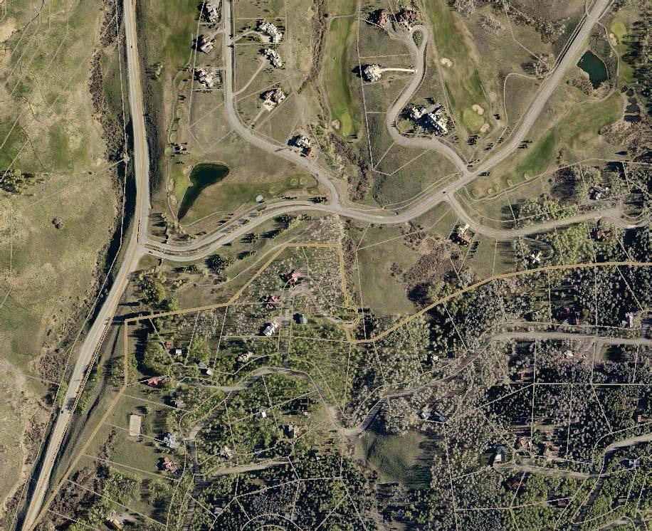
9 Thomas W. Conyers, Architect, A.I.A. P.O. Box 3383 Telluride, Co Phone Magid Residence Lot 364R TMV Mountain Village, Colorado PROJECT NARRATIVE The Magid Residence located at Lot 364R on Snowfield Drive is a 6946 square foot primary residence with an 832 square foot attached garage. Lot 364R is a heavily treed site sloping to the North toward a large section of wetlands as delineated by Chris Hazen and located by Foley and Associates in June of 2014(documents attached). Spanning approximately onethird of the entire lot to the North, the wetland delineation limits the buildable footprint for a home. Prior to the owner purchasing the lot, a worksession with the Mountain Village DRB was held on April 23, 2014 to determine the feasibility of encroaching into the South side 16-0 general easement for driveway access and the possibility of minor view corridor tree clearing in the wetland area. We received positive feedback for the proposed driveway encroachment and were instructed to work closely with Dave Bangert for tree clearing requirements and limitations. Further conversations with Dave Bangert have resulted in the proposal of relocating some of the smaller existing spruce trees on the property as much as realistically and economically possible. With these footprint and wetland limitations, the home was sited to provide access on the lower side(west) of the property and keep the building footprint away from the culvert and wet drainage areas to the Northwest. The home spans across a gently sloping section of the lot maintaining an appropriate distance from the wetland delineation for the mass excavation of the foundation. The use of reclaimed barnwood siding, 2x12 plank siding, heavy timber trusses, drystack stone veneer, and coreten metal roofing along with the low profile of a one story house with a walkout basement will allow the home to blend into the existing landscape and fit within the context of the existing homes on Snowfield and allow view corridors from neighboring properties to the South. The house is designed to include a large exterior terrace on the North side of the property. The terrace is partially covered and the roof form is designed to shed snow away from the terrace for year round use. To minimize the visual impact of the shed roof, a 3:12 roof pitch was incorporated. Per the CDC roof form guidelines, the 3:12 shed roof is consistent with the guidelines per the following: C. Roof Form 1. Roof Design a. Primary forms shall be gable. Secondary roof forms may be either gable or shed roof forms. All roof forms are gable or shed with the 3:12 shed pitch minimizing the impact of the secondary roof form. b. Roof forms shall be simple in design to the extent practicable. All roof forms are simple in design.
10 c. Dormers may be included to add interest and scale to major roof areas and to make habitable use of space within the roofs. Dormers may have gable or shed 113 forms. 3:12 shed roof add interest and scale to the major ridge lines without dominating the mass of the gable form. d. The DRB shall require ridgelines to be stepped to avoid long spans of unbroken ridges when such elements are not in proportion to the design and scale of the building. Primary ridgelines are broken with 4:12 shed roofs in scale with the overall forms. Only one shed roof is 3:12. e. Valleys shall be avoided to the extent practicable to remove a potential source of ice buildup and water damage, and to conserve energy by eliminating the need for heat tracing to prevent ice dams and roof damage. f. The design of roofs shall reflect concern for snow accumulation and ice/snow shedding. Entries, walkways and pedestrian areas shall be protected from ice/snow shedding. The 3:12 shed roof allows snow to shed away from the North terrace.
11
12 THE TERRA FIRM, Inc. Cindy and Tucker Magid Burt Street Omaha, NE RE: Lot 364, Telluride Mountain Village Cindy and Tucker, At the request of Tom Conyers, I have conducted a preliminary review of Lot 364 regarding wetlands and the potential limitations wetlands might impose on your conceptual building plans. I completed a site walk on April 11, 2014 and observed two locations where test pits had recently been excavated and filled presumably for engineering purposes. I also observed survey lathe that had been installed identifying an undated/unnamed wetland boundary, and some numbered orange pin flags that appear to be from previous field delineation activities. These flags were attached to tree branches and the aforementioned lathe was in snow approximately 2-3 feet deep. The dominant landscape feature of the area north of Lot 364 is a large wetland that is a fen a wetland type characterized by its peat soils and a consistent/reliable groundwater regime, which hydrates the site on an annual basis. The wetland is located on a topographic bench with a relatively flat grade, and the sloping topography south of the wetland appears to transition into the wetland within the limits of Lot 364. Additionally, there is a wetland area south of Snowfield Drive that may have been a part of the larger wetland complex to the north prior to development of the Mountain Village and Snowfield Drive. The wetland plant community visible above the snow cover is composed of willow species and alder and likely contains an understory dominated by sedge species. The lathe and pin flags that presumably identify the previous delineation boundary from 2007 are located in an area where spruce and fir species begin to transition to the willow/alder community. Without being able to observe the ground cover, soil characteristics and localized hydrology (due to the presence of snow) it is difficult to state with certainty that the previous delineation line is representative of conditions today. However, the location of the lathe/pin flags appears to be conservative with respect to the vegetation, allowing for ample buffer between the primary wetland area and its fringe margins. It is my PO BOX 362 TELLURIDE, COLORADO chrishazen@gmail.com
13 THE TERRA FIRM, Inc. preliminary opinion that the wetland area on Lot 364 today, is probably not larger in area than the extents defined during the 2007 delineation. Regarding buffers and the United States Army Corps of Engineers (USACE) position on their utility and requirement, the USACE does not require a buffer, however they do suggest that a buffer be employed to allow for 360 degree access around a building site without encroachment into wetland areas. If building plans can adequately demonstrate that construction can be completed adjacent to jurisdictional wetlands without compromising the wetland integrity, than building is allowed with zero setback requirements from the wetland. In a practical sense, a setback allows for the installation of adequate protections (Best Management Practices or BMP s including silt fencing etc..) to ensure that no impacts occur to wetland areas during construction. Lot 364 and the adjacent wetland are both heavily forested, and it is my understanding that there is a desire for some limited tree removal within the portions of the wetland on Lot 364 to improve view corridors from the proposed residential structure. The USACE does not regulate the removal of trees from wetland areas per se, but does restrict the use of machinery for timber removal in wetlands. Additionally any slash (limbs etc..) generated from the timber removal can not be left in the wetlands it must be removed to upland areas on Lot 364 or hauled offsite. The standard restrictions imposed for timber removal in wetlands by the Town of Mountain Village (removal with snow cover on ground, no machinery, no removal in the conservation easement portions of the wetland) should adequately protect the wetland area to the USACE s expectations. With regard to the installation of helical piers in the wetland to support a portion of a deck or a boardwalk, these activities are considered by the USACE under the Modified Nationwide Permit process available in the Mountain Village. The Modified Nationwide Permits are limited and more restrictive than the permits available in the rest of the United States due to the historic wetland impacts in the Mountain Village and the subsequent Consent Decree that resolved the legal issues surrounding the Clean Water Act violations. Permits for similar installations in the Mountain Village have been issued by the USACE, however each permit application is reviewed on a case-bycase basis and permit denial is possible if the USACE identifies reasonable alternatives to the proposed action or if the proposed action is determined to be ancillary to the project s viability. Necessary installations like driveways or access bridges are viewed differently than an elective like a larger deck. PO BOX 362 TELLURIDE, COLORADO chrishazen@gmail.com
14 THE TERRA FIRM, Inc. Cantilevering a structure over a wetland is not regulated by the USACE provided that the structure allows for adequate room between the bottom of the structure and the top of the wetland vegetation. Three feet of separation would be a safe assumption when discussing a minimum height required allowing for vegetation growth under a structure anything less could negatively impact the vegetation and would not be viewed favorably by the USACE. An additional consideration that will likely be identified by the USACE is the potential effect excavation and a foundation on Lot 364 may have on the local groundwater regime. Given the presence of the wetland area south of Snowfield Drive, it is an educated assumption that groundwater from the south wetland drains under Snowfield Drive and into the wetland north of Lot 364. I did not see a culvert passing flows under Snowfield Drive, but if there is a culvert it may presently be obscured by snow. If the plans for Lot 364 call for extensive excavation and foundations to be placed in any groundwater flow path (i.e. if a basement is proposed), the USACE may require demonstration that these structural components (including all foundation drains etc..) will not dewater the wetland area south or north of Lot 364. The observed test pits excavated for engineering purposes may have yielded information useful to understand the depth to groundwater in the site. I recognize that all of the information I have provided you with may appear to be daunting, however the process can be navigated rather painlessly through good communication with the USACE and the Town of Mountain Village. The next step required for the entitlement process at Lot 364 is to complete a wetland delineation according to the standards identified by the USACE, and submittal of the delineation for USACE concurrence at which point USACE will issue a Jurisdictional Determination for the wetland area which will be good for five years from the date of issuance. With the Jurisdictional Determination in-hand you will be able to apply to the USACE for permits as required, and will be able to proceed through the Town of Mountain Village Design Review Process. Thank you and if you have any questions please do not hesitate to contact me via cell phone or . Sincerely, Chris Hazen (via ) PO BOX 362 TELLURIDE, COLORADO chrishazen@gmail.com

15 HOOD OUTDOOR SCONCE As shown: All designs and images Hubbardton Forge. All rights reserved. HUBBARDTONFORGE.COM
16 HOOD Outdoor aluminum dark-sky friendly sconce. Patent Pending Dimensions Height 16" Width 10" Projection 12.8" Backplate 5.0" x 16.0" Mounting Height 8" ADA Compliant? No Max Hanging Weight 5 lbs 16" Incandescent Lamping Socket: medium Bulb: A-19, 100 watt max UL Listing Outdoor wet Updated " 12.8" HUBBARDTONFORGE.COM For more information call Customer Service at or customerservice@vtforge.com for residential; contract@vtforge.com for commercial. 154 RT. 30 SOUTH CASTLETON, VERMONT T F All designs and images Hubbardton Forge. All rights reserved.
17 C.L., ', " ', " PL. Æ OR Ø Thomas W. Conyers Architect, AIA P.O. BOX 3383 TELLURIDE, CO DESCRIPTION DATE Architect Seal TITLE Drawing Title A0 Drawing No. # MAGID RESIDENCE LOT 364R MOUNTAIN VILLAGE TELLURIDE, COLORADO.... BID SET DRB SUBMITTAL
18
19
20 MAGID RESIDENCE LOT 364R MOUNTAIN VILLAGE, COLORADO PROGRESS SITE PLAN A1.1
21 MAGID RESIDENCE LOT 364R MOUNTAIN VILLAGE, COLORADO DRB SUBMITTAL TREE REMOVAL A1.2
22 MAGID RESIDENCE LOT 364R MOUNTAIN VILLAGE, COLORADO DRB SUBMITTAL LANDSCAPE PLAN A1.3
23 MAGID RESIDENCE LOT 364R MOUNTAIN VILLAGE, COLORADO DRB SUBMITTAL IRRIGATION PLAN A1.3B
24 MAGID RESIDENCE LOT 364R MOUNTAIN VILLAGE, COLORADO DRB SUBMITTAL STAGING PLAN A1.4

25 MAGID RESIDENCE LOT 364R MOUNTAIN VILLAGE, COLORADO PROGRESS EXT. LIGHTING A1.5
26 MAGID RESIDENCE LOT 364R MOUNTAIN VILLAGE, COLORADO.... PRICING PACKAGE 2/25/15 DRB SUBMITTAL 2/9/15 PROGRESS FLOOR PLANS A2.0
27 Thomas W. Conyers Architect, AIA P.O. BOX 3383 TELLURIDE, CO MAGID RESIDENCE LOT 364R MOUNTAIN VILLAGE, COLORADO PRICING PACKAGE DRB SUBMITTAL DESCRIPTION DATE Architect Seal FLOOR PLAN Drawing Title Drawing No. A2.1A
28 Thomas W. Conyers Architect, AIA P.O. BOX 3383 TELLURIDE, CO MAGID RESIDENCE LOT 364R MOUNTAIN VILLAGE, COLORADO PRICING PACKAGE DRB SUBMITTAL DESCRIPTION DATE Architect Seal FLOOR PLAN Drawing Title Drawing No. A2.1B
29 Thomas W. Conyers Architect, AIA P.O. BOX 3383 TELLURIDE, CO MAGID RESIDENCE LOT 364R MOUNTAIN VILLAGE, COLORADO PRICING PACKAGE DRB SUBMITTAL DESCRIPTION DATE Architect Seal FLOOR PLAN Drawing Title A2.2 Drawing No.
30 MAGID RESIDENCE LOT 364R MOUNTAIN VILLAGE, COLORADO PRICING PACKAGE DRB SUBMITTAL ROOF PLAN A2.3
31 MAGID RESIDENCE LOT 364R MOUNTAIN VILLAGE, COLORADO PRICING PACKAGE DRB SUBMITTAL ELEVATIONS A3.0
32 MAGID RESIDENCE LOT 364R MOUNTAIN VILLAGE, COLORADO PRICING PACKAGE DRB SUBMITTAL ELEVATIONS A3.1
33 MAGID RESIDENCE LOT 364R MOUNTAIN VILLAGE, COLORADO PRICING PACKAGE DRB SUBMITTAL ELEVATIONS A3.2
34 MAGID RESIDENCE LOT 364R MOUNTAIN VILLAGE, COLORADO PRICING PACKAGE DRB SUBMITTAL BLDG SECTIONS A4.1
35 MAGID RESIDENCE LOT 364R MOUNTAIN VILLAGE, COLORADO PRICING PACKAGE DRB SUBMITTAL BLDG SECTIONS A4.2
36 MAGID RESIDENCE LOT 364R MOUNTAIN VILLAGE, COLORADO DRB SUBMITTAL MATERIAL CALCS A5.1
37 MAGID RESIDENCE LOT 364R MOUNTAIN VILLAGE, COLORADO PROGRESS HEIGHT CALCS A5.2
38 MAGID RESIDENCE LOT 364R MOUNTAIN VILLAGE, COLORADO PRICING PACKAGE DRB SUBMITTAL DETAILS A6.1
39

40
41 COMMUNITY DEVELOPMENT DEPARTMENT PLANNING DIVISION 455 Mountain Village Blvd. Mountain Village, CO (970) Agenda Item #8 TO: FROM: FOR: Design Review Board Chris Hawkins, Director of Community Development April 2, 2015 Meeting DATE: March 26, 2015 RE: Consideration of a Conditional Use Permit and Variance for 100 -tall Telecommunication Tower Located Next to Existing Tower on OSP49 PROJECT GEOGRAPHY Legal Description: OSP-49 Address: No Address Assigned Applicant/Agent: Black and Veatch as Agent for AT&T Owner: Telluride Ski and Golf, LLC Zoning: Full Use Active Open Space Zone District Existing Use: Antenna Proposed Use: Second new 100 tall antenna Adjacent Land Uses: o North: USFS o South: The Ridge Development o East: The Ridge Development o West: USFS/Full Use Active Open Space ATTACHMENTS Exhibit A: Applicant Narrative Exhibit C: Proposed Antenna Plans RECORD DOCUMENTS Town of Mountain Village Community Development Code (as adopted March 2013) Town of Mountain Village Home Rule Charter (as amended on June 28, 2005) Design Review Application as maintained by the Community Development Department. BACKGROUND The existing 90 foot tower on Coonskin Ridge was approved by San Miguel County prior to incorporation, with the Tower constructed around There is no record of the County s approval. The current tower is owned and managed by TSG. Staff believes that it is very important to ensure the current tower site is evaluated concurrently with the proposed conditional use permit in order to bring it up to the antenna regulations set forth in the Community Development Code as new antennas are mounted to the existing tower. 1
42 The existing tower provides vital community service and public safety functions, with KOTO, San Miguel County Sherriff, Mountain Village Police and State Patrol having antennas on the tower. In addition, the FAA placed an antenna on the tower in the last few years to assist with flight safety for the area. CRITERIA FOR DECISION Variance: A. The strict application of the CDC regulations would result in exceptional and undue hardship upon the property owner in the development of property lot because of special circumstances applicable to the lot such as size, shape, topography or other extraordinary or exceptional physical conditions; B. The variance can be granted without substantial detriment to the public health, safety and welfare; C. The variance can be granted without substantial impairment of the intent of the CDC; D. Granting the variance does not constitute a grant of special privilege in excess of that enjoyed by other property owners in the same zoning district, such as without limitation, allowing for a larger home size or building height than those found in the same zone district; E. Reasonable use of the property is not otherwise available without granting of a variance, and the variance being granted is the minimum necessary to allow for reasonable use; F. The lot for which the variance is being granted was not created in violation of Town regulations or Colorado State Statutes in effect at the time the lot was created; G. The variance is not solely based on economic hardship alone; and H. The proposed variance meets all applicable Town regulations and standards unless a variance is sought for such regulations or standards. Conditional Use Permit Criteria: A. The proposed conditional use is in general conformity with the principles, policies and actions set forth in the Comprehensive Plan; B. The proposed conditional use is in harmony and compatible with surrounding land uses and the neighborhood and will not create a substantial adverse impact on adjacent properties or on services and infrastructure; C. The design, development and operation of the proposed conditional use shall not constitute a substantial physical hazard to the neighborhood, public facilities, infrastructure or open space; D. The design, development and operation of the proposed conditional use shall not have significant adverse effect to the surrounding property owners and uses; E. The design, development and operation of the proposed conditional use shall not have a significant adverse effect on open space or the purposes of the facilities owned by the Town; F. The design, development and operation of the proposed conditional use shall minimize adverse environmental and visual impacts to the extent possible considering the nature of the proposed conditional use; G. The design, development and operation of the proposed conditional use shall provide adequate infrastructure; H. The proposed conditional use does not potentially damage or contaminate any public, private, residential or agricultural water supply source; and I. The proposed conditional use permit meets all applicable Town regulations and standards. 2
43 Antenna Design Requirements from Telecommunication Antenna Regulations, CDC Section : D. General Standards for Review 1. Freestanding Antenna Design Standards. Freestanding antennas not mounted to a building or structure shall meet the following requirements. a. Visual impacts shall be mitigated to the extent practical; i. Visual mitigation techniques such as coloring, screening, stealth antennas and landscaping shall be used to the extent practicable. ii. The level of mitigation required will depend on the location of the proposed facility in relation to topographic features, important visual features, major public thoroughfares, public recreational areas, residential neighborhoods and other sensitive visual areas. iii. Implementation of a visual mitigation plan shall be included as a condition of any conditional use permit approval. b. Antenna height shall be minimized to the extent practical with the acceptable height permitted determined by the review authority. In no event shall an antenna exceed the maximum height permitted in the underlying zone district unless approved by a variance or PUD development review process; c. The antenna shall be made available for the collocation of other telecommunication providers as a condition of approval with the goal to reduce the number of antennas in the town to the extent practical; and d. There are no other alternative antenna sites currently in existence in the Telluride/town region that provide for collocation and the desired telecommunication service, service area and telecommunication service provider s technical needs. 3. Consideration of Radio Frequency Emissions. The environmental effects of radio frequency emissions shall not be considered an appropriate concern of an adjacent lot owner provided the antenna complies with the regulations of the Federal Communications Commission regarding such concern. 4. No Signal Interference. Evidence shall be submitted to demonstrate that a proposed communication antenna complies with all specifications of the Federal Communications Commission with respect to preventing signal interference with other systems, facilities, towers or antennas in the area. After operation of the antenna commences, the antenna operator shall be required to investigate any electrical disturbances affecting operation of equipment beyond the boundaries of the antenna site and to resolve such disturbances if the disturbances are attributable to the use of the antenna. 5. Federal and State Regulations. Communication antennas shall comply with all applicable federal and state regulations. At the time application is made for a conditional use permit, site-plan or final plat approval, the applicant shall submit evidence showing he has obtained any required approvals or permits for commercial communication antennas from these agencies. 6. Reclamation and Abandonment. Notwithstanding the foregoing, any communication antenna that is not operated for a continuous period of twelve (12) months shall be considered abandoned, and the owner of the lot where such antenna is located shall remove the same within ninety (90) calendar days of the issue date of the notice to remove the antenna. 3
44 ANALYSIS Mitigation of Visual Impacts The site of the proposed tower is subject to the CDC Ridge Regulations that require a referral to San Miguel County and the Town of Telluride. Staff is working with the Town of Telluride, San Miguel County and the applicant on the best visual mitigation for the new antenna. Examples of mitigation include painting the tower and antennas blue/gray or green to blend with the sky or trees, or the use of a stealth tower designed to look like a tree. Staff will present the proposed mitigation and examples of other tower mitigation during next week s meeting. The accepted color standards should also be applied to the current tower as new antennas are added or if the current tower is ever reconstructed. Staff has asked the applicant if the proposed height of 90 feet will trigger the need for a red light beacon. In addition, the Federal Aviation Administration (FAA) sometimes requires towers to be painted a brighter color for it to stand out to aircraft. The applicant is exploring if the FAA will require a red light beacon or a brighter color tower due to the proposed new tower height of 100 feet. Staff would recommend that any approval include a condition that the tower shall not include a light beacon or be brightly painted to stand out to aircraft. This condition may limit the height to less than proposed depending upon FAA requirements. Minimization of Antenna Height The applicant is proposing an antenna that is 10 feet taller than the existing antenna in order to clear surrounding trees, provide better cellular coverage and to provide the ability for colocation as required by the CDC Telecommunication Antenna Regulations. Staff is very supportive of this request since it will allow for different telecommunications providers to locate in a clustered antenna site rather than be spread around the region in new sites. Staff believes that the proposed height is needed in order to clear the surrounding trees while also maximizing the cellular coverage area and the ability to collocate other telecommunication providers. Any DRB recommendation should include a condition that requires the tower owner to provide for the colocation of telecommunication providers on the new tower. Alternative Antenna Sites The main reason AT&T is requesting the new tower is because it does not have an adequate capacity to provide services to its customers in Mountain Village. During peak visitor time, it is oftentimes impossible for an AT&T customer to make phone calls or access the internet. This has created an adverse situation since people are more commonly relying on their cell phones to communicate, which makes cellular communication vital for emergencies and communication. Inadequate cellular service also negatively impacts the local economy as well as the visitor experience and the resort destination. Thus, it is critical for AT&T to upgrade its capacity. AT&T explored locating more antenna capacity on the existing tower; however, the structural capacity of the tower is maxed out. The new tower will allow AT&T to located new antennas and equipment at the tower site to provide significantly expanded capacity. Thus, there is not an alternative antenna site to provide service to Mountain Village residents and owners. Moreover, other existing towers in the Telluride Region cannot provide the needed coverage. 4
45 Access and Utility Easements Staff was informed that the current tower access easement through The Ridge property could be extinguished by Ridge property owners for any cause. This is very concerning to the Town since the tower site provides critical infrastructure for the town, local and state law enforcement, the FAA and residents and visitors that rely on cellular for emergency communication. The cellular system also provides a crucial backbone to the local economy. For these reasons, it is very important that the access easements through The Ridge property and the intervening TSG land are long-term in nature, with a minimum length of 20 plus years. As AT&T noted, they also plan on running new fiber and power to the site that should also be located in long-term easements across TSG, The Ridge and any other intervening property. TSG owns the antenna site and most of the land that will be needed for access and utility easements. Therefore the applicant will have to negotiate with TSG and The Ridge for longterm easements for the tower site, the access road to the site and utilities. Staff has added a condition of approval for the DRB s consideration. RECOMMENDATION Staff recommends that the DRB pass a motion to recommend the Town Council approve the variance and conditional use permit applications with the following motion: I move to recommend the Town Council approve a conditional use permit and variance applications to allow for a new 100 tall antenna with the findings contained in the staff memo of record dated March 27, 2015 and the following conditions. Conditions: 1. The tower shall not include a light beacon or be brightly painted to stand out to aircraft. 2. The tower shall implement the following visual mitigation plan: [To be presented at the DRB meeting] 3. The current and proposed towers shall be made available for collocation of new telecommunication equipment so long as: a) there is enough room on the tower for the new equipment (given the vertical & horizontal separation requirements of the current users), b) there is enough structural capacity for the new equipment, and c) the new equipment will not cause interference to the current users." 4. Prior to issuing a building permit, the applicant shall submit long-term easements from The Ridge, TSG ant any other intervening property owner for (1) the access road to the tower site; (2) the tower site; and (3) utility routes for existing and new utilities to the site. 5. Prior to issuing a building permit, the applicant shall submit a composite utility plan shall be submitted to show the planned routes for power and fiber to the site. 5
46 Variance Findings: 1. The strict application of the CDC building height regulations would result in exceptional and undue hardship upon the property owner in the development of the property because an antenna must have adequate height to clear surrounding trees, provide adequate cellular coverage and meet the Town s colocation requirement; 2. The variance can be granted without substantial detriment to the public health, safety and welfare due to visual mitigation, and will actually will help protect the public health, safety and welfare by ensuring the provision of critically needed cellular infrastructure; 3. The variance can be granted without substantial impairment of the intent of the CDC, with the proposed use meeting the Telecommunication Antenna Regulations; 4. Granting the variance does not constitute a grant of special privilege in excess of that enjoyed by other property owners in the same zoning district; 5. Reasonable use of the property for a telecommunications antenna is not otherwise available without granting of a variance, and the variance being granted is the minimum necessary to allow for reasonable use; 6. The lot for which the variance is being granted was not created in violation of Town regulations or Colorado State Statutes in effect at the time the lot was created; 7. The variance is not solely based on economic hardship alone; and 8. The proposed variance meets all applicable Town regulations and standards unless a variance is sought for such regulations or standards. Conditional Use Permit Criteria: 1. The proposed conditional use is in general conformity with the principles, policies and actions set forth in the Comprehensive Plan; 2. The proposed conditional use is in harmony and compatible with surrounding land uses and the neighborhood and will not create a substantial adverse impact on adjacent properties or on services and infrastructure; 3. The design, development and operation of the proposed conditional use will not constitute a substantial physical hazard to the neighborhood, public facilities, infrastructure or open space; 4. The design, development and operation of the proposed conditional use shall not have significant adverse effect to the surrounding property owners and uses, and visual mitigation will minimize visual impacts; 5. The design, development and operation of the proposed conditional use shall not have a significant adverse effect on open space or the purposes of the facilities owned by the Town; 6. The design, development and operation of the proposed conditional use shall minimize adverse environmental and visual impacts to the extent possible considering the nature of the proposed conditional use; 7. The design, development and operation of the proposed conditional use shall provide adequate infrastructure, with the antenna users providing crucially needed community service and public safety functions; 8. The proposed conditional use does not potentially damage or contaminate any public, private, residential or agricultural water supply source; and 9. The proposed conditional use permit meets all applicable Town regulations and standards. 6

47 Exhibit A

48
49

50
51
52
53

54

55
56
57
58
59

60
61
62 Exhibit B
63
64
65
66
67
68
69
70

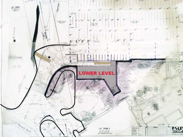
71 Telluride Medical Center Subarea Task Force 2 April MAHLUM ARCHITECTS INC


72 Agenda Subarea Site Analysis Connection Points Site Strategies Massing & Scale
73 Subarea Site Analysis
74
75
76
77
78
79
80

81
82
83
84
85
86
87
88
89
90
91
92
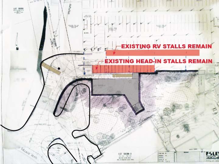
93 Connections

94 Parking Connection

95 Gondola Access

96 Vehicular Access
97 Site Strategies

98


99
100
101

102
103
104
105
106

107
108
109
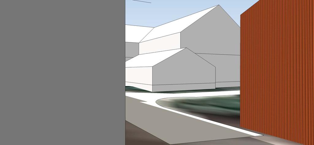
110
111
112
113 Massing and Scale

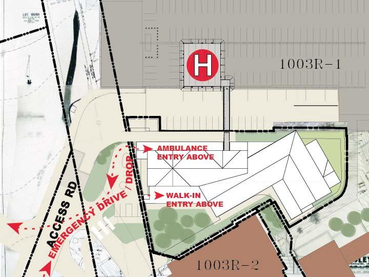
114 Primary Services Emergency Primary Care Diagnostic Imaging

115 Program Stacking

116 Program Blocking

117 Plan Perspective

118 Flight Paths

119 Southeast Aerial

120 Southwest Aerial

121 Emergency Entry Approach

122 Emergency Department Entry
123 Gondola Approach
124 Marketplace Entry

125 Garage Connection

126 Gondola Approach
127 Southeast Aerial Garage Expansion
128 Southwest Aerial Garage Expansion
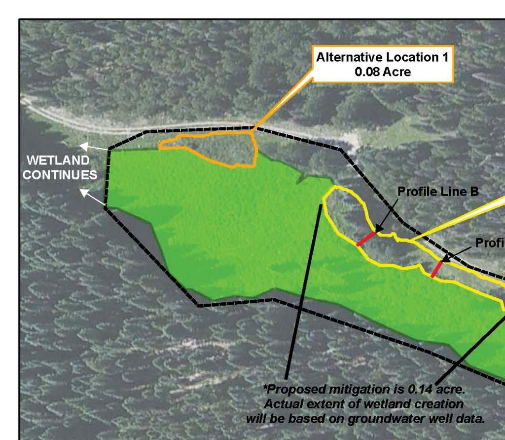
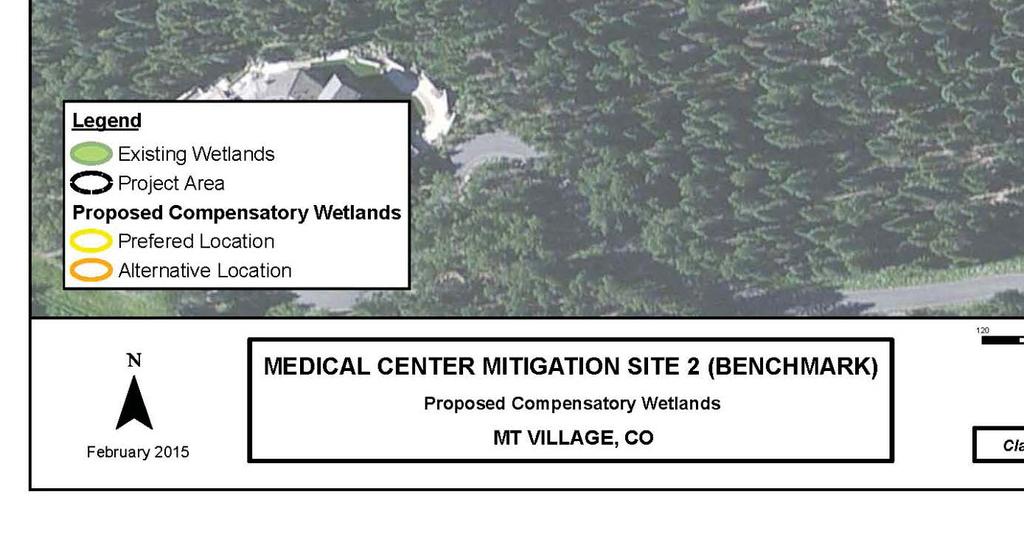
129 Emergency Entry Approach Garage Expansion
130 Questions

131 Appendix
132 Parking
133 GPG Parking Capacity: Capacity with Med Center Adds (Short Term ED Parking) 460 Spaces 466 Spaces
134 GPG Parking Highest Capacity Day ( )*: (31 December 2014) 272 Cars 188 Empty Lofts Parking (Assumes 43 Units) 65 Spaces *Excludes Bluegrass Festival

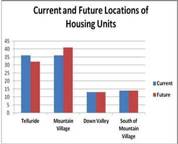
135 GPG Parking Total Capacity: Highest Use Day Lofts Use 460 Spaces 272 Spaces 65 Spaces Available Spaces for Medical Center 123 Spaces *TMC Parking Need to be verified by an approved parking study
136 Wetlands

137 Proposed Area of Wetland Fill 0.44 acre
138 Mitigation Site No 1


139 Wetland Fill Area: 0.44 acre Mitigation Areas: 0.73 Acre Approx: 1.6:1 ratio

140 Mitigation Site No 2


141
142 TMC Patient Data
143

144
145

146

147
REPRESENTATIVE: Centerline Solutions Table Mountain Parkway Golden, CO 80403
 COMMISSIONERS: DARRYL GLENN (PRESIDENT) MARK WALLER (PRESIDENT PRO TEMPORE) STAN VANDERWERF LONGINOS GONZALEZ PEGGY LITTLETON PLANNING AND COMMUNITY DEVELOPMENT DEPARTMENT CRAIG DOSSEY, EXECUTIVE DIRECTOR
SUMMARY OF MOTIONS TOWN OF MOUNTAIN VILLAGE DESIGN REVIEW BOARD MEETING THURSDAY, MARCH
 SUMMARY OF MOTIONS TOWN OF MOUNTAIN VILLAGE DESIGN REVIEW BOARD MEETING THURSDAY, MARCH 1 2018 Call to Order Chairman Banks Brown called the meeting of the Design Review Board of the Town of Mountain Village
New Cingular Wireless Telecommunication Tower at County Road 48, Milner Conditional Use Permit
 New Cingular Wireless Telecommunication Tower at 39415 County Road 48, Milner ACTIVITY #: Conditional Use Permit PP2012-023 HEARING DATES: Planning Commission (PC): August 16, 2012 at 6:00pm PETITIONER:
CHAPTER 10 Planned Unit Development Zoning Districts
 CHAPTER 10 Planned Unit Development Zoning Districts Section 10.1 Intent and Purpose The Planned Unit Development (PUD) districts are intended to offer design flexibility for projects that further the
ARTICLE 15 - PLANNED UNIT DEVELOPMENT
 Section 15.1 - Intent. ARTICLE 15 - PLANNED UNIT DEVELOPMENT A PUD, or Planned Unit Development, is not a District per se, but rather a set of standards that may be applied to a development type. The Planned
DEVELOPMENT DEPARTMENT STAFF REPORT THE PARK AT 5 TH
 DEVELOPMENT DEPARTMENT STAFF REPORT ARB Meeting Date: July 3, 2018 Item #: _PZ2018-293_ THE PARK AT 5 TH Request: Site Address: Project Name: Parcel Number: Applicant: Proposed Development: Current Zoning:
Pagosa Lakes Telecommunication Facility Development Plan Rezoning in the PUD zone, located at 1311 Lake Forest Cir.
 Archuleta County Development Services Planning Department 1122 HWY 84 P. O. Box 1507 Pagosa Springs, Colorado 81147 970-264-1390 Fax 970-264-3338 MEMORANDUM TO: Archuleta County Planning Commission FROM:
BOARD OF ADJUSTMENT AGENDA
 PLANNING DEPARTMENT 970.668.4200 0037 Peak One Dr. PO Box 5660 www.summitcountyco.gov Frisco, CO 80443 BOARD OF ADJUSTMENT AGENDA January 17, 2018-5:30p.m. Buffalo Mountain Room County Commons 0037 Peak
ADMINISTRATIVE HEARING STAFF REPORT
 ADMINISTRATIVE HEARING STAFF REPORT Providence Place Apartments Utility Box No. 2 Conditional Use Petition PLNPCM2011-00426 309 East 100 South September 22, 2011 Planning and Zoning Division Department
ARTICLE 14 PLANNED UNIT DEVELOPMENT (PUD) DISTRICT
 DISTRICT") ARTICLE 14 PLANNED UNIT DEVELOPMENT (PUD) DISTRICT Section 14.01 Intent. It is the intent of this Article to allow the use of the planned unit development (PUD) process, as authorized by the Michigan Zoning
ARTICLE 14 PLANNED UNIT DEVELOPMENT (PUD) DISTRICT Section 14.01 Intent. It is the intent of this Article to allow the use of the planned unit development (PUD) process, as authorized by the Michigan Zoning
Salem Township Zoning Ordinance Page 50-1 ARTICLE 50.0: PUD PLANNED UNIT DEVELOPMENT
 Salem Township Zoning Ordinance Page 50-1 ARTICLE 50.0 PLANNED UNIT DEVELOPMENT Section 50.01 Purpose The provisions of this Article provide enabling authority and standards for the submission, review,
This is a conditional use permit request to establish a commercial wind energy conversion system.
 Public Works 600 Scott Boulevard South Hutchinson, Kansas 67505 620-694-2976 Road & Bridge Planning & Zoning Noxious Weed Utilities Date: March 28, 2019 To: From: Reno County Planning Commission Russ Ewy,
CHAPTER 3 PRELIMINARY PLAT
 10-3-1 10-3-3 SECTION: CHAPTER 3 PRELIMINARY PLAT 10-3-1: Consultation 10-3-2: Filing 10-3-3: Requirements 10-3-4: Approval 10-3-5: Time Limitation 10-3-6: Grading Limitation 10-3-1: CONSULTATION: Each
Packet Contents: Page #
 CLEAR CREEK COUNTY PLANNING DEPARTMENT REQUIREMENTS FOR COMMERCIAL AND MULTI-FAMILY DEVELOPMENTS Prior to submitting a building permit application, the Planning staff will review the site plan and construction
UPPER MOUNT BETHEL TOWNSHIP NORTHAMPTON COUNTY, PENNSYLVANIA
 UPPER MOUNT BETHEL TOWNSHIP NORTHAMPTON COUNTY, PENNSYLVANIA JOINDER DEED / LOT CONSOLIDATION TOWNSHIP REVIEW PROCESS When accepting proposed Joinder Deeds / Lot Consolidations, review the Joinder Deed
KETCHUM PLANNING AND ZONING
 IN RE: ) Barrow Variance and ) Fence Design Review ) KETCHUM PLANNING AND ZONING ) COMMISSION - FINDINGS OF FACT, ) CONCLUSIONS OF LAW AND DECISION Permit Number: 13-122 ) BACKGROUND FACTS OWNER: Strada
Staff Report PLANNED DEVELOPMENT. Salt Lake City Planning Commission. From: Lauren Parisi, Associate Planner; Date: December 14, 2016
 Staff Report PLANNING DIVISION COMMUNITY & NEIGHBORHOODS To: Salt Lake City Planning Commission From: Lauren Parisi, Associate Planner; 801-535-7932 Date: December 14, 2016 Re: 1611 South 1600 East PLANNED
MINNETONKA PLANNING COMMISSION June 2, A conditional use permit for 2,328 square feet of accessory structures at 4915 Highland Road
 MINNETONKA PLANNING COMMISSION June 2, 2016 Brief Description A conditional use permit for 2,328 square feet of accessory structures at Recommendation Recommend the city council adopt the resolution approving
DEVELOPMENT DEPARTMENT STAFF REPORT DRESDEN HEIGHTS PHASE II DCI
 DEVELOPMENT DEPARTMENT Meeting Date: January 10, 2019 Item #: PZ2019-393 Project Name: Applicant and Owner: Proposed Development: Requests: STAFF REPORT DRESDEN HEIGHTS PHASE II DCI Dresden Heights Phase
DRAFT Smithfield Planning Board Minutes Thursday, May 7, :00 P.M., Town Hall, Council Room
 DRAFT Smithfield Planning Board Minutes Thursday, May 7, 2015 6:00 P.M., Town Hall, Council Room Members Present: Chairman Eddie Foy Vice-Chairman Stephen Upton Daniel Sanders Gerald Joyner Mark Lane Jack
CITY PLANNING COMMISSION COMPREHENSIVE PLAN AND REVIEW CRITERIA
 Page 3 CITY PLANNING COMMISSION COMPREHENSIVE PLAN AND REVIEW CRITERIA COMPREHENSIVE PLAN: The City Planning Commission uses the Comprehensive Plan as a guide in all land use matters. The Plan is available
ARTICLE II: CELLULAR ANTENNA TOWERS
 Kenton County Planning Commission 8 ARTICLE II: CELLULAR ANTENNA TOWERS SECTION 2.0 PRE-APPLICATION CONFERENCE: Applicants must contact Staff and request a pre-application conference. This meeting will
RE: 6. GILL/GREEN COMPREHENSIVE PLAN AMENDMENT, REZONING AND PRELIMINARY PLAT
 commission memo DATE: Thursday - August 9, 2018 TO: Marion Planning & Zoning Commission FROM: David N. Hockett, AICP Principal Planner RE: 6. GILL/GREEN COMPREHENSIVE PLAN AMENDMENT, REZONING AND PRELIMINARY
Planned Unit Development (PUD). Sections:
. Sections:") Chapter 19.07. Planned Unit Development (PUD). Sections: 19.07.01. Purpose. 19.07.02. PUD Definition and Design Compatibility. 19.07.03. General PUD Standards. 19.07.04. Underlying Zones. 19.07.05. Permitted
Chapter 19.07. Planned Unit Development (PUD). Sections: 19.07.01. Purpose. 19.07.02. PUD Definition and Design Compatibility. 19.07.03. General PUD Standards. 19.07.04. Underlying Zones. 19.07.05. Permitted
RESOLUTION PC NOW THEREFORE, the Planning Commission of the City of Duarte resolves as follows:
 RESOLUTION PC 18-09 A RESOLUTION OF THE PLANNING COMMISSION OF THE CITY OF DUARTE APPROVING CONDITIONAL USE PERMIT 14-02, FOR THE USE AND OPERATION OF A WIRELESS COMMUNICATION FACILITY FOR VERIZON WIRELESS,
PALM BEACH COUNTY PLANNING, ZONING AND BUILDING DEPARTMENT ZONING DIVISION
 PALM BEACH COUNTY PLANNING, ZONING AND BUILDING DEPARTMENT ZONING DIVISION Application No.: Z/CA-2013-00493 Application Name: Trails Charter School Control No.: 2013-00085 Applicant: MG3 ALF Military LLC
O-I (Office-Institutional) and AG-1(Agricultural)
 and AG-1(Agricultural)") PROPERTY INFORMATION ADDRESS 3503 and 3505 Bethany Bend DISTRICT, LAND LOTS 2/1 973 and 974 OVERLAY DISTRICT State Route 9 PETITION NUMBERS EXISTING ZONING O-I (Office-Institutional) and AG-1(Agricultural)
PROPERTY INFORMATION ADDRESS 3503 and 3505 Bethany Bend DISTRICT, LAND LOTS 2/1 973 and 974 OVERLAY DISTRICT State Route 9 PETITION NUMBERS EXISTING ZONING O-I (Office-Institutional) and AG-1(Agricultural)
MIDWAY CITY Municipal Code
 MIDWAY CITY Municipal Code TITLE 9 ANNEXATION CHAPTER 9.01 PURPOSE CHAPTER 9.02 GENERAL REQUIREMENTS CHAPTER 9.03 PROPERTY OWNER INITIATION OF ANNEXATION CHAPTER 9.04 PROCEDURES FOR CONSIDERATION OF PETITION
9 November 12, 2014 Public Hearing
 9 November 12, 2014 Public Hearing APPLICANT AND PROPERTY OWNER: GARRETT A. & BERNADETTE P. ALCARAZ STAFF PLANNER: Kristine Gay REQUEST: Subdivision Variance to Section 4.4(b) of the Subdivision Ordinance,
Instructions to the Applicant
 CONDITIONAL USE PERMIT APPLICATION Lake of the Woods County Land and Water Planning Office 206 8 th Avenue Southeast, Suite #290 Baudette MN 56623-2867 www.co.lake-of-the-woods.mn.us Phone: (218) 634-1945
FINAL SPUD APPLICATION
 The Planning & Development Services Department is here to assist you with your development application pursuant to the Community Development Code (CDC). This publication outlines the Final SPUD Development
ARTICLE XI CONDITIONAL USE PERMITS
 ARTICLE XI CONDITIONAL USE PERMITS 11.1 Purpose. The City of Hailey recognizes that certain uses possess unique and special characteristics with respect to their location, design, size, method of operation,
PLANNING AND ZONING COMMISSION AGENDA MEMORANDUM
 City and County of Broomfield, Colorado PLANNING AND ZONING COMMISSION AGENDA MEMORANDUM To: Planning and Zoning Commission From: John Hilgers, Planning Director Anna Bertanzetti, Principal Planner Meeting
M-43 CORRIDOR OVERLAY ZONE
 ARTICLE 26.00 M-43 CORRIDOR OVERLAY ZONE Section 26.01 Findings A primary function of the M-43 state highway is to move traffic through the Township and to points beyond. As the primary east-west arterial
PALM BEACH COUNTY PLANNING, ZONING AND BUILDING DEPARTMENT ZONING DIVISION
 PALM BEACH COUNTY PLANNING, ZONING AND BUILDING DEPARTMENT ZONING DIVISION ADMINISTRATIVE VARIANCE TYPE I B - STAFF PUBLIC MEETING STAFF REPORT (Revised 11/13/2012) 11/15/2012 AGENDA ITEM CODE SECTION
Nelson Garage Setback Variance
 Nelson Garage Setback Variance ACTIVITY #: BOARD OF ADJUSTMENT HEARING DATE: PL-15-1053 January 11, 2016 at 6:00 pm PETITIONER: PETITION: LOCATION/LEGAL: ZONE DISTRICT: AREA OF PARCEL: Randy and Kellie
Conditional Use Permit / Standard Subdivision Application
 Conditional Use Permit / Standard Subdivision Application Name of Proposed Subdivision: Total Area (Acres) Is Proposed Subdivision to be built in phases? Number of Lots If yes, how many phases? Applicant/Owner
TOWN OF ORO VALLEY PLANNING & ZONING COMMISSION MEETING DATE: December 6, 2011
 PLANNING & ZONING COMMISSION MEETING DATE: December 6, 2011 TO: FROM: SUBJECT: PLANNING & ZONING COMMISSION Matt Michels, Senior Planner mmichels@orovalleyaz.gov; tel. 229-4822 Public Hearing: Rancho de
Draft Zoning Changes for the 2nd Planning Board Public Hearing, January 22, 2018.
 Draft Zoning Changes for the 2nd Planning Board Public Hearing, January 22, 2018. No changes were made at the 1st Public Hearing. Proposed wording for the 1 st Public Hearing in red, eliminated text in
DEVELOPMENT DEPARTMENT STAFF REPORT STAFF REPORT EASTSIDE CHAMBLEE LINK DCI
 DEVELOPMENT DEPARTMENT STAFF REPORT Public Hearing Date: April 12, 2018 Item #: PZ-2018-248 STAFF REPORT EASTSIDE CHAMBLEE LINK DCI Request: Development of Community Compact (DCI), ten concurrent variances,
The Cannery Marketplace Narrative. Purpose: Site Design Approach: Cannery Commerce District 10/18/2017
 The Cannery Marketplace Narrative Cannery Commerce District 10/18/2017 Purpose: A number of entitlements are being requested for the Cannery Marketplace inclusive of a Master Conditional Use Permit (Master
DOUGLAS COUNTY ZONING RESOLUTION Section 4 LRR - Large Rural Residential District 3/10/99. -Section Contents-
 SECTION 4 LRR LARGE RURAL RESIDENTIAL DISTRICT -Section Contents- 401 Intent... 4-2 402 Principal Uses... 4-2 403 Accessory Uses... 4-3 404 Uses Permitted by Special Review... 4-4 405 Land Dedication...
DEVELOPMENT DEPARTMENT STAFF REPORT STAFF REPORT DRESDEN DRIVE TOWNHOMES DCI
 DEVELOPMENT DEPARTMENT STAFF REPORT Meeting Date: September 13, 2018 Item #: PZ2018-319 STAFF REPORT DRESDEN DRIVE TOWNHOMES DCI Request: Project Name: Development of Community Compact (DCI) and six concurrent
ITEM NO(S): B.1 B.3 STAFF: SHARON ROBINSON FILE NO(S): CPC CU QUASI-JUDICIAL CPC UV QUASI_JUDICIAL CPC NV QUASI-JUDICIAL
: B.1 B.3 STAFF: SHARON ROBINSON FILE NO(S): CPC CU QUASI-JUDICIAL CPC UV QUASI_JUDICIAL CPC NV QUASI-JUDICIAL") Page 16 CITY PLANNING COMMISSION ITEM NO(S): B.1 B.3 STAFF: SHARON ROBINSON FILE NO(S): CPC CU 09-00042 QUASI-JUDICIAL CPC UV 09-00130 QUASI_JUDICIAL CPC NV 09-00128 QUASI-JUDICIAL PROJECT: APPLICANT:
Page 16 CITY PLANNING COMMISSION ITEM NO(S): B.1 B.3 STAFF: SHARON ROBINSON FILE NO(S): CPC CU 09-00042 QUASI-JUDICIAL CPC UV 09-00130 QUASI_JUDICIAL CPC NV 09-00128 QUASI-JUDICIAL PROJECT: APPLICANT:
Letter of Intent May 2017 (Revised November 2017)
") THE BEACH AT WOODMOOR LETTER OF INTENT MAY 2017 (REVISED NOVEMBER 2017) OWNER/APPLICANT: CONSULTANT: Lake Woodmoor Holdings LLC N.E.S. Inc. 1755 Telstar Drive, Suite 211 619 North Cascade Avenue Colorado
THE BEACH AT WOODMOOR LETTER OF INTENT MAY 2017 (REVISED NOVEMBER 2017) OWNER/APPLICANT: CONSULTANT: Lake Woodmoor Holdings LLC N.E.S. Inc. 1755 Telstar Drive, Suite 211 619 North Cascade Avenue Colorado
Applicant s Agent Lisa Murphy, Esq. Staff Planner PJ Scully. Lot Recordation 12/01/1972 Map Book 94, Page 33 GPIN
 Property Owner and Applicant Address 3925 Shore Drive Public Hearing September 24, 2018 City Council District Bayside Agenda Item 6 Variance Request Encroachment into the Resource Protection Area (RPA)
BY BOARD OF COUNTY COMMISSIONERS AN ACT TO BE ENTITLED
 BY BOARD OF COUNTY COMMISSIONERS ORDINANCE NO. AN ACT TO BE ENTITLED AN ORDINANCE AMENDING THE PASCO COUNTY LAND DEVELOPMENT CODE, ARTICLE 700, BY REPEALING EXISTING SECTION 702, ENVIRONMENTALLY SENSITIVE
TRUSTT GILES REQUEST: APPLICANT: C AND C DEVELOPMENT. Page (b) of the all the AICUZ: SITE SIZE: 28,261 TOTAL 17,417 UPLAND GPIN:
 of the all the AICUZ: SITE SIZE: 28,261 TOTAL 17,417 UPLAND GPIN:") STAFF PLANNER: Carolyn A.K. Smith REQUEST: Subdivision Variance to Section 4.4(b) of the Subdivision Ordinance that requires all newly created lots meet all the requirements of the City Zoning Ordinance
STAFF PLANNER: Carolyn A.K. Smith REQUEST: Subdivision Variance to Section 4.4(b) of the Subdivision Ordinance that requires all newly created lots meet all the requirements of the City Zoning Ordinance
MAJOR SUBDIVISION APPLICATION
 Revised 2.26.18 The Department is here to assist you with your development application pursuant to the Community Development Code (CDC). This publication outlines the Major Subdivision Development Application
AN ORDINANCE TO AMEND SECTION OF THE RAPID CITY MUNICIPAL CODE TO ALLOW FOR ADMINISTRATIVE DISSOLUTION OF PLANNED DEVELOPMENTS
 Ordinance No. 6231 AN ORDINANCE TO AMEND SECTION 17.50.050 OF THE RAPID CITY MUNICIPAL CODE TO ALLOW FOR ADMINISTRATIVE DISSOLUTION OF PLANNED DEVELOPMENTS WHEREAS, the City of Rapid City has adopted a
Staff Report: Date: Applicant: Property Identification: Acreage of Request: Current Zoning of Requested Area: Requested Action: Attached:
 Staff Report: Completed by Jeff Palmer Director of Planning & Zoning Date: November 7, 2018, Updated November 20, 2018 Applicant: Greg Smith, Oberer Land Developer agent for Ronald Montgomery ET AL Property
PALM BEACH COUNTY PLANNING, ZONING AND BUILDING DEPARTMENT ZONING DIVISION ZONING COMMISSION VARIANCE STAFF REPORT 07/05/2012
 PALM BEACH COUNTY PLANNING, ZONING AND BUILDING DEPARTMENT ZONING DIVISION ZONING COMMISSION VARIANCE STAFF REPORT 07/05/2012 APPLICATION NO. CODE SECTION REQUIRED PROPOSED VARIANCE ZV-2012-00690 3.D.1.A
CHAPTER 21.12: NONCONFORMITIES
 CHAPTER 21.12: NONCONFORMITIES 21.12.010 GENERAL PROVISIONS... 12-2 A. Purpose... 12-2 B. Authority to Continue... 12-2 C. Determination of Nonconformity Status... 12-3 D. Government Agency Property Acquisitions...
DEVELOPMENT DEPARTMENT STAFF REPORT
 DEVELOPMENT DEPARTMENT STAFF REPORT Meeting Date: January 11, 2018 Item #: PZ2017-151 STAFF REPORT VARIANCES RESTAURANT WITH DRIVE-THROUGH Request: Multiple Variances for a new restaurant with drive-through
PALM BEACH COUNTY PLANNING, ZONING AND BUILDING DEPARTMENT ZONING DIVISION
 PALM BEACH COUNTY PLANNING, ZONING AND BUILDING DEPARTMENT ZONING DIVISION Application No.: CA-2012-00688 Control No.: 2011-00552 Applicant: Garry Bernardo Owners: Garry Bernardo Agent: Frogner Consulting,
Article 6 Development Permits. Division 5: Site Development Permit Procedures (Added by O N.S.; effective
 Article 6 Development Permits Division 5: Site Development Permit Procedures (Added 12-9-1997 by O-18451 N.S.; effective 1-1-2000.) 126.0501 Purpose of the Site Development Permit Procedures The purpose
ORDINANCE NO
 ORDINANCE NO. 2015-07 AN ORDINANCE OF THE TOWN COUNCIL OF THE TOWN OF MOUNTAIN VILLAGE, COLORADO APPROVING MAJOR PUD AMENDMENT TO ETEND THE LENGTH OF V ALIDITY AND VESTED PROPERTY RIGHTS FOR A SITE SPECIFIC
Spence Carport Variance
 Spence Carport Variance ACTIVITY #: BOARD OF ADJUSTMENTS HEARING DATE: PL-15-1042 12/14/2015 at 6:00 pm PETITIONER: PETITION: LOCATION: ZONE DISTRICT: AREA OF PARCEL: REQUIRED SETBACKS: STAFF CONTACT:
Town of Lisbon, Maine SUBDIVISION REVIEW APPLICATION
 Date Received: Fee Paid (amount): Applicant: Town of Lisbon, Maine SUBDIVISION REVIEW APPLICATION Subdivision Name/Title: This application must be received at the Town Office by close of business on the
ARTICLE 7: PLOT PLANS AND SITE PLAN REQUIREMENTS AND REVIEW
 ARTICLE 7: PLOT PLANS AND SITE PLAN REQUIREMENTS AND REVIEW Section 7.0 - Purpose The purpose of this article is to specify the documents and/or drawings required for a Site Plan Review or a Plot Plan
PALM BEACH COUNTY PLANNING, ZONING AND BUILDING DEPARTMENT ZONING DIVISION ZONING COMMISSION VARIANCE STAFF REPORT 06/07/2012
 PALM BEACH COUNTY PLANNING, ZONING AND BUILDING DEPARTMENT ZONING DIVISION ZONING COMMISSION VARIANCE STAFF REPORT 06/07/2012 APPLICATION NO. CODE SECTION REQUIRED PROPOSED VARIANCE ZV-2009-03300 Variance
BOARD OF ADJUSTMENT AGENDA
 PLANNING DEPARTMENT 970.668.4200 0037 Peak One Dr. PO Box 5660 www.summitcountyco.gov Frisco, CO 80443 BOARD OF ADJUSTMENT AGENDA January 18, 2017-5:30p.m. Buffalo Mountain Room County Commons 0037 Peak
CONDOMINIUM REGULATIONS
 ARTICLE 37 CONDOMINIUM REGULATIONS SECTION 37.01. Purpose The purpose of this Article is to regulate projects that divide real property under a contractual arrangement known as a condominium. New and conversion
Appendix1,Page1. Urban Design Guidelines. Back to Back and Stacked Townhouses. DRAFT September 2017
 Appendix1,Page1 Urban Design Guidelines DRAFT September 2017 Back to Back and Stacked Townhouses Appendix1,Page2 Table of Contents 1 Introduction 1 1.1 Purpose 1 1.2 Urban Design Objectives 1 1.3 Building
Planning and Building Department
 Page 1 of Report PB-83-13 TO: Development and Infrastructure Committee Planning and Building Department SUBJECT: OP & Rezoning 5001 Corporate Drive Appleby Gardens LJM Developers Report Number: PB-83-13
3.1. OBJECTIVES FOR RESIDENTIAL LAND USE DESIGNATIONS GENERAL OBJECTIVES FOR ALL RESIDENTIAL DESIGNATIONS
 3. RESIDENTIAL LAND USE DESIGNATIONS INTRODUCTION The Residential land use designations provide for housing and other land uses that are integral to, and supportive of, a residential environment. Housing
LETTER OF APPLICATION
 Description of Proposed Land Division: LETTER OF APPLICATION The proposed land division would split a 1.94 acres rectangular lot into two lots. The general configuration would have one lot in front of
PLANNED UNIT DEVELOPMENT (East), PLANNED UNIT DEVELOPMENT (West) STAFF REPORT Date: September 18, 2014
, PLANNED UNIT DEVELOPMENT (West) STAFF REPORT Date: September 18, 2014") PLANNED UNIT DEVELOPMENT (East), PLANNED UNIT DEVELOPMENT (West) STAFF REPORT Date: September 18, 2014 DEVELOPMENT NAME LOCATION McGowin Park, LLC PLANNED UNIT DEVELOPMENT (East) 1401 Satchel Paige Drive
PLANNED UNIT DEVELOPMENT (East), PLANNED UNIT DEVELOPMENT (West) STAFF REPORT Date: September 18, 2014 DEVELOPMENT NAME LOCATION McGowin Park, LLC PLANNED UNIT DEVELOPMENT (East) 1401 Satchel Paige Drive
Special Use Permit - Planned Unit Development Checklist. Property Address:
 Special Use Permit - Planned Unit Development Checklist Special Use Permit Number. Parcel Code/s #28-11- - - Property Address: Applicant: ARTICLE VIII Ordinance Reference - Section 8.1.2 Permit Procedures:
PLANNING AND ZONING DEPARTMENT
 Town of Minturn Development Review Process: Guide To Planned Unit Developments (Concept Plan) This guide describes the Planned Unit Development Process. This guide should be utilized in conjunction with
RIVER FOREST DEVELOPMENT REVIEW BOARD MEETING AGENDA
 REVISED 6/25/18 RIVER FOREST DEVELOPMENT REVIEW BOARD MEETING AGENDA A meeting of the River Forest Development Review Board will be held on Thursday, June 28, 2018 at 7:30 P.M. in the Oak Park River Forest
Town of Yampa Water Treatment Facility Setback Variance
 Town of Yampa Water Treatment Facility Setback Variance ACTIVITY #: BOARD OF ADJUSTMENTS HEARING DATE: PV2015-001 July 13, 2015 at 6:00 pm PETITIONER: PETITION: LOCATION: ZONE DISTRICT: AREA OF PARCEL:
City of Fayetteville, Arkansas Page 1 of 3
 City of Fayetteville, Arkansas 113 West Mountain Street Fayetteville, AR 72701 (479) 575-8323 Legislation Text File #: 2018-0144, Version: 1 ADM 18-6094 (AMEND UDC 164.19/ACCESSORY DWELLING UNITS): AN
SUBJECT: Application for Planned Unit Development and Rezoning 1725 Winnetka Road
 TO: FROM: CHAIRMAN BILL VASELOPULOS AND MEMBERS OF THE PLAN & ZONING COMMISSION STEVE GUTIERREZ DIRECTOR OF COMMUNITY DEVELOPMENT MEETING DATE: September 5, 2017 SUBJECT: Application for Planned Unit Development
EXCERPTS FROM HALIFAX REGIONAL MUNICIPALITY CHARTER
 EXCERPTS FROM HALIFAX REGIONAL MUNICIPALITY CHARTER Municipal planning strategy 227 The Council may adopt a municipal planning strategy for all, or part, of the Municipality and there may be separate strategies
COMMUNITY DEVELOPMENT CODE. Title 17 of Town of Mountain Village Municipal Code
 Title 17 COMMUNITY DEVELOPMENT CODE Title 17 of Town of Mountain Village Municipal Code Town of Mountain Village, Colorado Community Development Department As Amended June 20, 2017 1 Contents Title 17
LETTER OF APPLICATION
 Description of Proposed Land Division: LETTER OF APPLICATION The proposed land division would split a 1.94 acres rectangular lot into two lots. The general configuration would have one lot in front of
SECTION 5: ACCESSORY USES
 SECTION 5: ACCESSORY USES A. In Any District Subject to the restrictions of the Zoning Resolution, a use, equipment or item customarily incidental to an existing permitted use on a lot shall also be permitted
May 23, 2017 Staff Report to the Board of Zoning Ad justment. C AS E # VAR I t e m #1. Location Map. Subject
 May 23, 2017 Staff Report to the Board of Zoning Ad justment C AS E # VAR 2 0 1 7-00031 I t e m #1 U N I T E D R E N TA L S O R L A N D O Location Map S U M M A R Y Owner Herbert R. Matthews, Jr. Applicant
Telecommunications Development Permit Application Package
 Telecommunications Development Permit Application Package POLICY POL#308 Title: Policy Guidelines to Evaluate Commercial Communications Facilities Legal References: Radio Communication Act Municipal Government
Town of Southern Pines Planning Board Meeting, Thursday, July 24 19, 2014, 7:00 PM, Douglass Community Center, 1185 West Pennsylvania Avenue
 Town of Southern Pines Planning Board Meeting, Thursday, July 24 19, 2014, 7:00 PM, Douglass Community Center, 1185 West Pennsylvania Avenue I Call to Order II Approval of the Minutes June 19, 2014 III
Board of Adjustment Variance Process Guide
 Board of Adjustment Variance Process Guide Clear Creek County Planning Department PO Box 2000 Georgetown, CO 80444 Phone: 303.679.2436 Fax: 303.569.1103 Board of Adjustment Variance Process Guide Overview
Residential Project Convenience Facilities
 Standards for Specific Land Uses 35.42.220 E. Findings. The review authority shall approve a Land Use Permit in compliance with Subsection 35.82.110.E (Findings required for approval) or a Conditional
19.12 CLUSTER RESIDENTIAL DISTRICT
 Chapter 19.12 CLUSTER RESIDENTIAL DISTRICT (Adopted 12/22/2003; Ordinance #0061970). Amended 7/3/17, Ordinance #079100. Section 19.12.010 - Declaration of Intent. The Cluster Residential District provides
PLANNING COMMISSION STAFF REPORT. Merrimac PLNSUB Planned Development 38 West Merrimac November 9, Request. Staff Recommendation
 PLANNING COMMISSION STAFF REPORT Merrimac PLNSUB2011-00374 Planned Development 38 West Merrimac November 9, 2011 Planning and Zoning Division Department of Community and Economic Development Applicant:
ARCHITECTURAL REGULATIONS WOODSIDE PARK Units 2, 3 and 4 I. PREAMBLE Woodside is a community where dwellings of various styles and designs come
 ARCHITECTURAL REGULATIONS WOODSIDE PARK Units 2, 3 and 4 I. PREAMBLE Woodside is a community where dwellings of various styles and designs come together in harmony complementing the surrounding landscape.
(b) The location of principal and accessory buildings on the lot and the relationship of each structure to the other.
 The location of principal and accessory buildings on the lot and the relationship of each structure to the other.") ARTICLE XIX SITE PLAN Sec. 20-1900 Site Plan Review Procedure - Intent The site plan review procedures are instituted to provide an opportunity for the Township Planning Commission to review the proposed
ARTICLE XIX SITE PLAN Sec. 20-1900 Site Plan Review Procedure - Intent The site plan review procedures are instituted to provide an opportunity for the Township Planning Commission to review the proposed
2. The AT&T WCF shall consist of a stealth design (faux saguaro cactus) with a maximum height of 30 feet above adjacent grade;
 with a maximum height of 30 feet above adjacent grade;") AGENDA ITEM # DATE: October 24, 2011 COAC NUMBER: 11-4698 CITY OF GOODYEAR CITY COUNCIL ACTION FORM SUBJECT: Special Use to allow the installation of a proposed AT&T Wireless Communication Facility to
AGENDA ITEM # DATE: October 24, 2011 COAC NUMBER: 11-4698 CITY OF GOODYEAR CITY COUNCIL ACTION FORM SUBJECT: Special Use to allow the installation of a proposed AT&T Wireless Communication Facility to
Finnerty, Shawn & Lori Water Front Setback
 BONNER COUNTY PLANNING DEPARTMENT BOARD OF COUNTY COMMISSIONERS STAFF REPORT FOR JANUARY 10, 2018 Project Name: Finnerty, Shawn & Lori Water Front Setback File Number, Type: FILE #V492-17, Variance Request
MONTEREY COUNTY PLANNING COMMISSION
 MONTEREY COUNTY PLANNING COMMISSION Meeting: June 11, 2003 @ 9:30 AM Agenda Item: D2 Project Description: Use Permit (Associated Tagline/Sprint #PLN000669) for the construction of a 50 Ft. monopole with
TOWNSHIP OF MENDHAM Ord. No
 ORDINANCE SUPPLEMENTING THE LAND USE ORDINANCE OF THE TOWNSHIP OF MENDHAM BY A NEW CHAPTER XXIVA ESTABLISHING THE REQUIREMENT OF AN ENVIRONMENTAL PERMIT AND AMENDING AND SUPPLEMENTING SAID ORDINANCE WITH
AAAA. Planning and Zoning Staff Report Lake Shore Land Holdings, LLC CU-PH Analysis
 AAAA Planning and Zoning Staff Report Lake Shore Land Holdings, LLC CU-PH2016-28 Hearing Date: April 21, 2016 Development Services Department Applicant: BRS Architects/Cindy Huebert Staff: Kyle McCormick,
Town of Scarborough, Maine
 Town of Scarborough, Maine Miscellaneous Appeal INFORMATION REQUIRED FOR ALL APPEALS Before any appeal can be processed, the following material must be submitted to the Code Enforcement Office: 1. A fee
FOR OFFICE USE ONLY Date Submitted Received By Fees Paid $ Receipt No. Received By Application No. Application Complete Final Action Date
 COMMERCIAL, INDUSTRIAL, & MANUFACTURING SITE PLAN (CIM) APPLICATION Mariposa County Planning Department 5100 Bullion Street, P.O. Box 2039 Mariposa, CA 95338 Telephone (209) 966-5151 FAX (209) 742-5024
Public Facilities and Finance Element
 This Element of the General Plan addresses the following public facilities issues: Water Service, including both potable (drinkable) and non-potable water delivery. Sewer Service, and Financing and construction
Public Notice U.S. ARMY CORPS OF ENGINEERS, GALVESTON DISTRICT AND TEXAS COMMISSION ON ENVIRONMENTAL QUALITY
 Public Notice U.S. Army Corps Permit Application No: SWG-2016-00384 Of Engineers Date Issued: 27 December 2018 Galveston District Comments Due: 29 January 2019 U.S. ARMY CORPS OF ENGINEERS, GALVESTON DISTRICT
Certified Survey Map (CSM) Submittal Updated: 6/29/18
 Submittal Updated: 6/29/18") Certified Survey Map (CSM) Submittal Updated: 6/29/18 Town of Middleton 7555 W. Old Sauk Road Verona, WI 53593-9700 Phone: 608-833-5887 Fax: 608-833-8996 info@town.middleton.wi.us The Town of Middleton
Certified Survey Map (CSM) Submittal Updated: 6/29/18 Town of Middleton 7555 W. Old Sauk Road Verona, WI 53593-9700 Phone: 608-833-5887 Fax: 608-833-8996 info@town.middleton.wi.us The Town of Middleton
PLANNED DEVELOPMENT DISTRICT STANDARDS. Cadence Site
 PLANNED DEVELOPMENT DISTRICT STANDARDS Cadence Site A Planned Development District 1. Statement of General Facts, Conditions and Objectives Property Size: Approximately 57.51 Acres York County Tax Map
Staff Report: Date: Applicant: Property Identification: Acreage of Request: Current Zoning of Requested Area: Requested Action: Attached:
 Staff Report: Completed by Jeff Palmer Director of Planning & Zoning Date: November 7, 2018 Applicant: Greg Smith, Oberer Land Developer agent for Ronald Montgomery ET AL Property Identification: Frontage
Exhibit D. Tallow Ridge PUD. Written Description. Date: January 5, E. City Development Number:
 Exhibit D Tallow Ridge PUD Written Description Date: January 5, 2016 I. SUMMARY DESCRIPTION OF THE PROPERTY A. Current Land Use Designation: RR B. Current Zoning District: PUD C. Requested Zoning District: