ORDINANCE NO. 420 AN ORDINANCE AMENDING AND RE-ENACTING THE ZONING ORDINANCE OF 1977 OF THE CITY OF BEULAH, MERCER COUNTY, NORTH DAKOTA.
|
|
|
- Franklin Webb
- 5 years ago
- Views:
Transcription
1 ORDINANCE NO. 420 AN ORDINANCE AMENDING AND RE-ENACTING THE ZONING ORDINANCE OF 1977 OF THE CITY OF BEULAH, MERCER COUNTY, NORTH DAKOTA. BE IT ORDAINED BY THE CITY COUNCIL OF THE CITY OF BEULAH, MERCER COUNTY, NORTH DAKOTA, AS FOLLOWS: THAT ZONING ORDINANCE OF 1977 BE AMENDED AND RE-ENACTED TO READ AS FOLLOWS: I - 0

2 Adopted October 17, 2016 Zoning Ordinance
3
4 CHAPTER 1 HOW TO USE THIS DOCUMENT... 1 SECTION 1.1 ORGANIZATION OF ZONING ORDINANCE GENERAL INTENT GENERAL LAYOUT CHAPTER SUMMARIES... 2 SECTION 1.2 WHEN AM I REQUIRED TO GET A BUILDING PERMIT?...3 SECTION 1.3 HOW DO I OBTAIN A BUILDING PERMIT?...3 SECTION 1.4 DO I HAVE TO COMPLY WITH DEED RESTRICTIONS AND CITY ORDINANCES?...3 SECTION 1.5 HOW LONG DOES IT TAKE TO GET A BUILDING PERMIT?...3 SECTION 1.6 HOW DO I DETERMINE THE CURRENT ZONING OF MY SITE?...4 SECTION 1.7 WHAT USES ARE PERMITTED IN EACH ZONING DISTRICT?...4 SECTION 1.8 WHAT IS THE APPROVAL PROCESS FOR MY PROJECT?...4 SECTION 1.9 FORMAT OF ZONING ORDINANCE OUTLINE... 5 CHAPTER 2 ZONING DISTRICTS... 1 SECTION 2.0 RESIDENTIAL ZONING DISTRICTS R-1 SINGLE FAMILY, DETACHED R-2 LOW DENSITY MULTI-FAMILY R-3 HIGH DENSITY MULTI-FAMILY R-4 MANUFACTURED HOME R-5 (RESERVED FOR FUTURE USE) R-6 RURAL RESIDENTIAL R-7 URBAN MULTI-FAMILY SECTION 2.1 COMMERCIAL ZONING DISTRICTS C-1 CENTRAL BUSINESS C-2 HIGHWAY COMMERCIAL C-3 GENERAL COMMERCIAL C-4 NEIGHBORHOOD COMMERCIAL SECTION 2.2 INDUSTRIAL ZONING DISTRICTS I LIGHT INDUSTRIAL HI HEAVY INDUSTRIAL SECTION 2.3 OTHER ZONING DISTRICTS A AGRICULTURAL POC PUBLIC & OPEN SPACE CONSERVATION PUD PLANNED UNIT DEVELOPMENT SECTION 2.4 OVERLAY ZONING DISTRICTS FPO FLOOD PLAIN OVERLAY UGO UNDERGROUND MINING OVERLAY SECTION 2.5 USE TABLE... 51
5 CHAPTER 3 SPECIAL AND CONDITIONAL USE STANDARDS... 1 SECTION 3.0 ADULT ENTERTAINMENT CENTERS...1 SECTION 3.1 ACCESSORY STRUCTURES...2 SECTION 3.2 BED AND BREAKFAST ESTABLISHMENTS...2 SECTION 3.3 CAR ENTHUSIASTS AND COLLECTORS...3 SECTION 3.4 COMMERCIAL ABOVE-GROUND FUEL STORAGE...3 SECTION 3.5 CREW CAMPS...4 SECTION 3.6 DAYCARE FACILITIES...9 SECTION 3.7 GUEST HOUSE...9 SECTION 3.8 IN-HOME BUSINESSES...9 SECTION 3.9 MINERAL EXTRACTION AND SAND, GRAVEL, SCORIA, AND OTHER AGGREGATE MATERIAL MINING AND PROCESSING SECTION 3.10 RAILROAD SPUR (NOT RAILROAD OWNED) SECTION 3.11 RECREATIONAL VEHICLE (RV) PARKS SECTION 3.12 REFINERIES AND PETRO-CHEMICAL PLANTS SECTION 3.13 SALVAGE AND JUNK YARDS SECTION 3.14 SELF-SERVICE AND OUTDOOR STORAGE SECTION 3.15 TEMPORARY STRUCTURES & RESIDENCES SECTION 3.16 UTILITY CORRIDORS (SURFACE OR UNDERGROUND) SECTION 3.17 UTILITY-SCALE SOLAR FACILITIES CHAPTER 4 SITE DEVELOPMENT... 1 SECTION 4.0 ACCESS MANAGEMENT SITE ACCESS SIGHT VISIBILITY TRIANGLE... 3 SECTION 4.1 PARKING STANDARDS...5 SECTION 4.2 LIGHTING STANDARDS OUTDOOR LIGHTING SECTION 4.3 GENERAL LANDSCAPING STANDARDS GENERAL LANDSCAPING STANDARDS SECTION 4.4 SIGN STANDARDS INTENT GENERAL SIGN STANDARDS ZONING DISTRICT STANDARDS ELECTRONIC MESSAGING & DIGITAL SIGNS INCIDENTAL SIGNS & BULLETIN BOARDS OFF-PREMISE ADVERTISING SIGNS TEMPORARY SIGNS EXEMPT SIGNS PROHIBITED SIGNS SECTION 4.5 SETBACKS... 19
6 4.51 HOW TO MEASURE SETBACKS SETBACK AVERAGING SETBACK EXCEPTIONS SECTION 4.6 STRUCTURE HEIGHT HOW TO MEASURE STRUCTURE HEIGHT EXCEPTIONS SECTION 4.7 FENCES FENCE STANDARDS SECTION 4.8 PROPERTY PINS PROPERTY PINS REQUIRED REMOVAL AND REPLACEMENT SECTION 4.9 FOUNDATIONS MINIMUM FOUNDATIONS CHAPTER 5 PERMIT REVIEW AND APPLICATION... 1 SECTION 5.0 REVIEW AND DECISION-MAKING BODIES COUNCIL PLANNING AND ZONING COMMISSION... 2 SECTION 5.1 PROCESS...4 SECTION 5.11 BUILDING PERMIT REQUIRED...4 SECTION 5.12 BUILDING PERMIT...5 SECTION 5.13 CERTIFICATE OF OCCUPANCY*...7 SECTION 5.14 DEMOLITION PERMIT...8 SECTION 5.15 TEMPORARY PERMIT SECTION 5.16 CONDITIONAL USE PERMIT SECTION 5.17 VARIANCE SECTION 5.18 ZONING DISTRICT MAP AMENDMENT SECTION 5.19 ZONING ORDINANCE TEXT AMENDMENT SECTION 5.20 COMPREHENSIVE PLAN LAND USE MAP AMENDMENT SECTION 5.21 SUBDIVISION PLATS SECTION 5.22 ANNEXATION SECTION 5.23 APPEALS OF COUNCIL ACTIONS SECTION 5.24 ORGANIZATION CHART CHAPTER 6 LEGAL FRAMEWORK... 1 SECTION 6.0 AUTHORITY...1 SECTION 6.1 TITLE...1 SECTION 6.2 JURISDICTION...1 SECTION 6.3 PURPOSE...1 SECTION 6.4 CONSISTENCY WITH COMPREHENSIVE PLAN...1 SECTION 6.5 CONFLICTING PROVISIONS...1
7 SECTION 6.6 INTERPRETATION...2 SECTION 6.7 REPEAL AND RE-ENACTMENT...2 SECTION 6.8 SEVERABILITY...2 SECTION 6.9 BUILDING PERMITS...2 SECTION 6.10 ENFORCEMENT...3 SECTION 6.11 ZONING DISTRICT MAP...3 SECTION 6.12 NONCONFORMING LOTS, STRUCTURES, AND USES...4 SECTION 6.13 PROPERTY OWNER RESPONSIBILITY...6 SECTION 6.14 EXISTING LOTS OF RECORD...6 CHAPTER 7 WIRELESS FACILITIES... 1 SECTION 7.0 PURPOSE AND INTENT...1 SECTION 7.1 DEFINITIONS...1 SECTION 7.2 APPROVALS REQUIRED FOR WIRELESS FACILITIES AND WIRELESS SUPPORT STRUCTURES....3 SECTION 7.3 ADMINISTRATIVE REVIEW AND APPROVAL PROCESS....4 SECTION 7.4 CONDITIONAL USE PERMIT PROCESS FOR WIRELESS COMMUNICATION TOWERS...7 SECTION 7.5 GENERAL STANDARDS AND DESIGN REQUIREMENTS SECTION 7.6 MISCELLANEOUS PROVISIONS SECTION 7.7 WIRELESS FACILITIES AND SUPPORT STRUCTURES IN EXISTENCE ON THE DATE OF ADOPTION CHAPTER 8 EXTRATERRITORIAL ZONE (RESERVED FOR FUTURE USE)... 1 CHAPTER 9 DEFINITIONS... 1 SECTION 9.0 TERMS...1
8 Chapter 1 How To Use This Document Section 1.1 Organization of Zoning Ordinance General Intent This document referred to as the Zoning Ordinance is intended to protect and promote the public health, safety, peace, comfort, convenience and general welfare; and more particularly to: (1) Carry out the goals and objectives of the Comprehensive Plan, and to manage the future growth of the City in accordance with the Comprehensive Plan; (2) Manage land use in a manner that will assure the orderly development and beneficial use of the incorporated and extraterritorial areas of the City for residential, commercial, industrial, and other purposes; (3) Reduce hazards to the public resulting from the inappropriate location, use or design of buildings and land uses; (4) Attain the physical, social, and economic advantages resulting from comprehensive and orderly land use and resource planning; and (5) Conserve the value of land and buildings General Layout The Zoning Ordinance is organized as a reference document. It is not intended to be read from cover to cover. Instead, it is organized so you may look up only the parts you need. The list of chapters in the table of contents is, therefore, very important, as are the section listings at the beginning of each chapter. Subsequent portions of this introduction explain three commonly asked questions when using this Zoning Ordinance. There are many other ways to use the Zoning Ordinance, depending on your need. Topics that cover related information have been grouped together. There are a total of seven chapters. This chapter contains basic information on how to use this Zoning Ordinance. The six remaining chapters are summarized below. I - 1
9 1.103 Chapter Summaries Chapter 2: Zoning Districts This chapter states which uses are allowed in each zone. They also state which uses are allowed in limited situations, which are conditional uses, and which are prohibited. The general development standards for each base zone are also included. The development standards include requirements such as maximum heights and required setbacks. Chapter 3: Special and Conditional Use Standards This chapter outlines the development standards for a number of uses, whether permitted or conditional, that have been identified as unique and in need of special standards. Chapter 4: Site Development This chapter explains the site development standards including access, parking, lighting, landscaping, signage, fences, general setback guidance, general structure height guidance, and property pin guidance. Chapter 5: Permit Review and Application This chapter identifies review and decision making bodies in addition to the procedural process for building permits, Certificate of Occupancy, demolition permits, temporary permits, conditional use permits, variances, zoning map amendments, zoning ordinance text amendments, comprehensive plan land use map amendments, subdivision plats, and administrative decisions. Chapter 6: Legal Framework This chapter will be used most often by attorneys, experienced contractors/developers, and city officials. The sections will provide nonconforming ( grandfathered ) use and structure requirements and limitations, an interpretation clause, enacting clause, severability clause, and other related language. Chapter 7: Wireless Facilities This chapter establishes regulations for wireless telecommunication infrastructure so that they are consistent with the standards outlined by the Federal Communications Commission (FCC). Regulations are also provided to protect the city against potential safety and visual impacts. Chapter 8 Reserved for Future Use Chapter 9: Definitions Since this is a legal document and includes terms with specific meaning, the Zoning Ordinance also provides guidance on how specific terms are used. Chapter 7, Definitions, defines words that have a specific meaning within Chapter 7. I - 2
10 Section 1.2 When am I Required to Get a Building Permit? Determine Construction and Maintenance Activities Included A building permit is required prior to the construction and/or maintenance of structures listed in section Consult with the Building Official if planning to construct or maintain any improvement not listed. Section 1.3 How Do I Obtain a Building Permit? Obtain Application and Consult with Building Official To obtain a building permit, an application must be submitted to the Building Official in the appropriate form along with a non-refundable fee. Once the application and fee are received by the Building Official, the process outlined in section 5.12 for a building permit will follow. Section 1.4 Do I have to comply with Deed Restrictions and City Ordinances? Review Zoning Ordinance and Deed Restrictions Yes, if you live in a subdivision with restrictive and/or protective covenants you are required to contact your homeowners association for their requirements; and you must also comply with city ordinance requirements as well. If the provisions of this Zoning Ordinance impose a greater restriction than imposed by restrictive and/or protective covenants, which are a private agreement, the provisions of this Zoning Ordinance will supersede. If the provisions of a valid, enforceable private agreement impose a greater restriction than this Zoning Ordinance, the provisions of the private agreement will supersede. The City does not enforce private agreements or maintain a record of such agreements. Section 1.5 How long does it take to get a Building Permit? Consult with the Building Official The timeframe for receiving a building permit is dependent on various factors. Accuracy and completeness of information have major effects on application review time, as well as the fluctuations in the seasonal work load. The type and extent of structural work can also impact the length of time needed to review and potentially approve a building permit application. I - 3
11 Section 1.6 How do I Determine the Current Zoning of my Site? Check the Zoning District Map Refer to the Adopted Zoning District Map available from the Building Official. The published zoning map is periodically updated, however, you may want to verify the zoning shown on the map with the City. Check the City Comprehensive Plan Land Use Map The Comprehensive Plan Land Use Map illustrates the land use pattern envisioned for the future. If current zoning does not match your development plans or future intent for a site, the Comprehensive Plan Land Use Map might. Changes in zoning that are consistent with the Comprehensive Plan Land Use Map are usually favored by the P&Z Commission and Council. Section 1.7 What Uses are Permitted in Each Zoning District? Check the Corresponding Regulations This Zoning Ordinance provides descriptions for each zoning district including uses that are allowed by right, conditional uses, or prohibited uses. The regulations also outline the development standards necessary for each district. Section 1.8 What is the Approval Process for my Project? Determine Which Approvals are Needed This may include rezoning, conditional use permit, variance, subdivision, etc. First look up your proposed use in the Use Table section 2.5 to see whether the use is permitted, conditional, or not allowed with the current zoning. Application Forms Obtain copies of the application forms from the Building Official. I - 4
12 Key Submission Dates Check with the Building Official to determine key cut-off dates for being placed on an upcoming meeting agenda if P&Z Commission and/or Council hearings are required. Submittal Submit all required materials, application forms, and fees to the Building Official. Most applications require submittal several days before the meeting at which they will be discussed. This time period is used by the Council, P&Z Commission, and staff to review your application. In some cases, such as special land uses and rezonings, a longer lead time is needed to publish notice for public hearings and work sessions for the P&Z Commission and Council. Section 1.9 Format of Zoning Ordinance Outline Review Procedures A majority of the review procedures are conveniently located and outlined in Chapter 5. For a quick reference, refer to the flow charts supplemented throughout this chapter. The format of this Zoning Ordinance follows the same layout throughout. The section numbers use an expanded decimal number system following the chapter number. Major divisions within the Zoning Ordinance are called chapters. Major divisions within chapters are called sections. The format of the divisions in this Zoning Ordinance are shown below. Chapter # Chapter Title Section #.# Section Title Subsection #.### - Subsection Title (A) Paragraph Title Paragraph Text (1) Subparagraph Title Subparagraph Text (a) Subsubparagraph Text I - 5
13 Chapter 2 Zoning Districts Section 2.0 Residential Zoning Districts 2.01 R-1 Single Family, Detached (A) Description The R-1 Single Family, Detached district is intended to provide a low-density suburban environment with single family detached dwellings. Residences will be compatible with, and served by, parks, civic uses, institutional uses, public services. (B) Allowed Uses Uses are allowed as shown in the Use Table in Section 2.5. (C) Area Requirements (1) Density (a) Maximum Density: 5.2 units/acre (2) Lot Size (a) Minimum Lot Area: 8,400 sq ft (b) Minimum Width: 70 ft (c) Maximum Lot Coverage: 30% (3) Setbacks (a) Minimum Front Yard Setback: 25 ft i. 8 ft protrusion allowance into setback (b) Minimum Interior Side Setback: 6 ft i. 3 ft protrusion allowance into setback (c) Minimum Street Side Setback: 25 ft i. 8 ft protrusion allowance into setback (d) Minimum Rear Setback: 25 ft i. 3 ft protrusion allowance into setback (4) Setbacks from Highways Outside of City Limits 1 (a) Minor Arterial: 200 ft (b) Major and Minor Collectors: 150 ft (c) Local Roads: 100 ft. 1 For highway designations, refer to the latest NDDOT Functional Classification Systems Map for the City of Beulah, available at II - 1
14 (5) Building Height (a) Maximum Building Height: 40 ft (D) Other Standards Refer to Chapter 4 of the Zoning Ordinance. (E) Permit Process Refer to section 5.1 of the Zoning Ordinance. II - 2
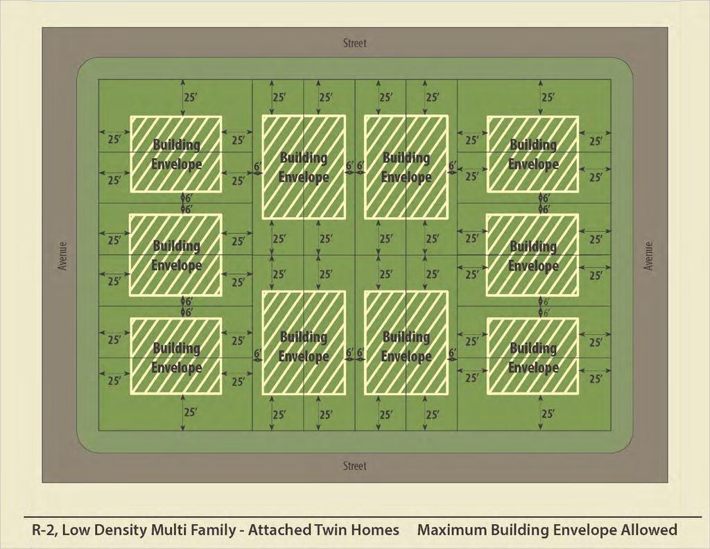
15 2.02 R-2 Low Density Multi-Family (A) Description The R-2, Low Density Multi Family district is intended to allow for a mix of twin homes, duplexes, and single family detached dwellings in a suburban setting, including larger setbacks and easy vehicle access. Residences will be compatible with, and served by, parks, civic uses, institutional uses, public services, and utilities. (B) Allowed Uses Uses are allowed as shown in the Use Table in Section 2.5. (C) Area Requirements (1) Density Maximum Density: 10.4 units/acre (2) Lot Size (a) Minimum Lot Area: 8,400 sq ft (b) Minimum Lot Area for Each Twin Home Dwelling Unit: 4,200 sq ft (c) Minimum Width: 70 ft (d) Minimum Width for Each Twin Home Dwelling Unit: 35 ft (e) Maximum Lot Coverage: 30% (3) Setbacks (a) Minimum Front Yard Setback: 25 ft i. 8 ft protrusion allowance into setback (b) Minimum Interior Side Setback: 6 ft i. 3 ft protrusion allowance into setback (c) Minimum Interior Side Setback for Each Twin Home Dwelling Unit: 6 ft / no setback if attached i. 3 ft protrusion allowance into setback, if applicable (d) Minimum Street Side Setback: 25 ft i. 8 ft protrusion allowance into setback (e) Minimum Rear Setback: 25 ft i. 3 ft protrusion allowance into setback (4) Setbacks from Highways Outside of City Limits 1 (a) Minor Arterial: 200 ft (b) Major and Minor Collectors: 150 ft (c) Local Roads: 100 ft (5) Building Height Maximum Building Height: 40 ft 1 For highway designations, refer to the latest NDDOT Functional Classification Systems Map for the City of Beulah, available at II - 3
16 (D) Other Standards Refer to Chapter 4 of the Zoning Ordinance. (E) Permit Process Refer to section 5.1 of the Zoning Ordinance. II - 4
17 II - 5
18 2.03 R-3 High Density Multi-Family (A) Description The R-3, High Density Multi Family district is intended to provide higher density residential development in a suburban setting, including larger setbacks and easy vehicle access. Appropriate development can include apartment buildings, attached dwellings, modular homes, and small single family detached homes. Residences will be compatible with, and served by, parks, civic uses, institutional uses, public services, and utilities. (B) Allowed Uses Uses are allowed as shown in the Use Table in Section 2.5. (C) Area Requirements (1) Density Maximum Density: 16 units/acre (2) Lot Size (a) Minimum Lot Area 6,000 sq ft (b) Minimum Lot Area for Attached Dwelling Units: 4,200 sq ft (c) Minimum Width: 60 ft (d) Minimum Width for Attached Dwelling Units: 35 ft (e) Maximum Lot Coverage: 40% (3) Setbacks (a) Minimum Front Yard Setback: 25 ft i. 8 ft protrusion allowance into setback (b) Minimum Interior Side Setback: 6 ft i. 3 ft protrusion allowance into setback (c) Minimum Street Side Setback: 25 ft i. 8 ft protrusion allowance into setback (d) Minimum Rear Setback: 25 ft i. 3 ft protrusion allowance into setback (4) Setbacks from Highways Outside of City Limits 1 (a) Minor Arterial: 200 ft (b) Major and Minor Collectors: 150 ft (c) Local Roads: 100 ft. (5) Building Height Maximum Building Height: 50 ft 1 For highway designations, refer to the latest NDDOT Functional Classification Systems Map for the City of Beulah, available at II - 6
 Permit Process Refer to section 5.1 of the Zoning Ordinance.")
19 (D) Other Standards Refer to Chapter 4 of the Zoning Ordinance. (E) Permit Process Refer to section 5.1 of the Zoning Ordinance. II - 7
20 2.04 R-4 Manufactured Home (A) Intent The R-4, Manufactured Home district is intended to allow for manufactured homes arranged together in a subdivision or park. However, single family detached dwellings are permitted. This development type is intended to be located in a suburban setting with parks, civic uses, institutional uses, public services, and utilities to serve residents. A manufactured home park offers spaces for the placement of manufactured home units on a lease or rental basis. Manufactured home subdivisions include individually platted lots, for sale within the subdivision, for the placement of manufactured home units. (B) Allowed Uses Uses are allowed as shown in the Use Table in Section 2.5. (C) Area Requirements (1) Density Maximum Density: 6.1 units/acre (2) Lot Size (a) Minimum Lot Area: 6,000 sq ft/lot (b) Minimum Width: 70 ft (c) Maximum Lot Coverage: 35% (3) Setbacks (a) Minimum Front Yard Setback: 25 ft (b) Minimum Interior Side Setback: 6 ft (c) Minimum Street Side Setback: 25 ft (d) Minimum Rear Setback: 10 ft (4) Setbacks from Highways Outside of City Limits 1 (a) Minor Arterial: 200 ft (b) Major and Minor Collectors: 150 ft (c) Local Roads: 100 ft. (5) Building Height Maximum Building Height: 35 ft (D) Other Standards Refer to Chapter 4 of the Zoning Ordinance. 1 For highway designations, refer to the latest NDDOT Functional Classification Systems Map for the City of Beulah, available at II - 8

21 (E) Permit Process Refer to section 5.1 of the Zoning Ordinance. II - 9
22 2.05 R-5 (Reserved for Future Use) II - 10
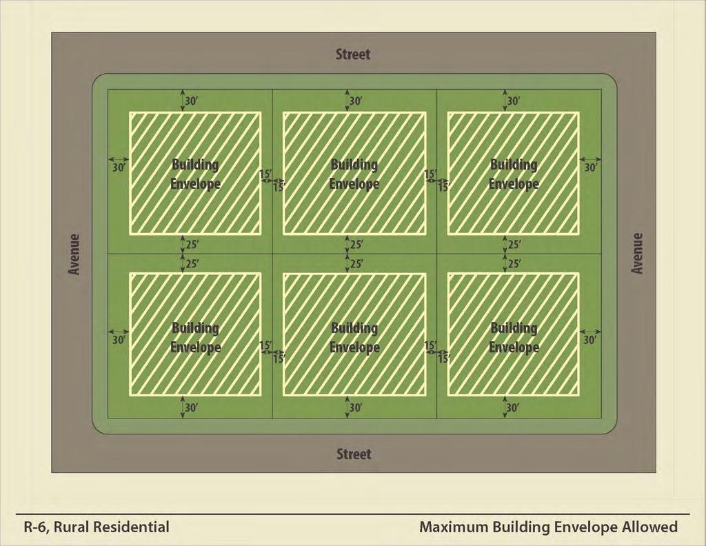
23 2.06 R-6 Rural Residential (A) Description The R-6, Rural Residential, district is the lowest density residential district. It provides for a semirural environment of low-density, single family detached dwellings along with parks, civic uses, institutional uses, public services, and utilities to serve residents. The intent of the district is to allow for individual sewage treatment systems on large lots with room for sewage treatment. (B) Allowed Uses Uses are allowed as shown in the Use Table in Section 2.5. (C) Area Requirements (1) Density Maximum Density: 1 unit/acre (2) Lot Size (a) Minimum Lot Area: 87,120 sq ft (2 acres) (b) Minimum Width: 150 ft (c) Maximum Lot Coverage: 25% (3) Setbacks (a) Minimum Front Yard Setback: 30 ft (b) Minimum Interior Side Setback: 15 ft (c) Minimum Street Side Setback: 30 ft (d) Minimum Rear Setback: 25 ft (4) Setbacks from Highways Outside of City Limits 1 (a) Minor Arterial: 200 ft (b) Major and Minor Collectors: 150 ft (c) Local Roads: 100 ft. (5) Building Height Maximum Building Height: 40 ft (D) Permit Process Refer to section 5.1 of the Zoning Ordinance. 1 For highway designations, refer to the latest NDDOT Functional Classification Systems Map for the City of Beulah, available at II - 11
24 II - 12
25 2.07 R-7 Urban Multi-Family (A) Intent The R-7, Urban Multi Family Residential, district is intended to accommodate higher density residential development in a compact urban setting with a focus on pedestrian access to the street. The district should be situated adjacent to downtown commercial areas to maximize pedestrian access. Appropriate development will include apartment buildings and attached dwellings with parks, civic uses, institutional uses, public services, and utilities to serve residents. (B) Allowed Uses Uses are allowed as shown in the Use Table in Section 2.5. (C) Area Requirements (1) Density Maximum Density: 20 units/acre (2) Lot Size (a) Minimum Lot Area: 5,000 sq ft (b) Minimum Width: 50 ft (c) Maximum Lot Coverage: 60% (3) Setbacks (a) Minimum Front Yard Setback: 0 ft (b) Minimum Interior Side Setback: 0 ft (c) Minimum Street Side Setback: 0 ft (d) Minimum Rear Setback: 15 ft (4) Setbacks from Highways Outside of City Limits 1 (a) Minor Arterial: 200 ft (b) Major and Minor Collectors: 150 ft (c) Local Roads: 100 ft. (5) Building Height Maximum Building Height: 60 ft (D) Other Standards (1) Parking Refer to Section 4.1 of the Zoning Ordinance. 1 For highway designations, refer to the latest NDDOT Functional Classification Systems Map for the City of Beulah, available at II - 13

26 (E) Permit Process Refer to section 5.1 of the Zoning Ordinance. II - 14
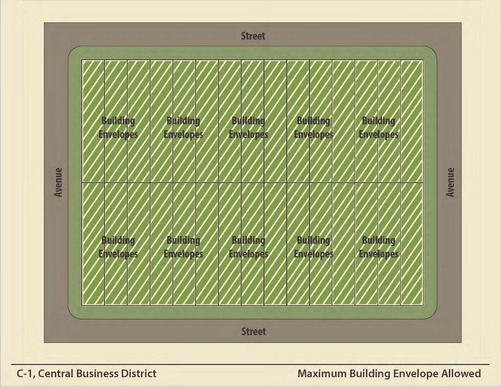
27 Section 2.1 Commercial Zoning Districts 2.11 C-1 Central Business (A) Description The C-1, Central Business, district is intended to preserve and enhance the City s main street and adjacent commercial area. The district allows for a variety of retail stores and related activities, as well as offices and service establishments which occupy the prime frontages in the central business district. The district is also designed to provide for the needs of the daytime work force and residents who may live above or behind commercial frontage. Development is intended to be pedestrian-oriented with a strong emphasis on a safe and attractive street. (B) Allowed Uses Uses are allowed as shown in the Use Table in Section 2.5. (C) Area Requirements (1) Density No requirement (2) Lot Size (a) Minimum Lot Area: No requirement (b) Minimum Width: 25 ft (c) Maximum Lot Coverage: 100% (3) Setbacks (a) Minimum Front Yard Setback: 0 ft (b) Minimum Interior Side Setback: 0 ft (c) Minimum Street Side Setback: 0 ft (d) Minimum Rear Setback: 0 ft (4) Setbacks from Highways Outside of City Limits 1 (a) Minor Arterial: 200 ft (b) Major and Minor Collectors: 150 ft (c) Local Roads: 100 ft. (5) Building Height Maximum Building Height: 60 ft 1 For highway designations, refer to the latest NDDOT Functional Classification Systems Map for the City of Beulah, available at II - 15
28 (D) Other Standards (1) Residential Multi-family dwellings are not permitted on the first floor lot frontage. (2) Parking Refer to Section 4.1. (3) Site Access Refer to Section (4) Signs Refer to Section 4.4. (5) Building Be advised that Building Code requirements in the C-1 District may differ from other districts. (E) Permit Process Refer to section 5.1 of the Zoning Ordinance. II - 16
29 II - 17
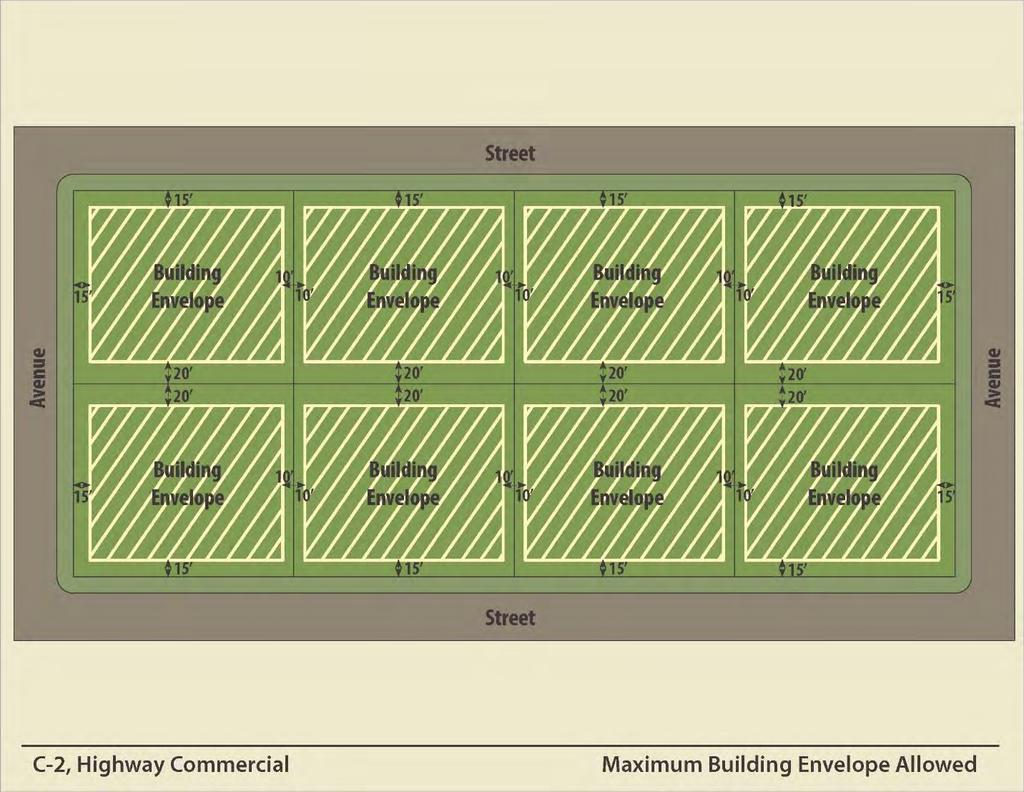
30 2.12 C-2 Highway Commercial (A) Description The C-2, Highway Commercial, district is intended to provide for a variety of office, retail, and service opportunities for the purpose of creating a high quality mixture of attractive land uses along main highways, such as ND Highway 49, ND Highway 200, and County Road 21. (B) Allowed Uses Uses are allowed as shown in the Use Table in Section 2.5. (C) Area Requirements (1) Density No requirement (2) Lot Size (a) Minimum Lot Area: No requirement (b) Minimum Width: 75 ft (c) Maximum Lot Coverage: 55% (3) Setbacks (a) Minimum Front Yard Setback: 15 ft (b) Minimum Interior Side Setback: 10 ft (c) Minimum Street Side Setback: 15 ft (d) Minimum Rear Setback: 20 ft (4) Setbacks from Highways Outside of City Limits 1 (a) Minor Arterial: 200 ft (b) Major and Minor Collectors: 150 ft (c) Local Roads: 100 ft. (5) Building Height Maximum Building Height: 60 ft (D) Other Standards Refer to Chapter 4 of the Zoning Ordinance. (E) Permit Process Refer to section 5.1 of the Zoning Ordinance. 1 For highway designations, refer to the latest NDDOT Functional Classification Systems Map for the City of Beulah, available at II - 18
31 II - 19
32 2.13 C-3 General Commercial (A) Description The C-3, General Commercial, district is intended to provide for a full range of commercial uses, including retail, service, and office. This district excludes warehousing and similar uses that may involve heavy truck traffic. (B) Allowed Uses Uses are allowed as shown in the Use Table in Section 2.5. (C) Area Requirements (1) Density No requirement (2) Lot Size (a) Minimum Lot Area: No requirement (b) Minimum Width: No requirement (c) Maximum Lot Coverage: 85% (3) Setbacks (a) Minimum Front Yard Setback: 20 ft (b) Minimum Interior Side Setback: 10 ft (c) Minimum Street Side Setback: 20 ft (d) Minimum Rear Setback: 15 ft (4) Setbacks from Highways Outside of City Limits 1 (a) Minor Arterial: 200 ft (b) Major and Minor Collectors: 150 ft (c) Local Roads: 100 ft. (5) Building Height Maximum Building Height: 60 ft (D) Other Standards Refer to Chapter 4 of the Zoning Ordinance. (E) Permit Process Refer to section 5.1 of the Zoning Ordinance. 1 For highway designations, refer to the latest NDDOT Functional Classification Systems Map for the City of Beulah, available at II - 20
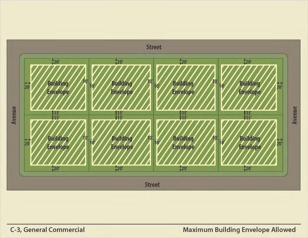
33 II - 21
34 2.14 C-4 Neighborhood Commercial (A) Description The C-4, Neighborhood Commercial, district is intended to allow those uses necessary to satisfy the basic convenience shopping or service needs of residents in adjacent neighborhoods. (B) Allowed Uses Uses are allowed as shown in the Use Table in Section 2.5. (C) Area Requirements (1) Density No requirement (2) Lot Size (a) Minimum Lot Area: 12,500 sq ft (b) Minimum Width: 70 ft (c) Maximum Lot Coverage: 50% (3) Setbacks (a) Minimum Front Yard Setback: 20 ft (b) Minimum Interior Side Setback: 10 ft (c) Minimum Street Side Setback: 20 ft (d) Minimum Rear Setback: 20 ft (4) Setbacks from Highways Outside of City Limits 1 (a) Minor Arterial: 200 ft (b) Major and Minor Collectors: 150 ft (c) Local Roads: 100 ft. (5) Building Height Maximum Building Height: 35 ft (D) Other Standards Refer to Chapter 4 of the Zoning Ordinance. (E) Permit Process Refer to section 5.1 of the Zoning Ordinance. 1 For highway designations, refer to the latest NDDOT Functional Classification Systems Map for the City of Beulah, available at II - 22
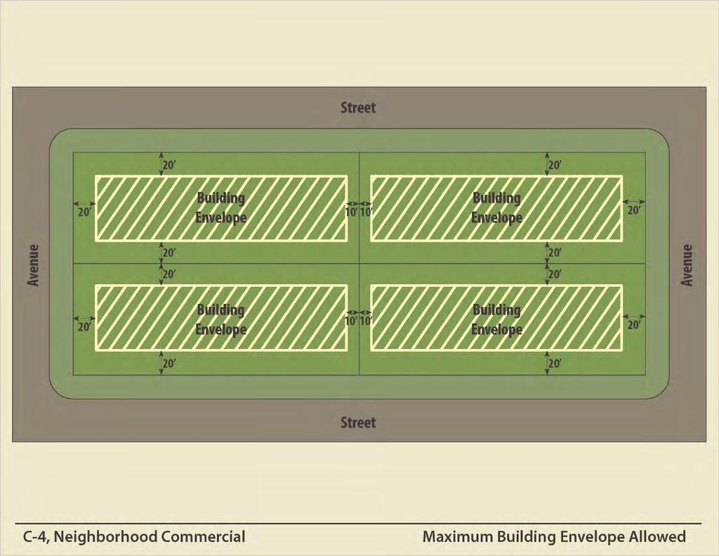
35 II - 23
36 Section 2.2 Industrial Zoning Districts 2.21 I Light Industrial (A) Description The I, Light Industrial, district is intended to accommodate manufacturing, processing, packaging, assembly, or treatment of finished or semi-finished products from previously prepared material. Common uses include outdoor storage, warehouses, wholesales, manufacturing, and industrial services. (B) Allowed Uses Uses are allowed as shown in the Use Table in Section 2.5. (C) Area Requirements (1) Density No requirement (2) Lot Size (a) Minimum Lot Area: 8,400 sq ft (b) Minimum Width: 70 ft (c) Maximum Lot Coverage: 85% (3) Setbacks (a) Minimum Front Yard Setback: 25 ft (b) Minimum Interior Side Setback: 12 ft (c) Minimum Street Side Setback: 25 ft (d) Minimum Rear Setback: 20 ft (4) Setbacks from Highways Outside of City Limits 1 (a) Minor Arterial: 200 ft (b) Major and Minor Collectors: 150 ft (c) Local Roads: 100 ft. (5) Building Height Maximum Building Height: 60 ft (D) Other Standards (1) Landscaping, Buffer Strip Refer to Section 4.3 of the Zoning Ordinance. See definition of buffer strip in Section For highway designations, refer to the latest NDDOT Functional Classification Systems Map for the City of Beulah, available at II - 24

37 (E) Permit Process Refer to section 5.1 of the Zoning Ordinance. II - 25
38 2.22 HI Heavy Industrial (A) Description The HI, Heavy Industrial, District is intended to locate manufacturing and industrial operations as to not impact lower intensity, incompatible uses. District areas should be isolated to protect uses that may be objectionable or hazardous. (B) Allowed Uses Uses are allowed as shown in the Use Table in Section 2.5. (C) Area Requirements (1) Density No requirement (2) Lot Size (a) Minimum Lot Area: 8,400 sq. ft. (b) Minimum Width: 70 ft. (c) Maximum Lot Coverage: 85% (3) Setbacks (a) Minimum Front Yard Setback: 40 ft (b) Minimum Interior Side Setback: 20 ft (c) Minimum Street Side Setback: 40 ft (d) Minimum Rear Setback: 40 ft (4) Setbacks from Highways Outside of City Limits 1 (a) Minor Arterial: 200 ft (b) Major and Minor Collectors: 150 ft (c) Local Roads: 100 ft. (5) Building Height Maximum Building Height: 100 ft (D) Other Standards (1) Landscaping, Buffer Strip (E) Permit Process Refer to Section 4.3 of the Zoning Ordinance. See definition of buffer strip in Section 9.0. Refer to section 5.1 of the Zoning Ordinance. 1 For highway designations, refer to the latest NDDOT Functional Classification Systems Map for the City of Beulah, available at II - 26
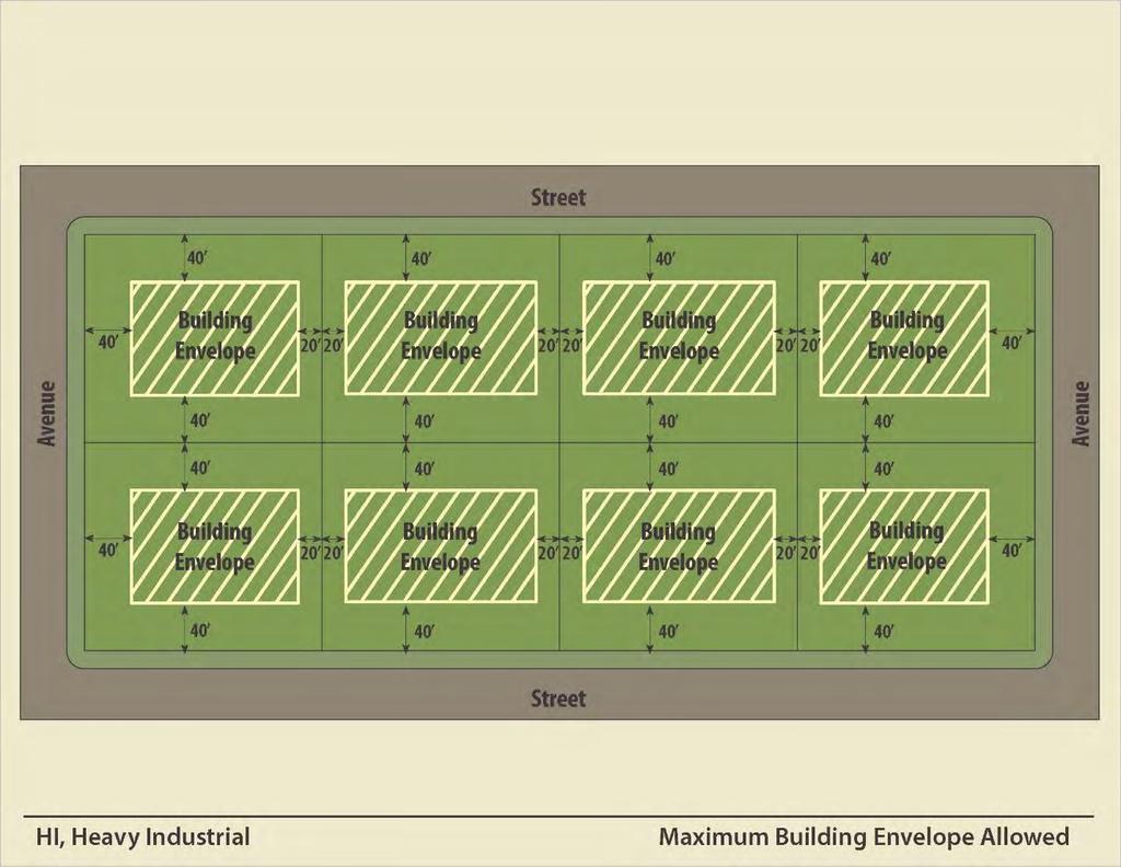
39 II - 27
40 Section 2.3 Other Zoning Districts 2.31 A Agricultural (A) Description The A, Agricultural, district is intended to provide a location for principally undeveloped or vacant land situated on the fringe of an urban area and used for agricultural purposes however, the land may be developed in the future. The types of uses allowed in this district encourage and protect agricultural uses until development is warranted. (B) Allowed Uses Uses are allowed as shown in the Use Table in Section 2.5. (C) Area Requirements (1) Density 1 unit/10 acres (2) Lot Size (a) Minimum Lot Area: 10 acres (b) Minimum Width: 200 ft (c) Maximum Lot Coverage: No requirement (3) Setbacks (a) Minimum Front Yard Setback: 50 ft (b) Minimum Interior Side Setback: 25 ft (c) Minimum Street Side Setback: 25 ft (d) Minimum Rear Setback: 50 ft (4) Setbacks from Highways Outside of City Limits 1 (a) Minor Arterial: 200 ft (b) Major and Minor Collectors: 150 ft (c) Local Roads: 100 ft. (5) Building Height Maximum Building Height: 60 ft (D) Other Standards Refer to Chapter 4 of the Zoning Ordinance. 1 For highway designations, refer to the latest NDDOT Functional Classification Systems Map for the City of Beulah, available at II - 28

41 (E) Permit Process Refer to section 5.1 of the Zoning Ordinance. II - 29
42 2.32 POC Public & Open Space Conservation (A) Description The POC, Public and Open Space Conservation, district is intended to provide for public facilities and permanent open spaces. Public facilities include uses that are governmental, civic, public service or quasi-public in nature. Open space uses include those areas of the community which exhibit significant scenic qualities, wildlife potential, or recreational potential. Also included are high risk resource areas, such as floodplain or steep terrain. (B) Allowed Uses Uses are allowed as shown in the Use Table in Section 2.5. (C) Area Requirements (1) Density No requirement (2) Lot Size (a) Minimum Lot Area: No requirement (b) Minimum Width: No requirement (c) Maximum Lot Coverage: No requirement (3) Setbacks (a) Minimum Front Yard Setback: 30 ft (b) Minimum Interior Side Setback: 6 ft (c) Minimum Street Side Setback: 30 ft (d) Minimum Rear Setback: 30 ft (4) Setbacks from Highways Outside of City Limits 1 (a) Minor Arterial: 200 ft (b) Major and Minor Collectors: 150 ft (c) Local Roads: 100 ft. (5) Building Height Maximum Building Height: 50 ft (D) Other Standards Refer to Chapter 4 of the Zoning Ordinance. 1 For highway designations, refer to the latest NDDOT Functional Classification Systems Map for the City of Beulah, available at II - 30

43 (E) Permit Process Refer to section 5.1 of the Zoning Ordinance. II - 31
44 2.33 PUD Planned Unit Development (A) Description The PUD, Planned Unit Development, district is a nonstandard district that permits greater flexibility of land planning and site design than conventional zoning districts. The district should only be provided in unique situations for the following purposes: (1) Provide flexibility in site design, placement, and clustering of buildings; use of open areas and outdoor living areas; provision of parking; and related site and design considerations; (2) Encourage the conservation of natural features; (3) Provide for efficient use of public services and improvements; (4) Permit higher density residential development in special circumstances to allow for affordable housing units. (5) Provide for a mix of compatible land uses not otherwise allowed in other zoning districts. The PUD designation shall not be used for the following purpose(s): (1) To obtain variances and waivers from existing development standards; (2) To secure agreements between an applicant and nearby property owners to receive zoning approval; (3) And/or to assign responsibility to the City of private restrictive or protective covenants. (B) Allowed Uses Allowed uses are those specified in an ordinance adopted by the Council establishing a PUD district. (C) Area Requirements As determined by the development plan. (D) Standards (1) Other City Requirements. Unless specified in an ordinance adopted by the Council establishing a PUD district, all buildings and uses shall comply with the special use standards specified in Chapter 3 and the site development standards specified in Chapter 4. (2) Compatibility. The planned development uses must be of a type and nature, as well as located as to not create a negative impact or influence upon surrounding properties. Within a mixed use planned development, the uses, despite their differences, should be complementary to one another. II - 32
45 (3) Need. The planned development must be of a character, land use and type needed in the area. (4) Size. The planned development must contain at least two (2) acres. (5) Comprehensive Plan Land Use Map. The proposed use is in harmony with the Comprehensive Plan Land Use Map of the City of Beulah. (6) Services. Adequate utility, drainage, and other such necessary facilities and services have been or will be provided at the time of development. (7) Access. Adequate access roads or entrance and exit drives will be provided and be so designed to prevent traffic hazards and to minimize traffic congestion on public streets. (E) Standards to be set by Planned Development The ordinance establishing the planned development shall specify the following items in detail, and must be in compliance with the PUD district standards (Section 2.33(D)). (1) Allowed Uses. The Council shall establish the list of uses allowed in a PUD zoning district during the PUD Conceptual Plan approval process (See Section 2.33(F)(2)). (2) Lot Size (3) Residential Density. (4) Setbacks. (5) Height. (6) Lot Coverage. II - 33
46 (F) Application Process PUD Conceptual Plan (see red text, pages II-35 to II-37 for detail) 2.33.F.2.a Pre-application Conference* 2.33.F.2.b Submit Application* 2.33.F.2.d Building Official Review for Completeness and Recommendation* 2.33.F.2.e P&Z Commission Review and Recommendation* 2.33.F.2.f Council Review and Decision to Approve, Approve with Conditions, or Deny Application* II - 34
 (1) Process Overview PUDs shall be processed in")
47 PUD Final Plan (see red text, pages II-37 to II-39 for detail) 2.33.F.3.b Submit Application* 2.33.F.3.d Building Official Review for Completeness and Recommendation* 2.33.F.3.e P&Z Commission Review and Recommendation* 2.33.F.3.f Council Review and Action to Approve, Approve with Conditions, or Deny Application * (A First and Second Reading of the Ordinance is Required) (1) Process Overview PUDs shall be processed in two stages: Conceptual Plan; Final Plan and Zoning Map Amendment. The Final Plan and Zoning Map Amendment are intended to be processed concurrently. Stage 1: A PUD Conceptual Plan is reviewed based on the PUD Standards provided in section 2.33 (D). PUD Conceptual Plan approval establishes basic parameters for the development. Stage 2: A PUD Final Plan is at the level of detail from which building permit approvals are issued. Detailed plans are required that are consistent with the approved PUD Conceptual Plan. (2) PUD Conceptual Plan The purpose of the PUD Conceptual Plan is to allow early review of a proposal before substantial commitment in technical planning from the applicant and city. II - 35
48 (a) Pre-application Conference* The application shall confer with the Building Official and other city officials as determined by the Mayor and Building Official. The purpose is to provide a common understanding of the proposed PUD and the PUD review process. (b) Submit Application* (i.) Complete application PUD Conceptual Plan applications shall be submitted to the Building Official in the appropriate form along with a non-refundable fee that has been established by a resolution of the Council. Additionally, Applicant shall pay into a City escrow account an amount representing the estimated legal and engineering fees and costs, and out of which the City will pay its legal and engineering fees and costs. Any legal and engineering fees and costs incurred by the City during the PUD process above and beyond the escrowed amount shall be the sole responsibility of the Applicant. (ii.) Processing Requirements The Building Official will determine when an application for a PUD conceptual plan is considered complete. In addition to the required fee, see the submittal checklist provided in section 2.33.F.2.c for all other required items. (c) Application Checklist (i) (ii) (iii) (iv) Conceptual architectural drawings. Site Plan, with dimensions and drawn to scale. Project description, including detail on the daily or seasonal operations; number of employees, customers, visitors; number of shifts; activities; products and services; maximum living units proposed, as applicable. Other items and information requested by the Building Official, P&Z Commission, or Council to evaluate the proposal s potential impacts on traffic, aesthetics, city utilities, noise, and other environmental impacts. (d) Building Official Review and Recommendation* The Building Official shall prepare a written recommendation to the P&Z Commission that considers the PUD Conceptual Plan in light of the PUD standards provided in section 2.33 (D). (e) P&Z Commission Review and Recommendation* The P&Z Commission shall hold a public hearing on the PUD Conceptual Plan. The P&Z Commission may make a recommendation to the Council to approve, approve with conditions, or deny the application. The PUD Conceptual Plan application may also be tabled by the P&Z Commission in order to allow for additional information requested of the applicant. The P&Z Commission will use the criteria located in section 2.33(D) as guidance to determine if the PUD Conceptual Plan should be approved. (f) Council Review and Action* II - 36
49 The Council shall hold a public hearing on the PUD Conceptual Plan application. The Council may act to approve, approve with conditions, or deny the application. The PUD Conceptual Plan application may also be tabled by the Council in order to allow for additional information requested of the applicant. The Council will use the criteria located in section 2.33(D) as guidance to determine if a PUD Conceptual Plan application should be approved. (g) Notice of Public Hearings (i) (ii) Newspaper Notice of the application and the dates of the P&Z Commission and Council hearings on the application is to be published in the official newspaper of the city at least once each week for 2 successive weeks and not less than 15 days preceding the date of the first scheduled public hearing (not necessary for hearings after a continuation of the application). Adjacent Properties Written notice shall be provided by first class mail to all owners of the subject property and all property owners within 300 feet of the subject property. The notice shall be deposited in the U.S. mail at least 15 days before the first scheduled public hearing (not necessary for hearings after a continuation of the application) and prior to the P&Z Commission meeting. (h) Effect of Approval (i) (ii) Approval of the PUD Conceptual Plan is the Council s acceptance of the general use, design, and other planning concepts for the proposed conceptual plan. Approval is required prior to filing for a PUD Final Plan and PUD Zoning Map Amendment. (i) Failure to Act An approved PUD Conceptual Plan shall be declared null and void if a PUD Final Plan and PUD Zoning Map Amendment are not filed for within one year of PUD Conceptual Plan approval. In the event this occurs, the existing zoning district requirements shall remain in effect. *See process chart on page II-34. (3) PUD Final Plan A PUD Zoning Map Amendment must be processed concurrently with the PUD Final Plan. (a) Criteria - To ensure compliance with the approved PUD Conceptual Plan, the PUD Final Plan shall not result in: (i) (ii) (iii) Increase in project density or intensity Change in the mix of housing types and land uses. A reduction in the amount of open space and recreational areas. II - 37
50 (iv) (v) Any substantial change to the circulation system, access, and parking areas. Any substantial change to the architectural character, quality, or aesthetics of that shown in the conceptual plan. (b) Submit Application* (i) Complete application PUD Final Plan applications shall be submitted to the Building Official in the appropriate form along with a non-refundable fee that has been established by a resolution of the Council. Additionally, Applicant shall pay into a City escrow account an amount representing the estimated legal and engineering fees and costs, and out of which the City will pay its legal and engineering fees and costs. Any legal and engineering fees and costs incurred by the City during the PUD process above and beyond the escrowed amount shall be the sole responsibility of the Applicant. (ii) Processing Requirements The Building Official will determine when an application for a PUD final plan is considered complete. In addition to the required fee, see the submittal checklist provided in section 2.33.F.3.c for all other required items. (c) Application Checklist (i) (ii) (iii) (iv) Detailed architectural drawings. Site Plan, with dimensions and drawn to scale. Project description, including detail on the daily or seasonal operations; number of employees, customers, visitors; number of shifts; activities; products and services; maximum living units proposed, as applicable. Other items and information requested by the Building Official, P&Z Commission, or Council to evaluate the proposal s potential impacts on traffic, aesthetics, city utilities, noise, and other environmental impacts. (d) Building Official Review and Recommendation* The Building Official shall prepare a written recommendation to the P&Z Commission that considers the PUD Final Plan in light of the approved PUD Conceptual Plan and section 2.33(F)(3)(a). (e) P&Z Commission Review and Recommendation* The P&Z Commission shall hold a public hearing on the PUD Final Plan. The P&Z Commission may make a recommendation to the Council to approve, approve with conditions, or deny the application. The PUD Final Plan application may also be tabled by the P&Z Commission in order to allow for additional information requested of the applicant. The P&Z Commission will use the criteria located in section 2.33(F)(3)(a) as guidance to determine if the PUD Final Plan should be approved. (f) Council Review and Action* II - 38
51 The Council shall hold a public hearing on the PUD Final Plan application. The Council may act to approve, approve with conditions, or deny the application. The PUD Final Plan application may also be tabled by the Council in order to allow for additional information requested of the applicant. The Council will use the criteria located in section 2.33(F)(3)(a) as guidance to determine if a PUD Final Plan application should be approved. (g) Notice of Public Hearing Notice of the application and the dates of the P&Z Commission and Council hearings on the application is to be published in the official newspaper of the city at least once each week for 2 successive weeks and not less than 15 days preceding the date of the first scheduled public hearing (not necessary for hearings after a continuation of the application) (h) Effect of Approval Approval of the PUD Final Plan grants the applicant the right to develop the subject property, in compliance with the PUD Final Plan, this Zoning Ordinance, the North Dakota Century Code, and the Building Code. (i) Failure to Act An approved PUD Final Plan shall be declared null and void if applications for development have not been filed within one year of approval. If Certificates of Occupancy are not obtained within two years of approval of the PUD Final Plan, the applicant must seek a time extension from the P&Z Commission. (j) Time Extension A time extension must be submitted to the Building Official, on a form acceptable to the Building Official, along with the same fee as required for the PUD Final Plan. *See process chart on page II-35. (4) City Zoning Map Amendment A City Zoning District Map Amendment must be processed concurrently with a PUD Final Plan. The City Zoning District Map Amendment must be processed as provided in section II - 39
52 Section 2.4 Overlay Zoning Districts 2.41 FPO Flood Plain Overlay (A) Description The FPO, Flood Plain Overlay, district is intended to provide special standards for development in areas subject to flooding. These areas include those that are defined as zones A, AE, AH, AO, AR, and A99 as depicted on the most recent Flood Insurance Rate Map (FIRM) produced by the Federal Emergency Management Agency (FEMA). The purpose of the overlay district is to minimize potential loss of life, destruction of property, and the use of public funds for costly flood control projects. (B) Statutory Authorization The Legislature of the State of North Dakota has in North Dakota Century Code, Chapters 40-47, and 58-03, or as may be amended, delegated responsibility to local governmental units to adopt regulations designed to promote the public health, safety, and general welfare of the citizenry. Therefore, the City Council of the City of Beulah, North Dakota does ordain as follows: (C) Findings of Fact (1) The flood hazard areas of the City of Beulah are subject to periodic inundation which can endanger life, result in loss of property, create health and safety hazards, disrupt commerce and governmental services, cause extraordinary public expenditures for flood protection and relief, and impair the tax base, all of which adversely affect the public health, safety and general welfare. (2) Flood losses caused by the cumulative effect of obstructions in the special flood hazard areas cause increases in flood heights and velocities. Inadequately floodproofed, elevated or otherwise unprotected structures also contribute to flood loss. (D) Statement of Purpose It is the purpose of this subsection to promote the public health, safety, and general welfare, and to minimize public and private losses due to flood conditions in specific areas by provisions designed; (1) To protect human life and health; (2) To minimize expenditure of public money for costly flood control projects; (3) To minimize the need for rescue and relief efforts associated with flooding, and generally undertaken at the expense of the general public; (4) To minimize prolonged business interruptions; (5) To minimize damage to public facilities and utilities such as water and gas mains, electric, telephone, and sewer lines, streets, and bridges located in special flood hazard areas; II - 40
53 (6) To help maintain a stable tax base by providing for the second use and development of special flood hazard areas so as to minimize future flood blight areas; (7) To ensure that potential buyers are notified that property is in a special flood hazard area; and, (8) To ensure that those who occupy the special flood hazard areas assume responsibility for their actions. (E) Methods of Reducing Flood Losses In order to accomplish its purposes, this Zoning Ordinance includes methods and provisions for: (1) Restricting or prohibiting uses which are dangerous to health, safety, and property due to water or erosion hazards, or which result in damaging increases in erosion or in flood heights or velocities; (2) Requiring that uses vulnerable to flood, including facilities which serve such uses, be protected against flood damage at the time of initial construction; (3) Controlling the alteration of natural floodplains, stream channels, and natural protective barriers, which help accommodate or channel flood waters; (4) Controlling filling, grading, dredging, and other development which may increase flood damage; and, (5) Preventing or regulating the construction of flood barriers, which will unnaturally divert flood waters or which may increase flood hazards in other areas. (F) Lands to Which this Subsection Applies This subsection shall apply to all special flood hazard areas within the jurisdiction of the City of Beulah. (G) Basis for Establishing the Special Flood Hazard Areas The special flood hazard areas identified by the Federal Emergency Management Agency in a scientific and engineering report entitled "The Flood Insurance Study for the City of Beulah, dated October 16, 2015," with an accompanying Flood Insurance Rate Map is hereby adopted by reference and declared to be a part of this subsection. The Flood Insurance Study is on file at Beulah City Hall located at 120 Central Avenue N., Beulah, North Dakota (H) Compliance No structure or land shall hereafter be constructed, located, extended, converted, or altered II - 41
54 without full compliance with the terms of this subsection and other applicable regulations. (I) Greater Restrictions This subsection is not intended to repeal, remedy, or impair any existing easements, covenants, or restrictive or protective covenants. However, where this subsection and another ordinance, easement, covenant, or restrictive or protective covenants conflict or overlap, whichever imposes the more stringent restrictions shall prevail. (J) Interpretation In the interpretation and application of this subsection, all provisions shall be: (1) Considered as minimum requirement; (2) Liberally construed in favor of the City of Beulah; and, (3) Deemed neither to limit nor repeal any other powers granted under state statutes. (K) Warning and Disclaimer or Liability The degree of flood protection required by this subsection is considered reasonable for regulatory purposes and is based on scientific and engineering considerations. Larger floods can and will occur on rare occasions. Flood heights may be increased by manmade or natural causes. This subsection does not imply that land outside the special flood hazard areas or uses permitted within such areas will be free from flooding or flood damages. This subsection shall not create liability on the part of the City of Beulah, its City Council members, officers, agents, or employees, or the Federal Emergency Management Agency, for any flood damages that result from reliance on this this subsection or any administrative decision lawfully made thereunder. (L) Designation of the City Floodplain Manager The City Floodplain Manager is hereby appointed to administrator and implement this subsection by granting or denying development permit applications in accordance with its provisions. (M) Duties and Responsibilities of the City Floodplain Manager Duties of the City Floodplain Manager shall include, but not be limited to: (a) Permit Review (i.) Review all development permits to determine that the permit requirements of this subsection have been satisfied. II - 42
55 (ii.) Review all development permits to determine that all necessary permits have been obtained from those federal, state, or local government agencies from which prior approval is required. (iii.) Review all development permits to determine if the proposed development is located in the floodway. If located in the floodway, assure that the encroachment provisions of subsection 2.41(R)(1)(a) are met. (b) Use of Other Base Flood Data When base flood data has not been provided in accordance with subsection 2.41(G), the City Floodplain Manager shall obtain, review, and reasonably utilize any base flood elevation data and floodway data available (known as best available data) from a federal, state, or other source, as criteria for requiring that new construction, substantial improvements, or other development in the floodplain are administered in accordance with subsection 2.41(Q). (c) Information to be Obtained and Maintained (i.) (ii.) Obtain and record the actual elevation (in relation to mean sea level) of the lowest floor (including basement) of all new or substantially improved structures, and whether or not the structure contains a basement. For all new or substantially improved floodproofed structures: 1. Obtain and record the actual elevation (in relation to mean sea level) to which the structure has been floodproofed; 2. Maintain the floodproofing certifications required in subsection 2.41(N)(1)(c). (iii.) Maintain for public inspection all records pertaining to the provisions of this subsection. (d) Alteration of Watercourses The Floodplain Manager shall: 1. Notify nearby communities, water resource districts, and the North Dakota State Engineer, as necessary, prior to any alteration or relocation of a watercourse, and submit evidence of such notification to the Federal Emergency Management Agency. 2. Require that maintenance is provided within the altered or relocated portion of said watercourse so that the flood carrying capacity is not diminished; and, II - 43
56 3. Notify the appropriate water resource district prior to removal or placement of fill within two hundred feet of the bank of a body of water during normal flow or stage. (e) Interpretation of Flood Insurance Rate Map (FIRM) Boundaries Make interpretation where needed, as to the exact location of the boundaries of the special flood hazard areas (for example, where there appears to be a conflict between a mapped boundary and actual field conditions). The person contesting the location of the boundary shall be given a reasonable opportunity to appeal the interpretation as provided in subsection 2.41(O). (N) Establishment of Development Permit A development permit shall be obtained before construction or development begins within any special flood hazard area established in subsection 2.41(G). Application for a development permit shall be made on forms furnished by the City Floodplain Manager and may include, but not be limited to: plans in duplicate drawn to scale showing the nature, location, dimensions, and elevations of the area in question; existing or proposed structures, fill storage materials, drainage facilities; and the location of the foregoing. Specifically, the following information is required: (1) Elevation in relation to mean sea level, of the lowest floor of all structures; (2) Elevation in relation to mean sea level to which any structure has been floodproofed; (3) Certification by a registered professional engineer or architect that the floodproofing methods for any non-residential structure meet the floodproofing criteria in subsection 2.41(Q); and, (4) Description of the extent to which any watercourse will be altered or relocated as a result of proposed development. (O) Variance Procedure (1) Council shall hear and decide requests for variances from the requirements of this subsection. (a) In passing upon such applications, the Council shall consider all technical evaluations, all relevant factors, standards specified in other parts of this subsection; and: (i.) (ii.) the danger that materials may be swept onto other lands to the injury of others; the danger to life and property due to flooding or erosion damage; (iii.) the susceptibility of the proposed facility and its contents to flood damage and the effect of such damage on the individual owner; (iv.) the importance of the services provided by the proposed facility to the community; II - 44
57 (v.) the necessity to the facility of a waterfront location, where applicable; (vi.) the availability of alternative locations, for the proposed use which are not subject to flooding or erosion damage; (vii.) the compatibility of the proposed use with existing and anticipated development; (viii.) the relationship of the proposed use to the Comprehensive Plan and Floodplain Management Program for that area; (ix.) (x.) (xi.) the safety of access to the property in time of flood for ordinary and emergency vehicles; the expected heights, velocity, duration, rate of rise, and sediment transport of the floodwaters and the effects of wave action, if applicable, expected at the site; and the costs of providing governmental services during and after flood conditions, including maintenance and repair of public utilities and facilities, such as sewer, gas, electrical, and water systems, and streets and bridges. (b) Generally, variances may be issued for new construction and substantial improvements to be erected on a lot of one-half acre to less in size contiguous to and surrounded by lots with existing structures constructed below the base flood level, providing items (i-xi) in subsection 2.41(O)(1) have been fully considered. As the lot size increases beyond the one-half acre, the technical justification required for issuing the variance increases. (c) Upon consideration of the factors of subsection 2.41(O)(1) and the purposes of this subsection, the Council may attach such conditions to the granting of variances as it deems necessary to further the purposes of this subsection. (2) Conditions for Variances (a) Variances may be issued for the reconstruction, rehabilitation, or restoration of structures listed on the National Register of Historic Places or the State Inventory of Historic Places, without regard to the procedures set forth in the remainder of this section. (b) Variances shall not be issued within the identified floodplain if any increase in flood level during the base flood discharge would result. (c) Variances shall only be issued upon a determination that the variance is the minimum necessary, considering the flood hazard, to afford relief. (d) Variances shall only be issued upon: (i.) a showing of good and sufficient cause; II - 45
58 (ii.) a determination that failure to grant the variance would result in exceptional hardship to the applicant; and, (iii.) a determination that the granting of a variance will not result in increased flood heights, additional threats to public safety, cause fraud on or victimization of the public as identified in subsection 2.41(O)(1), or conflict with existing laws or ordinances. (e) Any applicant to whom a variance is granted shall be given written notice that the structure will be permitted to be built with a lowest floor elevation below the base flood elevation and that the cost of flood insurance will be commensurate with the increased risk resulting from the reduced lowest floor elevation. (3) Appeals to the Council (a) The Council shall hear and decide requests for variances in accordance with the requirements of this subsection. (b) The Council shall hear and decide appeals when it is alleged there is an error in any requirement, decision, or determination made by the City Floodplain Manager in the enforcement or administration of this subsection. (c) Those aggrieved by the decision of the Council or any taxpayer, may appeal such decision to the District Court, as provided in N.D.C.C , , , or as amended. (d) The City Floodplain Manager shall maintain the records of all appeal actions and report any variances to the Federal Emergency Management Agency upon request. (P) General Standards In all special flood hazard areas the following standards are required: (1) Anchoring (a) All new construction and substantial improvements, including additions, shall be anchored to prevent flotation, collapse or lateral movement of the structure. (b) All manufactured homes must be elevated and anchored to resist flotation, collapse or lateral movement. Methods of anchoring may include, but are not limited to, use of overthe-top or frame ties to ground anchors. This requirement is in addition to applicable State and local anchoring requirements for resisting wind forces. (2) Construction Materials and Methods (a) All new construction and substantial improvements shall be constructed with materials and utility equipment resistant to flood damage. II - 46
59 (b) All new and substantial improvements shall be constructed using methods and practices that minimize flood damage. (c) All new construction and substantial improvements shall be constructed with electrical, heating, ventilation, plumbing and air conditioning equipment, and other service facilities that are designed and/or located so as to prevent water from entering or accumulating within the components during conditions of flooding. (3) Utilities (a) All new and replacement water supply systems shall be designed to minimize or eliminate infiltration of flood waters into the system; (b) New and replacement sanitary sewage systems shall be designed to minimize or eliminate infiltration of flood waters into the systems and discharge from the systems into flood waters; and, (c) On-site waste disposal systems shall be located to avoid impairment to them or contamination from them during flooding. (4) Subdivision Proposals (a) All subdivision proposals shall be consistent with the need to minimize flood damage; (b) All subdivision proposals shall have public utilities and facilities such as sewer, gas, electrical, and water systems located and constructed to minimize flood damage; (c) All subdivision proposals shall have adequate drainage provided to reduce exposure to flood damage; and (d) Base flood elevation data shall be provided for subdivision proposals and other proposed development which contain at least 50 lots or 5 acres (whichever is less). (Q) Specific Standards In all special flood hazard areas where base flood elevation data has been provided as set forth in subsection 2.41(G) or subsection 2.41(M)(1)(b), the following provisions are required: (1) Residential Construction New construction and substantial improvement of any residential structure shall have the lowest floor, including basement, elevated to at least one foot above the base flood elevation according to local, state, and federal regulations. (2) Nonresidential Construction II - 47
60 Construction and substantial improvement of any nonresidential structure shall either have the lowest floor, including basement, elevated to at least one foot above the base flood elevation according to local, state, and federal regulations or, together with attendant utility and sanitary facilities shall: (a) Be flood proofed to at least two feet above the base flood elevation, so that below this elevation the structure is watertight with walls substantially impermeable to the passage of water. (b) Have structural components capable of resisting hydrodynamic loads and effects of buoyancy. hydrostatic and (R) Floodways (c) Be certified by are registered professional engineer or architect that the standards of this subsection are satisfied. Such certification shall be provided to the City Floodplain Manger as set forth in subsection 2.41(N)(1)(c). (3) Manufactured Homes (a) Manufactured homes shall be anchored in accordance with subsection 2.41(P)(2)(b). (b) All manufactured homes or those to be substantially improved shall be elevated on a permanent foundation such that the lowest floor of the manufactured home is elevated on fill to at least one foot above the base flood elevation, and is securely anchored to an adequately anchored foundation system as referred to in the Federal Emergency Management Agency s Protecting Manufactured Homes from Floods and other Hazards, A Multi-Hazard Foundation and Installation Guide. Located within the special flood hazard areas established in subsection 2.41(G) are areas designated as floodways. Since a floodway is an extremely hazardous area due to the velocity of flood waters which carry debris, potential projectiles, and erosion potential, the following provisions apply: (1) Prohibit encroachments, including fill, new construction, substantial improvements, and other development unless certification by a registered professional engineer or architect is provided demonstrating that encroachments shall not result in any increase in flood levels during the occurrence of the base flood discharge. (2) If subsection 2.41(R)(1) is satisfied, all new construction and substantial improvements shall comply with all applicable flood hazard reduction provisions of subsections 2.41 (P), (Q), and (R). II - 48
61 2.42 UGO Underground Mining Overlay (A) Description The UGO, Underground Mining Overlay, district is advisory and voluntary; however, compliance is strongly recommended for the protection of life and property. This district is intended to advise property owners and developers of the potential development hazards and threats to life and property that may be created by underground mining as a result of historic mining activity in the area. Areas with proven underground mining and the potential for underground mining have been documented by the North Dakota Public Service P&Z Commission, Abandoned Mine Lands Division (AML). The overlay district corresponds to those areas within the City s zoning jurisdiction that have been documented by AML. This district applies to all forms of development, including roads, utilities, and any structures. All work in connection with development, including grading, paving, and other necessary activities is subject to this section. (B) Allowed Uses As allowed in the base zone district(s) (C) Area Requirements As allowed in the base zone district(s) (D) Standards (1) To demonstrate that no undermining hazards are present onsite, the following should be performed by the applicant: (a) (b) (c) (d) Coordinate with AML for documentation regarding whether or not undermining hazards exist at the proposed development site. Evidence of coordination with AML should be submitted and kept on file with the Building Official. If no documentation exists on record with AML, then the applicant should utilize an engineering or drilling firm to conduct a site evaluation. The engineering or drilling firm should provide evidence in writing that they have coordinated with AML to account for known undermining activity at the proposed site. A copy of the site evaluation results should be delivered to the Building Official. (2) If the proposed site has already been documented as having been undermined by the City and/or AML, then development of the site is not recommended. (3) If the site evaluation shows that undermining is present underneath the site, then development of the site is not recommended. II - 49
62 (E) Responsibility (1) All development decisions made as a result of this section are the responsibility of the property owner. (2) The City of Beulah and AML cannot assume the risk of injury to persons or damage to persons or property resulting from work performed as advised in this section. (3) Pursuant to N.D.C.C (3)(f)(1), the City of Beulah may not be held liable for any claim relating to injury directly or indirectly caused by the performance or nonperformance of a public duty, including inspecting, licensing, approving, mitigating, warning, abating, or failing to so act regarding compliance with or the violation of any law, rule, regulation, or any condition affecting health or safety. II - 50
63 Section 2.5 Use Table P C P[#] C[#] No Symbol Use Category Group Living Multi Family Single Family Permitted Use by Right Conditional Use Permitted Use w/ Requirements Conditional Use w/ Requirements Not Permitted Use AG - Agricultural R1 - Single Family, Detached R2 - Low Density Multi Family R3 - High Density Multi Family R4 - Manufactured Home Park Residential Assisted Living Facility C C Nursing Facilities C C Group Home - Disabled P P P P P P Group Home - Halfway House C C Retirement Facilities C P P Multi-family Residential P P Basement Apartment C P P C P P Crew Camp C[3.5] C[3.5] C[3.5] Twin Homes P P C Duplex P P C Townhomes P P P C Second Dwelling, Detached C C Dwelling, Single Family Detached w/ Horses P Dwelling, Single Family Detached P P P P P P C P Manufactured Homes P P C Mobile Homes P P Modular Homes P P P P P Guest House P[3.7] P[3.7] P[3.7] Temporary Residence P[3.15] P[3.15] P[3.15] P[3.15] P[3.15] P[3.15] P[3.15] P[3.15] P[3.15] Recreational Vehicle Park C[3.11] C[3.11] C[3.11] C[3.11] II - 51 R6 - Rural Residential P R7 - Urban Multi Family C1 - Central Business District P[2.11 (D)(1)] C2 - Highway Commercial C3 - General Commercial C4 - Neighborhood Commercial I - Light Industrial HI - Heavy Industrial POC - Public and Open Space Conservation
64 P C P[#] C[#] No Symbol Use Category Food and Beverages Motor Vehicle Sales and Services Other Permitted Use by Right Conditional Use Permitted Use w/ Requirements Conditional Use w/ Requirements Not Permitted Use AG - Agricultural R1 - Single Family, Detached R2 - Low Density Multi Family R3 - High Density Multi Family R4 - Manufactured Home Park Commercial Bakeries P P P Delicatessen P P P P Dine-In Restaurants P P P P Drive-Thru Restaurants C P P P Liquor Stores P P P P Taverns/Bars P P P P Car Wash P P P P Motor Vehicle Sales P P P Motor Vehicle Repair, Tire Sales, and Services R6 - Rural Residential R7 - Urban Multi Family C1 - Central Business District C2 - Highway Commercial C3 - General Commercial C4 - Neighborhood Commercial I - Light Industrial HI - Heavy Industrial P P P P Motor Vehicle Dealerships P P P Animal Hospitals/Veterinary P P P Animal Kennels C C C Barber Shop/Beauty Salon P P P P Bed and Breakfast Establishment C[3.2] C[3.2] C[3.2] P[3.2] P P Hotel/Motel P P P In-home Businesses P[3.8] P[3.8] P[3.8] P[3.8] P[3.8] P[3.8] P[3.8] P[3.8] Offices, Medical P P P P P P Offices, Professional P P P P P P Laundromats P P P P P Mortuaries C P P C Photography/Art Studios P P Self-Service Storage Facilities P[3.14] P POC - Public and Open Space Conservation Tattoo Parlor P P P II - 52
65 P C P[#] C[#] No Symbol Use Category Other Recreation, Commercial Permitted Use by Right Conditional Use Permitted Use w/ Requirements Conditional Use w/ Requirements Not Permitted Use AG - Agricultural R1 - Single Family, Detached R2 - Low Density Multi Family R3 - High Density Multi Family R4 - Manufactured Home Park R6 - Rural Residential R7 - Urban Multi Family C1 - Central Business District C2 - Highway Commercial C3 - General Commercial C4 - Neighborhood Commercial I - Light Industrial HI - Heavy Industrial POC - Public and Open Space Conservation Commercial Convenience Stores w/ Fuel P P P P Convenience Stores w/o Fuel P P P P P Filling Station P P P P Adult Entertainment Centers P[3.0] Dry Cleaner P P P P P Paint Store and Service P P P Plumbing Service P P P Radio/TV Station P P P P Shoemaker P P P P P Tailor P P P P P Butcher Shops P P P P P Retail Shops P P P P Amusement Parks P P C Bowling Alleys P P P Dance Studio P P P Health Club P P P P Mini Golf P P P Private Clubs C P P P Commercial Skating Rinks P P P Theaters, Drive-in P P C Theaters P P P C Agricultural Public Events C C II - 53
66 P C P[#] C[#] No Symbol Use Category Agriculture Industrial Production Resource Extraction Permitted Use by Right Conditional Use Permitted Use w/ Requirements Conditional Use w/ Requirements Not Permitted Use AG - Agricultural R1 - Single Family, Detached R2 - Low Density Multi Family R3 - High Density Multi Family R4 - Manufactured Home Park R6 - Rural Residential R7 - Urban Multi Family C1 - Central Business District C2 - Highway Commercial C3 - General Commercial C4 - Neighborhood Commercial I - Light Industrial HI - Heavy Industrial POC - Public and Open Space Conservation Industrial Agriculture/Farming P P Dairy Processing Plants C P Feedlots C P Grain Mills/Elevators C P P Wholesale Nurseries & Greenhouses P C P P Agriculturally-Oriented Business C C P C Chemical Fertilizer Plant P Lumber yard P P Salvage & Junk yard P[3.13] Pipeyards P Utility Corridors C[3.16] C[3.16] C[3.16] C[3.16] C[3.16] C[3.16] C[3.16] C[3.16] C[3.16] C[3.16] C[3.16] C[3.16] C[3.16] C[3.16] Refineries & Petro-chemical Plant C[3.12] Mineral Extraction C[3.9] C[3.9] Oil & Gas Drilling C C Sand and Gravel Mining C[3.9] P Sand and Gravel Processing C[3.9] P Utility Scale Solar C[3.17] P Wind Energy Conversion II - 54
67 P C P[#] C[#] No Symbol Use Category Other Education Permitted Use by Right Conditional Use Permitted Use w/ Requirements Conditional Use w/ Requirements Not Permitted Use AG - Agricultural R1 - Single Family, Detached R2 - Low Density Multi Family R3 - High Density Multi Family R4 - Manufactured Home Park R6 - Rural Residential R7 - Urban Multi Family C1 - Central Business District C2 - Highway Commercial C3 - General Commercial C4 - Neighborhood Commercial I - Light Industrial HI - Heavy Industrial POC - Public and Open Space Conservation Industrial Machine or Welding Shop P P Aviation C C Concrete Mixing Plant C P Car Enthusiasts & Collectors P[3.3] P Machinery/Equipment Sales & Services P P Outdoor Storage C C P P Production Facility P P Storage of Hazardous Materials C C Temporary Structures P[3.15] P[3.15] P[3.15] Truck Stops P P P P Commercial Above-ground Fuel Storage C[3.4] P[3.4] P[3.4] Railroad Spur (Not Railroad Owned) C[3.10] C[3.10] Commercial Warehouses P P Institutional Colleges C C P Preschools C C C C C C C C P Primary Schools P Secondary Schools P Technical/Trade Schools C C P P II - 55
68 P C P[#] C[#] No Symbol Use Category Government and Services Other Recreation Permitted Use by Right Conditional Use Permitted Use w/ Requirements Conditional Use w/ Requirements Not Permitted Use AG - Agricultural R1 - Single Family, Detached R2 - Low Density Multi Family R3 - High Density Multi Family R4 - Manufactured Home Park R6 - Rural Residential R7 - Urban Multi Family C1 - Central Business District C2 - Highway Commercial C3 - General Commercial C4 - Neighborhood Commercial I - Light Industrial HI - Heavy Industrial POC - Public and Open Space Conservation Institutional Governmental Offices/Facility (Other) C C C C C C C C C C C C P Drainage Facilities C C C C C C C C C C C C C P Utility Building C C C C C C C C C C C C C C Sewage Treatment Plants C C C Solid Waste Landfills C C C Water Storage Facility C C C C C C C C C C C C P Cemeteries P Emergency Response Facilities C C C C C C C Health Care Facilities C P P P P Community Centers C C C C C C P P P P P Conservation Areas P P Day Care Facilities P[3.6] P[3.6] P[3.6] P[3.6] P[3.6] P[3.6] P[3.6] P[3.6] P[3.6] P[3.6] Religious Institutions C C C C C C C C C C Parking Lot, Commercial or Public P P P P P P P P P Parking Garage P P P P Campground P Indoor Recreation Center C C C C C C C C C C P Community Swimming Pools P P P P P P P P Cultural Institutions P P P P Golf Courses/Country Clubs C P Libraries C C C C C C C C C C P Parks P P P P P P P P P P P II - 56
69 P C P[#] C[#] No Symbol Use Category Permitted Use by Right Conditional Use Permitted Use w/ Requirements Conditional Use w/ Requirements Not Permitted Use AG - Agricultural R1 - Single Family, Detached R2 - Low Density Multi Family R3 - High Density Multi Family R4 - Manufactured Home Park R6 - Rural Residential R7 - Urban Multi Family C1 - Central Business District C2 - Highway Commercial C3 - General Commercial C4 - Neighborhood Commercial I - Light Industrial HI - Heavy Industrial Communications Off-premise Advertising Signs C P[4.46] P[4.46] P[4.46] P[4.46] Wireless Telecommunication Facilities Go to [7.2] POC - Public and Open Space Conservation II - 57
70 Chapter 3 Special and Conditional Use Standards *Refer to the Use Table (Section 2.5) for other uses without special standards and not listed in this chapter. Section 3.0 Adult Entertainment Centers Standards (1) Separation Requirements An adult entertainment center business shall not be located within 1,250 feet of the following: (a) Any religious institution (b) School (public or private) (c) Park or recreation facility (excluding paths) (d) Residential zoning district (e) Daycare facility (f) Planned unit development with dwelling units. (g) Any establishment that dispenses alcoholic beverages onsite (h) Another adult entertainment center business (2) The entrance of persons less than 18 years of age shall be prohibited (3) Signs and Displays (a) No signs shall be displayed on the outside of the building or free-standing onsite, except for signs identifying the business as an adult entertainment center, adult bookstore, adult entertainment facility, adult cinema or something similar thereto. (b) No signs or other materials depicting sexual activities or anatomical areas shall be portrayed outside of the building or free-standing onsite. III - 1
71 Section 3.1 Accessory Structures (A) Area Requirements (1) Density Lot coverage: accessory structures are included within the maximum lot coverage for each zoning district. (2) Setbacks (a) Setbacks to lot lines are the same as required in the applicable zoning district. (b) Minimum setbacks between structures: as Building and Fire Codes allow. (3) Building Height (B) Other Standards Maximum height is provided in each zoning district section. Where not listed for accessory structures, the maximum height shall be the same for all structures. (1) Accessory structures may not be utilized for permanent or temporary residential occupancy. (2) Each accessory structure may include up to one (1) kitchen and one (1) bathroom for private use. Section 3.2 Bed and Breakfast Establishments Standards (1) No more than four (4) guestrooms shall be offered for use at any one time. (2) Each bed and breakfast shall meet the off-street parking requirements in Section 4.1. (3) No long-term rental shall be permitted. The maximum length of stay shall be 30 days. (4) The residence of the host/operator of the bed and breakfast shall be within the bed and breakfast establishment. (5) Structures shall not be altered in a way that changes the general appearance as a residential structure. (6) Receptions, private parties, or similar activities shall not be permitted unless expressly approved as part of a Conditional Use Permit. III - 2
72 (7) Other than registered guests, no meals shall be served to the general public unless expressly approved as part of a Conditional Use Permit. (8) No cooking facilities shall be allowed in the guest rooms. (9) One sign shall be allowed, with a size limit of three square feet. Internally illuminated signs are not allowed. Section 3.3 Car Enthusiasts and Collectors Standards (1) Antique Vehicles, Special Interest Vehicles, and/or Parts Cars may be located, stored, and maintained only on the vehicle owner s property. (2) Antique Motor Vehicles, Special Interest Vehicles, and/or parts cars may be dismantled on property owned by the car enthusiast or collector, for purposes of making necessary repairs or improvements to said vehicles. (3) The standards of this section shall not apply to any special interest vehicle which is operable and licensed to be operated on North Dakota highways and streets. Section 3.4 Commercial Above-ground Fuel Storage Standards (1) Exemption (a) Above-ground fuel storage tanks utilized for non-commercial, onsite building heating needs are allowed in any zone district and are subject to State requirements. (b) Below-ground storage does not apply to this section and are subject to State requirements. (2) Storage Restrictions Individual and aggregate tank size limits are determined by the State Fire Marshal. (3) Code Compliance (a) Written evidence of approval by the State Fire Marshall and/or respective fire districts shall be submitted to the Building Official. (b) Where State and City regulations apply, the stricter regulation applies. III - 3
73 (4) The applicant shall provide any other information the Building Official deems necessary. Section 3.5 Crew Camps (A) Standards (1) Lots The parcel upon which a crew camp is located will meet the lot area and width requirements of the zoning district in which it is located. (2) Access (a) The housing facility must be located along, or shall have direct access to, an improved section line roadway or other roadway classified as an arterial. If the arterial roadway is not improved, the developer/operator is responsible for construction and paving costs of said roadway to City standards, if required, based on site location, prior to occupancy of the housing facility. (b) A minimum of two access points are required for crew camps with occupancies of 25 or more residents. This is to allow for alternate emergency access. (c) A traffic study is required for facilities with more than 100 residents. Roadway improvements (i.e. turn lanes) recommended by the traffic study shall be installed at the owner s expense. (3) Emergency Preparedness (a) The applicant/owner must provide Law Enforcement officers unrestricted access to any crew camp building and/or premises for the purposes of carrying out their duties as Law Enforcement officers. (b) To allow emergency service providers to pinpoint the location of a victim and to speed up their response time, each dwelling unit in the facility shall have a locator device deemed suitable by the local emergency service providers. Such device may be a colored flashing beacon or strobe light. Locations of the locator devices shall be near the doorways of individual sleeping quarters and at any other locations throughout the facility as deemed necessary by local emergency service responders. (c) Each structure in the facility shall have full 360-degree access around the structure for fire-fighting apparatus and emergency responders. (d) Each structure in the facility shall provide for adequate fire suppression. (e) A storm shelter must be provided onsite to provide adequate space for all residents and employees of the crew camp at maximum occupancy. Shelter design must be approved by the City Building Official. III - 4
74 (f) Each unit within the development shall be numbered for emergency response purposes. A map mounted on a sign shall be provided at the entrance that identifies the location and numbers of the units within the development. Additional directional signs shall be utilized within the development to help guide emergency responders. (g) The crew camp facility shall provide for adequate security for the premises. The owner/applicant shall be required to submit a security plan approved by the Beulah Chief of Police. (4) Onsite Improvements (a) Roads to be constructed within the facility shall meet City specifications. (b) Each crew camp is subject to compliance with the State Building Code, the State Electrical Code, and the State Plumbing Code. (c) One off-street parking space is required for each resident and for each employee of the facility. No on-street parking is allowed. (d) Spacing between individual units shall be in compliance with fire code and building code specifications. Zoning district setback requirements do not apply. (e) A minimum of ten (10) percent of the gross area of the site shall be utilized for outdoor recreational and leisure space. (f) A 6 foot fence shall be installed around the perimeter of the crew camp facility. The fence may be chain linked or slatted, and shall be constructed in such a way as to prevent any garbage or refuse from escaping the crew camp premises. (5) Required Facility Identification Signs Up to sixty-four (64) square feet of sign area visible from external roadways and adjoining property is permitted onsite. No single sign shall exceed thirty-two (32) square feet in area. Signs shall not obstruct views of drivers. Signs shall be illuminated at night. (6) Storm Water Management Storm water runoff must be controlled to ensure no net increase in runoff as compared to the site prior to development. (7) Water and Wastewater (a) Onsite water and wastewater systems must meet compliance with North Dakota State Health Department requirements. (b) For connections to an existing water supply or wastewater systems, agreements with service providers are required. III - 5
75 (8) Occupant Restrictions (a) If pets are allowed by the facility owner s policy, the site must be fenced and gated to contain any animals on the site. Perimeter fencing must be provided as approved by the P&Z Commission. (b) Residents may not be permitted to move into or live in any previously used housing units unless the housing has a current limited certificate of inspection or has been found to meet all applicable codes and requirements by any code enforcement agency having jurisdiction. (c) Residents are prohibited from possessing any dangerous weapons or any firearm on the crew camp facility premises, as those terms are defined in N.D.C.C (d) Alcohol use shall be permitted pursuant to the Council s approval. The operator of the crew camp shall be responsible for establishing and enforcing any restrictions required related to possession and/or use of alcohol on the crew camp premises. (e) Recreational vehicles, campers, and mobile homes are prohibited within any crew camp facility within the City. (9) Enforcement (a) The City Building Official may conduct a nondestructive walkthrough inspection of previously used temporary work camp housing to ensure compliance with applicable codes, including the State Building Code, State Electrical Code, and State Plumbing Code. If the housing is found to be compliant with these codes, the Building Official may issue a limited certificate of inspection, which is effective for the term of the conditional use permit. (b) A third-party certificate of inspection is required for newly manufactured housing facilities. (c) The Council shall review any approved conditional use permit for a crew cramp on an annual basis to ensure compliance with the conditions as provided in the conditional use permit issued by the city. (10) Reclamation (a) An owner of a crew camp has the duty to remove that housing and all related abovegrade and below-grade infrastructure within one hundred eighty days after the crew camp is vacated, and return the property to its original condition, or such condition as approved by the property owner and the City.. (b) The City may abate any public nuisance caused by vacated crew camps within its jurisdiction. III - 6
76 (c) A crew camp owner shall provide the City with a surety bond, letter of credit, or other security instrument in the form and in an amount specified by the City. These funds must be used to cover actual expenses that may be incurred by the City in removal of the temporary work camp housing, including any above-grade or below-grade infrastructure. The owner is liable for any expenses that are reasonably incurred by the City which exceed the amount of the security. (d) The City may abate any public nuisance caused by vacated crew camps within its jurisdiction. The cost of such abatement shall be assessed against the property where the crew camp is located, or the reclamation surety bond, letter of credit, or other security instrument provided under this section. (B) Application Submittal Requirements (1) Site Plan, to include the following: (a) Existing Conditions (i) (ii) (iii) (iv) (v) Vicinity map inset showing facility location in proximity to Beulah Property lines Public rights-of-way and public and private access easements Utility easements Width and surfacing of existing roads serving the facility (b) Proposed Development (i) Location and use of structures (ii) Building setback distances from property lines (iii) Distances between structures (iv) Distance from structures to internal roads/streets (v) Widths and surfacing of roads/streets (vi) Off-street parking spaces (vii) Location and size of any signage (viii) Location, size, and type of onsite recreational amenities (ix) Onsite fencing location and detail (x) Infrastructure locations (xi) Snow storage areas (xii) Outdoor recreation and leisure area (c) Storm Water Management Plan (i) (ii) (iii) (iv) (v) Existing contours with existing drainage patterns Existing culvert sizes and locations Proposed contours and directions of flows Proposed retention facilities Calculations of proposed runoff and sufficient evidence to assure no net increase in offsite runoff. III - 7
77 (d) Any other information required by the Building Official to allow the P&Z Commission to make an informed decision on the request. (C) Pre-Occupancy Approvals Approvals of crew camps are contingent upon the following additional submittal items provided prior to the issuance of a certificate of occupancy and use of the facility: (1) Letters of acknowledgement from local service providers, including fire protection, emergency medical services, and law enforcement. (2) Agency Approvals (a) Copies of any permits required by other agencies such as the North Dakota Department of Health, the North Dakota State Water Board, South Central Regional Water District, and North Dakota Department of Transportation. (3) Traffic study (required for facilities of more than 100 residents) (4) Agreements with water and sewer providers (5) Proof of insurance (6) Fire and emergency operations plan (7) The name and contact information for the onsite manager (8) Policies & rules for residents of the facility (9) Infrastructure Compliance Compliance letter from the City Engineer stating the interior roadways, infrastructure, storm water drainage improvements and other features of the facility have been constructed properly and in accordance with sound engineering principles. III - 8
78 Section 3.6 Daycare Facilities (A) Standards (1) Adequate pick up and drop off areas shall be provided. (2) In-home Daycare Facilities. Section 3.7 Guest House (a) Daycare facilities that are located in a residence must comply with the in-home business standards (Section 3.8). (b) In-home daycare facilities may accommodate as many customers as permitted by the North Dakota Century Code and State Department of Human Services, provided the facility complies with all State requirements. (A) Area Requirements (1) Size A guest house cannot exceed 50% of the size of the single family detached house on the subject lot. (2) Setbacks (a) Setbacks to lot lines are the same as required in the applicable zoning district. (b) Minimum setbacks between structures: as Building and Fire Codes allow. (3) Building Height (B) Other Standards (a) Maximum height for a guest house with one (1) story: 15 ft. (b) Maximum height for a guest house above a garage or with two (2) or more stories: 35 ft. A guest house may only be permitted when a primary residential dwelling exists on the subject lot. Section 3.8 In-home Businesses (A) Standards III - 9
79 (1) In-home businesses shall be a secondary use within a residence and shall not be the primary use of the residence. (2) No more than 25% of the floor area of the residence shall be utilized for the in-home business. (3) Physical changes to the residence that require a building permit for the purposes of the inhome business is prohibited. (4) Outside activities, storage, or displays (except signs) related to the in-home business shall be prohibited on the property. (5) Up to three (3) square feet of total sign area relating to the in-home business is allowed on the property. (6) In addition to those living at the place of business, up to two (2) employees are allowed at a time. (7) No additional off-street parking areas may be developed for the use of business-related parking. (8) The in-home business shall not be utilized as a staging area where employees meet and are dispatched to other work sites. (9) Up to one (1) commercial vehicle relating to the in-home business may be parked outside the place of business (off-street or on-street). (B) Federal and State Requirements In-home businesses must comply with the standards provided in section 3.8(A), unless otherwise required by federal or state law. (C) Prohibited In-home Businesses (1) Any activity is prohibited which produces noise, litter, vibration, glare, fumes, odors, dust, or electrical hazards, fire hazards, or involves the storage of hazardous materials, or any other nuisance greater than that normally experienced in the zoning district where the business is taking place. (2) The following activities shall be prohibited as an in-home business: (a) Vehicle repair (b) Auto body work (c) Taxidermy (d) Boarding of pets III - 10
80 (e) Other uses as determined by the Building Official to be detrimental to the integrity of the residential area. (D) Submittal Requirements Each In-home business shall submit a standards checklist to the city that shall be completed and signed by the property owner. The submittal shall verify compliance with section 3.8(A). Section 3.9 Mineral Extraction and Sand, Gravel, Scoria, and Other Aggregate Material Mining and Processing (A) Mineral Extraction (1) Applicability (2) Standards The standards (as provided in Section 3.9(A)(2)) are limited to mineral extraction activities not regulated by the State of North Dakota. (a) The applicant shall submit mining activity plans to the Building Official that show how the proposal will effect City growth areas and plans. The proposal s impact upon City growth areas and plans shall be minimized. (b) The applicant shall prepare for City review and approval a road improvement and maintenance plan to offset the impact of truck trips generated by mining activities. The plan shall be formalized by an agreement between the City and the mine operator that identifies road improvements and maintenance to be constructed and/or funded by the operator proportional to the impact. (c) Rock crushers shall be considered accessory to sand and gravel operations, provided that the material used and processed is limited to that found on the subject property. (d) Buffers (i.) No excavation shall take place within three hundred (300) feet of an adjacent property line. (ii.) No excavation shall take place within five hundred (500) feet of an existing residence. (e) The applicant shall prepare a schedule for hours of work for City review and approval. (B) Sand, Gravel, Scoria, and Other Aggregate Material Mining and Processing Standards (1) The applicant shall submit documentation verifying compliance with State Health Department requirements and shall provide a copy of all documentation submitted to the State Soil Conservation Committee. III - 11
81 (2) The application shall submit mining activity plans to the Building Official that show how the proposal will effect City growth areas and plans. The proposal s impact upon City growth areas and plans shall be minimized. (3) The applicant shall prepare for City review and approval a road improvement and maintenance plan to offset the impact of truck trips generated by mining activities. The plan shall be formalized by an agreement between the City and the mine operator that identifies road improvements and maintenance to be constructed and/or funded by the operator proportional to the impact. (4) Rock crushers shall be considered accessory to sand and gravel operations, provided that the material used and processed is limited to that found on the subject property. (5) Buffers (a) No excavation shall take place within three hundred (300) feet of an adjacent property line. (b) No excavation shall take place within five hundred (500) feet of an existing residence. (c) The applicant shall prepare a schedule for hours of work for City review and approval. (C) Reclamation (1) An owner of a mine has the duty to begin reclamation of the mine and all related abovegrade and below-grade infrastructure to its former condition within one hundred eighty days after the operation of the facility has ceased. Reclamation must be completed 1 year after operation of the facility has ceased. (2) The City may abate any nuisance of the mine and all related above-grade and below-grade infrastructure if the owner fails to do so, and assess the cost thereof against the property in question as a lien against the real property from which the cost was incurred and the lien may be foreclosed in judicial proceedings in the manner provided by law for loans secured by liens on real property. If this amount is not adequate to cover the cost of reclamation, repair, or removal, the City has a lien for the amount of the additional costs on real property owned, or later acquired, by the property owner in the City. If the City provides the amount of the lien and the name of the owner, the County Auditor shall enter on the tax list the amount of the additional cost as a tax lien. The tax lien is enforceable by the City in the same manner as a tax lien by a county. (3) The mine owner shall provide the City with a surety bond, letter of credit, or other security instrument in the form and in an amount specified by the City. These funds must be used to cover actual expenses that may be incurred by the City in reclamation of the mine to the previous state, including any above-grade or below-grade infrastructure. The owner is liable for any expenses that are reasonably incurred by the City which exceed the amount of the security. Section 3.10 Railroad Spur (Not Railroad Owned) (A) Standards III - 12
82 (1) No trackage shall be placed within one hundred twenty-five (125) feet of an area zoned for residential use, including, but not limited to R-1 through R-7 or PUD. Section 3.11 Recreational Vehicle (RV) Parks (A) Definitions (1) Recreational Vehicle: A vehicle which is: (a) (b) (c) (d) (e) built on a single chassis; 400 square feet or less when measured at the largest horizontal projections; designed to be self-propelled or permanently towable by a light duty truck; designed primarily not for use as a permanent dwelling but as temporary living quarters for recreational camping, travel, or seasonal use; including, but not limited to; travel trailers, trailers on wheels, park-model trailers, and other similar vehicles. (2) Recreational Vehicle Parks: An identified area providing space and facilities for recreational vehicles for recreational use or transient lodging. Recreational vehicle parks are developed for the placement and occupancy of recreational vehicles for residential purposes on rented, leased, or owned spaces with necessary accessory uses and amenities. (B) Purpose These standards are intended to provide for recreational vehicle parks which are suitably developed for the placement and occupancy of recreational vehicles for residential purposes on rented, leased, or owned spaces with necessary accessory uses and amenities. These standards will enable the development of unique, well-planned projects incorporating a variety of vehicle-based housing for permanent or seasonal occupancy. It is the intent of these standards to provide adequate regulations to preserve the residential character of the development and to prohibit inappropriate and incompatible land uses. (C) Allowed Uses Uses are allowed as shown in the Use Table in Section 2.5. (D) Permit Process: As part of following the Conditional Use Permit process detailed in Chapter 5, the proposal shall involve the following: Master Plan (1) A master plan shall be submitted to the Building Official and shall include items as deemed necessary by the Building Official, including, but not limited to: (i.) RV pad layout (ii.) Landscaping plan and layout (iii.) Parking (iv.) Lights (v.) Bathroom and shower facilities (vi.) Recreation plan III - 13
83 (vii.) Garbage pick up (E) Standards (2) The master plan shall be reviewed by the P&Z Commission and is subject to approval by the Council as part of the permit process. (1) RV Pads (a) (b) (c) A pad for the placement of the RV shall be provided that is at least fifteen (15) feet wide and fifty (50) feet deep. One (1) RV is allowed on each approved space or lot. No manufactured homes, mobile homes, storage structures or any other type of structure shall be permitted on a lot or space designated as an RV lot on an official site plan on file with the City. The pad surface material shall be appropriate to the context or general location of the park (rural, urban, etc.), subject to approval by the P&Z Commission. (2) Area Requirements (a) Lot/Space Size (i) (ii) Minimum Lot Area: 1,500 sq ft Minimum Width: 30 ft (b) RV Pad Setbacks (i) (ii) (iii) (iv) Minimum Front Yard Setback: 15 ft Minimum Interior Side Setback: 5 ft Minimum Street Side Setback: 15 ft Minimum Rear Setback: 10 ft (c) RV Pad Setback Exceptions (i) (ii) (iii) Outdoor terraces or patios without roofs or walls may project three (3) feet into the setback. Outdoor steps or stairs may project three (3) feet into the setback. Window canopies may project into any setback space. (3) Parking (a) A minimum of one (1) paved parking stall shall be provided on each lot/space. (b) A minimum of one (1) paved parking stall shall be provided for visitors for every ten (10) RV spaces/lots. (c) Parking surface material shall be appropriate to the context or general location of the park (rural, urban, etc.), subject to approval by the P&Z Commission. III - 14
84 (4) Site Access Access to lots or spaces shall be from the interior of the development. (5) Dedicated Streets (City Right of Way) If served by dedicated public streets, the development shall comply with City street standards. (6) Private Streets (a) Minimum curb-to-curb width for streets with parking on one (1) side: 32 ft (b) Minimum curb-to-curb with for street with parking on both sides: 40 ft (7) Street Surface The street surface material shall be appropriate to the context or general location of the park (rural, urban, etc.), subject to approval by the P&Z Commission. (8) Pedestrian Circulation Plan A plan shall be submitted with the Permit that defines all intended routes for pedestrian access within the Park and connections to existing paths adjacent to the park (if existing paths are present). (9) Lighting All streets, walkways, and recreation areas must be adequately lit, with final approval by the P&Z Commission. (10) Drainage A drainage plan must be prepared by a State of North Dakota registered professional engineer and is subject to any applicable City and State requirements. (11) Recreation (a) A recreational plan is required, subject to approval by the P&Z Commission. (b) Adjacent recreational facilities shall be considered to account for the needs of Park occupants. (12) Buffer Strip (a) A buffer strip composed of landscaping, as described herein, shall be placed along the perimeter of the development area abutting public right of way or any other residential zone district. (b) The minimum width of the buffer shall be twenty (20) feet. III - 15
85 (c) The buffer area must include at least 1 tree and 10 shrubs per 50 lineal feet of buffer. (13) Water and Sewer The entire development shall be connected to and served by City water and sewer systems. (14) Electrical Services The entire development shall be served with underground electrical service facilities. No overhead distribution systems are allowed. (15) Park Layout Diagram (a) A diagram of the development layout must be provided at all entrances to the development. (b) The diagram must be externally lit for use during evening hours. (16) Landscaping (a) A landscaping plan for the entire development must be prepared. (b) All landscaping within the development shall be planted, seeded, or sodded within one year of occupancy of the first dwelling. Up to one (1) extension, not to exceed 6 months, may be granted by the Building Official. (17) Park Showers and Bathroom Facilities (a) A common shower and bathroom facility available for all residents and visitors must be provided in a central location within the development. (b) Two (2) bathrooms with wash basins and two (2) showers must be provided for every 30 lots/spaces within the development. Any RV park with less than 30 lots/spaces within the development is not required to have bathrooms with wash basins or showers. Section 3.12 Refineries and Petro-Chemical Plants (A) Standards The development shall comply with all state and federal regulations. (B) Permit Process As part of following the Conditional Use Permit process detailed in Chapter 5, the proposal shall involve the following: (1) Preliminary Master Plan III - 16
86 a. A preliminary master plan shall be submitted to the Building Official and shall include items as deemed necessary by the Building Official. b. The master plan shall be accompanied by a statement from the applicant detailing the needs of the plant, construction crews, employees, housing, community facilities, and county and community services. c. The preliminary master plan shall be reviewed by the P&Z Commission and is subject to approval by the Council. (2) Environmental Impact Statement a. The applicant shall provide twelve (12) copies of an environmental impact statement to the Building Official for distribution to the appropriate agencies. b. Provide written evidence of approval of the State Department of Health on pollution controls. c. Provide written evidence of approval for a water permit from the State Water Board. d. Provide written evidence of approval for all other applicable state and federal agencies as determined by the Building Official. e. The project shall conform to all requirements regarding preservation, removal, or relocation of historical or archeological artifacts. Section 3.13 Salvage and Junk Yards Standards (1) All salvage and/or junkyards shall be screened by evergreen plantings or solid fences, and are subject to review and approval by the P&Z Commission. (2) No burning of salvaged material and/or junk shall be permitted. (3) The applicant shall provide any additional information the Building Official deems necessary. Section 3.14 Self-Service and Outdoor Storage Standards (1) Outdoor storage areas must be fenced to affectively block views from adjacent properties and public right of way. Fence plans must be submitted for P&Z Commission review and approval. III - 17
87 (2) Landscape Strip Except for necessary walks, driveways, and parking areas, each yard on the street side of the development shall be planted with ground cover, shrubs, and trees. (a) Width. The minimum width of the landscape strip along the each street side of the development shall be ten (10) feet. (b) Trees & Shrubs. The landscape strip must include at least 1 tree and 20 shrubs per 50 lineal feet of buffer. (c) A landscaping plan for the entire development must be prepared and submitted to the P&Z Commission for approval. (d) All landscaping within the storage area shall be commenced within 180 days of approval, and completed within 1 year of approval by the P&Z Commission. Up to one (1) extension, not to exceed 6 months, may be granted by the Building Official. Section 3.15 Temporary Structures & Residences (A) Exemptions The following temporary uses are not subject to this Ordinance: (1) Periodic or one-time events (2) Christmas tree sales lots (B) Time Limit (C) Standards (1) Not Construction-related: Temporary structures not associated with a construction project are permitted for a maximum of one (1) year. (2) Construction-related: Temporary structures and residences associated with a construction project shall be removed within one (1) year of the date: (a) A Certificate of Occupancy is issued for the permanent building; or (b) The permit for the temporary structure or residence expires, whichever occurs first. (3) Temporary permit renewals must be reviewed and approved by the P&Z Commission. Compliance with all local and State building codes is required. (D) Permit Process III - 18
88 Refer to section 5.1. Section 3.16 Utility Corridors (Surface or Underground) Standards (1) Utility corridor siting shall have minimal interference with farming operations. (2) The applicant shall submit corridor development plans to the Building Official that show how the proposal will effect City growth areas and plans. The proposal s impact upon City growth areas and plans shall be minimized. Section 3.17 Utility-scale Solar Facilities Standards Where a Conditional Use Permit is Required (1) Zoning District Standards that do not Apply (a) (b) The building area to lot area ratio shall not apply to utility-scale solar facilities. Zone district height restrictions do not apply. (2) Site Reclamation (a) (b) An owner of a solar facility has the duty to begin reclamation of the area and all related above-grade and below-grade infrastructure to its former condition within one hundred eighty days after the operation of the facility has ceased. Reclamation must be completed 1 year after operation of the facility has ceased. The City may abate any nuisance of the solar facility and all related above-grade and below-grade infrastructure if the owner fails to do so, and assess the cost thereof against the property in question as a lien against the real property from which the cost was incurred and the lien may be foreclosed in judicial proceedings in the manner provided by law for loans secured by liens on real property. If this amount is not adequate to cover the cost of reclamation, repair, or removal, the City has a lien for the amount of the additional costs on real property owned, or later acquired, by the property owner in the City. If the City provides the amount of the lien and the name of the owner, the County Auditor shall enter on the tax list the amount of the additional cost as a tax lien. The tax lien is enforceable by the City in the same manner as a tax lien by a county. (c) The facility owner shall provide the City with a surety bond, letter of credit, or other security instrument in the form and in an amount specified by the City. These funds must be used to cover actual expenses that may be incurred by the City in reclamation of the facility to the previous state, including any above-grade or below-grade infrastructure. The owner is liable for any expenses that are reasonably incurred by the City which exceed the amount of the security. III - 19
89 Chapter 4 Site Development Section 4.0 Access Management 4.01 Site Access (A) Access to Highways 49 and 200 within the extraterritorial area subject to city zoning jurisdiction (1) Access shall be limited to one (1) per quarter (1/4) mile. (2) The landowner shall provide a backage road at least three hundred (300) feet from the Highway. Backage roads allow adequate stacking distance for vehicles and allows businesses to have improved Highway visibility. This requirement does not apply where an existing frontage road exists. (3) Written evidence of approval by the North Dakota Department of Transportation (NDDOT) shall be provided to the Building Official. (B) Access to Highways 49 and 200 within the city limits (1) Access shall be limited to one (1) per six hundred (600) feet. (2) The landowner shall provide a backage road at least three hundred (300) feet from the Highway. Backage roads allow adequate stacking distance for vehicles and allows businesses to have improved Highway visibility. This requirement does not apply where an existing frontage road exists. (3) Written evidence of approval by the North Dakota Department of Transportation (NDDOT) shall be provided to the Building Official. IV - 1
90 IV - 2
91 4.02 Sight Visibility Triangle (A) Purpose The sight visibility triangle is intended to prevent a motorist s visibility from being obstructed while entering or exiting a driveway or public/private street right-of-way. (B) Standards (1) Unless otherwise noted, no building, sign, tree, shrub, parking spaces, fences, or any other object not mentioned in this section may be erected or constructed within the sight visibility triangle. (2) The sight visibility triangle does not apply to the Central Business district and Urban Multi Family district. (3) Sight Visibility Triangle Size: (a) The distance shall be measured along the intersecting property lines from where the two property lines meet. (b) For properties containing property lines that are the centerline of a right-of-way, the distance shall be measured from where the curb lines extend and intersect. The edge of pavement applies in the absence of a curb. (c) For properties containing one property line that is the centerline of a right-of-way, the distance shall be measured from where the curb line extends and intersects the property line. The edge of pavement applies in the absence of a curb. (d) For lots adjacent to or containing private drives, the distance shall be measured from where the curb lines extend and intersect. The edge of pavement applies in the absence of a curb. (e) The following table shall be used to determine the size of the sight visibility triangle: *Road Functional Classification Principal Arterial Minor Arterial Major Collector Local Street (all other streets not classified by NDDOT) Size of Sight Visibility Triangle 60 feet from property line 60 feet from property line 40 feet from property line 15 feet from property line *Refer to the NDDOT Functional Classification Map for Beulah at IV - 3
.")
92 (f) Where two streets with differing classifications intersect, the street with the higher volume classification applies (Principal arterial is highest, followed by Minor Arterial, Major Collector, and Local Street). Sight Visibility Triangle Diagram (g) The size of the sight visibility triangle is subject to change when the Building Official finds that an increase is necessary for safety reasons. IV - 4
93 Section 4.1 Parking Standards (A) Administration (1) No application for a building permit or certificate of occupancy that requires off-street parking shall be approved unless there is included within the plan for such improvement, or use, the required off-street parking spaces. The certificate of occupancy shall not be issued unless the required parking spaces are provided (see Section 4.1(C) for detail) in accordance with this Ordinance and the approved site plan. (2) Parking requirement calculations with fractions over one-half (1/2) shall require one (1) parking space. (3) In the case of uses not listed in the Off-street Parking Table (Section 4.1(B)), the Building Official shall determine the appropriate requirements based upon a similar use. (4) Requirements for off-street parking shall be a continuing obligation so long as the structure and/or use is in existence and is operational, requiring vehicle parking. (5) The off-street parking area shall not be encroached upon by buildings, storage, or any other use. (6) A reduction in the number of spaces can only be made by the P&Z Commission. An approved reduction must be consistent with the following criteria: (a) A reduction must be by reason of reduction of floor space, number of employees, or change in other factors controlling the regulation of the number of required parking spaces. (b) The reduction must be both reasonable and consistent with the intent of this section. IV - 5
94 (B) Off-Street Parking Table Use Category Use Examples Minimum Parking Spaces Required Residential Group Living Assisted Living 1 per every patient room Multi Family Twin Homes 1.25 per efficiency & 1-bedroom unit 2 per 2-bedroom or larger unit.20 guest space per unit Single Family Dwelling, Single Family Detached 1 per each dwelling unit Commercial Food & Beverages Motor Vehicle Sales & Services Recreation, Commercial Shops (Liquor Stores, Bakeries, Delicatessen) Dine-In Restaurants Dine-Thru Restaurants Taverns/Bars Amusement Parks Bowling Alleys 1 per every 250 square feet of customer service space 1 per every 75 square feet of customer service space 1 per every 75 square feet of customer service space plus stacking spaces 1 per every 150 square feet of customer service space 1 per every 200 square feet of customer service space Parking Study Required 4 per every bowling lane, plus 1 for each employee Health Club 1 per every 150 square feet of floor area Theater 1 per each 5 seats planned for patron use Other Services Office, Professional 1.5 per each office Office, Medical 1.5 per patient exam room Animal Hospitals/Vets 1.5 per each animal care room Industrial Agriculturallyoriented businesses Industrial Production Hotel/Motel/Bed & Breakfast Community Centers Bank & Financial Institutions All other retail establishments Grain Mills/Elevators Lumber Yard 1 per guest room, plus required spaces for associated uses 1 per every 300 square feet of floor area 1 per 250 square feet of floor area, plus stacking spaces 1 per every 150 square feet of floor area 1 per each employee, 1 additional space for each 5 employees 1 per each employee, 1 additional space for each 10 employees IV - 6
95 Resource 1 per each employee, 1 additional space for Extraction Sand and Gravel Processing each 10 employees Other Administrator or Office Area 1.5 per every office space Adult Entertainment Centers Machinery/equipment Sales & Services Games of Chance Production Facilities Truck Stops Warehouses 1 per every 200 square feet of customer service space 1 per every 200 square feet of customer service space 1 per every 250 square feet of customer service space 1 per each 2 employees, 1 additional space for each 10 employees 1 per every 100 feet of customer service space 1 per each 2 employees, 1 additional space for each 10 employees Institutional Education College Parking Study Required Government Facilities & Services Other Institutional Uses Recreation Primary Schools and Preschools Secondary Schools Technical/Trade Schools Hospitals Day Care Facilities Religious Institutions Campground Community Swimming Pools Cultural Institutional Golf Courses/Country Club Libraries Parks Parking Study Required Parking Study Required Parking Study Required Parking Study Required Parking Study Required 1 per each 500 square feet of floor area 1 per each 3 seats 1 per each camp site, 10 visitor spaces, 1 per each employee 1 per each employee, 1 per every 100 square feet Parking Study Required Parking Study Required 1 per every employee, 1 per every 500 square feet Parking Study Required IV - 7
96 (C) Off-Street Circulation Area Detail (1) Location (a) Off-street parking shall be provided on the same lot as the subject building or use and within the same zoning district. (b) Based upon practical difficulties, the Building Official may allow off-street parking to be located within 400 feet of the premises to which the parking requirement applies. If the parking is on a separate lot, a cross access and parking easement(s) shall be recorded as necessary prior to the certificate of occupancy. (2) Right-of-Way Use Prohibition Parking facilities shall be designed so that vehicles maneuvering out of parking spaces do not back into or across the road right-of-way. All parking facilities shall be designed so that every space is accessible without having to leave the facility and re-entering from the road right-of-way. Public alleys are exempt from this requirement. This does not apply to R-1- Single Family, Detached, R-2 Low Density Multi family, R-4 Manufactured Home, and R-6 Rural Residential zone districts. (3) Striping and Pavement Marking All parking facilities that are paved shall be striped in such a manner so that individual parking spaces and traffic patterns are clearly delineated. (4) Size Each parking space must be a minimum of nine (9) feet wide by twenty (20) feet long. Parking lot dead-ends shall include an extension of the parking lot not less than five (5) feet to allow vehicles to back out of stalls. (5) Surfacing Except in the HI-Heavy Industrial, A-Agricultural, R-6-Rural Residential, and POC-Public Open Space and Conservation zone districts, all off-street parking areas shall be surfaced with impervious asphalt, concrete, or similar material approved by the P&Z Commission. The surface must be intact and not composed of any loose material. (6) Wheel Stops and/or Bollards If curbs are not provided, then parking spaces that face and are adjacent to a building, fence, or other structure shall utilize wheel stops and/or bollards. (7) Stacking Requirements (a) Stacking Space Definition: Stacking spaces provide the ability for vehicles to queue on site prior to receiving a service, such as a drive-through bank teller or restaurant. IV - 8
97 (b) Size: A stacking space shall be a minimum of 9 feet in width and 20 feet in length and shall not be located within or interfere with any other circulation driveway, parking space, fire lane, or maneuvering area. (c) Required Stacking Spaces Use Stacking Spaces Required Financial Institution (Automated or Not) 4 Car Wash 4 Pharmacy or Other Retail with Drive-Through 3 Restaurant with Drive-Through 5 (from first window) School As determined by Building Official Daycare Facility (except in-home) As determined by Building Official (8) Loading and Unloading Requirements (a) Loading spaces shall be required in I-Light Industrial, HI-Heavy Industrial, C-2 Highway Commercial, C-3 General Commercial, and C-4 Neighborhood Commercial zone districts. (b) Ample space for vehicles to maneuver into and out of loading spaces shall be provided off-street. (c) Loading space requirements Structure Size (Gross Square Minimum Loading Spaces Minimum Loading Space Size Feet) (feet) 0 19, x 25 20,000 and greater 1 per 20,000 square feet 12 x 55 Shopping Center As determined by Building Official As determined by Building Official (9) Parking Lot Layout Dimensions Angle of Parking Space in Degrees Driving Aisle (feet) Total Width of 1 Tier of Spaces Plus Driving Aisle (feet) one-way two-way* 24 not allowed one-way two-way* 24 not allowed 54 Parallel one-way Parallel two-way *Spaces oriented to direction of traffic Total Width of 2 Tiers of Spaces Plus Driving Aisle (feet) IV - 9

98 (10) Parking Lot Layout Diagram IV - 10
99 Section 4.2 Lighting Standards 4.21 Outdoor Lighting (A) Purpose These lighting standards are designed to ensure personal safety and prevent motor vehicle and pedestrian conflicts by reducing the negative effects of glare, light pollution and light trespass. (B) Applicability This section applies to outdoor lighting in the following zoning districts: C1 (Central Business District), C2 (Highway Commercial), C3 (General Commercial), C4 (Neighborhood Commercial), I (Light Industrial), HI (Heavy Industrial), and POC (Public Open Space and Conservation). (C) Standards Exterior lighting shall be hooded and designed as follows: (1) To prohibit glare on public right of way. (2) To prohibit glare on neighboring properties. (3) Directed downward. (4) To only produce glare upwards to accent architectural features, monuments, or flags. Section 4.3 General Landscaping Standards 4.31 General Landscaping Standards (A) Installation (1) All landscaping and buffers (other than street trees) required by this Ordinance must be installed within one (1) year of the date that the building permit was approved. (2) Installed landscaping shall not create a safety hazard or negatively impact adjacent areas. Section 4.4 Sign Standards 4.41 Intent IV - 11
100 Sign standards are intended to regulate and coordinate the type, placement, height, dimensions, maintenance, and construction of signs in order to provide the citizens of Beulah a safe and aestheticallypleasing environment. These standards will allow the dissemination of public and private information and advertising General Sign Standards (A) Location (1) All signs shall be located on the same lot as the business that the sign is advertising. Offpremise advertising signs as provided in this section are an exception. (2) Signs, regardless of type, shall not impede, obstruct, interfere or frustrate the following: (a) (b) (c) (d) vehicular circulation pedestrian walkways public right-of-ways sight visibility triangles (B) Maintenance (1) All types of signs shall be maintained in good repair at all time. (2) Cracked and peeling paint, missing or damaged sign panels, burned-out bulbs, or any other state of disrepair shall be attended to within 90 days from when notice of the damage is provided to the property owner by the City. (3) After a business ceases, the owner has thirty (30) days to remove signs identifying businesses, goods, or services that are no longer provided on the premise. (4) The P&Z Commission may order the repair or removal of any damaged, deteriorated, obsolete, or abandoned signs, or signs on vacant buildings. (C) Nonconformance (1) Signs lawfully existing at the time of adoption of this Zoning Ordinance shall be deemed legal non-conforming, and may continue regardless of its conformance pertaining to use, size or location with this Zoning Ordinance. (2) Signs that are nonconforming under this section shall be deemed nonconforming uses or structures, and therefore, fall under the standards of Section 6.12 (nonconforming lots, structure, and uses) of this Zoning Ordinance. IV - 12
101 (D) Variances Variances from the Sign Area and Height Standards are unlawful unless an application for variance has been filed with a permit application. All variances are subject to review by the P&Z Commission. See Section 5.17 for Variance procedure Zoning District Standards (A) Residential Zoning Districts (1) One sign per dwelling, excluding temporary signs, not exceeding a total area of three (3) square feet. (2) One sign per lot or complex for apartment buildings and condominiums of four (4) or more units. The sign shall not exceed a total area of thirty-six (36) square feet and must serve to identify the apartment building or condominium. (3) One temporary sign per lot, not exceeding a total area of six (6) square feet. (4) Wall signs shall not exceed ten (10) feet in height. (5) Free standing signs shall not exceed six (6) feet in height. (6) Illuminated and animated signs are prohibited. (B) Neighborhood Commercial Zoning District (7) One sign per structure, excluding temporary signs, not exceeding a total area of thirty-six (36) square feet. (8) One temporary sign per lot, not exceeding a total area of six (6) square feet. (9) Wall signs shall not exceed fifteen (15) feet in height. (10) Free standing signs shall not exceed fifteen (15) feet in height. (11) Illuminated and animated signs are prohibited. (C) General Commercial & Highway Commercial Zoning Districts (12) Lots containing one business: IV - 13
102 (a) (b) (c) Wall, pedestal, awning, free standing, or projecting signs shall not exceed a total area of fifty (50) square feet. Wall signs shall not exceed forty (40) feet in height. Free-standing signs shall not exceed thirty (30) feet in height. (13) Lots containing multiple businesses: (a) (b) (c) (d) (e) Each lot may only contain one free standing sign, and the property owner is encouraged to construct a cooperative free standing sign identifying the multiple businesses located on the premises. Each business is permitted one sign wall, awning or projecting in addition to a cooperative free standing sign between multiple businesses. Wall, pedestal, free standing, awning, or projecting signs shall not exceed a total area of fifty (50) square feet. Wall signs shall not exceed forty (40) feet in height. A cooperative free standing sign identifying each business may not exceed forty (40) feet in height, nor exceed a total area of fifty (50) square feet per business or two hundred (200) square feet, whichever is greater. (D) Central Business District (14) Wall, pedestal, awning, free standing, or projecting signs shall not exceed a total area of forty (40) square feet. (15) Signs shall not exceed twenty (20) feet in height (16) Free-standing signs shall not exceed ten (10) feet in height. (E) Industrial Districts (17) Lots containing one business: (a) (b) (c) Wall, pedestal, awning, free standing, or projecting signs shall not exceed a total area of thirty (30) square feet. Wall signs shall not exceed thirty (30) feet in height. Free-standing signs shall not exceed thirty (30) feet in height. (18) Lots containing multiple businesses: IV - 14
103 (a) (b) (c) (d) (e) Each lot may only contain one free standing sign, and the property owner is encouraged to construct a cooperative free standing sign identifying the multiple businesses located on the premises. Each business is permitted one sign wall, awning or projecting in addition to a cooperative free standing sign between multiple businesses. Wall, pedestal, free standing, awning, or projecting signs shall not exceed a total area of sixty (60) square feet. Wall signs shall not exceed thirty (30) feet in height. A cooperative free standing sign identifying each business may not exceed forty (40) feet in height, nor exceed fifty (50) square feet per business or two hundred (200) square feet, whichever is greater Electronic Messaging & Digital Signs (A) Standards (1) Digital signs are permitted in the following districts:, C-1 Central Business District, C-2 Highway Commercial, C-3 General Commercial, I Light Industrial, HI Heavy Industrial. (2) Electronic messaging & digital signs shall not exceed a total area of fifty (50) square feet. (3) Electronic messaging & digital signs shall not exceed a height of twenty (20) feet. (4) Electronic messaging & digital signs shall hold a static message that cannot be change for a period of at least seven (7) seconds. (5) If applicable, if an electronic messaging/digital sign contains more than one message, the transition from each message shall happen instantaneously. (6) Electronic messaging and digital signs shall be equipped with automatic dimming technology, which allows the sign to automatically adjust the display s brightness based on ambient light conditions. (7) The brightness level shall not increase by more than 0.3 foot-candles over ambient levels. (8) Compliance with this section must be verified by the city engineer Incidental Signs & Bulletin Boards (A) Standards IV - 15
104 Signs & bulletin boards customarily incidental to religious institutions, public institutions, and other societal meeting establishments do not require a permit; however, shall meet the following standards: (1) One incidental sign or bulletin board per lot; (2) The incidental sign or bulletin board shall not exceed a total area of twenty (20) square feet; (3) The sign or bulletin board shall not exceed a height of eight (8) feet; 4.46 Off-premise Advertising Signs (A) Dimensional Limitations (1) Off-premise advertising signs shall not exceed a total area of two hundred (200) square feet. (2) Off-premise advertising signs shall not exceed fifty (50) feet in height. (B) Location Limitations (3) Off-premise advertising signs are only permitted in the following districts: C2 Highway Commercial, C3 General Commercial, I Light Industrial, HI Heavy Industrial. (4) Non-digital off-premise advertising signs shall be set back seven-hundred fifty (750) feet from all Residential districts, Neighborhood Commercial districts, Central Business districts, and Public and Open space districts. (5) Digital off-premise advertising signs shall be set back one thousand (1,000) feet from all Residential districts, Neighborhood Commercial districts, Central Business districts, and Public and Open space districts. (6) Non-digital off-premise advertising signs shall be set back one thousand (1,000) feet from all other off-premise advertising signs. (7) Digital off-premise advertising signs shall be set back one thousand five hundred (1,500) feet from all other off-premise advertising signs. (C) Digital Off-premise Advertising Signs (8) Digital off-premise advertising signs shall hold a static message that cannot be changed for a period of seven (7) seconds. (9) If a digital off-premise advertising signs contains more than one message, the transition from each message shall happen instantaneously. IV - 16
105 (10) Electronic messaging and digital signs shall be equipped with automatic dimming technology, which allows the sign to automatically adjust the display s brightness based on ambient light conditions. The brightness level shall not increase by more than 0.3 foot-candles over ambient levels Temporary Signs (A) Applicability The following signs are deemed temporary, and therefore, a permit is not required to place the sign on the corresponding lot: (1) Contractor Signs (a) (b) Signs that denote the architect, engineer, or contractor on the premise where construction, repair, or renovation is in progress; Signs shall not exceed sixteen (16) square feet in residential districts and thirty-two (32) square feet in all of other district. (2) Signs advertising the development of a new subdivision development (a) (b) (c) Signs shall not exceed forty (40) square feet; The number of signs may not exceed one (1) per entrance; The signs may remain in place until owners of 75% of the lots within the subdivision have been issued certificates of occupancy. (3) Banner signs that are affixed to the façade of the building (4) Going-out-of-business signs (5) Grand opening signs (6) Garage sale signs (7) Portable Signs (a) (b) (c) (d) (B) Duration One portable sign per lot The portable sign must be placed within the confines of the property The total area of the portable sign may not exceed thirty (30) square feet Portable signs shall not be permanently affixed to the ground, but rather, securely anchored to the ground for the duration of their placement. (1) Unless otherwise provided, to qualify as a temporary sign, the sign may not remain in place for more than fourteen (14) days. (2) Upon completion of the duration period, a temporary sign may not be erected on the same premises until an additional thirty (30) days has elapsed. IV - 17
106 4.48 Exempt Signs (A) Applicability The following signs are exempt from the provisions of this Zoning Ordinance: (1) Signs required by law; (2) Signs authorized for a public purpose; (3) Political signs; (4) Holiday-related non-advertising signs; (5) Official traffic control, parking restrictions, or informational signs; (6) Danger or warning signs of a cautionary nature; (7) Cornerstones and historical markers; (8) Real estate for sale, rental, or lease signs; (9) Name plates and addresses; and (10) Window displays of actual merchandise 4.49 Prohibited Signs (A) Applicability The following types of signs are prohibited: (1) No part of any sign shall be permitted to be located on or above public right of way, except for signs required by law. (2) Obscene or Indecent Signs Signs that depict, in whole or in part, anatomical areas or specified sexual activities. (3) Beacon, Flashing, or Strobing Signs Signs that emit a flashing or steady light, except for signs connected with the operation of the airport or public facilities. Signs utilized for public and/or traffic safety purposes are exempt. (4) Rotating Signs Signs that rotate or revolve (5) Signs affixed to natural features such as trees, rocks, or shrubs. IV - 18
107 (6) Signs affixed to utility poles. (7) Signs that resemble, imitate, or approximate the shape, size, form, or color of railroad or traffic signs, signals, or devices. (8) Signs that obstruct or interfere with the effectiveness of railroad or traffic signs, signals, or devices. Section 4.5 Setbacks 4.51 How to Measure Setbacks (A) Description The setback is measured from the edge of the road easement or the lot line, whichever is closest to the proposed structure. (B) Eaves If the eave (roof overhang) extends more than three (3) feet from the structure wall, then the setback distance must be measured from the edge of the eave Setback Averaging (A) Description Setback averaging is only allowed on a block where the average front setback of existing buildings within 200 feet of the subject lot is not more than 6 feet less than the front setback requirement. Where the subject block is all in a single zoning district, the front setback for the proposed building shall be set at such average depth. When a block is zoned in different zoning districts, the front setback requirements of the district that requires the greater front setback shall apply along the entire block. IV - 19
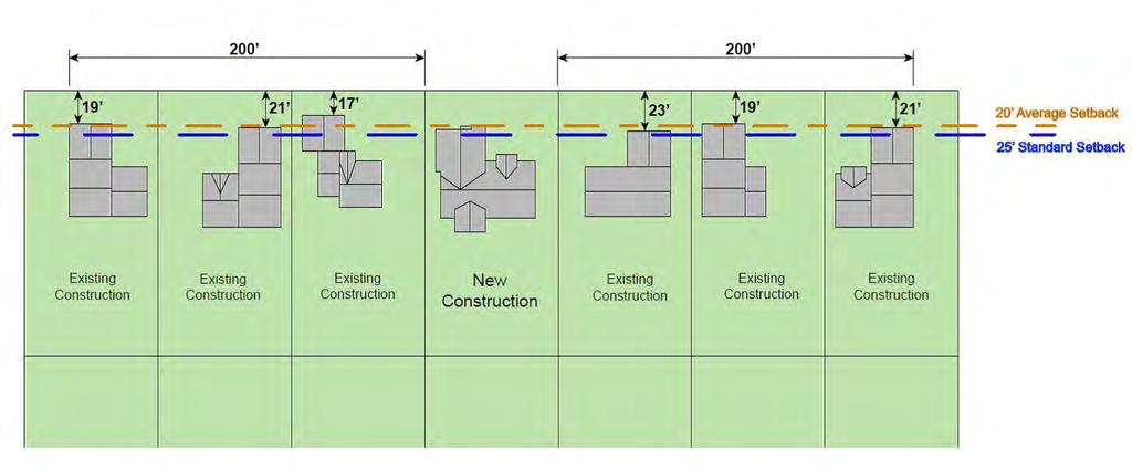
108 IV - 20
109 4.53 Setback Exceptions (A) Description Sight visibility triangle requirements supersede all setback requirements. Otherwise, every part of the required yard setback must be open and unobstructed from the ground to the sky except as set out in this subsection: (1) Trees, shrubbery or other landscape features may be located within any required setback; (1) Fences and walls may be located within any required setback. (2) Driveways and sidewalks may be located within any required setback; (3) Utility lines, wires and associated structures, such as power poles, may be located within any required setback; (4) Signs, where permitted, may be located within any required setback; (5) Uncovered decks, terraces, steps, earthworks and other similar landscaping or design elements placed directly on finished grade that do not exceed an average height of thirty (30) inches above the surrounding grade may project up to eight (8) feet into the required setback. Section 4.6 Structure Height 4.61 How to Measure Structure Height (A) Description Structure height shall be measured from the center point, or middle elevation of the structure pad to the peak of the roof. IV - 21
110 4.62 Exceptions (A) Items Excepted from Height Requirements (1) Chimneys and flues Section 4.7 Fences (2) Agricultural buildings (3) Appurtenances usually required to be placed above roof level and not intended for human occupancy Fence Standards (A) Height Standards District Maximum Height in Max. Side Max. Rear Max. Height in front yard or where Yard Height Yard Height Other Locations facing right of way (feet) Not (feet) Not (feet) Not Along (feet) Along Right Along Right of Right of Way of Way Way All Residential Districts (R1 R7) Neighborhood Commercial (C-4) Central Business District (C-1) Highway Commercial (C-2) General Commercial (C-3) & (B) Other Standards (1) Fences shall be set back no less than twelve (12) inches from all lot lines and a minimum of three (3) feet from alleys. (2) No fences shall be constructed of barbed wire, chicken wire, snow fence, or any other material which is deemed unsightly or hazardous by the Building Official. (3) Fences shall have an entrance no less than three and one-half (3.5) feet wide to allow access for emergency purposes. (4) These standards do not apply to temporary fences used in conjunction with construction or public events. (5) The sight visibility triangle requirements must be met as described in section IV - 22
111 Section 4.8 Property Pins 4.81 Property Pins Required (A) It shall be the responsibility of the property owner to pin property lines for new construction of primary structures. (B) If there is an existing structure, it is the property owner s responsibility to identify the property lines. The City shall not be liable for incorrect property lines Removal and Replacement No property pin or monument shall be removed, and if found to be removed, must be replaced by property owner. Section 4.9 Foundations 4.91 Minimum Foundations (A) All buildings and structures of a size of 100 square feet or more, and not otherwise required to have a foundation, shall be anchored by a minimum foundation of an approved floating concrete slab approved by the Building Official. (B) All buildings and structures, not otherwise required to have a foundation, and under 100 square feet in size, shall be anchored in a manner approved by the Building Official. IV - 23
112 Chapter 5 Permit Review and Application Section 5.0 Review and Decision-making Bodies 5.01 Council (A) Powers and Duties The Council shall make the final decision on the following applications and appeals provided in the Zoning Ordinance: (1) Zoning Ordinance Text Amendments The Council may from time to time amend, supplement, or change by ordinance the text of this Zoning Ordinance on its own initiative or upon application for a text amendment. (2) Zoning Map Amendments The Council shall be responsible for reviewing zoning map amendment (rezoning) applications and for taking the final action to approve or deny such applications. (3) Planned Unit Development (PUD) Amendments (a) PUD Conceptual Plan The Council shall be responsible for reviewing PUD Conceptual Plans and for taking the final action to approve, approve with conditions, or deny such applications. (b) PUD Final Plan The Council shall be responsible for reviewing PUD Final Plans and for taking the final action to approve, approve with conditions, or deny such applications. The Council is also responsible for reviewing PUD zoning map amendment applications, which are required to be processed along with the PUD Final Plan. (4) Conditional Use Permits The Council shall be responsible for reviewing and taking the final action to approve, approve with conditions, or deny Conditional Use Permit applications. (5) Subdivision Plats The Council shall be responsible for reviewing and taking the final action to approve, approve with conditions, or deny final subdivision plat applications. (B) Council and the Board of Adjustment (1) The Council will perform all duties of a Board of Adjustment as defined by the NDCC. (2) Duties (a) Zoning Variances V - 1
113 The Council shall be responsible for reviewing and taking final action to approve, approve with conditions, or deny zoning variance applications. (b) Appeals of Administrative Decisions The Council shall hear and decide appeals from affected parties regarding any order, requirement, decision, or determination made by an administrative official charged with the enforcement of this Zoning Ordinance Planning and Zoning Commission (A) Authority The P&Z Commission is created in accordance with North Dakota Century Code and includes the same powers and duties authorized for the Zoning P&Z Commission as provided in North Dakota Century Code section (or as modified) and planning P&Z Commissions as provided in North Dakota Century Code Chapter (or as modified). (B) Members P&Z Commission membership includes the following: (1) Five members to be appointed by the Mayor, with the approval of the Council. (2) One member residing outside the corporate limits of the City of Beulah, whose residence is located within the territorial limits of the zoning regulation authority exercised by the City of Beulah. (Said member to be appointed by the Mercer County Board of County P&Z Commissioners.) (C) Terms of Office The terms of office are determined by the North Dakota Century Code. (D) Powers and Duties (1) The P&Z Commission shall have such powers and shall perform such duties as provided for a Planning P&Z Commission as detailed in North Dakota Century Code. (2) The P&Z Commission shall act in an advisory capacity to the Council in any matter which may be assigned to the P&Z Commission for consideration and recommendation. (3) The P&Z Commission s powers and duties under this Ordinance are set out in this subsection (below). (a) Zoning Ordinance Text Amendments V - 2
114 The P&Z Commission shall be responsible for reviewing Ordinance text amendment applications and for recommending that the Council approve, approve with conditions, or deny such applications. (b) Zoning Map Amendments The P&Z Commission shall be responsible for reviewing zoning map amendment (rezoning) applications and for recommending that the Council approve, approve with conditions, or deny such applications. (c) Planned Unit Development (PUD) Overlay Amendments (i) PUD Conceptual Plan The P&Z Commission shall be responsible for reviewing PUD Conceptual Plans and for recommending that the Council approve, approve with conditions, or deny such applications. (ii) PUD Final Plan The P&Z Commission shall be responsible for reviewing PUD Final Plan applications and for recommending that the Council approve, approve with conditions, or deny such applications. (d) Conditional Use Permits The P&Z Commission shall be responsible for reviewing Conditional Use Permit applications and for recommending that the Council approve, approve with conditions, or deny such applications. (e) Subdivision Plats (i) (ii) The P&Z Commission shall be responsible for reviewing Preliminary Subdivision Plat applications and for recommending that the Council approve, approve with conditions, or deny such applications. The P&Z Commission shall be responsible for recommending that the Council approve or deny Final Subdivision Plat applications. (f) Building Permit Prior to building permit approval by the Building Official, the P&Z Commission may be provided notification of current building permits under review and provide comment on building permits as necessary pertaining to planning and zoning matters. The P&Z Commission may act to accept building permits subject to its purview. (g) Bonding and Fees The P&Z Commission may recommend that the Council approve, approve with conditions, or deny bonding and fee schedules pertaining to planning and zoning matters. (h) Variances The P&Z Commission shall be responsible for reviewing Variance applications and for recommending that the Council approve, approve with conditions, or deny such applications. V - 3
115 Section 5.1 Process (i) Other Matters The P&Z Commission shall have such other duties as determined from time-to-time by the Council and this Zoning Ordinance. Section 5.11 Building Permit Required The construction and/or maintenance of the following improvements requires a building permit. Consult with the Building Official if planning to construct or maintain any improvement not listed below. V - 4

116 Section 5.12 Building Permit Building Permit Process (see following pages red text for detail) Projects subject to review by Building Official Only 5.12.B.1 Administrative Review by the Building Official* Construct Project/Inspections No 5.12.A.1 Submit Permit Application* 5.12.A.2 Determine Application Completeness* Is P&Z Commission Review Needed? 5.13 End of Construction Certificate of Occupancy* Yes 5.12.B.2 Administrative Review by the Building Official and P&Z Accepted by P&Z Commission Construct Project/Inspections Projects subject to review by Building Official and P&Z Commission V - 5
117 (A) Application (1) Submit Permit Application* Building Permit applications shall be submitted to the Building Official in the appropriate form along with a non-refundable fee that has been established by a resolution of the Council. (2) Determine Application Completeness* (a) Building Permits may be issued only for development on legal lots where the plat creating the lot has been recorded by the County Recorder of Mercer County. This requirement may be waived by the P&Z Commission for development where the city has extraterritorial zoning jurisdiction, if the P&Z Commission is satisfied that roadway access and the provision of utilities can be properly provided without the platting process. (b) The applicant has verified the location of the lot lines for the subject lot. Lot line verification is the responsibility of the applicant. (c) The Building Official will determine when an application for a building permit is considered complete. In addition to the required fee, see the submittal checklist provided in section 5.12.A.2.d for all other required items. (d) Application Checklist (i) Site plan, drawn to scale, with dimensions. (ii) Floor plan, drawn to scale, with dimensions. (iii) Elevations, drawn to scale, with dimensions. (iv) Foundation plans, drawn to scale, with dimensions. (v) Elevation of final lot grade, drawn to scale, with dimensions. (B) Review and Action (1) Administrative review by the Building Official* (a) The following types of improvements/maintenance require administrative review. Note that the below list is not all-inclusive. The Building Official must be contacted to determine whether a building permit is required. (i) Siding (ii) Windows (iii) Exterior Doors (iv) Water and Sewer Tie-ins (v) Drain Tile (b) The Building Official will review all building plans and site plans, working with the applicant until all plans meet applicable Zoning Ordinance and building code requirements, as determined by the Building Official. The final lot grade shall be reviewed to ensure it does not pose a hazard to life or property on the subject lot or on adjacent lots. (c) When all required plans have been accepted and approved by the Building Official, the Building Permit is issued and the applicant is able to construct the project. V - 6
118 (d) Inspections must be completed to ensure compliance with the Zoning Ordinance, building code, and State Electrical and Plumbing Codes as determined applicable by the Building Official. Inspections are carried out by the Building Official or his designee. (e) When all required items on the Certificate of Occupancy checklist have been completed, a Certificate of Occupancy will be issued. (2) Administrative review by the Building Official and P&Z Commission* (C) Expiration (a) Administrative review and action by the Building Official and P&Z Commission applies to all projects not listed in section 5.12(B)(1)(a). (b) The Building Official will review all building plans and site plans, working with the applicant until all plans meet applicable Zoning Ordinance and building code requirements, as determined by the Building Official. (c) When all required plans have been accepted by the P&Z Commission, the Building Permit is issued and the applicant is able to construct the project. (d) The Building Official will notify the P&Z Commission of all permits in compliance with Zoning Ordinance requirements. (e) Inspections must be completed to ensure compliance with the Zoning Ordinance and building code. Inspections are carried out by the Building Official or his designee. (f) When all required items on the Certificate of Occupancy checklist have been completed, an Certificate of Occupancy will be issued, when applicable. In case construction has not begun within six (6) months after the date of issuance of a Building Permit, said permit shall be cancelled, unless an extension is granted by the P&Z Commission. (D) Failure to Obtain Permit All building permits must be obtained before any requested work is begun. Failure to obtain a building permit prior to the commencement of any work shall constitute a violation of this Zoning Ordinance. *See process chart on page V-5. Section 5.13 Certificate of Occupancy* (A) Permit Process Where a building permit has been approved, a Certificate of Occupancy shall be obtained prior to habitation or use of the structure. V - 7
119 (B) Permit Required It is unlawful to use or permit the use of any building or premises or part, hereafter created, erected, changed, converted, moved, altered or enlarged wholly, or partly in its use or structure, until a Certificate of Occupancy has been issued by the Building Official. Such permit shall show that such building or premises or part and the proposed use are in conformity with the provisions of the building code, State Electrical and Plumbing Codes, and this Zoning Ordinance. *See process chart on page V-5. Section 5.14 Demolition Permit (A) Permit Required A demolition permit is required to demolish any of the following improvements. Each improvement must be included in the permit. Each separate property must have a separate demolition permit. The Building Official shall be consulted regarding any item not listed below as to whether a demolition permit is required. (1) Garage (2) Shed (3) Sidewalk (4) Curb and Gutter (5) Driveway (6) Deck (7) Residence (8) Commercial Structure (9) Storage Unit (10) Communication Tower (11) Freestanding Sign (12) Swimming Pool that required a building permit for construction V - 8
120 Demolition Permit Process (see following text in red for detail) 5.14.B.1 Submit Application* 5.14.C.1 Building Official Review* 5.14.C.2 Permit Approval, Approval with Conditions, or Denial by Building Official* 5.14.C.3 State Environmental Mitigation Complete Prior to Demolition* (B) Application (1) Submit Permit Application* Demolition Permit applications shall be submitted to the Building Official in the appropriate form along with a non-refundable fee that has been established by a resolution of the Council. (2) Determine Application Completeness The Building Official will determine when an application for a demolition permit is considered complete. In addition to the required fee, see the submittal checklist provided in section 5.14.B.3 for all other required items. (3) Application Checklist (a) State Department of Health mitigation approval. (b) Ownership verification and approval. (c) Building Official approval. V - 9
121 (C) Review and Action (1) The Building Official will review the application for completeness.* (2) The Demolition Permit application shall be approved, approved with conditions, or denied by the Building Official. If approved, or approved with conditions, the Building Official shall issue the Demolition Permit. * (3) Any environmental mitigation activities required by the State of North Dakota Department of Health must be completed prior to Demolition.* Section 5.15 Temporary Permit (A) Permit Required *See process chart on page V-9. All temporary structures and temporary residences as listed in this Ordinance require a Temporary Permit. See Chapter 7, Definitions regarding what constitutes a temporary structure or residence. Temporary Permit Process (see following text in red for detail) 5.15.B Submit Application* 5.15.C.1 Building Official Review for Completeness and Recommendation* 5.15.C.2 P&Z Commission Approves, Approves with Conditions, or Denies Application * (B) Submit Application* (1) Application Temporary Permit applications shall be submitted to the Building Official in the appropriate form along with a non-refundable fee that has been established by a resolution of the Council. V - 10
122 (2) Determine Application Completeness The Building Official will determine when an application for a temporary permit is considered complete. In addition to the required fee, see the submittal checklist provided in section 5.15.B.3 for all other required items.* (3) Application Checklist (a) Site plan, drawn to scale, with dimensions. (b) Elevations and/or photos. (c) Written description of proposed use. (C) Review and Action (1) The Building Official will review the application for completeness and develop a recommendation for the P&Z Commission.* (2) The P&Z Commission may act to approve, approve with conditions, or deny the application. The action upon the temporary permit application may also be tabled by the P&Z Commission in order to allow for additional information requested of the applicant.* *See process chart on page V-10. V - 11
123 Section 5.16 Conditional Use Permit Conditional Use Permit Process (see following text in red for detail) 5.16.A Submit Application* 5.16.B.1 Building Official Review for Completeness and Recommendation* 5.16.D Notice of P&Z Commission Hearing and Council Hearing Given in Newspaper and to Adjacent Property Owners* 5.16.B.3 P&Z Commission Hearing and Recommendation * (A) Submit Application* (1) Application 5.16.B.4 Council Hearing and Decision to Approve, Approve with Conditions, or Deny Application Conditional Use Permit applications shall be submitted to the Building Official on an appropriate form along with a non-refundable fee that has been established by a resolution of the Council. (2) Processing Requirements The Building Official will determine when an application for a conditional use permit is considered complete. In addition to the required fee, see the submittal checklist provided in section 5.16.A.3 for all other required items. V - 12
124 (3) Application Checklist (a) (b) (c) (d) (e) (f) Site Plan, drawn to scale, with dimensions. Elevation of proposed structure(s), if structures are included. Project description, including detail on the daily or seasonal operations; number of employees, customers, visitors; number of shifts; activities; products and services; maximum living units proposed, as applicable. Non-refundable fee An amount to be determined by the City to cover estimated engineering and legal fees related to the project. Said amount shall be held in escrow by the City, and paid to the City Engineer and City Attorney upon completion of the project. Any engineering fees and/or costs outstanding after payment of the escrowed funds shall be the sole responsibility of applicant. Other items and information requested by the Building Official, P&Z Commission, or Council to evaluate the proposal s potential impacts on traffic, aesthetics, city utilities, noise, and other environmental impacts. (B) Review and Action (1) The Building Official will review the application for completeness and develop a recommendation based upon the review criteria in section 5.16(C).* (2) The P&Z Commission will be advised of the application and provided with the Building Official s recommendation. (3) The P&Z Commission shall hold a public hearing for the conditional use permit request. The P&Z Commission will thereafter make a recommendation to the Council to approve, approve with conditions, or deny the application. The action upon the application may also be tabled by the P&Z Commission in order to allow for additional information requested of the applicant. The P&Z Commission will use the criteria located in section 5.16(C) as guidance to determine if a Conditional Use Permit should be approved.* (4) The Council shall hold a public hearing on the proposed conditional use permit. The Council may act to approve, approve with conditions, or deny the application. The action upon the application may also be tabled by the Council in order to allow for additional information requested of the applicant. The Council will use the criteria located in section 5.16(C) as guidance to determine if a Conditional Use Permit should be approved.* (C) Criteria A Conditional Use Permit may not be approved unless the Council finds that all of the following criteria, as applicable, have been satisfied: (1) The proposed use is in harmony with the purpose and intent of this Zoning Ordinance, applicable zoning district, and with the purpose and intent of the Comprehensive Plan. V - 13
125 (2) If applicable, the proposed use will comply with all special standards established in Chapter 3. (3) Adequate utility, drainage, and other such necessary facilities and services have been or will be provided at the time of development. (4) Adequate access roads or entrance and exit drives will be provided and be so designed to prevent traffic hazards and to minimize traffic congestion in public streets. (D) Notice of Public Hearing (1) Newspaper Notice is to be published in the official newspaper of the City at least once each week for 2 successive weeks and not less than 15 days preceding the date of each scheduled public hearing (not necessary for hearings after a continuation of the application). (2) Adjacent Properties Written notice shall be provided by first class mail to all owners of the subject property and all property owners within 300 feet of the subject property. The notice shall be deposited in the U.S. mail at least 15 days before the scheduled public hearings (not necessary for hearings after a continuation of the application). (E) Appeal Process An appeal of the Council decision may be made to the district court. (F) Amendments The process for amendments to conditional use permits is the same as required for a new application. *See process chart on page V-12. V - 14
126 Section 5.17 Variance (A) Variance Restrictions A variance can only be considered in the following areas: (1) Height (2) Yard/setbacks (3) Lot area (4) Lot coverage (5) Off-street parking and loading requirements (6) Sight visibility triangle (7) Sign area (8) Sign height Variance Process (see following text in red for detail) 5.17.B Submit Application* 5.17.C.1 Building Official Review for Completeness and Recommendation* 5.17.C.3 P&Z Commission Review and Recommendation* (B) Submit Application* 5.17.C.4 Council Review and Decision to Approve, Approve with Conditions, or Deny Application* (1) Application Variance applications shall be submitted to the Building Official on the appropriate form along with a non-refundable fee that has been established by a resolution of the Council. V - 15
127 (2) Processing Requirements The Building Official will determine when an application for a variance is considered complete. In addition to the required fee, see the submittal checklist provided in section 5.17.B.3 for all other required items. (3) Application Checklist (C) Review and Action (D) Criteria (a) Site Plan, drawn to scale, with dimensions. (b) Elevation(s) of proposed structures (for height variances only). (c) Written statement of hardship. (d) Written notice provided by first class mail to all owners of the subject property and all property owners within 300 feet of the subject property. The notice shall be deposited in the U.S. mail at least 15 days before the scheduled meetings of P&Z Commission and Council (not necessary for hearings after a continuation of the application). (1) The Building Official will review the application for completeness and develop a recommendation based upon the review criteria in section 5.17(D).* (2) The P&Z Commission will receive the application as well as the Building Official s recommendation. (3) The P&Z Commission will thereafter make a recommendation to the Council to approve, approve with conditions, or deny the application. The action upon the application may also be tabled by the P&Z Commission in order to allow for additional information requested of the applicant. The P&Z Commission will use the criteria located in section 5.17(D) as guidance to determine if a variance should be approved.* (4) The Council will act to approve, approve with conditions, or deny the application. The action upon the application may also be tabled by the Council in order to allow for additional information requested of the applicant. The Council will use the criteria located in section 5.17(D) as guidance to determine if a variance should be approved.* A Variance may not be approved unless the Council finds that all of the following criteria, as applicable, have been satisfied: (1) The requested variance arises from conditions that are unique to the subject property, that are not ordinarily found in the same zoning district. (2) The request is not made to satisfy the owner s convenience. (3) The granting of the permit for the variance will not adversely affect the rights of adjacent property owners or residents. V - 16
128 (4) The strict application of the applicable zoning standards will constitute an unnecessary physical hardship (not economic hardship). (5) The variance desired will not adversely affect the public health, safety or general welfare. (6) The variance is the minimum variance that will overcome the hardship. (E) Appeal Process An appeal of the Council decision may be made to the district court. *See process chart on page V-15. V - 17

129 Section 5.18 Zoning District Map Amendment Zoning District Map Amendment Process (see following text in red for detail) 5.18.A Submit Application* 5.18.B.1 Building Official Review for Completeness and Recommendation* 5.18.D Notice of P&Z Commission Hearing and Council Hearing Given in Newspaper and to Adjacent Property Owners* 5.18.B.4 P&Z Commission Hearing and Recommendation* 5.18.B.5 Council Hearing and Decision to Approve, Approve with Conditions, or Deny Application and First Reading of Ordinance* 5.18.B.6 Second Reading of Amending Ordinance* 5.18.B.7 Update Zoning District Map by Formal Resolution* V - 18
Midwest City, Oklahoma Zoning Ordinance
 2010 Midwest City, Oklahoma Zoning Ordinance 9/2/2010 Table of Contents Section 1. General Provisions... 5 1.1. Citation... 5 1.2. Authority... 5 1.3. Purpose... 5 1.4. Nature and Application... 5 1.5.
The following regulations shall apply in the R-E District:
 "R-E" RESIDENTIAL ESTATE DISTRICT (8/06) The following regulations shall apply in the R-E District: 1. Uses Permitted: The following uses are permitted. A Zoning Certificate may be required as provided
LAND USE AND ZONING OVERVIEW
 OVERVIEW OF PLANNING POLICIES LAND USE AND ZONING OVERVIEW The Minneapolis Plan for Sustainable Growth and Other Adopted Plans Community Planning and Economic Development Development Services Division
Subchapter 5 Zoning Districts and Limitations
 Subchapter 5 Zoning Districts and Limitations 35.5.1 Rural Districts Sections: 35.5.1.1 Purpose. 35.5.1.2 Permitted Uses. 35.5.1.3 General Regulations. 35.5.1.1 Purpose. The purpose of a Rural District
ARTICLE VII. NONCONFORMITIES. Section 700. Purpose.
 ARTICLE VII. NONCONFORMITIES. Section 700. Purpose. The purpose of this chapter is to regulate and limit the development and continued existence of legal uses, structures, lots, and signs established either
City of Valdosta Land Development Regulations
 Chapter 206 Section 206-1 Base Zoning Districts Standards for Uses, Structures, and Property Development (B) (C) Principal Uses and Structures. Principal uses and structures permitted in each base zoning
Salem Township Zoning Ordinance Page 50-1 ARTICLE 50.0: PUD PLANNED UNIT DEVELOPMENT
 Salem Township Zoning Ordinance Page 50-1 ARTICLE 50.0 PLANNED UNIT DEVELOPMENT Section 50.01 Purpose The provisions of this Article provide enabling authority and standards for the submission, review,
Glades County Staff Report and Recommendation REZONING
 Glades County Staff Report and Recommendation REZONING CASE NUMBER: RZ15-01 DATE: October 2, 2015 CASE TYPE: Application for Rezoning REQUEST: J.J. Wiggins Memorial Trust is requesting a rezoning of 22.1±
Glades County Staff Report and Recommendation Unified Staff Report for Small Scale Plan Amendment and Rezoning
 Glades County Staff Report and Recommendation Unified Staff Report for Small Scale Plan Amendment and Rezoning CASE NUMBERS: COMP17-02 and RZ17-02 DATE of STAFF REPORT: May 1, 2017 CASE TYPE: Application
UPPER MOUNT BETHEL TOWNSHIP NORTHAMPTON COUNTY, PENNSYLVANIA
 UPPER MOUNT BETHEL TOWNSHIP NORTHAMPTON COUNTY, PENNSYLVANIA JOINDER DEED / LOT CONSOLIDATION TOWNSHIP REVIEW PROCESS When accepting proposed Joinder Deeds / Lot Consolidations, review the Joinder Deed
COMMERCIAL SITE DEVELOPMENT GUIDE FOR UNINCORPORATED ST. CHARLES COUNTY
 COMMERCIAL SITE DEVELOPMENT GUIDE FOR UNINCORPORATED ST. CHARLES COUNTY GENERAL INFORMATION: This brochure is to be used as a guide and is not intended to amend or supersede the corresponding County ordinances
Draft Model Access Management Overlay Ordinance
 Draft Model Access Management Overlay Ordinance This model was developed using the City of Hutchinson and the Trunk Highway 7 corridor. The basic provisions of this model may be adopted by any jurisdiction
CHAPTER 10 Planned Unit Development Zoning Districts
 CHAPTER 10 Planned Unit Development Zoning Districts Section 10.1 Intent and Purpose The Planned Unit Development (PUD) districts are intended to offer design flexibility for projects that further the
Town of Windham Land Use Ordinance Sec. 400 Zoning Districts SECTION 400 ZONING DISTRICTS
 Town of Windham Land Use Ordinance Sec. 400 Zoning Districts Sections SECTION 400 ZONING DISTRICTS SECTION 400 ZONING DISTRICTS 4-1 401 Districts Enumerated 4-2 402 Location of districts; Zoning Map 4-2
THE CITY OF RAYMORE, MISSOURI Single-Family Residential Zoning Districts
 THE CITY OF RAYMORE, MISSOURI Single-Family Residential Zoning Districts REGULATIONS COMMON TO ALL DISTRICTS: Uses permitted in each district include detached single-family dwellings, manufactured homes
ARTICLE 7. SPECIFIC USE STANDARDS
 ARTICLE 7. SPECIFIC USE STANDARDS Section 7.1 Applicability The following standards apply to specified uses in all zoning districts in which such uses are allowed. Section 7.2 Accessory Apartments (A)
LINCOLN COUNTY FLOOD DAMAGE PREVENTION ORDINANCE
 LINCOLN COUNTY FLOOD DAMAGE PREVENTION ORDINANCE SECTION 1.0 STATUTORY AUTHORIZATION, FINDINGS OF FACT, PURPOSE AND OBJECTIVES SECTION 2 DEFINITIONS SECTION 3.0 GENERAL PROVISIONS SECTION 4.0 ADMINISTRATION
CHAPTER 14 PLANNED UNIT DEVELOPMENTS
 9-14-1 9-14-1 CHAPTER 14 PLANNED UNIT DEVELOPMENTS SECTION: 9-14-1: Purpose 9-14-2: Governing Provisions 9-14-3: Minimum Area 9-14-4: Uses Permitted 9-14-5: Common Open Space 9-14-6: Utility Requirements
CITY OF PORT ORCHARD
 CITY OF PORT ORCHARD ZONING DESIGNATIONS (Adapted from POMC Chapter 20.34 Zoning Districts, as adopted 6/13/2017) 20.34.110 Greenbelt zone (Gb). (1) Purpose. It is the purpose of the greenbelt zone to
1101 MAIN STREET ANDREWS NC PHONE FAX MAYOR NANCY J. CURTIS MEMORANDUM
 1101 MAIN STREET ANDREWS NC 28901 PHONE 828-321-3113 FAX 828-321-4159 MAYOR NANCY J. CURTIS ALDERMAN RAY FRAZIER ALDERMAN JERRY PULLIUM ALDERMAN GARY JAMES ALDERMAN PHIL HORTON MEMORANDUM March 7, 2017
APPLICANT NAME SUBDIVISION NAME DEVELOPMENT NAME LOCATION. CITY COUNCIL DISTRICT Council District 4 PRESENT ZONING PROPOSED ZONING
 SUBDIVISION, PLANNED UNIT DEVELOPMENT, PLANNING APPROVAL, ZONING AMENDMENT, & SIDEWALK WAIVER REQUEST STAFF REPORT Date: February 17, 2010 APPLICANT NAME SUBDIVISION NAME DEVELOPMENT NAME LOCATION David
Title 6 - Local Government Provisions Applicable to Special Purpose Districts and Other Political Subdivisions
 Title 6 - Local Government Provisions Applicable to Special Purpose Districts and Other Political Subdivisions CHAPTER 29. SOUTH CAROLINA LOCAL GOVERNMENT COMPREHENSIVE PLANNING ENABLING ACT OF 1994 1994
GREENCASTLE, INDIANA Zoning Ordinance
 GREENCASTLE, INDIANA Zoning Ordinance CITY OF GREENCASTLE - ZONING ORDINANCE Table of Contents Prepared by: Urban Planning Architecture Interior Design Landscape Architecture Historic Preservation RATIO
TABLE OF CONTENTS. 1.1 Official Title Effective date Authority
 Chapter 1: GENERAL PROVISIONS TABLE OF CONTENTS 1.1 Official Title... 1-1 1.2 Effective date... 1-1 1.3 Authority... 1-1 1.3.1 General Authority... 1-1 1.3.2 References to North Carolina General Statutes...
NEW AND REVISED. Organization, format and editing. Numbering, page layout, tables, charts, illustrations General editing and plain English voice
 NEW AND REVISED Organization, format and editing Numbering, page layout, tables, charts, illustrations General editing and plain English voice ORGANIZATION AND FORMAT Chapter 1 Introductory Provisions
Town of Truckee. Contents. Article I - Development Code Enactment and Applicability. Chapter Purpose and Effect of Development Code...
 Town of Truckee TITLE 18 - DEVELOPMENT CODE Article I - Development Code Enactment and Applicability Chapter 18.01 - Purpose and Effect of Development Code... I-3 18.01.010 - Title... I-3 18.01.020 - Purposes
Exceptions to minimum yard requirement... V-1 Exchanges, PDD... V-25 Incentives, PDD... V-24 Extraction and junkyard uses, defined...
 INDEX Accessory Dwelling Unit...IV-10 Accessory Structures V-32 Accessory uses Residential Only antennas... V-37 family child care home... V-36 home occupations... V-34 limitations on... V-33 private swimming
Staff Report: Date: Applicant: Property Identification: Acreage of Request: Current Zoning of Requested Area: Requested Action: Attached:
 Staff Report: Completed by Jeff Palmer Director of Planning & Zoning Date: November 7, 2018, Updated November 20, 2018 Applicant: Greg Smith, Oberer Land Developer agent for Ronald Montgomery ET AL Property
ZONING AMENDMENT & SUBDIVISION STAFF REPORT Date: July 3, 2014
 ZONING AMENDMENT & SUBDIVISION STAFF REPORT Date: July 3, 2014 APPLICANT NAME SUBDIVISION NAME LOCATION Georgia Crown Distributing Subdivision Georgia Crown Distributing Subdivision Southwest corner of
Prince Edward County Zoning Ordinance. Effective October 1, 2007
 Prince Edward County Zoning Ordinance Effective October 1, 2007 ARTICLE I GENERAL PROVISIONS...6 SEC. 1-100 TITLE AND AUTHORITY...6 SEC. 1-102 JURISDICTION...6 SEC. 1-104 PURPOSE...6 SEC. 1-106 EFFECTIVE
Appendix A: Guide to Zoning Categories Prince George's County, Maryland
 Appendix A: Guide to Zoning Categories Prince George's County, Maryland RESIDENTIAL ZONES 1 Updated November 2010 R-O-S: Reserved Open Space - Provides for permanent maintenance of certain areas of land
AGENDA ITEM SUMMARY GLADES COUNTY BOARD OF COUNTY COMMISSIONERS
 AGENDA ITEM SUMMARY GLADES COUNTY BOARD OF COUNTY COMMISSIONERS SUBJECT: Case Number COMP17-01, Legend Moto LLC This is a Legislative Hearing. DEPARTMENT REQUEST: The Community Development Department requests
CCC XXX Rural Neighborhood Conservation (NC)
") CCC 33.10.XXX Rural Neighborhood Conservation (NC) Purpose: Maintain low density rural residential areas and associated uses commonly found in rural areas consistent with the local character of the distinctive
CCC 33.10.XXX Rural Neighborhood Conservation (NC) Purpose: Maintain low density rural residential areas and associated uses commonly found in rural areas consistent with the local character of the distinctive
SUBDIVISION, PLANNED UNIT DEVELOPMENT, PLANNING APPROVAL, ZONING AMENDMENT, & SIDEWALK WAIVER REQUEST STAFF REPORT Date: February 17, 2010
 SUBDIVISION, PLANNED UNIT DEVELOPMENT, PLANNING APPROVAL, ZONING AMENDMENT, & SIDEWALK WAIVER REQUEST STAFF REPORT Date: February 17, 2010 APPLICANT NAME SUBDIVISION NAME DEVELOPMENT NAME LOCATION David
DEVELOPMENT DEPARTMENT STAFF REPORT THE PARK AT 5 TH
 DEVELOPMENT DEPARTMENT STAFF REPORT ARB Meeting Date: July 3, 2018 Item #: _PZ2018-293_ THE PARK AT 5 TH Request: Site Address: Project Name: Parcel Number: Applicant: Proposed Development: Current Zoning:
Amendments to Chapter proposed by the Assembly Title 21 Committee
 Amendments to Chapter 21.04 proposed by the Assembly Title 21 Committee All page numbers refer to the S version. PZC recommended additions are underlined. PZC recommended deletions are in [BRACKETS AND
DIVISION I. GENERAL ZONING... 6
 TABLE OF CONTENTS DIVISION I. GENERAL ZONING... 6 CHAPTER 17.02 GENERAL PROVISIONS... 6 17.02.010 AUTHORITY... 6 17.02.020 SHORT TITLE... 6 17.02.030 APPLICABILITY AND JURISDICTION... 6 17.02.040 PURPOSE...
NOTICE OF LAND USE DECISION BY THE COOS COUNTY PLANNING DIRECTOR
 NOTICE OF LAND USE DECISION BY THE COOS COUNTY PLANNING DIRECTOR Coos County Planning 225 N. Adams St. Coquille, OR 97423 http://www.co.coos.or.us/ Phone: 541-396-7770 Fax: 541-396-1022 This notice is
Draft Zoning Changes for the 2nd Planning Board Public Hearing, January 22, 2018.
 Draft Zoning Changes for the 2nd Planning Board Public Hearing, January 22, 2018. No changes were made at the 1st Public Hearing. Proposed wording for the 1 st Public Hearing in red, eliminated text in
ARTICLE III District Regulations. A map entitled "Franklin Zoning Map" is hereby adopted as part of this chapter 1.
 ARTICLE III District Regulations ~ 305-8. Adoption of Zoning Map. A map entitled "Franklin Zoning Map" is hereby adopted as part of this chapter 1. ~ 305-9. Official Zoning Map; amendments. Regardless
PLANNING COMMISSION REPORT Regular Agenda Public Hearing Item
 PC Staff Report 11/12/12 Item No. 2B- 1 PLANNING COMMISSION REPORT Regular Agenda Public Hearing Item ITEM NO. 2B: A TO GPI; 110 ACRES; E OF K-10 & N OF W 6 TH ST (MKM) : Consider a request to rezone approximately
CHAPTER 3 PRELIMINARY PLAT
 10-3-1 10-3-3 SECTION: CHAPTER 3 PRELIMINARY PLAT 10-3-1: Consultation 10-3-2: Filing 10-3-3: Requirements 10-3-4: Approval 10-3-5: Time Limitation 10-3-6: Grading Limitation 10-3-1: CONSULTATION: Each
Staff Report: Date: Applicant: Property Identification: Acreage of Request: Current Zoning of Requested Area: Requested Action: Attached:
 Staff Report: Completed by Jeff Palmer Director of Planning & Zoning Date: November 7, 2018 Applicant: Greg Smith, Oberer Land Developer agent for Ronald Montgomery ET AL Property Identification: Frontage
4.2 RESIDENTIAL ZONING DISTRICTS
 4.2 RESIDENTIAL ZONING DISTRICTS A. Purpose: To define regulations and standards for each residential zoning district in the City. The following sections identify uses, regulations, and performance standards
DIVISION 1 PURPOSE OF DISTRICTS
 ARTICLE 2 ZONING DISTRICTS AND MAP DIVISION 1 PURPOSE OF DISTRICTS Section 2.101 Zoning Districts. For the purpose of this Ordinance, the City of Richmond is hereby divided into districts as follows: DISTRICT
TOWNSHIP OF SOLON COUNTY OF KENT, MICHIGAN. Members: Robert Ellick, Fred Gunnell, Mark Hoskins, Mary Lou Poulsen
 As recommended by Planning Commission at its December 27, 2017 meeting TOWNSHIP OF SOLON COUNTY OF KENT, MICHIGAN At a regular meeting of the Township Board of the Township of Solon, Kent County, Michigan,
Metropolitan Planning Commission. DATE: April 5, 2016
 TO: FROM: Metropolitan Planning Commission MPC Staff DATE: April 5, 2016 SUBJECT: Petition of Nine Line Inc. Robert McCorkle, Agent PIN: 2-1034-01-002 380.5 Acres Aldermanic District: 5 (Shabazz) County
FREQUENTLY USED PLANNING & ZONING TERMS
 City Of Mustang FREQUENTLY USED PLANNING & ZONING TERMS Abut: Having property lines, street lines, or zoning district lines in common. Accessory Structure: A structure of secondary importance or function
CONDITIONAL USE PERMIT (CUP)
") CONDITIONAL USE PERMIT (CUP) LAND DEVELOPMENT APPLICATION FORM DEPARTMENT OF PLANNING 300 East Main Street, Sun Prairie, WI 53590-2227 (608)825-1107 FAX (608)825-1194 Applications will not be processed
CONDITIONAL USE PERMIT (CUP) LAND DEVELOPMENT APPLICATION FORM DEPARTMENT OF PLANNING 300 East Main Street, Sun Prairie, WI 53590-2227 (608)825-1107 FAX (608)825-1194 Applications will not be processed
St. Mary s County Comprehensive Zoning Ordinance Article 1. GENERAL PROVISIONS
 0 0 0 0 ARTICLE. GENERAL PROVISIONS CHAPTER 0 TITLE, PURPOSE AND ORGANIZATION Sections: 0. Title. 0. Authority. 0. Purpose. 0. Organization of the Zoning Ordinance. 0. Official Zoning Map. 0. Applicability.
DEVELOPMENT DEPARTMENT STAFF REPORT DRESDEN HEIGHTS PHASE II DCI
 DEVELOPMENT DEPARTMENT Meeting Date: January 10, 2019 Item #: PZ2019-393 Project Name: Applicant and Owner: Proposed Development: Requests: STAFF REPORT DRESDEN HEIGHTS PHASE II DCI Dresden Heights Phase
PUBLIC DRAFT May 2017 Zoning Districts Use Regulations Definitions (partial)
") PUBLIC DRAFT May 2017 Zoning Districts Use Regulations Definitions (partial) Table of Contents Subchapter 1: General Provisions... 1 Subchapter 2: Administration & Procedures... 3 Subchapter 3: Zoning
PUBLIC DRAFT May 2017 Zoning Districts Use Regulations Definitions (partial) Table of Contents Subchapter 1: General Provisions... 1 Subchapter 2: Administration & Procedures... 3 Subchapter 3: Zoning
Truckee Development Code User s Guide TOWN OF TRUCKEE. A. Introduction...3. B. Organization of the Development Code 3
 TOWN OF TRUCKEE Development Code User s Guide A. Introduction...3 B. Organization of the Development Code 3 I. Development Code Enactment and Applicability.3 II. Zoning Districts and Allowable Land Uses....4
Chapter 1107: Zoning Districts
 Chapter 1107: Zoning Districts 1107.01 Establishment of Zoning Districts (a) Districts Established In order to carry out the purpose of this code, the City is hereby divided into the zoning districts established
SECTION 4 ZONING DISTRICTS
 SECTION 4 ZONING DISTRICTS Sec. 4-1 Establishment of Districts. In order to protect the character of existing neighborhoods, to prevent excessive density of population in areas which are not adequately
CHAPTER 50 LAND USE ZONES ARTICLE 50 BASIC PROVISIONS
 CHAPTER 50 LAND USE ZONES ARTICLE 50 BASIC PROVISIONS 50.010 - PURPOSE The purposes of this chapter are to establish land use zones required to implement the goals and policies of the Klamath County Comprehensive
PRELIMINARY SUBDIVISION PLAN APPLICATION
 PRELIMINARY SUBDIVISION PLAN APPLICATION CHESAPEAKE PLANNING DEPARTMENT APPLICATION NUMBER: (Assigned by Chesapeake Planning Department) GENERAL INFORMATION 1. Name of Subdivision: 2. Applicant(s): Address:
ARTICLE Encourage well planned, efficient development.
 ARTICLE 14.00 PD PLANNED SECTIONS: 14.01 Intent 14.02 Procedure 14.03 Initial Development Plan 14.04 Final Development Plan 14.05 Amendments 14.06 Planned Development Districts PD-1 Willow Run PD PD-2
Mohave County General Plan
 63 64 65 66 67 68 69 70 71 The Land Use Diagram is not the County's zoning map. 13 It is a guide to future land use patterns. Zoning and area plan designations may be more restrictive than the land use
1. Multi-family dwellings, including town homes, apartments, or condominiums.
 Sec. 4-6.67 Planned Unit Development (PUD-M). a. Definition. A planned multi-family zoning district of three acres or more, consisting of townhouses, apartments, condominiums, single-family detached, single-family
AGENDA. a. Carol Crews Special Exception Hair Salon (Continued from February) b. James Barber Special Exception Horse
 b. James Barber Special Exception Horse") Baker County Land Planning Agency (LPA) Thursday, April 23, 2015 Baker County Administration Building 55 North Third Street Macclenny, FL 32063 (904) 259-3354 AGENDA 5:OO P.M. LDR Mining Workshop A. Draft
Baker County Land Planning Agency (LPA) Thursday, April 23, 2015 Baker County Administration Building 55 North Third Street Macclenny, FL 32063 (904) 259-3354 AGENDA 5:OO P.M. LDR Mining Workshop A. Draft
ARTICLE 3: Zone Districts
 ARTICLE 3: Zone Districts... 3-1 17.3.1: General...3-1 17.3.1.1: Purpose and Intent... 3-1 17.3.2: Districts and Maps...3-1 17.3.2.1: Applicability... 3-1 17.3.2.2: Creation of Districts... 3-1 17.3.2.3:
PART 3 RESIDENTIAL ZONING DISTRICTS. Designation of Residential Zoning Districts and Purpose Statements.
 PART 3 S Section 301. Designation of and Purpose Statements. See Table 3-1 herein this Section for the designations and purpose statements of the respective Residential Zoning Districts which are shown
PICKENS COUNTY UNIFIED DEVELOPMENT STANDARDS ORDINANCE. Organization of the Ordinance
 PICKENS COUNTY UNIFIED DEVELOPMENT STANDARDS ORDINANCE Organization of the Ordinance Article 1. Article 2. Article 3. Article 4. Article 5. Article 6. Article 7. Adoption, Applicability and Interpretation
;ARTICLE 27N. SOUTH BOSTON SEAPORT BUFFER ZONE INTERIM PLANNING OVERLAY DISTRICT (;Article inserted on December 6, 1997*, rescinded on July 22, 1999)
") ;ARTICLE 27N SOUTH BOSTON SEAPORT BUFFER ZONE INTERIM PLANNING OVERLAY DISTRICT (;Article inserted on December 6, 1997*, rescinded on July 22, 1999) SECTION 27N-1. Statement of Purpose. The purposes of
;ARTICLE 27N SOUTH BOSTON SEAPORT BUFFER ZONE INTERIM PLANNING OVERLAY DISTRICT (;Article inserted on December 6, 1997*, rescinded on July 22, 1999) SECTION 27N-1. Statement of Purpose. The purposes of
Residential Project Convenience Facilities
 Standards for Specific Land Uses 35.42.220 E. Findings. The review authority shall approve a Land Use Permit in compliance with Subsection 35.82.110.E (Findings required for approval) or a Conditional
Application for Sketch Plan Review
 Town of Standish 175 Northeast Road Standish, ME - 04084 Phone: (207)642-3461 Fax: (207) 642-5181 Application for Sketch Plan Review Applicant & Owner Information 1) Name of Applicant: Address: Phone:
SUBDIVISION, PLANNED UNIT DEVELOPMENT, & PLANNING APPROVAL STAFF REPORT Date: February 1, 2007
 SUBDIVISION, PLANNED UNIT DEVELOPMENT, & PLANNING APPROVAL STAFF REPORT Date: February 1, 2007 DEVELOPMENT NAME SUBDIVISION NAME Pala Verde Mobile Home Park Subdivision Pala Verde Mobile Home Park Subdivision
PROPOSED AMENDMENTS TO THE DERBY ZONING REGULATIONS AUGUST 12, 2008
 ARTICLE II Definitions and word usage 195-7. Definitions and word usage. Modify the following: HOUSING FOR THE ELDERLY OLDER PERSONS Housing in accordance with and as defined in the United States Fair
Planning & Zoning Commission Meeting Date: 11/14/2018 Submitted By: Janice Pokrant, Engineering Department. 3.a. Information SUBJECT:
 Planning & Zoning Commission Meeting Date: 11/14/2018 Submitted By: Janice Pokrant, Engineering Department 3.a. SUBJECT: Information Conduct a Public Hearing and Consider a Request for Zoning Change Appeal
AN ORDINANCE TO AMEND SECTION OF THE RAPID CITY MUNICIPAL CODE TO ALLOW FOR ADMINISTRATIVE DISSOLUTION OF PLANNED DEVELOPMENTS
 Ordinance No. 6231 AN ORDINANCE TO AMEND SECTION 17.50.050 OF THE RAPID CITY MUNICIPAL CODE TO ALLOW FOR ADMINISTRATIVE DISSOLUTION OF PLANNED DEVELOPMENTS WHEREAS, the City of Rapid City has adopted a
ARTICLE 3 ZONING DISTRICTS AND ZONING MAP. Table of Contents
 ARTICLE 3 ZONING DISTRICTS AND ZONING MAP Table of Contents 3-1 Establishment of Zoning Districts... 1 A. General Use Zoning Districts... 1 B. Conditional Zoning Districts... 3 C. Overlay Zoning Districts...
Unified Development Ordinance. Pulaski County, Virginia
 Unified Development Ordinance Pulaski County, Virginia Adopted October 26, 2015 Amendments Adopted: October 26, 2015 Pulaski County Unified Development Ordinance Page 2 of 155 Table of Contents Article
CITY OF HENDERSON TABLE OF CONTENTS. Section 101: Purpose... 1 Section 102: Authority... 1 GENERAL REGULATIONS APPLIED TO ALL DISTRICTS
 TABLE OF CONTENTS ARTICLE 100: PURPOSE AND AUTHORITY Section 101: Purpose... 1 Section 102: Authority... 1 ARTICLE 200: GENERAL REGULATIONS APPLIED TO ALL DISTRICTS Section 201: Jurisdiction and Zoning
1. Cuyler-Brownsville planned neighborhood conservation (P-N-C) districtphase I (section ). (2) Single-family semiattached dwellings;
 districtphase I (section ). (2) Single-family semiattached dwellings;") Sec. 8-3035. Planned unit development multifamily (PUD-M). A. Purpose. The PUD-M district is intended to allow a variety of residential development including single-family residential, two-family residential,
Sec. 8-3035. Planned unit development multifamily (PUD-M). A. Purpose. The PUD-M district is intended to allow a variety of residential development including single-family residential, two-family residential,
ABILENE ZONING REGULATIONS TABLE OF CONTENTS
 ABILENE ZONING REGULATIONS TABLE OF CONTENTS ARTICLE SECTION TITLE PAGE 1 TITLE AND PURPOSE 1-1 Title. 1-1 1-2 Purpose and Intent.. 1-1 1-3 Consistency with Comprehensive Plan 1-2 1-4 Jurisdiction. 1-2
Part 4, C-D Conservation District
 The Township is divided into the districts set forth by this chapter and as shown by the district boundaries on the Official Zoning District Map. The zoning districts are: C-D Conservation District A-1
DRAFT PARK COUNTY US HIGHWAY 89 SOUTH EAST RIVER ROAD OLD YELLOWSTONE TRAIL ZONING DISTRICT REGULATIONS
 Formatting: Changes recommended by the Board and accepted by the County Commission are formatted in RED: Changes made by the Park County Commission are formatted in YELLOW highlight: and changes made by
SECTION CLASSIFICATION OF ZONES For the purpose of this Code the following primary land use zoning districts are hereby established:
 ARTICLE 4 ZONING DISTRICTS SECTION 4.010 CLASSIFICATION OF ZONES For the purpose of this Code the following primary land use zoning districts are hereby established: Primary Zones Abbreviated Designation
REZONING APPLICATION INSTRUCTIONS
 REZONING APPLICATION INSTRUCTIONS All required information, as stated on the Rezoning Application Checklist, must be included to qualify as a complete application. Upon receipt, staff will review the application
CHAPTER 3 PERMITS, PLANS AND ANNEXATION
 CHAPTER 3 PERMITS, PLANS AND ANNEXATION SECTION: 10-3-1: General Regulations 10-3-2: Building Permit 10-3-3: Plans 10-3-4: Certificate of Compliance and Occupancy 10-3-5: Conditional Use Permits 10-3-6:
O-I (Office-Institutional) and AG-1(Agricultural)
 and AG-1(Agricultural)") PROPERTY INFORMATION ADDRESS 3503 and 3505 Bethany Bend DISTRICT, LAND LOTS 2/1 973 and 974 OVERLAY DISTRICT State Route 9 PETITION NUMBERS EXISTING ZONING O-I (Office-Institutional) and AG-1(Agricultural)
PROPERTY INFORMATION ADDRESS 3503 and 3505 Bethany Bend DISTRICT, LAND LOTS 2/1 973 and 974 OVERLAY DISTRICT State Route 9 PETITION NUMBERS EXISTING ZONING O-I (Office-Institutional) and AG-1(Agricultural)
Temporary Use Permit. A guide to the Application Process
 A guide to the Application Process Temporary Use Permit Planning Services Department, 50 West 13th Street, Dubuque, IA 52001-4864 (563) 589-4210 e-mail: planning@cityofdubuque.org Temporary Use Permit
Special Use Permit - Planned Unit Development Checklist. Property Address:
 Special Use Permit - Planned Unit Development Checklist Special Use Permit Number. Parcel Code/s #28-11- - - Property Address: Applicant: ARTICLE VIII Ordinance Reference - Section 8.1.2 Permit Procedures:
4. facilitate the construction of streets, utilities and public services in a more economical and efficient manner;
 PVPC MODEL BYLAW BY-RIGHT CLUSTER ZONING BYLAW Prepared by Pioneer Valley Planning Commission Revised: October 2001 1.00 Development 1.01 Development Allowed By Right Development in accordance with this
RP-2, RP-3, RP-4, AND RP-5 PLANNED RESIDENTIAL DISTRICTS
 6.10 - RP-2, RP-3, RP-4, AND RP-5 PLANNED RESIDENTIAL DISTRICTS 6.10.1 GENERAL DESCRIPTION: 6.10.1.1 The regulations established in this Section are intended to provide optional methods of land development
CHAPTER XVII. REGULATION OF FLOOD PLAIN STATUTORY AUTHORIZATION, FINDINGS OF FACT, PURPOSE AND OBJECTIVES
 CHAPTER XVII. REGULATION OF FLOOD PLAIN ARTICLE 1.0 STATUTORY AUTHORIZATION, FINDINGS OF FACT, PURPOSE AND OBJECTIVES 17.0101 STATUTORY AUTHORIZATION The Legislature of the State of North Dakota has in
PLANNED UNIT DEVELOPMENT & SUBDIVISION STAFF REPORT Date: April 18, 2019
 PLANNED UNIT DEVELOPMENT & SUBDIVISION STAFF REPORT Date: April 18, 2019 DEVELOPMENT NAME SUBDIVISION NAME Springhill Village Subdivision Springhill Village Subdivision LOCATION 4350, 4354, 4356, 4358,
CHAPTER 14 SPECIAL DEVELOPMENTS
 10-14-1 10-14-1 CHAPTER 14 SPECIAL DEVELOPMENTS SECTION: 10-14-1: Cluster and Inner Block Development 10-14-2: Planned Unit Development 10-14-1: CLUSTER AND INNER BLOCK DEVELOPMENT: A. Land Use: Cluster
Applications will be received on business days between 9:00 AM and 3:00 PM
 Special Use Permit Application Douglas County Board of Commissioners Douglas County, Georgia Applications will be received on business days between 9:00 AM and 3:00 PM Date of Application: Application
Camp Washington Zoning Proposed Changes 11/30/2018
 Camp Washington Zoning Proposed Changes 11/30/2018 The Camp Washington Community Board was established in 1975 to help save houses in distress, build homeownership, and generally improve the quality of
CITY OF CUDAHY CALIFORNIA Incorporated November 10, 1960 P.O. Box Santa Ana Street Cudahy, California
 CITY OF CUDAHY CALIFORNIA Incorporated November 10, 1960 P.O. Box 1007 5220 Santa Ana Street Cudahy, California 90201-6024 PLANNING DIVISION PLANNING APPLICATION FOR MAJOR PROJECTS Appeal Change of Zone
301. Zoning Districts. C-D A-1 R-1 R-V B-1 I-1
 301. Zoning Districts. The Township is divided into the districts set forth by this chapter and as shown by the district boundaries on the Official Zoning District Map. The zoning districts are: C-D Conservation
PERMITTED USES: Within the MX-1 Mixed Use Neighborhood District the following uses are permitted:
 6.25 MX-1 - MIXED USE NEIGHBORHOOD 6.25.1 INTENT: The purpose of the MX-1 Mixed Use Neighborhood District is to accommodate the development of a wide-range of residential and compatible non-residential
ARTICLE B ZONING DISTRICTS
 ARTICLE B ZONING DISTRICTS Sec. 8-3021 Established. In order to protect the character of existing neighborhoods; to prevent excessive density of population in areas which are not adequately served with
Town of Scarborough, Maine
 Town of Scarborough, Maine Miscellaneous Appeal INFORMATION REQUIRED FOR ALL APPEALS Before any appeal can be processed, the following material must be submitted to the Code Enforcement Office: 1. A fee
THE AREA PLAN COMMISSION OF ST. JOSEPH COUNTY, IN AGENDA
 THE AREA PLAN COMMISSION OF ST. JOSEPH COUNTY, IN AGENDA Tuesday, June 20, 2017 Fourth-Floor Council Chambers 3:30 p.m. County-City Building, South Bend, IN PUBLIC HEARINGS: 1. Rezonings: A. A combined
Be linked by an internal circulation system (i.e., walkways, streets, etc.) to other structures within the IPUD;
 to other structures within the IPUD;") 2. HALIFAX ACTIVITY CENTER A. DESCRIPTIONS OF FUTURE LAND USE DESIGNATIONS Each of the future land use designations specified by Phase I of the Halifax Activity Center Plan, and the relationship of these
2. HALIFAX ACTIVITY CENTER A. DESCRIPTIONS OF FUTURE LAND USE DESIGNATIONS Each of the future land use designations specified by Phase I of the Halifax Activity Center Plan, and the relationship of these
Planning Department Oconee County, Georgia
 Planning Department Oconee County, Georgia STAFF REPORT REZONE CASE #: 6985 DATE: October 31, 2016 STAFF REPORT BY: Andrew C. Stern, Planner APPLICANT NAME: Williams & Associates, Land Planners PC PROPERTY
3.1. OBJECTIVES FOR RESIDENTIAL LAND USE DESIGNATIONS GENERAL OBJECTIVES FOR ALL RESIDENTIAL DESIGNATIONS
 3. RESIDENTIAL LAND USE DESIGNATIONS INTRODUCTION The Residential land use designations provide for housing and other land uses that are integral to, and supportive of, a residential environment. Housing