PRESENTED: BY OTTER TAIL COUNTY DITCH INSPECTOR
|
|
|
- Clifton Anderson
- 5 years ago
- Views:
Transcription

1 DRAINAGE DITCH #55 PRESENTED: BY OTTER TAIL COUNTY DITCH INSPECTOR KEVIN FELLBAUM NOVEMBER/14/2016


2 COUNTY DITCH #55 PRESENTATION *Drainage Authority Chair Comments *Introductions *Reason for Meeting *Ditch Proceedings *Re-determination of Benefits *History *Maps *Drone Video *Summary *Questions and Comments

3 DRAINAGE AUTHORITY CHAIR COMMENTS *Use microphone when you speak, Please speak Loud and Clear *Please state your first and last name for the record *Be Respectful to others, listen to other peoples questions, chances are they are asking questions that you may want answers to too *2 minute time limit per opportunity to speak *One opportunity to speak until all others have had a chance to speak

4 INTRODUCTIONS
5 REASON FOR MEETING *Informational Meeting to Inform Public about County Ditch #55 and Drainage Proceedings *Discussion on need for doing a Re-determination of Benefits by MN State Statute and Otter Tail County s Plan *This meeting is a platform for Owners of the Ditch to get together and have a general discussion of the operation and maintenance of the County Ditch *Discuss the Future of the County Ditch (What do you want to see be done, Maintenance, Repairs)
6 DITCH PROCEEDINGS *County Ditches are owned by all Benefitted Property Owners within that given Ditch System *County Ditches are controlled by the Drainage Authority (County Board) *County Ditches are inspected by the County Ditch Inspector (who reports information and issues of the Ditches to the Drainage Authority) *Right of Entry: According to MN Statute 103E.061- the engineer, the engineer s assistants, the viewers, and viewer s assistants may enter any property to make a survey, locate a drain, examine the property, or estimate damages and benefits. *Ditch Viewers are appointed by the Drainage Authority to view and report how and which properties are affected by the in place Ditch System *Any costs associated with the Ditch system are the responsibility of All the Benefitted Property Owners. * Buffer Strips: According to MN Statute 103E.021- A 16.5 foot permanent strip of perennial vegetation approved by the drainage authority be established on each side of the ditch.

7 DITCH PROCEEDINGS What can be done to the County Ditch? Do Nothing: Leave the Ditch in it s current state and perform no maintenance going forward (However the Drainage Authority does have the obligation to maintain the ditch if someone has requested that it be maintained) Abandon: Remove the Ditch system from the record books (if one person needs the drainage however, the Ditch can not be abandoned) Re-determination of Benefits: Find out which properties are benefitted from the in place Ditch. Currently the County is going through and Re-determining all Benefits to the County Ditches (State Statute and County Plan) Repair: perform maintenance to the Ditch to restore it to working condition (a Re-determination needs to take place in order to determine Benefits) Improvement: perform maintenance to the Ditch, the Ditch s alignment and sizing can be changed to handle present day flows (a Re-determination needs to take place in order to determine Benefits)
) (Happening Countywide to all Ditches) Ex.")
8 WHY A RE-DETERMINATION Purpose of doing a Re-determination of Benefits *According to State Statute, we need to perform Re-determinations when the Drainage Authority deems that original benefit values no longer reflect present day values *Re-determine the Benefits of the Ditch to match present day values (Current values are from (1916)) (Happening Countywide to all Ditches) Ex. Ditch 15/28(2014): 1906 Benefits: $6, Benefits: $18,000,000 *County Plan: Re-determine Benefits of all of it s County Ditches and establish maintenance funds so that when work needs to be done the funds are available. *Figure out which properties are within the watershed and who owns them and how those properties are Benefitted by having an in-place County Ditch System, The Redetermination process spreads the Benefits derived from the Ditch System over a larger area *Viewing techniques have changed since the early 1900 s. Early techniques looked at lands directly next to the Ditch (wet acres), Current techniques use soil and elevation maps, Lidar(Light Detection and Ranging), and GIS mapping to determine how property is contributing water to the Ditch system. *Properties are viewed looking at two property types, Farm Land and Lake Lots. *Farm Land is broken down into A,B,C,D Land categories and those lands are assessed on a per acre basis *Lake Lots are given percentage break downs (10%-50%) relative to the lots relationship to the water s elevation (Flood Protection and Runoff Based assessment)
.")
9 RE-DETERMINATION OF BENEFITS Lake Lots are described as a percentage. The higher the percentage, needs the Ditch in place to prevent flooding on their property. While the lower percentage does not need the Ditch for flooding but is receiving benefit from the Ditch because it is handling the runoff from that property(contribution). Before Ditch / After Ditch A Land B Land C Land D Land Cattails, Wet Meadow Tillable acres Hill tops / meadow, occasionally farmable / increased farm ability, row crop / increased crop production / highest crop potential
 Original Cost: $4,999.06 Original Benefit: $11,109.")
10 HISTORY Ditch #55 Established: June 6, 1916 Purpose: Will reclaim large areas of land now worthless and make the same valuable for farming purposes, will remove large quantities of stagnant water and there by promote the general health. (From Original Petition for Ditch- Sept 7, 1916 ) Original Cost: $4, Original Benefit: $11, Events: Petition submitted requesting abandonment of Ditch 55, Petitioners declared the Ditch has ceased to function properly and that restoration is not practical. The petition was denied Authorization given to Ditch Inspector to remove Beaver dams in order to restore flow in Ditch 55. Dams were backing up water onto CSAH 35 ROW. Currently: Ditch 55 is an open channel system. The system is semi- functional, several beaver dams have been removed from the system and several more should be removed. The system would function more efficiently if some maintenance activities were performed. As of Oct/4/2016 Ditch 55 has a maintenance fund at a value of -$2,175.00
11 MAP
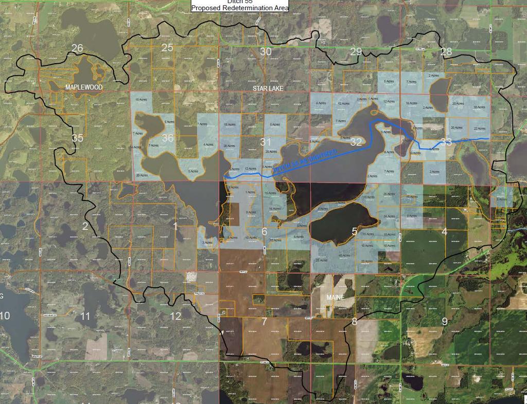
12

13 DRONE INSPECTION

14 *Correspondences and Letters received *There is a need for a Re-determination to take place State Statute when Benefits no longer reflect present day valuations County Plan- every Ditch will have its Benefits Re-determined *Discussion on Ditch Proceedings History of Ditch 55 What does a Re-determination of Benefits accomplish *Legal Discussion from County Attorney David Hauser *What would property owners like to see done on Their Ditch: Repairs- Current Issues Maintenance- Be Pro-active Do Nothing Minimal work

15 QUESTIONS AND COMMENTS
Otter Tail County Drainage Authority. for County Ditch 58.
 Otter Tail County Drainage Authority County Ditch 58 Benefit Redetermination Hearing Perham City Hall 125 2 nd Ave NE., Perham, MN 56573 Monday, July 25, 2016 The Otter Tail County Board of Commissioners
BWSR MN Public Drainage Manual Broad Users Outreach Workshop John Kolb, Attorney Lead Writer Chapter 4. MPDM Chapter 4: Viewing and Appraising
 BWSR MN Public Drainage Manual Broad Users Outreach Workshop John Kolb, Attorney Lead Writer Chapter 4 MPDM Chapter 4: Viewing and Appraising Chapter 4 Subcommittee Members 2 Sherry Enzler, MN DNR Bob
Todd County. Drainage System. Management Policy
 JD 5 JD 8 JD 8 JD 5 CD 28 CD 45 CD 23 CD 15 CD 39 CD 35 CD 7 CD 7 CD 26 CD 26 CD 25 CD 36 CD 34 CD 20 CD 20 CD 20 CD 13 CD 16 CD 41 JD 6 CD 25 CD 41 Drainage System CD 15 CD 27 CD 31 Management Policy
MILLE LACS COUNTY DRAINAGE AUTHORITY DRAINAGE POLICY
 CONTENTS MILLE LACS COUNTY DRAINAGE AUTHORITY DRAINAGE POLICY 1. DEFINITIONS... 2 2. GENERAL INFORMATION... 2 3. INSPECTIONS... 3 4. MEETINGS... 3 5. RECORDS RETENTION... 3 6. ADDITIONAL DRAINAGE... 3
TOP 10 COMMON LAW DRAINAGE PROBLEMS BETWEEN RURAL NEIGHBOURS H. W. Fraser, P.Eng. and S. Vander Veen, P.Eng.
 ORDER NO.98-015 APRIL 1998 AGDEX 752 TOP 10 COMMON LAW DRAINAGE PROBLEMS BETWEEN RURAL NEIGHBOURS H. W. Fraser, P.Eng. and S. Vander Veen, P.Eng. INTRODUCTION It has often been said that good drainage
INDIANA DRAINAGE LAW. Title 36 Article 9 Chapter 27
 INDIANA DRAINAGE LAW Title 36 Article 9 Chapter 27 IC 36-9-27 Chapter 27. Drainage Law IC 36-9-27-1 Application of chapter Sec. 1. This chapter applies to all counties. However, sections 6, 7, 9, 10, 30,
Minnesota Board of Water and Soil Resources Wetland Conservation Act 2017 Annual Reporting Form
 Minnesota Board of Water and Soil Resources Wetland Conservation Act 2017 Annual Reporting Form Use the tab key to navigate between fields. Local Government Unit (LGU): Becker SWCD Organization Type: SWCD
RESPONSIBILITY AND PROCEDURE FOR IMPROVEMENT AND MAINTENANCE OF DRAINS, DITCHES AND WATERCOURSES
 RESPONSIBILITY AND PROCEDURE FOR IMPROVEMENT AND MAINTENANCE OF DRAINS, DITCHES AND WATERCOURSES FORWARD The Offices of the County Engineer and County Commissioners of Greene County are inundated yearly
DRAINAGE CLASSIFICATION & RECLASSIFICATION
 DRAINAGE CLASSIFICATION & RECLASSIFICATION December 9, 2016 ARCHITECTURE + ENGINEERING + ENVIRONMENTAL + PLANNING PRESENTATION OUTLINE What is Classification & Reclassification? When and Why Reclassification?
Buffer and Soil Loss Statutes, as amended in 2017 by Laws of Minnesota 2017, Chapter 93 (S.F. 844)
") Buffer and Soil Loss Statutes, as amended in 2017 by Laws of Minnesota 2017, Chapter 93 (S.F. 844) May 30, 2017 103B.101 BOARD OF WATER AND SOIL RESOURCES Subd. 12. Authority to issue penalty orders. (a)
Buffer and Soil Loss Statutes, as amended in 2017 by Laws of Minnesota 2017, Chapter 93 (S.F. 844) May 30, 2017 103B.101 BOARD OF WATER AND SOIL RESOURCES Subd. 12. Authority to issue penalty orders. (a)
CHAPTER 6 CHESAPEAKE BAY PRESERVATION AREAS AND STREAM PROTECTION AREAS
 CHAPTER 6 CHESAPEAKE BAY PRESERVATION AREAS AND STREAM PROTECTION AREAS 6.1 INTRODUCTION Virginia s Chesapeake Bay Preservation Area (CBPA) Designation and Management Regulations (9VAC10-20 et seq.) require
OPEN SPACE PLANNING & PRIORITIZATION
 OPEN SPACE PLANNING & PRIORITIZATION Introduction What issues does this tool address? What does this tool accomplish? Define Open Space Conservation Objectives Natural Resource Protection Agricultural
Chapter Five Drainage 2017 final Law.docx 1
 Chapter Five Drainage Law One of the realities of living in Iowa is our abundant rainfall making it possible for us to farm and produce crops. But anyone who owns land knows that too much (or too little)
APPLICATION FOR FLOODPLAIN PERMIT
 Receipt No. Fee Date TOWN OF: Date Permit Issued: OWNER: Certificate of Compliance: Date Floodplain Zoning Permit: Date DOOR COUNTY LAND USE SERVICES 421 Nebraska Street Door County Government Center Sturgeon
Lilly Creek Improvement Project
 Part 1 Lilly Creek Improvement Project What is Lilly Creek? Lilly Creek is an open-air, private stormwater drainage system which collects surface water from western Greene County and eastern Montgomery
Article III. Erosion and Sedimentation Control
 Article III. Erosion and Sedimentation Control Section 9.6 Erosion and Sedimentation Control Plan Requirements Section 9.6.1 Plan Submission A plan shall be prepared for all land-disturbing activities
ARTICLE I. IN GENERAL
 Adopted by City Council on December 7, 2009 AN ORDINANCE TO AMEND AND REORDAIN CHAPTER 10 (WATER PROTECTION) OF THE CODE OF THE CITY OF CHARLOTTESVILLE, 1990, AS AMENDED, BY DELETING SECTIONS 10-51 AND
VILLAGE OF ASHVILLE DEPARTMENT OF PUBLIC UTILITIES DIVISION OF STORMWATER MANAGEMENT STORMWATER MANAGEMENT PROGRAM STORMWATER CREDIT MANUAL
 VILLAGE OF ASHVILLE DEPARTMENT OF PUBLIC UTILITIES DIVISION OF STORMWATER MANAGEMENT STORMWATER MANAGEMENT PROGRAM STORMWATER CREDIT MANUAL SECTION I. OVERVIEW AND GENERAL INSTRUCTIONS INTRODUCTION A stormwater
Resource Protection Area Map Update - Frequently Asked Questions
 DEPARTMENT OF ENVIRONMENTAL SERVICES Office of Sustainability and Environmental Management 2100 Clarendon Boulevard, Suite 705, Arlington, VA 22201 TEL 703-228-4488 FAX 703-228-7134 TTY 703-228-4611 www.arlingtonva.us
engineering planning environmental construction
 engineering planning environmental construction 1648 Third Avenue SE Rochester, MN 55904 Tel: 507-289-3919 Fax: 507-289-7333 June 3, 2015 Mr. John Harford Rochester / Olmsted Planning Department 2122 Campus
The Drainage Control Regulations
 1 The Drainage Control Regulations Repealed by Saskatchewan Regulations 89/2015 (effective October 16, 2015) Formerly Chapter D-33.1 Reg 1 (effective August 18, 1981) as amended by Saskatchewan Regulations
Citizens Advisory Committee 5/16/2013 6:00 p.m.
 Citizens Advisory Committee 5/16/2013 6:00 p.m. Over 225 organizations in the state manage 2000+ miles of ditch County Breakdown: New Castle County 26 Kent County 78 Sussex County - 143 Formed through
Frequently Asked Questions for: Drainage, Watershed and Water Quality Property Owners Near Creeks Developers and Engineers and Definitions of Terms
 FREQUENTLY ASKED QUESTIONS Draft DEFINITIONS OF TERMS Last Revised July 2, 2008 Introduction: The following questions have been organized in the categories below. We have attempted to group the questions
CITY OF ST. FRANCIS ST. FRANCIS, MN PLANNING COMMISSION MINUTES APRIL 19, 2006
 CITY OF ST. FRANCIS ST. FRANCIS, MN PLANNING COMMISSION MINUTES APRIL 19, 2006 1. Call to Order: The Planning Commission meeting was called to order at 7:00 pm by Chairman Rich Skordahl. 2. Roll Call:
TRUSTEE RESPONSIBILITIES ARCHITECTURE + ENGINEERING + ENVIRONMENTAL + PLANNING
 TRUSTEE RESPONSIBILITIES ARCHITECTURE + ENGINEERING + ENVIRONMENTAL + PLANNING CHAPTER 468 OF THE CODE OF IOWA Drainage Districts are governed under this chapter of the Code of Iowa. PETITION Triggers
PROJECT SCOPE OF WORK CITY OF TOWN AND COUNTRY STORMWATER PROGRAM
 PROJECT SCOPE OF WORK CITY OF TOWN AND COUNTRY STORMWATER PROGRAM Project ID Number: 2-2 Problem: The backyards at 962, 97, and 978 Delvin Drive are located in a low area of shallow ponding that takes
Purpose: Regulations:
 Administrative Procedures for the Designation and Refinement Of Chesapeake Bay Preservation Area Boundaries Guidance on the Chesapeake Bay Preservation Area Designation and Management Regulations September,
Interim Use Permit Application
 BENTON COUNTY DEPARTMENT OF DEVELOPMENT 531 DEWEY STREET, PO BOX 129 FOLEY, MN 56329-0129 PHONE: (320) 968-5065 FAX: (320) 968-5351 Interim Use Permit Application Application Fee: $400 ($754 if it is an
ORDINANCE CITY OF DUNDAS RICE COUNTY STATE OF MINNESOTA
 ORDINANCE 2014 01 CITY OF DUNDAS RICE COUNTY STATE OF MINNESOTA An Ordinance Amending Dundas City Code Title 5, Public Works, to Add Chapter 504 Storm Water Utility RECITALS There is hereby established
Part 72. Sec. 1. This ordinance shall be known and may be cited as the Clyde Township Wetlands Ordinance.
 Part 72 72.000 WETLANDS ORDINANCE Ord. No. 1 Adopted: June 12, 1991 Amended: April 13, 1994 72.001 SHORT TITLE. 72.002 PURPOSE. 72.003 DEFINITIONS. CLYDE TOWNSHIP ORDAINS: Sec. 1. This ordinance shall
SANILAC COUNTY ROAD COMMISSION ROAD POLICIES. A. Drainage, Base and Grade Construction (NON BITUMINOUS)
") I. LOCAL ROADS SANILAC COUNTY ROAD COMMISSION A. Drainage, Base and Grade Construction (NON BITUMINOUS) 1. Cost Sharing: Sanilac County Road Commission Share 17% Township Share 83% 2. A Notice of Construction
I. LOCAL ROADS SANILAC COUNTY ROAD COMMISSION A. Drainage, Base and Grade Construction (NON BITUMINOUS) 1. Cost Sharing: Sanilac County Road Commission Share 17% Township Share 83% 2. A Notice of Construction
BRISTOL CONSERVATION COMMISSION INLAND WETLANDS AGENCY FORM IW-1 (Application for a Wetlands Permit)
") APPLICATION NO. BRISTOL CONSERVATION COMMISSION INLAND WETLANDS AGENCY FORM IW-1 (Application for a Wetlands Permit) DATE FILED: APPROVED: DENIED: 1. APPLICANT: Name: Signature: Address: City: State: Zip
APPLICATION NO. BRISTOL CONSERVATION COMMISSION INLAND WETLANDS AGENCY FORM IW-1 (Application for a Wetlands Permit) DATE FILED: APPROVED: DENIED: 1. APPLICANT: Name: Signature: Address: City: State: Zip
TOWN OF WATERVILLE VALLEY NEW HAMPSHIRE SITE PLAN REVIEW REGULATIONS
 TOWN OF WATERVILLE VALLEY NEW HAMPSHIRE Effective date March 17, 1981 Revised March 16, 1982 Revised March 13, 1986 Revised March 10, 1987 Revised March 14, 2013 Revised March 8, 2016 TOWN OF WATERVILLE
Texas Land Trust Conference March 6, 2015
 Texas Land Trust Conference March 6, 2015 James D. Bradbury James D. Bradbury, PLLC Austin Fort Worth An Overview Unique area of law where the government can take private property Protected by the US Constitution
Draft MINUTES OF THE CARLTON COUNTY BOARD OF ADJUSTMENT MEETING August 21, 2018
 Draft MINUTES OF THE CARLTON COUNTY BOARD OF ADJUSTMENT MEETING August 21, 2018 (1) Chairman Ezell called the meeting to order at 7:00 p.m. (2) Members Present: Jack Ezell, John Manninen, Howard Eskuri,
FIRE DEPARTMENT INFORMATION BULLETIN #007
 SUBJECT: WEED ABATEMENT FIRE DEPARTMENT INFORMATION BULLETIN #007 Fire Department 955 Sonoma Ave Santa Rosa, CA 95404 (707) 543-3500 FAX (707) 543-3520 www.santarosafd.com Code References: Santa Rosa City
7) Contact information of the responsible design professional.
 Contact information of the responsible design professional.") SECTION 14 EROSION AND SEDIMENTATION CONTROL PLAN THE PURPOSE of an Erosion and Sedimentation Control Plan is to minimize soil erosion and sedimentation that is caused by construction activity. The intent
SECTION 14 EROSION AND SEDIMENTATION CONTROL PLAN THE PURPOSE of an Erosion and Sedimentation Control Plan is to minimize soil erosion and sedimentation that is caused by construction activity. The intent
Implementation of Permanent Easements and Associated Nutrient Load Reductions
 1 Minnesota Nutrient Reduction Strategy Agricultural Sector/BWSR RIM Program Measure Implementation of Permanent and Associated Nutrient Load Reductions Measure Background Visual Depiction The map in Figure
BOA David Hollerich Centerline Setback Variance 09/05/2012
 BOA 10-12 David Hollerich Centerline Setback Variance 09/05/2012 Request for variance to reduce the required centerline setback from Granite Circle of 65 feet to 40 feet for a proposed farm equipment building
TOWNSHIP OF MENDHAM Ord. No
 ORDINANCE SUPPLEMENTING THE LAND USE ORDINANCE OF THE TOWNSHIP OF MENDHAM BY A NEW CHAPTER XXIVA ESTABLISHING THE REQUIREMENT OF AN ENVIRONMENTAL PERMIT AND AMENDING AND SUPPLEMENTING SAID ORDINANCE WITH
ZONING LOCAL LAW TOWN OF KIRKWOOD. Local Law # Adopted March 4, 2008
 Local Law #2-2008 - Adopted March 4, 2008 SECTION 1201. Purpose and Intent The purpose and intent of the Composting District of the Town of Kirkwood, New York, is to guide the future development of the
APPLICATION FOR BUSINESS PARTNER MEMBERSHIP
 7321 Sunshine Grove Rd. Brooksville, FL 34613 352-799-1971 FAX: 352-799-4350 APPLICATION FOR BUSINESS PARTNER MEMBERSHIP The Hernando County Association of REALTORS (HCAR) invites local businessmen and
ADMINISTRATIVE CODE BOARD OF COUNTY COMMISSIONERS
 ADMINISTRATIVE CODE BOARD OF COUNTY COMMISSIONERS CATEGORY: Development/Planning/Zoning TITLE: Vacation of Plats or Easements created through the platting process in accordance with Chapter 177, Florida
This is the Schedule referred to in Easement in Gross in Form 9 dated the day of 200. Title Reference:
 Page 2 of 7 This is the Schedule referred to in Easement in Gross in Form 9 dated the day of 200. Item 8 Title Reference: 1.0 OBJECTS OF THE GRANT OF EASEMENT 1.1 The objects of this Instrument of Easement
APPLICATION FOR REGULAR ZONING PERMIT
 Receipt No. Fee Date Date Permit Issued: Certificate of Compliance: Date Floodplain Zoning Permit: Date DOOR COUNTY LAND USE SERVICES 421 Nebraska Street Door County Government Center Sturgeon Bay, Wisconsin
RPA Map Update Public Meeting Questions and Answers
 DEPARTMENT OF ENVIRONMENTAL SERVICES Office of Sustainability and Environmental Management 2100 Clarendon Boulevard, Suite 705, Arlington, VA 22201 TEL 703-228-4488 FAX 703-228-7134 TTY 703-228-4611 www.arlingtonva.us
ORDINANCE NO WHEREAS, the County Council desires to amend the current Code of
 1 1 1 1 1 1 0 1 0 1 ORDINANCE NO. 00- AN ORDINANCE OF THE COUNTY COUNCIL OF VOLUSIA COUNTY, FLORIDA, AMENDING THE CODE OF ORDINANCES OF THE COUNTY OF VOLUSIA, CHAPTER, TITLED UTILITIES, ARTICLE IV, STORMWATER
DEVELOPMENT EXPENDITURE (Extract taken from Farm Accounting Made Easy, Module four, pages 17-22)
") DEVELOPMENT EXPENDITURE (Extract taken from Farm Accounting Made Easy, Module four, pages 17-22) The term "development expenditure" was coined somewhere back in the late 190's. At that time a number of
DEVELOPMENT EXPENDITURE (Extract taken from Farm Accounting Made Easy, Module four, pages 17-22) The term "development expenditure" was coined somewhere back in the late 190's. At that time a number of
CHARLES CITY COUNTY SITE PLAN ORDINANCE. This Ordinance shall be known as the Charles City County Site Plan Ordinance.
 CHARLES CITY COUNTY SITE PLAN ORDINANCE Section 1. Title This Ordinance shall be known as the Charles City County Site Plan Ordinance. Section 2. Authority. This Ordinance is enacted pursuant to the authority
TOWNSHIP SERVICES POLICY PREPARED BY: ALAN BRUBAKER, P.E., P.S. SUMMIT COUNTY ENGINEER
 TOWNSHIP SERVICES POLICY PREPARED BY: ALAN BRUBAKER, P.E., P.S. SUMMIT COUNTY ENGINEER ISSUED JUNE 8, 2011 Summit County Engineer Policy for Township Services The Summit County Engineer endeavors to provide
2015 WETLAND CONSERVATION ACT STATUTE CHANGES
 2015 WETLAND CONSERVATION ACT STATUTE CHANGES Summary of Key Statute Changes and Related Legislation with Explanations This summary includes excerpts from Laws of MN 2015, Chapter 4, Article 4. It includes
RESIDENTIAL CLUSTER DEVELOPMENT DISTRICT SPECIAL PERMIT RULES AND REGULATIONS OF THE PLANNING BOARD OF THE TOWN OF COHASSET, MASSACHUSETTS
 RESIDENTIAL CLUSTER DEVELOPMENT DISTRICT SPECIAL PERMIT RULES AND REGULATIONS OF THE PLANNING BOARD OF THE TOWN OF COHASSET, MASSACHUSETTS Attached: Residential Cluster Development District Special Permit
CEDAR COUNTY SECONDARY ROAD DEPARTMENT POLICY FOR UPGRADE OF LEVEL B COUNTY ROADS
 CEDAR COUNTY SECONDARY ROAD DEPARTMENT POLICY FOR UPGRADE OF LEVEL B COUNTY ROADS Cedar County recognizes that as land use changes, demands on county roads may also change. Roads were placed in the level
SIMPLIFIED APPROACH PERMIT PROCEDURES
 SIMPLIFIED APPROACH PERMIT PROCEDURES UPPER ALLEN TOWNSHIP Community Development Department 100 Gettysburg Pike, Mechanicsburg, PA 17055 Phone: 717-766-0756 Fax: 717-796-983 Office Hours: M-F 8:00 AM 4:30
MAJOR SUBDIVISION PRELIMINARY PLAT CHECKLIST
 TOWNSHIP OF EGG HARBOR PLANNING BOARD/ZONING BOARD OF ADJUSTMENT 3515 BARGAINTOWN ROAD EGG HARBOR TOWNSHIP, NJ 08234 MAJOR SUBDIVISION PRELIMINARY PLAT CHECKLIST The following checklist is designed to
Natural Gas Pipelines: The Role of Conservation Commissions MASSACHUSETTS ASSOCIATION OF CONSERVATION COMMISSIONS
 Natural Gas Pipelines: The Role of Conservation Commissions EUGENE B. BENSON, MACC EXECUTIVE DIRECTOR PRESENTED TO FRCOG REGIONAL PIPELINE ADVISORY COMMIT TEE MARCH 8, 2016 Presentation Topics 1. NATURAL
PROPOSED STATE STREET ROAD SANITARY SEWER DISTRICT
 Informational Meeting For PROPOSED STATE STREET ROAD SANITARY SEWER DISTRICT May 30, 2018 Introductions Agenda 1. Proposed Project Area 2. Benefits of Public Sewer 3. What is a Sewer District 4. Options
RISK ASSESSMENT APPENDIX E HAZARD ANALYSIS RESULTS
 RISK ASSESSMENT E0 APPENDIX E HAZARD ANALYSIS RESULTS E1 NORTHUMBERLAND COUNTY HMP RISK ASSESSMENT E2 APPENDIX E HAZARD ANALYSIS RESULTS Summary Nearly ninety percent of federal disaster declarations are
Surface Water Management District. Summit County Engineer Alan Brubaker, P.E., P.S.
 Surface Water Management District Summit County Engineer Alan Brubaker, P.E., P.S. Stormwater We have spent the last nine years devising various solutions to stormwater issues in Summit County With no
LAKE OF THE WOODS COUNTY WETLAND CONSERVATION ORDINANCE OF 2002
 Ordinance # LAKE OF THE WOODS COUNTY WETLAND CONSERVATION ORDINANCE OF 2002 ARTICLE 1 TITLE AND PURPOSE Section 1.1. Title This Ordinance shall be known, cited and referred to as the Lake of the Woods
Grand Rapids, MN Stormwater Utility Best Management Practices Credit Policy (As per Section (b) of Ordinance No )
 of Ordinance No )") Grand Rapids, MN Stormwater Utility Best Management Practices Credit Policy (As per Section 70-203(b) of Ordinance No. 17-05-03) Background On May 8, 2017, the Grand Rapids City Council approved a Stormwater
Grand Rapids, MN Stormwater Utility Best Management Practices Credit Policy (As per Section 70-203(b) of Ordinance No. 17-05-03) Background On May 8, 2017, the Grand Rapids City Council approved a Stormwater
Standard Operating Procedure: Implementation of the Inspection and Maintenance Program Under the Long Creek Watershed Management Plan
 Standard Operating Procedure: Implementation of the Inspection and Maintenance Program Under the Long Creek Watershed Management Plan 1. PURPOSE: The Long Creek Watershed Management District ( LCWMD )
Protecting Water in the Stream: Colorado s Instream Flow Program Sustaining Colorado Watersheds
 Protecting Water in the Stream: Colorado s Instream Flow Program 2011 Sustaining Colorado Watersheds Avon, Colorado October 5, 2011 Colorado Water Conservation Board Carl Trick Eric Wilkinson North Platte
Understanding the Conditional Use Process
 Understanding the Conditional Use Process The purpose of this document is to explain the process of applying for and obtaining a conditional use permit in the rural unincorporated towns of Dane County.
Hiawatha Drain Informational Open House
 May 10, 2017 Open House Times: 12:00 3:00 p.m. 6:00 8:00 p.m. Hiawatha Drain Informational Open House Ottawa County Water Resources Commissioner Why are we here? The last public meeting was in 2010. Property
Town of Pineville. Post-Construction Storm Water Ordinance
 Town of Pineville Post-Construction Storm Water Ordinance Effective June 30, 2007 TABLE OF CONTENTS SECTION 1: GENERAL PROVISIONS... 1 101 TITLE... 1 102 AUTHORITY... 1 103 FINDINGS... 1 104 PURPOSE...
KENT COUNTY STORMWATER MAINTENANCE DISTRICT
 KENT COUNTY STORMWATER MAINTENANCE DISTRICT 2015 VUSP Stormwater Symposium Villanova, Pennsylvania David Athey, PE, CPSWQ, CMS4S AECOM (previously with Duffield Associates) Sarah Keifer, AICP Kent County,
A Guide to Water Supply Replacement and Subsidence Damage Repair
 A Guide to Water Supply Replacement and Subsidence Damage Repair A guide to rights and A Guide to Water Supply Replacement and Subsidence Damage Repair A guide to information, rights and responsibilities
GIS in Public Health. Septic Maintenance Program in Lewis and Clark County
 GIS in Public Health Septic Maintenance Program in Lewis and Clark County About Lewis and Clark County Approximately 55,000 people-mostly in the Helena Valley and City of Helena Approximately 10,000 septic
Appendix A Reproducible Forms
 Appendix A Reproducible Forms Form LD-33 LD-34 LD-35 LD-40 LD-41 LD-42 LD-50 LD-51 LD-52 LD-53 Subject County Engineer Approval Form Storm Sewer Computation Sheet Ohio Drainage Design Criteria Form Gutter
Easements: Ditch and flowage easements will be terminated upon sale.
 Property #156084: Otter Tail County Parcel Removed from Sale Containing 58.20 acres, more or less. Property Data Sheet 156084 Parts of the Southeast Quarter of the Northeast Quarter (SE1/4, NE1/4), Government
2015 Reinvest in Minnesota (RIM) Reserve Wetlands Program
 Reserve Wetlands Program") 2015 Reinvest in Minnesota (RIM) Reserve Wetlands Program Eligibility Guidance Document 1/16/15 The purpose of the RIM Wetlands Program is to identify and enroll under permanent easement lands that contain
2015 Reinvest in Minnesota (RIM) Reserve Wetlands Program Eligibility Guidance Document 1/16/15 The purpose of the RIM Wetlands Program is to identify and enroll under permanent easement lands that contain
Planning & Zoning Department GENERAL APPLICATION 400 DeWitt Street - Portage, WI Phone: Fax:
 Planning & Zoning Department GENERAL APPLICATION 400 DeWitt Street - Portage, WI 53901 Phone: 608-742-9660 Fax: 608-742-9817 www.@co.columbia.wi.us The applicant hereby authorizes access to the property
Park Acquisition Opportunity Fund Grant Rules Adopted by the Metropolitan Council on May 28, 2014 as an Amendment to 2030 Regional Parks Policy Plan
 Park Acquisition Opportunity Fund Grant Rules Adopted by the Metropolitan Council on May 28, 2014 as an Amendment to 2030 Regional Parks Policy Plan In 2001, the Metropolitan Council established a Park
Planning Commission Staff Report
 Planning Commission Staff Report Project: Summary Vacation of a Drainage Easement for a Drainage Canal or Ditch over the Apple Computer Inc. Campus Property Finding of Consistency with the General Plan
WHEN A PUBLIC AGENCY IS INTERESTED IN ACQUIRING AN EASEMENT
 Form 6-H When a Public Agency is interested in Acquiring an Easement Booklet WHEN A PUBLIC AGENCY IS INTERESTED IN ACQUIRING AN EASEMENT Introduction This booklet describes important features of the Uniform
RULE F: WETLAND ALTERATION
 RULE F: WETLAND ALTERATION 1. POLICY. It is the policy of the Board of Managers to: (a) (b) (c) (d) (e) Maintain no net loss in the quantity, quality, and biological diversity of Minnesota's existing wetlands.
A Resolution of the Governing Board of the South Florida Water Management District authorizing eminent domain proceedings for the
 18. 2009-304 A Resolution of the Governing Board of the South Florida Water Management District authorizing eminent domain proceedings for the acquisition of certain lands consisting of 7.66 acres, more
BEFORE THE ST. JOHNS RIVER WATER MANAGEMENT DISTICT PETITION FOR ADMINISTRATIVE HEARING
 BEFORE THE ST. JOHNS RIVER WATER MANAGEMENT DISTICT SIERRA CLUB INC. and ST. JOHNS RIVERKEEPER INC. Petitioners v. ST JOHNS RIVER WATER MANAGMENT DISTRICT and SLEEPY CREEK LANDS LLC Respondents PETITION
Brief Summary of Drainage Law. November 2011
 Brief Summary of Drainage Law November 2011 This document is general information distributed by the State of South Dakota. Nothing in this document should be considered legal advice as to any specific
Chesapeake Bay Preservation Area (CBPA) Map Update. Presentation to the County Board July 15, 2017
 Map Update. Presentation to the County Board July 15, 2017") Chesapeake Bay Preservation Area (CBPA) Map Update Presentation to the County Board July 15, 2017 Chesapeake Bay Program Comprehensive Plan Chesapeake Bay Preservation Ordinance (1992) (Chapter 61, Arlington
Chesapeake Bay Preservation Area (CBPA) Map Update Presentation to the County Board July 15, 2017 Chesapeake Bay Program Comprehensive Plan Chesapeake Bay Preservation Ordinance (1992) (Chapter 61, Arlington
COMPREHENSIVE PLAN FUTURE LAND USE MAP AMENDMENT APPLICATION
 COUNTY STAFF DATA ONLY Date Received: Project No. CPA-20 - GADSDEN COUNTY DEPARTMENT OF PLANNING & COMMUNITY DEVELOPMENT 1-B East Jefferson Street, Post Office Box 1799, Quincy, FL 32353-1799 PLANNING
DEED OF EASEMENT & MAINTENANCE AGREEMENT FOR STORMWATER MANAGEMENT FACILITIES THIS DEED OF EASEMENT AND MAINTENANCE AGREEMENT FOR
 (The City of Chesapeake is exempt from recordation taxes pursuant to Section 58.1-811.A.3. and Grantors are exempt pursuant to Section 58.1-811.C.5. of the 1950 Code of Virginia as amended.) DEED OF EASEMENT
Final Plats for Major Residential and Commercial Subdivisions Checklist
 Project Name: : This form is a checklist of Zoning Ordinance requirements for major residential and commercial subdivision plats to assist the applicant in their submittal. It is not intended to be a comprehensive
MEETING AGENDA. Johnson County Advisory Plan Commission January 22, 2018, 6:00 PM Auditorium, West Annex Building 86 West Court Street, Franklin, IN
 JOHNSON COUNTY Department of Planning and Zoning Phone: (317) 346-4350 86 West Court Street Fax: (317) 736-4722 Courthouse Annex www.co.johnson.in.us Franklin, Indiana 46131 MEETING AGENDA Johnson County
ARTICLE 15 - PLANNED UNIT DEVELOPMENT
 Section 15.1 - Intent. ARTICLE 15 - PLANNED UNIT DEVELOPMENT A PUD, or Planned Unit Development, is not a District per se, but rather a set of standards that may be applied to a development type. The Planned
NC General Statutes - Chapter 153A Article 15 1
 Article 15. Public Enterprises. Part 1. General Provisions. 153A-274. Public enterprise defined. As used in this Article, "public enterprise" includes: (1) Water supply and distribution systems. (2) Wastewater
SHORELAND PROTECTION ORDINANCE FOR VERNON COUNTY, WI. Table of Contents
 SHORELAND PROTECTION ORDINANCE FOR VERNON COUNTY, WI Table of Contents Section Page 50-1.0 Statutory Authorization, Finding of Fact, Statement of Purpose and Title 3 50-1.1 Statutory Authorization 3 50-1.2
FRESHWATER WETLANDS PROTECTION IN NEW JERSEY Tools for Municipal Action
 FRESHWATER WETLANDS PROTECTION IN NEW JERSEY Tools for Municipal Action The Freshwater Wetlands Protection Act INTENT OF FRESHWATER WETLANDS LAW The New Jersey legislature passed the Freshwater Wetlands
Upper Southampton Township US ACOE USF&WS UNH
 Upper Southampton Township US ACOE USF&WS UNH 1 Corps of Engineers Who? Heather Jensen, Project Manager Mark Eberle, Project Biologist Sarah Apperson, Jennifer McGrath, Real Estate Rich Pearsall, public
Request to Advertise: Chesapeake Bay Preservation Area (CBPA) Map Update. June 20, 2017
 Map Update. June 20, 2017") Request to Advertise: Chesapeake Bay Preservation Area (CBPA) Map Update June 20, 2017 Outline Context Past County Board actions Why update the CBPA Map? What and Why - Resource Protection Areas Property
Request to Advertise: Chesapeake Bay Preservation Area (CBPA) Map Update June 20, 2017 Outline Context Past County Board actions Why update the CBPA Map? What and Why - Resource Protection Areas Property
Jackson County Courthouse 3rd Floor Civil Records 415 E. 12th Street RM 305 Kansas City, MO (816)
") Western Jackson County (Kansas City, Grandview) (All cases where the property is located in Kansas City or Grandview should be filed in Western Jackson County, at the Kansas City (downtown) Courthouse.)
Western Jackson County (Kansas City, Grandview) (All cases where the property is located in Kansas City or Grandview should be filed in Western Jackson County, at the Kansas City (downtown) Courthouse.)
City Of Attleboro Conservation Commission
 City Of Attleboro Conservation Commission GOVERNMENT CENTER, 77 PARK STREET ATTLEBORO, MASSACHUSETTS 02703 (508) 223 2222 FAX 222 3046 GENERAL INSTRUCTIONS AND CHECKLIST FOR COMPLETING STORMWATER MANAGEMENT
in Article 5 of the Palm Beach County Unified Land Development Code
 RESOLUTION NO. R-95-1122 RESOLUTION APPROVING ZONING PETITION CA91-44(A) CLASS A CONDITIONAL USE PETITION OF CAROL ORLANS WHEREAS, the Board of County Commissioners, as the governing body of Palm Beach
DUNN TOWNSHIP OTTER TAIL COUNTY, MINNESOTA RESOLUTION NO RESOLUTION DETERMINING ELIGIBILITY AND CONDITIONALLY GRANTING A CARTWAY
 DUNN TOWNSHIP OTTER TAIL COUNTY, MINNESOTA RESOLUTION NO. 2018-04 RESOLUTION DETERMINING ELIGIBILITY AND CONDITIONALLY GRANTING A CARTWAY WHEREAS, the Dunn Township ( Town ) board of supervisors ( Town
STORMWATER MANAGEMENT FACILITIES AND PRACTICES COVENANT
 STORMWATER MANAGEMENT FACILITIES AND PRACTICES COVENANT City of Roswell, GA Community Development Department (770) 641-3780 THIS INSTRUMENT, made and entered into this day of, 20, by and between (Insert
Draft MINUTES OF THE CARLTON COUNTY BOARD OF ADJUSTMENT MEETING July 17, 2018
 Draft MINUTES OF THE CARLTON COUNTY BOARD OF ADJUSTMENT MEETING July 17, 2018 (1) Chairman Ezell called the meeting to order at 7:00 p.m. (2) Members Present: Jack Ezell, John Manninen, Howard Eskuri,
FUTURE LAND USE. City of St. Augustine Comprehensive Plan EAR-Based Amendments
 FUTURE LAND USE City of St. Augustine Comprehensive Plan EAR-Based Amendments Future Land Use Element FLU Goal To create an environment within the City and adjacent areas in which its residents have the
PLANNING FOR OUR FUTURE
 PLANNING FOR OUR FUTURE ELLSWORTH TOWNSHIP LAND USE AND POLICY PLAN The purpose of this Plan is to serve as a guide for the Township Trustees, Zoning Commission, Board of Zoning Appeals, developers, employers,
Septic Tank / Drainfield / Holding Tank Permit Application
 Septic Tank / Drainfield / Holding Tank Permit Application : Permit # : PID #: Septic Fee $: Soil Verification Fee $: Investigative/Other Fee $: PLEASE PRINT CLEARLY Total Permit Fee $: The Applicant Is: