Citizens Advisory Committee 5/16/2013 6:00 p.m.
|
|
|
- Elmer Watts
- 5 years ago
- Views:
Transcription

1 Citizens Advisory Committee 5/16/2013 6:00 p.m.

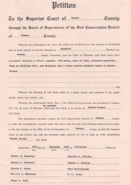
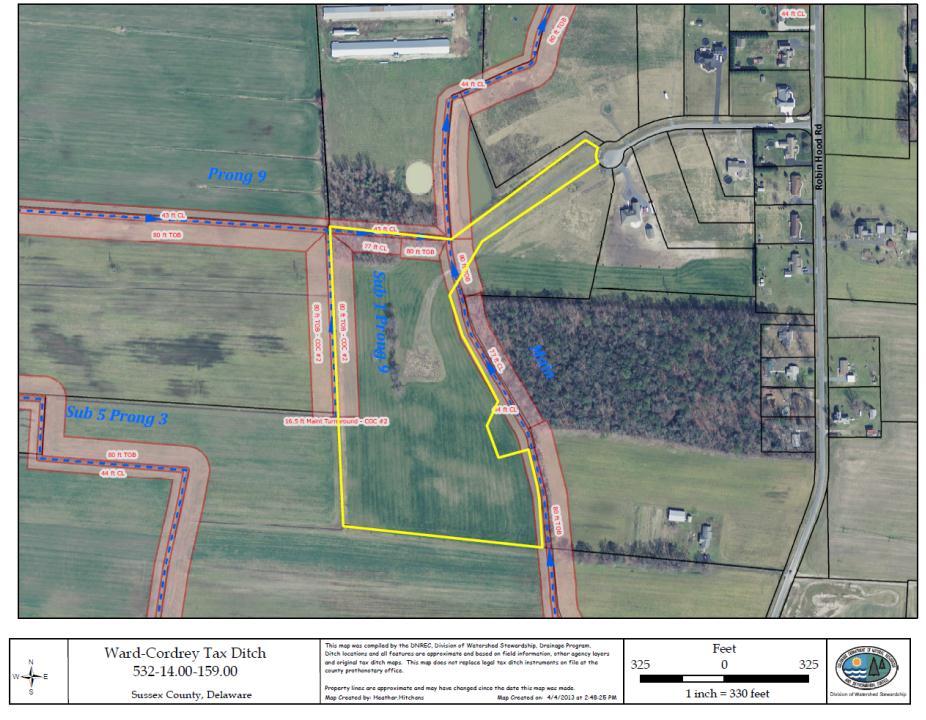
2 Over 225 organizations in the state manage miles of ditch County Breakdown: New Castle County 26 Kent County 78 Sussex County Formed through Superior Court

3 Governmental Subdivision of the State Permanent Right of Way for Maintenance Levy taxes (warrant) Sue & be sued Make & execute contracts Borrow money Receive administrative & technical assistance from DNREC, Division of Watershed Stewardship
4


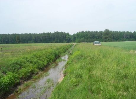
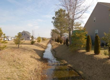
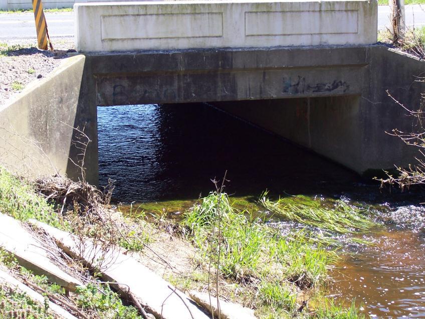
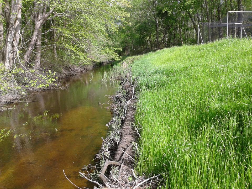
5 Maintenance Right of Way: Area typically used for minor maintenance Construction Right of Way: Area typically used for construction, reconstruction, major maintenance


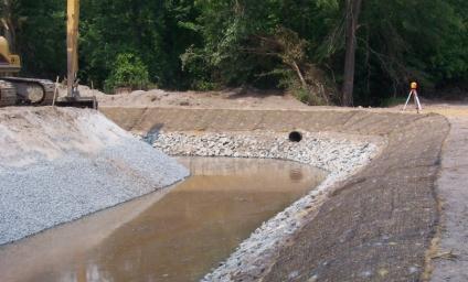
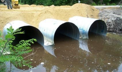
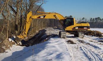
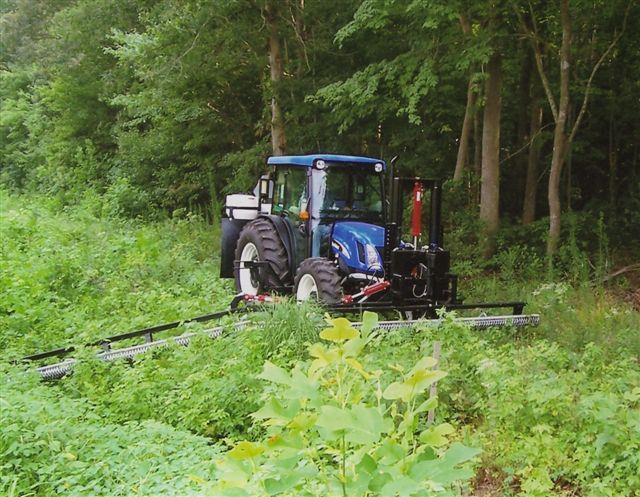
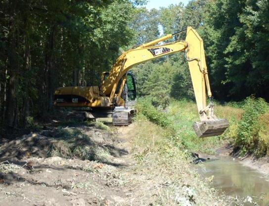
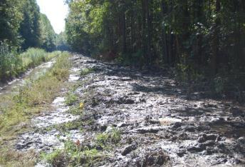
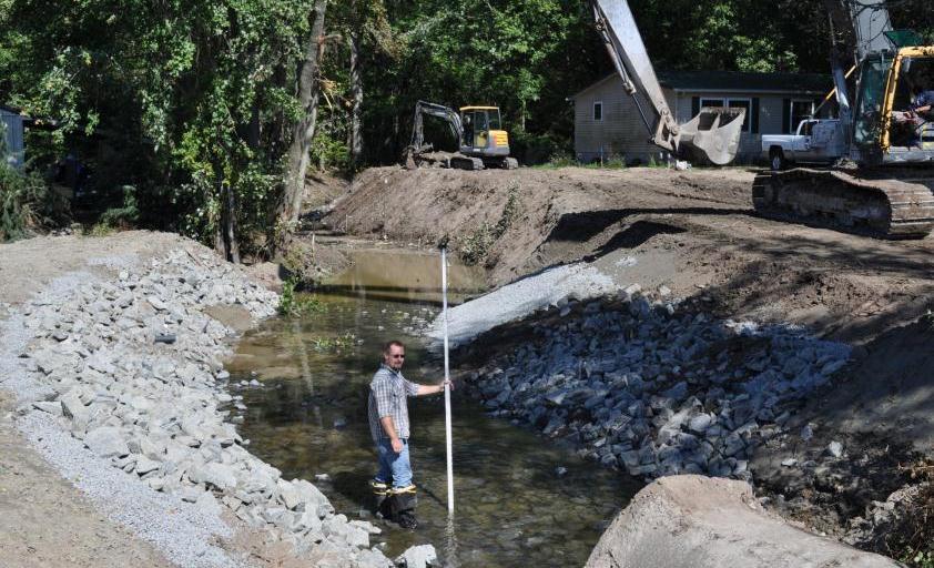
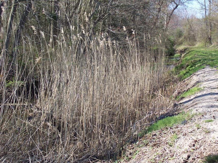
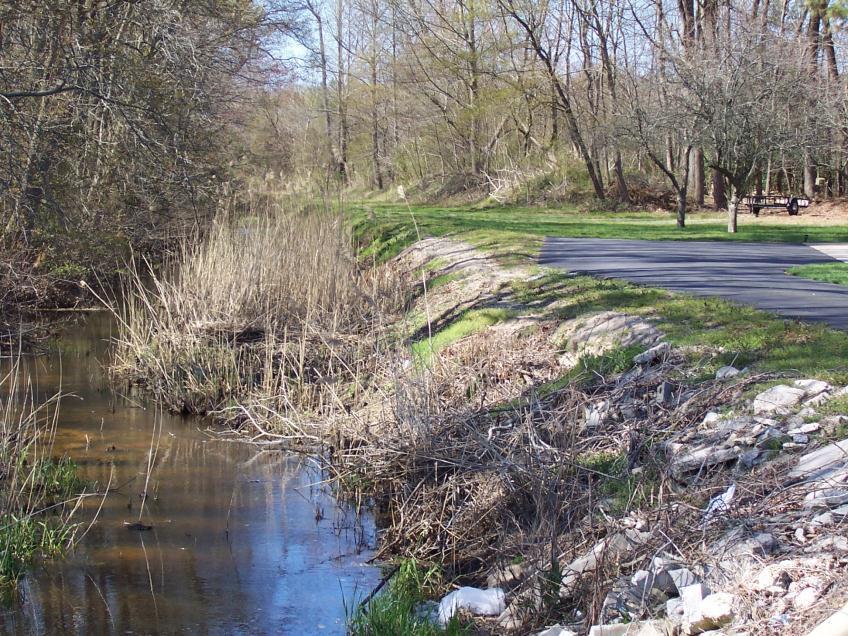
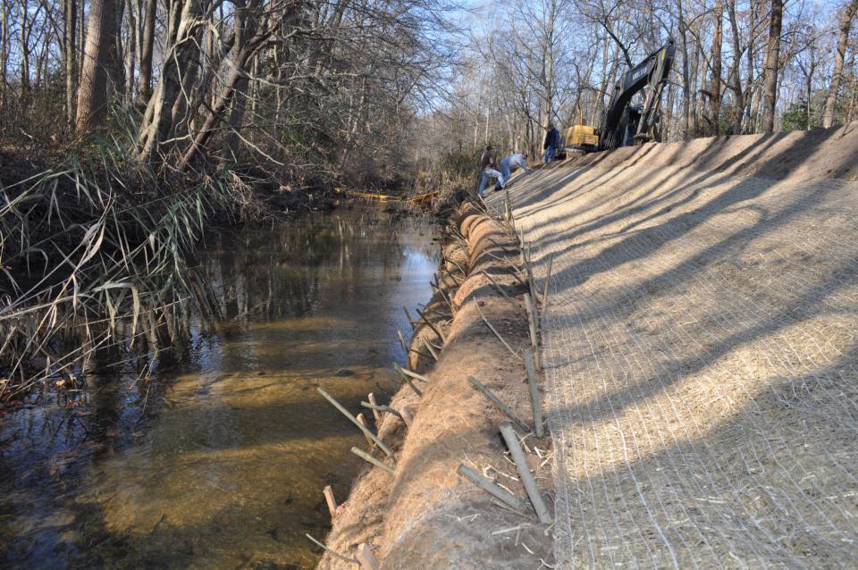
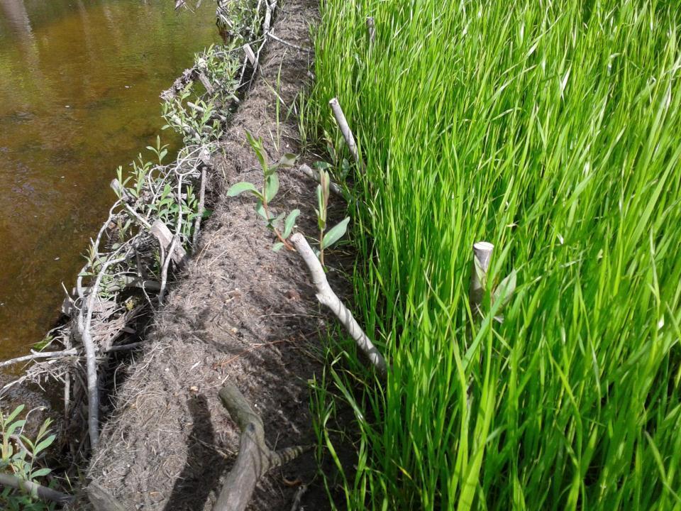
6 Minor Maintenance: controlling woody vegetation by mowing and/or applying herbicides Major Maintenance: activities related to the dipout and spreading of accumulated sediments every 10 to 20 years
7 Title 7, Chapter 41 of the Delaware Code passed in 1951 last revised in 2008 Drainage of Lands and Management of Waters; Tax Ditches Law Declared: that the drainage and the prevention of flooding of lands and the management of water for resource conservation shall be considered a public benefit and conducive to the public health, safety and welfare.
8 Petition (Local Landowners) Preliminary Report Submitted to Superior Court Planning Order Commissioner s Report Hearing & Referendum or 100% Agreement Final Order Modify Final Order through Court Order Change Process
9

10 Powers as a Governmental Subdivision of the State: Levy taxes (warrant) Make & execute contracts Cooperate, or enter into agreement with the state or federal government, or other agencies Exercise the power of eminent domain Transfer control of tax ditch operations to DNREC Receive administrative & technical assistance from Division of Watershed Stewardship

11 Officers are elected at annual meetings Officers must be a landowner within the tax ditch boundary or a company authorized representative Two Managers Chairman of the Managers Manager Secretary/Treasurer
12 Determine from the taxables desired program of operations Determine the amount of taxes to be levied Execute warrants Present report at annual meeting Provide for construction work Provide for adequate maintenance
13 Keep minutes of all meetings Prepare financial statement Have financial statement audited Provide for safekeeping of funds Attend all meetings of ditch managers & taxables Furnish bond in amount satisfactory to managers

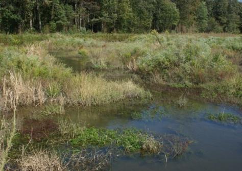
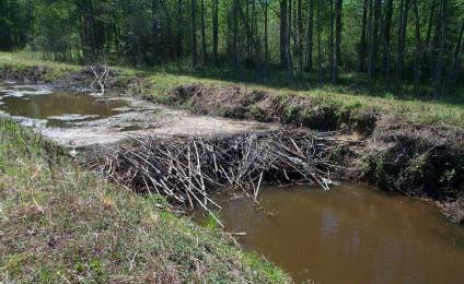
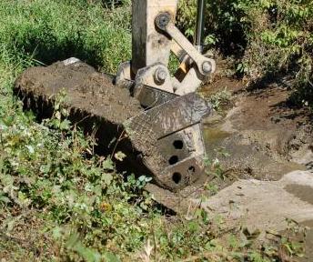
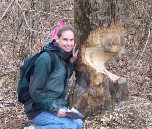
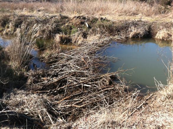
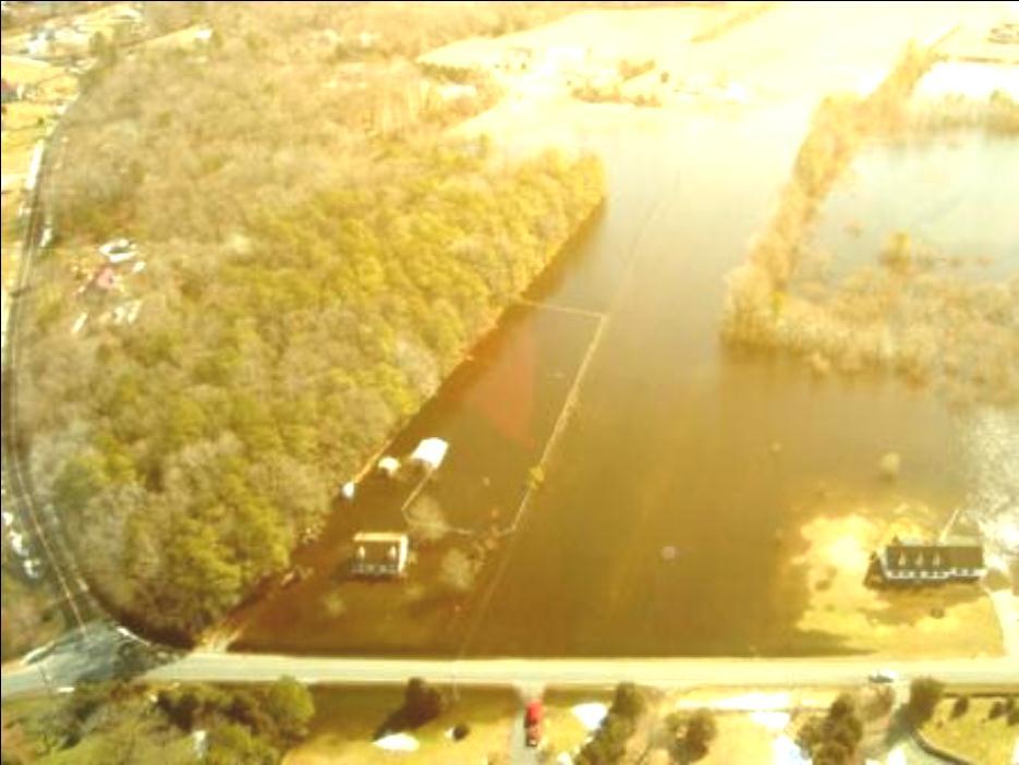
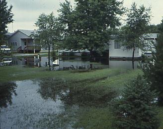
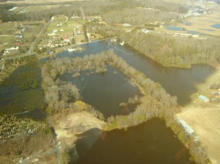
14 Collect Taxes sufficient enough to provide funding required for maintenance Maintain The Drainage System: Control vegetation on ditch bottom and slopes Done every 1-3 yrs Mowing Weed Wiper Bar Dipouts: Restore channels to the designed lines and grades Removal of Beavers and Beaverdams
15
16
17

18 ROWS provide the area necessary for the Construction and maintenance of ditches The widths of the ROWS are highly variable. By Type By Watershed Within the Watershed Construction and Major Maintenance Right-of-Way Construction/reconstruction of the tax ditch, to allow for the piling of debris and to allow spoil to be leveled as part of the construction operations and major maintenance activities Minor Maintenance Right-of-Way Inspection, mowing, use of specialized equipment for vegetative management (i.e. herbicide applications), removal of debris and obstructions, pipe repairs and installation of crossings for access

19 Filed in Prothonotary Office since 1951 Filed in Recorder of Deeds Office since 2006

20 Fax or property information to: Fax: (302) Requried Property Information Parcel Number \ Tax ID number Landowner of Record Acres Your Contact Information
21

22 Inspection Right of Way Obstruction Issues Attend Annual Meetings Audit Financial Records Jump Start Inactive Organizations Environmental Permitting Tax Ditch Planning

23

24 Provide both Federal and DNREC Permitting Assistance Tax Ditch Dipouts Culvert Pipes Bank Stabilization Invasive Species


25 Houses, Decks, Porches Stormwater Management Ponds Sheds Wells Septic Systems Fences Swimming Pools Telephone, Electric, and Cable boxes Anything else that will prevent equipment from using the ROW

26
27 We will provide tax ditch managers with documents to help them conduct their business Maps Managers Maps - including Property Codes Mowers Maps - Ditch alignments and right of way sides Assessment Lists Mailing Labels
 Guinea Creek (Long Neck) Houston")

28 Currently 4 Active Petitions Hudson Road (Milton) Guinea Creek (Long Neck) Houston Planning Grant from Clean Water Advisory Council Improvements to Water Quality are being explored Kitts Hummock

29 Long Process Petition Received from Landowners Preliminary Report/Investigation Planning Order Received Planning/Engineering Begins Tax Ditch Commissioners Report to Superior Court Hearing/Referendum/100% Agreement Final Order Granted Organizational Meeting Held Construction
30
31


32 Planning Modifications to original court order Engineering Permitting Utility Conflicts
33
34
35
36
37
38

39
40
41
42
43
44
45
46 Contact: Matthew T. Grabowski Program Manager Division of Watershed Stewardship Berlin Road, Unit #6 Georgetown, DE (302) office (302) cell
Schedule "A Fees (Planning Advisory Program)
") Approvals Fee Schedule (Effective January 1, 2018) Schedule "A Fees (Planning Advisory Program) - 2018 Planning Application Type Fee is for provision of comments to municipal approval authority on site
Approvals Fee Schedule (Effective January 1, 2018) Schedule "A Fees (Planning Advisory Program) - 2018 Planning Application Type Fee is for provision of comments to municipal approval authority on site
MILLE LACS COUNTY DRAINAGE AUTHORITY DRAINAGE POLICY
 CONTENTS MILLE LACS COUNTY DRAINAGE AUTHORITY DRAINAGE POLICY 1. DEFINITIONS... 2 2. GENERAL INFORMATION... 2 3. INSPECTIONS... 3 4. MEETINGS... 3 5. RECORDS RETENTION... 3 6. ADDITIONAL DRAINAGE... 3
Drainage Maintenance Policy
 Drainage Maintenance Policy The purpose of this Drainage Maintenance Policy is to clarify how the City of McKinney may address various drainage and stormwater related concerns of residents. BACKGROUND
WYOMING WATER DISTRICTS. Harriet M. Hageman Hageman and Brighton, P.C.
 WYOMING WATER DISTRICTS Harriet M. Hageman Hageman and Brighton, P.C. TYPES OF DISTRICTS Water Conservancy District (W.S. 41-3-701 through 41-3-779) Flood Control District (W.S. 41-3-801 through 41-3-803)
TRUSTEE RESPONSIBILITIES ARCHITECTURE + ENGINEERING + ENVIRONMENTAL + PLANNING
 TRUSTEE RESPONSIBILITIES ARCHITECTURE + ENGINEERING + ENVIRONMENTAL + PLANNING CHAPTER 468 OF THE CODE OF IOWA Drainage Districts are governed under this chapter of the Code of Iowa. PETITION Triggers
KENT COUNTY STORMWATER MAINTENANCE DISTRICT
 KENT COUNTY STORMWATER MAINTENANCE DISTRICT 2015 VUSP Stormwater Symposium Villanova, Pennsylvania David Athey, PE, CPSWQ, CMS4S AECOM (previously with Duffield Associates) Sarah Keifer, AICP Kent County,
Board of County Commissioners
 Board of County Commissioners A board of commissioners consisting of three elected people governs each county (except Marion County). In all except Lake and St. Joseph counties, the commissioners are elected
OWNERSHIP DETAILS. Mailing Address: City / Town: Postal Code. Phone Business: ( ) Residence: ( ) FAX: ( )
 Residence: ( ) FAX: ( )") P.O. Box 81067 838 Mineral Springs Road Ancaster, ON L9G 4X1 Email: Darren.Kenny@conservationhamilton.ca Phone: (905) 648-4427 or (905) 525-2181 FAX: (905) 648-4622 Development, Interference with Wetlands,
P.O. Box 81067 838 Mineral Springs Road Ancaster, ON L9G 4X1 Email: Darren.Kenny@conservationhamilton.ca Phone: (905) 648-4427 or (905) 525-2181 FAX: (905) 648-4622 Development, Interference with Wetlands,
DRAINAGE EASEMENT & MAINTENANCE AGREEMENT
 DRAINAGE EASEMENT & MAINTENANCE AGREEMENT THIS DRAINAGE EASEMENT & MAINTENANCE AGREEMENT (this Easement ) is granted this day of, 20, by, [husband and wife/trustee, etc.], whose address is (the Grantor
Lilly Creek Improvement Project
 Part 1 Lilly Creek Improvement Project What is Lilly Creek? Lilly Creek is an open-air, private stormwater drainage system which collects surface water from western Greene County and eastern Montgomery
OWNERSHIP DETAILS. Mailing Address: City / Town: Postal Code. Phone Business: ( ) Residence: ( ) FAX: ( )
 Residence: ( ) FAX: ( )") P.O. Box 81067 838 Mineral Springs Road Ancaster, ON L9G 4X1 Email: Darren.Kenny@conservationhamilton.ca x131 Jaime.Tellier@conservationhamilton.ca x165 Phone: (905) 648-4427 or (905) 525-2181 FAX: (905)
P.O. Box 81067 838 Mineral Springs Road Ancaster, ON L9G 4X1 Email: Darren.Kenny@conservationhamilton.ca x131 Jaime.Tellier@conservationhamilton.ca x165 Phone: (905) 648-4427 or (905) 525-2181 FAX: (905)
PERMIT APPLICATION FORM
 CVCA File #: P.O. Box 416, 70 Hughes Lane, Marmora, ON K0K 2M0 Tel: 613-472-3137 Fax: 613-472-5516 www.crowevalley.com PERMIT APPLICATION FORM FOR A DEVELOPMENT, INTERFERENCE WITH WETLANDS AND ALTERATIONS
City of Prior Lake APPLICATION FOR PRELIMINARY PLAT
 City of Prior Lake APPLICATION FOR PRELIMINARY PLAT Requested Action Brief description of proposed project (Please describe the proposed amendment, project, or variance request. Attach additional sheets
130A-55. Corporate powers. A sanitary district board shall be a body politic and corporate and may sue and be sued in matters relating to the
 130A-55. Corporate powers. A sanitary district board shall be a body politic and corporate and may sue and be sued in matters relating to the sanitary district. Notwithstanding any limitation in the petition
Surface Water Management District. Summit County Engineer Alan Brubaker, P.E., P.S.
 Surface Water Management District Summit County Engineer Alan Brubaker, P.E., P.S. Stormwater We have spent the last nine years devising various solutions to stormwater issues in Summit County With no
PROPERTY; PROVIDING FOR EXPENDITURE OF REVENUE; PROVIDING FOR REIMBURSEMENT
 ORDINANCE NO. 12- AN ORDINANCE OF MARION COUNTY, FLORIDA ESTABLISHING THE RAINBOW PARK UNITS 1 & 2 MUNICIPAL SERVICE BENEFIT UNIT FOR ROAD MAINTENANCE; PROVIDING FOR A PURPOSE; PROVIDING FOR THE POWERS
SANILAC COUNTY ROAD COMMISSION ROAD POLICIES. A. Drainage, Base and Grade Construction (NON BITUMINOUS)
") I. LOCAL ROADS SANILAC COUNTY ROAD COMMISSION A. Drainage, Base and Grade Construction (NON BITUMINOUS) 1. Cost Sharing: Sanilac County Road Commission Share 17% Township Share 83% 2. A Notice of Construction
I. LOCAL ROADS SANILAC COUNTY ROAD COMMISSION A. Drainage, Base and Grade Construction (NON BITUMINOUS) 1. Cost Sharing: Sanilac County Road Commission Share 17% Township Share 83% 2. A Notice of Construction
OWNERSHIP DETAILS. Mailing Address: City / Town: Postal Code. Phone Business: ( ) Residence: ( ) FAX: ( )
 Residence: ( ) FAX: ( )") P.O. Box 81067 838 Mineral Springs Road Ancaster, ON L9G 4X1 Email: Darren.Kenny@conservationhamilton.ca x131 Jaime.Tellier@conservationhamilton.ca x165 Phone: (905) 648-4427 or (905) 525-2181 FAX: (905)
P.O. Box 81067 838 Mineral Springs Road Ancaster, ON L9G 4X1 Email: Darren.Kenny@conservationhamilton.ca x131 Jaime.Tellier@conservationhamilton.ca x165 Phone: (905) 648-4427 or (905) 525-2181 FAX: (905)
APPLICATION FOR A SWIMMING POOL ENCLOSURE PERMIT
 Page 1 of 5 APPLICATION FOR A SWIMMING POOL ENCLOSURE PERMIT By-law Services 905-619-2529 ext. 3370 Incomplete application packages will not be accepted Address of property Plan Lot Name of all property
STORMWATER MANAGEMENT FACILITIES AND PRACTICES COVENANT
 STORMWATER MANAGEMENT FACILITIES AND PRACTICES COVENANT City of Roswell, GA Community Development Department (770) 641-3780 THIS INSTRUMENT, made and entered into this day of, 20, by and between (Insert
ARTICLE 7 UTILITIES AND EASEMENTS
 7.1 PLACEMENT OF UTILITIES ARTICLE 7 UTILITIES AND EASEMENTS 7.1.1 All authorized public underground utilities shall be located within the right-of-way of a public street or within an easement designated
EAST GOSHEN TOWNSHIP CHESTER COUNTY, PENNSYLVANIA ORDINANCE NO.
 EAST GOSHEN TOWNSHIP CHESTER COUNTY, PENNSYLVANIA ORDINANCE NO. AN ORDINANCE AMENDING THE EAST GOSHEN TOWNSHIP ZONING ORDINANCE OF 1997, AS AMENDED, WHICH IS CODIFIED IN CHAPTER 240 OF THE EAST GOSHEN
APPLICATION FOR A SWIMMING POOL ENCLOSURE PERMIT
 Page 1 of 5 APPLICATION FOR A SWIMMING POOL ENCLOSURE PERMIT By-law Services 905-619-2529 ext. 3370 Incomplete application packages will not be accepted Address of property Plan Lot Name of all property
Maintenance Agreement
 STATE OF GEORGIA COUNTY OF GWINNETT Maintenance Agreement WHEREAS, the Property Owner recognizes that the wet or extended detention facility or facilities (hereinafter referred to as "the facility" or
MOTION TO SET ROAD SPECIFICATION STANDARDS
 MOTION TO SET ROAD SPECIFICATION STANDARDS Whereas; Pelican Township, Crow Wing County, Minnesota, has legal authority over certain local roads, and Whereas; Pelican Township does lawfully accept certain
Right-of-Way and Easements for Electric Facility Construction
 Right-of-Way and Easements for Electric Facility Construction The Public Service Commission of Wisconsin (PSC) offers this overview to landowners who must negotiate easement contracts with utilities for
PERMANENT EASEMENT AGREEMENT. good and valuable consideration, the sufficiency and receipt of which is hereby acknowledged, The Esther Harrison
 PERMANENT EASEMENT AGREEMENT For and in consideration of the sum of Seven thousand thirty and 00/100 dollars ($7,030.00) and other good and valuable consideration, the sufficiency and receipt of which
SUBCHAPTER 02C - SECONDARY ROADS SECTION SECTION SECONDARY ROADS
 SUBCHAPTER 02C - SECONDARY ROADS SECTION SECTION.0100 - SECONDARY ROADS Note: The Department of Transportation publishes a volume entitled "Minimum Design and Construction Criteria for Subdivision Streets"
The Drainage Control Regulations
 1 The Drainage Control Regulations Repealed by Saskatchewan Regulations 89/2015 (effective October 16, 2015) Formerly Chapter D-33.1 Reg 1 (effective August 18, 1981) as amended by Saskatchewan Regulations
Appendix G. Non-Federal Letters of Support and Draft Real Estate Plan
 Appendix G Non-Federal Letters of Support and Draft Real Estate Plan REAL ESTATE PLAN UPPER DELAWARE RIVER WATERSHED FEASABILITY STUDY LIVINGSTON MANOR, NEW YORK 1. GENERAL 2. REAL ESTATE REQUIREMENTS
COLUMBIA COUNTY LAND DEVELOPMENT SERVICES COURTHOUSE 230 STRAND ST. HELENS, OREGON (503) APPLICANT: Name:
 APPLICANT: Name:") COLUMBIA COUNTY LAND DEVELOPMENT SERVICES COURTHOUSE 230 STRAND ST. HELENS, OREGON 97051 (503) 397-1501 PARTITION General Information File No. APPLICANT: Name: Mailing address: City State Zip Code Phone
COLUMBIA COUNTY LAND DEVELOPMENT SERVICES COURTHOUSE 230 STRAND ST. HELENS, OREGON 97051 (503) 397-1501 PARTITION General Information File No. APPLICANT: Name: Mailing address: City State Zip Code Phone
Appendix A Reproducible Forms
 Appendix A Reproducible Forms Form LD-33 LD-34 LD-35 LD-40 LD-41 LD-42 LD-50 LD-51 LD-52 LD-53 Subject County Engineer Approval Form Storm Sewer Computation Sheet Ohio Drainage Design Criteria Form Gutter
CHAPTER 17 SURFACE DRAINAGE MANAGEMENT
 CHAPTER 17 SURFACE DRAINAGE MANAGEMENT TABLE OF CONTENTS 17.01 INTENT...1 17.02 DRAINS...1 17.03 MODIFICAITON OF DRAINS, PERMIT REQUIRED...3 17.04 DRAIN OBSTRUCTIONS AND UNAUTHORIZED STRUCTURES AND MODIFICATIONS
Paintbrush North Siesta/Paintbrush Corridor Meeting. Saturday May 5, :00 4:00 PM
 Paintbrush North Siesta/Paintbrush Corridor Meeting Saturday May 5, 2012 2:00 4:00 PM Welcome and Introductions Supervisor Liz Archuleta District 2 Coconino County 2 Opening Remarks Natural Resources Conservation
Natural Gas Pipelines: The Role of Conservation Commissions MASSACHUSETTS ASSOCIATION OF CONSERVATION COMMISSIONS
 Natural Gas Pipelines: The Role of Conservation Commissions EUGENE B. BENSON, MACC EXECUTIVE DIRECTOR PRESENTED TO FRCOG REGIONAL PIPELINE ADVISORY COMMIT TEE MARCH 8, 2016 Presentation Topics 1. NATURAL
REGULAR FINAL PLAT SUBDIVISION APPLICATION
 REGULAR FINAL PLAT SUBDIVISION APPLICATION Name of Subdivision (Subdivision Name must be approved by at 856-6216) ( )Cluster Subdivision ( )Lot-by-Lot Subdivision ( )Open Space Subdivision Name of Subdivision
MINOR SUBDIVISION INFORMATION
 A. POINTS OF CONTACT: MINOR SUBDIVISION INFORMATION Surveyor: Address: Phone #: Fax # E-Mail Address: Representative (If different from applicant): Address: Phone #: Fax # E-Mail Address: B. GENERAL INFORMATION:
610 LAND DIVISIONS AND PROPERTY LINE ADJUSTMENTS OUTSIDE A UGB
 ARTICLE VI: LAND DIVISIONS AND PROPERTY LINE ADJUSTMENTS VI-21 610 LAND DIVISIONS AND PROPERTY LINE ADJUSTMENTS OUTSIDE A UGB 610-1 Property Line Adjustments (Property Line Relocation) A property line
CHAPTER 35 PARKS AND RECREATION
 35.01 INTRODUCTION CHAPTER 35 PARKS AND RECREATION Latest Revision 1994 Local park and recreation activities are becoming more important in the lives of Ohioans. Many residents are "rediscovering" the
BWSR MN Public Drainage Manual Broad Users Outreach Workshop John Kolb, Attorney Lead Writer Chapter 4. MPDM Chapter 4: Viewing and Appraising
 BWSR MN Public Drainage Manual Broad Users Outreach Workshop John Kolb, Attorney Lead Writer Chapter 4 MPDM Chapter 4: Viewing and Appraising Chapter 4 Subcommittee Members 2 Sherry Enzler, MN DNR Bob
STATEMENT OF POLICY LAKESIDE MOBILE HOME & RV PARK
 STATEMENT OF POLICY LAKESIDE MOBILE HOME & RV PARK LOCATION AND SIZE OF SPACE: 1. The location and approximate size of your space is: Space # Approximate Square feet 2. Our policy on reserving spaces is
BOUNDARY LINE ADJUSTMENT APPLICATION GUIDE
 BOUNDARY LINE ADJUSTMENT APPLICATION GUIDE SISKIYOU COUNTY PLANNING DIVISION 806 South Main Street, Yreka CA 96097 Phone: (530) 841-2100 / Fax: (530) 841-4076 WHAT IS A BOUNDARY LINE ADJUSTMENT? A Boundary
APPENDIX C REAL ESTATE PLAN BOULEVARD RESACA, BROWNSVILLE, TX CAMERON COUNTY, TEXAS
 APPENDIX C REAL ESTATE PLAN BOULEVARD RESACA, BROWNSVILLE, TX CAMERON COUNTY, TEXAS November 19, 2016 Table of Contents Purpose... 3 Project Authority... 3 Project Location and Description... 3 Non-Federal
Emergency Watershed Program Sandy Recovery Activities and Flood Plain Easement Program
 Emergency Watershed Program Sandy Recovery Activities and Flood Plain Easement Program Greg Westfall, Resource Conservationist USDA-Natural Resources Conservation Service (NRCS) Set up by Congress to respond
Buffer and Soil Loss Statutes, as amended in 2017 by Laws of Minnesota 2017, Chapter 93 (S.F. 844)
") Buffer and Soil Loss Statutes, as amended in 2017 by Laws of Minnesota 2017, Chapter 93 (S.F. 844) May 30, 2017 103B.101 BOARD OF WATER AND SOIL RESOURCES Subd. 12. Authority to issue penalty orders. (a)
Buffer and Soil Loss Statutes, as amended in 2017 by Laws of Minnesota 2017, Chapter 93 (S.F. 844) May 30, 2017 103B.101 BOARD OF WATER AND SOIL RESOURCES Subd. 12. Authority to issue penalty orders. (a)
STORMWATER BEST MANAGEMENT PRACTICES OPERATION, MAINTENANCE, AND INSPECTION PLAN AND AGREEMENT
 STORMWATER BEST MANAGEMENT PRACTICES OPERATION, MAINTENANCE, AND INSPECTION PLAN AND AGREEMENT THIS AGREEMENT, made and entered into this day of, 20, by and between Township, Chester County, Pennsylvania,
RIM 201. BWSR Academy 2013
 RIM 201 BWSR Academy 2013 presented by. The Easement Witches History Citizen Commission to Promote Hunting and Fishing in MN, (established by Gov. Perpich) proposes the concept of RIM in 1984 Reinvest
SUBMITTAL REQUIREMENTS: The number indicates the number of copies for submittal (if applicable).
.") Office Use Only Preliminary Long Plat Long Subdivision Applicant Checklist PLANNING, COMMUNITY, & ECONOMIC DEVELOPMENT DEPARTMENT PRELIMINARY LONG PLAT LONG SUBDIVISION CHECKLIST Mailing Address: P.O.
Office Use Only Preliminary Long Plat Long Subdivision Applicant Checklist PLANNING, COMMUNITY, & ECONOMIC DEVELOPMENT DEPARTMENT PRELIMINARY LONG PLAT LONG SUBDIVISION CHECKLIST Mailing Address: P.O.
Easement Program Guidelines for Water Resources and Stream Work
 Easement Program Guidelines for Water Resources and Stream Work The following guidelines are established by the Easement Committee to create standards for reviewing requests by landowners to conduct stream
PRESENTED: BY OTTER TAIL COUNTY DITCH INSPECTOR
 DRAINAGE DITCH #55 PRESENTED: BY OTTER TAIL COUNTY DITCH INSPECTOR KEVIN FELLBAUM NOVEMBER/14/2016 COUNTY DITCH #55 PRESENTATION *Drainage Authority Chair Comments *Introductions *Reason for Meeting *Ditch
City of Prior Lake APPLICATION FOR COMBINED PRELIMINARY AND FINAL PLAT
 Case File No. Property Identification No. City of Prior Lake APPLICATION FOR COMBINED PRELIMINARY AND FINAL PLAT Requested Action Brief description of proposed project (Please describe the proposed amendment,
Subdivision (Plat) Checklist
 Checklist") Subdivision (Plat) Checklist This Checklist is intended to assist you in preparing a complete application for submittal. Occasionally, additional items may be required to complete the review. Incomplete
Subdivision (Plat) Checklist This Checklist is intended to assist you in preparing a complete application for submittal. Occasionally, additional items may be required to complete the review. Incomplete
Article III. Erosion and Sedimentation Control
 Article III. Erosion and Sedimentation Control Section 9.6 Erosion and Sedimentation Control Plan Requirements Section 9.6.1 Plan Submission A plan shall be prepared for all land-disturbing activities
COUNTY OF MOWER HIGHWAY DEPARTMENT th Avenue N.E. Austin, MN Phone (507) /Fax (507) REGISTRATION FORM.
 /Fax (507) REGISTRATION FORM.") Permit Forms Please check whether you will be the Owner of equipment placed in the ROW or a Contractor wishing to work in the ROW. If other, please explain in next section. COUNTY OF MOWER HIGHWAY DEPARTMENT
Permit Forms Please check whether you will be the Owner of equipment placed in the ROW or a Contractor wishing to work in the ROW. If other, please explain in next section. COUNTY OF MOWER HIGHWAY DEPARTMENT
DECLARATION OF RESTRICTIVE COVENANTS
 STATE OF MARYLAND COUNTY OF DECLARATION OF RESTRICTIVE COVENANTS THIS DECLARATION OF RESTRICTIVE COVENANTS is made this day of, 20, by ( Declarant(s) ). RECITALS WHEREAS, Declarant(s) is/are the owner(s)
BRISTOL CONSERVATION COMMISSION INLAND WETLANDS AGENCY FORM IW-1 (Application for a Wetlands Permit)
") APPLICATION NO. BRISTOL CONSERVATION COMMISSION INLAND WETLANDS AGENCY FORM IW-1 (Application for a Wetlands Permit) DATE FILED: APPROVED: DENIED: 1. APPLICANT: Name: Signature: Address: City: State: Zip
APPLICATION NO. BRISTOL CONSERVATION COMMISSION INLAND WETLANDS AGENCY FORM IW-1 (Application for a Wetlands Permit) DATE FILED: APPROVED: DENIED: 1. APPLICANT: Name: Signature: Address: City: State: Zip
STAFF REPORT. Arthur and Kathleen Quiggle 4(b)
") STAFF REPORT Application: Requests related to the construction of a 28' x 41' dwelling and 6' wrap-around open deck to replace an existing 24' x 32' cabin and wrap-around open deck and the installation
STAFF REPORT Application: Requests related to the construction of a 28' x 41' dwelling and 6' wrap-around open deck to replace an existing 24' x 32' cabin and wrap-around open deck and the installation
JANUARY 2016 MAMARONECK & SHELDRAKE RIVERS NEW YORK FLOOD RISK MANAGEMENT GENERAL REEVALUATION REPORT FOR THE VILLAGE OF MAMARONECK APPENDIX E
 U.S. Army Corps of Engineers New York District MAMARONECK & SHELDRAKE RIVERS NEW YORK FLOOD RISK MANAGEMENT GENERAL REEVALUATION REPORT FOR THE VILLAGE OF MAMARONECK JANUARY 2016 APPENDIX E REAL ESTATE
City of Prior Lake APPLICATION FOR REGISTERED LAND SURVEY
 Case File No. Property Identification No. City of Prior Lake APPLICATION FOR REGISTERED LAND SURVEY Requested Action Brief description of proposed project (Please describe the proposed amendment, project,
Todd County. Drainage System. Management Policy
 JD 5 JD 8 JD 8 JD 5 CD 28 CD 45 CD 23 CD 15 CD 39 CD 35 CD 7 CD 7 CD 26 CD 26 CD 25 CD 36 CD 34 CD 20 CD 20 CD 20 CD 13 CD 16 CD 41 JD 6 CD 25 CD 41 Drainage System CD 15 CD 27 CD 31 Management Policy
A.3. ARTICLE 7 PLAN REQUIREMENTS FOR MINOR SUBDIVISION AND/OR LAND DEVELOPMENT
 700. 701.A.3. ARTICLE 7 PLAN REQUIREMENTS FOR MINOR SUBDIVISION AND/OR LAND DEVELOPMENT SECTION 700 PURPOSE The purpose of this Article is to set forth a streamlined set of Plan Requirements for minor
APPLICATION PROCEDURE
 ANTRIM PLANNING BOARD P. O. Box 517 Antrim, New Hampshire 03440 Phone: 603-588-6785 FAX: 603-588-2969 APPLICATION FORM AND CHECKLIST FOR MINOR OR MAJOR SITE PLAN REVIEW File Date Received By APPLICATION
APPENDIX 7 SPECIAL NOTES FOR PLATS AND CONSTRUCTION PLANS
 APPENDIX 7 SPECIAL NOTES FOR PLATS AND CONSTRUCTION PLANS EASEMENT AND DRAINAGE STATEMENT TO BE PLACED ON PLANS AND ALL SUBDIVISION PLATS REQUIRING SOIL DRAINAGE MANAGEMENT PLANS The easements designated
( ) Ordinance. Environmental Resources Management
 Ordinance. Environmental Resources Management") PALM BEACH COUNTY BOARD OF COUNTY COMMISSIONERS AGENDA ITEM SUMMARY Agenda Item #:5 I/" 3 Meeting Date: April 1,2008 ( ) Consent Department Submitted By: Submitted For: ( ) Ordinance Environmental Resources
PALM BEACH COUNTY BOARD OF COUNTY COMMISSIONERS AGENDA ITEM SUMMARY Agenda Item #:5 I/" 3 Meeting Date: April 1,2008 ( ) Consent Department Submitted By: Submitted For: ( ) Ordinance Environmental Resources
CHAPTER 3 PRELIMINARY PLAT
 10-3-1 10-3-3 SECTION: CHAPTER 3 PRELIMINARY PLAT 10-3-1: Consultation 10-3-2: Filing 10-3-3: Requirements 10-3-4: Approval 10-3-5: Time Limitation 10-3-6: Grading Limitation 10-3-1: CONSULTATION: Each
Funding Public Capital Projects
 Funding Public Capital Projects Kara A. Millonzi Development Finance Toolbox February 2019 millonzi@sog.unc.edu CURRENT REVENUES SAVINGS SPECIAL LEVIES BORROWING MONEY LEASES GRANTS AND PARTNERSHIPS CURRENT
CITY OF CORNING TENTATIVE MAPS
 CITY OF CORNING TENTATIVE MAPS APPLICANT S GUIDE TO PROCEDURES WHAT IS A TENTATIVE MAP? A division of land for the purpose of sale, lease, or finance requires submittal of a map for City approval showing
INDIANA DRAINAGE LAW. Title 36 Article 9 Chapter 27
 INDIANA DRAINAGE LAW Title 36 Article 9 Chapter 27 IC 36-9-27 Chapter 27. Drainage Law IC 36-9-27-1 Application of chapter Sec. 1. This chapter applies to all counties. However, sections 6, 7, 9, 10, 30,
CHECKLIST FOR DEVELOPMENT REVIEW
 CHECKLIST FOR DEVELOPMENT REVIEW Petitions and related documents and plans for land development or other proposals regulated by Title 16 of the Municipal Code (Development Ordinance) and Title 17 of the
ARTICLE V PRELIMINARY PLAN SUBMISSION
 ARTICLE V PRELIMINARY PLAN SUBMISSION 501. Plan Requirements a. On or before the 25 th day of the month prior to a regularly scheduled meeting of the Planning Commission, the applicant shall submit two
Community Development Committee
 Community Development Committee For the Metropolitan Council meeting of February 13, 2013 Committee Report Business Item 2013-29 ADVISORY INFORMATION Date Prepared: January 25, 2013 Subject: Rice Creek
METROPOLITAN COUNCIL 390 North Robert Street, St. Paul, MN Phone (651) TDD (651)
 TDD (651)") METROPOLITAN COUNCIL 390 North Robert Street, St. Paul, MN 55101 Phone (651) 602-1000 TDD (651) 291-0904 DATE: December 26, 2012 TO: Metropolitan Parks and Open Space Commission FROM: Jan Youngquist, AICP;
METROPOLITAN COUNCIL 390 North Robert Street, St. Paul, MN 55101 Phone (651) 602-1000 TDD (651) 291-0904 DATE: December 26, 2012 TO: Metropolitan Parks and Open Space Commission FROM: Jan Youngquist, AICP;
WATAB TOWNSHIP, BENTON COUNTY, STATE OF MINNESOTA. ORDINANCE #4 (Amended November 2014) AN ORDINANCE REGULATING TOWN ROAD RIGHTS-OF-WAY
 AN ORDINANCE REGULATING TOWN ROAD RIGHTS-OF-WAY") WATAB TOWNSHIP, BENTON COUNTY, STATE OF MINNESOTA ORDINANCE #4 (Amended November 2014) AN ORDINANCE REGULATING TOWN ROAD RIGHTS-OF-WAY The Board of Supervisors of Watab Township, Benton County, hereby
WATAB TOWNSHIP, BENTON COUNTY, STATE OF MINNESOTA ORDINANCE #4 (Amended November 2014) AN ORDINANCE REGULATING TOWN ROAD RIGHTS-OF-WAY The Board of Supervisors of Watab Township, Benton County, hereby
Time Extension Staff Report
 Time Extension Staff Report Subdivision Name Lunara Subdivision File Number SUB07-00019 Approval Time Extension for Lead Agency Boise City Certification Signature of Boise City Engineer Annexation Date
Townships and the County Engineer
 Townships and the County Engineer Dean C. Ringle, P.E., P.S. Executive Director County Engineers Association of Ohio New Trustees Role of & Working with the County Engineer The county engineer is responsible
MINNEHAHA COUNTY HIGHWAY DEPARTMENT HIGHWAY ACCESS APPLICATION & PERMIT
 MINNEHAHA COUNTY HIGHWAY DEPARTMENT HIGHWAY ACCESS APPLICATION & PERMIT Complete this form, print, and mail to: Minnehaha County Highway Dept. 2124 E 60 th St N, Sioux Falls, SD 57104, or Email: jmaras@minnehahacounty.org
Submittal Requirements: Subdivision Plat (Final)
") s Planning and Zoning Submittal Requirements: Subdivision Plat (Final) 1. Application form, APO fees, and filing fee. Transportation Development Review Fee please contact Engineering at (970) 221-6605
s Planning and Zoning Submittal Requirements: Subdivision Plat (Final) 1. Application form, APO fees, and filing fee. Transportation Development Review Fee please contact Engineering at (970) 221-6605
Conditional Use Permit / Standard Subdivision Application
 Conditional Use Permit / Standard Subdivision Application Name of Proposed Subdivision: Total Area (Acres) Is Proposed Subdivision to be built in phases? Number of Lots If yes, how many phases? Applicant/Owner
Use permitted by: Right Special Exemption
 CENTER TOWNSHIP 150 Henricks Road Butler, PA 16001-8472 Phone (724) 282-7805 Fax (724) 282-6550 Application Number: FEE COLLECTED: Application for: Preliminary Final Land Development Location: Map and
Appendix F - Earth Materials Extraction, Processing and Site Reclamation
 Appendix F - Earth Materials Extraction, Processing and Site Reclamation Intent It is the purpose of this Article to establish regulations and standards for surface mining operations and to provide for
Chapter 21 MOBILE HOME PARK REGULATIONS.
 Chapter 21 MOBILE HOME PARK REGULATIONS. Sec. 21.1 SCOPE. For the preservation of the interests of various types of residential developments which should be permitted in every community and for the protection
JEFFERSON COUNTY, ALABAMA
 JEFFERSON COUNTY, ALABAMA Major Development Checklist, Notes and Information A Major Development is any proposed new structure or addition to an existing structure which will cause a change in the topography
FINAL SUBDIVISION AND LAND DEVELOPMENT PLAN CHECKLIST. Plan Name. Applicant's Name:
 TOWNSHIP OF UPPER ST. CLAIR FINAL SUBDIVISION AND LAND DEVELOPMENT PLAN CHECKLIST Date Filed Plan Name PLC Applicant's Name: Phone Filing Date for Final Application Final Plat 114.22. FINAL APPLICATION
Time Extension Staff Report
 Time Extension Staff Report Subdivision Name Therrin Subdivision File Number SUB06-00020 Approval Time Extension for Lead Agency Boise City Certification Signature of Boise City Engineer Annexation Date
2012 COMMUNITY INFORMATION
 2012 COMMUNITY INFORMATION THE HARPER S PRESERVE COMMUNITY ASSOCIATION INC. ( HOA ) HAS PREPARED THIS COURTESY NOTICE OFSUMMARY INFORMATION TO ENCOURAGE THOSE INTERESTED IN HARPER S PRESERVE TO START TO
Champaign County's Common Access Drive (CAD) Regulations
 Regulations") - 1- Champaign County's Common Access Drive (CAD) Regulations '-"" Definition. A Common Access Drive (CAD) is a privately constructed, privately owned and privately maintained driveway within an ingress/egress
- 1- Champaign County's Common Access Drive (CAD) Regulations '-"" Definition. A Common Access Drive (CAD) is a privately constructed, privately owned and privately maintained driveway within an ingress/egress
MINUTES. Council met at 4:00 p.m. for their second regular meeting of the month. Mayor Wearn, Councillors Banbury, Glendinning, Mordue and Peterson
 Township of Blandford-Blenheim Regular Council Meeting Wednesday, 4:00 p.m. MINUTES Council met at 4:00 p.m. for their second regular meeting of the month. Present: Staff: Others: Mayor Wearn, Councillors
TOWNSHIP OF ALGOMA. County, Michigan, held in the Algoma Township Hall, Algoma Avenue, N.E., within
 TOWNSHIP OF ALGOMA COUNTY OF KENT, MICHIGAN At a special meeting of the Township Board of the Township of Algoma, Kent County, Michigan, held in the Algoma Township Hall, 10531 Algoma Avenue, N.E., within
IC Chapter 15. Public Safety Communications Systems and Computer Facilities Districts
 IC 36-8-15 Chapter 15. Public Safety Communications Systems and Computer Facilities Districts IC 36-8-15-1 Application of chapter Sec. 1. This chapter applies to the following counties: (1) A county having
APPLICATION PROCESSING. CHECK WITH STAFF - Development Services Staff will explain the requirements and procedures to you.
 PLANNED DEVELOPMENT ZONE 1810 E. HAZELTON AVENUE, STOCKTON CA 95205 BUSINESS PHONE: (209) 468-3121 Business Hours: 8:00 a.m. to 5:00 p.m. (Monday through Friday) STEP 1 STEP 2 FEE FORM DEED SERVICES APPLICATION
building or renovating your home?
 Thinking about... building or renovating your home? What you should know before you start. What you should know before you start... Building or renovating your home can be a very exciting time. You need
City of Sanibel Planning Department
 City of Sanibel Planning Department Guide to Redevelopment in the Resort Housing District The purpose of this guide is to address general and basic questions that often arise pertaining to the City s regulations
Clarksville, TN APPENDIX C STORM WATER AND BMP MAINTENANCE AGREEMENTS AND INSPECTIONS FORMS
 Clarksville, TN APPENDIX C STORM WATER AND BMP MAINTENANCE AGREEMENTS AND INSPECTIONS FORMS STORM WATER MAINTENANCE AGREEMENT Grading Permit No.: Tax Map and Parcel No.: Project Name: THIS AGREEMENT, made
Board of County Commissioners. Regular Meeting Thursday, October 2, :30 P.M. School Board Administrative Complex
 Board of County Commissioners Regular Meeting Thursday, October 2, 2014 5:30 P.M. School Board Administrative Complex PUBLIC HEARING CPA 0211 PUBLIC HEARING CPA 0212 PUBLIC HEARING Acquisition of Certain
LOT LINE ADJUSTMENT APPLICATION GUIDE (BCC , ET SEQ.)
") Butte County Department of Development Services PERMIT CENTER 7 County Center Drive, Oroville, CA 95965 Planning Division Phone 530.552.3701 Fax 530.538.7785 Email dsplanning@buttecounty.net FORM NO PLG-02
Butte County Department of Development Services PERMIT CENTER 7 County Center Drive, Oroville, CA 95965 Planning Division Phone 530.552.3701 Fax 530.538.7785 Email dsplanning@buttecounty.net FORM NO PLG-02
TOWNSHIP OF BORDENTOWN LAND DEVELOPMENT APPLICATION CHECKLIST. General Requirements for all Applications
 TOWNSHIP OF BORDENTOWN LAND DEVELOPMENT APPLICATION CHECKLIST This CHECKLIST has been adopted in accordance with Section 25:807 of the Land Development Ordinance of the Township of Bordentown and will
PONDS. A. Definitions.
 A. Definitions. PONDS For purposes of this section, the following terms shall have the following meanings: 1. Application means all documents, forms and other information that the Department may require
BRIDGETON SUBDIVISION APPLICATION CHECKLIST
 APPLICATION NAME AND # CHECKLIST COMPLETED BY: DATE: Signature and printed name BRIDGETON SUBDIVISION APPLICATION CHECKLIST TO SUBDIVISION APPLICANTS: The attached checklist is to assist you in the submission
MINOR BOUNDARY LINE ADJUSTMENT PROCESS GUIDE
 MINOR BOUNDARY LINE ADJUSTMENT PROCESS GUIDE Clear Creek County Planning Department P.O. Box 2000 Georgetown, Colorado 80444 (303) 679-2436 phone (303) 569-1103 fax 1 PURPOSE To establish criteria and
Appeals to the Board of County Commissioners Code standard as part of a project review Code standard without a project submittal $725.
 COMMUNITY DEVELOPMENT DIVISION P.O. Box 1190 Fort Collins, CO 80522-1190 Planning (970) 498-7683 Building (970) 498-7700 Planning Fax (970) 498-7711 Building Fax (970) 498-7667 http://www. larimer.org/planning