Year 2: Middle Peninsula Conservation Corridor Plan
|
|
|
- Arron Johns
- 5 years ago
- Views:
Transcription


1 Middle Peninsula Planning District Commission Year 2: Middle Peninsula Conservation Corridor Plan MPPDC staff worked with regional Stakeholders to develop a memorandum of understanding as well as a public policy and recommendation matrix to support the cohesion between land use practices and public policy as it relates to conservation easements within the Middle Peninsula. September 2011 This project was funded in whole by the Virginia Coastal Zone Management Program at the Department of Environmental Quality through Grant #NA10NOS Task and Task 95 of the U.S. Department of Commerce, National Oceanic and Atmospheric Administration, under the Coastal Zone Management Act of 1972, as amended. The views expressed are those of the author(s) and do not necessarily reflect the views of the U.S. Department of Commerce, NOAA or any of its subagencies.
2 TABLE OF CONTENTS Executive Summary...1 I. Introduction...2 II. Continued Discussion: Fiscal Impacts of Conservation Easements...2 III. Mapping: Conservation Efforts in the Region...4 IV. Land use practice and public policy: Creating cohesion...5 V. Conclusions...6 Appendix A: Commissioner of Revenue Roundtable Meeting Agenda and Minutes...8 Appendix B: Conservation Stakeholder Meeting Agenda and Minutes...11 Appendix C: Series on maps depicting regional conservation efforts...14 Figure 1: Map of Currently Protected Areas (ie. Managed Lands and Lands with Conservation Easements) within the Middle Peninsula Figure 2: Map of Priority Conservation Areas, as determined by the State and Currently Protected Areas (ie. Managed Lands and Lands with Conservation Easements) within the Middle Peninsula Figure 3: Map of Zoning Incompatible/Compatible with Conservation and Currently Protected Areas (ie. Managed Lands and Lands with Conservation Easements) within the Middle Peninsula Appendix D: A GIS Analysis Report...17 Appendix E: County Comprehensive Plan Language Relevant to land conservation and preservation...35 Appendix F: Conservation Easement Presentation given at the VaULT Conference (6/1/2011) as well as the Virginia Association of Assessing Officers Educational Seminar (7/13/2011)...41 Appendix G: A Guidance Document: Consistently Accounting for Conservation Easements within Your Jurisdiction...53
3 Report Abbreviations CoR - Commissioner of Revenue DCR-DNH - Virginia Department of Conservation and Recreation Division of Natural Heritage DCR - Virginia Department of Conservation and Recreation DGIF Department of Game and Inland Fisheries DOF - Virginia Department of Forestry DRSC Dragon Run Steering Committee FODR Friends of Dragon Run HRPDC Hampton Roads Planning District Commission MPLT Middle Peninsula Land Trust MPPDC Middle Peninsula Planning District Commission PCA Priority Conservation Areas NOAA National Oceanic and Atmospheric Association TNC The Nature Conservancy VAAO Virginia Association of Assessing Officers VaTAX Virginia Department of Taxation VaULT Virginia United Land Trusts VCU-CES Virginia Commonwealth University Center for Environmental Studies VOF Virginia Outdoors Foundation
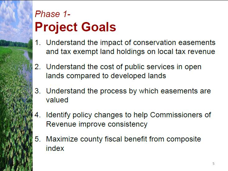
4 Executive Summary Middle Peninsula localities pride themselves on their rural character, heritage, as well as their natural resource based economy which is reflected throughout county comprehensive plans. To support such a vision, private landowners are encouraged to place conservation easements on their property. However in Fall 2009, when The Nature Conservancy (TNC) purchased over 13,000 acres of land within the Dragon Run Watershed and then sold the land pending a conservation easement, Middle Peninsula localities began to question the fiscal impacts of conservation easements and recognized that current land use practices may not coincide with current land use policies. Therefore, in 2010, Middle Peninsula Planning District Commission (MPPDC) Staff, funded through the Virginia Coastal Zone Management Program (Grant #NA09NOS Task and Task 95), explored the fiscal impacts of conservation easements in the Middle Peninsula. As MPPDC staff worked closely with a variety of stakeholder groups (i.e. Virginia Department of Taxation (VaTAX), Commissioners of Revenue (CoR), Conservation Entities, County Planners and County Administrators), it was found that CoR were over reporting the total land book value to the VaTAX, which reduced the county s composite index score and thus the overall State funds received for education. To maximize the fiscal benefits through the Composite Index, MPPDC staff educated CoR as to the implications of current practices and presented opportunities to improve the methods for valuing and reporting conservation easements within their jurisdiction. With a handle on the fiscal impacts of conservation easements, developing cohesion between land use practices and policy was the focus of year 2. In part, MPPDC staff spent continued educating CoR, County Planners, County Administrators, and Conservation Entities within the Middle Peninsula and State-wide about the qualitative and quantitative findings from year 1. Furthermore MPPDC staff engaged stakeholders in discussions to identify challenges associated with conservation easements. Identified challenges included: (1) communication between the conservation community and localities, (2) disconnection between land use tools and current views of local officials, (3) CoR and Planning Staff are unable to easily track conservation easements once they are recorded, and (4) consistency in accounting for the reduction in fair market values of lands with conservation easements. With this information MPPDC staff developed a Public Policy options and Recommendation matrix to offer solutions to identified challenges and to ultimately improve local accountability of conservation easements. 1 P a g e
5 I. Introduction The Middle Peninsula Planning District Commission (MPPDC) funded through the Virginia Coastal Zone Management Program, continued focusing on the ramifications of conservation easements within the Middle Peninsula. However, rather that considering the fiscal impacts of conservation easements, as in year 1, MPPDC staff focused on the land use implications of conservation easements within the region. Through the developed of maps depicting the location of current conservation efforts, MPPDC staff engaged local stakeholder s in discussions to promote cohesion between land use practices and land use policies. II. Continued Discussion: Fiscal Impacts of Conservation Easements Throughout the grant year, MPPDC staff presented the quantitative and qualitative findings, found under grant #NA09NOS Task and Task 95, to Commissioners of Revenue (CoR), County Planners, County Administrators, and Conservation Entities within the Middle Peninsula and State-wide. Locally, MPPDC staff convened meetings targeting Middle Peninsula CoR as well as conservation entities and county staff. First in October 2011, MPPDC staff hosted Middle Peninsula CoR to present the findings (Appendix A). MPPDC staff reviewed VA Code associated with conservation easements (i.e. Virginia Open Space Land Act and Virginia Conservation Easement Act ) and the authority given to localities to adjust the fair market value of properties with conservation easements. MPPDC staff also reviewed the specific quantitative findings from each county; since each locality approached conservation easements differently, it prompted discussions about the VA Code and the professional responsibilities of the CoR. In particular, CoR shared ideas to improve the current process in handling conservation easements in their locality as well as within the region. To name a few, suggestions included (1) maintaining a list of eligible conservation easement holders within the State for CoR reference, (2) MPPDC staff could host educational seminars to share fiscal impacts from MPPDC localities, and (3) MPPDC staff could work with CoR to develop a template to track conservation easements (ie. Tax-map number, holder, fair market value, devaluation due to easement, etc). As this meeting was the first of its kind between Middle Peninsula CoR, it ultimately facilitated the development of professional relationships and the 2 P a g e
6 exchange of ideas and practices which assisted several localities in maximizing their fiscal benefits through the composite index. A month following the CoR meeting, MPPDC staff convened a meeting with a more diverse group of local stakeholders, including Directors of County Planning within the Middle Peninsula, Hampton Roads Planning District Commission (HRPDC), The Nature Conservancy (TNC), Virginia Outdoor Foundation (VOF), Middle Peninsula Land Trust (MPLT), Virginia Department of Forestry (DOF), as well as Virginia Department of Conservation and Recreation (DCR) (Appendix B). Although the meeting s topic of discussion was almost identical to the CoR meeting, the discussion ensued by these stakeholders was invariably different due to this group s professional experience in land use and public policy. Therefore as the MPPDC staff reviewed the findings from year 1, the stakeholders offered policy solutions and recommendations to improve how localities account for conservation easements within their jurisdiction. For more policy information please see section IV. Additionally on two separate occasions, MPPDC staff presented the findings of year 1 at state conferences, including Virginia s United Land Trust (VaULT) Conference and the Virginia Association of Assessing Officers (VAAO) Educational Seminar (Appendix F). At the VaULT conference the audience primarily included conservation entities, while the VAAO Seminar consisted of CoR and Assessors throughout the State. In any case, Middle Peninsula localities have become a case study for all other counties within the Commonwealth of Virginia, particularly as localities work within the same Virginia Code framework and strive to maximize their fiscal benefits through the composite index. MPPDC staff enquired about the usefulness of report from year 1 and how it may be used or is currently being used by conservation entities as well as counties: I am bringing together a Land Trust subcommittee under our Conservation Planning & Stakeholder Outreach Committee to talk about how we might use your study and other similar information to develop a presentation for County Administrators, Elected Officials, Planners and Commissioners of Revenue. The goal of the presentation will be to educate them about the value of conservation easements and the impacts to County revenues and state education funding. Mr. John R. Eustis, Executive Director New River Land Trust (June 2011) I have talked about and provided your well done study to officials and staff in the counties of Bland, Carroll, Floyd and Montgomery. This has included county 3 P a g e
7 administrators, board of supervisors and commissioners of revenue. What I need to do now is follow up with meetings specifically about the findings and how things are being done in these counties. Mr. John R. Eustis, Executive Director New River Land Trust (November 2011) We re already using it [the Conservation Easement Report] in our advocacy work here the Piedmont Environmental Council. Ms. Heather Richards, Director of Land Conservation Piedmont Environmental Council I ve read it [the Conservation Easement Report] and found the results both interesting and potentially helpful. I expect we [Land Trust of Virginia] will be using the study next time we hear a challenge from a member of the Board of Supervisors, member of the public, or legislative representative claiming that easements adversely affect the county s tax base. Your report may be particularly helpful to other county tax assessor s offices in properly assessing properties under easement. Mr. Donald J. Owen, Executive Director Land Trust of Virginia (June 2011) Q: How has your organization utilized the report? Or how does your organization plan to use this report in the future? A: To incorporate this research and study as reference in the 2013 Virginia Outdoors Plan. - Ms. Janit Llewellyn, Virginia Department of Conservation & Recreation (June 2011) III. Mapping: Conservation Efforts in the Region To provide a visual of conservation efforts within the region as well as to support stakeholder discussions, MPPDC staff conducted a GIS analysis (Appendix D) and developed maps depicting Priority Conservation Areas (PCA), local zoning districts compatible with conservation, as well as the location of conservation easements within the Middle Peninsula. MPPDC staff first started with the development of a map depicting only protected areas (ie. Managed Lands or Lands with Conservation easements) (Appendix C: Figure 1). To add to the analysis MPPDC staff overlaid PCA data. As a collaboration between the Virginia Department of Game and Inland Fisheries (DGIF), Virginia Department of Conservation and Recreation Division of Natural Heritage (DCR-DNH), and Virginia Commonwealth University Center for Environmental Studies (VCU-CES), conservation information and priorities were synthesized into a unified dataset of Priority Conservation Areas (PCA). The PCA is a geospatial 4 P a g e
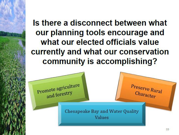
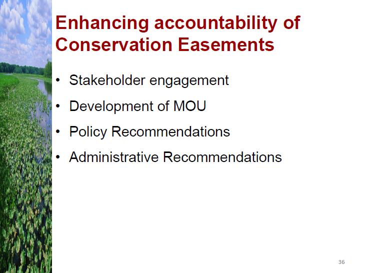
8 representation of conservation opportunities throughout the Commonwealth developed to assist localities in conservation planning efforts. Therefore get an idea of the how current land use practices jive with the State s conservation priorities, MPPDC staff overlaid the protected lands with the PCA data (Appendix C: Figure 2). MPPDC staff also reviewed the various zoning definitions from Middle Peninsula Locality Ordinances to determine those zones compatible with conservation (Appendix D) and compared that with the location of conservation easements (Appendix C: Figure 3). As these maps juxtaposed current land use practices with current land use policies, local elected officials, county administrators as well as county planners were able to observe and notice that within the Middle Peninsula conservation efforts are indeed occurring within high priority conservation areas, and that there are few protected areas that are in conflict with current land use policies (ie. Zoning). IV. Land use practice and public policy: Creating cohesion Middle Peninsula localities pride themselves on their rural character and natural resource based economy. As this is reflected in each county s comprehensive plan (Appendix E), conservation efforts within the region are generally encouraged; however current county planning tools do not specifically direct the location of conservation easements. Thus MPPDC staff, in partnership with conservation entities and Middle Peninsula county stakeholders, identified inconsistencies and challenges associated conservation easements. Through a series of stakeholder meetings, challenges of accounting for conservation easements were identified. Challenges included (1) communication between the conservation community and localities, (2) disconnection between land use tools and current views of local officials, (3) Commissioners of Revenue and Planning Staff are unable to easily track/search for conservation easements once they are recorded, and (4) consistency in accounting for the reduction of fair market values of lands with conservation easements. In order to offer some solutions, MPPDC staff developed a matrix of Public Policy Options and Recommendation to improve local accountability of conservation easements within a given locality. As part of the matrix, a Memorandum of Understanding template created to establish a process agreement to encourage communication between these stakeholder groups upon the initiation of a conservation easement. 5 P a g e
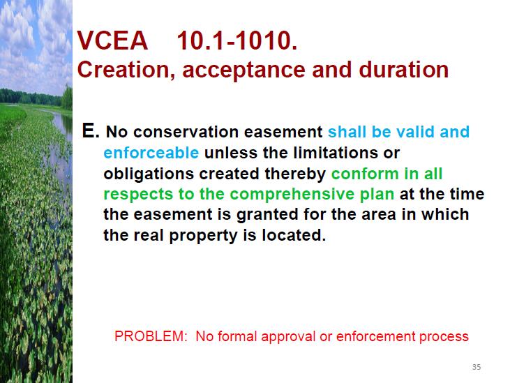
9 This Public Policy Options and Recommendation matrix was later incorporated into a Guidance Document (Appendix G) to assist counties participating within the Virginia Use Value Assessment Program (ie. land-use counties), and those counties that are not (ie. non-land use counties), by offering options to improve the accountability of conservation easements within a given jurisdiction. To facilitate interested localities in making recommended land use policy and administrative changes, MPPDC presented the matrix to county administrators and planning directors. V. Conclusions Throughout year 2, MPPDC staff continued educating Middle Peninsula Commissioners of Revenue and Regional Stakeholders as to the fiscal impacts of conservation easements. Besides helping to improve processes within the Middle Peninsula, localities throughout the Commonwealth also benefited from year 1 findings as MPPDC staff presented this information at State Conferences. According to the Virginia Conservation Easement Act 1 an easement in not valid unless it conforms to the county comprehensive plan. This suggests that local governments have the responsibility to use their authority, through the comprehensive plan and zoning ordinances, to specify the location of conservation easements, if they are unsatisfied with current land use practices. Therefore, as land conservation efforts become more popular among landowners, localities should have a clear understanding of how their current land use practices coincide, or not, with their current land use polices. Therefore through the development of maps and facilitating discussions with regional stakeholders focused on the relationship between land conservation, land use policy and land use practices, Middle Peninsula localities have gained a better sense of the current land use practices and policies associated with conservation easements. 1 Virginia Conservation Easement Act ( ), No conservation easement shall be valid and enforceable unless the limitations obligations created thereby conform in all respects to the comprehensive plan at the time the easement is granted for the area in which the real property is located. 6 P a g e
10 Project Outcomes: Regional and State-wide stakeholders discussions were prompted by MPPDC with regard to the fiscal impacts of conservation easements as well as associated legislation to maximize their fiscal benefits through the composite index. The Middle Peninsula CoR Meeting facilitated the development of professional relationships and the exchange of ideas and practices which assisted several localities in improving their fiscal benefits from the composite index. A Public Policy Options and Recommendation matrix was developed to focus on creating cohesion between current land use practices and policies. The development of a Memorandum of Understanding between a given conservation entity and a locality to improve communication between the two entities during the onset of a conservation easement. Conservation Entities throughout the Commonwealth have used or plan to use the Conservation Easements: Fiscal Impacts to Localities in the Middle Peninsula report from year 1: (1) DCR may use this report as a reference in the 2013 Virginia Outdoors Plan, (2) the New River Land Trust has talked about and provided the report to officials and staff in the counties of Bland, Carroll, Floyd and Montgomery, and (3) the Piedmont Environmental Council has used this report in advocacy efforts. 7 P a g e
11 Appendix A: Commissioner of Revenue Round Table Meeting Agenda and Minutes Commissioner of Revenue Roundtable November 17, 2010 AGENDA 1. Overview of relevant Virginia Code 2. Discussion on composite index 3. Needs identified by CORs 4. Overview of impacts for each county 5. Idea sharing to improve the process by 8 P a g e
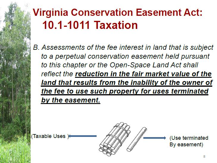
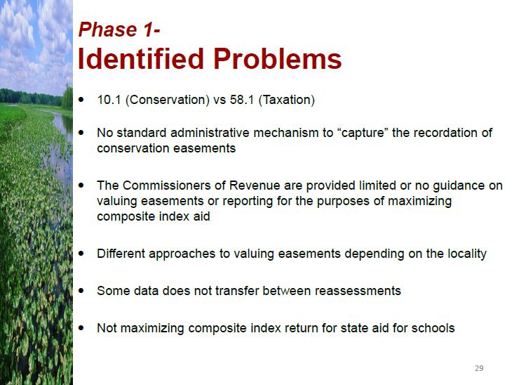
12 Commissioner of Revenue Roundtable November 17, 2010 MINUTES Welcome and Introductions Middle Peninsula Planning District Commission Staff held a meeting with the Commissioners of Revenue from Middle Peninsula localities and the Virginia Department of Taxation in the Middle Peninsula Planning District Commission Board Room in Saluda, Virginia, at 11 a.m. on November 17, 2010 to discuss the findings of the Conservation Easement Initiative. Ms. Sara Stamp, Regional Projects Planner II, welcomed those in attendance. Commissioners of Revenue in attendance included Mr. Kevin Wilson, Gloucester County; Ms. Sally Pearson, King William County; Ms. Helen Longest, King and Queen County; Ms. Bonnie Davenport, Middlesex County; and Mr. Thomas Blackwell, Essex County. Also present were Mr. Reese Milligan, Gloucester County Assessor; Mr. Jason Hughes, Virginia Department of Taxation; and Ms. Jackie Rickards, Regional Projects Planner I. Overview of relevant Virginia Code Ms. Stamp introduced the initiative to understand the fiscal impacts of conservation easements within the Middle Peninsula. She shared that over the last six-months, MPPDC staff have been working with each Commissioners of Revenue (CoR) from each locality to understand the process/method in which counties currently handle conservation easements. MPPDC staff explained that to start this project, legislation relevant to conservation easements and tax code was reviewed. In VA Code, Section 10.1 Conservation, CoR may find information relevant to conservation easements and how to value them. MPPDC staff acknowledged that this is not included within the VA Taxation Code (Section 58.1) that CoR typically work with. According to Section 10.1, properties with conservation easements shall be reduced in fair market value due to the inability of the owner of the fee to use such property for uses terminated by the easement. In land use-counties the property with an easement shall be devalued based on the land use rates that have been adopted by the county, while the CoR or the assessor in non-land use counties shall value the property based only on uses of the land that are permitted under the terms of the easement and not those values attributable to the uses or potential uses of the land that have been terminated by the easement. Discussion on composite index MPPDC staff reviewed how conservation easements impact local State aid received for education through the composite index. As the fair market value of properties with conservation easements are reduced based on the encumbrances placed on the property, CoR are to report a reduced total land book value to the Department of Taxation rather than the original fair market value of the land. As the reduced fair market value is recorded this will reduce the total land book value of the county which will then increase the State aid received by the county for education. Through MPPDC staff research it was found that Commissioners of Revenue are not currently maximizing fiscal benefit of conservation easements. Overview of impacts for each county Over the last six months, MPPDC staff have worked with CoR, researched county records, and connected with entities affiliated with conservation easements to gain a comprehensive list of 9 P a g e
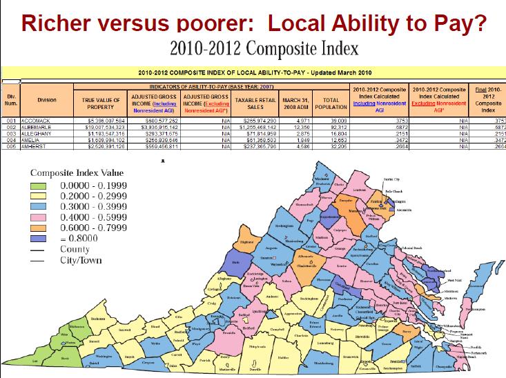
13 properties with easements. From this list, MPPDC staff worked with CoR and reviewed property cards to conduct a quantitative analysis of the conservation easements and tax exempt land holdings for conservation purposes within each county. With this information MPPDC staff assessed the fiscal impacts of conservation easements to each locality. In particular, MPPDC staff shared that while working with Essex County, the county was able to reduce their total land book value by an additional $18 million which will increase the amount of state aid they will receive from the State for education. Idea sharing to improve the process by CORs Following the overview of the project and the outcomes, Commissioners of Revenue were able to provide feedback and ideas with regards to the report and how to improve the current process in dealing with conservation easements within their locality: Having a list of eligible conservation easement holders within the State would inform the CoR of legitimate transactions; Education seminars statewide to clarify conservation easement and their fiscal impacts to localities; present at the VAAO (Virginia Association of Assessing Officers) in July 2011; Make a template available for keeping track of conservation easements (ie. parcel, holder, value, devaluation due to easement) to Commissioners of Revenue; Have Virginia Outdoor Foundation (VOF) and other conservation groups include localities earlier in the conservation easement process. According to CoR, VOF will inform the county of an easement only days before the easement is approved by the board; Historic Easements - how are they Valued? Suggest to adding tax exempt properties to sales study is this even possible? Questions that arose through conversations 1. What are the elements impacting the composite index? 2. What numbers are TAX submitting to the US Department of Education? 3. What is the impact of tax exempt properties to localities and their ability to collect federal funding? 4. Does a county specifically need to adopt open space land use in order to devalue an open space property with a conservation easement? 5. If a land is placed in conservation easement prior to the county s adoption of a land use program, do that property get devalued using the land use rates? The Commissioners of Revenue agreed to have another meeting at the end of the project to continue discussions with regards to this project. 10 P a g e
14 Appendix B: Conservation Stakeholder Meeting Agenda and Minutes Conservation Easements Where do you want em? December 17, pm Regional Boardroom, MPPDC Office, Saluda AGENDA 1. Welcome and Introductions 2. Background of the Project 3. Fiscal Findings from the Conservation Initiative Report 4. Virginia Open-Space Land Act and Virginia Conservation Easement Act 5. Currently in the Middle Peninsula 6. What is the perceived land use impact of conservation easements in the Middle Peninsula? Your thoughts?? 7. Next Steps 11 P a g e
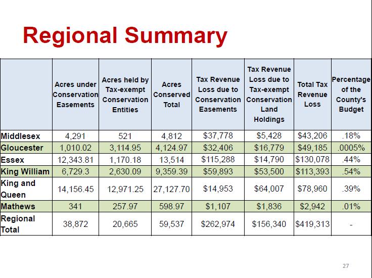
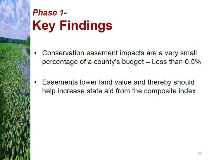
15 Conservation Easements Where do you want em? December 17, pm Regional Boardroom, MPPDC Office, Saluda MINUTES The Middle Peninsula Planning District Commission Staff held a meeting in the Middle Peninsula Planning District Commission Board Room in Saluda, Virginia, at 1 p.m. on December 17, Ms. Sara Stamp welcomed those in attendance including Frank Herrin, Friends of Dragon Run (FODR); Hank Hartz, Virginia Outdoors Foundation (VOF); Bob Lee, VOF; Scott Lucchesi, King William Planning Department; Andy Lacatell, The Nature Conservancy (TNC); Ben McFarlane, Hampton Roads Planning District Commission (HRPDC); Rob Suydam, Virginia Department of Forestry (DOF); Sarah Richardson, Virginia Department of Conservation and Recreation (DCR); Neal Barber, Middle Peninsula Land Trust (MPLT); and Jackie Rickards, Middle Peninsula Planning District Commission. Ms. Sara Stamp first reviewed the background of this project, the fiscal finding of the report as well as the Virginia Open-Space Land Act and Virginia Conservation Easement Act. This project began in April 2010 to look at the fiscal impacts of conservation easements and tax exempt land holdings by conservation groups and how they fiscally impact counties. Initiated by the Dragon Run Steering Committee, and then strongly supported by the Middle Peninsula Planning District Commission, MPPDC staff worked closely with the Commissioners of Revenue from each county to understand how conservation easements are considered. Through MPPDC staff research, there were several findings from the first year of this project including: 1. The tax revenue impact of conservation easements is less than about 0.5% of any given Middle Peninsula locality s annual budget. 2. Easements lower land value and help the composite index. 3. Schools receive more state aid funding because of easements. 4. Commissioners of Revenue are inconsistent when addressing conservation easements. 5. Commissioners of Revenue have changed reporting practices because of this work. Besides providing an overview of the project, the group discussed the land use impacts of conservation easement in the Middle Peninsula. Currently with no guidance as to where to place easements, conservation easements are placed randomly throughout the localities landscape. However through the Virginia Open Space Act as well as the Virginia Conservation Easement Act authority is given to local governments to adjust their comprehensive plan to provide placement guidance for conservation entities. According to Scott Lucchesi counties may benefit with a few changes to how conservation easements are tracked. For example with parcels that have conservation easements a CE could be added to the tax map number. Additionally, Mr. Lee explained the process in which VOF takes to inform localities of conservation easements within their jurisdiction. In the early stages of easement process VOF will contact the county to verify if the conservation easement is consistent with the comprehensive plan. VOF will allow some time for the county to respond and provide feedback. 12 P a g e
16 Therefore if such a process is standardized for the other conservation entities, this may help improve partnerships with local governments. To continue dialog a meeting will be scheduled in March 2011 to try to gain more local support in the discussion of land use implications and policies. 13 P a g e
 within the Middle Peninsula 2010.")
17 Appendix C: Series of maps depicting regional conservation efforts Figure 1: Map of Currently Protected Areas (ie. Managed Lands and Lands with Conservation Easements) within the Middle Peninsula P a g e
 within the Middle Peninsula 2010. 15 P a g e")
18 Figure 2: Map of Priority Conservation Areas, as determined by the State and Currently Protected Areas (ie. Managed Lands and Lands with Conservation Easements) within the Middle Peninsula P a g e
 within the Middle Peninsula 2010.")
19 Figure 3: Map of Zoning Incompatible/Compatible with Conservation and Currently Protected Areas (ie. Managed Lands and Lands with Conservation Easements) within the Middle Peninsula P a g e
20 Appendix D: A GIS Analysis Report A GIS Analysis Report: Middle Peninsula Locality Zoning Compatible with Conservation Efforts Document Purpose The purpose of this report is to document the GIS analysis undertaken for conservation corridor planning efforts within the Middle Peninsula Region. This report also provides the description language directly from local zoning ordinances of zoning districts determined to be compatible with conservation. General GIS Zoning Data Explanations The following GIS layers were created for the Conservation Corridor Project by (1) exporting Middle Peninsula County zoning districts within the MPPDC GIS database, (2) exporting relevant data from original attribute tables of county zoning districts within GIS files, (3) using ArcMap to digitally draw zoning districts (ie. Digitizing). Group Layer: All Middle Peninsula Zoning : Group Layer: Zoning Incompatible with Conservation : o Essex Districts Zoned Planned Unit Development o Essex Districts Zoned Industrial M-1 M-2 o Essex Districts Zoned Limited Business (B-1) o EssexIndSites o GloucesterNonCZoning o K&QNonAzoning MHP (Mobile Home Park) LB (Light Business) I (Industrial) GB/RS (General Business GB (General Business) A/I (Agricultural/Industrial) A/GB (Agricultural/General Business) o KWNotConsCompat o MathewsParcelsAvoid 17 P a g e
21 o Group Layer: Middlesex Zoning Incompatible : GB (General Business) CD (Cluster Development H (Housing) LI (Light Industry) MH (Mobil Homes) R (Residential) VC (Village Community) WC (Waterfront Commercial) Group Layer: Zoning Compatible with Conservation : o Layer: A-1 District Zoning (Agricultural) o GloucesterZonedC (Conservation) o K&QZonedA&Null o K&QZoned RR (Rural Residential) o KWZonedRR (Rural Residential) o o KWZonedAC (Agricultural Conservation) Group Layer: Middlesex Zoning Compatible with Conservation: MiddlesexZoned-C (Conservation) DRC/CBP (Dragon Run Conservation/Chesapeake Bay Preservation) LDR (Low Density Rural) RH (Resource Husbandry) Current colors of categories: Red: Parcels/Areas to Avoid-Zoning or Incompatible with Conservation Orange: Compatible with Conservation Purple: Protected Lands Mapping notes: All Towns colored as incompatible with conservation since they are population/business centers. As most of Middle Peninsula Locality zoning is compatible with conservation, depicting the zones incompatible with conservation was determined to be the most effective since the map was less cluttered. Essex County zoning data is not completely mapped. GIS data is not available. Most of the county is compatible with conservation. There are four incompatible with conservation and one conservation compatible layer for Essex. The remainder of the county is contained within a zoning district that is compatible with conservation and it was not digitized. Mathews County zoning data is not completely mapped. GIS data was not able to be used because it was faster to digitize a small number of parcels. Parcels that fell within the proposed VaNLA conservation corridors, and were zoned as a district that was determined to be incompatible with conservation, were digitized to show where in the proposed area should be avoided when considering zoning. Areas zoned as C or conservation district were not mapped. Mathews is the only county that does not have a conservation compatible layer. The special purpose zoning districts are not in the GIS data. 18 P a g e
22 Essex County Mapped zoning that is compatible and incompatible with conservation: Compatible: A-1, A-2 (did not map A-2, it is most of the county) Incompatible: PUD, M-1, M-2, B-1 Description of Zoning Districts determined to be Compatible with Conservation a. Purpose of the A-1 Agricultural Preservation: Purpose of this A-1 district is to encourage continued agricultural and forest uses and preserve the natural beauty of the rural areas of the County where urban services, such as sewer and water mains, are not planned. This district generally corresponds to areas of the county represented as the Agricultural Preservation District in the County Comprehensive Plan. At the same time, the District is intended to provide for limited residential development for those who choose to live in a rural environment and to protect this development where it occurs. In order to protect against premature subdivision of land and the formation of urban clusters where none are planned, subdivisions are controlled to maintain and protect the land base necessary to support the County s agricultural economy (Essex County Zoning Ordinance, VI-1). b. Purpose of the A-2 Limited Agricultural District: Purpose of this district is to protect farming operations and at the same time allow for low density residential uses. This district generally corresponds to areas of the County represented as the Countryside District and Rural Residential District in the County Comprehensive Plan. Generally, this district covers certain portions of the County now devoted entirely or predominantly to various open uses, such as farms, forest, parks or lakes, into which residential or other types of development could reasonably be expected to expand in the foreseeable future. In order to protect against premature subdivision of land and the formation of urban clusters where none are planned, subdivisions are controlled to maintain the rural character of the district (Essex County Zoning Ordinance, VII-1). Please see the following page for an image of the Essex County Official Zoning Map. 19 P a g e

23 20 P a g e
24 Gloucester County Mapped zoning that is compatible and incompatible with conservation: Compatible: C-1, C-2, RC-1 and RC-2. Incompatible: B-1:4, I-1, MF-1, PUD-1, SC-1 and SF-1. Description of Zoning Districts determined to be Compatible with Conservation a. Purpose of the Conservation District (C-1): The intent of the C-1 district is to conserve water and wildlife resources, to reduce soil and shore erosion, to protect watersheds, to reduce hazards from flood and fire, to protect the wetlands, and to set aside large areas as open space by permitting only those uses compatible with natural areas. (Sec. 4-2 in Gloucester County Zoning Ordinance) b. Purpose of the Bayside Conservation District (C-2): The intent of the C-2 district is to allow low density residential development in a manner which protects natural resources in a sensitive environment. The intent is further to prevent soil and shore erosion, to reduce hazards from flood, hurricane, and fire, and to protect wetlands. A limited amount of residential development is permitted and clustering is encouraged to achieve the district's intent. (Sec. 4-3 in Gloucester County Zoning Ordinance) c. Purpose of the Rural Countryside District (RC-1): The intent of the RC-1 district is to conserve farm and forest land and to encourage agricultural activities, thereby helping to ensure that commercial agriculture and silviculture will continue as long term land uses and viable economic activities within the county. The RC-1 district is also established to preserve natural features and the rural landscape, while allowing low density, clustered residential development. Residential development is to be permitted only when it is located and designed to minimize its impact on agricultural land, farming and silviculture, and sensitive environmental features; to create attractive rural developments; and to respect existing features of the rural landscape. Cluster development is encouraged to better achieve these goals (Sec. 4-4 in Gloucester County Zoning Ordinance). d. Purpose of the Rural Conservation District (RC-2): The intent of the RC-2 is to protect the natural resources of the bayside area of the county, to preserve prime agricultural soils, to protect watersheds and wildlife habitat, to reduce hazards from flood, hurricane, and fire, to protect wetlands, and to preserve large contiguous areas of open space and forests. A limited amount of residential development is permitted and clustering is encouraged to achieve the district's intent (Sec. 4-5 in Gloucester County Zoning Ordinance). (Gloucester County, Appendix B-Article 4) Please see the following page for an image of the Gloucester County Zoning Map. 21 P a g e

25 22 P a g e
26 King and Queen County Mapped zoning that is compatible and incompatible with conservation: Compatible: A & RR Incompatible: A/RS, RS, LB, MHP, GB, GB/RS/I, A/I, A/GB, GB/A, A/LB, A/RG, RG Table of Zoning Districts and Codes: NAME OF ZONING DISTRICT Primary Zoning Districts Agricultural Residential, Rural Residential, Single-Family Residential, General Limited Business General Business Industrial Special Purpose Zoning Districts Airport Safety Overlay District Chesapeake Bay Preservation Area Dragon Run Conservation District Floodplain Overlay District Planned Unit Development District Rural Residential Cluster District ABBREVIATED CODE A R-R R-S R-G LB GB I AIR CBPA DRCD FLD PUD RRC Description of Zoning Districts determined to be Compatible with Conservation: a. Purpose of the Agricultural (A) District: This district is designed to protect existing farms, forests, conservation areas and other types or rural uses; to encourage future development only when it promotes the preservation of the rural qualities of the county; and to provide for supportive commercial uses, along with necessary community facilities. The use restrictions and other regulations within the district are intended to reflect the importance of agriculture and forestry to the character and economy of the county and to discourage development of other uses, except where they promote the preservation of the rural qualities of the county. Residential uses are permitted primarily: to accommodate farm families and workers; to provide opportunities for a limited number of independent home sites, while avoiding pressures for major residential subdivisions and strip development along highways (King and Queen, Part II-Chapter 3 Article 3). b. Purpose of the Residential-Rural (R-R) District: The purpose of the residential-rural (R-R) district is to provide for moderately low-density residential development together with accessory and support uses including recreational facilities and public service uses. The predominant development in this district is envisioned to be subdivisions of moderate density, including rural residential cluster subdivisions, which do not require public water or public sewerage systems (King and Queen, Part II-Chapter 3 Article 3). Please see the following page for an image of the map of parcels in King and Queen County that are not zoned agricultural. 23 P a g e
27 24 P a g e
28 King William County Mapped zoning that is compatible and incompatible with conservation: Compatible: A-C & R-R Incompatible: R-1, B-1, B-2, M, HP, 2 Table of Zoning Districts with Code: Name of Zoning District Primary Zoning Districts A-C agricultural-conservation district R-R rural residential district Abbreviated Code A-C R-R R-1 suburban residential district R-1 B-1 local business district B-1 B-2 general business district B-2 M industrial district R-C rural-conservation district Special Purpose Zoning Districts PUD planned unit development district HP historic preservation district TC transportation corridor district RPA resource protection area RMA resource management area M R-C PUD HP TC RPA RMA Descriptions of Zoning Districts determined to be Compatible with Conservation: a. Purpose of the A-C agricultural-conservation district: The purpose of the A-C agricultural-conservation district is to encourage continued agricultural and forestal uses and preserve the natural beauty of rural areas of the county where urban services, such as sewer and water mains, are not planned or expected to be planned. At the same time, the A-C district is intended to provide for limited residential development for those who choose to live in a rural environment and to protect this development where it occurs. In order to aid in reduction of access points and traffic hazards, wider lots and deeper front yards are required when fronting on major thoroughfares. In order to protect against premature subdivision of land and the formation of urban clusters where none are planned, large-scale subdivisions are not intended in this A-C district. b. Purpose of the R-R rural residential district: The purpose of the R-R rural residential district is to provide for moderately low-density residential development together with such churches, recreational facilities, public uses and accessory uses as may be necessary or are normally compatible with residential surroundings. Since substantial tracts of vacant land are or may be included in the R-R district, agricultural and open uses are expected to be intermixed with rural cluster subdivisions which emphasize 2 = null values in attribute table, grouped in with not compatible zoning districts 25 P a g e
29 preservation of agricultural and forestal lands. Major subdivisions with very low densities and no central water system are envisioned as the major development style of this R-R district, although slightly lower densities are acceptable where public water is provided for larger subdivisions. (King William County Code, Chapter 86-Article IV) Please see the following page for an image of the King William County Zoning Map. 26 P a g e
30 27 P a g e
31 Mathews County Mathews County zoning GIS data was unable to function away from the county offices (geodatabase and layer files pull data from Mathew s system that doesn t transfer, need to export layer file as a shapefile). MPPDC staff mapped the parcels in Mathews that are zoned something other than C or RU AND are within the VaNLA network proposed by DCR. Mathews County Zoning Districts: B-1: Business-1 District B-2: Business-2 District C: Conservation District I: Industrial District R-1: Residential-1 District RU: Rural Residential R-2: Residential-2 District Descriptions of Zoning Districts determined to be Compatible with Conservation: a. Purpose of the Conservation District (C): This district is intended to protect, preserve and propagate the County's living marine environment and its natural resources. The district is intended for use in water, wetlands and shoreline areas and other areas which are not suited for development and where such development would have an adverse effect on the environment and public and private areas which have been set aside for conservation purposes. Areas within the district generally are unsuitable for development or intensive use due to soil, water or high flood hazard conditions. b. Purpose of the Rural District (RU): This district covers portions of the county which are occupied by various open uses, such as forests, parks, and farms necessary public and private industrial, recreational and religious facilities, single-family and twofamily dwellings and certain transient uses in a rural environment. Manufactured home parks and certain commercial and light manufacturing uses are allowed by Conditional Use Permit. This district is established for the specific purpose of facilitating existing and future farming operations, conservation of land and other natural resources, reducing soil erosion, and reducing hazards from flood, fire, and storms. Uses not consistent with the existing character of this district are not permitted. (Mathews County, 29) Image of the Mathews County zoning map and GIS data layer containing the zoning codes. 28 P a g e

32 29 P a g e
33 Middlesex County Zoning that is compatible and incompatible with conservation: Compatible: C, DRC, LDR, RH Incompatible: GB, CD, H, LI, MH, R, VC, WC, A All Middlesex Zoning Districts from Zoning Ordinance: Name of Zoning District Dragon Run Conservation Conservation Resource Husbandry Low Density Rural Residential Village Community Cluster Development General Business Waterfront Commercial Light Industrial Mobile Home Airport Abbreviated Code DRC C RH LDR R VC CD GB WC LI MH A Descriptions of Zoning Districts in Middlesex County determined to be Compatible with Conservation: a. Purpose of the Dragon Run Conservation (DRC) District: The purpose of the Dragon Run Conservation DRC District is to protect and conserve fragile resource areas which perform valuable functions in their natural state and which are unsuitable for development and intense use. Areas to be designated as the DRC primarily include wetlands and swamps, but may include other areas deemed to be important for flood plain management, aquifer recharge, water storage, critical wildlife habitat, or similar functions. b. Purpose of the Conservation (C) District: The purpose of the C District is to protect and conserve fragile natural resource areas which perform valuable functions in their natural state and which are unsuitable for development and intense use. Areas to be designated as C District primarily include wetlands and swamps, but may include other areas deemed to be important for flood control, aquifer recharge, water storage, critical wildlife habitat, or similar functions. c. Purpose of the Resource Husbandry District (RH):The purpose of the Resource Husbandry RH District is to conserve and protect from competing or incompatible uses, traditional agricultural and forestry uses of large tracts which are particularly well suited for such uses by virtue of soil, topographic, and other natural conditions. The protection of large agricultural and forestry tracts is necessary to promote the general health and welfare of the County by insuring that valuable natural resources such as timber and fertile farmlands are properly managed and preserved for present beneficial environmental effects and for use of future generations. To this end, the RH District is intended to be occupied and used almost exclusively by large-scale agricultural and forestry uses and to provide areas in which these uses may be freely 30 P a g e
34 and intensively conducted with minimum potential for conflict with or competition from incompatible uses. In addition to agricultural and forestry, permitted uses in the RH District will be limited to those which support the two primary uses or which offer no potential for competition or conflict. Residential uses are permitted, but the RH District is not intended to be a general residential district. The residential use is included primarily to accommodate farm families and farm laborers, and secondarily to enable retired farmers to sell a limited number of home sites for income purposes, thereby reducing the risk that farms will be sold to reduce the financial burden of taxes and maintenance expenses. To this end, subdivision of land is severely restricted in the RH District. Residential uses will be encouraged to locate considerable distances from highways and to avoid strip development along highways. d. Purpose of the Low Density Rural (LDR) District: Most of Middlesex County is zoned as LDR-low density rural, determined compatible with conservation for this project. Middlesex County is predominantly rural in character and should remain so according to the Comprehensive Plan. The rural character of the County promotes the general health, welfare and safety of the citizens of the County by insuring them with a quiet, peaceful, uncluttered and safe living environment. The LDR District is intended to aid in the achievement of this goal by providing for a low density mixture of the primary uses of agriculture and forestry and secondary residential, recreational, and selected non-intensive commercial and public or quasi-public uses, throughout a major portion of the County. In order to protect agricultural and forestry uses, the range of other permitted uses is limited, but not to the same degrees as in the RH District. Strip development will be discouraged in favor of cluster development in order to avert undue pressures on land values and to prevent landlocking of parcels which do not abut highways. (Middlesex County, 15-55) Please see the following page for an image of the Middlesex County General Zoning Map. 31 P a g e
35 32 P a g e
36 Resources Essex County, Virginia. Essex County, Virginia Zoning Ordinance. Essex County, Virginia: Essex County, Gloucester County, Virginia. CODE County of GLOUCESTER, VIRGINIA. Codified through Ordinance of May 4, 2010 (Supplement No. 50 Redo). < King and Queen County, Virginia. CODE OF THE County of KING AND QUEEN, VIRGINIA. Codified through Amendment of Nov. 16, 2009 (Supplement No. 16). < King William County, Virginia. CODE OF THE COUNTY OF KING WILLIAM, VIRGINIA. Codified through Ordinance of Nov. 23, 2009 (Supplement No. 10). < Mathews County, Virginia. Zoning Ordinance of Mathews County, Virginia. Mathews County, Virginia: Mathews County, Middlesex County, Virginia. Middlesex County Virginia Zoning Ordinance, Reprinted: March 17, 2010 to include revisions. Middlesex, Virginia: Department of Planning and Community Development, P a g e
37 Acknowledgement and Disclaimer Although this data has been used by the Middle Peninsula Planning District Commission (MPPDC), no warranty, expressed or implied is made by the MPPDC as to the accuracy or application of the database and related materials, nor shall the fact of distribution constitute any such warranty; and no responsibility is assumed by the MPPDC in connection herewith. This project was funded in whole by the Virginia Coastal Zone Management Program at the Department of Environmental Quality through Grant #NA10NOS Task and Task 95 of the U.S. Department of Commerce, National Oceanic and Atmospheric Administration, under the Coastal Zone Management Act of 1972, as amended. The views expressed are those of the author(s) and do not necessarily reflect the views of the U.S. Department of Commerce, NOAA or any of its subagencies. 34 P a g e

 -to preserve agricultural/open space land or release it to unrestrained development. Agriculture is a land use activity which has supported Middlesex economically for generations.")
38 Appendix E: County Comprehensive Plan Language Relevant to land conservation and preservation MIDDLESEX County County Wide: -The citizens will continue to place high priority on maintaining the rural nature of the territory while accommodating desirable new development. (pg. 17) -The rural nature of the County, which combines watercourses, forests, and fields, provides ideal circumstances for quality wildlife habitats and biological diversity (pg. 55) -to preserve agricultural/open space land or release it to unrestrained development. Agriculture is a land use activity which has supported Middlesex economically for generations. Furthermore, it may be even more important to recognize that agricultural lands are a major element of the open space which defines the rural nature of the County. This particularly visible component of the country scene contributes directly to the quality of life and satisfaction its residents enjoy.(pg.104) -First, highest priority must be placed on the preservation of the rural character of the County. As defined, the rural character includes natural and open spaces between concentrations of activities. (pg. 105) -the County should adopt and or promote additional methods of land conservation.(pg. 123) -Enhance the rural and environmental character of the County through the preservation of agricultural and forestall lands, wetlands, flood hazard areas, and Chesapeake Bay Resource Protection Areas (pg. 136) Within the Dragon Run Watershed: -Low intensity land uses that are consistent with the conservation of the area s natural resources should be the dominant land uses in the Watershed and new development should be compatible with surrounding rural areas as well as incorporate development standards and management practices that ensure protection of the area s natural resources (pg.111) - The County should consider implementation strategies that preserve existing land uses and protect the natural resources in the Watershed such as conservation zoning and subdivision approaches, additional stream buffers and setbacks, the purchase of development rights, donation of private easements, landowner compacts, and land use taxation (pg. 112) -The County should protect the key natural resources in the Watershed, including the ground and surface water quality, wetlands, and sensitive environmental features; native plant and animal species and their natural habitats; and the productive soils that support farming and forestry uses. (pg.112) 35 P a g e
 -To project and enhance the environmental quality and the Chesapeake Bay for present and future residents (pg. 17) -To conserve and manage Gloucester s natural resources and community assets.")
 to update and revise local")
39 GLOUCESTER County -To protect the unique character and identity of Gloucester County careful management of the natural resources (pg. 17) -To project and enhance the environmental quality and the Chesapeake Bay for present and future residents (pg. 17) -To conserve and manage Gloucester s natural resources and community assets. Objectives: (3)to conserve prime agricultural and forested land sand guide residential, commercial and industrial development to areas suitable for urban growth, (4) to cooperate and actively work with local, regional, state, and federal environmental agencies to implement safe and effective programs and policies to protect Gloucester s natural resources and (5) to update and revise local ordinances as needed in order to protect and enhance the County s natural resources (pg.20) - To place high priority on selective acquisition, preservation, and recreational uses of areas with natural resources.(pg. 21) -special emphasis should be placed on the preservation of natural resources, sensitive natural areas, and waterfront areas (pg. 45) -To protect our wetlands and natural resources from unnecessary destruction due to increased drainage, filling or construction that would hamper vegetation, water storage, erosion control, or support for plant and wildlife (pg. 71) - balance population growth with the ability or capacity of the County to provide adequate public facilities and services while maintaining the rural nature and quality of the County. inherent to the quality of life in Gloucester county is its abundant natural environmental assets including an extensive shoreline, broad estuarine rives, forested areas, rural landscapes and waterfront vistas. (Appendix B- pg.3) -Protect open space and groundwater recharge areas through use of existing ordinances, development and implementation of an open space plan, consideration of conservation subdivisions and incentives for open space preservation through the land use tax assessment program. (Appendix B- pg. 69) -Use existing land use regulations and incentives to protect existing habitat for wildlife and preserve potential habitat areas for future use to preserve biodiversity in technologies and protect the County s recreation opportunities for hunting, fishing and wildlife observation. (Appendix B pg. 71) -Prepare a Countywide open space inventory and evaluation as baseline for an open space plan. The concept of the plan would be to evaluate as baseline for an open space plan. The concept of the plan would be to evaluate existing open space resources and provide the basis for to develop future County goals for preservation of environmentally sensitive lands and planning for the sustainable development use of the County s existing land resources consistent with the County s growth management goals. Preserve and protect open space resources as ground water recharge areas and to reduce non-point source pollution. (Appendix B pg. 71) 36 P a g e
40 ESSEX County - Conserve farmland, forested areas, open space and rural character (pg.71) -Protect and enhance the natural resources and environmental quality of the County through measures which protect the County s natural resources and environmentally sensitive lands and waters (pg. 74): Conserve forest resources while supporting the timber harvesting industry as an important component of the County economy Protect the important natural function of floodplains within the County by limiting disturbances caused by development activity Protect important plan and wildlife habitats within the county Coordinate environmental quality protection efforts with future opportunities to establish public parks, natural recreation areas, and open spaces -Protect the land resources necessary to support the County s agricultural and timber harvesting industries and maintain and enhance its rural character (pg. 78): Preserve the land base of productive agricultural soils in rural areas for a farming Manage and maintaining forestland resources in the County Minimize the conflicts which can occur between farm activities and residential development. Establish provisions in the Zone Ordinance which support the farmers right to farm in the Agricultural Preservation and country-side plan districts Encourage the implementation of soil conservation and water quality management plans, nutrient management plans and integrated pest management on all farms in the county -Preserve and enhance the County s rich cultural and historic heritage (ie. significant and important historic sites, properties, and structures) (pg. 79) -Two guiding objectives of the Essex County Land Use Plan are the preservation of the County s rural character and protection of its natural resources. (pg. 87) -The County s natural environment, its wildlife, steep slopes, masses of forest cover, riverfront and tributaries all literally define the county. As such they reflect the character and culture of the County. (pg. 118) 37 P a g e
 -To minimize the reduction of vegetative cover caused by development (pg. VIIi-4) -To preserve the large forested areas of the County (pg.")
41 KING WILLIAM County -The preservation and protection of the County s forests are of prime concern based on survey responses and comments made by citizens at public meetings. (pg. II-9) -To minimize the reduction of vegetative cover caused by development (pg. VIIi-4) -To preserve the large forested areas of the County (pg. VIII-5) -To maintain and preserve rural, agricultural, environmental and historic qualities of the County (pg. VIII-5) -To ensure that sound land use and development practices are employed and guide future development in an efficient and serviceable manner which is protective of King William County s predominantly rural and ecologically sensitive character. (pg. VIII-5) - To ensure the continuation of forestry as an industry and the preservation and establishment of woodlands for their aesthetic and ecological value. (pg. VIII-10) -Support programs and efforts to protect the County s prime agricultural lands from conversion to noncompatible land uses (pg. VIII-10) - Evaluate alternative tax structures such as land use taxation as tools to promote agricultural land preservation. (pg. VIII-11) - Support programs and efforts to promote woodlands as one of the best preventions of soil and pollutants from entering the Bay. (pg. VIII-11) -Support programs and efforts to preserve woodlands. (pg. VIII-11) -Establish incentives which encourage sensitive areas to be avoided while preserving the owner s development rights of the property. Some tools that may be pursued include cluster development, protective easements, and limited density transfers.(pg. VIII-23) -To protect natural wetlands and habitat areas and other environmentally-sensitive areas from loss or degradation as a result of development.(pg. VIII-27) -To ensure that critical and unique environmental areas are protected and preserved for the general welfare of King William County citizens and marine and wildlife populations, and the enjoyment of visitors (pg. VIII-27) -Study incentives to encourage conservation easements. (pg. VIII-28) 38 P a g e

42 KING & QUEEN County Countywide: -Rural Atmosphere: It is the general policy of the County to maintain and preserve the rural atmosphere and scenic beauty of the County while allowing moderate and carefully managed growth. The preservation of existing agricultural and forest lands by protecting them from excessive fragmentation, development, and incompatible uses is essential, as is innovative and attractive design and thoughtful placement of both residential and commercial development. Cluster housing, village development, open space requirements, attractive landscaping, vegetative buffers, conservation easements, and effective outdoor lighting and sign policy are among the tools and concepts which can make this possible. Preservation of the rural atmosphere and beauty was a major theme of both the citizen survey responses and the citizen committee reports.(pg. 2) - Continuation of land uses customarily associated with farming and forestry is to be permitted and encouraged in these areas. (pg.3) - The use of conservation or similar easements to preserve open spaces and limit fragmentation is encouraged. Land use taxation or a program for purchase of development rights would be helpful in preserving farm and forest land if economically feasible, and should be investigated.(pg.3) - This [Cluster and Planned Unit Development] method of development enables the owner of a large tract of agricultural or woodland to use only part of the land for development as residential lots while preserving the majority of the land for agriculture, woodland, or conservation areas. (pg.6) Within the Dragon Run Watershed -Adoption of Dragon Run Special Area Management Plan (Appendix C) -The Mission of the Plan is to support and promote community-based efforts to preserve the cultural, historic and natural character of the Dragon Run, while preserving property rights and the traditional uses within the watershed (Appendix A pg. 13) -A variety of tools (ie. Conservation easements, PDR, Agricultural and Forestall Districts, etc) exist with which to preserve forest and farmland (Figure 3) and unique natural resources within the Dragon Run watershed. (Appendix C - pg. 18) 39 P a g e
 -Increased conservation and management of large tract agriculture and forests (pg.")
43 MATHEWS County -Committed leadership to managing future growth and development in a way that balances development, jobs, revenues, and public services while sustaining the rural character and special natural features of Mathews County (pg. 2) -Increased conservation and management of large tract agriculture and forests (pg. 4) -Preserve and protect the natural environment and resources of Mathews County, which are fundamental to the community s quality of life and prosperity. (pg. 7) - Environmental conservation - wetlands, forests, water, soils, etc.; rising sea levels (pg. 14) -Encourage grouped development for new housing subdivisions to preserve open space and the environment. -Of particular importance worthy of greater conservation efforts are the maritime forests of Mathews County. These forests are important coastal habitats that are now challenged by climate change and rising sea levels (pg. 104) - Protect the environment by promoting and encouraging the use of best management practices and riparian buffers in agriculture and forestal operations. Promote environmental stewardship among landowners and operators by actively working with them in educational efforts and incentive or recognition programs. Tie reduced land use taxation to use of effective environmental practices. Encourage landowners to consider conservation easements for their properties. (pg. 144) -Where possible, conservation measures should be employed to protect natural communities and prevent investment losses in the future. (pg. 146) -In addition, Mathews County supports preservation of land through conservation or open-space easements (pg.151) -Rural Preservation/Conservation areas include public open space, natural preserves, and areas that should have carefully managed development or be conserved because of special ecosystems or natural conditions. (pg. 156) -Amend the County Zoning Ordinance to increase lot sizes for rural agriculture and forested lands. Consider using agricultural and forestal districts to preserve the lands for production. (pg. 208) 40 P a g e
 41 P a")
44 Appendix F: Conservation Easement Presentation given at the VaULT Conference (6/1/2011) as well as the Virginia Association of Assessing Officers Educational Seminar (7/13/2011) 41 P a g e


45 42 P a g e


46 43 P a g e


47 44 P a g e


48 45 P a g e


49 46 P a g e


50 47 P a g e

51 48 P a g e


52 49 P a g e

53 50 P a g e

54 51 P a g e

55 52 P a g e
56 Appendix G: A Guidance Document: Consistently Accounting for Conservation Easements within Your Jurisdiction 53 P a g e

 and a public body (grantee), conservation easements place restrictions on both the present and the future use of a property, which helps to")
, funded through the Virginia Coastal Zone Management Program, has been working with local")
. This document will assist counties participating within the Virginia Use Value Assessment Program (ie.")
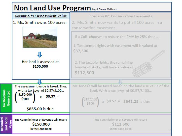
57 A Guidance Document: Consistently Accounting for Conservation Easements within Your Jurisdiction This report was funded in whole by the Virginia Coastal Zone Management Program at the Department of Environmental Quality rough Grant # NA10NOS Task and Task 95 of the U.S. Department of Commerce, National Oceanic and Atmospheric Administration, under the Coastal Zone Management Act of 1972, as amended. The views expressed are those of the author(s) and do not necessarily reflect the views of the U.S. Department of Commerce, NOAA, or any of its subagencies. As a legal agreement made between a landowner (grantor) and a public body (grantee), conservation easements place restrictions on both the present and the future use of a property, which helps to preserve the rural quality of the region in perpetuity. However as conservation easements become a more popular land use tool in the Middle Peninsula, there are fiscal impacts to localities. In order to reduce these fiscal impacts, the Middle Peninsula Planning District Commission (MPPDC), funded through the Virginia Coastal Zone Management Program, has been working with local Commissioners of Revenue, Conservation Entities, and County Planners to understand the fiscal impacts, while at the same time taking advantage of the composite index benefits (ie. receiving the proper amount of State aid for county education). This document will assist counties participating within the Virginia Use Value Assessment Program (ie.land-use counties), and those counties that are not (ie. non-land use counties), in accounting for conservation easements within their jurisdiction connecting the Commonwealth s legislative requirements to the County s role in meeting those requirements. As the Virginia Conservation Easement Act, Section Taxation, provides legislative guidance to properly assess conservation easements within the Commonwealth of Virginia, below is a simplified outline of how one may approach adjusting the fair market value of conservation easements which is authorized by VA Conservation Easement Act. NON LAND-USE counties- 1. The Commissioner of Revenue, or a qualified assessor, may reduce the fair market value of conservation easements based on the encumbrances placed on the property. According to Code (Section Part B), Assessments of the fee interest in land that is subject to a perpetual conservation easement held pursuant to this chapter or the Open Space Land Act shall reflect their reduction in the fair market value of the land that results from the inability of the owner of the fee to use such property for uses terminated by the easement. 2. Specifically, reduce the fair market value of lands with conservation easements based on only the uses of the land remaining after the easement and not on the uses or potential uses of the land that have been terminated by the easement. Directly from the Code, the fair market value of such land [lands with conservation easements] (i) shall be based only on uses of the land that are permitted under the terms of the easement and (ii) shall not include any value attributable to the uses or potential uses of the land that have been terminated by the easement. 3. With the reduced fair market value, the Commissioner of Revenue is to record the reduced value of the property with the conservation easement in the County Landbook and therefore report this reduced value to the Virginia Department of Taxation. Reporting the reduced value will ultimately lower the total landbook value and benefit the county through the composite index. 4. The County may tax the reduced fair market value of the land with the conservation easement. As conservation easements are take exempt, the County may only tax those property right that remain.
Middle Peninsula Conservation Corridor Plan
 Middle Peninsula Conservation Corridor Plan Middle Peninsula Planning District Commission 2010 As population within the Middle Peninsula rises, conservation corridor planning provides an option for localities
EASEMENTS: Fiscal Impacts to Localities in the. Jackie Rickards Middle Peninsula Planning District Commission July 13, 2011
 CONSERVATION EASEMENTS: Fiscal Impacts to Localities in the Middle Peninsula Jackie Rickards Middle Peninsula Planning District Commission July 13, 2011 1 Location of the Middle Peninsula Middle Peninsula
Conservation Easements: Fiscal Impacts to Localities in the Middle Peninsula. Middle Peninsula Planning District Commission Amended - December 1, 2010
 Conservation Easements: Fiscal Impacts to Localities in the Middle Peninsula Middle Peninsula Planning District Commission Amended - December 1, 2010 While Conservation Easements and land holdings by tax-exempt
Special Area Management Plan:
 Middle Peninsula Planning District Commission Special Area Management Plan: DRAGON RUN WATERSHED The Virginia Coastal Zone Management Program has funded a ten year endeavor through the Dragon Run Watershed
STAFF REPORT. Permit Number: Porter. Kitsap County Board of Commissioners; Kitsap County Planning Commission
 STAFF REPORT Permit Number: 15 00461 Porter DATE: November 9, 2015 TO: FROM: Kitsap County Board of Commissioners; Kitsap County Planning Commission Katrina Knutson, AICP, Senior Planner, DCD and Jeff
CHAPTER Committee Substitute for Committee Substitute for Senate Bill No. 2188
 CHAPTER 2004-372 Committee Substitute for Committee Substitute for Senate Bill No. 2188 An act relating to land development; amending s. 197.502, F.S.; providing for the issuance of an escheatment tax
Instructions: Script:
 Before the course, select four of the 11 tool topics to insert into the presentation, including at least one tool from each of the three goal categories. Replace each tool placeholder slide with the slides
ARLINGTON COUNTY, VIRGINIA. County Board Agenda Item Meeting of June 17, 2017
 ARLINGTON COUNTY, VIRGINIA County Board Agenda Item Meeting of June 17, 2017 DATE: June 9, 2017 SUBJECT: Request to authorize advertisement of public hearings by the Planning Commission and County Board
FUTURE LAND USE. City of St. Augustine Comprehensive Plan EAR-Based Amendments
 FUTURE LAND USE City of St. Augustine Comprehensive Plan EAR-Based Amendments Future Land Use Element FLU Goal To create an environment within the City and adjacent areas in which its residents have the
Purpose: Regulations:
 Administrative Procedures for the Designation and Refinement Of Chesapeake Bay Preservation Area Boundaries Guidance on the Chesapeake Bay Preservation Area Designation and Management Regulations September,
Implementation Guidance for The Sustainable Growth and Agricultural Preservation Act of 2012 Senate Bill 236
 Implementation Guidance for The Sustainable Growth and Agricultural Preservation Act of 2012 Senate Bill 236 May 22, 2012 Version 1.0 Table of Contents 1. Executive Summary... 1 1.1 Bill Highlights...
ZONING CLASSIFICATION SUMMARY SHEET
 Growth and Resource Management Planning and Development Services 123 West Indiana Avenue Room 202 DeLand, Florida 32720-4253 Telephone (386) 943-7059 Fax (386) 626-6570 www.volusia.org ZONING CLASSIFICATION
PLANNING FOR OUR FUTURE
 PLANNING FOR OUR FUTURE ELLSWORTH TOWNSHIP LAND USE AND POLICY PLAN The purpose of this Plan is to serve as a guide for the Township Trustees, Zoning Commission, Board of Zoning Appeals, developers, employers,
IRS FORM 8283 SUPPLEMENTAL STATEMENT DONATION OF CONSERVATION EASEMENT
 Name(s) shown on income tax return Identifying Number Robert T. Landowner 021-34-1234 Susan B. Landowner 083-23-5555 IRS FORM 8283 SUPPLEMENTAL STATEMENT DONATION OF CONSERVATION EASEMENT On November 12,
A STUDY OF TRANSFER OF DEVELOPMENT RIGHTS (TDR) IN THURSTON COUNTY, WASHINGTON
 IN THURSTON COUNTY, WASHINGTON") A STUDY OF TRANSFER OF DEVELOPMENT RIGHTS (TDR) IN THURSTON COUNTY, WASHINGTON Prepared June 2010 by Evergreen College students Jenna Fissenden and Steven Michener with guidance from staff members within
A STUDY OF TRANSFER OF DEVELOPMENT RIGHTS (TDR) IN THURSTON COUNTY, WASHINGTON Prepared June 2010 by Evergreen College students Jenna Fissenden and Steven Michener with guidance from staff members within
Implementation Guidance. for. The Sustainable Growth and Agricultural Preservation Act of Senate Bill 236
 Implementation Guidance for The Sustainable Growth and Agricultural Preservation Act of 2012 Senate Bill 236 August 1, 2012 Version 2.0 Table of Contents 1. Executive Summary... 1 1.1 Bill Highlights...
4.2 LAND USE INTRODUCTION
 4.2 LAND USE INTRODUCTION This section of the EIR addresses potential impacts from the Fresno County General Plan Update on land use in two general areas: land use compatibility and plan consistency. Under
Title 6 - Local Government Provisions Applicable to Special Purpose Districts and Other Political Subdivisions
 Title 6 - Local Government Provisions Applicable to Special Purpose Districts and Other Political Subdivisions CHAPTER 29. SOUTH CAROLINA LOCAL GOVERNMENT COMPREHENSIVE PLANNING ENABLING ACT OF 1994 1994
PROJECT SCORING GUIDANCE. Introduction: National Proiect Selection:
 FOREST LEGACY PROGRAM PROJECT SCORING GUIDANCE Introduction: This document provides guidance to the National Review Panel on how to score individual Forest Legacy Program (FLP) projects, including additional
STAFF REPORT. Permit Number: Garland. Kitsap County Board of Commissioners; Kitsap County Planning Commission
 STAFF REPORT Permit Number: 15 00686 Garland DATE: February 25, 2016 TO: FROM: Kitsap County Board of Commissioners; Kitsap County Planning Commission Katrina Knutson, AICP, Senior Planner, DCD and Jeff
St. Mary s County Comprehensive Zoning Ordinance Article 1. GENERAL PROVISIONS
 0 0 0 0 ARTICLE. GENERAL PROVISIONS CHAPTER 0 TITLE, PURPOSE AND ORGANIZATION Sections: 0. Title. 0. Authority. 0. Purpose. 0. Organization of the Zoning Ordinance. 0. Official Zoning Map. 0. Applicability.
Public Access Authority Private Land Giving Program Development for Enhancement of Public Water Access on the Middle Peninsula
 Public Access Authority Private Land Giving Program Development for Enhancement of Public Water Access on the Middle Peninsula Public Access Authority Private Land Giving Program Development for Enhancement
Special Use Permit - Planned Unit Development Checklist. Property Address:
 Special Use Permit - Planned Unit Development Checklist Special Use Permit Number. Parcel Code/s #28-11- - - Property Address: Applicant: ARTICLE VIII Ordinance Reference - Section 8.1.2 Permit Procedures:
TOWN OF PELHAM, NEW HAMPSHIRE
 TOWN OF PELHAM, NEW HAMPSHIRE BUILDOUT ANALYSIS Prepared for the PELHAM CONSERVATION COMMISSION with the assistance of the NASHUA REGIONAL PLANNING COMMISSION TABLE OF CONTENTS I. INTRODUCTION...1 II.
FINAL PROJECT REPORT
 PRESERVATION AND PROGRESS IN THE DRAGON RUN RECOMMENDATIONS for a MODEL COMPREHENSIVE PLAN DISTRICT and ZONING OPTIONS for the DRAGON RUN A Report of the Task Force to the Dragon Run Steering Committee
STAFF REPORT. Permit Number: Lee. Kitsap County Board of Commissioners; Kitsap County Planning Commission
 STAFF REPORT Permit Number: 15 00689 Lee DATE: March 2, 2016 TO: FROM: Kitsap County Board of Commissioners; Kitsap County Planning Commission Katrina Knutson, AICP, Senior Planner, DCD and Jeff Arango,
L. LAND USE. Page L-1
 L. LAND USE 1. Purpose This section discusses current and likely future land use patterns in Orland. An understanding of land use trends is very important in determining Orland's ability to absorb future
1. Future Land Use FLU6.6.8 Land uses within the Rural Service Area portion of the Wekiva Study Area shall be limited to very low and low intensity
 1. Future Land Use FLU6.6.8 Land uses within the Rural Service Area portion of the Wekiva Study Area shall be limited to very low and low intensity uses to the greatest extent possible. Existing land uses
Planning Justification Report
 Planning Justification Report, Township of Puslinch FARHI HOLDINGS CORPORATION Updated January 27, 2017 Zelinka Priamo Ltd. Page i TABLE OF CONTENTS Page No. 1.0 1.1 1.2 1.3 2.0 2.1 2.2 2.3 2.4 2.5 3.0
Georgia Conservation Tax Credit Program Frequently Asked Questions
 Georgia Conservation Tax Credit Program Frequently Asked Questions What are the minimum requirements for eligibility under the Georgia Conservation Tax Credit Program (GCTCP)? Individual and corporate
Land Use. Existing Land Use
 8 Land Use 8.1 Land Use Chapter Purpose and Contents This element includes a brief summary of existing land use conditions and trends followed by a series of goals, objectives, and recommendations to guide
Land Use. Land Use Categories. Chart 5.1. Nepeuskun Existing Land Use Inventory. Overview
 Land Use State Comprehensive Planning Requirements for this Chapter A compilation of objectives, policies, goals, maps and programs to guide the future development and redevelopment of public and private
OPEN SPACE PRESERVATION. Reflections on the Value of Acquiring Property for Preservation Purposes
 OPEN SPACE PRESERVATION Reflections on the Value of Acquiring Property for Preservation Purposes What is open space and what does it do? The Town Plan of Conservation and Development defines it as follows:
Midwest City, Oklahoma Zoning Ordinance
 2010 Midwest City, Oklahoma Zoning Ordinance 9/2/2010 Table of Contents Section 1. General Provisions... 5 1.1. Citation... 5 1.2. Authority... 5 1.3. Purpose... 5 1.4. Nature and Application... 5 1.5.
ORANGE COUNTY VOLUNTARY FARMLAND PRESERVATION PROGRAM ORDINANCE
 4/18/00 1 ORANGE COUNTY VOLUNTARY FARMLAND PRESERVATION PROGRAM ORDINANCE Section I - ENACTMENT Pursuant to the authority conferred by the Farmland Preservation Enabling Act, Article 61 of Chapter 106
WENATCHEE PLANNING COMMISSION SCHEDULED MEETING October 15, 2014 WENATCHEE CITY HALL COUNCIL CHAMBERS 129 S. Chelan Avenue Wenatchee, WA AGENDA
 WENATCHEE PLANNING COMMISSION SCHEDULED MEETING October 15, 2014 WENATCHEE CITY HALL COUNCIL CHAMBERS 129 S. Chelan Avenue Wenatchee, WA 98801 AGENDA I. CALL TO ORDER: 5:30 PM II. ADMINISTRATIVE AFFAIRS
Planning Department Oconee County, Georgia
 Planning Department Oconee County, Georgia STAFF REPORT REZONE CASE #: 6985 DATE: October 31, 2016 STAFF REPORT BY: Andrew C. Stern, Planner APPLICANT NAME: Williams & Associates, Land Planners PC PROPERTY
SENATE, No STATE OF NEW JERSEY. 217th LEGISLATURE INTRODUCED SEPTEMBER 8, 2016
 SENATE, No. 0 STATE OF NEW JERSEY th LEGISLATURE INTRODUCED SEPTEMBER, 0 Sponsored by: Senator BOB SMITH District (Middlesex and Somerset) Senator CHRISTOPHER "KIP" BATEMAN District (Hunterdon, Mercer,
Conservancy Mission. Leveraging GIS Technologies in Chesapeake Conservation and Restoration 10/17/2018
 Leveraging GIS Technologies in Chesapeake Conservation and Restoration Rachel Soobitsky Geospatial Project Manager Chesapeake Conservancy Conservation Innovation Center Kristin Kirkwood Executive Director
MIDWAY CITY Municipal Code
 MIDWAY CITY Municipal Code TITLE 9 ANNEXATION CHAPTER 9.01 PURPOSE CHAPTER 9.02 GENERAL REQUIREMENTS CHAPTER 9.03 PROPERTY OWNER INITIATION OF ANNEXATION CHAPTER 9.04 PROCEDURES FOR CONSIDERATION OF PETITION
CCC XXX Rural Neighborhood Conservation (NC)
") CCC 33.10.XXX Rural Neighborhood Conservation (NC) Purpose: Maintain low density rural residential areas and associated uses commonly found in rural areas consistent with the local character of the distinctive
CCC 33.10.XXX Rural Neighborhood Conservation (NC) Purpose: Maintain low density rural residential areas and associated uses commonly found in rural areas consistent with the local character of the distinctive
STAFF REPORT. Permit Number: Unlimited. Kitsap County Board of Commissioners; Kitsap County Planning Commission
 STAFF REPORT Permit Number: 15 00550 Unlimited DATE: March 2, 2016 TO: FROM: Kitsap County Board of Commissioners; Kitsap County Planning Commission Katrina Knutson, AICP, Senior Planner, DCD and Jeff
Central Pennsylvania Conservancy Project Selection Criteria Form
 Central Pennsylvania Conservancy Project Selection Criteria Form The following criteria guide the actions of the Central Pennsylvania Conservancy s Land Protection Committee and Board of Directors in selecting
Mohave County General Plan
 63 64 65 66 67 68 69 70 71 The Land Use Diagram is not the County's zoning map. 13 It is a guide to future land use patterns. Zoning and area plan designations may be more restrictive than the land use
Conservation & Development Policies: The Plan for Connecticut
 2013-2018 Conservation & Development Policies: The Plan for Connecticut CT Land Conservation Council March 21, 2015 www.ct.gov/opm/cdplan CT s Planning Framework State statutes include three separate,
Pierce County Comprehensive Plan Review
 2015-2016 Pierce County Comprehensive Plan Review March 16, 2016 Introduction Planning and Management Policies Some of the policies governing both the planning and management of growth and change within
Special Consideration Multiple jurisdictions is cumbersome
 Elements of Agricultural Land Preservation Hawaii Technique Comments Status in Hawaii Agriculture Zoning Most effective if it minimizes farmland conversion and prevents the intrusion of nonfarm uses into
Chapter XX Purchase of Development Rights Program
 Chapter XX Purchase of Development Rights Program Short Title. This ordinance is to be known and may be cited as the Purchase of Development Rights ( PDR ) Program. Purpose Pursuant to the authority granted
Thurston County Planning Department PUBLIC HEARING DRAFT. AMENDMENTS TO THE CRITICAL AREAS REGULATIONS Chapter /18/2011 GENERAL PROVISIONS
 Thurston County Planning Department PUBLIC HEARING DRAFT AMENDMENTS TO THE CRITICAL AREAS REGULATIONS Chapter 24.01 11/18/2011 Chapter 24.01 GENERAL PROVISIONS GENERAL PROVISIONS Sections: 24.01.005 Short
CHAPTER 6 CHESAPEAKE BAY PRESERVATION AREAS AND STREAM PROTECTION AREAS
 CHAPTER 6 CHESAPEAKE BAY PRESERVATION AREAS AND STREAM PROTECTION AREAS 6.1 INTRODUCTION Virginia s Chesapeake Bay Preservation Area (CBPA) Designation and Management Regulations (9VAC10-20 et seq.) require
Chapter 100 Planned Unit Development in Corvallis Urban Fringe
 100.100 Scope and Purpose. Chapter 100 Planned Unit Development in Corvallis Urban Fringe (1) All applications for land divisions in the Urban Residential (UR) and Flood Plain Agriculture (FPA) zones within
Conservation Design Subdivisions
 Conservation Design Subdivisions An excerpt from the Rules and Regulations Governing Division of Land in Sheridan County, Wyoming, November 5, 2010 Sheridan County Public Works Department 224 S. Main Street
United States Post Office and Multi-Family Residential; and, Single- Family Residence with an Apartment
 Planning Commission File No.: AME2013 0009 January 9, 2014 Page 2 of 9 Existing Land Use: United States Post Office and Multi-Family Residential; and, Single- Family Residence with an Apartment Surrounding
Appendix A: Guide to Zoning Categories Prince George's County, Maryland
 Appendix A: Guide to Zoning Categories Prince George's County, Maryland RESIDENTIAL ZONES 1 Updated November 2010 R-O-S: Reserved Open Space - Provides for permanent maintenance of certain areas of land
MONTGOMERY COUNTY PLANNING DEPARTMENT THE MARYLAND-NATIONAL CAPITAL PARK AND PLANNING COMMISSION
 MONTGOMERY COUNTY PLANNING DEPARTMENT THE MARYLAND-NATIONAL CAPITAL PARK AND PLANNING COMMISSION MCPB Item No. 9 Date: 06-21-12 Proposed Zoning Text Amendment Revising the Requirements for Permitting Accessory
GLOUCESTER SEAFOOD, INC.
 Appendix C Middle Peninsula Planning District Commission Case Studies The following case studies were selected to illustrate some of these factors in the Middle Peninsula Region: Gloucester Seafood, Inc.
El Dorado County Overview of the General Plan and County Code/Zoning Ordinances. A. General Plan
 El Dorado County Overview of the General Plan and County Code/Zoning Ordinances A. General Plan General Plan Purpose (From July 2004 Page 1Introduction El Dorado County General Plan) The General Plan provides
Kent Land Trust Strategic Reassessment Project Final Report
 Kent Land Trust Strategic Reassessment Project Final Report Prepared For: Connecticut Institute for Resilience and Climate Adaptation (CIRCA) Prepared by: Michael A. Benjamin, Land Steward, Kent Land Trust
PINELLAS COUNTY COMPREHENSIVE PLAN
 PINELLAS COUNTY COMPREHENSIVE PLAN Future Land Use Map (FLUM) Category Descriptions and Rules Amended March 17, 2009 (Ordinance 09-17) Amended March 16, 2010 (Ordinance 10-18) Amended October 26, 2010
Staff recommends the City Council hold a public hearing, listen to all pertinent testimony, and introduce on first reading:
 CITY COUNCIL PUBLIC HEARING JANUARY 16, 2018 SUBJECT: INITIATED BY: MULTI-FAMILY NEIGHBORHOODS ZONE TEXT AMENDMENTS: AMEND MINIMUM DENSITY REQUIREMENTS FOR R3 AND R4 DISTRICTS; AMEND THE DENSITY BONUS
Crediting Conservation: Frequently Asked Questions
 Crediting Conservation: Frequently Asked Questions 1) How and who developed the Conservation Plus family of land use scenarios, also known as Land Policy Best Management Practices (BMPs)? The Conservation
COUNTY OF HUMBOLDT. To: Board of Supervisors. From: Planning and Building Department. Agenda Section: Public Hearing
 COUNTY OF HUMBOLDT For the meeting of: 12/11/2018 File #: 18-1604 To: Board of Supervisors From: Planning and Building Department Agenda Section: Public Hearing SUBJECT: 10:00 a.m. - Zoning Text Amendments
BAYPORT SCOUT CAMP. 623 Bayport Road, Jamaica, Virginia commonwealthcommercial.com
 BAYPORT SCOUT CAMP 623 Bayport Road, Jamaica, Virginia 23079 OFFICE LOCATIONS: Richmond Hampton Roads Nashville Jacksonville Greensboro Tampa commonwealthcommercial.com A TABLE OF CONTENTS EXECUTIVE SUMMARY
Article XII. R-1 Agricultural-Low Density Residential District
 Article XII R-1 Agricultural-Low Density Residential District Section 1200. Declaration of Legislative Intent In expansion of the Declaration of Legislative Intent and Statement of Community Development
Chapter 10 Local Protection Measures
 The DPC fully supports the protection of private property rights and the DPC will work to ensure that there will be no negative impacts stemming from NHA activities on private property, should the designation
STAFF REPORT. Permit Number: Gonzalez. Kitsap County Board of Commissioners; Kitsap County Planning Commission
 STAFF REPORT Permit Number: 15 00657 Gonzalez DATE: March 2, 2016 TO: FROM: Kitsap County Board of Commissioners; Kitsap County Planning Commission Katrina Knutson, AICP, Senior Planner, DCD and Jeff Arango,
MITIGATION POLICY FOR DISTRICT-PROTECTED LANDS
 MITIGATION POLICY FOR DISTRICT-PROTECTED LANDS Approved by the District Board of Directors on July 18, 2017 The following Mitigation Policy is intended to inform the evaluation of environmental mitigation-related
1. Updating the findings for the Inclusionary Housing Ordinance ("Ordinance"); and
; and") COUNCIL AGENDA: 3/29/16 ITEM: ty CITY OF '^2 SAN JOSE CAPITAL OF SILICON VALLEY Memorandum TO: HONORABLE MAYOR AND CITY COUNCIL SUBJECT: IMPLEMENTATION OF THE IN CLU SION ARY HOUSING ORDINANCE FROM: Jacky
COUNCIL AGENDA: 3/29/16 ITEM: ty CITY OF '^2 SAN JOSE CAPITAL OF SILICON VALLEY Memorandum TO: HONORABLE MAYOR AND CITY COUNCIL SUBJECT: IMPLEMENTATION OF THE IN CLU SION ARY HOUSING ORDINANCE FROM: Jacky
Town of Onalaska. A scale map depicting the portion of Pineview Drive to be officially laid out as a Town highway is attached hereto as Exhibit A.
 Town of Onalaska Special Meeting Minutes for March 31, 2011 The Town Board met on site of the Pineview Road and County OT in Onalaska for the purpose of viewing the lay out of the road as required by law.
MULTI-FAMILY DWELLING UNIT SUBDIVISION ORDINANCE TOWN OF SIDNEY, MAINE
 MULTI-FAMILY DWELLING UNIT SUBDIVISION ORDINANCE TOWN OF SIDNEY, MAINE I. GENERAL A. Title B. Purpose C. Administration D. Scope II. DEFINITIONS A. Building Height B. Dwelling Unit C. Family D. Multi-Unit
resilient grand haven Charter Township
 resilient grand haven Charter Township Grand Haven Charter Township 2016 Master Plan executive summary This plan was prepared by the Land Information Access Association (LIAA) as part of the Resilient
SECTION 16. "PUD" PLANNED UNIT DEVELOPMENT OVERLAY DISTRICT
 SECTION 6. "PUD" PLANNED UNIT DEVELOPMENT OVERLAY DISTRICT Subsection. Purpose. This district is established to achieve the coordinated integration of land parcels and large commercial and retail establishments
Zoning Text Amendments & Zone Reclassifications to Implement the General Plan
 Zoning Text Amendments & Zone Reclassifications to Implement the General Plan COUNTY OF HUMBOLDT McKinleyville Municipal Advisory Committee Meeting March 13, 2019 Zoning Text and Map Amendments Info Project
General Development Plan Background Report on Agricultural Land Preservation
 General Development Plan 2008 Background Report on Agricultural Land Preservation February 2008 I. Introduction Anne Arundel County has been an agricultural community for over 350 years, beginning with
4. If any perennial surface water passes through or along the property lines of the acreage, a minimum of 200 feet or frontage should be required.
 b. Provide adequate acreage for appropriate productive use of rural residential land, such as small numbers of livestock, large gardens, etc. 3. Minimum of 200 feet of frontage on an improved county or
Thurston County Planning Department BOARD OF COUNTY COMMISSIONERS PUBLIC HEARING DRAFT AMENDMENTS TO THE CRITICAL AREAS REGULATIONS. Chapter 24.
 Thurston County Planning Department BOARD OF COUNTY COMMISSIONERS PUBLIC HEARING DRAFT AMENDMENTS TO THE CRITICAL AREAS REGULATIONS Chapter 24.01 GENERAL PROVISIONS Chapter 24.01 6/4/2012 GENERAL PROVISIONS
2030 General Plan. December 6, 7 pm
 2030 General Plan GPAC Meeting #9 GPAC Meeting #9 December 6, 7 pm City Council Input on Working Draft Land Use Map Council discussed GPAC & PC versions of the working draft land use map 11/28 Council
SUBJECT: Application for Planned Unit Development and Rezoning 1725 Winnetka Road
 TO: FROM: CHAIRMAN BILL VASELOPULOS AND MEMBERS OF THE PLAN & ZONING COMMISSION STEVE GUTIERREZ DIRECTOR OF COMMUNITY DEVELOPMENT MEETING DATE: September 5, 2017 SUBJECT: Application for Planned Unit Development
Kitsap County Department of Community Development. Administrative Staff Report
 Kitsap County Department of Community Development Administrative Staff Report Report Date: Application Complete Date: March 15, 2018 Application Submittal Date: March 12, 2018 Project Name: Nikki Lee Salon
Attachment 4 ANALYSIS I. Current Special Exception Use Standards for Accessory Apartments (Also See Attachment 2 Table for Quick Comparison)
") The Planning Board conducted the first of its public hearings/worksessions on the proposed accessory apartment provisions on May 3, 2012. At that time, the Board determined that additional input from stakeholders
The Planning Board conducted the first of its public hearings/worksessions on the proposed accessory apartment provisions on May 3, 2012. At that time, the Board determined that additional input from stakeholders
APPENDIX 2 COUNTY LAND USE POLICIES. PART 1: CHAMPAIGN COUNTY LAND USE GOALS AND POLICIES Adopted November 29, 1977
 APPENDIX 2 COUNTY LAND USE POLICIES Appendix 2 Contents Part 1 Champaign County Land Use Goals and Policies, adopted November 29, 1977 Part 2 Champaign County Land Use Regulatory Policies, as amended November
TOWN OF MIDDLEBOROUGH COMMUNITY PRESERVATION PLAN
 TOWN OF MIDDLEBOROUGH COMMUNITY PRESERVATION PLAN Vision The residents of Middleborough desire a community which is family-oriented and which retains its small town character while preserving an abundance
Marion County Board of County Commissioners
 Marion County Board of County Commissioners Date: 12/29/2015 P&Z: 12/28/2015 BCC: 1/12/2016 Item Number 160113Z Type of Application Rezoning Request From: A-1 (General Agriculture) To: PUD (Planned Unit
APPLICATION FOR SUBDIVISION APPROVAL OF A SKETCH PLAN with checklist
 Prior to filing any application for SUBDIVISION approval, the applicant shall request in writing that the zoning administrator schedule a pre-submission conference. APPLICATION TO THE PLANNING BOARD TOWN
SUBURBAN AND URBAN RESIDENTIAL LAND USE
 SUBURBAN AND URBAN RESIDENTIAL LAND USE GOAL 1 DISCOURAGE URBAN AND SUBURBAN DEVELOPMENT OUTSIDE INCORPORATED AREAS IN WHITMAN COUNTY, EXCEPT WITHIN DESIGNATED UNINCORPORATED COMMUNITIES, AND THOSE AREAS
UNOFFICIAL COPY OF HOUSE BILL 1272 A BILL ENTITLED
 UNOFFICIAL COPY OF HOUSE BILL 1272 M4 6lr0525 By: Delegates Smigiel, Kelley, Rosenberg, and Sossi Introduced and read first time: February 10, 2006 Assigned to: Environmental Matters 1 AN ACT concerning
Planning Commission Meeting Minutes
 Okanogan County OFFICE OF PLANNING AND DEVELOPMENT 123-5 th Ave. N. Suite 130 - Okanogan, WA 98840 (509) 422-7160 FAX: (509) 422-7349 TTY/Voice Use 800-833-6388 email: planning@co.okanogan.wa.us Planning
Chapter VIII. Conservation Easements: Valuing Property Subject to a Qualified Conservation Contribution
 A. Overview and Purpose Chap. VIII Conservation Easements: Valuing... Jacobson & Becker 91 Chapter VIII Conservation Easements: Valuing Property Subject to a Qualified Conservation Contribution Forest
Implementation TOWN OF LEON COMPREHENSIVE PLAN 9-1
 9 Implementation 9.1 Implementation Chapter Purpose and Contents This element includes a compilation of regulatory and non-regulatory measures to implement the objectives of this comprehensive plan. The
ARTICLE 10.0 ZONING DISTRICTS
 Section 10.101 Use Regulations. ARTICLE 10.0 ZONING DISTRICTS SECTION 10.100 GENERAL PROVISIONS In all zoning districts, no structure or land shall be used or occupied, except in conformance with Article
Business Item Community Development Committee Item:
 Business Item Community Development Committee Item: 2008-124 C Meeting date: July 21, 2008 ADVISORY INFORMATION Date: May 21, 2008 Subject: Flexible Residential Development Ordinance Guidelines District(s),
Staff Report. October 19, 2016 Page 1 of 17. Meeting Date: October 19, 2016
 October 19, 2016 Page 1 of 17 Staff Report Report No.: PDSD-P-58-16 Meeting Date: October 19, 2016 Submitted by: Subject: Recommendation: Ben Puzanov, RPP, Senior Planner Application for Zoning By-law
ARTICLE XI - CONSERVATION SUBDIVISIONS
 ARTICLE XI - CONSERVATION SUBDIVISIONS Section 1101: Purpose and Intent. This Article is intended to provide for residential subdivisions that are designed based first and foremost on the preservation
Lane Code CHAPTER 10 CONTENTS
 Lane Code CHAPTER 10 CONTENTS AGRICULTURAL LAND DISTRICT (A-2) 10.107-05 Purpose. 10.107-10 Uses. 10.107-12 Review Process. 10.107-20 Land Division Requirements. 10.107-30 Land s. 10.107-40 Setback Requirements.
PROPOSED FINDINGS OF FACT BENDER URBAN GROWTH BOUNDARY EXPANSION AND ANNEXATION REQUEST April 3, Background
 PROPOSED FINDINGS OF FACT BENDER URBAN GROWTH BOUNDARY EXPANSION AND ANNEXATION REQUEST April 3, 2016 Background The owners of TL300, 301, 302, 303, and 304, 3N1027BD - properties abutting the City Limits
Butte County Planning Commission
 Butte County Planning Commission MAY 10, 2018 PUBLIC WORKSHOP DRAFT SHORT-TERM RENTAL ORDINANCE Agenda for Public Workshop 1. Development Services Presentation 2. Planning Commission Question and Answer
Please review the Draft PTF Grant Manual with the above background information in mind. AGC
 Board of Trustees Anna G. Chisholm, PTF Program Administrator 3.15.2017 Proposed Updates to the PTF Grant Manual The PTF Grant Manual was last updated in 2006 and many details of the easement process have
Innovative Local Government Land Conservation Techniques
 Innovative Local Government Land Conservation Techniques Three new successful land conservation programs used in Maryland by Baltimore and Carroll Counties are worthy of further examination. Baltimore
Rule 80. Preservation of Primary Agricultural Soils Revised and approved by the Land Use Panel during its public meeting on January 31, 2006.
 Rule 80. Preservation of Primary Agricultural Soils Revised and approved by the Land Use Panel during its public meeting on January 31, 2006. (A) Purpose. In accordance with 10 V.S.A. Sections 6025(b)
Guide to Combined Preliminary and Final Plats
 Guide to Combined Preliminary and Final Plats Introduction The Douglas County is committed to providing open, transparent application processes to the public. This Guide is provided to assist anyone interested